Conceptual Bridge Engineering Report Swanton to St. Johnsbury STP LVRT (1) Lamoille Valley Rail Trail from Swanton to St. Johnsbury Prepared for: Vermont Association of Snow Travelers Prepared by: Vanasse Hangen Brustlin, Inc. Date: September 30, 2010
Transcript
Conceptual Bridge Engineering Report
Swanton to St. Johnsbury STP LVRT (1) Lamoille Valley Rail Trail from Swanton to St. Johnsbury
Prepared for: Vermont Association of Snow Travelers Prepared by: Vanasse Hangen Brustlin, Inc. Date: September 30, 2010
Inspection Findings: • Date: August 24, 2009 • Location
o Station: 55+27.3 o St. Johnsbury o Over Mt. Vernon Street o Map sheet 2
• Superstructure o No superstructure remains
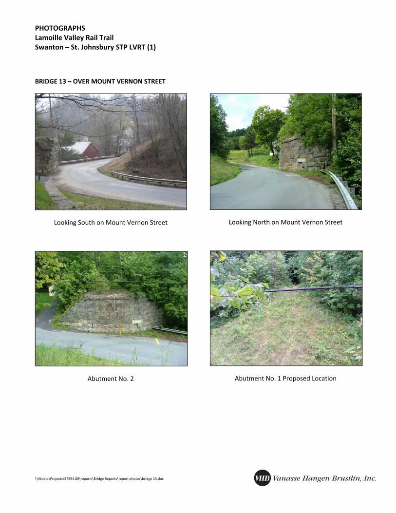
• Substructure o Masonry Abutment No. 2 remains o Abutment No. 1 removed. To be designed in coordination with D&K and the Three Rivers Trail o Abutment No. 2 appears to have settled slightly in the past and appears stable and retains batter o Northwest wingwall of Abutment No. 2 appears to have settled slightly in the past but appears stable o Bridge seat and backwall of Abutment No. 2 in poor condition
• Approaches/Site o Available vertical clearance sufficient to meet standards o Site distance is limited on the road o Horizontal clearance is nonstandard at west abutment o A concrete box culvert runs from south to north, under Mt. Vernon Street and west abutment. Culvert is
clear of debris and in good condition. Some scour and spalling of headwall at inlet. Some scour was observed on culvert outlet headwall.
o Guardrail on Mt. Vernon Street runs into northwest wingwall of Abutment No. 2 with unsafe transition o Overhead electrical and telephone utilities need to be raised for clearance over bridge o Retaining wall (supporting Mt. Vernon St.) north of bridge paralleling drive in good condition
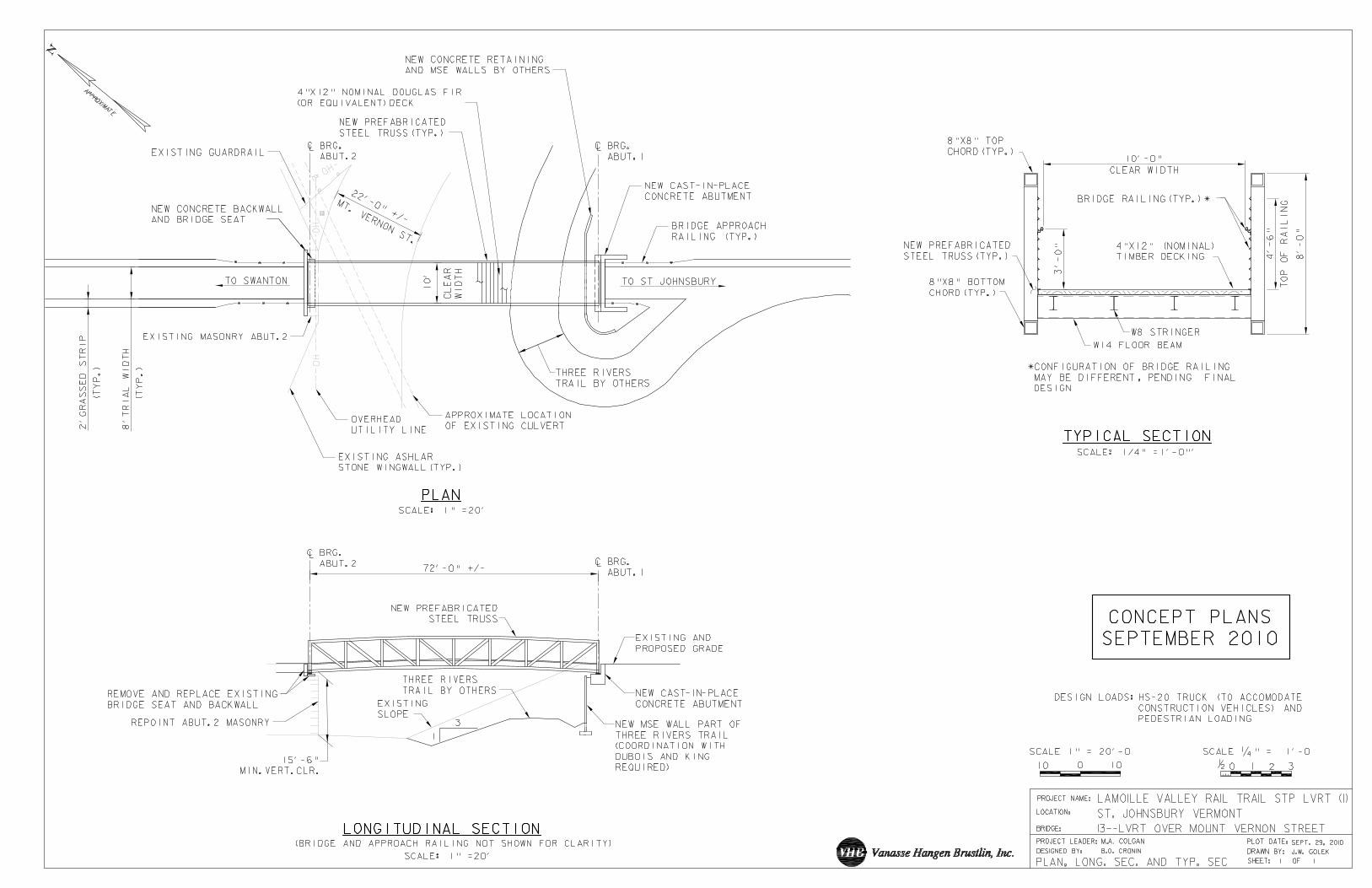
Rehabilitation/Replacement Concepts: • New stub abutment and mechanically stabilized earth (MSE) wall for Abutment No. 1 with new Three Rivers Trail
(D&K)
• Consider stabilizing northwest wingwall and Abutment No. 2 with tie‐backs
• Reuse Abutment No. 2, construct new concrete bridge seat and backwall, and repoint masonry
• Evaluated prefabricated truss vs. steel beam superstructure with approx. 70’ span (truss determined more cost‐effective)
• Realign guardrail at northwest wingwall of Abutment No. 2 (local responsibility?)
• Telephone lines require permanent relocation. Electrical utilities may require temporary relocation for erection of bridge
Resource ID: • Not eligible for National Historic Register
Available Information/Data: • DuBois & King Three Rivers Trail Preliminary Plans
• Existing Plans of culvert construction
• Railroad Val Plan
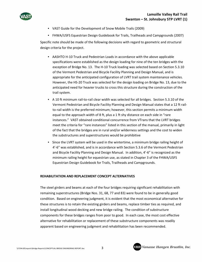
Comments: • Use HS‐20 design loading for construction access
• Detour length approximately 6.0 miles
PHOTOGRAPHS Lamoille Valley Rail Trail Swanton – St. Johnsbury STP LVRT (1)
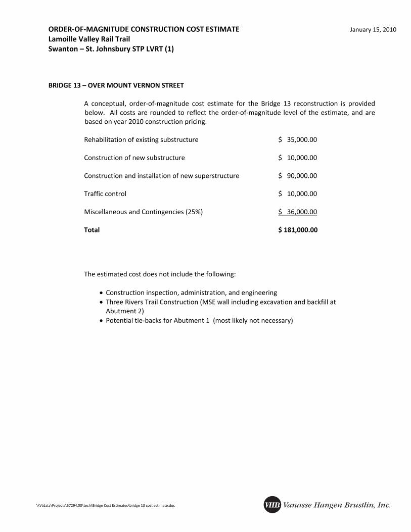
A conceptual, order‐of‐magnitude cost estimate for the Bridge 13 reconstruction is provided below. All costs are rounded to reflect the order‐of‐magnitude level of the estimate, and are based on year 2010 construction pricing.
Rehabilitation of existing substructure $ 35,000.00 Construction of new substructure $ 10,000.00 Construction and installation of new superstructure $ 90,000.00 Traffic control $ 10,000.00
Miscellaneous and Contingencies (25%) $ 36,000.00
Total $ 181,000.00
The estimated cost does not include the following: • Construction inspection, administration, and engineering • Three Rivers Trail Construction (MSE wall including excavation and backfill at
Abutment 2) • Potential tie‐backs for Abutment 1 (most likely not necessary)
INSPECTION FINDINGS AND REHABILITATION/REPLACEMENT ALTERNATIVES January 15, 2010 Lamoille Valley Rail Trail Swanton – St. Johnsbury STP LVRT (1)
• Location o Station 314+53 o Danville o Over Whiteman Brook o Map sheet 12
• Superstructure o No superstructure remains
• Substructure o No substructure remains
• Approaches/Site o Steep washout of embankments o Approximately 83’ clear opening and 23’ deep (trail grade to stream invert) o Existing slopes East: 1:1, West: 1.2:1 o Heavy debris jamming channel up and down stream o Northeast, northwest, and southwest approach embankments have steep banks o Channel has poor alignment on approach from southwest o Stream flood elevations far below trail grade, based on existing channel geometry and FIRM
Rehabilitation/Replacement Concepts: • Recommend laying back abutment slopes 1.5:1 with heavy stone fill
• 1.5:1 slopes result in approximate 100’ superstructure. Prefabricated steel truss most cost‐effective alternative
Resource ID: • Not eligible for National Historic Register
Available Information/Data: • No FIS available – 1975 FIRM available
• Railroad Val Plan
Comments: • VAST Individual Bridge Feature sheet recommends a bridge which is removable if further erosion occurs
PHOTOGRAPHS Lamoille Valley Rail Trail Swanton – St. Johnsbury STP LVRT (1)
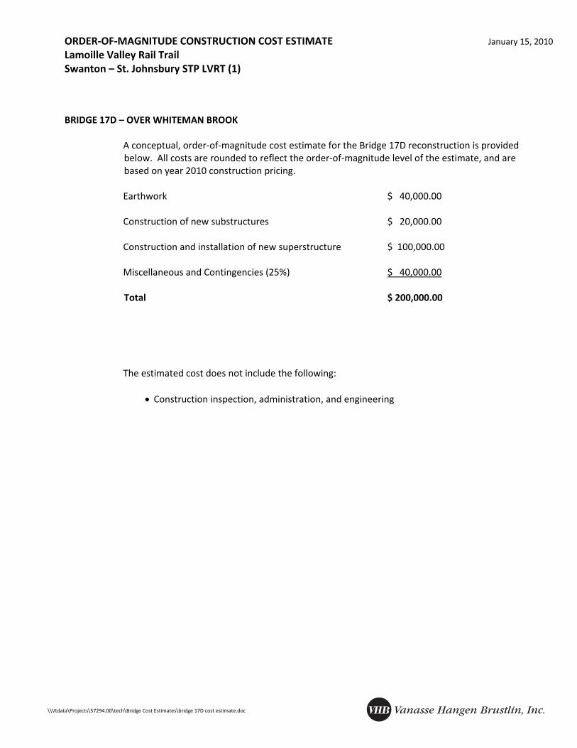
A conceptual, order‐of‐magnitude cost estimate for the Bridge 17D reconstruction is provided below. All costs are rounded to reflect the order‐of‐magnitude level of the estimate, and are based on year 2010 construction pricing.
Earthwork $ 40,000.00 Construction of new substructures $ 20,000.00 Construction and installation of new superstructure $ 100,000.00 Miscellaneous and Contingencies (25%) $ 40,000.00
Total $ 200,000.00
The estimated cost does not include the following:
• Construction inspection, administration, and engineering
INSPECTION FINDINGS AND REHABILITATION/REPLACEMENT ALTERNATIVES January 15, 2010 Lamoille Valley Rail Trail Swanton – St. Johnsbury STP LVRT (1)
Inspection Findings: • Date: August 24, 2009 • Location
o Station 1029+23 o Walden o Over VT RT 15 o Map Sheet 36
• Superstructure o No superstructure remains
• Substructure o No substructure remains
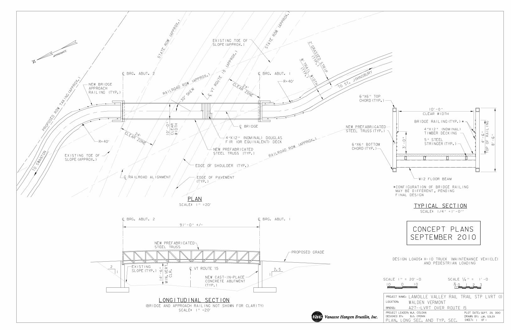
• Approaches/Site o Existing RR ROW & VT RT 15 alignments require skewed bridge alignment to minimize ROW & slope
impacts, and for trail approach alignment to meet minimum groomer turning radius o Roadway clearance approximately 15’ below trail grade at south approach o South approach is relatively flat and north approach is sloped for several hundred feet before
meeting existing trail alignment o Speed limit is not posted (assumed 50 mph regulatory) o VT RT 15 is classified as minor arterial, based on online Vermont State Highway Map, with 2800 AADT
in Danville
Rehabilitation/Replacement Concepts: • Location of Abutment No. 2 should be at edge of required clear zone to minimize ROW taking and to
accommodate VAST groomer turning radius (see comments below), which requires full height abutment
• Location of Abutment No. 1 should be at edge of required clear zone to minimize slope impacts, easements, and to accommodate VAST groomer turning radius (see comments below)
• Prefabricated steel truss bridge span of 91’ +/‐ required to meet above geometric constraints
Resource ID: • Not eligible for National Historic Register
• ROW acquisition required (see comments below)
• Minor increases in sound levels to one residence to the west of the existing corridor
Available Information/Data: • ROW plans from prior VT RT 15 construction
• Railroad Val Plan Comments:
• Survey required to determine optimum location of bridge and ROW requirements
• Required clear zone to face of abutments for assumed design speed of 55 mph = 24’ (reference AASHTO Roadside Design Guide and VT State Standards)
• Confirm adequate sight distance with proposed Abutment No. 1 location in final design
• Assume minimum turning radius for VAST groomer = 40’
• Location and extent of proposed ROW taking and slope easements require discussion with VAST and VTrans
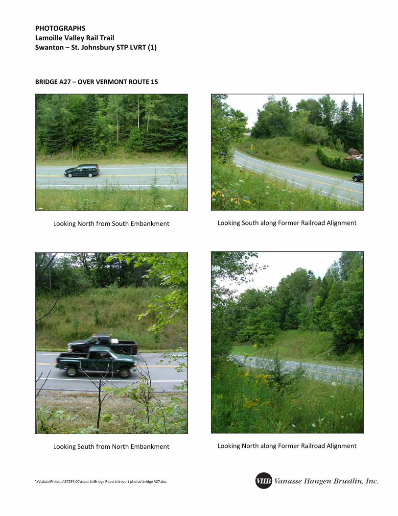
PHOTOGRAPHS Lamoille Valley Rail Trail Swanton – St. Johnsbury STP LVRT (1)
A conceptual, order‐of‐magnitude cost estimate for the Bridge A27 reconstruction is provided below. All costs are rounded to reflect the order‐of‐magnitude level of the estimate, and are based on year 2010 construction pricing.
Earthwork $ 35,000.00 Construction of new substructures $ 70,000.00 Construction and installation of new superstructure $ 95,000.00 Traffic Control $ 10,000.00 Miscellaneous and Contingencies (25%) $ 53,000.00
Total $ 263,000.00
The estimated cost does not include the following:
• Construction inspection, administration, and engineering • ROW acquisition
INSPECTION FINDINGS AND REHABILITATION/REPLACEMENT ALTERNATIVES January 15, 2010 Lamoille Valley Rail Trail Swanton – St. Johnsbury STP LVRT (1)
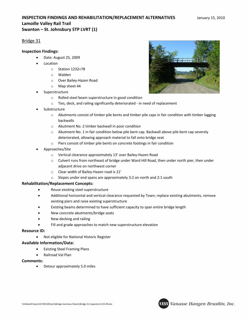
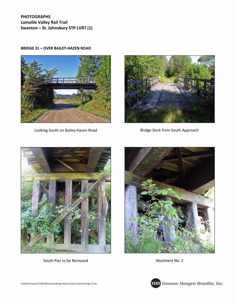
• Location o Station 1232+78 o Walden o Over Bailey‐Hazen Road o Map sheet 44
• Superstructure o Rolled steel beam superstructure in good condition o Ties, deck, and railing significantly deteriorated ‐ in need of replacement
• Substructure o Abutments consist of timber pile bents and timber pile caps in fair condition with timber lagging
backwalls o Abutment No. 2 timber backwall in poor condition o Abutment No. 1 in fair condition below pile bent cap. Backwall above pile bent cap severely
deteriorated, allowing approach material to fall onto bridge seat o Piers consist of timber pile bents on concrete footings in fair condition
• Approaches/Site o Vertical clearance approximately 13’ over Bailey‐Hazen Road o Culvert runs from northeast of bridge under Ward Hill Road, then under north pier, then under
adjacent drive on northwest corner o Clear width of Bailey‐Hazen road is 21’ o Slopes under end spans are approximately 3:2 on north and 2:1 south
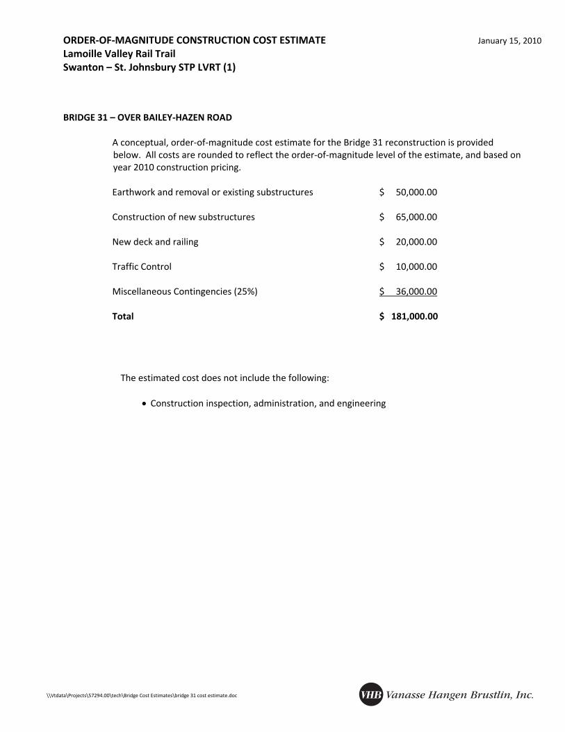
A conceptual, order‐of‐magnitude cost estimate for the Bridge 31 reconstruction is provided below. All costs are rounded to reflect the order‐of‐magnitude level of the estimate, and based on year 2010 construction pricing.
Earthwork and removal or existing substructures $ 50,000.00 Construction of new substructures $ 65,000.00 New deck and railing $ 20,000.00 Traffic Control $ 10,000.00 Miscellaneous Contingencies (25%) $ 36,000.00
Total $ 181,000.00
The estimated cost does not include the following:
• Construction inspection, administration, and engineering
INSPECTION FINDINGS AND REHABILITATION/REPLACEMENT ALTERNATIVES January 15, 2010 Lamoille Valley Rail Trail Swanton – St. Johnsbury STP LVRT (1)
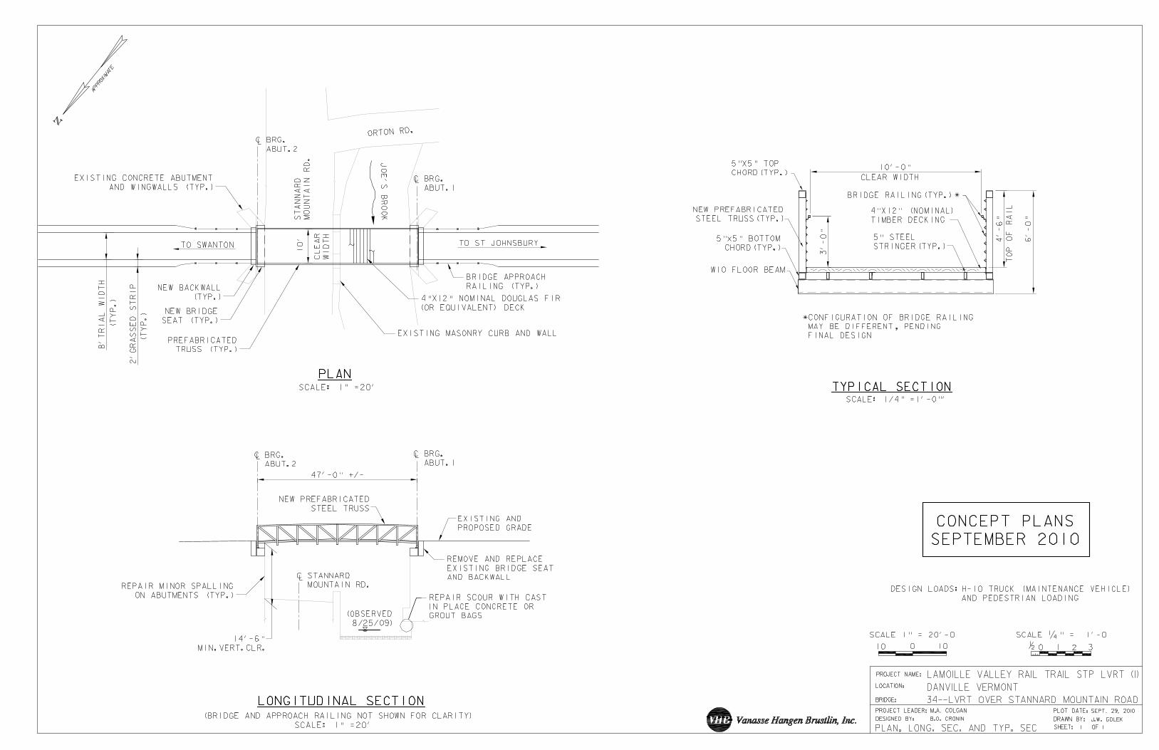
• Location o Station 1421+65 o Walden o Over Stannard Mountain Road o Map Sheet 52
• Superstructure o No superstructure remaining
• Substructure o Both abutments are still in place o Abutment No. 2 bridge seat and backwall in poor condition, concrete scaling near bottom of
abutment o Abutment No. 1 has some scour under footing no more than 2 ft. and bridge seat in fair condition
• Approaches/Site o Roadway vertical clearance is less than 12’ from bridge seat elevations. Roadway also has a grade
from east to center of bridge of approximately 3% o Roadway masonry curb and retaining wall has one missing block which may have been intentionally
removed for roadway drainage. Some scour on north side o Horizontal clearance and horizontal site distance nonstandard o Span between existing backwalls 47’
Rehabilitation/Replacement Concepts: • Reuse abutments with new bridge seats and backwalls
• Repair spalling of abutments
• New prefabricated truss superstructure due to vertical clearance requirements
Resource ID: • Not eligible for National Historic Register
Available Information/Data: • Existing plans for bridge prior to removal
• Railroad Val Plan
Comments: • According to VAST, a small insurance settlement may be available to help pay for this structure • Detour approximately 6.0 miles
PHOTOGRAPHS Lamoille Valley Rail Trail Swanton – St. Johnsbury STP LVRT (1)
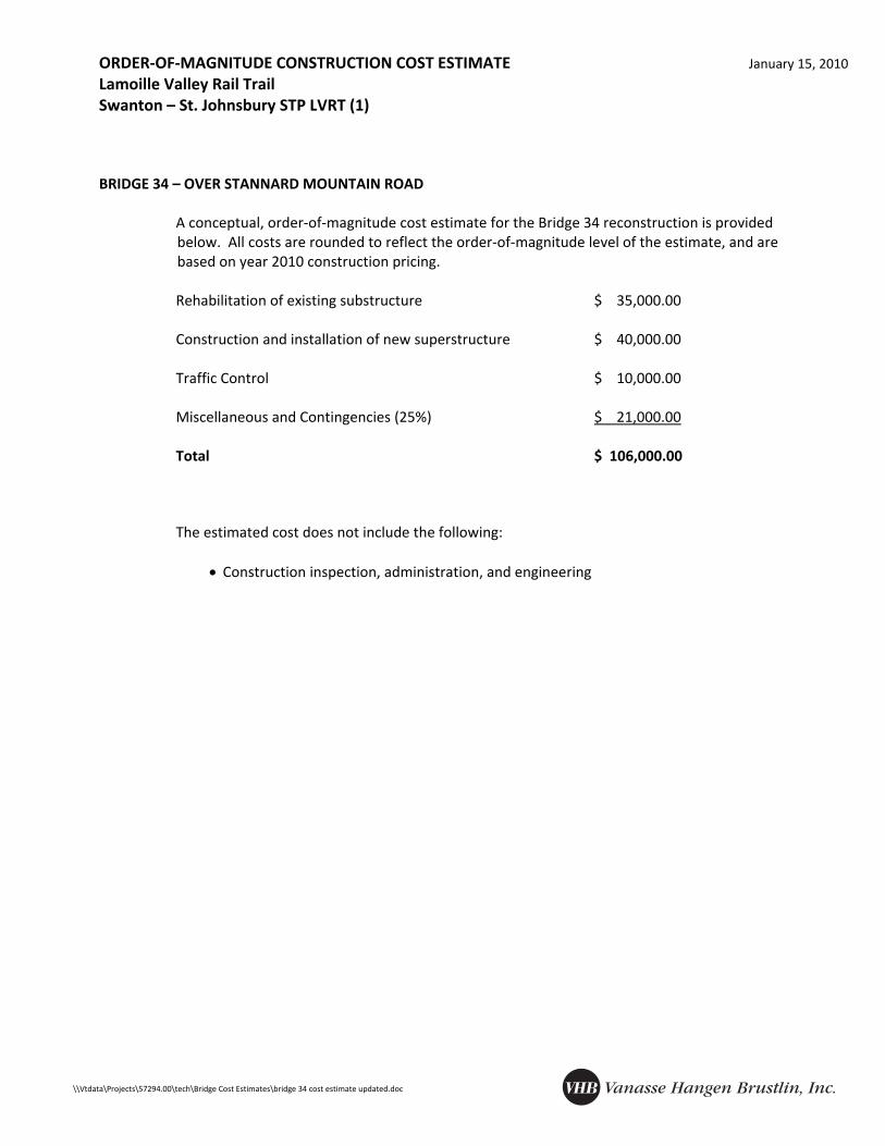
A conceptual, order‐of‐magnitude cost estimate for the Bridge 34 reconstruction is provided below. All costs are rounded to reflect the order‐of‐magnitude level of the estimate, and are based on year 2010 construction pricing.
Rehabilitation of existing substructure $ 35,000.00 Construction and installation of new superstructure $ 40,000.00 Traffic Control $ 10,000.00 Miscellaneous and Contingencies (25%) $ 21,000.00
Total $ 106,000.00
The estimated cost does not include the following: • Construction inspection, administration, and engineering
INSPECTION FINDINGS AND REHABILITATION/REPLACEMENT ALTERNATIVES January 15, 2010 Lamoille Valley Rail Trail Swanton – St. Johnsbury STP LVRT (1)
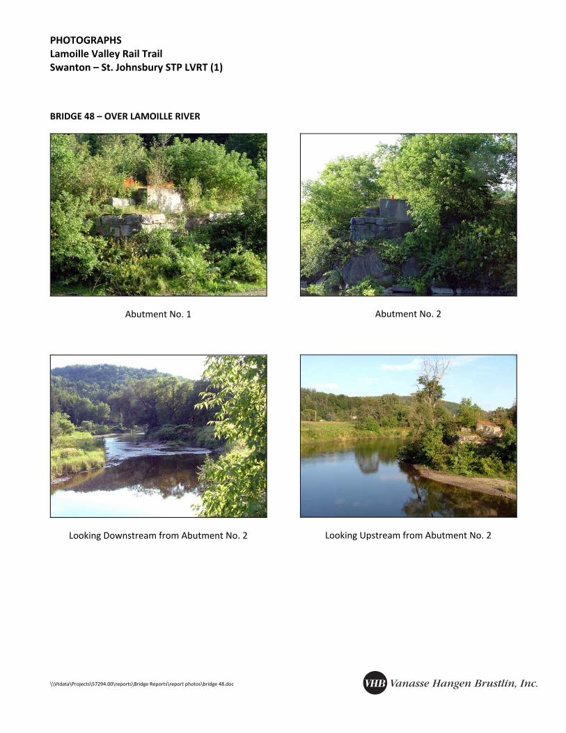
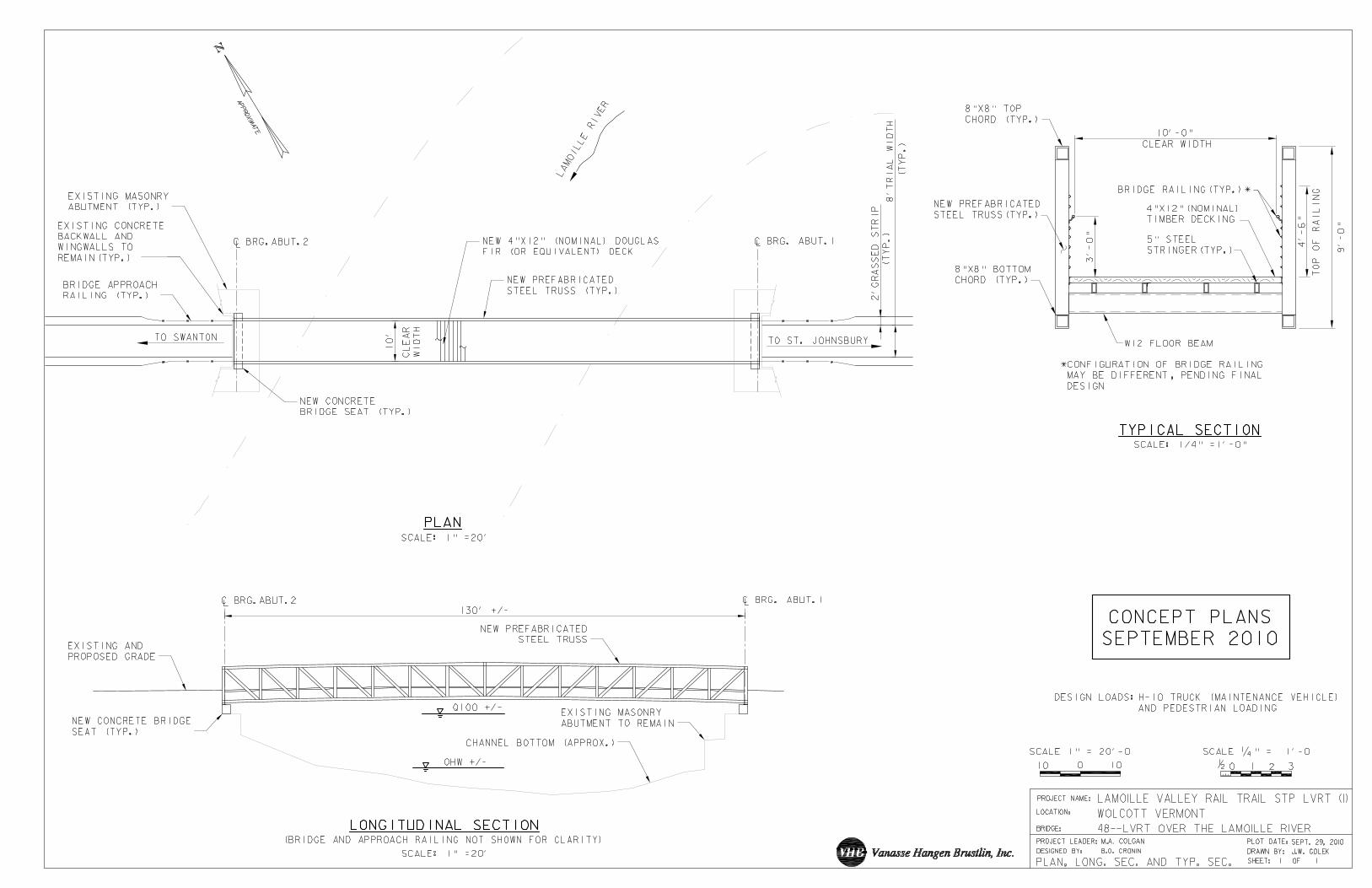
• Location o Station 2183+54 o Wolcott o Over Lamoille River o Map sheet 81
• Superstructure o No superstructure remaining
• Substructure o Both abutments are still in place and in good condition, but both require clearing and removal of
brush o Abutment No. 2 has tree growing out of north side o Both abutments are concrete on masonry on ledge o Abutment No. 1 has small trees growing between masonry blocks but in good condition
• Approaches/Site o Abutment No. 2 access from adjacent property owners land (McArthur) o Abutment No. 1 is remote access from School Street or by boat from Abutment No. 2 o Span approximately 130’ o FIS Q100 approximately at existing bridge seat elevation o 2000 FIS Q100 WSE profile shows 1967 reconstruction (new girders and lowered bridge seats)
Rehabilitation/Replacement Concepts: • Reuse existing substructure with minor repairs and build seats up for Q100+1 desired freeboard
• New prefab truss superstructure based on span length
• Remove brush and trees from existing abutments
Resource ID: • Not eligible for National Historic Register
Available Information/Data: • 2000 FIS (FIRM with cross sections and floodway boundaries shown)
• Railroad Val plan
• Existing plans (prior to bridge removal)
Comments: • VAST lease states VTrans has responsibility for this bridge.
PHOTOGRAPHS Lamoille Valley Rail Trail Swanton – St. Johnsbury STP LVRT (1)
A conceptual, order‐of‐magnitude cost estimate for the Bridge 48 reconstruction is provided below. All costs are rounded to reflect the order‐of‐magnitude level of the estimate, and are based on year 2010 construction pricing.
Rehabilitation of existing substructure $ 35,000.00 Construction and installation of new superstructure $ 150,000.00 Miscellaneous and Contingencies (25%) $ 46,000.00
Total $ 231,000.00
The estimated cost does not include the following:
• Construction inspection, administration, and engineering
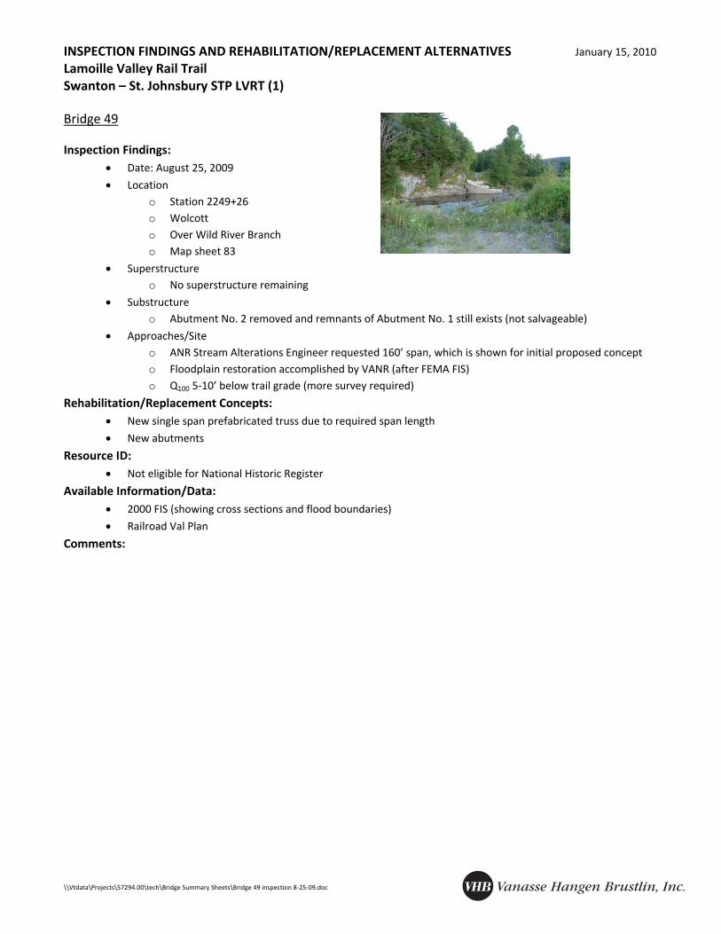
INSPECTION FINDINGS AND REHABILITATION/REPLACEMENT ALTERNATIVES January 15, 2010 Lamoille Valley Rail Trail Swanton – St. Johnsbury STP LVRT (1)
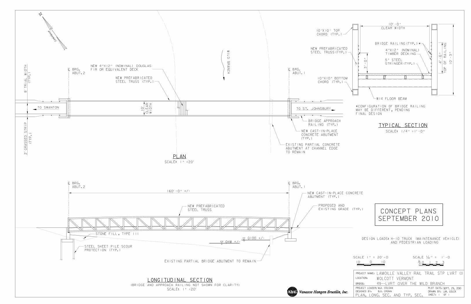
• Location o Station 2249+26 o Wolcott o Over Wild River Branch o Map sheet 83
• Superstructure o No superstructure remaining
• Substructure o Abutment No. 2 removed and remnants of Abutment No. 1 still exists (not salvageable)
• Approaches/Site o ANR Stream Alterations Engineer requested 160’ span, which is shown for initial proposed concept o Floodplain restoration accomplished by VANR (after FEMA FIS) o Q100 5‐10’ below trail grade (more survey required)
Rehabilitation/Replacement Concepts: • New single span prefabricated truss due to required span length
• New abutments
Resource ID: • Not eligible for National Historic Register
Available Information/Data: • 2000 FIS (showing cross sections and flood boundaries)
• Railroad Val Plan
Comments:
PHOTOGRAPHS Lamoille Valley Rail Trail Swanton – St. Johnsbury STP LVRT (1)
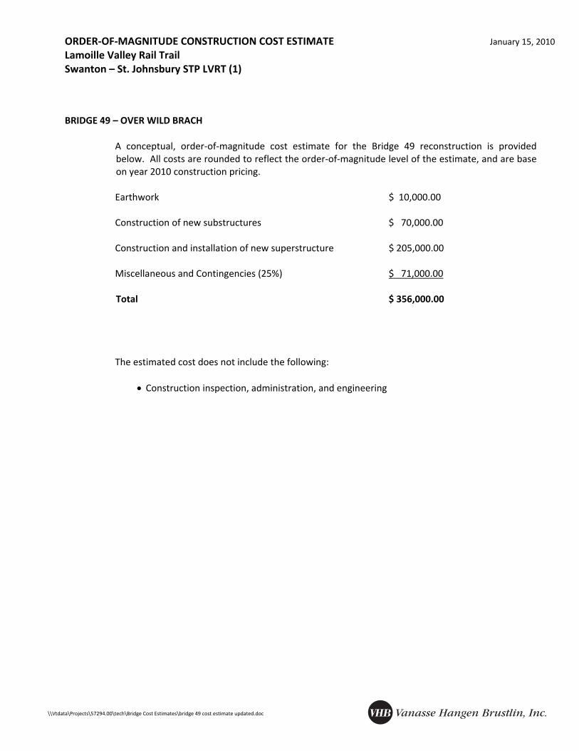
A conceptual, order‐of‐magnitude cost estimate for the Bridge 49 reconstruction is provided below. All costs are rounded to reflect the order‐of‐magnitude level of the estimate, and are base on year 2010 construction pricing.
Earthwork $ 10,000.00 Construction of new substructures $ 70,000.00 Construction and installation of new superstructure $ 205,000.00 Miscellaneous and Contingencies (25%) $ 71,000.00
Total $ 356,000.00
The estimated cost does not include the following:
• Construction inspection, administration, and engineering
INSPECTION FINDINGS AND REHABILITATION/REPLACEMENT ALTERNATIVES January 15, 2010 Lamoille Valley Rail Trail Swanton – St. Johnsbury STP LVRT (1)
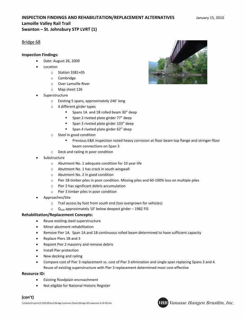
• Location o Station 3381+05 o Cambridge o Over Lamoille River o Map sheet 126
• Superstructure o Existing 5 spans, approximately 246’ long o 4 different girder types
Spans 1A and 1B rolled beam 30” deep Span 2 riveted plate girder 77” deep Span 3 riveted plate girder 103” deep Span 4 riveted plate girder 62” deep
o Steel in good condition Previous E&K inspection noted heavy corrosion at floor beam top flange and stringer‐floor
beam connections on Span 3 o Deck and railing in poor condition
• Substructure o Abutment No. 1 adequate condition for 10 year life o Abutment No. 1 has crack in south wingwall o Abutment No. 2 in good condition o Pier 1B timber piles in poor condition. Missing piles and 60‐100% loss on multiple piles o Pier 2 has significant debris accumulation o Pier 3 timber piles in poor condition
• Approaches/Site o Trail access by foot from south end (too overgrown for vehicles) o Q100 approximately 10’ below deepest girder – 1982 FIS
• Remove Pier 1A. Span 1A and 1B continuous rolled beam determined to have sufficient capacity
• Replace Piers 1B and 3
• Repoint Pier 2 masonry and remove debris
• Install Pier protection
• New decking and railing
• Compare cost of Pier 3 replacement vs. cost of Pier 3 elimination and single span replacing Spans 3 and 4. Reuse of existing superstructure with Pier 3 replacement determined most cost‐effective
Resource ID: • Existing floodplain encroachment
• Not eligible for National Historic Register
(con’t)
INSPECTION FINDINGS AND REHABILITATION/REPLACEMENT ALTERNATIVES January 15, 2010 Lamoille Valley Rail Trail Swanton – St. Johnsbury STP LVRT (1)
A conceptual, order‐of‐magnitude cost estimate for the bridge 68 reconstruction is provided below. All costs are rounded to reflect the order‐of‐magnitude level of the estimate, and are based on year 2010 construction pricing.
Rehabilitation and removal of existing substructure $ 50,000.00 Construction of new substructure $ 95,000.00 New deck and railing $ 100,000.00 Miscellaneous and Contingencies (25%) $ 61,000.00
Total $ 306,000.00
The estimated cost does not include the following:
• Construction inspection, administration, and engineering
INSPECTION FINDINGS AND REHABILITATION/REPLACEMENT ALTERNATIVES January 15, 2010 Lamoille Valley Rail Trail Swanton – St. Johnsbury STP LVRT (1)
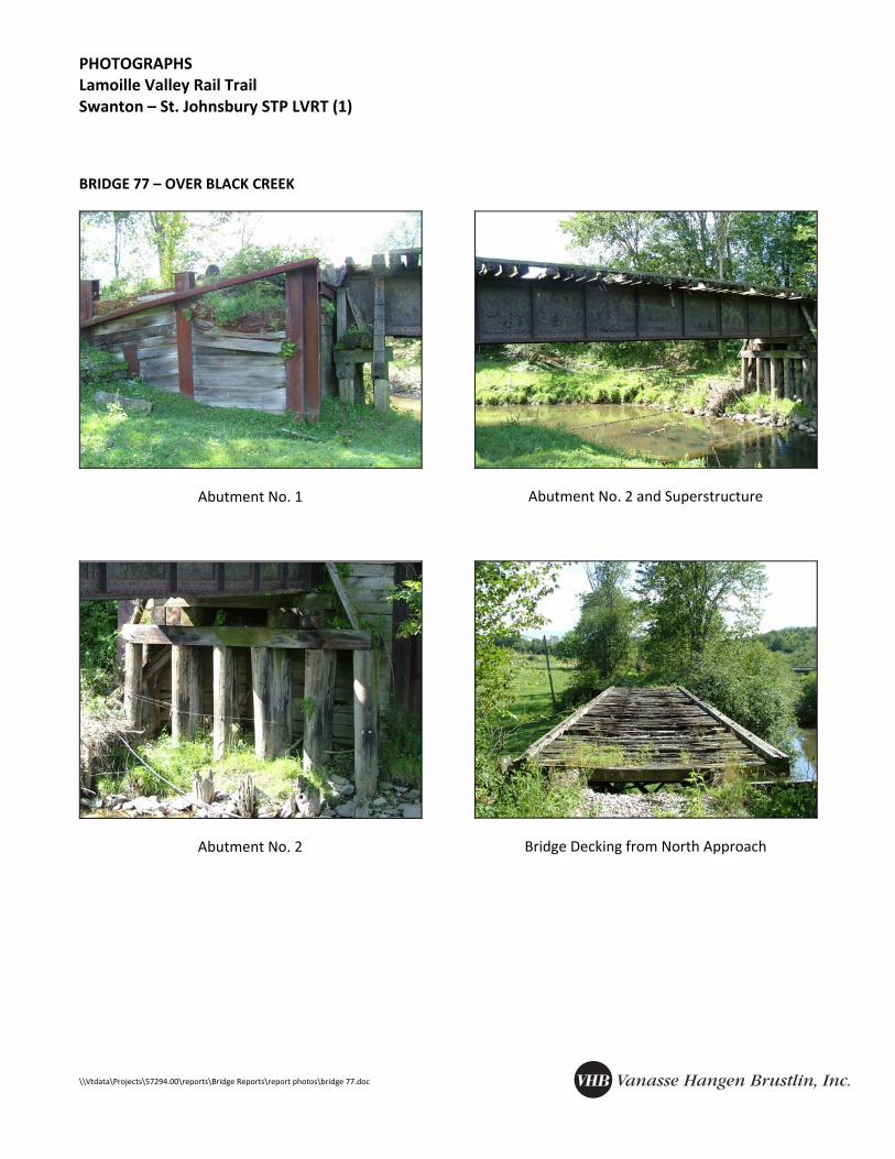
• Location o Station 3829+75 o Bakersfield o Over Black Creek o Map sheet 143
• Superstructure o Steel salvaged from another structure in good condition o Decking in poor condition o Railing not present
• Substructure o Abutment No. 2: 6 back piles checked and hollow sounding, 4 interior front piles in good condition,
and 2 exterior front piles questionable o Abutment No. 1 piles good condition, but pile cap in poor condition o Timber lagging at Abutment No. 1 deteriorated, and condition at north abutment not determined
(requires coring)
• Approaches/Site o Bridge in middle of two pastures o Barbwire and electric fence present on all corners of bridge
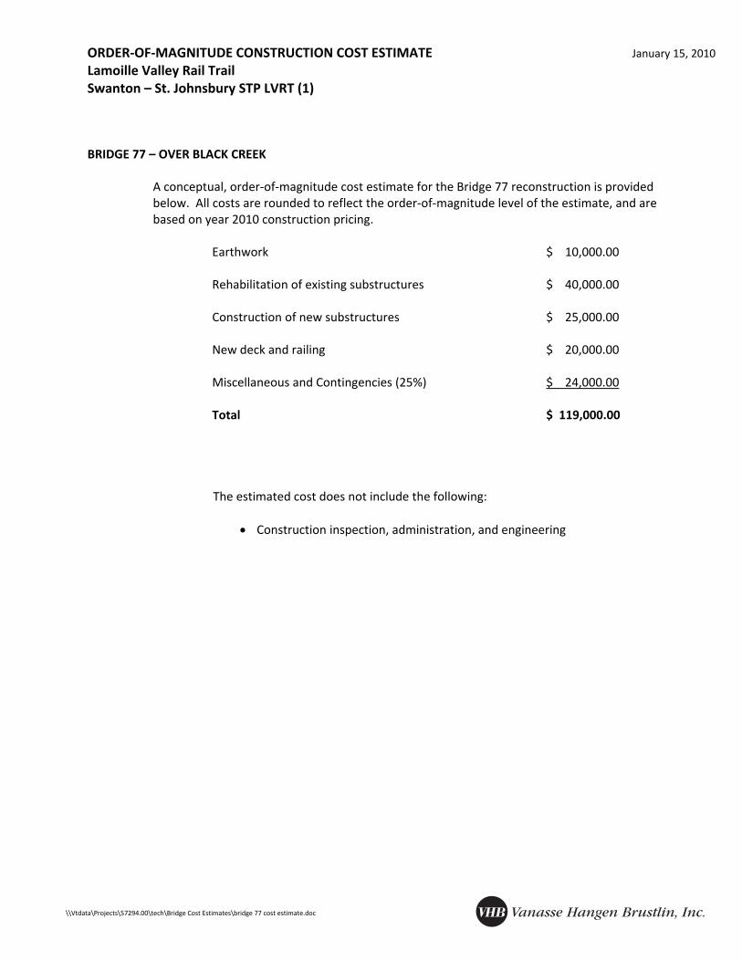
A conceptual, order‐of‐magnitude cost estimate for the Bridge 77 reconstruction is provided below. All costs are rounded to reflect the order‐of‐magnitude level of the estimate, and are based on year 2010 construction pricing.
Earthwork $ 10,000.00 Rehabilitation of existing substructures $ 40,000.00 Construction of new substructures $ 25,000.00 New deck and railing $ 20,000.00 Miscellaneous and Contingencies (25%) $ 24,000.00
Total $ 119,000.00
The estimated cost does not include the following: • Construction inspection, administration, and engineering
INSPECTION FINDINGS AND REHABILITATION/REPLACEMENT ALTERNATIVES January 15, 2010 Lamoille Valley Rail Trail Swanton – St. Johnsbury STP LVRT (1)
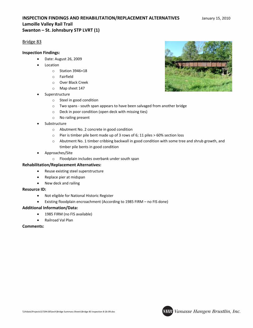
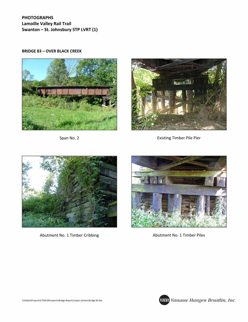
• Location o Station 3946+18 o Fairfield o Over Black Creek o Map sheet 147
• Superstructure o Steel in good condition o Two spans ‐ south span appears to have been salvaged from another bridge o Deck in poor condition (open deck with missing ties) o No railing present
• Substructure o Abutment No. 2 concrete in good condition o Pier is timber pile bent made up of 3 rows of 6; 11 piles > 60% section loss o Abutment No. 1 timber cribbing backwall in good condition with some tree and shrub growth, and
timber pile bents in good condition
• Approaches/Site o Floodplain includes overbank under south span
A conceptual, order‐of‐magnitude cost estimate for the Bridge 83 reconstruction is provided below. All costs are rounded to reflect the order‐of‐magnitude level of the estimate, and are based on year 2010 construction pricing.
Construction of new substructures $ 40,000.00 New deck and railing $ 50,000.00 Miscellaneous and Contingencies (25%) $ 23,000.00
Total $ 113,000.00
The estimated cost does not include the following: • Construction inspection, administration, and engineering
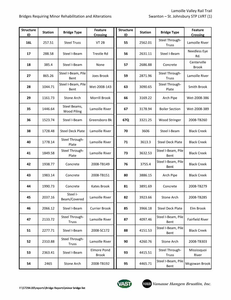
Bridges Requiring Minor Rehabilitation and Alterations