Forests and Climate Change Briefing Paper No. 6: Delineation of the Kayan Mentarang National Park Buffer Zone Using Geographic Information Systems Conceptually, a buffer zone is an area functioning as a preventive/protective zone adjacent to a conservation area. Within the framework of the Kayan Mentarang National Park (KMNP) and its collaborative management, the buffer zone is delineated using 2 approaches, i.e. socio-economic and ecological, landscape based, considerations. The main variables of both approaches were analyzed with a scoring method and a Geographic Information System (GIS). The 410,431 Hectare large buffer zone identified spreads across 10 sub-districts of Malinau and Nunukan districts. 5 types of area management patterns should be used here, according to the area status identified and its designation. The buffer zone activity is part of the FORCLIME-GTZ program (an Indonesian-German collaboration on Forests and Climate Change) through its Component 3, Sub- component KMNP, which is implemented by WWF Indonesia. Introduction Covering 1.36 million Hectare, KMNP is the largest conservation area in Kalimantan, and among the largest of its kind in Southeast Asia. Situated in Malinau and Nunukan districts in East Kalimantan Province, this area has been inhabited by native peoples since hundreds of years. Its current population is approximately 34,500, who belong to 11 customary land areas. These Dayak people are highly dependent on forests and, for generations, have generated traditional wisdom in managing and protecting their forests, in particular in their customary forests (hutan adat) and forest reserves (tana ulen). Acknowledging these circumstances, the Ministry of Forestry agreed to manage the KMNP collaboratively. The park became the first collaboratively managed National Park in Indonesia, i.e. it involves local communities in its management and oversight. A supervisory body, DP3K or Collaborative Management Board, has been established through Minister of Forestry Decree No. 374/Kepts-II/2007. Owing to its social/economic/cultural values and its unique landscape, Malinau declared itself on 5 July 2005 a conservation district, confirmed by Malinau district government regulation No. 4/2007. Thus, the district development has to consider conservation aspects aiming at the sustainability of its forest resources, while at the same time, improving the people’s welfare and contributing to other main goals of the district’s government. Buffer Zone Definition In the context of the KMNP, buffer zone is a physical/ecological area serving as a protective zone adjacent to the park’s boundary. The Bio-conservation and Its Ecosystem Law No 5/1990 states that a buffer zone is an area outside a nature reserve or a nature conservation territory, comprising forests/state land/other land, needed and able to protect the nature reserve/conservation area. According to Government Regulation No. 68/1998 on Nature Conservation Area and Nature Reserve Area, article 56 (2), the criteria for a buffer zone are: 1. Border a conservation area 2. Have ecological influence, outside and inside the conservation area 3. Be able to prevent disturbances The KMNP buffer zone is within the Nunukan and Malinau districts. Considering its function as the area’s shelter from disturbances, the buffer zone protects not only the KMNP area but also the upper reaches of the large rivers significantly important to both districts. Having declared itself a conservation district, Malinau should adopt a buffer zone management which is in line with the principles of conservation. Besides its ecological function, the KMNP buffer zone also serves as a social buffer, i.e. it provides materials needed by the local communities and their indigenous people.
Transcript
Forests and Climate Change
Briefing Paper No. 6: Delineation of the Kayan Mentarang National Park Buffer Zone Using Geographic Information Systems
Conceptually, a buffer zone is an area functioning as a preventive/protective zone adjacent to a conservation area. Within the framework of the Kayan Mentarang National Park (KMNP) and its collaborative management, the buffer zone is delineated using 2 approaches, i.e. socio-economic and ecological, landscape based, considerations. The main variables of both approaches were analyzed with a scoring method and a Geographic Information System (GIS). The 410,431 Hectare large buffer zone identified spreads across 10 sub-districts of Malinau and Nunukan districts. 5 types of area management patterns should be used here, according to the area status identified and its designation. The buffer zone activity is part of the FORCLIME-GTZ program (an Indonesian-German collaboration on Forests and Climate Change) through its Component 3, Sub-component KMNP, which is implemented by WWF Indonesia.
Introduction
Covering 1.36 million Hectare, KMNP is the largest conservation area in Kalimantan, and among the largest of its kind in Southeast Asia. Situated in Malinau and Nunukan districts in East Kalimantan Province, this area has been inhabited by native peoples since hundreds of years. Its current population is approximately 34,500, who belong to 11 customary land areas. These Dayak people are highly dependent on forests and, for generations, have generated traditional wisdom in managing and protecting their forests, in particular in their customary forests (hutan adat) and forest reserves (tana ulen). Acknowledging these circumstances, the Ministry of Forestry agreed to manage the KMNP collaboratively. The park became the first collaboratively managed National Park in Indonesia, i.e. it involves local communities in its management and oversight. A supervisory body, DP3K or Collaborative Management Board, has been established through Minister of Forestry Decree No. 374/Kepts-II/2007.
Owing to its social/economic/cultural values and its unique landscape, Malinau declared itself on 5 July 2005 a conservation district, confirmed by Malinau district government regulation No. 4/2007. Thus, the district development has to consider conservation aspects aiming at the sustainability of its forest resources, while at the same time, improving the people’s welfare and contributing to other main goals of the district’s government.
Buffer Zone Definition
In the context of the KMNP, buffer zone is a physical/ecological area serving as a protective zone adjacent to the park’s boundary. The Bio-conservation and Its Ecosystem Law No 5/1990 states that a buffer zone is an area outside a nature reserve or a nature conservation territory, comprising forests/state land/other land, n e e d e d a n d a b l e t o p r o t e c t t h e n a t u r e reserve/conservation area.
According to Government Regulation No. 68/1998 on Nature Conservation Area and Nature Reserve Area, article 56 (2), the criteria for a buffer zone are:
1. Border a conservation area2. Have ecological influence, outside and inside the
conservation area 3. Be able to prevent disturbances
The KMNP buffer zone is within the Nunukan and Malinau districts. Considering its function as the area’s shelter from disturbances, the buffer zone protects not only the KMNP area but also the upper reaches of the large rivers significantly important to both districts.
Having declared itself a conservation district, Malinau should adopt a buffer zone management which is in line with the principles of conservation. Besides its ecological function, the KMNP buffer zone also serves as a social buffer, i.e. it provides materials needed by the local communities and their indigenous people.
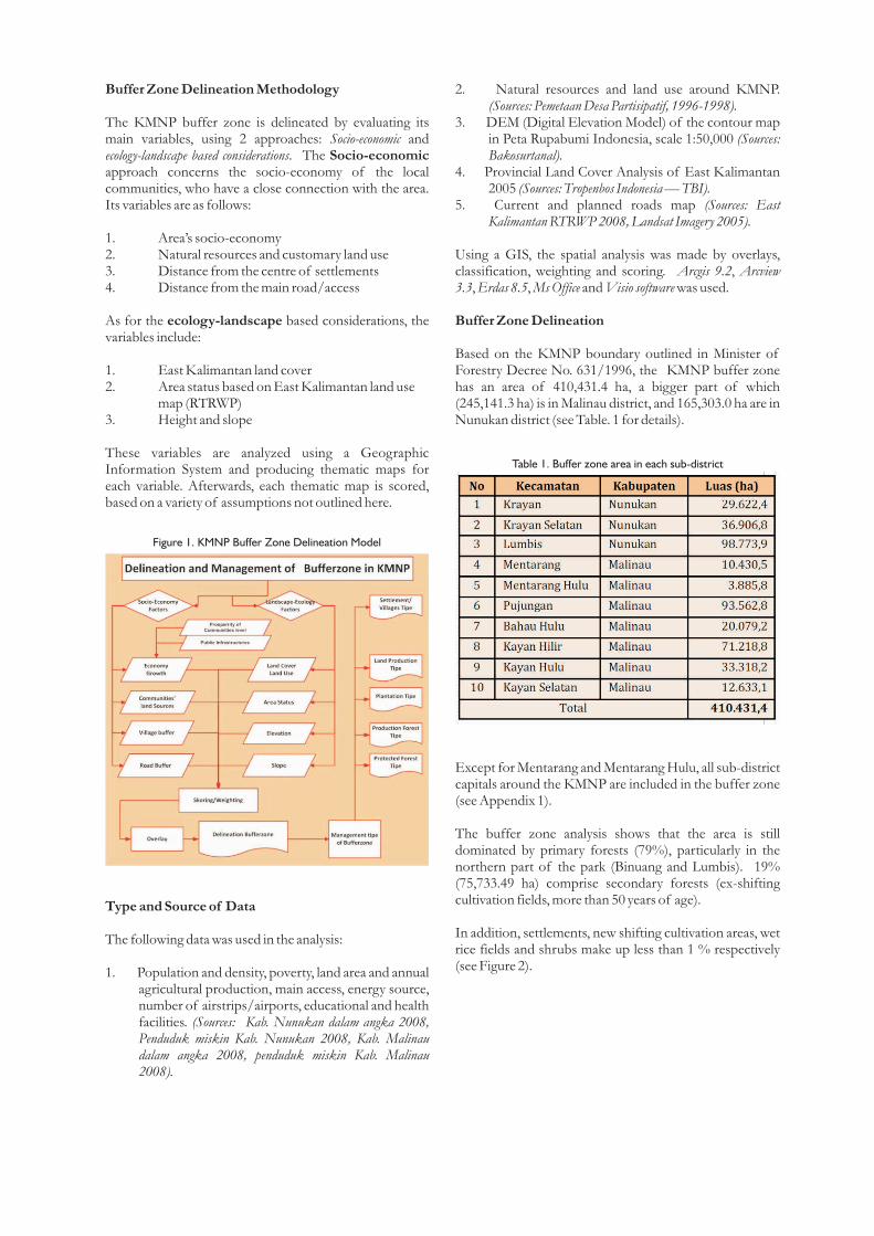
Buffer Zone Delineation Methodology
The KMNP buffer zone is delineated by evaluating its main variables, using 2 approaches: Socio-economic and ecology-landscape based considerations. The Socio-economic approach concerns the socio-economy of the local communities, who have a close connection with the area. Its variables are as follows:
1. Area’s socio-economy2. Natural resources and customary land use3. Distance from the centre of settlements4. Distance from the main road/access
As for the ecology-landscape based considerations, the variables include:
1. East Kalimantan land cover 2. Area status based on East Kalimantan land use
map (RTRWP)3. Height and slope
These variables are analyzed using a Geographic Information System and producing thematic maps for each variable. Afterwards, each thematic map is scored, based on a variety of assumptions not outlined here.
Type and Source of Data
The following data was used in the analysis:
1. Population and density, poverty, land area and annual agricultural production, main access, energy source, number of airstrips/airports, educational and health facilities. (Sources: Kab. Nunukan dalam angka 2008, Penduduk miskin Kab. Nunukan 2008, Kab. Malinau dalam angka 2008, penduduk miskin Kab. Malinau 2008).
Figure 1. KMNP Buffer Zone Delineation Model
Table 1. Buffer zone area in each sub-district
2. Natural resources and land use around KMNP. (Sources: Pemetaan Desa Partisipatif, 1996-1998).
3. DEM (Digital Elevation Model) of the contour map in Peta Rupabumi Indonesia, scale 1:50,000 (Sources: Bakosurtanal).
4. Provincial Land Cover Analysis of East Kalimantan 2005 (Sources: Tropenbos Indonesia — TBI).
5. Current and planned roads map (Sources: East Kalimantan RTRWP 2008, Landsat Imagery 2005).
Using a GIS, the spatial analysis was made by overlays, classification, weighting and scoring. Arcgis 9.2, Arcview 3.3, Erdas 8.5, Ms Office and Visio software was used.
Buffer Zone Delineation
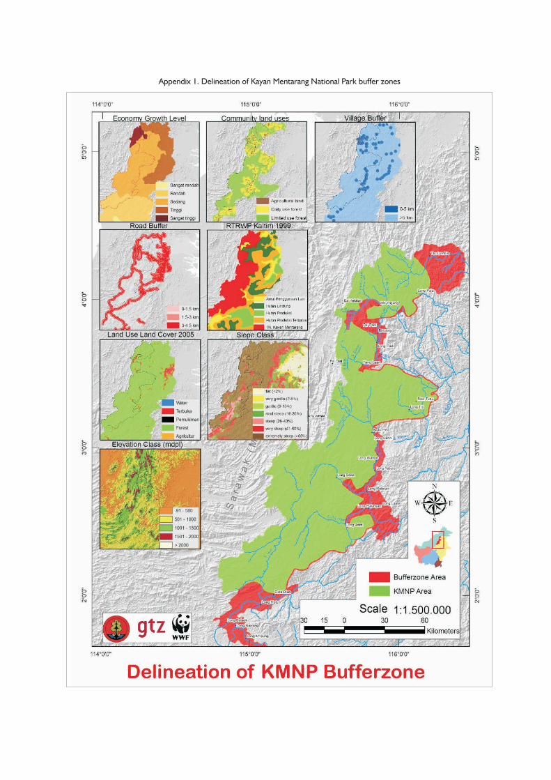
Based on the KMNP boundary outlined in Minister of Forestry Decree No. 631/1996, the KMNP buffer zone has an area of 410,431.4 ha, a bigger part of which (245,141.3 ha) is in Malinau district, and 165,303.0 ha are in Nunukan district (see Table. 1 for details).
Except for Mentarang and Mentarang Hulu, all sub-district capitals around the KMNP are included in the buffer zone (see Appendix 1).
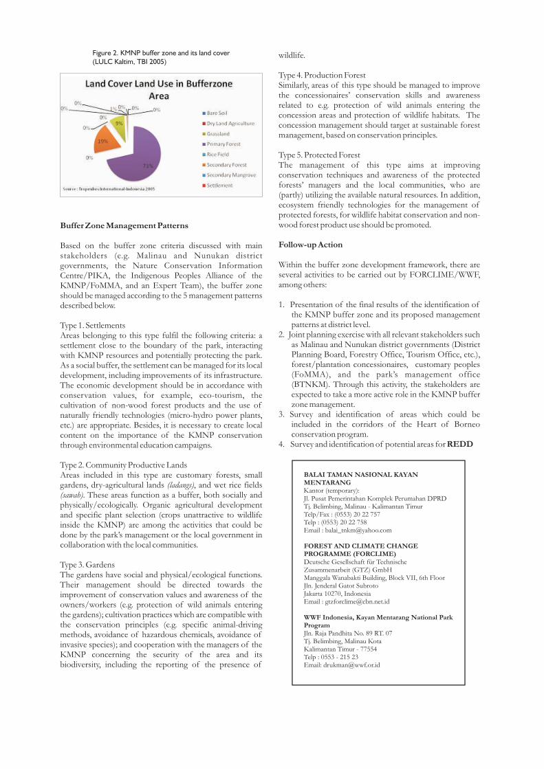
The buffer zone analysis shows that the area is still dominated by primary forests (79%), particularly in the northern part of the park (Binuang and Lumbis). 19% (75,733.49 ha) comprise secondary forests (ex-shifting cultivation fields, more than 50 years of age).
In addition, settlements, new shifting cultivation areas, wet rice fields and shrubs make up less than 1 % respectively (see Figure 2).
wildlife.
Type 4. Production ForestSimilarly, areas of this type should be managed to improve the concessionaires’ conservation skills and awareness related to e.g. protection of wild animals entering the concession areas and protection of wildlife habitats. The concession management should target at sustainable forest management, based on conservation principles.
Type 5. Protected ForestThe management of this type aims at improving conservation techniques and awareness of the protected forests’ managers and the local communities, who are (partly) utilizing the available natural resources. In addition, ecosystem friendly technologies for the management of protected forests, for wildlife habitat conservation and non-wood forest product use should be promoted.
Follow-up Action
Within the buffer zone development framework, there are several activities to be carried out by FORCLIME/WWF, among others:
1. Presentation of the final results of the identification of the KMNP buffer zone and its proposed management patterns at district level.
2. Joint planning exercise with all relevant stakeholders such as Malinau and Nunukan district governments (District Planning Board, Forestry Office, Tourism Office, etc.), forest/plantation concessionaires, customary peoples (FoMMA), and the park’s management office (BTNKM). Through this activity, the stakeholders are expected to take a more active role in the KMNP buffer zone management.
3. Survey and identification of areas which could be included in the corridors of the Heart of Borneo conservation program.
4. Survey and identification of potential areas for REDD
Figure 2. KMNP buffer zone and its land cover (LULC Kaltim, TBI 2005)
Buffer Zone Management Patterns
Based on the buffer zone criteria discussed with main stakeholders (e.g. Malinau and Nunukan district governments, the Nature Conservation Information Centre/PIKA, the Indigenous Peoples Alliance of the KMNP/FoMMA, and an Expert Team), the buffer zone should be managed according to the 5 management patterns described below.
Type 1. SettlementsAreas belonging to this type fulfil the following criteria: a settlement close to the boundary of the park, interacting with KMNP resources and potentially protecting the park. As a social buffer, the settlement can be managed for its local development, including improvements of its infrastructure. The economic development should be in accordance with conservation values, for example, eco-tourism, the cultivation of non-wood forest products and the use of naturally friendly technologies (micro-hydro power plants, etc.) are appropriate. Besides, it is necessary to create local content on the importance of the KMNP conservation through environmental education campaigns.
Type 2. Community Productive Lands Areas included in this type are customary forests, small gardens, dry-agricultural lands (ladangs), and wet rice fields (sawah). These areas function as a buffer, both socially and physically/ecologically. Organic agricultural development and specific plant selection (crops unattractive to wildlife inside the KMNP) are among the activities that could be done by the park’s management or the local government in collaboration with the local communities.
Type 3. GardensThe gardens have social and physical/ecological functions. Their management should be directed towards the improvement of conservation values and awareness of the owners/workers (e.g. protection of wild animals entering the gardens); cultivation practices which are compatible with the conservation principles (e.g. specific animal-driving methods, avoidance of hazardous chemicals, avoidance of invasive species); and cooperation with the managers of the KMNP concerning the security of the area and its biodiversity, including the reporting of the presence of
Kantor (temporary):
Appendix 1. Delineation of Kayan Mentarang National Park buffer zones