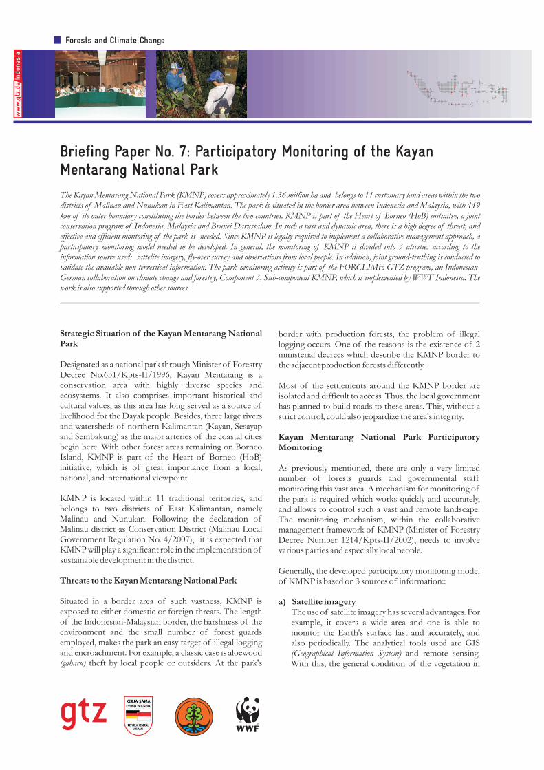
Briefing Paper No. 7: Participatory Monitoring of the Kayan Mentarang National Park The Kayan Mentarang National Park (KMNP) covers approximately 1.36 million ha and belongs to 11 customary land areas within the two districts of Malinau and Nunukan in East Kalimantan. The park is situated in the border area between Indonesia and Malaysia, with 449 km of its outer boundary constituting the border between the two countries. KMNP is part of the Heart of Borneo (HoB) initiaitve, a joint conservation program of Indonesia, Malaysia and Brunei Darussalam. In such a vast and dynamic area, there is a high degree of threat, and effective and efficient montoring of the park is needed. Since KMNP is legally required to implement a collaborative management approach, a participatory monitoring model needed to be developed. In general, the monitoring of KMNP is divided into 3 ativities according to the information source used: sattelite imagery, fly-over survey and observations from local people. In addition, joint ground-truthing is conducted to validate the available non-terrestical information. The park monitoring activity is part of the FORCLIME-GTZ program, an Indonesian- German collaboration on climate change and forestry, Component 3, Sub-component KMNP, which is implemented by WWF Indonesia. The work is also supported through other sources. border with production forests, the problem of illegal logging occurs. One of the reasons is the existence of 2 ministerial decrees which describe the KMNP border to the adjacent production forests differently. Most of the settlements around the KMNP border are isolated and difficult to access. Thus, the local government has planned to build roads to these areas. This, without a strict control, could also jeopardize the area's integrity. Kayan Mentarang National Park Participatory Monitoring As previously mentioned, there are only a very limited number of forests guards and governmental staff monitoring this vast area. A mechanism for monitoring of the park is required which works quickly and accurately, and allows to control such a vast and remote landscape. The monitoring mechanism, within the collaborative management framework of KMNP (Minister of Forestry Decree Number 1214/Kpts-II/2002), needs to involve various parties and especially local people. Generally, the developed participatory monitoring model of KMNP is based on 3 sources of information:: a) Satellite imagery The use of satellite imagery has several advantages. For example, it covers a wide area and one is able to monitor the Earth's surface fast and accurately, and also periodically. The analytical tools used are GIS (Geographical Information System) and remote sensing. With this, the general condition of the vegetation in Strategic Situation of the Kayan Mentarang National Park Designated as a national park through Minister of Forestry Decree No.631/Kpts-II/1996, Kayan Mentarang is a conservation area with highly diverse species and ecosystems. It also comprises important historical and cultural values, as this area has long served as a source of livelihood for the Dayak people. Besides, three large rivers and watersheds of northern Kalimantan (Kayan, Sesayap and Sembakung) as the major arteries of the coastal cities begin here. With other forest areas remaining on Borneo Island, KMNP is part of the Heart of Borneo (HoB) initiative, which is of great importance from a local, national, and international viewpoint. KMNP is located within 11 traditional teritorries, and belongs to two districts of East Kalimantan, namely Malinau and Nunukan. Following the declaration of Malinau district as Conservation District (Malinau Local Government Regulation No. 4/2007), it is expected that KMNP will play a significant role in the implementation of sustainable development in the district. Threats to the Kayan Mentarang National Park Situated in a border area of such vastness, KMNP is exposed to either domestic or foreign threats. The length of the Indonesian-Malaysian border, the harshness of the environment and the small number of forest guards employed, makes the park an easy target of illegal logging and encroachment. For example, a classic case is aloewood (gaharu) theft by local people or outsiders. At the park's Forests and Climate Change
Transcript
Briefing Paper No. 7: Participatory Monitoring of the Kayan Mentarang National Park
The Kayan Mentarang National Park (KMNP) covers approximately 1.36 million ha and belongs to 11 customary land areas within the two districts of Malinau and Nunukan in East Kalimantan. The park is situated in the border area between Indonesia and Malaysia, with 449 km of its outer boundary constituting the border between the two countries. KMNP is part of the Heart of Borneo (HoB) initiaitve, a joint conservation program of Indonesia, Malaysia and Brunei Darussalam. In such a vast and dynamic area, there is a high degree of threat, and effective and efficient montoring of the park is needed. Since KMNP is legally required to implement a collaborative management approach, a participatory monitoring model needed to be developed. In general, the monitoring of KMNP is divided into 3 ativities according to the information source used: sattelite imagery, fly-over survey and observations from local people. In addition, joint ground-truthing is conducted to validate the available non-terrestical information. The park monitoring activity is part of the FORCLIME-GTZ program, an Indonesian-German collaboration on climate change and forestry, Component 3, Sub-component KMNP, which is implemented by WWF Indonesia. The work is also supported through other sources.
border with production forests, the problem of illegal logging occurs. One of the reasons is the existence of 2 ministerial decrees which describe the KMNP border to the adjacent production forests differently.
Most of the settlements around the KMNP border are isolated and difficult to access. Thus, the local government has planned to build roads to these areas. This, without a strict control, could also jeopardize the area's integrity.
Kayan Mentarang National Park Participatory Monitoring
As previously mentioned, there are only a very limited number of forests guards and governmental staff monitoring this vast area. A mechanism for monitoring of the park is required which works quickly and accurately, and allows to control such a vast and remote landscape. The monitoring mechanism, within the collaborative management framework of KMNP (Minister of Forestry Decree Number 1214/Kpts-II/2002), needs to involve various parties and especially local people.
Generally, the developed participatory monitoring model of KMNP is based on 3 sources of information::
a) Satellite imagery The use of satellite imagery has several advantages. For example, it covers a wide area and one is able to monitor the Earth's surface fast and accurately, and also periodically. The analytical tools used are GIS (Geographical Information System) and remote sensing. With this, the general condition of the vegetation in
Strategic Situation of the Kayan Mentarang National Park
Designated as a national park through Minister of Forestry Decree No.631/Kpts-II/1996, Kayan Mentarang is a conservation area with highly diverse species and ecosystems. It also comprises important historical and cultural values, as this area has long served as a source of livelihood for the Dayak people. Besides, three large rivers and watersheds of northern Kalimantan (Kayan, Sesayap and Sembakung) as the major arteries of the coastal cities begin here. With other forest areas remaining on Borneo Island, KMNP is part of the Heart of Borneo (HoB) initiative, which is of great importance from a local, national, and international viewpoint.
KMNP is located within 11 traditional teritorries, and belongs to two districts of East Kalimantan, namely Malinau and Nunukan. Following the declaration of Malinau district as Conservation District (Malinau Local Government Regulation No. 4/2007), it is expected that KMNP will play a significant role in the implementation of sustainable development in the district.
Threats to the Kayan Mentarang National Park
Situated in a border area of such vastness, KMNP is exposed to either domestic or foreign threats. The length of the Indonesian-Malaysian border, the harshness of the environment and the small number of forest guards employed, makes the park an easy target of illegal logging and encroachment. For example, a classic case is aloewood (gaharu) theft by local people or outsiders. At the park's
Forests and Climate Change
and around KMNP is identified by classifying all phenomena shown on the images taken from satellites. The results are assessed further to determine the rate of land cover change and deforestation.
b) Fly-over surveyAerial surveys are conducted periodically to identify any specific pressure on the park. This option is considerably effective, although it cannot cover the entire area due to its high costs. By combining satellite imagery with the results of strategically planned aerial surveys the condition of KMNP can be assessed quite efficiently.
Usually, combinations of pre-identified flight paths identified on satellite images, and spot-checks on the ground are carried out. A laptop computer equipped with GPS and other devices for documentation is absolutely necessary when conducting such surveys.
c) Local people's informationLong before the establishment of Kayan Mentarang as a conservation area, the area has been inhabited and wisely managed by the Dayak people. Customary forest (Tana Ulen), shifting cultivation and organic farming are some examples of the sustainable management systems the local people have applied for generations. The well-preserved forests and the high biodiversity in KMNP are credited to its cautious local management.
To increase local people's participation in the collaborative management of KMNP, and to acknowledge their contribution to conservation in the past, a monitoring organization was established on a volunteer basis. This organization is called PAM SWAKARSA (voluntary park rangers). Its direct function is to help the Balai TNKM (the formal park management institution) to monitor the park.
Results of the Participatory Monitoring
1. Satellite Imagery Analysis
a) The 2006's analysis of the land cover conditions in KMNP (using a composite of Landsat Images 2002-2005) shows that around 95 % of the KMNP area is made up of primary and secondary forests, and the rest is of non-forest areas: settlements, agricultural fields and bushes.
The analysis also identified some locations showing large-scale forest clearance or logging roads, likely done by concessionaires from Sabah and Sarawak (Malaysia) and, in a few cases, by Indonesian companies.
b) A most recent analysis of land cover changes (2009/2010) is based on Alos Avnir images with 10 m
2. Fly-over Survey
Between 2004 and 2006, four aerial surveys using a small Cessna airplane were conducted. The survey team included representatives from East Kalimantan's BKSDA office, the police, the army and the local governments. In 2007, two specific over-flights were conducted along the border.
Based on these surveys, KMNP, particularly its area along the border with Malaysia (Sarawak and Sabah), was rated as relatively safe from encroachment and illegal logging, even though a number of high risk locations were identified : 1) upstream Sulon R., Lumbis sub-district, Nunukan district (N 4º20' and E 115º50'; 2) western KMNP, upstream Lesung R., Kayan Hilir sub-district, Malinau district (N 2º3' and E 114º48'; and 3) upstream Apauping, Bahau Hulu sub-district, the Batu Kalong mountains (N .2º3' and E 114º48').
Following a meeting on the revision of the KMNP outer boundary on 25 July 2009, another fly-over was conducted, involving East Kalimantan's integrated spatial planing team, Malinau and Nunukan local governments, the park management institution and WWF Indonesia/FORCLIME. The objective of this survey was to evaluate the land cover conditions around the settlements within the KMNP. As a result of the evidence gathered, the integrated planning team decided that most of the villages should be excluded from the KMNP area, as maintaining them inside the park was no longer appropriate for conservation purposes. The changes were accommodated in the draft of the revision of East Kalimantan's spatial plan.
3. Ground-checking
Joint ground-checking activities have been carried out at the following locations:
a) Apauping – Long Banga border area to Malaysia, 2005 and 2008
b) Krayan, July 2006
Upstream Bahau R., (Apauping village), Bahau Hulu sub-distrct – Malinau border)
Upstream Raye R. (Pa Raye – Krayan Hilir), Krayan Hilir – Sabah border; Nunukan district
Upstream Betung R. (Pa Betung) Krayan Hilir – Sarawak border; Nunukan districtUpstream. Lumbis R. (Tau Lumbis) Lumbis – Sabah border ; Nunukan district
Upstream Lesung R.(Data Dian village – Sarawak border) Kayan Hilir, Malinau districtLong Ketaman village, Pujungan sub-district, bordering HPH Rangga Kusuma
1
2
34
5
6
No Estimated Locations Coordinates
115 47 59 BT & 4 13 25 LU
115 39 40 BT & 4 03 06 LU
115 54 54 BT & 4 22 39 LU
Table1. Estimation of forest clearance locations
resolution recorded during 2007-2009. These high quality images show only minor changes if compared with the previous images, which indicates that the KMNP area is still intact and well preserved. Ground-checking of some locations was, however, deemed necessary.
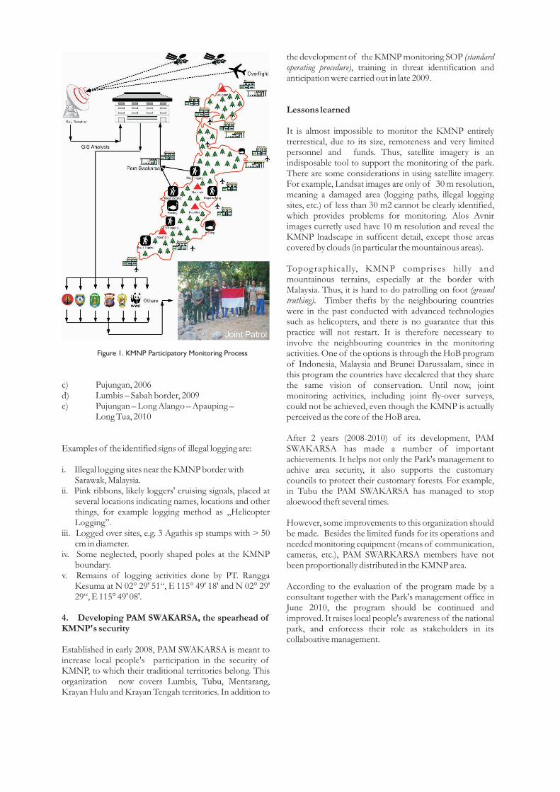
Figure 1. KMNP Participatory Monitoring Process
c) Pujungan, 2006d) Lumbis – Sabah border, 2009e) Pujungan – Long Alango – Apauping –
Long Tua, 2010
Examples of the identified signs of illegal logging are:
i. Illegal logging sites near the KMNP border with Sarawak, Malaysia.ii. Pink ribbons, likely loggers' cruising signals, placed at
several locations indicating names, locations and other things, for example logging method as „Helicopter Logging”.
iii. Logged over sites, e.g. 3 Agathis sp stumps with > 50 cm in diameter.
iv. Some neglected, poorly shaped poles at the KMNP boundary.
v. Remains of logging activities done by PT. Rangga Kesuma at N 02° 29' 51“, E 115° 49' 18' and N 02° 29' 29“, E 115° 49' 08'.
4. Developing PAM SWAKARSA, the spearhead of KMNP's security
Established in early 2008, PAM SWAKARSA is meant to increase local people's participation in the security of KMNP, to which their traditional territories belong. This organization now covers Lumbis, Tubu, Mentarang, Krayan Hulu and Krayan Tengah territories. In addition to
the development of the KMNP monitoring SOP (standard operating procedure), training in threat identification and anticipation were carried out in late 2009.
Lessons learned
It is almost impossible to monitor the KMNP entirely trerrestical, due to its size, remoteness and very limited personnel and funds. Thus, satellite imagery is an indisposable tool to support the monitoring of the park. There are some considerations in using satellite imagery. For example, Landsat images are only of 30 m resolution, meaning a damaged area (logging paths, illegal logging sites, etc.) of less than 30 m2 cannot be clearly identified, which provides problems for monitoring. Alos Avnir images curretly used have 10 m resolution and reveal the KMNP lnadscape in sufficent detail, except those areas covered by clouds (in particular the mountainous areas).
Topographically, KMNP comprises hil ly and mountainous terrains, especially at the border with Malaysia. Thus, it is hard to do patrolling on foot (ground truthing). Timber thefts by the neighbouring countries were in the past conducted with advanced technologies such as helicopters, and there is no guarantee that this practice will not restart. It is therefore necesseary to involve the neighbouring countries in the monitoring activities. One of the options is through the HoB program of Indonesia, Malaysia and Brunei Darussalam, since in this program the countries have decalered that they share the same vision of conservation. Until now, joint monitoring activities, including joint fly-over surveys, could not be achieved, even though the KMNP is actually perceived as the core of the HoB area.
After 2 years (2008-2010) of its development, PAM SWAKARSA has made a number of important achievements. It helps not only the Park's management to achive area security, it also supports the customary councils to protect their customary forests. For example, in Tubu the PAM SWAKARSA has managed to stop aloewood theft several times.
However, some improvements to this organization should be made. Besides the limited funds for its operations and needed monitoring equipment (means of communication, cameras, etc.), PAM SWARKARSA members have not been proportionally distributed in the KMNP area.
According to the evaluation of the program made by a consultant together with the Park's management office in June 2010, the program should be continued and improved. It raises local people's awareness of the national park, and enforcess their role as stakeholders in its collaboative management.
BALAI TAMAN NASIONAL KAYAN MENTARANGKantor (temporary):Jl. Pusat Pemerintahan Komplek Perumahan DPRDTj. Belimbing, Malinau - Kalimantan TimurTelp/Fax : (0553) 20 22 757Telp : (0553) 20 22 758Email : [email protected]
FOREST AND CLIMATE CHANGE PROGRAMME (FORCLIME)Deutsche Gesellschaft für Technische Zusammenarbeit (GTZ) GmbHManggala Wanabakti Building, Block VII, 6th FloorJln. Jenderal Gatot SubrotoJakarta 10270, IndonesiaEmail : [email protected]
WWF Indonesia, Kayan Mentarang National Park ProgramJln. Raja Pandhita No. 89 RT. 07Tj. Belimbing, Malinau KotaKalimantan Timur - 77554Telp : 0553 - 215 23Email: [email protected]
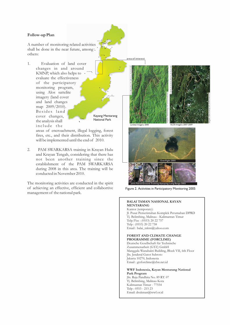
Figure 2. Activities in Participatory Monitoring 2005
Follow-up Plan
A number of monitoring related activities shall be done in the near future, among others:
1. Evaluation of land cover changes in and around KMNP, which also helps to evaluate the effectiveness of the participatory monitoring program, using Alos sattelite imagery (land cover and land changes map 2009/2010). B e s i d e s l a n d cover changes, the analysis shall i n c l u d e t h e areas of encroachment, illegal logging, forest fires, etc., and their distribution. This activity will be implemented until the end of 2010.
2. PAM SWARKARSA training in Krayan Hulu and Krayan Tengah, considering that there has not been another training since the establishment of the PAM SWARKARSA during 2008 in this area. The training will be conducted in November 2010.
The monitoring activities are conducted in the spirit of achieving an effective, efficient and collabortive management of the national park.