123
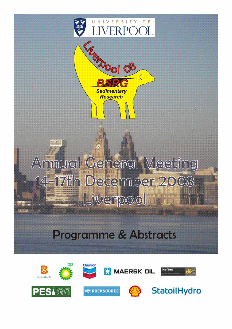
2
BRITISH SEDIMENTOLOGICAL RESEARCH GROUP ANNUAL
GENERAL MEETING
14th to 17th December 2008
Department of Earth and Ocean Sciences University of Liverpool
Programme, abstracts and other information
BSRG would like to thank to following sponsors for their support:
BG Group BP
Chevron Maersk Oil
Neftex PES GB
Rocksource Shell UK
Statoil UK

3
BSRG AGM LIVERPOOL December 14th to 17th 2008
Department of Earth and Ocean Sciences
University of Liverpool
Organising Committee:
Steve Flint Dave Hodgson
Rufus Brunt Rory O’Hara Murray
Amandine Prélat Rhodri Jerrett
Rowena Moore Sofia Stone
John Cummings

4
HOW TO GET TO LIVERPOOL AND THE BRITANNIA ADELPHI HOTEL
The Adelphi Hotel is on Ranelagh Place opposite the large Lewis’s department store
(see map on next page) Rail The mainline station is Liverpool Lime Street. Take the main exit and turn left into Lime Street and continue round a slight bend. The Britannia Adelphi Hotel is on the left just before the street named Brownlow Hill. Liverpool Central is served by local trains. Take the main exit and turn right onto Ranelagh Street. The Britannia Adelphi Hotel is straight ahead on the other side of Renshaw Street. National Rail Enquiries: 08457 484950 (UK only) http://www.nationalrail.co.uk/ Road From the M62: at the end of the motorway continue straight ahead onto Edge Lane (A5080 then A5047) and follow signs for Liverpool City Centre. The Adelphi has some parking but this will be at an extra charge, is only for residents, and needs to be booked in advance. There are also multi-storey car parks in the city centre. Air Liverpool John Lennon Airport is situated eight miles from the city and is best reached by taxi or the express bus (Airlink 500), located directly outside the entrance to the airport terminal. There is also a direct coach service linking Liverpool with Manchester Airport, which takes around an hour. From the John Lennon Airport the Airlink 500 bus goes to Liverpool Lime Street Station (follow directions from Lime Street shown above). The city centre is also served by numerous local buses which either stop at Lime Street, at the bus station or outside Lewis’s. Liverpool Airport: 0870 750 8484 (UK only) www.liverpooljohnlennonairport.com Manchester Airport: 0161489 3000 (UK only) www.manchesterairport.co.uk Coach (see location map on next page) The National Express coach station is in Norton Street, a ten-minute walk from the Adelphi Hotel. From the exit, turn right and cross London Road into Seymour Street. Then turn right into Copperas Hill and head down into town. Pass Lime Street Station on the right and then turn left at Renshaw Street. The Adelphi is the large building on the left opposite Lewis’s. National Express Coaches: 08705 808080 (UK only) www.nationalexpress.com Ferry Mersey Ferries operates services between Pier Head and Birkenhead/Wallasey on the Wirral. You can also sail between Liverpool and Belfast and the Isle of Man. Once in Liverpool, follow signs for Lime Street Station, then follow directions to the Adelphi from Lime Street station, as listed above. Mersey Ferries: 0151 630 1030 (UK only) www.merseyferries.co.uk Local For comprehensive local travel information call Traveline on 0871 200 22 33 or log on to www.merseytravel.gov.uk

5
See you at the Adelphi Hotel for all Oral and Poster presentations
and the Conference Dinner
The Adelphi Hotel
Ranelagh Place Liverpool
Tel: 0871 222 0029 Fax: 0871 222 7009
Email: [email protected]
Conference dinner on Monday at 7.30pm at the Adelphi Hotel

6
Adelphi Hotel Floor plan
Conference dinner on Monday at 7.30pm
at the Adelphi Hotel

7
SUNDAY 14th December 2008
Field Trips
Morphodynamics of the Dee Estuary
Coordinators: Rowena Moore, University of Liverpool Andy Plater, University of Liverpool
Laboratories Stephen Flint, University of Liverpool Richard Worden, University of Liverpool
Meet at the Department of Earth & Ocean Sciences at 10 am.
Sedimentology and architecture of submarine slope channels: Pendle Grit Formation (Carboniferous) of the Craven Basin
Coordinators: Ian Kane, University of Leeds John Collinson, consultant
Meet at the Department of Earth & Ocean Sciences at 8:30 am.
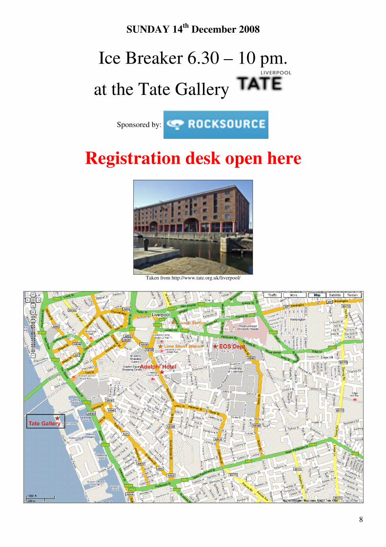
8
SUNDAY 14th December 2008
Ice Breaker 6.30 – 10 pm.
at the Tate Gallery
Sponsored by:
Registration desk open here
Taken from http://www.tate.org.uk/liverpool/

9
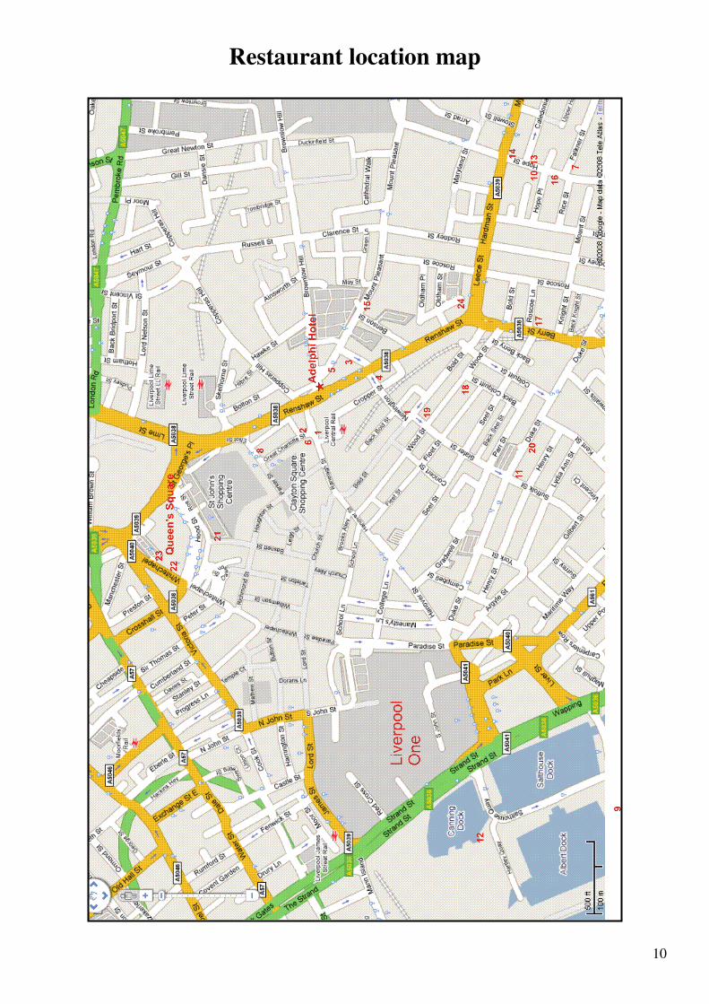
Restaurant Recommendations
Bold street near Central Station is a good place for food, as is China Town just off Berry Street (see big Chinese arch). Liverpool One, The Albert Dock and Queen’s Square are also good for restaurants. Here are some suggestions near the conference venues. Fast food
1. Subway, Ranelagh Street near Central Station and on Bold Street 2. McDonalds, Ranelagh Street opposite Central Station
Café / Lunch
3. Green fish café (daytime only), Upper Newington 4. Egg café, Newington 5. Kimos, Mount Pleasant
Italian
6. Bella Italia, Ranelagh Street opposite Central Station 7. The Quarter, Falkner Street 8. Pizza Hut, Parker Street 9. Pizza Express, Near the Albert Dock
Pub
10. Philharmonic, Hope Street 11. The Monro Reasurant, 92 Duke Street 12. The Pump House, Near the Albert Dock
Other
13. The Side Door, Hope Street 14. The Everyman, Hope Street 15. Heart and Soul, Mount Pleasant 16. London Carriageworks, Hope Street
Chinease
17. Mei Mei, 9-13 Berry Street 18. Chaya, 78-82 Wood Street
Indian
19. Passage To India , Bold Street
Mexican 20. Savina Mexican Restaurant & Bar, 138 Duke Street 21. Nando’s, Queen’s Square 22. The Tavern, Queen’s Square
Spanish
23. La Tasca, Queen’s Square Greek
24. Zorbas, Leece Street See map for restaurant locations on next page �
10
Restaurant location map
11
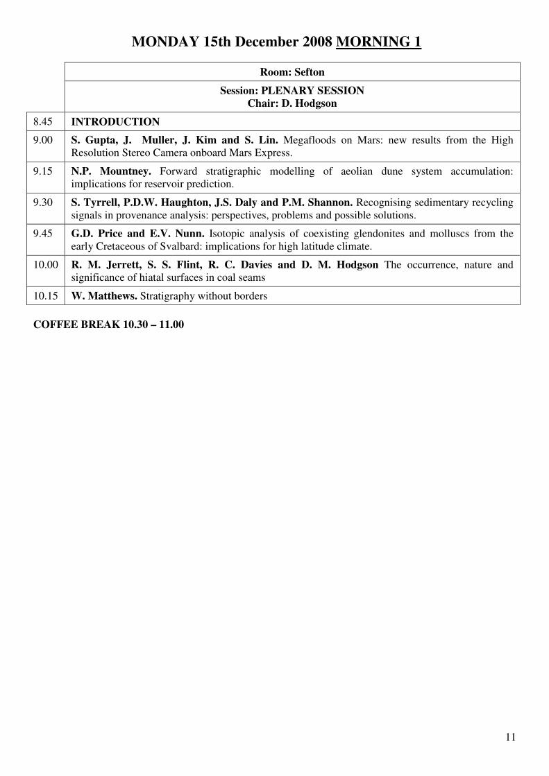
MONDAY 15th December 2008 MORNING 1
Room: Sefton
Session: PLENARY SESSION Chair: D. Hodgson
8.45 INTRODUCTION
9.00 S. Gupta, J. Muller, J. Kim and S. Lin. Megafloods on Mars: new results from the High Resolution Stereo Camera onboard Mars Express.
9.15 N.P. Mountney. Forward stratigraphic modelling of aeolian dune system accumulation: implications for reservoir prediction.
9.30 S. Tyrrell, P.D.W. Haughton, J.S. Daly and P.M. Shannon. Recognising sedimentary recycling signals in provenance analysis: perspectives, problems and possible solutions.
9.45 G.D. Price and E.V. Nunn. Isotopic analysis of coexisting glendonites and molluscs from the early Cretaceous of Svalbard: implications for high latitude climate.
10.00 R. M. Jerrett, S. S. Flint, R. C. Davies and D. M. Hodgson The occurrence, nature and significance of hiatal surfaces in coal seams
10.15 W. Matthews. Stratigraphy without borders
COFFEE BREAK 10.30 – 11.00

12
MONDAY 15th December 2008 MORNING 2
Room: Sefton Room: Crosby
FLUVIAL I Chair: I. Kane
DIAGENESIS & CO2 SEQUESTRATION I
Chair: R. Worden
10.55 INTRODUCTION INTRODUCTION
11.00 R.Goswami, N.C.Mitchell, S.H.Brocklehurst and R.L.Gawthorpe. Observation of drainage system of the NE Sicily and SW Calabria.
E. Daneshvar, D.M. Hodgson and R.H. Worden. Production of mineral assemblages: interaction between modern sediment alteration and burrowing animals.
11.15 I.W. Marshall, M. Price and H. Li. Novel approaches to the assessment of morphodynamics in upland headwater streams.
I. Al Rajaibi and J. MacQuaker. Origin and Lithofacies Variability of the late Precambrian-Cambrian Athel Silicilyte, South Oman Salt Basin.
11.30 M. Stokes, A.E. Mather and J.S. Griffiths. Palaeoflood hydrology of coarse grained fluvial terrace deposits using a maximum boulder size method (Río Almanzora, SE Spain).
M. J. O’Leary, C. T. Perry, S. J. Beavington-Penney and J. R. Turner. Biological controls on sediment textural properties within a tropical reef lagoon environment.
11.45 A.J.H. Reesink, M.L. Amsler, P.J.A. Ashworth, J.L. Best, R.J. Hardy, S.N.Lane, A.P.Nicholas, O. Orfeo, D.R. Parsons, G.H.Sambrook-Smith, S. Sandbach and R. Szupiany. The influence of fine-grained sediment on the architecture of mid-channel bars in one of the world’s largest braided rivers: Río Paraná River, Argentina.
S. Ghadeer, J. H. S. MacQuaker and C. R. Hughes. Depositional and diagenetic processes involved in the development of mudstone successions: a multi proxy study of the Lower Jurassic Cleveland Basin (The North Yorkshire coast, England).
12.00 POSTER PRESENTATION
12.15 POSTER PRESENTATION
12.30 POSTER PRESENTATION
12.45 POSTER PRESENTATION
LUNCH BREAK 12.45 – 13.45
A note on the poster session This year we are introducing a new concept to BSRG: the poster introduction session. In the session before lunch on the first day, all poster presenters are given the opportunity to summarise their poster, using one powerpoint slide, with a time limit of 2 minutes. This allows you to promote your poster’s key points to the full audience, meaning that interested people will then make sure they visit the poster. This concept has been used in other conferences for several years and works very well, ensuring maximum feedback to the presenter

13
MONDAY 15th December 2008 AFTERNOON 1
Room: Sefton Room: Crosby
DEEP WATER 1 Chair: R. Brunt
TECTONIC & SEDIMENT ROUTING Chair: C. Jackson
13.40 INTRODUCTION INTRODUCTION
13.45 J.I. Scotchman. Climate control on Deep Marine Sandy Systems, Eocene Ainsa Basin, Spanish Pyrenees.
S.J. Vincent, A.C. Morton, S. Gibbs and T.G. Barabadze. Evidence for the Oligocene uplift of the Western Greater Caucasus; implications for the timing of initial Arabia-Eurasia collision.
14.00 J. P. Cummings, D. M. Hodgson, C. Jeffrey-Abt, Richard Worden. The impact of the Palaeocene Eocene Thermal Maximum in the Deep Seas: An integrated ichnological, geochemical and stratigraphical approach.
G. McCay, A. Robertson and M. Necdet Controls of Oligo-Miocene basin formation along a destructive plate boundary: Kyrenia Range, northern Cyprus.
14.15 E. Dmitrieva, C. Jackson and M. Huuse. Geometry of Palaeocene deep-water depositional systems in the Norwegian North Sea: a 3D seismic case study from the eastern margin of the North Viking Graben.
O. Duffy, R. Gawthorpe, M. Docherty, S.H. Brocklehurst and M. Leeder. Stratigraphic response to normal fault growth and linkage: observations of the evolution of the Coffee-Soil Fault Zone, Danish North Sea.
14.30 J.J.P. Figueiredo, D.M. Hodgson, S.S. Flint. Differential compaction as a control on sand deposition on a mud-dominated submarine slope – case study: Laingsburg Formation, SW Karoo Basin, South Africa.
S. Nairn, A.H.F. Robertson, M. Hempton and U.C. Ünlügenç. Tectonostratigraphic evolution of the Late Cretaceous – Middle Eocene Haymana sedimentary Basin, Central Anatolia, Turkey.
14.45 I. A. Kane, W. D. McCaffrey and O. J. Martinsen. Submarine channel response to intra-basinal tectonics: the influence of lateral tilt.
S. Turner, N.R. Brook, J.W. Cosgrove and J.G. Liu. Tectonostratigraphic evolution of the NW Tarim Basin and impacts on the structural architecture of fold-thrust belts.
15.00 M. Thomas, J. Redfern and D. Irving. Architecture and evolution of incisional, upper-slope submarine channel complexes within the Oligo-Miocene Numidian Flysch of Sicily and Tunisia.
A. Robertson and T. Ustaömer. Sedimentological evidence for accretionary processes related to Carboniferous subduction of Palaeotethys in E Greece and W Turkey.
15.15 I. Clark, J. Cartwright. Submarine channel – structure interactions in deepwater fold belts.
B. Clements and R. Hall. 45 ma of subduction at a continental margin: a stratigraphic record from west java, Indonesia.
COFFEE BREAK 15.30 – 16.00

14
MONDAY 15th December 2008 AFTERNOON 2
Room: Sefton Room: Crosby
PROCESS MODELLING Chair: J. Peakall
GENERAL STATIGRAPHY Chair: J. Maynard
15.55 INTRODUCTION INTRODUCTION
16.00 J. H. Baas and J. L. Best. On the flow of natural clay suspensions over smooth and rough beds.
J. Noad. The sedimentology of Gloop: previously unreported evidence of the Zechstein transgression in the Middle East.
16.15 R.G. Macdonald, J. Alexander, M.J. Cooker and J.C. Bacon. How to make a hydraulic-jump unit bar
M.C. Muniz. Tectonostratigraphic Evolution in the Aptian of Campos Basin, Brazil.
16.30 S. P. Neill. Lateral grain size sorting by an estuarine front.
D.P. Le Heron, C. Wilson, H. Armstrong and L. Gindre. Late Ordovician Glacially-Related Sediments in Al Kufrah Basin, Libya I: A Tale of Turbidites and Tidalites.
16.45 R. B. O’Hara Murray, D. M. Hodgson, P. D. Thorne and P. S. Bell. Observations of vortex shedding over sand ripples under irregular waves at field scale.
C. Wilson, D.P. Le Heron, H. Armstrong and L. Gindre. Late Ordovician Glacially-Related Sediments in Al Kufrah Basin, Libya, II: A Storm-influenced Glacial Outwash Delta in Jabal az Zalmah.
17.00 D. McCann , A. Davies and P. Bell. Tracking intertidal sand dunes with X-band radar.
G.J. Potts. Predicting the number of vertical sequences or stratigraphies present within a area.
17.15 J.T. Eggenhuisen and W.D. McCaffrey. Turbulence probability characterisation in experimental sedimentology: a new tool for the analysis of suspended sediment transport
Y. Najman, S. Akhter, R. Allen, S. Ando, M. BouDhager-Fadel, M. Bickle, A. Carter, E. Chisty, E. Garzanti, G. Oliver, R. Parrish, M. Paul, L. Reisberg, G. Vezzoli, J. Wijbrans and E. Willett. Constraining hinterland tectonics and basin evolution from the detrital record ; a multi-technique provenance study applied in the Bengal Basin, Bangladesh.
17.30 F. Giorgio-Serchi, J. Peakall, D. B. Ingham, A. Burns. Numerical modelling of 3D flow patterns in sinuous submarine channel bends.
R. Kieft, C. Jackson and G. Hampson. Facies architecture within a thick, net-transgressive coastal succession: Upper Almond Formation, Rock Springs Uplift, south west Wyoming.
17.45 R. Groenenberg, D. Hodgson, A. Prélat, S. Luthi and S. Flint. Autogenic controls on the geometry and stacking pattern of terminal lobe deposits in distributive water systems: integrating outcrop observations and process-based numerical model realizations.
A.G.M & POSTER SESSION 18.00 – 20.00

15
TUESDAY 16th December 2008 MORNING 1
Room: Sefton Room: Crosby
FLUVIAL II Chair: N. Mountney
DIAGENESIS & CO2 SEQUESTRATION II
Chair: S. Haszeldine
8.45 INTRODUCTION INTRODUCTION
9.00 A. Rowan, M. Jones, S.H. Brocklehurst and S. Covey-Crump. The influence of glacial-interglacial climatic variations on coarse-grained braided river deposits.
G.D. Nicoll, A. Cavanagh, R.S. Haszeldine and S. Geiger. Modelling CO2 Migration in Sedimentary Basins: Utsira Overburden.
9.15 A.J. Hartley, G.S. Weissmann and G.J. Nichols. Are existing facies models for fluvial systems wrong? A new model for the interpretation of fluvial systems in the rock record.
P. J. Armitage, R. H. Worden, D. R. Faulkner, and J. Iliffe. Experimental evaluation of the geochemical and geomechanical effects of CO2 storage on a siliciclastic caprock.
9.30 I.G. Stanistreet. Interstadial climatic oscillations and Milankovitch variations orchestrate a finely resolved time framework, contextualising early hominin finds and traces, Olduvai Gorge, Tanzania.
J.Lu, M.Wilkinson, R.S.Hazeldine, A.Boyce. Carbonate cements in the Miller Field of the UK North Sea – a natural analogue for mineral trapping in engineered CO2 storage.
9.45 K.J Keogh, S. Leary, A. Martinius, A. Taylor and S. Gowland Data capture for multi-scale modelling of the Lourinhã Formation, Lusitanian Basin, Portugal: an outcrop analogue for the Statfjord Fm, Norwegian North Sea.
D. R. Lee, M. Wilkinson and R. S. Haszeldine Determining CO2-rich fluid flux into an oilfield reservoir from fault-rock hosted carbonate fracture cements, Brae Field, North Sea.
10.00 O. Wakefield and N.P. Mountney. Styles of fluvial-aeolian interaction in the Permian Cutler Group, SE Utah, USA.
R. H. Worden. Oil-souring by thermochemical sulphate reduction at 115°C: Khuff Formation, Saudi Arabia.
10.15 L. Evenstar, A. Hartley, S. Archer and R. Chaloner Late Neogene climatic fluctuations recorded in a fluvio-lacustrine succession, Salar de Atacama, northern Chile: Implications for climate change and Andean Uplift
M. Aehnelt, R.H. Worden, S. Hill, S.S. Flint, D.M. Hodgson and A. Canham. Chemostratigraphy in oilfield development: first implications/results from a field analogue study for reservoirs in deep water channel system (Tabernas basin, Spain).
COFFEE BREAK 10.30 – 11.00

16
TUESDAY 16th December 2008 MORNING 2
Room: Sefton Room: Crosby
DEEP WATER II Chair: J. Howell
BRUCE SELLWOOD MEMORIAL Chair: J. Marshall
10.55 INTRODUCTION INTRODUCTION
11.00 R. B. Wynn Giant submarine landslides and gravity flows in our backyard: should we be worried?
M. Tucker. Are beds in shelf carbonates millennial-scale climate cycles?
11.15 V. Catterall, J. Redfern, R. Gawthorpe and, D. M. Hansen. Channel distribution controlled by episodic structural deformation: offshore Nile Delta.
J. A. Gardner, D. Bosence, P. Burgess and D. Waltham. Tectono-stratigraphic Models for Phanerozoic Carbonate Platforms.
11.30 J. Peakall, T. Nakajima, W. McCaffrey and D. Paton. First sighting of a NEW architectural element: Outer bank bars in deep-sea channels.
J. Hill, R. Wood, A. Curtis, and D. Tetzlaff. Modelling shallow marine carbonate depositional systems.
11.45 N. Farrell and T. Goodall. Recognition, analysis and interpretation of disturbed deep marine bedding from borehole images in the Forties Sandstone Member, Pierce field, Central North Sea, UK.
N. Amezcua, R. Gawthorpe and J. MacQuaker. Multiple spill-point controls on carbonate-dominated lacustrine basin fills: Mayrán Basin, NE Mexico.
12.00 M. Patacci, W.D. McCaffrey and P.D.W. Haughton. Ponding of turbidity currents: flow processes and deposit implications.
S.E. Palmer, C.T. Perry and S.G. Smithers. Reef framework development and accretionary history of a nearshore, turbid-zone coral reef.
12.15 H. Macdonald, J. Peakall, P. Wignall and J. Best. Erosion within a deep sea depositional system: a sedimentological analysis of the Carboniferous Ross Formation megaflutes.
R. Raine and P. Smith. Do relative sea-level falls preserve an environmental snapshot of a once more extensive coastal sabkha on the Laurentian margin in Scotland?
12.30 A. Prélat, D. M. Hodgson and S. S. Flint. Hierarchy, geometry, dimensions and stacking patterns of submarine lobe deposits: similarities and differences between ancient and modern systems.
A. Juerges, C. Hollis and D. Hodgetts. Reconstructing the Burial Diagenetic History of Fractured Carbonate Systems Using the Lower Carboniferous of UK and Europe.
LUNCH BREAK 12.45 – 13.45

17
TUESDAY 16th December 2008 AFTERNOON
Room: Sefton
Session: SHALLOW MARINE & COASTAL Chair: A. Hartley
13.45 C. A-L. Jackson and H. D. Johnson. River-dominated delta deposits at a tectonically-controlled shelf-edge and implications for slope sedimentation: Lower Miocene, Labuan Island, offshore NW Borneo.
14.00 C. Perry and A. Berkeley. Intertidal substrate modification as a result of mangrove planting: impacts of introduced mangrove species on sediment microfacies characteristics.
14.15 J. Howell, H. Enge and S. Buckley. Quantification of shallow marine, deltaic clinothems from virtual outcrop models: Examples from the Cretaceous Western Interior of the USA.
14.30 J.R. Kirby and R. Kirby. Controls on mudflat development in Bridgwater Bay, Somerset, UK, and the influence of the North Atlantic Oscillation.
14.45 P. Wilson, D. Hodgetts, F. Rarity, R. Gawthorpe, and M. Young. Quantifying thickness variations in syn-rift shoreface parasequences: LIDAR-based digital outcrop mapping applied to the south Gushia area, Hammam Faraun fault block, Suez rift.
15.00 T. Knudsen and J. Howell. Application of 3D Geocellular Modelling to Understand Large Scale Stratigraphic Architecture and Stacking Pattern in the Cretaceous of Central Utah, USA.
15.15 H.E. Langford. Sediment deformation associated with the emplacement of a subaqueous slide (Middle Pleistocene, Peterborough, eastern England).
COFFEE BREAK 15.30 – 16.00

18
Poster Session
Monday and Tuesday all day
Empire room Dedicated poster presentations in Sefton Room, Monday 12.00– 12.45
GENERAL
P1. K.J. Keogh, S. Leary and J. Leknes. Utilising ArcGIS tools for storage, visualisation and analysis of an outcrop analogue study: an example from the Lourinhã Fm, Portugal.
P2. J.C. Laya and M. Tucker. Facies analysis of Carboniferous – Permian strata in the Venezuela Andes, palaeogeographic implications.
P3. T. Wei, J. Peakall, D. Parsons and J. Best. Pulsating flow and sediment dynamics of density currents: example of the Xiaolangdi Reservoir, the middle Yellow River, China.
FLUVIAL
P4. S. A. Cain and N. P. Mountney. Sediment supply and accommodation as controls on fluvial
behaviour and style of preservation in an ephemeral fluvial succession: the Permian Organ Rock Formation, SE Utah, USA.
P5. S. Ghazi and N.P. Mountney. Fluvial cyclicity and stratigraphic evolution of the Early Permian Warchha Sandstone, Salt Range, Pakistan.
P6. J.H. Venus, N.P. Mountney and D.B. Thompson. Styles of fluvial-aeolian interaction in the Triassic Sherwood Sandstone Group of the Cheshire, Needwood and Stafford basins, Central England.
P7. O. Wakefield and N.P. Mountney. Modelling the 3D stratigraphic complexity inherent in mixed fluvial-aeolian successions.
P8. S. Leleu, Adrian J. Hartley & B. P.J. Williams. Alluvial architecture of pebbly braided river system: Triassic Wolfville Formation, Fundy Basin, Canada.
DIAGENESIS & C02 SEQUESTRATION
P9. P. J. Armitage, R. H. Worden , D. R. Faulkner, and J. Iliffe. Petrological and petrophysical characteristics of a siliciclastic caprock to a CO2 storage reservoir, Krechba, Algeria.
P10. P.J. Dowey, G.M. Byrne, D.M. Hodgson, and R.H. Worden. Clay mineral origin and distribution in modern estuaries: towards analogues to help predict permeability enhancing chlorite cement in sandstone reservoirs.

19
DEEP WATER
P11. C. Di Celma, G. Cantalamessa, A. Corradetti, V. Marini, R. Teloni, P. Didaskalou, P. Lori and M. Potetti. Architecture and lithofacies of erosionally-confined channel-levee complexes from the Pliocene of the Periadriatic basin, central Italy: I. Ascensione and Castignano systems.
P12. C. Di Celma, G. Cantalamessa, A. Corradetti, V. Marini, R. Teloni, P. Didaskalou, P. Lori and M. Potetti. Architecture and lithofacies of erosionally-confined channel-levee complexes from the Pliocene of the Periadriatic basin, central Italy: II. Offida and Notaresco systems.
P13. I.A. Kane, W.D. McCaffrey and O.J. Martinsen. Turbidite hosted scours: allogenic vs. autogenic mechanisms of megaflute formation.
P14. A. D. McArthur, A. J. Hartley and D. W. Jolley Palaeoenvironmental reconstruction of a coarse grained submarine slope succession: A combined palynofacies and sedimentological study of the Upper Jurassic Helmsdale Boulder Beds, Sutherland, Scotland.
TECTONICS AND SEDIMENT ROUTING
P15. L. Cross. An evaluation of the regional structural and depositional style across Java,
Indonesia, during the Neogene.
P16. I. Sevastjanova, R. Hall and D. Alderton. Detrital heavy minerals from the volcanic arc and their response to tropical weathering, South Sumatra.
PROCESS MODELLING
P17. J.H. Baas, C. Jago, M. Macklin and CCCR Team. The river-estuarine transition zone (RETZ) of
the Afon Dyfi (West Wales) as test bed for sediment transfer between river catchments and coastal environments.
P18. K. Marten. Field observations of sediment transport under transient waves and currents.
CARBONATES AND LAKES
P19. R.E. Dale, P. Wignal and O.E. Sutcliff. A sequence stratigraphy interpretation of the
Chokierian/Alportian sediments across the British Isles.
P20. R. H. Richardson and J. D. Marshall. Bathonian Carbonates of the Cotswolds, SW England: Sedimentation, Diagenesis and Isotope Stratigraphy.
P21. J.R. Wheeley and L. Cherns. Palaeoenvironmental controls on short-lived and widespread Upper Ordovician cool-water carbonate sedimentation.
P22. H.D. Williams. The dynamics of carbonate ramp systems; a forward modelling approach.

20
WEDNESDAY 17 th December 2008
North Sea core workshop
One of the highlights of this year's conference will be a unique opportunity to view specially selected cores from some of the North Sea's most famous and diverse reservoirs. The PESGB have provided generous sponsorship to ensure that this workshop is a success, with core being brought in from all corners of the United Kingdom (well, almost!). Cores from many of the classic North Sea plays will be on display, illustrating a wide range of depositional environments and reservoir types. These include Upper Carboniferous deltas and alluvial plains, Permo-Triassic marginal aeolian deposits and dryland rivers, a range of Middle-to-Upper Jurassic deltaic and shallow-marine systems, and Cretaceous-to-Tertiary deepwater fans. The workshop will highlight the tricky business of interpreting sedimentary processes and environments from core data and will emphasise the role that core sedimentology has played, and continues to play, in reservoir characterisation, development and management. Despite new and ever more sophisticated remote-sensing technologies, cores continue to provide the direct samples that are critical to many aspects of reservoir geology, and ultimately to the efficient extraction of hydrocarbon resources. The workshop has been organised with the co-operation of the British Geological Survey and Fugro Data Solutions and will run on 17th December. It will include presentations by students and academics that put the reservoirs into context, from both a depositional and a commercial standpoint. It is not to be missed. Coordinators: Gary Hampson, Imperial College John Collinson, consultant
Well nameWell nameWell nameWell name Core depthsCore depthsCore depthsCore depths Core lengthCore lengthCore lengthCore length UnitUnitUnitUnit Depositional EnvironmentDepositional EnvironmentDepositional EnvironmentDepositional Environment 43/2743/2743/2743/27----1111 10800'-10930' 39 m Millstone Grit fluvial-dominated deltaic cycles 43/25A43/25A43/25A43/25A----2X2X2X2X 13707'-13780' 22 m Barren Red Measures alluvial plain, secondary porosity development 30/2430/2430/2430/24----20202020 9745'-9755', 9763'-9800', 18 m Zechstein brecciated carbonates, condensed shales 30/2430/2430/2430/24----26262626 9152'-9181' 9 m Zechstein brecciated carbonates 48/10B48/10B48/10B48/10B----3333 11708'-11780' 22 m Rotliegend "feather edge" marginal aeolian and sabkha 29/10/200329/10/200329/10/200329/10/2003 14643'-14706' 19 m (thin core) Skagerrak dryland fluvial and palaeosols 110/26110/26110/26110/26----9999 3726'-3785' 18 m Sherwood (E. Irish Sea) marginal aeolian and dryland fluvial 3/4a3/4a3/4a3/4a----12121212 10179'-10290' 33 m Broom, Rannoch, Etive wave-dominated and tidally influenced shallow marine 3/4a3/4a3/4a3/4a----12121212 9531'-9576' 14 m Ness lagoonal cycles 21/18a21/18a21/18a21/18a----2A2A2A2A 9930'-9990' 18 m Fulmar intensely bioturbated shallow marine 16/8a16/8a16/8a16/8a----4444 15687'-15744' 17 m Ling (Upper Jurassic) sand-rich basin-floor fan; high-density turbidites(?) 16/2616/2616/2616/26----B04B04B04B04 13929'-13971' 13 m Lower Britannia slurry flows and linked turbidites-debrites 16/2616/2616/2616/26----B01B01B01B01 12933'-12957' 7 m Upper Britannia slurry flows and linked turbidites-debrites 15/3015/3015/3015/30----11Z11Z11Z11Z 4914'-4968' 16 m Lark Sandstone injected deepwater sandstones TOTAL 256 m

21
ORAL PRESENTATION: ABSTRACTS

22
Chemostratigraphy in oilfield development: first results from a field analogue study for reservoirs in deep water channel system (Tabernas basin, Spain)
M. Aehnelt1,2, R.H. Worden1, S. Hill2, S.S. Flint1, D.M. Hodgson1, A. Canham2
1 Department of Earth and Ocean Sciences, University of Liverpool, 4 Brownlow Street, Liverpool L69 3GP,
UK 2 Integrated Reservoir Solutions Ltd. (IReS), The Technology Centre, Inward Way, Rossmore Business Park,
Ellesmere Port CH65 3EN, UK [email protected]
Geochemical studies in sandstone and mudstone strata from exposures of a deep marine channel system in the Tabernas basin of southern Spain were undertaken to assess the accuracy of the chemostratigraphic technique in oilfield development. Data were obtained from sampling of vertical sections of outcrops to mimic deep vertical wells, covering axial to marginal settings as well as a variety of scales (km-scale) down this ancient and exhumed deep marine channel complex. The objective of this study is to determine the controls of geochemical variations stratigraphically and along the channel, and the distinctions in the chemical signature between separate channel units within the channel complex and between the channel complex and its abandonment. The data set gained from this excellently exposed and exactly correlatable analogue for reservoirs originally deposited as deepwater channels shall demonstrate the relationships between the chemical correlation based on the element distributions determined by XRF and the known physically mapped correlation of the profiles. This will allow distinct conclusions about the validity of chemically-defined sequence stratigraphic correlations improving this method of chemostratigraphy as approach to the correlation and interpretation of hydrocarbon reservoir geometry. Furthermore, this study will enhance the knowledge of how chemical trends follow depositional ones by interpreting the exact reasons why certain elements in certain ways are distributed within the sediment dispersal system especially with regard to subtle provenance differences, but also to diagenesis.
23
Origin and lithofacies variability of the late Precambrian-Cambrian Athel Silicilyte, South Oman Salt Basin
I. Al Rajaibi and J. MacQuaker
School of Earth Science, University of Manchester, Manchester, U.K
Silica precipitation in recent environments is mainly carried out by silica-secreting organisms (e.g. diatoms, radiolarian, and sponges). However, during late Proterozoic and early Palaeozoic silica precipitation was either a direct inorganic precipitate or driven by microbially mediated processes (biochemically). The Athel Silicilyte represents 300-400 m thick of silica accumulation was deposited around the Precambrian-Cambrian boundary in a restricted, marine intra-cratonic basin, surrounded by a carbonate platform in the South Oman Salt Basin (SOSB). The Silicilyte forms reservoirs entrapped in salt domes at depth 4-5 km. The main debate about this formation is the source of the large volume of silica and the process involved for its accumulation. The aim of this study is to understand the origin of the Athel Silicilyte by identifying the constituent material and its origin (detrital, productivity, and/or digenetic products). Around 200 samples were collected only from cores of the Athel in absence of any exposure. Petrographic techniques, both optical and electronic (backscattered and secondary imagery), and geochemical techniques (XRD and XRF) were used to characterise 40 Athel samples.
Initial results from the petrographical analyses indicate that no biogenic, in the form of test material, are present. By combining the results from petrographic techniques and geochemical techniques, three different lithofacies were identified; 1) silica-cement dominated mudstone (>90% silica cement) with trace amounts of clay, pyrite and organic matter), 2) silica cement-rich mudstone (<90% silica cement) and 3) silica and dolomite-cement bearing mudstone. Texturally, the first two of these lithofacies exhibit very thin (20 µm thick) intercalated lamina various composed of silica rich layers and organic matter rich layers. The third is homogenous and contains significant dolomite in addition to the silica and trace amounts of clay, minerals, pyrite and organic matter. XRD analyses indicate that the silica here is present both as opal-CT and micro-crystalline quartz. In the absence of any mineralised biogenic remains in the Athel, silica likely precipitated chemically or/and biochemically. Wavy discontinues lamination might indicate silica precipitation in algae/microbial mat by sediments trapping and binding mechanisms. Also, sulphate reducing bacteria (SRB) living within algae mat might drop pH by the following acid generating reaction:
+−−−++→+ HHSHCOSOOCH
34
2
222
++++→++
−− HO4H9HCO4FeS 09CH4SOO2Fe2324
2
32
Firs reaction involves organic matter oxidation; second reaction (little Fe available, average 1.2% and average S 3%) involves pyrite precipitation. All reaction will drop pH causing surrounded water to become supersaturated to respect of amorphous silica. Consequently, silica precipitated as opal-A or opal-CT, during diagensis opal-A and opal-CT was converted to microcrystalline quartz.

24
Multiple spill-point controls on carbonate-dominated lacustrine basin fills: Mayrán Basin, NE Mexico
N. Amezcua1, R. Gawthorpe1 and J. MacQuaker1,2
1Basin Studies and Petroleum Geoscience, School of Earth, Atmospheric and Environmental Sciences, University of Manchester, Williamson Building, Oxford Road, Manchester, M13 9PL, U.K
2Present address: Department of Earth Sciences, Memorial University of Newfoundland, St. John's, NL A1B 3X5. Canada.
The Mayrán Basin is a late Neogene continental basin in northeast Mexico dominated by carbonates and deposited in a series of down-stepping, terrace-like sub-basins. The sub-basin depocentres occur at several different elevations that display an overall northward down-stepping geometry from 1700 m in the south to 1250 m in the north, and are connected through multiple spill-points. Two styles of deposition are observed around the spill-points, and are related to relative lake level across adjacent depocentres: i) prograding carbonate (tufa) clinoforms, and ii) parallel stratified lacustrine carbonate. Only the carbonate clinoform type is discussed. Carbonate clinoforms are part of prograding waterfall deposits, which form delta-like bodies in aerial view that have a radius of ~1 km from the spill-point, and are up to 50 m thick. They are composed of sigmoidal to oblique clinoforms, with slope angles between 10˚ to 60˚ and prograde to the northeast. The clinoforms downlap onto an angular unconformity, cut into Laramide-aged folds and show complex interfingering with lacustrine carbonates within the lower sub-basin. A considerable segment of the top of the delta-like body is a flat surface. Hydraulic regimes, sediment supply and carbonate production, differential bedrock erosion, and potential accommodation, may have controlled the geometry and evolution of the spill-point clinoforms. Cinoform formation may also been subjected to subaereal and subaqueous processes. If hydraulic regimes controlled clinoform structure, the upper lake waters were a major contributor to their formation. Spill-points contain key data to understand stratigraphic relations and the development of these 'terrace-like' lacustrine basin fills.
25
Experimental evaluation of the geochemical and geomechanical effects of CO2 storage on a siliciclastic caprock
P. J. Armitage1, R. H. Worden1, D. R. Faulkner1, and J. Iliffe2
1Department of Earth and Ocean Science, University of Liverpool, Liverpool, U.K.
2BP Exploration, Sunbury on Thames, Middlesex, TW16 7LN, UK [email protected]
Field trials into CO2 sequestration are currently being undertaken at the InSalah gas field, Algeria. As a part of a wider project, the University of Liverpool is investigating the geochemical and geomechanical effects of CO2 storage on the caprock to the host reservoir. Initial results are presented together with details of the research programme. CO2 injection into saline aquifers and depleted petroleum reservoirs alters in situ stress and geochemical conditions. CO2-rich aqueous fluids are acidic and have the potential to geochemically-interact with caprocks. These changes will affect caprock properties such as strength and fluid flow properties which in turn may to facilitate CO2 migration and escape from the intended holding structure. Direct experimental evaluation of these effects on samples of well characterised caprocks will be crucial in helping to evaluate the long term integrity of CO2 storage. The first stage of the work has been to analyse caprock samples using a range of petrological and petrophysical techniques, including direct measurement of permeability across a range of effective pressures, to provide analysis in terms of paragenetic sequences and sequential processes and then use this to discern the main intrinsic and extrinsic controls on porosity, permeabilty and thus caprock quality. The caprocks were found to be unusually coarse grained, but with very low porosities and permeabilties (10-
23m2). Caprock quality, in terms of porosity and permeability was found to be controlled by the primary sedimentology and subsequent diagenesis. Deposition in an estuarine environment has led to mineralogical and microstructural variability within the samples. Thus caprock quality is variable within and between samples. The second stage of the work will be to use an innovative experimental approach to understand the complex interplay between in-situ stress conditions, rock damage, permeability and porosity evolution in a system where high pressure reactive fluid flow is occurring. We will measure, real-time, experimentally, under simulated reservoir P-T conditions, how the strength, reactive surface area and fluid flow properties of caprocks evolve under varying stress conditions during the flow of reactive CO2 rich aqueous pore fluids. We will also monitor how the acoustic wave velocities (P and S) vary and monitor acoustic emission (AE) output that will record the progress of microcracking in the rock. This innovative approach has never been previously attempted and will directly assess the geomechanical and geochemical consequences of CO2 injection and storage for this caprock.

26
On the flow of natural clay suspensions over smooth and rough beds
J. H. Baas1 and J. L. Best2
1School of Ocean Sciences, Bangor University, Menai Bridge, LL59 5AB, Wales, U.K
2Departments of Geology and Geography and Ven Te Chow Hydrosystems Laboratory, University of Illinois, 1301 W. Green St., Urbana, Illinois 61801, USA
Past work detailing the flow of clay-rich fluids over a smooth bed has revealed a distinct series of flow types transitional between turbulent and laminar end members as clay concentration is increased (Baas et al., in press). New laboratory flume experiments were designed to compare the dynamic properties of clay-rich flows over a smooth and rough (7-mm gravel) surface. Kaolin was used as the clay in volumetric concentrations up to 15% and at mean flow velocities ranging between 0.13 ms-1 and 1.47 ms-1 under steady, uniform flow conditions. These flows are assumed to be analogous to a wide range of natural river flows, mud flows and turbidity currents. The experimental results show that the presence of gravel provides an additional source of turbulence, as compared to smooth-wall flows, and that this modifies the sequence of flows transitional between turbulent and laminar, produced as clay concentration is raised. In particular, a turbulence-enhanced transitional flow, which is formed once a certain amount of clay has been added to a turbulent flow moving over a smooth bed, is absent over rough surfaces. Grain roughness generates greater mixing in the near-bed flow than over a smooth bed and this appears to inhibit the formation of any turbulence-enhanced flow regime, possibly due to the inability of these rough-bed flows to generate a near-bed internal shear layer. Additionally, at a given clay concentration and mean flow velocity, turbulence-attenuated transitional flows are formed at a lower applied fluid shear over the smooth than the rough bed. This feature is attributed to the greater role of grain roughness in creating additional near-bed turbulence and fluid mixing over the gravel surface. Greater clay concentrations are needed to form particle-particle networks and eventually a volume-filling gel, that are required to transform a turbulent flow into a transitional plug flow and quasi-laminar plug flow. It is clear from the experimental results that prediction of natural, clay-laden suspension flow dynamics must account for sediment concentration as well as the size, and type, of bed roughness present. Baas, J.H., Best, J.L., Peakall, J. and Wang, M. (2008, in press) A phase diagram for turbulent, transitional and laminar clay suspension flows. Journal of Sedimentary Research

27
Channel distribution controlled by episodic structural deformation: offshore Nile Delta
V. Catterall1, J. Redfern1, R. Gawthorpe1 and D. M. Hansen2
1Basin Studies and Petroleum Geoscience, School of Earth, Atmospheric and Environmental Sciences, University of Manchester, Williamson Building, Oxford Road, Manchester, M13 9PL, UK
2Statoil (UK) Ltd, Statoil House, 11a Regent Street, London, SW1Y 4ST, UK [email protected]
Tectonically active submarine slope settings are natural laboratories to test the relative importance of allo vs. autocyclic processes essential to develop predictive models of slope evolution. These models are important for our understanding of earth surface processes and as tools for the appraisal of hydrocarbon prospectivity in these settings. Interpretation of three-dimensional seismic data covering the Plio-Pleistocene succession in the offshore Nile Delta reveals numerous submarine channels and several depocentres. Spatial and temporal relationships between the main structural features in the survey area (Rosetta Fault and Nile Delta Offshore Anticline (NDOA)) and channel and depocentre distribution suggest that structural deformation is a primary control on slope evolution. Channels preferentially develop at times when the slope is above-grade and erosional processes are enhanced. Shifts of channel location are controlled by spatial and temporal changes in the slope healing process. Channel distribution in the early Pleistocene gradually moved eastwards over approximately 1.3 Myr, as depocentres were filled and since sediment flux outpaced structural deformation the slope reached an above-grade state. A later large-scale and abrupt (c. 0.5 Ma), westward shift of channel location is interpreted to have been triggered by episodic fault movement and resultant adjustment of the slope profile. Slope systems controlled by episodic tectonic movement and characterised by a sediment flux which outpaces deformation are characterised by channels which trend parallel to the regional slope and show abrupt and rapid shifts of channel location which results in widely dispersed channels. Tectonically quiescent systems are more likely to contain closely spaced, stacked and potentially more amalgamated channels as autogenic processes such as compensational stacking dominate.
28
Submarine channel – structure interactions in deepwater fold belts
I. Clark, J. Cartwright
3DLab, Department of Earth, Ocean and Planetary Sciences, Cardiff University, Main Building, Park
Place, Cardiff CF10 3YE [email protected]
The relationships between submarine (turbidite) channel systems and evolving structures in deepwater fold belt settings reveal several end member channel – structure interactions: Confinement, diversion, deflection and blocking. These interactions and combinations thereof can control submarine channel evolution over time and can affect the deposition of potential reservoir sand units. Structures such as folds developed above underlying thrust faults and strike slip faults not only control the positioning of submarine channels but also locations of increased sinuosity development. Sinuosity is a key feature of these systems as channel migration over time results in deposition of potentially sand rich lateral accretion deposits. This study uses 3D seismic data from the Nile deepwater fold belt in which submarine channel sedimentation is coeval with deformation. Submarine channels in this area are significantly affected by a fold and thrust belt whose orientation is orthogonal to that of the primary downslope flow direction. This fold belt is a result of the up-dip gravitational collapse of the Nile Delta and Deep Sea Fan above the ductile Messinian evaporites. Submarine channels in this area show significant diversion around the folds, which can result in preferential sinuosity development within the hanging wall and footwall synclines. The results of this study aim to improve our understanding of the interactions between submarine sedimentation and deformation in deepwater fold belt settings, particularly in terms of reservoir development and stratigraphic trapping potential. This study also shows that, in structurally active settings, the channel fed sediment distribution is strongly controlled by the structural evolution of the basin. The interactions described here also provide a descriptive framework for deepwater systems in which sedimentation occurs in a structurally active setting.

29
45 Ma of subduction at a continental margin: a stratigraphic record from West Java, Indonesia
B. Clements1 and R. Hall2
1Fault Dynamics Research Group Royal Holloway University of London, Egham, Surrey, TW20 0EX, UK
2SE Asia Research Group, Royal Holloway University of London, Egham, Surrey, TW20 0EX, UK [email protected]
Java is often cited as an example of a classic convergent margin; it experiences near orthogonal subduction of Indian oceanic lithosphere, has an accretionary prism with a well defined forearc high and basin (although this is not continuous) and a calc-alkaline character to the arc itself. The development of the volcanic arc has previously been assumed to be continuous through the Cenozoic, and thus the stratigraphy would be expected to be representative of this, and to be dominated by volcanogenic detritus. Neither is true for West Java and thick sequences of quartz-rich sandstones dominate the Paleogene section. This work discusses the atypical arc stratigraphy and implications for arc development, the unusual distribution of sediments behind the arc and the relevance of this work to the petroleum industry. Middle Eocene deposits in SW Java record the onset of subduction as Australia accelerated northwards at ~45 Ma. The oldest sediments deposited above basement at the Sundaland margin are also Middle Eocene, were deposited in relatively shallow water, and were sourced from the north. Thick sequences of continental sediments were deposited by large braided rivers in West Java during the Late Eocene and siliciclastic material continued to be deposited through the Oligocene. During this time, the volcanic arc remained submerged, and was further south than its present position; only rarely did the eruptive products reach West Java and the shelf edge. This voluminous quartzose clastic material accumulated behind the arc, but not in a back arc basin. The arc became emergent during the Late Oligocene and Early Miocene and volcanism was explosive and of Plinian type. Volcanic activity probably increased at this time. The load of volcanoes contributed to the development of a flexural basin between the arc and the shelf. A diminution of volcanism occurred during the Middle Miocene and carbonates were deposited above the arc rocks. During the Late Miocene volcanism resumed, but in a more northerly position than during the Paleogene. At the end of the Miocene or in the Pliocene West Java experienced considerable N - S shortening and the Paleogene arc was thrust over the flexural basin fill and older continental margin sediments.
30
The impact of the Palaeocene Eocene Thermal Maximum in the Deep Seas: An integrated ichnological, geochemical and stratigraphical approach
J. P. Cummings, D. M. Hodgson, C. Jeffrey-Abt, Richard Worden
Dept. Of Earth and Ocean Sciences, Liverpool University, UK
A marked increase in diversity of deep marine trace fossil assemblages during the Late Cretaceous, with an eventual peak in the Early Eocene has been identified in many basins. During this period there were major geochemical and environmental changes at the Palaeocene Eocene Thermal Maximum (PETM) and Early Eocene Climatic optimum (EECO). Here, sedimentary logs with detailed ichnological data tied to clay mineralogy data have been collected in order to assess the impact the abrupt warming events had on trace fossil assemblages, and marine biodiversity. The study area is the Tertiary Basque Basin in Northern Spain where several outcrops of Palaeocene-Eocene strata contain well exposed trace fossil assemblages. Initial results indicate that late Palaeocene deposition was predominantly carbonate with Zoophycos being the most abundant trace fossil with less common Rhizocorrallium plus several ‘facies-crossing’ taxa including Planolites and Thallassinoides. Post PETM deposits gradually display a general increase in the diversity of trace fossils that is coincident with a transition to siliciclastic deposition. Many beds display classic high diversity, low abundance Nereites ichnofacies assemblages with the common occurrence of graphoglyptids such as Palaeodictyon, Protopaleodictyon and pasichnial traces such as Nereites. Widespread oligotrophic conditions during the Early Eocene favour the agrichnial nature of graphoglyptids and efficient grazers such as Nereites. Large, robust Ophiomorpha such as Ophiomorpha Rudis and Ophiomorpha rectus are rare in Palaeocene deposits and Scolicia was absent in deposits of this age in the studied sections. However, Scolicia and Ophiomorpha are much more abundant in Early Eocene siliciclastic deposits. Both genera are infaunal deposit feeders that theoretically are not suited to oligotrophic conditions. The analysis of detrital clay minerals in the studied sections tests the hypothesis that increases in weathering on the continental hinterland provided terriginous derived nutrients to the marine realm. An additional nutrients supply may have aided colonisation of the deep seas by opportunistic taxa generally more associated with more shallow marine conditions. Such a colonisation will have been further supported by increases in ocean bottom temperatures associated with the PETM. Equilibrium communities characteristic of the Nereites ichnofacies will have been dominant in the periods between turbidite events.

31
Production of mineral assemblages: interaction between modern sediment alteration and burrowing animals
E. Daneshvar, D.M. Hodgson and R.H. Worden
Liverpool Diagenesis Research Group, Dept. of Earth & Ocean Sciences,
University of Lit verpool, Liverpool, L69 3GP, UK. [email protected]
Early diagenesis in marine environments, especially estuaries and tidal flats, may be influenced by the occurrence of sediment ingestion and excretion by lugworms and other non-selective filter feeding animals. This research aims to determine whether ingestion alters the mineralogy of sediments under experimental conditions and in the natural environment. Arenicola marina (burrowing lugworm) is distributed world-wide and the effects of their intense bioturbation can easily be seen and sampled in the form of sand faecal casts. For the experiments, fine sediment composed of finely-crushed, unweathered, Icelandic basalt was mixed with mashed spinach and horizontally layered in experimental (with worms) and control (no worms) tanks alternating the synthetic mud with sand-grade silica glass beads. X-ray diffraction analysis of the < 2 µm fraction of the basalt showed no carbonate or clay minerals of any sort in the initial basalt. Natural seawater was added to these tanks that effectively simulated an intertidal or shallow-marine sedimentary environment. Several lugworms were introduced to the experimental tank; the worms burrowed beneath the sediment surface and created J-shaped burrows, which destroyed the original sedimentary layering. Faecal casts were gathered, collected and analysed using X-ray diffraction and Fourier Transform Infrared spectroscopy (FT-IR) techniques. In addition, the composition of the seawater in the tank was analysed during the experiments using titration, ion chromatography and atomic absorption spectroscopy. X-ray diffraction results show a variety of changes in the worm faecal casts when compared to both the original material fed to the worms and material from control tanks. These changes consist of the development of small XRD peaks resulting from authigenic growth of clay minerals. In addition, FTIR spectra showed a significant new band which represents growth of calcite in the experimental tank. Water chemistry results show increasing alkalinity during the experiment while calcium concentration decreased. Geochemical modelling showed that the seawater became saturated with respect to calcite during the experiment thus explaining the presence of calcite in the FTIR spectra. The processes of modern sediment ingestion and excretion led to growth of clay minerals in faecal casts and precipitation of a new carbonate mineral. Over a period of many months the synthetic mud proved to be unchanged in the control tank, but it was significantly different in the faecal casts from the experimental tank that contained the worm A.marina. The main conclusion from the work so far is that laboratory experiments using the common lugworm (Arenicola marina) simulating marine conditions show that significant quantities of new carbonate and clay minerals can be produced by macrobiological burrowing and ingestion processes within sediments.
32
Geometry of Palaeocene deep-water depositional systems in the Norwegian North Sea: a 3D seismic case study from the eastern margin of the North Viking Graben
E. Dmitrieva1, C. Jackson1 and M. Huuse2
1Department of Earth Science and Engineering, Imperial College, London, UK 2Department of Geology & Petroleum Geology, King’s College, Aberdeen, UK
The majority of the reservoirs in the Palaeocene and Eocene of the North Sea Basin are deep-water channel and fan deposits. Previous work has mainly focused on the development of these systems along the western margin of the basin within the UK sector. In contrast, this study focuses on the Paleocene to Lower Eocene succession along the eastern margin of the basin within the Norwegian sector. The specific aims of this study are two-fold; (i) to establish a depositional framework for deep-water sandstones along the eastern margin of the North Sea Basin; and (ii) establish the origin depositional morphology of these sandbodies prior to large-scale, post-depositional remobilisation and injection. The study is based on a 3D seismic reflection survey which partly covers North Sea exploration block 35/11 and has a total areal extent of 600 km². Eight exploration wells with a full suite of wireline data are also utilised; these wells contain cuttings information but no core data. Well data indicates that the study interval consists of turbidite sandstones interbedded with hemipelagic mudstones. The sandstones are fine to coarse-grained and moderately to well-sorted. Individual sand bodies up to 80 m in thickness are they occur at different stratigraphic levels. They are best-developed in the lower part of the study interval towards the SE basin margin. Sandbodies cannot be confidently correlated between wells suggesting they are of limited lateral extent and may be channelised. In addition, examples of compensational stacking of sandbodies are observed. Through the generation of synthetic seismograms it is possible to tie well-based observations to seismic data. This indicates that the thicker sandbodies are represented by high amplitude anomalies. Both channel and sheet-like anomalies are observed, with channels reaching up to 10 km in length and 2 km in width. These features are interpreted as being deposited in a series of channels and lobes on a large submarine fan. The distribution of these anomalies matches the well-based observations and indicates that sands are best developed towards the base of the succession and towards the SE basin margin. This distribution also correlates to regional palaeogeographic reconstructions which suggest that sediment input from the E and SE was highest in the Early Palaeocene and that this declined through time into the Eocene. The visualisation and interpretation of 3D seismic supported by well data provides better insights into the geometry of Palaeocene-age depositional systems along the eastern margin of the North Viking Graben. The established depositional morphology allows us to better understand the distribution and controls on the geometry of large-scale, post-depositional clastic intrusions which formed within the study area.
33
Stratigraphic response to normal fault growth and linkage: observations of the evolution of the Coffee-Soil Fault Zone, Danish North Sea
O. Duffy1, R. Gawthorpe1, M. Docherty2, S.H. Brocklehurst1 and M. Leeder3
1School of Earth, Atmospheric and Environmental Sciences, University of Manchester, M13 9PL,UK
2Exploration and New Business, Mærsk Olie og Gas AS, Esplanaden 501263, Copenhagen, Denmark
3School of Environmental Sciences, University of East Anglia, Norwich, NR4 7TJ, UK [email protected]
This study focuses on the eastern margin of the Danish Central Graben around the Poul Plateau, a complex segment boundary along the basin-bounding NNW-SSE-trending Coffee-Soil fault system. The present day Coffee-Soil fault expresses a westerly-dipping, fully-linked 3D geometry, with a significant sinistral jog in the fault trace around the Poul Plateau. Strain localisation processes and an earlier stage of soft-linkage between northern and southern fault components are inferred by the presence of a zone of distributed deformation at the Poul Plateau. The Coffee-Soil fault system has developed as a result of episodic regional rifting, with an initial phase dating from Permian to Late Triassic and another, of major importance to this study, dating from the Late Jurassic to the Early Cretaceous. This tightly-constrained tectono-stratigraphic history is a result of the wealth of petroleum-related well-log, core and biostratigraphic data available. Hence, when integrated with this high-resolution 3D seismic study, it provides an excellent opportunity to elucidate the spatial and temporal evolution of complex extensional fault arrays. Here we present an initial interpretation of the Late Triassic to Early Cretaceous kinematic evolution of the Coffee-Soil fault, using evidence preserved within the syn-rift stratigraphy. Detail has been elucidated through seismic stratigraphic analysis from near the base syn-rift (Late Triassic) through to the Base Cretaceous Unconformity. Analysis of the 3D morphology of these maps has been undertaken, with further evidence obtained from analysis of syn-rift stratal thickness variations and their relationship to fault geometry in plan and cross-section. These techniques have identified major depocentre shifts, sequential filling and coalescence of hanging wall sub-basins, all of which may be used in the interpretation of fault system evolution. We suggest that the ca.25 km-long southern segment of the Coffee-Soil fault evolved through the hierarchical coalescence of a minimum of three shorter (4-8 km long) palaeo-segments with linkage dated at between Top Oxfordian and Late Kimmeridgian. Timing of linkage across the main Poul Plateau segment boundary is unknown at present, although it is inferred to post-date palaeo-segment linkage within the southern segment. Post-linkage strain localisation and relative acceleration in subsidence and accommodation generation rates is likely to have controlled a subsequent major landward shift in facies.
34
Turbulence probability characterisation in experimental sedimentology: a new tool for the analysis of suspended sediment transport
J.T. Eggenhuisen and B.D. McCaffrey
School of Earth and Environment, University of Leeds, Leeds LS2 9JT, UK
On the earth’s surface, a wide range of gravity driven fluid flows carry solid sediment particles in suspension, with both air and water serving as the transporting fluid: e.g. rivers, estuarine and tidal currents, deep sea turbidity currents, powder-snow avalanches, pyroclastic flows, dust storms and snow drives. The turbulent components of the velocity field are thought to play a major role in getting and keeping this sediment in suspension. Therefore, previous attempts to quantitatively predict the carrying capacity of natural fluid flows have focussed on determining a relationship between measures of the degree of turbulence and the amount of sediment being transported. A key factor in any attempt to address the issue in this way is the measure chosen to quantify turbulence. Traditionally time-averaged bulk statistical measures such as the “root-mean-square velocity”, the skewness of the velocity distribution and the turbulent kinetic energy have been used to describe the state of turbulence. However, these simple statistical measures obscure information about characteristics of the turbulence, such as velocity asymmetry as a function of velocity magnitude. To develop an accurate understanding of the dynamics of suspended sediment transport it is essential to develop new ways of capturing the architecture of turbulent velocity fluctuations throughout the body of the transporting flows. Preliminary results are presented that have been obtained with a novel descriptive method that extracts turbulence characteristics from the simplest of datasets: time-series of components of velocity at a single point. In this analysis, the probability distribution of velocity change is mapped as a function of the velocity. The resulting probability landscapes capture the full range of characteristic turbulent events and show distinct structures. In this way, contrasting turbulence structures have been derived at different vertical positions within a pilot particulate sub-aqueous gravity current. The current is characterised by a turbulence intensity maximum near the bed, a turbulence minimum midway through the flow and a second turbulence maximum at the top of the flow. Bulk statistical measures only reveal that the turbulence is more intense at the turbulence maxima and less intense at the turbulence minimum. From the probability landscape plots of velocity change as a function of velocity, a much richer structure is evident. The results derived from the upper and lower turbulence maxima display symmetry around the turbulence minimum. This is caused by symmetry of the lower and upper frictional boundaries that, although different in nature, play a similar role in the mechanics of the flow. Further experimental work is planned in which the sampling time dependency of the probability landscapes and the universal applicability of the developed approach is to be tested on a range of established measurement techniques that are widely used in academic research and applied fluid flow monitoring. The proposed methodology may significantly improve our ability to analyse the turbulent flow patterns in natural gravity driven fluid flow and their interaction with suspended particulate matter.
35
Late Neogene climatic fluctuations recorded in a fluvio-lacustrine succession, Salar de Atacama, northern Chile: Implications for climate change and Andean Uplift
L. Evenstar1, A. Hartley1, S. Archer2 and R. Chaloner3
1University of Aberdeen
2ConocoPhillips, Aberdeen 3St. George, Bristol
The Salar de Atacama forms the largest salt basin within Chile. It is bound to the east by the modern Andean volcanic arc, the Western Cordillera and to the west by the Cordillera de Domeyko, it’s two main sediment sources. Within the last 15 Ma the Cordillera de la Sal has uplifted separating the Cordillera de Domeyko from the Salar de Atacama. The Cordillera de la Sal is formed from a number of salt domes interpreted as protruding along a series of strike-slip faults that form positive flower structures originating from the frontal thrust connected to the Cordillera de Domeyko at depth. The complex interplay between the tectonics, salt movement and climate change over the last 15 Ma have been recorded within fluvio-lacustrine deposits of the Vilama Formation deposited within the Cordillera de la Sal. The use of field and landsat mapping, combined with facies analysis has provided a detailed description of the Vilama formation. Frequent inputs of volcanic material allow age constraints to be placed on the timing of lithology changes and as such constrain the exact timing and effect of climate change and the movement of the salt domes within the Cordillera. The sediments reveal a complex history with switches in sediment source and the slow migration of the salt movement to the south east edge of the Cordillera de la Sal through time. This new data on the Vilama Formation has allowed constraints to be placed on climate and tectonics within the Andes.

36
Recognition, analysis and interpretation of disturbed deep marine bedding from borehole images in the Forties Sandstone Member, Pierce field, Central North Sea, UK
N. Farrell1 and T. Goodall2
1Task Geoscience, Aberdeen, UK
2Shell UK, Aberdeen, UK Natalie.Farrell@taskgeoscience
The Pierce Field in the Central North Sea is a twin salt diapir structure where the Zechstein salt has punched through the turbiditic Palaeocene Forties Sandstone Member. The field comprises a floating production,
storage and offloading vessel (FPSO) with long reach horizontal wells extending to reservoir compartments around steeply inclined Forties on the diapir flanks. Bedding dip data interpreted from borehole images show common to locally abundant deformed bedding sequences in some of the wells located around both diapirs. Deformation occurs in the form of rotated blocks, layer bound deformation, fold elements and detachment surfaces representing slumps, slides and debrite facies on a range of scales. Soft sediment deformation is prevalent in many other deep marine successions and can be important for reservoir characterisation and compartmentalisation. This style of deformation is challenging to model in itself, and the addition of a complex stress regime associated with diapirism compounds the problem. Furthermore, the seismic data quality on the flanks of the salt diapirs is generally poorly imaged and as such these deformation structures are difficult to accurately delineate. Analysis of borehole images through these successions allows identification, quantification and orientation of soft sediment deformation across a range of scales. While intervals of disturbed bedding are present within most wells around the diapirs; variations in logging tool technologies must be acknowledged to account for limitations of feature observation. In cases of poor image resolution, deformed sections can be identified and analysed using dip azimuth and inclination patterns, statistical curvature analysis techniques (SCAT) and open-hole log response. In this study, dip data collected from vertical and deviated wells employing a range of borehole imaging tools as well as dipmeters has been used to locate and interpret deformed sections and define disturbed bedding facies within the Pierce field.

37
Differential compaction as a control on sand deposition on a mud-dominated submarine slope – case study: Laingsburg Formation, SW Karoo Basin, South Africa
J.J.P. Figueiredo1,2, D.M. Hodgson1 and S.S. Flint1
1University of Liverpool, Liverpool, UK
2Petrobras – Petroleo Brasileiro SA [email protected]
Sea floor topography plays an important role in controlling the geometry and architecture of coarse-grained deposits on the submarine slope. Salt or shale movement, gravitational collapse and mass transport are well known drivers of sea floor topography on the slope. In this work we present evidence for the importance of a less well documented process - differential compaction- which also can create suitable accommodation for coarse-grained deposition on the slope. In the 400 km2 study area of a middle/upper submarine slope succession, the pattern of coarse-grained deposition varies across strike and down dip over time. Careful mapping of shale thicknesses and sequence stratigraphic analysis suggests that this distribution is linked to spatial distribution of sand deposition across the strike of the submarine slope. Areas with high net-to-gross sand accumulation underwent less compaction than those dominated by mud deposition. This combination of across strike and down dip differential compaction resulted in variable topography on the sea floor which played an important role for the localization, geometry and internal anatomy of different sand-prone deposits.

38
Tectono-stratigraphic models for Phanerozoic carbonate platforms
J. A. Gardner, D. Bosence, P. Burgess and D. Waltham
Department of Earth Sciences, Royal Holloway University of London, Egham, UK [email protected]
The traditional morphological classification of carbonate platforms utilises margin geometry to designate examples as rimmed shelves or ramps. However, it is less successful at describing overall platform morphology and evolution and provides little explanation for the evolution of a platform in time and space. Research conducted on Cenozoic examples led to the creation of a new classification scheme (Bosence, 2005), which incorporates the entire morphology and stratigraphy to categorise platforms into one of 8 types based on their basinal and tectonic setting. The study postulated, that during the Cenozoic, tectonics exerted a 1st order control on platform evolution and that basinal and tectonic setting controls occurrence, overall 3-D morphology, large-scale stratigraphic features and depositional sequences. A major advantage of the new system is that it can be applied to understand details of less well exposed or seismically imaged platforms, enabling them to be characterised in terms of tectono-sedimentary processes. The Cenozoic study has now been extended to evaluate the suitability of the scheme as a tool for classifying carbonate platforms from the entire Phanerozoic. To test the robustness of the scheme through time, a review of the best known outcropping and subsurface examples from literature and subsurface databases is currently being undertaken. The resulting dataset is being complied to create a searchable, process-based, semi-quantitative database of Phanerozoic carbonate platforms. The database contains over 200 examples that can be interrogated to establish: (i) whether the eight types from the Cenozoic study were present during the Mesozoic and Palaeozoic, (ii) if new types can be identified from the geological record or (iii) if time specific models controlled by biological or oceanographic evolution are required to characterise platforms from the ancient past. The database will also act as a knowledgebase for 3D numerical modelling to assist with testing the classification scheme under laboratory conditions providing insights into the impacts of different evolutionary processes on carbonate platform development. The original scheme has been modified to account for changes to carbonate platforms during their lifespan. To aid in the classification process the scheme now records different developmental stages of a carbonate platform (time-slices). Additionally, new classes have been added to account for variations in structural types, sedimentary basin types, tectonic processes or activity rates (a measure of tectonic subsidence) that may have influenced the evolution of a platform. Bosence, D. (2005) A genetic classification of carbonate platforms based on their basinal and tectonic settings in the Cenozoic. Sedimentary Geology, 175 (1-4) 49-72.

39
Depositional and diagenetic processes involved in the development of mudstone successions: a multi proxy study of the Lower Jurassic Cleveland Basin (The North Yorkshire coast, England)
S. Ghadeer1, J. H. S. MacQuaker2 and C. R. Hughes1
1University of Manchester, Manchester, UK 2Memorial University of Newfoundland, Canada
[email protected] Mud and mudstones are the most abundant (>60%) sediment and sedimentary rock type preserved at and close to the surface of the Earth. They have formed commonly throughout the Phanerozoic and are found in many environments including present-day soils, lake basins, continental shelves, and ocean basins. Mudstones deposited in ancient shelf seas are particularly important as they are very common and significant components of many petroleum systems as sources and seals. In spite of their importance the variability that they exhibit is usually not incorporated into basin-scale facies models as they are assumed to contain little information that is useful in predicting the distribution of reservoir facies. The fundamental mechanisms (physical, chemical and biological) that control the origin of fine-grained sediments in ancient shelf seas is less studied in comparison with other sediments types (e.g. limestones and sandstones). The Middle Jurassic aged succession from the Staithes Sandstone through to the Mulgrave Shale Member (Jet Rock), which is largely continuous and very well-exposed in two locations in the Cleveland Basin, North Yorkshire Coast, England is an ideal natural laboratory to investigate how marginal marine processes evolve into deep marine processes. In the literature, the fundamental controls on lithofacies variability in mudstone-dominated successions preserved in distal shelf environments have been mainly interpreted in terms of varying bottom water oxygen concentrations, primary production and suspension settling. In proximal muddy environments researchers have broadly interpreted lithofacies variability in terms of storm events, tidal currents, etc. These are very different mechanisms. Moreover, these rocks are rarely studied as a whole system; the basinal mudstones are rarely connected up-dip to muddy sandstones and mudstones deposited in the offshore transition and offshore zones. In order to determine the processes responsible for the formation of the individual beds samples were collected from both the proximal sandstone and more basinal mudstone lithofacies. The fabrics present and mineralogy of these materials were visualised by manufacturing unusually large thin sections and imaging the textures present using optical and electron optical methods. A wide diversity of lithofacies present has been found in this section including (intensely bioturbated, silt-bearing, organic matter poor muddy sandstone; relic, thin-bedded, silt-bearing clay-rich mudstone; bioturbated, silt-bearing carbonate cement-rich mudstone; and laminated, clay and silt bearing, organic matter rich mudstone). Facies variability in this succession was controlled by the complex interplay between clastic sediment input, physical sediment dispersal, primary production, bioturbation and rates of sedimentation.
40
Numerical modelling of 3D flow patterns in sinuous submarine channel bends
F. Giorgio-Serchi1, J. Peakall1, D. B. Ingham2 and A. Burns3
1School of Earth and Environment, University of Leeds, LS1 9JT, Leeds, UK 2CFD Centre, SPEME, University of Leeds, LS2 9JT, Leeds, UK
3Alpha Beta Numerics, 10 Ullswater Road, PR2 8AT, Preston, UK [email protected]
The flow dynamics of turbidity currents in sinuous submarine channels is a topic of intense research due to its impact on hydrocarbon exploitation. In recent years the question concerning the orientation of the secondary flow at submarine channel bends has been a topic of active discussion. Lately the work of Corney et al. (2006, 2008) and that of Keevil et al. (2006, 2007) have demonstrated the actual occurrence of a reversed secondary circulation in submarine channel bends as opposed to that of rivers. The work of Corney et al. (2006, 2008) employs a theoretical mathematical approach, while the results from Keevil et al. (2006, 2007) are based on experimental evidence. These works represent valuable contributions in the understanding of the secondary flow in submarine channels, however they are constrained by significant limitations when it comes to further expanding the present research. In the case of the theoretical mathematical theory, only very simplified case studies can be addressed, neglecting issues concerned with the geometry of the problem and with non-linear phenomena. Laboratory work, on the other hand, is constrained by the feasibility of complex experiments and by the often limited resolution of the recording setup. Numerical modelling is the ideal tool for expanding the present knowledge about submarine channel hydrodynamics by building on the existing theoretical and experimental background. Here we present the first results from a series of CFD simulations aimed at reproducing the laboratory experiment from Keevil et al. (2006). The numerical model allows us to fill the gaps of the experimental recording system and to double check the observations concerning the secondary circulation. The CFD model allows us to extract further information regarding the fate of the particles being transported by the density current. These results show great promise for the modelling of more complex sedimentological phenomena such as the evolution of the geometry of submarine channels and the prediction of the deposition patterns of the different grain sizes.
41
Observation of drainage system of the NE Sicily and SW Calabria
R.Goswami, N.C.Mitchell, S.H.Brocklehurst and R.L.Gawthorpe
School of Earth, Atmospheric and Environmental Sciences, University of Manchester, UK [email protected]
The landscapes of southern Italy provide an opportunity to observe how drainage systems in a Mediterranean climate respond to variations in bed erodibility and uplift rate. The area of NE Sicily and SW Calabria studied is mainly composed of granite and high-grade gneisses. Published Late Pleistocene to Holocene uplift rates from bedrock terraces and erosional notches in the study area were compiled to characterise the pattern of uplift. A 90 m SRTM DEM was used for geomorphic analysis. Drainage basins were extracted from the DEM and longitudinal channel profiles were prepared. To verify the quality of the DEM, longitudinal profiles of the channels were also extracted from 1:50,000 topographic maps. Both sets of profiles show a general concave upward trend with some locally steep reaches (knickpoints), which fall on neither major lithological boundaries nor major faults. Large scale knickpoints (150-200 m height) lie at drainage areas less than 106 m2, which is considered to be the critical drainage area representing the transition from debris-flow dominated colluvial channels to stream-flow dominated fluvial channels (Wobus et.al., 2006). Log-log plots of slope versus area are used to determine concavity and steepness for the channels. Theoretical arguments suggest that in both detachment- and transport-limited erosion the topographic indices of the longitudinal profile are influenced by the uplift rates (Wobus et.al., 2006). In general, the steepness indices in the Calabria region show higher values than in Sicily. Provisional results suggest a predictable positive correlation between steepness and uplift rates in the Sicily area but a weak correlation in the Calabria area. This could be due to different processes of bedrock incision in the two regions and further investigation on the different bedrock lithologies are to be incorporated. This study is part of the ongoing research which aims to find the link between the onshore erosion and the offshore erosion in the Ionian Sea, Italy.

42
Autogenic controls on the geometry and stacking pattern of terminal lobe deposits in distributive water systems:
integrating outcrop observations and process-based numerical model realizations
R. Groenenberg1, D. Hodgson2, A. Prélat2, S. Luthi1 and S. Flint2
1Department of Geotechnology, Faculty of Civil Engineering and Geosciences, Delft University of
Technology, The Netherlands 2Stratigraphy Group, Department of Earth and Ocean Sciences, University of Liverpool, UK
[email protected] Terminal lobes constitute the most distal part of distributive deep-water systems. Traditionally, lobes are viewed as consisting of sheets of sand deposited in an unconfined basin-floor setting from flows that decelerate at the terminus of channels due to loss of confinement. However, studies on modern systems (e.g. Golo Pleistocene lobe, east Corsica) and ancient analogues (e.g. the Permian Skoorsteenberg Formation, South Africa) have revealed that lobes consist of collections of depositional elements that exhibit considerable architectural variability, which is considered to be intimately related to the interplay between allogenic and autogenic processes that drive distributive deep-water systems. In this work the control of two autogenic processes on the geometry and stacking pattern of depositional elements in lobes are investigated by integrating outcrop observations and numerical model realisations. We hypothesize that switches in the site of deposition are driven by a combination of two processes we consider to be primarily autogenic: a) the interaction of flows with depositional topography and b) the avulsion of distributary channels. Based on this hypothesis, we define a set of outcrop-constrained process-based modelling scenarios, and try to mimic the process-sedimentology that we infer to result in similar geometries and stacking patterns of lobe deposits to those observed in the Tanqua depocentre of the Karoo Basin, South Africa. Features of the depositional elements observed in outcrop, such as a finger-like geometry, and systematic shifts in the position of local thickness maxima, can also be identified in the synthetic stratigraphy produced by the process-based model, where they are related to the interaction of flows with depositional relief constructed by previous flows, and to changes in the position of the mouth of the channel supplying the lobe.

43
Megafloods on Mars: New results from the High Resolution Stereo Camera onboard Mars Express
S. Gupta1, J. Muller2, J. Kim2 and S. Lin2
1Department of Earth Science & Engineering, Imperial College London, South Kensington Campus,
London, SW7 2AZ 2Mullard Space Science Laboratory, Department of Space and Climate Physics, University College London,
Holmbury St Mary, Surrey, RH5 6NT [email protected]
The circum-Chryse outflow channel systems of Mars are the largest known fluvial-eroded planetary landscapes in the Solar System, and are widely considered to have formed by catastrophic floods released from groundwater aquifers. Understanding their history of water discharge is important in reconstructing the global hydrological cycle on Mars, and in establishing the occurrence of putative oceans. Despite numerous observational and numerical modelling studies the mechanisms of water release from the martian subsurface and the discharges involved remain uncertain. The previous lack of high-resolution topographic data over the outflow channels has hindered reconstruction of their detailed history of flooding. We use recently acquired stereo and colour images and derived topographic data from the High Resolution Stereo Camera (HRSC) onboard Mars Express to constrain the detailed morphology of Ares Vallis, one of the largest outflow channels. We find distinct evidence that channel erosion was achieved by multiple episodes of catastrophic flooding suggesting that abrupt release of water from subsurface aquifers occurred at repeated intervals but with lower discharges, thus supporting recent numerical modelling studies. If replicated in other circum-Chryse outflow channels, this implies that channel activity may not have discharged sufficient volatiles to initiate and maintain a northern ocean. Furthermore, the more sustained activity of the channels than previously inferred enhances the astrobiological potential of the chaos regions from which they are sourced.
44
Are existing facies models for fluvial systems wrong? A new model for the interpretation of fluvial systems in the rock record.
A.J. Hartley1, G.S. Weissmann2 and G.J. Nichols3
1Department of Geology & Petroleum Geology, School of Geosciences, University of Aberdeen, Aberdeen,
AB24 3UE, UK 2University of New Mexico, Department of Earth and Planetary Sciences, MSC03 2040, 1 University of New
Mexico, Albuquerque, NM 87131-0001, USA 3Department of Earth Sciences, Royal Holloway, University of London, Egham, Surrey, TW20 0EX, UK
[email protected] Fluvial facies models are largely based on examples taken from tributary drainage networks. For example the Donjek, South Saskatchewan, Kicking Horse and Scott are all taken from the contributory part of fluvial systems. These systems are either developed within bedrock confined valleys or form part of larger tributary drainage networks that are actively incising into their own floodplain (e.g. the tributary network to the Mississippi such as the Platte and Missouri Rivers). Although the deposits of these systems may be preserved in the short term (up to 1000’s of years) they are unlikely to be preserved in the rock record and as such have limited or no preservation potential. In fact, the deposits of many of the world’s large fluvial systems have little or no preservation potential along much of their course except in low lying coastal plain or delta areas e.g. the Amazon, Nile, Brahmaputra, Rio Grande. As a consequence, fluvial facies models are largely derived from modern day examples that have little or no preservation. Remote sensing imagery has been undertaken on approximately 700 continental sedimentary basins where alluvial systems are actively aggrading. The studied basins are located in different tectonic (extensional, compressional, strike-slip, arc-related or cratonic) and climatic (from polar tundra to hyperarid) settings. Common to all these basins is that deposition occurs predominantly on distributary fluvial systems (DFS). Indeed up to as much as 80% of the basin area may be covered with DFS deposits. In endorheic basins the remaining area is dominated by lake or playa deposition and exorheic systems by an axial fluvial system. The proportion of different facies varies depending on the climate regime that prevails in both the basin and the catchment. We suggest that all fluvial sediments preserved in the rock record form either part of a distributary fluvial system or an axial fluvial system.

45
Modelling shallow marine carbonate depositional systems
J. Hill1, R. Wood2,3, A. Curtis2,3 and D. Tetzlaff 4
1EPCC, The University of Edinburgh, JCMB, Mayfield Road, Edinburgh, EH9 3JZ, UK
2School of GeoSciences, The University of Edinburgh, Grant Institute, West Mains Road, Edinburgh EH9 3JW, UK
3Edinburgh Collaborative of Subsurface Science and Engineering, UK 4Schlumberger Information Solutions, 5599 San Felipe Ave., suite 1700,
Houston TX, 77056, U.S.A [email protected]
Geological Process Models (GPMs) have been used in the past to simulate carbonate stratigraphies, and to explore the interaction of controls that produce heterogeneity. These heterogeneities are key considerations in order to understand fully the porosity and permeability changes that are so prevalent in carbonates. No previous GPMs to our knowledge, however, have directly included a key physicochemical control on carbonate production in reef and lagoon environments, namely the supersaturation of calcium carbonate in seawater. We use residence time of water in the lagoon and reef areas as a proxy for supersaturation in a new process model, Carbonate GPM. Residence times in the model are calculated using a particle tracking algorithm which tracks virtual particles along flow patterns derived from wave set up. We show that representing supersaturation as a function of distance from open marine sources as in previous models cannot correctly predict the supersaturation distribution over a lagoon due to the complexity of the flow regime. In Carbonate GPM, carbonate production is also controlled by water depth and wave power dissipation. Once deposited, sediment can be eroded, transported, and re-deposited via both advective and diffusive processes. We also show that including the fundamental control of supersaturation can explain the formation of typical complex, three-dimensional carbonate stratigraphies by, amongst other processes, lateral shifts in the locus of carbonate deposition on timescales comparable to so-called 5th order sea level oscillations. Importantly this is achieved using only a limited number of simple underlying physical and chemical processes, without the need for explicit modeling biological interactions. Biological production is without doubt an intermediate component in the production machinery, but not necessarily a component that must be invoked to generate spontaneous complexity.
46
Quantification of shallow marine, deltaic clinothems from virtual outcrop models: Examples from the Cretaceous Western Interior of the USA
J. Howell, H. Enge and S. Buckley
Centre for Integrated Petroleum Research, University of Bergen, Allegaten 41,
Bergen, Norway [email protected]
The presence of clinoforms and clinothems within a shallow marine, deltaic sandstone deposit may significantly impact reservoir performance. However, their geometry and distribution in 3D is poorly understood and they are rarely included in reservoir models. In addition clinothem architecture may yield important information on the shoreline trajectory and evolution through time. A detailed study, based upon high resolution virtual outcrop models of two deltaic systems, one highstand and one forced-regressive, has been undertaken to address clinothem geometry and architecture. The studied systems are from the Ferron Formation and Panther Tongue Member and, both of which lie within the Mesaverde Group outcrops of central Utah, USA. A series of quantitative parameters are introduced to describe clinothems. The bed parametrisation and data analysis are based heavily on 3D virtual outcrop models generated by ground-based laser scanning (lidar). These models have allowed the accurate, spatial constrained measurement of over 5000 individual bed thickness measurements along more than 100 individual clinothems from the two systems. Results illustrate that the Panther Tongue clinothem beds are longer and lie at a lower angle than their Ferron counterparts. They are however not significantly thicker. Beds in the Panther Tongue have a mean thickness:length relationship of 1:525 with a range from 1:350 to 1:700 m for the majority of the beds. The mean dip for almost 80 percent of the beds in Panther is 1.25°. The Ferron clinothems have a mean dip of 2.6° and mean thickness:length relationship of 1:415, with a range from 1:230 to 1:600. A new parameter (α), which described bed thickness decay down depositional dip is described. In both cases values for this parameter show subtle cyclic depositional patterns in successive beds. Combined with systematic changes in the dip angle, these cycles define bedsets which are interpreted to have an autogenic origin related to the evolution and abandonment of mouth bar complexes within the lower delta front. The data also have important implications for the correlation and computer based modelling of subsurface hydrocarbon reservoirs, where dipping mudstones associated with clinoforms generate important barriers and baffles to fluid flow.

47
River-dominated delta deposits at a tectonically-controlled shelf-edge and implications for slope sedimentation: Lower Miocene, Labuan Island, offshore NW Borneo
C.A-L. Jackson and H.D. Johnson
Department of Earth Science & Engineering, Imperial College, Prince Consort Road, London, SW7 2BP,
Well-exposed coastal exposures on Labuan Island, offshore NW Borneo, preserve a ca. 1 km thick, overall upwards-coarsening succession, which documents the Early Miocene progradation of the NW Borneo slope margin. Previous studies have indicated that the stratigraphically oldest units within this succession record deposition on the slope to proximal basinfloor. These comprise sand-rich turbidites interpreted to have been deposited by ‘sustained flows’ sourced by either repeated collapse of shelf-edge deltas or directly from hyperpycnal flows derived from river effluent. The key to discriminating between these two contrasting sediment supply mechanisms is in the analysis of genetically-related shelf-edge depositional systems, which are exposed in the overlying, stratigraphically-younger units. Detailed sedimentary logging indicates that the upper ca. 300 m of the succession comprises three, erosively-bounded facies associations, which are arranged in stratigraphic order (oldest to youngest) as follows: (i) Facies Association 1 (outer shelf/upper slope) – finely laminated, dark grey mudstones, which are interbedded with subordinate slumped and loaded HCS, fine-grained, storm-deposited sandstone beds; (ii) Facies Association 2 (mouth bar/delta front) - sharp-based, planar-parallel laminated, non-bioturbated, fine-grained sandstones, which contain climbing current- and wave-ripples and wave-modified current-ripples and are interpreted to have been deposited by decelerating, fully-turbulent, sustained flows. These sandstones infill shallow (0.5 m), broad (20 m) scours or chutes cut into the mouth-bar slope and coarsen-upwards; and (iii) Facies Association 3 (fluvial-distributary channel) - sharp-based, decimetre-scale, trough cross-bedded, very coarse- to medium-grained sandstones. Bioturbation is virtually absent throughout the succession, while highly-contorted, slumped mudstones and dewatered sandstones are ubiquitous within the lower facies association. The coarsening-upwards packages in Facies Association 2 are interpreted to represent the progradation of small mouth-bars associated with a river-dominated shelf-edge delta system. The lack of bioturbation supports stressed conditions related to the frequent outpouring of riverine fresh water and high sedimentation rates. The abundance of slumped mudstone intervals reflects slope instability, related both to local mouth-bar slopes and to the tectonically unstable nature of the fault or fold-controlled shelf-edge. The frequent occurrence of decelerating sand-rich flows within the mouth-bar deposits (Facies Association 2) suggests relatively high-energy delivery of sands further basinwards onto the slope. This study indicates that sand-rich, river-dominated deltas were developed at the shelf-edge during progradation of the NW Borneo slope. This is in contrast to previous studies which suggest that the shelf systems were always wave-dominated. This study also supports the inference that the delivery of sand to the slope, and to deeper water environments, may have been by hyperpycnal flows.
48
The Occurrence, Nature and Significance of Hiatal Surfaces in Coal Seams
R. M. Jerrett1, S. S. Flint1, R. C. Davies2 and D. M. Hodgson1 1Stratigraphy Group, Department of Earth and Ocean Sciences, University of Liverpool, 4 Brownlow Street,
Liverpool, L69 3GP, United Kingdom. 2Rocksource ASA, Olav Kyrres gate 22, 5014 Bergen, Norway.
[email protected] The traditional view of coal seams is that they represent ancient accumulations of peat in an environment which is wholly depositional. However, calculations based on de-compaction of coal and peat accumulation rates have long indicated that the duration of time represented by coal seams appears to be anomalously short. We present petrographic data from a Westphalian B (Mid Pennsylvanian; ~310 Ma) coal from the Central Appalachian Basin, USA. The extensively mined Fire Clay coal (up to 1.5 m thick) was deposited in a delta-top environment, in an ever-wet, palaeoequatorial setting. 300 samples of the Fire Clay coal collected from 11 localities across 150 km in eastern Kentucky were analysed for their maceral and mineral compositions, and these data were used to correlate the internal stratigraphy of the coal seam. Correlation was confirmed by the unusual occurrence of a volcanic ash-fall horizon within the coal, which provides an independent time-line. A striking feature of the coal bed is the presence of abrupt shifts in petrographic composition upward through the seam, which are correlatable over distances of more than 100 km and define a micro-stratigraphic framework. These correlatable units of superposed coal, each typically show a trend of peat deposition under progressively drier conditions. Upward increases in inertinite concentration indicate increasing oxidation of the peat. Loss of primary lamination and an increase in the concentration of resistant peat components such as liptinites and detrital minerals indicate increased reworking and degradation of the peat. The top of each unit is represented by a “dry maceral assemblage” with high inertinite and inorganic mineral content indicating maximum rates of biomass-loss, and possibly an aeolian-derived clastic component which accumulated on a hiatal surface. We interpret the upper bounding surface of each sub-unit to represent the equivalent of a clastic palaeosol developed in organic material. Plants probably continued to colonise this surface, but biomass was unable to accumulate during low water-table, oxidising conditions (low accommodation). Following subsequent water table rise (higher accommodation), peat accumulation was able to resume, marking the initiation of another “drying-up” unit. Each of these genetic sub-units has a different spatial distribution, indicating that this 1.5 m thick coal-bed represents several spatially and temporally distinct mire phases. The basin-wide and rhythmic nature of these units indicates that peat accumulation rates were responding to an allocyclic sea-level and/or climatic control on ground-water conditions.

49
Reconstructing the burial diagenetic history of fractured carbonate systems using the lower Carboniferous of UK and Europe
A. Juerges, C. Hollis and D. Hodgetts
School of Earth, Atmospheric and Environmental Sciences, Manchester University, Manchester, M13 9PL,
Fracture systems exert a varying influence upon, and often dominate, the permeability architecture of carbonate hydrocarbon reservoirs and aquifers. Similarly, during burial, fractures can act as important conduits for the circulation of diagenetic fluids, which can result in either cementation or dissolution of the fracture network and/or the surrounding rock matrix. Where a well-connected and open fracture system is present, then flow rates many orders of magnitudes higher than the matrix pore system can result. Therefore, confidently predicting the distribution, density and connectivity of open fractures and understanding the connectivity to the supporting matrix pore network is critical to modelling flow in any carbonate system. Nevertheless, prediction of the distribution, connectivity and flow properties of fractured carbonates remains an area of significant uncertainty. In particular, only a limited number of studies have attempted to fingerprint the relationship between the diagenetic evolution of the fracture and matrix pore network and relate it to regional and basinal structural evolution. This project will focus upon building a detailed diagenetic evaluation of the Lower Carboniferous (Dinantian) of the UK, and a comparative location in Europe. The project will build upon a previous study (Hollis and Walkden, 2002), which demonstrated a relationship between the timing of diagenesis and structural evolution on the Derbyshire Platform. This work will be extended to other platforms within the Variscan Orogen to compare and contrast the nature of the burial diagenetic overprint, within the matrix and the fracture pore network, between individual carbonate platforms. Matrix and fracture fill cements will be geochemically fingerprinted to constrain the extent of matrix-fracture interaction during burial diagenesis, and the source, volume, composition and migration pathway of the precipitating fluids defined. In addition, key burial diagenetic events will be tied to the structural evolution and burial history. The study will use both traditional and state-of-the art digital techniques to map the distribution and orientation of fractures in the field. Samples of both the host matrix and cemented fractures will be selected in order to determine the paragenetic history using conventional (plane light and cathodoluminescence) petrographical and image analysis techniques. This paragenesis will be refined through the use of stable isotope, fluid inclusion and trace element analysis, focusing on the relationship between matrix and fracture cementation and porosity evolution. The structural evolution of the Variscan Orogen is complex but well established, and therefore through the combination of field data, detailed petrography and geochemistry it should be possible to relate key diagenetic events to specific phases of structural deformation.
50
Submarine channel response to intra-basinal tectonics: the influence of lateral tilt
I. A. Kane1, W. D. McCaffrey1 and O. J. Martinsen2
1School of Earth and Environment, University of Leeds, Leeds, LS29JT, UK
2StatoilHydro ASA, Research Centre, Bergen, P.O. Box 7200, NO-5020 Bergen, Norway [email protected]
Submarine channels are strongly influenced by the slope which they traverse. In the case of extensional basins, basin margin tectonics may be particularly important, influencing the path of channels into the basin and dictating the degree and style of confinement. The influence of lateral tilting on fluvial channels may be significant, controlling the resultant sand-body architecture, and the style of the system development. Rapid avulsions may create isolated sand ribbons, whilst more gradual movement may result in a laterally connected sand sheet. Growth faulting and titling have been demonstrated in 3D seismic data sets, but the resultant architecture of submarine channels within these settings has not been documented. This talk presents an example from the Carboniferous of northern England, of a sand-rich slope channel system developed within a dying extensional basin. A major fan feeder channel in a proximal setting underwent progressive and unidirectional migration towards a topographic low associated with syn-depositional faults antithetic to the distal basin margin. The resultant sandbody is wedge shaped, comprised dominantly of laterally accreted and laterally stepped sandstone bodies, with some important heterogeneities, the distribution of which is controlled by the transport regime (debris flow or turbidity current). These proximal channel sandstones were deposited on a laterally tilting block, whilst more distal sandstones were deposited within a rapidly subsiding basin, the resultant large scale geometry demonstrates that sandbodies fan out laterally, and through time, vertically into the basin. Proximal sandstones display excellent lateral and vertical connectivity, whilst more distal sandstones have limited vertical connectivity but may coalesce further up the depositional dip.

51
Data capture for multi-scale modelling of the Lourinhã Formation, Lusitanian Basin, Portugal: an outcrop analogue for the Statfjord Fm, Norwegian North Sea
K.J Keogh1, S. Leary2, A. Martinius3, A. Taylor4 and S. Gowland4
1TNE SST RGG GRC, StatoilHydro ASA, 4035 Stavanger, Norway
2TNE RD RCT GG SSP, StatoilHydro ASA, 7035 Trondheim, Norway 3TNE GET GME S&S, StatoilHydro ASA, 7035 Trondheim, Norway
4Ichron Ltd, UK [email protected]
Even with the extensive well log and core database available on the Norwegian continental shelf together with log production experience, predicting the occurrence and distribution of hydrocarbon bearing sands within the Statfjord Formation in the Tampen Spur area of the Norwegian North Sea is still a very difficult task. Current recovery from the Statfjord Fm on the majority of the Tampen fields is low and a contributing factor to this is an incomplete understanding of facies types & distribution and the potential correlatability away from well data. The use of outcrop analogues for studying the facies types, their relationships and stratigraphic development together with collecting geometrical and relational data for reservoir modelling input is a key tool for better understanding the subsurface Statfjord Fm reservoirs. The Upper Jurassic (Kimmeridgian-Tithonian) Lourinhã Formation within the Lusitanian Basin of Portugal contains over one thousand meters of stratigraphy that is considered a good analogue for collecting such field data to assist in our conceptual understanding of the deposition of the Statfjord Fm and also providing input data to reservoir modelling studies of the Tampen fields. Traditional field data has been supplemented with the collection of LiDAR data and the incorporation of Digital Terrain Models. A field data collection methodology has been devised to allow systematic recording of both qualitative and quantitative sandbody observations and interpretations that can be more easily utilised in multi-scale modelling studies. These scaled models are used to increase our understanding of the lithofacies, internal architectural elements and associated heterogeneities within fluvial sandbodies that are often not represented within field-scale subsurface modelling studies.
52
Facies architecture within a thick, net-transgressive coastal succession: Upper Almond Formation, Rock Springs Uplift, south west Wyoming
R. Kieft, C. Jackson and G. Hampson
Dept. of Earth Science and Engineering, Imperial College, London, SW7 2BP, UK
Reconstructing facies architecture in net-transgressive coastal successions using subsurface datasets alone can be difficult, especially where well data is limited and sedimentary units are sub-seismic in scale. This reconstruction is especially difficult where syn-depositional structural development has impacted on facies distribution and architecture. The Hugin Formation of the South Viking Graben is one such example where syn-depositional rifting and halokinesis have made reservoir prediction difficult. With a better understanding of similar net-transgressive units deposited in comparatively simple structural settings, it will be possible to develop more reliable models and predict reservoir quality for units such as the Hugin Fm. The Upper Almond Formation was deposited during the Campanian-Maastrichtian on the western margin of the Cretaceous Interior Seaway. The net-transgressive succession of the Upper Almond Formation is of a comparable thickness (up to 110m) and facies character to the Hugin Formation. For this study, more than 40 sections were measured through the formation where it is exposed on the eastern flank of the Rock Springs Uplift, Wyoming. These sections have been correlated along two panels oriented oblique to regional depositional strike, in order to highlight the vertical and horizontal facies variability of the units. Surfaces of sequence stratigraphic importance within the section have been walked out in the field to test the robustness of these correlation panels. Three facies associations are recognised within the study area: (i) non-marine; (ii) bay-fill; and (iii) wave-influenced shoreface. Deposition of the shoreface sandstones is interpreted to have occurred within a prograding strandplain whilst the preservation of bay-fill units mark the phases of transgression that saw a coastal barrier and associated bays and lagoons develop. Several coals are developed within a single bay-fill unit, thereby indicating cycles of infilling and flooding of the bay during a single episode of transgression, implying a stepped shoreline retreat. The shoreface sandstones are typically highly continuous along strike and in some cases can be traced over more than 19 km. These sandstones are seen to pinch out up-dip into bay-fill units over short distances (400 m) and in some places are laterally truncated by channelised sandstones developed within tidal inlets 200 m wide and 5 m deep. Sandstones within the bay-fill and non-marine associations are more discontinuous along strike; channelised sandbodies typically pinch out over less than 200 m whilst non-channelised sandbodies can be up to 2.5 m thick and are correlatable laterally over more than 6 km. The results of this study provide insights into the sedimentology and variability of shallow-marine units deposited during transgression in a comparatively simple structural setting. Application of these insights into facies architecture will help to constrain well-based correlations and allow for optimal development of reservoir units deposited in similar net-transgressive settings.

53
Controls on mudflat development in Bridgwater Bay, Somerset, UK, and the influence of the North Atlantic Oscillation
J.R. Kirby and R. Kirby
School of Natural Sciences and Psychology, Liverpool John Moores University, Byrom Street, Liverpool, L3
3AF, UK [email protected]
This paper presents the results of an 11-year study into mudflat elevation changes within the intertidal zone at Stert Flats in Bridgwater Bay, Somerset. This site is situated in the outer Severn Estuary/inner Bristol Channel which is hypertidal (MTR 8.5m at Cardiff). The system is dominated by physical processes with strong tidal currents, high turbidity and a significant degree of exposure to wind generated waves. Two transects of stakes were installed perpendicular to the coast, extending seawards 300m from the edge of the saltmarsh onto the mudlfats, against which variations in accretion or erosion could be measured. Mudflat development was recorded over both short-term (monthly / seasonal) and medium-term (inter-annual) timescales. The over-riding feature of the profiles is a long-term trend of erosion which appears to be over-printing shorter term trends within the dataset. Hence, features like a seasonal waxing and waning of the mudflat surface between winter and summer are not obviously recorded at all sites. Variability and scatter within the dataset related to the mobility of surface fluid mud and migration of ridges and runnels also mask shorter term trends in the data. Viewed over the 11-year period, the changes in mudflat elevation closely match the pattern in of the Index of the North Atlantic Oscillation (NAO) during the 1990s, suggesting a strong climatic control over mudflat development on a decadal scale. Most profiles show an erosional trend during the early 1990s when the NAO index was positive. This erosional trend peaked in 1995 at a time when monthly mean significant wave heights were notably high. Between 1996 and 2001, the profiles generally record accretion and the data also display more variability. This corresponds to a shift to a strongly negative and then weakly positive NAO index phase. Over the medium term therefore, mudflats in Bridgwater Bay are predominantly controlled by changes in the wind-wave climate as a function of changing NAO conditions. Both the background erosional trend and influence of the NAO in controlling mudflats have important implications for estuary management. This is especially relevant in Bridgwater Bay in the light of a proposed Severn Tidal Power Barrage and more widely, in terms of how climate change may affect the strength and pattern of NAO conditions (and hence mudflat development) in future.

54
Application of 3D Geocellular Modelling to Understand Large Scale Stratigraphic Architecture and Stacking Pattern in the Cretaceous of Central Utah, USA
T. Knudsen1,2 and J. Howell1,3
¹Centre for Integrated Petroleum Research, University of Bergen, Norway
2Norwegian Petroleum Directorate, Prof. Olav Hanssens vei 10, 4003 Stavanger,Norway 3 Rocksource ASA, Bergen, Norway
[email protected] The Cretaceous strata which crop out around the San Rafael Swell in central Utah includes up to 2500 m of Turonian to Campanian shallow marine and coastal plain deposits, laid down on the western edge of the epiric seaway that occupied the Sevier foreland basin. The deposits have been sub-divided into 4 large scale depositional cycles which include the Ferron, Emery, Star Point and Blackhawk formations of the Mesaverde Group. Numerous studies have addressed the stratigraphic architecture of the individual units, but little work has been done to understand the large scale stratal architecture. The aim of this study has been to utilise reservoir modelling technology to represent, in 3D, the large scale stratal architecture and facies of the Mesaverde Group in this area The model, covers an area of 16,000 km², with a lateral grid resolution of 1 x 1 km and a vertical resolution of 1- 5 m. It contains 64 million cells in 36 zones. The individual zones represent the parasequence. Facies associations have been modelled within each zone. The model has been conditioned to outcrop data, published literature, geological maps and a large virtual outcrop that was built by draping aerial photographs on to a terrain model. Such large scale aspects of depositional systems have not typically been considered in this way, being more traditionally represented in 2D maps and cross sections. Building 3D geocellular models of such a large area provides an alternative method for better understanding the stratigraphic architecture. The results of the study demonstrate that models of such a scale can be used to quantifying aspects such as shoreline trajectories, which are not achievable by more conventional methods.

55
Sediment deformation associated with the emplacement of a subaqueous slide (Middle Pleistocene, Peterborough, Eastern England)
H. E. Langford
16 Magnolia Avenue, Longthorpe, Peterborough PE3 9QT, UK
At the 2007 meeting I described the characteristic features of a Middle Pleistocene subaqueous slide deposited within a water body that occupied the present-day area of Fenland, eastern England. The current presentation places that slide in its spatial context and considers the distribution of internal and substrate deformation within that context. The slide travelled a minimum of 30 km before impacting against penecontemporaneous deltaic deposits infilling a SW–NE-trending depression at Stanground on the southeastern outskirts of Peterborough. Internal deformation includes thrust faults that in the lower part of the slide facies are associated with synclinal and overturned anticlinal structures, as well as intrafacies sediment entrainment. It is suggested that minor jack-knifing occurred locally as a result of the impact, which led to ribbons and bands of slide material descending into the underlying deep-water facies, sometimes terminating at flint boulders. On settling, the slide facies appears to have coupled with the deep-water facies, thereby mobilizing the latter; as evidenced by ductile and brittle deformation of the descending ribbons and bands and the presence of a deformable bed at the interface of the deep-water facies and the underlying deltaic facies, approximately 6 m below the base of the subaqueous slide. The deformable bed has a maximum thickness of about 1 m and comprises an overconsolidated, homogenized horizon overlying a severely compressed horizon displaying extensive ductile and brittle deformation. To the west, in the deltaic facies, stratified sand–silt beneath the deformable bed forms complex loading-type structures above delta-top or shoreface sediments that show compressional ductile folding, beneath which there is evidence of rotational slip.

56
Late Ordovician Glacially-Related Sediments in Al Kufrah Basin, Libya I: A Tale of Turbidites and Tidalites
D.P. Le Heron1, C. Wilson2, H. Armstrong2 and L. Gindre3
1Department of Earth Sciences, Royal Holloway University of London, Egham, Surrey, TW20 0EX, UK
2Department of Earth Sciences, Durham University, Science Labs, Durham, DH1 3LE, UK 3STATOILHYDRO ASA, Research Centre, Arkitekt Ebbelsveg 10, Rotvoll, N-7005 Trondheim, Norway
[email protected] Late Ordovician glacially-related deposits are exceptionally preserved at the flanks of many large intracratonic basins across the Moroccan, Algerian and Libyan Sahara. They were deposited as ice sheets expanded northward over North Africa to deposit the Mamuniyat Formation. In the first of two presentations, we describe for the first time outcrops of glacially-related sediments of probable Hirnantian age in the Jabal Azbah region of Al Kufrah Basin, eastern Libya. This remote region has received minimal study by academic, survey and industry geologists alike, and in addition to understanding the sedimentology of Late Ordovician glacially related sediments (analogues to potential hydrocarbon reservoirs in the basin subsurface), one of our key objectives is to properly differentiate the Lower Palaoeozoic stratigraphy. In Jabal Azbah, glacially related deposits of the Mamuniyat Formation rest unconformably upon preglacial deposits of the Hawaz Formation (Mid-Late Ordovician as inferred from Cruziana morphology). Near the Libyan/ Egyptian border, the Mamuniyat Formation is sandstone dominated, and can be split into two informal members or units. The lower unit (~65-70 m) is characterised by a thickly bedded sandstone facies association which includes mud-chip bearing tabular sandstones with climbing mega ripples and intraformational conglomerates. These deposits both thicken slightly and show an increase in mud content over >150 km along strike in a NE direction, and show no systematic coarsening or fining upward in 8 detailed logged sections (no net vertical grain size change). These deposits are interpreted as aggradational turbidites and debrites deposited along a gently inclined glaciomarine outwash apron that deepened slightly to the NE. The lower unit is truncated at its top by a major unconformity along which a series of streamlined ridges (~1 m amplitude, 1-3 m width, tens of metres length) are preserved separated by grooves striking NW-SE. Convolute bedding occurs beneath the grooves; elsewhere, en echelon microfaults crosscut the surface. The features along the unconformity are interpreted to record subglacial deformation of a sandy substrate. Above, sandstones of the upper unit bear Arthrophycus burrows, and Orthocone-bearing sandstones are intercalated with trough and planar cross-bedded gravely sandstones. In these, multidirectional palaeocurrents are recorded but evidence for wave agitation is absent. We interpret this upper unit as tidalites resulting from the reworking of glaciogenic sediments during latest Ordovician / earliest Silurian transgression.
57
Determining CO2-rich fluid flux into an oilfield reservoir from fault-rock hosted carbonate fracture cements, Brae Field, North Sea
D. R. Lee, M. Wilkinson and R. Stuart Haszeldine
School of Geosciences, University of Edinburgh, The King’s Buildings,
West Mains Road, EH9 3JW [email protected]
Geological storage of carbon dioxide has been identified as a potential strategy to mitigate the effects of increased atmospheric CO2 levels. It has been proposed that emissions from sources such as power stations can be captured and stored in sedimentary rock formations such as saline aquifers or depleted oilfields. The naturally CO2-rich Brae Field in the northern North Sea provides a natural analogue for investigating long-term geological storage of CO2 in the desired reservoir-caprock scenario. The structure of the Brae region grants a unique opportunity to investigate subsurface flux of CO2 in a fault zone. A number of workers have postulated that the high CO2 content (up to 35%) in the field is predominantly derived from an unconstrained inorganic source at depth. Carbonate fracture cements present in tectonised slope talus breccia within faults bounding the field potentially preserve a record of timing, source and duration of CO2 movement up through the fault system into the reservoir. Five successive generations of fracture-filling dolomite cement are distinguished based on their petrographic and geochemical characteristics, showing compositional evolution through time. Future work will involve high resolution stable isotope analysis of the fracture cements, tracing the evolution of the host fluid through time and distinguishing a probable source of the CO2. Coupled with microthermometric studies of inclusions within the cements, a fluid-flow history into the Brae field can be created, providing a greater insight into movement of CO2 in the subsurface: a key factor when considering the applicability of carbon capture and storage technologies on a larger scale.

58
Carbonate cements in the Miller Field of the UK North Sea – a natural analogue for mineral trapping in engineered CO2 storage
J. Lu1, M. Wilkinson1, R. S. Haszeldine1 and A. Boyce2
1School of GeoSciences, University of Edinburgh, Edinburgh EH9 3JW, Scotland
2Scottish Universities Environmental Research Centre, East Kilbride G75 0QF, Scotland [email protected]
The Miller Field of the North Sea has had high concentrations of natural CO2 for c. 70 Ma and is a good analogue for the long-term fate of CO2 during engineered storage. Particularly, the effectiveness of carbonate mineral formation that permanently locks up CO2 in solid form can be determined. The Brae Formation reservoir sandstone contains an unusually high quantity of calcite concretions, however C and O stable isotopic signatures suggest that these are not related to the present day CO2 charge but are the product of early diagenesis. The margins of the concretions are corroded, probably caused by reduced pH due to CO2 influx. Dispersed calcite cements are also present, some of which postdate the CO2 charge, and therefore are the products of mineral trapping. It is calculated that only a significant minority of the reservoired CO2 in Miller (24 ± 8 %) has formed carbonate minerals even after 70 Ma of storage. The majority of the CO2 is dissolved in the porefluids (oil and water). Therefore, in a reservoir similar to the Brae Formation, engineered CO2 storage must depend upon physical retention mechanisms such as dissolution in porefluids, because mineral trapping is both incomplete and slow.

59
Erosion within a deep sea depositional system: a sedimentological analysis of the Carboniferous Ross Formation megaflutes
H. Macdonald1, J. Peakall1, P. Wignall1 and J. Best2
1Institute of Geological Sciences, School of Earth and Environment,
University of Leeds, Leeds, LS2 9JT, UK 2Departments of Geology and Geography and Ven Te Chow Hydrosystems Laboratory, University of Illinois
at Urbana-Champaign, IL 61801, USA [email protected]
Erosional scours within the deep sea may range from several centimetres in size to many hundreds or thousands of metres long. They occur across a range of morphological shapes, from long straight lineations, through flute-shaped parabolic scours, to regions of amalgamated scour with widths that far exceed their downstream length. The common occurrence and wide variety of scour shapes and dimensions highlights their capacity to erode large volumes of sediment, and makes them highly important features in environments that may otherwise be considered aggradational. The processes of erosion involved in scouring and the exact formative locations of the features within the deep sea environment are poorly understood. This study comprises a detailed analysis of erosional scours termed megaflutes, exposed along bedding surfaces within the Carboniferous Shannon Basin, western Ireland. Data were obtained via stratigraphic logging, lateral unit correlations and grain-size analysis, together with surveying for the detailed quantification of scour morphology. Results reveal the distribution of megaflutes with regard to each other and to distributary channels within the formation. In contrast to existing models of megaflute formation, findings show that megaflutes are not restricted to specific locations within the turbidite system. However they are especially common in proximal lobe settings where they are associated with regions of bypass and wide deflation surfaces. Survey data reveal the exact interior morphologies of the megaflutes, and allow scour cross-sectional profiles and volumetric data to be presented for the first time.
60
How to make a hydraulic-jump unit bar
R.G. Macdonald1, J. Alexander1, M.J. Cooker2 and J.C. Bacon1
1School of Environmental Sciences, University of East Anglia, Norwich, Norfolk, UK
2School of Mathematics, University of East Anglia, Norwich, Norfolk, UK [email protected]
Three flume runs of sand addition to a hydraulic jump have generated experimental deposits up to 0.5 m thick, formed in part by previously undocumented bed feature(s) termed hydraulic-jump unit bars. Each hydraulic-jump unit bar developed from a proto bed feature where bedload initially mounded on top of a suspension-fallout unit, and became a hydraulic-jump unit bar when the mound was high and steep enough that avalanche foresets developed. In a run with well sorted sand (mean d = 274 µm, standard deviation 111 µm) and small additions of denser and coarser black grit, foresets prograded downstream, growing to 0.12 m thick, decreasing to 0.10 m by the channel end. The grain size within the foreset generally decreased downstream, in patches. The mound was picked out particularly well by the black grit and except for this mound, the appearance of this bed could easily be mistaken for dune foresets in a stream-parallel exposure. In two runs with more poorly sorted sand (mean d = 333 µm, standard deviation 255 µm) a relatively finer distribution of the bedload initially accumulated on the upstream face of the mound to form a set of upstream-dipping laminae. At the same time relatively coarser bedload grains moved to the downstream end of the mound to form a downstream-dipping avalanche set. As the upstream-dipping lamina set developed, its dip decreased, and its rate of growth (but not the bedload supply) decreased to become imperceptible. Once upstream growth effectively ceased, the grain size distribution within the downstream avalanche sets approached that of the bulk load input to the flume system. The grain size distribution of the bulk load would only be equalled in the deposit at some specific streamwise location, where the suspended proportion of the bulk load settled to the bed at an appropriate rate. The initial segregation of bedload by grain size can be explained by a distribution of velocity within millimetres of the flume floor whereby: Finer grains approaching a steep upstream bar face become trapped in the low velocity “blocking area” at the contact point. The coarser grains, which have greater momentum and protrude into faster flow above, would be pushed downstream over the mound. If the finer bedload preferentially stalled at the contact point, the angle of the upstream face would decrease and the blocking effect diminish, allowing increased movement of fine bedload over the mound. This mechanism of grain size segregation could be applicable to other bed features which have a similar geometry to their upstream face. Hydraulic-jump unit bars which terminated within the flume length had ratios of height for [upstream-dipping lamina set mound: coarser foreset : finer foreset] of [2 : 5 : 8 : 6] and length ratios of [2 : 3 : 3 : 6].
61
Novel approaches to the assessment of morphodynamics in upland headwater streams
I. W. Marshall, M. Price and H. Li
Lancaster Environment Centre, Lancaster University, Lancaster, UK [email protected]
We are investigating the couplings between meteoric inputs, discharge and bank alteration in three headwater streams feeding the Tarnbrook Wyre in the Forest of Bowland, Lancashire, UK. One stream (Hare Syke) has a large (peat) catchment, a near zero base flow, and a large peak flow (reflected in the channel morphology). The second stream is ground water dominated (Ward Stone aquifer) and has a small run-off catchment. The third stream (Brown Syke) has significant groundwater input (Bowland shales) with Carbonate content, and an intermediate runoff catchment. We have installed a network of sensors (3 pressure gauges, 3 Turbidity meters, 6 temperature loggers, 6 tilt based flow and level estimators, an automated weather station (Vaisala) and 3 soil moisture detectors), and have a regular programme of site visits to capture photographic evidence of change, and measure a range of water quality parameters. The sensors are all logging at 10 minute intervals and can thus capture rapid changes. The sampling is a reasonable match to the streams dynamic response to rainfall events (a minimum observed rise time of 30 mins), and does not fill the logger memories too quickly. The streams were subject to a >1 in 32 yr rainfall event on 25/6 Oct 2008 (more rain in 24 hours than previously recorded). This event was preceded by a dry spell and succeeded by a dry spell, so the maximum flood level was no more than 100% bank-full. Nevertheless significant small scale changes have been observed along the entire length of all three channels. Most importantly the event has served as a rigorous test of the robustness of the novel instrumentation we are using. The Vaisala weather station was chosen since it has no moving parts so will be easier to maintain in a remote site (1 hrs hike from nearest public road access). In particular the piezo based rain estimator avoids undercatch in high rainfall conditions due to bucket flooding. We are using HOBO-G Tilt loggers (secured with tent pegs) to estimate level (the logger floats at an angle linearly related to depth over a range of 10cm) and flow (the logger is hydrodynamically unstable, and oscillates over a couple of centimetres in high flow conditions). The aim is to use this data to capture the timing of the responses of the different streams and the contribution of each stream to the measured discharge (pressure) at a rated weir immediately downstream from their confluence. The network largely survived the floods (3 sensors lost and a broken mooring cable on a turbidity gauge), and has allowed detailed determination of the timings for initiation and fall of the flood and their relation to the rainfall. As might be expected turbidity fell more rapidly than the water level as the available sediment supplies were exhausted, but peaks can be observed corresponding to late bank collapse events. The instrumentation is low cost, and we are now confident the instrumentation can survive, so are planning to deploy a denser network that will allow a detailed correlation of post hoc observations of change with in-situ measurements. This will allow the automated capture of a detailed description of the timing and process couplings of morphodynamic events in small streams for the first time. Our presentation will describe the network and the data captured during and after the October event in detail. We thank the Westminster estate for their support for our experiments

62
Stratigraphy without borders
W. Matthews
The Ghadames basin in North Africa spans three countries; Algeria, Libya and Tunisia. There has never been a consistent stratigraphy across the basin with each country having a lithostratigraphy of its own. Well actually, several lithostratigraphies, one for well data, one for outcrop data and one for seismic, and in some cases there is one for production and another, slightly different, one for exploration. This is before the many different spellings that translation from Arabic can produce. All this causes much confusion when trying to understand what is really happening in the basin as a whole. Over the last year a standard ‘BP’ stratigraphy has been devised and applied to the Ghadames basin and beyond, across the whole of North Africa. Biostratigraphy is the backbone of the stratigraphic scheme and correlation across the basin is based on unconformities and major flooding surfaces. Using well data alone proved to be misleading and seismic was needed to pick up some of the unconformities. Overall an integrated approach both in terms of utilising the knowledge of the country specific teams and technically, combining wells, biostratigraphy, outcrop descriptions and seismic, enabled a complete picture of the entire basin through time to be produced. Only once this was in place could we then set about understanding the sedimentology.

63
Tracking intertidal sand dunes with X-band radar
D. McCann1, A. Davies1 and P. Bell2
1School of Ocean Sciences, University of Bangor, UK 2Proudman oceanographic laboratory, Liverpool, UK
The Dee estuary, Northwest England, is a site of intensive bedload sediment transport. Images from the X-band radar facility on Hilbre Island are used to detect and track wave-breaker patterns over large, intertidal sand dunes on West Kirby Sands. A normalised 2-D cross correlation motion tracking algorithm is developed and applied to monthly composite radar images throughout 2006 and 2007 to estimate monthly dune migration rates. A method is developed to attempt to map dune geometry with radar. Sediment grain size, ADCP and Lidar bathymetric survey data are utilised validate dune migration rates and via the inferred bedload transport. Monthly breaker-pattern migration rates are found to correlate well with the monthly significant wave height in Liverpool bay. The bedload flux per tide inferred from dune migration is found to be comparable to that calculated by the combined wave-current formula of Soulsby. It is concluded that the dunes on West Kirby Sands are driven by a combination of a non-rectilinear tidal flow and large wave events, with emphasis placed on the latter. The dunes most likely migrate in discrete events, driven predominantly by wave induced bed shear stresses. X-band radar is confirmed to be suitable for tracking intertidal bedforms and therefore making remote estimates of bedload transport rates and directions over intertidal sand flats. Further work is required to measure intertidal dune geometry with radar, but promises to be a powerfull remote survey method.
64
Controls of Oligo-Miocene basin formation along a destructive plate boundary: Kyrenia Range, northern Cyprus
G. McCay1, A. Robertson1 and M. Necdet2
1School of GeoSciences, University of Edinburgh, Edinburgh, EH9 3JW, UK
2Geology and Mines Dept., Cyprus (NERC CASE collaboration) [email protected]
The Eastern Mediterranean marks the site of the Southern Neotethys ocean that was created, then largely destroyed near the northern margin of Gondwana. Sedimentary and structural evidence is well preserved in the Kyrenia Range, a several hundred kilometre-long, narrow, E-W-trending, broadly arcuate lineament that encompasses northern Cyprus and a submarine ridge that links S Turkey (Misis). This study focuses on the Oligocene-Miocene sediments exposed on both flanks of the Kyrenia Range. We recognise two related sedimentary basins that are today separated by a high-angle, E-W trending fault zone (Kythrea fault). The northern basin encompasses the Range, whereas the southern basin is located between this fault and an E-W trending fault lineament (Ovgos fault zone), to the south of which is the Troodos ophiolitic massif. The sedimentary sequence in the northern basin unconformably overlies Mesozoic platform carbonates and latest Cretaceous-Palaeogene pelagic carbonates with interbedded volcanics. Above basal conglomerates, there is a fining-upward siliciclastic turbidite sequence (Late Oligocene), then biogenic calciturbidites and marls (Aquitanian-Langhian). The northerly basin is characterised by thin, to medium bedded, pale hemipelagic calciturbidites and marls (Serravallian; ~400 m), overlain by thick-bedded, medium- to coarse-grained lithic sandstones with carbonate concretions (Tortonian; ~ 250 m). The succession in the southern basin, which is more deformed by thrusting, begins with poorly dated pelagic marls (Early Miocene?), followed by regularly bedded siliciclastic turbidites (~>1000 m), with abundant sole structures (Serravallian-Tortonian). Palaeocurrent evidence shows mainly E to W flow for the southern basin, and locally also generally E-W flow for the northerly basin, at least for the Late Miocene. Gypsum accumulated in local depocentres during the Messinian salinity crisis. Petrographic studies of the Serravallian-Tortonian sandstones indicate that the northern basin is richer in recrystallised limestone grains compared to the southern basin, which contains more abundant siliciclastic and ophiolite-derived material. The likely source area is the Eurasian-African suture zone in the Tauride Mtns. to the northeast. The greater detrital limestone abundance in the south may record relatively deep-level erosion of the source area, through ophiolites to an underlying Mesozoic carbonate platform. Possible explanations for the contrasting basin successions involve extensional faulting, reverse faulting, or strike-slip. We see no evidence of syn-sedimentary compression or contemporaneous overthrusting of the northerly basin over the southerly one (e.g. local sediment reworking is not seen). On the other hand, recent study of the southern part of Cyprus (T. Kinnaird) suggests an extensional setting during Oligo-Miocene time. As a working hypothesis, we envisage that the northern and southern basins formed during the Late Miocene in an extensional (or trans-tensional) setting controlled by regional slab-rollback of a northward-subducting oceanic plate that was located south of Cyprus. The Kyrenia Range was later unplifted and deformed in a broadly transpressional setting during the Plio-Quaternary, related to westward 'tectonic escape' and incipient collision.

65
Forward stratigraphic modelling of aeolian dune system accumulation: implications for reservoir prediction
N. P. Mountney
Fluvial Research Group, School of Earth & Environment, University of Leeds, LS2 9JT, UK
Accumulation of aeolian dune systems to produce a stratigraphic record principally occurs for two reasons. In dry aeolian systems, where the water table lies substantially below the accumulation surface, accumulation occurs as a result of aerodynamic configuration alone such that bedforms tend to commence climbing only once they have been constructed to a size whereby surrounding interdune flats have been reduced to isolated hollows. By contrast, in wet aeolian systems, where the water table or its capillary fringe is in contact with the accumulation surface such that moisture influences sedimentation, accumulation occurs as a result of both aerodynamic configuration and moisture content. Because damp sand is less susceptible to aeolian entrainment than dry sand, sediment availability for aeolian transport in damp interdunes tends to be restricted. A progressive rise in the relative water table is the fundamental mechanism by which both dune and interdune deposits accumulate in such wet aeolian systems, the angle of climb being determined by the ratio between the rate of relative water table rise and the rate of downwind migration of the bedforms. Accumulations of wet aeolian systems tend to be characterised by units of climbing dune strata separated by damp interdune units. For simple geometric configurations, where the size of the dune and interdune units, the rate of bedform migration and the rate of aggradation all remain constant over space and time, the resulting accumulation has a simple architecture characterised by sets of uniform thickness inclined at a constant angle of climb. However, the dynamic nature of most aeolian dune systems means that such simple configurations are unlikely in nature. The complexity inherent in most aeolian dune systems is best accounted for by a numerical modelling approach whereby key controlling parameters such as dune and interdune size, migration rate and aggradation rate are allowed to vary systematically both spatially (e.g. from a dune-field centre to its margin) and temporally (e.g. in response to changes in sediment availability). The range of synthetic stratigraphic architectures resulting from this modelling approach can be used to account for all the best-known examples of aeolian dune and interdune stratigraphic configurations documented from the many dry and wet aeolian systems preserved in the global stratigraphic record. Modelling results have been used to erect a scheme for the classification of dune system type whereby the many elaborate stratal architectures known to exist in nature can be effectively accounted for by only four parameters that are allowed to vary sinusoidally over space and time. This modelling technique represents an effective way to populate reservoir models so as to test their sensitivity to various stratal configurations and to predict resulting effects on flow rates and pathways. The work has implications for modelling the flow of hydrocarbons, water, CO2 and contaminants within important reservoirs such as the Permian White Rim Sandstone of the SW USA and parts of Triassic Sherwood Sandstone Group of the UK.

66
Tectonostratigraphic evolution in the Aptian of Campos Basin, Brazil
M.C. Muniz
Department of Earth Sciences, Royal Holloway University of London, Egham, UK [email protected]
The Campos Basin is a typical Passive Margin Basin formed during the rifting of Gondwana in the Cretaceous. A very exciting challenge is the study of the Aptian of the Campos Basin, because the sedimentological and stratigraphic frameworks record the transition from the continental rift to the marine phase of South Atlantic opening. Early Aptian sediments overly the Gondwana break up unconformity which separates them from the syn-rift Barremian continental section. They are in turn overlain by a thick sequence of the Late Aptian marine evaporites. The Aptian sediments characterize a sag basin and are about 200m thick. The genetic facies distribution normally shows clastic alluvial fans close to the shoreline and shallow water carbonates basinward. Combined FMI, Gamma Ray and sidewall core data obtained by several wells drilled from nearshore to offshore, as well as the modern and ancient analogues outcrops, allowed facies and high-frequency cycle identification and the construction of a facies model. Three 4th order depositional sequences formed within a period of 6 Ma duration, during the Lower to Middle Aptian (117 to 123Ma), are defined on the basis of sedimentological and stratigraphic analysis. The stacking patterns of these cycles are shallowing up in a regressive transgressive context. High frequently cycles (6th order) normally initiate with a sub-tidal facies association and culminate with subtidal to intertidal facies. Occasionally supratidal features such as breccias are observed; however they are more common nearshore or on structural highs. High energy depositional facies are associated with sub-tidal sites at the zone of ancient wave break, close to the platform edge. All these rock frameworks represent sediments of very shallow and restricted environment, which are characteristic of the transitional phase in South Atlantic opening. However, facies distribution and geometry are controlled mostly by extensional tectonics and relative sea-level changes, which establish a basis for facies prediction.

67
Tectonostratigraphic evolution of the Late Cretaceous – Middle Eocene Haymana sedimentary Basin, Central Anatolia, Turkey
S. Nairn1, A.H.F. Robertson1, M. Hempton2 and U.C. Ünlügenç3
1Grant Institute of Earth Science, School of Geosciences, University of Edinburgh, West Mains Road,
Edinburgh, EH9 3JW, UK 2Shell, UK
3Çukurova University, Jeoloji Mühendisiği Bölümü, Balcalı, Adana, Turkey [email protected]
We are currently investigating several Late Mesozoic-Early Cenozoic basins within the Tethyan suture zone (e.g. the Kırıkkale, Bayat, Sungurlu and Haymana Basins) with the aim of developing a new tectonic-sedimentary model of deposition within an evolving continental collision zone. Here, we present preliminary results of a study of the Late Cretaceous-Middle Eocene Haymana Basin in central Turkey. Based on detailed logging and facies analysis, the Haymana Basin is up to 4 km thick, and records a Maastrichtian to Eocene sedimentary succession. The basement is composed of Jurassic to Cretaceous crystalline carbonates, possibly part of the Eurasian active margin, on which Maastrichtian rudist-bearing limestone debris flows were unconformably deposited. This gives way to a >1 km- thick, laterally variable succession of siliciclastic turbidites and deep-water channelised conglomerates. These were exposed near the basin depocentre, while the basin margins were emergent. The conglomerates are composed of ophiolite-derived clasts (red chert, diabase etc.), schist and black cherts, all correlated with units exposed in the Eurasian margin to the north. The overlying Lower Palaeocene succession again shows marked lateral facies variation; from algal limestones that were deposited in a shallow-marine carbonate ramp setting to nodular continental clastics along the basin margins. The Late Palaeocene shows a second transgressive cycle, involving the deposition of gastropod-bearing shallow-marine limestones and marls. The Early to Middle Eocene featured marine deltaic sandstones and shales, passing laterally into sandy limestones rich in large benthic foraminifera (Nummulites). No sediment appears to have reached the basin from the convergent margin to the south. The Haymana Basin was initiated in the Maastrichtian during northward subduction of Neotethys, deepened during the Early Palaeocene, and then progressively shallowed from Mid/Late Palaeocene-Middle Eocene time. We relate this evolution to the later stages of subduction of Tethys and progressive continental collision of the Eurasian and Tauride plates. Future petrographic, provenance and geochemical work will test and develop this working model, which is hoped will be applicable to comparable settings elsewhere (e.g. Caledonides).
68
Constraining hinterland tectonics and basin evolution from the detrital record ; a multi-technique provenance study applied in the Bengal Basin, Bangladesh.
Y. Najman1, S. Akhter2, R. Allen1, S. Ando3, M. BouDhager-Fadel4, M. Bickle5, A. Carter4, E. Chisty6, E.
Garzanti3, G. Oliver7, R. Parrish8, M. Paul9, L. Reisberg9, G. Vezzoli3, J. Wijbrans10 and E. Willett11
1Lancaster University, UK 2Dhaka University, Bangladesh
3University of Milano-Bicocca, Italy .4UCL-Birkbeck, UK
5Cambridge University, UK 6Cairn Energy, Bangladesh
7St. Andrews University, UK 8 NIGL, UK
9CNRS-CRPG Nancy, France .10Vrije University, Netherlands
11Cairn Energy, UK (now at Bowleven Plc, UK) [email protected]
The application of isotopic analyses to detrital material, in particular techniques applied to single grains, has revolutionised the utility of the detrital record to determination of hinterland tectonics and basin palaeogeography and evolution. Using the sediment record to constrain hinterland tectonism is of particular value where the bedrock record is overprinted by later metamorphism, or removed by tectonism or erosion. Now a plethora of techniques are available and a multi-proxy approach is preferable if provenance is to be constrained robustly. We applied 11 techniques to the Tertiary sediments of the Bengal Basin, in order to understand the tectonic and erosion history of the Himalaya, and to constrain the evolution of this petroliferous basin. The principle objective of the study was to search for the earliest record of Himalayan erosion, as the Paleogene archive of orogenic erosion is scant. We used seismic data to determine sediment input direction, biostratigraphic and isotopic methods to constrain formation ages, and petrographic, heavy mineral, and a number of geochemical and isotopic techniques (including Ar-Ar, U-Pb, fission track, Sm-Nd and Re-Os) to determine that by 38 Ma, sediments in the basin are Himalayan rather than Indian craton or Burman derived. Comparison between detrital mineral ages and sediment depositional age determined by biostratigraphy indicates rapid exhumation of the orogen at this time. Our data reduce the time gap between collision and known onset of erosion from the southern flanks of the east-central Himalaya from >20 Myrs to 12 Myrs. This has implications for models of crustal deformation and tectonic-erosion coupling, as well as the proposed influence of Himalayan erosion on Cenozoic global cooling and the marine Sr record. Najman, Y., Bickle, M., Boudaher-Fadel, M., Carter, A., Garzanti, E., Paul, M., Wijbrans, J., Willet, E., Oliver, G., Parrish, R., Akhter, H., Allen, R., Ando, S., Chisty, E., reisberg, L. and Vezzoli, G (2008) The “missing” record of Himalayan erosion, Bengal Basin, Bangladesh. Earth and Planetary Sciences Science Letters (273) 1-14
69
Lateral grain size sorting by an estuarine front
S. P. Neill
School of Ocean Sciences, Bangor University, Menai Bridge, UK [email protected]
Sediment in a river meander may become laterally sorted because the helicoidal flow pattern (driven by the centripetal force) transports fine grains towards the inner bend, while gravity transports coarse grains towards the outer bend. This results in a progressive segregation of coarse and fine size fractions throughout the bend. In an estuary, regardless of channel curvature, density effects can lead to the formation of an estuarine front with two such helicoidal flows, one occurring either side of the surface convergence (foam line) of the front. Lateral flows associated with estuarine fronts can reach magnitudes of 0.2 m/s, i.e. 20% of the longitudinal flow. It is here hypothesised (using the river meander analogy) that due to these strong secondary flows, coarser sediment will be preferentially deposited on the bed beneath the surface convergence of an estuarine front, and that finer sediment will be preferentially deposited on the bed at the bankward limits of estuarine frontal cross-sectional recirculation. A two-dimensional non-hydrostatic model of baroclinic flow was applied to an estuarine cross-section, parameterised on the Conwy Estuary. The model was driven by lateral variations in density and produced the bilateral cross-sectional recirculation of an axial-convergent front. Simulations of the erosion, transport and deposition of sediment by the frontal secondary flows were applied to a range of grain sizes. The model predicted considerable lateral variation in grain size deposition across the frontal recirculation zone, analogous to the lateral grain size sorting which occurs in river meanders. The sorting primarily took place between the frontal surface convergence and the bankward limit of recirculation. A series of sensitivity tests revealed that the contribution of the front to lateral grain size sorting was strongly influenced by the lateral channel slopes and lateral density gradient. The results from this numerical study support previous suggestions (based on observations of near-surface discontinuities in sediment concentration across the frontal interface) that fronts may act as sieves within the estuarine sediment transport system.

70
Modelling CO2 migration in sedimentary basins: Utsira Overburden
G.D. Nicoll1, A. Cavanagh2, R.S. Haszeldine1 and S. Geiger3
1School of GeoSciences, The University of Edinburgh, The King’s Buildings, West Mains Road, Edinburgh, UK
2The Permedia Research Group Inc., 557 Somerset Street West, Ottawa, Ontaria, Canada, 3Institute of Petroleum Engineering, Heriot-Watt University, Edinburgh, UK
The links between anthropogenic CO2 emissions from industrial processes and global warming are well documented: developing technologies for cost-effective capture, transport and storage of anthropogenic CO2, has become a major priority for industrialised countries bound by international treaties to reduce CO2 emissions to agreed limits. By identifying, evaluating and quantifying areas of current uncertainty in existing models (such as processes affecting the buoyancy-driven migration of supercritical CO2 from a storage reservoir, through seals and overburden sediments to the seabed or land surface), it is hoped that an improved prediction methodology can be developed for the future modelling of CO2 migration in sedimentary basins and risk evaluation purposes. Known sites of CO2 and CH4 accumulation and leakage can be used as analogues for calibrating, modelling and predicting CO2 storage dynamics over a period of 10,000 years or greater. This case study uses proprietary modelling software to investigate the overburden sediments of the Nordland Group deposited over Utsira, the world’s first engineered CO2 storage facility: the CO2 is a by-product from the adjacent Sleipner Øst hydrocarbon field. The storage site is situated in Block 15/9 of the Norwegian Sector, North Sea and since its operational start date in 1996, over 12 million tonnes of supercritical CO2 have been injected into the storage formation (Utsira Sandstone) at a rate of approximately 1 Mt (1 x 10⁶ tonnes) per annum, via a highly-deviated horizontal injection well (1012 m TVDSS). A high-resolution 3D model of the Utsira storage site has been constructed to account for the presence of sedimentary structures and seismic-anomalies identified in the Nordland Group overburden. Sedimentary sequences within the North Sea basin have been subjected to several glacial/inter-glacial episodes throughout the Neogene as evidenced by the presence of tunnel valley and channel systems, fluid escape structures and regional unconformity surfaces. These features are highly significant for CO2 storage site assessments within areas formerly affected by glacial/inter-glacial processes, since they offer potential migration routes for CO2 through seals and overburden formations and may compromise storage integrity if migration rates prove to be significant.

71
Observations of vortex shedding over sand ripples under irregular waves at field scale
R. B. O’Hara Murray1,2, D. M. Hodgson1, P. D. Thorne2 and P. S. Bell2
1Department of Earth and Ocean Science, 4 Brownlow Street, University of Liverpool
2Proudman Oceanographic Laboratory, 6 Brownlow Street, Liverpool [email protected]
In shallow marine settings, the transfer of momentum in the near bed layer over steep wave induced sand ripples (with height to wavelength ratios greater than 0.1) and under regular two-dimensional flows is dominated by the process of vortex formation and shedding. The entrainment of sediment is highly influenced by this process, with maximum pick-up being associated with lee wake vortex shedding events near the moment of flow reversal. In contrast, the maximum pick-up of sediment over flat (non-rippled) beds occurs at times of peak shear stress. The phenomenon of vortex formation is a highly effective mechanism of sediment suspension under regular waves as it is both coherent and repeatable. Whether this process occurs under irregular waves is still subject to debate, but is an important question as irregular wave conditions are more common in nature. The Deltaflume of Deltares, Delft Hydraulics, the Netherlands, is a large scale flume facility where the interactions of wave forcing, bedform development and sediment suspension can be observed at field scale in a controlled environment. JONSWAP irregular waves were generated in the Deltaflume and near bed velocities, bedforms and suspended sediments were monitored using an Acoustic Doppler Velocitmeter, Acoustic Ripple Profiler and Acoustic Backscatter System respectively under a variety of wave conditions. The intra-wave structure of the sediment suspensions over a sand ripple crest and trough have been examined by phase averaging the high resolution suspended sediment concentration through a number of irregular wave cycles. The results show that the process of vortex formation and shedding does not occur during every half-wave cycle but only when the near bed orbital excursion diameters are between 1.7 and 4.5 times the ripple wavelength. This range differs from the widely cited regular wave forcing range of between 1 and 4 times the ripple wavelength. This difference is interpreted as being due to the wide range of orbital excursion diameters under irregular waves.
72
The significant role of sediment bio-retexturing within a contemporary carbonate platform system: implications for interpreting carbonate microfacies
M. J. O’Leary1, C. T. Perry1, S. J. Beavington-Penney2 and J. R. Turner3
1Dept. of Environmental and Geographical Sciences, Manchester Metropolitan University, Manchester, UK
2BG Group, 100 Thames Valley Park Drive, Reading, UK 3School of Ocean Sciences, Bangor University, Bangor, Menai Bridge, Anglesey, UK
Assessments of reef-lagoon sediments and benthic habitats around Rodrigues Island in the south-west Indian Ocean have been undertaken in order to examine the characteristics of, and primary controls on, the develop of carbonate platform sediment deposits. Reef-lagoon sediments from these sites principally comprise poorly sorted medium- to coarse-grained sands, composed of a low diversity of grain constituents - dominated by coralline algal bioclasts. Despite a marked homogeneity in sediment compositional and grain size properties, eight distinct sediment textural groups can however, be identified. We recognise a distinctive cross-platform transition in sediment fabrics and controlling processes, across the island’s windward lagoon. Platform margin (reef crest and sand apron) environments are characterised by a predictable transition in sediment textural groups apparently controlled by selective physical sediment transportation and sorting. However, the main expanse of the lagoon is characterised by an irregular mosaic of texturally-defined sedimentary facies – formed primarily as a function of sediment bio-retexturing. The burrowing activities of alpheid and callianassid shrimps are particularly important in this respect and impart a distinctly unique textural fabric to the sediments in the environments in which they occur. The consequence of this is that, at the platform system scale, individual, texturally-defined sediment groups are relatively poor indicators of prevailing hydrodynamic regimes or of local sediment production, reflecting more the biological action of organisms inhabiting the substrate. This has important implications for the use of sediment textural properties for carbonate palaeoenvironmental reconstructions and for assessing spatial variations in textural properties in the rock record.
73
The sedimentology of Gloop: previously unreported evidence of the Zechstein transgression in the Middle East
J. Noad
Shell Canada, PO Box 100, Station M, Calgary, Alberta T2P 2H5, Canada
Evidence from excellent Permian exposures in the southwest of the Middle East show a fascinating array of sedimentary environments. Lithofacies associations include subaerial, incised canyon fills, fluvial deposits and aeolian facies including dune and interdune deposits. There are also a series of glacial deposits including tills and outwash sediments. The lithofacies associations can be correlated laterally, and their vertical distribution constrained. They are deposited on a Cambrian to Carboniferous basement. Core and outcrop data will be used to demonstrate the facies and their associations. An enigmatic deposit within the succession has been termed “Gloop”. It comprises of a series of stacked lobes of medium to coarse grained, poorly sorted sandstone. Within each tongue of sediment, which is typically around 5m to 10 m in width, sedimentary structures with a trough-like appearance dip towards the axis of the tongue; these troughs lack any internal sedimentary structure. These tongues of sediment may incise metres into underlying thinner beds of trough cross-bedded sandstone, and there is some evidence for a northerly flow direction. Some possible glacial striations were seen in association with these deposits. The Gloop overlies aeolian dune deposits, and is in turn overlain by fluvio-estuarine deposits and tidal flats, overlain by marine shales. The working interpretation was that overlying glacial ice may have led to massive fluidization and dewatering. However comparison with the Permian Weissliegend of NW Europe, where aeolian dune sands have been similarly deformed due to the Zechstein transgression suggests that this may be an excellent analogue. This has extensive palaeogeographic implications. Glennie, K. W. and Buller, A. T. (1983) The Permian Weissliegend of N.W. Europe: the partial deformation of aeolian dune sands caused by the Zechstein transgression. Sedimentary Geology (35) 43–81
74
Reef framework development and accretionary history of a nearshore, turbid-zone coral reef
S. E. Palmer1, C. T. Perry1 and S. G. Smithers2
1Department of Environmental and Geographical Sciences, Manchester Metropolitan University, Manchester, UK
2School of Earth and Environment Sciences, James Cook University, Townsville, Australia [email protected]
Nearshore, turbid-zone reefs on the Great Barrier Reef (GBR) grow on the terrigenoclastic inner shelf and represent important analogues for understanding early-mid Holocene reef initiation on the GBR. They are recognised as ecologically and geologically significant, but knowledge of their development remains limited. The growth history of Paluma Shoals (Halifax Bay, north of Townsville) has been studied in detail to improve our understanding of inshore reef development. Paluma Shoals comprises two areas of active reef development, the Northern Complex and the South Shoal. The reef structure displays distinct phases of reef initiation, reef accretion and reef ‘turn-off’, and the depositional sequence suggests 1) evidence for long-term reef accretion in association with terrigenoclastic sediment accumulation, and 2) phases of reef initiation, growth and burial influenced by nearshore sediment dynamics. Reef growth began ~1600 cal years BP across the Northern Complex and ~1300 cal years BP across the South Shoal, over coarse-grained, terrigenoclastic-dominated subtidal sands and/or Pleistocene clays. The reef sequence is up to 2.0-2.5m thick, comprising an unconsolidated framework of coral rubble within a terrigenoclastic-carbonate matrix. In situ massive corals (Goniopora stokesi, Favites halicora) within basal units are interpreted as shallow pioneer coral communities (the ‘reef initiation’ phase ~1200 cal years BP), now enveloped in mainly terrigenoclastic silts. Later reef growth was dominated by framework builders Acropora pulchra, Turbinaria frondens and Montipora mollis, infilled with fine- to medium-grained sands. Reef growth has been characterised by vertical accretion and then seaward progradation, followed by accumulation landward. Since ~100-200 cal years BP reef growth is characterised by well-established intertidal coral communities and carbonate-rich sands. In contrast, northernmost areas exhibit an increase of terrigenous sands, interpreted as a ‘turn-off’ phase in reef development driven by natural shoreline dynamics.

75
Ponding of turbidity currents: flow processes and deposit implications
M. Patacci1, W.D. McCaffrey2 and P.D.W. Haughton1
1UCD School of Geological Sciences, Dublin, Ireland
2TRG, University of Leeds, Leeds, UK [email protected]
The behaviour of turbidity currents and their deposits are strongly affected by the topography over and around which they flow. Different types of interaction can be distinguished: 1) flow-substrate interaction; 2) flow confinement; 3) flow ponding. The ponding process occurs when a turbidity current is discharged into a topographic low and part or all the flow is trapped. Flow ponding is of particular interest as it can result in localised and thick sand accumulations that have distinct sedimentary characteristics. Deposits of ponded turbidity currents have been widely recognised in the geological record. Four different types of ponding can be defined according to flow duration (flow volume) and confinement height (basin volume). Short-lived flows are either partly or fully reflected to form a reverse current whereas sustained currents result in the formation of a thick sediment-bearing cloud (ponded cloud) which may or may not overspill. A series of experiments carried out at the Sorby Lab at the University of Leeds have given new insight into the ponding process in the case of steady long-lived turbidity flows (both partly and fully contained). The ponded currents are characterised by: 1) interaction between the input flow and the developing suspension cloud; 2) development of a settling interface; 3) multilayered horizontal velocity structure with flow reversals, flow pulses and internal waves; 4) enhanced upward velocity component; 5) unsteady to quasi-steady evolution, and 6). distinctive concentration and grain size gradients. The evolution of the ponded suspension clouds can be related to the structure of the deposits in natural examples such as turbidite beds from the Tabernas Basin (SE Spain) and the Annot Sandstone (SE France). Flow reversals can explain vertical changes in palaeocurrents. Internal waves can produce vertical textural cyclicity, particularly where density interfaces impinge on surrounding slopes. Collapse of the sediment-bearing cloud can lead to sudden deposition of massive sand and unusual vertical sequences of sedimentary structures. Characteristic grain size and concentration gradients within the suspension can result in thinning and fining up the confining slope, with implications for reservoir quality trends at sand pinch outs.

76
First sighting of a NEW architectural element: Outer bank bars in deep-sea channels
J. Peakall1, T. Nakajima2, W. McCaffrey1 and D. Paton1
1School of Earth and Environment, University of Leeds, Leeds, LS2 9JT, United Kingdom
2National Institute of Advanced Industrial Science and Technology (AIST), Geological Survey of Japan, C-7, 1-1-1 Higashi, Tsukuba, Japan
[email protected] Whilst different terminology for the same morphological feature appears regularly, genuinely NEW architectural elements are discovered very rarely. Even in the deep-sea where our knowledge has increased so dramatically in recent years, new architectural elements that do not have major similarities with existing fluvial features have been few and far between. Nested mounds were perhaps the last example to be discovered in submarine channels, and these were first described over 20 years ago. Here we report on a new architectural element, with no counterpart in the fluvial world. Here we reveal that this elusive element accreting as it does at great depths in the ocean is typically only found in tight meander loops at the outer corners of bend apices. Even then Outer Bank Bars are best preserved in the final ‘death-throes’ of these giant channels. Here we describe the size, geometry, facies and formative processes of OBB’s. Finally, since this architectural element is likely to be sand prone, its recognition may have significant implications for hydrocarbon reservoir prediction. Footnote: discovery dates of other recently observed architectural elements are requested in order to see how many have been found in recent years, and estimate how many are left to hunt!
77
Intertidal substrate modification as a result of mangrove planting: impacts of introduced mangrove species on sediment microfacies characteristics
C. Perry1 and A. Berkeley2
1Department of Environmental & Geographical Sciences, Manchester Metropolitan University, John Dalton Building, Manchester M1 5GD. UK
2Present address: Comparative Sedimentology Laboratory, Rosenstiel School of Marine and Atmospheric Science (University of Miami), 4600 Rickenbacker Causeway, Miami, FL 33139, USA
Abstract. A programme of mangrove planting has been undertaken around the island of Rodrigues (SW Indian Ocean) since the mid-1980’s involving the introduction of the species Rhizophora mucronata. We examined three coastal embayment sites (Baie Diamant, Anse Goeland and Anse Pansia) in which planting has been undertaken over different time periods within the past 20 years. Planting has met with variable success in the different sites, probably due to variations in fluvial and groundwater influence. At two sites (Baie Diamant – first planted in 1990, and Anse Pansia – first planted in 1995) ecological data indicates that the mangroves are becoming well-established, and sedimentary evidence suggests that relatively rapid modification of intertidal substrates has occurred. This is evident in the form of significant increases in sediment organic-matter content (especially fibrous organic-matter) and an increase in the accumulation of sediment fines inside the mangroves. A strong correlation exists between the magnitude and depth of substrate modification and mangrove forest density, especially root and sapling density. At the third site, Anse Goeland (first planted in 2001), mangrove establishment has not been successful, many of the seedlings have died and no secondary colonisation has occurred. Sediment substrates show no deviation from background levels in terms of organic content or weight % fines content, and we find no evidence for mangrove planting influencing sediment substrates. Despite evidence for the development of a distinctive mangrove facies at Baie Diamant and Anse Pansia there is, however, no evidence as yet for a marked change in substrate geochemistry such as would be demonstrated by evidence of active bioclast dissolution - a common process in many natural (mature) mangrove substrates. We infer this to be a function of the present relative immaturity of the still developing mangrove substrates, but may also be a function of the apparent paucity of burrowing crabs which play an important role in nutrient cycling and sediment geochemistry. Thus whilst the mangroves in some of the study sites are reaching a stage where they are producing distinctive sedimentary facies, the systems appear to be in a state of progressive sedimentary and diagenetic modification as the floral and infaunal components of the mangroves continue to develop.

78
Predicting the number of vertical sequences or stratigraphies present within an area
G.J. Potts
Department of Earth and Ocean Sciences, University of Liverpool, Liverpool, L69 3GP, UK [email protected]
A discontinuous unit pinches out at a line or termination. From the number of terminations the number of vertical sequences or stratigraphies that might be encountered within a study area can be calculated using a small set of equations. The different equations reflect the geometry of the terminations (e.g. straight versus curved, closed versus open, etc.). The equations were developed primarily for datasets comprising isolated, spatially dispersed successions such as those found in exposures or wells but they provide insights into stratigraphic patterns in general. The basic dataset consists of the presence or absence of a depositional unit at a number of locations. Within the limits of the original data the number of vertical sequences can be determined. This information can be used in any number of ways. For example, it may be compared with the number of vertical sequences that have been observed which, even for small numbers of terminations, is likely to be a subset of those present. Thus, the “completeness” or “incompleteness” of the data can be explored and the presence of key successions can be inferred. Furthermore, the number of additional observations (e.g. wells) needed to constrain completely the stratigraphy of the area can be calculated. With care, sub-areas may be delineated within which these unobserved vertical sequences may lie. The effects of observing the stratigraphy of an area in planar sections (e.g. the walls of straight canyons or seismic lines) can be determined. The number of vertical sequences displayed in a section is simply related to the number of terminations. There is a considerable mismatch between the (smaller) number of vertical sequences that may be seen in a section and those that might be present within an area. This mismatch provides a quantitative explanation of the often voiced opinion “even with good exposures you never feel they are quite good enough”. Again, from the number of vertical sequences that might be present and the number that have been observed, the number of additional sections needed to constrain completely the stratigraphy of an area can be calculated. Thankfully, the equations are not scale dependent and they may be applied with equal success to high resolution sequence stratigraphic units or regionally correlatable lithostratigraphies.

79
Hierarchy, geometry, dimensions and stacking patterns of submarine lobe deposits: similarities and differences between ancient and modern systems
A. Prélat, D. M. Hodgson and S. S. Flint
Department of Earth and Ocean Sciences,
4 Brownlow Street, University of Liverpool, L69 3GP, UK [email protected]
Terminal submarine lobes are the down-dip depositional record of sediments transported by density flows through continental margins. This work reviews the differences and similarities between the Permian Fan 3 lobe complex of the Tanqua depocentre, South Africa with three other distributive systems where high quality datasets are published. In the Tanqua study area, Fan 3 (lobe complex) consists of several fine-grained sandstone packages (lobes). Intervals between lobes are thin-bedded and silt-prone; they do not change facies over several kilometres, and are therefore identified as a different architectural element. Each lobe consists of one to several lobe elements. A compensational stacking pattern is observed at the scale of lobes and lobe elements. The Golo Fan System, northern margin of East Corsica; the Cenozoic Kutai Basin, Indonesia; the Amazon fan, Brazil, and the Tanqua depocentre, South Africa have different basin configurations, sediment supply (grain-size range and rate), tectonic setting, seabed topography, age, and delivery system. Despite these differences the results show that lobe deposits are characterised by two distinct planform shapes that is believed to be due to amplitude of basin floor topography. Secondly, average volumes of lobes from the different systems are not influenced by the size of the system. This indicates a control on the size of a lobe before a new one is generated, that is independent of age or tectonostratigraphic setting. Finally, compensational stacking patterns between different elements of the hierarchy is common but the exact organisation of individual elements seems to be specific to a system.

80
Isotopic analysis of coexisting glendonites and molluscs from the early Cretaceous of Svalbard: implications for high latitude climate
G.D. Price1 and E.V. Nunn2
1School of Earth, Ocean and Environmental Sciences, University of Plymouth, Drake Circus, Plymouth, PL4 8AA, UK
2Department of Applied & Analytical Paleontology, Institute for Geosciences Johannes Gutenberg-Universität Mainz Johann-Joachim-Becher-Weg 21, 55128 Mainz, Germany
This study examines a sedimentary succession from Svalbard that contains rocks of early Cretaceous (Ryazanian to Valanginian) age. Svalbard during the Cretaceous was located at a high latitude, just within the Arctic Circle. The Cretaceous is commonly viewed as time of high CO2 levels leading to a greenhouse climate. However, increasing complexity emerges with respect to the longevity of this purported period of warmth. A number of studies have suggested at least the presence of limited polar ice during this period of time. In order to evaluate high latitude climates during this period, two sections were examined on Svalbard, at Festningen and Janusfjellet. The Festningen section is known for its almost vertically inclined strata where a nearly continuous succession of sediments from Permian into Cretaceous is exposed along 5 km of beach cliffs at the mouth of Isfjorden. The successions at both localities were dominated by clays and shales (with TOC values up to 10 wt. %) which grade upwards into prodelta-deltafront siltstones and sandstones. Both sections examined also contain within the shales anomalous pebbles (? dropstones) and in their uppermost part (late Valanginian) glendonites. Together they are consistent with short-lived episodes of cool or subfreezing conditions. Geochemical analysis of fossil material (principally belemnites) provides data indicative of some samples being well preserved and suitable for isotopic analysis. Using reasonable assumptions regarding the isotopic composition of Cretaceous seawater (based on the isotopic analysis of the glendonites) these isotopic data are suggestive of very cool ocean temperatures during the Valanginian, not inconsistent with the presence of polar ice. Ice during the Cretaceous could explain purportedly synchronous and rapid changes of sea level recorded from passive continental margins.

81
Do relative sea-level falls preserve an environmental snapshot of a once more extensive coastal sabkha on the Laurentian margin in Scotland?
R. Raine and P. Smith
Lapworth Museum of Geology
School of Geography, Earth and Environmental Sciences University of Birmingham, B15 2TT, UK
[email protected] The Durness Group of northwest Scotland represents a kilometre-thick succession of Middle Cambrian to lower Middle Ordovician carbonates. Cambro-Ordovician rocks crop out in a narrow belt along the Caledonian foreland and within the Moine Thrust zone, stretching some 170 km from Loch Eriboll south-westwards to the Isle of Skye, this almost continuous belt is rarely more than 10 km in width. The Cambro-Ordovician sediments in northwest Scotland are believed to represent deposition on a palaeo-southeast facing, low latitude, passively subsiding continental margin. During this time Laurentia moved very little and Scotland was situated at around 25 degrees south. Evaporite pseudomorphs have been previously recorded from the Sangomore Formation, but have recently been found to be more frequent throughout the Durness Group. Evidence for evaporites within the succession consists of quartz nodules pseudomorphed after anhydrite. Lath-shaped vugs representing growth of gypsum within the sediment, evaporite dissolution breccias, and occasional halite pseudomorphs. They often coincide with sequence boundaries, represented by an influx of well-rounded quartz sand and karstified parasequence tops. Thin successions of evaporite pseudomorphs record relative sea-level falls on the Scottish Laurentian shelf. During the late highstand systems tract, supratidal flats prograded over intertidal deposits and provide glimpses of a coastal sabkha environment which was situated inboard of the preserved depositional site. The recognition of these former evaporite beds allows more precise correlation with the Sauk Sequence (recognised across much of North America) and with the Cambrian Grand cycles for the first time, in parts of the succession lacking biostratigraphical constraint or other controls on correlation.
82
The influence of fine-grained sediment on the architecture of mid-channel bars in one of the world’s largest braided rivers: Río Paraná River, Argentina
A. J. H. Reesink, M. L. Amsler, P. J. A. Ashworth, J. L. Best, R. J. Hardy, S. N. Lane, A. P. Nicholas, O.
Orfeo, D. R. Parsons, G. H. Sambrook-Smith, S. Sandbach and R. Szupiany
The Rio Paraná, Argentina, is the 6th largest braided river in the world. Nine mid-channel bars of varying size and age in the Río Paraná, both upstream and downstream from the confluence with the Río Paraguay, have been investigated using Ground Penetrating Radar (GPR), Electrical Resistivity Ground Imaging (ERGI), and coring. The Río Paraguay transports large amounts of suspended silt and clay (∼102 – 103 mg/L) compared to the Río Paraná (∼10 – 102 mg/L ), and this study sought to investigate the influence of such a sediment input on the resultant alluvial architecture.
Mid-channel bars in the Río Paraná upstream from the confluence are composed of medium sand with little silt and the depth of penetration of the radar signal is typically 12-15 m. GPR and cores indicate the deposits are composed of dune- and ripple-sets with occasional large-scale sets (1-8 m thick) of angle-of-repose cross strata associated with bar margins and adjoining unit bars. Fine-grained layers associated with flow deceleration in the lee of bars are rare. A bar ∼5 km downstream from the confluence, but dominated by the influence of the Río Paraná and which receives only periodic sediment from the Río Paraguay, is composed of medium-sand but contains a layer of silt and clay which extends laterally for several hundreds of metres. Two other bars ∼8 km downstream from the junction, but always within the plume of finer sediment supplied by the Río Paraguay, are composed predominantly of fine-grained sediment, and here the depth of GPR penetration is <1 m. ERGI surveys and cores indicate coarser-grained layers (∼0.5-1 m thick) in the barhead regions and an overall downstream fining in these fine-grained bars. At bars ∼50 km downstream from the confluence, evidence from both cores and attenuation of the GPR signal at depths ranging from 2 to 7 m indicates that the deposits become composed increasingly of both sand and silt as the two rivers mix downstream. The finer-grained sediment is commonly associated with the leeside regions of unit bars and with bartails. This paper will outline the first results concerning the impact of a fine-grained sediment load upon the alluvial architecture of a sandy braided river. These field observations will feed into ongoing Computational Fluid Dynamics and Reduced-Complexity modelling of large river dynamics, sediment transport and preservation.

83
Sedimentological evidence for accretionary processes related to Carboniferous subduction of Palaeotethys in E Greece and W Turkey
A. Robertson1 and T. Ustaömer2
1School of GeoSciences, University of Edinburgh, Edinburgh, EH9 3JW.
2Department of Geology, Istanbul University, Istanbul, Turkey [email protected]
During Late Palaeozoic time the future Eurasian and African continents (Gondwana) were separated by a wide ocean known as Palaeotethys. This ocean closed in Europe to the west during the Hercynian orogeny, whereas in Asia further east it remained open and evolved into the Mesozoic Tethys. This was followed by final closure related to the Alpine (U. Cretaceous-Early Cenozoic) collision of Africa and Eurasia. Palaeotethys has been subducted leaving little record other than occasional accretionary units and widespread magmatic arc rocks. Three Upper Palaeozoic lithological assemblages, the Tekedere unit (Lycian Nappes, SW Turkey), the Karaburun melange (westernmost Aegean Turkey) and the Chios melange (on the adjacent Greek island) provide insights concerning sedimentary and tectonic processes related to closure of Palaeotethys. The Tekedere unit in the southeast is an assemblage of trench-type sandstones, intersliced with seamount (within-plate)-type volcanics and overlying Upper Carboniferous shallow-water, to slope-type, carbonates. The Karaburun and Chios units further west are mainly terrigenous turbidites with blocks of Silurian-Upper Carboniferous platform carbonates (slope to shallow-water facies) and (undated) volcanics. Sandstone petrography implies derivation from diverse sources, probably different parts of the Hercynian suture zone further west in the Balkan region. All three units are mainly tectonic slice complexes in which pervasive shear zones separate component parts. Silurian-Lower Carboniferous black cherts (lydites), and slope carbonates were accreted in a subduction trench where sandstone turbidites accumulated. However, some blocks exhibit sedimentary contacts, showing that gravitational processes also contributed to formation of the melange. Specifically, detached blocks of Upper Palaeozoic shallow-water carbonates (e.g. on Chios) are commonly mantled by conglomerates, which include water-worn clasts of black chert. As an explanation, the carbonate blocks can be restored as one, or several, carbonate platforms that collided with an active margin, fragmented into blocks and then slid into a subduction trench. The blocks were later tectonically accreted into a subduction complex (accretionary prism), resulting in layer-parallel extension, shearing and slicing. Subduction persisted at least throughout the Carboniferous since lithologies of at least Early-Late Carboniferous age are involved. Alternative sedimentary-tectonic models can be considered in which the timing and extent of closure of Palaeotethys differed, and in which subduction was either northwards beneath Eurasia, or southwards beneath Gondwana. Structural data from Chios and Karaburun suggest that subduction could have been southwards, after restoration of the curvature of the Neogene Aegean arc. The simplest interpretation is accretion of all three units (and also the Konya Complex ~500 km further east) related to subduction beneath Gondwana. Alternative northward subduction beneath Eurasia requires regional-scale terrane migration because there is little or no evidence of proximity of the Eurasian continental margin in this region until the final closure of Tethys during Late Palaeocene-Middle Eocene time.
84
The influence of glacial-interglacial climatic variations on coarse-grained braided river deposits
A. Rowan, M. Jones, S.H. Brocklehurst and S. Covey-Crump
School of Earth, Atmospheric and Environmental Sciences, University of Manchester, M13 9PL, UK [email protected]
River response to climate events, which occur on a variety of scales from local advances and retreats to interhemispheric glacial-interglacial cycles, is broadly due to the changes in sediment and discharge supply that control allogenic processes such as aggradation/incision and avulsion. These changes may be recorded in the stratigraphic record by changes in grain size, channel flow depth, the abundance and distribution of depositional facies, and the occurrence of local and regional erosive surfaces. The rate of change in response to climate will vary along the sediment transport path, creating a basin-wide lag in response to climatic forcing. The Canterbury Plains of eastern central South Island, New Zealand are made up of coarse-grained braided fluvial sediment that has been deposited by systems active through the Last Glacial Maximum (22-18 ka) to the present day. New Zealand is a key site for the study of Quaternary climate change and the interhemispheric linkage of glaciations, with a well-constrained, high-resolution climatic chronology. The three major basins under investigation, the Rakaia, Ashburton and Rangitata, have experienced differing degrees of glaciation through the LGM, and changes in drainage area driven by transfluent ice. It is expected that periods of high sediment production and deposition occur at climate transitions and that temporal changes from glacial- to fluvial-dominated systems leads to sediment supply with distinct volume and grain size characteristics, leading to differing flow regimes and process response between these climate conditions. Stratigraphic panels constructed from surveyed, orthorectified photomontages at four sites along a 70 km section of the incisional Canterbury coastline provide ~15m vertical sections of braided river gravels spanning ~30-7 ka. Depositional architecture has been recorded, and at least six major erosive surfaces have been identified. Samples have also been taken for palynology and OSL in order to tie the stratigraphy to New Zealand’s climate history. This study aims to provide a high-resolution, chronologically constrained, field-based model of changes in braided fluvial transport and depositional processes in response to climate change that can be usefully compared to established laboratory and numerical models.
85
Climate control on deep marine sandy systems, Eocene Ainsa Basin, Spanish Pyrenees
J. I. Scotchman
UCL Deep-Water Research Group, University College London, Gower Street, London, WC1E 6BT
Time-series analysis of outcrop spectral gamma-ray and other geochemical data, from the Eocene Ainsa basin, Spanish Pyrenees, suggests a likely climatic control on clastic sediment supply to the deep-marine basin. Two deep-marine, fine-grained intervals were selected for study: (i) inter-Guaso I & II, and (ii) inter-Ainsa II & III fine-grained sections bound by sandy, channelised, submarine fan deposits. Total K, U and Th data were collected from the marl sequences using a portable gamma-ray detector (Exploranium GR-320). Inter-Guaso sampling was carried out with a 20 cm sampling frequency through 58 m of stratigraphy, whilst inter-Ainsa data acquisition was carried out at 20 to 40 cm sampling frequency through 41 m of stratigraphy. In all cases, a 3-minute reading was obtained for each value. In these sections, the K, U and Th are proxies for sand content, organic content and heavy detrital minerals, respectively. Within the 8 sand systems of the Ainsa basin, the ~25 sandbodies are believed to have been deposited over ~10 Myrs, corresponding to one sandbody every ~400 kyrs (long eccentricity cycle). Constituent frequencies were identified from the time-series using the Blackman-Tukey autospectral analysis algorithm. The resultant autospectrum shows significant peaks that may correspond to the ~100 kyr, ~41 kyr & ~20 kyr Milankovitch frequencies. The inter GI & II interval shows three high-amplitude cycles. If these are due to ~100 kyr eccentricity cycle, this data appears consistent with the ~400 kyr climatic control on coarse clastic supply proposed by Heard et al. (2008). These preliminary results suggest sediment accumulation rates for the inter-Guaso section at ~18 cm/kyrs, similar to the rates calculated by Heard et al. (2008) as ~30 cm/kyrs for the inter Ainsa II and III section. Heard, T.G. Pickering, K.T. and Robinson, S.A. (2008) Milankovitch forcing of bioturbation intensity in deep-marine thin-bedded siliciclastic turbidites. Earth & Planetary Science Letters, 272, 130-138.

86
Interstadial climatic oscillations and Milankovitch variations orchestrate a finely resolved time framework, contextualising early hominin finds and traces, Olduvai Gorge, Tanzania
I. G. Stanistreet
Department of Earth & Ocean Science, University of Liverpool, Liverpool, U.K.
Palaeoenvironmental reconstruction of landscapes and palaeoecologies, in which evolved earliest hominins such as Homo habilis and Australopithecus boisei, requires definition of time planes to the finest possible resolution. Time resolution was previously a tephrostratigraphy, delimiting time intervals of 2 to 3 x 10⁴a, an order of resolution inadequate for precise timeplane definition, and thus individual landscape identity, in the intervals between tuffs. An urgent requirement for hominin research in East Africa is a more finely resolved framework approaching the millennial order (103a). A Sequence Stratigraphic approach, potentially applicable to analysis of all lake-centred hominin-bearing basins, was applied to the eastern Olduvai Basin in this study, analogous to the Sequence Stratigraphic analyses that more usually, but not exclusively framework marine basins. The pilot analysis at Olduvai was of uppermost Bed I and Lower Bed II, separated by the time marker Tuff IF, erupted from the nearby, now extinct volcano Mt Olmoti, and was undertaken as part of the Olduvai Landscape and Palaeoanthropology Project (OLAPP), dedicated to reconstructing the palaeoenvironments and landscapes hosting evolution of Homo habilis and the associated Oldowan stone tool culture (Leakey, 1971). The technique involved assessment of Plio-Pleistocene advances and withdrawals of lake-level. Detailed analysis of facies associations shows that such lake cyclicity, which could proceed from almost total lake disappearance up to maximal flooding over very short time spans, operated on very much higher frequency and lateral shift than was previously appreciated. The resulting time-rock units, referred to here as lake-parasequences, to distinguish them from their marine counterparts, are particularly well defined in the lake marginal setting. There the saline-alkaline lake deposited units of smectitic (waxy) claystone decimetres to a metre thick, capped by soil profiles generated after lake withdrawal. In areas of maximal accommodation space the entire profile is preserved, up to and including surficial fossilized grassland. More usually a lake parasequence is topped by a shallow sub-planar to incised disconformity surface. Parasequences can also be traced into neighbouring alluvial fan and lacustrine settings to the east and west. Lake-parasequences have a period of approximately 4000 to 5000 years. Although this period is interstadial and sub-Milankovitch, it compares in order to Holocene East African lake-level frequency records and has the potential to define finely resolved cyclic time slices. Hominin occurrences can thus be placed into the specific palaeolandscape that directly affected their palaeoecology and can be related more precisely to other significant contemporary but laterally distant hominin-related discoveries pertinent to that landscape. Systemic environmental changes in parasequence style allow their contextualization within the lower frequency Milankovitch record, which leads to an absolute time framework additional to, but timewise independent of the existing tephrostratigraphy.
87
Palaeoflood hydrology of coarse grained fluvial terrace deposits using a maximum boulder size method (Río Almanzora, SE Spain)
M. Stokes1, A.E. Mather2 and J.S. Griffiths1
1School of Earth, Ocean and Environmental Sciences, University of Plymouth, Plymouth, UK 2School of Geography, University of Plymouth, Plymouth, UK
The Río Almanzora is a large (2,500km2) ephemeral fluvial system within the Betic Cordillera of SE Spain. This paper documents the sedimentology and palaeoflood hydrology of Quaternary fluvial terraces along a 7km transverse reach that cuts across an uplifted basement high of metamorphic basement, the Sierra Almagro (≤700 m altitude), linking the Neogene Almanzora and Vera Basins. The transverse reach comprises four inset fluvial terrace levels (highest and oldest terrace = level 1 [early Quaternary age?]) that can be mapped along the valley margins. Terraces are commonly well preserved in spectacular km-scale abandoned meander loops, suggesting a sustained pattern of high sinuosity (sinuosity≤4.2) valley meandering and periodic valley avulsions throughout the Quaternary. River terrace outcrops consistently reveal up to 15m thick units of coarse gravels that unconformably overlie basement phyllites and metacarbonates. Terraces can be sub-divided into two facies associations corresponding to 1) Main River and 2) Tributary Fan environments. Main river facies comprise rounded cobble-boulder size clasts up to 2.5m in diameter dominated by local and regionally sourced metamorphic basement. The gravels commonly display well developed planar cross-stratification with foresets up to 5m high. Main river facies grade vertically and laterally into the tributary fan facies. Integration of Main River facies sedimentological characteristics and the planform geometry of the abandoned meander loops indicate high energy, coarse grained fluvial sediment aggradations by bank attached lateral and point bar forms. The tributary fan facies dominate the terrace landforms comprising poorly sorted, angular gravel to cobble size clasts that are supported within a sand-silt matrix and arranged into either horizontally stratified or dipping beds. Clast imbrications, metamorphic basement provenance, together with poor sorting and matrix supported grain fabrics indicate deposition by sediment gravity processes from highly localised valley side sources. The gradation from Main River into Tributary Fan facies corresponds to cut off, abandonment and tributary fan infilling of the km scale bedrock valley meanders. A palaeoflood hydrological analysis of the Main River facies using type localities from terrace levels 2-4 was undertaken using a maximum boulder size flow competence method. Results show flood events with discharges of <500 m3/sec were responsible for fluvial sedimentation. Peak paleo-discharges based upon visible maximum boulder size appear to be markedly lower than historical flood events (e.g. 1973: 1 in 350 year event with 3,100 m3/s peak discharge). However, the preliminary palaeodischarge data presented here provide a useful starting point for meaningful discussion of climate-related flood hydrology for river terrace aggradation in SE Spain, something that has not been attempted before.
88
Architecture and evolution of incisional, upper-slope submarine channel complexes within the Oligo-Miocene Numidian Flysch of Sicily and Tunisia
M. Thomas, J. Redfern and D. Irving
North Africa Research Group (NARG), School of Earth, Atmospheric and Environmental Science,
University of Manchester, UK [email protected]
The Numidian Flysch is the most widespread tectono-stratigraphic unit in the western Mediterranean. In Sicily and Tunisia it is an Oligocene to mid-Miocene flysch-type deposit sourced from the north-African passive margin and deposited into an east-west trending foreland basin. Studies of channel complex outcrops in the region of Cefalu, Sicily, allow characterisation of a large channel complex set at least 5 Km in lateral extent, with 3.5 Km of downdip exposure and a minimum thickness of 430 m. 16 discrete channel complex bodies are mapped with dimensions of 50 to 280 m in width and 15 to 85 m thick. Channel complexes show symmetric to asymmetric basal erosion surfaces which cut steeply into slope mudstones and thin bedded turbidites. Individual channels are typically up to 15 m thick, and show a continuous and amalgamated stack of event beds bound by basinward dipping incisional surfaces which may be complex-wide, or deeply incised and of limited extent. Channel bases show distinct and conglomeratic non-cohesive debris flow and grain flow facies while channel fill consists mainly of high-density turbidite deposits and a massive sand facies. Massive structureless sandstones up to 8 m thick may be amalgamated flows, cohesionless debris flows or hyperpycnal deposits. Horizontal steps in channel complex margins, coupled with channel bounding incision surfaces and conglomeratic bypass facies suggest that a switch from aggradation to bypass is a regular and important process in the complex evolution. Mapping of channel complexes along the coastline show a shallow eastward migration coupled with a palaeoflow swing from northwest to northeast. Complexes inland within the same system migrate to the west while displaying a palaeoflow swing from northeast to northwest. This demonstrates a genetic link between complexes within a >5 Km wide channel complex set. Migration of the deeply incisional and genetically linked channel complexes takes place within a slope setting that shows at least 430 m of aggradation through deposition of hemipelagic mudstones and fine grained turbidites. This suggests an upper slope setting in which complexes incise to reach grade. Slope steepening due to southwards migration of the encroaching foredeep could also be a major factor in complex set evolution. This work is part of a PhD evaluating the sedimentology of the Numidian flysch both in Sicily and Tunisia. Results of channel complex characterisation will be used to construct synthetic seismic models allowing comparison of excellent outcrop exposure of upper-slope incisional channels with subaqueous and subsurface seismic data.
89
Are beds in shelf carbonates millennial-scale climate cycles?
M. Tucker
Earth Sciences, Durham University, DH1 3LE, UK [email protected]
There is an extensive literature on sub-Milankovitch, millennial-scale cyclicity recorded from Quaternary strata. The mechanisms involved include rapid warming / cooling for Dansgaard-Oeschger (D-O) events and Bond cycles; and ice-sheet dynamics for ice-rafted debris in Heinrich events. Millennial-scale periodicities (~1500 yrs) in δ
18O in Greenland ice cores are explained as due to changes in climate and / or solar irradiance. Interpreted in a similar way are centennial and millennial periodicities in aragonite content of upper slope carbonates of the Bahamas. Sub-orbital sea-level fluctuations are also being inferred from Quaternary δ18O coral data. Shelf and slope carbonate environments in the more distant past can also be expected to have been affected by millennial-scale fluctuations in solar output/climate change and/or oceanic–atmospheric interaction, and these would have caused changes in depositional conditions, one way or another. However, there have been few descriptions of such high-frequency cycles; or is it that we have simply overlooked them? They have been recorded in basinal and evaporitic facies, but it is suggested here that the beds of the shallow-marine carbonate record, well at least some of them, are the product of high-frequency climate/environmental changes, driven by fluctuations in solar output. Platform limestones deposited in 5-30 metres water depth are widespread throughout the geological record. They are common in the Carboniferous where in NE England they commonly have a well-developed stratification, 10-100 cm thick, defined by shale partings, which is laterally extensive over many 1000s of sq km. They also show vertical patterns of bed thickness variation, defining thinning-up and thickening-up units. Thus, the beds are not random in their thickness patterns. There may be corresponding variations in δ
18O, TOC and trace elements too, within individual beds and within bed-sets. Jurassic oolites from Yorkshire show similar regular patterns of bed thickness. All these features indicate an allocyclic control on bed and bed-set deposition. The context of the Carboniferous beds, within a lower frequency cyclicity of probable precession (bed-set) and short eccentricity (Yoredale cycle), indicates their millennial scale. The most likely explanation for the beds involves variations in the quantities of wind-blown dust or river-borne clay and subtle salinity changes, resulting from arid to humid climate changes; these would generate shale partings and affect carbonate productivity. Fluctuations in temperature and nutrient supply could also have contributed. Fluctuations in solar output may have been the climate driver. Metre-scale cycles have been detected in lower slope facies too, in the Upper Permian (Zechstein), of NE England, shown by the patterns of turbidite-bed thickness The duration of these cycles can be estimated as millennial scale (1-3000 yrs) from the thickness of interbedded laminites. Variations in turbidite bed thickness will have reflected variations in carbonate supply, driven by productivity variations through climate change on the adjacent platform from which the sediment was derived. Millennial-scale climate rhythms will have operated throughout geological time. Their record in stratigraphy is there in the beds.
90
Tectonostratigraphic evolution of the NW Tarim Basin and impacts on the structural architecture of fold-thrust belts
S. Turner, N.R. Brook, J.W. Cosgrove and J.G. Liu
Basins Research Group, Department of Earth Science & Engineering,
Imperial College London, London SW7 2AZ, UK [email protected]
The thick sedimentary sequence of the Tarim Basin, northwestern China, records the protracted and complex evolution of the basin from the Precambrian to the present. Through a combination of measured field sections and satellite image interpretation, we have analysed, interpreted and correlated the stratigraphy across the NW Tarim Basin. Up to six distinct phases of basin evolution can be defined. Of particular interest is a short but important phase of rifting which began in the Late Early Permian, and is associated with the emplacement of a basic dyke swarm and extrusive basalts. Stratigraphic correlations have revealed the development of major extensional structures, which created a series of intrabasinal horsts and grabens. As a result, there are substantial along-strike variations in the thickness of the sedimentary sequence. During the most recent (Late Cenozoic) evolution of the basin, a series of fold-thrust belts have deformed the sedimentary sequence of the NW Tarim Basin. Along-strike variations in sediment thickness and rheology have acted to control the structural architecture of the fold-thrust belts and cause lateral variations in horizontal shortening, the spatial distribution of structures, and deformation style. Where these lateral variations are abrupt, major strike slip faults have formed and reactivated the ancestral extensional structures. These faults act to compartmentalise the fold-thrust belt, creating domains that are defined by the properties of the deforming sediment pile. This study demonstrates the importance of understanding stratigraphy during the analysis of fold-thrust belt systems.

91
Recognising sedimentary recycling signals in provenance analysis: perspectives, problems and possible solutions
S. Tyrrell, P.D.W. Haughton, J.S. Daly and P.M. Shannon
Sand Provenance Centre, UCD School of Geological Sciences, University College Dublin, Belfield, Dublin
4, Ireland [email protected]
Sandstone provenance analysis offers insights into palaeogeography and seeks to resolve drainage scales and identify sediment pathways in ancient depositional systems. However, the ability to reconstruct robust palaeodrainage models is hampered in a number of ways, one of the critical failings being the difficulty in recognising and quantifying sedimentary recycling. With the advent of in-situ micro-analysis, provenance studies increasingly utilise geochemical or isotopic signals in single mineral grains. Although these techniques are commonly used to identify and discriminate sourcelands, the transport history of individual components remains unconstrained. Robust mineral grains (e.g. zircon), can be recycled through one or more intermediary sediment repositories. In contrast, it can be argued that less stable mineral grains (e.g. K-feldspar) are unlikely to survive sedimentary recycling and therefore, if they are present, can be interpreted as first-cycle components. First-cycle detrital grains should more accurately reflect the scale and orientation of the drainage system. Using the integration of detrital U-Pb zircon and Pb K-feldspar data, this presentation aims to illustrate how the problem of sedimentary recycling can manifest itself in provenance studies and to explore some of the issues which arise. Reinterpretation of provenance datasets from Namurian sandstones in the Pennine Basin, onshore UK, allows likely recycled grain populations to be identified. However, comparison of data from the two different provenance approaches highlights some interesting disparities, with a distinct Pb-K-feldspar source signal apparently under-represented in U-Pb zircon data.
92
Evidence for the Oligocene uplift of the Western Greater Caucasus; implications for the timing of initial Arabia-Eurasia collision
S.J. Vincent1, A.C. Morton1,2, S. Gibbs3 and T.G. Barabadze4
1CASP, University of Cambridge, 181a Huntingdon Road, Cambridge, CB3 0DH, UK 2HM Research
Associates, 2 Clive Road, Balsall Common, West Midlands, CV7 7DW, UK 3National Oceanography Centre, European Way, Southampton, SO14 3ZH, UK
4Georgian Technical University, 77 Kostava Street, 380075, Tbilisi, Georgia [email protected]
The Greater Caucasus is Europe’s largest mountain belt. Significant uncertainties remain over the evolution of the range, largely due to a lack of primary field data. Original fieldwork and analysis demonstrates that depositional systems within the Oligocene-Early Miocene Maykop Series on either side of the Western Greater Caucasus display a similar provenance and divergent palaeocurrents away from the range, constraining a minimum age for the subaerial uplift of the range as early Early Oligocene. An Eocene-Oligocene hiatus, basal Oligocene olistostromes and a marked increase in nannofossil reworking also point to initial deformation in the earliest Oligocene. The initial uplift of the Western Greater Caucasus occurred immediately after the Late Eocene final suturing of northern Neotethys. It is proposed that uplift occurred in response to the initial collision of Arabia with the southern accreted margin of Eurasia during the closure of southern Neotethys. This suggests that compressional deformation was rapidly transferred across the collision zone from the indenting Arabian plate to its northern margin and predicts that evidence for latest Eocene-earliest Oligocene deformation should be present within the intervening Tethyside collage.

93
Styles of fluvial-aeolian interaction in the Permian Cutler Group, SE Utah, USA
O. Wakefield1 and N.P. Mountney2
1Earth Sciences, Keele University, Keele, Staffordshire, ST5 5BG, UK
2Fluvial Research Group, School of Earth & Environment, University of Leeds, LS2 9JT, UK [email protected]
The Pennsylvanian-Permian Cutler Group exposed in the Paradox foreland basin of SE Utah and northern Arizona exhibits a range of styles of fluvial-aeolian interaction that demonstrate (i) the fluvial reworking of relict aeolian dune-field systems, (ii) the aeolian reworking of ephemeral stream and sheet flood deposits, and (iii) the contemporaneous interaction between competing fluvial and aeolian processes. Architectural relationships within the transition zone between the predominantly aeolian Cedar Mesa Sandstone and the overlying, predominantly fluvial Organ Rock Formation of the Cutler Group, demonstrate that these basic types of fluvial-aeolian interaction occurred on a range of spatial scales and persisted over a variety of timescales. Data collection has involved the construction of a suite of 80 one-dimensional sedimentary logs, each ~50 m thick, that were used to erect a regional stratigraphic framework across the 2000 km2 area where the interval of Cedar Mesa – Organ Rock transition outcrops. Within this regional framework, a series of 15 high-resolution, two-dimensional architectural panels, representing a ~2000 m length of the outcrop belt, have been constructed using a semi-quantitative data collection technique to reveal the geometry, lateral extent, thickness and interrelationship between adjoining fluvial and aeolian architectural elements. Fluvial architectural elements include multi-storey, overlapping channel complexes, single-storey isolated channels fills, unconfined sheet flood sandstones, and aqueously-flooded fine-grained sandstone interdune elements. Aeolian architectural elements include wind-deposited sand sheets, simple and compound trough and planar cross-bedded dune units, and a range of interdune elements indicative of accumulation under dry, damp and wet (ponded) substrate conditions. Both the fluvial and aeolian elements have undergone widespread post-depositional alteration in response to calcrete pedogenesis and pedoturbation. Examples of common styles of observed interaction include: (i) ‘passive’ fluvial inundation of the marginal parts of aeolian dune fields, whereby open interdune corridors act to direct flood waters before they are dammed and ponded within the dune-field interior but where the aeolian dunes remained essentially in tact; (ii) ‘active’ fluvial inundation of extensive aeolian dune fields whereby dune topography was breached and progressively degraded as a result of persistent, on-going flooding and associated aeolian deflation related to a shut-down in the availability of sand for aeolian transport; (iii) aeolian reworking of ephemeral fluvial stream and sheet flood deposits whereby low-relief fluvial channels became filled with deposits of apparently aeolian origin and whereby fluvial sheet flood deposits were winnowed to leave a deflation lag.
94
Late Ordovician Glacially-Related Sediments in Al Kufrah Basin, Libya, II: A Storm-influenced Glacial Outwash Delta in Jabal az Zalmah
C. Wilson1, D.P. Le Heron2, H. Armstrong1 and L. Gindre3
1Department of Earth Sciences, Durham University, Science Labs, Durham DH1 3LE, UK
2Department of Earth Sciences, Royal Holloway University of London, Egham, Surrey, TW20 0EX, UK 3StatoilHydro Research Centre, 7005 Trondheim, Norway
[email protected] Field observations and facies analysis of Ordovician and Silurian outcrops at the flanks of Al Kufrah Basin, SE Libya reveal details of the sedimentary environments and processes responsible for the deposition of a thick succession of siliciclastic sediments in pro-glacial and post-glacial marine environments. During the Hirnantian glacial event a continental-scale ice sheet expanded across North Africa to deposit the Melaz Shuqran and Mamuniyat Formations and their equivalents across a broad, shallow continental margin. At the northern basin margin (Jabal az Zalmah) the glacial succession displays an extensive basal unconformity with considerable vertical relief over tens of kilometres. The overlying sediments record a transgression and subsequent regression during the glacial period, with cross-bedded sandstones and greenish, unfossiliferous siltstones wedging from 8-50 m toward the north (lower delta plain), succeeded by climbing ripple-cross-laminated and HCS sandstones up to 120 m in thickness (distal through proximal delta mouth bar deposits). These rocks were deformed by thrusts and > 50 m amplitude fault-propagation folds related to glaciotectonic processes during the final ice-advance and are locally sealed by a diamictite then overlain by glacial outwash fan sandstones and a conglomeratic lag during ultimate deglaciation. A depositional model for alternating glaciomarine ice-contact and storm-influenced glacial outwash delta systems on a shallow proglacial shelf is proposed.

95
Quantifying thickness variations in syn-rift shoreface parasequences: LIDAR-based digital outcrop mapping applied to the south Gushia area, Hammam Faraun fault block, Suez rift
P. Wilson1, D. Hodgetts1, F. Rarity1, R. Gawthorpe1 and M. Young2
1Basin Studies and Petroleum Geoscience, School of Earth Atmospheric and Environmental Sciences, University of Manchester, Williamson Building, Oxford Road, Manchester, M13 9PL, UK
2StatoilHydro Research Centre, Sandsliveien 90, Bergen, Norway [email protected]
The south Gushia area is located in the northern part of the Hammam Faraun fault block of the Oligo-Miocene Suez rift. During rift development, the area was located in a low-accommodation setting close the tip of the Thal fault, a block-bounding fault with maximum throw of several kilometres. Within this tectonic setting, shoreface parasequences of the rift-climax Lower Rudeis Formation were deposited. Parasequences typically comprise coarsening-upward units with laminated mudstone at the base grading into medium to coarse bioturbated and shelly sandstone. The parasequences are capped by areally extensive, proud-weathering, well-cemented units of coarse sandstone on the order of 1 m thick. These cemented units are commonly highly bioturbated and encrusted with oysters or echinoids, suggesting they represent firmgrounds; they are therefore interpreted as flooding surfaces. The parasequences defined by the flooding surfaces are typically 10-40 m thick (at the limits of seismic resolution), and their thickness varies across the study area. In this study, we use terrestrial LIDAR data to accurately and quantitatively map syn-rift strata over an area of approximately 16.5 km2. The dataset allows us to quantify thickness variations in syn-rift strata and, in conjunction with structural mapping, place those variations in the context of the evolving rift structure. Variations in thickness of syn-rift strata across the study area can be attributed to variations in accommodation space creation both along faults (due to along-strike variations in fault displacement), and perpendicular to faults (due to the formation of fault-parallel growth folds associated with normal fault propagation). The calculated thickness gradient between two of the major flooding surfaces across the entire area shows that the gradient is in the range 0.01 to 0.04 (i.e. change in thickness of 1 to 4 cm for each horizontal metre). Thickness gradients in parasequences associated with a fault-parallel fault propagation syncline are in the range 0.01 to 0.05 in the western limb of the syncline (closest to the fault), and up to 0.04 in the eastern limb. Thickness measurements taken from the LIDAR data at different points across the syncline give similar results, 0.051 in the western limb and 0.012-0.018 in the eastern limb.

96
Oil-souring by thermochemical sulphate reduction at 115°C: Khuff Formation, Saudi Arabia
R. H. Worden
Liverpool Diagenesis Research Group, Dept. of Earth and Ocean Sciences, University of Liverpool, Liverpool, L69 3GP, UK
[email protected] H2S is toxic, corrosive and environmentally damaging. It is an undesirable constituent of petroleum, and its presence requires careful management in terms of drilling, production equipment, facilities processing and marketing. Understanding and predicting the presence of H2S is important at all stages of exploration, appraisal and production. H2S has a number of possible origins: direct from source rocks during maturation, cracking of S-bearing compounds in petroleum, bacterial sulphate reduction (BSR) and thermochemical sulphate reduction (TSR). Only the last is thought to be capable of leading to concentrations of several percent H2S in petroleum accumulations. TSR reactions have the general form:
anhydrite + petroleum → calcite + H2S + H2O ± S ± altered petroleum
The specific aims of this study were to prove the occurrence of TSR in sour reservoirs of Permian Khuff Formation, Ghawar condensate field, Saudi Arabia, to define the temperature and time at which TSR occurred and to help decipher other controls on the degree of TSR and thus H2S generation. Fluid inclusion analysis from the Khuff Formation at ten wells from the giant Ghawar and neighboring fields, together with geochemistry and petrography, has confirmed that H2S in the Khuff Formation is due to thermochemical sulphate reduction (TSR). Anhydrite has been replaced by calcite and elemental sulphur; concrete proof of TSR. However, of all the various types of anhydrite, only nodules composed of tiny anhydrite crystals have undergone TSR. Some wells have no finely crystalline anhydrite, and thus have no H2S. Fluid inclusion analysis revealed, for the first time, that the initial charge in the Khuff Formation in Ghawar was a black oil with a low gas-oil ratio (GOR), later displaced or diluted by gas. Fluid inclusion analysis also showed that TSR occurred due to the oil charge between 115ºC and 135ºC (i.e. 20-25°C lower than in neighbouring gas fields in Abu Dhabi; Worden et al., 1995), and that the Khuff has been hotter than its present day temperature. An important implication from this work is that oil-TSR occurs at lower temperature (faster) than gas-TSR. Some wells have minimal H2S and yet have petrographic and fluid inclusion evidence of TSR. This may be due to pyrite growth within or stratigraphically-near the Khuff Formation, or more likely by displacement of soured oil by a new gas charge. Based on petrography and fluid inclusion analysis, TSR is at an early stage at Ghawar. This may be due to lower reservoir temperatures than in other sour gas provinces, recent cooling, the recent emplacement of less reactive gaseous petroleum or the isolating effect of TSR calcite that grows on the finely crystalline anhydrite nodules.
97
Giant submarine landslides and gravity flows in our backyard: should we be worried?
R. B. Wynn
National Oceanography Centre, European Way, Southampton, SO14 3ZH
[email protected] The northeast Atlantic continental margin has been regularly affected by giant submarine landslides and gravity flows in the last 200,000 years, with certain areas continuing to experience activity during the Holocene sea-level highstand. The scale of some events is impressive, for example the largest turbidity currents have run-out distances exceeding 1500 km and can transport >100 km3 of sediment. Recent studies have focussed on the potential hazards posed by these events, both to human life (from associated earthquakes and tsunamis) and seafloor/coastal infrastructure. A much publicised threat is that of volcanic island flank collapses around the Canary Islands. However, the event frequency is low (roughly 1 every 100,000 years), and their emplacement mechanism and tsunamigenic potential are controversial and poorly understood. A more immediate danger is associated with earthquake-triggered canyon-head failures, especially off southwest Iberia. The most recent major event, the 1755 Lisbon earthquake, triggered both submarine landslides and turbidity currents, and generated tsunamis that reached UK shores. This contribution will therefore focus on the location, character, timing and geohazard potential of large-scale landslides and gravity flows between the Canary Islands the UK. New geophysical and sedimentological data, collected during two recent research expeditions on NERC vessels, will be presented. Finally, outstanding science questions will be discussed, e.g. why some canyon-heads experience slope failure during major earthquakes, yet others remain unaffected.

98
POSTER PRESENTATION: ABSTRACTS

99
Petrological and petrophysical characteristics of a siliciclastic caprock to a CO2 storage reservoir, Krechba, Algeria.
P. J. Armitage1, R. H. Worden1 , D. R. Faulkner1, and J. Iliffe2
1Department of Earth and Ocean Science, University of Liverpool, Liverpool, U.K.
2BP Exploration, Sunbury on Thames, Middlesex, TW16 7LN, UK [email protected]
Fine-grained siliciclastic lithologies commonly act as sealing caprocks to both petroleum fields and host reservoirs for CO2 sequestration, and are of great importance in controlling fluid flow and storage in the subsurface. Despite this, they are rarely characterised in terms of sedimentology and diagenesis, or how these relate to caprock quality. This work was planned to improve our understanding of caprocks using petrological techniques more normally applied to reservoirs. The processes that affected the caprock were determined and related to a paragenetic sequence and then used to determine the key intrinsic and extrinsic controls on porosity and thus caprock quality. Subsequently, direct experimental measurement of caprock permeability and its relation to petrological and other petrophysical data was used to test the quality of the caprock and the controls on caprock quality. Seventeen samples from a Lower Carboniferous gas field caprock (the Krechba field, Algeria; also used for ongoing CO2 sequestration,) have been analysed using a range of petrophysical and petrological techniques, including mercury injection porosimetry, X-ray diffraction (XRD), Fourier Transform Infrared spectroscopy (FTIR), traditional light microscopy, backscatter secondary electron microscopy (BSEM) and cathode luminescence (CL) techniques as well as new QEMSCAN® techniques. The caprock was found to be unusually coarse grained (siltstone), whilst exhibiting low porosities typical of much finer-grained siliciclastic caprocks. Porosity, and thus caprock quality, is controlled in these rocks by both intrinsic and extrinsic factors linked to primary mineralogy and burial diagenetic processes. Depositional mineralogy was dominated by quartz, detrital mica, detrital clay (likely Fe-rich 7Å clay and illite-smectite) with minor feldspar and oxide phases. Caprock quality seems to be predominantly controlled by the primary amount of muscovite in the sediment and also by the amount of chlorite cement and the extent of quartz cementation. Deposition in an estuarine environment has led to variable distribution of these minerals between the samples, and within samples. As a consequence caprock quality is highly variable between, and even within, samples. Experimental apparatus was used to directly measure vertical (kv) and horizontal (kh) permeability across a range of effective pressures for samples from the Krechba caprock. Permeabilities as low as 10-23m2 were recorded and were in the range of, or lower than, typical fine-grained siliciclastic caprock lithologies. The permeability data were analysed in conjunction with petrophysical and petrological information to elucidate the controls on permeability. As predicted and measured by previous experimental work on fine-grained siliciclastic lithologies, permeability is effectively controlled by porosity, pore size distribution and clay fraction. Permeability generally decreases with decreasing porosity and poresize distribution and increasing clay content. However, scatter in the trends was caused by heterogeneity of the sample leading to large kv and kh ratios. Primary depositional features led to interlayers of relatively low and high permeability in the samples. kv is controlled by lowest permeability layer, kh controlled by highest permeability layer. Thus kv and kh in heterogeneous rocks is not a simple relationship between porosity, pore size distribution and clay fraction, and is dependent upon the spatial distribution of primary and diagenetic minerals.

100
The river-estuarine transition zone (RETZ) of the Afon Dyfi (West Wales) as test bed for sediment transfer between river catchments and coastal environments
J.H. Baas1, C. Jago1, M. Macklin2 and CCCR Team1,2
1School of Ocean Sciences, Bangor University, Menai Bridge, LL59 5AB, Wales, U.K.
2Institute of Geography & Earth Sciences, Aberystwyth University, SY23 3DB, Wales , U.K. [email protected]
The river-estuarine transition zone (RETZ), where marine processes (e.g. tidal flows and waves) and fluvial processes (e.g. fair-weather river flows and river floods) interact in a complex way, is highly sensitive to climate change and human activity, but the linkages between hydrodynamical, sedimentological, biological and geochemical processes are poorly constrained. Detailed knowledge of the processes that control the erosion, transport and deposition of particulate matter, and thus govern the dynamical behaviour of the RETZ, is a fundamental requirement for the successful management of water quality, biodiversity and natural hazards, and the protection of habitats and infrastructure. The Centre for Catchment and Coastal Research (CCCR) brings together various disciplines within Bangor University and Aberystwyth University to investigate the full range of physical, chemical and biological factors that influence fluvial, estuarine and coastal environments and their ecosystems. CCCR has chosen the Afon Dyfi (Dovey River) system in West Wales as a key area for pursuing catchment and coastal research, because the RETZ of the Dyfi is a highly dynamic system and thus well suited for characterising the historic and future development of RETZs with similar typology. Bedload and suspended load transport rates in the Dyfi are highly susceptible to short-term changes in environmental forcing, brought about by, for example, storm surges and extreme river floods, and possibly also to predicted longer-term changes in the magnitude and frequency of these events. The dynamic character of the Dyfi’s RETZ is particularly well reflected in processes of morphological change that take place on a wide range of spatial scales (10-2 to 103 metres: patch, bar and reach scales) and temporal scales (e.g. from visible migration of intertidal channels during river floods to annual/decadal salt marsh growth and channel avulsions). A selection of CCCR-coordinated research activities in the RETZ of the Dyfi will be described. Studies of the feedback relationships between morphodynamical change and hydro-sediment dynamical processes will be one of the focal points. These studies use a unique set of measurement techniques, including: (1) Multibeam and single beam echosounders for bathymetric profiling; (2) 3D Laser Scanners, airborne LIDAR, Blimp photography, aerial photography and RTK GPS for topographic surveying; (3) Acoustic Doppler Current Profilers (ADCP) for flow velocity measurements; (4) CTD probes for acquisition of water salinity, density and temperature, and; (5) Laser In-Situ Scattering and Transmissometer (LISST) for measuring the size and concentration of suspended sediment. The data acquired with these instruments are used to develop conceptual sedimentological models of morphological change, and to validate and calibrate numerical models that simulate the morphological evolution of the Dyfi’s RETZ.

101
Sediment supply and accommodation as controls on fluvial behaviour and style of preservation in an ephemeral fluvial succession: the Permian Organ Rock Formation, SE Utah, USA
S.A. Cain1,2 and N.P. Mountney2
1Earth Sciences, Keele University, Keele, Staffordshire, ST5 5BG, UK
2Fluvial Research Group, School of Earth & Environment, University of Leeds, LS2 9JT [email protected]
The fluvial Organ Rock Formation, which forms part of the Pennsylvanian-Permian Cutler Group of the Paradox foreland basin, is exposed across much of SE Utah and adjoining parts of northern Arizona and represents a wedge of coarse-grained fluvial strata that progressively fines south-westwards (distally) away from its source area, the Uncompahgre Uplift. By the time of onset of Organ Rock deposition (Leonardian/Artinskian), the Paradox basin was in an overfilled state, resulting in the progradation of a 100 m-thick wedge of fluvial strata across an 80 to 120 km-wide part of the basin floor. These deposits record a downstream transition from a proximal fluvial system that was dominated by in-channel sedimentation in which evidence for both repeated nodal avulsions and entrenchment is evident, through a medial zone in which channels lay within belts that were subject to a variety of lateral accretion, avulsion and anabranching processes, to a distal zone where evidence for in-channel sedimentation is less abundant and in which sheet flood and aeolian dune elements are dominant. The progradational nature of the lower part of the Organ Rock Formation, together with the vertical stacking and repeated overprinting of multi-storey gritstone channel complexes, is indicative of a fluvial system that was initially characterised by high rates of sediment supply that outpaced the slow rate of load-induced, post-orogenic accommodation creation within the basin. By contrast, the upper part of the succession, which is characterised by a retrogradation of coarse-grained clastic facies back towards the hinterland and the vertical stacking of multiple sheets of fine- to very fine-grained sandstone, is representative of a distal fluvial sheet flood environment. By late Organ Rock times, the calibre of sediment delivered to the basin had decreased, probably in response to the retreat of the fluvial source area as the Uncompahgre Uplift became progressively denuded. The ubiquitous presence of rhizoliths, a restricted non-marine trace fossil assemblage and calcrete palaeosols throughout the succession suggests that the role of climate change in dictating the nature of the preserved succession was secondary to the roles of a limited rate of accommodation space creation and the switch from an initially high rate of sediment delivery to a lower rate of supply, as the basin-bounding uplift diminished.
102
An evaluation of the regional structural and depositional style across Java, Indonesia, during the Neogene
L. Cross
SE Asia Research Group, Department of Earth Science, Royal Holloway University of London, Egham,
Surrey, TW20 0EX [email protected]
The stratigraphy of Java, Indonesia, is at present poorly constrained, which makes dating and describing discreet tectonic phases very difficult, and has thus resulted in conflicting accounts as to the tectonic and depositional history of the island, with few large scale studies carried out. With this in mind a project was undertaken to evaluate the large scale processes that have affected the island during the Neogene, based on field analysis of outcrop data, incorporating both structural and sedimentological information in order to build a reliable model of the Neogene evolution of Java. The stratigraphy of Java is often compartmentalised into separate E-W trending physiographic zones (van Bemmelen 1949; Martodjojo 1989) which have been subject to separate depositional and tectonic regimes. The four zones broadly represent the stratigraphic systems of the carbonate dominated shelf, the back-arc or flexural basin, the young volcanic arc, and the old, extinct volcanic arc. Though these segregations seem acceptable in the broadest sense, it is now clear that the systems are interlinked, each affecting the other. Structural evidence from outcrop, stratigraphic analysis, and depositional environmental interpretations imply that there have been multiple phases of deformation during the Neogene, the youngest of these, a Plio-Pleistocene compressional event, resulted in the uplift and inversion of the flexural basin in the East of the island into a young fold and thrust belt. Older compressional events across the island, one during the Serravallian-Tortonian and another in the Lower Messinian-Lower Zanclean also seem to have influenced sedimentation by generating geomorphological highs which have become sources for clastic material deposited in the basins and sites for the growth of carbonates. These factors have been incorporated into a series of paleoenviromental reconstructions, which better describe the systems in place, and their relationship to each other, incorporating the tectonic, eustatic and volcanic processes and events which have influenced sedimentation in Java during the Neogene. Martodjojo, S. (1989). "Stratigraphic and tectonic behaviour of a back arc basin in West Java, Indonesia." Proceedings of the Sixth Regional Conference on the Geology, Mineral and Hydrocarbon resources of Southeast Asia, Jakarta, 1987 (Situmorang, B., Ed.): 229-244. van Bemmelen, R. W. (1949). "The Geology of Indonesia. (3 Vols) Vol. 1a: General Geology of Indonesia and Adjacent Archipelagos. Vol.1b: Portfolio (maps, charts, indexes and references). Vol.2: Economic Geology." Govt. Printing Office, Nijhoff, The Hague (2nd edition, 1970): 732pp.
103
A sequence stratigraphy interpretation of the Chokierian/Alportian sediments across the British Isles
R.E. Dale1, P. Wignal1 and O.E. Sutcliff2
1Department of Earth Sciences, University of Leeds 2Neftex Petroleum Consultants
[email protected] The Chokierian-Alportian of the UK provides a continuous record of sedimentation across the Mississippian-Pennsylvanian transition, which is characterised by discontinuous sedimentation on a shallow carbonate platform at its GSSP. However, in the UK, little is known about the detailed evolution of depositional environments or the precise nature of sea-level change at the fourth or third order level. At outcrop and in the subsurface, a robust biostratigraphgically framework facilitates the development of an Exxon-style sequence stratigraphic model over this interval to reveal the development of a major third order lowstand between goniatite zones H1a and H2a. During this period, a hiatus is recognised over the platforms of northern England and Scotland, in some regions occurring between E2c and R1a. During this time deltaic progradation continued from easterly and southerly sources in the North Staffordshire and Central Pennine Basins. In the northern regions of the Pennine Basin, the absence of major sand-prone turbidites is curious and may reflect the changing palaeogeographical form of this northern basin margin, where sea-level fall was insufficient to exposure the whole of this shelf. The overlying Alportian represents a third order transgressive system tract that is punctuated by addition high frequency sea-level change. These events demonstrate the effects of ice-sheet growth and decay in the Namurian.
104
Architecture and lithofacies of erosionally-confined channel-levee complexes from the Pliocene of the Periadriatic basin, central Italy: I. Ascensione and Castignano systems
C. Di Celma, G. Cantalamessa, A. Corradetti, V. Marini, R. Teloni,
P. Didaskalou, P. Lori, and M. Potetti
Department of Earth Sciences, University of Camerino, Italy [email protected]
The Apennines imbricate fold-thrust belt and associated foredeep system have been developing since the Neogene and propagated progressively toward east in relation to the eastward retreat of the subducting Adriatic continental microplate. The Periadriatic basin, the central portion of the Apennines foredeep system, is oriented almost northwest-southeast and its infill consists of Plio-Pleistocene sediments partially incorporated into the frontal part of the orogenic wedge. During the Pliocene, gravel and sand originated from the uplifting Apennines fold-thrust belt were abundantly supplied from the west to the deepwater basin through a series of transverse to longitudinal erosional conduits. In the rock record these conduits appear as a well-exposed series of slope submarine canyons separated by thick and extensive hemipelagic intervals. The coarse-grained, deep-water strata of the Monte dell’Ascensione canyon system and those of the overlying Castignano canyon system are both middle Pliocene in age and accumulated within a narrow piggy-back basin bounded by the Sibillini Structure to the west and the buried, actively deforming Ortezzano-Bellante Structure to the east. The trends of canyon margins, gross sedimentation patterns, and palaeocurrent measurements from the canyon fills all converge to indicate a northerly-directed dispersal pattern, which is roughly parallel with regional tectonic trends. This suggests that the sea-floor expression of the developing Ortezzano-Bellante Structure strongly influenced the downslope transport direction of gravity currents and was sufficient to cause major diversion of canyon orientation. A detailed facies analysis suggests deposition within an overall slope to base-of-slope setting and reveals that most of the sediments were deposited by a wide spectrum of subaqueous sediment gravity flows, such as cohesive debris flows and high- and low-density turbidity currents. The infill of these canyons comprises several channel-levee complexes. In the present study the architectural elements associated with the channel-levee complexes are documented and depositional models to account for the observed sediment distribution and its relationship to tectonic deformation are developed. Architectural elements include channelized clast-supported conglomerates that are locally flanked by thinly interbedded sandstones and mudstones derived from gravity flows locally escaping channel confinement (internal levees) and grade downstream into thick, channelized turbiditic sandstones. Each of these channel-levee complexes is overlain by a laterally extensive, mud-prone mass-transport complex, resulting into a well-developed cyclic arrangement of the canyon fill controlled by periodic, obliquity-driven glacio-eustatic sea-level changes. Sequence boundaries, interpreted to represent the lowest point of relative-sea level fall, are expressed by canyon-wide erosional surfaces across which channel-levee complexes overlie mass-transport complexes.

105
Architecture and lithofacies of erosionally-confined channel-levee complexes from the Pliocene of the Periadriatic basin, central Italy: II. Offida and Notaresco systems
C. Di Celma, G. Cantalamessa, A. Corradetti, V. Marini, R. Teloni,
P. Didaskalou, P. Lori, and M. Potetti
Department of Earth Sciences, University of Camerino, Italy [email protected]
The Plio-Pleistocene Periadriatic foreland basin, central Italy, is an elongate, roughly north- to south-oriented trough located immediately east of the Apennines fold-thrust belt, the crustal loading of which was responsible for its genesis. The subaerially exposed clastic fill of the basin provides high-quality outcrops of a series of canyon-confined turbidite systems of middle to late Pliocene age. The primary objectives of the present study are to document the sedimentology and depositional architecture of two of these turbidite systems (the Offida, and Notaresco systems), including a detailed sequence stratigraphic analysis, and to present paleogeographic models through the analysis of extensive outcrop data. Available palaeocurrent measurements, coupled with biostratigraphic and seismic data, suggest that the late Pliocene Offida and Notaresco systems were fed from the west and their coarse-grained strata were deposited by flows moving down the easterly-sloping, western side of a narrow piggy-back basin, which was limited to the east by an actively deforming, thrust-related sea floor structural high (the Costiera Structure). Each canyon was active over a considerable period of time, embracing several of the glacio-eustatic changes in sea-level recorded during the Pliocene. It is therefore to be expected that during its lifetime cycle, a particular canyon would have passed through several phases of relative activity and inactivity, responding to sediment flux variations and cycles of eustatic changes in sea level. The stratigraphic architecture of the canyon fills, comprising several turbidite packages separated by canyon-wide, mudstone-rich mass-transport complexes, indicates repeated episodes of erosion, bypass, and backfill and results in a well-developed cyclic stacking pattern. The sequence boundaries between successive sequences are placed at the canyon-wide erosive unconformity that separates the mudstone-rich mass-transport complex from the overlying channel-levee complex and represents the lowest point of relative sea-level fall. The erosional nature of these surfaces suggests that canyons were primarily a zone of sediment bypass during these periods. During early lowstand and transgressive times the canyons were filled with sediments delivered by turbidity currents from the shelf edge. The overlying chaotic mass-transport complexes are thought to have been deposited during relative highstand and fall in sea-level, prior to its lowest point, and are placed within the highstand and forced regressive systems tracts.

106
Clay mineral origin and distribution in modern estuaries: towards analogues to help predict permeability enhancing chlorite cement in sandstone reservoirs
P.J. Dowey, G.M. Byrne, D.M. Hodgson, and R.H. Worden
Liverpool Diagenesis Research Group, Dept. of Earth & Ocean Sciences, University of Liverpool,
Liverpool, L69 3GP, UK [email protected]
Chlorite cement is responsible for porosity and permeability preservation in some deeply-buried petroleum reservoirs. An understanding of the origin and distribution of chlorite precursor minerals in modern environments could be used to predict reservoir quality in the subsurface during exploration, appraisal and reservoir development. To carry out this work, the Chlorite Consortium has been established in the Liverpool Diagenesis Research Group, with funding provided by eight international oil companies. Chlorite cement results from burial diagenetic alteration of primary or early diagenetic minerals. The diagenesis literature suggests that Fe-chlorite forms due to replacement of early diagenetic precursor minerals, such as Fe-rich 7Å berthierine. Work at the University of Liverpool has shown that this Fe-rich clay can occur as a grain coat on sand grains due to animal-sediment interaction. Numerous studies of petroleum reservoir have shown that Fe-chlorite cement is most common in estuarine and shallow marine sedimentary rocks. River water geochemistry studies have shown that 95% of all dissolved or colloidal iron in rivers is deposited in estuaries with only 5% being transported into open marine conditions; estuaries are thus sites of trapping (deposition) of iron minerals. It is thus proposed here that Fe-chlorite precursor minerals and species are transported by rivers, deposited in estuaries, reworked by bioturbating animals and converted into early diagenetic minerals such as berthierine. Subsequent burial would then convert this into Fe-chlorite. Important factors in predicting the source and location of chlorite precursor minerals are provenance, transport and deposition processes of the material. For provenance, hinterland geology and proximity to an estuary are significant. To consider these potential controls and influences, and to establish a method by which Fe-chlorite distribution could be predicted, sedimentological, mineralogical and geochemical analyses are being undertaken in modern estuaries. Studies will be carried out in a range of estuarine environments, from temperate to sub-tropical. Sampling methods include estuary mapping and facies descriptions, sediment coring, water sampling and filtering and salinity, temperature and pH measurements. Analytical procedures will include the use of quantitative X-ray diffraction and infrared spectroscopy, scanning electron microscopy, ion chromatography and voltammetric analysis.

107
Fluvial cyclicity and stratigraphic evolution of the Early Permian Warchha Sandstone, Salt Range, Pakistan
S. Ghazi and N.P. Mountney
Fluvial Research Group, School of Earth & Environment, University of Leeds, LS2 9JT, UK
[email protected] During Early Permian (Artinskian) times, fluvial conditions prevailed in what is now the Salt Range of northern Pakistan. Deposits of the Warchha Sandstone preserve a record of both the proximal and distal parts of a meandering river system that drained the northern margin of Gondwanaland. Although the regional and temporal distribution of these deposits is complex, in broad terms the lower part is dominated by stacked, multi-storey channel bodies, whereas single-storey channel elements isolated in abundant fine-grained floodplain deposits dominate the middle and upper parts of the formation. Both styles of sand-prone channels represent deposits of a high-sinuosity fluvial system that underwent significant lateral accretion. Preserved units are arranged into classic fining-upward cycles represented by thin channel lag deposits at their base and thick mudstone accumulations at their top. Sedimentary cyclicity records fluvial system development on a variety of spatial and temporal scales. Overall, the Warchha Sandstone exhibits a series of 3-10 repeated fining-upward cycles, which are superimposed within a larger scale third-order sequence. These small-scale fluvial cycles originated through autocyclic mechanisms, predominantly as a result of repeated channel avulsion processes that occurred concurrently with ongoing subsidence-generated accommodation creation. A total of 54 small-scale cycles, each ranging in thickness from 2 to 40 m, are identified within eight measured sections from across the Salt Range. Completely preserved cycles can be divided in to three parts; a lower part composed of an erosive base with gravel- and coarse sand-grade trough cross-bedded facies, a middle part composed of planar cross-bedded, ripple cross-laminated and horizontally laminated sandstone facies, and an upper part composed predominantly of horizontally laminated and massive mudstone facies. Nine architectural elements are recognised within these cycles and these record the presence of both single- and multi-storey channels, downstream- and laterally-accreting barforms, laminated sand sheets, crevasse splays, levees, overbank floodplain units and shallow lakes. Overall, the Warchha Sandstone records the progradation of a wedge of non-marine fluvial strata into an otherwise shallow marine realm. The underlying marine Dandot Formation is terminated by a major unconformity that represents a type-I sequence boundary associated with a region-wide relative sea level fall and a significant regression of the Tethyan shoreline. The overlying Warchha Sandstone represents the onset of the subsequent lowstand system tract in which – according to palaeocurrent and clast provenance analysis – northward-flowing meandering river systems were supplied with clastic detritus from a tectonically-active source area that lay to the south (the Aravalli and Malani ranges). This episode of fluvial sedimentation was terminated by a widespread marine transgression, as represented by the abrupt upward transition to the overlying shallow marine Sardhai Formation. This change is interpreted to mark the transition from a lowstand to a transgressive system tract.
108
Turbidite hosted scours: allogenic vs. autogenic mechanisms of megaflute formation
I.A. Kane1, W.D. McCaffrey1 and O.J. Martinsen2
1School of Earth and Environment, University of Leeds, Leeds, LS29JT, UK
2StatoilHydro ASA, Research Centre, Bergen, P.O. Box 7200, NO-5020 Bergen, Norway. [email protected]
Erosional scours within turbidite sandstones have been described from modern and ancient settings, these have been termed megaflutes, and are interpreted to represent the passage of largely bypassing turbidity currents. Two types of megaflute are recognised herein: 1) allogenic, i.e., the erosive event occurs as a separate event to deposition of the bed, and; 2) autogenic, i.e., the erosion occurs during aggradation of the bed. The ‘classical’ megaflutes of Ross Bay may be included in the first category, examples of these are illustrated from the Carboniferous Hind Sandstone and Pendle Grit of northern England. Autogenic megaflutes are reported from the Pendle Grit and from the Eocene/Oligocene Grés d’Annot of France. Autogenic megaflutes reported herein occur above inversely graded, poorly sorted sandstones, which improve in sorting and decrease in mud content to the scour surface, with the scour being mantled by much more well-sorted but very coarse sediment. A process-based model of scour formation, based on detailed vertical grain-size profiles, suggests that these scours are intraformational features and occur in response to flow waxing, shifting from a depositional state (at first capacity driven, then increasingly competence driven), to net-erosional state, cannibalizing the already deposited sand bed. Post-scouring, the flow wanes, reverting to a depositional (competence driven) state, dropping the coarsest grained fraction of its load first, with or without shale clasts, followed by the finer-grained sediment carried by the flow. This normally graded part of the deposit may have an additional debritic component deposited from the latter stages of a hybrid flow. The model differs significantly from previous interpretations, suggesting flow unsteadiness promotes the formation of these features, which has implications for the reconstruction of paleoenvironmental conditions, specifically the generation mechanisms, return periods, flow routing into the basin, and the resultant flow characteristics of turbidity currents. Additionally, the recognition that megaflute surfaces may be intra-event features has significant implications for the estimation of up- and down-dip sediment distributions.

109
Utilising ArcGIS tools for storage, visualisation and analysis of an outcrop analogue study: an example from the Lourinhã Fm, Portugal.
K.J. Keogh1, S. Leary2 and J. Leknes3
1TNE SST GGP GRC, StatoilHydro ASA, 4035 Stavanger, Norway 2TNE RCT GG SSP, StatoilHydro ASA, 7035 Trondheim, Norway
3TNE MTO PTM MDMGI, StatoilHydro ASA, 4035 Stavanger, Norway [email protected]
Outcrop analogues studies often result in a wealth of data collected in the field and subsequently analysed further back in the office. These data types can consist of “traditional” field data (outcrop logs, correlations on photomontages) and more recently, digital data (LiDAR, digital terrain maps, GPS mapped features). Integration of these data into a common database for storage, retrieval, analysis, display and delivery is not a trivial task. ESRI ArcGIS (Geographical Information Systems) tools have been utilised to integrate all data types collected from the Lourinhã Formation, Portugal into a common data structure. These data include digitised 1D outcrop logs (parameterised and loaded into ODMTM), 2D correlated photomontages and 3D digital terrain models and LiDAR surveys. Having all data types digitally available and georeferenced allows for visualisation and analysis of sedimentary and structural elements in a single user interface and underlying database. This increases the user’s ability to better understand the geology as all available data are used in interpretation. The ArcGIS functionality allows the user to navigate around the field area easily, and with the aid of hyperlinks, can retrieve multiple data types without the need for an in-depth knowledge of the database structure. In-built links to external statistical programs (SpotFire® DecisionSite) provides the user with “on-the-fly” statistical analysis of any geological objects that are stored with tabulated attributes (i.e. lithofacies types & proportions within multi-storey channels; width and thickness ranges for single storey channels). Such data is invaluable for input to scaled geological modelling of subsurface fields. The database and viewer is transportable, as it can be published as a standalone package, allowing for the data to be taken back into the field and used interactively in subsequent field campaigns and is also well suited for delivery as a final product to the appropriate business units within StatoilHydro as well as external partners. This paperless delivery of project results increases the availability and user friendliness to a much wider audience than has previously been the norm. The data management methodology that is now in place for this project has been defined in a way that these tools can easily be expanded to create a global “atlas” of studied outcrop analogues within StatoilHydro.

110
Facies analysis of Carboniferous – Permian strata in the Venezuela Andes, palaeogeographic implications
J.C. Laya1,2 and M. Tucker1
1Earth Sciences Department, Durham University, DH1 3LE, UK
2Grupo de investigaciones de ciencias de la tierra “TERRA”, Universidad de Los Andes, Venezuela. [email protected]
Carboniferous - Permian times were important on the global scene with the formation of Pangaea which led to significant tectonic, sedimentary and stratigraphic developments, with the formation of major sedimentary basins, global changes in climate, and biotic evolutionary event. In the northern part of South America, specifically in Venezuela, the Upper Palaeozoic stratigraphic record is poorly documented but the sedimentary record there reveals major changes in palaeo-environments which can be related to changing global-scale events. This poster shows the sedimentary setting of western Venezuela at this time, and the results of facies analysis in the Merida Andes. Ideas are presented on the relationship with other basins in the region, notably the Amazonas and Samoens Basins of Brazil, and the Delaware Basin of southern US, which was close at the time. The initial deposits on the northern flank of the Venezuelan Andes are probable Upper Carboniferous fluvial red sandstones beds and conglomerates, showing channel structures, accretion surfaces, and cross-bedding. These grade into thinly-bedded red mudrocks with calcretes which are of floodplain origin. The Upper-most Carboniferous through Lower Permian facies consist of light to dark grey, thick-bedded siltstone and shale interbedded with minor sandstones containing sparse fossils, of coastal plain-nearshore facies. These pass up into various carbonate facies, mostly lime mudstone through packstone, with a normal-marine fauna of crinoids and brachiopods, and very fossiliferous shales. On the southern flank of the Andes the Upper Carboniferous fluvial red-bed facies are truncated by a strong erosional surface, a transgressive, ravinement surface, which is overlain by coastal-tidal flat facies. The latter are calcareous sandstones and mudstone with abundant ostracods, and evidence of emergence. They grade up into dark calcareous deep-ramp deposits. Here well-bedded muddy limestones contain a rich fauna. The succession is terminated with shallow-marine limestones, with suggestions of reefal developments. There are major contrasts with the Upper Palaeozoic succession in the Amazonas Basin where thick evaporites occur in a markedly cyclic succession of tidal-flat and sabkha facies, and the Delaware Basin, USA, where the succession is largely carbonate, with major reefs. Correlations with these successions will be attempted to produce a regional palaeogeography.
111
Alluvial architecture of pebbly braided river system: Triassic Wolfville Formation, Fundy Basin, Canada
S. Leleu, Adrian J. Hartley & B. P.J. Williams
University of Aberdeen, King’s College, AB24 3UE, Aberdeen, Scotland, UK
Determining what the controls are on the large scale (> 10 km) horizontal architecture of coarse-grained fluvial deposits is important for understanding subsurface fluid distribution and extraction from aquifers and hydrocarbon reservoirs. This contribution describes the architecture of coarse-grained fluvial sediments from a 27 km long by 115 m high almost continuous lateral profile within the Upper Triassic Wolfville Formation, (Fundy Basin, Nova Scotia). The lateral extent of exposure allows the development of a high-resolution correlation scheme and the definition of architectural elements. The lower Wolfville Formation is dominated (80%) by pebbly sandstones deposited as part of a gravelly braided fluvial system and ends abruptly with a thin ephemeral lake margin facies association. Locally, alluvial fan deposits fill remnant topography within Carboniferous strata beneath the fluvial deposits in which two scales of erosion surface and cycle development can be recognised. The ‘S’ surfaces can be correlated across the full profile and show evidence of up to 10 m of erosion, a significant facies or grain size change, onlap and association with mature calcic palaeosols. The ‘E’ surfaces can be correlated between 5 and 17 km, display minor erosion, no significant grain size and may be associated with incipient palaeosols. Individual high-resolution cycle, bounded by both ‘E’ and ‘S’ surfaces, record braid plain development and are interpreted as a multi-storey channel belt packages. The braid plain width is estimated at 19 km but the width of individual active channels is unknown. The ‘S’ surfaces provide an example of a robust, high-resolution correlation framework in coarse-grained braided fluvial deposits that could be applied elsewhere. In contrast the ‘E’ surfaces do not display any significant facies or grain size changes across them, such that many of the smaller scale cycles could potentially be miscorrelated. Although the controls on the ‘S’ surfaces formation are not clear, we interpret the high-resolution cycles and bounding ‘E’ surfaces to record a progressive decrease in runoff and fluvial transport capacity indicative of a drying upward, climatically-driven signal.
112
Field observations of sediment transport under transient waves and currents
K. Marten
School of Ocean Sciences, University of Bangor
[email protected] Friction induced by bed roughness is an important component in nearshore sediment transport modelling, and as such, knowledge of bedform scales, resulting from wave and current forcing, is essential1. Suspended sediment concentration profiles (c-profiles) are also known to be related to bedforms, in particular bedform steepnesses, compounding the need for accurately predicted ripple scales2. Most ripple predictors are based ‘equilibrium ripples’ i.e. those that are fully-developed for a given flow type. It is stated by some authors that ripples in the field are very rarely in equilibrium with the flow, due to the irregular nature of the waves and constantly changing energy levels of the flow3. This has major implications for predicting ripples in the field, and though the need for a time-dependent approach has been tentatively addressed4, there exists much scope for development. This PhD project aims to produce a linked module-based, time-dependent algorithm for small-scale near-shore sediment transport, for application to a field site. The algorithm will be based on the concepts of ‘transient’ (developing) ripple fields under waves and currents, and the effect of these ripple fields on the suspended sediment concentration profiles. Concurrent measurements of hydrodynamics, bedforms and c-profiles over periods longer than a few days are very rare. The LEACOAST2 collaborative project provides such measurements, using instrument frames mounted with acoustic instruments deployed for three two-month periods on an exposed East Anglian beach, fronted by artificial reefs. For hydrodynamics, Acoustic Doppler Velocimeters (ADV) were utilised; for ripple scales, a combination of Acoustic Ripple Profiles (ARP) and Sector Scanning Sonars were deployed; and for c-profiles, Acoustic Backscatter Systems (ABS) provided high-res data. Each recorded in bursts of 20 min duration on the hour, producing an excellent dataset for analysis of time-dependent ripple formation. ARP dimensions were calculated through comparisons of ‘turning points’. ADV pressure sensor data were analysed via PUV analysis, for hydrodynamic variables. ABS data were subjected to a complex inversion procedure, resulting in profiles of both grain size, and concentration (kg.m3). Periods of transient conditions were selected and scrutinised in order to develop a ‘rate-of-change’ function for ripple response to changing hydrodynamic forcing. For c-profiles, shape and magnitude will be attributed to specific parameter forcings (e.g. ripples, waves), so the ‘best-fit’ practical models can be determined. Wave and current parameters presented in time-series, and ripple migration rates identified. A dataset of ripple dimensions has been compared with many equilibrium ripples predictors, highlighting time-periods where over-prediction is occurring. These periods will form the basis for developing ripple ‘rate-of-change’ functions and correction factors. ABS data has been inverted and extrapolated to give direct comparisons for reference concentration formulae, giving confidence in the data collection and analysis procedures. 1 Nielsen (1992). Coastal bottom boundary layers and sediment transport, London: World Scientific; 2 Davies & Thorne (2005). Modelling of sediment transport by waves in the vortex ripple regime, JGR Vol. 110 (C050017); 3 Traykowski et al (1999). Geometry, migration and evolution of wave orbital ripples at LEO-15, JGR 104(C1);
113
Palaeoenvironmental reconstruction of a coarse grained submarine slope succession: A combined palynofacies and sedimentological study of the Upper Jurassic Helmsdale Boulder Beds, Sutherland,
Scotland.
A. D. McArthur, A. J. Hartley and D. W. Jolley
Department of Geology & Petroleum Geology University of Aberdeen
[email protected] A new study of the Kimmeridgian – Lower Tithonian Helmsdale Boulder Beds is underway with the aim of reconstructing depositional paleoenvironments using a combined palynofacies and sedimentological approach. Whilst individual aspects of the succession have been studied in the past this project aims to combine analysis of the palynofacies with that of the more standard sedimentary lithofacies. The aim is to reconstruct water depths and depositional processes in what is inferred to be a fault-controlled deep water slope succession. Another important aspect of the study is to distinguish between the effects of relative sea-level fluctuations and fault activity. Key questions to be addressed include why sedimentation changed from a clastic-dominated system in the early cymodoce zone to that of a carbonate-dominated clastic starved system by the wheatleyensis zone? What water depth were these sediments deposited in and how did this change? Were there any provenance changes in the Upper Jurassic and how is this reflected in the succession? What is the relationship of the Allt na Cuile Formation to the Boulder Beds? These problems are being addressed by detailed sedimentary logging of this c.900m thick succession, recording the fine detail in the sedimentology. Collection, preparation and analysis of palynological samples has identified a palynomorph assemblage rich in terrestrial bisaccate pollen and trilete spores along with low salinity acritarchs and a low diversity of fully marine dinoflagellate cysts from which a picture of the changing palynofacies and palaeoenvironments is being constructed. If a direct link between lithofacies and palynofacies can be established then this could become a valuable tool in subsurface exploration, particularly in stratigraphically complex environments where facies change rapidly.

114
Bathonian Carbonates of the Cotswolds, SW England: Sedimentation, Diagenesis and Isotope Stratigraphy
R. H. Richardson and J. D. Marshall
Department of Earth and Ocean Sciences, University of Liverpool, 4 Brownlow Street, Liverpool, L69 3GP,
A global shortfall of data, in both oxygen (O) and carbon (C) secular isotopic records, has been identified during the Bathonian Stage (167.7-164.7Ma) of the Middle Jurassic. Presented here is a new isotopic, sedimentological and diagenetic dataset for the Bathonian Stage, as determined from the exposed Great Oolite Group of the Worcester Basin at Daglingworth Quarry, ~5km North of Cirencester, SW England. Carbon and oxygen isotopic analyses were conducted on bulk rock samples, biogenic calcites, and diagenetic cements with the aim of delineating the Bathonian secular isotopic curves. Bulk rock samples and biogenic calcites present δ13C (12C/13C) and δ18O (16O/18O) values with ranges of 2.34‰ to 0.76‰ PDB and -1.48‰ to -4.09‰ PDB respectively. Diagenetic alteration has been shown to cause many of the measured oxygen isotopic compositions to be unreliable markers of primary marine compositions, thus the δ
18O secular curve through this period remains ill-defined. In contrast, carbon isotopic compositions are shown to be robust. The inclusion of these data into the global Jurassic dataset has further corroborated the findings of a handful of other studies, in which quasi-stable compositions are observed during the Middle Bathonian with increasingly variable compositions in to the late Bathonian. The cause of these late Bathonian fluctuations is proposed as the onset of climatic perturbations, previously considered limited to the Callovian, and the associated changes in carbon burial. Small scale dissimilarities between published datasets are here attributed to the regional variability of environmental conditions during climatic perturbations and difficulties in the precise chronostratigraphic correlation of geographically separate sedimentary successions.

115
Detrital heavy minerals from the volcanic arc and their response to tropical weathering, South Sumatra
I. Sevastjanova, R. Hall and D. Alderton
TW20 0EX, UK
Heavy mineral analysis is an informative tool for palaeogeographic reconstructions when provenance can be distinguished from effects of hydraulic sorting, mechanical abrasion and selective dissolution during weathering and deep burial. The effect of these provenance masking processes on volcanic heavy minerals is poorly understood, because only few studies have focused on the stability of heavy minerals in modern arc-derived sediments, and most examples lie outside tropical areas (e.g. Garzanti and Ando, 2007). Volcanic minerals such as olivine, pyroxenes and amphiboles, are regarded as unstable (Morton and Hallsworth, 2007; 1999) and the absence of these minerals in older sedimentary rocks is commonly attributed to dissolution during chemical weathering and/or deep burial. However, abundant pyroxenes described from older volcanic arc-derived sedimentary rocks (e.g. Mange et al., 2003) do not support this assumption. As a volcanic island spreading across the equator from 6°N to 6°S and from 95°E to 106°E, Sumatra is a valuable area for understanding the behaviour of volcanic heavy minerals in tropical climate. Heavy mineral assemblages in the modern rivers of South Sumatra are composed predominantly of orthopyroxene (23-70 %), clinopyroxene (15-52 %), amphibole (0-25.5 %), locally zircon (0-24 %), chlorite (0-12 %), olivine (0-9 %), apatite (0-5.5 %), epidote (0-4.5 %), garnet (0-4 %), and andalusite (0-3 %). Tourmaline, chrome spinel, rutile, anatase, and corundum are present locally in minor amounts (less than 3 %). The abundance of pyroxene is not consistent with the supposed low stability during chemical weathering. Orthopyroxene is euhedral or angular, strongly pleochroic, occasionally surrounded by brown or colourless volcanic glass. Clinopyroxene is anhedral, angular and often shows “hacksaw terminations”. Olivine is colourless and rounded. Some zircon grains are also surrounded by volcanic glass. The presence of brittle volcanic glass around these grains suggests a significant input from air-borne tuffs, which can be transported over large distances. This is also supported by the presence of volcanic zircon commonly associated with more acid source rocks in pyroxene dominated heavy mineral assemblages. The morphology of clinopyroxene suggests that it is less stable to weathering than orthopyroxene. Garzanti, E. and Ando, S., 2007. Plate Tectonics and Heavy Mineral Suites of Modern Sands. In: M.A. Mange and D.T. Wright (Editors), Heavy Minerals in Use. Elsevier, Amsterdam, pp. 741-763. Mange, M.A., Dewey, J.F. and Wright, D.T., 2003. Heavy minerals solve structural and stratigraphic problems in Ordovician strata of the western Irish Caledonides. Geological Magazine, 140(1): 25-30. Morton, A.C. and Hallsworth, C., 2007. Stability of Detrital Heavy Minerals During Burial Diagenesis. In: M.A. Mange and D.T. Wright (Editors), Heavy Minerals in Use. Elsevier, Amsterdam, pp. 215-245. Morton, A.C. and Hallsworth, C.R., 1999. Processes controlling the composition of heavy mineral assemblages in sandstones. Sedimentary Geology, 124(1-4): 3-29.
116
Styles of fluvial-aeolian interaction in the Triassic Sherwood Sandstone Group of the Cheshire, Needwood and Stafford basins, Central England
J. H. Venus1, N. P. Mountney1, W. D. McCaffrey1 and David B. Thompson2
1Fluvial Research Group, School of Earth &Environment, University of Leeds, LS2 9JT
2Research Fellow, Keele University, Keele, Staffordshire, UK, ST5 5BG [email protected]
Deposits of the Triassic Sherwood Sandstone Group in the Cheshire, Needwood and Stafford basins of Central England exhibit a variety of styles of interaction between competing fluvial and aeolian depositional systems. Sedimentary facies analysis using data collected from the Hawksmoor and Hollington formations of Staffordshire, and the Chester Pebble Beds, Wilmslow Sandstone and Helsby Sandstone formations of Cheshire has enabled various three-dimensional architectural relationships between adjoining fluvial and aeolian elements to be reconstructed in detail. From these, the competing behaviour of a range of ephemeral fluvial systems and localised aeolian dune-field systems has been reconstructed. Styles of interaction include (i) the localised aeolian reworking of ephemeral stream deposits, (ii) the fluvial inundation and partial destruction of the marginal parts of active and/or stabilized aeolian dune fields, and (iii) the ongoing migration of aeolian dunes despite repeated episodes of interdune flooding via both fluvial processes and in response to elevation of the groundwater table. Evidence for penecontemporaneous fluvial reworking of aeolian sediments includes the occurrence of a range of fluvially-derived intraformational clasts that are clearly of former aeolian origin within both interdune and fluvial channel elements. Sedimentary structures indicative of the aqueous reworking of exclusively well sorted, sand-grade grain populations with distinctive millet seed textures are numerous and indicate the localised fluvial reworking of aeolian dune deposits following flash flood events. The interfingering of aeolian dune toeset deposits with planar- and ripple-laminated fluvial sheet flood elements demonstrates the coeval activity of competing fluvial and aeolian processes. Many of these small-scale observations, which have been made through the detailed study of individual outcrops, can be placed within a broader stratigraphic framework through the integration of local outcrop data with regional borehole records and with the records from long-abandoned quarries, which were once numerous across the region.

117
Modelling the 3D stratigraphic complexity inherent in mixed fluvial-aeolian successions
O. Wakefield1 and N.P. Mountney2
1Earth Sciences, Keele University, Keele, Staffordshire, ST5 5BG, UK
2Fluvial Research Group, School of Earth & Environment, University of Leeds, LS2 9JT [email protected]
A number of published case studies now exist to document the range of preserved facies expressions associated with styles of fluvial-aeolian interaction from many sedimentary successions around the world. Within the Paradox foreland basin of southeast Utah and northern Arizona, the Pennsylvanian-Permian Cutler Group records a varied array of such examples within its various stratigraphic divisions: the Lower Cutler Beds, the Cedar Mesa Sandstone, the Organ Rock Formation and the Undivided Cutler Formation. Common types of fluvial-aeolian interaction within the Cutler Group include: (i) the short-lived and localised fluvial reworking of aeolian dune deposits in response to intra-dune-field flash flood events; (ii) the aeolian reworking of fluvial sheet flood and stream deposits via winnowing; (iii) the fluvial exploitation of open interdune corridors and the damming of fluvial flood waters by surrounding aeolian dunes; (iv) the flooding of isolated (spatially enclosed) interdune hollows in response to climate- and subsidence-induced changes in water table level; (v) the widespread and repeated incursion of fluvial streams via open interdune corridors into aeolian dune fields over many kilometres and an associated temporary cessation in aeolian dune accumulation and/or migration, thereby resulting in aeolian system bypass; and (vi) the widespread regional deflation of entire aeolian dune fields in response to a regional change in climate regime and sediment supply and the subsequent exploitation of the resulting low-relief deflation surface by unconfined fluvial sheet flood systems. The preserved architectural elements and facies arrangements that record these varied styles of fluvial-aeolian interaction within the Cutler Group are typically intimately related to each other and, in places, smaller-scale elements are nested inside larger elements suggesting that interactions commonly occur on several spatial and temporal scales. Specifically, autogenic interactions arising from intrinsic competition between coeval fluvial and aeolian processes can be shown to occur within sequences ascribed to allogenic controls, such as climatic cycles and systematic variations in sediment supply. Many of the types of interaction inferred from the Cutler Group successions are widely recognised within present-day desert systems. Criteria for the recognition and prediction of styles of fluvial-aeolian interaction have applied implications because resultant facies configurations exert a primary control on stratigraphic heterogeneity and compartmentalisation within hydrocarbon reservoirs. The 3D summary models resulting from this work provide tools for predicting net-gross ratio and, hence, the potential yield in analogous sub-surface reservoir intervals.
118
Pulsating flow and sediment dynamics of density currents: example of the Xiaolangdi Reservoir, the middle Yellow River, China
T. Wei, J. Peakall, D. Parsons and J. Best
School of Earth and Environment, University of Leeds, Leeds, UK
Pulsating phenomena are increasingly recognised as important components of density currents that are ubiquitous in lakes and reservoirs. Due to intrinsic fluctuations in shear stress such pulsing has the potential to generate erosion and deposition events in single flows (Lambert et al., 1976; Normark et al., 1976; Best et al., 2005) and can also potentially produce facies discontinuities (e.g. laminae interbedding) in the turbidite deposits (Best et al., 2005). Despite their clear importance however, the flow and sediment dynamics associated with the density current plunging processes and pulse generation are poorly understood and the impact of positive slope breaks of subaqueous delta systems and flow spreading on current dynamics, in particular, are yet to be fully addressed. To investigate these processes, the whole flow field dynamics of continuous density currents plunging into the subaqueous delta of the Xiaolangdi Reservoir, the middle Yellow River of China, have been measured. Spatial and temporal changes in current dynamics have been examined using an Acoustic Doppler Profiler (ADP) system, at moored locations upstream and downstream of the subaqueous delta and along pre-determined transects. Additional data were obtained with optical back-scatter (OBS) turbidity profiling systems and simultaneous direct sampling. These results were used to calibrate both the ADP acoustic backscattering and the OBS turbidity values with the concentration of suspended sediment (SSC) within the flow. The topographic effects of the subaqueous delta on flow dynamics were evaluated through pulse period and frequency analysis of velocity and concentration time series. Based on the post-wavelength measurement and the Richardson number analysis, pulsing is shown to be generated by an interaction of Kelvin-Helmholtz instabilities at the density current-ambient fluid interface. These results help to solve the current discrepancy among the previously-proposed mechanisms for pulse generation, such as plunging line alternation (Best et al. 2005) and/or auto-suspension (Normark et al 1976), and has the potential to improve our predictive capacity of sediment dynamics and dispersal at these important sites.
119
Palaeoenvironmental controls on short-lived and widespread Upper Ordovician cool-water carbonate sedimentation
J.R. Wheeley1 and L. Cherns2
1School of Geography, Earth and Environmental Sciences, University of Birmingham, Edgbaston,
Birmingham B15 2TT UK 2School of Earth and Ocean Sciences, Cardiff University, Cardiff CF10 3YE, UK
[email protected] Palaeoceanographic and climatic controls are evaluated for a relatively short-lived but extensive interval of carbonate sedimentation typically interrupting siliciclastic successions in the mid-high southern latitudes of the Late Ordovician (late Katian). A temporal and spatial overview of Ordovician carbonate sedimentation focuses on the palaeoenvironmental significance of warm-water, cool-water and mud-mound factories. The distribution and characteristics of mid-high latitude late Katian cool-water carbonate sedimentation is considered against changing climate and glacio-eustacy. The effects on sedimentation of changes to: terrigenous input, oxygenation of deep shelf settings, the carbonate compensation depth (CCD), ocean circulation and stratification, and sea level are evaluated. A summary model is presented for late Ordovician high latitude carbonate sedimentation, and discussed with reference to Late Pleistocene cool-water carbonate sedimentation in the Ross Sea, Antarctica, and polar carbonates deposited during interglacial highstands on a high latitude Permian shelf. Processes leading to high latitude late Ordovician carbonate sedimentation are compared with those proposed for Neoproterozoic cap carbonates which are closely associated with evidence for icehouse conditions. Switches in late Ordovician carbonate factory type evident from the low latitude carbonate record are discussed alongside the high-latitude model, as are the effects of this interval of mid-high latitude carbonate sedimentation on the Ordovician global carbon cycle.
120
The dynamics of carbonate ramp systems; a forward modelling approach
H.D. Williams
School of Earth and Ocean Sciences, Cardiff University, Cardiff, UK [email protected]
The accurate classification of a carbonate depositional system as ramps or flat-topped platforms is important because many predictive elements of facies and sequence stratigraphic models vary between these two platform types. Platform type is determined on the basis of large scale (Km’s) geomorphology imaged on seismic, or at a smaller scale (100’s m), on the distribution of depositional facies belts. However it is not clear what controlling processes lead to persistence of ramp geometries and what controls cause a ramp to be a transient feature that evolves into a flat-topped steep-sloped platform. Forward stratigraphic modelling is a fundamental tool for the investigation of platform geometry evolution. An exhaustive forward modelling approach had not previously been applied to the identification of the specific conditions of initial topography, and sediment production and transport under which carbonate ramps will form and persist. The analyses consisted of a number of simple two dimensional models, run over a 5 My time span, varying carbonate production and sediment transport rate to create a matrix of model output ranging from low production and transport rate systems to systems with high production and transport. Model results show that all flat-topped platform examples develop from an initial homoclinal ramp geometry, the lifespan of which is dependent on the dynamics of the system. Homoclinal ramp geometries are maintained under lower carbonate production rates, while higher production rates inevitably, and in most cases rapidly lead to a transition into a flat-topped steep-sloped platform system. The margin evolution from low gradient ramp (<1°) to steep-sloped platform is portrayed in the model matrices, with distally steepened ramps likely representing a transient stage within these matrices. An improved understanding of the dynamic processes affecting platform margin geometry and development has implications for our depositional system interpretations, providing a clearer set of parameters for specific platform types. Continuing modelling aims to test how altering additional parameters including production profiles, sea level oscillations and basement bathymetry will affect these matrices. A synthetic seismic study investigating the seismic visibility of the platform margins is also being conducted.

121
LIST OF DELEGATES
Name: Affiliation: Email Address:
AEHNELT, Michaela Liverpool University [email protected]
AL RAJAIBI, Ibrahim Manchester University [email protected]
AMEZCUA, Natalia Manchester University [email protected]
ARMITAGE, Peter Liverpool University [email protected]
BAAS, Jaco H Bangor University [email protected]
BERTOUCH, Meriem Badley Ashton [email protected]
BOOTH, Matthew Edinburgh University [email protected]
BRUNT, Rufus Liverpool University [email protected]
BYRNE, Gemma Liverpool University [email protected]
CAIN, Stephen Keele University [email protected]
CALEY, Jennie Badley Ashton [email protected]
CATTERALL, Victoria Manchester University [email protected]
CHURCHILL, James Ichron [email protected]
CLARK, Ian Cardiff University [email protected]
CLEMENTS, Benjamin Royal Holloway University London [email protected]
CORRADETTI, Amerigo Camerino University [email protected]
CROSS, Lanu Royal Holloway London University [email protected]
CUMMINGS, John Liverpool University [email protected]
DALE, Rachael Leeds University [email protected]
DAVIES, Roy Rocksource [email protected]
DI CELMA, Claudio Camerino University [email protected]
DMITRIEVA, Evelina Imperial College London [email protected]
DOWEY, Patrick Liverpool University [email protected]
DUFFY, Oliver Manchester University [email protected]
EATON, Stephen Rocksource [email protected]
EGGENHUISEN, Joris Leeds University [email protected]
FANELLI, Fabio Liverpool University [email protected]
FARRELL, Natalie Task Geosciense [email protected]
FIGUEIREDO, Jorge Liverpool University [email protected]
FILOMENA, Claudio Aachen University, Germany [email protected]
FLINT, Stephen Liverpool University [email protected]
GARDNER, James Royal Holloway London University [email protected]
GATT, Peter Durham University [email protected]
GHADEER, Samer Manchester University [email protected]
GHAZI, Shahid Leeds University [email protected]
GIORGIO-SERCHI, Francesco Leeds University [email protected]
GOMEZ, Marcela Cambridge University [email protected]
GOSWAMI, Rajasmita Manchester University [email protected]
GOWLAND, Stuart Ichron [email protected]
GRAHAM, Jennifer Leicester University [email protected]
GRINDROD, Tony Sussex University [email protected]
GROENENBERG, Remco Delft University [email protected]
GUPTA, Sanjeev Imperial College London [email protected]
HARTLEY, Adrian Aberdeen University [email protected]

122
HASZELDINE, Stuart Edinburgh [email protected]
HAUGHTON, Peter University College Dublin [email protected]
HEINEMANN, Niklas Edinburgh University [email protected]
HILL, Jon Edinburgh University [email protected]
HODGETTS, Jenny Birmingham University [email protected]
HODGSON, David Liverpool University [email protected]
HOWELL, John Rocksource [email protected]
HUNT, James Southampton University [email protected]
HUTHNANCE, John Proudman Oceanographic Laboratory [email protected]
IBELL, Ben [email protected]
ILLOTT, Samantha Plymouth University [email protected]
JACKSON, Christopher Imperial College [email protected]
JAMES, Ceri British Geological Survey [email protected]
JERRETT, Rhodri Liverpool University [email protected]
JUERGES, Alanna Manchester University [email protected]
KANE, Ian Leeds University [email protected]
KAVANAGH, John Liverpool University [email protected]
KEOGH, Kevin StatoilHydro [email protected]
KETTLE, Simon Cambridge University [email protected]
KIEFT, Rachel Imperial College London [email protected]
KILHAMS, Ben Aberdeen University [email protected]
KINNAIRD, Timothy Cambridge University [email protected]
KIRBY, Jason John Moores University [email protected]
LANGFORD, Harry Peterborough University [email protected]
LAYA, Juan Carlos Durham University [email protected]
LE HERON, Daniel Royal Holloway London University [email protected]
LEE, David Edinburgh University [email protected]
MACDONALD, Heather Leeds University [email protected]
MACDONALD, Robert University of East Anglia [email protected]
MAHER, Liz John Moores University [email protected]
MARINI, Valerio Camerino University [email protected]
MARSHALL, Ian Lancaster University [email protected]
MATHER, Anne Plymouth University [email protected]
MATTHEWS, Wendy BP British Petroleum [email protected]
MAUZ, Barbara Liverpool University [email protected]
MAYNARD, James Exxon Mobil [email protected]
McARTHUR, Adam Aberdeen University [email protected]
McCANN, David Bangor University [email protected]
McCAY, Gillian Edinburgh University [email protected]
MELLETT, Claire Liverpool University [email protected]
MITCHELL, Neil Manchester University [email protected]
MOORE, Rowena Liverpool University [email protected]
MOUNTNEY, Nigel Leeds University [email protected]
MUNIZ, Moises Royal Holloway London University [email protected]
NAIRN, Steven Edinburgh University [email protected]
NAJMAN, Yani Lancaster University [email protected]
NEAL, Adrian Badley Ashton [email protected]
NEILL, Simon Bangor University [email protected]

123
NICOLL, Grant Douglas Edinburgh University [email protected]
NOAD, Jon Shell [email protected]
O'HARA MURRAY, Rory Liverpool University [email protected]
O'LEARY, Michael Manchester Metropolitan University [email protected]
PALMER, Suzanne Manchester Metropolitan University [email protected]
PANTIN, Henry Leeds University [email protected]
PATACCI, Marco University of College Dublin [email protected]
PEAKALL, Jeffrey Leeds University [email protected]
PERRY, Chris Manchester Metropolitan University [email protected]
PRELAT, Amandine Liverpool University [email protected]
PRICE, Gregory Plymouth University [email protected]
RAINE, Robert Birmingham University [email protected]
RARITY, Franklin Manchester University [email protected]
REDFERN, Jonathan Manchester University [email protected]
REESINK, Arjan Brighton University [email protected]
ROBERTSON, Alastair Edinburgh University [email protected]
ROWAN, Ann Manchester University [email protected]
RUSHWORTH, Elisabeth Liverpool University [email protected]
SAMBROOK-SMITH, Greg Birmingham University [email protected]
SCOTCHMAN, James University of College London [email protected]
SEVASTJANOVA, Inga Royal Holloway London University [email protected]
SIEMES, Andreas University College Dublin [email protected]
SMITH, Paul Birmingham University [email protected]
STANISTREET, Ian Liverpool University [email protected]
STEVENSON, Chris Southhampton University [email protected]
STOKES, Martin Plymouth University [email protected]
STONE, Sofia Liverpool University [email protected]
TELONI, Riccardo Camerino University [email protected]
THOMAS, Myron Manchester University [email protected]
TUCKER, Maurice Durham University [email protected]
TURNER, Seb University of College London [email protected]
TYRELL, Shane University College Dublin [email protected]
VACHTMAN, Dina Manchester University [email protected]
VAN DER MERWE, Willem Liverpool University [email protected]
VENUS, Joanne Leeds University [email protected]
VINCENT, Stephen Cambridge University [email protected]
WAKEFIELD, Oliver Keele University [email protected]
WEI, Taoyuan Leeds University [email protected]
WHEELEY, James Birmingham University [email protected]
WHITFIELD, Greg Liverpool University [email protected]
WILKINSON, Mark Edinburgh University [email protected]
WILLIAMS, Huw Cardiff University [email protected]
WILSON, Paul Manchester University [email protected]
WITTS, Duncan Royal Holloway London University [email protected]
WOOD, Jonathan Manchester University [email protected]
WORDEN, Richard Liverpool University [email protected]
WYNN, Russell NOC Southampton [email protected]


