Technical Forum on Climate Change Adaptation in Dominica October 14-16, 2009 The use of Buffer Zone as an Adaptation Measure for Anthropogenic and Climate Change Impacts in the Morne Trois Piton National Park and Morne Diablotin National Park Presented by: Lloyd S. Gardner http://www.ess-caribbean.com
Transcript
Technical Forum on Climate Change Adaptation in Dominica October 14-16, 2009
The use of Buffer Zone as an Adaptation Measure for Anthropogenic and Climate Change Impacts in the Morne Trois Piton National Park
and Morne Diablotin National Park
Presented by:
Lloyd S. Gardner http://www.ess-caribbean.com
- 1 -
TABLE OF CONTENTS Page No:
List of Acronyms ……………………………………………………………… 2 1. Introduction …………………………………………………………….... 3 2. Use of Buffer Zones ………………………………………………………. 3 3. Climate Change and Protected Areas ………………………………. 15 4. Policy and Legal Framework for Buffer Zones in Dominica ………. 16 5. Impacts in the Two Target Protected Areas ………………………. 18 6. Possible Approaches to Buffer Zone Management in Dominica 21 7. Main Design Issues ………………………………………………………. 25 References ………………………………………………………………………. 27
- 2 -
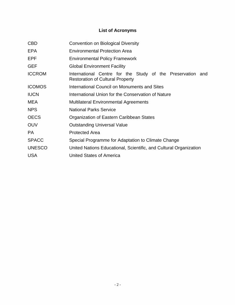
List of Acronyms CBD Convention on Biological Diversity EPA Environmental Protection Area EPF Environmental Policy Framework GEF Global Environment Facility ICCROM International Centre for the Study of the Preservation and
Restoration of Cultural Property ICOMOS International Council on Monuments and Sites IUCN International Union for the Conservation of Nature MEA Multilateral Environmental Agreements NPS National Parks Service OECS Organization of Eastern Caribbean States OUV Outstanding Universal Value PA Protected Area SPACC Special Programme for Adaptation to Climate Change UNESCO United Nations Educational, Scientific, and Cultural Organization USA United States of America
- 3 -
The use of Buffer Zone as an Adaptation Measure for Anthropogenic and Climate Change Impacts
in the Morne Trois Piton National Park and Morne Diablotin National Park 1. INTRODUCTION The Commonwealth of Dominica is participating in the Special Programme for Adaptation to Climate Change (SPACC) Project, funded by the Global Environment Facility (GEF). The objective of the SPACC project is to “… implement specific (integrated) pilot adaptation measures addressing primarily, the impacts of climate change on their natural resource base, focused on biodiversity and land degradation along coastal and near-coastal areas. This will be delivered through: (i) the detailed design of pilot adaptation measures to reduce expected negative impacts of climate change on marine and terrestrial biodiversity and land degradation; and (ii) the implementation of pilot adaptation measures” (Situation Analysis, 2009). The two project sites in Dominica are the Morne Diablotin National Park and the Morne Trois Piton National Park. Based on the range of disciplines that is required to undertake the first step in the process; that is, the evaluation and design of adaptation measures, the Government of the Commonwealth of Dominica decided to convene a Technical Forum of experts to assist with the design process. This paper discusses the potential use of one adaptation measure, the establishment of buffer zones for the two target national parks. 2. USE OF BUFFER ZONES A buffer zone is defined as “… an area surrounding the nominated property which has complementary legal and/or customary restrictions placed on its use and development to give an added layer of protection to the property. This should include the immediate setting of the nominated property, important views and other areas or attributes that are functionally important as a support to the property and its protection.” (Paragraph 104, Operational Guidelines for the Implementation of the World Heritage Convention, January 2008). As implied in the definition above, buffer zones are designed to protect the primary conservation features of a protected area, while allowing for some uses. Paragraph 103 of the Operational Guidelines makes this statement more directly, as; “Wherever necessary for the proper conservation of the property, an adequate buffer zone should be provided.”
- 4 -
That purpose is similarly stated by Article 8 of the Protocol Concerning Specially Protected Areas and Wildlife1, which states that; “Each Party to this Protocol may, as necessary, strengthen the protection of a protected area by establishing, within areas in which it exercises sovereignty, or sovereign rights or jurisdiction, one or more buffer zones in which activities are less restricted than in the protected area while remaining compatible with achieving the purposes of the protected area”. The Man and the Biosphere Programme of the United Nations Educational, Scientific, and Cultural Organization (UNESCO) is credited with institutionalising the buffer zone concept. The biosphere concept was designed to examine the sustainable use of natural resources. Each biosphere reserve is intended to fulfill three basic functions (http://www.unesco.org/mab): (a) A conservation function - to contribute to the conservation of landscapes,
ecosystems, species and genetic variation; (b) A development function - to foster economic and human development which is
socio-culturally and ecologically sustainable; (c) A logistic function - to provide support for research, monitoring, education and
information exchange related to local, national and global issues of conservation and development.
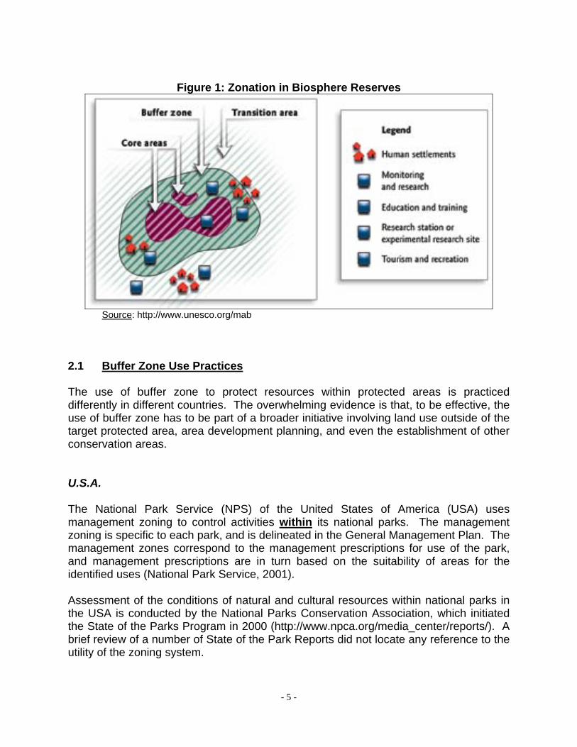
To support these three functions, biosphere reserves were organized into three zones (Figure 1):
• The core area; • The buffer zone; and • The transition zone.
In the three afore-mentioned programmes (World Heritage, Man and the Biosphere, and Specially Protected Areas and Wildlife), it is implied that buffer zones would be established outside of designated protected areas. In the case of biosphere reserves, the language is more direct, stating that “Only the core area requires legal protection and hence can correspond to an existing protected area such as a nature reserve or a national park” (http://www.unesco.org/mab). However, the practice of buffer zone use varies, and in the case of most national parks, the buffer zone is usually located within the delineated park boundary.
1 Protocol of the Convention for the Protection and Development of the Marine Environment of the Wider
Caribbean Region.
- 5 -
Figure 1: Zonation in Biosphere Reserves
Source: http://www.unesco.org/mab
2.1 Buffer Zone Use Practices The use of buffer zone to protect resources within protected areas is practiced differently in different countries. The overwhelming evidence is that, to be effective, the use of buffer zone has to be part of a broader initiative involving land use outside of the target protected area, area development planning, and even the establishment of other conservation areas. U.S.A. The National Park Service (NPS) of the United States of America (USA) uses management zoning to control activities within its national parks. The management zoning is specific to each park, and is delineated in the General Management Plan. The management zones correspond to the management prescriptions for use of the park, and management prescriptions are in turn based on the suitability of areas for the identified uses (National Park Service, 2001). Assessment of the conditions of natural and cultural resources within national parks in the USA is conducted by the National Parks Conservation Association, which initiated the State of the Parks Program in 2000 (http://www.npca.org/media_center/reports/). A brief review of a number of State of the Park Reports did not locate any reference to the utility of the zoning system.
- 6 -
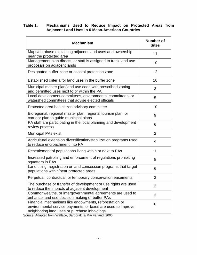
Canada Canada uses a somewhat similar park zoning system to control activities within its national parks. That zoning system consists of five zones that are pre-set in its operational policy guidelines, though every site does not necessarily contain all five zones. “The national parks zoning system is an integrated approach by which land and water areas are classified according to ecosystem and cultural resource protection requirements, and their capability and suitability to provide opportunities for visitor experiences” (Parks Canada, 1994). As with the USA, Canada also prepares State of Park Reports for national parks and State of Site Reports for national historic sites. These reports generally do not contain an assessment of the utility of the zoning system (http://www.pc.gc.ca/eng/docs). However, such reports occasionally contain information that implies that additional buffer zones are needed outside of national parks. An example is the Banff National Park. Approximately 60% of the park is bordered by other protected areas, yet its 2008 State of the Park Report noted that the increase of provincial parks in the state (as well as in the neighbouring state of British Colombia) provided “… complementary buffer areas and deflects some recreational use from the national park” (Banff National Park of Canada, 2008). Meso-America A study of land use planning and regulation in and around fifteen (15) protected areas in six (6) Meso-American countries in 2002 (Wallace, Barborak, & MacFarland, 2005) included a review of legal requirements for buffer zones. The study found the following:
• Four of the six countries possessed laws requiring the creation of buffer zones for protected areas;
• Buffer zones were often not delineated; • Clear jurisdictional guidelines and regulations regarding land use was often
lacking; and • A multiplicity of approaches was used to reduce the impacts of adjacent land use
on protected areas (Table 1).
- 7 -
Table 1: Mechanisms Used to Reduce Impact on Protected Areas from Adjacent Land Uses in 6 Meso-American Countries
Mechanism Number of Sites
Maps/database explaining adjacent land uses and ownership near the protected area 11
Management plan directs, or staff is assigned to track land use proposals on adjacent lands 10
Designated buffer zone or coastal protection zone 12
Established criteria for land uses in the buffer zone 10
Municipal master plan/land use code with prescribed zoning and permitted uses next to or within the PA 3
Local development committees, environmental committees, or watershed committees that advise elected officials 5
Protected area has citizen advisory committee 10
Bioregional, regional master plan, regional tourism plan, or corridor plan to guide municipal plans 9
PA staff are participating in the local planning and development review process 6
Municipal PAs exist 2
Agricultural extension diversification/stabilization programs used to reduce encroachment into PA 9
Resettlement of populations living within or next to PAs 1
Increased patrolling and enforcement of regulations prohibiting squatters in PAs 8
Land titling, registration or land concession programs that target populations within/near protected areas 6
Perpetual, contractual, or temporary conservation easements 2
The purchase or transfer of development or use rights are used to reduce the impacts of adjacent development 2
Commonwealths, or intergovernmental agreements are used to enhance land use decision making or buffer PAs 3
Financial mechanisms like endowments, reforestation or environmental service payments, or taxes are used to improve neighboring land uses or purchase inholdings
6
Source: Adapted from Wallace, Barborak, & MacFarland, 2005
- 8 -
Buffer Zones and World Heritage Sites The use of buffer zones in World Heritage Sites was examined at the “International Expert Meeting on World Heritage and Buffer Zones” in March 2008 (Martin and Piatti, 2009). Position papers presented by the various expert organisations and advisory bodies to the World Heritage Convention generally agreed that the primary role of the buffer zone at a World Heritage Site is the protection of the site’s Outstanding Universal Value (OUV), the primary criterion for the site’s designation. The following are the main issues identified in the position papers:
1. Absence of a buffer zone inhibits the ability of the management entity to protect the World Heritage Site from pressures originating from outside the inscribed property.
2. Zoning within an inscribed property may achieve the same goals as an
external buffer zone, assuming the boundary of the property is adequately defined.
3. The purpose of a buffer zone should be clearly established. The desired
conditions in the buffer zone should protect the outstanding universal value of the inscribed property, but not at the expense of the heritage value of the buffer zone.
4. Buffer zone boundaries can be drawn too narrowly to fully protect the
outstanding universal value of the site. All threats to the inscribed property should be identified, and the role of the buffer zone in eliminating or minimizing those threats should be clearly articulated. In that respect, the buffer zone should be seen as an important part of the inscribed property, and should be actively managed as such.
5. A buffer zone can have both negative and positive impacts. Negative impacts
arise when there is general lack of clarity concerning the policy and legislative framework, such as (a) conditions in the buffer zone are undefined, (b) rules are unclear, (c) legislation is inadequate or lacking, (d) there is inadequate policy dealing with the role and objectives of the buffer zone, (e) there are inadequate rules dealing with applicable standards, and (f) overlapping and/or conflicting institutional responsibilities are created. Benefits accrue when the buffer zone is devised as an important management tool to protect the World Heritage Site and surrounding areas. Such benefits include; (i) setting limits to protect views, settings, land uses, and other site aspects, (ii) provides a clear tool that includes maps, regulations, and standards that guides the actions of managers, policy makers, and affected communities.
6. The adoption of controls in the buffer zone that are too strict can contribute to
isolation of the inscribed property from its social, cultural, and economic context. Buffer zones designed “… in relation to social, cultural and economic
- 9 -
parameters as well as physical parameters would ensure that defined conditions would reflect all sources of the heritage values of a place” (Page 28, ICOMOS Position Paper).
7. For a buffer zone to be effective in protecting the outstanding universal value
(OUV) of an inscribed property, the following are needed: (a) a well-formulated Statement of Outstanding Universal Value, (b) identification of the site attributes that provide the OUV, (c) the desired state of conservation of the attributes that contribute to the OUV and the site as a whole, (d) a full understanding of the authenticity of the attributes and the integrity of the site.
8. The existence of a buffer zone is sometimes used to justify inappropriate
development proposals. The rationale is that the buffer zone protects the heritage property. The buffer zone is therefore treated as less important than the inscribed property, and is therefore allowed to accommodate development activity that would not be allowed in the inscribed property. Activities within the buffer zone must be compatible with sound ecological practices.
9. There is growing concern regarding the visual impact on the inscribed
property from development activities within and outside the buffer zones. Additionally, threats to the site may arise from outside the buffer zone. As such, buffer zone management should be supported by mechanisms to protect the wider setting/landscape. Buffer zone management should be part of a larger integrated planning process. Integrated planning was identified as one of the most important tools for long-term protection of world heritage sites. “Through an integrated planning process, the heritage values of the World Heritage site (as well as other heritage values in the territory) are taken into account while at the same time ensuring appropriate economic development and improved quality of life from the social, environmental, and cultural points of view. An integrated planning process may include buffer zones (not just one, but sometimes multiple ones). Conversely, an integrated planning process may render buffer zones unnecessary as they direct more intense or incompatible development to parts of the city or territory that can accommodate them” (Page 48, ICCROM Position Paper).
10. Buffer zones should be responsive to dynamic changes and challenges; such
as threats due to global warming, social and economic development, and political pressure. “Influences on historical monuments and natural sites in a comprehensive sense go beyond our understanding to date of the perimeter. Social impacts, contemporary mobility, demographic changes or new leisuretime needs can have a lasting impact on the site and its environment. Naturally, these types of considerations are outside the scope of defining regulatory requirements for protective areas. We must, however, increasingly take up these issues in order to ensure the conservation of our cultural heritage in the future” (Johann Mürner, Preface to World Heritage Report 25).
- 10 -
The IUCN Position Paper (Martin and Piatti, 2009) identified a number of functions that are required within an effective buffer zone (of a World Heritage Site):
• The effective management of buffer zone lands to maximize the protection of the values of the protected area (including the outstanding universal value of a World Heritage property) and their resilience to change.
• To maximize the connectivity of the World Heritage property/protected area with other natural lands in a landscape as a basis for responding to climate change caused biome shifts of fauna, flora and habitats – and to maximize landscape connectivity; habitat connectivity, ecological connectivity and evolutionary process connectivity.
• To integrate the World Heritage property/protected area within landscape scale conservation with community initiatives for sustainable use practices including catchment protection, the conservation of healthy environments and the realization of sustainable livelihoods.
Caribbean The situation regarding the use of buffer zones in protected areas in the Caribbean is somewhat unclear. The legislation reviewed for the preparation of this presentation did not find any stated requirement for the establishment of buffer zones for protected areas. A review of fourteen (14) management plans (comprising 8 marine parks, 3 terrestrial national parks, and 3 mixed sites) from nine (9) Caribbean countries found the following:
• Thirteen (13) sites utilized an internal zoning scheme, based either on use classes or management prescriptions (one site was too small for any zoning scheme to be applied);
• Only five (5) sites proposed the use of buffer zones; • Of the 5 sites using buffer zones, three were external, one was internal, and one
was not defined; • Of the 3 sites with external buffer zones, none had regulatory or management
control over activities taking place in the buffer zone; • All sites were responding to impacts from adjacent land uses.
The practice regarding the use of buffer zones in biosphere reserves and world heritage sites in the Caribbean is similarly unclear. There are ten (10) biosphere reserves in the Insular Caribbean (http://www.unesco.org/mab). However, there is no information on the effectiveness of buffer zones at those sites. The most recent information on the use of buffer zones in world heritage sites in the Caribbean is contained in the 2004 Periodic Report for Latin America and the Caribbean. The report noted that in July 2003 there were 14 world heritage properties in the Caribbean (currently 16 in the Insular Caribbean), and that there was 100% reporting on cultural heritage sites and 64.3% reporting on natural heritage sites (UNESCO, 2004). The report noted the following responses (for the whole Latin America and the Caribbean region) regarding the use of buffer zones:
- 11 -
• 54.1% or respondents considered the borders of the property and its buffer zone to be adequate. 34.4% considered it to be inadequate.
• 49.2% of State Parties were actively considering revision of boundaries or buffer zones. 47.5% were not considering any boundary or buffer zone revision.
Based on the submission of reports by the State Parties to the World Heritage Convention, the 2004 Periodic Report for Latin America and the Caribbean concluded that “… the concept and function of a buffer zone in support of the protection of the outstanding universal value of the property needs to be clarified” (page 22). The report formulated a Regional Action Plan for World Heritage, and the recommended actions in Heritage Conservation and Management Practices (of relevance to buffer zones) include:
• Develop or revise management plans under participatory, value-driven processes, considering new visions and criteria. Integrate these plans in territorial development and social development plans. Critical components include: risk preparedness and mitigation plans, public use plans and the prescription of means for control, protection and vigilance of significant threats such as looting, security, illegal logging, poaching, squatting, urban development and growth. Plans should also clearly define mechanisms for implementation, monitoring and evaluation.
• If appropriate, and on the basis of a review of the values and significance of a property, proceed with the re-nomination of the property. Propose revisions to the boundaries of the property if so required for its adequate conservation and management.
• Develop methodologies, criteria and guidelines for the establishment of buffer zones through the analysis of best practices, promote the discussion of new concepts and visions.
• If appropriate, revise and/or establish buffer zone limits considering a holistic analysis of socio-economic and cultural conditions; define its management in participatory processes and systematize the functionality of the areas.
2.2 Relevant Issues The role and effectiveness of buffer zones in the conservation of resources within protected areas seem to be based on a range of factors, some of which are site-specific, and some of which are related to the broader development planning processes in the particular country. The literature review identified the following issues as relevant to buffer zone management: (a) Impact of adjacent land uses – Adjacent land uses include activities that take
place in close proximity to the boundary of the protected area or within the buffer zone itself (farming, logging, hunting, development projects, recreation, etc.), those that generate byproducts that are transported to the protected area (chemicals, sediment, noise, etc.), and those uses that affect the amenity value
- 12 -
of the site (such as views). The impacts from those activities can be expressed both spatially and temporally, and thus management interventions should be based on an understanding of trends in the functioning of affected ecosystems. The migration of some species of wildlife to areas outside the protected area on a daily or seasonal basis adds another dimension to the problem. Migratory species may not be protected outside the protected area, may experience problems with their migration corridors, or may lose the feeding or nesting areas that they use outside of the protected area.
(b) Capacity and authority of the protected area (PA) management institution –
The authority of the protected area management institution usually does not extend beyond the boundary of the site. Regulation of adjacent land use is therefore the responsibility of other institutions. More often than not, the two different management regimes are designed to meet different objectives, diminishing the effectiveness of the buffer zone. The PA management institution often has limited resources, particularly financial resources. This reduces the ability of the institution to undertake routine resource management functions. Where adjacent communities depend on resources in the PA or buffer zone, lack of resources reduces the ability of the management institution to support economic initiatives that would reduce the dependence of the communities on the PA resources.
(c) Appropriateness of the policy and planning framework – Protected area
development is often not supported by an adequate policy and legal framework, the management plan (where one exists) if often not integrated into the local or regional land use plan, and sector development plans may even create increased pressure on PA resources.
(d) Increasing trend towards using protected areas to provide community
livelihoods – Increasing, protected areas are established or managed for the provision of community benefits. Within the Caribbean, the current OECS Protected Areas and Associated Livelihood Project is so focused. The previous regional project dealing with PAs, the Caribbean Regional Environmental Project, treated PAs as amenity areas. This trend is probably driven by the continued degradation of natural resources outside the boundaries of PAs.
(e) Adequacy of the institutional framework – There are usually a number of institutions that have regulatory authority affecting several aspects of protected areas development and management. In the absence of a comprehensive policy and legislative framework, overlapping (and sometimes conflicting) institutional responsibilities can reduce the effectiveness of the PA management institution, particularly with respect to buffer zone management. A 2006 review of the policy, legal, and institutional frameworks for PA management in Dominica (Gardner, 2006) identified a number of regulatory agencies whose responsibilities affected several areas of PA management. Additionally, a number of civil society institutions had PA initiatives. However, there was no
- 13 -
coordinating mechanism to facilitate collaboration among the various institutions. (f) Availability of information to support management decision making –
Information to support informed decision making by the PA management institution is usually inadequate, particularly with respect to the activities and conditions in the buffer zone. This situation has more recently been complicated by the impacts of climate change on wildlife and ecosystems.
(g) Clarity of the conceptual framework for site establishment – One of the
impacts of an inadequate policy framework is the establishment of PAs with multiple objectives, some of which are sometimes mutually exclusive. A number of PA professionals have stated concern that there is little evidence to support the concept that “sustainable use” of biological resources is compatible with biodiversity conservation in the long term.
(h) Impact of climate change – Climate change affects PAs directly and indirectly.
Directly impacts include the natural shocks (such as storms) and ecosystem impacts (such as changes in hydrological balance and temperature) that affect species of flora and fauna differentially. Additionally, climate change may exacerbate existing threats.
The literature clearly indicates that protected areas are being subjected to increasing pressure from both anthropogenic and natural factors, and management interventions must extend beyond the PA boundaries. “All but the largest protected areas exist in a wider landscape dominated by human-altered ecosystems, and even where stronger protection measures are put in place, the ecological viability of most protected areas will depend on bio-regional and local land use planning, code enforcement, efforts to instill a land (and sea) ethic, and the promotion of land and resource stewardship beyond protected area boundaries” (Wallace, Barborak, & MacFarland, 2005). Case Study: Landscape Approach to Buffer Zone Management in Nepal (extracted from Budhathoki, 2003) Prior to 1994, national parks in Nepal designed strict protection measures on the use of park resources as a strategy to reduce impact on the resources. The strict measures significantly reduced the traditional access of adjacent communities to resources within the parks, resulting in intensification of extractive activities in the areas surrounding the parks. This intensification of activities resulted in significant resource degradation and ecological damage. Additionally, increased livestock and crop depredation lead to conflicts between the parks and the adjacent communities. Despite the protection measures, there continued to be threats to biodiversity conservation. It was determined that in order to address the problem, there should be better resource management in areas outside the parks, and that such management initiatives should
- 14 -
be undertaken in conjunction with adjacent communities. The buffer zone concept was identified as an appropriate approach to creating a balance between the needs of adjacent communities and the conservation objectives of the parks, and as such, buffer zones were introduced in 1994. The buffer zones were designed to encompass the parks, forests, agricultural lands, settlements, cultural heritage resources, open spaces, and other land uses. The buffer zones were meant to function as an ecological link between the parks and the surrounding areas. As such, the extension of the conservation approaches from the parks to buffer zones promoted sustainable resource uses in the areas outside the parks. Buffer zone management was based on a principle of community engagement, partnership development, and community development, articulated as the development of four capitals at the local level:
• Social Capital – “motivating, organizing and mobilizing community men and women into self-governing, self-functioning and self-reliant community organizations”;
• Financial Capital – “encouragement to mobilize capital resources through the promotion of community saving schemes”;
• Human Resource/Capital – “enhancing capacity of community organizations through training and skills”; and
• Environmental Capital – “entrusting resource users with the rights to manage natural resources/environmental governance”.
Reviews of the use of buffer zones in Nepal determined that they generated positive results, including:
• Increased cooperation from the communities in addressing problems such as grazing and wood theft;
• By 2003, approximately 20% of the user groups supported park authorities in protecting wildlife (including detection of poachers);
• By 2000, park offences had decreased by 38% compared with 1994; • Initiatives in the buffer zones had resulted in increased forest cover, wildlife
populations, and income from forests; • By 2003, 40% of the user groups were self-sufficient in forestry resources; • Positive changes in social indicators, such as per capita income; • Generation of community capital (approximately US$600,000.00 in five years); • Increase participation of women in conservation initiatives;
The author of the case study noted that there were still gaps between policy and practice (in 2003), but that the practices were innovative and progressive. The strengths of the buffer zone programme are said to be “… well-formulated policy frameworks and a well-tested and balanced implementation strategy”.
- 15 -
3. CLIMATE CHANGE AND PROTECTED AREAS It is projected that climate change will impact ecosystems in the Caribbean in the following ways:
• Increased frequency and intensity of storms, resulting in more structural damage to ecosystems, increased flooding, and greater loss of soils.
• Increased average temperature, resulting in stresses on particular faunal species.
• Longer dry seasons, resulting in a changed hydrological balance, with secondary impacts on flowering plants.
• Migration of species in reaction to water, food, or habitat disturbances, with the possibility of increased mortality levels.
• Changed biodiversity as vulnerabilities of native species increase or invasive species become more competitive.
It has been projected that the greater the current stresses on ecosystems, the greater will be the impact of the stresses from climate change. The major threats that reduce the ability (resilience) of natural systems to cope with climate change were identified (Taylor and Figgis, 2007) as:
• Land clearing and resulting loss and fragmentation of core habitats and migration corridors;
• Unsustainable extractive land use activities; • Changed hydrology and extraction of water; • Invasive weeds and animal pests; • Inappropriate fire regimes (intensities, frequencies and timings).
The report recommends that an appropriate response is the adoption of a precautionary approach that prevents additional land clearing or intensification of uses in natural areas. Establishment of protected areas is one option. “However protected area boundaries rarely contain all necessary elements of high conservation value native ecosystems and must be managed in conjunction with adjoining lands. Some threats like feral pests and weeds can only be managed both on and off reserves. Continuance of threats through poor management practices on adjacent off-reserve lands can detract from the protection provided by the reserve system”. The World Heritage Centre (2007) noted that the following types of protected areas are at risk from climate change:
• Small and/or isolated protected areas; • Protected areas with high-altitude environments; • Protected areas with low-altitude environments; • Protected areas with rare or threatened species with restricted habitats or home
ranges; • Protected areas with species at the limits of their latitudinal or altitudinal range; • Protected areas with abrupt land use transitions outside their boundaries; • Protected areas without usable connecting migration corridors;
- 16 -
• Protected areas with rare or threatened species near the coast; • Protected areas with interior wetlands.
It was noted that buffer zones can provide part of the response by protected areas to climate change impacts. However, the point was made that additional space and connectivity to other conservation areas would be needed in order to adapt to change or facilitate migration by species as necessary. “Climate Change impacts should therefore be considered as a factor when considering the requirements for, and design of a buffer zone. Extensions to buffer zones and new management measures should also be actively considered for existing properties. However, other measures (such as conservation corridors), and national and regional scale connectivity strategies should also be considered as part of the nomination process” (Martin and Piatti, 2009). 4. POLICY AND LEGAL FRAMEWORK FOR BUFFER ZONES IN DOMINICA The policies for protected area management in Dominica are not contained in a unified, clear framework. In 1979, the Forestry Division prepared the “Dominica Forest and Park System Plan” (Shanks and Putney, 1979). The report rated land for conservation purposes according to their forestry and agricultural capability, as habitat for endangered wildlife, domestic water catchments, and unique natural features. The document also articulated the land management objectives for the forest and park system, proposed the categories of units to be included in the system, and described thirteen (13) sites proposed for inclusion in the system. The objectives listed in the 1979 Forest and Park System Plan are:
• Maintain sample ecosystems in a natural state. • Maintain ecological diversity and environmental regulation. • Provide education, research, and environmental monitoring. • Preserve genetic resources. • Regulate streamflow, prevent flooding. • Control erosion and water pollution. • Produce protein from wildlife, sport hunting and fishing. • Provide timber and forage on a sustained-yield basis. • Provide recreation and tourism opportunities. • Protect cultural or historical sites. • Retain scenic beauty and green areas.
The 1979 Forest and Park System Plan therefore provides a basis for discussion by articulating the objectives for a system of protected areas for Dominica. However, in addition to the non-inclusion of marine protected areas, more recent work on guidelines for preparation of national protected areas system plans suggest that the 1979 plan needs to be updated. Sector and sub-sector plans and strategies (such as those for tourism and forestry)
- 17 -
contain areas of focus and specific initiatives that have implications for protected areas development. The draft National Environmental Management Strategy for Dominica also contains initiatives that will be relevant to protected areas development. None of the above-mentioned policy guidance includes any provision for buffer zone establishment and management. The multilateral environmental agreements (MEAs) directly relevant to protected areas that have been signed by the Government of Dominica are:
• Convention concerning the Protection of the World Cultural and Natural Heritage (World Heritage Convention), ratified 1995; and
• Convention on Biological Diversity (CBD), ratified 1994. Other multilateral environmental agreements of relevance to specific operational aspects of protected areas management (such as pollution control) include:
• Convention on International Trade in Endangered Species of Wild Fauna and Flora;
• Framework Convention on Climate Change; • United Nations Convention to Combat Desertification; • United Nations Convention on the Law of the Sea; • International Convention on Civil Liability for Oil Pollution Damage; • Convention for the Protection and Development of the Marine Environment in the
Wider Caribbean Region (Cartagena Convention); and • Protocol Concerning Cooperation in Combating Oil Spills in the Wider Caribbean
Region (Protocol under the Cartagena Convention). The World Heritage Convention and the CBD have both impacted national protected areas programming, such as with the preparation of a national biodiversity strategy and action plan as required under the CBD. The Morne Trois Pitons National Park was inscribed as a World Heritage Site in 1997, even though Dominica has not submitted a Tentative List as required by the World Heritage Convention. However, though there is no national world heritage programme, there are a number of initiatives dealing with cultural resources protection. Of the MEAs ratified by Dominica that are relevant to protected areas, only the World Heritage Convention has provision and guidance for the establishment of buffer zones. The legal framework for protected areas development and management in Dominica contains a range of legal instruments, administered by a number of agencies. The primary laws under which protected areas can be designated are:
• Forest Act, 1958 (Amended by Act 12 of 1990) • National Parks and Protected Areas Act, 1975 • Forestry and Wildlife Act, 1976 • Fisheries Act, 1987 • Physical Planning Act, 2002.
- 18 -
In addition, there are 14 other laws that could impact on protected areas operations in some form (Gardner, 2006). The review noted that the legal framework was inadequate, and needed to be updated to address a wide range of concepts and practices applicable to protected area development. None of the laws contains provisions for buffer zone management. 5. IMPACTS IN THE TWO TARGET PROTECTED AREAS The Situation Analysis prepared under the Special Programme for Adaptation to Climate Change (SPACC) Project identified the anthropogenic impacts in the areas adjacent to the Morne Trois Piton National Park as:
• Tree cutting for charcoal production – the extent of the problem has not been determined.
• Slash and burn cultivation – anecdotal information indicates that the practice generates significant negative impact on wildlife, but no supporting data is available.
• Increased residential development – sediment and other pollutants are transported through drainage channels and rivers, resulting in damage to water catchments and disruption of water supply during major rainfall events.
• Tourism visitation – there is no available information on the impact of tourism visitation to the national park, although a preliminary study recommends improved visitor management.
Emerald Pool-Dominica, August 1, 2000
The Situation Analysis identified the anthropogenic impacts in the areas adjacent to the Morne Diablotin National Park as:
• Extraction of wood for fuel – the extent of the problem is unknown. • Slash and burn cultivation for subsistence crops – there is some debate as to
- 19 -
whether or not the problem is significant, but no data is available. • Hunting for subsistence purposes – said to result in negative impacts on wildlife
species, although the severity of the problem has not been quantified. Conversely, the parks themselves are said to be having a negative impact on the surrounding communities, as the two main species of parrots, particularly the Jaco (Amazonia arausiaca), are causing damage to citrus crops. Of the range of natural hazards affecting Dominica, the ones applicable to the two national parks are storms, earthquakes, volcanic eruptions, landslides, and flooding from extreme rainfall events. Several of those natural hazards are expected to be exacerbated by climate change. The following impacts are anticipated:
• Hurricane damage – resulting in wildlife mortality, habitat loss, and reduction of food supply for wildlife species.
• Increased intensity of rainfall events – resulting in increased levels of soil erosion and increased incidences of landslides. Flooding from such events will also cause damage to park and social infrastructure.
• Longer dry seasons – resulting in lower average flows in streams, with associated impacts on freshwater fauna. Longer dry seasons will also reduce the regeneration rate for cleared forest plots, and increase the potential for spread of invasive species of plants.
• Increased pest and disease outbreaks – the impact of the fungal disease chytridiomycosis on the population of Mountain Chicken (Leptodactyllus fallax) has not been directly linked to climate change. However, the theory has been advanced that increased temperature due to climate change is the main reason behind the spread of the fungus.
• Changed rainfall patterns – is expected to affect the flowering times of flora within the parks, reducing the availability of food for wildlife species at critical times in their life cycles. Changes in the flowering/fruiting season for some of the food trees for the parrots have already been observed (Situation Analysis).
Information Gaps There are significant gaps in the information needed to undertake detailed buffer zone management planning for the two national parks. Information gaps include: (a) Anthropogenic Impacts:
• Residents – types of activities, use patterns, levels, number of persons, contribution of park resources to household income, impacts on wildlife species, introduction of non-native or pest species.
• Recreation (tourists) – data on use patterns, levels, and impact. • Recreation (residents) – only data available is for visits to eco-tourism sites.
(b) Climate Change Impacts:
• Individual species – fecundity, adaptive ability, etc.
- 20 -
• Habitat functioning. • Acreage/corridors needed for ranging animals. • Food availability. • Species diversity.
(c) Ecology
• Flora – No extensive survey of the flora within the parks has been carried out. A list of mainly woody species from the western slope of the Morne Diablotin National Park includes approximately 180 species, but many other species have yet to be recorded (Morne Diablotin management plan).
• Fauna – Only the higher invertebrates have been documented in the Morne Diablotin National Park. Invertebrates, such as freshwater shrimp and freshwater and terrestrial crabs, occur in the park, but no collection has been made. There are 24 species of butterflies identified in the park, but fishes have not been studied (Morne Diablotin management plan).
• Ecological processes – no study in either site. • Impact of feral animals (pigs and rats) on wildlife populations • Extent of impact of diseases – Mountain Chicken afflicted with fungal disease
(chytridiomycosis) (Situation Analysis).
- 21 -
6. POSSIBLE APROACHES TO BUFFER ZONE MANAGEMENT IN DOMINICA The 2003 national submission to the Periodic Report for World Heritage in Latin America and the Caribbean (Commonwealth of Dominica National Commission for UNESCO, 2003) contained a section that identified a number of policy and legal reforms needed for the Morne Trois Pitons World Heritage Site, including:
• Integration of policy and administrative management towards best and ethical practices in the conservation and sustainability of natural and cultural sites;
• Regulations to prevent the illicit removal of cultural and natural heritage from sites;
• Review and upgrade legislation and the enactment of new regulations dealing with development control, in particular, as it relates to tourism and visitor management;
• Enforce legislation to eliminate or control damaging or inappropriate land use within and around the natural and cultural heritage site;
• Enforcement of conservation policy and practices in the management of archaeological, historical sites and monuments;
• Coordination and harmonization of policies and legislation that is fragmented and spread across several ministries;
• Pursue land use policies and legislation to activate a Buffer Zone (continue to work in close collaboration with Physical Planning Division and land-owners); and
• Rectify current situation of insufficiently trained and specialized personnel to implement legislations.
The needs stated above are underscored by the intent of the management plan for the Morne Diablotin National Park to establish a buffer zone approximately 2 kilometres wide around the park. 6.1 Possible Approaches to Buffer Zone Establishment As shown above, there is a stated intent to establish buffer zones for the two sites. Based on land ownership in the areas adjacent to the sites and the proximity of communities, the placement of the buffer zone has to be carefully considered. The buffer zone can be established either inside or outside the current boundaries of the two national parks. The primary issue is the minimum size needed to protect the integrity of the values contained within the designated area. If either of the buffer zones is to be established within the boundary of a site, and the boundary is currently drawn too tightly to protect the values of the site, then it will be necessary to expand the boundary of the site. In such a scenario, the government may acquire the incorporated properties. If there is no land acquisition, any loss of benefits by the private landowner will, under the laws of Dominica, require compensation to be paid by the Government of the Commonwealth of Dominica. The experience with buffer zones in other countries suggests that a buffer zone by itself
- 22 -
cannot fully protect the values within a designated area. As such, it is important to consider the design of the buffer zone as well as the need for supporting initiatives. The following approaches to buffer zone development can be supported by current policy, legislation, or practice:
• Establish a Biosphere Reserve around the two target protected areas – The underlying concept for establishment of biosphere reserves provides an appropriate framework for development of a buffer zone for the two target national parks. The biosphere reserve approach matches the current scenario surrounding the target parks, involving; (a) community economic development, (b) natural resources conservation, and (c) research and education.
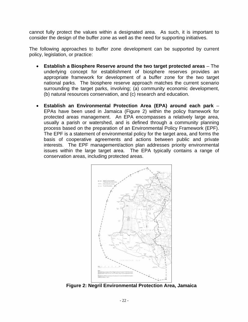
• Establish an Environmental Protection Area (EPA) around each park –
EPAs have been used in Jamaica (Figure 2) within the policy framework for protected areas management. An EPA encompasses a relatively large area, usually a parish or watershed, and is defined through a community planning process based on the preparation of an Environmental Policy Framework (EPF). The EPF is a statement of environmental policy for the target area, and forms the basis of cooperative agreements and actions between public and private interests. The EPF management/action plan addresses priority environmental issues within the large target area. The EPA typically contains a range of conservation areas, including protected areas.
Legislative support for EPAs in Dominica is provided by Sections 56-59 of the Physically Planning Act (2002). An EPA can be declared independently of any development plan, and takes into consideration environmental and community issues. It also addresses the matter of private lands within an EPA. While an EPA has not yet been declared in Dominica, EPAs have been declared in Saint Lucia, based on similar legislation. In the case of Saint Lucia, one of the sites is the Pitons Management Area, a World Heritage Site.
• Establish Protected Forests around each site – Legislative support for
protected forests is provided by the Forest Act (No. 25 of 1958, as amended by Act 12 of 1990). However, while this approach may prove useful, it is based on a negotiated arrangement with private land owners. More importantly, it will not be applicable to lands currently under other land uses, unless the landowners will undertake aforestation projects.
A range of initiatives will be needed to support buffer zone development and management. Such initiatives could take a number of forms, and the appropriate mix of actions has to be decided. Initiatives could include the following: • Land swap deals – Some private land owners may not support any initiative that
affects how they use their lands, and as such, incorporation of private lands into a buffer zone may require compensation. Land exchanges between the government and private landowners can bring land more completely within the control of the park management institution, as well as reduce the associated financial outlays by the government. This depends on the availability of public lands for such exchanges, as well as the willingness of the government and affected parties to participate in such a programme.
• Transfer of development rights/densities – The 2002 land use study around protected areas in Meso-America (Wallace, Barborak, & MacFarland, 2005) found that permanent conservation easements were successfully used as a conservation tool. The project also identified legislation that supported the transfer of development rights from areas needing protection to areas designated for more intense development. Costa Rica was noted in the study as the best example of how to develop compensation schemes to support the afore-mentioned initiatives. The government used “… a combination of debt for carbon swaps, a fuel tax, and international donations …” to establish an environmental service payment system. Payments are said to be prioritized based on the buffering and corridor functions of the eligible private lands. Within the Caribbean, proposals for establishment of conservation easements usually revolve around the reduction of property taxes, rather than an actual payment to the private land owner.
• Establish integrated watershed management programme – There is a rich
history of watershed management in the Caribbean. Such programmes have included initiatives such as forestry management, ecosystem management,
- 24 -
community development, and pollution reduction. Given the issues identified as relevant to the two target areas, relevant lessons from other countries could be added to the experience in Dominica.
• Establish rural development programme – Rural development programmes are usually used to address a range of development needs for rural/farming communities. More recently, these have included community-managed forests, tourism, and protected areas. A rural development programme would complement the dual objectives of community livelihoods and natural resources management. In regard to buffer zone management, this type of programme would facilitate the shifting of some economic activities from the areas adjoining the protected area to areas designated for more intensive uses.
• Develop new land management practices – Land use practices generate adverse impacts on the target protected areas. In order to ensure integrity of protected areas resources, and improve resilience to climate change, land use practices have to be improved. Best practices include land clearance measures, use of soil erosion measures, use of storm water management methods, road construction methods, building design and location, and waste reduction practices.
• Adopt new resource management practices and tools – The ICCROM Position Paper (Martin and Piatti, 2009) identified a number of tools, which could be used by themselves or in conjunction with buffer zones, to protect the Outstanding Universal Value of world heritage sites. These include:
Statement of Outstanding Universal Value – when adopted as part of a site management plan, the statement provides guidance to planners and developers on the compatibility of proposed development with the values of the inscribed property.
Field of View / Viewshed Analysis – viewshed analysis is typically used by landscape architects and planners to predict the visual impact of a proposed activity. As most natural heritage sites contain a significant landscape component, the use of this technique would reduce the visual impact of developments on the target protected areas.
Integrated Planning – The Position Paper identified integrated planning as “… probably the most important tool to be considered”. Integrated planning is a proactive approach that incorporates social, environmental, and economic development strategies.
Historic Urban Landscapes – For cultural heritage sites, use of the historic urban landscape approach facilitates integrated planning that takes into account future changes in the landscape. As such, both protection of historic values and facilitation of continued compatible development are ensured.
World Heritage Impact Assessment – Similar to environmental impact assessment and cultural impact assessment, world heritage impact assessment would measure the impact of development projects on world heritage sites. This would necessarily mean that certain projects outside of
- 25 -
the buffer zone may be subjected to this particular type of assessment. Other tools for extractive and non-extractive uses of the protected areas have to be developed to ensure that such uses do not create negative impacts on the ecological integrity of the park and buffer zone resources, including their resilience to climate change impacts.
7. MAIN DESIGN ISSUES There are clearly several possible approaches to buffer zone development for the two national parks. As the guidance for biosphere reserves indicate, a zonation scheme can be applied flexibly to “… accommodate geographic conditions, socio-cultural settings, available legal protection measures and local constraints”. Using the above guidance, the following issues should be considered in buffer zone design and establishment: (a) Legal Framework – Though the existing laws do not contain provision
specifically for buffer zone development, they support several possible approaches (Section 6.1). The determination of which law to use as the legal basis for buffer zone development is itself contingent on the socio-political ramifications of buffer zone development. Regardless of the principal legislation used, new regulations will have to be promulgated to support the range of management interventions, participatory processes, and community development strategies to be developed as part of a buffer zone management programme.
(b) Cost – Costs would include land acquisition or compensation for loss of development opportunities, monitoring equipment, personnel, community development initiatives, etc.
(c) Applicability – Any selected approach has to be applicable within the current social and political context. Not only must the benefits of any approach be clearly articulated, affected communities and land owners must understand and trust the process. Additionally, affected groups and individuals must be able to participate actively in the process.
(d) Utility – A range of factors should be considered in the determination of whether or not a particular design has the potential for successful application; including: • Scope (spatial and temporal) of existing and potential future impacts at the
target site; • Site attributes (natural barriers, ease of access, etc.); • Availability of information needed for detailed design, including the potential to
capture necessary (but unavailable) information in a reasonable timeframe; • Size of the protected area in relation to the surrounding landscape (proximity
of settlements, industrial activities, etc.); and
- 26 -
• In the case of Morne Trois Piton National Park (the World Heritage Site), the necessity to protect the Outstanding Universal Value and integrity of the site.
(e) Ownership of the Buffer Zone Development Process – Successful buffer
zone development and management is apparently based on collaborative institutional arrangements. However, experience dictates that a single institution must be charged with the responsibility for implementation of the process. Such an institution must be credible, be able to institutionalise the concept and practices of collaborative resource management and development planning, and be able to convey successfully the importance and benefits of the process to the various stakeholders.
(f) Implementation Strategy – The implementation strategy will be influenced significantly by the capacities and capabilities of the lead and collaborating institutions (including community groups). Programme design should take into consideration whether implementation will focus on the full programme or initially on selected critical elements. If using an incremental implementation strategy, then it should be clear whether the selected elements are being implemented for their demonstration values or for generation of the benefits most important to the overall adaptation strategy.
Possible Next Steps The Forum may wish to consider the following steps in the design of the buffer zone development strategy for the two target sites: 1. Select option for intervention – primary objective, approach, appropriate mix of
actions.
2. Select lead institution (and clarify roles for identified collaborating institutions).
3. Meet with communities to discuss reason for intervention, process to date, objectives, and proposed approach.
4. Design intervention.
5. Draft implementation plan. 6. Facilitate development of community collaborative mechanisms (e.g. community
groups and one overall Buffer Zone Development Council/Committee).
7. Finalise design of intervention and implementation plan.
8. Initiate plan.
- 27 -
References Banff National Park of Canada. 2008. State of the Park Report. Parks Canada. Budhathoki, Prabhu. 2003. ‘A Category V Protected Landscape Approach to Buffer Zone Management in Nepal’, in Parks. Vol. 13, No. 2. IUCN. pp 22-30. Commonwealth of Dominica National Commission for UNESCO, 2003. Section I: Application of the World Heritage Convention by the State Party. Periodic Reporting Exercise on the Application of the World Heritage Convention. Gardner, Lloyd. 2006. Review of the Policy, Legal, and Institutional Frameworks for Protected Areas Management in Dominica. Environment and Sustainable Development Unit, Organisation of Eastern Caribbean States. Martin, Oliver and Giovanna Piatti (Ed.) 2009. World Heritage and Buffer Zones. World Heritage Paper 25. United Nations Educational, Scientific, and Cultural Organization. National Park Service. 2001. Management Policies 2001. U.S. Department of the Interior. Parks Canada. 1994. Parks Canada: Guiding Principles and Operational Policies. Shanks, David, L. and Allen D. Putney. 1979. Dominica Forest and Park System Plan. Eastern Caribbean Natural Area Management Program and Dominica Forestry Division. Special Programme for Adaptation to Climate Change (SPACC) Project. 2009. Situation Analysis. Government of Dominica. Final Draft, 9/4/2009. Taylor M. & Figgis P. (Eds). 2007. Protected Areas: Buffering Nature Against Climate Change. Proceedings of a WWF and IUCN World Commission on Protected Areas symposium, 18-19 June 2007, Canberra. WWF Australia, Sydney. United Nations Educational, Scientific, and Cultural Organization. 2004. The State of the World Heritage in Latin America and the Caribbean: 2004 Periodic Report. UNESCO office in Montevideo. Wallace, George N., James R. Barborak, and Craig MacFarland. 2005. ‘Land use planning and regulation in and around protected areas: a study of legal frameworks, best practices and capacity building needs in Mexico and Central America’, in Natureza & Conservação - vol. 3 - n.2 - October 2005 - pp. 147-167. World Heritage Centre. 2008. Operational Guidelines for the Implementation of the World Heritage Convention. United Nations Educational, Scientific, and Cultural Organization. January 2008
- 28 -
World Heritage Centre. 2007. Climate Change and World Heritage: Report on Predicting and Managing the Impacts of Climate Change on World Heritage and Strategy to assist States Parties to Implement Appropriate Management Responses. World Heritage Report 22. UNESCO. http://whc.unesco.org http://www.unesco.org/mab www.dominica.gov.dm