DEPARTMENT OF THE INTERIOR UNITED STATES GEOLOGICAL SUKVEY GEORGE OTIS SMITH,-DIRECTOR BULLETIN 452 THE LANDER AND SALT CREEK OIL FIELDS WYOMING THE LANDER OIL FIELD, FREMONT COUNTY BY E. G. WOODKUFF THE SALT CREEK OIL FIELD, NATRONA COUNTY BY. C. H. WEGEMANN WASHINGTON GOVERNMENT PRINTING OFFICE 1911
Transcript
DEPARTMENT OF THE INTERIOR
UNITED STATES GEOLOGICAL SUKVEYGEORGE OTIS SMITH,-DIRECTOR
BULLETIN 452
THE
LANDER AND SALT CREEK OIL FIELDSWYOMING
THE LANDER OIL FIELD, FREMONT COUNTYBY
E. G. WOODKUFF
THE SALT CREEK OIL FIELD, NATRONA COUNTYBY.
C. H. WEGEMANN
WASHINGTONGOVERNMENT PRINTING OFFICE
1911
CONTENTS.
THE LANDEB OIL FIELD, by E. G. Woodruff:.Page.
Introduction____________________________________ 7Location and extent of the field________________________. 7Topography ___ _ __ 8Geology __________ __ ________________________ 10
Stratigraphy___________________________________ 10General features_ 10Detailed descriptions of the formations___________ 12
Salt Creek anticline_________________________ 54Salt Creek dome__________ ______________ 55
General character_________________________ 55Faults in the Salt Creek dome_________________ 56
Teapot dome _______________________ _______ 57General relations of the Salt Creek anticline____________ 58Bothwell syncline_______________________;______ 58Powder River anticline_______ __ _____ _ 50Structure contours_________ __________________ 59
Methods of field work_______________________:_______ 62Horizontal control __ _ _ _ 62Vertical control____ ________ ___ ___i_ 64
Land surveys___ _________ _ ____ 64The oil sands__________________ _________________ 65
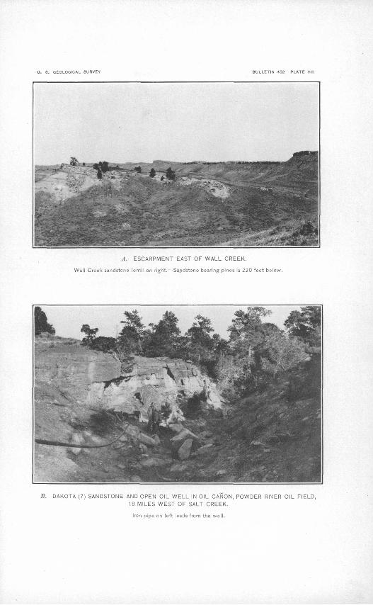
Shannon sandstone lentil______________________ 65Character and thickness '. 65Wells that obtain oil from the Shannon sand____^______ 68
The Franco-American Co.'s wells_______ _______ 68The Ascos wells ________________________ 69
Wall Creek sandstone lentil____________ _ ____ 71Outcrops and thickness______ _ _ __ 71Oil seeps________________ ___ ________ 72Wells that obtain oil from the Wall Creek sand__________ o 72
Dutch well No. 1__________________________ 72Iba well____________ - __ 73
Other wells of the Dutch Co____________ _______ 74Well of the Stock Oil Co________________________ 74Wells of the. California Oil Co__________ __ 74
Dakota sandstone________ _ ' _ 75Relation of oil to the anticline_____ '. 76Origin of the oil_______-__-__ - - 78Analyses of the oil __ _ ' 79Bibliography '- __ 83
INDEX , , .----- ' - S5
ILLUSTRATIONS.
Page. PLATE I. Map of Lander oil field____:_________________ In pocket
II. General view of beds forming the anticline in the Lander oil field- 16III. A, View of anticline in Little. Popo Agie district, Lander oil
field, looking northwest across Twin Creek; B, Diagram ex plaining structure and stratigraphy of anticline in Little Popo Agie district__:______:_____:__ ______ 24
IV. View in the Little Popo Agie'district________________ 26V. Sections of wells in the Lander oil field____________'____ 32
.VI. View of drill rigs in the Lander oil field_____________ 32VII. Map of Salt Creek oil field___________________ In pocket
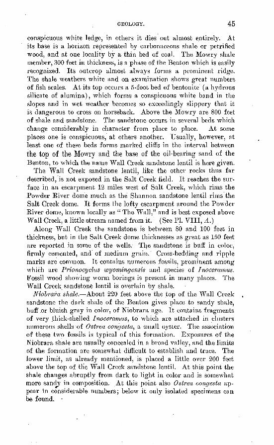
VIII. A, Escarpment of Wall Creek sandstone lentil; B, Dakota (?)sandstone and open oil well____________________ 44
I.. A, Massive sandstone at base of Parkman sandstone member of the Pierre formation; B, Little Pine Ridge, sec. 7, 1. 38 N., 11. 78 W__________________________________ 48
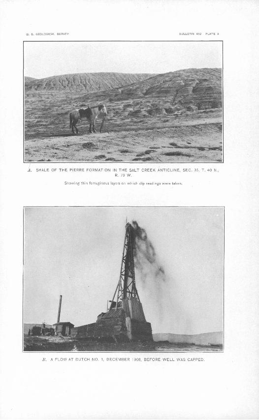
X. A, Shale of the Pierre formation in the Salt Creek anticline;B, A flow at Dutch well No. 1___.________ ______ 60
XI. A, Shannon sandstone lentil 1£ miles south of Shannon; B, CastleRock, Shannon sandstone lentil.__________;________ 66
XII. Map showing location of oil wells at Shannon___________ 68 FIGXJKE 1. Columnar section showing the geologic formations in the Lander
oil field____________'_____________________ 11
THE UNDER OIL FIELD, WYOMING.
By E. G. WOODRUFF.
INTRODUCTION.
This report is based chiefly on field work done in July and August, 1909, by a party under the direction of the writer. Dean E. Win chester, chief assistant in the party, has given valuable aid, both in collecting data in the field and preparing it for publication. Other members of the field party were Sam V. Eakin, A. J. Jarrett, and Frank J. Hindera. The writer is indebted to operators and others who are either financially or scientifically interested in the develop ment of the field, especially to E. W. Hainsworth, C. W. Carlisle, N. H. Brown, of Lander, and A. A. Cypert, of Dallas, who furnished information relating to the development, production, and history of the field.
LOCATION AND EXTENT OF THE FIELD.
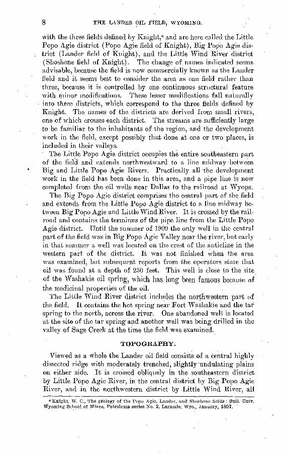
The Lander oil field is a rectangular area in central Wyoming 39 miles long and from 3 to 11 miles wide, embracing 200 square miles. It lies in Fremont County and extends N. 30° W. from near the middle of T. 31 N., R. 98 W., sixth principal meridian, to T. 2 N., R. 1 W., Wind Kiver meridian. The location and extent of the field are shown on Plate I (in pocket). Lander is the largest town arid the principal trading point in the region. It is the terminus'of the Wyoming & Northwestern Railway (Chicago & Northwestern sys tem) and the point from which stage lines start northwest and south east across the field. Hudson is a coal-mining town in the valley of Big Popo Agie River, on the northeastern side of the field. Fort Washakie and Wind River are trading posts in the north western part of the area, and Dallas is a post office at a ranch house in the southeastern district. The part.of the field northwest of Big Popo Agie River is in the Shoshone Indian Reservation, and devel opment in that area can take place only under lease from the Indians and subject to the regulations of the United States Office of Indian Affairs.
For convenience in description the field is divided into three dis tricts, which coincide in a general way with the three natural and commercial subdivisions of the field. These- districts also coincide
7
8 THE LANDER OIL FIELD, WYOMING.
with the three fields defined by Knight,a and are here called the Little Popo Agie district (Popo Agie field of Knight), Big Popo Agie dis trict (Lander field of Knight), and the Little Wind Eiver district (Shoshone field of Knight). The change of names indicated seems advisable, because the field is now commercially known as the Lander field and it seems best to consider the area as one field rather than three, because it is controlled by one continuous structural feature with minor modifications. These lesser modifications fall naturally into three districts, which correspond to the three fields defined by Knight. The names of the districts are derived from small rivers, one of which crosses each district. The streams are sufficiently large to be familiar to the inhabitants of the region, and the development work in the field, except possibly that done at one or two places, is included in their valleys.
The Little Popo Agie district occupies the entire southeastern part of the field and extends northwestward to a line midway between Big and Little Popo Agie Rivers. Practically air the development work in the field has been done in this area, and a pipe line is now completed from the oil wells near Dallas to the railroad at Wyopa.
The Big Popo Agie district comprises the central part of the field and extends from the Little Popo Agie district to a line midway be tween Big Popo Agie and Little Wind River. It is crossed by the rail road and contains the terminus of the pipe line from the Little Popo Agie district. Until the summer of 1909 the only well in the central part of the field was in Big Popo Agie Valley near the river, but early in that summer a well was located on the crest of the anticline in the western part of the district. It was not finished when the area was examined, but subsequent reports from the operators state that oil was found at a depth of 250 feet. This well is close to the site of the Washakie oil spring, which has long been famous because of the medicinal properties of the oil.
The Little Wind River district includes the northwestern part of the field. It contains the hot spring near Fort Washakie and the tar spring to the north, across the river. One abandoned well is located at the site of the tar spring and another well was being drilled in the valley of Sage Creek at the time the field was examined.
TOPOGRAPHY.
Viewed as a whole the Lander oil field consists of a central highly dissected ridge with moderately trenched, slightly 'undulating plains on either side. It is crossed obliquely in the southeastern district by Little Popo Agie River, in the central district by Big Popo Agie River, and in the northwestern district by Little Wind River, all
"Knight, W. C., The geology of the Popo Agie, Lander, and Shoshone fields: Bull. Univ. Wyoming School, of Mines, Petroleum series No. 2, Larainie, Wyo., January, 1897.
TOPOGRAPHY. 9
of which rise high in the Wind River Mountains, flow down the slopes in deep-cut canyons, and cross the field in their course to Wind River, the trunk stream of the region. Besides these streams, Twin
. Creek enters the southeastern district from the east and after cross ing the axis of the field in a narrow canyon turns along the strike of the beds and floAvs northwestward to Little Popo Agie River. Simi larly Sage Creek enters from the west near the northwestern end of the field, crosses the beds on that side of the anticline in a diagonal course, and flows southeastward to Little Wind River.
The topographic expression of the field is believed to. have resulted from the erosion of a plain composed of loose material that once covered the area at a much higher altitude than the present surface and sloped northwestward from the mountains toward the interior of the Wind River Basin. Streams whose courses approximately coincide with the present ones rose on the high mountains and flowednortheastward across this field. They gradually removed the Surface covering of loose material and became superimposed upon the lower harder beds. At this stage the harder rocks which had been folded previously in the central part of the area resisted erosion more than the softer beds on both sides and in consequence a ridge was developed on the hard rocks along the axis of the field and plains Avere formed on both sides. Furthermore, in the shale beds which lay on both sides of the hard core, erosion is progressing rapidly at this time; conse quently the main streams occupy channels in gorges, or have only small flood plains, and the lateral branches are in trenches. As a re sult of these conditions the central part of the field is rough. It con sists of many sharp-crested steep-sided ridges carved by numerous ravines. The plains on either side possess an undulating surface intersected here and there by narrow steep-sided gorges. Roads and various culture features are controlled by this topography and di rected along two lines. The first line extends in the direction of the axis of the fold, because the strike ridges prevent easy passage across the fold, except where it has been cut by the main streams. The sec ond direction in which progress is possible is along the valleys of the larger streams transverse to the ridges. (See PI. I, in pocket.)
The topography and the culture shown on the map were prepared from data collected by the field party. The survey was accomplished by means of the plane table, telescopic alidade, and stadia rod. Ver tical control is based primarily on United States Geological Survey bench marks, one line of which extends along Little Wind River and another from Lander to Dallas, and also on the profile of the Wyo ming £ Northwestern Railway, Avhich crosses the central district. From these base lines altitudes were determined instrumentally at short intervals and the topography was sketched.
10 THE LANDER OIL FIELD, WYOMING.
GEOLOGY.
STRATIGRAPHY.
GENERAL FEATURES.
The strata exposed at the surface in this field belong to the Triassic (?), Jurassic, Cretaceous, Tertiary, and Quaternary systems. Below the Triassic (?) are rocks of Permian (?) and Pennsylvanian age, which do not outcrop in the field but are exposed on the slope of Wind River Mountains and dip under the field. They are entered by some of the oil wells and are believed to be the source of most, if not all, of the oil, and are therefore included in the discussion of the stratigraphy of the field.
The following table shows the relations of these formations:
Geologic formations in the Lander oil field.
Era.
Ceno- zoic.
Meso- zoic.
Paleo zoic.
System.
Quaternary.
Tertiary.
Cretaceous.
Jurassic (?).
Jurassic.
Triassic (?).
Carboniferous.
Series.
Recent.
Eocene.
Unconformity.
Upper Creta ceous.
Lower Creta- ceous (?).
P e n n s y 1 v a- nian, with Permian (?) at top.
Group.
Montana.
Colorado.
Formation.
Wind River for mation.
Mesaverde for-" mation.
Mancos shale.
Dakota sand stone.
Morrison forma tion.
Sundance for mation.
Chugwater for mation ("Red Beds").
Embar forma tion.
Character.
Alluvium.
Sandy shale, shaly sandstone, and local beds of con glomerate.
Massive light-buff sandstone and sandy shale.
Drab sandy shale merging upward into moderately rusty very sandy
. shale.
Massive ferrugi nous sandstone.
Shale, sandy, and sandstone in both massive andshaly beds andbeds of conglom erate locally de veloped.
Variegated sandy shale ' and con glomerate com posed of water-' worn pebbles.
Olive-green fossilif- erous limestone and shale.
Sandy shale and massive sand stone.
Massive and shaly limestone (locally containing chert), shale, and sand stone.
Thickness in feet.
Only the lower part exposed.
Less than 200 feet e x- posed.
6,110.
20 to 50.
400 to 410.
236 to 242.
347 to 350.
1,500.
344.
A columnar section of the formations is presented in figure 1. The small type along the margin of the section shows the locality where each part was measured. The Embar aiid the lower members of
GEOLOGY. 11
isdoFeet
FIGURE 1. Columnar section showing the geologic formations In the Lander oil field.
12 THE LANDER OIL FIELD, WYOMING.
the Chugwater formation were not exposed in the field, and were therefore measured along the canyon of Little Popo Agie River, where good exposures were obtained a few miles southwest of Dallas post office. The thickness of the Sundance, Morrison, Lower Creta ceous (?), and Dakota formations was determined along Sage Creek in the northwestern district and along Twin Creek in the southeastern district. The Mancos, Mesaverde, and Wind River formations were measured in the central district west of Big Popo Agie River.
DETAILED DESCRIPTIONS OF THE FORMATIONS.
EMBAR FORMATION.
Embar is the name applied to the lowest group of beds considered in this report. Lower Paleozoic formations are exposed on the side of the Wind River Mountains adjacent to the area and are believed to pass under the field and to be involved in the structure, but since they bear no direct'relation to the oil they are not discussed here. Although the Embar formation is not exposed in the Lander oil field it is believed to be the source of some of the oil, and as some of the wells penetrate it, it will be described.
About half of the Embar formation consists of limestone, most of it massive and crystalline, but certain members of this half are shaly and cherty; the other half of the formation is shale. Two members consist of very shaly sandstone containing a large percentage of lime and some bituminous matter which comes to the surface in oil seeps. Pieces of this rock contain small cavities filled with oil or lined with bitumen. The survey made was insufficient to show the continuity, character, and extent of the two oil-bearing beds, but it was determined that both of them are highly fossiliferous. The upper bed is 4^ to 5 feet thick, the lower bed is 2 feet thick, and the two are separated by strata measuring in .thickness 215 feet. These sandstones and adjoining limestones, where they have been folded into favorable structural shape for the accumulation of oil, form natural reservoirs which are to be sought in drilling in this region. Oil may locally accumulate at higher horizons, as at the oil springs near wells Nos. 1 and 2, Little Popo Agie district, but generally it is to be sought near the top of the Embar. The following section was measured in the canyon of Little Popo Agie River 6 miles southwest of Dallas:
Section of Embar formation in canyon of Little Popo Agie River 6 miles soutli.-west of Dallas.
Feet.Limestone, shaly and tan-colored; sandy at top; lies immedi
ately below red shale at the base of the Chugwater formation; contains some fossils (collection No. 121, listed below, was obtained from this member) ; - 18
GEOLOGY. 13
Feet.Limestone, massive, crystalline, slightly cherty and with dis
tinct major joints. Contains fossils (collection No. 122)__ 23 Limestone, concretionary, cherty, slightly shaly ______ 45 Shale, drab, sandy ________________ _______ 40 Sandstone, bituminous; the upper oil sand. Not well exposed,
but best measurement obtainable shows it to be about 5 feet and certainly not more than 10 feet thick. Yielded fossil lot No. 123_________________________ 5
Limestone, shaly, crystalline___________ ______ 5Shale (?). Surface covered by talus, but underlying rock is
probably shale___________________________ 24 Shale; small blotches of oil on surface, as if globules had
oozed from the rock since its exposure; probably some oil has seeped into this from below_: ________ .______ 21
Limestone, massive, impure, with well-developed major joint;lower part concealed______ _______________ 73
Limestone; contains occasional thin, shaly limestone layers,one of them (oil sand No. 2) 2 feet thick, sandy and very fossiliferous __ ______ ______ 90
34.4
The 'age -of the Embar is determined from fossils collected in it and identified by G. H. Girty, as follows:
Spirifer? sp. . Pleurophorus? sp.Leda sp. Small indeterminable gastropods.Nucula aff. levatiformis. Fish plate.
Lot 151.
Lingulidiscina utahensis?
Regarding the geologic age of these fossils Dr. Girty writes:Lot 121 very probably belongs to the fauna which occurs in the " Permo-
Carboniferous " (Ankareh, Thayues, and Woodside formations) of the Wasatch Mountains section in Utah, as defined by the geologists of the Fortieth Parallel Survey. This fauna is widely distributed in Idaho, Wyoming, and Utah. Its geologic age is at present in doubt, having been variously determined as " Permo-Carboniferous," Permian, and Triassic.
The faunas of the two other lots are hardly diagnostic enough for a satis factory correlation., but 151 is almost certainly Paleoxoic, and I would tenta tively place both collections at a lower horizon than 121. .
14 THE LAFDEB OIL FIELD, WYOMING.
From the Embar Mr. Darton has obtained Spiriferma pulchra, a Pennsyl- vanian species, and one which seems to be characteristic of the Park City forma tion of Utah and Idaho. The data at hand therefore seem to indicate that the Ernbar formation as at present limited includes two faunas very different from each other and of different geologic ages. The upper is represented by lot 121, listed above, and the lower by the two other lots collected by Mr. Woodruff and by the one collected by Mr. Darton, which contains Syiriferina pulchra and on the strength of which the whole formation was originally referred to the Pennsylvania!!.
The formation is exposed in an almost continuous belt along the Wind River Mountains and undoubtedly underlies the oil field and conforms to the general anticlinal structure. Although it comes to the surface at no point, it lies so near the surface that some of the wells penetrate it. In the Little Popo Agie district the formation is reached at a depth of about 700 feet, and in the Little Wind River district at 1,150 feet.
CHTJGWATER FORMATION.
The Chugwater ("Red Beds") is the most easily recognizable formation in the region, because it comprises brick-red sandy shale and sandstone nearly 1,500 feet thick. Since there is a very'notice able difference in the thickness of the formation as determined by the writer and as given by Knight,a who states that it is nearly 1,000 feet, the writer feels justified in stating the method used by him in determining its measurement. The base of the Jurassic was located in a bank on the west side of Little Popo Agie River,- from which point a stadia traverse was run across the strike of the Chugwater. Relative elevations were carefully determined and dip and strike measurements were made at frequent intervals. The thickness of the beds was computed from these data and further checked by the known thickness of the beds exposed 'along Little Popo Agie Riverincreased by the thickness determined from the logs of wells. A structure section of the district prepared by Knight shows that all the Chugwater has been remoA-ed and that the Embar is covered by alluvium only, whereas the records of wells show that the base of the Chugwater formation is 700 feet below the surface.
About three-fourths of the formation is shale and one-fourth is intercalated sandstone. The formation also contains some limestone and thin discontinuous lenses of gypsum. Some parts of both the shale and sandstone are massive and hard; others are loose and soft. A thin bed of oolitic sandstone occurs 220 feet below the top and a bed of dolomite 4J feet thick lies 475 feet lower. The following section of this formation was measured along Little Popo Agie River southwest of Dallas.
a Knight, W. C., Petroleum of the Shoshone anticlinal : Bull. Univ. Wyoming School of Mines, Petroleum series, No. 2, Laramie, Wyo., January, 1897,
GEOLOGY. 15
Section of Chugioater formation along Little Popo Agie River southwest ofDallas.
Ft. in. Shale, red_____-_ '- _______________________ 123Shale, sandy, gray_______________________ 6 6 Limestone, grayi cloloniitic, massive, breaking into angu
lar blocks_______________!___________ 9 Shale, sandy, reel, with occasional thin shaly sandstonelayer _ _____ ___ _ 8 6
into angular blocks. Locally this bed is thin bedded and irregular, as if deposited1 from hot springs___ 4 6
Shale, sandy, dark red. Intercalated in this shale at intervals there are zones 10 to 20 feet thick, of very shaly thin-bedded sandstone_______________ S02
1,421
The formation is remarkable for the scarcity of its organic re mains. No Avell-preserved shells or remnants of vegetable life were found in it. S. W. Williston" reports finding the bones of Triassic reptiles in beds 40 to 80 feet thick and 200 feet below the top of the formation. By the identification of species in these collec tions the Chugwater is referred provisionally to the Triassic. No stratigraphic unconformity was observed between the Chugwater and the Embar below or between the Chugwater and the Jurassic above it.
The exposed portion of- the formation is distributed into four separate areas, one of which forms a nucleus for the northwestern district, another for the central, and two for the southeastern district. The areal distribution of this formation is shown on Plate I.
SUNDANCE FORMATION.
The name Sundance, like several others used in this report, has been applied to this formation in the Black Hills of South Dakota and in the Bighorn Mountains and Bighorn Basin, Wyoming. The correlation between this field and those in which the formation has been recognized is based on the occurrence of identical fossils and on similarity of lithological character and stratigraphic position. The Sundance formation is of marine origin and of Jurassic age. It comprises olive-green fossiliferous limestone and sandy shale, which is olive green in the upper part of the formation, but tan in the lower part. Th$ formation is easily recognized by its position immediately above the red beds of the Chugwater, by its green color, and by the abundance of fossils found in both the limestone and shale. The for-
a Williston, S. W., Notice of some new reptiles from the Upper Trias of Wyoming, Univ. Chicago Press, 1904.
16 THE LANDER OIL FIELD, WYOMING.
mation, as shown' by the following sections, is 350 feet thick along Sage Creek, in the Little Wind River district, and only a few feet less along Twin Creek, near the southeastern limit of the field.
Section of Sundance formation along Sage Creek.Ft. in.
'Shale, sandy, olive green_l ___ 46 Sandstone, shaly,. light tan, locally massive-________ 25 Shale, sandy, light tan generally, but at some places slightly
olive green_____ :_.___ ________ 45Sandstone, shaly, tan colored _ 5 Shale, sandy, tan colored _ _________ 40 Sandstone, shaly, locally becoming compact__________ 3 Shale, sandy, tan colored _______________ 15 4Limestone, highly fossiliferous__________________ 8 Shale, sandy, tan colored____________________ 3 Shale, sandy, fine grained, tan colored, merging into a
3-foot bed of very sandy, shaly, fossiliferous limestone at the top___________________________ 30
Limestone, highly fossiliferous. This bed is regularly jointed and weathers into pieces from 4 to 10 inches square __ ___________ 1
Shale, sandy, tan colored. In the upper 10 feet there'is an abundance of Belemnites______________________________ 87
' 347 The Sundance formation outcrops in a narrow zone bordering the
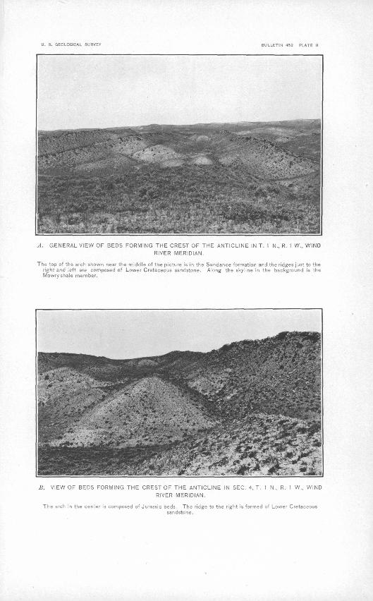
Chugwater formation in each of .the four areas where that formation is exposed and occurs in much larger tracts where it arches over the crest of the anticline. (See PL I.) The Sundance is exposed on the flanks of the anticline in each'district where the crest has been eroded and arches over the summit where erosion has not progressed so far. Plate II, A and 5, shows the structure of this formation where it makes a sharp fold along Sage Creek in the northwestern part of Little Wind River district.
MORRISON FORMATION. . »
The Morrison formation embraces fresh-water sandstone, sandy shale, and conglomerate beds. The shale consists of intercalated beds of maroon, brick red, gray, tan, and green colors, none of which were found to be continuous beyond a short distance. The conglom-
U. S. GEOLOGICAL SURVEY BULLETIN 452 PLATE II
A, GENERAL VIEW OF BEDS FORMING THE CREST OF THE ANTICLINE IN T. 1 N., R. 1 W., WIND
RIVER MERIDIAN.
The top of the arch shown near the middle of the picture is in the Sundance formation and the ridges just to the right and left are composed of Lower Cretaceous sandstone. Along the skyline in the background is the Mowry shale member.
. VIEW OF BEDS FORMING THE CREST OF THE ANTICLINE IN SEC. 4, T. 1 N., R. 1 W., WIND
RIVER MERIDIAN.
The arch in the center is composed of Jurassic beds. The ridge to the right is formed of Lower Cretaceoussandstone.
GEOLOGY. 17
erate comprises beds of small, well-rounded quartz pebbles, loosely cemented. The sandstone occurs in both massive and shaly beds. The following sections show the character of this formation. (See also fig. 1.) One section was measured near Sage Creek, in the Little Wind River district, and the other on Twin Creek, in the Little Popo Agie district.
Section of Morrison formation along Sage CreeJc.Feeti
Shale, massive, banded, maroon at the top and brick red andlighter in color below; about equal parts of each member_ 154
Sandstone, gray and tan in color, weathering tan, generally coarse-grained and locally becoming a conglomerate. The upper part of this member weathers to a bright red___ 88
242
Section of Morrison formation along Twin Crcelc.Feet.
Shale, soft, sandy, subdued colors, maroon, pink, and gray_ 86 Sandstone, massive, gray in the lower part and slightly shaly
in the upper part________________________ 6Shale, sandy, light green _ 4 Sandstone, massive, gray 16 Shale, sandy, gray in the upper third, pink in the middle
third, and light pink' in the lower third_________ 631 Sandstone, massive, gray, forming cliff_____________ 61
236
The type locality of the Morrison is in Colorado, but the name has been applied to the formation in this region by Darton a who based the correlation on lithologic character. No fossils were found in this formation, but it occupies the stratigraphic position at which the Morrison is found in adjacent fields and lithologically is not unlike the formation as recognized and described by Darton 6 in the Bighorn Mountains and by Fisher c in the Bighorn Basin. Paleontologists do not agree as to the age of the Morrison formation. Some have re ferred it to the Jurassic, but others consider it Lower Cretaceous. In this report it is referred provisionally to the Jurassic, though a final decision can not be made at this time. The Morrison .outcrops in a zone just outside of and parallel to the Sundance formation in each of the three districts. Besides these narrow belts there is a larger area of this formation adjacent to the strike fault in the Little Popo Agie district. (See PI. I. in pocket.)
"Darton, N. H., Paleozoic and Mesozoic of central Wyoming: Bull. Geol. Soc. America, vol. 19, 1908, p. 443.
6 Darton, N. H., Geology of the Bighorn Mountains: Prof. Paper U. S. Gcol. Survey No. 51, 1906, p. 47.
a Fisher, C. A., Geology and water resources of the Bighorn Basin, Wyoming: Prof. Paper U. S. Geol. Survey No. 53, pp. 25, 41.
79495° Bull. 452 11 2 .
18 THE LANDER OIL FIELD, WYOMING.
LOWER CRETACEOUS ROCKS.
The lower part of the Cretaceous, underlying the Dakota sandstone, consists of sandy shale and sandstone. The basal member is a mas sive gray coarse-grained cross-bedded sandstone, which locally be comes conglomeratic. The conglomerate is formed mostly of water- worn gray-quartz pebbles, some of which are as large as one-third inch in diameter. The upper member is a. soft sandy tan-colored shale. The following sections present the character of the beds:
Section of the loivest beds in the Cretaceous along Twin Creek, in Little PopoAf/ie district.
Feet. Shale, soft, sandy, tan in the lower part, drab in the upper
part; weathers to form slope_________:________ 267 Sandstone, slightly shaly, rusty, weathers to form cliffs. Con
tains many impressions of wood and stems________ 44 Shale, soft, sandy, gray in the lower part with brick red in
middle and gray above_____________________ 88 Sandstone, massive, gray, coarse grained, cross-bedded, and
containing conglomeratic layers. Beds from 1 to 6 inches thick near the base. Two miles farther east this member is a gray conglomerate with small, well-rounded pebbles of chert, both gray and black_________ '._________________ 9
408 '
Section of the lowest beds in the Cretaceous along Sage Creek, in Little WindRiver district.
Feet. Shale, drab, fissile, with a thick bed of black carbonaceous
shale near the middle______________________ 123 Sandstone, shaly, rusty, merging into rusty colored sandy
shale at the top___________________________ 158 Sandstone, massive, rusty, but weathering gray in places.
This sandstone is hard and weathers into a distinct shoul der. Some imperfect bivalves (Uniof) were found in it__ 12
Shale, sandy, maroon colored, merging into gray at the top_ 93 Sandstone, massive, gray, weathering gray. Locally this sand
stone becomes a gray conglomerate formed of well:rounded pebbles of quartz, generally about one-third inch in great est diameter, and rarely exceeding 1 inch__________ 20
406
The age of these beds has not been clearly determined. The study of the stratigraphy in the field indicates that the lithologic unit comprising the Morrison formation terminates upward at the bot tom of the gray sandstone and conglomerate beds that form the basal member of the Cretaceous in the above sections. It is also be lieved that the beds between the top of the Morrison and the base
GEOLOGY. 19
of the Dakota sandstone were deposited under similar conditions and are therefore a unit of deposition. The opinion that the lower part of the -Cretaceous is of marine origin is based on data furnished by T. W. Stanton, who examined the beds at several points and col lected fossils from the upper member. Dr. Stanton submits the folloAving statement concerning the fossils:
The interesting fauuule of marine shells, concerning which I am not ready to express a decided opinion, was found at a number of places a short distance beneath the Dakota sandstone, or at least beneath a sandstone which, west of Lauder, yielded a Dakota flora. From its stratigraphic position and its gen eral characteristics this faunule ought to be Lower Cretaceous, but I have not been able to make specific identifications of any forms characteristic of the Lower Cretaceous or the Comanche series.
This group of beds was referred by Knight" to the Jurassic with out any specific separation, and by Darton 6 to the Morrison.. The evidence outlined above, produced by the more detailed work recently undertaken, seems to show that these beds are distinct from the Mor rison, which, lies below them, and that they- are Lower Cretaceous in age, and not a part of the Dakota, Avhich lies above, and is Upper Cretaceous. It is believed that they form a distinct stratigraphic unit, but the evidence at hand is inconclusive both as to the limits and age of the strata. Therefore the proposal of a name for them is deferred until more conclusive evidence can be obtained, in order to avoid the confusion which may arise from the inaccurate defini tion of a formation.
DAKOTA SANDSTONE.
The Dakota sandstone of this area has been described by Eldridge,0 Knight,0 and Darton,d all of Avhom properly correlated it with the Dakota of the type locality. Mr. Darton, however, has called this formation the Cleverly sandstone,6 but the name Cloverly had been used previously by him for a tripartite group of beds composed of " coarse, massive, buff sandstone below, with light-colored shales and some sandstone above," believed to include the " Dakota, Fuson, and Lakota.f To the writer it seems inconsistent to apply a name to a group of beds at one place and to only one member of the group in an adjacent area where the strata are similar, and it therefore seems best either to broaden the appHcation of the term in the Lander field to include the group (consisting of the Dakota sandstone and the underlying Lower Cretaceous (?) shale and sandstone) or to
0 Bull. Univ. Wyoming School of Mines, Petroleum- series, No. 2, 1897, p. 9. "Bull. Geol. Soc. America, vol. 19, 1908, p. 442.c Eldridge, G. H., A geological reconnaissance in northwest Wyoming: Bull. U. S. Geol.
Survey No. 119, 1894, p. 22. ' " Op. cit., p. 448.
o Idem, p. 447. f Prof. Paper U. S. Geol. Survey No. 51, 1906, pp. 14, 50.
20 THE LANDER OIL FIELD, WYOMING.
reject the term entirely. The latter course is pursued, because the bed in this area to which Mr. Barton applied the name Cloverly sandstone is shown to be Dakota sandstone by the list of fossil plants given below, and because earlier writers properly termed the bed Dakota. The formation consists of a massive rusty sandstone nearly 60 feet thick in the northwestern part of the field but about one- third of that amount in the southeastern part. The following sec tions present the thickness of the Dakota:
Dakota sandstone on. Twin Creek, in Little Popo Ayie district.
Feet.Sandstone, massive, rusty; forms one of the highest ridges in
the region________________________________ 20
Dakota sandstone on Sage Creek in Little Wind River district.
Feet.Sandstone, massive gray, weathers gray except in the upper part,
where it weathers rusty___________i__________ 56
The age of the formation is determined from the following fossils collected 2 miles west of Lander and identified by F. H. Knowlton:
Fossil plants collected from the Dakota sandstone.
Dr. Knowlton remarks as follows concerning these specimens:
The specimens are much broken, but doubtless with very close study two or three other species might be determined with more or less certainty. As it is there is an ample number to prove its Dakota age.
The Dakota and the Lower Cretaceous were not mapped separately in the field; therefore both formations are shown by the same color on the map (PL I).
MANGOS SHALE.
The Mancos comprises a mass of sandy shale and sandstone more than 6,000 feet thick, and is therefore the thickest formation in the field. One member, called the Mowry shale member by Darton,a
a Darton, N. H., Geology of the Bighorn Mountains: Prof. Paper U. S. Geol. Survey No. 51, 1906, p. 53.
GEOLOGY. 21
consists of hard, drab, thin-bedded fine-grained sandy shale, which . weathers gray. It is believed that the change of color on weathering is due to the loss of carbonaceous material, which the shale includes. The shale contains abundant impressions of fish scales but no parts of the skeleton were found. This member is near the base of the formation, and weathers into high, moderately steep ridges, which form one of the most persistent topographic features of the field. The fish scales and carbonaceous matter in this member have at tracted the attention of investigators seeking the primary source of the oil in this and other fields in Wyoming. Some have suggested that the innumerable scales indicate a prolific type of fish, whose remains were included in the shale and contributed the carbonaceous matter in the form of fish oil, which has since been segregated in part and forms the oil pools occasionally found.
The great mass of sandy shale in the Mancos is loose and easily broken up; hence most of the area occupied by that formation is reduced to broad, open flats. There are, however, small areas Ayhere erosion is progressing rapidly, forming badlands or uneven surfaces trenched by narrow, steep-sided gullies. The age of the lower part of this formation is definitely fixed by the abundance of fossils found in it, but the time in which the middle and upper parts were de posited is less certain. No evidence has been obtained concerning the middle part, but since there is continuous deposition from the known Colorado the middle part of the formation is provisionally assigned to that group. The upper part, likewisej seems to indicate continuous deposition, but. fossils collected from it and identified by Dr. Stanton are referred to the Montana rather than the Colorado group. The evidence at hand is therefore insufficient to indicate the line of separation between the two groups. It is believed that there is a gradual transition from the Colorado to the Montana group, and that the deposition of the upper member of the Mancos began in Colorado time and extended without distinct interruption into the Montana. This is a condition similar to that at the type locality of the Mancos, where deposition was continuous from the Colorado to the Montana, and there is no striking litholoeic change
' O D o
at the boundary between-the two groups. The following is a list of invertebrate fossils collected near the top of the member about 1 mile northwest of Hudson:
Anemia sp.Modiola regularis White.Corbula undifera Meek.Corbula subtrigonalis M. and H.Siliqna? sp.Melania iusculpta Meek.
22 THE LANDEE. OIL FIELD, WYOMING.
Because it is impossible in the field to separate this shale into lithologic units, the entire mass is included in the Mancos, which extends upward to the base of the Mesaverde formation.
The following section of the Mancos was measured north of Big Popo Agie Kiver, west of Hudson:
Section of Mancos shale west of Hudson, -Wyo.Feet.
Shale, light drab, with occasional brown sandstone bedsup to 12 inches thick_________'. _______________ 150
Shale and sandstone, shale predominating__________ 90Shale, gray __________ ______________:_ 4,900Sandstone, light gray, and shale, soft, light drab______ 80Shale, thin bedded, light gray, with fish scales (Mowry)__ 730Sandstone, heavy, gray_____________________ 100Shale, sandy, soft; in color light________________ 60
6,110
Areally the Mancos is the most widely distributed formation in the field. It arches over the axis of the anticline at both ends of the central and northwestern districts and forms broad flats on both sides of the main uplift. The Mancos conforms to the general anti clinal structure of the field. It lies on the flanks of the uplift where erosion has removed it from the crest and revealed the lower beds, and it arches over the crest at both ends of each of the three districts except at the southeastern end of the field, where terrace gravel con ceals all the pre-Quaternary rocks. On the southwestern side of the anticline the Mancos dips into the syncline and then rises and is exposed on the flanks of the Wind River Mountains. The northeast limb of the anticline becomes a part of the monocline which extends from the oil field toward the interior of the basin.
For years oil has been seeping from this formation at the Washakie oil spring, in the northwestern part of the Big Popo Agie district. During the present survey of that part of the field a well was being drilled near the site of the oil spring, and it was reported that oil had been found in this well (locally known as the Plunkett well) at a depth of 250 feet, and at a point which is stratigraphically in the Mowry shale.
MESAVERDE FORMATION.
The Mesaverde formation comprises massive light tan-colored sandstone and sandy shale, deposited apparently conformably to the Mancos. The basal member is characterized by massive sandstone and intercalated shale beds containing lenses of coal. This forma tion has been determined to be the Mesaverde from invertebrate
GEOLOGY. 23
fossils collected by the writer and identified by T. W. Stanton; previously, however, it had been considered as La-ramie.0
WIND RIVER FORMATION.
The Wind River formation is composed of sandstone and sandy shale in about equal parts. The sandstone members are lenticular, reaching in places a thickness of 20 feet and a lateral extent of 1 mile, and are composed of subangular grains of. quartz, feldspar, and various kinds of igneous rocks. The shale consists of intercalated gray, pink, and red members. Locally a conglomerate containing coarse, moderately well rounded pebbles is the basal member of the formation. The Wind River' formation rests unconformably upon the strata below and has been slightly tilted from the horizontal. It was deposited in Eocene time but subsequent to the deformation which warped the Fort Union beds, as determined by the evidence of fossil plants identified by F. H. Knowlton. The Fort Union is not exposed in this field because, if. it was deposited, it has either been removed by erosion or is concealed beneath the Wind River formation. Areally, the Wind River formation is distributed along the northeastern border of the field and in. an isolated outlier several square miles in extent lying between Little Wind River and Big Popo Agie River.
STRUCTURE.
GENERAL FEATURES.
The structural province in which this field lies comprises very broad synclinal basins bordered by relatively high narrow mountain ranges with small steep-sided, slightly elevated anticlines that are exposed about the edges of the basins in a zone between the basins proper and the mountains. If the strata in the interior of the basins are folded, the folds are concealed beneath beds which were deposited subsequent to the major structural movements in the province. It seems probable that there are folds in the interior and possibly some of them contain oil, but they can be found only by drilling.
The Wind River basin is typical of the large synclines and the Wind River Mountains of the high anticlines, and the field here dis cussed is embraced in the zone of secondary folds exposed on the border of the basin. The minor folds are asymmetrical, the beds near the Wind River Mountains dipping steeply, but those on the oppo site side of the field lying more nearly level.
a Eldridge, G. H., A geological reconnaissance in northwest Wyoming; Bull. U. S. Geol. Survey No. 119, 1894, p. 24.
24 THE LANDER OIL FIELD, WYOMING.
The crest of the anticline is not a horizontal line, but undulates gently, a rise corresponding to each district and a depression lying between. The general structure is further complicated by faults in the southern district and by a spur from the main fold in the Little Wind River district. Locally, the rocks are sharply folded and may have been -faulted, but there is no direct evidence of breaks except at places where faults are shown on Plate I. Fractures, however, may be indicated by oil springs which appear at three points along the anticline and by a large hot spring which occurs at another place near the crest of the uplift. .
The structure of the field is represented by the structural contours on the map forming Plate I, which shows the position of the base of the Chugwater formation with regard to sea level. The contour in terval is 500 feet, and the figures placed along the lines show the distance of each contour above sea level. If a figure is preceded by the plus sign (+), it indicates that the base of the Chugwater is the given number of feet above sea level at all points along that line, and if preceded by minus sign ( ), that it is below sea level. Since the surface contours are also based on sea level, the depth of the base of the Chugwater below any point is the difference between the alti tude of the two contour lines.
ARTESIAN CONDITIONS.
In this oil field artesian flows of water in drill holes interfere with the drilling to a considerable extent, and sometimes even stop the work; hence a brief discussion of the artesian conditions is presented. Flows of water under pressure may be expected in wells at almost any depth. :
Although the oil field itself is an anticline artesian conditionswithin it are almost ideal because the beds involved are exposed beyond a neighboring syncline on the flank of the Wind River Moun tain high above the oil district, thus producing excellent conditions for the absorption of water by the porous strata and its accumulation under pressure. Some of the beds are poorly cemented sandstones which absorb and transmit water readily, and the bedding planes of others are suitable conductors. The high portions of the Wind River Range are covered by snow throughout the year. The melting of this snow and the rainfall in the same area together give a rather constant supply of water to the exposed edges of the porous beds. Thus the structure, character of the beds, and the constant supply of water favor artesian flows.
U. S. GEOLOGICAL SURVEY BULLETIN 452 PLATE III
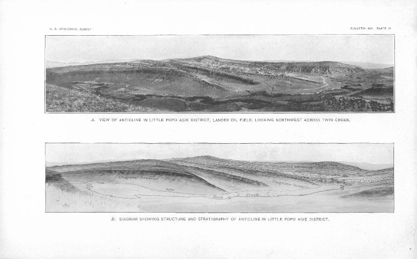
A. VIEW OF ANTICLINE IN LITTLE POPO AGIE DISTRICT, LANDER OIL FIELD, LOOKING NORTHWEST ACROSS TWIN CREEK.
J3. DIAGRAM SHOWING STRUCTURE AND STRATIGRAPHY OF ANTICLINE IN LITTLE POPO AGIE DISTRICT.
GEOLOGY^ 25
DETAILS OF STRUCTURE.LITTLE POPO AGIE DISTRICT.
Structurally the Little Popo Agie district is an asymmetrical anti cline which is believed to extend southeastward beyond the limit of this field, though the beds forming it are concealed at the end of the field beneath a cover of more recently deposited material which forms a terrace that slopes northeast from the base of the Wind River Mountains. Over the crest of the anticline the beds are vaulted into a flat arch that is sharply flexed on its southwest side. The unsymmetrical character of the fold is best shown in the central part of the district, where the beds on the southwest side are vertical in sec. 11 and dip 82° in sec. 24,. T. 32 N., R. 99 W., where Little Popo" Agie River enters the anticline. At both ends of the district the beds on this side of the anticline are less steeply upturned than in the central part. On the northeast side of the field the angle of dip ranges from 16° to 46°, and is most commonly between 20° and 30°. Along Twin Creek,'in sec. 30, T. 32 N., R. 98 W., the beds on the southwest limb are deflected sharply to the east and form a re entrant angle, a condition which is probably brought about in part by the strike fault in sees. 19, 20, 29, and 32, T. 32 N., R. 98 W. This fault is of the thrust type, with the fault plane nearly vertical. It extends 2^ miles along the strike of the beds and has a maximum throw of 1,180 feet. It decreases in throw abruptly at the southeast end but more gradually to the northwest. The complex areal dis tribution of the formations affected by this fault is shown on the map (PL I). No springs occur along the line of fault and neither oil seeps nor asphalt beds were noted near it. The fault is believed to extend downward to the oil-bearing strata, but the abundant shale in the Chugwater formation has probably sealed the break effectu ally and prevented the escape of gas or oil.
.There is another thrust fault, much smaller and transverse to the strike of the strata, in the southwestern part of the district in sec. 9, T. 31 N., R. 98 W. The trend of the fault is N. 64° E., and the maximum displacement of 650 feet brings the Morrison formation against the Chugwater. The fault seems to be a clean break; cer tainly the zone of disturbance is not more than 25 feet wide. One end'is lost in the shale of the Chugwater and the other in the Man- cos. A third fault occurs in the Chugwater east of the oil wells, in sec. 13, and extends across the southeast corner of the adjacent sec tion to the east. The maximum displacement along this fault is about 100 feet. Along these faults there are no springs of water, oil seeps, or asphalt beds. Sections A and B, Plate I, show the structure along the lines A-B and C-D. The structure is also shown on Plates III and IV.
26 THE LANDEB 'OIL FIELD, WYOMING.
BIG POPO AGIE DISTRICT.
The Big Popo Agie district comprises another rise of the crest of the anticline which has been eroded until the red beds of the Chug- water formation are exposed in the center. The structure of the fold is slightly asymmetrical. On the western limb of the anticline the beds are upraised locally as much as 68°, but on the opposite side the dip of the beds is much less except in a narrow zone extending from the river for about 2 miles to the northwest. In that area the dip is as much as 54°. The beds are folded sharply over the crest of the anticline and are less broadly arched than in the south eastern district. An excellent conception of the structure is pre sented to the observer in the field along the walls of the canyon where Big Popo Agie River cuts the anticline. No faults were observed in the district. A cross section of the structure along the lines E-F is shown by C, Plate I.
LITTLE WIND RIVER DISTRICT.
In Little Wind River district the fold is asymmetrically anticlinal and embraces a local rise along the summit of the uplift. The north west limit of the fold is concealed beneath one of the large terraces which spread from the Wind River Mountains into the basin, but since the anticline decreases in. elevation to the northwest, and is not represented in the escarpment at the opposite edge of the terrace along Big Wind River, it is concluded that the beds gradually flatten and the folcl disappears under the terrace cover. The struc ture is complicated in the northwestern part of the district by a small structural spur which leaves the main fold in sec. 28, T. IN., R. 1 W., and after continuing slightly north of west for about a mile it curves to the north and follows the general trend of the main anticlinal axis until it disappears beneath a terrace on the western edge of the field. The beds dip steeply on the southwest side of the fold, being vertical at the point where the Little Wind River crosses the formations between the Chugwater and the Mancos shale, but on the opposite side the beds lie at more moderate angles. The strata are rather broadly arched along Little Wind River, but are lifted into two sharp folds, including a syncline between them, in the northwestern part of the district. Cross section D on Plate I represents this structure along the line G-H, and views A and B, Plate II, further illustrate the same subject. It should be noted that though no break in the beds was observed in the district an oil spring occurs in the valley on the northwest side of Little Wind River near the crest of the anticline and a hot spring discharging sulphur-bearing water occurs on the southeast side of the stream a short distance southwest of the axis of the uplift. These may result from breaks that are concealed beneath the alluvium of the valley.
U. S. GEOLOGICAL SURVEY
VIEW ALONG LITTLE POPO AGIE RIVER NEAR THE MOUTH OF TWIN CREEK, SHOWING OIL WELLS AND STORAGE TANK.
THE'LANDER OIL FIELD, WYOMING. 27
THE OIL.
OCCURRENCE.
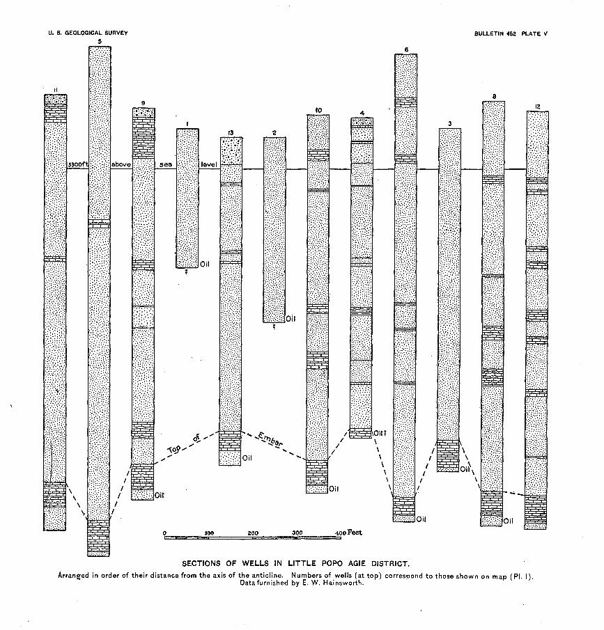
Oil was first observed in .three springs, one in the valley of Little Popo Agie Kiver, where No. 1 well is situated, another in the north western part of the central district,' and a third in the valley of Little Wind Kiver, near the axis of the anticline, and 1 mile north west of the hot-water spring. These oil springs are seeps, from which only a small quantity of oil flowed. In two of the springs the oil is a heavy asphaltic variety, and when it comes to the surface the lighter portions evaporate and leave the asphalt to impregnate the soil, and produce a condition which readily attracts attention. In fact, the asphalt bed is so large that it readily deceives the casual observer into believing that the discharge from the spring has been very large in rather recent time, but the total quantity of asphalt results not so much from the amount of discharge from the spring as from the high percentage" of that substance in the oil. The oil from the third spring contains much less asphalt, and therefore leaves less residue.
These springs, together with the favorable anticlinal structure, lead to prospecting for oil. The wells put down in the Little Popo Agie district found oil at the following depths, as shown on Plate V: No. 1, at 300 feet; No. 2, at 400 feet; No. 3, at 750 feet; No. 4, at 697 feet; No. 6, at 1,025 feet; No. 8, at 918 feet; No. 9, at 848 feet; No. 10, at 825 feet, and Nor 13, at 697 feet. No considerable quan tity of oil was found in wells Nos. 5, 7,11, and 12, which are reported, respectively, as 1,120, 1,520, 955, and 914 feet deep. The oil is here generally found in the top of the Embar formation, immediately below the base of the Chugwater, the horizon which forms the initial point in the structure contour map, Plate I. Good wells have been de veloped in local accumulations of oil in the Chugwater, as wells Nos. 1 and. 2, whose oil has probably escaped from the Embar.
Oil is reported in a. well near the Washakie spring at a depth of 250 feet, in an entirely different formation, the Mowry shale mem ber of the Mancos, which is stratigraphically about 3,700 feet above the horizon of the oil pool at the top of the Embar in the Little Popo Agie region, and about 3,300 feet above the pool in the Chug water developed by wells Nos. 1 and 2. It is this Mowry forma tion which yields the oil in the Spring Valley field, in southwestern Wyoming, where it is a paraffin .base oil similar to that encountered here and different from that found in the Embar and the Chugwater formations.
28 THE LADDER OIL FIELD, WYOMING.
SOURCE OF THE OIL.
Investigators who. have worked during recent years in surround ing regions assign the source of the oil. to various formations. In the Bighorn Basin in northwestern Wyoming C. W. Washburne 0 states that the source of the oil and gas is the black shale at the base of the Colorado. He further remarks, concerning a report of a bed of asphalt, "Apparently the asphalt has exuded from the Pennsyl- vanian rocks at this place." Wegemann 6 states that in the Salt Creek field, Wyoming, oil is found in the Colorado and in the Montana, and adds further that oil occurs in the Dakota in an adjacent field.
Though oil has been found in several different formations, its occurrence is believed to be controlled strictly by the structure, be cause as far as known it occurs only near the crest of an anticline.
CHARACTER OF THE OIL.
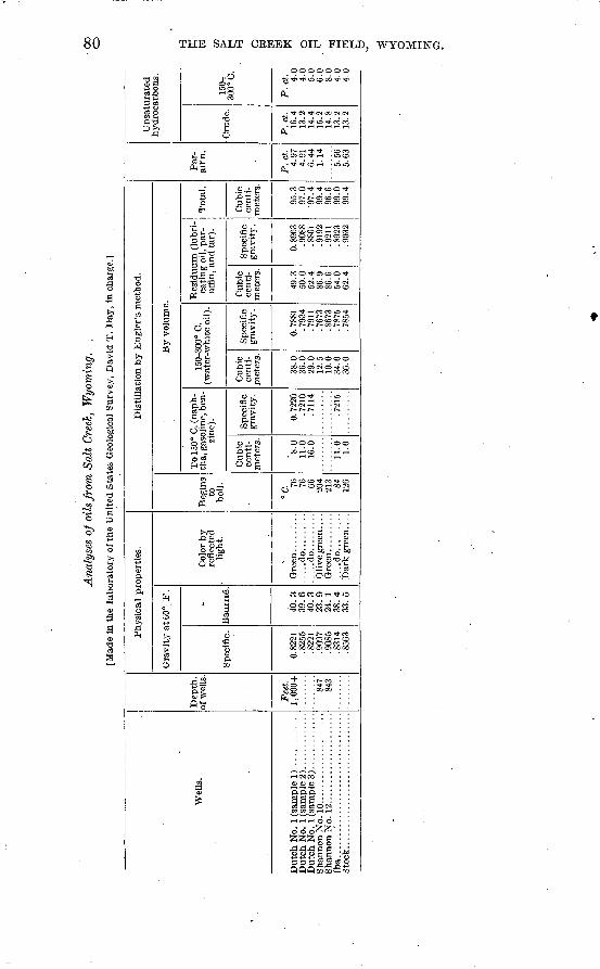
The oil is dark brown and flows readily as it comes from the wells and becomes slightly thicker on exposure to the air for several weeks. Some of the samples contain a large percentage of water as the oil flows from the wells, but most of this separates from the oil on stand ing, though in some cases an emulsion seems to have been formed. Samples of oil from six of the wells were analyzed under the direc tion of David T. Day, expert in charge of petroleum for the United States Geological Survey, with the following results:
a Washburne, C. W., Gas fields of the Bighorn Basin, Wyoming: Bull. U. S. Geol. Sur vey No. 340, 1908, pp. 351-361.
6 Wegemann, C. H., accompanying report in this bulletin.
Ana
lyse
s of
oil
s fr
om
La
nd
er f
ield
, F
rem
bnt
Cou
nty,
~W
yo.
Ser
ial
No.
Wyo
. 3
..
Wyo
. 4
..
Wyo
. 5
..
Wyo
. 6..
W
yo. 7..
W
yo. 8..
Wel
l N
o.
3 2 10
611 13
H
un
k-
ett.
Dep
th
of w
ell.
Fee
t. 750
400
825
965
097
300
Phy
sica
l pr
oper
ties
.
Gra
vit
y a
t 60
° F
.
Spe
cifi
c.
0. 9
198
.912
6 .9
121
.912
6 .9
091
.812
1
Bau
mfi
.
22.2
23
.4
23.5
23
.4
24.0
42.4
«
Col
or.
...:.
do..
....
....
...d
o..
....
....
...d
o..
....
.......d
o........
Dis
till
atio
n by E
ngle
r's
met
hod.
Beg
ins
to b
oil.
"C. 93 120 93 108 77
By
volu
me.
To
150°
C.
Cub
ic
cent
i
met
ers.
2,5
2,0
2.0
2.5
14.0
Spe
cifi
c gra
vit
y.
0. 7
244
150-
300°
C.
Cub
ic
cent
i
met
ers.
f ' 22
.0
23.5
21
.0
24.0
23
.0
41.0
Spe
cifi
c gra
vit
y.
00
0.80
41
.806
7 .S
018
.804
7 .7
994
Res
iduum
.
Cub
ic
cent
i
met
ers.
(a)
69.9
75
.2
73.9
73
.1
41.1
Spe
cifi
c gra
vit
y.
(a)
0.95
43
.958
9 .9
605
. 958
9 .8
755
Tot
al
cubi
c ce
nti
m
eter
s.
(a)
95.4
98
.2
99.4
9S
.6
96.1
Par
affi
n.
Per
cent
.(o
) 0.91
1.
27
.90
.02
5.85
A sp
hal
t.
Per
cen
t, (a
) 4.02
5.
69
11.0
4 15
.26
.0
Un
satu
rate
d h
y
droc
arbo
ns.
Cru
de.
Per
cen
t. 50
.4
46.4
50
.8
58.0
50
.8
10.4
150-
300°
C
.
Per
cen
t. (a
) 4 4 4 9 5
Fla
sk b
roke
dur
ing
dist
illa
tion
. W
ater
in
the
oil.
6 N
o.
11 h
ere
is N
o. 9
on
the
map
.
fcO
'-O
J
30 THE LANDEK OIL FIELD, WYOMING.
Dr. Day remarks as follows concerning these oils:With one exception these oils are heavy asphaltic oils, differing from one
another only in minor details. As might be expected, they are very deficient in gasoline, but yield as much kerosene as can be expected from oils of a specific gravity of 0.9 or more.
The oil from the Plunkett well, near Oil Spring, is significantly different from the others, as shown by the analysis. It is not only free from asphalt, but contains the proportion of paraffin wax characteristic of paraffin hydro carbons, and is as free from unsaturated hydrocarbons as is usual even with Appalachian oils. That this oil really belongs to the paraffin series is further shown by the low specific gravity of the gasoline portion, 0.71S3. Oils of the naphtheue or benzol series usually show 0.75 or higher for the gasoline frac tion. Although no exact calculation has been made, it is evident that if by diffusion the heavy asphaltic oils found in this region had been deprived of their unsaturated hydrocarbons from, say, 58 per cent down to 8 per cent, these heavy oils would show about 40 per cent of kerosene distillate, instead of 23, and about the proportion of gasoline distillate found in the light oil, and, although this analysis can not be set forward as a proof of this relationship between the heavy and light oils, it makes that relationship somewhat probable.
USES OF THE OIL.
The oil is adapted to several uses. In its native state, when taken from the wells, it can be used for almost any purpose to which crude oil is generally applied. It forms an excellent fuel, comparing favor ably with the Texas or California oils, and is now employed for that purpose in practically all the development work in the Little Popo Agie district. It can be used to a limited extent in its raw state as a lubricant, though in general it is not suitable for that purpose. Since oil from the Little Popo Agie district contains a heavy asphalt base, it is a good variety for oiling roads. Frac tional distillation gives a small amount of gasoline, a fair amount of illuminating oil, and a considerable residue which can be further separated by distillation into lubricating oil and a tar suitable for use as a fuel or asphalt. The oil shown by analysis No. 8 in the above table is entirely different. It contains a fair per cent of gaso line, a large per cent of illuminating oil, and a residue containing a paraffin base. It is suitable for lubricating purposes. Asphalt is not present in this oil.
MARKET.
The field is located in a sparsely settled country, where the demand for fuel can be supplied from forest and country coal banks and where very little machinery is employed, and consequently only a small quantity of lubricating oil is demanded and, where, also, there is only a small total consumption of illuminants. With these condi tions there was practically no demand for the oil previous to' the building of the railroad into the region, in 1907. The completion
THE OIL. 31
of that work created two markets for the oil. The first was for fuel on the locomotives of the railroad, the second was for various pur poses in the towns and cities to which oil can be shipped. -As yet the first-named market is practically the only one which has been entered. Oil is reported to have been used on.a locomotive running between Casper and Lander for one month during the winter of 1907-8. The use was discontinued, probably because a sufficient quantity of oil was not assured. The local market continues to de mand about 50 barrels a day, which is supplied at 75 cents a barrel. All the oil now marketed is produced from the Little Popo Agie district.
PRODUCTION.
The quantity of oil placed on the market has never been large; in fact, the field has not entered the market as an active producer. Mr. Carlisle, who is now in charge of the wells near Dallas, states thattheir capacity has never been tested,, and since they were completed most of them have remained capped. There has been considerable leakage, however, and several years ago there was sufficient waste of oil into Little Popo Agie River to pollute the water. This led to objection by the irrigators using water from the stream, and is reported to have resulted in lawsuits for damages. At present the escaping oil is confined to pools, which are set on fire periodically to prevent an overflow into the river. Very little gas accompanies the oil, and most of it is allowed to escape. A small amount, how ever, is used about the plant at Dallas, but even in that district the total quantity of gas is insufficient to furnish fuel for pumping arid development work. A conservative estimate of the annual produc tion of 1909 for the field is less than 5.0 barrels a day.
DEVELOPMENT.
HISTORY.
Practically all the development in the field has been confined to the southeastern district, along Little Popo Agie Kiver, in the vicin ity of Dallas post office. Previous to 1907 test wells were sunk in other parts of the area, but with little success. The history of opera tions previous to 1897 is presented by W. C. Knight 0 in' his report on this region. .Mr. Knight writes:
The history of this field is far more interesting than that of any other oil field in Wyoming, since it was in this field that Bonneville discovered oil in 1S33,
0 Knight, W. C., The geology of the Popo Agie, Lander, and Shoshone fields: Bull. Univ. Wyoming School of Mines, Petroleum series, No. 2, Laramie, Wyo., January, 1897, p. 8.
32 THE LANDER OIL FIELD, WYOMING.
and is the place where the first producing oil well was drilled. From the date of Bonneville's visit up to 1867 the oil spring was- unknown except to the hunter and trapper, who frequented the locality to secure the oil for medicinal purposes. Upon the completion of the Union Pacific Railroad people became interested in the natural resources of economic importance, and located, among other things, the Popo Agie oil spring and the surrounding country. This property changed hands several times prior to 1889, but there was no develop ment, except pits sunk as assessment holes. In 1881 Dr. Graff, of .Omaha, and associates purchased the oil claims and did considerable surface work. In 1883 and 1884 they drilled three oil wells, all of which were producers. The company then purchased a large number of iron barrels and commenced to market the oil at the Union Pacific Railroad. On account of keen competition from the eastern oil producers the first Wyoming oil company had to abandon their enterprise. Since that time the wells have remained packed. The oil that has flown from 'the wells through leaks has been utilized by the ranchers for miles about for lubricating purposes, and, to some extent, by the gold mines and the flour mills for steam making.
Since the above sketch was written wells Nos. 4 and 5 (see PL V) were drilled in 1901, Nos. 6, 7, 8, and 9 in 1902, and Nos. 10, 11, and 12 in 1903. Very little development work was done during the five 3^ears following this period of activity. Recently operations have begun on a more extensive scale than at any preceding time. The present conditions are set forth by districts as follows:
LITTLE POPO AGIE DISTRICT.
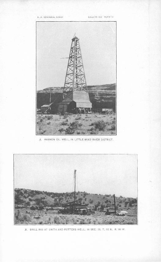
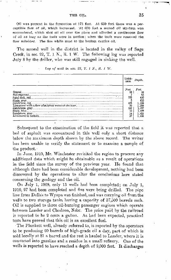
Practically all the development work now in progresses confined to the Little Popo Agie district. A 6-inch pipe line has been laid from the group of wells near Dallas post office to a point on the railroad at Wyopa, near Big Popo Agie River. In August, 1909, when the field was visited last, steel storage tanks and pumping machinery were being installed. It is planned to erect receiving tanks at the intake end of the line and storage tanks where the oilis to be discharged. At present oil is hauled from the wells in tanks on wagons to Lander to supply a local market. Three drill rigs were in operation in the district at points marked 0 on Plate I. The Pennsylvania derrick type of standard rig is most commonly used in the district, but some wells are drilled with the common deep-well type. These types are shown on Plate VI, A and B.
The following detailed information relating to wells in this dis trict was furnished by E. W. Hainsworth, of Lander:
Well No. 1 (Murphy's No. 1) ; drilled in 1884: A crevice well drilled along side natural oil spring. Depth said to be 300 feet. Shows considerable gas pressure and flows spasmodically. Tubing is chained to " dead men."
Well No. 2 (Murphy's No. 2) ; drilled in 1884-1886: A crevice well. Depth said to be 400 feet. Shows considerable gas pressure and flows spasmodically. Tubing is chained to " dead men."
U. 8. GEOLOGICAL SURVEY 5
5300ft above sea level
Oil
oir
100
to
oil
Oil
Oil
200 300 400 Feet
Oil
BULLETIN 452 PLATE V
oiK
Oil
SECTIONS OF WELLS IN LITTLE POPO AGIE DISTRICT.
Arranged in order of their distance from the axis of the anticline. Numbers of wells (at top) correspond to those shown on map (PI. I).Data furnished by E. W. Hainsworth.
U. S. GEOLOGICAL SURVEY BULLETIN 452 PLATE VI
A. i-iANNGN OiL WELL. IN LITTLE WIND RIVER DISTRICT.
S. DRILL RIG AT SMITH AND POTTERS WELL, IN SEC. 25, T. 32 N., R. 99 W.
THE OIL. 33
Well No. 3 (Murphy's No. 3); drilled in-1884-1886: Well drilled just into the oil sand. Depth said to be 750 feet. Shows considerable gas pressure and flows spasmodically. Tubing is chained to " dead men."
Well No. 4;.drilled in 1901: Spudding commenced June 20, 1901; drilling ceased August 21, 1901. Depth of well, 697 feet Good crevice well; flows spas modically. Well stopped in limestone capping.
Well No. 5 (Sulphur well) ; drilled in 1901: Spudding commenced September 4, 1901; work stopped October 8, 1901; drilling recommenced November 7, 1901; finished November 17, 1902. Depth of well, 1,120 feet. A nonproducer; oil sand strong with sulphur water, of which there is a copious flow.
Well No. 6 (Werlen well); drilled in 1902: Spudding commenced July 2, 1902; drilling finished September 5, 1902. Depth of well, 1,025 feet. A good pumping well.
Well No. 7 (Anchor well); drilled in 1901-2: Spudding commenced No vember 6, 1901; stopped. November 26, 1901; recommenced February 19, 1902; stopped again. May 14, 1902; recommenced again June 23, 1902, and stopped June 27, 1902. Depth of well, 1,520 feet. Sulphur water and very little oil inhole.
Well No. 8 (Litchfield well) ; drilled in 1902: Spudding commenced October 13, 1902; drilling finished October 28, 1902. Depth of well, 918 feet. Well just in sand and flows oil spasmodically.
Well No. 9 (Skallawag well); drilled in 1902-3: Spudding commenced De cember 17, 1902; drilling stopped January 7, 1903. Depth of well, 848 feet. Well produces oil and sulphur water and is a good pumper.
Well No. 10 (Marguerite well); drilled in 1902-3: Spudding commenced November 11, 1902; tools lost November 25, 1902; casing drawn and hole reamed December 28, 1902; tools recovered and well finished March 31, 1903. Well is just through capping and yields considerable oil and gas. Depth of well, 825 feet.
Well No. 11 (Neptune well) ; drilled in 1903: Spudding commenced January 21, 1903; well finished February 26, 1903. Depth of well, 955 feet. A non- producer, yielding only sulphur water with little oil.
Well No. 12 (Jupiter well) ; drilled in 1903: Spudding commenced March 16, 1903; well finished April 10, 1903. Depth of well, 914 feet. A nonproducer, yielding much sulphur water and little oil.
Well No. 13 (Titauia well) ; drilled in 1903: Spudding commenced April 20, 1903; well finished May 19, 1903. Depth of well, 697 feet. Good well; flows spasmodically.
BIG POPO AGIE DISTRICT.
The most active development in the Big Popo Agie district Avas undertaken in connection with the pipe line that begins in the south eastern district and terminates at the railroad in the valley of Big Popo Agie River. The Plunkett well, in sec. 25, T. 1 S., R. 1 E., Wind River meridian, near the Washakie oil spring, was being drilled at the tiine that portion of the field was surveyed and, ac cording to later reports, struck a high grade of oil at a depth of 250 feet. If the statement is true this oil occurs in Mancos shale at a horizon that is stratigraphically 3,300 feet higher than that of the oil in any well in the Little Popo Agie district.
79495° Bull. 452 11 3
34 THE LANDER OIL FIELD, WYOMING.
LITTLE WIND RIVER DISTRICT.
Previous to 1909, according to report, no development was begun in the Little Wind River district. In the spring of 1909 one well, now abandoned, was sunk by the Washakie Hydrocarbon Mining Co. in the vaHey of Little Wind River, at the point marked Tar Spring on the map (PI. I). The following information relating to this well was furnished by Russel Thorp, president of the Company:
Water: At 165 feet, cold sulphur water; at 300 feet, artesian flow warm sul phur water at rate of 1,450 barrels a day (24 hours) ; at 350 feet, additional artesian flow warm sulphur water (flow of water from tar springs decreasing) ; at 500 feet; third artesian flow of warm sulphur water up to 3,000 barrels a day; at 540 feet, February 23 flow from tar .springs stopped entirely. The con tinuous flow since March 16, 1909, Ms settled down to a steady flow of 20 barrels a day. The different flows of water could be plainly noted, both by the increase in flow and by the added fumes'and gases, which affected the men's eyes to such an extent( that work had to be shut down from one to three days until the gases subsided, although a decided odor of .sulphur may be noted up to the present time.
Drilling: Spudded January 30, 1909, with 39 feet of 10-inch conductor; 10- inch bit used to 405 feet, when attempt was made to shut off water in the brown sand, without success. The diameter of the hole was reduced at this point to S inches and 8-inch hole was carried to depth of 555 feet. At 500 feet bits wore down rapidly; at 540 feet tools stuck in blue clay; at 555 feet to bottom of rimming casing was set in without successful shut-off or reduction of water bailing. Casing settled 4 feet in three days. Set 672 feet of 6^-inch casing. Eighty pounds of wheat used to swell bottom, apparently without success. From 675 feet to bottom of hole, SOO feet, very hard rock that wore the bits rapidly.
The entire drilling was conducted in water continuously, from 165 feet down, and the hole stood up with practically no casing.
THE OIL. 35
Oil was present in the formation at 171 feet. At 650 feet there was a per ceptible flow of oil, which increased. At 670 feet a second oil stratum was encountered, which shot oil all over the place and afforded a continuous flow of oil as long as the tools were in motion; when the tools were removed the flow subsided. The fine white sand to the bottom carries oil.
The second well in the district is located in the valley of Sage Creek, in sec. 22, T. 1 N., R. 1 W. The folloAving log was reported July 8 by the driller, who Avas still engaged in sinking the well.
Loo of -well in sec. 22, T. 1 N., R. J. W.
Sand rock, red .................................................................-....'.:...
Shale, blue .............................................................................
Thick ness.
Feet. 58
7385
5675
7019712.1427
Depth.
Feet. 5865
450455
1,1301,2001,3971,4091,4231,450
Subsequent to the examination of the field it was reported that a bed of asphalt Avas encountered in this well only a short distance below the maximum depth shown by the above record. The writer lias been unable to verify the statement or to examine a sample of the product.
In June, 1910, Mr. Winchester revisited the region to procure any additional data which might be obtainable as a result of operations in the field since the survey of the previous year. He found that although there had been considerable development, nothing had been discovered by the operations to alter the conclusions here stated concerning the geology and the oil.
On July 1, 1909, only 13 wells had been completed; on July 1, 1910, 27 had been completed and five AArere being drilled. The pipe line from Dallas to Wyopawas finished, and was carrying oil from the Avells to two storage tanks having a capacity of 37,500 barrels each. Oil is supplied to three oil-burning passenger engines which operate betAveen Lander and Chadron, Nebr. The price paid by the railroad is reported to be 2 cents a gallon. As had been expected, practical tests have proved that this oil is an excellent fuel.
The Plunkett well, already referred to, is reported by the operators to be producing 60 barrels of high-grade oil a day, part of which is sold locally at $1 a barrel and the rest is hauled to Lander, Avhere it is converted into gasoline and a residue in a small refinery. One of the wells is reported to have reached a depth of 2,000 feet. It discharges
36 THE LANDEB. OIL, FIELD, WYOMING.
daily about 2,000 barrels of water containing carbon dioxide and sulphur, with only a trace of oil. Thirteen wells, producing about 330 barrels of oil a day, are now supplying oil to the pipe line, and other wells will be connected with the line as soon as possible. Sev eral wells are being drilled, and prospecting has been undertaken in earnest.
THE SALT CEEEK OIL FIELD, WYOMING.
By CARROLL H. WEGEMANN.
INTRODUCTION.
ACKNOWLEDGMENTS.
In presenting the following report on the Salt Creek oil field of Wyoming the writer desires to express his thanks for valuable sug gestions and criticism to M. R. Campbell, who had general super vision of the work, and to R. W. Stone, both of whom were in the field during the beginning of the investigation. The author is also much indebted to Dr. T. W. Stanton, who visited the field in 1910, and who made the fossil determinations. The major part of the'field work was done in the fall of 1909, the Avriter being assisted by Ralph W. Ho well and William Mulholland. The work was completed in 1910 by the author, assisted by C. J. Hares. . ,
LOCATION OF THE FIELD.
The Salt Creek oil field is located in Tps. 38 to 41 N., Rs. 78 and 79 W. of the sixth principal meridian, in the northeast corner of Natrona County, Wyo. It lies in the drainage basin of Powder River, about 50 miles due north of Casper and 80 miles southeast of Buffalo. The country is open and easily accessible, but there has been little travel in the region and consequently roads are few. The field may be reached by three roads. The easiest line of approach is from Casper, on the Chicago & Northwestern Railway, by private conveyance over a wagon road that runs directly northward to the field. The next easiest line of approach is from Sheridan or Clear- mont, on the Chicago, Burlington & Quincy Railroad, by stage to Buffalo, thence by stage to Kaycee, and thence by private convey ance southeastward over a wagon road directly to Shannon, in the north end of the field, a total distance of about 130 miles. The third
37
38 THE SALT CREEK OIL FIELD, WYOMING.
road, least traveled, runs from Buffalo to Sussex, in the valley of Powderx River, and from that place to Shannon. In traveling from Shannon to Casper the first permanent ranch is south of the divide, about 30 miles from the oil field. Between Shannon and Kaycee there are a few ranches, the nearest being 12 or 15 miles from Shannon. North of Shannon- the nearest ranches are in the valley of Powder River, 20 miles distant. In the oil field a road house at Shannon is maintained for the accommodation of travelers, and several drilling camps have been established. There is at present no post office at Shannon. Mail for the" field is usually addressed to Casper.
HISTORY OF DEVELOPMENT.
It is difficult to obtain trustworthy information concerning the early history.of the Salt Creek field, for the numerous accounts pre sented do not entirely agree. Knight states that oil was reported from this area prior to 1880.° The occurrence of oil was well known a few years later. It is said that A. T. Seymore took up the first oil claims in the field in 1885 or 1886. Seymore was a civil and min ing engineer and compiled a map of the oil fields of central Wyo ming. C. Y. Iba was also interested in the development of the field. An " oil spring " which bears his name is situated in the bed of Salt Creek, in the' SE. £ SW. £ sec. 13, T. 40 N., R. 79 W. Samuel Aughey,6 territorial geologist for Wyoming, describes it as follows:
When I last visited this spring, in May, 1884, not less than 20 barrels of oil had accumulated in the creek bed. The rise of the creek from a rainfall one night washed it away, but it immediately commenced again to accumulate, and in less than a week the original quantity was stored.
At the present time oil does not collect in noticeable quantity in the Creek bed. A small sand bar in the middle of the creek marks the site of the spring at a point where the creek bends to the north with a cut bank on the east side, along the crest of which the Casper road runs. The surface of the sand is black and greasy, and on digging into it the smell of petroleum becomes very marked.
P. M. Shannon, of the Pennsylvania Oil & Gas Co., was the first to begin actual development in the field. The first well, Shannon No. 1, was located in the SE. J SE. £ sec. 36, T. 41 N., R. 79 W. This well was drilled in 1889, and three more wells were drilled in the next' two years. By 1893 rates had been obtained from the rail road and the shipment of oil was begun. The oil was hauled to. Casper by wagon, a distance of 50 miles, 12 to 16 horse teams being
a Knight, W. C., Geology and technology of the Salt Creek oil field : Bull. Univ. Wyo ming School of Mines, Petroleum series No. 1.
6 Ann. Kept. Territorial Geologist' of Wyoming, 1886.
INTRODUCTION. 39
employed. In 1895 the Pennsylvania Oil & Gas Co. erected a re finery at Casper and put down wells 5, 6, 7, and 8, W. H. Smith being the driller. In 1901 well No. 9 was completed, and in 1902 Nos. 10, 11,12, and 13.
These wells yield a heavy lubricating oil of rather high viscosity, containing little or no naphtha, asphalt, or sulphur, but more than 1 per cent of paraffin. By reflected light its color is olive green; by transmitted light it is red. Its gravity is 0.9097 (23.9 Baume). It is chiefly valuable for lubricating.
In 1905 (?) the Pennsylvania Oil & Gas Co. sold its entire property to Mr. Lobell. He in turn sold a few acres in the NE. £ sec. 2, T. 40 N., R. 79 W. to a French company called the Ascos, under the management of Mr. Delvaux, Avho drilled four wells in 1906. In 1906, also, Dr. Porro, an Italian geologist, examined the field and made a private report. It is said that he located the well after ward drilled by the Petroleum Maatschappij Salt Creek, a Holland company, in the SE. £ sec. 23, T. 40 N., R. 79 W., about 3 miles south of Shannon. The well was not drilled until the fall of 1908. On October 23 of that year oil under great pressure was struck in sand stone about 1,000 feet below the surface. This well was drilled by J. E. Stock and was the first to strike the lower sand, here named Wall Creek sandstone lentil.
This oil, in contrast to that obtained from the Shannon wells, is a light gasoline oil containing 16 per cent of naphtha, 29 per cent of water-white oil, and 6 per cent of paraffin. In color it is a very dark green by reflected light and reddish brown by transmitted light. It is valuable, first, for the illuminating oils and, second, for the lubricating oils which it contains.
Before this " gusher " well was put down, a well known as the " Iba " was drilled by J. E. Stock in the NE. £ SE. £ sec. 22, on Both- well Draw. Some oil was encountered in the shale, but scarcely in paying quantities. After the completion of the "gusher" well the Stock Oil Co. was formed and a well was drilled in the SW. £ NE. £ sec. 25, T. 40 N., K. 79 W. Some oil was encountered in shale, but the sand was not reached. During the year 1910 several new companies have entered the field and development has progressed rapidly. The Lobell interests have been bought out by the Franco- American Oil Co., which has drilled four new wells at the northern end of the dome near Shannon.
The California Oil Company completed the old Stock well and drilled several new wells in the south half of the dome, which have added materially to our knowledge of the extent of the oil pool. The Maatschappij Company drilled three wells in 1910, all of which reached the sand.
40 THE SALT CREEK OIL FIELD, WYOMING.
Several wells that have been drilled outside of the producing area deserve mention. The first of these was put down by the Pennsyl vania Oil and Gas Company when it first entered the field, at the junction of Teapot Creek and Salt Creek, in the SE. ^ sec. 16, T. 39 N., R. 78 W. The site is marked by a pool of alkaline water close to the bank of the creek. The record of the well was not preserved. In 1895 the Wyoming Lubricating Company drilled to the depth of more than 1,200 feet near the center of sec. 31, T. 41 N., R. 78 W., without encountering oil, and abandoned the well. Mr. H. W. Davis, of Sussex, drilled a well near the east line of sec 12, T. 41 N., R. 80 W., which passed through the Shannon sandstone lentil, and ob tained a slight showing of oil. The well was continued to a depth of 1,200 or 1,300 feet and was abandoned. In the SW. £ sec. 16, T. 40 N., R. 80 W., a little east of the outcrop of the Wall Creek sand stone lentil, a well was drilled to a depth of 1,200 feet by the French Oil Company. The well must have passed through the Wall Creek sandstone lentil, but did not encounter oil. A small amount of gas was obtained, however. At the present time the well flows a 1-inch stream of lukewarm sulphur water, and from a hole in the top of the plug gas rises which, when ignited, burns with a flame about 6 or 8 inches high. It is probable that the gas comes from the Wall Creek sandstone.
TOPOGRAPHY.
BELIEF.
The country in general aspect is barren and desolate. Though it is traversed by numerous deep valleys the effect of relief is lost in the distance, the somber colors of the treeless hills causing one to fade into tlie next, forming a vast, rolling expanse, whose prevailing tones are brown and gray. Above this expanse rise bold escarp ments, formed by the tilted edges of sandstone strata. Some of these escarpments can be seen for many miles and form conspicuous landmarks. These escarpments are important in this discussion, since some of them bear oil, and all of them, being easily recognized, form convenient key rocks by which the geologist can determine relative position in the stratigraphic section. These will be de scribed in more detail in the following pages.
The rocks over the central portion of the Salt Creek dome have been removed by erosion, which has here formed an anticlinal valley. Around this valley runs an escarpment formed by the cut edge of the Shannon sandstone lentil. Outside of this, but not completely encircling the dome, are escarpments formed by higher beds of sand stone, and between them are valleys which are developed on the inter vening shale.
TOPOGRAPHY. 41
Within the Salt Creek dome and east of the creek broad flats have been .formed by the stream. The greater part of the area, however, within the escarpment of the Shannon sandstone lentil is occupied by bad lands developed on the shale. These represent the mature type of topography the stage when relief is greatest. The streams have cut deep, narrow valleys in the shale, but have not had time to lower the hill crests between or to make the slopes gradual. As these changes take place as thejiills are reduced in height and the valleys are widened a type of topography is produced which in this area is exemplified by the broad flats above mentioned.
In this area several of the streams are located on anticlines, form ing what are known as anticlinal valleys. The present relief is thus the reverse of that produced by the folding of the rocks, the surface on several of .the anticlines being lower than that in the adjoining synclines. On the flanks of the rock folds, where the dip of the strata brings alternating soft shale and hard sandstone to the surface, the shale is eroded rapidly, forming valleys, and the sandstone is left in escarpments.
Three prominent beds of sandstone produce the escarpments the Shannon sandstone lentil, the lower part of the Parkman sandstone member, and the strati graphically higher sandstone which forms Little .Pine Kidge. The first of these completely encircles the Salt Creek dome and forms the ridge trending north and south about 3 miles west of the dome. In the northern part of the area this sand stone is less conspicuous as a cliff maker, but toward the south it rises in sheer cliffs, some of them 100 feet or more in height. So far as observed the ridge formed by this sandstone does not bear pine trees, as does Little Pine Ridge and the ridge formed by the Parkman sand stone member.
The lower part of the Parkman sandstone member, about 1,300 feet above the Shannon sandstone lentil, forms the most marked escarp ment in the field. Erosion has carved this massive sandstone into many strange and picturesque forms. Isolated masses stand here and there like turrets and domes above the rolling, grass-covered surface of the surrounding country; elsewhere the sandstone rises in great cliffs, partly covered by pine trees and forming striking features, which may be seen from a distance of many miles. (See PI. IX, A.)
Little Pine Ridge is a much less prominent escarpment than those just described. The sandstone is bluish, and as it almost invariably bears pine trees it is easily followed throughout the field. (See PI. IX, B.) , .
Two other sandstones form local ridges. One of these, between the Shannon sandstone lentil and the Parkman sandstone member, forms a ridge about 4 miles long in the NW. £ T. 40 N., R. 78. W., and the
42 THE SALT CREEK OIL FIELD, WYOMING.
NE. £ T, 40 K, R. 79 W. This sandstone is not recognizable in other parts of the field. The second sandstone, 'which lies about 325 feet above the standstone forming Little Pine Ridge, can.be traced throughout the field and forms several prominent escarpments.
DRAINAGE.
Salt Creek, the principal stream of the field, rises about 25 miles southeast of Shannon and flows in the general direction N. 30° W., joining Powder River at the Davis ranch, in the SE. £ sec. 15, T. 43 N"., R. 79 W., its total length being about 50 miles. During the sum mer the creek flows only in rainy weather, the water ordinarily stand ing in pools along a dry bed. It is therefore mapped as an inter mittent stream, although it is of considerable size. It enters the area at the southeast'corner of T. 39 N., R. 78 W., and leaves it near the middle of the north line of T. 41 K, R. 79 W: In the southwest corner of T. 40 N., R. 78 W., it makes a decided bend to the west and, crossing the outcrop of the Shannon sandstone lentil, enters the Salt Creek dome, where it is joined in sec. 25, T. 40 N., R. 79 W., by Castle Creek. It then turns northward and leaves the dome, cross ing the Shannon sandstone again in sec. 12, T. 40 N., R. 79 W.
The principal tributaries of Salt Creek in the field are Dugout Creek, Castle Creek, and Teapot Creek with its branch, Little Teapot.
WATER SUPPLY.
Water for drinking and domestic use is somewhat difficult to obtain. The surface water and that reached by drilling are both alkaline. The water in Salt Creek, when that stream is flowing, can be used, but it is not altogether palatable. The water in Castle Creek during dry weather is so bad it is hardly fit for the use of stock. No analysis- has been made of the water, but it probably contains sul phates of magnesium and sodium in large amounts. At the oil wells all water for domestic use is distilled in pipes attached to the boilers.
GEOLOGY.
STRATIGRAPHY.
CRETACEOUS SYSTEM.
The rocks to be directly considered in a study of the Salt Creek oil field belong to the upper part of the Cretaceous system of the Mesozoic, which is known as Upper Cretaceous series. (See accom panying table.)
GEOLOGY.
Rock formations in Salt Greek oil field, Wyoming.
43
System.
Tertiary.
Tertiary or Creta ceous.
Cretaceous.
Jurassic?
Series.
Eocene.
?
i
Upper Cre taceous.
Group.
i
Montana.
Colorado.
Formations and number recognized
' in this field.
Fort Union forma tion.
Lance formation.
Fox B ills sandstone.
Pierre formation.
P a r k in a n sandstone member.
Shannon sand stone lentil.
Niobrara shale.
Benton shale.
Wall Creek sand stone lentil.
\ Mowry shale
member.
Dakota(?) sandstone.
Morrison formation.
Character.
Fine grained fresh-water sand stone, shale, and coal beds.
Concretionary buff sandstone and shale bearing Triceratops remains. Fresh water.
AVhite sandstone and shale. Marino.
Shale with several sandstone beds, including that which forms Little Pine Ridge. Marine.
Massive Imff sandstone over lain by shale and thin coalbeds. Marine and fresh water.
Shale with sandstone stratum 250 feet above its base.
. Marine.
Oil-bearing horizon near base. Marine.
Gray shale. Marine.
Light-colored shale in parts, somewhat arenaceous. Marine.
Dark shale, several calcareous beds. Marine.
Buff sandstone, ripple marked, and cross boclded. Petrified wood, marine shells and fish teeth. The principal oil sand of Salt Creek.
Dark shale, several sandstone beds. Marine.
Finn slaty shale, usually form ing escarpment. Weathers light gray and bears numer ous fish scales. Marine.
Dark shale with one thin, per sistent, strongly ripple- marked sandstone.
Variegated shale with several sandstone beds which in certain localities bear oil. Fresh water.
Thick ness in
feet.
Several thousand
feet.
3,200
700?
1,000
350
1,100
175
1,025
735
220
80
800
300
270
50
. 250
44 THE SALT CREEK OIL FIELD, WYOMING.
DAKOTA (?) SANDSTONE.
The lowest Upper Cretaceous formation in this region, according to the usual classification, is the sandstone called the Dakota, which here rests upon the variegated shale of the Morrison formation. By some authors, however, the Morrison is placed in the Cretaceous system.0 Its sandstones bear oil, but in doubtful quantity.
The sandstone here called the Dakota may or may not be the Dakota. It occupies the same stratigraphic position as the formation described by Darton a as the Cloverly, which is supposed by him to represent the Lakpta, Fuson, and Dakota of the Black Hills, or, in other words, to represent the later Lower Cretaceous deposits and the earliest Upper Cretaceous deposits. Fisher 6 correlates the Cloverly formation of the Bighorn of Wyoming with the Kootenai of Mon tana and believes it to be of Lower Cretaceous age.
The Dakota sandstone does not outcrop in the Salt Creek field, although it doubtless underlies it. Some 20 miles west of the field it is brought to the surface in the Powder River dome, where it is-com posed of 55 feet of conglomeratic cross-bedded oil-bearing sandstone. (PI. VIII, B.) At its base in many localities there is a thin coal bed and particles of coal occur throughout the conglomerate. The only fossils found in the formation are the impressions of small leaves and these are by no means numerous. In the Powder River field the Dakota is a definite sandstone unit, but in areas farther north it is hot so well -defined. The sandstone is not, conglomeratic and is inter- bedded with shale. Its exposures in this area have been described by N. H. Darton, under the name of Cloverly.
COLORADO GROUP.
Benton shale. Upon the Dakota (?) sandstone, in apparent con formity, lies the Benton shale, 1,700 feet thick, containing sandstone beds and, in its lower part, the cliff-forming fish-scale shale known as the Mowry siliceous shale member. The lowest of the sandstone beds occurs 80 feet above the top of the Dakota sandstone. It. is 14 feet thick, the lower part consisting of thin-bedded sandstone and shale, the top layers of firm sandstone, strongly ripple marked. This sand stone bed, though comparatively thin, is found throughout a con siderable area in this region. It usually forms a marked plateau or terrace,.
About 170 feet above the sandstone just described is a thin sand stone bed at the base of the Mowry. In some places this bed forms a
"Darton, N. H., Geology of the Bighorn Mountains : Prof. Paper U. S. Geol. Survey No. 51, 1906.
6 Fisher, C. A., Southern extension of the Kootenai and Montana coal-bearing forma tions in northern Montana : Econ. Geology, vol. 3, No. 1.
A. ESCARPMENT EAST OF WALL CREEK.
Wall Creek sandstone lentil on right. Sandstone bearing pines is 220 feet below.
B. DAKOTA (?) SANDSTONE AND OPEN OIL WELL IN OIL CANON, POWDER RIVER OIL FIELD,
18 MILES WEST OF SALT CREEK.
Iron pipe on left leads from the well.
GEOLOGY. 45
conspicuous white ledge, in others it dies out almost entirely. At its base is a horizon represented by carbonaceous shale or petrified wood, and at one locality by a thin bed of coal. The Mowry shale member, 300 feet in thickness, is a phase of the Benton which is easily recognized. Its outcrop almost always forms a prominent ridge. The shale weathers white and on examination shows great numbers of fish scales. At its top occurs a 5-foot bed of bentonite (a hydrous silicate of alumina), which forms a conspicuous white band in the slopes and in wet weather becomes so exceedingly slippery that it is dangerous to cross on horseback. Above the Mowry are 800 feet of shale and sandstone. The sandstone occurs in several beds which change considerably in character from place to place. At some places one is conspicuous, at others another. Usually, however, at least one of these beds forms marked cliffs in the interval between the top of the Mowry and the base of the oil-bearing sand of the Benton, to which the name Wall Creek sandstone lentil is here given.
The Wall Creek sandstone lentil, like the other rocks thus far described, is not exposed in the Salt Creek field. It reaches the sur face in an escarpment 12 miles west of Salt Creek, which rims the Powder River dome much as the Shannon sandstone lentil rims the Salt Creek dome. It forms the lofty escarpment around the Powder River dome, knoAvn locally as " The Wall," and is best exposed above Wall Creek, a little stream named from it. (See PL VIII, .A.)
Along Wall Creek the sandstone is between 80 and 100 feet in thickness, but in the Salt Creek dome thicknesses as great as 150 feet are reported in some of the wells. The sandstone is buff in color, firmly cemented, and of medium grain. Cross-bedding and ripple marks are common. It contains numerous fossils, prominent among which are Prionocyclus Wyomingensis and species of Inoceramus. Fossil wood showing worm borings is present in many places. The Wall Creek sandstone lentil is overlain by shale.
Niobrara shale. About 220 feet above the top of the Wall Creek sandstone the dark shale of the Benton gives place to sandy shale, buff or bluish gray in color, of Niobrara age. It contains fragments of very thick-shelled Inoceramus, to which are attached in clusters numerous shells of Ostrea congests, a small oyster. The association of these two fossils is typical of this formation. Exposures of the Niobrara shale are usually concealed in a broad valley, and the limits of the formation are somewhat difficult to establish and trace. The lower limit, as already mentioned, is placed a little over 200 feet above the top of the Wall Creek sandstone lentil. At this point the shale changes abruptly from dark to light in color and is somewhat more sandy in composition. At this point also Ostrea congesta ap pear in considerable numbers; below it only isolated specimens can be found.
46 THE SALT CREEK OIL FIELD, WYOMING.
At the top. of the formation are two or three thin beds of limestone only a few inches in thickness. Ostrea congests are fairly abundant in the shale below these beds of limestone, but above them none could be found. At several places large Baculites distinctive of the Mon tana group were found a short distance above these limestone beds. At the limestone horizon, also, there is a slight change in lithologic character of the shale. Above the limestones there are numerous veiy thin beds of reddish calcareous shale, whereas below none is found. The peculiar structure known as " cone in cone" is also common above the limestones, but does not occur in the Niobrara. The amount of alkali in the Montana group is apparently greater than in the Niobrara shale, as indicated by the white alkali deposited on the surface by.evaporation. These differences, although perhaps unimportant in themselves, furnish a convenient means of separating the Niobrara from the overlying Montana where fossils can not be found.
Owing to the lack of exposures the thickness of the Niobrara shale is difficult to determine. Three sections made along the outcrop from 1 to 4 miles northwest of Kaycee give an average :of 735 feet. Another section at the southeast side of the Powder Iliver dome, about 4 miles southwest of Scott's ranch, gives a thickness of 1,025 feet, which is unusually great. Exposures in this locality are good and there seems to be little chance of error unless concealed faults have duplicated the beds. Even if this section is disregarded, how- eA^er, it is evident that the Niobrara in this general region is of unusual thickness as compared with other localities, although much less distinct in lithologic character.
MONTANA GROUP.
Pierre formation. Above the Niobrara shale the gray shale of the Pierre extends uninterruptedly for 1,000 feet. It weathers into " adobe hills " producing a type of topography that is monotonous and uninteresting. As stated above, the shale contains numerous thin beds of firmer calcareous shale stained red by oxide of iron. At a few places also lenses of other material occur. In T. 40 N., E. 79 W., a peculiar conglomerate was observed about 375 feet above the base of the Pierre. It is for the most part brick red in color, but contains a few black, well-rounded pebbles and numerous fish teeth (p. 54, t). The bed is not over 2 feet thick and can be traced for only a mile along its outcrop. In sec. 14 of the same township is a thin red sandstone containing dark pebbles. A bone of a swim ming saurian was found on its surface. The bed is small in extent and lies about 200 feet stratigraphically above the fish^tooth con glomerate just described. These sandstones are evidently lenses in
GEOLOGY. 47
the shale. The principal fossils in this portion of the Pierre are large Baculites, but even these are not numerous.
Upon the shale just described lies a sandstone which forms the rim rock of the Salt Creek dome. South of Shannon this sandstone has a thickness of 170 feet. It is somewhat variable in character, but usually contains two resistant beds, about 100 feet apart, and an intermediate mass of softer sandstone. It is here named the Shannon sandstone lentil. The heavy lubricating oil of the Shannon field occurs near the base of this sandstone, which is further described under the heading " Oil sands " (p. 65).
Above the Shannon sandstone lentil is 1,100 feet of shale, with a 30-foot bed of sandstone, locally occurring 225 feet above its base (p. 53, q). About 100 feet below the top of this shale are definite marine Montana fossils. Here also was found a vertebral centrum doubtfully determined as Mosasaurus. (See p. 54, oj also pp. 50-51, c,d,e,g.)
Above the shale just described occurs a series of beds of sandstone, coal, and shale, about 300 feet thick, which bears a fauna similar to that found in the upper Claggett of Montana, the Parkman sandstone of Wyoming, and the Mesaverde formation of Colorado. The name Parkman is adopted in this report, since this name has been used by Darton 0 for the sandstone as it outcrops along the flank of the Bighorn uplift.
At the base of the Parkman sandstone member is about 40 feet of shaly sandstone, and above this a massive white to buff sandstone., 100 feet thick, which shows much cross-bedding. Its outcrop forms a striking escarpment (PL IX, A). Almost at the base of this mas sive sandstone near Shannon, R. W. Stone collected fossils which were identified by Dr. Stanton. (See p. 50, a; also pp. 51, /<-, 52, a, k). Large bones have also been found embedded in the sandstone. The writer measured one which was 6 inches in diameter and 2 feet 6 inches long in its exposed portion. The entire bone was considerably longer. It was identified by C. W. Gilmore as the distal half of a femur of an animal belonging to the genus Trachodon. Turtle shell was found in association Avith it.
A group of thin coal beds, dark shale, and white sandstone, the whole 125 feet thick, increases the height of the sandstone escarp ment or forms a second escarpment outside it. These beds appar ently represent alternating brackish-water and fresh-water condi tions. Some of the strata contain considerable iron, which gives
0 Darton, N. I-L, Geology of the Bighorn Mountains, Prof. Paper U. S: Geol. Survey No. 51, 1906; Bald Mountain-Dayton folio (No. 141), Geol. Atlas U. S., U. S.^Geol. Survey, 1906; Cloud Peak-Fort McKinney folio (No. 142), Geol. Atlas U. S., U. S. Geol. Survey, 1006.
48 . THE SALT CEEEK OIL FIELD, WYOMING.
them a brownish cast. The contrast in colors white, black, brown, and gray between the numerous thin beds of this group is striking. The coal beds are less than 14 inches thick in this field. They occur at the same horizon as those mined 50 miles farther south, near Casper. (" Coal B," Shaw's map." )
Near the top of the fresh-water beds just described is a white sand stone, 10 to 40 feet thick, and above it in certain localities is a thin calcareous layer in which are embedded fragments of dinosaur bones, among which a caudal vertebra of Trachodon was identified. At this horizon, in the SW. i SE. | sec. 23, T. 41 N., R. 79 W., a dermal scute of an ancient crocodile was obtained, but no other bones were found in the vicinity (p. 54, u). Only one other specimen of this crocodile has been found and that occurred in the Judith River forma tion of Montana. It was described and named by Dr. W. J. Holland as Deinosuchus hatcheri, and is estimated to have been from 35 to 40 feet in length.6
About 30 feet above the dinosaur horizon invertebrate fossils Avere collected (see pp. 51, // 52, i, j, k; 53, r), of which Dr. T. W. Stanton says:
They belong to a phase of the Montana fauna very similar to that which occurs in the upper Claggett, near Billings, Mont., and the Mesaverde of the Laramie plains, near Harper, Wyo.
From these marine forms it is evident that salt-water conditions were soon reestablished after the deposition of the coal beds. Above the stratum in which these fossils occur soft sandstone alternates with shale for an interval of 325 feet. These strata bear occasional Montana fossils. Overlying them is the sandstone forming Little Pine Ridge, a bluish white sandstone, 50 feet thick, containing two thin beds of coal, which, like the other coal of this general region, is subbituminous. The sandstone forms a ridge (PL IX, $), which, by the color of the rock and the occasional pine trees it bears, is easily traced throughout the field southward to the vicinity of Casper and thence eastward for 30 miles along the base of the Laramie Moun tains, where it is reported to form a more prominent ridge than the massive sandstone comprising the base of the Parkman. To the north, however, near Kaycee, Little Pine Ridge can scarcely be recog nized, although the escarpment of the Parkman sandstone is promi nent in this region. The coal occurring in the sandstone of Little Pine Ridge is occasionally mined for local use in the NW. £ NW. | sec. 32, T. 41 N., R. 78 W., where it is 26 inches thick. It is lower in grade than the Fort Union coal, exposed 10 miles to the northeast,
« Shaw, E. W., The Glenrock coal field, Wyoming: Bull. U. S. Geol. Survey No. 341, 1909, p. 154.
& Annals Carnegie Mus., vol. 6.
U. S. GEOLOGICAL SURVEY
A. MASSIVE SANDSTONE AT BASE OF PARKMA:, i^.'.DSTONE MEMBER OF PIERRE FORMATION,
SEC. 4, T. 38 N., R. 78 W.
Ji. LITTLE PINE RIDGE, SEC. 7, T. 38 N,. R. 78 W.
GEOLOGY. 49
and the bed is not constant in thickness, being less than 14 inches over much of the field. An analysis of an air-dried sample is given below:
Analysis of an air-dried sample of coal from Little Pine Ridge, in NW. ^ NW. % sec. 32, T. J,J. A7 ., R. 78 W.
A collection of fossil leaves was obtained from the sandstone of Little Pine Ridge above the coal, but no invertebrate fossils were found. The sandstone of Little Pine Ridge has been traced through to North Platte River, where its coal was mapped and described by Shaw as " Coal A " in the report just cited.
Above the sandstone forming Little Pine Ridge is 600 feet of shale, containing some sandy beds. In these beds a few marine inverte brates were found.
Fox Hills sandstone. Upon the shale just mentioned rests a sand stone about 100 feet thick, which is persistent throughout this general region. In some localities it is broken in its middle part by a bed of brown carbonaceous shale 6 feet thick. The sandstone below is brown and weathers characteristically into small knobs and pillars. The sandstone overlying the shale is pure white.
Above this sandstone is 600 feet of alternating sandstone and sha.le of marine origin. This is capped by a pure Avhite sandstone 100 feet thick, which bears the marine plant Halymenites and is'overlain by the fresh-water beds of the Lance formation. Associated with this sandstone are one or more coal beds, which, for the most part, are but a few inches thick, but which in certain places (as for example, sec. 6, T. 38 N., R, 77 W., and sec. 4, T. 37 N., R. 78 W.) reach a thick ness of 5 feet or more. The lower limit of the Fox. Hills sandstone is as yet uncertain and is here placed arbitrarily at the base of the sandstone described in the paragraph above. Further studies may, however, show that this boundary is placed too IOAV in the section and that the name Fox Hills should be applied to the upper part of the sandy series only instead of to the whole.
79495° Bull. 452 11 4 __
50 THE SALT CKEEK OIL FIELD, WYOMING.
CEETACEOUS OR TERTIARY SYSTEM.
Lance formation. Above the Fox Hills sandstone are 50 feet b'f transitional beds shale, sandstone, and thin coal which are barren of fossils. Above these comes the concretionary buff sandstone of the Lance formation (also .known as " Ceratops beds " and " somber beds ") bearing the bones of Tricemtops and Trqckodon. The Lance formation is 3.200 feet in thickness and is overlain by the Fort Union formation, comprising the youngest strata exposed in this region.
TERTIARY "SYSTEM (EOCENE SERIES).
Fort Union formation. At the base of the Fort Union formation lies approximately 2,000 feet of white shaly sandstone containing here and there red ferruginous beds. The sandstone in this area forms a prominent pine-covered ridge which can be seen, for many miles. Above the sandstone occur one or more coal beds and above them a great series of sandstone and shale for the most part light in color. The whole formation is 4,500 feet in thickness.
FOSSILS.
The small letters before the collections refer to locations on the general map. These locations are not to be taken as precise, except those accompanied on the map by a small triangle, the symbol for an instrumental location.
The fossil plants named below were identified by F. H. Knowlton, of the United States Geological Survey:
a. Shells and seaweed from lower part of Parkmau sandstone member, 1 mile east of Shannon.
Halymenites major Lesq.6. Northwest corner T. 41 N., E. 78 W., 6 miles north of Shannon, near base of
Lance formation.Platanus cf. P. raynoldsii Newb. Salix? sp.?
This material is too poor to say much about, as there are no margins pre served, but so far as can be made out it suggests only the " somber beds."
The following invertebrate fossils were collected by E. W. Stone and identified by Dr. T. W. Stanton of the United States Geological Survey:
c. One-third mile east of Shannon, in bed coulee. Upper part of dark shale below Parkman sandstone member.
Inoceramus cripsi var. barabini Morton. Nucula sp. Lucina? sp.
^ Protocardja subquadrata E, and S.?Baculites pyatus Say.
These belong to the Montana. gr.Qup f.auna.
GEOLOGY. '51
d. Coulee one-third mile east of Shannon. Upper part of dark shale below Parkruan sandstone member.
Inoceranius cripsi var. barabini Morton. Baculites ovatns Say.
Same horizon as c.e. Top of shale below Parkmau sandstone member, three-fourths mile east of
Montana./. Upper part of dark carbonaceous series, about 150 feet above massive sand
stone of the Parkmau member, l.mile northeast of Shannon. Ostrea patina M. and H. ? Veuiella sp.Sphseriola cordata M. and H. Liopistha nndata M. and H. Dentalium sp. Fasciolaria? sp.
/. Float from same locality and horizon as /, 30 feet above limouite band in Parkman sandstone member and below bone horizon.
Avicula linguiforniis E. and S. Avicula nebrascana E. and S. Syucyclonenia sp. Leptosoleu sp.Liopistha uudata M. and H. Baculites ovatus'Say. Baculites compressus Say. Pachydiscus cornplexus (H. and M.)
The last two lots belong to a phase of the Montana fauna that is very simi lar to that which occurs in the Parkman sandstone of northern Wyoming, the upper Claggett near Billings, Mont., and the Mesaverde formation of the Lara- rnie Plains near Harper, Wyo. It is believed that about the same horizon is represented at all of these places.g. Limestone at top of shale below Parkmau sandstone member, 1 mile north
west of Shannon. . Inoceramus cripsi var. barabini Mortou. Mactra sp.Baculites compressus Say.
Montana. .g. Yellow sandy series, 15 feet above collection g and about 75 feet below
massive sandstone of the "Parkmau member, one-half mile northwest of Shannon.
Lingula sp.Callista deweyi M. and H.? Mactra sp.Baculites compressus Say.
Montana.h. Base of Parkman sandstone member, 1$ miles north of Shannon, west of
Salt Creek.Avicula nebrascana E. and S. .Cardiuin speciosum M. and H. Tellina? sp.
52 THE SALT CREEK OIL FIELD, WYOMING.
Leptosolen sp.Corbulamella gregaria M. and H.Liopistha undata M. and H.
Same fauna as /. 4. 11 miles north of Shannon, in east bank of Salt Creek. Same horizon as /.
Ostrea sp.Avicula nebrascana E. and S.Pinna sp.Veniella subtumida M. and H.Liopistha undata M. and H.Anchura sp.Fasciolaria? sp.Pyrifusus? sp. iPyropsis? sp.
j. About 3 miles southeast of Shannon, above Parkman sandstone member.Callista deweyi M, and H.Baculites ovatus Say. . Scaphites sp. related to S. nicollettii (Morton).
Upper Montana. a. 1 mile east of Shannon, in lower part of Parkman sandstone member.
Inoceramus cripsi var. bambini Morton.Sphteriola sp.Cardium speciosum M. and H.Liopistha undata M. and H.Mactra formosa M. and H.Lunatia-sp.
Same fauna as /. . fc. Same horizon as collection /, 1$ miles east of Shannon.
Modiola attenuata M. and H.Veniella subtumida M. and H.Liopistha undata Say.Dentalium sp. 'Anchura sp.Fasciolaria sp.Baculites ovatus Say.
Same fauna as /. I. 2 miles east of Shannon and 105 feet above Little Pine Ridge.
Mactra gracilis M. and H.Baculites compressus Say.
Montana. . m. 2 miles east of Shannon, 95 feet above I,
Leda scitula M. and H.Thracia sp. -Corbula sp.Mactra gracilis M. and H.Scaphites nodosus Owen.Crustacea undetermined fragments.
Montana. n. 3 or 4 miles east of Shannon, in bank of Sherwood Creek.
Protocardia subquadrata E. and S.Dentalium sp.
Montana.
GEOLOGY. 53
o. 2$ miles southeast of Shannon below Parkmau sandstone member. Inoceranius. Baculites ovatns Say.
Montana. .p. Just west of S. ^ corner sec. 10, T. 40 N., R. 78 W., in middle zone of large
gray sandstone ledges several hundred feet below the top of the Fox Hills sandstone.
Inoceramns simpsoui Meek? Upper Montana.
q. Shale in bank of Salt Creek, one-fourth mile south of Shannon. Inoceranius cripsi var. barabiui Morton. Mactra sp.Baculites anceps var. obtnsus Meek.
Montana. r. T. 38 N., R. 78 W., at station marked 5588, north-central part of township.
Pachydiscus complexus (H. andM.)?The type of the species was found in the Pierre shale on Missouri
River, in South Dakota. The species or a closely allied form also occurs in the Mesaverde formation near Harper, Wyo.
Near east side sec. IS, T. 40 N., R. 77 W. Unio sp. cast. Auodonta parallela White? Sphferium sp. Planorbis sp. Physa sp. Linn tea? sp. Helix? sp.Acroloxus sp. related to A. minutus M. and H. Viviparus sp. Viviparus trochiformis M. and H.? possibly young of Tulotorna
thornpsoni White.Goniobasis tenuicarinata M. and H.?
This lot does not contain any strictly diagnostic species that can be positively identified. It may belong either to the Lance formation or to the Fort Union formation.
Powder River oil field. The Wall Creek standstone-lentil, above road east of Wall Creek.
Colorado group, near the horizon of the top of the Benton shale.
Vertebrate fossils identified by C. W. Gilmore and J. W. Gidley, U. 8. NationalMuseum.
f. 270 feet above the base of the Parkman sandstone member, 1 mile east of Shannon. Collected by Stone.
Caudal vertebrte of Trachodon.Other pieces of dinosaur bones which were too fragmentary to be
identified.Sec. 4, T. 42 N., R. 79 W. Top of bluff east side Salt Creek. Collected by
Stone.Portions of the frill of Triceratops. Foot bones and part of jaw of Trachodon. Foot bone of some carnivorous dinosaur. Fragmentary turtle remains, not determinable.
54 THE SALT CEEEK OIL FIELD, WYOMING.
o. With Baculites ovatus, Inoceramus, etc., 22 miles southeast of Shannon. Collected by Stone.
Vertebral centrum of Mosasaurus. s. SE. i NW. i sec. 13, T. 40 N., R. 78 W.; collected by Howell.
Fragment of dinosaur bone. Not determinable. *. Sec. 27, T. 40 N., R. 79 W.
Conglomerates containing fish teeth representing the genera Car- " charias, Lamna, and Galeocerdo.
u. SW. i SE. i sec. 23, T. 41 N., R. 79 W.; collected by Howell.Dermal scute of a large crocodilian recently described by W. J.
Holland (Annals Carnegie Mns., vol. 6, No. 1, pp. 281-294) as Dinosuchus hatcheri. The type of the above genus and species is from the Judith River formation of Montana.
v. SE. i SE. i sec. 25, T. 41 N., R. 78 W.; collected by Mulholland.Claw of one of the carnivorous dinosaurs, probably Ornithomimus.
This genus is also present in the Judith River formation.
STRUCTURE.
SALT CREEK ANTICLINE.
The Salt Creek anticline, considered as a whole, is an arch of strata about 18 miles long by 6 or 8 miles wide, trending in general north west-southeast. On the northeast slope the dip of the rocks ranges from 8° to 10°, but on the southwest slope it is considerably steeper, ranging from 15° to 29°. At each end of its axis the anticline pitches downward with gradually decreasing dip until it vanishes entirely.
When considered in detail the anticline is seen to consist of two distinct domes, the northern or principal dome, on which the dis coveries of oil have been made and which is outlined by the Shannon sandstone lentil, 'and the southern or smaller dome, in which the Shannon sandstone is beneath the surface and which is partly out lined by the Parkman sandstone member. In the following descrip tion the term " Salt Creek dome " will be applied to the northern ofthese two structures and " Teapot dome " to the southern. The two domes are separated by a shallow syncline, the axis of which lies just northwest of and parallel to Teapot Creek near its mouth.
The axis of the anticline at its north end appears to lie just east of well No. 7 at Shannon. Thence it runs a little west of south to the point where Salt Creek crosses the Shannon sandstone lentil on emerging from the dome. Continuing its course it bends a little to the west, passing west of Dutch well No. 1, and then turns south, crossing the western borders of sees. 26 and 35, T. 40 N., R. 79 W. It then turns rather abruptly to the east and southeast to a point on the Shannon sandstone in sec. 18, T. 39 N., R. 78 W., about one-half mile east of the place where the Casper road crosses that stratum. This abrupt turn to the east is marked by a number of faults, and the precise position of the axis is difficult to determine. It runs, how ever, in a course approximately S. 34° E., to the middle of the
GEOLOGY. 55
southern line of T. 39 N., R. 78 W., which it crosses about halfway between Little Teapot Creek on the east and the escarpment of Park- man sandstone on the west. Thence the course of the axis swings gradually to the south, approaching Little Teapot Creek, until at the south end of the anticline it practically coincides with the course of that stream.
It is evident that throughout the greater portion of it's course the axis is nearer the western side of the anticline than the eastern, a condition which follows naturally from the fact that the dips are steeper on the-western than on the eastern limb.
A better idea of the general structure and the position of the axis of the anticline may be had from a study of the structure contours on the map than can be gained from a written description. As has been already stated (p." 41), the present relief is not directly indic ative of the structure; the axis of the anticline is not marked in the field by a ridge, in fact it is in part occupied by a stream valley. The strata which originally extended over the arch have been largely removed by erosion which has left only their truncated edges encirc ling the dome. The Shannon sandstone lentil, had it not been so removed, would be 900 feet above the present surface at Dutch well No. 1.
SALT CREEK DOME.
GENERAL CHARACTER.
The Salt Creek dome is an oval structure about 10 miles long and 5 or 6 miles wide. Its general shape is well shown by the outcrop of the Shannon sandstone lentil. (See also structure contours and cross sections shown on large map, PI. VII.) The general structure of the dome within the encircling outcrop of the Shannon sandstone has been worked out from .dip and strike determinations made for the most part on thin reddish brown calcareous layers, in places less than an inch thick, which are present in the shale. Where these are absent dip and strike readings are hard to obtain. As already stated, the axis of the dome lies much nearer the west than the east side of the oval. The highest point on the axis lies somewhere in the SW. £ sec. 26 or the NW. £ sec. 35, T. 40 N., R. 79 W. The axis in this locality is well defined, for the crest of the uplift is only a few rods wide, and the rocks on the sides dip away at perceptible angles to the east and to the west. A mile or more north of this point the crest begins gradually to broaden and the axis becomes less definite. Minor rolls occur on the surface of the dome. Near the oil seeps, in the central part of sec. 11, T. 40 N., R. 79 W., a sharp bend occurs, as is indicated by the abrupt change in dip from 7° to 12° without change in strike. It seems not unlikely that the oil seeps may in some way depend on this bend. Near Shannon, at the extreme north
56 THE SALT CR.EEK OIL, FIELD, WYOMING.
end of the dome, the crest of the fold becomes abruptly narrower and the western limb has a much steeper dip than the eastern. Several faults may be observed along the escarpment of the Parkman sand stone, to the east. How far they extend toward the wells, however, is a matter of conjecture, as they are difficult to detect in the soft shale. The wells near Shannon, with the exception of No. 8, are located on the steeper western limb of the fold.
Considering now the southern portion of the Salt Creek dome, the crest south of the highest point of the fold broadens and the axis turns eastward. Along Castle Creek, especially on its east side, it is impossible to make many satisfactory determinations of strike and dip owing to the lack of exposures, but it is probable that'considerable irregularity in structure in this area.
FAULTS IN THE SALT CREEK DOME.
Faults occur in many places in the tilted strata of the Salt. Creek anticline. Displacements in the comparatively hard sandstone beds, such as the Shannon^gandstone lentil and the Parkman sandstone member, which outcrop on the flanks of the dome, may be readily observed, but those that occur in areas occupied by shale, especially over the interior of the dome, are hard to detect, for the shale there includes no distinctive strata which are conspicuous enough topo graphically to show such breaks and the narrow planes of the faults are generally covered by the wash of the rains. Therefore the faults mapped as cutting the sandstone escarpments were nearly all observed, but those shown in the shale area within the dome have been inferred from an adjustment of the structure contours. In the southern part of the dome, for example, it is impossible to space the contours accord ing to the dips and yet make them accord with the strikes observed in the field without introducing very sharp bends or faults. Several faults have therefore been inferred and are represented on .the map. All inferred faults are indicated by question marks. These inferred displacements are probably continuations of faults observed in the Shannon sandstone to the .east, and they are thus drawn.
The faults trend in general at right angles to the major axis of the anticline, the displacement ranging from 5 to over 100 feet. By far the greater number are normal faults, which are ordinarily con sidered to be due to tension, and in these the fault plane dips toward the downthrown side. Thrust faults, due to horizontal thrust, also occur, and in these the fault plane dips toward the upthrown side.
A typical normal fault, trending K» 78° E., occurs in the Shannon sandstone near the middle of sec. 5, T. 39 N., E. 78 W., just south of a high point which bears a monument of stones. This fault has a stratigraphic displacement of 128 feet and the fault plane dips to the southeast at an angle of 61°, the southeast side being downthrown.
GEOLOGY. 67
The rocks immediately adjoining the fault are but little broken, the brecciated zone, which is marked by deposits of calcite, being only 10 or 12 inches wide. Another normal fault, trending N. 77° E,, occurs in sec. 3, T. 39 N., R. 79 W. This fault has a displacement of 117 feet, the downthrow being on the southeast side. It is consid erably too far north to be in line with the fault just described, on the opposite side of the dome, and the two are probably not connected across the anticline, yet no positive statement on this point can be made.
HOAV far such faults may extend toward the center of the dome or to what depth they may reach below the surface it is impossible to say. Should they reach the Wall Creek sandstone lentil the throw is sufficient to interrupt the continuity of the sand. Faults in soft shale, however, abruptly disappear, owing to the plasticity of the strata, and it may be that those which appear to be of considerable size at the surface do not extend a great distance below it.
In many places a block of strata that lies between two faults is upthrown as a whole, such as the block between two small faults in the SW. | NW. 1 sec. 7, T. 40 N., R. 78 W. This block occurs on a local escarpment formed by a sandstone somewhat above the Shannon sandstone lentil.
A typical thrust fault occurs in the Shannon sandstone in the SE. £ NE. £ sec. 15, T. 40 N., R. 79 W. The stratigraphic displacement is 52 feet and the fault plane dips to the southwest, toward the up- thrown side. On this side the sandstone has been thrust over the other for a horizontal distance of 80 feet.
At the south end of the Salt Creek dome, near the place where the Casper road crosses the Shannon sandstone, in sec. 18, T. 39 N., R. 78 W.,. and sec. 13, T. 39 N., R. 79 W., the sand is cut by an east- west fault that brings up a second escarpment of the Shannon sand stone south of the first. This is probably a thrust fault, the southern of the two ridges having been thrust upward and northward some what over the main mass of the sandstone. The dips do not show this, however, being no steeper on the southern ridge than on the northern. Exposures in this locality are so obscured that the exact structure is difficult to determine.
TEAPOT DOME.
The Teapot dome lies south of the Salt Creek dome and is sepa rated from it by a shallow syncline whose axis forms a right angle to the axis of the anticline as a whole. The Teapot dome is somewhat smaller than the Salt Creek, being about 8 miles long by 4 miles broad. The Shannon sandstone disappears below the surface at the south end of the Salt Creek dome and does not come to the surface again in the Teapot dome, which is outlined by the Parkman sandstone
58 THE'SALT CHEEK OIL FIELD, WYOMING.
member, the next prominent bed of sandstone above the Shannon sandstone lentil. Beyond this the higher sandstone of the Little Pine Ridge forms a second escarpment. The variation in the dip of the rocks about this dome is well shown by the variation in the distance between the outcrops of the two sandstones. On the east, where the dip is 10° or 12°, the distance between, the outcrops is about three- quarters of a mile; at the southern extremity of the dome, where the axis pitches southward at an angle of 5°, the distance between the outcrops is a mile and a half; on the west, where the dip of the strata is as high as 24°, the distance between the sandstone escarpments is only a quarter of a mile. The Teapot dome differs from the Salt Creek dome in that its crest is divided by a, slight cross fold or buckle, so that the dome really consists of two very small domes. The northern of these domes is somewhat the higher and probably brings the.Shannon sandstone within 100 or 200 feet of the surface. The southern of these small domes is clearly defined in the field by two white beds of bentonite, on which dip readings can be taken. Over the dome as a whole exposures are not so numerous as in the Salt Creek dome and the structure, therefore, can Hot be worked out with so great accuracy.
No surface indications of oil were found in the Teapot dome, but an oil seep is reported in sec. 22, T. 38 N., R. 78 W. (See p. 67.)
GENERAL RELATIONS OF THE SALT CREEK ANTICLINE.
East of the Salt Creek anticline, for perhaps 10 or 12 miles from its crest, the rocks dip eastward at angles ranging from 5° to 10°. East of the escarpment of Big Pine Ridge these dips flatten rather abruptly in the rocks of the Great Plains which lie b'eyond, so that within 2 or 3 miles the strata become practically horizontal and remain so for 50 miles or more, until they begin 'to rise gradually toward the Black Hills uplift on the east.
West of the Salt Creek anticline, the rocks plunge abruptly into a syncline, but rise again almost immediately in the long gentle slope of a second dome or anticline, about 15 miles wide, the axis of which lies a little east of the Tisdale ranch on Powder River. This dome is called the Powder River anticline. West of it lies a second syn cline, beyond which the strata rise gradually on the flanks of the Bighorn Mountains. The Tisdale and Salt Creek anticlines are thus minor structures, distinct from the great anticlinal uplift of the Bighorns, yet doubtless connected with it in origin.
BOTHWELL SYNCLINE.
The syncline west of the Salt Creek anticline may be best con sidered as two synclines, the axis of one pitching north, that, of the other pitching south, the two uniting just west of the highest point
GEOLOGY.
of the Salt Creek dome. As this point is much nearer to the northern, extremity of the anticline, considered as a whole, than to its southern end, the southward pitching syncline is much the larger of the two, and by it the outcrop of the Parkman sandstone is carried far to the north in a great loop before it swings southward, away from the field.
The northern syncline is much shallower and rapidly dies out to the north, so that it exercises no appreciable effect on the trend or direction of the outcrop of the Parkman sandstone member.
POWDER RIVER ANTICLINE.
The Powder River anticline lies about 15 miles west of.the Salt Creek anticline and is in many respects similar to it. It is outlined by the outcrop of the Wall Creek sandstone lentil, which lies about 1,970 feet below the Shannon sandstone lentil and which does notcome to the surface in the Salt Creek field. In the Powder River anticline, as in the Salt Creek anticline, the dip of the eastern limb is gradual, whereas, that of the western is abrupt.
The discoveries of oil, which here occurs in the Dakota sandstone, have been made along the crest of the arch near the western side of the dome. (For a description of this oil see p. 78.)
Any discussion of the forces that produced the Powder River and Salt Creek anticlines, as well as the uplift of the Bighorn Mo.untains themselves, must be for the most part theoretical. It seems probable, hoAvever, that the thrust that produced each was vertical (at the surface at least), since the shale, which is the predominating rock in the smaller structures, is not competent to transmit horizontal stresses for any considerable distance. The movements which caused these structures occurred, in part at least, after the deposition of the Fort
'Union, for the. rocks of that formation are tilted around the margins of these uplifts.
STRUCTURE CONTOURS.
The structure of the Salt Creek anticline is represented on the map (PL VII, in pocket) by structure contours drawn on the upper surface of the lowermost bed of the Shannon sandstone lentil. This stratum was chosen as a datum horizon because the oil at Shannon occurs in or just below it. The contours represent the anticlines and synclines formed by the warping of the Shannon sand stone as they would exist had they not been partly destroyed by erosion. These contours have no relation whatever to the present topography, but have been determined by means of surface altitudes at numerous points on the Shannon sandstone and off it, by dip and strike readings, by strati graphic distances between prominent beds of sandstone, and by well records. The altitudes were calculated
60 THE SALT CKEEK OIL FIELD, WYOMING.
from an assumed datum of 5,000 feet above sea level (see p. 64), and contain no error in amount exceeding 10 feet. Their relative values only are important.
The starting points selected in plotting these structure contours were points of known altitude on the Shannon sandstone either surface outcrops or places at which the sandstone had been pene trated by wells. In the latter case, the depth of the well and alti tude of the surface being known, the altitude of the top of the sand stone was easily calculated.
The Parkman sandstone member is the important key rock above the datum surface, but before it could be used in determining the positions of structure contours on the Shannon sandstone it was necessary to determine as accurately as possible the distance between the two sandstones. This distance was found by measuring accu rately the distance between their outcrops and then calculating from observed clips the stratigraphic distance between the beds. This calculation was often done graphically, the dips being plotted and the distances between the beds scaled off. The distance thus deter mined between the Shannon sandstone lentil and the Parkman sand stone member at three separate points was 1,300, 1,300, and 1,440 feet, an average of nearly 1,350 feet. The altitude of the Shannon sand stone at any given point below nn outcrop of the Parkman sandstone was therefore .obtained by subtracting 1,350 feet from the surface altitude of the base of the Parkman outcrop.
The altitude of the Shannon sandstone lentil was thus obtained at many points outside the actual outcrop of that stratum in fact, in a belt corresponding to the outcrop of the Parkman sandstone member. The contours were then spaced between the sandstone out crops according to the dips. If a bed dips 5° it falls 100 feet in a certain horizontal distance. If it dips 10° it falls 100 feet in a.much shorter distance. A scale for any contour interval which materially aids in the work may be constructed according to the
formula x=- -, where x is the horizontal distance in feet between tan a
contours, b the contour interval, and a the angle of dip.Within the outcrop of the Shannon sandstone the compilation of
structure contours is much more' difficult, as shale is generally the surface rock and there is no easily recognized stratum which,-traced from point to point, will serve as a marker in the stratigraphic sec tion. Fortunately, the bedding in the shale is generally well marked by thin beds of ferruginous shale, as shown in Plate X, A, and from dip readings on these the shape 'of the dome was determined with a fair degree of accuracy. Many observations of strike and dip were made, the point of observation being located horizontally by inter-
U. S. GEOLOGICAL SURVEY
A. SHALE OF THE P1ERRE FORMATION IN THE SALT CREEK ANTICLINE, SEC. 35, T. 40 N.,
R. 79 W.
Showing thin ferruginous layers on which dip readings were taken.
B. A FLOW AT DUTCH NO. 1, DECEMBER 1908, BEFORE WELL WAS CAPPED.
GEOLOGY. 61
section from known points, and in many places vertically by dip angle readings taken with the telescopic alidade.
The determination of the structure from such data was necessarily difficult and somewhat uncertain, but the contours were extended inward from the Shannon sandstone rim in much the same manner as they were determined between the Shannon sandstone lentil and the Parkman sandstone member. The final check was the agreement of the contouring brought in from the rim rock from various directions. This agreement was so close that the amount of error in the contours and the height of the dome is thought to be negligible.
It is evident that the structure contours must be parallel to the lines of strike. In some areas in order to space the contours accord ing to several dip readings and at the same time make them conform to the several strikes given an abrupt bend in the contours is neces sary. This may indicate an actual bend of the strata or a fault which was not observed in the field work. Faults in shale may be difficult to detect.
The structure contour map just described is obviously far from perfect, but is believed to be the best representation of the real condi tions that can be made from the facts at hand. The map can be em ployed for various purposes, but it should be used with discretion. It shows approximately the depth of the Shannon sandstone or any sandstone at any point where the surface altitude is known. For example, if the surface altitude at a particular point is 4,750 feet and the point falls on the map between contours 3,900 and 4,000 it is evident that the Shannon sandstone is 4,750 3,950=800 feet below the surface at this point. The most important use to Avhich the map can be put is to determine the position at any particular point of the oil-bearing Wall Creek sandstone lentil, the important sand of the field. It is assumed that the Wall Creek sandstone is parallel with the Shannon sandstone and that it is deformed and crumpled in a similar manner, and in the absence of any evidence of uncon formity between them this assumption seems to be perfectly justifiable.
The first step in calculating the depth of the Wall Creek sandstone at any point is to determine the distance between this sand and the Shannon. The Wall Creek sandstone is not exposed in the Salt Creek field, but has at the present time been reached in several wells. When this survey was undertaken only one' well, Dutch No. 1, had reached the sand. It was necessary to calculate the thickness of strata exposed between the mouth of this well and the outcrop of the Shannon sandstone on the west and to this thickness to add the depth to the sand as observed in Dutch No. 1, the sum being the dis tance between the two sands. The work was done by tracing certain
62 THE SALT CBEEK OIL FIELD, WYOMING.
thin reddish layers in the shale around the dome to a point from which a continuous series of dip readings could be taken to the out crop of the Shannon sandstone on the west. Surface elevations were also taken at numerous points. The distance between the sands as thus calculated was 1,950 feet. Recently a well has been drilled by the Franco company in the SW. J SW. \ sec. 18, T. 40 N., R. 78 W., which struck the Wall Creek sandstone at a depth of 1,760 feet. The Avell is so.near the outcrop of the Shannon sandstone that it is a simple matter to measure the thickness of beds exposed between the mouth of the Avell and the base of the sand, and from this thickness and the measurements in the well to determine accurately the thick ness of strata between the two sands, which is 1,970 feet. This deter mination serves also as a check on the former work.
To estimate the depth of the Wall Creek sandstone at any point the altitude of the Shannon sandstone at that point must first be obtained from the structure contours on the map. Suppose this altitude to be 5,600 feet; since the Wall Creek is 1,950 feet below the Shannon, the elevation above sea level of the Wall Creek at the required point is 3,650 feet. If the surface altitude is 4,900 feet the actual depth of the Wall Creek sandstone at the required point is 1,250 feet. If the dip of the rocks is steep this number should be multiplied by the cosine of the angle of dip. In this area the dips are generally low and for most places this correction need not be made.
The cross sections of the field, which appear on the margins of the general map, were drawn from the structure contours. The Shan non sandstone was first outlined and the other strata were drawn parallel to it at proper distances. The vertical scale is not exag gerated. ^
METHODS OF FIELD WORK.
HORIZONTAL CONTROL.
In the present study mapping was done on a scale of 2 inches to the mile, the unit of area being the township. A 15-inch plane table and a telescopic alidade were employed. A base line was measured in sec. 13, T. 40 N., R. 79 W. Two intervisible points were chosen on level ground, one in the NE. \ NE. \ sec. 13 and the other in the SW. \ SW. \ of the same section. The distance between them, 5,500 feet, was measured with a 50-foot tape. The plane table was set up at the southwest end of the base line and the approximate magnetic declination of 16° 30', obtained from the Land Office plat, was laid off on the sheet. A compass was then placed aJong this line and the table was oriented by it. By pacing from a near-by section corner a point on the sheet for this end of the base line was so fixed
METHODS OF. FIELD WORK. 63
that the map of the township when finally completed would fall so evenly on the sheet that a proper margin would be left on all sides. A fine needle was stuck in the sheet at the point chosen and by placing the ruler edge of the alidade against it and sighting at the other end of the base line a line was drawn on the sheet to represent this direc tion. The distance, 5,500 feet, was then scaled off along this line and a point was thus established which represented the other end of the base line. Other sights were taken to prominent points, such as the hill in the SE. £ SE. £ sec. 23, the point of the rim rock just south of the northeast end of the base line, and the flat-topped hill in the eastern part of sec. 14. On these hills were placed white flags or monuments of stone 2 to 4 feet high which furnished definite and easily recognizable points at which sights could be taken.
The plane table was next removed to the northeast end of. the base line and oriented by a backsight on the first location. Sights were then taken to the prominent points already sighted from the first station and their locations were thus determined by intersection. These points being occupied, other points were in turn located from them and the system of triangulation Avas expanded to cover the township. During this work orientation was made by backsighting to some point previously occupied.
After the main control was established'the compass was used in orientation, and where possible this was checked by intersection from three points. If the intersection Avas not perfect the table was shifted slightly one way or the other until the three lines met in a point. Lo cations of section corners, dip readings, outcrops, and the like Avere usually made in this Avay, other points being cut in by intersection.
When work was to be begun in T. 40 N., R. 78 W., tAvo located points were chosen near the eastern margin of the sheet of T. 40 N. ? R. 79 W., to serve as a base line for the new township. Of these the northeast end of the first base line was one and a high point located north of the center of sec. 6, T. 40 N., R. 78 W., Avas the other. The eastern margin of the old sheet Avas placed over the western margin of the new sheet and the tAvo points Avere pricked through Avith a needle. These points served as the ends of a new base line, and con trol was expanded over this township exactly as in the other one. Control was carried over townships to the north and \vest in a similar way. w
A slight error appeared in the control in the southern part of T. 40 N., R. 79 W., so that when work was begun in T. 39 K, R. 79 W., it was considered adArisable to measure a neAv base line. The south east corner of sec. 1, T. 39 N., R. 79 W., Avas chosen for the northeast end of this base line and a flag Avas set to mark it. For the southAvest end of the line a monument of stouQ was built <m the ridge north oi
64 « THE SALT CREEK OIL FIELD, WYOMING.
the center of sec. 13, T. 39 N., R. 79 W. The distance between these points was measured as 7,220 feet. From this base line control was established over T. 39 K, R. 79 W., and T. 39 N., R. 78 W., and from these townships it was carried south and west by the transfer of established points as described in the case of T. 40 N., R. 78 W.
Points common to any two adjoining sheets were thus fixed and by means of these points the sheets could later be joined together in proper relation to each other.
VERTICAL CONTROL.
The altitude above sea level at Casper, 50 miles south of the field, has been determined. Elevations have been carried from Casper to Shannon by barometer and thus the approximate altitude at Shannon was known. Relative- elevations only were important in the present study, and it was decided to assume the altitude of some prominent point and from this to calculate altitudes throughout the field. For this purpose the prominent hill south of Dutch well No. 1, in the SE. J SE. 4 sec. 23, T. 40 N., R. 79 W., was chosen, and its highest point was assumed to be 5,000 feet above sea level. A white flag was set up on the hill and readings were taken at the base of the pole."
LAND SURVEYS.
As already stated, the locations of section corners were determined by triangulation from control points. The errors in the land sur veys are thus correctly represented as accurately as the scale of the map will permit. The original land corners which were found are represented on the map by a special symbol. It was impossible in the time allotted to the work to make careful search for every corner in the field. The endeavor was made, however, to locate most of theoriginal corners on the Salt Creek dome and to locate a sufficient number over the rest of the area for the projection of the land net. In certain townships, as in T. 41 N"., R. 78 W., only a small number of corners could be found, as the original surveys appear to have been defective. In T. 38 N., R. 78 W., and T. 38 N., R. 79 W., and in the portions of townships represented'in R. 80 W. no search whatever was made for corners.
In drawing the land net on the map both solid and dotted lines have been employed solid lines where the corners have been accurately determined, dotted lines where corners were not found and the land net is more or less theoretical.
"Altitudes have recently been carried by vertical angles with"the telescopic alidade from a United States Geological Survey bench mark west of Trabing.^ 40 miles north of- the field. Such elevations are accurate within 10 or 15 feet. They indicate that the elevation assumed was 54 feet too low. Hence to obtain elevations above sea" level add 54 feet to the elevations as given on the large map.
THE SALT CREEK OIL FIELD, WYOMING. 65
THE OIL SANDS.
. SHANNON SANDSTONE LENTIL.
CHARACTER AND THICKNESS.
The Shannon sandstone lentil or rim rock has already been re ferred to as that which outlines the Salt Creek anticline and furnishes the oil obtained in the wells at Shannon. A good exposure of the sandstone occurs near the head of a draw in the SW. ^ NW. £ sec. 12, T. 40 N., E. 79 W. The section is as follows:
Section of Shannon sandstone lentil in gulch in sec. .12, T. 40 N., R. 79 W.
Sandstone: Feet. Hard, reddish _______________________ 4 Soft___________..______________________ 7 Hard, buff______________________________ 4Fine-graiiied, white soHard, buff_________,._____________________ 4Soft__°_________________________ y Hard____________________________ 4Fine-grained_____________________________ 26 Hard_________________-________-___ - 4Coarse, bluish, soft_________________________ 30Coarse-grained, saturated with oil_ 8
Shale. 179
In the above section the hard beds of sandstone form ledges as shown in Plate XI, A. These really fall into two groups, between which lies 80 feet of fine-grained shaly sandstone, so that from a dis tance the escarpment of the rim rock appears to be composed of two ledges. It must not be inferred that the thicknesses of the numerous hard beds are constant from place to place, yet the total thickness of the sandstone appears to be fairly constant throughout the field. The occurrence of the two hard beds in the Shannon sandstone agrees with conditions encountered in the Shannon oil wells. W. H. Smith states that on the flat near Shannon three sands were passed through in drilling, the first being doubtless the sandstone locally developed about 500 feet above the Shannon sandstone and outcropping on the east side of Salt Creek, southeast of the .wells. The Shannon sand stone lentil itself was represented by two sands, about 30 feet apart, the upper bearing water and the lower oil. In well No. 8 these sands are reported as one. In this well water was struck at the top, and oil at a depth of 55 feet in the sand. The sand between the water and oil- bearing zones is very fine-grained.
In the 8 feet of oil-saturated sand at the base of the section cross bedding is marked. The sand is coarse and contains many dark minerals. At its base it is massive, but most of the. layers are not more than 8 or 10 inches thick. It includes numerous calcareous
79495° Bull. 452 11 5
66
and siliceous lenses. In the bed of Salt Creek, where it crosses the rim rock at the north end of the dome, two ledges of sandstone are exposed, which appear to correspond to the ledges 60 feet above the oil sand in the section. Mr. H. W. Davis states that he has seen oil standing here in pools, but at present there is no indication of oil at this place.
At about the center of sec. 12 of the same township about 2 square feet of the surface of the lower of the sandstone ledges, which here forms the rim rock, was oil-stained, but no trace of oil could be seen at any other place in the vicinity.
In the NW. £ SE. ^ sec. 11 of the same township a sandstone saturated-with oil occurs, which is taken to be the same bed as at the head of the gulch first described.
Just west of this point two oil seeps occur in the NE. | .SW. ^ sec. 11. The southern seep is at the outcrop of the oil sand, but the northern is in shale. The oil probably rises through the shale from the oil sand below.
In the SW. | SW. £ sec. 11 the oil sand is exposed, with the follow ing section:
Section of Shannon sandstone lentil in sec. 11, T. 40 N., R. 79 W.
No other indications of oil have been found along the outcrop of the Shannon sandstone or rim rock in the Salt Creek anticline. Far ther SOUth, Ott the west limb of the anticline, the rim rock is made up of two hard beds with softer sandstone between, but no third bed bearing oil appears below them.
On the east limb of the anticline the conditions are much the same. Near the center of sec. 5, T. 39 N., R. 78 W., the following section of the rim rock was measured:
Section of Shannon sandstone lentil in sec. 5, T,. 39 N., R. 78 W.
Feet.Sandstone, gray, weathering buff; the cap rock of the great butte and the " castles "_____________________ 48 Sandstone, yellow and brown, weathering bluish; does not
form a ledge _ 42 Sandstone, gray, weathering buff, fairly coarse; lower bed of
the rim rock_____________ _____ .__ ___ 48 Shale, bluish-black; upper part sandy; contains particles of
biotite; base not exposed. 138
BULLETIN 452 PLATE XI
A. THE SHANNON SANDSTONE LENTIL, U MILES SOUTH OF SHANNON, EAST SIDE OF SALT
CREEK.
Both ledges appear, the upper at the crest of the hill, the lower, which carries the oil, half way down the slope. The cut bank above the creek is alluvium.
B. CASTLE ROCK. SHANNON SANDSTONE LENTIL. SW. £ SEC. 8, T. 39 N., R. 78 W.
The two ledges here stand in a single cliff.
THE. OIL SANDS. 67
It will be noted that although the sandstone here forms a higher, more conspicuous cliff than at the northern end of the anticline, it is in reality somewhat thinner 138 feet, as compared with 179 feet (see section on p. 65). The increased height of the cliff may be due in part to the slight dip.of the rocks at this locality, which makes them less susceptible to .erosion here than at the north end of the dome, where the dips are greater.
One mile south of the point just described, in the east-central part of sec. 8, T. 39 N., R. 78 W., the following section of the rim rock was measured:
<> _
Section of Shannon sandstone lentil in sec. 8, T. 89 N.., R. 78 W.
Feet. Sandstone, bard, containing several thin, reddish calcareous
layers; forms a ledge________________________ 52 Sandstone, soft; does not form a ledge 32Sandstone, reddish.____________________________ 2 Sandstone, hard, corresponds to lower bed of rim rock_ 34 Shale, dark, lower limit not exposed.
120
The lower sandstone bed is not conspicuous here, the rim rock standing for the most part in one perpendicular cliff, as shown in Plate XI, B. One-half mile south of this point the upper sandstone appears as two hard ledges about 20 feet apart, with soft sandstone between them.
A letter recently received from Mr. Thomas S. Harrison, formerly of the Land Office, who spent a short time in the Salt Creek field, de scribes an oil seep in the NE. £ SW. £ sec. 22, T, 38 N., R. 78 W. The. seep occurs in the bed of a stream near a sheep corral.
Mr. Harrison writes:Several springs of water came from the banks here, all alkaline, and the
surface of the water and the ground showed oil. These springs came from the Parkman, and I took it that the oil was brought from the Pierre shale below,through one of the small faults which cross the anticline.
iThe seep thus described is at a considerable distance from any other
known occurrence of oil, and is particularly interesting as indicating the possible existence of oil in the southern extension of the anticline.8
West of the Salt Creek anticline, as already mentioned, the Shan non sandstone plunges abruptly into a syncline, with dips ranging as high as 29°, but quickly rises again at. very low angles and comes to the surface in a ridge having a general north-south course, about 3 miles west of the point where it disappeared. The ridge varies con siderably in topographic expression from north to south, owing to differences in hardness and thickness of the sandstone. Across the
"The writer recently visited this locality but was unable to discover any.sign of the oil described by Mr. Harrison.
68 THE SALT CREEK OIL FIELD, WYOMING.
eastern side of T. 41 N., E. 80 W., and the western side of T. 41 N., R. 79 W., the outcrop of the Shannon sandstone is represented by a low ridge along which the sandstone is here and there exposed. In the NW. £ sec. 30, T. 41 N., R. 79 W., water charged with hydrogen - sulphide (H2S) comes to the surface along a fault plane, forming a sulphur spring. A few rods south of this spring, in an exposure of the rim rock, about 5 inches of sandstone stained with oil was found. The stain is about 32 feet below the top of the sandstone ledge, as here exposed, and but a few feet above the underlying shale.
In the NE. ^ sec. 31, in the bed of a deep coulee near the road, is an outcrop of the Shannon sandstone, which is said to give off the odor of petroleum. No indication of oil was seen here, however.
The ridge that marks the outcrop of the Shannon sandstone becomes more prominent southward until, in sec. 24, T. 40 N., R. 80 W., the sandstone begins to appear in ledges. In sec. 36 of the same town ship the sandstone forms perpendicular cliffs which are marked features of the landscape. These cliffs increase in height across the township to the south (T. 39 N., R. 80 W.). The escarpment faces west, the slope on the east being a dip slope of 3°. or 4°.
No other indications of oil besides that above mentioned were found along this outcrop of the Shannon sandstone.
WELLS THAT OBTAIN OIL FROM THE SHA'NNON SAND.
THE FRANCO-AMEKICAN COMPANY'S WELLS."
The wells which obtain oil from the Shannon sandstone, lentil are scattered over an area of a little more than a quarter of a square mile lying along Salt Creek in the northeast corner of T. 40 N., R. 79 W., and the southeast corner of T. 41 N., R. 79 W., as shown on Plate XII. They belong to the Franco-American Company. A brief descriptionof each well is here given., The author is indebted to W. H. Smith,of Casper, for much of the information. All the wells except No. 2 are in the vicinity of Shannon.
1. Drilled in 18S9. Altitude of top of casing, 4,755 feet; depth, 1,030 feet. Struck oil at about 1,000 feet. From 1895 to 1904 this well was pumped almost daily, yielding an average of 3* barrels of oil a day, and its yield did not decrease during that time.
2. Well drilled at the junction of Teapot and Salt creeks,. 10 miles southeast of Shannon. Record lost. Flows alkaline water.
3. Altitude of top of casing 4,752 feet; depth, 1,196 feet. No oil. The well flows a 1-inch stream of water, which is slightly alkaline and gives off a faint odor of H2 S. Well was not cased, but water is supposed to come from the Shannon oil sand.
4. Drilled 1891-92. Altitude of top of casing, 4,753 feet; depth, 888 feet. Oil. Flows a small stream of somewhat alkaline water. Water stands around the casing in a small pool through which gas rises in large amount. No odor.
0 Wells 1 to 14 were drilled by the Pennsylvania Oil and Gas Company (see pp. 38-39), but have recently been acquired by the Franco-American Company, which owns also the Ascos wells, described on page 69.
12_Figures refer to Franco-American Company's wells
A2_Letters and figures refer to Ascos Company's wells
S, 4752__lndicate altitude of surface
08,809_Indicate depth to oil sand
500 1000 Feet
MAP SHOWING LOCATION OF OIL WELLS AT SHANNON.
THE, OIL SANDS. 69
5. Drilled in 1S95. Altitude of top of casing, 4,752 feet; depth, 809 feet. Oil.6. Drilled in 1895. Altitude of top of casing 4,753 feet; depth, 873 feet. Oil.7. Drilled in 1S95. Altitude of top of casing, 4,829 feet; depth, 1,075 feet. Oil.8. Drilled in 1895. Altitude of top of casing, 4,852 feet; depth, 1,165 feet. Oil.9. Drilled in 1901 as a test well. Altitude of top of casing, 4,753 feet; depth,
2,350 feet. No oil. Well was cased, and this proved that the water caine from the Shannon oil sand. Not a flowing well.
10. Drilled in 1902. Altitude of top of casing, 4,754 feet; depth, 847 feet. Oil.11. Drilled in 1902. Altitude of top of casing, 4,756 feet; depth, 856 feet. Oil.12. Drilled in 1902. Altitude of top of casing, 4,757 feet; depth, 843 feet
Oil overflows around casing. Considered the best well of this company.13. Drilled in 1902. Altitude of top of casing, 4,756 feet; depth, 776 feet. Oil.14. Record not obtained.
The four wells described below were drilled by the Franco-Ameri can Oil Companj''.
15. Drilled in 1910. Top of Shannon, 724 feet; through Shannon, 757 feet;depth, 779 feet. Three or four barrels a day.
16. Drilled in 1910. Top of Shannon, 664 feet; through Shannon, 689 feet; depth, 710 feet. Fifteen to twenty barrels a clay.
17. Drilled in 1910. Depth not obtained. Gas enough to run a boiler and a showing of oil.
18. Record not obtained.
, In 1910 a well was drilled by the Franco-American Company in the SW. \ SW. \ sec. 29, T. 39 N., R. 78 W., to a depth of 1,930 feet. This well struck water at 600 feet and the Shannon sandstone (?) at 645 feet. There was a slight showing of oil and gas near its top.
As already stated (p. 65) the oil in these wells is struck in the lower of the two sands which here represent the Shannon. The wells were drilled about 30 feet into the lower sand.
THE ASCOS WELLS.
The Ascos wells are five in number and are situated just southeast of the wells drilled by the Pennsylvania Oil and Gas,Company.
1. Drilled in 1905. Altitude of top of casing, 4,771 feet; oil sand, 826 feet. Slight showing of oil and gas.
2. Drilled in 1905. Altitude of top of casing, 4,764 feet; oil sand, 772 feet; depth of well, 858 feet. Oil; good producer.
3. Drilled in 1905. Altitude of top of casing, 4,762 feet; oil sand, 720 feet; depth of well, 800 feet. Oil; good producer.
4. Drilled in 1905. Altitude of top of casing, 4,760 feet; oil sand, 875 feet Oil and gas; shows oil and gas 35 pounds pressure; small producer.
5. Drilled in 1905. Oil sand, 730 feet; depth of well, 800 feet. Oil and gas; good producer.
In 1907 a Swedish company drilled one well in the NE.- \ NE. \ sec. 2, T. 40 N. 3 R. 79 W., to a depth of 1,050 feet. The altitude of the top of the casing is 4,783 feet. The well flows alkaline water, but an oily scum appears inside the casing. There is no odor of sulphureted hydrogen.
70 THE SALT CBEEK OIL FIELD, WYOMING.
. The structure contours shown near the wells (see map, PL VII, in pocket) are based directly on the depths at which the oil-bearing sand of the Shannon lentil was struck in them. From reference to these contours it is plain that the crest of the anticline narrows abruptly at Shannon, the axis lying just east of the group of wells. With the exception of well No. 8, all are on the western limb. Just south of Shannon a flattening of the dip, which is here to the north west, produces a. small structural shelf or terrace on the western side of the anticline, and on this the greater number of the wells are located. At Shannon is the point of a small syncline which opens to the north. Well No. 1, which obtained oil from the Shannon sand stone, is situated in the axis of this syncline near its head. Wells Nos. 3 and 9, which obtained water from the same sand, are northwest of No. 1, in the axis of the syncline, at a point where the Shannon sand is 200 feet lower than in No. 1. The well of the Swedish com pany and Ascos well 1 are both in another minor syncline lying west of the first. They obtained artesian water, apparently from the Shannon sandstone, whereas Ascos wells 2, 3, 4, and 5, situated a little east of well 1 on the limb of the anticline, obtained oil from the same sand.
It seems evident from the foregoing that the oil in this locality is directly associated with the anticlines and that it is backed by artesian water. The water contains instead of salt (NaCl), its con tent in many eastern fields, certain " alkalies," among which sodium sulphate is doubtless prominent, although analyses have not been made. Ascos well 1 obtained water at a horizon 75 feet above that at which Shannon well No. 1 obtained oil. The lower limit of the oil zone is probably somewhat irregular, being influenced by the shape and steepness of the anticline at various points.
Gas was obtained in Ascos No. 3 from the Shannon sandstone.This well struck the sand at about the same depth as Ascos No. 5, which is south of it. It seems probable that a very small secondary fold or dome occurs at this point and this allows the accumulation of gas here.
The small shoulder of the anticline occurring in the northern part of sec. 3, T. 40 N., E. 79 W., and the extreme southern portion of sec. 35, T. 41 N., E. 79 W., being similar in many respects to the structure on which the Shannon wells are located, seems to offer favorable conditions for the accumulation of oil. No drilling has yet been done here, however.
The occurrence of the oil seeps in sec. 11, T. 40 N., E. 79 W., shows that oil is present in the Shannon sandstone at this locality and probably somewhat north of it; perhaps all the way to the wells. The seeps themselves are small.
THE. OIL SANDS. 71
At other points along the strike of the beds northwest or southeast of Shannon no oil seeps and no outcrops of oil-bearing sand were found except that noted in sec. 30, T. 41 N., R, 79 W. (See p. 68.) The accumulation at Shannon seems to be due to the peculiar shape of the anticline at that place, which gives a comparatively large gathering ground on the structural slope below for the oil and at the same time an excellent reservoir.at the crest of the anticline for its retention.
On the north and east the limits of the oil pool are not yet deter mined. A well was drilled on Sherwood Creek, in the middle of sec. 31 ; T. 41 K, E, 78 W., in 1895, by the Wyoming Lubricating Company. The depth reached, however, was only 1,300 feet, and as the Shannon sandstone is somewhat deeper at this point the well' proved nothing as to the presence or. absence of oil. It seems prob able that oil will not be struck below the 3,600-foot contour, for at that horizon water was encountered in Shannon wells Nos. 3 and 9.On the southeast the oil pool is very probably limited by the faults above mentioned.
WALL CHEEK SANDSTONE LENTIL.
OUTCROPS AND THICKNESS.
The Wall Creek sandstone lentil is not brought to the surface on the Salt Creek anticline. It does outcrop, however, on the flank of the Powder River anticline, in a bold escarpment east of Wall Creek, 10 miles west of the Salt Creek field, as shown in Plate VIII, A. It is not there important as an oil-bearing stratum, but it outlines the Tisdale dome much as does the Shannon sandstone in the Salt Creek field, and disappears in a syncline on the west, rising again along the flank of the Bighorn Mountains. Along Wall Creek the total thickness of the resistant sandstone capping the escarpment is 80 feet. It is here underlain by 5 feet of shale and below that by soft sandstone with two hard beds of sandstone considerably lower. (See columnar section, PL VII.)
In a rather hurried examination of the Wall Creek sandstone in this locality no indications of oil were found. A quotation here from Samuel Aughey's report a is of interest:
Conformably to these [the Benton] shales, but several miles farther east-, ward, the Fox Hills sandstones appear in lofty escarpments, forming the eastern boundary of Wall Creek. * * * While there is some sandrock of the upper [Fox Hills] series stained and in some places saturated with oil, there is not enough to justify expectation of even small results from that source.
0 Kept. Territorial Geologist of Wyoming, 1886, pp. 73-75.
72 THE SALT dREEK OIL FIELD, WYOMING.
There is little doubt that the reference is here, to the Wall Creek sandstone in the escarpment east of Wall Creek. It is now known that this sand is of Colorado and not Fox Hills age. The important part of the quotation is the statement that this sandstone bears oil, though in small amount, in this locality.
OIL SEEPS.
In the Salt Creek field indications of a lower oil-bearing sand than the one reached by the Shannon wells are given by numerous oil seeps occurring within the encircling outcrop of the Shannon sand stone. Important among these is the Iba spring, already described (p. 38), which occurs in the SW. ± sec. 13, T. 40 N., B; 79 W., in the bed of Salt Creek.
Another seep in the bed of Salt Creek occurs in the SW. £ NW. £ sec. 25, T. 40 IS"., R. 79 W., just north of the mouth of a draw which comes in from the southwest. Bubbles of gas may be seen rising at intervals through the water and spreading an oily film on the surface.
On Castle Creek, a little above its junction with Salt Creek in the SW. i sec. 25, T. 40 N., E. 79 W., sand and gravel along the stream bed is saturated with oil which may rise from below. It is not a definite oil-bearing stratum.
It is reported that the Dutch No. 1 well was located beside a large oil seep that is now concealed by the oil reservoir south of the well.
As the Shannon sandstone has been removed from the part of the dome in which these oil seeps occur it is evident that the oil which finds its way to the surface at these seeps must be derived from some other source. W. Q. Knight, of the University of Wyo ming, wrote in 1896: °
Judging from the data at hand there are two oil horizons at Salt Creek. The upper one is the one from which the oil is obtained at the present time, and the lower sand will be found about 1,000 feet below.
Professor Knight thus realized the existence of a lower oil sand, but considerably underestimated the distance between the two oil sands.
WELLS THAT OBTAIN OIL FROM THE WALL CREEK SAND.
DUTCH WELL NO. 1.
As already stated (p. 39), Dr. Porro examined the field in 1906 for the Holland company,6 called the Petroleum Maatschappij Salt Creek, and, it is said, located the "gusher" well (Dutch No. 1) near a large oil seep in the NE. £ SE. £ sec. 23, T. 40 N., R. 79 W., about
a Petroleum of Salt Creek, Wyoming: Bull. Univ.' Wyoming.6 The Holland company is always spoken of as the Dutch Company and the name is
therefore adopted in this report.
THE, OIL SANDS. 73
3 miles south of the Shannon wells. The well was drilled in the fall of 1908 by J. E. Stock and his father. Shale was encountered for over 1,000 feet. .The oil sand was struck October 21, and oil and gas in small quantities were found near its top. The drilling was continued that night, and at 11 o'clock p. m. the gas took fire from the light of the lantern. The driller was badly burned, and no work was done the following day, but on October 23 drilling was continued to a depth of 24 feet into the sand. Oil rose to the top of the casing and then above it higher and higher until the column shot 100 feet into the air. The well was cased for the first 550 feet with 10-inch casing. Then 8^-inch casing was put down inside the 10-inch and extended to the bottom of the well. The 8^-inch casing was capped, but the force of the accumulated gas twice blew off the cap. The third attempt to cap the Avell was successful. It is reported that the total depth of the well is 1.076 feet.
At present the oil finds its way to the surface on the outside ofthe casing, as the well is still capped. About once a day the oil rises within a foot or two of -the surface, where it may be seen, greatly agitated by the gas which rises through it. Suddenly it surges upward some 6 or 8 feet above the surface in a great fountain, throwing out many barrels of oil, which flow down into a reservoir formed by building an earthen dam across a gulch on the edge of which the well is located. A. valve at the top of the casing when opened emits gas and then gas and oil under heavy pressure with a roar like a steam whistle.
The periodic flow of such a well is probably caused by much the same forces as those operative in geysers. In a geyser water and steam accumulates; in an oil well, oil and gas. The well is filled .with a column of oil. Gas accumulates at the bottom. The weight of the long column of oil above holds the gas under great pressure. The gas accumulates until its power of expansion is sufficient to over come the weight upon it, when it suddenly expands, forcing the oil out from the mouth of the well and itself escaping. The well thus cleared of gas is quiescent until the casing fills with oil and suffi cient gas accumulates at the bottom again to force out the oil. (See PL X, B.)
IBA WELL.
The Iba well, located in the NE. £ SE. I sec. 22, T. 40 N., E. 79 W., on Bothwell Draw, was drilled by Stock for the Holland company. It is reported that a light oil was struck in shale at a depth of 63 feet. The well is said to have been continued through shale to a depth of 1,263 feet, but no other deposit of oil was encountered. It would probably produce from 8 to 10 barrels a day. At present a
74 THE SALT CREEK OIL FIELD, WYOMING.
large wooden plug is set in the top of the casing. On removing this the oil is seen within 2 feet of the top. Bubbles of gas rise through it continually. It appears not unlikely that the oil in this well is derived from a " pocket " in the shale, the oil of which has worked its way upward from the Wall Creek sandstone below. A reference to the table of analyses will show that the oils from this well and the Dutch well No. 1 are "very similar.
OTHER WELLS OF THE DUTCH COMPANY.
The wells listed below were also sunk by the Dutch Company:
2. Drilled in 1910. NE. £ NE. £ sec. 26, T. 40 N., R. 79 W. Elevation of top of casing, 4,867 feet; depth to Wall Creek sandstone, 1,050 feet. Oil; good producer, equal to or better than No. 1.
3. Drilled in 1910. SW. i sec. 24, T. 40 N., R. 79 W. Elevation of top of casing, 4,831 feet; depth to Wall Creek sandstone, 990 feet. Oil; best showing of oil near top of sand. Good producer; flows two or three times a day.
4. Drilled in 1910. Middle of sec. 26, T. 40 N., R. 79 W. Elevation of top of casing, 4,927 feet; top of Wall Creek sandstone, 1,000 feet. Almost constant flow of oil estimated by the drillers to be between 500 and 600 barrels a day.
The same company has put down 14 shallow wells which obtained oil in shale in limited quantity in sees. 22, 23, 24, 25, 26. and 27, T. 40 N., R. 79 W.
WELL OF THE STOCK OIL COMPANY.
A well of the Stock Oil Company is located in the SW. £ NE. £ sec. 25, T. 40 N., R. 79 W. It was drilled by J. E. Stock and his father after they had completed work on the Dutch well No. 1. Oil is said to have been struck in shale at a depth of 313 feet. The well was continued to a depth of 1,050 feet, but the oil sand was not encountered, as it probably lies at still greater depth at this point. The well is said to produce by pumping 12 to 14 barrels in twenty- four hours. Analysis of a sample of the oil from this well (see table on p. 80) shows that although it is similar in many respects to that obtained from the Dutch well No. 1 it contains much less naphtha. This small content of naphtha may or may not be due to the fact that the oil had been standing in the casing for some months, undisturbed.
WELLS OF THE CALIFORNIA OIL COMPANY.
The wells described below were drilled by the California Oil Com pany in 1909 and 1910.
1. Drilled in 1909. Close to the old Stock well. Sand, 1,166 feet; oil, 1,180 feet; depth, 1,238 feet. About 65 barrels a day; flows once or twice a day.
2. Drilled in 1910. West center of sec 6, T. 39 N., R. 78 W. Depth, 680 feet Oil and gas in shale; about 18 barrels a day by bailing.
THE OIL SANDS. . 75
3. Drilled in 1910. East side of sec. 11, T. 39 N., R. 79 W. Struck oil in shale, 1,176 feet. Large producer; when struck, threw oil above the derrick and flowed from the pipe for more than three hours.
4. Drilled in 1910. . SE. i sec. 36, T. 40 N., R. 79 W. Wall Creek sand, 1,287 feet. Brackish water at 27 feet in sand; depth, 1,447 feet; still in sand; at 110 feet in sand got a small showing of oil.
5. Drilled in 1910. Sec. 7, T. 39 N., R. 78 W. Struck oil in shale at 700 feet.6. Drilled in 1910. South of center of sec. 30, T. 40 N., R. 78 W. Shut down
at 1,700 feet without reaching sand.7. Drilled in 1910. Sec. 25, T. 40 N., R. 79 W., south of No. 1. Wall Creek
sand, 1,151 feet; oil, 1,170 feet; depth, 1,205 feet. About 65 barrels a day.8. Drilled in 1910. North side of sec. 1, T. 39 N., R. 79 W. Wall Creek sand,
1,278 feet; depth, 1,310 feet. Brackish water and slight showing of oil.
Perhaps the most interesting of the wells drilled by the California company is No. 3, above, which struck oil under pressure in shale. The amount of oil which is said to have flowed from the well when it was struck seems unusually large for a shale well. Oil travelsmuch more slowly through shale'than through sandstone, and where large quantities are produced from shale a slight crevice or fissure is-generally present. This fissure may be a fraction of an inch in width and yet be of sufficient extent to contain large quantities of oil and to allow the oil to reach the well rapidly. This is the only adequate explanation of the extraordinary flow of this well, but there is noth ing to be observed at the surface to prove or disprove its applicability, for the rocks near the well are concealed by surface wash in a broad valley. The well does not reach within 400 feet of the Wall Creek sandstone below. It is significant that numerous wells throughout the field have encountered oil in shale, many of them, showing signs of gas, which bubbles up continually through the column of oil. No other wells, however, have flowed as this one olid. This well probably does not differ in kind from such wells as the Iba well, on Bothwell Draw.
DAKOTA (?) SANDSTONE.
The Dakota sandstone, which carries oil at the Powder River anti cline, probably underlies the Salt Creek anticline as well. Whether or not it is here oil bearing it is impossible to say, as the Dakota in this region is variable in character, at some places consisting of fine grained sandstone and shale, and at others, as in the Powder River anticline, of coarse conglomeratic sandstone. Its oil content is likely to vary with its lithologic character. The structural conditions in the Salt Creek field are, however, very favorable to the accumulation of oil in this stratum, and the great thickness of the shale above it would tend to prevent its escape.
76 THE SALT GREEK OIL FIELD, WYOMING.
At Dutch well No. 1 the Dakota sandstone is estimated to be about 2,250 feet below the surface. At the crest of the Teapot dome it is about 3,200 feet below the surface. Such depths are not too great for drilling in the rather soft shale of this region.
For the character of the Dakota oil see page 78; also the table of analyses on pages 80-82.
RELATION OF OIL TO THE ANTICLINE.
In general, where, as in the Salt Creek field, oil occurs at or near the crest of an anticline the presumption is that it is backed by water. Were this not the case, the oil would settle by its own weight down, the structural slope into the syncline. Where the oil occurs on an anticline the porous rock which forms the reservoir for the oil may be considered as saturated with water, oil, and gas. The oil being lighter than the water is forced above it,' the gas is probably dissolved in the oil under great pressure. Under these conditions if a well taps the sandstone below the oil horizon it obtains water, and if it taps it at the oil horizon it obtains oil. Should much gas be dissolved under pressure in the oil, and should the sandstone be tapped at the top of the oil horizon, the gas, suddenly relieved from pressure, separates from the oil and a gas well is the result. It seems improbable that the great pressures which occur in wells like Dutch No. 1 of the Salt Creek field are due to water under artesian pressure which backs the oil. The water doubtless has its effect, but the direct cause which produces " flowing wells " is the accumulation of gas.
In regard to the location of oil wells about a dome, several points should be considered. Important among these is the gathering ground for the oil. The oil which is obtained from a porous sand stone by drilling at a certain point was, it is believed, originally dis tributed in Small amounts through that sandstone or the adjacent rocks. For a long time it has been working its way upward through the pores of the sandstone, impelled, perhaps, by the pressure of the water below it or by other agencies. It has collected in quantity in certain parts of the sandstone which are capable of retaining it, but the quantity collected depends on the area which has supplied the oil. In the Salt Creek dome, for example, the eastern slope extends for many miles and its dips of from 5° to 10° are amply sufficient to cause the oil to rise if it is backed by artesian water. Wells located on the eastern side of the dome may tap oil reservoirs which have thus been supplied from this broad area. On the western side of the dome, however, the dip of the rocks is comparatively steep. 'The slope is abrupt and short, and the axis of the syncline lies only a mile west of the crest of the dome. Oil occurring in the sandstone west of the synclinal axis would migrate westward, away from the Salt
RELATION OF OIL TO THE ANTICLINE. 77
Creek dome. Wells located on the western side of the dome would therefore obtain oil collected from a slope a mile long, instead of one several miles long, as on the eastern side of the dome. As to the extent of the oil pool on the east, it is significant that California No. 8, near the road on the north side of sec. 1, T. 39 N., R. 79 W., reached the sand and obtained brackish water and a small showing of oil. This well is a little outside the 5,600 contour shown on the map. Wells Nos. 1 and 7 of the same company, 1£ miles north of well No. 8, are inside this contour and obtained a good flow of oil. If the oil is distributed regularly according to the elevation of the sand above sea level the area outside the 5,GOO contour probably does not bear oil in paying quantity. If, however, minor folds occur in this area, which do not reach the surface or which have not been observed, they may retain oil along their axes in sufficient quantity to warrant development.*
In some eastern fields a structural " terrace," formed by the abrupt flattening of a slope, Avith steeper dips above and below, is propitious to the accumulation of oil. As already noted (p. 70) a small " ter race " of this kind occurs southwest of Shannon, and on it most of the Shannon wells are located.
Faults in the Salt Creek dome may break the continuity of the oil sand and interfere with the distribution of the oil. Unfortunately, they are difficult to detect in the soft shale on the higher portions of the dome. The Wall Creek sandstone is probably about 150 feet thick in this area, and a fault of that amount might completely break the stratum and seal the ends with a comparatively impervious shale. Such a sealed break might furnish conditions for the accumulation of oil in the sandstone on the lower side of the fault, but might render the sandstone above barren of oil.
No drilling has yet been done in the Teapot dome, but the structural conditions here are very favorable for the accumulation of oil. There is a broad gathering ground to supply the oil, sufficient dip to cause it to accumulate, and but few faults to break the continuity of the oil sands. Both the Shannon and Wall Creek sandstones underlie this dome, the Shannon at a depth of 100 or 200 feet below the surface, the Wall Creek at a depth somewhat more than 2,000 feet. Either one of the two minor crests which form the Teapot dome should furnish good locations for prospecting. It is noteworthy that no oil seeps occur in this part of the field except the one reported by T. S. Harri-
0 A well recently drilled by the Franco-American Company in the SW. J SW. J sec. 18, T. 40 N., R. 78 W., is reported to produce,25 barrels a day. A second well drilled by the same company in the SW. J SW. J sec. .19; T. 40 N., R. 78 W., obtained about 17 barrels of oil in shale. When the Wall Creek sandstone was encountered the well was shot and a small flow of oil was obtained. Both wells are considerably outside of the 5,600-foot contour.
78 THE SALT CREEK OIL FIELD, WYOMING.
son (p. 67). This fact is somewhat against the occurrence of oil in this dome, for in the Salt Creek dome oil seeps are fairly numerous where oil has been found. This, however, is but negative evidence.
ORIGIN OF THE OIL.
In regard to the origin of the oil of this general region little can be said. It is at present found for the most part in sandstone, but whether it originated there or in the adjacent shale and later found its way into the sandstone and whether it is of animal or of vegetable origin are open questions. The oil occurs at three widely separated horizons the Dakota, a conglomeratic sandstone, contains a heavy oil of 0.916 specific gravity; the Wall Creek sandstone, 1,350 feet above the Dakota sandstone, carries a light oil of 0.822 gravity; the Shan non sandstone, 1,970 feet above the Wall Creek, carries a heavy oil of 0.909 gravity. The Dakota oil has an asphaltum base and contains sulphur.* The oils of the Wall Creek and Shannon sandstones are paraffin 'Oils, practically free from asphaltum and sulphur. The Dakota sandstone carries occasional leaves but is otherwise nonfossil- iferous. The Wall Creek and Shannon sandstones contain the -re mains of sea weeds and marine invertebrates. The rocks intervening between the three oil-bearing sandstones are for the most part shale. In the Mowry shale member, 300 feet above the Dakota sandstone, there are great numbers of fish scales, and in a thin sandstone lens 1,300 feet above the Wall Creek sandstone lentil there are great num bers of fish teeth. Fishes were evidently plentiful in the ocean in which the shale was deposited, and their bodies may have contributed to the oil supply. The presence of sulphur in oil has usually been taken to denote animal origin. The Salt Creek oil is notably low in1 sulphur.
The oil in the Pierre shale is practically the same as that whichoccurs in the Wall Creek sandstone of the underlying Benton shale. Whether or not the oil in the shale is derived from that in the sand stone, rising from it along small fissures in the shale, is a subject for discussion. Such a hypothesis appears to explain the facts in the field. If the oil is native to the. shale and has in part passed down ward into the Wall Creek sandstone it must have done so against the force of the artesian water in the sand. With our present knowl edge it is impossible to tell. Whatever may have been the origin of the oil the principal flow is in general to be expected from the sand stone, but oil in quantity may be occasionally struck in shale, as at California No. 3. The water which backs the oil in the Wall Creek sandstone is slightly brackish but could scarcely be termed salt. That
« Knight, W. C., and Slosson, E. E., The Button, Rattlesnake, Arago, Oil Mountains, and Powder River oil fields; Bull. Univ. Wyoming School of Mines, Petroleum series No. 4.
ANALYSES OF THE OIL. 79i
associated with the Shannon oil carries considerable quantities of the alkalies. As noted in the descriptions of the wells, the water from Shannon well No. 3 and Ascos well 1 gives off the odor of sulphureted hydrogen. This water probably comes from the oil-bearing Shannon sandstone. In the NW. £ sec. 30, T. 41, N., R. 79 W., a sulphur spring, already described (p. 68), emerges from the Shannon sand stone. Sulphur water is also associated with the oil in the Powder River field.
ANALYSES OF THE OIL.
The following analyses of the Salt Creek oils were made in the laboratory of the United States Geological Survey under the direc tion of Dr. David T. Day. The table includes also determinations of the specific gravity and flashing point of oil from the Tisdale (or Powder River) field, as published by Knight and Slosson and by Sir Boverton Eedwood. Analyses of well-known oils from West Vir ginia, Illinois, and Oklahoma, made by the United States Geological Survey, are also given for comparison.
Dr. Day speaks as follows of the Salt Creek oils:
These analyses show that the oils are of two general classes. One (Shannon Nos. 10 and 12) is suitable for lubricating purposes; the others are suitable for profitable refining for the gasoline and kerosene which they will yield, together with lubricating oils, paraffin, etc: The specific gravity of the dis tillate, the absence of asphalt, and the comparatively low proportion of unsat- urated hydrocarbons unite to show that these oils have a paraffin base, and .the quantity of paraffin obtained from most of t-hem is as great as is usually expected. No determination of water or sulphur was made, the distillate showing practically the absence of both of these substances.
Analy
ses
oj
oils
from
Salt
Cre
ek,
Wyo
min
g.
,
[Mad
e in
the
lab
orat
ory
of th
e U
nite
d St
ates
Geo
logi
cal
Surv
ey,
Dav
id T
. D
ay,
in c
harg
e.]
00
O
Wel
ls.
£ba.
. ...
..I.
... ..
....
....
....
....
...
Dep
th,
of w
ells
.
Fee
t. 1,
000+ 847
843
Phy
sica
l pr
oper
ties
.
Gra
vity
at 6
0° 1
\
Spec
ific
.
0.82
21
.825
5.8
221
.909
7 .9
085
.831
4 .8
563
Bau
m.6
.
40.3
39
.640
.3
23.9
24
.1
38.4
33
.5
Col
or b
y re
flec
ted
ligh
t.
....
.do..
....
...
.....d
o.........
Oliv
e gre
en....
.....d
o.........
Dar
k gre
en....
Dis
till
atio
n by
Eng
ler's
met
hod.
Beg
ins
to
boil.
°C. 76
76
66
20
4 21
3 84
126
By
volu
me.
To
150°
C. (
naph
th
a, g
asol
ine,
ben
zi
ne).
Cub
ic
cent
i
met
ers.
's.o
11.0
16
.0
11.0
1.
0
Spec
ific
gr
avit
y.
0. 7
220
.721
0 .7
114
.721
5
150-
300°
C.
(wat
er- w
hite
oil)
.
Cub
ic
cent
i
met
ers.
38.0
36
.0
29.0
12
.5
10.0
34
.0
36.0
Spec
ific
gr
avit
y.
0. 7
881
.793
4 .7
911
.767
3 .8
673
.787
5 .7
854
Res
iduu
m (
lubr
i
cati
ng o
il, p
ar
affi
n, a
nd t
ar).
Cub
ic
cent
i
met
ers.
49.3
50
.0
52.4
86
.9
86.6
54
.0
62.4
Spec
ific
gr
avit
y.
0. 8
963
.905
8 .8
861
.919
2 .9
211
.892
3 .9
032
Tot
al.
Cub
ic
cent
i
met
ers.
95.3
97
.0
97.
4 99
.4
96.6
99
.0
99.4
Par
af
fin.
P.
ct.
4.97
4.
91
6.44
1.
14
5.56
5.
63
Uns
atur
ated
hy
droc
arbo
ns.
Cru
de.
P.c
t.
16.4
13
.2
14.4
15
.2
14.8
13
.2
13.2
150-
30
0° C
.
P.c
t.
4.0
4.0
5.0
6.0
8.0
4.0
4.0
Analy
ses
of
wel
l-kn
ow
n o
ils'
fro
m o
ther
fiel
ds
giv
en h
ere fo
r co
mp
ari
son
wit
h S
alt
Cre
ek o
ils.
[Mad
e in
the
lab
orat
ory
of th
e U
nite
d St
ates
Geo
logi
cal S
urve
y, D
avid
T.
Day
, in
cha
rge.
]
Wel
ls.
McF
arla
n po
ol,
Cai
ro
salt
sa
nd.
Cai
ro O
il C
o.,
Cai
ro
, W
. V
a..
....
..........
Vol
cano
po
ol,
heav
y oi
l sa
nd,
A'o
lcan
ic
Oil
and
Gas
C
o.,
Par
kers
buK
r,
W. V
a................
Rob
inso
n po
ol,
Cra
wfo
rd
Co.
, II
I...
....
....
...:
....
.D
unca
nsvi
lle
pool
, M
ont
go
mer
y T
owns
hip,
Cra
w-
Gle
nnpo
ol,
Okl
ahom
a, s
ec.
7, T
. 17
N.,
R.1
2 W
. '..
....
Dep
th
of w
ells
.
feet
. 1.
494
350
950
970
1,50
0
Phy
sica
l pr
oper
ties
.
Gra
vity
at
60°
F.
Spe
ci
fic.
0.80
05
.875
0
.846
.915
.845
9
Bau
m§.
44.9
30.0
35.5
23.0
35.6
Col
or b
y re
flec
ted
ligh
t.
Med
ium
gre
en.
Bla
ck.........
. D
isti
llat
ion
by E
ngle
r's
met
hod.
Beg
ins
to
boil
.
"C. 90 18
6 SO SO
105
By
volu
me.
To
150°
C. C
naph
- th
a, g
asol
ine,
be
nzin
e).
Cub
ic
cent
i
met
ers.
16.0
S.O
1.0
S.5
Spe
cifi
c gra
vit
y.
0. 7
175
.718
3
.756
6
150-
300°
C.
(wat
er-w
hite
oil)
.
Cub
ic
cent
i
met
ers.
39.0
17.0
39.0
24.5
42.0
Spe
cifi
c g
rav
ity
.
0. 7
773
.831
4
.794
1
.839
1
.800
1
Res
iduum
(lu
bri
ca
ting o
il, p
ar
affi
n,
and t
ar).
Cu
bic
ce
nti
m
eter
s.
45.0
83.7
53.0
74.5
49.9
-
Spe
cifi
c g
rav
ity
.
0.86
18
.882
2
.903
2
Tot
al.
Cub
ic
cent
i
met
ers.
100.
0
100.
7
100.
0
100.
0
100.
4
Par
af
fin.
P.c
t.
4.22
6.98
As
p
hal
t.
P.c
t.
.45
Unsa
tura
ted
hydr
ocar
bons
.
Cru
de.
P.
ct.
8.4
21.6
22.8
150-
30
0° C
.
P.
ct.
2.0
5.0
7.0
Sul
phur.
P.c
t.
0.16
.39
OO
82: THE SALT GREEK OIL FIELD, WYOMING.
Analyses published by Knight and 8losson.a
Powder River (Tisdale) field
Specific gravity.
0.910
.916
.913
.933
Flashing point.
105
11880
134
Color. Sulphur.
0.31.10.67
o Knight, W. C., and Slosson, E. E., Petroleum of Salt Creek, Wyoming: Bull. Univ. Wyoming School of Mines, Petroleum series No. 1. The Dutton, Rattlesnake, Aragoj Oil Mountain, and Po\vder River Oil, .fields: Bull. Univ. Wyoming School of Mines, Petroleum series No. 4.
Analyses published by Redwood.®
Salt Creek (Shannon) No. 1 .....................................................Salt Creek (Shannon) No. 7. ....................................................
Specific gravity.
0.909.905.916
Flashing point.
°C. 645293
a Redwood, Boverton: Petroleum and its products, vol. 1, 2d ed.
BIBLIOGRAPHY.
AUGHEY, SAMUEL, Ann. Kept. Territorial geologist Wyoming for 1886.Contains brief descriptions of Tisdale (Powder River) and Salt Creek
oil fields.DARTON, N. H., Geology of the Bighorn Mountains: Prof. Paper U. S. Geol.
Survey No. 51, 1906.Describes general geology but contains no reference to oil.
Comparison of the stratigraphy of the Black Hills, Bighorn Mountains, and Rocky Mountain Front Range: Bull. Geol. Soc. America, vol. 15, pp. 370-448, 1904.
Describes general geology. Paleozoic and Mesozoic of central Wyoming: Bull. Geol. Soc. America,
vol. 19, pp. 403-470,1908.Describes general geology.
GALE, HOYT. S., and WEGEMANN, CARROLL H., The Buffalo coal field, Wyoming: Bull. U. S. Geol. Survey No. 381, 1910.
Describes geology with special reference to coal. KNIGHT, W. C., and SLOSSON, E. E., The petroleum of Salt Creek, Wyoming:
Bull. Univ. Wyoming School of Mines, Petroleum series No. 1, 1S96. The Dutton, Rattlesnake, Arago, Oil Mountain, and Powder River
oil fields: Bull. Univ. Wyoming School of Mines, Petroleum series No. 4.Both the above contain brief descriptions of the geology and development
of the fields and give analyses of the oil.
BED WOOD, BOVERTON, Petroleum and its products (second edition), London, Charles Griffin & Co., 1906.
Gives partial analyses of oils from the Salt Creek and Tisdale fields.
THE SALT CREEK OIL FIELD, WYOMING. 83
SEYMOUR, A. T., Map of the oil fields of central Wyoming. Published by H. IXFisher, Florence, Wis.
SHAW, E. WESLEY, The Gleurock coal field, Wyoming: Bull. U. S. Geol. Survey No. 341, 1909.
Describes geology with special reference to coal. UNITED STATES GEOLOGICAL SURVEY, Mineral Resources U. S. 1895 to 1907.
Contain brief descriptions of development of the Salt Creek field and its production for each year.
INDEX.
A.Page.
Acknowledgments to those aiding......... 7,37Altitudes, determination of................ 64Anchor well, description of................ 33
section of, figure showing.............. 32Artesian conditions, description of......... 24Ascos wells, location and character of.. 69-71,79 Aughey, Samuel, on Salt Creek'oil. -....... 38,71
B.
Uenton shale, distribution and characterof............................ 43,44^15
Bibliography of Salt Creek field............ 82-83Big Popo Agie district, description of...... 8
development in ...................... 8,22,33- oilof.................................... 33
California Oil Co., wells of .................. 74-75Campbell, .M. R., work of.................. 37Carboniferous rocks, distribution and char
acter of...................... 10,12-14Casper, refinery at.......................... 39Castle Creek, description of................ 42
oil on....'.......................-....... 72Castle Rock, view of....................... 66Ceratops beds. See Lance formation. Chugwater formation, distribution and
character of................. 11,14-15section of............................... 10
G. Geology, description of............... 10-^26,42-62Gidley, J. W., fossils determined by ........ 53Gihnore, C. W., fossils determined by...... 47,53Girty, G. H., fossils determined by......... 13-14
H. Hains.worth, E. W., on oil wells ............ 32-33Hares, C. J., work of........................ 37Harrisou, T. S., cited .................... .67,77-78Hindera, F. J.. work of...................... 7Holluud, W. J., fossils determined by...... 48Howell, H. W., work, of.......'.............. 37Hudson, description of..................... 7
Iba spring, description of.................. 38,72Iba well, description of..................... 73-74
development of..................... 31-36market for............................ 30-31occurrence and character of........ 27-30production of....................... 31source of............................ 28uses of.............................. 30
Niobrara shale, distribution and characterof............................ 43,45-46
0.
Oil, relations of structure, and.............. 76See also Lander field; Salt Creek field.
Oil sands, distribution and character of.... 65-76 'Oil springs, distribution and character of.. 27 Oil wells, list of ............................ 32-33
Parkman sandstone member, distributionand character of ............... 43,47
fossils from .......................... 47,50-53position of............................. 60topography due to...................... 41view of................................. 48
Pennsylvania Oil & Gas Co., wells of....... 69Pierre formation, distribution and'charac-
.terof........................... 46-49fossils from............i................ 47-49oil in ................................... 78view of................................. GO
Plunkett well, oil in ................. 22,33,35-36Popo Agie district. See Big Popo Agie dis
trict; Little Popo Agie district.Powder River anticline, description of..... 59
oil in ................................... 59Powder River field, fossils of............... 53
oil of, analyses of ...................... 82rocksof ................................ 44,46
R.
" Red Beds." See Chugwater formation. Redwood, B., analyses by.................. 82Relief, description of..................... 9,40-42
S.
Sage Creek, sections on............... 16,17,38,20well on................................. 35
record of............................ 35Salt Creek, description of .................. 42
well on................................. 40,68Salt Creek anticline, description of......... 54-55
Page.Salt Creek dome, description of......... 40,55-50
faults in............................:. 50-57,77oil in ............................. 55-56,76-77
Salt Creek field, development of, history of. 38-40 faults in ................................ 50-57fossils from ............................. 50-54geology of.............................. 42-62location of..'............................ 37-38map of............................... Pocket.oil of, analyses of....................... 79-82
oil sands of. See Oil sands.oil wells in, map showing...........'... 68structure of............................. 51-62topography of .......................... 40-42water of ................................ 42
Shannon, fossils from vicinity of ........... 50-54 oil at................................... 47
rocks near.............................. 47view near............................... 06wells at and near................. 38-39,68-69
location of, map showing........... 68oil of, analyses of................... SO
Shannon sandstone lentil, distribution andcharacter of.............. 43,47, G5-G8
oil in ............................. 59,65-71,79oil wells in ............................. 6S-71sections of.............................. 65-67structure contours on .................. 59-61topography due to...................... 40-41views of................................ 66
Shannon wells, description of........... 38-39,79Sherwood. Creek, fossils from............... 52
well near............................... 71Shoshone Indian Reservation, develop
ment in, conditions of.......... 7Skallawag well, description of............. 33
section of, figure showing.............. 32Slosson, E. E., and Knight, W. C., analyses
by .............................. 82Smith, W. H., cited......................... 05,68Stanton, T. W., on fossils of Lower Creta
ceous. .............. 19,23,37,47,48,50Stock Oil Co., well of....................... 74
well of, oil of, analysis of............... 80Stone, R. W., work of ................... 37,47,50Stratigraphy, account of............. 10-23,42-54
Wall Creek sandstone lentil, distributionand character of.......... 43,45,71-72
fossils from ............................. 53Oil and gas in.................. 40,01,72-75,78oil wells in ............................. 72-75position of.............................. 61-62topography due to...................... 45view of.:........'....................... 44
Washakie Hydrocarbon M ining Co., well of. 34-35 well of, section of....................... 34
Washburne, C. W., on origin of oil......... 28 'Water, underground, conditions of......... 24Wegenmnn, C. H., on origin of oil ...... 28,78-79
on Salt Creek oil field................... 37-83Werlen well, description of................. 33
section of, figure showing .............. 32West Virginia, oils of, analyses of.......... 81Williston, S. W., cited ...................... 15Winchester, D. E., aid of................... 7Wind River district. See Little Wind River
district. Wind River formation, distribution and
characterof..................... 10,23Woodruff, E. G., on Lander oil field........ 7-36