BULLETIN OF THE MASSACHUSETTS ARCHAEOLOGICAL SOCIETY VOLUME 52, NUMBER 1 CONTENTS: SPRING 1991 PREHISTORIC MAIZE AT RIVERSIDE, GILL James C. Garman 1 NEW ENGLAND'S LOGBOATS: FOUR CENTURIES OF WATERCRAFT Ann Marie Plane 8 THE HATHAWAY SITE, SECTIONS 6 AND 5, ROCKY NOOK, KINGSTON, MASSACHUSETTS: A SMALL LATE WOODLAND AND LATE ARCHAIC LITHIC WORK SITE, AND A SMALL LATE ARCHAIC SHELL MIDDEN Bernard A. Otto 18 A COPPER ARTIFACT FROM NEW BRAINTREE, MASSACHUSETTS Maurice Robbins 28 IN MEMORIAM: MAURICE ROBBINS 1899-1990 . Contributors Thomas Lux 31 32 THE MASSACHUSETTS ARCHAEOLOGICAL SOCIETY, Inc. P.O.Box 700, Middleborough, Massachusetts 02346
Transcript
BULLETIN OF THE
MASSACHUSETTS ARCHAEOLOGICALSOCIETY
VOLUME 52, NUMBER 1
CONTENTS:
SPRING 1991
PREHISTORIC MAIZE AT RIVERSIDE, GILL James C. Garman 1
NEW ENGLAND'S LOGBOATS: FOUR CENTURIES OF WATERCRAFTAnn Marie Plane 8
THE HATHAWAY SITE, SECTIONS 6 AND 5, ROCKY NOOK, KINGSTON,MASSACHUSETTS: A SMALL LATE WOODLAND AND LATE ARCHAICLITHIC WORK SITE, AND A SMALL LATE ARCHAIC SHELL MIDDEN
Bernard A. Otto 18
A COPPER ARTIFACT FROM NEW BRAINTREE, MASSACHUSETTSMaurice Robbins 28
IN MEMORIAM: MAURICE ROBBINS 1899-1990 .
Contributors
Thomas Lux 31
32
THE MASSACHUSETTS ARCHAEOLOGICAL SOCIETY, Inc.P.O.Box 700, Middleborough, Massachusetts 02346
OFFICERS
President: Ruth Warfield, 13 Lee St., Worcester MA 01602First Vice President: Curtiss Hoffman, 58 Hilldale Rd., Ashland MA 01721Second Vice President:. . . . .. Charles Bartels, 147 Emerson Gardens, Lexington MA 02173Corresponding Secretary: Lesley H. Sage, 33 West Rd., 2B, Orleans MA 02653Recording Secretary: Thomas Doyle, 247 Aldrich Rd., Bridgewater MA 02324Financial Secretary: .. Lillian Harding, 143 Fisher St., Westboro MA 01583Membership Secretary: . . Eunice Kramer, Off North St., Middleborough MA 02364Treasurer: . . . . . . . . . . . . . . Marilyn Crary, Box 427, Eastham MA 02642Bulletin Editor: . . .. . Elizabeth A. Little, 37 Conant Rd., Lincoln MA 01773Newsletter Editor: Thomas Lux, 45 Nisbet St., Providence RI 02906Museum Director: Thomas Lux, 45 Nisbet St., Providence RI 02906Program Secretary:. . . Janice M. Weeks, 12 Long Ave., Greenfield MA 01301Museum Coordinator: . . . . . . . . . . Michael Roberts, 51 Hollis St., Groton MA 01450Trustees:
1990-92: Roger J. Heinen, James Irving, William E. Moody, James H. Wait1989-91: Kathleen S. Anderson, Marylou Curran, Alan F. Smith
Past President: Michael Touloumtzis, 367 S. Main St., Attleboro MA 02703
Archivist: . . . . . . . . . . . . . . Ralph Bates, 42 Leonard St., Bridgewater MA 02324MHC Representative: ....Barbara Luedtke, Anthropology Dept., UMass, Boston MA 02125Museum Development Director: ..... Linda V. Hewitt, 290 Elm St., Pembroke MA 02359
The BULLETIN OF THE MASSACHUSETTS ARCHAEOLOGICAL SOCIETY is published semiannually, with each volume beginning in the spring. Institutional subscriptions are $25; individualmemberships in the Society are $18 and include a subscription to the Bulletin. Information onspecial rates for family members, seniors, students, etc., is available from the MembershipSecretary. Order back issues of the Bulletin from the Museum Director. MassachusettsArchaeological Society, P. O. Box 700, Middleborough, MA 02346 (508-947-9005).
Manuscripts and communications for the Bulletin may be sent to:
Elizabeth A. Little, EditorBulletin of the Massachusetts Archaeological Society37 Conant Road, Lincoln, MA 01773(617-259-9397 or 508-228-4381)
tltJL
VOLUME 52. NUMBER 1
PREHISTORIC MAIZE AT RIVERSIDE, GILL
James C. Garman
1
Maize has always been a problematic issue forstudents of New England prehistory. Sinceremains of prehistoric maize are extremely rare,and since indisputable dates for those remains arerarer still, the timing of the cultigen's arrival intothe region is a matter of particular dispute. Ritchie(1969) recovered a single kernel of maize from theHornblower II site on Martha's Vineyard. Thecharcoal ash in which that one kernel was foundyielded an age of 790 ± 80 radiocarbon years B.P.(Ritchie 1969:52). Other dates for maize in NewEngland are later than Ritchie's by as many asthree centuries. Bumsted (1980), for example,found maize in Vermont at the Donohue site in alevel with an age of 510 ± 125 radiocarbon yearsB.P.
During the summer of 1979, Dr. DenaDincauze and Ms. Janice Weeks conducted asalvage excavation of a pit in Gill (Dincauze andWeeks 1979). The feature contained artifactsranging in time from a Late Archaic Orient Fishtailpoint to a sherd of twined-fabric impressed MiddleLate Woodland Pottery, along with four carbonizedkernels of Maiz de Ocho. Although the kernelswere lost during the laboratory analysis, theirrecognition and identification are nonetheless asignificant addition to the growing literatureconcerning maize in New England.
LOCATION, GEOGRAPHY AND GEOLQGY
A backhoe cut in the backyard of a residenceat 19FR-329 in Gill originally revealed the pit inprofile (Figure 1). The feature lay in an aeolianmantle on the western edge of the Fort Hillembankment. The Riverside National RegisterDistrict encompasses the entire Fort Hill complex,
Copyright 1991 James C. Garman
including the excavated but unpublished Stempleand Casley sites. The district also includes theWMECO site (Thomas 1980), which liesapproximately 300 meters to the north of Fort Hill.The area falls squarely into Thomas' environmentalZone XI: "a gently sloping, south-facing area withriverine and lake-derived soils between the presentConnecticut River and the upper terrace left byglacial Lake Hitchcock" (1980:80).
The neighborhood surrounding Fort Hill isresidential. Disturbance has been extensive onother sites in the area (Thomas 1980; Janice Weekspers. comm. 1988). The surface of the pit lay atan elevation of approximately 65 meters above sealevel and 7 meters above the dammed artificialpool level of the Connecticut River, 120 meters tothe east. The river and nearby Healall Brook arethe only permanent sources of water in the FortHill vicinity.
On their arrival at 19FR-329 Dr. Dincauzeand Ms. Weeks estimated that the backhoe cut hadleft intact at least 50 percent of the feature's width,although other soil stains in the profile indicatedthat the operation had thoroughly destroyed at leastone and possibly two other pits. The deposit wasalmost exclusively loose aeolian mantle, except forthe uppermost level, a plowzone of dark brownfine sandy loam that extended 27 centimeters downfrom the ground surface and truncated the top ofthe pit neatly, obscuring its original shape.Organic material had stained the sand within the pita rich, dark black, which contrasted sharply withthe dark brown sand surrounding it. The roots ofa nearby locust tree intruded through the plowzoneinto the pit; these not only contributed to theorganic material but also hampered the excavationsignificantly.
Figure 1. The pit featureas it appeared after abackhoe had cut throughthe embankment. The pitis visible as a dark stainagainst the lighter-coloredaeolian sand in thissectional view. In thisphotograph. east is to theright.
BULLETIN OF THE MASSACHUSETIS ARCHAEOLOGICAL SOCIETY
EXCAVATION
The pit's location in a 3-meter highembankment of aeolian sand. the large root massin the pit and the steep. 90-degree nature of the cutall combined to make a conventional excavationimpossible. The excavators feared that if theyattempted to dig the feature from the groundsurface. the loose sand would crumble.endangering the stability of the entire bank. Timewas also an important consideration. Dr. Dincauzeand Ms. Weeks had only the weekend in which towork. since further landscaping was scheduled toresume on Monday. After some deliberation. theyconcluded that by standing against the face of thebackhoe cut and reaching above their heads. theycould scoop the fill out of the pit while preventingthe feature from collapsing in on itself. Althoughthe strategy is not one that any textbook onarchaeological method would recommend. it wasimposed by the particular conditions andcircumstances. All excavation was by trowel. withmatrix checked visually for artifacts. faunal
specimens and plant remains before beingdiscarded. When the excavators had removed allthe matrix from the feature, they collapsed the pitin on itself for the sake of safety.
ARTIFACTS
Artifact bag numbers from the 19FR-329 pithave no real stratigraphic or contextual meaning.Artifacts within individual bags were found withinrough proximity to one another within the pit,although the preciseness of that proximity isimpossible to determine. Table 1 lists theinventory of finds from the pit.
Several items were recovered from the fragileground surface directly above the pit. Theseincluded a chip of quartz, as well as an 11.5em-long piece of tabular arkose that has asmoothed edge. The excavators also identifiedsome historic material on the surface. includingtwo sherds of creamware. a fragment of anthraciticcoal and a piece of slag.
VOLUME 52. NUMBER 1
The excavators decided to leave the plowzoneuntouched because of the mass of locust roots. Asidewall slump immediately below the pit yieldeda spall of historic creamware, as well as fivequartzite and two flint flakes. When the excavatorshad reached a point well below the root mass, theyremoved approximately 1.2 kg of pitfill forflotation analysis. This material held the greatestpotential for study because of its relatively highcharcoal content. The excavators recoveredadditional charcoal in situ from two faint,concave-up lenses, although they noticed no seedsor other plant remains.
Just below this charcoal the excavatorsrecovered four carbonized plant remains, whichthey immediately took to be a type of bean.Laboratory analysis would later reveal that thesewere, in fact, four kernels of Maiz de Ocho, anearly variety of eight-rowed corn.
By far the greatest amount of materialrecovered was lithic in nature, most of whichappeared on the eastern edge of the pit. The singleintact diagnostic point was a Late Archaic OrientFishtail Point that exhibits the small blue ooliticparticles characteristic of Eastern Onondaga chert(John Cross, pers. comm. 1989). One point tip ofargillite or mudstone was also recovered. Flakesrepresented include examples of quartz, quartzite,felsite, argillite and flow-banded rhyolite ofpossible New Hampshire origin (Dincauze 1976).
A large quantity (> 1.5 kg) of burned,naturally broken rock (FCR) appeared in aconcentration toward the bottom of the pit. Mostof this rock was local arkose; however, chunks offelsite and granodiorite were also present. Sixmedium-sized unmodified quartz pebbles appearedin rough association with this group. Theexcavators also recovered a heavy (296 g) chunk ofsteatite; the chunk displays a high degree ofcurvature and may be a sherd from a massivebowl.
An unusual lithic object from the feature is aslab of Triassic "fossil rock" recovered from thefloor of the pit. The rock has fossilized raindropsall over its surface and may well have been, as theexcavators surmised in their field notes, "...a
3
curiosity or a wonder" (Dincauze and Weeks1979:3), which someone in the distant past deemedworthy of preservation.
Ceramic sherds recovered from the pit included24 small body sherds of undecorated pottery ofMiddle Woodland to Middle Late Woodland date.All examples were grit-tempered, with grains ofmoderate size (2 mm or smaller). The excavatorsnoted that, as was the case with the lithics, most ofthe sherds came from the eastern edge of the pitbetween 27 cm and approximately 55 cm. Anon-site estimate placed the number of differentvessels represented at six. All sherds werewet-wiped, and most display impressed exteriors.
In addition to the 24 sherds described above,the excavators recovered one diagnostic piece froma seventh vessel of probable Middle LateWoodland origin. - This shell-tempered specimenbears the impression of a twined fabric on itsexterior. Carbonized organic matter is present onthe sherd's inner surface, which has also beenscored.
Flotation analysis of the soil sample was carriedout in November, 1988, chemical studies havingbeen deemed impractical and of little value to theanalysis of the feature. The sample yielded only asmall and unidentifiable amount of charcoal « 5g), five quartz flakes, one flint flake and severalquartz and quartzite microflakes. All artifactsfrom the pit, along with the excavators' field notesand photographs, are on file at the AnthropologyDepartment of the University of Massachusetts,Amherst.
DISCUSSION
Maize kernels
The only plant remains recovered from the pitwere the four carbonized maize kernels, which theexcavators had initially mistaken for beans. It istruly unfortunate that the kernels disappeared afterDr. Walton Galinat had identified them as Maiz deOcho, an eight-rowed race that originated in theAmerican Southwest. In 1986 Fred Dunford
4 BULLETIN OF THE MASSACHUSETTS ARCHAEOLOGICAL SOCIETY
Table 1: Finds recovered from in and near the 19FR-329 pit(See text for explanation of bag numbers)
Bag # Contents Weight (g)Bag # Contents of Pit Weight (g)
1 surface finds1 piece arkose, smooth edge 12.7 5A unid. charcoal 25.41 quartz chip 0.58 5B 4 maize kernels NA8 pieces burned arkose 0.40 5C Orient fishtail point NA2 sherds creamware NA 50 151 pieces FCR; arkose -15001 lump anthracitic coal NA 5E 6 calcined bone frags. 1.4
6A 71 quartzite chips and flakes 54.42 sidewall slump 4 quartz chips and flakes 2.4
5 quartzite flakes 4.9 6B 3 flow-banded rhyolite chips 3.43 frag. calcined bone 0.20 2 felsite flakes 1.52 flint flakes 0.64 6C 17 chert/flint flakes 9.21 unid. dark rock 0.27 8 argillite chips and flakes 5.41 spall creamware NA 1 flint proj. pt. tip NA1 lump granodiorite 11.2 601 1 twined-fabric impressed sherd NA1 piece burned arkose 7.2 602 7 grit-tempered sherds 16.7
603 1 grit-tempered sherd 1.13 surface, east of pit 6D4 9 grit-tempered sherds 3.8
1 hammerstone 410.04 pit, below root mass 7 Triassic fossil rock 2121.0
1 bag pitfill, for flotation >2000
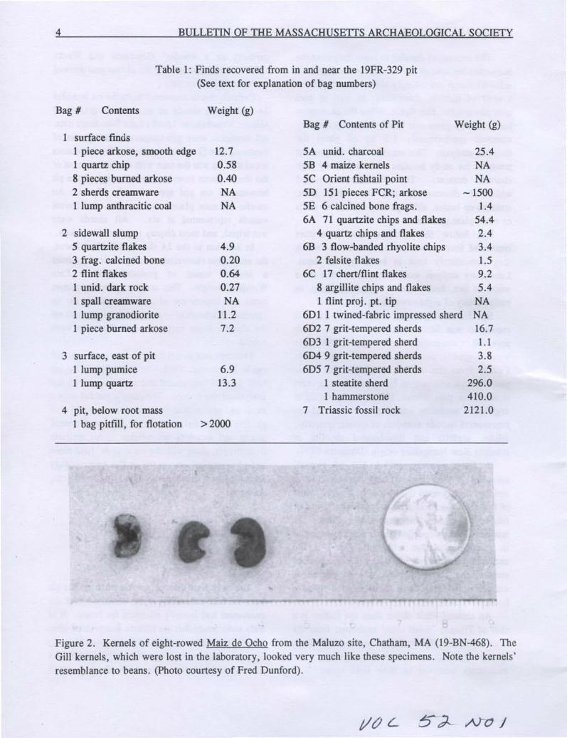
Figure 2. Kernels of eight-rowed Maiz de Ocho from the Maluzo site, Chatham, MA (19-BN-468). TheGill kernels, which were lost in the laboratory, looked very much like these specimens. Note the kernels'resemblance to beans. (photo courtesy of Fred Dunford).
VOLUME 52. NUMBER 1 5
At the Blain Village site in Ohio, Maiz deOcho kernels were radio-carbon dated toapproximately AD 1040 (Galinat 1970).Furthermore, Brown and Anderson (1947) hadreported Maiz de Ocho in New York state atapproximately the same time. These recoveriesoriginally led Galinat to conclude:
Data mapping the prehistoricspread of the eight-rowed race ofmaize...are still meager. This raceleft the Southwest after AD 700 ona course toward NewEngland ...where it probablyarrived later than AD 1000...(1970:224).
recovered three kernels of Maiz de Ocho from theMaluzo site at Chatham (19-BN-468) (Dunford1986). The resemblance that these kernels bear tobeans is immediately apparent (Figure 2).
In a letter to Dr. Dincauze analyzing the Gillkernels, Dr. Galinat wrote that" ... the diagnosticattributes of the kernels of this race are wider (w)than deep (d) and, thereby, give a wid ratio greaterthan unity ... " (Galinat 1979). Galinat alsoprovided the measurements of the kernels:
As more data appeared, Galinat revised the date ofmaize's entrance into New England dramatically tothe present estimate of approximately 1400 A.D.(Galinat 1985).
Bumsted reported maize at the Donohue siteappearing in the Middle Late Woodland period.Although three cobs and nine individual kernelswere recovered during her excavations, Bumstedcould not date the carbonized maize because of theunavailability of accelerator dating at the time. Asample of butternut shells yielded an age of 510 ±
Ceramics
The majority of the ceramics recovered fromthe 19FR-329 pit are of Middle Woodland origin.The crushed-granite grit temper generally hasmoderate, visible particles of feldspar and quartz;exteriors are impressed and wet-wiped. The meanthickness of the admittedly insignificant samplewas 8.37 mm. Most of the sherds arelight-colored, ranging in hue from tan to brown.In temper, thickness and color the 25 undecoratedsherds generally resemble Middle Woodlandceramics from the Winooski site (VTCH46)described by Petersen (1980).
The twined-fabric impressed sherd differsnoticeably from the other pottery fragmentsrecovered from the pit. It appears to beshell-tempered, although the high degree ofcarbonization both of the temper and of the interiorof the sherd makes the identification tentative. Thefabric impression is one of tight weaving in apattern similar to Category TF17 described byScholtz in a Middle Late Woodland context (1975).The pattern is also similar to the Kelso CordedVariant of the Late Pahaquarra and Early Minisinkcultures of New Jersey (AD 1250-1400) (Kraft1975).
Clearly, the dating of the pit is problematic,given the broad temporal range of the artifacts.For example, the steatite sherd and the OrientFishtail point are roughly coeval, both dating to theLate Archaic of approximately 3000 years BP.Furthermore, the majority of the ceramics were ofMiddle Woodland origin. The presence of theMiddle Late Woodland sherd, however, at leastallows us to propose that the sealing of the pit tookplace in the Middle Late Woodland period.
125 radiocarbon years B.P., which made therecovered maize "... the first documentedprehistoric remains [of maize] from Vermont"(Bumsted 1980:81). Ritchie's kernel fromHornblower II has already been discussed.
Ratio Race1.10 Maiz de Ocho1.16 Maiz de Ocho1.47 Maiz de Ocho1.50 Maiz de Ocho
*Estimate
Depth5.0mm6.4 mm*6.0 mm*6.0 mm*
Kernel Width1 5.5 mm*2 7.3 mm3 8.8 mm4 9.0mm
6 BULLETIN OF THE MASSACHUSETTS ARCHAEOLOGICAL SOCIETY
SUMMARY
Archaeologists working in Massachusetts needto realize that when it comes to prehistoric maize,things are very seldom what they seem. It is quitepossible that other remnants of Maiz de Ocho mayhave passed undetected; it is also quite possiblethat they may have been misidentified as beanremains.
Furthermore, the presence of prehistoric maizeat Gill confirms the necessity for furtherinvestigations within the Riverside ArchaeologicalDistrict. Thomas (1980:75) proposed questions of"short distance and long-distance phenomena"pertaining to the study of prehistoric populationdynamics and settlement patterns in the District.Given his hypothesis that the area may have been"an important location for the maintenance of thecommunication network among 'minimal bands'during the Early and Middle Archaic" (1980:93),and given the Late Woodland date for the sealingof the 19FR-329 pit, the potential for observinglong-term cultural change within a tightly-focusedgeographical area is significant.
Thomas recognized that his model washeuristic, especially because he based it on the onlydata available from the region, the excavation ofthe WMECO site. Certainly data from theunpublished Stemple and Casley sites will supportor refute the theorized communication and tradenetworks. The sheer amount of material from the
Stemple site alone, of which Hight (1980) made apreliminary assessment, holds an enormouspotential for study.
Further work in the Riverside ArchaeologicalDistrict has a twofold potential. First, thetantalizing glimpse of maize from the 19FR-329 pitindicates that there may be other maize remainsthat archaeologists are just not recovering.Second, further examination of excavated sitesmight provide a data base from which the "actualpopulation densities" (Thomas 1980:90) might betested. These are questions that are fundamental tothe larger issues of settlement patterns in NewEngland prehistory, and they demand answers.
Acknowledgements
Writing a report about the excavation of afeature dug nearly a decade ago is a processfraught with peril. I would like to thank theexcavators of the pit, Dr. Dena Dincauze andJanice Weeks. Their notes, comments andrecollections have been invaluable in reconstructingevents of the summer afternoon in Gill. FredDunford generously supplied the photograph ofmaize from the Maluzo site. I would also like tothank Ann Marie Mires for her help with theflotation sample and John Cross for hisidentification of the material of the Orient FishtailPoint. Any errors of fact or interpretation,however, are strictly my own.
REFERENCES CITED
Brown, W.L. and E. Anderson1947 The Northern Flint Corns. Annals of the Mis
souri Botanical Garden 34(1): 1-28.
Bumsted, M.P.1980 VT-Ch-94: Vermont's earliest known agricultur
al experiment station. Man in the Northeast19: 73-82.
Cross, J. Personal communication to author, 17November 1988.
Dincauze, D.F.1976 The Neville Site: 8,000 Years at Amoskeag,
----- and Weeks, J.1979 Field notes from the excavation of the [19FR
329] Pit. Manuscript on file at the Departmentof Anthropology, University of Massachusetts,Amherst.
Dunford, F.J.1986 19-BN-468 Chatham, MA: Site Salvage with a
Research Orientation. Bulletin of the Massachusetts Archaeological Society 47:34-41.
Galinat, W. C.1970 Maize from the Blaine Site. In Blaine Village
and the Fort Ancient Tradition in Ohio, editedby O.H. Prufer and O.C. Shane III, pp. 219226. Kent State University Press, Kent.
1979 Letter to Dr. Dena Dincauze.
1985 Domestication and Diffusion of Maize. InPrehistoric Food Production in North America,edited by R.I. Ford, pp. 245-282. Anthropological Papers No. 75, Museum of Anthropology, University of Michigan, Ann Arbor.
Hight, S.1980 Fort Hill in Riverside, Gill, Massachusetts.
Unpublished manuscript in the possession ofDr. Dena Dincauze, University of Massachusetts, Amherst.
7
Kraft, H.C.1975 The Archaeology of the Tocks Island Area.
Archaeological Research Center, Seton HallUniversity Museum, South Orange.
Petersen, J.B.1980 The Middle Woodland Ceramics of the Win
ooski Site, AD 1-1000: Vermont Archaeological Society, New Series Monograph No.1,Burlington.
Ritchie, W.A.1969 The Archaeology of Martha's Vineyard. The
Natural History Press, Garden City, NewYork.
Scholtz, S.C.1975 Prehistoric Plies: A Structural and Comparative
Analysis of Cordage. Netting. Basketry andFabric from Ozark Bluff Shelters. ArkansasArchaeological Survey Research Series No.9.University of Arkansas, Fayetteville.
Thomas, P.A.1980 The Riverside District, the WMECO site and
suggestions for archaeological modeling. InEarly and Middle Archaic Cultures of theNortheast, edited by D. Starbuck and C.Bolian, pp. 73-95. Occasional Papers in Northeast Anthropology No.7.
Weeks, J. Personal communication to the author, 18October 1988.
A BRIEF NOTE TO CONTRIBUTORS
The Editor solicits for publication original contributions related to the archaeology of Massachusetts.Manuscripts should be sent to the Editor for evaluation and comment. Authors ofarticles submitted to theBulletin of the Massachusetts Archaeological Society are requested to follow the style guide for AmericanAntiquity 48:429-442 (/983). Additional instructions for authors may be found in the Bulletin of theMassachusetts Archaeological Society, Volume 50, Number 2:76 (/989).
8 BULLETIN OF THE MASSACHUSETTS ARCHAEOLOGICAL SOCIETY
NEW ENGLAND'S LOGBOATS: FOUR CENTURIES OF WATERCRAFT
Ann Marie Plane
Dugout boats provide an untapped resourcefor understanding the ways in which the inhabitantsof New England have lived and worked at differenttimes in history. Yet when unearthed from pondsor enshrined in museums, these vessels are oftenmistaken for artifacts from the precontact Indianpast. My study of New England's dugouts, orlogboats as many prefer to call them (McGrail1978, vol. 1: 2)1, has shown that most survivingboats date from a later period, when both Indiansand Euro-Americans made such boats. Irish,English, French, African, and native Americandesigns converged to create New England'slogboats. From their all-purpose uses in theseventeenth century, to their survival in the northwoods of-the twentieth, New Englanders preferredlogboats to other, more sophisticated craft. Farfrom being pristine artifacts of Amerindianexperience, all but a handful of the survivinglogboats discovered in New England as of thiswriting appear to date to the contact or historicperiod.
By studying these logboats from New Englandwe can glimpse the ways in which the people-English, French, and Amerindian--made and usedthese boats within specific regional economies.The dynamics between these three groups variedwidely in different regions and different timeperiods. Further, the examples remind us onceagain that people shape their material worldaccording to cultural needs and expectations, incombination with environmental conditions andresource availability. As students of materialculture have argued, all material objects reflect theculture that produced them. The cultural andmaterial worlds are intertwined in the design,construction, and use of common objects. AsRobert St. George put it, when read "socially,"
Copyright 1991 Ann M. Plane
artifacts must be "interpreted as related parts of alarger puzzle" (St. George 1988:9). Logboats, likeother artifacts of the material world, have a greatdeal to tell us about the cultures that made andused them.
Elsewhere I have argued that New England'slogboats fall into two loosely defined types: acoastal/riverine type found from Connecticut toNova Scotia, and an inland lake type prevalent innorthern New England, New Brunswick, andQuebec (plane 1990:2,38). My conclusions werebased on the study of surviving canoes from NewEngland and Canada, in combination withreferences in historical documents. Of the thirtyodd boats I located, all but three survive in someform. Probably many more canoes were excavatedin the early part of this century but did notsurvive. I was able to study eleven boats of thesample in detail, recording ten of them by meansofphotography, drawings, and detailed description.I also looked at other researchers' surveys of theseboats when available. Eight boats I studied viapublished or unpublished reports. I compared mysample to surveys of similar boats from NovaScotia, New Brunswick, Ontario, Virginia, andNorth Carolina, as well as England and Ireland, inorder to identify regional characteristics, commonstylistic sources, and so forth.
For detailed reports on these vessels, I referthe reader to my unpublished essay (plane 1990:Appendix). But, in brief, of those surviving boatsthat have been radiocarbon dated, only four,located at three underwater sites in Vermont,predate the period of contact with Europeans.Those which appear to be of early contact periodnative American origin (see Figures 1, 2) tend tohave rounded ends and less angular appearance,whereas the Euro-American are more likely tohave a pointed bow and a square or truncate stern(Fig. 3). Common features of historic period boats
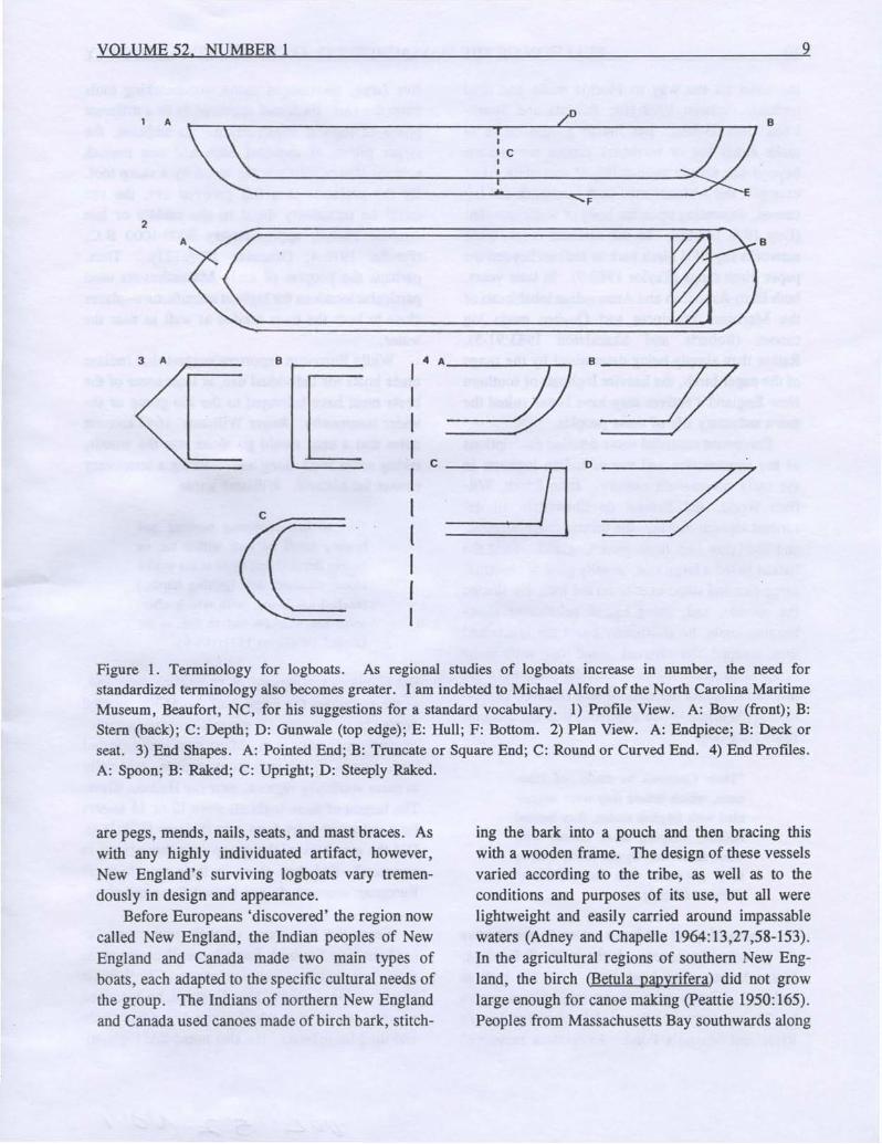
Figure 1. Terminology for logboats. As regional studies of logboats increase in number, the need forstandardized terminology also becomes greater. I am indebted to Michael Alford of the North Carolina MaritimeMuseum, Beaufort, NC, for his suggestions for a standard vocabulary. 1) Profile View. A: Bow (front); B:Stem (back); C: Depth; D: Gunwale (top edge); E: Hull; F: Bottom. 2) Plan View. A: Endpiece; B: Deck orseat. 3) End Shapes. A: Pointed End; B: Truncate or Square End; C: Round or Curved End. 4) End Profiles.A: Spoon; B: Raked; C: Upright; D: Steeply Raked.
are pegs, mends, nails, seats, and mast braces. Aswith any highly individuated artifact, however,New England's surviving logboats vary tremendously in design and appearance.
Before Europeans 'discovered' the region nowcalled New England, the Indian peoples of NewEngland and Canada made two main types ofboats, each adapted to the specific cultural needs ofthe group. The Indians of northern New Englandand Canada used canoes made of birch bark, stitch-
ing the bark into a pouch and then bracing thiswith a wooden frame. The design of these vesselsvaried according to the tribe, as well as to theconditions and purposes of its use, but all werelightweight and easily carried around impassablewaters (Adney and Chapelle 1964:13,27,58-153).In the agricultural regions of southern New England, the birch (Betula papyrifera) did not growlarge enough for canoe making (peattie 1950: 165).Peoples from Massachusetts Bay southwards along
10 BULLETIN OF THE MASSACHUSETTS ARCHAEOLOGICAL SOCIETY
the coast all the way to Florida made and usedlogboats (Salwen 1978: 164; Roberts and Shackleton 1983:63-80). But Indian people chose tomake either log or birchbark canoes for reasonsbeyond the simple availability of materials. Forexample, the Abenaki used both birchbark and logcanoes, depending upon the body of water traveled(Day 1978: 148-59). In the extreme north, tradenetworks supplied birch bark to Indians beyond thepaper birch range (faylor 1980:9). In later years,both Euro-American and Amerindian inhabitants ofthe Maritime Provinces and Quebec made logcanoes (Roberts and Shackleton 1983:91-5).Rather than simply being determined by the rangeof the paper birch, the heavier logboats of southernNew England's natives may have better suited themore sedentary life of these peoples.
Europeans recorded some detailed descriptionsof the construction and use.of Indian logboats inthe early seventeenth century. John Smith, William Wood, and Samuel de Champlain all described logboat making, the former from Virginia,and the latter two from New England. First theIndian felled a large tree, usually pine or chestnut,using fire and stone axes to do the job. He shapedthe outside, and, using heated pebbles or slowburning coals, he alternately burnt the inside andthen scraped the charred wood out with stonescrapers or clam shells, carefully controlling theprocess to obtain the desired size (Fowler 1976: 1-3). As William Wood described it in his accountsfrom 1629-34,
"Their Cannows be made...of Pinetrees, which before they were acquainted with English tooles, they burnedhollow, scraping them smooth withClam-shels and Oyster-shels, cuttingtheir out-sides with stone-hatchets"(Wood 1898:96).
Archaeological evidence seems to corroboratethe historians' accounts. A site in North Reading,Massachusetts may have been used for logboatmaking. A large mass of charcoal, 6.1 m squareby 28 cm deep was found 1.8 m above Skud'sRiver and Martin's Pond. Excavators recovered
five large, undamaged stone woodworking toolsfrom the site. Each tool appeared to fit a differentphase of logboat construction. In addition, thelarger pieces of charcoal each had one smoothside, as if scraped from the wood by a sharp tool.By the presence of a full grooved axe, the sitecould be tentatively dated to the middle or lateArchaic Period, approximately 5000-1000 B.C.(Fowler 1976:4; Dincauze 1976: 121). Thus,perhaps the peoples of early Massachusetts usedparticular locations for logboat manufacture--placesclose to both the trees needed as well as near thewater.
While European reporters suggest that Indiansmade boats for individual use, at least some of theboats must have belonged to the kin-group or thewider community. Roger Williams' 1643 accountnotes that a man would go alone into the woods,taking some food along and building a temporaryshelter for himself. Williams wrote,
"but so hee continues burning andhewing untill he hath within ten ortwelve dayes (lying there at his workealone) finished, and (getting hands,)lanched his Boate; with which afterward hee ventures out to fish in theOcean" (Williams 1971:108-9).
But Williams was writing as an English man, and,as we shall see, the English of the 1630s counteddugout boats as personal possessions, made exclusively by individual men. Many explorers reportedlarge canoes, filled with many natives, especiallyin more southerly regions, near the Hudson River.The largest of these logboats were 12 or 15 meterslong and could carry forty men (Salwen 1978:164).Did the members of the group own these boats incommon? Did they share in their manufacture?European accounts do not answer these questions.
From the first years of their settlement throughout New England, English colonists also madetheir own multi-purpose log canoes. In WilliamWood's 1634 acount of New England, he describedsome of the ways in which Euro-Americans madeand used these boats. He also noted that logboats
5 ~ A.JCJ /
VOLUME 52, NUMBER 1 11
2
c
.'. ,,, "
A '. :B · ,·0
• W· ' 0• • I• I
'. I, •• " \ ,,, \ ,, ,,
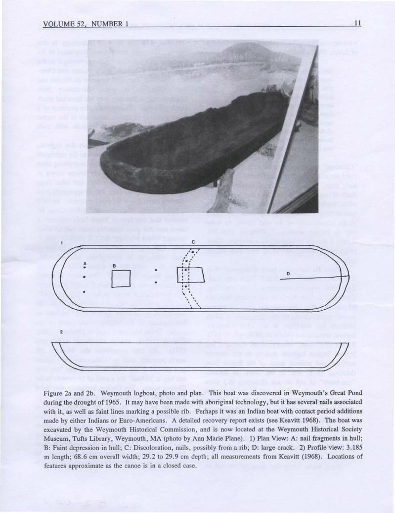
Figure 2a and 2b. Weymouth logboat, photo and plan. This boat was discovered in Weymouth's Great Pondduring the drought of 1965. It may have been made with aboriginal technology, but it has several nails associatedwith it, as well as faint lines marking a possible rib. Perhaps it was an Indian boat with contact period additionsmade by either Indians or Euro-Americans. A detailed recovery report exists (see Keavitt 1968). The boat wasexcavated by the Weymouth Historical Commission, and is now located at the Weymouth Historical SocietyMuseum, Tufts Library, Weymouth, MA (photo by Ann Marie Plane). 1) Plan View: A: nail fragments in hull;B: Faint depression in hull; C: Discoloration, nails, possibly from a rib; D: large crack. 2) Profile view: 3.185m length; 68.6 em overall width; 29.2 to 29.9 em depth; all measurements from Keavitt (1968). Locations offeatures approximate as the canoe is in a closed case.
12 BULLETIN OF THE MASSACHUSETTS ARCHAEOLOGICAL SOCIETY
were especially popular in particular areas, writingof Salem, Massachusetts,
they crosse these rivers with smallcannowes, which are made of wholepine trees, being about two foot & ahalf over, and 20. foote long: in theselikewise they goo a fowling, sometimes two leagues to sea; there bemore Cannowes in this town than inall the whole Patent; every householdhaving a water-house [water-horse] ortwo (Wood 1898:35).
"Cannows" show up frequently in probate andcourt records of the Plymouth Colony from a veryearly date. In 1638, a jury of inquest into thedeath of one John England found that he drownedwhile "sayleing in a canow ofMr. Thomas Burne'sbetwixt Greene's Harbor andPlymouth...by reasonof the insufficiency of the said canow, to makeway in stormy weather. .. " (yentsch 1986:57).Within a decade of year-round settlement, Europeans were making and using their own dugoutcanoes.
Where did Europeans learn of dugouts? Wasit from the Indians? The Irish? Their own tradition? The evidence sometimes seems confusing.Certainly, as Sean McGrail has documented, theEnglish and other Europeans had made logboats ofvarious types, usually of oak (Ouercus sp.), whichMcGrail has described as the ideal wood forlogboat construction (McGrail 1978, vol. 1: 117).By the seventeenth century, wood shortages hadlimited English logboat- making to the extremenorthern and western areas of the British Isles(McGrail 1978, vol. 2: fig. 206). In Ireland,"tree-boats" of oak or ash (Fraxinus sp.) weremade right up through the end of the eighteenthcentury (MacDowell 1983, vol. 1: 16, 43). HenryGlassie has suggested that logboats were only fullyaccepted into Anglo-American culture when thatculture included African and Irish elements (Glassie 1972: 158), and certainly English contact withthe Irish and African peoples familiarized themwith such vessels.
.But it seems likely that Amerindians had an
enormous influence on boat technology in thisregion. The word itself, canoe, originated in theAmericas, as a post-Columbian borrowing from theCarib word for logboat, canoa (Adney and Chapelle 1964:13). The small numbers of African andIrish Americans in seventeenth-century NewEngland suggest that they may not have had muchdirect influence. Undoubtedly, the presence of alively tradition of Indian canoe use in the regionstimulated the adoption of logboats with suchenthusiasm by the English.
The documentary record shows that logboatsremained popular with colonists into the eighteenthcentury, and they used them for everything fromferrying passengers and goods across rivers tohauling manure, salt marsh hay, and other largeloads (plane 1990:16-34)2. People apparently evenreserved certain trees for making canoes. In 1679in Essex County, Massachusetts, Robert Cross, Jr.testified that one Samuel Pipen "sold deponent acanoe tree that grew upon the north side of a hillamongst ledges of rocks" (ECCR 1913-19, vol. 7:203). Canoe trees were also protected by law insome areas, as in Springfield, Massachusetts,where they could not be felled without generalconsent (Bacon 1970:306? One survey of household inventories from Suffolk County, Massachusetts (excluding Boston), in the period from 1675to 1775, turned up only four canoes out of all 109inventories (Cummings 1964:v,276), perhaps sofew because of the largely inland focus of thestudy. These four were used in Dedham (1681),Chelsea (1761), and in Dorchester (1768 and1771). All four inventories also included saltmarsh property, such as "Canoo meadow" valuedat 9 pounds in the Dedham estate, and "ten loadsalt hay at 36/load" for a total of 18 pounds in theChelsea estate. The Chelsea inventory also listeda great deal of livestock and a "Negro man," whoperhaps brought African or African-Americannotions of boat design to New England.4 All thisshows that throughout the colonial period, canoesfitted comfortably within the system of pettyenterprise and private ownership common to NewEngland's Euro-American coastal settlement. Incertain pockets of the coast, logboats continued in
tit!L t5.2--~ /
VOLUME 52, NUMBER 1 13
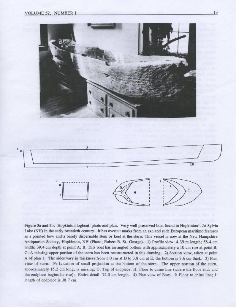
Figure 3a and 3b. Hopkinton logboat, photo and plan. Very well preserved boat found in Hopkinton's Jo-SylviaLake (NH) in the early twentieth century. It has overcut marks from an axe and such European maritime featuresas a pointed bow and a barely discernable stem or keel at the stern. This vessel is now at the New HampshireAntiquarian Society, Hopkinton, NH (photo, Robert B. St. George). 1) Profile view: 4.39 m length; 58.4 cmwidth; 39.4 cm depth at point A; B: This boat has an angled bottom with approximately a 10 cm rise at point B;C: A missing upper portion of the stern has been reconstructed in this drawing. 2) Section view, taken at pointA of plan 1. The sides vary in thickness from 1.0 cm at D to 3.8 cm at E; the bottom is 7.6 cm thick. 3) Planview of stern. F: Location of small projection at the bottom of the stern. The upper portion of the stern,approximately 15.2 cm long, is missing; G: Top of endpiece; H: Floor to chine line (where the floor ends andthe endpiece begins its rise); Entire detail: 74.3 em length. 4) Plan view of Bow. I: Floor to chine line; J:length of endpiece is 38.7 cm.
14 BULLETIN OF THE MASSACHUSETTS ARCHAEOLOGICAL SOCIETY
use right up to the twentieth century. Despitedepletion of local wood resources by the lateeighteenth century (Cronon 1983: 112-3), logboatswere used for oyster-tonging in the New Haven(CT), flats until the early twentieth century. Threewhich survive have histories that link them to aspecific maker in the first quarter of the nineteenthcentury. According to Ernest E. Ball, the son ofthe original owner of several such boats, dugoutswere made at Cayuga Lake, one of the "Fingerlakes" of upstate New York by "a man calledUncle John Smith who was a veteran of the war of1812" (Ball 1938). Smith floated the canoes downthe Erie Canal and the Hudson River. Oystermenof New Haven preferred these boats, presumablybecause they were uniquely suited to work amongoyster flats.
In northern New England, sparser settlementand an economic dependence on hunting andfishing encouraged lively use of small logboats onponds and lakes right into the twentieth century.These inland boats survive in relatively greaternumbers than either the coastal/riverine or theaboriginal types. Sunk in ponds and marshes, theyare discovered and excavated with some frequency.Their common characteristics include flat bottoms6-7.5 cm thick, sides rising at near ninety degreeangles, and square or pointed bows. These boatstend to range from 3~ meters in length, while thecoastal boats run from 6-9 m in length. The inlandboats in general look rougher than the coastal andriver logboats--their lines are sharper, and theysometimes still bear the blade marks from the toolsused to make them. Examples of this type of pondor lake boat cluster in northern New England,although some examples exist elsewhere.
Boats such as these seem to have been used onone pond or lake, for fishing, transportation, andfowling up into the twentieth century. The AdamsFamily of Fair Haven, Vermont, made and usedone such boat on Lake Champlain. John TracyAdams described its manufacture and use in somedetail after its purchase by the Vermont Divisionfor Historic Preservation. Adams reported that thedugout was made in 1881 or 1882, "to use forhunting and trapping muskrats" (Adams n.d.:l).
Adams' ancestor, James E. Adams, made the boatwith a friend, Benjamin Smith, who had builtabout thirty dugouts. Adams notes,
In the summer of 1881 Mr. Smith andMr. Adams started searching for afine log large enough to make a dugout. They finally found one in Benson, Vermont and purchased it, to becut when the snow was deep to savelog from any breaking or splittingdamage when falling. When the snowwas deep in the winter, they drovetheir team and sleighs up on the laketo Benson Landing, then to the treewhich they fell, loaded on the sleighs,and started back to West haven. As
they drove up the lake, they choppedoff the rough sides of the log to startthe outside shape of the dugout (Adams n.d.:1-2).
After the outside shape was complete, the menbored holes in the curvature of the boat to serve asthickness gauges. They cut red cedar pegs to thedesired finished thickness, drove them into theholes, and then removed wood from the inside.The boat was repaired several times, once whenthe side was cracked, and again when the heartwood from the bow rotted away. Adams reportsthat the boat was in use for about seventy years,which would mean that his family stopped using itin the 1940's or 1950's (Adams n.d.:2-3).
To be sure, other than the four Vermont finds,there are no surviving logboats from New Englandthat clearly reflect a flourishing and unchangednative American culture; no such unchangedculture could exist. However, boats from Canadademonstrate ways in which the material world ofthe Indians both responded to and influencedEuro-Canadian society. Both in New Brunswickand in Ontario, Indians made logboats that responded to birchbark designs as well as to European design challenges. Several canoes as well asoral history from Ontario suggest that, as Indiansbecame more sedentary they adopted logboats,which remained in use well into the twentieth
VOLUME 52, NUMBER 1
century (Rogers 1965:458). A canoe from NewBrunswick demonstrates similar influences frombirchbark design on the log canoes of Indians ineastern Canada. Its light design and delicate hullreflect birchbark traditions as well as similarities tothe light French-Canadian pirogue, which springsfrom the same influences (plane 1990:42-4).
Euro-Americans also felt the influence ofIndianboats, sometimes adopting Indian styles intentionally. As early as the late eighteenth century, Indiansand their boats had begun to hold some romancefor white New Englanders.5 By the mid-nineteenthcentury, the Indian was firmly entrenched as aromantic figure in the American mind. FromThoreau onward, whites traveled to the northwoodsof Maine and Canada for 'back to nature' experiences. 6
It is this romance that shapes our attitudesabout logboats even today. As I have shown inthis paper, logboats did have a source in the nativeAmerican cultures of this area. But they also wereintegrated into Euro-American culture, and thisintegration persisted beyond the point of initialfrontier contact into the twentieth century in manyareas. When we can keep this tradition in mind,then we can better understand and more accurately
15
interpret the artifacts before us. I hope that thisessay has demonstrated some of the real history ofNew England's logboats, and the people who madethem. Indians belong in this story, but not as theyhave been romantically portrayed. Rather, theAmerindian traditions form one strand of manywhich converged to create the logboats of NewEngland's past.
Acknowledgements: I would like to thank themany museums, historical societies, and individuals who opened their collections to me. I am alsograteful for the advice and criticisms of MaryBeaudry, Robert B. St. George, Timothy Kent andElizabeth Little. Of course, any errors in theconclusions presented here are mine.
* * * * * * *
Author's Note: If you discover a logboat, contactyour state archaeologist before excavation. Insoutheastern New England you may also reportlogboats to the archaeology department at thePeabody Museum, Salem (MA) (508-745-1876), orto the Massachusetts Archaeological Society,Middleborough (MA) (508-947-9005).
End Notes
1. Sean McGrail has argued that the term dugoutconnotes a method of construction which may not havebeen used, and also that these boats should be considered along with rafts and multi-log boats (McGrail1978, vol 2: 2).
2. In 1654 a servant to Thomas Williams of WinterHarbor [Maine] was presented to the court, "for Emptiing a conow that was laded with dressing for groundon the Lords day & for cariing the said conow to theside of Richard Moores boate" (See Case of SylvesterPage, June 29, 1654, Yorkshire County, Maine Province and Court Records, vol. 2: 31). In 1664, NicholasCole of Wells [Maine] was granted "lyberty to keepe theFerry over Cape Porpus River for the Tearme of SevenYeares, hee providing a Conow & makeing bridges forconveniency of passage & travelling.... " (Act establish-
ing a ferry, July 5, 1664, Wells, MPCR, vol. II: 158).In Essex County, Massachusetts, in 1670, a dispute overa piece of salt meadow led to the seizure of hay allegedly cut illegally. William Hascall, Jr. deposed that hewent with the Constable's deputy "to Goodman Harradine's dock where there were two loads of hay oncanoes" (Edward Harraden vs. James Steevens andAnthony Day, Ipswich Quarterly Court, ECCR, vol. III:442).
3. Springfield, due to its location on the wide Connecticut River and its early settlement, may have used boatslike those of the coastal regions.
4. Estates of Sgt. Henry Wight, Dedham, April 2,1681; Jonathan Bill, Chelsea, Nov. 19, 1761; SamuelPierce, Dorchester (yeoman), Nov. 22, 1768; James
16 BULLETIN OF THE MASSACHUSETTS ARCHAEOLOGICAL SOCIETY
5. In 1773, a Connecticut-born white student of Dartmouth College, John Ledyard, left school in a dugout hemade himself. As described by an unspecified alumnusof the college, Ledyard "absents himself for threemonths without leave in rambling among the Indians ofCanada and the Six Nations. Leaves the college in acanoe made with his own hands and descends theConnecticut alone to Hartford." To
complete the romance, Bacon's sources inform us thatLedyard took only a bearskin, a shelter made of willowbranches at one end of the canoe, and Ovid and theGreek Testament along with him. Ledyard went on toexplore the world, writing accounts of parts of Africaand Siberia and chronicling Captain Cook's last voyageto Hawaii (Bacon 1970:384).
6. For an account of Thoreau's journey and an exampleof the continued allure of the north woods, see McPhee(1975:69-73, and throughout).
Primary
REFERENCES CITED
Maine Province and Court Records, vol. II, IV.1931,1958. Maine Historical Society, Portland, ME.
Adams, John Tracyca. 1970. History of the Adams Dugout Canoe.
Letter, Fair Haven, VT, to William B. Pinney.Division of Historic Preservation, Montpelier,Vermont.
Ball, Ernest E.1938 Letter to Fred F. Hill. New Haven, Connecti
cut, September 20. Catalog Entry for numberBU 6, The Mariner's Museum, Newport News,Virginia.
the Names, Uses, and FumishingsofRooms inthe Colonial New England Home 1675-1775.Society for the Preservation of New EnglandAntiquities, Boston, MA.
Dincauze, Dena F.1976 The Neville Site: 8,000 Years at Amoskeag,
Manchester NH. Peabody Museum Monographs, No.4. Harvard University, Cambridge.
ECCR: See Essex County Court Records.
Essex County Court Records, vol. III, IV, VII, VIII.1913-19. The Essex Institute, Salem, MA.
MPCR: See Maine Province and Court Records.
Roberts, Kenneth G., and Philip Shackleton1983. The Canoe: A History of the Craft from Pan
ama to the Arctic. The International MarinePublishing Company, Camden, ME.
Williams, Roger1971. A Key into the Language of America [1643].
English Linguistics 1500-1800 Series, no. 299,ed. R.C. Alston. The Scolar Press Limited,Menston, England.
Wood, William1897 New England's Prospect [1634], ed. E. M.
Boynton, London; reprint, n.p., Boston, MA.
Yentsch, Anne E., ed.1986. Plymouth Colony Wills and Inventories, vol.
I, II. Plimoth Plantation, Plymouth, MA.
Secondary
Adney, Edwin Tappan and Howard I. Chapelle1964. The Bark Canoes and Skin Boats of North
America. Smithsonian Institution, Washington,D.C.
Bacon, Edwin M.1970. The Connecticut River and the Valley of the
Connecticut [1906]. G. P. Putnam's Sons,New York; reprint, Johnson Reprint Corporation, New York.
VOLUME 52. NUMBER 1
Cronon, William1983. Changes in the Land: Indians. Colonists. and
the Ecology of New England. Hill and Wang,New York.
Day, Gordon M.1978 Western Abenaki. In Handbook of North
American Indians, vol. 15, edited by Bruce G.Trigger, pp. 148-159. Smithsonian Institution,Washington, D.C.
Fowler, William S.1975-6 A Review of Dugout-Making. Bulletin of
the Massachusetts Archaeological Society37: Hi.
Glassie, Henry1972 The Nature of the New World Artifact: The
Instance of the Dugout Canoe. Festschrift porRobert Wildhaber, for his 70th birthday ofAugust 3, 1972. English Translation. NewYork Folk Quarterly 24(4):153-67.
Keavitt, Chester B.1968 Aboriginal Dugout Discovered at Weymouth.
Bulletin of the Massachusetts ArchaeologicalSociety 30: 1-5.
McGrail, Sean1978 Logboats of England and Wales with compara
tive material from European and other Countries, vol. 2. National Maritime Museum,
17
Archaeological Series No.2, British Archaeological Reports, Greenwich, England.
McPhee, John1975 The Survival of the Bark Canoe. Farrar,
Straus, Giroux, New York.
Peattie, Donald Culross1950 A Natural History of Trees of Eastern and
Central North America. Houghton Mifflin,Boston.
Plane, Ann M.1990 Logboats of New England. Master's Essay,
American Studies. Boston University, Boston.
Rogers, Edward S.1965. The Dugout Canoe in Ontario. American
Antiquity 30:454-9.
St. George, Robert Blair1988 Introduction. In Material Life in America,
1600-1860, ed. by Robert Blair St. George, pp.3-13. Northeastern University Press, Boston.
Salwen, Bert1978 The Indians of Southern New England and
Long Island: Early Period. In Handbook ofNorth American Indians, vol. 15., edited byBruce G. Trigger, pp. 160-176. SmithsonianInstitution, Washington, D.C.
Taylor, J. Garth1980 Canoe Construction in a Cree Cultural Tradi
tion. National Museum of Man, MercurySeries: Canadian Ethnology Service, paper #64.National Museums of Canada, Ottawa.
18 BULLETIN OF THE MASSACHUSETTS ARCHAEOLOGICAL SOCIETY
THE HATHAWAY SITE, SECTIONS 6 AND 5, ROCKY NOOK, KINGSTON, MASSACHUSETTS:A SMALL LATE WOODLAND AND LATE ARCHAIC LITHIC WORK SITE,
AND A SMALL LATE ARCHAIC SHELL MIDDEN
Bernard A. Otto
This site is located on a seventeen acre (8.6hectares) parcel of land owned by Isaac and MaryHathaway. Westward lies an extensive salt marshthrough which the lower part of the Jones Riverflows. Eastward at the mouth of the river isKingston Bay (Figure 1).
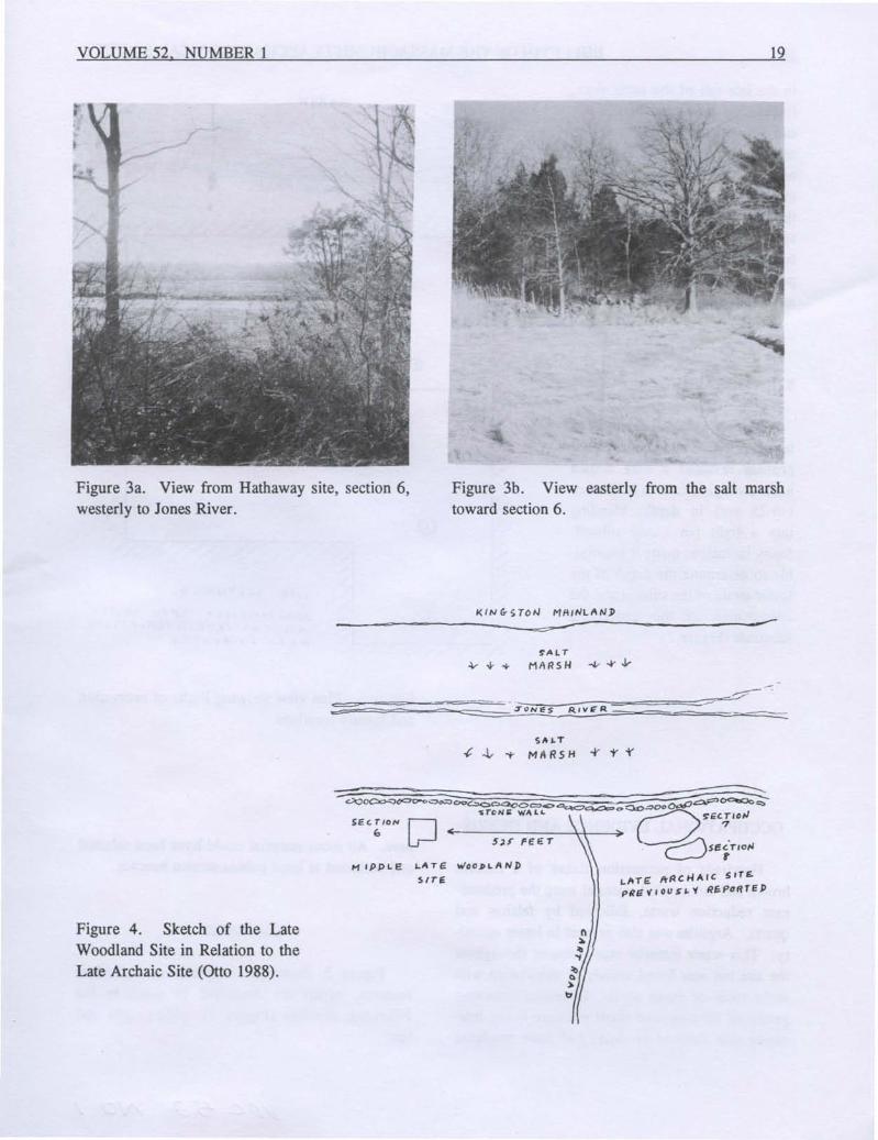
The Hathaway property is part of the RockyNook peninsula and is heavily wooded with cedar,oak, maple and dense brush and briar. There arenumerous rock out-croppings and ledges. Situatedon a level, wooded shelf overlooking the marshand river (Figures 2, 3a,b), the locus, section 6 of
the Hathaway Site, lies south 525 feet (159 m)across the cart road from the Late Archaic site,Section 7 and 8, previously reported by the author(Otto 1988; Figure 4).
Beyond a bordering old stone wall, the dropoff to the marsh is six feet (1.8 m). The stone toolpreparation site layover a lightly defined LateArchaic component.
After shovel testing for the limits of the site, Ilaid out a north/south baseline. Robert Po and Ibegan excavations in the early spring of 1976.Working on weekends, we stopped the excavation
Figure 3a. View from Hathaway site, section 6,westerly to Jones River.
19
Figure 3b. View easterly from the salt marshtoward section 6.
KIN G- STON MAINLAN»
---=---------=.;;;r ~----~------------
Figure 4. Sketch of the LateWoodland Site in Relation to theLate Archaic Site (Otto 1988).
I-I\TI:: /+ACHAIC SITEpRri 'i' ou S ~ 'f Rf;poRTE P
20 BULLETIN OF THE MASSACHUSETIS ARCHAEOLOGICAL SOCIETY
APPROJt.IMAT£~'1 1,I''tO SQ. F'(,fJCLt:I>I"c,. TREE INT/:/l1I.CprlCNS
wERE c=)Cc;AVAfiSP
in the late fall of the same year.Excavation was extremely difficult because of the forest coverand stony nature of the area, andno workable grid could be laidout. We excavated a total of onethousand eight hundred and fortysquare feet (171 sq. m) includingtree interruptions. For recordingpurposes, I designated the locusas section 6 of the Hathaway site.
STRATIGRAPHY
Beneath a woodland duff ofleaves and dead branches, verticalprofiles revealed a dark brownloam averaging four to ten inches(10-25 cm) in depth, blendinginto a light tan sandy subsoil.Stony inclusions made it impossible to determine the depth of thelower strata of the subsoil and thecomposition of the underlyingsubstrate (Figure 2).
Figure 5. Plan view showing limits of excavationand feature locations.
OCCUPATIONAL EVIDENCE AND DEBRIS
Hundreds of percussion flakes of a reddishbrown and tan mottled material were the predominant reduction waste, followed by felsites andquartz. Argillite was also present in lesser quantity. This waste material was scattered throughoutthe site but was found mainly in association withstone tools or stone anvils. Extensive screeningproduced thousands of small pressure-flakes indicating that finished products had been produced
here. All stone material could have been selectedand collected at local pebble-strewn beaches.
FEATURES
Figure 5 shows the locations of individualfeatures, which are described in detail in thefollowing sketches (Figure 7), photographs andtext.
VOLUME 52. NUMBER 1
Feature I (Figure 7.1). Six inches (15 cm) belowground level and bedded well into the subsoil, arather large boulder protruded with a longitudinalcleft or division. In the cleft were several one foot(30 cm) lengths of charred red cedar (Figure 6)with charcoal indicating use as a stone hearth.
Figure 6. Charred red cedar and charcoal fromFeature I.
Feature n (Figure 7.2). A large rock resting inand on the subsoil with stone slabs set on edgeformed a rectangular open-end hearth with charcoalwithin its structure.
Feature ill (Figure 7.3). Two flat stone slabs,one smaller, rested at the terminus of the top soiland were used as anvils with chipping debris onand about them.
Feature IV (Figure 7.4). Directly off one end ofan elongated flat stone anvil positioned at the loamjunction was a concentration of quartz chips.Throughout the site, a number of flat surfacedrocks, large and small, with associated chippingdebris revealed that they also had been used aspercussion support platforms.
Feature V (Figure 7.5; Figure 8). Four inchesbelow ground level a large boulder protruded fromthe subsoil with a wedge-shaped cleft through itscenter. In its soil- and rootlet-ftlled cavity I recovered two extremely well made Levanna points andone tapered stemmed point of maroon argillite.
21
The Levanna points, one of black felsite andthe other of a semi-opaque yellow/red quartz, arevery thin and were skillfully pressure-flaked toperfect symmetry exhibiting a high degree oflcnapping skill. The felsite point with excurvateand recurvate edges is 2 and 1/4 inches (5.72 cm)from tip to basal projections and 1 and 6/16 inches(3.50 cm) in basal width. The quartz schist pointis 1 and 5/8 inches (4.13 cm) in length and 6/16inches (0.95 cm) in basal width. I assume that thethree projectile points were either hidden or misplaced and never utilized.
Feature VI (Figure 7.6; Figure 12). On the southside of a large, in-ground, rounded-top boulder,five feet (1.5 m) in circumference and surfacing atthe top- and subsoil terminus, were six largebroken-in-half stemmed knives and spearpoints,five inches (12.7 cm) below the junction of theloam horizon. Made of the reddish brown and tanmottled material, which predominated at section 6,they were recovered within a two foot (0.61 m)radius along with many waste flakes of the samematerial. The broken halves fit together to formsix whole blades. Whether these large implementswere broken and rejected in the final stages ofreduction or ritually broken is conjecture.
Feature VII (Figure 7.7; Figure 9). Lying directly in contact and situated 5 and 1/2 inches (14.0cm) in the topsoil lens, a lance head and a flat ovalwhetstone lying on top of it were recovered. Thearrangement of these two artifacts hints of deliberate concealment.
Feature VIII (Figure 7.8; Figure 13). Twoclusters, six inches (1.52 cm) apart, of potterysherds were found at the base of the loam. Averaging 1/4 of an inch (6.4 mm) in thickness, theexterior surfaces exhibit cord-malleation and amedium brown coloration. The inner surfaces arealso brown and tool-smoothed. No temper couldbe seen. The sherds were quite hard and durable.Forty-three body sherds comprised the entirety ofthis ceramic feature.
22 BULLETIN OF THE MASSACHUSETTS ARCHAEOLOGICAL SOCIETY
Figure 7 (one inch = 2.5 em).
\,/ \/ /
1/ \1< I ( \.1/
\., I
y
t.IfRC-E {]oUlPER BEPJlEP IN SOG'SOIL.
'filTH PIRT-FII..LE]> CL.EF1'
Itl Cl.EF1'
.1 L.E'I//ltN N 1\ "\/tIVP .I HEMME}) POINT
----"---- -
5. Feature V.
,,\:,
6. Feature VI.( ), .I j I ,
...."
PROTR.UI>lN GaOVlj)E"A ,",'TH
c&.EFrIN $1I8$Ool&.
I"
""
1. Feature I.
\ l( VI IV 'y ,"'It '{Iv (SEVE~Al FooT 1.0N (je "He-HESr lee E 5 0" C. tf It R R E~P_----:t:r-_
Figure 12. Hathaway 6. 1-6: spear heads or knives from FeatureVI; 7: isolated find.
0)~
~"-
~f'
VOLUME 52. NUMBER 1
2
8
25
Figure 14. Hathaway 6. 1,2,3: percussors or hammerstones; 4: basal end of pestle; 5: percussor withbattering on projection; 6: leaf-type knife; 7: lanceolate biface; 8: gouge with concave bit; 9: ovate stemlessknife. Isolated finds.
INTERPRETAnON
The diagnostic Levanna points would indicatea Late Woodland occupation locus. Extensive useof stone anvils and large amounts of chippingdebitage would indicate a complete reduction localefor producing projectiles and edged tools. In
comparing the enormous bulk of waste flakes tothe relatively few recovered projectiles and edgedtools, it would seem that the major portion of thefinished products were transported off site and usedelsewhere. The cord-malleated pottery sherds areprobably associated with the Woodland trianglesand date to the Late Woodland.
26 BULLETIN OF THE MASSACHUSETTS ARCHAEOLOGICAL SOCIETY
TABLE 1. ARTIFACT RECOVERIES FROM SECTION 6, HATHAWAY SITE.
Vertical distribution of artifacts varied verylittle at this undisturbed site with the exception thatthe Late Archaic triangular points were slightlylower in stratification. All recoveries were isolatedfinds, except in features as noted.
The mottled reddish-brown and tan blades(Figs. 9, 12) may be Mansion Inn blades (Watertown and Coburn varieties) and thus represent theLate Archaic (Dincauze 1968), and the thirteenquartz Squibnocket triangular points represent aslightly earlier Late Archaic time (Ritchie 1969).These Late Archaic artifacts may have been anisolated extension of the Late Archaic site on theopposite side of the cart road that was previouslyexcavated and recorded (Otto 1988).
Shell refuse pits that normally give clues tofood resources and diet preferences were totallyabsent. Also absent were fishing gear such asknobbed weights (plummets) and grooved net
weights supporting the fact that other than edgedtool fabrication, site activities were limited here.
The lower reaches of the Jones River andmarsh are subjected to tidal in-flow and out-flowmaking the river water brackish and unpalatable.Two fresh water sources could have been a smallbrooklet entering the marsh one hundred yards(91.4 m) south of the site, and a now defunctspring three hundred feet (91.4 m) eastward.
COMMENTS
This relatively small and isolated campsiteclose to the marsh and river could have been atemporary activity area of short durations for amicro-group originating from larger camps acrossthe river on the mainland. This riverside on thepeninsula offers an excellent view of the marsh and
VOLUME 52. NUMBER 1
river system and a good exposure to the afternoonsun. However, open exposure to cold northwestprevailing winter winds would make this particulararea uncomfortable for habitation during wintermonths. I would propose that it was sporadicallyoccupied during warm seasons.
Levanna points, true armament for arrowshafts, are usually well made, as were the examples recovered. Flake scars often reveal a preciseparallel pressure flaking technique.
Some of the numerous large bedded boulders,outcroppings, and rock ledges on the propertyappeared to have been focal points for someactivity by the prehistoric occupants, as chippingdebris, charcoal and an occasional artifact werefound close by. Charcoal samples from the Woodland site were collected and saved for possiblefuture carbon-dating.
HATHAWAY SITE, SECTION 5
Easterly on the Hathaway property, nine hundred feet (275 m) from the stone wall and marsh,we investigated a small clearing with a growth ofyoung sumac. Sumac has an affinity for in-groundshell deposits, which prompted us to test theclearing. Shovel testing revealed a thin scatteringof finely broken clam shell in the lower zone of theloam horizon. Four hundred and thirty-two squarefeet (132 sq.m) were excavated, the limits of thislocus. Here we found six small shell refuse pitsthat were basin shaped depressions solidly packedwith broken valves of the soft shell clam and bluemussel. At the bottom of each pit was grey ashindicating that they were formerly used as roastingovens. Thirty-six edged artifacts, including onefelsite eared-notched Brewerton in the top fill ofone pit, and several crude quartz Squibnockettriangles were found at section 5. The locationaway from the present Jones River shoreline, andthe age of the shell remains at this component mustbe related to the rising sea level or possibly to theprevailing northwest winter winds in some way andwill require further study.
27
SUMMARY
The topography and soils at this propertyappear never to have been disturbed by formerowners. In part because of this, the archaeologicalvisibility of the small and isolated components wassmall. Those which have been excavated arediversified in location and in the chronologicalsequences of coastal adaptation patterns.
Records of archaeological studies at the Hathaway site (Otto 1988; this study) and a completedsite inventory form have been deposited with theMassachusetts Historical Commission and theMassachusetts Archaeological Society, which havegiven the site numbers: MHC #19-PL-582 andMAS #M41-NW-114.
REFERENCES CITED
Dincauze, Dena F.1968 Cremation Cemeteries in Eastern Massachusetts.
Papers of the Peabody Museum of Archaeologyand Ethnology, Harvard University 59 (1).Peabody Museum, Cambridge.
Otto, Bernard A.1988 The Hathaway Site, Rocky Nook, Kingston,
Massachusetts, A Small Late Archaic Site Nearthe Coast. Bulletin of the MassachusettsArchaeological Society 49:4-20.
Ritchie, William A.1969 The Archaeology of Martha's Vineyard: A
Framework for the Prehistory of Southern NewEngland. The Natural History Press, GardenCity, N.Y.
28 BULLETIN OF THE MASSACHUSETTS ARCHAEOLOGICAL SOCIETY
A COPPER ARTIFACT FROM NEW BRAINTREE, MASSACHUSETTS
Maurice Robbins
As early as six or seven thousand years ago,the Indians of the Upper Great Lakes were miningand making artifacts of native copper. Thesepeople obtained much of their raw material fromthe upper Michigan Peninsula, particularly alongthe Ontario shore of Lake Superior. Many miningpits from prehistoric times have also been found onthe Keneenum Peninsula and on Isle Royale inupper Michigan.
The prehistoric Indian miners, working withfire and hammerstones, broke up the rock surrounding the pure copper veins by heating andfracturing it with cold water and then prying outthe nuggets of pure copper. This copper was thentaken to village workshops nearby where it waspounded into the desired shapes. The process ofsmelting was unknown; all of their copper toolsand other artifacts were fashioned by cold-hammering or forging and annealing (Drier 1961). Indescribing Late Archaic copper tools from theLake Superior area, Martin, Quimby and Collier(1947:302) say:
"Pikes were gigantic awl-like formsin copper. One of these, for example, is forty inches long and weighsfive pounds. With a sharp point ateach end, it would have done considerable damage if used as a weapon."
Prehistoric artifacts of native copper from theOld Copper Culture « 3000 B.C.) up to theOwasco Period (1250 A.D.) have been found overa wide area - New York, Illinois, Kentucky andNew England - in association with the typical stonetools of the Archaic and Woodland Periods (Bradley 1987; Martin et al. 1947:231-258; Quimby1960:52-80; Willoughby 1935). Additional copperfinds in Massachusetts have been reported in theBulletin (Bradley et al. 1987; Howes 1942; Huntington 1957; Jeppson 1964; Little 1984; Revere
Copyright 1991 Maurice Robbins
Copper and Brass 1942; Sherman 1959).Early explorers of the New England coast,
Verrazano at Rhode Island and Maine in 1524,Bartholomew Gosnold at the Elizabeth Islands offMassachusetts in 1602, and Martin Pring at Plymouth in 1603, all found natives wearing ornamentsof copper or brass (Howe 1940a, 1940b, 1940c).Gosnold (Howe 1940b) reported "a plate of richcopper, in length a foot, in bredth half a foot, fora breastplate", ear pendants, collars and chains ofrolled strung copper beads, arrow points anddrinking cups. When asked where the coppercame from, one of the Indians, "taking a piece ofcopper in his hand, made a hole with his finger inthe ground, and withall, pointed to the maine fromwhich they came." By 1602, much of it may havecome from European traders.
While hunting Indian artifacts in a cultivatedfield in New Braintree, Massachusetts, Mr. Herbert L. Pollard, Jr., found the copper artifaCtshown in Figure 1. He and others have found atthis site stone artifacts from all of the culturalperiods known to be present in the area, includingseveral Clovis-like fluted projectile points. Mr.Pollard brought the copper artifact to our attentionand kindly allowed us to retain it for several weeksand to take from it a small sample of metal foranalysis.
The artifact was made from a nugget of almostpure copper. It is a bit over 14 inches (36 cm) inlength, oval in cross-section, and measures one anda quarter by three eighths of an inch (3 cm x 1 cm)at the butt end. The artifact shows pecking markson all surfaces, with the exception of the butt end,which presents a smooth almost polished surface asif the tool had been cut off from a longer object.However, there are no saw marks or abrasions togive a clue as to how the end was cut off. Theupper and lower surfaces at the butt end have beenroughened for about four inches (10 cm) as if toprovide for insertion in some sort of handle. At
the pointed end, the artifact has been bent to oneside so that it is not now symmetrical. The method of manufacture by cold-hammering is suggestedby surface irregularities and pecking marks, andthe artifact could probably be assigned to the OldCopper Culture with a source near the Great Lakeswithout question.
However, there is a relatively new method ofsourcing copper from spectrographic studies of itstrace elements, which Bastian (1961) has reviewedfor the purpose of identification of American andEuropean sources. He reports considerable inconsistency, but in general, trace elements in American copper are most likely to be silver (also inEuropean copper), iron, magnesium, silicon,arsenic, with nickel, lead, and rare cobalt. InEuropean copper one would expect to find tin,zinc, lead (also in American copper) and bismuth.A good deal of variation is possible.
We are greatly indebted to the Leach andGarner Company of Attleboro for the followingoptical spectrographic analysis made in 1985 of asample of the metal taken from the New Braintreeartifact:
Copper: almost pureCobalt: traceLead: small trace
The presence of lead and absence of traces ofsilver cannot prove Europe or America as thesource for this material. The absence of tin, zincand bismuth suggests an American source. Thepresence of cobalt, which is very rare, but American (Bastian 1961), suggests an American origin ofas yet unknown location for this copper.
Careful trace element studies of copper artifacts, of copper sources and of soils are neededbefore we can draw firm conclusions from thepresent data.
REFERENCES CITED
Bastian, Tyler1961 Trace Element and Metallographic Studies of
Prehistoric Copper Artifacts in North Ameri-
29
Figure 1. Copper artifact from New Braintree.
30 BULLETIN OF THE MASSACHUSETTS ARCHAEOLOGICAL SOCIETY
ca: A Review. In Lake Superior Copper andthe Indians: Miscellaneous Studies of GreatLakes Prehistory, J. Griffin, editor. Anthropological Papers #17. Museum of Anthropology, University of Michigan.
Bradley, James W.1987 Native Exchange and European Trade: Cross
Cultural Dynamics in the Sixteenth Century.Man in the Northeast 33:31-46.
Bradley, James W., and S. Terry Childs1987 Analysis of a Copper Artifact from the Palmer
Site, Westfield, Massachusetts. Bulletin of theMassachusettsArchaeologicalSociety48:53-57.
Drier, Roy W.1961 Archaeology and Some Metallurgical Investi
gative Techniques. In Lake Superior Copperand the Indian: Miscellaneous Studies of GreatLakes Prehistory, J. Griffm, editor. Anthropological Papers #17. Museum of Anthropology, University of Michigan.
Howe, Henry F.1960a Original Narrative Reprints, [I, Voyage of
Verrazano]. Bulletin of the MassachusettsArchaeological Society 1(3):30.
1960b Original Narrative Reprints, II, Voyage ofBartholomew Gosnold. Bulletin of the Massachusetts Archaeological Society 1(4):11-15.
1960c Original Narrative Reprints, III, Voyage ofMartin Pring. Bulletin of the MassachusettsArchaeological Society 2(1):24.
Howes, William J.1942 The Problematical Thin Shell Stone Beads.
Bulletin of the Massachusetts Archaeological
Society 3(2): 11-17.Huntington, E. G.
1957 Preliminary Report on the Lagoon Pond Site,Martha's Vineyard, Mass. Bulletin of theMassachusetts Archaeological Society 18(3):5961.
Jeppson, Britta D.1964 A Study of Cordage and Rolled Copper Beads,
Burial #6, Titicut Site. Bulletin of the Massachusetts Archaeological Society 25(2):37-38.
Little, Elizabeth A.1984 Locus Q-6, Site M52/65, Quidnet, Nantucket,
Massachusetts. Bulletin of the MassachusettsArchaeological Society 45:9-23.
Martin, Paul S., George I. Quimby and Donald Collier1947 Indians Before Columbus. University of
Chicago Press, Chicago.Quimby, George I.
1960 Indian Life in the Upper Great Lakes. University of Chicago Press, Chicago.
Revere Copper and Brass, Inc.1942 Analysis of Copper Bead from Indian Grave,
Holyoke, Massachusetts. Bulletin of the Massachusetts Archaeological Society 3(2): 18-19.
Sherman, Charles F.1959 A Rare Copper Ax from the Powers Shell
Heap, Kingston, Massachusetts. Bulletin of theMassachusetts Archaeological Society 21(2): 1719.
Willoughby, Charles C.1935 Antiquities of the New England Indians. Pea
body Museum, Harvard University, Cambridge, Massachusetts.
IN MEMORIAM: MAURICE ROBBINS 1899-1990Thomas Lux
Maurice Robbins, 91, of 23 Steere Street,Attleboro, dean of New England archaeologists,,,died on June 13, 1990. Born in Mansfield, Mass.,April 15, 1899, he was the son of George andJenny (Robbins) Giles.
An electrical engineer with the New EnglandPower Company for 42 years, Maurice Robbins'real passion from 1925 on was archaeology andhistory. At that time, Doc, as he was later universally called, began working with Dr. Warren King
Copyright 1991 Thomas Lux
Moorehead, who was assisting Charles C. Willoughby, then writing Antiquities of the NewEngland Indians.
A graduate of Wentworth Technical Institute,Boston, Doc began taking courses at Brown University in archaeology and geology. He alsocompleted correspondence courses with the University of Chicago, and in 1947 received his doctoratefrom McKinley-Roosevelt Institute, Chicago.
In company with Ben Smith, Doug Byers andFred Johnson, among others, Dr. Robbins in 1939founded the Massachusetts Archaeological Society,
and was elected its first president. He also servedas editor of the Bulletin of the MassachusettsArchaeological Society between 1951 and 1956. In1941 the Society moved into the fifth floor of theBronson Building, then owned by Winn Barden,secretary-treasurer of the MAS. This was the startof the Bronson Museum, of which Doc became thefirst director, serving from 1944-1983, when hewas elected director-emeritus.
Doc excavated the Faulkner Spring Site and theTiticut Site with the Moorehead Chapter, breakingaway with other members in 1950 to form the localCohannet Chapter. Some of those membersbecame Doc's dig crew at the Wapanucket Site onLake Assawompsett, Lakeville, Mass. It was hereDoc pioneered the environmental approach toarchaeology and the collection of paleobotanicalspecimens.
To help train new and future chapter members,Doc authored The Amateur Archaeologist's Handbook in 1964, which went through several editions.He served as president of the Eastern States Arch-
31
aeological Federation, 1971-1975, and launchedtheir journal, Archaeology of Eastern North America.
Through the Society Dr. Robbins helpedsponsor legislation that created the MassachusettsHistorical Commission in 1969 and served as oneof the original commissioners from 1969 to 1972.He was instrumental in the establishment of theOffice of State Archaeologist and was appointedthe first State Archaeologist 1972-1979. In 1986he was honored by the Commonwealth of Massachusetts, the Congress of the United States and theCity of Attleboro for his archaeological leadership.In 1989 he received a Massachusetts HistoricalCommission Lifetime Achievement Award.
From 1939 through 1990, Doc authored some50 articles, reports and "books, the majority published by the MAS. He remained mentally alert tothe day of his death, holding a tremendous store ofexperience and knowledge in his memory. He was~ irreplaceable resource for the Society to thevery end.
BffiLIOGRAPHY OF MAURICE ROBBINS
1939 To the Members of the Massachusetts Archaeological Society. BMAS 1(1):2-3.
1939 Our Survey. BMAS 1(1):7.1940 Report of the Southern Group of the Massachu
setts Archaeological Society. BMAS 1(2):9-12.1940 Archaeological Cultures of the Northeast. BMAS
1(2):17-31.1941 Two Habitation Floors at the Faulkner Spring
Site. Contributions of the MassachusettsArchaeological Society, 1.
1943 Archaeological Reconnaisance in the MarionRegion During 1942. BMAS 4:17-24.
1943 Book Review of Prologue to New England, byHenry F. Howe. BMAS 4:64.
1944 The Faulkner Spring Site. Papers of the Attleboro Museum. Inc., No. 1. Reprinted 1980 inWidening Horizons, Curtiss Hoffman, ed., pp.17-74. Massachusetts Archaeological SocietySpecial Publication #1.
1944 Comments on Interpreting the Past. BMAS5:40-41.
1945 (with Ripley Bullen) An Indian Burial at South
Dartmouth, Massachusetts. BMAS 6:44-45.1946 It Pays to be Careful. BMAS 7:42-43.1946 Problematical Stones of the Northeast. Unpub
lished doctoral dissertation, McKinleylRoosevelt Institute, Chicago.
1946 The Ford Site: A Protohistoric Station in Norton,Massachusetts. American Antiquity 12(2):80.
1949 A Brief Review of the Progress of the Massachusetts Archaeological Society. BMAS 10:50-53.
1949 An Indian Burial at Warwick, Rhode Island.BMAS 11:1.
1950 Historical Approach to Titicut. BMAS 11:48-73.1953 (editor) Museum Number. BMAS 14:89-103.1955 (with Arthur and Arnold Staples) Sweet's Knoll.
BMAS 16:61-76.1956 Some Evidence of the Use of Red Ochre into
Historic Times. BMAS 17:18.1956 An Indian Burial at Gardner's Neck. BMAS
17:22-25.1956 Editorial Comment. BMAS 17:39-40.1956 Indians of the Old Colony: Their Relation With
1959 Some Indian Burials from Southeastern Massachusetts, part 1. BMAS 20: 17-32.
1959 Some Indian Burials from Southeastern Massachusetts, part 2. BMAS 20:61-67.
1960 How a Group of Amateurs, with ProfessionalGuidance, Unearthed an Early Indian Village[Wapanucket #6]. In "The Amateur Scientist", conducted by C. L. Strong. ScientificAmerican 202(1):158-168.
1960 The Recovery of an Ax or Mace in its OriginalHaft. BMAS 21:62-63.
1963 Secondary Cremation Burial Number Two, TheHawes Site. BMAS 24:30-33.
1963 A Porpoise Effigy. BMAS 24:49-50.1965 The Amateur Archaeologist's Handbook. Thomas
Y. Crowell, New York.1967 The Titicut Site. BMAS 28:33-76.1968 (with George Agogino) The Wapanucket #8 Site:
A Clovis-Archaic Site in Massachusetts.American Antiquity 29(4):509.
1968 A Brass Kettle Recovery at Com Hill, Cape Cod.BMAS 29:62-68.
1968 An Archaic Ceremonial Complex at Assawompsett. Massachusetts Archaeological Society,Attleboro.
1969 The Indian History of Attleboro. AttleboroHistorical Commission, Attleboro.
1970 Some Early House Floors. BMAS 32(1/2):1-12.1972 In Memoriam: Jesse Brewer. BMAS 33(3/4):
28.1976 In Appreciation: William S. Fowler. BMAS
37:35.1976 A Unique Artifact from Cape Cod. BMAS
37:45-47.1976 A Unique Artifact from Raynham, Mass. BMAS
38: 12-14.1979 Inconsistencies in Contemporary Accounts of
Seventeenth-Century Indian Events. Archaeological Quarterly of the W. Elmer EkblawChapter. Massachusetts Archaeological Society.1(4):6.
1980 Wapanucket: An Archaeological Report. SpecialPublication #2. Massachusetts ArchaeologicalSociety, Attleboro.
n.d. The Town That Moved. Attleboro HistoricalCommission and Attleboro Historical Volunteers.
1984 Pathways of the Past: A Series. MassachusettsArchaeological Society, Attleboro.1) The Rescue of Tisquantum Along the Nemasket-Plimoth Path.2) The Path to Pokanoket: Winslow andHopkins Visit the Great Chief.3) The Sandwich Path: Church Searches forAwashonks.4) The Monponset Path: The Capture andDeath of Wamsutta.
1984 In Memoriam: William Smith Fowler 1893-1983. BMAS 45:1-2.
1988 In Memoriam: Viggo C. Petersen. BMAS 49:3.1989 Middleborough Origins. BMAS 50:65-66.1990 In Memoriam: George S. Gibb 1916-1989.
BMAS 51:1.1990 In Memoriam: Arthur C. Staples, 1900-1990.
BMAS 51:96.1991 A Copper Artifact from New Braintree, Mass
achusetts. BMAS 52:28-30.
CONTRIBUTORS
JAMES C. GARMAN is a graduate student in the Department ofAnthropology at the University ofMassachusetts,
Amherst.
MAURICE ROBBINS, 1899-1990, was a founder andfirst president of the MAS.
BERNARD A. OTTO is chairman of the Massasoit Chapter, MAS.
ANNMARIE PLANE has an M.A. in American Studies from Boston University. She is currently pursuing a Ph.D.
in History at Brandeis University, Waltham MA.
THOMAS LUX, Director of the Robbins Museum, teaches anthropology at Providence College.