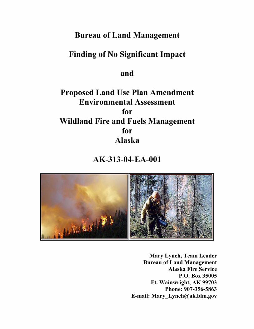
Bureau of Land Management Finding of No Significant Impact and Proposed Land Use Plan Amendment Environmental Assessment for Wildland Fire and Fuels Management for Alaska AK-313-04-EA-001 Mary Lynch, Team Leader Bureau of Land Management Alaska Fire Service P.O. Box 35005 Ft. Wainwright, AK 99703 Phone: 907-356-5863 E-mail: [email protected]
Transcript
Bureau of Land Management
Finding of No Significant Impact
and
Proposed Land Use Plan Amendment Environmental Assessment
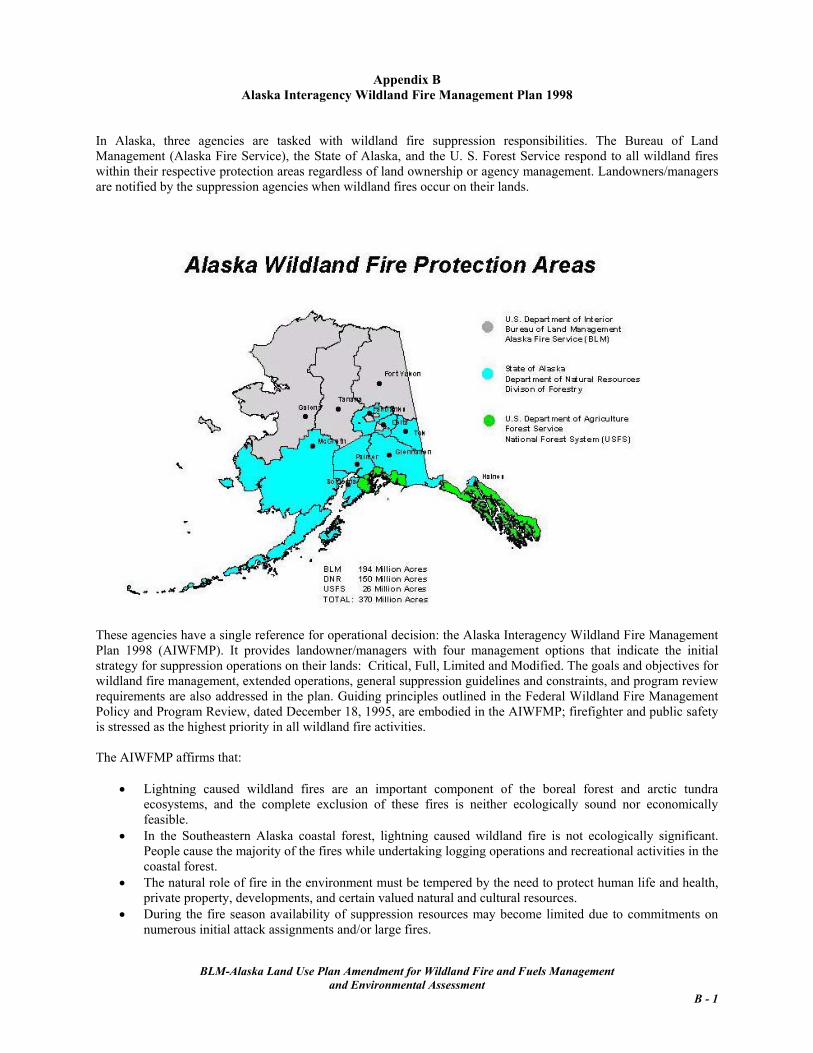
In January 2003, the Bureau of Land Management-Alaska wildland fire and fuels management program was evaluated by the BLM National Office of Fire and Aviation. That review determined that the existing wildland fire and fuels management direction in BLM-Alaska land use plans was not adequate. Congress has directed that all land use plans must contain wildland fire and fuels management guidelines as described in various National Fire Plan documents by September 2004. BLM-Alaska’s planning schedule did not sufficiently meet that mandate. Therefore, this Land Use Plan Amendment for Wildland Fire and Fuels Management and the associated Environmental Assessment were developed to bring the 12 existing BLM-Alaska land use plans into compliance and supply interim guidance for BLM-managed lands for which completion of new land use plans is scheduled.. The Amendment identifies land use and resource objectives and the wildland fire suppression options and fuels management activities that will achieve those objectives. Fire management options ensure the protection of human life and site-specific values and also recognize fire as an essential ecological process and natural change agent of the Alaskan ecosystems. Firefighter and public safety are identified as the number one priority in all fire management activities. Existing Alaska-specific fire management decisions and policy in the Alaska Interagency Wildland Fire Management Plan 1998 (AIWFMP) were used to develop the Amendment. As BLM-Alaska Field Office staffs develop alternative criteria for future land use plans, the Amendment decisions will be reviewed, incorporated, revised or replaced by area-specific land use and resource objectives that can be achieved by wildland fire and fuels management activities. This Amendment addresses BLM wildland fire and fuels management guidance to:
• Protect human life and property. • Use wildland fire and fuel treatments to meet resource objectives. • Reduce the risk and cost of uncontrolled wildland fires through wildland fire use,
prescribed fire, and manual and mechanical treatments. • Reduce the adverse effects of fire management activities. • Continue interagency collaboration and cooperation.
The level of detail in the Environmental Assessment is appropriate to the first tier of BLM’s land use planning process. The analysis considers the environmental consequences of BLM fire suppression, fire exclusion, and fuels management activities. Individual projects were not considered; when projects are proposed, a site-specific environmental analysis will be required. The Amendment also reinforces BLM-Alaska’s commitment to support the interagency wildland fire program, consider the latest available technology and methods, and support scientific research to study fire effects and improve business practices. Appendices contain additional supporting information and reference material.
BLM-Alaska Land Use Amendment for Wildland Fire and Fuels Management
and Environmental Assessment
Table of Contents Acronyms Chapter 1 Purpose of and Need for Action 1.1 Purpose 1-1 1.2 Need for the Proposed Action 1-1 1.3 Scope of the Analysis 1-2
1.3.1 Land Use Plans 1-2 1.4 Laws, Regulations, and Policies 1-3 1.5 Planning Criteria 1-3
Chapter 2 Alternatives Including the Fire and Fuels Amendment
2.1 Introduction to Alternatives 2-1 2.2 Scoping and Alternative Development 2-1 2.3 Management Common to Both Alternatives 2-1
2.3.3a Air Quality 2-5 2.3.3b Cultural and Paleontilogical Resources 2-5
2.3.3c Safety 2-5 2.3.3d Standard Operating Procedures 2-5
2.3.3e Structure and Sites, Known 2-7 2.4 No Action Alternative 2-7 2.5 Preferred Alternative: Land Use Plan for Wildland Fire and Fuels Management 2-7 2.5.1 Amendment Goals and Objectives 2-8
2.5.5a Standard Operating Procedures 2-14 2.5.5b Structures, Unknown 2-15 2.5.6 Monitoring for Cumulative Effects 2-15 2.5.7 Fuels Management 2-15 2.5.7a Priorities 2-16 2.5.7b Treatment Methods 2-16 2.5.7c Wildland Fire Use 2-16 2.6 Comparison of the No Action Alternative to the Preferred Alternative 2-16 2.7 Alternative Considered but Eliminated 2-16 Chapter 3 Affected Environment and Environmental Consequences 3.1 Critical Elements 3-1 3.1.1 Air Quality 3-2 3.1.1a Affected Environment 3-2 3.1.1b Environmental Consequences 3-3 3.1.2 Aquatic Resources and Essential Fish Habitat 3-4
BLM-Alaska Land Use Amendment for Fire and Fuels Management and Environmental Assessment
TOC - 1
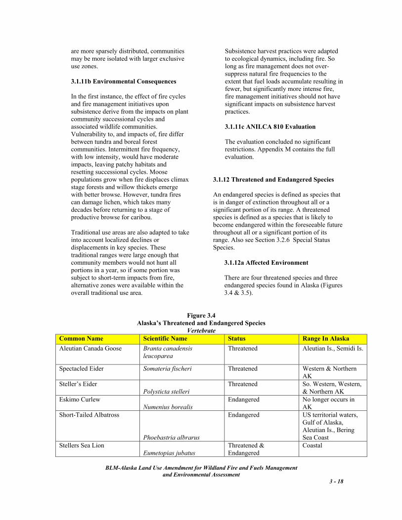
3.1.2a Affected Environment 3-4 3.1.2b Environmental Consequences 3-8 3.1.2c Essential Fish Habitat Compliance 3-9 3.1.3 Areas of Critical Environmental Concern 3-10 3.1.4 Cultural Resources 3-10 3.1.4a Affected Environment 3-10 3.1.4b Environmental Consequences 3-11 3.1.4c National Historic Preservation Act Sec.106 Compliance 3-12 3.1.5 Environmental Justice 3-12 3.1.6 Farmlands 3-13 3.1.7 Floodplains 3-13 3.1.8 Migratory Birds 3-13 3.1.9 Noxious and Invasive Plants 3-13 3.1.9a Affected Environment 3-13 3.1.9b Environmental Consequences 3-14 3.1.10 Native American Religious Concerns 3-15 3.1.11 Subsistence 3-15 3.1.11a Affected Environment 3-15 3.1.11b Environmental Consequence 3-18 3.1.11c ANILCA 810 Compliance 3-18 3.1.12 Threatened and Endangered Species 3-18 3.1.12a Affected Environment 3-18 3.1.12b Environmental Consequences 3-21 3.1.12c Endangered Species Act Sec. 7 Compliance 3-22 3.1.13 Wastes, Hazardous and Solid 3-23 3.1.14 Water Quality 3-23 3.1.14a Affected Environment 3-23 3.1.142b Environmental Consequences 3-23 3.1.15 Wetlands and Riparian Zones 3-26 3.1.15a Affected Environment 3-27 3.1.15b Environmental Consequences 3-27 3.1.16 Wild and Scenic Rivers 3-28 3.1.17 Wilderness 3-28 3.2 Other Elements Analyzed 3-28 3.2.1 Recreation 3-28 3.2.2 Socio-Economics 3-29 3.2.3 Soils 3-29 3.2.3a Affected Environment 3-29 3.2.3b Environmental Consequences 3-30 3.2.4 Special Status Species 3-31 3.2.4a Affected Environment 3-33 3.2.4b Environmental Consequences 3-33 3.2.5 Vegetation Resources 3-34 3.2.5a Forestlands, Affected Environment 3-35 3.2.5b Forestlands, Environmental Consequences 3-37 3.2.5c Shrublands, Affected Environment 3-38 3.2.5d Shrublands, Environmental Consequence 3-39
BLM-Alaska Land Use Amendment for Fire and Fuels Management and Environmental Assessment
TOC - 2
Chapter 4 Consultations and Coordination 4.1 BLM Internal Issue Development 4-1 4.2 Outreach Efforts 4-2 4.3 Public Comments and Responses 4-2 4.4 List of Preparers 4-4 Appendices A. Applicable Laws, Executive Orders, Instruction Memoranda, etc. B. Alaska Interagency Wildland Fire Management Plan 1998 C. Alaska Wildland Fire Coordinating Group (AWFCG) Role and Membership List D. Interagency Fire Management Planning E. Fire Occurrence Statistics F. AWFCG Management Option Change Procedure G. Condition Class Definition Table H. Fuel Treatment Methods I. Detailed Summary of No Action Alternative, Wildland Fire and Fuels Management in Existing
Land Use Plans J. BLM-Alaska Planning Schedule K. Detailed Summary of the Preferred Alternative, Land Use Plan Amendment for Wildland Fire and
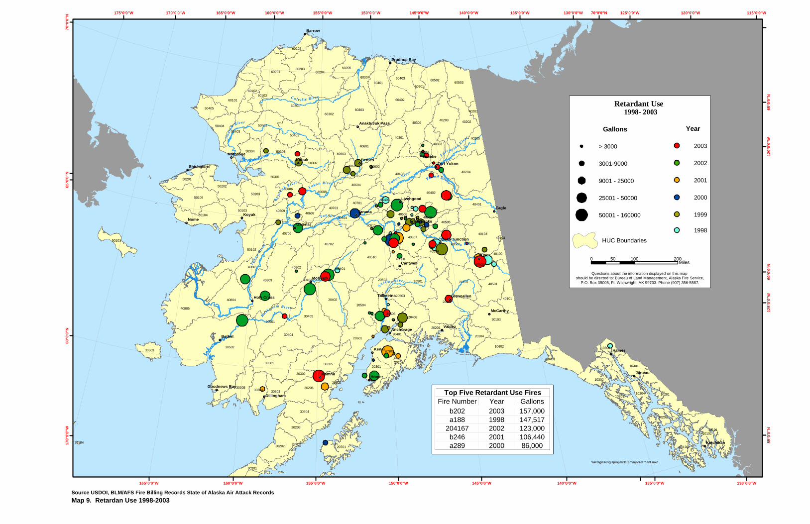
Fuels Management L. BLM Policy for Cabin/Structure Protection M. Alaska National Interest Lands Conservation Act Section 810 Evaluation N. Retardant Composition and Use O. Fuel Models and Fire Behavior P. Alaskan Fire Control Service to BLM Alaska Fire Service Maps 1. BLM-Managed Lands 2. BLM-Managed Lands within BLM Resource Management Planning Units 3. Fire Management Options for BLM-Managed Lands 4. Alaska Statewide Fire Management Options 5. Alaska Interagency Fire Management Planning Units 6. Alaska Hydrologic Units with Fire History 7. Alaska Vegetation Cover (Vegetation Map of Alaska, 1- km resolution) 8. Alaska CFFDRS Fuel Models 9. Retardant Use 1998-2003 Glossary Bibliography List of Figures Page
2.1 Critical Management Option Anticipated Average Annual Occurrence 2-3 2.2 Full Management Option Anticipated Average Annual Occurrence 2-4 2.3 Limited Management Option Anticipated Average Annual Occurrence 2-4
2.4 Modified Management Option Anticipated Average Annual Occurrence 2-5 3.1 Alaska Nonattainment Areas and Class 1 for Air Quality 3-2
BLM-Alaska Land Use Amendment for Fire and Fuels Management and Environmental Assessment
TOC - 3
BLM-Alaska Land Use Amendment for Fire and Fuels Management and Environmental Assessment
TOC - 4
List of Tables 2-1 Comparison of Management Option Classifications 2-2
2-2 No Action Alternative, Summary of Fire Management Guidance in Existing Land Use Plans 2-6 2-3 Preferred Alternative, Summary of the Land Use Plan Amendment for Wildland Fire and Fuels Management 2-11 2.4 Comparison of the Alternatives 2-17
ACRONYMS ADEC Alaska Department of Environmental Conservation ADF&G Alaska Department of Fish and Game AFO BLM Anchorage Field Office AFS Alaska Fire Service AIWFMP Alaska Interagency Wildland Fire Management Plan 1998 ANILCA Alaska National Interest Land Conservation Act 1980 ANCSA Alaska Native Claims Settlement Act 1971 ASO BLM Alaska State Office AWFCG Alaska Wildland Fire Coordinating Group BLM Bureau of Land Management CAA Clean Air Act 1970,1990 CAMA Central Arctic Management Area CERCLA Comprehensive Environmental Response, Compensation, and Liability Act 1980 CFR Code of Federal Regulations CFFDRS Canadian Forest Fire Danger Rating System CNIPM Committee for Noxious and Invasive Plants Management CO Carbon monoxide EA Environmental Assessment EFH Essential Fish Habitat EIS Environmental Impact Statement EPA Environmental Protection Agency ESMP Enhanced Smoke Management Plan FLPMA Federal Land Policy and Management Act FMO Fire Management Officer FR Federal Register FRCC Fire Regime-Condition Class GFO BLM Glennallen Field Office IAP Integrated Activity Plan IM Instruction Memorandum LUP Land Use Plan MAC Multi-Agency Coordinating Group MFP Management Framework Plan NAAQS National Ambient Air Quality Standards NEPA National Environmental Policy Act NFO BLM Northern Field Office NFP National Fire Plan NPR-A National Petroleum Reserve–Alaska OF&A BLM National Office of Fire and Aviation PM Particulate matter RBZ Riparian Buffer Zone RCRA Resource Conservation and Recovery Act 1976 RMP Resource Management Plan ROD Record of Decision SIP State Implementation Plan (for air quality) SOP Standard Operating Procedures T&E Threatened and Endangered species USC United States Code USDA United States Department of Agriculture USDI United States Department of Interior USFS United States Forest Service WSA Wilderness Study Area WFSA Wildland Fire Situation Analysis WFIP Wildland Fire Implementation Plan WFU Wildland Fire Use WO Washington Office WUI Wildland Urban Interface
BLM-Alaska Land Use Amendment for Fire and Fuels Management and Environmental Assessment
Chapter 1 Purpose of and Need for Action
1.1 Purpose The Bureau of Land Management (BLM) proposes to amend all of Alaska’s existing Resource Management Plans (RMP)1, Management Framework Plans (MFP), and the National Petroleum Reserve-Alaska Integrated Activity Plans (IAP) to update direction for wildland fire and fuels management for all public lands. The amendment identifies land use and resource objectives, wildland fire suppression options, and fuels (vegetation) management activities that achieve those objectives. This also allows BLM to comply with the National Fire Plan2 and 2001 Review and Update of the 1995 Federal Wildland Fire Management Policy. Public input, specialist input, and existing Alaska-specific fire management decisions and policy were used to develop the alternatives. The amendment and planning analysis includes BLM-managed lands not covered under existing plans and will be applicable to BLM-managed lands statewide3 (See Map 1. BLM-Managed
Lands). It provides a consistent approach for integrating wildland fire and fuels management policy into existing RMPs and also will supply interim guidance for BLM-managed lands for which completion of new land use plans is scheduled. 1.2 Need for the Proposed Action Current federal fire policy states that land use plans will define and identify overall wildland fire and fuel management direction to meet land use and resource management objectives by September 2004. The BLM-Alaska Fire and Aviation Program Review of January 2003 noted inadequate direction for the wildland fire management program in the existing BLM land use plans. The Proposed Statewide Land Use Plan Amendment for Wildland Fire and Fuels Management addresses BLM-Alaska wildland fire and fuels management direction and guidance to fulfill the national requirements and achieve these goals:
1 BLM uses RMPs authorized under Section 202 of the Federal Land Policy and Management Act (FLPMA) of 1976. Several MFPs, which are older forms of land use plans, are still in effect in Alaska. Section 6508 of the Naval Petroleum Reserves Production Act of 1976 exempted the National Petroleum Reserve-Alaska (NPR-A) from FLPMA’s RMP requirements and, as a result, the planning documents that fulfill the statutory mandates for NPR-A are Integrated Activity Plans with accompanying EIS.
• Protect human life and property. • Use wildland fire and fuel treatments to
meet resource objectives. • Reduce the risk and cost of uncontrolled
wildland fires through wildland fire use, prescribed fire, and manual and mechanical treatments.
• Reduce the adverse effects of fire management activities.
• Continue interagency cooperation and collaboration.
2On September 8, 2000, the Secretaries of the Interior and Agriculture submitted “Managing the Impact of Wildfires on Communities and the Environment, A Report to the President In Response to the Wildfires of 2000”. This report, its accompanying budget request, Congressional direction for appropriations for wildland fire, and resulting action plans and agency strategies have collectively become know as the National Fire Plan. For additional information on the National Fire Plan and its components, see http://www.fireplan.gov/content/home/.
3 BLM currently manages 86 million acres which includes lands withdrawn for military purposes,
lands selected for consideration for conveyance under the Alaska Statehood Act 1958 (State-selected), the Alaska Native Claims Settlement Act 1971 (Native-selected), and the Native Allotment Act 1906. When a conveyance is approved, the new land manager is responsible for fire management decisions. Once all conveyances have been completed, BLM will manage approximately 65 million acres in Alaska.
BLM-Alaska Land Use Amendment for Fire and Fuels Management
1.3 Scope of the Analysis Although State and coastal district program policies are to guide consistency determinations, more restrictive federal agency standards may be applied. Federal regulations state that “(w)hen federal agency standards are more restrictive than standards or requirements contained in the State’s management program, the federal agency may continue to apply its stricter standards . . .” (15 CFR, Section 930.39[d]).
A Notice of Intent was published in the Federal Register on October 15, 20034, which initiated a 60-day period for public comments to be considered in drafting the amendment criteria. Internal BLM issues and comments were solicited. Other federal and State agencies were consulted. Comments and questions were considered in the analysis and focused on a review of wildland fire and fuels management activities, fire regime, biomass use and techniques for fuels treatments.
In this analysis, general guidance for fuels treatments and their environmental effects are included. Specific information, effects, and activities associated with individual projects will not be considered. Site-specific environmental review will be completed when projects are proposed. Certain fire management actions may require a Coastal Consistency Determination. BLM will contact the Department of Natural Resources’ Alaska Coastal Management Program for program applicability before beginning a project.
In this analysis, fire management is considered at the RMP and MFP level. The level of detail regarding proposed activities and potential effects are appropriate to this first tier of BLM’s land use planning process. The analysis considers the environmental consequences of BLM fire suppression, fire exclusion and fuels management activities.
This proposed action applies only to BLM-managed land; it does not include other federal, Native, State or private land where BLM provides fire protection.
Although federal lands are excluded from the coastal zone (16 U.S.C., Section 1453[1]), the Coastal Zone Management Act of 1972, as amended (PL 92-583), directs federal agencies conducting activities within the coastal zone or that may affect any land or water use or natural resources of the coastal zone to conduct these activities in a manner that is consistent “to the maximum extent practicable” 5 with approved State management programs.
1.3.1 Land Use Plans BLM-Alaska has 12 existing land use plans6: • Central Yukon RMP 1986
• Fort Greely RMP 1995, 2001 The Alaska Coastal Zone Management Act of 1977, as amended, and the subsequent Alaska Coastal Management Program and Final Environmental Impact Statement (1979) establish policy guidance and standards for the review of projects within or potentially affecting Alaska’s coastal zone. In addition, specific policies have been developed for activities and uses of coastal lands and water resources within regional coastal resource districts. Most incorporated cities, municipalities, and boroughs as well as unincorporated areas (coastal resource service areas) within the coastal zone now have State-approved coastal management programs.
• Fort Wainwright RMP 1995, 2001 • Fortymile MFP 1980 • Northeast NRR-A IAP 1998 • Northwest NPR-A IAP 2004 • Northwest MFP 1982 • Steese National Conservation Area RMP
1986 • Southcentral MFP 1980 • Southwest MFP 1981 • Utility Corridor RMP 1991 • White Mountains National Recreation Area
RMP 1986
Concurrently planning efforts have begun to replace the Northwest MFP with a new RMP (Kobuk/Seward Peninsula RMP) and the 4 Federal Register Volume 68, Number 199.
Page 59415-59416.
BLM-Alaska Land Use Amendment for Fire and Fuels Management
and Environmental Assessment 1 - 2
5 “To the maximum extent practicable” means, “to the fullest degree permitted by existing law (15 CFR, Section 930.32).”
6 Map 2. BLM-Managed Lands by RMP displays lands covered by the existing and proposed plans.
BLM-Alaska Land Use Amendment for Fire and Fuels Management
and Environmental Assessment 1 - 3
Southcentral MFP with 2 new RMPs (East Alaska RMP and Ring of Fire RMP). A new RMP for the Bristol Bay Planning Area and a new Integrated Activity Plan for South NPR-A will cover lands not previously addressed in land use plans. This proposed amendment provides fire management direction and guidance for these lands. 1.4 Laws, Regulations, and Policies Under either alternative, the BLM would comply with the planning constraints and processes imposed by laws, policies, and legal/regulatory agreements, both on this plan and any future site-specific plans that tier to it. The following is a list of the primary references. Additional sources are listed in Appendix A, Laws, Regulations, and Policies. • Alaska National Interest Lands Conservation
Act (16 USC 3101 et seq.) (ANILCA) • Federal Land Policy and Management Act
of 1976 (43 USC 1701) (FLPMA) • BLM Land Use Planning Handbook H-
1601-1 • BLM National Environmental Policy Act
(NEPA) Handbook H-1790-1 • Washington Office (WO) Instruction
Memorandum (IM) No. 2002-034 Land Use Planning and Fire Management Planning
1.5 Planning Criteria In addition to the Laws, Regulation and Policies listed above, the following criteria were developed internally and were used in the amendment process: • Opportunities for public participation will be
encouraged throughout the amendment process.
• Valid existing rights will be recognized and protected.
• Subsistence uses and needs will be considered and adverse impacts will be minimized whenever possible in accordance with ANILCA Sec. 810.
• The BLM will continue to work cooperatively with the State of Alaska, Native corporations, other Federal agencies, interested groups, and individuals regarding
fire suppression alternatives and other fire management activities.
• Existing data, information, plans, and land use analyses will be used.
• Only BLM-managed lands within Alaska will be addressed.
• Landscape level fire management goals and objectives will be identified.
• Acreage figures used throughout this document are as of October 2003.
Chapter 2 Alternatives Including the Fire and Fuels Amendment
2.1 Introduction to Alternatives Fire management has been conducted by
agreements executed on an interagency, landscape-scale basis since the early 1980s2. This effort standardized policies and procedures among land managing agencies in Alaska. As a result, four wildland fire suppression management options (Critical, Full, Modified, Limited) are utilized statewide by all federal, State and Native land managers. Each management option is defined by objectives, management constraints, and values to be protected. The management option categorizations ensure:
This chapter describes the two alternatives: the No Action Alternative and the Preferred. The Preferred Alternative (Proposed Action) is the Land Use Plan Amendment to provide wildland fire and fuels management guidance and direction to achieve land use and resource objectives. 2.2 Scoping and Alternative Development
Two alternatives were identified. The following summarizes the alternative development process; a full accounting, including dates, is found in Chapter 4.
human life, designated private property and identified resources receive an appropriate level of protection with available firefighting resources,
the ability to achieve land use and resource management objectives is optimized,
• AFS staff initiated internal BLM participation by asking Field Office staffs to identify issues and concerns.
and the cost of the suppression effort is commensurate with values identified for protection.
• Public participation was invited during Scoping.
• AFS briefed the BLM Resource Advisory Council and solicited comments and participation in the planning effort.
Options are assigned on a landscape scale across agency boundaries3. Management option categorizations are designed to be ecologically and fiscally sound, operationally feasible, and sufficiently flexible to respond to changes in objectives, fire conditions, land use patterns, resource information, new technologies and new scientific findings. The designation of a management option pre-selects strategies (appropriate management response) assigned to accomplish established land use and resource objectives. Land manager/owner(s) including BLM have selected management options based upon an evaluation of their individual legal mandates, policies, regulations, resource management objectives, and local conditions. Six of the existing RMPs and MFPs implemented these management options.
• AFS developed a Preferred Alternative based on comments received.
2.3 Management Common to Both Alternatives The following definitions, policies and procedures are currently in place and operational on all BLM-managed lands in Alaska. They have been implemented through various laws, regulations, interagency documents, instruction memorandum and by BLM national and State policy1. Under the No Action Alternative, fire management on BLM-managed lands would continue to be implemented under those documents. In the Preferred Alternative, these definitions, policies and procedures are aggregated into the Land Use Plan Amendment.
2 See Appendix D for a history of the interagency fire planning effort.
1 See Appendix A for a list of laws, regulations, instruction memorandum, etc., Appendix B for a summary of the Alaska Interagency Wildland Fire Management Plan (AIWFMP), Appendix C for information on the Alaska Wildland Fire Coordinating Group (AWFCG).
BLM-Alaska Land Use Amendment for Wildland Fire and Fuels Management
and Environmental Assessment 2 - 1
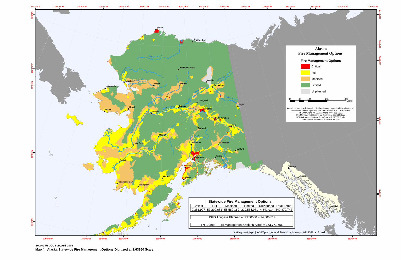
3 For a graphic description of management option designations: see Map 3. Fire Management Options for BLM-Managed Lands and Map 4. Alaska Statewide Fire Management Options.
BLM-Alaska Land Use Amendment for Wildland Fire and Fuels Management
and Environmental Assessment 2 - 2
Table 2-1: Comparison of Management Option Classifications
Critical Full Modified Limited% of BLM-Managed Acres 0.2% 8% 14% 78%Anticipated Average Annual Fire Occurrence 1.1 fires @30.3 acres 12.2 fires @ 22,219.7 acres 13.3 fires @ 43,179.3 acres 32.9 fires @ 209,926.8 acres
Priority for Allocation of Suppression Forces First Second Third Fourth
Lands Designated Inhabited property, populated areas and BLM-managed lands adjacent to populated areas (wildland urban interface), National Historic Landmarks.
Cultural and paleontological sites, structures on or eligible for the National Register of Historic Places, BLM-developed recreational facilities, physical developments, administrative sites and cabins, uninhabited structures, high-value natural resources, and other high-value areas.
Lands where resource objectives are met when the numbers of acres burned during the time of year when large fires are likely is restricted, fire performs its ecological role when fire potential lessens, and acres burned are balanced with suppression costs.
Lands where resource objectives are met by the natural fire regime and areas where the cost of suppression may exceed the value of the resources to be protected, the environmental impacts of fire suppression activities may have more negative impacts on the resources than the effects of the fire, or the exclusion of fire may be detrimental to the fire dependent ecosystem.
Appropriate Management Response for Wildland Fire
Aggressive and continued actions to protect the area from fire without compromising firefighter safety.
Aggressive action to minimize resource damage and suppress the fires at the smallest reasonably possible number of acres.
High Level (contingent upon availability of suppression resources): Initial attack with intent to contain the fire. Low Level: Routine surveillance to ensure that identified values are protected and that adjacent higher priority management areas are not compromised.
Allow fire to function in its natural ecological role while conducting routine surveillance to observe fire activity and to determine if site-specific values or adjacent higher priority management areas are compromised.
BLM-Alaska Land Use Amendment for Wildland Fire and Fuels Management
and Environmental Assessment 2 - 3
4 The 10-Year Comprehensive Strategy Implementation Plan defines wildland urban interface (WUI) as “The line, area, or zone where structures and other human development meet or intermingle with undeveloped wildland or vegetative fuel.”
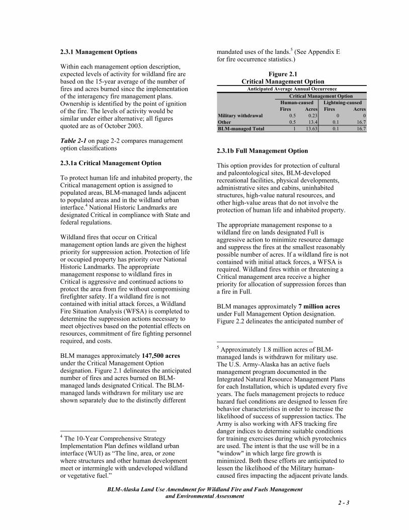
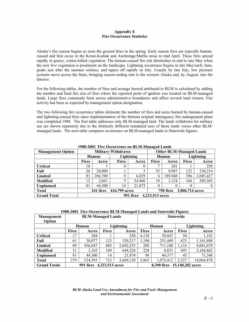
2.3.1 Management Options Within each management option description, expected levels of activity for wildland fire are based on the 15-year average of the number of fires and acres burned since the implementation of the interagency fire management plans. Ownership is identified by the point of ignition of the fire. The levels of activity would be similar under either alternative; all figures quoted are as of October 2003. Table 2-1 on page 2-2 compares management option classifications 2.3.1a Critical Management Option To protect human life and inhabited property, the Critical management option is assigned to populated areas, BLM-managed lands adjacent to populated areas and in the wildland urban interface.4 National Historic Landmarks are designated Critical in compliance with State and federal regulations. Wildland fires that occur on Critical management option lands are given the highest priority for suppression action. Protection of life or occupied property has priority over National Historic Landmarks. The appropriate management response to wildland fires in Critical is aggressive and continued actions to protect the area from fire without compromising firefighter safety. If a wildland fire is not contained with initial attack forces, a Wildland Fire Situation Analysis (WFSA) is completed to determine the suppression actions necessary to meet objectives based on the potential effects on resources, commitment of fire fighting personnel required, and costs. BLM manages approximately 147,500 acres under the Critical Management Option designation. Figure 2.1 delineates the anticipated number of fires and acres burned on BLM-managed lands designated Critical. The BLM-managed lands withdrawn for military use are shown separately due to the distinctly different
mandated uses of the lands.5 (See Appendix E for fire occurrence statistics.)
5 Approximately 1.8 million acres of BLM-managed lands is withdrawn for military use. The U.S. Army-Alaska has an active fuels management program documented in the Integrated Natural Resource Management Plans for each Installation, which is updated every five years. The fuels management projects to reduce hazard fuel conditions are designed to lessen fire behavior characteristics in order to increase the likelihood of success of suppression tactics. The Army is also working with AFS tracking fire danger indices to determine suitable conditions for training exercises during which pyrotechnics are used. The intent is that the use will be in a "window" in which large fire growth is minimized. Both these efforts are anticipated to lessen the likelihood of the Military human-caused fires impacting the adjacent private lands.
Anticipated Average Annual OccurrenceCritical Management Option
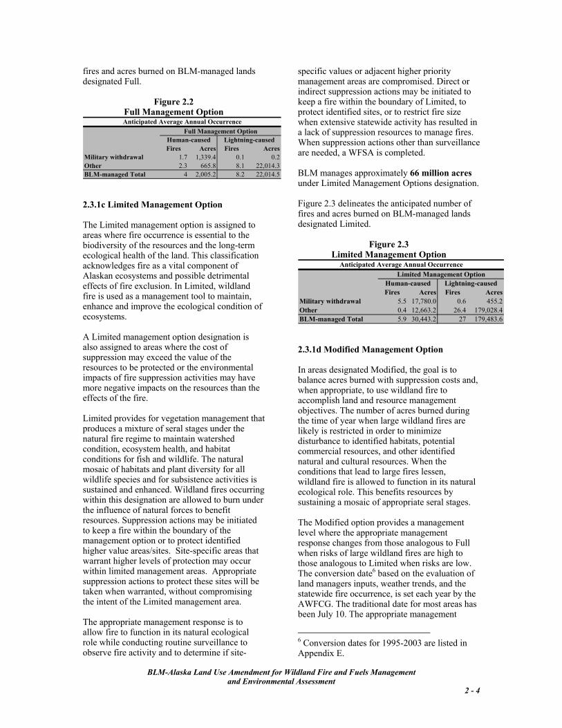
2.3.1b Full Management Option This option provides for protection of cultural and paleontological sites, BLM-developed recreational facilities, physical developments, administrative sites and cabins, uninhabited structures, high-value natural resources, and other high-value areas that do not involve the protection of human life and inhabited property. The appropriate management response to a wildland fire on lands designated Full is aggressive action to minimize resource damage and suppress the fires at the smallest reasonably possible number of acres. If a wildland fire is not contained with initial attack forces, a WFSA is required. Wildland fires within or threatening a Critical management area receive a higher priority for allocation of suppression forces than a fire in Full.
BLM manages approximately 7 million acres under Full Management Option designation. Figure 2.2 delineates the anticipated number of
fires and acres burned on BLM-managed lands designated Full.
Anticipated Average Annual OccurrenceFull Management Option
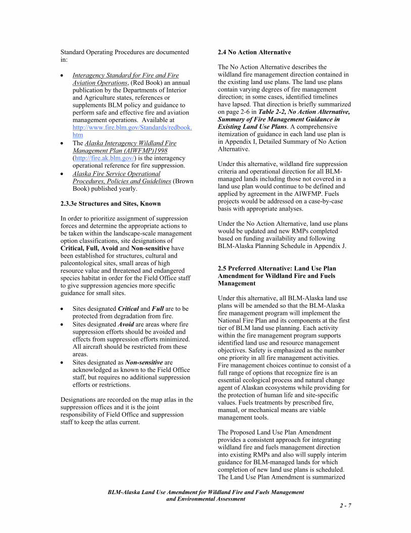
2.3.1c Limited Management Option The Limited management option is assigned to areas where fire occurrence is essential to the biodiversity of the resources and the long-term ecological health of the land. This classification acknowledges fire as a vital component of Alaskan ecosystems and possible detrimental effects of fire exclusion. In Limited, wildland fire is used as a management tool to maintain, enhance and improve the ecological condition of ecosystems. A Limited management option designation is also assigned to areas where the cost of suppression may exceed the value of the resources to be protected or the environmental impacts of fire suppression activities may have more negative impacts on the resources than the effects of the fire. Limited provides for vegetation management that produces a mixture of seral stages under the natural fire regime to maintain watershed condition, ecosystem health, and habitat conditions for fish and wildlife. The natural mosaic of habitats and plant diversity for all wildlife species and for subsistence activities is sustained and enhanced. Wildland fires occurring within this designation are allowed to burn under the influence of natural forces to benefit resources. Suppression actions may be initiated to keep a fire within the boundary of the management option or to protect identified higher value areas/sites. Site-specific areas that warrant higher levels of protection may occur within limited management areas. Appropriate suppression actions to protect these sites will be taken when warranted, without compromising the intent of the Limited management area.
The appropriate management response is to allow fire to function in its natural ecological role while conducting routine surveillance to observe fire activity and to determine if site-
specific values or adjacent higher priority management areas are compromised. Direct or indirect suppression actions may be initiated to keep a fire within the boundary of Limited, to protect identified sites, or to restrict fire size when extensive statewide activity has resulted in a lack of suppression resources to manage fires. When suppression actions other than surveillance are needed, a WFSA is completed. BLM manages approximately 66 million acres under Limited Management Options designation.
Figure 2.3 delineates the anticipated number of fires and acres burned on BLM-managed lands designated Limited.
Anticipated Average Annual OccurrenceLimited Management Option
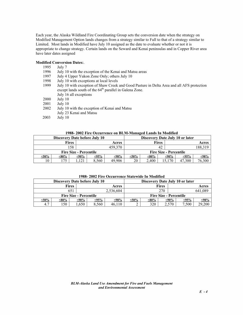
2.3.1d Modified Management Option In areas designated Modified, the goal is to balance acres burned with suppression costs and, when appropriate, to use wildland fire to accomplish land and resource management objectives. The number of acres burned during the time of year when large wildland fires are likely is restricted in order to minimize disturbance to identified habitats, potential commercial resources, and other identified natural and cultural resources. When the conditions that lead to large fires lessen, wildland fire is allowed to function in its natural ecological role. This benefits resources by sustaining a mosaic of appropriate seral stages. The Modified option provides a management level where the appropriate management response changes from those analogous to Full when risks of large wildland fires are high to those analogous to Limited when risks are low. The conversion date6 based on the evaluation of land managers inputs, weather trends, and the statewide fire occurrence, is set each year by the AWFCG. The traditional date for most areas has been July 10. The appropriate management
BLM-Alaska Land Use Amendment for Wildland Fire and Fuels Management
and Environmental Assessment 2 - 4
6 Conversion dates for 1995-2003 are listed in Appendix E.
response for fires occurring within this designation, before the conversion date, is to contain the fires with initial attack forces. After the conversion date, the default action for all fires occurring within Modified areas will be to allow fire to function in its natural ecological role while conducting routine surveillance to observe fire activity and to determine if identified site-specific values and adjacent higher priority management areas are compromised. Direct or indirect suppression actions may be initiated to keep a fire within the boundary of the management option or to protect identified sites. Before the conversion date, a WFSA is completed if a fire is not contained by initial attack forces. After the conversion date, a WFSA is completed if suppression actions other than surveillance are needed. Critical and Full areas are higher priorities for the assignment of suppression forces than Modified. BLM manages approximately 12 million acres under Modified Management Options designation.) Figure 2.4 delineates the anticipated number of fires and acres burned on BLM-managed lands designated Modified.
Anticipated Average Annual OccurrenceModified Management Option
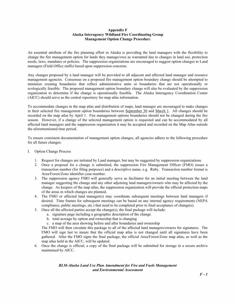
2.3.2 Management Option Designation Review and Changes An essential attribute of the interagency fire planning in Alaska is the flexibility to change the fire management option as warranted due to changes in land use, resource objectives, protection needs, laws, suppression concerns, mandates or policies. As part of the annual management option review, if the appropriate management response for the designation is not followed for a fire, the area in which the fire occurred will be evaluated to determine if the management option designation is suitable and meeting current land use and resource objectives. The AWFCG has established procedures to review fire activity and management options.
The AWFCG procedures to change management option designations are in Appendix F. 2.3.3 Procedures, Restrictions and Constraints The following are applicable to BLM-managed lands regardless of management option designation. 2.3.3a Air Quality Alaska Department of Environmental Conservation (ADEC) regulates air quality. The ADEC Enhanced Smoke Management Plan and the State Implementation Plan stipulate regulations to be followed. (http://www.state.ak.us/dec/home.htm) 2.3.3b Cultural and Paleontological Resources The requirements in CFR 36 Sec. 800, National Historic Preservation Act, and of the Alaska State Historic Preservation Office apply. Site-specific designations as noted in Section 2.3.3e will be applied and the map atlas maintained by suppression agencies updated yearly by Field Office staffs. Critical management option is assigned to National Historic Landmarks sites and Full to structures on or eligible for inclusion on the National Register of Historic Places. Full may also be assigned to sites currently under excavation. When a site or structure is discovered during any fire management activity, the appropriate Field Office will be notified immediately. A cultural resource evaluation is required for fuel treatment projects. 2.3.3c Safety Public and firefighter safety is the single, overriding priority for every fire management activity without exception. 2.3.3d Standard Operating Procedures Standard Operating Procedures are followed to exercise the following best management practices:
provide a safe working environment, implement standard procedures and
practices, reduce the adverse effects of suppression
actions or other fire management activities on plant, fish and wildlife habitats,
BLM-Alaska Land Use Amendment for Wildland Fire and Fuels Management
Table 2-2: No Action Alternative Summary of Fire Management Guidance in Existing Land Use Plans
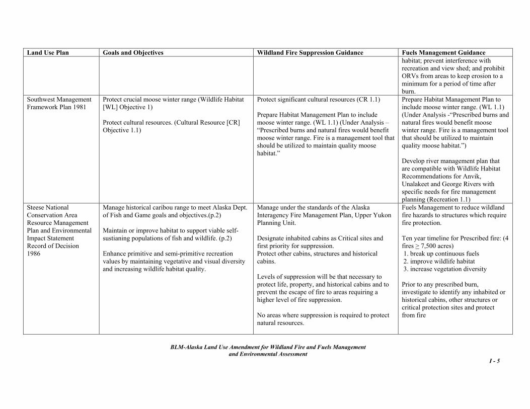
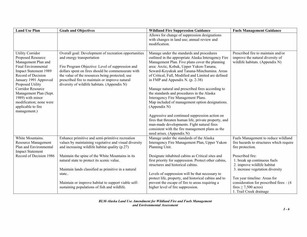
Wildland Fire Management Fuels Management Wildland Fire Suppression Direction: Fire managed according to standards and procedures outlined in the appropriate interagency fire management plan. Use suppression classes: Critical, Full, Limited and Modified. (UC, CY, S, WM, FW, FG) Allows for change of suppression designations with changes in land use; annual review and modification. (S, WM,CY, FG, FW) Designate inhabited structures and commercial facilities as Critical sites and first priority for suppression. (S, WM, UC) No areas where suppression is required to protect natural resources. (S, WM) Allow fire under prescribed conditions. (NW) Provide for a natural fire occurrence (mosaic), where other important resources values would not be harmed. Fires should be < 10,000 acres. (SC) Resource Protection Guidelines: Protect significant cultural resources. (SC, SW, 40M) Monitor to document achievement of wildlife goals. (CY) Protect areas of identified habitats including sensitive, threatened, and endangered plants and animals. (NW) Manage fire to promote wildlife habitat. (S, WM, SW (Moose) and 40M (Caribou)) Develop and implement Fire Management Plan. (NW, FW, FG) Protect commercial timber stands. (SC) Maintain watershed cover in healthy condition through use of natural or prescribed fire. (40M)
Prescribed fire uses: • break up continuous fuels (S, WM, 40M) • improve wildlife habitat (S, WM, UC, NW, SC, FW, FG, CY) • increase vegetation diversity (S, WM, UC, 40M, FW, FG) • reduce hazards to structures and cultural sites (40M) • reduce fire hazards (FW, FG)
Prescribed burns (4 > 7,500 acres each) to re-establish /improve habitat. (S) and Prescribed burns (4 > 7,500 acres each) to re-establish /improve habitat: Trail Creek, Ophir Creek, Champion Creek, and Bear Creek areas. (WM) (Targeted timelines have lapsed.) Prescribed fire in Mosquito Flats. (40M) Include constraints in Burn Plans to protect commercial timber, climax-dependent species, and swan and raptor habitat; prevent interference with recreation and view shed; and prohibit ORVs from areas to keep erosion to a minimum for a period of time after burn. (SC) Other Treatments: Mechanically remove shrubs in 1/5-1/4 acres patches on known sharptail grouse leks along the Taylor Highway. (40M) General: Conduct inventory of fuel types and natural barriers for the benefit of limited action and prescribed fire. (40M) Conduct delineation and monitoring studies related to wildlife-fire-succession relationships within recommended prescribed fire areas. (40M)
Plan codes: CY Central Yukon RMP FG Fort Greely RMP FW Fort Wainwright RMP 40M Fortymile MFP NW Northwest MFP S Steese National Conservation Area RMP SC Southcentral MFP SW Southwest MFP UC Utility Corridor RMP WM White Mountains National Recreation Area RMP
BLM-Alaska Land Use Amendment for Wildland Fire and Fuels Management
2.4 No Action Alternative Standard Operating Procedures are documented in: The No Action Alternative describes the
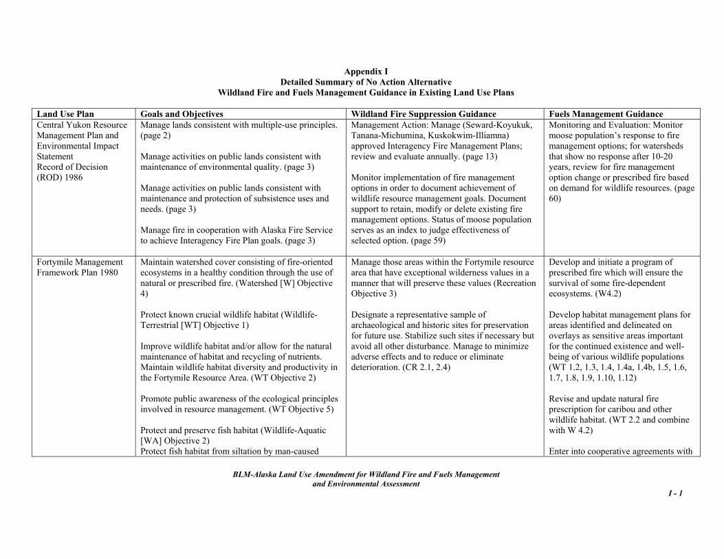
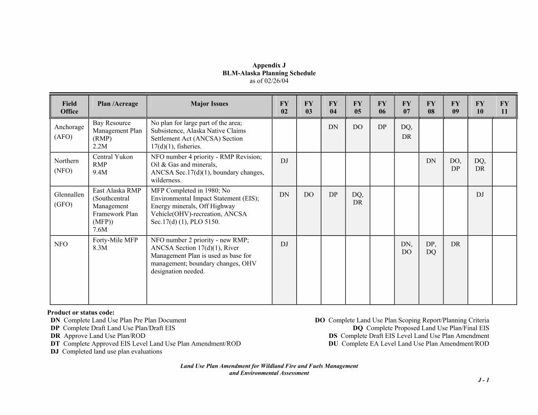
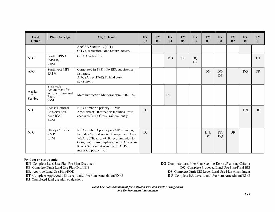
wildland fire management direction contained in the existing land use plans. The land use plans contain varying degrees of fire management direction; in some cases, identified timelines have lapsed. That direction is briefly summarized on page 2-6 in Table 2-2, No Action Alternative, Summary of Fire Management Guidance in Existing Land Use Plans. A comprehensive itemization of guidance in each land use plan is in Appendix I, Detailed Summary of No Action Alternative.
• Interagency Standard for Fire and Fire Aviation Operations, (Red Book) an annual publication by the Departments of Interior and Agriculture states, references or supplements BLM policy and guidance to perform safe and effective fire and aviation management operations. Available at http://www.fire.blm.gov/Standards/redbook.htm
• The Alaska Interagency Wildland Fire Management Plan (AIWFMP)1998 (http://fire.ak.blm.gov/) is the interagency operational reference for fire suppression.
Under this alternative, wildland fire suppression criteria and operational direction for all BLM-managed lands including those not covered in a land use plan would continue to be defined and applied by agreement in the AIWFMP. Fuels projects would be addressed on a case-by-case basis with appropriate analyses.
• Alaska Fire Service Operational Procedures, Policies and Guidelines (Brown Book) published yearly.
2.3.3e Structures and Sites, Known
In order to prioritize assignment of suppression forces and determine the appropriate actions to be taken within the landscape-scale management option classifications, site designations of Critical, Full, Avoid and Non-sensitive have been established for structures, cultural and paleontological sites, small areas of high resource value and threatened and endangered species habitat in order for the Field Office staff to give suppression agencies more specific guidance for small sites.
Under the No Action Alternative, land use plans would be updated and new RMPs completed based on funding availability and following BLM-Alaska Planning Schedule in Appendix J. 2.5 Preferred Alternative: Land Use Plan Amendment for Wildland Fire and Fuels Management Under this alternative, all BLM-Alaska land use plans will be amended so that the BLM-Alaska fire management program will implement the National Fire Plan and its components at the first tier of BLM land use planning. Each activity within the fire management program supports identified land use and resource management objectives. Safety is emphasized as the number one priority in all fire management activities. Fire management choices continue to consist of a full range of options that recognize fire is an essential ecological process and natural change agent of Alaskan ecosystems while providing for the protection of human life and site-specific values. Fuels treatments by prescribed fire, manual, or mechanical means are viable management tools.
• Sites designated Critical and Full are to be
protected from degradation from fire. • Sites designated Avoid are areas where fire
suppression efforts should be avoided and effects from suppression efforts minimized. All aircraft should be restricted from these areas.
• Sites designated as Non-sensitive are acknowledged as known to the Field Office staff, but requires no additional suppression efforts or restrictions.
Designations are recorded on the map atlas in the suppression offices and it is the joint responsibility of Field Office and suppression staff to keep the atlas current.
BLM-Alaska Land Use Amendment for Wildland Fire and Fuels Management
and Environmental Assessment 2 - 7
The Proposed Land Use Plan Amendment provides a consistent approach for integrating wildland fire and fuels management direction into existing RMPs and also will supply interim guidance for BLM-managed lands for which completion of new land use plans is scheduled. The Land Use Plan Amendment is summarized
in Table 2-3 on pages 2-11 to 2-13 and a detailed matrix by management option describing resource objectives, rationale for assigning option designations, appropriate responses and fuels management guidance is in Appendix K. The Preferred Alternative includes all elements listed under Section 2.3 Management in Common plus the following.
o Manage vegetation adjacent to populated areas to reduce risk of wildfires.
• Use wildland fire and fuel treatments to
meet resource objectives. The supporting objectives include: o Manage vegetation to the appropriate
seral stages8 to maintain watershed condition, ecosystem health, and habitat conditions for fish and wildlife.
2.5.1 Amendment Goals and Objectives The BLM manages land within the forestlands, shrublands and herbaceous (tundra and grasslands) vegetative communities. Management of the wildland fire and fuels program will focus on maintaining the key ecosystem components of vegetation composition and structure intact and functioning within their historical range. The fire management program will provide for public and firefighter safety and protection of identified sites and structures from degradation caused by wildland fire.
o Sustain the natural range of variation in plant composition and structure.
o Sustain the proper functioning condition of riparian areas.9
o Maintain species diversity while decreasing the probability of wildland fires in areas where the land use or resource objective necessitates wildland fire be excluded or minimized.
o Maintain and protect subsistence uses and needs.
o Sustain high value natural resources. o Maintain visual diversity. Fuels management activities are necessary and important resource management tools to accomplish land and resource management objectives where fire has been excluded due to land use and allocation decisions that conflict with the natural role of fire.
o Preserve cultural and paleontological sites.
o Maintain or enhance commercial resource values.
o Manage for requirements of threatened and endangered (T&E) species’ critical habitat, other special status species habitats, and migratory birds.
In order to be successful, fire management programs must also be economically viable, weighing the values to be protected and the associated costs. Interagency coordination and cooperation are essential to ensuring success and efficiency.
o Meet State air and water quality standards.
• Reduce risk and cost of uncontrolled
wildland fire through wildland fire use, prescribed fire, manual, or mechanical treatment. The supporting objectives include:
The goals (Section 1.2) and supporting objectives are: • Protect human life and property. The
supporting objectives include: o Provide for firefighter and public safety
as highest priority in every fire management activity.
o Provide appropriate protection to BLM physical developments, facilities and administrative sites while balancing costs with value-at-risk.
o Preserve cultural and paleontological sites7
7 Cultural resources is an all encompassing term and includes historical, archeological, religious, and other significant sites. For information on cultural resources, see U.S. Department of
Interior, BLM publication, “America’s Priceless Heritage: Cultural and Fossil Resources on Public Lands, Alaska”, November 2003. It can be viewed at http://www.blm.gov/heritage/aph_nav_web_low_pdf.htm.
8 See Sections 3.2.6 and .7 for discussions on appropriate seral stages for vegetation and for wildlife habitat. 9 Of the anadromous stream habitat under BLM management 98% (14,800 miles) is considered to be in natural or near-natural condition. See Section 3.1.2a.
BLM-Alaska Land Use Amendment for Wildland Fire and Fuels Management
o Reduce risk to life and property. 2.5.2a Critical Management Option o Minimize effects of wildland fire in
areas where the natural role of fire conflicts with current land use.
The BLM objectives achieved by designating lands Critical are:
o Balance acres burned and values at risk against suppression costs.
• Provide for public safety.
• Provide appropriate protection to inhabited structures and other physical developments. • Reduce adverse effects of fire management
activities. The supporting objectives include: • Preserve National Historic Landmarks. o Prevent damage to cultural resources. • Manage vegetation adjacent to populated
areas to reduce risk of wildfires. o Minimize effects of suppression actions. o Prevent the introduction or spread of
noxious or invasive plants. • Minimize effects of wildland fire in areas where current land use conflicts with natural role of fire. o Safeguard essential fish habitat, T&E
species, and all other plant and wildlife habitats.
The supporting suppression objectives are to suppress 95% of the wildland fires at 5 acres or less and to exclude fire from structures and sites. Under very extraordinary circumstances, as appropriate to the site and situation, wildland fire use for resource benefit may be considered as a management alternative.
• Continue interagency collaboration and
cooperation. The supporting objectives include: o Continue the use of the wildland fire
suppression criteria and operational direction in the AIWFMP. o Continue membership in the AWFCG10. The management emphasis in Critical is to work
collaboratively with adjacent landowners on community planning, risk assessments, prevention, and mitigation to prevent and exclude wildland fire. Appropriate mitigation measures to reduce the wildland fire risks to life and property and costs of wildland fires in Critical are mechanical and manual fuel treatments that reduce the amount of vegetation (fuel loads) within and around wildland urban interface areas, National Historic Landmarks, and physical developments. Prescribed fire may be used when appropriate for the site and situation (for example, burning slash piles). The anticipated average annual number of acres treated through the fuels program is 25-50 acres.
o Authorize suppression actions or fuel treatments on BLM-managed land to hinder wildland fire from occurring or spreading to higher management option designation on BLM-managed lands, inholdings or those of adjacent landowners.
o Apply current fire management option classifications11.
o Use the change protocol issued by AWFCG to modify fire management options designations or boundaries.
o Support scientific research. o Work cooperatively on landscape scale
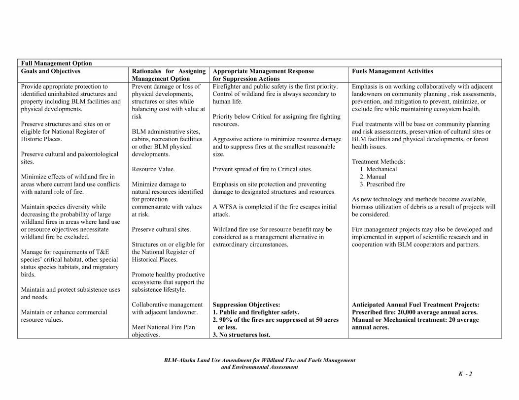
multi-jurisdictional projects. 2.5.2 Management Options 2.5.2b Full Management Option Under the Preferred Alternative, the management criteria defined in Section 2.3 is added to the existing direction in all the land use plans. The following management direction supplements that direction.
The BLM objectives achieved by designating lands Full are: • Provide appropriate protection to identified
uninhabited structures and property including BLM facilities and physical developments.
• Preserve structures and sites on or eligible
for National Register of Historic Places.
• Preserve cultural and paleontological sites. • Minimize effects of wildland fire in areas
where current land use conflicts with natural role of fire.
10 See Appendix C for Role of AWFCG and 2004 membership list.
BLM-Alaska Land Use Amendment for Wildland Fire and Fuels Management
and Environmental Assessment 2 - 9
• Maintain species diversity while decreasing the probability of large wildland fires in
11 Map 3. Fire Management Options for BLM-Managed Lands.
areas where land use or resource objectives necessitate wildland fire be excluded or minimized.
• Sustain the proper functioning condition of riparian areas.
• Maintain and protect subsistence uses and needs. • Manage for requirements of T&E species’
critical habitat, other special status species habitats, and migratory birds.
• Maintain visual diversity. • Manage for requirements of T&E species’
critical habitat, other special status species habitats, and migratory birds.
• Maintain and protect subsistence uses and needs.
• Maintain or enhance commercial resource values.
• Minimize the adverse effects of fire suppression efforts.
• Balance acres burned with values at risk against suppression costs. The supporting suppression objectives are to
suppress 90% of the wildland fires at 50 acres or less and to exclude fire from structures and sites. Under extraordinary circumstances, as appropriate to the site and situation, wildland fire use for resource benefit may be considered as a management alternative.
The supporting suppression objectives allow the number of fires and annual acres burned to be dependent on weather and vegetation conditions and within the historical fire regime for the vegetation type. Based on historical records, the fire size on approximately 10% of fires occurring on Limited lands would be >10,000 acres.
To reduce the risks and costs of wildland fires, the management emphasis for Full Management Option lands is to minimize the effects of wildland fire by:
Fuels treatment objectives that assist in balancing acres burned and values at risk and also meet resource objectives are habitat manipulation, reduction of the amount of available fuels and the continuity of fuels, improvement of ecological health, and preservation of cultural and other identified sites. The anticipated average annual acres treated through the fuels program is 1,000 acres by prescribed fire.
working collaboratively with adjacent
landowners on community planning and risk assessments,
completing project proposals based on those assessments,
using mitigation measures to maintain low fuel loads and promote healthy productive ecosystems that support the subsistence lifestyle,
2.5.2d Modified Management Option
developing prevention programs as warranted,
Wildland fire use for resource benefit and strategies that are based on the annual conversion date are the key components of this designation. The BLM objectives achieved by designating lands Modified are:
and maintaining known sites on or eligible for National Register of Historic Places in a viable condition.
The anticipated average annual number of acres treated through the fuels program is 20 acres by manual or mechanical methods and 20,000 acres by prescribed fire.
• Manage for requirements of T&E species’
critical habitat, other special status species habitats, and migratory birds.
• Maintain species diversity while decreasing the probability of large wildland fires in areas where resource objectives necessitate wildland fire be minimized.
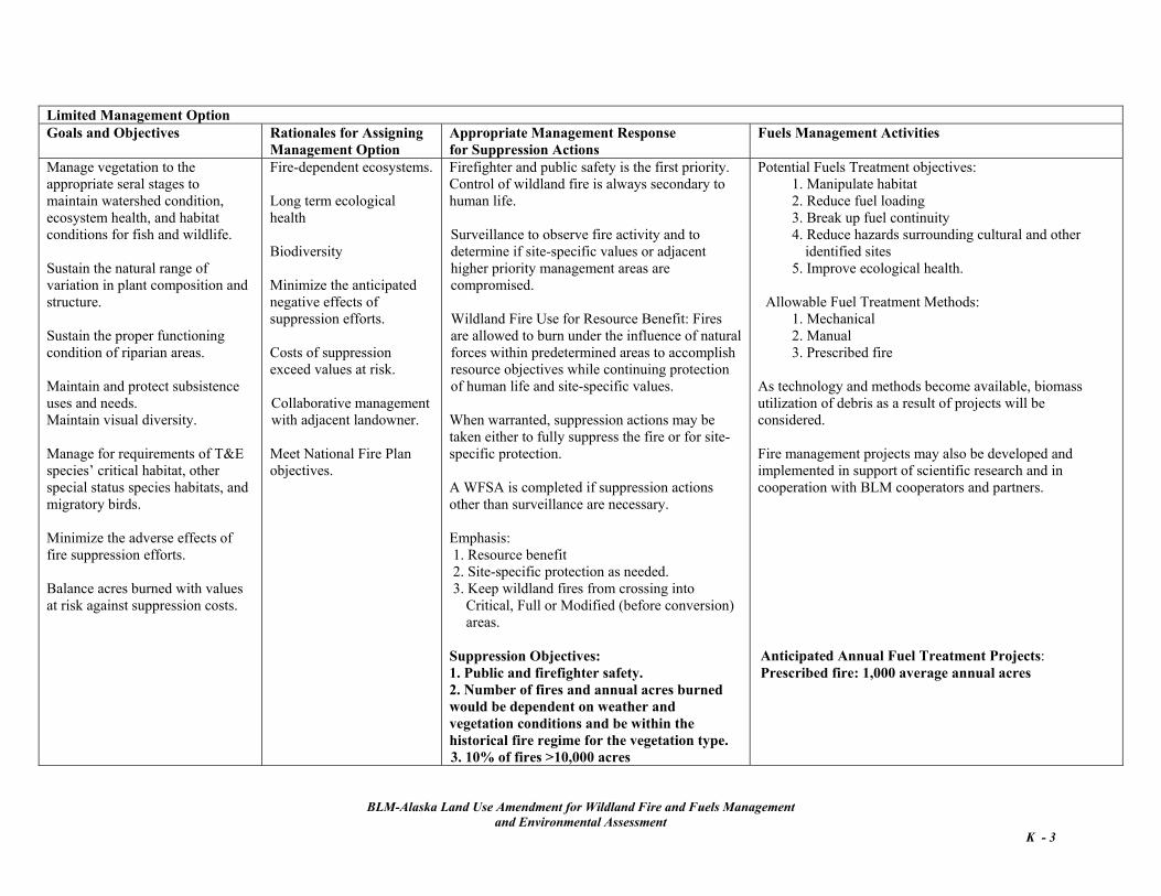
2.5.2c Limited Management Option Wildland fire use for resource benefit is the key component of this designation. The BLM objectives achieved by designating lands Limited are:
• Maintain and protect subsistence uses and needs.
• Maintain visual diversity. • Moderate the adverse effects of fire
suppression efforts. • Manage vegetation to the appropriate seral
stages to maintain watershed condition, ecosystem health, and habitat conditions for fish and wildlife.
• Maintain or enhance potential commercial resource values.
• Balance acres burned with values at risk against suppression costs.
• Sustain the natural range of variation in plant composition and structure.
BLM-Alaska Land Use Amendment for Wildland Fire and Fuels Management
and Environmental Assessment 2 - 10
Table 2-3: Preferred Alternative Summary of the Land Use Plan Amendment for Wildland Fire and Fuels Management
Wildland Fire Management Fuels Management
Critical Management Option Lands (Fire is not desired.) Emphasis on protecting human life and inhabited structures, site protection and preventing damage to or loss of cultural sites. Wildland Fire Suppression Direction: Appropriate Management Response: Immediate, continuing aggressive suppression of fires within or threatening designated areas. Highest priority for assigning firefighting resources. Suppression Objectives: 1. Public and firefighter safety. 2. 95% of the fires are suppressed at 5 acres or less. 3. No structures lost. Resource Protection Guidelines: Complete protection of designated sites: Urban Areas or Wildland-Urban Interface Area with permanent residences, and valuable cultural resources, including National Historic Landmarks. Collaborative management with adjacent landowner. Meet National Fire Plan objectives.
Critical Management Option Lands Fuel treatments will be based on community planning and risk assessments and preservation of cultural sites or BLM facilities and physical developments. Anticipated Annual Fuel Treatment Projects: Manual treatment projects: 25-50 average annual acres. Prescribed fire to burn debris resulting from manual treatments. Treatment Methods: 1. Mechanical 2. Manual 3. Prescribed fire to burn debris resulting from manual treatments. As new technology and methods become available, biomass utilization of debris as a result of projects will be considered. Fire management projects may also be developed and implemented in support of scientific research and in cooperation with BLM cooperators and partners.
Full Management Option Lands (Unplanned fire is likely to cause negative effects.) Emphasis on protecting uninhabited structures, site protection and preventing damage to or loss of cultural sites. Wildland Fire Suppression Direction: Same as Critical Option. However, fires occurring in Critical have a higher priority for allocation of suppression resources. Suppression Objectives: 1. Public and firefighter safety. 2. 90% of the fires are suppressed at 50 acres or less. 3. No structures lost.
Full Management Option Lands Fuel treatments will be based on community planning and risk assessments, preservation of cultural sites or BLM facilities and physical developments, or ecosystem health issues. Anticipated Annual Fuel Treatment Projects: Prescribed fire: 20,000 average annual acres. Mechanical treatment: 20 average annual acres. Treatment Methods: 1. Mechanical 2. Manual 3. Prescribed fire As new technology and methods become available, biomass utilization of debris as a result of projects will be considered.
BLM-Alaska Land Use Amendment for Wildland Fire and Fuels Management
and Environmental Assessment 2 - 11
Wildland Fire Management Fuels Management Full Management Option Lands continued: Resource Protection Guidelines: Prevent damage or loss of physical developments, structures or sites (BLM administrative sites, cabins, recreation facilities or other BLM physical developments) while balancing cost with value at risk. Minimize damage to natural resources identified for protection commensurate with values at risk. Preserve cultural sites. Protect structures on or eligible for the National Register of Historical Places. Promote healthy productive ecosystems that support the subsistence lifestyle. Meet National Fire Plan objectives.
Full Management Option Lands continued: Fire management projects may also be developed and implemented in support of scientific research and in cooperation with BLM cooperators and partners.
Limited Management Option Lands (Fire is desired.) The key component is wildland fire use for resource benefit. Fires are allowed to burn under the influence of natural forces within predetermined areas to accomplish resource objectives while continuing protection of human life and site-specific values. Wildland Fire Suppression Direction: Appropriate Management Response: Surveillance. Lowest priority for allocation of suppression resources. Suppression Objectives: 1. Public and firefighter safety. 2. Site-specific protection as needed. 3. Number of fires and annual acres burned would be dependent on weather and vegetation conditions and be within the historical fire regime for the vegetation type. 4. Keep wildland fires from crossing into Critical, Full or Modified (before
conversion) areas. 5. 10% of fires >10,000 acres. Resource Protection Guidelines: Resource benefit of fire in fire-dependent ecosystems. Long term ecological health; Biodiversity. Minimize the anticipated negative effects of suppression efforts. Costs of suppression exceed values at risk. Collaborative management with adjacent landowner. Meet National Fire Plan objectives.
Limited Management Option Lands The key component is wildland fire use for resource benefit. Wildland Fire Use Acres: 130,000 – 180,000 average annual acres Anticipated Annual Fuel Treatment Projects: Prescribed fire: 1,000 average annual acres Treatment Methods:
1. Mechanical 2. Manual 3. Prescribed fire
Treatment objectives that support land use and resource objectives: 1. Reduce hazards surrounding cultural and other identified sites 2. Reduce fuel loading 3. Break up fuel continuity 4. Manipulate habitat 5. Improve ecological health
As technology and methods become available, biomass utilization of debris as a result of projects will be considered. Fire management projects may also be developed and implemented in support of scientific research and in cooperation with BLM cooperators and partners.
BLM-Alaska Land Use Amendment for Wildland Fire and Fuels Management
and Environmental Assessment 2 - 12
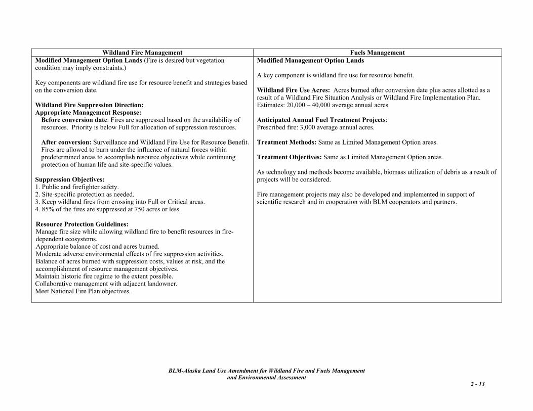
Wildland Fire Management Fuels Management Modified Management Option Lands (Fire is desired but vegetation condition may imply constraints.) Key components are wildland fire use for resource benefit and strategies based on the conversion date. Wildland Fire Suppression Direction: Appropriate Management Response: Before conversion date: Fires are suppressed based on the availability of
resources. Priority is below Full for allocation of suppression resources.
After conversion: Surveillance and Wildland Fire Use for Resource Benefit. Fires are allowed to burn under the influence of natural forces within predetermined areas to accomplish resource objectives while continuing protection of human life and site-specific values.
Suppression Objectives: 1. Public and firefighter safety. 2. Site-specific protection as needed. 3. Keep wildland fires from crossing into Full or Critical areas. 4. 85% of the fires are suppressed at 750 acres or less. Resource Protection Guidelines: Manage fire size while allowing wildland fire to benefit resources in fire-dependent ecosystems. Appropriate balance of cost and acres burned. Moderate adverse environmental effects of fire suppression activities. Balance of acres burned with suppression costs, values at risk, and the accomplishment of resource management objectives. Maintain historic fire regime to the extent possible. Collaborative management with adjacent landowner. Meet National Fire Plan objectives.
Modified Management Option Lands A key component is wildland fire use for resource benefit. Wildland Fire Use Acres: Acres burned after conversion date plus acres allotted as a result of a Wildland Fire Situation Analysis or Wildland Fire Implementation Plan. Estimates: 20,000 – 40,000 average annual acres Anticipated Annual Fuel Treatment Projects: Prescribed fire: 3,000 average annual acres. Treatment Methods: Same as Limited Management Option areas. Treatment Objectives: Same as Limited Management Option areas. As technology and methods become available, biomass utilization of debris as a result of projects will be considered. Fire management projects may also be developed and implemented in support of scientific research and in cooperation with BLM cooperators and partners.
BLM-Alaska Land Use Amendment for Wildland Fire and Fuels Management
and Environmental Assessment 2 - 13
In Modified the suppression goal is to manage fire size and minimize disturbance to identified habitats during specific time periods while allowing wildland fire to achieve resource objectives. The supporting suppression objective is to suppress 85% of the fires at 750 acres or less.
Long-term needs will be assessed on a case-by-case basis. Key indicators include severity of burn, permafrost layer affected, erosion potential, soil profile, percent of hydrological unit burned, extensive multi-year fire activity in the same area, vegetation type, threat of introduction and spread of noxious or invasive plants, T&E and special status species’ habitats adjacent to or affected, the riparian areas involved, and subsistence issues.
Before the conversion date, if a deviation from the appropriate management response as defined in Section 2.3.1d is necessary, wildland fire use for resource benefit may be considered as a management alternative. After the conversion date, the wildland fire use is the appropriate management response.
2.5.5 Procedures, Restrictions and Constraints The following apply to all fire management activities within all management options classifications and are in addition to those listed in Section 2.3.3.
Fuels treatment objectives that assist in balancing acres burned and values at risk and also meet resource objectives are habitat manipulation, reduction of the amount of available fuels and the continuity of fuels, improvement of ecological health, and preservation of cultural and other identified sites. The anticipated average annual acres treated through the fuels program is 3,000 acres by prescribed fire.
2.5.5a Standard Operating Procedures The documents listed in Section 2.3.3d are incorporated here by reference and to further reduce fire management effects, the following mitigation measures were identified during the analysis completed for Chapter 3 and are to be implemented:
2.5.3 Management Option Designation Review and Changes
• Use of tracked or off-road vehicles (for
example, bulldozers or all-terrain vehicles) requires written authorization by the Field Office Authorized Officer and will be approved on a case-by-case basis prior to use. Stipulations in the authorization will address use of equipment to avoid line construction near streams where it may cause erosion, damage to riparian areas, harm cultural or paleontological resources, degrade water quality or fish habitat, or contribute to stream channel sedimentation.
In addition to the requirements in Section 2.3.2, extensive fire activity in a single year or multi-year incidents within the same hydrologic unit also triggers the need to initiate an interagency review for that unit. Reviews on a collaborative, interagency level after extensive fire activity are encouraged to ensure management option designations are still meeting all land managers’ land use and resource objectives. The effects noted by Native villagers adjacent to or within the area should be weighed in management option reviews.
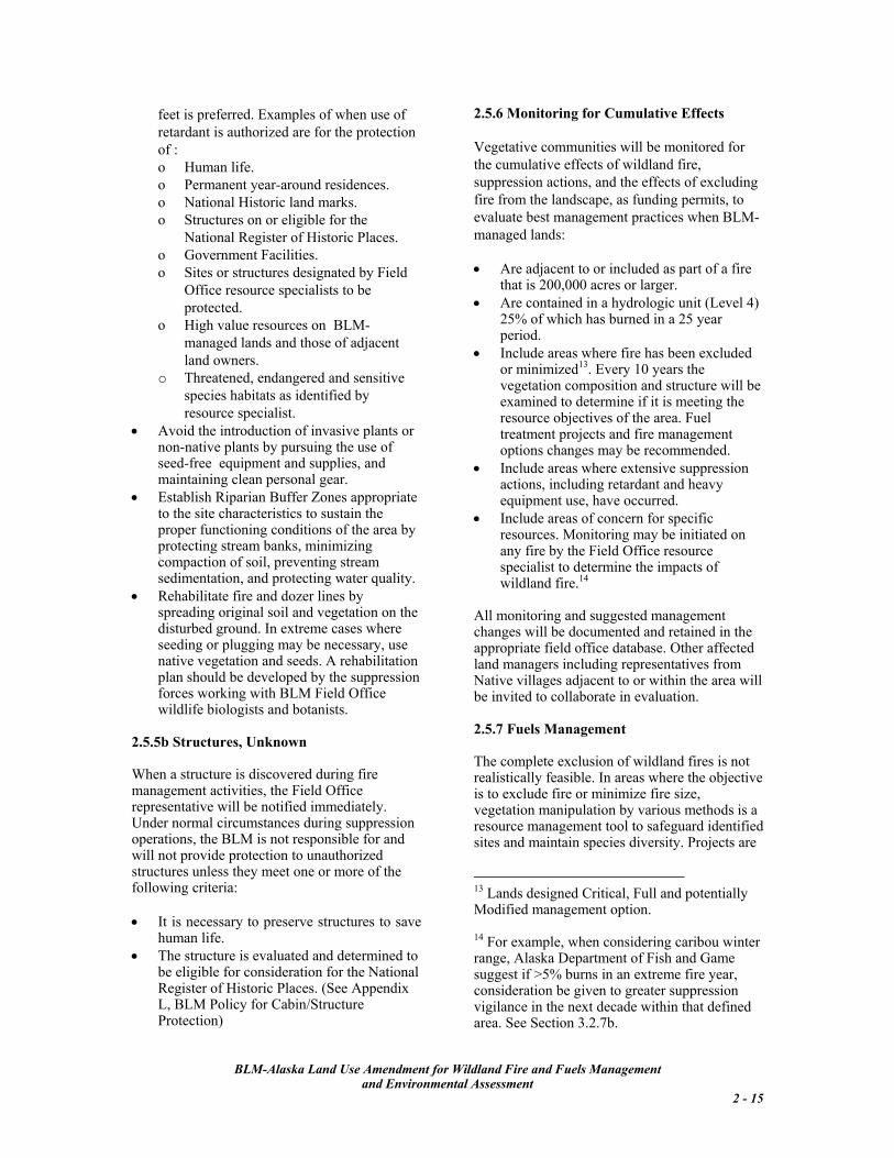
• Use of aerial fire retardant near lakes, wetlands, streams, rivers, sources of human water consumption, and areas adjacent to water sources should be avoided to protect fish habitat and water quality. If feasible in these areas, the use of water rather than retardant is preferred. When the use of retardant is necessary, avoid aerial or ground application of retardant or foam within 300 feet of a waterway; application beyond 500
2.5.4 Stabilization and Rehabilitation Short- term stabilization is the responsibility of the team assigned to fire suppression. On large-scale fires, a stabilization and rehabilitation plan, approved by the Field Office Authorized Officer must be completed before the final demobilization occurs. Standard operating procedures listed in Sections 2.3 and 2.5 are applicable.12
12 Also see Wildland Fire Emergency Stabilization and Rehabilitation Policy and Procedures found in Department of Interior
Manual 620; BLM WO IM No. 2003-221 and No. 2003-221 Change 1, and No. 2004-065 Use of the Categorical Exclusions for Hazardous Fuels Treatments and Post-Fire Rehabilitation Projects.
BLM-Alaska Land Use Amendment for Wildland Fire and Fuels Management
and Environmental Assessment 2 - 14
2.5.6 Monitoring for Cumulative Effects feet is preferred. Examples of when use of retardant is authorized are for the protection of :
Vegetative communities will be monitored for the cumulative effects of wildland fire, suppression actions, and the effects of excluding fire from the landscape, as funding permits, to evaluate best management practices when BLM-managed lands:
o Human life. o Permanent year-around residences. o National Historic land marks. o Structures on or eligible for the
National Register of Historic Places. o Government Facilities. • Are adjacent to or included as part of a fire
that is 200,000 acres or larger. o Sites or structures designated by Field
Office resource specialists to be protected. • Are contained in a hydrologic unit (Level 4)
25% of which has burned in a 25 year period.
o High value resources on BLM-managed lands and those of adjacent land owners. • Include areas where fire has been excluded
or minimized13. Every 10 years the vegetation composition and structure will be examined to determine if it is meeting the resource objectives of the area. Fuel treatment projects and fire management options changes may be recommended.
o Threatened, endangered and sensitive species habitats as identified by resource specialist.
• Avoid the introduction of invasive plants or non-native plants by pursuing the use of seed-free equipment and supplies, and maintaining clean personal gear.
• Include areas where extensive suppression actions, including retardant and heavy equipment use, have occurred. • Establish Riparian Buffer Zones appropriate
to the site characteristics to sustain the proper functioning conditions of the area by protecting stream banks, minimizing compaction of soil, preventing stream sedimentation, and protecting water quality.
• Include areas of concern for specific resources. Monitoring may be initiated on any fire by the Field Office resource specialist to determine the impacts of wildland fire.14
• Rehabilitate fire and dozer lines by spreading original soil and vegetation on the disturbed ground. In extreme cases where seeding or plugging may be necessary, use native vegetation and seeds. A rehabilitation plan should be developed by the suppression forces working with BLM Field Office wildlife biologists and botanists.
All monitoring and suggested management changes will be documented and retained in the appropriate field office database. Other affected land managers including representatives from Native villages adjacent to or within the area will be invited to collaborate in evaluation.
2.5.7 Fuels Management 2.5.5b Structures, Unknown
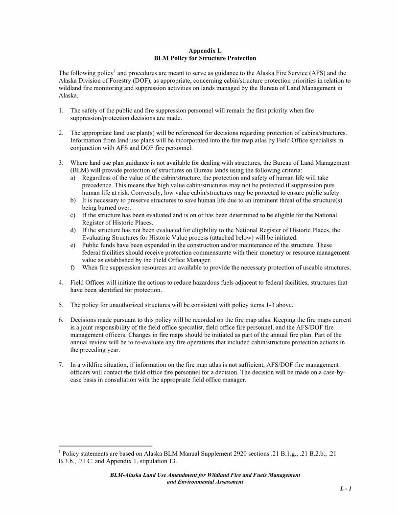
The complete exclusion of wildland fires is not realistically feasible. In areas where the objective is to exclude fire or minimize fire size, vegetation manipulation by various methods is a resource management tool to safeguard identified sites and maintain species diversity. Projects are
When a structure is discovered during fire management activities, the Field Office representative will be notified immediately. Under normal circumstances during suppression operations, the BLM is not responsible for and will not provide protection to unauthorized structures unless they meet one or more of the following criteria:
13 Lands designed Critical, Full and potentially Modified management option.
• It is necessary to preserve structures to save human life.
14 For example, when considering caribou winter range, Alaska Department of Fish and Game suggest if >5% burns in an extreme fire year, consideration be given to greater suppression vigilance in the next decade within that defined area. See Section 3.2.7b.
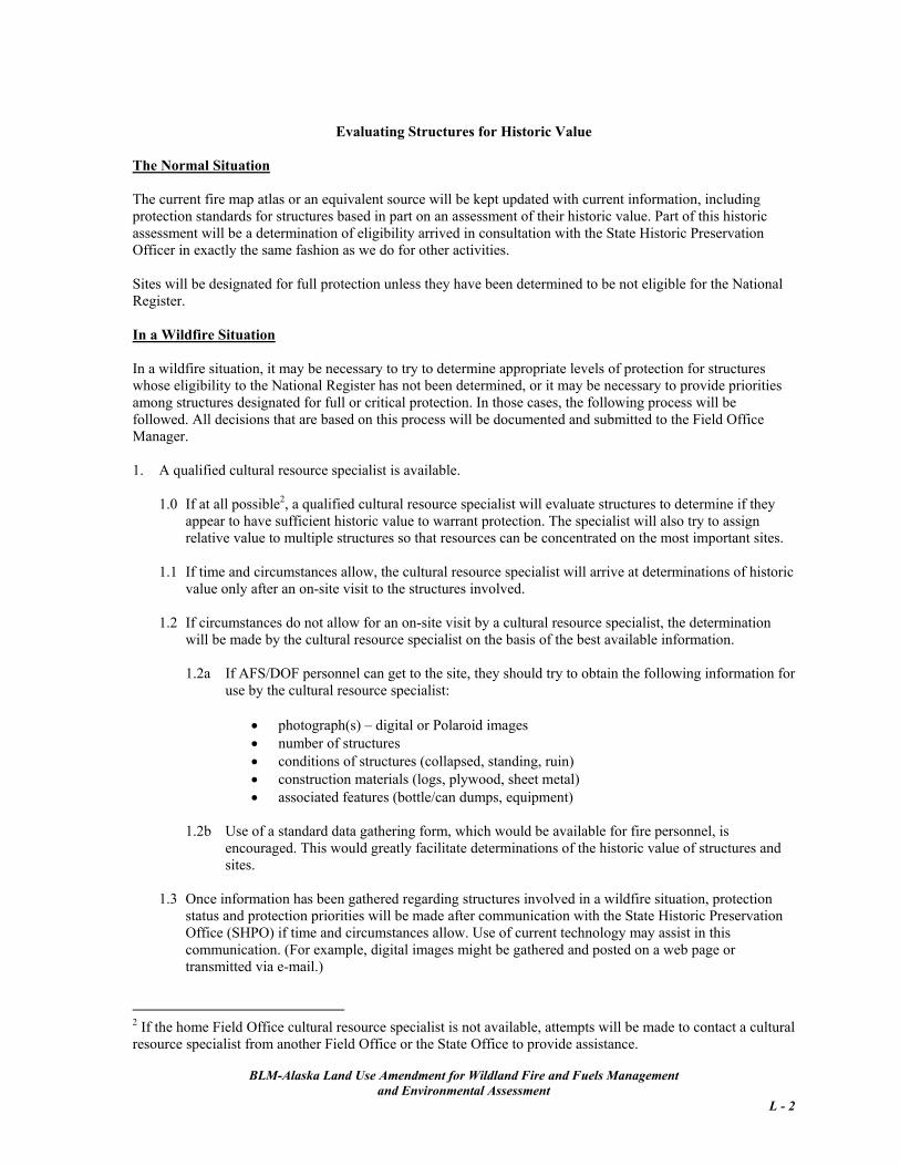
• The structure is evaluated and determined to be eligible for consideration for the National Register of Historic Places. (See Appendix L, BLM Policy for Cabin/Structure Protection)
BLM-Alaska Land Use Amendment for Wildland Fire and Fuels Management and Environmental Assessment
2 - 15
designed with regard to site characteristics and the reproductive characteristics of the plant species present on the site. Projects are approved and funded on a case-by-case basis.
• Mechanical • Manual The total anticipated average annual acreage for fuels treatment by Manual or Mechanical methods is 50 acres.
Fuels Management will assist in achieving the objectives stated under each management option classification. Projects may also be developed and implemented in support of scientific research and in cooperation with BLM cooperators and partners.
The total anticipated average annual acreage for fuels treatment by Prescribed Fire is 24,000 acres.
As new technology and methods become available, biomass utilization of debris as a result of projects will be considered.
2.5.7a Priorities Fuels treatments are prioritized to: 2.5.7c Wildland Fire Use (WFU) 1. Reduce the risk to human life and inhabited
property. WFU is the management of wildland fires to accomplish specific resource management objectives in pre-defined geographic areas. In Alaska, WFU is reported by the Fuels Program and implemented through the fire suppression program. The anticipated average annual acreage reported for wildland fire use is equivalent to the anticipated acres burned by lightning-caused fires on Limited and Modified Management Option lands: 150,000 to 200,000 acres.
2. Reduce the risk and cost of fire suppression in areas of hazardous fuels buildup.
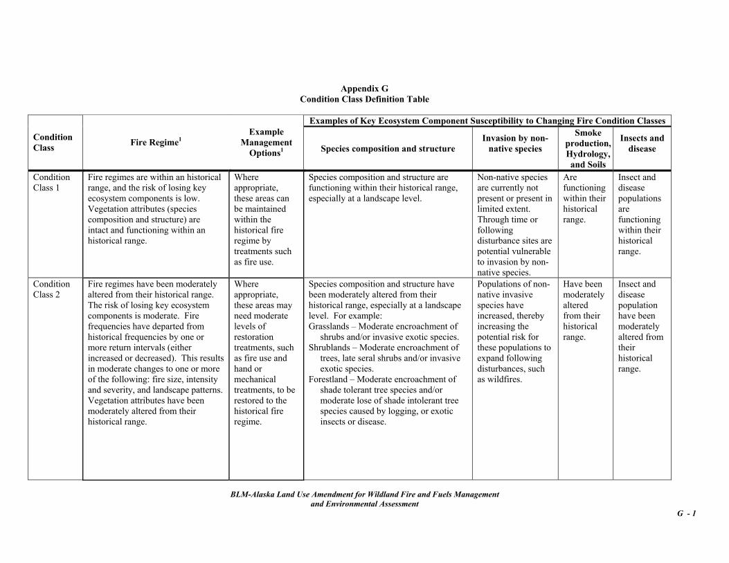
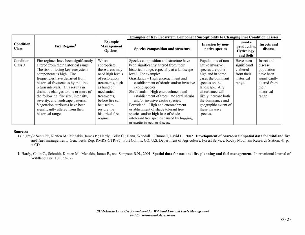
3. Achieve other resource objectives. Treatments around communities would be prioritized based on community planning and risk assessments. The top priority for fuel treatments will be those communities surrounded by vegetation in Condition Class 2 and 3.15. 2.5.7b Treatments Methods 2.6 Comparison of the No Action Alternative
to the Preferred Alternative Treatments listed below are implemented based on funding availability and after required site-specific analyses, including the appropriate NEPA16 documentation, have been completed. The following methods are used in Alaska. A detailed description of each treatment is in Appendix H.
Table 2-4 on pages 2-17 and 18 summarizes the differences between the two Alternatives. 2.7 Alternative Considered but Eliminated from Detailed Study
• Prescribed Burning17 Have each Field Office amend each of its land use plans individually. This alternative was eliminated due to the redundant workload in each Field Office. It will be more efficient and cost-effective to complete one amendment applicable to all plans.
15 See Appendix G for definitions of Condition Classes and http://www.frcc.gov/ for additional information on Fire Regime and Condition Class. 16 Federal Register Notice 33824, Vol. 68, No. 108, Thursday, June 5, 2003 contains the Categorical Exclusion for Fuels Projects; See BLM WO IM No. 2003-221, 221 Change 1 and 2004-065 Information BLM Use of the Categorical Exclusions for Hazardous Fuels Treatments and Post-Fire Rehabilitation Projects.
BLM-Alaska Land Use Amendment for Wildland Fire and Fuels Management
and Environmental Assessment 2 - 16
17BLM Office of Fire and Aviation (OF&A) IM No. 2004-003 Prescribed Fire Management for BLM guidance. The IM also contains additional prescribed fire references.
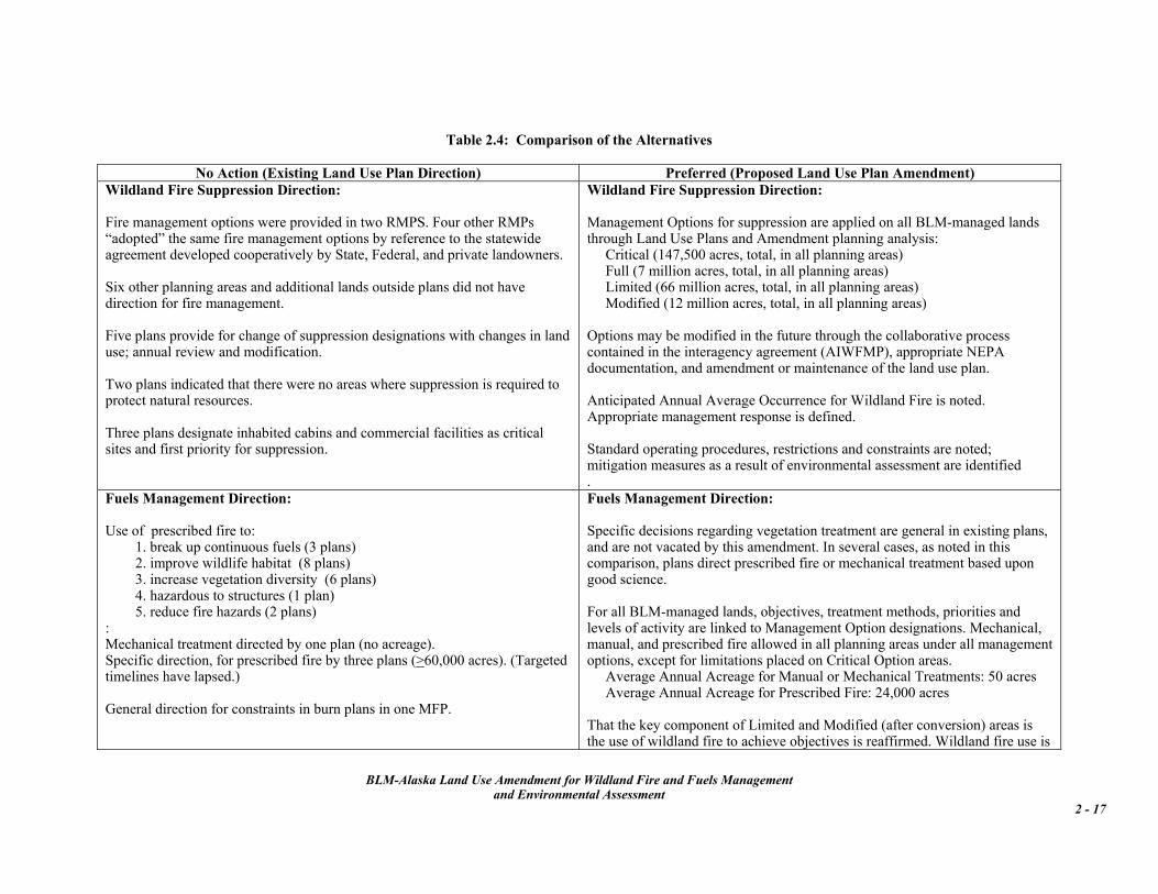
No Action (Existing Land Use Plan Direction) Preferred (Proposed Land Use Plan Amendment) Wildland Fire Suppression Direction: Fire management options were provided in two RMPS. Four other RMPs “adopted” the same fire management options by reference to the statewide agreement developed cooperatively by State, Federal, and private landowners. Six other planning areas and additional lands outside plans did not have direction for fire management. Five plans provide for change of suppression designations with changes in land use; annual review and modification. Two plans indicated that there were no areas where suppression is required to protect natural resources. Three plans designate inhabited cabins and commercial facilities as critical sites and first priority for suppression.
Wildland Fire Suppression Direction: Management Options for suppression are applied on all BLM-managed lands through Land Use Plans and Amendment planning analysis:
Critical (147,500 acres, total, in all planning areas) Full (7 million acres, total, in all planning areas) Limited (66 million acres, total, in all planning areas) Modified (12 million acres, total, in all planning areas)
Options may be modified in the future through the collaborative process contained in the interagency agreement (AIWFMP), appropriate NEPA documentation, and amendment or maintenance of the land use plan. Anticipated Annual Average Occurrence for Wildland Fire is noted. Appropriate management response is defined. Standard operating procedures, restrictions and constraints are noted; mitigation measures as a result of environmental assessment are identified .
Fuels Management Direction: Use of prescribed fire to:
: Mechanical treatment directed by one plan (no acreage). Specific direction, for prescribed fire by three plans (>60,000 acres). (Targeted timelines have lapsed.) General direction for constraints in burn plans in one MFP.
Fuels Management Direction: Specific decisions regarding vegetation treatment are general in existing plans, and are not vacated by this amendment. In several cases, as noted in this comparison, plans direct prescribed fire or mechanical treatment based upon good science. For all BLM-managed lands, objectives, treatment methods, priorities and levels of activity are linked to Management Option designations. Mechanical, manual, and prescribed fire allowed in all planning areas under all management options, except for limitations placed on Critical Option areas. Average Annual Acreage for Manual or Mechanical Treatments: 50 acres Average Annual Acreage for Prescribed Fire: 24,000 acres That the key component of Limited and Modified (after conversion) areas is the use of wildland fire to achieve objectives is reaffirmed. Wildland fire use is
BLM-Alaska Land Use Amendment for Wildland Fire and Fuels Management
and Environmental Assessment 2 - 17
BLM-Alaska Land Use Amendment for Wildland Fire and Fuels Management
and Environmental Assessment 2 - 18
No Action (Existing Land Use Plan Direction) Preferred (Proposed Land Use Plan Amendment) permitted as an Wildland Fire Situation Analysis alternative for other management option classifications if a wildland fire escapes initial attack. Wildland Fire Use Annual Average Acres: 150,000 -200,000 Biomass utilization is encouraged; projects may be developed to support research or in cooperation with partners.
Resource Protection Guidelines: One plan allowed fire to occur under prescribed (but unspecified) conditions. Two plans indicated inventory or monitoring of fuel types, natural barriers, fire succession, or wildfire for the benefit of limited action and prescribed fire to document achievement of wildlife goals. Three plans required protection of cultural resources. One plan prioritized a natural fire occurrence (mosaic), where other important resources values would not be harmed. Fires should be < 10,000 acres. Two plans protect or enhance areas of crucial wildlife habitat for moose, caribou, or sensitive, threatened, and endangered plants, animals, and their habitat. One plan specified protection of commercial timber stands. One plan indicated maintaining watershed cover in healthy condition through use of natural or prescribed fire. Direction to develop and implement a fire management plan in one MFP, and two RMPs.
Resource Protection Guidelines: Existing plan-specific decisions regarding resource protection are general in existing plans, and are not vacated by this amendment. Public and firefighter safety is incontrovertibly identified as the number one priority in all fire and fuels management activities. Fire and fuels management direction for all BLM-managed lands is addressed uniformly at the first tier of BLM land use plans. Resources goals and objectives to be achieved by wildland fire and fuels management are identified and linked to management option designations. Protection is required in all planning areas for: improvements, such as pipeline pump station facilities, BLM campgrounds, administrative sites, designated structures and cultural sites.
Requirements of T&E species, Special Status species, migratory birds and other fish and wildlife habitats are met through management option designations and standard operating procedures. BLM has the option of enhancement or manipulation of vegetation to improve habitat for species identified during the planning process for all planning areas. For example caribou and moose in various areas may require different habitat actions related to wildland fire and vegetation treatment. All plans specify post wildland fire monitoring.
BLM-Alaska Land Use Amendment for Wildland Fire and Fuels Management
and Environmental Assessment 3 - 1
Chapter 3 Affected Environment and Environmental Consequences
For each proposed action by the federal government, NEPA requires a review of the affected human environment and environmental consequences of that action. The proposed action is the Preferred Alternative, the Land Use Plan Amendment for Wildland Fire and Fuels Management. In addition to this analysis, the planning unit1 specific information on the affected environment and environmental consequences contained in the 13 Interagency Fire Management Plans written in the 1980s is incorporated here by reference. Appendix D discusses the history of the interagency planning effort for following units: • Tanana/Minchumina Planning Area 1982
and Amendment 1984 • Copper Basin Planning Area 1983 • Kuskokwim/Iliamna Planning Area 1983 • Fortymile Planning Area 1984 • Kenai Planning Area 1984 • Kobuk Planning Area 1984 • Seward/Koyukuk Planning Area 1984 • Upper Yukon/Tanana Planning Area 1984 • Yukon/Togiak Planning Area 1984 • Arctic Slope Planning Area 1986 • Kodiak/Alaska Peninsula Planning Area
1986, Matanuska/Susitna Planning Area 1986
• Southeast Planning Area 1988. Since the Preferred Alternative was developed using the policies, terminology and appropriate management responses already in place through the AIWFMP into the BLM-managed land use plans, the anticipated impacts of the Preferred and the No Action alternatives are very similar. This analysis will focus on the effects of wildland fire, suppression actions, fuels management, and the exclusion of fire on ecosystem health and the human environment. The main difference between the two alternatives is that the Preferred Alternative prioritizes and
1 Map 5 displays the interagency fire planning units.
broadens the opportunities for fuels treatments; however, it retains the requirements in place for site-specific plans and analyses. For both alternatives, this analysis makes the following assumptions: • Past wildland fire history provides a
reasonable basis upon which to predict future wildland fire activity.2
• Wildland fire will continue to occur at approximately the same level and in the same hydrological units that it has been occurring since the implementation of the interagency wildland fire management plans.3
• Wildland fire is an essential ecological process and natural change agent of the Alaskan ecosystems.
• Future fuel treatment projects will require a project plan and corresponding analyses. Each will be reviewed for compliance with State and federal regulations and policies.
• All fire and fuels management activities will follow procedures, restrictions and constraints listed in Sections 2.3.3 and 2.5.5.
3.1 Critical Elements BLM requires the following Critical Elements be analyzed in all Environmental Assessments. Critical elements are subject to requirements specified in statue, regulations, or executive orders.
2 Appendix E for Fire Occurrence Statistics 3 Map 6, Alaska Hydrologic Units with Fire History for a graphic depiction of large fire occurrence. The map illustrates the fire history from 1950 to 1987 and post interagency fire plan implementation occurrence from1988 to 2002.
BLM-Alaska Land Use Amendment for Wildland Fire and Fuels Management
and Environmental Assessment 3 - 2
3.1.1 Air Quality
3.1.1a Affected Environment The Clean Air Act (CAA) was enacted in 1970 (amended in 1990) to limit the emission of pollutants into the atmosphere to protect human health and the environment from the effect of airborne pollution. The CAA authorized the U.S. Environmental Protection Agency (EPA) to achieve this objective by setting air quality standards and regulating emissions of pollutants into the air. These controls are implemented in Alaska through EPA and the Alaska Department of Environmental Conservation (ADEC). In undeveloped areas, ambient air pollutant levels are below measurable limits. Locations near population centers are most vulnerable to air quality impacts from emissions sources such as automotive exhaust and residential wood smoke. National Ambient Air Quality Standards (NAAQS) limit the amount of specific pollutants allowed in the atmosphere: carbon monoxide (CO), lead, nitrogen dioxide, ozone, sulfur dioxide, and particulate matter (PM). The major pollutant of concern in smoke from fire is fine particulate matter, both PM104 and PM2.5. Alaska has four Class I airsheds5. There are no BLM-managed lands near or adjacent to any Class I airsheds. Fire management activities on BLM-managed land may affect four Areas of Non-Attainment6: three with CO and one with particulate matter exceeding PM10 guidelines. The Northern Field Office has resource management
4 PM10 is particulate matter less than 10 microns in diameter; PM2.5 is less than 2.5 microns. 5 Geographic areas designated under the Clean Air Act where only a very small amount or increment of air quality deterioration is permissible. 6 An area considered to have an air quality attribute that does not meet the NAAQS as defined in the Clean Air Act.
responsibilities on lands near or adjacent to the Fairbanks and North Pole CO Non-Attainment Area. The Anchorage Field Office manages lands near or adjacent to the Anchorage CO and Eagle River PM10 Non-Attainment Areas. Figure 3.1 displays Alaska Class 1 Airsheds and Non-Attainment areas
Figure 3.1
ADEC is responsible for declaring air episodes and issuing air quality advisories, as appropriate, during periods of poor air quality or inadequate dispersion conditions. That agency is represented on the AWFCG. During periods of wildland fire activity the Multi-Agency Coordinating Group (MAC), a sub-group of the AWFCG, addresses air quality and smoke management issues. At the present, the ADEC has a Memorandum of Understanding and an Enhanced Smoke Management Plan (ESMP) circulating for signature among the State and federal agencies. The ESMP addresses ADEC procedures and requirements for managing smoke from prescribed fires. As ADEC develops its State Implementation Plan (SIP) for regional haze, changes may be necessary to address additional fire tracking and emission management needs based upon policies and guidelines developed by the Western Regional Air Partnership. Under State law all agencies, corporations and individuals that burn forty acres or more of land require written approval from ADEC. The ESMP outlines the process and items
BLM-Alaska Land Use Amendment for Wildland Fire and Fuels Management
and Environmental Assessment 3 - 3
which must be addressed by land management agencies to help ensure that prescribed fire activities minimize smoke and air quality problems. The ESMP addresses elements required by the EPA’s Interim Air Quality Policy on Wildland and Prescribed Fire (April 23, 1998). 3.1.1b Environmental Consequences The U.S. Dept. of Agriculture, U.S. Forest Service, Rocky Mountain Research Station, General Technical Report RMRS-GTR-42-volume 5, December 2002, Wildland Fire in Ecosystems, Effects of Fire on Air7, is incorporated here by reference. It includes chapters on air quality regulations, overview of air pollution from fire, emission characteristics, chemistry, impacts, consequences and recommendations for research. Fires are a source of CO and PM air pollutant emissions. Fire affect on air quality and visibility depends on many factors including amount and duration of emissions, wind speed and direction, atmospheric stability, humidity, weather system patterns, the scope and severity of fires, terrain, and the type and quantity of fuels burned. Prevailing winds and atmospheric circulation during periods when there are active fires on BLM-managed land may result in impacts to the Class I airsheds or populated areas. Other impacts to air quality would include minimal increases in noise, dust, and combustion engine exhaust generated by manual and mechanical treatment methods or suppression actions. In general, impacts in an area are temporary.
Wildland fire occurrence and impacts from those fires vary widely from year to year. For example, in Alaska in 1989 just less than 60,000 acres burned and in 1990 just over 3 million acres burned. The CAA and State air quality regulations distinguish between impacts associated with wildland fire (natural events) and those of prescribed fires (planned events). Wildland fire
7 The publication is available at http://www.fs.fed.us/rm/main/fire_res/fire_pubs.html.
emissions are not regulated under current EPA or State policy; prescribed fire emissions are regulated.
Site-specific treatment plans are reviewed for compliance with applicable laws and policies. Additional mitigation may be incorporated into specific project proposals to further reduce potential impacts. Prescribed burning activities must also comply with the BLM Manual Sections 9211.31 (E), Fire Planning, and 9214.33, Prescribed Fire Management, to minimize air quality impacts from resulting smoke. Prescribed burns are planned to be implemented under favorable atmospheric conditions for smoke dispersion; the impacts on air quality and visibility resulting from smoke emissions would be localized and limited to the time and duration of the prescribed fire. By allowing wildland fire to function in its natural role, wildland fires burn more frequently and provide a natural mosaic of fuel conditions. The most effective means of controlling air pollutant emissions from wildland fire is to reduce the number of large fires through selective use of wildland fire and vegetation treatments to break up heavy, continuous fuels. Prescribed fires and manual and mechanical treatments on lands in the wildland urban interface and adjacent to populated areas would reduce fuels accumulation and the likelihood of wildland fire occurrence. By reducing the risk of wildland fire, the risk of significant air quality impacts is also reduced. In summary, under both alternatives, impacts to air quality and visibility are anticipated due to wildland and prescribed fires. Optimal atmospheric conditions would minimize any adverse impacts. The Preferred Alternative authorizes more fuel treatment projects than the No Action Alternative. Proper implementation of prescribed fire would prevent increases in PM10 or CO concentrations sufficient to cause any change in the NAAQS attainment status. Under both alternatives, effects on the human environment from wildland fire will
BLM-Alaska Land Use Amendment for Wildland Fire and Fuels Management
and Environmental Assessment 3 - 4
vary yearly. The adverse impacts on quality and visibility will depend on the location and extent of activity that year. In general, air quality impacts would be greater from large wildland fires than from fuel treatments since wildland fires burn more acreage over an extended time period under varying atmospheric dispersion conditions. Compliance with local smoke management programs would minimize effects from prescribed fires.
Data documenting the cumulative effects on the health of firefighters with long-term exposure to smoke is lacking.
3.1.2 Aquatic Resources and Essential Fish Habitat The 1996 Sustainable Fisheries Act enacted additional management measures to protect commercially harvested fish species. It reauthorized the Magnuson-Stevens Act (16 USC 1801 et seq.) which directs action to stop or reverse the continued loss of fish habitats and added measures to describe, identify and minimize adverse effects to essential fish habitat. Toward this end, Congress mandated the identification of habitats essential to managed species and measures to conserve and enhance this habitat. The Act requires federal agencies to consult with the Secretary of Commerce regarding any activity, or proposed activity, authorized, funded, or undertaken by the agency that may adversely affect essential fish habitat (EFH). For the purposes of this environmental assessment, essential fish habitat means those waters and substrate necessary for salmon for spawning, breeding, feeding, or growth to maturity. For the purpose of interpreting the definition of essential fish habitat: Waters include aquatic areas and their associated physical, chemical, and biological properties that are used by salmon and may include aquatic areas historically used by salmon where appropriate. Substrate includes sediment, hard bottom, structures underlying waters, and associated biological communities. Necessary means the habitat required to support a sustainable fishery and the managed species’ contribution to a healthy ecosystem. Spawning,
breeding, feeding, or growth to maturity covers a species’ full life cycle. The National Marine Fisheries Service recognizes waters cataloged under AS 16.05.870 (Waters Important for the Spawning, Rearing or Migration of Anadromous Fishes) as essential fish habitat. An Environmental Impact Statement is being written by National Marine Fisheries Service which analyses several alternative descriptions of EFH; any new regulations concerning EFH are expected to be published no later than August 2006.
3.1.2a Affected Environment The aquatic community consists of three main components: (1) aquatic plants (phytoplankton, periphyton, and rooted vascular macrophytes), which fix energy from sunlight; (2) bacteria and fungi, which decompose organic matter; and (3) consumers, both sedentary (invertebrates and fish, which use energy from plants, animals, bacteria, and fungi) and mobile (birds, mammals, amphibians). The habitat requirements for fish include a healthy, functioning aquatic ecosystem consisting of all three community components, as well as the proper physical and chemical attributes.
Aquatic Habitat
and the Fish It Supports In Alaska BLM manages 115,000 miles of fish-bearing stream habitat, which includes 15,145 miles of habitat used by anadromous species. In addition, BLM-Alaska manages an estimated 2.6 million surface acres of lake habitat. This habitat ranges from high mountain lakes to lowland and tidal influenced lakes and ponds and small first-order tributaries to large rivers.
Of the anadromous stream habitat under BLM management 98% (14,800 miles) is considered to be in natural or near-natural condition, and 2% (319 miles) is in fair to minimal condition (BLM 1996).
Fish species utilizing freshwater habitats include the following families: Salmonidae (salmon, trout, char, grayling, whitefish); Cottidae (slimy sculpin); Catostomidae
BLM-Alaska Land Use Amendment for Wildland Fire and Fuels Management
and Environmental Assessment 3 - 5
(longnose sucker); Esocidae (northern pike); Petromyzontidae (lampreys); Gadidae (burbot); and Gasterosteidae (sticklebacks), and Umbridae (Alaska Blackfish). Much is known about the life history and habitat requirements of some of these species, and nothing is known about others. All of the species are important to the natural functioning of their associated ecosystems, and many species have social or economic value to humans.
Habitat Factors
That Influence Fish Abundance Habitat needs for fish vary with the species, season of the year, and life stage. A variety of chemical, physical, and biological parameters interact to provide the range of environmental conditions that allow the species to exist. Some of the more important parameters include water quality, lake/stream, depth, temperature, water velocity, streamflow, cover, substrate, and nutrient/energy (food) availability. These parameters are directly influenced by riparian function, but climate, geology, soils, topography, upland vegetation, hydrology, and land use within a watershed all play a role in defining the condition and quality of the aquatic environment. Fish respond to these parameters both physiologically (altered growth rates and health) and behaviorally (site selection and community interaction). Fish generally respond to these environmental factors in combination. Where fish can live and reproduce, the range of environmental conditions must be suitable throughout their lives. To show the complex and often narrow range of environmental conditions required by fish the following narrative [from Bjornn and Reiser (1991) unless otherwise cited] discusses the habitat requirements of salmonids (e.g. trout, salmon, and char), a group that represents many species found in streams within the study area. • Water Quality: Salmonids require
water that has a high concentration of dissolved oxygen (>75% saturation), is nearly neutral to slightly alkaline (pH 6.5-8.7), is free from toxic
concentrations of heavy metals and other toxic chemicals, and has sediment levels (bedload and suspended) that approximate natural undisturbed conditions. In addition, water temperature plays a crucial role in defining suitable water quality for fish. Additional information is contained in Section 3.1.14 Water Quality.
• Water Temperature: The timing of
salmonid spawning has evolved in response to water temperatures in each stream before, during, and after spawning. Water temperatures can influence the upstream migration of adult spawners and delay the entry of spawners into their natal streams. Temperature also determines the rate of embryo and alevin (newly hatched fish still attached to the egg yolk) development. Within the temperature range for successful spawning and incubation, 4-14○C (Bell 1986), warmer temperatures result in shorter development times. In many streams winter temperatures fall below the 4○C minimum recommended for incubation, but the eggs develop normally because the spawning and development occurred when temperatures are within the suitable range.
Water temperature also determines the capacity of water to hold oxygen in solution. The relationship is an inverse one, with oxygen solubility lower in warmer water. Salmonids can survive relatively low concentrations of dissolved oxygen for short periods of time, but swimming performance, growth rate, and food conversion efficiency are adversely affected.
• Streamflow: Adequate streamflow is
important for providing fish passage (both for upstream migrating adults and for the downstream migration of juveniles). Streamflow regulates the amount of spawning and rearing area by controlling the wetted perimeter, depth, and velocity of water. Streamflow also determines stream channel morphology, bed material
BLM-Alaska Land Use Amendment for Wildland Fire and Fuels Management
and Environmental Assessment 3 - 6
particle size, and the sediment transport capacity of the stream. These parameters in turn determine the quality and distribution of aquatic habitat types.
• Water Velocity: Next to flow, water
velocity is probably the most important variable in determining the amount of living space available for fish. If velocities are unsuitable, no fish will be present. Natural streams have a variety of velocities, some of which are suitable for fish. The velocities suitable for salmonids vary with life stage of the fish, the species, and the season of the year.
• Cover: In-stream cover provides fish
with security from predation and displacement during high flows and allows fish to use portions of a stream they may not otherwise be able to use. Some of the more common cover elements include deep water, water turbulence, large-particle substrates, overhanging riparian vegetation, undercut streambanks, woody debris, and aquatic vegetation. The cover requirements of fish change diurnally, seasonally, and by species and life stage. Cover has been correlated to fish abundance and is an important aspect of quality habitat.
• Substrate: Streambed substrate
provides juvenile fish cover from predators and adverse environmental conditions, serves as habitat for aquatic invertebrates that often provide a substantial component of the fish’s diet, and contributes to the quality of spawning, incubation, and rearing habitat. In-stream cover is provided by the interstitial space (voids) between substrate particles. In many streams, large-particle substrate is the main cover type, along with water turbulence and depth. Small-particle substrates, such as silt and sand, are of no value as cover for fish. Small fish, such as newly emerged fry, can use substrates consisting of 2-5 cm diameter rocks,
whereas larger fish require cobble- and boulder-size material.
Aquatic invertebrates, which are a primary food for fish, are produced in the substrate. Some types of invertebrates are more suited to fine-particle substrates than others. But watershed disturbance and erosion can add fine sediments, which can reduce the abundance of many species of invertebrates, resulting in reduced fish production.
When an adult salmonid selects a spawning site, it is also selecting the incubation environment. During redd (nest) construction, fine sediment and organic material are displaced from the redd, larger substrate material such as gravel and rubble are rearranged, and the site is as favorable to egg development as it will ever be. As the incubation period proceeds, redds may become less suitable to developing embryos if fine sediment and organic material are deposited in the interstitial space between particles. The fine sediment can impede the movement of water and alevins from the redd, and the organic matter can consume dissolved oxygen during decomposition. If the dissolved oxygen is consumed faster than the reduced intragravel water flow can replace it, the embryos or alevins will asphyxiate. The amount of fine sediment deposited and the depth to which it intrudes depends on the size of substrate in the redd, flow conditions in the stream, and the amount and size of sediment being carried.
• Energy Flow and Stream Productivity:
Stream and terrestrial ecosystems are closely linked. The flow of water, sediment, nutrients, and organic matter from the surrounding watershed shapes the physical habitat and supplies energy and nutrients to the stream community. Activities of the numerous components of the stream community influence the flow of energy from primary production to decomposition. As predators, salmonids are influenced by energy-
BLM-Alaska Land Use Amendment for Wildland Fire and Fuels Management
and Environmental Assessment 3 - 7
flow processes operating at all levels in the stream ecosystem (Murphy and Meehan 1991).
Streams vary in productivity, largely in response to the available nutrients and energy. Energy comes to the stream community from two main sources: photosynthesis by aquatic plants in the stream and decomposition of organic matter imported from upland and riparian areas outside the stream. Imported energy sources contribute organic matter to a stream by four main pathways: litter fall from streamside vegetation, ground water seepage, soil erosion, and fluvial transport from upstream. In addition, animals can contribute important amounts of organic matter and nutrients. Streamside vegetation provides large amounts of organic matter when leaves, needles, and woody debris fall into the stream. Leaves and needles usually contribute most of the readily usable organic matter in woodland streams. As much as one-quarter of a stream’s total imported organic matter may enter dissolved in ground water. But the nutritional value of this dissolved organic matter is generally low, and this organic matter does not contribute much energy to the stream community (McDowell and Fisher 1976; Klotz and Matson 1978). As with ground water, most dissolved organic matter from soil erosion offers little nutritional value to the stream community. Fluvial transport of organic material from upstream reaches becomes an energy input to downstream reaches. Upstream reaches can supply up to a third of the total organic input to small streams and nearly all the organic matter in large rivers (Vannote et al. 1980). The source of fluvial transport is generated in the stream itself by invertebrate processing of detritus (Webster and Golladay 1984 in Meehan 1991) and algal cells detached from the
streambed (Swanson and Bachmann 1976).
Animals transport organic matter to streams in many ways. Terrestrial insects drop into streams and are eaten by fish. Drift of aquatic insects export matter downstream, and mature insects can move matter upstream by flying. Beavers carry woody debris to streams, and grazing and browsing mammals transfer matter by feeding in uplands and defecating in the floodplain. Annual spawning runs of anadromous salmon (and decay of carcasses) can contribute large amounts of organic matter and nutrients to some streams and historically contributed a substantial input of organic material and nutrients to streams.
• Influence of Riparian Vegetation: Additional information on riparian areas is contained in Section 3.1.15, Wetlands and Riparian Areas. Watershed and riparian community condition directly influences the condition, quality, and maintenance of aquatic habitat. Riparian plants filter sediments and nutrients, provide shade, stabilize streambanks, provide cover in the form of large and small woody debris, produce leaf litter energy inputs, and promote infiltration and recharge of the alluvial aquifer (Orth and White 1993; Wesche 1993). As a result of these functions, spawning beds for salmonids and microhabitats for macroinvertebrates remain relatively free of damaging fine sediment deposits. Riparian vegetation reduces sedimentation of pools, thereby maintaining water depths and structural diversity of the channel. Base flow levels are augmented throughout the year by the slow release of water stored in aquifers. Complex off-channel habitats, such as backwaters, eddies, and side channels, are often formed by the interaction of streamflow and riparian features such as living vegetation and large woody debris. These areas of slower water provide critical refuge during floods for a
BLM-Alaska Land Use Amendment for Wildland Fire and Fuels Management
and Environmental Assessment 3 - 8
variety of aquatic species and serve as rearing areas for juvenile fish. The bank stabilizing function of streamside vegetation not only helps reduce erosion and influence channel morphology but also acts to supplement in-stream cover by contributing to the development of undercut streambanks and by providing overhanging vegetation. Well-vegetated stream channels and stable streambanks help reduce turbidity and channel scouring resulting from high runoff events; they can also enhance primary production. In Alaska and other cold regions, well-vegetated stream channels help reduce the formation of aufeis (ice formed by the overflow of water onto existing ice). Aufeis can decrease primary productivity, delay riparian plant growth, increase erosion, tie up water in the form of ice during critical low-flow periods, and cause the formation of new stream channels due to channel blockage (Churchill 1990; Michel 1971; Slaughter 1990).
3.1.2b Environmental Consequences Fish species and aquatic fauna adapted to the cold water in Interior Alaska streams have been exposed to indirect effects of wildland fire for thousand of years. Fire can indirectly influence fish populations or their prey through increased siltation, increased water temperature, altered water quality (dissolved oxygen, pH, suspended and dissolved solids, total hardness, turbidity), changes in nutrient input to water system, and changes in permafrost status that can lead to altered hydrology. The extent of surface erosion after a fire largely depends on the topography and soil types of the immediate area, and the amount of ice-rich frozen ground within the active layer. Stream siltation is usually negligible from surface erosion on burned sites in interior Alaska due to its gentle topographical features. Siltation may be a factor where severe burns occur on steep slopes or even shallow slopes with ice-rich active layers, where fire has severely damaged riparian protection of bank soils’ integrity, or where heavy
equipment is used in suppression activities. Lakes are also potentially vulnerable to fire effects of concentration of nutrients, sedimentation, and erosion of riparian protected shorelines from wave and wind action. Response of deciduous riparian foliage after a fire is related to already existing riparian vegetation; the impact of a fire is a change in age structure and short term productivity. Data on how fires affect stream temperatures and productivity are currently inadequate to accurately assess the effects of fire on anadromous or resident fish habitats. Much of the published work has focused on changes in lake systems (McEachern et al. 2000, St-Onge and Magnan 2000). Analyses of long-term fire effects on stream ecology are currently underway as part of FROSTFIRE8, a landscape-scale prescribed research burn in the boreal forest of interior Alaska conducted in July 1999. Future research may be able to clarify anecdotal information collected in some systems that seems to suggest higher abundance of juvenile salmonids in systems where land use or fire modifications in canopy cover have led to increased water temperatures.
Fish populations have generally shown a positive response during the initial five-year period after wildland fire where populations exhibit good connectivity with key refugia throughout the watershed (Gresswell 1999; Minshall et al. 1989). Fish will generally reinvade fire-affected areas rapidly where movement is not limited by barriers. These new colonists generally come from areas upstream of the affected area, from surrounding watersheds and from main-stem rivers where migration is not limited. Fish population recovery generally tracks the increase in primary and secondary production that occurs in the early post-fire period. Where sediment is continually delivered into the main-stem, there could be short-term negative effects on fish and macro-invertebrate communities.
BLM-Alaska Land Use Amendment for Wildland Fire and Fuels Management
and Environmental Assessment 3 - 9
Fuels projects are designed and implemented in a “non-emergency” manner that minimizes impacts to aquatic resources. Although wildland fires may still occur in areas where hazardous fuel loads have been reduced, fires which may occur are expected to be predominately ground fires rather than crown fires. Ground fires are easier to control with lower-impact suppression methods (such as hand-built fire line) that are less likely to adversely affect aquatic resources. In contrast, the crown fires associated with heavier fuel loads often require suppression techniques likely to have greater adverse impacts to aquatic habitats and species. Competent planning and implementation will minimize the effects of fuels treatments. Some projects involve multiple treatments of the same area. Prescribed fires conducted in the spring (when drainage-bottoms are still snow covered) help to protect riparian vegetation and soils. The primary goal of these projects is to reduce the occurrence, risk, and impacts of wildland fires, not restore the natural capacity of aquatic species to withstand the effects of natural fires.
Removal of vegetation to reduce future fuel loading may be accomplished with minimal impacts in some areas, but in others, sensitivity to ground disturbance from loss of vegetation can cause increased erosion, compacted soils, and a loss of nutrients (USDA 2000, Beschta et al. 1995).
To protect water quality and the diversity of habitats for fish, amphibians and other aquatic organisms, standard operating procedures (Section 2.3.3 and 2.5.5) are in place to protect the proper functioning condition of riparian area and stream characteristics. When the primary objective is to protect life, these techniques may not be followed since species and habitat protection is logically placed below protection of human life; in Alaska, these occasions would be unusual and rare.
As a result of this analysis, the Preferred Alternative includes the formation of Riparian Buffer Zones (RBZ) around
riparian, streamside, lakeside, and wetland areas (Section 2.5.5). In RBZs, the effects of wildland fire are not considered adverse impacts and fire will be allowed to function in its natural ecological role. Configuration recommendations are found in widely accepted riparian and aquatic protection strategies: PACFISH 1995 and INFISH 19959. These buffer zones help preserve ecological processes by creating a vegetation filter that removes sediment before it reaches water bodies (Montana State University 1991). Properly maintained RBZs protect salmon fry and other young fish; maintain water temperatures necessary for spawning and rearing; introduce insects and other fish food to the water from streamside vegetation; stabilize stream banks and floodplains; and protect bird habitat and wildlife travel corridors associated with riparian areas. To minimize erosion and the amount of sediment that reaches waterways, RBZs should be adjusted to appropriate width depending on the volume of the stream. The width necessary to protect stream and riparian area structure and function will be determined on a case-by-case basis and from site-specific analysis.
Under both alternatives, the occurrence of wildland fire and impacts associated with those would be the same. The preferred alternative authorizes fuel treatments, prioritized to protect human life and property, on all BLM-managed lands. Each project would be planned based on site characteristics. Properly planned and implemented treatment projects would result in minimal impacts to aquatic resources and EFH.
3.1.2c Essential Fish Habitat Compliance
Standard operating procedures (Section 2.3.3 and 2.5.5) applicable to wildland fire and fuels management are in place to protect the proper functioning condition of riparian areas, streams characteristics and EFH.
BLM-Alaska Land Use Amendment for Wildland Fire and Fuels Management
and Environmental Assessment 3 - 10
Examples of mitigation measures included in those procedures to avoid or minimize impacts to EFH and water quality are:
Create Riparian Buffer Zones (RBZ)
for all fire management activities for all perennial water bodies.
Use minimum impact suppression tactics.
Use of aerial fire retardant near lakes, wetlands, streams, rivers, sources of human water consumption, and areas adjacent to water sources should be avoided to protect fish habitat and water quality. If feasible in these areas, the use of water rather than retardant is preferred. When the use of retardant is necessary, avoid aerial or ground application of retardant or foam within 300 feet of a waterway; application beyond 500 feet is preferred. Examples of when use of retardant is authorized are for the protection of : ▪ Human life. ▪ Permanent year-around residences. ▪ National Historic land marks. ▪ Structures on or eligible for the
National Register of Historic Places.
▪ Government Facilities. ▪ Sites or structures designated by
Field Office resource specialists to be protected.
▪ High value resources on BLM-managed lands and those of adjacent land owners.
▪ Threatened, endangered and sensitive species habitats as identified by resource specialist.
Procedures for heavy equipment use.
In addition, stabilization or restoration activities after a wildland fire are planned in conjunction with a resource specialist. (Section 2.5.4)
3.1.3 Areas of Critical Environmental Concern (ACEC)
BLM manages 42 ACECs. ACEC designations highlight areas where special management attention is needed to protect and prevent irreparable damage to important cultural, historic, and scenic values; fish or wildlife resources; natural systems or processes; or to protect human life and safety from natural hazards. On-the-ground suppression actions on wildland fires are necessary only to protect resource values at sites specifically identified by staff specialists. Fuel treatments are only likely in areas requiring maximum protection from wildland fire, such as high value cultural or historic sites or structures, or to meet a specific management objective for resources for which the ACEC was established. Under both alternatives, projects require site-specific consideration and planning. 3.1.4 Cultural Resources
Cultural, archeological, historical, and paleontological resources are addressed in this section since impacts are similar.
3.1.4a Affected Environment
BLM-managed lands contain a variety of known cultural and related resources, including prehistoric, historic, and archeological sites, Native cemeteries, former community sites, and travel routes associated with Native heritage. Evidence of more recent human settlers includes cabins, roadhouse sites, mines, trails, and tools and equipment associated with European explorers and settlers. Although some surveys have been done and others are ongoing, only a relatively small portion of BLM-managed lands have been extensively investigated for cultural resources. Site-specific designations (Section 2.3.3e) and procedures for newly discovered structures (Section 2.5.5b) are in place to preserve and protect cultural resources to the extent possible from wildland fire and associated activities. BLM also manages cultural resources under its internal manual procedures, the 1997
BLM-Alaska Land Use Amendment for Wildland Fire and Fuels Management
and Environmental Assessment 3 - 11
National Programmatic Agreement for Section 106 Compliance and its 1998 Implementing Protocol with the Alaska State Historic Preservation Officer.
3.1.4b Environmental Consequences Nearly 25 years ago the Fairbanks District Office prepared an Environmental Assessment for a fire plan. As part of the analysis of impacts, that EA contained the following statement:
“Information concerning the effects of fire and fire suppression activities on cultural resources is scanty at best. Some information has been gathered concerning fire effects in the lower 48 states, but any attempt to generalize from this data to radically different conditions in Alaska would not be justifiable.”
While the concluding statement is perhaps no longer true, the rest of the paragraph still applies. Despite our best efforts, we have not managed to achieve any appreciable expansion of our knowledge of fire effects on cultural resources in Alaska. Experience with fire and cultural resources has improved in the Lower 48 states, however, and the following general discussion, based largely on an EA prepared in Montana, may be useful. In general, the effect of wildland fire and prescribed burning on cultural resources depends on the location of the resource with respect to the ground surface, the proximity to fuels that could provide a source of heat, the material from which artifacts are made, and the temperatures to which artifacts are exposed. Threshold temperatures for damage to cultural artifacts manufactured from different materials, such as ceramic or stone, vary significantly. Surface or near-surface cultural materials may be damaged, destroyed, or remain essentially unaffected by fires, depending on the temperatures reached and the duration of exposure to that temperature. Wooden structures or wooden parts of stone structures are susceptible to fire and
potential damage from suppression activities. Combustible artifacts lying directly on the ground surface could be damaged or destroyed. The ability to date noncombustible surface artifacts may be adversely affected if exposed to specific high temperatures. Subsurface resources are much less likely to be significantly affected by fire; however, they may be affected if excessive amounts of soil heating occur. Much of interior Alaska is known to have burned in the past. Evidence of such burning has been observed on several archaeological sites that have been excavated, apparently with no evidence of severe impacts from the fires. Hence the resources most susceptible to damage usually are the most recent ones which have not been burned previously, such as standing cabins. Prescribed fires in areas of cultural significance would not be ignited under conditions dry enough to cause significant subsurface heating. Subsurface cultural resources are generally more subject to harm from construction of fire lines around planned fire boundaries than from the fire itself. The heat, smoke and soot from fires can also damage cultural resources, especially prehistoric rock art, by causing spalling, which physically destroys the resource, or by obscuring the surface of the resource with smoke and soot. Smoke and soot can damage cultural resources by either increasing chemical deterioration or obscuring carvings and painted motifs. In general, damage to cultural resources, prehistoric and historic, also may result from fire suppression-related activities. Cultural resources may be more at risk from activities such as blading fire lines, setting camps and staging areas, or using vehicles off road, than by the fire. Impacts from smoke, heat, or soot are not believed to produce measurable effects on fossil resources unless those elements are in close proximity to the resources.
BLM-Alaska Land Use Amendment for Wildland Fire and Fuels Management
and Environmental Assessment 3 - 12
The effect of fire on fossil resources is directly related to the location of the resource with respect to the ground surface, the proximity of the fuels that provide the source of heat, and the location and use of hand tools, motorized vehicles, fossil collecting activities, and heavy equipment. Fossils lying at or near the surface would likely be located in an area lacking vegetation or fuel. Wildland fire and prescribed burns make sites both cultural and paleontological more susceptible to the effects of erosion and it also results in a more visible resource. Illegal collecting may increase on burned areas, especially along access routes. The greatest risk for these resources would likely come from the equipment and activities associated with fire management activities. This includes any surface disturbing activities such as camp preparation, fire line construction, motorized vehicle use, and heavy equipment operation. If these activities are isolated from the fossil producing formations and the selected areas are judged unlikely to contain significant cultural resources, the impacts to these resources should be negligible. For fuel reduction projects where mechanical or manual treatments are proposed, a Class III cultural resource inventory is required. If any cultural resources are located, the planning and mitigation measures for the project are directed toward avoiding any damage to the resources. Given these procedures, impacts to significant cultural resources are not anticipated from mechanical or manual treatments.
During wildland fires, impacts to significant cabins would be minimized by use of BLM’s Policy for Cabin/Structure Protection (Appendix L). In areas where fossil resources are known or anticipated, mechanical or manual treatments will include provisions to avoid areas containing sensitive fossil producing formations. If those areas cannot be avoided by the treatments or associated activities, a
qualified paleontologist will be retained to recover specimens subject to direct impact. In conclusion, the anticipated impacts under both alternatives are the same. Using the standard operating procedures associated with site-specific designations and procedures in place for newly discovered sites including the statewide wildland fire cabin policy, the effects of both suppression activities and fuels treatment activities should be minimal.
3.1.4c National Historic Preservation Act Section 106 Compliance
Impacts to cultural resources by naturally-ignited fires without human intervention are not Undertakings. BLM emergency suppression actions and planned fuel reduction projects (both mechanical and manual treatments) are Undertakings. Potential impacts to significant cultural resources from both emergency and planned fire-related actions taken by BLM will be avoided or minimized to the maximum extent possible through application of existing BLM policies and procedures. These include following procedures for Section 106 compliance in BLM's 1997 National Programmatic Agreement for Section 106 compliance which is implemented in Alaska by BLM's 1998 Protocol with the Alaska State Historic Preservation Office. BLM would also use its Policy for Cabin/Structure Protection (Appendix L) to further proactively help identify and protect significant standing structures in rural parts of the state.
3.1.5 Environmental Justice Executive Order 12898 directs federal agencies to review the effects of proposed projects on minority or low income populations. This includes native corporations and villages. Under both alternatives, Native representation and equal participation in fire management issues statewide continue through the Alaska Interagency Wildland Fire Coordinating Group. Neither alternative would result in unique effects or issues specific to any minority or low-income population or community other than those discussed under Section 3.1.11 Subsistence.
BLM-Alaska Land Use Amendment for Wildland Fire and Fuels Management
and Environmental Assessment 3 - 13
3.1.6 Farm Lands (Prime or Unique) The Farmland Protection Policy Act of 1985 and 1995 requires identification of proposed actions that would affect any lands classified as prime and unique farmlands. No BLM-managed lands in Alaska are identified as such. 3.1.7 Floodplains Executive Order 11988 was enacted to “avoid to the extent possible the long-term and short-term adverse impacts associated with the occupancy and modification of floodplains and to avoid direct or indirect support of floodplain development wherever there is a practicable alternative.” Standard operating procedures (Section 2.3.3 and 2.5.5) have been developed to avoid damage to riparian area and wetlands during all fire management activities. No developments or effects of development by the BLM in conjunction with wildland fire or fuels management activities are anticipated in a floodplain with either alternative. 3.1.8 Migratory Birds Executive Order 13186 issued January 10, 2001 directs federal agencies to protect migratory birds. Alaska is home to over 445 species of birds. Most of these are migratory birds for which the Fish and Wildlife Service is responsible under international treaties and the Migratory Bird Treaty Act. Some of the birds stay in Alaska year-round. Most migrate to Canada, Central America, South America, Asia, or the lower 48 United States. In fact, birds from Alaska pass through virtually every other state in the Union (even Hawaii) on the way to their wintering grounds. Maintaining migratory birds and their habitats in Alaska is clearly a matter of national and international significance.10 The environmental consequences of wildland fire on birds are contained in Section 3.1.12 Threatened and Endangered Species, 3.2.4 Special Status Species and 3.2.7 Wildlife. 10 From US Fish and Wildlife Service website http://www.r7.fws.gov/mbm/introduction.html
3.1.9 Noxious and Invasive Plants
3.1.9a Affected Environment Noxious and invasive plants (weeds) are an increasing problem on BLM-managed lands nationally. Alaska BLM-managed lands are less impacted by noxious and invasive plants than other lands in the west but many vectors for weed spread onto AK BLM-managed lands exist and are presenting an increasing threat. Noxious and invasive plants can rapidly displace desirable plants that provide habitat for wildlife. Such weeds can cause drastic changes in the composition, structure and productivity of vegetation communities. Some weeds documented in Alaska are noxious to wildlife, humans and pets. Invasive plants can be native or non-native plants. Most invasive plants in Alaska are non-native, having been introduced accidentally or intentionally. Most occur on disturbed areas but many can invade natural landscapes. Most commonly they have been introduced and spread unintentionally through hay, feed or straw contaminated with weed seed, by hitchhiking on vehicles, domestic animals (horses, dogs) or humans, via waterways, and contaminated agricultural seeds and equipment. Intentional introductions of the invasive plants in Alaska have occurred commonly through re-vegetation of disturbed areas, such as highway or other rights-of-way, and horticulture. Noxious plants are listed by state and federal law and are generally considered those that are exotics and negatively impact agriculture, navigation, fish, wildlife or public health. Figure 3.2 lists the noxious weeds regulated through seed laws by the State of Alaska, 11AAC 34.020. The Committee for Noxious and Invasive Plants Management in Alaska (CNIPM)11 is developing a ranked list of problematic weeds that will expand on the state noxious weed lists. Invasive plants known to occur in
11 For more information see http://cnipm.org/
BLM-Alaska Land Use Amendment for Wildland Fire and Fuels Management
and Environmental Assessment 3 - 14
Figure 3.2 Alaska Regulated and Restricted Noxious Weeds
Species Scientific Name State Designation Field Bindweed Convolvulus arvensis Prohibited Austrian Fieldcress Rorippa austriaca Prohibited Galensoga Galensoga parviflora Prohibited Hempnettle Galeopsis tetrahit Prohibited Horsenettle Solanum carolinense Prohibited Russian Knapweed Acroptilon repens Prohibited Blue-flowering Lettuce Lactuca pulchella Prohibited Quackgrass Elymus repens Prohibited Perennial Sowthistle Sonchus arvensis Prohibited Leafy Spurge Euphorbia esula Prohibited Canada Thistle Cirsium arvense Prohibited Whitetops and varieties, pepperweed
Alaska are not likely to contribute to changes in fire frequency or intensity; however, they may provide an unwanted seed source adjacent to natural or prescribed fires or other fire fuels treatments. New invasive plants are arriving in Alaska and some may impact fire intensity and occurrence.
The control of noxious and invasive plants on BLM-managed lands is being evaluated in the Environmental Impact Statement for Vegetation Treatments, Watersheds and Wildlife Habitats on Public Lands Administered by the BLM in the Western United States, Including Alaska (Vegetation EIS). 12
3.1.9b Environmental Consequences No new impacts would occur under either alternative. The No-Action Alternative represents continuation of current invasive or noxious weed management. The primary
12 http://www.blm.gov/weeds/VegEIS/index.htm
impacts from continuing the current fire management practices are from noxious and invasive plants (weeds) becoming established as a direct result of fire or fire suppression activities. Seeds or plant parts may be transported into relatively remote and undisturbed areas by fire crews, equipment aircraft, and dozers. Rehabilitation of fire lines (hand, dozer or other) or burn areas may be a source of noxious and invasive plant introduction. There is little evidence of invasive, non-native vegetation becoming established on burned areas on BLM-managed lands in Alaska where fire suppression activity did not occur (for example, on lands designated Limited Management Options.) In some of the contiguous western states, noxious and invasive plant spread does occur after wildland fire and contributes to hazardous fuel loads and alteration of burn intervals (USDI/BLM Arizona 2003).
The Preferred Alternative, Land Use Plan Amendment, includes how management
BLM-Alaska Land Use Amendment for Wildland Fire and Fuels Management
and Environmental Assessment 3 - 15
objectives drive fire management on BLM-managed lands in Alaska. Objectives for noxious and invasive plant management emphasize prevention and control. These objectives were in place prior to this amendment through other documents and agreements. Under both alternatives, these objectives are met, by allowing fire to occur on the landscape, except where public health and safety issues warrant fire exclusion, or in the few cases where fire may now or in the future need to be deferred from an area for specific resource protection. Under the Preferred Alternative, the following standard operating procedures have been added and will hinder noxious weed spread when suppression actions or rehabilitation of areas impacted by suppression activities are necessary:
Use original soil and vegetation to
rehabilitate fire and dozer lines. Use native vegetation and seed (when
available) when seeding or plugging is necessary.
Develop rehabilitation plan by working with BLM wildlife biologists and botanists.
3.1.10 Native American Religious Concerns See Sec. 3.1.3 Cultural Resources. 3.1.11 Subsistence
3.1.11a Affected Environment In Alaska, the term subsistence refers to contemporary hunting, fishing, trapping, and gathering practices, providing food, fuel, and other products on which many households rely for a significant portion of their livelihood. Under Title VIII of the Alaska National Interests Lands Conservation Act (ANILCA 1980), the subsistence uses of rural Alaskans are granted a priority in the management of fish and wildlife on Federal public lands. The statute equally protects the subsistence practices of rural Alaska Natives and non-Natives, but it is important to note that Alaska Native societies have a particularly
long history and richly elaborated social and cultural practices associated with the subsistence way of life. Subsistence represents a productive and highly valued component of the rural economy, where participation in the monetized economy is uneven, due to limited employment and income, along with high costs for imported goods.
The vitality of contemporary subsistence activities is closely tied to healthy ecosystem processes. Productive hunting, fishing, and trapping depend upon healthy fish and wildlife populations, and these in turn require intact, productive habitats. Ecosystems are dynamic, changing over time, and fire is a natural ecological process, to which flora and fauna have adapted. The subsistence way of life in rural Alaska, particularly as practiced by Alaska Natives, incorporates a detailed knowledge of local climate, habitat, and fish and wildlife, including adaptive harvest strategies to respond to habitat change and resource population dynamics. The demographic scale and economic productivity of contemporary subsistence production may be seen in the estimate that, as of the late 1990s, 120,000 rural residents harvest nearly 44 million pounds of wild food per year, or about 375 pounds per person per year.13 Rural Alaskans live in 270, generally small, relatively isolated, communities. The rural population is about equally Alaska Native and non-Native. The high level of production is paralleled by high rates of participation: nearly 83% of rural households harvest fish, and about 60% harvest wildlife. When sharing and redistribution are taken into account, about 95% of rural households consume fish, and 86% consume wildlife. Assuming costs replacement costs of $3 - $5 per pound, these subsistence foods represent a monetary value of between $131 million and $215 million per year. One of the most important ecological dimensions of subsistence production is
13 Figures in this section taken from Wolfe 2000, unless otherwise noted.
BLM-Alaska Land Use Amendment for Wildland Fire and Fuels Management
and Environmental Assessment 3 - 16
3.3 Wild Food Harvest Species Composition14
14 Source: Alaska Department of Fish and Game, Division of Subsistence
BLM-Alaska Land Use Amendment for Wildland Fire and Fuels Management
and Environmental Assessment 3 - 17
found in the species composition and seasonal cycle of subsistence harvests. These vary enormously from one region in Alaska to another, as a result of the diverse ecosystems involved. Arctic and Western coastal regions, for example, have access to marine mammals, but lower reliance on land mammals. Many coastal and riverine communities, from the Norton Sound south, have access to rich salmon resources, which make up a large component of total subsistence harvest. In more remote Interior communities, salmon are more limited or absent, so freshwater fish species are more important, as are the large mammals, including moose, caribou and bear. Several examples of the diversity in subsistence species composition across the state are shown in Figure 3.3. Taking the rural Alaska as a whole, fish make up 60% of subsistence harvests, while land mammals constitute 20%, marine mammals 14%, birds 2%, shellfish 2% and plants 2%.
The other significant ecological dimension of subsistence practices is the traditional subsistence use areas associated with each community. Over generations, each community has established a traditional range for its hunting, fishing and trapping activities. Effective and efficient subsistence harvest strategies are based on intimate knowledge of this range, including familiarity with a variety of ecological factors. In the cumulative stories developed over several generations and shared widely throughout a community, hunters can draw upon an intricate body of knowledge concerning weather and hydrological conditions, productive habitat zones, and animal natural history. Traditional place names provide a shared, highly detailed map of important locations throughout this range. Thus, hunters have a repertoire of probabilities about where animals will be concentrated at key times of the year, varying with changes in the weather, such as prevailing winds on the coasts, high water, early or late freeze-up and breakup, high snow depth, etc. The stories also provide examples of adapting harvest activities to these conditions. Included in this body of intensive ecological knowledge of the traditional use area are accounts of fire
events and their impacts on habitat and wildlife. In the central Kuskokwim River area, for example, elders talk of a fire early in this century, after which moose became more common, and caribou declined as a key species (Brelsford, field notes, 1983-1986). Maps of traditional subsistence use areas have been prepared for most rural Alaska communities as part baseline research by the Alaska Department of Fish and Game Subsistence Division (Fall 1990). For many areas, researchers documented the lifetime use areas of elders in the community, extending back to the early part of the 20th century. Prior to the 1950s, in most parts of rural Alaska, Alaska Natives exploited their range through a series of seasonal settlements, including fish camps, trapping camps, and spring camps, with the specific pattern varying with the ecological zone. But by the 1950s and 1960s, government policies emphasized the importance of school attendance and pressured families to remain year-round in the primary settlement. Generally, the advent of new transportation technology, including more reliable outboard motors and widespread use of snowmobiles, counteracted the effects of sedentarization, and people continued to exploit nearly the entire traditional range from the central community. Traditional socio-territorial patterns are diverse among Alaska Native societies, responding to ecological and social factors. Some species are available in high concentration near the communities, so the use area for fish, for example, is relatively compact. Other species are widely dispersed, and the traditional use area may extend more than a hundred miles from the community, typically along river or coastline transportation corridors. Depending on the overall concentration of resources, communities may be densely settled in an area, such as the Yukon-Kuskokwim Delta, or in Southeast Alaska. In these cases, traditional use areas may have portions that are perceived as reserved for the exclusive use of a community, and overlapping portions shared with adjacent communities. Alternatively, where resources
BLM-Alaska Land Use Amendment for Wildland Fire and Fuels Management
and Environmental Assessment 3 - 18
are more sparsely distributed, communities may be more isolated with larger exclusive use zones. 3.1.11b Environmental Consequences In the first instance, the effect of fire cycles and fire management initiatives upon subsistence derive from the impacts on plant community successional cycles and associated wildlife communities. Vulnerability to, and impacts of, fire differ between tundra and boreal forest communities. Intermittent fire frequency, with low intensity, would have moderate impacts, leaving patchy habitats and resetting successional cycles. Moose populations grow when fire displaces climax stage forests and willow thickets emerge with better browse. However, tundra fires can damage lichen, which takes many decades before returning to a stage of productive browse for caribou. Traditional use areas are also adapted to take into account localized declines or displacements in key species. These traditional ranges were large enough that community members would not hunt all portions in a year, so if some portion was subject to short-term impacts from fire, alternative zones were available within the overall traditional use area.
Subsistence harvest practices were adapted to ecological dynamics, including fire. So long as fire management does not over-suppress natural fire frequencies to the extent that fuel loads accumulate resulting in fewer, but significantly more intense fire, fire management initiatives should not have significant impacts on subsistence harvest practices.
3.1.11c ANILCA 810 Evaluation
The evaluation concluded no significant restrictions. Appendix M contains the full evaluation.
3.1.12 Threatened and Endangered Species An endangered species is defined as species that is in danger of extinction throughout all or a significant portion of its range. A threatened species is defined as a species that is likely to become endangered within the foreseeable future throughout all or a significant portion of its range. Also see Section 3.2.6 Special Status Species.
3.1.12a Affected Environment There are four threatened species and three endangered species found in Alaska (Figures 3.4 & 3.5).
Figure 3.4 Alaska’s Threatened and Endangered Species
Vertebrate Common Name Scientific Name Status Range In Alaska Aleutian Canada Goose Branta canadensis
leucoparea Threatened Aleutian Is., Semidi Is.
Spectacled Eider Somateria fischeri Threatened Western & Northern AK
Steller’s Eider Polysticta stelleri
Threatened So. Western, Western, & Northern AK
Eskimo Curlew Numenius borealis
Endangered No longer occurs in AK
Short-Tailed Albatross
Phoebastria albrarus
Endangered US territorial waters, Gulf of Alaska, Aleutian Is., Bering Sea Coast
Stellers Sea Lion Eumetopias jubatus
Threatened & Endangered
Coastal
BLM-Alaska Land Use Amendment for Wildland Fire and Fuels Management
and Environmental Assessment 3 - 19
Figure 3.5
Alaska’s Threatened and Endangered Species Botanical
Common Name Scientific Name Status Range In Alaska Shield Fern Polystichum aleuticum Endangered Adak Is.
Of the threatened and endangered vertebrate and botanical species known to occur in Alaska, only the spectacled and Steller’s eiders have designated critical habitat that may be affected by fuels treatments and fire suppression activities. Therefore, no further analysis of other species is included in this document.
Spectacled Eider (Somateria fischeri)
(Threatened)
The spectacled eider was listed as a threatened species under the Endangered Species Act in May 1993 (58 Federal Register [FR] 27474). The primary reasons for listing spectacled eiders were their rapid and continuing decline on the Yukon-Kuskokwim Delta (YKD) breeding grounds (Stehn et al. 1993) and indications that they may have declined on Alaska’s North Slope (Warnock and Troy 1992). Population estimates in the YKD prior to 1972 ranged from 48,000 nesting pairs in an average year to as many as 70,000 pairs in a year with high productivity (Dau and Kistchinski 1977). Declines in numbers of spectacled eiders of between 79-96% have been reported for the 20 year period between the mid 1970’s and the mid 1990’s on the YKD (Dau and Kistchinski 1977, Ely et al. 1994). Surveys of nesting populations in the Prudhoe Bay area suggest that this population has also declined (Warnock and Troy 1992). Spectacled eiders’ summer breeding habitat is along the northern coastal areas of Alaska, most notably Alaska’s National Petroleum Reserve (NPR-A). Their primary nesting grounds on the Arctic Coastal Plain are west of the Sagavanirktok River, and nesting locations appear to be most abundant in the western portions of the coastal plain (Cape Simpson to the Sagavanirktok River). In the NPR-A, spectacled eiders select breeding
habitat areas that are large emergent wetlands with high shoreline development, vegetated islands and islets (Balogh 1997). Critical habitat for the spectacled eider has been designated in molting areas in Norton Sound and Ledyard Bay, breeding areas in central and southern YKD, and wintering area in waters south of St. Lawrence Island. A total of 38,991 mi2 has been designated as critical habitat for spectacled eiders. (Figure 3.6). Spectacled eiders are diving ducks that spend most of the year in marine waters predominately feeding on clams and small amounts of snails, amphipods, and other bivalves (Lovvorn et. al. 2003). On the nesting grounds, spectacled eiders feed by dabbling in shallow freshwater or brackish ponds, or on flooded tundra (Kistchinski and Flint 1974). Food items include mollusks, insect larvae, trichopterans, and chironomids; small crustaceans, and plants or seeds (Cottam 1939, Dau 1974, Kistchinski and Flint 1974, Kondratev and Zadorina 1992). Causes of declines in populations of spectacled eiders are not well understood. Threats to spectacled eiders may be due to increased human presence and activity in summer and wintering grounds. Lead poisoning (caused by consumption of lead shot that has been deposited into the environment) has been documented as a direct cause of mortality on the YKD (Flint et al. 1997 ) and as a factor affecting over- winter survival (Grand et al. 1998). Subsistence harvest of eggs and adults is also potential factor in the decline of the population. Subsistence hunting, predation by foxes, gulls, jaegers, and ravens on the breeding grounds, commercial fishing, environmental contaminants, disease and regime shifts in the Bering Sea ecosystem
BLM-Alaska Land Use Amendment for Wildland Fire and Fuels Management
and Environmental Assessment 3 - 20
Figure 3.6 Spectacled Eiders Critical Habitat
are all possible causes of decline in this species. Trash dumps and reduced trapping support increased populations of predators like the arctic fox, and building structures and power poles aid as perches for avian predators. Other factors that may affect spectacled eider survival but have not been fully investigated are: bioaccumulation of contaminants in the marine environment, accidental strikes, harvest of eiders outside breeding grounds, disease, and parasites.
Satellite-tagged post-breeding birds from the North Slope have been relocated in Ledyard Bay, a primary Alaskan molting area, and in several other coastal areas from the Beaufort Sea to the Yukon-Kuskokwim Delta and Russian Far East and scattered localities near Saint Lawrence Island. Subsequent aerial surveys have revealed large molting concentrations of birds in Ledyard Bay and Norton Sound in Alaska and in Mechigmenskiya in the Russian Far East
(Larned et al. 1993, 1994, and 1995). In March 1995, the U.S. Fish and Wildlife Service located a large proportion of the world’s spectacled eider population (an estimated 140,000 birds) wintering in leads in the pack ice in the central Bering Sea, about halfway between Saint Matthew and Saint Lawrence islands. (Larned et al. 1997, Petersen et al. 1999)
Steller’s Eider (Polysticta stelleri)
(Threatened)
In 1994, the U.S. Fish and Wildlife Service proposed to list the Alaska breeding population of the Steller’s eider as threatened (59 FR 35896). In the 1960s, the worldwide population of Steller’s eiders was estimated at 400,000 to 500,000. The Steller’s eider population, estimated at 150,000 to 200,000 individuals rangewide, has declined by about 50 percent since the early 1970s (59 FR 35896). The Alaska
BLM-Alaska Land Use Amendment for Wildland Fire and Fuels Management
and Environmental Assessment 3 - 21
breeding population of Steller’s eiders was designated as threatened under the Endangered Species Act on June 11, 1997, due to a substantial decrease in the species nesting range (62 FR 31748). Historically, Steller’s eiders nesting in Alaska were found in western Alaska and on the North Slope. In western Alaska, Steller’s eiders were primarily found in the coastal areas of the YKD where they were thought to be a common breeding species in the 1920s, to the 1960s but not recorded as breeding between 1976 and 1994 (Kertell 1991). In 1994, 1996-1998, and 2002, one to two nests of Steller’s eiders have been found on the YKD (Flint and Herzog 1999) indicating that the population has not been expatriated from the area but that nesting birds are extremely rare. On the North Slope the species has historically been documented nesting in the area between Wainwright and Cape Halkett (Quakenbush et al. 2002). The highest concentrations of Steller’s eiders on the North Slope are found near Barrow (Quakenbush et al. 2002).
Critical habitat for the Alaska breeding population includes breeding habitat on the Yukon-Kuskokwim Delta and four units in the marine waters of southwest Alaska, including the Kuskokwim shoals in the northern Kuskokwim Bay, and Seal Island, Nelson Lagoon, and Izembek Lagoon on the north side of the Alaska Peninsula. A total of 2,830 mi2 has been designated as critical habitat for Steller’s eiders (Figure 3.7). Steller’s eider nesting habitat in northern Alaska is characterized by low relief tundra with numerous lakes and ponds (especially ponds with Arctophila and Carex), polygonized tundra, and small streams (Quakenbush et al. 1995). Steller’s eiders near Barrow apparently do not nest every year (Quakenbush et al. 1995; Suydam, 1997). Current information indicates that nesting densities on the Arctic Coastal Plain are highest near Barrow, where eiders still occur regularly, though not annually. In some years, up to several dozen pairs may breed in approximately a one-mile area (62 FR 31748).
Steller’s eiders are diving ducks that spend most of the year in marine habitats. During the winter, the majority of Steller’s eiders have been found in near-shore marine waters concentrated along the Alaska Peninsula from the eastern Aleutian Islands to Cook Inlet (Jones 1965, Peterson 1980). Izembek Lagoon is one of the most important molting and wintering areas due to its extensive eelgrass beds and associated invertebrate fauna (Jones 1965, as cited in Quakenbush et al., 1995). They also have been found to occur in the western Aleutian Islands and along the Pacific coast of North America (Cramp et al. 1977). Prior to spring migration in 1992, an estimated 138,000 Steller’s eiders concentrated in Bristol Bay (Larned et al. 1994) before sea ice conditions allowed northward movement of birds. Spring migration of Alaska breeding birds takes place along the offshore ice leads through the Bering Sea with birds reaching Barrow in early June. Fall migration begins with males leaving in mid-June with females and broods leaving nesting areas from late August to mid-September.
3.1.12b Environmental Consequences
Wildland fire suppression or treatment activities during early spring and summer months would have no direct or indirect affect on Steller’s eiders and their critical wintering habitat and no adverse affects on the species. A human-caused summer fire near Barrow would be within the eiders’ nesting range and could pose a negative affect on this breeding population. However, fire frequency in the northern wet tundra ecosystem around Barrow is very low and no known fires have occurred in the vicinity of Barrow since 1950. The threat of wildland fires to the breeding population of Steller’s eiders and their habitat is negligible.
BLM-Alaska Land Use Amendment for Wildland Fire and Fuels Management
and Environmental Assessment 3 - 22
Figure 3.7
Steller’s Eider Critical Habitat
Few fires have been known to occur in the NPR-A region over the past 20 years15. The most recent fires on record were over 100 miles south of the coast and not in any spectacled eider breeding habitat. The potential direct effects on spectacled eiders from wildland fires is anticipated to be negligible due to the infrequency of fire in this region. Wildland fire suppression activities during early spring and summer months would have no direct or indirect effects on spectacled eiders and their critical wintering habitat and no adverse effects on the species.
15 Map 6. Alaska Hydrologic Units with Fire History.
Based on currently available information, neither the No Action nor the Preferred Alternative would affect any T&E species or their habitats. Since these habitats are neither located in the fire-dependent ecosystems of the Interior nor adjacent to populated areas, there is no potential for fuels management actions. 3.1.12c Endangered Species Act Section 7 Compliance
Section 7(a)(1) of the Endangered Species Act directs federal agencies to utilize their authorities to further the purposes of the Act by carrying out conservation programs for the benefit of threatened and endangered species. One of the conservation
BLM-Alaska Land Use Amendment for Wildland Fire and Fuels Management
and Environmental Assessment 3 - 23
recommendations is to minimize or avoid adverse effects of a proposed action on listed species or critical habitat. Both alternatives allow fire to perform its ecological role in the Alaskan environment. However, due to the location of these habitats in wetlands and riparian areas, the threat of wildland fire to spectacled eider or Steller’s eider habitat or the surrounding lands is low. Fire occurrence in those ecosystems is rare. The high humidities of the marine climate zones during the summer months also minimize the potential for wildland fire. The remainder of Alaska’s threatened and endangered (T&E) species and their habitats are outside fire management’s area of influence. Neither alternative would promote fuels management activities in these areas. Therefore, there is no anticipated impact to listed species.
3.1.13 Wastes, Hazardous or Solid Activities associated with either alternative would be conducted to be in compliance with the Resource Conservation and Recovery Act (RCRA), which provides “cradle to grave” control of hazardous waste and solid wastes by imposing management requirements on generators and transporters of the wastes. Spills of retardant, fuels, and other chemicals are subject to the spill reporting requirements of the Comprehensive Environmental Response, Compensation, and Liability Act (CERCLA) or Clean Water Act. These reporting requirements are contained in the National Contingency Plan (40 CFR Part 300). In general, with “proper housekeeping procedures,” compliance with these environmental laws and regulations would not be a significant concern for any of the activities associated with either alternatives. 3.1.14 Water Quality The Safe Drinking Water Act of 1974 establishes protective measures for culinary water systems by providing standards that regulate allowable contaminant levels. This would not be affected by either fire management alternative. The Clean Water Act of 1977, as amended by the Water
Quality Act of 1987, provides national policy and mandates the control of non-point pollution. Agencies are directed to develop and implement programs to meet the goals of this act through the control of both point and non-point source pollution. Also see Section 3.1.2 Aquatic Resources and Essential Fish Habitat, Section 3.1.15 Wetlands and Riparian Zones and Appendix N Retardant Composition and Use.
3.1.14a Affected Environment BLM manages lands in the Anchorage, Eklutna and Ketchikan areas that are withdrawn for or adjacent to municipal water supplies.
3.1.14b Environmental Consequences Fire may cause extensive changes in a watershed, including burning of vegetation and litter, which releases plant nutrients (such as Nitrogen, Phosphorus) and metals (such as Mercury, Manganese); heating of soils, which alters soil properties and flow paths; and post-fire erosion, which may increase turbidity and sediment loads. These changes can impact water quality and affect aquatic ecosystems, however, the nature and degree of the impact is highly variable depending on the watershed size, stream size and flow regime, fire size, and local fire intensity and severity. Most of the important effects of fire on water quantity and quality ultimately result from destruction of vegetation and soil litter by fire. Destruction of vegetation and litter can affect water in several ways, including decreased soil stability, leading to increased erosion of upland soils during rainstorms or snowmelt, and to loss of bank stability along streams. The ultimate effect is increased loading of solutes, suspended solids and bed load to surface waters, adversely affecting water quality and aquatic flora and fauna. The suspended solids are eventually deposited, either within the stream channel, near the stream mouth in standing waters, or in adjacent bank and wetland/riparian areas. Loss of vegetation can also result in a temporary decrease in the infiltration capacity of soils, causing increased surface runoff and exacerbating erosion until the
BLM-Alaska Land Use Amendment for Wildland Fire and Fuels Management
and Environmental Assessment 3 - 24
vegetation has been re-established in a burned area. Erosion is a natural process occurring on landscapes at different rates and scales, depending on geology, topography, vegetation and climate. Natural erosion rates increase as annual precipitation increases. Landscape disturbing activities such as agriculture and road construction lead to the greatest erosion, which generally exceeds the upper limit of natural geologic erosion. Wildland fires and fuels management activities can also affect erosion. The timing and severity of erosion and sedimentation differ by geography, geology, precipitation regime and fire regime. Fire-related erosion and sedimentation can occur chronically and episodically. Chronic erosion tends to deliver fine sediment over long periods, typically in the absence of re-vegetation or from roads and fire lines. In contrast, pulses of sediment and large wood are delivered to streams by post-fire landslides and debris flows. Over time, wood and sediment are routed downstream by fluvial processes that form aquatic habitats (Reeves et al. 1995). Coarse sediment and wood are gradually depleted as they decay, break up and are transported downstream until replenished by new post-fire erosional episodes (Benda et al. “in press”).
After fires, suspended sediment concentrations in streamflow can increase due to the addition of ash and silt-to-clay sized soil particles in streamflow. High turbidity reduces municipal water quality and can adversely affect fish and other aquatic organisms. It is often the most easily visible water quality effect of fires. Less is known about turbidity than sedimentation in general because it is difficult to measure, highly transient, and extremely variable.
Depending on the size and severity of the fire, increases in streamflow after fire can result in substantial to little effect on the physical and chemical quality of streams and lakes. Higher stream flows and velocities result in additional transport of solid and dissolved materials that can adversely affect water quality for human use and damage aquatic habitat. The most obvious effects are
produced by suspended and bed load sediments, but substantial changes in anion/cation chemistry can also occur (Robichaud 2000). Undisturbed forest, shrub, and range ecosystems usually have tight cycles for major cations and anions, resulting in low concentrations in streams. Disturbances such as cutting, fires and insect outbreaks interrupt or temporarily terminate uptake by vegetation and may affect mineralization, microbial activity, nitrification, and decomposition. These processes result in the increased concentration of inorganic ions in soil which can be leached to streams via subsurface flow. Nutrients carried to streams can increase growth of aquatic plants, reduce the potability of water supplies and produce toxic effects. Most attention relative to water quality after fire focuses on nitrate nitrogen (NO3-N) because it is highly mobile. High NO3-N levels, in conjunction with phosphorus, can cause eutrophication of lakes and streams. Most studies of forest disturbances show increases in NO3-N, with herbicides causing the largest increases. Herbicides are not used in Alaska in either suppression operations or in fuels treatment projects. A stable stream channel reflects a dynamic equilibrium between incoming and outgoing sediment and streamflow (Rosgen 1996). Increased erosion after fires can alter this equilibrium by transporting additional sediment into channels. However, increased peak flows that result from fires can also produce channel erosion (degradation). Sediment transported from burned areas as a result of increased peak flows can adversely affect aquatic habitat, roads, buildings, bridges, and culverts. Deposition of sediments alters habitat and can fill in lakes and reservoirs (Rinne 1996). Mass wasting includes slope creep, rotational slumps, debris flows and debris avalanches. Slope creep is usually not a major post-fire source of sediment. Rotational slumps normally do not move any significant distance. Slumps are only major problems when they occur close to stream channels, but they do expose extensive areas of bare soil on slope surfaces. Debris flows
BLM-Alaska Land Use Amendment for Wildland Fire and Fuels Management
and Environmental Assessment 3 - 25
and avalanches are the largest, most dramatic and main form of mass wasting that delivers sediment to streams (Benda and Cundy 1990). They can range from slow- moving earthflows to rapid avalanches of soil, rock, and woody debris. Debris avalanches occur when the mass of soil material and soil water exceed the shear strength needed to maintain the mass in place. Steep slopes, logging, road construction, heavy rainfall, and fires aggravate debris-avalanching potential. Most fire-associated mass failures are correlated with development of water repellency in soils which is not common to Alaska. The effects of wildland fires on streams are generally viewed as "pulse" disturbances (Detenbeck et al. 1992) that may be initially severe but are generally short-lived depending on the extent and severity. Full recovery of aquatic communities is often dependent on the presence of intact communities that are juxtaposed to burned areas and the lack of additional disturbances that either retard recovery or pose additional stresses to the system. The response of aquatic ecosystems during a fire and immediately post-fire can be highly variable. Where fire intensity and severity is light to moderate, the initial effects of a fire are most likely minimal. Ephemeral and intermittent streams in a severe burn area will likely experience almost complete removal of streamside vegetation and the duff and litter layer of the surrounding watershed. The immediate post-fire effects include the movement of nutrients and sediments downstream into perennial streams. Benthic macro-invertebrate communities could be affected in a fire area, depending on the severity within the immediate watershed and at the local site scale. Short-term effects during a fire may include local extirpations or a drift response where stream temperatures or water chemistry may reach sub-lethal to lethal levels. (Minshall, in review; Minshall et al. 1989; Spencer et al., in review). Immediate post-fire response of the invertebrate community could also be affected by the amount of sediment and
debris transported into small streams from surface gravel and during initial runoff events. Lower 48 studies have documented a decline in both diversity and biomass in some streams affected by fires where channel sedimentation has occurred (Minshall et al. 1995, 2001a; Rinne 1996). Local effects related to sedimentation appeared to be highly variable. Where large woody debris was present in sufficient quantity or there were beaver dams present to trap sediment, it appeared that stream substrate immediately downstream was much more heterogeneous. A variety of short-term responses in the Lower 48 have been noted for fish communities affected by wildland fire. Extirpation of fishes has been noted where fire intensity was severe, causing lethal increases in water temperature, and where short-term changes in water quality may have created unfavorable conditions for fish (Spencer et al., in review). Certainly in cases where high fire intensity has severely affected water temperature, large-scale mortality can occur and can cause significant population losses (Rinne 1996). In general, the five-year period after a major wildland fire is one of transition in aquatic ecosystems. Stream nutrient levels and suspended sediment increase within the first year post-fire and gradually decline within the first five years (Minshall et al. 1989; Spencer et al., in review). The trajectory and the speed of this response are often dependent on the presence of major debris flows and/or floods. The initial pulse of sediment appears to be moving through the system, and a much more heterogeneous particle size distribution is apparent. The aggrading channels will take much longer to recover, as there has to be sufficient flow to scour out the channels without any substantial inputs of sediment (Moody and Martin 2001). Depending on the sequence of future storm events, this could take anywhere from decades to centuries. Increased solar inputs from the opened canopy, combined with increased nutrient levels, often result in an increase in primary production and a shift in the aquatic
BLM-Alaska Land Use Amendment for Wildland Fire and Fuels Management
and Environmental Assessment 3 - 26
invertebrate community from organisms that process leaf litter and debris to organisms that can scrape and graze attached algae from the substrate (Gresswell 1999; Minshall, in review; Minshall et al. 1989). The extent of this phenomenon will be dependent on the recovery of riparian vegetation and the extent that the canopy closes over the stream. In areas where little vegetation is present, temperature increases will be dependent on water quantity available and the recovery of riparian vegetation. Short-term increases in temperature are more likely to occur in smaller, perennial streams. Other inputs from the riparian area show a variety of responses. Inputs of leaf and needle litter will often decline within the first five years if the canopy and surrounding riparian vegetation has been completely burned or removed. Large wood inputs often increase in the short-term as a result of wind-throw but generally remain stable during the first decade or more. Long-term replacement of large wood is affected by the rate of forest succession. Recruitment from the dead standing wood in the riparian areas within the fire will be critical to maintain in-stream large wood in the near future.
Fire suppression can also affect water resources, soils and vegetation. Riparian areas may be disturbed or damaged by heavy equipment traffic. Components of aerial retardants16 can be toxic to aquatic fauna if released into or near surface waters. The aggregate effect of these processes is primarily as changes to water quality – minor to very significant increases in suspended solids, and sometimes increases in temperature, nutrient and metal concentrations. The degree and duration of change are influenced by several factors, including size and severity of the fire, proximity of the burned area to surface waters, slope, erodability of soils, and amount and intensity of precipitation. Changes to conditions in the water column are temporary, and would wane as vegetation is re-established and erosion is
16 Information on retardant composition and use in Alaska is in Appendix N.
controlled, but deposition of sediments can lead to long-term changes in stream morphology and habitat. Wildland fires and fuel treatments reduce vegetation cover that buffers raindrops before they hit the soil surface. The lack of vegetative cover on burned or treated areas allows raindrops to increase soil loss and sediment input to surface waters. Burned sites have lower soil-water infiltration rates, which increases surface runoff and decreases soil moisture available for plants. Increased runoff can stress the stability of receiving streams and the associated aquatic biota. The seasonal timing, size, duration, and intensity of fires and fuels treatments determine the magnitude of impacts. Intense wildland fires cause greater increases in water temperature, sedimentation, and turbidity by burning off vegetative cover, exposing mineral soil, and increasing runoff. Accelerated erosion also increases with surface disturbing activities such as the use of heavy equipment to blade fire lines, hand tool fire line construction, and off-road vehicle use. Sediment from accelerated soil erosion and elevated levels of nitrogen and phosphorous from ash are common in water after wildland fires. Under both alternatives, water quality impacts related to wildland fire and disturbance depend on the amount of accelerated erosion. Often these impacts are short term and conditions return to pre-fire levels once vegetation is re-established. The Preferred Alternative includes mitigation measures to establish RBZs as discussed in Section 3.1.2b which would assist in mitigating impacts from wildland fire and fuels management activities and maintaining water quality. In addition, impacts from fuel treatments would be mitigated on case-by-case basis in project plans.
3.1.15 Wetlands and Riparian Areas Management considerations must comply with Executive Order 11990, Protection of Wetlands, which requires federal agencies to minimize the destruction, loss, or degradation of wetlands while preserving and enhancing their natural and beneficial values on federal property. The order
BLM-Alaska Land Use Amendment for Wildland Fire and Fuels Management
and Environmental Assessment 3 - 27
restricts most activities that could affect wetlands administered by the federal government. Activities mentioned in the EO include federal activities and programs affecting land use. (Also see Section 3.1.2 Aquatic Resources)
3.1.15a Affected Environment Aquatic environments across the planning area are extremely variable, reflecting diverse geological settings, climates, disturbance histories, and past management. Aquatic habitat types range from small, high-gradient montane streams to low-gradient large rivers such as the Yukon. Lakes, ponds, wetlands, estuaries, tidal marshes, and springs are all present across the planning area. Riparian and aquatic areas comprise only a small portion of the total lands managed by the BLM nationwide; BLM-Alaska manages a large proportion of the national wetlands - approximately 12.5 million acres of BLM-managed lands are classified as wetlands (USDI/BLM FY2002). Their ecological significance is far greater than their limited physical scope as these systems form some of the most dynamic and ecologically rich portions of the landscape (Elmore and Beschta 1987). Under natural conditions, riparian and aquatic ecosystems have a high degree of structural complexity, reflective of past disturbances such as floods, fire, ice floes, wind storms, grazing, disease and insect outbreaks. Historically, whether streamside or lakeside vegetative communities were substantially burned or not, fires altered watersheds and aquatic systems, primarily through changes in sediment and streamflow regimes. These effects, however, were extremely variable as noted in Sections 3.12 and 3.1.14. Watershed characteristics such as vegetation structure and seral stage, inherent geology, pattern of geomorphic processes, and local climate and weather combined to influence the trajectory and magnitude of post-fire change to aquatic systems. Humans have altered stream aquatic and riparian environments by direct modifications (channelization, wood removal, diversion, dam building, irrigation de-watering) and indirect impacts (from
timber harvest, mineral exploration and development, grazing, and road building). These activities have altered channels by changing the rate at which sediment, water, and wood enter and are moved through streams. Anthropogenic activities have also affected the incidence, frequency, and magnitude of the natural disturbance events described above (McIntosh et al. 1994; Wissmar et al. 1994). 3.1.15b Environmental Consequences Wetlands and riparian areas in Alaska are generally more resistant to fire than the surrounding wildlands and, therefore, the effects of fire in those areas are often more limited. Wetlands and riparian areas can and do burn, especially when high to extreme burning conditions exist, but the more pronounced disturbance effects can come from suppression efforts. Large mechanized equipment and/or excessive use of smaller motorized vehicles can cause damage to wetland and riparian zones and underlying permafrost, but since riparian areas are often utilized by suppression resources as natural barriers to fire spread, heavy equipment use is usually quite limited. The use of retardant in riparian areas, although not allowed by standard operating procedures, also can have detrimental effects. RBZs as discussed in section 3.1.2b would be incorporated into fuels management projects, where riparian resources receive primary management emphasis, and require analysis of project-related impacts to specific elements of riparian and aquatic function. These RBZs are designed to protect a comprehensive suite of ecological processes, and would protect wetlands, riparian areas, amphibians and fish. There is little difference in impacts between the alternatives. Suppression activities and fuels treatment activities are relatively infrequent in riparian areas. Most fuels treatments occur in areas that have high flammability fuels near the wildland urban interface, or in areas that are at greater risk from wildland fire. Since riparian areas are generally composed of less flammable fuels
BLM-Alaska Land Use Amendment for Wildland Fire and Fuels Management
and Environmental Assessment 3 - 28
and because these areas pose little threat to the wildland urban interface, fuels treatments in riparian areas are unlikely to occur.
3.1.16 Wild and Scenic Rivers BLM-Alaska manages six rivers identified in the National Wild and Scenic River System: All were established by the Alaska National Interest Lands Conservation Act of December 2, 1980. The National Wild and Scenic River System allows a river to qualify in three classification areas: wild, scenic, and recreational. All six of the rivers managed by the BLM are classified as wild; two are also classified as scenic and recreational. The Wild and Scenic Rivers Act states that selected rivers “shall be preserved in free-flowing condition, and that they and their immediate environments shall be protected for the benefit and enjoyment of present and future generations.” Under both alternatives, management option designations along the river corridors are consistent with the intent of Wild and Scenic River designations and wildland fire occurrence is not considered an adverse impact on the physical environment. Safety concerns due to fire activity may result in restricted access or temporary closure to the public. This impact would be short-term and affect recreational and subsistence users. Fuels treatments may be conducted on adjacent land and affect viewsheds. Projects will be evaluated in a site-specific NEPA process before action.
3.1.17 Wilderness
BLM manages no designated wilderness areas in Alaska, but does manage one wilderness study area. The Alaska National Interest Lands Conservation Act of 1980 directed a wilderness study of the Central Arctic Management Area (CAMA) in north-central Alaska. Congress later designated the CAMA Wilderness Study Area (WSA). Congress has yet to decide its long-term designation. CAMA is designated Limited Management Option.
Under both alternatives, the appropriate management response for a wildland fire is to allow fire to function in its natural ecological role while conducting routine surveillance to observe fire activity and to determine if site-specific values or adjacent higher priority management areas are compromised. This is consistent with the intent of wilderness areas. Safety concerns due to fire activity may result in restricted access or temporary closure. That would result in a short-term impact to users. 3.2 Other Elements Analyzed Due to the potential impacts, the following additional elements were analyzed.
3.2.1 Recreation BLM-managed lands in Alaska provide a wide variety of summer and winter recreational opportunities. That includes 14 campground/waysides, 12 public use cabins, a visitor center, a visitor contact station and 10 areas that are part of the National Landscape Conservation System. Under both alternatives, site-specific designations provide protection priority based on values at risk. Short-term effects from large wildland fires may adversely affect recreational use of BLM-managed lands. Large fires may displace recreational users and may even cause areas to be evacuated, access-restricted or closed to recreational use. In addition, heavy smoke associated with large fires will limit sightseeing and wildlife viewing opportunities and could prevent aircraft flights into remote areas. Firelines and burned areas may provide additional access to the public and Off-Highway-Vehicles (OHV) to areas adjacent to existing routes. Fire has a positive impact by promoting vegetation and wildlife diversity, which can enhance recreation opportunities. Fuels management will have additional benefits to recreation by promoting public safety while benefiting ecosystem health, increasing wildlife populations and diversity of species.
BLM-Alaska Land Use Amendment for Wildland Fire and Fuels Management
and Environmental Assessment 3 - 29
3.2.2 Socio-Economics BLM-managed land in Alaska is predominantly remote and removed from human developments. Except for BLM-managed lands withdrawn for military use near population centers, population densities are very low. This is well accounted for by the predominance of BLM-managed land where the appropriate management response is to allow fire to function in its natural ecological role while conducting routine surveillance to observe fire activity and to determine if site-specific values or adjacent higher priority management areas are compromised. Ninety-two percent of BLM-managed land will continue to be open to wildland fire. This is a continuation of the historic situation, where wildland fire has been largely allowed to occur as a natural process. Eight percent of BLM-managed land is classified as Critical and Full Management Options (complete protection from wildland fire). This includes BLM-managed land near the population centers of Anchorage, Fairbanks, Kodiak, Delta Junction, and others. The current level of protection, where less than 0.023% of BLM acreage sustains fire annually, will continue. The level of fire suppression will not change in the proposed action. The net effect resulting from these BLM activities will remain the same. The amendment allows vegetation and fuels management on a broader scale than current management. The objectives are designed to enhance and protect resources, while lowering human risk. Control of wildfire where appropriate is therefore an enhancement to the social and economic system. Similarly, manipulation of resources to prevent fire, or to benefit habitat, is also an enhancement to the social and economic system. It should be noted that individual projects to manipulate fuels or habitat will be undertaken only after a separate NEPA process. 3.2.3 Soils
3.2.3a Affected Environment Soils vary across the state of Alaska based on location on the landscape and geomorphic process. Physical characteristics
such as depth and texture; and different chemical properties such as reaction (pH) and nutrient content vary considerably over short distances. These characteristics are influenced by parent material, regional and local climate, slope, aspect, vegetation and surface stability. A broad statewide description of this variability is provided in the Exploratory Soil Survey of Alaska (Reger, et al. 1979). This document, as well as more detailed descriptions of smaller areas, are provided in published soil surveys and electronic data files provided on the U.S. Department of Agriculture web sites. Soils located on BLM-managed lands in Alaska have formed in a variety of climates and environments. Bailey et al. (1994) describe two sub-continental climates or Ecoregion Domains for Alaska, including a Humid-Temperate and Polar Domain. The Humid-Temperate climate is found along the coastal regions including Southeast and Southcentral Alaska where coastal rainforests and coastal boreal forests occur as a narrow band at elevations below about 2,000 feet and subalpine and alpine biomes common at higher elevations. Also included within this climate are the extensive grasslands of the Aleutian Islands and Alaska Peninsula. Wildland fire appears to only be common to boreal portions within the Cook Inlet Lowlands portion where conditions are significantly drier. The sub-continental Polar Domain climate includes Interior Alaska between the summits of the Alaska and Brooks Ranges, the North Slope of the Brooks Range and coastal areas that are locked in pack ice during much of the winter months or have significant areas of permafrost. Within the more interior portion, boreal biomes dominate landscapes below about 2,500 feet with the alpine biome at higher elevations and non-vegetated rock and ice dominating mountains above about 4,500 feet. The Western Alaska portion includes a mixture of boreal, alpine and tundra biomes with tundra biomes dominating the remaining Coast Plain portion of the North Slope. Wildland fires are common to the boreal portions within this climatic domain, and
BLM-Alaska Land Use Amendment for Wildland Fire and Fuels Management
and Environmental Assessment 3 - 30
infrequent within the tundra and alpine biomes. 3.2.3b Environmental Consequences Wildland fires are common to the boreal biomes of the State, especially the Interior portion, and to a lesser degree, Southcentral and Western Alaska. The most widespread impacts of fire, both wildland and prescribed, and other fuel treatments are on landscapes underlain by permafrost within the Interior portion where plant communities consist of stunted black spruce (Picea mariana) and larch (Larix laricina) woodlands on soils that are typically classified within the Typic Historthels and Typic Histoturbels soil taxonomic Subgroups of the Gelisol Order. This naturally occurring phenomenon of fire and post-fire succession is best described as a cycle of events on the landscape. The short-term impact following most wildland fires is thawing of the permafrost and an increase in the thickness of the active layer, the surface layer that thaws during summer. As permafrost thaws, a large volume of water is liberated and either accumulates in depressions or runs off through surface or subsurface drainage outlets. Differential subsidence of the soil surface and slumping on steeper slopes can occur, depending on the ice content of the permafrost and the rate of thawing. Gradually, in the absence of additional fires or disturbances, the moss-organic layer reestablishes and permafrost level returns to the pre-fire condition (Foote 1976; Viereck 1973). Return to the pre-burn state depends, in part, on the depth of the organic layer consumed by the fire and the rate of re-vegetation (Viereck and Dyrness 1979). The pre-burn state returns as post-fire vegetation succession progresses and the organic mat reestablishes. Dyrness (1982) reported that, four years after burning in the black spruce type, thaw layer thickness increased threefold when one-half of the organic mat was consumed by the fire and fivefold when the entire surface was consumed and mineral soil exposed. Foote (1976) and Viereck (1973) agree that, in the black spruce type in Interior Alaska, the forest canopy, forest floor, and active layer thickness return to their original state within
50 to 70 years following fire. Fuels treatments not involving fire will not affect the vegetative mat directly, and consequently allow partial insulation of soil, resulting in less change in the ice layer. Specific soil processes are associated with each part of this cycle. The saturation or accumulation of basic soil metals and nutrients, such as calcium, magnesium, potassium, sodium, and nitrates, in surface soil layers originates from the ash residue left behind after fire. The ash layer typically effervesces when dilute hydrochloric acid is added; this reaction can often be observed in the remaining surface organic layer of soils for a year or more following fire. Associated with effervescence is a soil reaction (pH) of 8 to 8.2. Other changes in nutrient status following fire, such as improved phosphorus and nitrate status of soils, are usually related to this increase in pH (Heilman 1966). Heilman reports that the removal of low-density and low-nitrogen containing layers of moss by fire maximizes nitrogen content of soils at the surface. This restoration of the bulk of the soil nitrogen to the warmest portion of the soil profile explains the substantial improvement in productivity and nitrogen availability following burning. Acidification is associated with the aerobic, well drained, permafrost-free portion of this cycle. As conditions become more acid and organic mats thicken, rates of biological decomposition slow and litter and moss tend to accumulate on the soil surface. Nutrients for plant growth become less available. Thickening of the organic mat is important in terms of nutrient cycling. Without a corresponding increase in the quantity of available nutrients, the quantity of available nutrients in the upper portion of the soil is considerably diminished. As succession proceeds, elements that are at low levels and potentially limited, such as Nitrogen, Phosphorus, and Potassium, are cycled by the vegetation and dispersed throughout the increasingly thick organic layer (Heilman 1966, 1968). This gradual thickening of the surface organic mat is accompanied by a lowering of soil temperatures in underlying soils and eventually the reformation of permafrost.
BLM-Alaska Land Use Amendment for Wildland Fire and Fuels Management
and Environmental Assessment 3 - 31
Fire influenced communities without permafrost are also present throughout Interior and Western Alaska; however, these are less extensive. Riparian white spruce (Picea glauca) forests along rivers support some of the most productive forests in Interior Alaska. Major soils are occasionally flooded and moderately well or well drained with slight acid to moderately alkaline reaction. Parent materials consist of stratified loamy alluvium of various depths over sand and gravel. Moderate amounts of nitrogen and phosphorus associated with moderate organic matter decay and nitrification (Van Cleve, et al., 1993) and relatively high levels of calcium, magnesium and potassium from relatively young alluvial deposits contributes significantly to the overall high forest productivity of these soils. These are classified within the Cryofluvents Soil Great Group. The high initial calcium, Subalpine woodlands of white spruce (Picea glauca) and dense stands of shrub birch scrub (Betula glandulosa and Betula nana) are found along the upper limits of tree growth at about 3,000 feet elevation on seasonally wet and well drained soils. Major soil taxa included are Cryaquepts, Eutrocryepts, and Dystrocryepts Soil Great Groups. Little is known regarding nutrient cycling within this subalpine zone. Within the Humid-Temperate climatic domain, wildland fire is primarily restricted to the boreal portion in lowlands below about 2,000 feet within the Cook Inlet Lowlands of Southcentral Alaska. Wildland fire within this region is most common where either well-drained or poorly drained soil conditions favor the establishment of dwarf black spruce woodland and forest. Well-drained soils are primarily Haplocryods and poorly drained soils that are classified within the Cryaquepts, Cryaquands, Cryohemists, and Cryosaprists taxonomic Subgroups. Site conditions responsible for the establishment of black spruce forests on some well-drained soils is not entirely clear. However, the thin loamy surface layer that mantles many of these soils has a high percentage of nutrient poor volcanic ash as well as very acidic soil conditions with surface mineral soil pH
levels commonly 4.5 to 5.5. These conditions favor the establishment of this more acid tolerant tree species. Regardless of the site conditions, fire releases significant nutrients and bases to the surface. Resultant processes are similar to those described previously, with the exception of permafrost that does not form in these soils due to warm mean annual air temperatures. A gradual decrease in nutrient availability occurs on the forest floor with time following fire as nitrogen, phosphorus, and potassium are cycled by the vegetation and dispersed throughout the increasing biomass.
Since some of the existing land use plans indicated varied levels of wildland fire and fuels management, the effect on soils is considered similar for both alternatives.
3.2.4 Special Status Species BLM Manual 6840 provides policy and direction for the conservation of special status species of plants and animals, and the ecosystems upon which they depend. Categories of Special Status Species include: • Federally Listed Threatened and Endangered
Species and Designated Critical Habitats. (Section 3.1.12)
• Federally Proposed Species and Proposed Critical Habitats.
• Candidate Species. • State Listed Species. • BLM Sensitive Species. (Figures 3.8 and
3.9) Sensitive Species are those plants or animals that are known or suspected to occur on federal lands and do not meet either the threatened or endangered criteria but have been determined to be rare or sensitive. They will be provided the same protection as that of a candidate species under the Endangered Species Act.
BLM-Alaska Land Use Amendment for Wildland Fire and Fuels Management
and Environmental Assessment 3 - 32
Figure 3.8 BLM’s Sensitive Species
Vertebrate Common Name- Birds Scientific Name Northern Goshawk (Queen Charlotte) Accipiter gentilis laingi Tule White-Fronted Goose Anser albifrons elgasi Marbled Murrelet Brachyramphus marmoratus Dusky Canada Goose Branta canadensis occidentalis Gray-Cheeked Thrush Catharus minimus Olive-Sided Flycatcher Contopus cooperi Trumpeter Swan Cygnus Buccinator Blackpoll Warbler Dendroica striata Townsend's Warbler Dendroica townsendi Harlequin Duck Histrionicus histrionicus Bristle-Thighed Curlew Numenius tahitiensis Buff-Breasted Sandpiper Tryngites subruficollis Kittlitz's Murrelet Brachyramphus brevirostris King Eider Somateria spectabilis Long-tailed Duck Clangula hyemalis Black Scoter Melanitta nigra Black Guillemot Cepphus grille Dovekie Alle alle Red Throated Loon Gavia stellata Black Brant Branta bernicla nigricans Red Knot Calidris canutus Black-tailed Godwit Limosa limosa Surf Scoter Melanitta perspicillata Mckays Bunting Plectrophenax hyperboreus Marbled Godwit Limosa fedoa
Common Name –Animals Scientific Name Canada Lynx Lynx Canadensis Harbor Seal Phoca vitulina Common Name- Fish Scientific Name Angayukaksurak Char Salvelinus anaktuvukensis Western Brook Lamprey Lampetra richardsoni Gulkana Steelhead Oncorhyachus mykiss Kigliak Char Salvelinus alpinus Clear Creek Chum Salmon Onconhynchus keta Beaver Creek Chinook Salmon Onconhynchus tshawytscha
A BLM-Alaska sensitive species list (Figures 3.8 and 3.9) has been developed using guidance provided in the BLM 6840 Manual. It was derived using information gathered from the Alaska Natural Heritage Program, the Nature Conservancy, Alaska Department of Fish and Game, U.S. Fish and Wildlife Service and the National Park Service. The list includes only those species that have been determined to likely occur on BLM-managed lands in Alaska. Many of the species on this list are there because of a general lack of inventory; this list may be modified to exclude or add species in the future, as inventories are completed.
3.2.4b Environmental Consequences Some sensitive species would benefit from continued aggressive fire suppression activities that minimize loss of individuals, populations, or habitats. Conversely, fire suppression activities can also affect sensitive species through mortality, disturbance, displacement, damage or alteration of key habitat components. Impacts to sensitive species would vary depending upon a variety of factors including range and distribution, life history and preferred habitats.
BLM-Alaska Land Use Amendment for Wildland Fire and Fuels Management
and Environmental Assessment 3 - 34
The following are the potential direct and indirect effects to sensitive species from fire suppression:
• Terrestrial Wildlife Species
o Mortality or injury of adults, young, or eggs from smoke inhalation or crushing by vehicles or equipment used during fire management operations.
o Disturbance or displacement of individuals from smoke, noise, and other human activities associated with the operations affecting foraging, roosting or reproductive behavior.
o Nest abandonment or mortality of young, resulting in the loss of one year’s recruitment.
o Loss or conversion of key habitat components for nesting, foraging, roosting or cover.
o Increased risk of predation from removal of cover.
o Changes in food quality and quantity or foraging habitats.
o Long-term changes in habitat quality or quantity for nesting, roosting, foraging, or cover affecting the ability of a species to continue occupying a site or facilitating the return of a species to its historic range.
• Fish and Other Aquatic Species
o Mortality of adults, young, or larvae from using occupied water resources during fire suppression or proposed fire management activities.
o Loss of habitat (water quality). o Chemical contamination of individuals
or aquatic habitats from fire retardant drops.
o Damage or loss of riparian or upland vegetation resulting in decreased channel stability, increased erosion and sedimentation, increased water temperature, reduced instream cover and altered water velocities.
• Plant Species
o Heat stress from prescribed fire or wildland fire.
o Mortality from prescribed fire or wildland fire.
o Crushing from vehicles during suppression activities.
o Crushing from human foot traffic during suppression activities.
o Damage to seed bank due to fire severity or mechanical disturbance.
o Change in vegetation composition and/ or structure of the habitat as a result of wildland fire or treatments.
o Increase in invasive species in the habitat which may outcompete special status species.
Sensitive species may be adversely or positively impacted by habitat changes or vegetation removal associated with wildland fire. Under both alternatives, the assignment of the landscape scale management options and use of site-specific designations consistent with the conservation needs of special status species and based on BLM resource specialists recommendations would minimize any adverse impacts and maximize potential habitat enhancements through the use of wildland fire. Little or no impact would occur to sensitive species from fuel treatments since sites are inventoried for species of concern and mitigation measures are incorporated into project plans.
3.2.5 Vegetation Resources Northern boreal ecosystems evolved with fire as a natural occurrence (Shugart, et al. 1992), and future disturbance by naturally occurring wildland fires is assured, regardless of management alternatives chosen. Fires clearly have a direct impact on vegetation. The direct, indirect, and cumulative impacts of alternatives presented here will differ primarily based on anticipated levels and timing of fire activity and fuels treatments, but it is understood that complete exclusion of fire from this landscape is neither feasible nor desirable. The only single land cover classification covering all BLM-managed lands in Alaska to date is the 1-km resolution Vegetation map of Alaska, developed by Michael Fleming of USGS (Map 7, Alaska Vegetation Cover ). This classification contains 19 vegetated classes, and
BLM-Alaska Land Use Amendment for Wildland Fire and Fuels Management
and Environmental Assessment 3 - 35
was developed using the phenology of a vegetation index (AVHRR/NDVI) collected during the 1991 growing season17. A more detailed regional land cover classification developed from satellite imagery by a collaboration of BLM and Ducks Unlimited covers over 90 percent of BLM-managed lands in Alaska at a resolution of 30 meters per pixel. The Alaska Vegetation Classification by Viereck, et al. (1992) has been the basis for these and all other land cover classifications referred to in this document. Viereck described 888 known plant communities. However, only general classes will be addressed in this analysis, along with knowledge and firsthand experience of resource specialists. Three general classes will be analyzed: forestlands, shrublands and herbaceous communities.18 Species-specific fire effects on northern vegetation, including Alaska, have been compiled and summarized into the electronic Northern Rockies Interagency Fire and Aviation Management Fire Effects Information System.19 Information on fire effects in Alaska vegetation types has been summarized in Wildland Fire in Ecosystems: Effects of Fire on Flora, (USFS 2000), and reviewed by the in Effects of Fire in Alaska and Adjacent Canada: A literature review (Viereck and Schandelmeier, 1980). This information on individual species effects is incorporated by reference into this analysis. Stand-level effects will be reviewed here only briefly.
17 Map 7 and Map 8 are products derived from AVHRR satellite imagery collected in 1990-91. Both show fires from the 1990 and 1991 due to timeframe of collections. 18 Appendix O Fuel Models and Fire Behavior relates these vegetative communities to expected fire behavior. 19 http://www.fs.fed.us/database/feis/ welcome.htm
3.2.5a Forestlands, Affected Environment Viereck’s (1992) classification considers areas with tree species comprising more than 10 percent of the canopy cover as forestlands. Forestlands account for 39 percent, or approximately 33.5 million acres, of BLM-managed lands. Forestlands are a composite of coniferous, hardwood, and mixed deciduous-conifer, with the primary conifer in interior Alaska being spruce (Picea, sp.). Four representative forestland types are very common throughout the non-coastal forested areas of the state:
• Black Spruce Woodland: Black spruce
forests with a canopy closure of less than 25 percent, but greater than 10 percent, typically occur on poorly-drained permafrost sites. The understory is dominated by sphagnum moss on wetter sites and feathermoss/lichens on drier sites. Ericaceous shrubs, resin birch, and cottongrass are also important. The trees are often very stunted due to the harshness of the site. These black spruce communities often have a thick organic mat: 15-30 cm. Moss and lichen on the surface wets and dries out quickly in response to changes in relative humidity. This, along with the continuity of fuel over larger areas, allows this vegetation type to burn readily when ignited during dry conditions. Generally ground fuels such as moss, grass, or shrub carry the fire, with later “torching” trees and consumption of the tree canopy.
• Open/Closed Black Spruce Forest: Black spruce stands with canopy cover greater than 25 percent occur throughout the planning area. Paper birch, aspen clones and tamarack are occasional components. These stands are usually located on slightly drier sites than are woodland black spruce communities, and the trees are often taller. The understory is usually dominated by feathermosses, although lichens may form a nearly continuous mat in some stands. Ericaceous shrubs, dwarf arctic birch, and low willows make up most of the shrub layer. Fire in these forests burn similarly to the woodland type (above) but crown fires, where high intensity fire is carried through and
BLM-Alaska Land Use Amendment for Wildland Fire and Fuels Management
and Environmental Assessment 3 - 36
consumes the treetops ahead of the ground fire, are not uncommon in this fuel type.
• Open/Closed White Spruce Forest: This forest type is widespread throughout interior, northwest, southwest, and south-central Alaska, representing the most productive of taiga forests, often occupying alluvial fans, river terraces, and other well drained soils. Some stands, although slow-growing compared to temperate forest species, have commercial value as individuals may reach over two feet in diameter. Stand development may occur for 300 years or more before fire reinitiates succession (Foote 1983). Around 150 years post-fire, shrub/hardwood forest yields canopy dominance to white spruce. White spruce also commonly forms "stringers" along smaller streams and around lakes. Paper birch and balsam poplar often comprise a significant part of the tree canopy in these stands. In open stands, a wide variety of shrubs and herbs dominate the understory, along with horsetail and feathermoss. Alder, tall willow, prickly rose, buffaloberry, dwarf dogwood, twinflower, and ericaceous shrubs are common.
• Open/Closed Deciduous Forests: Pure
stands of birch, aspen, or mixtures of the two species are common on upland sites in the Interior. Aspen are most common on warm, well-drained sites, and grade into birch on colder, wetter sites. Aspen is an intermediate stage leading to white spruce, while paper birch sites may later be dominated by white or black spruce. A well developed understory of alder, willow, highbush cranberry, and low shrubs is usually present, as well as herbaceous vegetation, mosses and lichens. Fires are infrequent in deciduous forests and generally are low intensity when they do occur. When they do occur, these fires often kill the thin-barked overstory, after which a new hardwood stand will quickly reestablish. Understory tall shrubs vary widely in occurrence and distribution throughout Alaska. Rocky Mountain maple occurs in the Haines area; red dogwood also occurs in several regions. Mixed coniferous/deciduous forests are also very common. Many represent a stage of
development which generally moves toward coniferous dominance in the absence of a disturbance, such as fire, logging, flooding, or insect outbreaks. In the southeast panhandle of Alaska, the forestlands are a temperate rainforest, which will be referred to as “coastal forest.” Very little of BLM-managed lands falls within this forest type. The forest which characterizes the Matanuska Valley, Kenai Peninsula, Cook Inlet, and Copper Delta regions have been termed a “coastal-boreal transition” type. Dominant overstory vegetation includes white spruce, Sitka spruce, Lutz spruce (a hybrid of white and Sitka spruce), and inclusions of mountain and western hemlock. Widespread mortality in the spruce component has recently occurred in this type related to spruce bark beetle (Dendroctonus rufipennis) infestations. Since 1989, about three million acres of spruce forest on the Kenai Peninsula have been impacted by beetles, resulting in the death of most mature spruce trees in these localities (Berg 1998). In a natural setting, fire visits these forests infrequently - about every 200-600 years.
Fire regimes in forested types vary greatly between coastal and interior forest types, but in general they are characterized by low frequency/high intensity fire events. Open/closed black spruce forests burn with a frequency similar to that of black spruce woodlands. Stands can be ready to burn as early as 40 years, once a moss/lichen layer has developed, but average fire return interval for both woodland and closed spruce stands is estimated to be 80 years. The range of reported fire cycles from black spruce forests is roughly 40 to 120 years (Viereck 1983). However, much older stands are not uncommon. The floodplain white spruce forest type is characterized by longer fire cycles, estimated at 110 years, with a range of 80-150 years. Under the U.S. Forest Service scheme of classification (Hardy et al. 1998) both have been classed into fire regime group 4 - moderate frequency, stand replacement. Northern boreal forests are adapted to fire. Vegetation recovers by sprouting or from
BLM-Alaska Land Use Amendment for Wildland Fire and Fuels Management
and Environmental Assessment 3 - 37
seed stored in the forest soil organic layer (duff) after fire. The exact response varies by fire prescription, season, moisture condition and plant species. The amount of organic forest floor material consumed is particularly important in dictating revegetation because the roots and propagules of species are located at different depths, and some species have light, windblown seed, which can readily colonize exposed mineral soil seedbeds. Some later successional species, especially “reindeer” and beard lichens, will be scarce in post-fire stands for long periods. Lichens, especially the Cladina sp., which are important as winter forage for reindeer and caribou, typically require over 100 years to re-establish on some sites (Thomas, et al. 1996, Joly, et al. 2002). Post-fire recovery of white spruce stands after fire depends on stage of seed production, and the rate of reinvasion depends on distance to seed source, the size of the burned area, and the presence of dispersal agents.
3.2.5b Forestlands, Environmental Consequences Increased forest fuel hazard and/or declined forest health would be the expected manifestations of inappropriate fire management of forestlands. BLM-managed forestlands in Alaska are generally considered “healthy” in terms of few non-native species, low incidence of disease, and natural fire allowed to occur in most (>70%) of these forestlands since the inception of statewide fire management plans that direct levels of fire suppression in the early 1980s (USDI 1996). Coastal/boreal transition forest types, which historically had low frequencies of fire, have experienced periodic irruptions of bark beetles, which increase the proportion of dead trees. These irruptions are believed to be the result of climate signal (temperature and drought). Accumulations of understory dead woody fuels, the standard of “fire hazard” in the conterminous United States, can occur in Alaskan forests as a result of windfall, flooding, disease, or low intensity fire, but is a rare condition. On the other hand, black spruce forests in their natural state are among the most hazardous of forest fuel due
to their dry, resinous fine needles and growth form with branches to the ground creating a ladder between the surface fuels and the tree crowns. Stand replacing fires are typical. It is rare to find trees that have survived a surface fire in spruce forests. This is very unlike the conditions in the western United States where many forests have had fire excluded for 50 to 75 years, and some fires in recent years are attributed to the accumulation of fuels and insect activity.
The concept of Fire Regime Condition Class (FRCC)20 (Appendix G) was developed to measure the degree to which fire has been excluded from the forest. In the western United States, where this concept was developed, fire exclusion correlates well with the degree to which fire hazard characteristics, such as ladder fuels, flammable understory species, and dense stocking rates, may be present. This correlation breaks down in Alaska, because natural spruce forests have high fire hazard. However, fire exclusion on forests with long stand replacement cycles results in increased fire hazard at the landscape level because of greater contiguous areas of flammable mature forest and fewer young, less flammable patches of herbaceous, shrub, or deciduous forest.
At the time of this analysis, Condition Class assessments have not been systematically employed on forestlands in Alaska. Small project areas, comprising acres to hundreds of acres have been classified by estimate of local resource specialists. Efforts are underway to develop FRCC as a standardized assessment tool for the use of all state and federal land managers. It is anticipated that most Alaska forestlands should classify as Condition Class 1 due to their relatively long fire cycles and short history of suppression activities. In areas where aggressive suppression of fires is mandated for the protection of human life, property, or natural resources, prescribed fires and other fuel treatments may be required to maintain healthy forests.
20 More information is available on U.S. Forest Service website: http://www.frcc.gov
BLM-Alaska Land Use Amendment for Wildland Fire and Fuels Management
and Environmental Assessment 3 - 38
Mechanical or manual treatments and prescribed burning can be effective management tools in forested vegetative communities in Alaska. Fire can sometimes be used to:
reduce surface fuels in the understories
of fire resistant trees, return forest stands to less hazardous
early regenerative stages, create seedbed especially for post-
logging white spruce stands, enhance forage values for wildlife, maintain and improve browse quality
and quantity; and rejuvenate old stands of deciduous
trees. Prescribed fire can produce favorable conditions for conifers, or for deciduous forest, depending on prescription and initial condition. Burning spruce forests increases grasses and forbs and top-kills shrubs, such as willow, shrub birch, and alder, which often resprout the next year (Zasada 1971).
After mechanical or manual treatments, slash can be piled and burned to reduce fire hazard without harming the residual trees in these communities. Timely removal of woody slash residue also precludes colonization and enhancement of insects, such as bark beetle and northern engraver beetle, which in sufficient numbers can invade adjacent healthy stands.
Under both alternatives, the choice of Limited and, to an extent, Modified suppression management options help maintain a mosaic of forested and non-forested vegetative successional stages that reflect natural processes and maintain or improve ecosystem health. One consequence of the proposed action would be allowing consideration of mechanical or manual treatments and prescribed burning as options in managing BLM-managed lands where they are not currently addressed in management plans.
Without the benefits of wildland fire, mechanical or manual treatments or prescribed fires, the ultimate result would be a loss of stand diversity and more
contiguous areas of flammable spruce fuels. This would decrease the value of habitat for some wildlife species, such as moose, and risk forest health due to insect outbreaks. In addition, the risk of wildland fire to adjacent communities, private land inholdings, and public land users would be increased due to an accumulation of fuels. 3.2.5c Shrublands, Affected Environment The Alaska Vegetation Classification (Viereck 1992) classifies shrublands as areas with more than 25 percent shrub cover and less than 10 percent forest cover. Shrublands account for about 30.1 million acres and approximately 35 percent of BLM-managed lands. Shrublands are common as post-fire seres on boreal forestlands, where they dominate post-fire sites from roughly 5-30 years after burning (Foote 1983). However, there are sites in Alaska where shrub communities are considered the potential natural vegetation. Mesic shrubland communities are noted on river terraces, deltas, lake margins, colluvial deposits, flood plains, and south-facing slopes. Alder and shrub birch form dense stands near altitudinal treeline in the foothills of the Alaska Range and willow/alder complexes dominate the western Alaska tall shrub belt in headwater drainage basins and below high elevation tundra types. Dense tall willows (especially feltleaf willow) are common in riparian zones, and medium willow (such as diamondleaf willow) line drainages in tundra areas, especially in the northern and western parts of the state. The understory varies considerably, consisting of dense grasses and herbs, or mosses and lichens. Vast shrub bog communities, dominated by ericaceous shrubs, are found on wet cold sites, generally underlain by permafrost, and have a thick organic mat. Stunted black spruce and dwarf arctic birch are often scattered throughout. This community grades almost imperceptibly into black spruce woodland and low shrub tundra. On very wet sites, all shrubs disappear and a bog characterized by sphagnum dominates. These areas are often left unburned when large fires burn surrounding, drier areas.
BLM-Alaska Land Use Amendment for Wildland Fire and Fuels Management
and Environmental Assessment 3 - 39
The fire history of shrublands has not been firmly established, but fire return intervals are speculated to be around 100-150 years, similar to adjacent forestlands, where they often originate. Typically fires burn slowly and with low intensity when they occur in this vegetation type, due to moisture, shading, and lack of fine ground fuel in dense shrub stands. Exceptions, however, are noted and under severe drought conditions and low relative humidity, shrub stands can burn with higher intensity. Shrub birch (Betula glandulosa) is recognized by firefighters for burning intensely once ignited due to its resinous leaves and twigs. Since fire occurrence is rare, and many of these communities are characterized by other types of disturbance (riparian willow communities, for example, are maintained by flooding and ice-scouring), fire regimes are likely to be within historical range and the risk of losing key ecosystem components is low (Condition Class 1) on most BLM-managed shrublands. Post-fire revegetation in shrublands and bogs is primarily by resprouting of shrubs, grasses, sedges, and low-growing herbaceous plants. Because these vegetation types are fairly wet, fires rarely burn severely enough to burn all roots and rhizomes, and resprouting by shrubs is normally rapid following fire. After the rare event that a fire burns deeply into the organic layers, seed reproduction will assume greater importance, and recovery of the pre-fire vegetation will initially be slower. 3.2.5d Shrublands, Environmental Consequences Appendix H describes potential treatments anticipated on shrublands. Shrublands designated Full Management Option will tend to result in progression to older, and possibly less productive sites without an active fuels management program. In tundra areas, willow in drainage eventually become decadent and do not grow as tall, as the organic duff layer thickens over time, resulting in cooler soils (Viereck et al. 1992). Under the Preferred Alternative, treatment of shrubland communities for
purposes of enhancing wildlife habitat and precluding succession to more hazardous forest fuels near the urban and rural/wildland interface would tend to slightly increase shrubland vegetation on BLM-managed lands. The extent of such treatments would certainly account for a difference of less than 1% in shrubland vegetation between alternatives, due to practical considerations and per-acre cost. Fires in tundra transitional zones have been shown to facilitate colonization by shrubs, and increasing fire use in these areas will have the effect of converting some tundra areas to shrub dominated communities. It is expected that these areas would be small in extent and ultimately succeed back to tundra. However, they could be maintained and expand as shrublands by additional impact of warming climatic conditions (Rupp et al. 2000). 3.2.5e Herbaceous Communities (Tundra and Grasslands), Affected Environment Vegetation dominated by grasses, sedges, forbs, or aquatic vegetation - either submerged or floating - with less than 25 percent shrub cover and less than 10 percent forest cover is classified as “herbaceous” (Viereck et al. 1992). Grasslands account for about 6.2 million acres and approximately 7 percent of BLM-managed lands. True grasslands communities are important ecosystems in the western United States but are relatively rare in Alaska. Grassy meadows are commonly found at lake margins, in recently drained lake beds, recently disturbed areas, and on old lacustrine and glacial deposits. They are frequently dominated by bluejoint grass (Calamagrostis canadensis), coastal ryegrass (Elymus spp.) or native fescues (Festuca spp.). On the other hand, tundra herbaceous communities, including low shrub tundra and tussock tundra cover immense areas above treeline, in western Alaska, and north of the Arctic Circle. Tussock tundra is dominated by cottongrass (Eriophorum vaginatum). Other important species include ericaceous shrubs — such as Labrador tea, lingonberry, blueberry, and Kamchatka rhododendron — dwarf birch (Betula nana),
BLM-Alaska Land Use Amendment for Wildland Fire and Fuels Management
and Environmental Assessment 3 - 40
dwarf willows (Salix spp.), mosses, lichens, sedges, and cloudberry. Shrub tundra is dominated by dwarf birch, blueberry, labrador tea, dryas, bearberry, cassiope, and dwarf willow. Tussock tundra will replace shrub tundra communities or lichen tundra communities for a variable period following fire, depending on burn severity and moisture regime (Jandt and Meyers 2000). Mat-and-cushion tundra communities are located where harsh environmental conditions limit the development of vegetative cover, particularly in exposed, rocky and montane areas. Discontinuous low growing mats of vegetation, primarily of Dryas and prostrate willow, are found, along with ericaceous shrubs, forbs, sedges, grasses, and lichens. Fire occurrence is very low because fuels are sparse and discontinuous. It is estimated that fire regimes in tundra and grasslands are within an historical range and the risk of losing key ecosystem components is low on most BLM-administered units (Condition Class 1). Vegetation attributes (species composition and structure) are intact and functioning within an historical range but information is still being collected on rare and relict plant species (which include some grasses and tundra forbs), and plants with limited distribution. To date, no adverse effects on rare plant species in Alaska from fire or fire exclusion have been documented. 3.2.5f Herbaceous Communities Environmental Consequences Based on the conditions created by fire exclusion in grasslands in other states and Canadian provinces (i.e., encroachment of conifers), prescribed fire would be the primary tool used to achieve hazardous fuels reduction and function of natural processes in fire-dependent grassland ecosystems. Therefore, this analysis of effects focuses on the impacts associated with prescribed and wildland fires on grasslands. Mechanical treatments of grasslands (such as mowing) could also be used in combination with prescribed fire to control conifer encroachment. In planning any surface-
disturbing activity, local factors are considered. In general, the effect of fire on grasslands or tundra depends on the growth form, age of the stand, weather, and soil moisture. Many of the grass species are fairly fire resistant after green current annual growth appears. Following low-to-medium severity burns, grasses can produce new shoot growth within a week or two of the fire extinguishment. Fires in tussock tundra have been noted to burn with high intensity during very dry summers (Racine et al. 1987), but can sustain a ground fire whenever the relative humidity and fuel moistures are low due to the accumulations of grass litter. Typically tundra fires consume only the surface organic layer and are fought by “beating” the dry surface down to moist lower layer of vegetation and organic duff. However, in extreme drought (10-15 year events), fires can burn very deeply into the organic mat. Rapid melting of permafrost results which can produce mass wasting, subsidence, erosion and sediment deposition into drainages.
Prescribed burn projects are planned to allow for recovery of key plant species, and typically are scheduled during periods of higher soil and fuel moisture, higher relative humidity, and lower temperature. Prescribed fires to maintain grasslands are often conducted just after snowmelt in spring, while forest fire danger is still very low. Native vegetation re-establishes rapidly (without rehabilitation) following fires under these conditions, and the burn scar may not be apparent to an untrained observer by the end of growing season. Naturally-ignited wildland fires typically occur during June and July, when summer convective storms occur. Under these conditions, soil and fuel moisture and relative humidity are lower, and temperatures are higher. In general, artificial restoration (rehabilitation) would be necessary more often following wildland fire than following prescribed fire. In some cases, short-term reductions in desirable species/uses may be necessary to achieve long-term benefits such as increased plant productivity. For example, burning
BLM-Alaska Land Use Amendment for Wildland Fire and Fuels Management
and Environmental Assessment 3 - 41
lichen tussock tundra may reduce winter forage lichens for caribou or reindeer for 50-100 years, but may be necessary in tundra transitional areas to reduce conifer encroachment into these ranges.
In conclusion, by allowing wildland fire to
perform its ecological role, most BLM-managed lands will remain in a proper functioning condition. Similarly, protection of particular habitats through fire management may be prioritized in future land use planning. Fuel treatments would help sustain the ecological health and function of fire-adapted grasslands, shrublands, and forestlands where, due to current land use, the objective is to exclude or minimize naturally occurring fires. Under the Preferred Alternative, fuel treatments by prescribed fire, manual methods or mechanical means are anticipated on approximately 20,000 acres annually. Treatments are prioritized in areas where the objective is to increase protection of human life and property, but are an option to protect, maintain, or enhance habitat as well. On areas with Condition Class 2 and 3 attributes that are not treated, and where the appropriate management response is to exclude or minimize wildland fires for protection of private property or fire-sensitive resources, trends (conditions) created by fire exclusion would continue, including: o Large, continuous expanses of flammable
fuel in fire-adapted forests that are beyond their natural fire return intervals. These stands may be more vulnerable to insects and disease.
o Loss of some grassland and shrubland habitats to conifer encroachment.
o Moderate to high potential for wildland fire. These potential impacts are more likely under the No Action than the Preferred Alternative. 3.2.6 Visual Resource Management Visual Resource Management classifications are incomplete for BLM-managed lands. Wildland fire is an integral part of the ecological process that maintains or enhances natural visual diversity. No adverse impacts from wildland fires are anticipated. The visual impacts of fuels
treatment projects will need to be evaluated on a project-by-project basis. 3.2.7 Wildlife
3.2.7a Affected Environment
Fire is a natural disturbance affecting a large portion of upland areas within mainland Alaskan, particularly the northern boreal forest or taiga (Viereck 1973). Fire is the primary agent of change in the boreal forest and is responsible for maintaining habitat heterogeneity in the large portion of mainland Alaska that is covered by a mosaic of coniferous and deciduous forest, shrub, meadow, and bog habitats. Higher elevations throughout the boreal forest contain dry tundra, whereas large coastal regions of western and northern Alaska are dominated by wet tussock tundra and wetlands. Natural fire is rare in coastal areas of the Alaska Peninsula, Gulf of Alaska, and Southeast Alaska. The few accidental human-caused fires near the southern coast are usually contained within small areas by natural barriers such as water bodies and rocky outcroppings near ridge tops, so fire is a minor influence on wildlife habitat in that region. Wildlife communities are various and responsive to the heterogeneity, size variation and juxtaposition of habitats. There are key life stage periods where wildlife may be particularly vulnerable to negative effects. These would be nesting and brooding periods for many bird species. for example. Fire enhancement of post fire insect populations and increased woodpecker productivity around the edges of large burns is another of a myriad of potential affects of fire on the environment that affects wildlife abundance and distribution. Fire is rare on the Arctic Slope, and areas burned tend to be small. The role of fire in the tundra ecosystem is less conspicuous than in the northern boreal forest but nonetheless contributes to habitat heterogeneity. Most wildlife species inhabiting tundra and wetlands of the Arctic Slope are widely dispersed and occur at low densities, with large mammals generally
BLM-Alaska Land Use Amendment for Wildland Fire and Fuels Management
and Environmental Assessment 3 - 42
ranging over wide areas. Loss of relatively small burned areas within their range has little effect, although some species may take advantage of increased forage and seed production in recent burns. The infrequent, small fires on the Arctic Slope will not meet all yearly habitat requirements of large species, and population responses will be less pronounced than in Interior ecosystems. Fires may have a significant effect on the habitat of localized populations of small, sedentary species.
3.2.7b Environmental Consequences
Generally, the effects of fire on habitat are more significant than the effects on existing animals (Viereck and Schandelmeier 1980). Habitat changes determine the suitability of the environment for future generations of animals. Fires may have a short-term negative impact on existing animals by displacing or sometimes killing them or by disrupting critical reproductive activities. However, populations recover quickly if suitable habitat is provided. Fire maintains the mosaic of vegetation types and age classes that provide habitat for a wide variety of species. The adverse effects that the immediate generation of wildlife may experience are usually greatly offset by the benefits accrued to future generations. Herbivores are directly affected by changes in vegetative cover and forage associated with fire, whereas predators respond indirectly to changes in both cover and abundance of their primary prey. Boreal forest wildlife has adapted to the presence of fire, so maintenance of a natural fire regime should be viewed as positive for maintaining habitat and wildlife diversity at the landscape scale. Even those species normally associated with mature stages of vegetation are able to accommodate and benefit from some level of disturbance by fire.
The grasses, sedges, and herbaceous plants that quickly re-establish on burned areas provide forage and cover for small mammals, several species of grassland or steppe birds, and grazing species such as bison (Bison spp.) and muskox (Ovibos
moschatus). A change in species composition and abundance of small mammals usually occurs following a fire. This abundance of small prey animals in turn makes the recently burned area an important foraging area for predatory mammals and birds. However, the size of the fire and the subsequent proximity to cover and denning or nesting sites affects the degree of use by these larger animals (Magoun and Vernam 1986, Johnson et al. 1995).
Fire severity and frequency greatly influence the length of time that this grass and herbaceous plant stage will persist. Severe burning delays the re-establishment of shrubs, a benefit to grazing animals and seed-eating birds. Frequent re-burning of a site further retards generation of shrubs and seedlings and prolongs the grassland environment.
Browsers such as ptarmigan (Lagopus spp.), snowshoe hares (Lepus americanus), and moose (Alces alces) can benefit from the fire as soon as shrubs and tree seedlings begin to reestablish. If a fire leaves most of the shrub root and rhizome systems intact, sprouting will occur very soon after burning. In the case of early season fires, some forage may be available by the end of the growing season, and use by browsing animals is dependent upon the local populations of wildlife on or near the fire area at the time of the fire. Post fire use may range from be very high to very low. Forage quality is improved, with higher digestibility, protein, and mineral content for a few years after fire (McCracken and Viereck 1990). As tall shrubs and tree saplings begin to dominate, the site becomes increasingly able to provide shelter and forage for a greater variety of wildlife. Although the rate of regrowth varies among burned areas and is dependent on many factors discussed earlier, this productive stage can persist for as long as 30 years after fire.
The greatest diversity of wildlife typically will be found during the tall shrub-sapling stage. Many species, which up to that point have frequented the burned area only to hunt or forage, begin to find that it provides edge
BLM-Alaska Land Use Amendment for Wildland Fire and Fuels Management
and Environmental Assessment 3 - 43
effect complexes, shelter and denning or nesting sites. This abundance and diversity of wildlife, in turn, makes these burned areas extremely important to people, whether it be to hunt and trap or to view and photograph. Fire may enhance human accessibility to wildlife when burned areas or firelines are used as transportation corridors.
On most sites the young trees outgrow the shrubs and begin to dominate the canopy after 25-30 years. At this point the shrub component thins out and changes, as more shade-tolerant species replace the willows. Subsequently, use by browsing animals declines. On mesic sites that are developing into black spruce forest, lichens become important during this period and increase in abundance for 50 to 60 years. As the forest canopy develops and the understory species disappear, a burned site becomes progressively more unproductive. Relatively few animal species can find the requirements necessary for their survival in the mature black spruce that will eventually develop in the absence of further fire. Lichens are slowly replaced by feather and sphagnum mosses. On valley bottoms where a muskeg bog situation exists, lichen cover also develops but, contrary to the upland sites, lichens may persist as succession advances.
Large, severe fires are generally not as beneficial to wildlife as are more moderate fires. Fires of low severity and intensity quickly benefit browsing animals and their predators by opening the canopy, recycling nutrients, and stimulating sprouting of shrubs. In addition, the mature trees that are killed but not consumed by the fire provide perches and sites for cavity nesting by several raptors and passerine birds. A severe fire that burns off the aboveground biomass and kills root systems can result in site conversion to different plant species via seed dispersal, which is a slower process to regenerate browse and cover than sprouting from existing rootstock. However, in the long term it improves carrying capacity for browsing species by converting conifer stands to shrubs and deciduous-dominated forest for several decades.
Some sites have progressed so far toward a spruce forest community that very little shrub understory exists from which re-vegetation of the site may occur. Some sites are so cold and poorly drained that black spruce or tamarack has a competitive edge over the less cold-tolerant shrub species. In these situations, a light fire simply results in more spruce. Severe or frequently recurring fires are necessary to kill the seeds in the spruce cones and prepare a suitable seedbed for other species. Then the value of the site to most species of wildlife is enhanced.
The following species accounts largely focus on game species because of their importance as food for humans and the extent of effort by state and federal agencies to manage their habitats and sustainable harvest. The list of species was compiled from the 13 regional fire plans written in Alaska during 1982-88. This brief review is not a complete account of the various limiting factors on wildlife populations (food quantity and quality, thermal cover, predation, disease, etc.).
The review focuses primarily on habitat relationships with respect to fire effects and is not a prescriptive guideline to increase wildlife abundance. A positive response in species abundance after fire should be expected only when fire enhances a limiting factor, such as food or cover. Carnivores tend to respond to fire in a manner similar to that of their primary prey, although specialized denning or nesting structures may be important also. Whereas larger mammals and adult birds can typically disperse from burning forest in boreal regions, fire may occasionally kill small mammals (if it burns deeply into the organic layer where they take shelter) or nestling birds. Critical reproductive activities can be disrupted the year of the fire, but subsequent improvement in vegetative productivity and habitat diversity usually cause populations to exceed pre-fire abundance within a few years after burning.
An overview of effects on large mammals, small mammals, furbearers, and birds follows:
BLM-Alaska Land Use Amendment for Wildland Fire and Fuels Management
and Environmental Assessment 3 - 44
Large Mammals • Black bears (Ursus americanus) and
grizzly bears (U. arctos): Bears are omnivorous, and fires often increase the availability of both plant and animal foods in some habitats and decrease preferred foods on others. Blueberries, cranberries, and soapberries often increase following fire, particularly in upland areas (Johnson et al. 1995), and fires quickly rejuvenate a variety of grasses and forbs consumed by bears in spring and summer. Devil’s club fruits are favored by black bears on the Kenai Peninsula; fire eliminates that species for many years.
Moose calves are important in the diets of both the black and grizzly bears in the springtime. Early stages of plant succession tend to increase moose production; therefore, more calves are available as prey. Because grizzly bears are wide-ranging and tundra fires are small, fire has relatively little direct affect on grizzly populations. Fire has no effect on polar bears (U. maritimus) that are only found inland when they den during winter along some of the rivers of the arctic slope in northeastern Alaska
• Plains bison (Bison bison bison): Currently
about 900 plains bison (Bison bison bison) exist in four wild herds in Alaska. Additionally, several hundred plains bison exist in domestic herds in interior and southcentral Alaska (Steve Trickett and Ed Arobio, Alaska Dept. Natural Resources, Division of Agriculture, in litt. to Tom Paragi, Alaska Department of Fish & Game (ADF&G). This species was first introduced to the Delta Junction area from Montana in the 1920s, and this founder stock was subsequently used for introductions of free-ranging herds to Farewell, Copper River, and Chitna. Dated skeletal remains and historic accounts demonstrate that wood bison (B. b. athabascae) were native to Alaska for thousands of years but disappeared during the last few hundred years, likely because of changes in habitat distribution combined with the effects of hunting. About 3,000 free-ranging wood bison remain in northwest Canada, and
ADF&G is working with a coalition of interested groups to restore wood bison to a suitable range in Alaska where they could exist in isolation from existing herds of plains bison. Bison are principally a grazing species that utilizes windswept floodplains, recent burns, and natural meadows in boreal forests to obtain grass, sedges, and herbaceous plants as forage (Campbell and Hinkes 1983, Waggoner and Hinkes 1989, Berger 1996). Herds may also forage on the leaves and twigs of woody shrubs such as willow for short periods in early summer. Wildland fires are typically beneficial to bison by removing woody cover to allow soil warming and rejuvenation of grasses and forbs. Severe burns that kill rootstock of trees and shrubs may prolong the grass and forb stage after fire. Repeated fires in a short return interval can have the same result by killing trees and shrubs before they mature enough to produce seeds. The August 1977 fire in the Farewell area stimulated forage that was utilized by bison during the summer, fall, and winter (Campbell and Hinkes 1983, Waggoner and Hinkes 1989). Where bison are present, a management program that entails periodic burning to preclude invasion by shrubs and trees can supplement the rangeland that is naturally available along the braided river courses. The Farewell plains bison herd occupies a mix of State and BLM-managed lands south of McGrath. ADF&G has led an effort for prescribed burning on State land occupied by the Farewell herd and is working with BLM on fire management options and prescribed fire planning on adjacent federal lands. ADF&G is also currently identifying potential habitat for wood bison (large meadow complexes in woodland black spruce) in the Interior, some of which may occur partly on BLM-managed lands. Key criteria for potential release sites include adequate forage of preferred species, snow conditions that allow forage access, and suitable logistics for transporting bison to a fenced enclosure for a gradual release program.
• Barren ground caribou (Rangifer tarandus
granti) and woodland caribou (R.t. caribou): Caribou have definitive summer and winter ranges, the latter often occurring
BLM-Alaska Land Use Amendment for Wildland Fire and Fuels Management
and Environmental Assessment 3 - 45
in taiga (Russell et al. 1993). Lichens are the major forage for caribou in winter and typically take 80 years after fire disturbance to achieve biomass suitable for caribou winter range (Klein 1982). Forage lichen biomass in the Fortymile region was greatest in 80-220 year-old stands but virtually absent from stands less than 60 years old (Joly et al. 2003). Fire reduces immediate forage quantity by removing vegetation, but it can also reduce availability of winter forage to caribou if deadfall inhibits travel and snow interception by conifers no longer occurs. Deeper snow inhibits forage detection by smell and increases energy spent on digging to forage. Fire can produce short-term positive responses in sedges and other winter-green plants (Viereck 1973, Racine et al. 1987, Saperstein 1993). Caribou may be better characterized as influenced by fire rather than adapted to fire. Fire intervals >100 years maintain the ecological diversity of caribou range, and short-term effects of fire on parts of a winter range are not detrimental if the herd is below the range carrying capacity (Klein 1982). Caribou are nomadic, and each herd has historically utilized a range much larger than necessary to meet its short-term food needs. Light fires may rejuvenate stands of lichens with declining production, and fire replaces old forest stands where lichens have been replaced by mosses. Periodic fire creates a mosaic of fuel types and fire conditions that naturally preclude large, extensive burns. However, even light fires recurring on a short rotation may result in forests being replaced by grasslands or shrub-dominated communities, thus reducing range available for caribou. A natural fire regime is generally desired for maintaining wildlife habitat, but there may be instances where recovery efforts for specific herds (e.g., Fortymile and Chisana herds in eastern Alaska) may benefit from occasional fire suppression within a larger area of a Limited Management Option designation. Where winter range is well defined for the smaller caribou herds, managers might plan for an acceptable rate of range replacement by fire. For example, allowing no more than 5% of the range to burn per decade gives complete range replacement (turnover by fire) in 200 years. Assuming you start with good quality
range (>60 years old) over the entire area, allowing <5% of the range to burn per decade without spatial overlap (reburn of young range) would maintain >70% of the range in the 60-200 year age class over the long run. If >5% burns in an extreme fire year, greater suppression vigilance in the next decade within the defined area can get replacement rate back on schedule.
• Dall sheep (Ovis dalli dalli): Sheep are
usually adapted to climax vegetation communities because fire is relatively rare on subalpine sites (Hoefs 1979). Winter range, lambing areas, and mineral licks are critical elements of Dall sheep habitat. In some circumstances, fire may enhance sheep range by reducing spruce and shrub encroachment into subalpine habitat. Renewal of more open habitat can increase the amount or short-term quality of herbaceous or gramminoid forage and reduce ambush cover used by bears and wolves, particularly near licks and along lower-elevation migration routes among seasonal ranges. The sheep winter and spring ranges along Cook Inlet south of Anchorage is an example of an area that fire could potentially benefit sheep. Seip and Bunnell (1985) studied the effect of prescribed fire on summer and winter ranges of stone sheep in northern British Columbia. Although spring forage quantity was increased in the burned areas, forage quality (crude protein and acid detergent fiber) was not. Similar intake rates on burned and unburned range demonstrated that spring range was not a limiting factor. However, winter range was effectively limited to windswept areas (<30 cm snow), in which instance the burned range provided far more forage than unburned range. Higher lamb production and lower counts of lungworm larvae (Protostrongulus spp.) in feces were subsequently observed in the population using burned subalpine range as compared to a population on unburned alpine range (Seip and Bunnell 1985). For population-level benefits to sheep, burning should be focused on areas of winter range where snowfall typically is removed by wind. However, in the Chugach and much of the Alaska Range, this may not be beneficial. Research on Alaska Dall sheep is limited
BLM-Alaska Land Use Amendment for Wildland Fire and Fuels Management
and Environmental Assessment 3 - 46
and not specific to different mountain complexes or habitat differences; little is known about Dall sheep winter and spring habitat use and distribution.
• Moose (Alces alces): Fire benefits moose
populations primarily by increasing quantity (availability) of forage for two to three decades and improving quality (nutritional value) of forage for a few years following disturbance (MacCracken and Viereck 1990, Peek 1997). Moose respond to disturbance at two scales. At the stand scale, local herds can be affected by individual fires or habitat alterations (such as timber harvest sites), whereas several herds may respond to regional habitat changes at the landscape scale of thousands of square miles (Thompson and Stewart 1997). Fire management options are germane to habitat at the landscape scale. Fire suppression activities have interrupted the natural fire regime near larger communities (Chapin et al. 2003), which overall is detrimental to moose and other species dependent on early forest seral stages. Moose are relatively philopatric to seasonal ranges and migration routes, so colonization of a specific burn may take several years through dispersal if it was not utilized as range prior to the burn (Gasaway et al. 1985). Allowing wildland fires to spread will increase opportunities for moose to encounter enhanced forage on seasonal ranges or in migration corridors. Large fires often contain numerous unburned inclusions that provide concealment from predators and may allow better utilization by cows (Weixelman et al. 1998). Numerical response by moose to burns may occur most rapidly where range enhancement improves body condition and overwinter survival of cows. Thus, sites for prescribed burning to enhance moose populations should be chosen based on knowledge of important range already occupied by moose, particularly upland ranges adjacent to floodplain willow communities maintained by fluvial action (flooding, ice scouring) or early-successional habitats maintained by human activity near settlements (logging, land clearing). If a moose population is being limited by factors other than poor habitat (e.g. predation), moose may be slow to
effectively utilize new habitat created by burning, and moose numbers may not increase dramatically.
• Muskoxen (Ovibos moschatus): Muskox
are restricted to treeless habitats because they rely on visual detection of predators to form their defensive grouping. Their principal forage includes forbs, graminoids, and willow leaves in summer and sedges in winter. Similar to caribou, they require a high quality diet during the brief arctic summer to enhance nutritional reserves necessary for winter survival, and snow dynamics play an important role in access to forage (Klein 2000). Fire is relatively rare in arctic tundra. Fire effects on muskoxen range is likely positive because it maintains herbaceous forage and willows, reduces encroachment of spruce forest into tundra, increases habitat heterogeneity, and rejuvenates decadent or over-browsed riparian communities. Habitat selection and distribution of muskox relative to fire has not been studied in depth.
• Roosevelt elk (Cervus elaphus canadensis):
Herds on Raspberry and Afognak Islands were transplanted from Washington in 1928, and herds have subsequently been established in southeast Alaska. Fire is not a common natural feature in coastal spruce-hemlock forest. Mature Sitka spruce in coastal winter ranges is important for cover and to provide food in periods with deep snow conditions. Occasional burning of areas dominated by grass/shrub and patchy spruce would probably result in improving summer range by stimulating new growth of herbaceous vegetation. Wildland fire in mature coastal spruce could be a serious detriment to elk. Considering that much of the elk winter range on Afognak Island has been logged, there is little need for additional clearing through wildland fire.
• Mountain goats (Oreamnos americanus):
Goats are found in alpine and subalpine areas, typically with steep bedrock outcroppings as escape terrain. Goats in Alaska generally inhabit coastal mountains where deep snowfall forces animals to winter in adjacent late-seral coniferous forest that intercepts snowfall and allows
BLM-Alaska Land Use Amendment for Wildland Fire and Fuels Management
and Environmental Assessment 3 - 47
access to forage (Fox et al. 1989). Winter food habits are quite varied for goats and they utilize a wide range of woody browse, evergreen foliage as well as cured herbaceous matter. In more inland areas in the Talkeetna and Chugach mountains and, in low snowfall winters, in the Haines region, windblown alpine and subalpine habitats become important winter habitat. Summer habitat is predominantly herbaceous growth at higher elevations, thus has low fire potential. Most of the nanny-kid groups utilize highly productive subalpine meadows to meet nutritional needs of lactation. Fire in subalpine areas might improve forage condition by stimulating early growth of herbaceous vegetation and reducing ambush cover for predators. Loss of bordering old growth forest habitat would likely be detrimental to the goat’s winter cover and food needs.
• Sitka Black-Tailed Deer (Odocoileus
hemionus): Deer select herbaceous forages whenever available but often resort to browse during winter (Hanley et al. 1989). The infrequent and often small wildland fires in coastal spruce-hemlock forest typically have little effect on Sitka black-tailed deer populations. Stimulation of herbaceous growth by fires will enhance summer range, and small fires in dense stands of younger spruce might enhance range conditions. Extensive burning of mature Sitka spruce in coastal winter range are detrimental to deer, which depend on old-growth forest for cover and accessible forage during periods of deep snow accumulations (Kirchhoff and Schoen 1987). Limited burning of logging slash has been done in coastal Alaska as a silvicultural practice and may remove post-logging barriers to wildlife movement, but low ambient temperatures and high fuel moisture content makes burning difficult.
Small Mammals
• Yellow-cheeked voles (Microtus
xanthognathus): Small mammals (particularly voles and lemmings) are the primary prey base of many small and medium-sized carnivores in boreal forest. Fires benefit most small mammals in the
long run but may cause temporary declines in their populations for one to two years following fire. The grasses, sedges, and fireweed that recover following fire are the primary foods of voles, which begin to occupy areas soon after fire (Magoun and Vernam 1986, Johnson et al. 1995). The yellow-cheeked voles occur primarily in early-successional habitats, often those created by fire (Lehmkuhl 2000). Yellow-cheeked voles require burns that do not remove all the litter layers. These voles are only found after fires in the thick duff or organic islands; they are the key prey base for dispersing young pine martin that move onto burned areas from the occupied territories of their parents.
• Red squirrels (Tamiasciurus hudsonicus)
and northern flying squirrels (Glacomys sabrinus): Squirrels are adapted to late-seral coniferous forests. These squirrels are dependent on white spruce seed, fungi, lichens, and berries for food and may be adversely affected by fire in the short term.
• Snowshoe hares (Lepus americanus):These
hares are a browsing species that undergoes dramatic population cycles of abundance and scarcity over 8-11 year periods that are driven by predation (Krebs et al. 2001). During population lows, hares prefer refugia that provide cover from terrestrial and avian predators (Keith 1990, Wolff 1980) but use a variety of habitats during population highs, including even severely burned areas. Summer diet consists largely of herbaceous plants and leaves from low shrubs, which are more abundant and nutritious on recently burned sites. Snowshoe hares are most abundant in willow, birch, and aspen stands with typically high browse production 5-25 years after fire (Paragi et al. 1997) and may use older stands of black spruce and thick alder tangles during lows in their 10-year cycles. Small fires or large fires with numerous unburned inclusions of black spruce or other heavy cover should provide optimal habitat for hares.
• Tundra hares (L. othus): Shrubland and
tundra of northern and western Alaska to the margin of boreal forest are the habitats of the tundra hares. Fire is relatively less
BLM-Alaska Land Use Amendment for Wildland Fire and Fuels Management
and Environmental Assessment 3 - 48
frequent in this region than in boreal forest and serves to reduce encroachment of forest.
Furbearers:
• Muskrats (Ondatra zibethica): Semi-
aquatic species such as muskrats have flexible habitat requirements beyond access to permanent water and protected sites for shelter and rearing of young (Boutin and Birkenholz 1987). Fire rejuvenates herbaceous forage, and fire in dry herbaceous vegetation such as cattails serves to maintain open marshes where vegetative succession is progressing toward shrubland or forest.
• Beavers (Castor Canadensis): These are a
keystone species in northern aquatic ecosystems, maintaining habitat for waterfowl and fish, and they are important to subsistence users as pelts and food. Beavers benefit from the abundance of shrubs and deciduous saplings maintained by fluvial processes along streams, and forage can be enhanced along wetlands and lake shores by fire because roots remain intact in moist soil when fires sweep over the surface. Beaver populations can be depressed by severe fires until forage species recolonize. However, beavers can persist by utilizing large roots of aquatic plants that proliferate in lakes surrounded by severe burns, possibly as a result of ash fertilization (Stephen Attla, Huslia, pers. comm. to Tom Paragi, ADF&G). Furbearers other than beaver and muskrat are carnivorous and tend to respond to fire in a manner similar to that of their primary prey (Stephenson 1984).
• Wolves (Canis lupus): Wolves have fairly
large pack territories and prey upon a variety of mammals. The abundance of wolves is largely dependent on prey availability, and wolves benefit from fires that develop habitat conditions favoring prey species. Large fires in caribou winter range may displace herds (Joly et al. 2003) but improve habitat for moose. In this instance, wolves may cease to use the caribou range or switch to alternate prey species encountered more frequently.
• Red fox (Vulpes vulpes) and coyote (Canis latrans): These species subsist primarily on rodents and hares, thus benefit from fires that produce openings within the boreal forest or result in replacement of forest with grassland. Depending upon the numerical response of prey, the first couple of decades following fire should benefit the smaller canids (Stephenson 1984).
• Arctic fox (Alopex lagopus): The Arctic
fox inhabit predominantly coastal areas and islands, feeding largely on nesting birds, rodents, and beach carrion. Because of the damp climate, fires seldom occur in coastal areas and often have minimal effects.
• Lynx (Lynx canadensis): Lynx prefer the
same habitat types as snowshoe hares, their primary prey, which are often most abundant in mid-successional forest and shrubland (Paragi et al. 1997). Fires that benefit hares by increasing browse production in association with adequate cover will also benefit lynx. Fires with numerous unburned inclusions should create optimal conditions for hares and lynx because large debris typically found in old burns and mature forest is used for maternal denning sites by lynx (Slough 1999).
• Marten (Martes americana): Marten can be
abundant in recent burns, foraging beneath the snow surface and using burned trees as escape cover from terrestrial predators (Paragi et al. 1996). Voles make up the majority of the marten's diet and they do especially well in burned areas where grasses, sedges, and fireweed are abundant soon after the fire occurs (Magoun and Vernam 1986, Johnson et al. 1995). Birds and berries can also compose a large part of the marten's diet in some years. Mature forest on the burn periphery and unburned inclusions may be important for maternal denning in martens (Paragi et al. 1996).
• Others: The least weasel (Mustela nivalis)
and muskrats (Ondatra zibethica) also benefit from the increased vole abundance that usually follows burning. Fire has little effect on wolverines (Gulo gulo) because they are wide-ranging, use a variety of habitats and prey, and often den above
BLM-Alaska Land Use Amendment for Wildland Fire and Fuels Management
and Environmental Assessment 3 - 49
treeline. Wolverine are primarily scavengers that indirectly benefit from fires that enhance populations of their prey species.
Birds
• Waterfowl: Fire near wetlands and riparian
areas can consume dead grass, sedges, and shrubs, thus opening up dense marsh vegetation to a degree that maintains habitat for waterfowl. Burning also stimulates the growth of new shoots that are of greater forage quality and nesting value. In dry summers, peat marshes can burn down to the point where new bodies of water are created. Burning removes old marsh vegetation and allows soil warming where permafrost or ice lenses are prevalent. Without fire, some ponds may be filled in by marsh vegetation. Organic matter accumulation will then favor the establishment of shrubs and trees. Fire can have a short-term negative effect on waterfowl when it occurs during nesting or molting periods, and reduction of woody vegetation may reduce suitability to some species requiring overhead cover during nesting.
• Gallinaceous birds: Grouse and ptarmigan
generally benefit from the increased forage and cover diversity created by fires in the boreal forest. Sharp-tailed grouse (Tympanuchus phasianellus) are a steppe species that prefers the open, shrubby areas created by fire and found in muskeg bogs. Insects and berries are a common summer-autumn forage for these birds, and dwarf birch (Betula nana/glandulosa) is a primary winter forage (Raymond 1999). Sharp-tailed grouse extensively utilize open areas of young burns for foraging and for essential reproductive activities such as "lekking" (male display). Ruffed grouse (Bonasa umbellus) numbers may be initially depressed by the occurrence of a fire; however, they begin using the burned areas extensively as summer foraging and brood rearing sites when the sapling stage develops. Aspen buds are an important winter forage for grouse. Fire is important to ruffed grouse because it maintains aspen clones in the boreal forest. Despite a preference for mature coniferous forest,
spruce grouse (Falcipennis canadensis) may benefit indirectly from patchy fires that maintain dense stems for brood rearing cover and foraging sites for insects and berries in early-successional forest. Alaska is inhabited by rock ptarmigan (Lagopus mutus), white-tailed ptarmigan (L. leucurus), and willow ptarmigan (L. lagopus). Ptarmigan breed in the alpine areas at higher elevations and frequently segregate by age and sex during winter, with males remaining in higher elevations. Ptarmigan forage on forbs and berries during summer (with young consuming insects for protein) and switch primarily to buds of shrubs and deciduous trees during winter. Fires near treeline could increase ptarmigan nesting and brooding habitat by removing spruce trees that are encroaching on alpine tundra sites, and fire in boreal forest often increases availability of winter forage and cover. Fire or the lack thereof is not a limiting factor relative to ptarmigan habitat in Alaska.
• Passerine Birds: The habitat requirements
for passerine birds vary greatly with their nesting and foraging requirements. White-winged crossbills (Loxia leucoptera) and pine grosbeaks (Pinicola enucleeator) are specialized in feeding on seeds, buds, or fruits and prefer spruce forest, whereas others like yellow warblers (Dendroica petechia) are insect gleaners found primarily in shrubs and young broadleaf forest. Black-backed woodpeckers (Picoides arcticus) and three-toed woodpeckers (P. tridactylus) move immediately into burned areas (Murphy and Lehnhausen 1998), and others, such as olive-sided flycatchers (Contopus cooperi), take advantage of forest openings and edge effects created by fire. Many species frequent younger seral stages of vegetation and are most abundant in areas of greatest plant diversity. Shrub and sapling seral stages often support the greatest diversity and abundance of passerine species (Spindler and Kessel 1980, Kessel 1998, Johnson 1999). Ground, shrub and timber nesting birds are particularly vulnerable to fire in nesting and brooding periods in wet and dry tundra and gramminoid dominated habitats and regions.
BLM-Alaska Land Use Amendment for Wildland Fire and Fuels Management
and Environmental Assessment 3 - 50
• Raptors: Hawks, owls, eagles, and falcons may benefit from fire. Small raptors that feed on voles and mice benefit most rapidly by rejuvenation of herbaceous vegetation that is preferred by some rodents and birds. These species include American kestrel (Falco sparverius), boreal owl (Aegolius funereus), and northern hawk owl (Surnia ulula). Raptors that specialize in preying on hares and grouse benefit the most when shrubs and sapling trees invade the burned site. These larger raptors include northern goshawk (Accipiter gentilis), red-tailed hawk (Buteo jamaicensis), and great horned owl (Bubo virginianus). Fires produce standing dead trees (snags) that are excavated for primary cavity nesting by woodpeckers and great gray owls for hunting perches and nest sites. Short eared owls, snowy owls and northern harriers inhabit open tundra habitats and burns create short term vulnerability of prey species and high productive post burn prey populations. Merlins prefer tall shrub communities that provide abundant passerine prey populations. Some raptors (American kestrel and boreal owl) and passerines (tree swallow [Tachycineta bicolor], mountain bluebird [Sialia currucoides], some chickadees [Poecile spp.]) practice secondary cavity nesting. Regardless of perimeter size, fires with many unburned inclusions of mature forest provide foraging habitat interspersed with nesting structures. Sharp-shinned hawks (Accipter striatus) prefer dense young stands of conifers or mixed conifer-deciduous forest. In interior Alaska, wildland fires may be the most important factor influencing sharp-shinned hawk distribution and abundance (Clarke 1984).
There is anecdotal and oral-history evidence of indigenous burning in Alaska (Lutz 1959, Roessler 1997) and boreal Canada (Lewis and Ferguson 1988) to maintain open areas and early-successional habitat for game prior to the influx of Europeans. More recently, cattle ranchers practiced spring burning of grassland-shrub vegetation for many years on northeastern Kodiak Island. The ranch fires stimulate green-up of grasses and other herbaceous vegetation by removing heavy accumulations of leaf litter, thereby fertilizing and warming the soils.
However, repeated burning allows grasses, salmonberry, and other herbaceous vegetation to replace the normally dominant woody species such as alder, elderberry, birch, and cottonwood. This change benefits wildlife species adapted to a grassland environment, but browsing animals are largely displaced. Suppression guidance from the Alaska Interagency Wildland Fire Management Plan, driven by increasing fiscal constraints and a growing realization of the ecological role of fire, has resulted in a largely natural fire regime outside of developed areas (commonly referred to as the Wildland-Urban Interface). However, fire suppression has effectively reduced fire size and amount of area burned near population centers (Chapin et al. 2003), which reduces the amount of early-successional habitat in these areas. The reduced extent and frequency of disturbance near forested communities allows spruce to dominate the canopy over time, which increases risk of spreading future fires. Fuels management at the stand scale in developed areas can be compatible with habitat enhancement objectives because maintenance of early-successional broadleaf forest and shrubs creates a relatively low-risk fuel type that provides cover and forage for many species of boreal wildlife. Following a fuels assessment by fire professionals, stand-scale vegetative treatments can be judiciously located to help protect communities from fires originating in wildlands and in turn provide subsistence resources (game, berries, mushrooms) adjacent to communities. Subsequent disturbance on a relatively short rotation schedule (30-60 years) through prescribed fire or mechanical or manual treatment will prevent establishment of a continuous spruce understory capable of spreading fire beneath the hardwood overstory. However, adequate late-seral features (snags, cavity trees, woody debris, old growth) and islands with various successional seral stages must be retained during fuel treatment activities to provide denning or nesting habitat for wildlife species that otherwise favor early-seral forest.
BLM-Alaska Land Use Amendment for Wildland Fire and Fuels Management
and Environmental Assessment 3 - 51
3.3 Cumulative Effects
Wildland fire is an historic and vital component of Alaskan ecosystems, an essential ecological process and natural change agent. Modern (post 1988) fire management on BLM-managed land in Alaska has allowed natural processes to continue. 92% (78 million acres) of BLM-managed land has been under Limited and Modified suppression options set by interagency agreement. This is proposed to continue with the Amendment. On the remaining 8% (7 million acres) of BLM-managed land, fire is suppressed with high proficiency. Fire consumes approximately 0.023% (22,000 acres) annually. The effect of designating land Limited Management Option is considered nil, since this is equivalent to the baseline condition of natural ecosystems in Alaska. Suppression of wildland fires on the remaining 8% of BLM-managed land may cause long term departure from the natural process. It also introduces effects of fire management activities such as retardant21. Exclusion of fire itself raises its risk, intensity, and severity. Exclusion also favors late seral stage vegetation, which is desirable for some species and not desirable for others. Suppression activity on the ground may cause local changes, but lasting changes must result from other decisions, such as maintenance of new trails and roads. Firelines may be attractive avenues for OHV use, and become travelways. Retardant will change in formula in upcoming years, and probably will have little environmental effect in the future. The pattern of retardant use diminishes potential effect as it is excluded from use within at least 300 feet of waterways, a primary site of chemical effect and vector for the spread of effects. By following national guidelines and the additional mitigation measures that have been added in Section 2.5.5a, negative impacts of retardant should be minimized.
21 Issues regarding the composition and use of retardant are addressed in Appendix N.
Prescribed fire and fuels reduction also introduce effects, although similar to the natural process. Historic and even prehistoric human use of fire and igniting wildfires in Alaska is documented. With practices of prescribed fire and fuels reduction continued consistently, benefits will accrue. Both practices will prevent disastrous wildfires affecting human safety and property, as well as ecosystems. Ecosystems will benefit by both control of wildfire intensity and severity, but also by rotation of seral stage in a manner consistent with natural processes or to attain a desired future condition for a specific objective, such as bison range. These practices may benefit land in any fire management option. Fuel management may be paramount in critical and full suppression areas, yet bestow benefits of habitat diversification and renewal as well. Fuel management activities will be more localized on modified and limited option land, but prescribed fire may be used to benefit local ecosystems on a small scale of up to 20,000 acres each year. Controlling the size of fire, its intensity, and severity will cumulatively benefit subsistence species and species with specific habitat requirements. It is important to note that specific prescribed fire and fuels reduction projects will be either discussed in future land use plans or, at minimum, documented with their own NEPA process addressing site specific proposals, before action is taken.
Chapter 4.0 Consultation and Coordination
Alaska Fire Service solicited issues to address during the development of alternatives from the BLM-Alaska State Office and Field Office staffs, the public, and other federal and State agencies. The present situation (Sections 2.3 Management in Common and 2.4 No Action Alternative), BLM resource objectives identification (Section 2.5.1), and procedures, restrictions and constraints (Sections 2.3.3 and 2.5.5) were the focus of meetings held at each Field Office. BLM State Office staff critiqued the document and initiated the reviews required by law by other federal and State agencies. A Notice of Intent was published in the Federal Register on Oct. 15, 2003 which opened the 60-day period for public comments. A news release inviting public participation and announcing the public meetings was distributed to the media and mailed to more than 600 people on the AFS newsletter list. A public meeting was held Dec. 2, 2003 in Anchorage and another was held Dec. 4, 2003 in Fairbanks. Both meetings were also advertised in local newspapers and through Public Service Announcements. In an effort to reach citizens in western Alaska, a presentation was made at the December 10, 2003 meeting of the Western Arctic Caribou Herd Working Group whose members include subsistence and sport hunters, conservationists, commercial hunting guides, federal and state agencies, reindeer herders and representatives from western Alaska communities. Three people attended each of public meetings. The news media from Anchorage TV Channel 13 also attend the Anchorage meeting. That evening their statewide evening news broadcast described the BLM’s effort to integrate fire-related resource objectives into its land use plans and requested comments be sent to Alaska Fire Service. Comments in Anchorage focused on use of biomass for cogeneration of electricity and techniques for rehabilitation and erosion control. The Fairbanks meeting was attended by a person from the University of Alaska doing a post-doctoral study on human influences in the fire regime. A comment was also received to review management options after large wildfires near
villages. One written public comment was received. Next, planning criteria were itemized and alternatives developed. An initial version of the EA was submitted to the State Office, the three Field Offices, and an Alaska BLM Resource Advisory Council member in December with a request for comments. Comments received have been assimilated into the final version. 4.1 BLM Internal Issue Development Alaska Fire Service staff held the following major meetings in which the internal issues were discussed and developed. In addition to these, there were numerous informal meetings and phone conversations with the Planning staff at the Alaska State Office and Field Office staff members. • January 22-31, 2003 BLM National Office
of Fire and Aviation conducted a review of the BLM Alaska Fire Management Program.
• March 24, 2003 Formal review findings were received by the Alaska-BLM State Director. One finding noted Alaska land use plans contained inadequate direction for wildland fire and fuels management.
• July 21, 2003 Meeting with Field Office Managers and Associate State Director.
• August 11, 2003 Briefing paper and Notice of Intent submitted for publication in the Federal Register was sent to BLM national office.
• September 4, 2003 Meeting with new Deputy State Director for Resources.
• October 13-14, 2003 Meeting with Alaska State Office Branch of Resources and Planning.
• October 15, 2003 Notice of Intent published. • October 27 and October 30, 2003 Northern
Field Office. • October 28, 2003 Anchorage Field Office. • November 4, 2003 Glennallen Field Office. • December 12, 2003 Initial Amendment
criteria sent to State Office and Field Offices for review and comment.
BLM-Alaska Land Use Amendment for Fire and Fuels Management
and Environmental Assessment 4 - 1
4.2 Outreach Efforts • May 8, 2003 Alaska Interagency Wildland
Fire Coordinating Group briefed. • September 17, 2003 Meeting with Alaska
Department of Fish and Game. • October 15, 2003 Notice of Intent published. • October 24, 2003 Initial consultation with
Fish and Wildlife Service. • October 31, 2003 600 Notices mailed to
interested parties. • October 31, 2003 News release issued. • November 13, 2003 BLM Resource
Advisory Council briefed. • December 2, 2003 Public Meeting,
Anchorage • December 4, 2003 Public Meeting,
Fairbanks • December 10, 2003 Western Arctic Caribou
Herd Working Group briefed. 4.3 Public Comments and Responses 4.3.1 Written Comment One written comment was received. Three issues were raised. The response follows each issue. 1. The designation of four appropriate
management responses (critical, full, modified and limited) have been essentially developed on the basis of human population densities with limited being in the most unpopulated areas and critical being near villages, towns, etc. In the designation of these options little attention has been given to past fire history in terms of temporal or spatial distribution of these disturbances across the landscape. The Environmental Assessment should address impacts to the human environment by initiating these management options. This has not been done in the past. Tanana Chiefs Conference (TCC) provides services to 43 villages that cover a wide range of natural fire disturbance regimes. Although much of the village corporation lands are within the full protection management option, several of these villages have seen negative impacts to land, water and cultural resources by fires allowed to burn on adjacent federal lands. Areas where very large fires have burned in recent history may particularly be affected
by additional large fire events. Village concerns have been brought up about burning trees falling into spawning salmon streams, burned up traplines and cemetery sites, and the burning of lichen areas, which may take up to 60 years to grow with the subsequent displacement of caribou.
Response: o Chapter 3 of this document contains the
environmental analysis. It addresses the direct and indirect effects of wildland fire and ties the cumulative effects to management option designations.
o An Environmental Assessment was also prepared during the development of the original interagency fire management plans. Doyon Corporation and TCC were two of the signatory parties.
o Management option changes were beyond the scope of the Amendment.
o If the villages or Tanana Chiefs wish to recommend management option changes, it is appropriate for them to work with the suppression Fire Management Officer responsible for their lands and follow the AWFCG procedures (Appendix C) to effect those changes.
o Site-specific management option designations (Section 2.3.3e) are available for cultural and paleontological sites, high value resources, etc. Corporations or villages are encouraged to work with suppression agencies to identify sites on the map atlas.
o The inclusion of villages in the management option review process and monitoring for BLM-managed lands is noted in Sections 2.5.3 and 2.5.6.
o Each year the Alaska Wildland Fire Coordinating Group hosts a Fall Fire Review to discuss issues that have arisen in that fire season; the review is open to all.
2. On the other hand there are villages within
the TCC region that contain lands that have not had wildfires in the recent past. Village corporation lands, which are under BLM fire protection services, can also be eligible for dollars related to fuel management projects. These villages have seen negative impacts to wildlife resources from habitat that has aged
BLM-Alaska Land Use Amendment for Fire and Fuels Management
and Environmental Assessment 4 - 2
and may have a preponderance of black spruce and/or decadent willow. In many cases village corporation lands may have inholdings of Native allotments. In the past the BLM has not been very receptive to conducting landscape level prescribed burns for the main benefit of wildlife habitat enhancement. These projects, however, have the added benefit of fire-proofing adjacent villages, and with available Bureau of Indian Affairs Hazard Fuel Reduction funds, can also help reduce fire risk on Native allotments.
Response: o The role of BLM, Alaska Fire Service
is outside the scope of this amendment. This amendment is applicable only to BLM-managed lands.
o In the past BLM has cooperated with Alaska Department of Fish and Game, State of Alaska, Department of Natural Resources and TCC implementing prescribed fires for habitat improvement. For example: Mosquito Flats Burn in 1999.
o Under this Amendment, projects for habitat improvement are authorized. However, authorization does not insure funding. Project proposals for burns that include BLM-managed lands should be submitted to the appropriate Field Office Fire Management Officer.
o Written proposals for BLM, Alaska Fire Service assistance for project development or implementation should be submitted in to the Manager, Alaska Fire Service.
o The inclusion of villages in the management option review process and monitoring is noted in Sections 2.5.3 and 2.5.6.
o The Bureau of Indian Affairs is the agency responsible for all issues related to Native allotments.
3. The Environmental Assessment should also
address rural economic issues as they relate to the human environment. By including villages and fire crews in fire projects
relating to hazard fuel reduction and prescribed burning activities, a more positive working relationship can be achieved between the fire agencies and the constituents they serve. This will result in true fire management as opposed to fire suppression or non-suppression activities.
Response: o Past BLM Field Office fuels projects
have been implemented by BLM, Alaska Fire Service personnel. The necessity and authorization for hiring village fire crews is included with individual project plans.
o Past national office policy did not allow for hiring EFF crews for project work; current policy allows crew hires under specific conditions and defines length of time.
o The role of BLM, AFS is not within the scope of this Amendment. AFS is the manager of the EFF crew program. For reference, the history of fire suppression organizations and economic impacts of AFS are in Appendix P.
4.3.2 Verbal Comments A verbal comment at the Public Meeting in Anchorage regarded methods of disposal of debris resulting from projects. Response:
o Biomass utilization has been included as an option to explore under all management option classifications and fuel management projects. (See Table 2-2 Summary of Preferred Alternative).
Research on the human element of wildland fire was the main topic raised at the Fairbanks meeting. Response:
o University of Alaska has received a grant to study this topic. Participation by BLM and AFS staff is voluntary.
BLM-Alaska Land Use Amendment for Fire and Fuels Management
and Environmental Assessment 4 - 3
BLM-Alaska Land Use Amendment for Fire and Fuels Management
and Environmental Assessment 4 - 4
4.4 List of Preparers Project Leads: Mary Lynch, Planning and Environmental Coordinator, Alaska Fire Service Mike Kasterin, Regional Economist, Alaska State Office, Branch of Resources and Planning Contributors: Alaska Fire Service: Scott Billing AFS Manager Kato Howard State Fuels Management Specialist Randi Jandt Fire Ecologist Kent Slaughter Assistant Fire Management Officer, Upper Yukon Zone Sean Triplett GIS Specialist Dave Whitmer Fire Management Officer, Galena Zone Andy Williams Writer-Editor Alaska State Office: Taylor Brelsford Subsistence Coordinator, Branch of Resources and Planning Marisa Budwick Wildlife/Threatened and Endangered Species Associate, Branch of Resources and Planning Scott Guyer General Biologist, Branch of Geographic Sciences Bob King Archaeologist, Branch of Resources and Planning John Payne Wildlife Biologist, Branch of Resources and Planning Dennis Tol Fisheries Biologist, Branch of Resources and Planning Northern Field Office: Ruth Gronquist Wildlife Biologist, Central Yukon Team Carl Kretsinger Fisheries Biologist, Central Yukon Team Other Agencies: Tom Paragi State of Alaska, Dept. of Fish and Game Mark Clark U.S. Department of Agriculture, Nature Resources Conservation Service The comments and edits that were submitted by BLM Field Office and State Office staff on the initial document were merged with sections composed by the listed contributors and are essential components of the document. Editors included:
Anchorage Field Office: Wayne Svejnoha (submitted consolidated comments from the Anchorage Field Office staff) Brian Sterbenz AFO Fire Management Officer Mike Zaidlicz Forester
Jeff Denton Subsistence Specialist Northern Field Office
Jeanie Cole Wildlife Biologist Tim Craig Wildlife Biologist Jim Herriges Wildlife Biologist Randy Meyers Surface Protection Specialist Robin Mills Archaeologist Debbie Nigro Wildlife Biologist Howard Smith Archaeologist Skip Theisen NFO Fire Management Officer
Glennallen Field Office Bruce Rogers Planner and Environmental Specialist
AAppppeennddiicceess
Appendix A Applicable Laws, Executive Orders, Instruction Memoranda, etc.
I. Alaska-Specific:
a. Laws Alaska Coastal Zone Management Act of 1977, as amended Alaska National Interest Lands Conservation Act 1980 (16 USC. 3101 et seq.) (ANILCA) Alaska Native Claims Settlement Act 1971 (43 USC 1601) (ANCSA) Naval Petroleum Reserves Production Act of 1976
b. Fire Management Guidance Alaska Interagency Wildland Fire Management Plan 1998 (AIWFMP) Alaska Interagency Fire Management Plans:
• Arctic Slope Planning Area 1986 • Copper Basin Planning Area 1983 • Fortymile Planning Area 1984 • Kenai Planning Area 1984 • Kobuk Planning Area 1984 • Kodiak/Alaska Peninsula Planning Area 1986 • Kuskokwim/IIliamna Planning Area 1983 • Matanuska/Susitna Planning Area 1986 • Seward/Koyukuk Planning Area 1984 • Southeast Planning Area 1988 • Tanana/Minchumina Planning Area 1982 and Amendment 1984 • Upper Yukon/Tanana Planning Area 1984 • Yukon/Togiak Planning Area 1984
Alaska Fire Service Operational Procedures, Policies and Guidelines (published yearly) Alaska Wildland Fire Coordinating Group Charter (AWFCG) (1994 MOU) BLM's 1998 Protocol with the Alaska State Historic Preservation Office
II. National Fire Plan Policy and Guidance
1995 Federal Wildland Fire Management Policy and Program Review, U. S. Departments of Interior and Agriculture
A Collaborative Approach for Reducing Wildland Fire Risks to Communities, 10-Year Comprehensive Strategy (August 2001) and Implementation Plan, May 2002, U. S. Departments of Interior and Agriculture
Healthy Forest: An Initiative for Wildfire Prevention and Stronger Communities, August 2002, Office of the President
Managing the Impact of Wildfires on Communities and the Environment, A Report to the President In Response to the Wildfires of 2000, September 8, 2000, submitted by Secretaries of the Interior and Agriculture
Principal Wildland Fire Laws for the U.S. Department of the Interior, Bureau of Land Management, Reference Guide, DRAFT October 2003
Restoring Fire-Adapted Ecosystems on Federal Lands, A Cohesive Strategy for Protecting People and Sustaining Natural Resources, February 2002, U. S. Departments of Interior and Agriculture
Review and Update of the 1995 Federal Wildland Fire Management Policy, January 2001, U. S. Departments of Interior and Agriculture
BLM-Alaska Land Use Amendment for Fire and Fuels Management
And Environmental Assessment A - 1
III. Bureau of Land Management, Fire Management Guidance
a. Instruction Memorandum BLM Washington Office (WO) Instruction Memorandum (IM) No. 2002-034 Land Use Planning and Fire
Management Planning, Nov. 13, 2001 BLM WO IM No. 2003-226 Fire Program Analysis System, Development of Fire Management Objectives,
July 24, 2003 BLM WO IM No. 2003-237 Wildland Fire Emergency Stabilization and Rehabilitation Policy and
Procedures per May 5,2003 DOI Memorandum, August 5, 2003 BLM WO IM No. 2003-221 Change 1, Categorical Exclusions for Hazardous Fuels Treatments and Post-
Fire Rehabilitation Projects, August 15, 2003 BLM WO IM No. 2004-007 Land Use Plan and Implementation Plan Guidance for Wildland Fire
Management, October 7, 2003 BLM WO IM No. 2004-065 Additional Information Regarding Use of the Categorical Exclusions for
Hazardous Fuels Treatments and Post-Fire Rehabilitation Projects, December 15, 2003 BLM Wo IM 2004-127 Issuance of Healthy Forest Restoration Act Field Guide, March 10, 2004 BLM Office of Fire and Aviation (OF&A)IM No. 2004-003 Prescribed Fire Policy and Direction, October
21, 2003 BLM OF&A IM 2004-012 Fiscal Year 2005 Hazardous Fuels and Wildland Urban Interface Projects,
March 2, 2004
b. Manuals and Handbooks BLM Manuals 9200 series and associated Handbooks, various release dates BLM Land Use Planning Handbook H-1601-1, Rel. 1-1667, November 22, 2000 and BLM WO IM No.
2004-007 (Revision of Appendix C), October 7, 2003 BLM National Environmental Policy Act (NEPA) Handbook H-1790-1, Rel. 1-1547, October 25, 1988 BLM Manual 6840 Special Status Species, Rel. 6-121, January 17, 2001
IV. Department of Interior Guidance
Department of Interior Memorandum, Determining Fire Condition Class, Feb. 21, 2003 Department of Interior Manual 620, April 1998 1982 Secretarial Order 3077
V. Laws
Archaeological Resource Protection Act of 1974 Clean Air Act 1970 (amended 1977, 1990) (42 U.S.C. 7401 et seq.) Comprehensive Environmental Response, Compensation, and Liability Act (CERCLA) of 1980 Coastal Zone Management Act of 1972, as amended 1976 (16 USC 1451 et seq.) Endangered Species Act of 1973 (16 U.S.C. 1531 et seq.) Farmland Protection policy Act 1985, 1995 Federal Noxious Weed Act of 1974, as amended Fish and Wildlife Coordination Act of 1934 Federal Land Policy and Management Act of 1976 (43 USC 1701) (FLPMA) Healthy Forests Restoration Act 2003 Lacey Act, as amended (invasive/nonnative species) Magnuson-Stevens Fishery Conservation and Management Act (16 USC 1801et seq.) National Environmental Policy Act 1970 National Historic Preservation Act of 1966 (Section 106) and BLM regulations in 36 CFR 800 Native American Graves Protection and Repatriation Act of 1990 Resource Conservation and Recovery Act (RCRA) of 1976 (42 USC 6901) Safe Drinking Water Act of 1974, as amended by Water Quality Act 1987 (42 USC 300f et.seq.)
BLM-Alaska Land Use Amendment for Fire and Fuels Management
And Environmental Assessment A - 2
BLM-Alaska Land Use Amendment for Fire and Fuels Management
And Environmental Assessment A - 3
Superfund Amendments and Reauthorization Act of 1986 (SARA) Sustainable Fisheries Act 1996 (Public Law 104-297) Wild and Scenic Rivers Act of 1968, as amended (16 USC 1271)
VI. Executive Orders
11990 Protection of Wetlands, May 24, 1977 11988 Floodplain Management, May 24, 1977 12898 Environmental Justice, February 11, 1994 13112 Invasive Species, February 3, 1999 13186 Responsibilities of Federal Agencies to Protect Migratory Birds, January 10, 2001
Appendix B Alaska Interagency Wildland Fire Management Plan 1998
In Alaska, three agencies are tasked with wildland fire suppression responsibilities. The Bureau of Land Management (Alaska Fire Service), the State of Alaska, and the U. S. Forest Service respond to all wildland fires within their respective protection areas regardless of land ownership or agency management. Landowners/managers are notified by the suppression agencies when wildland fires occur on their lands.
These agencies have a single reference for operational decision: the Alaska Interagency Wildland Fire Management Plan 1998 (AIWFMP). It provides landowner/managers with four management options that indicate the initial strategy for suppression operations on their lands: Critical, Full, Limited and Modified. The goals and objectives for wildland fire management, extended operations, general suppression guidelines and constraints, and program review requirements are also addressed in the plan. Guiding principles outlined in the Federal Wildland Fire Management Policy and Program Review, dated December 18, 1995, are embodied in the AIWFMP; firefighter and public safety is stressed as the highest priority in all wildland fire activities. The AIWFMP affirms that:
• Lightning caused wildland fires are an important component of the boreal forest and arctic tundra ecosystems, and the complete exclusion of these fires is neither ecologically sound nor economically feasible.
• In the Southeastern Alaska coastal forest, lightning caused wildland fire is not ecologically significant. People cause the majority of the fires while undertaking logging operations and recreational activities in the coastal forest.
• The natural role of fire in the environment must be tempered by the need to protect human life and health, private property, developments, and certain valued natural and cultural resources.
• During the fire season availability of suppression resources may become limited due to commitments on numerous initial attack assignments and/or large fires.
BLM-Alaska Land Use Plan Amendment for Wildland Fire and Fuels Management
and Environmental Assessment B - 1
BLM-Alaska Land Use Plan Amendment for Wildland Fire and Fuels Management
and Environmental Assessment B - 2
• The pre-fire season assignment of management options establishes priorities for allocation of suppression forces and substantially improves the cost-effectiveness of wildland fire management.
• Non-standard responses become necessary when situations such as unusual burning conditions, critical shortages of suppression resources, or human safety and health issues arise. These responses occur rarely and are limited to specific instances and specific geographic locations. A convened Multi-Agency Coordinating (MAC) group or the involved fire suppression organization and land manager/owner(s) will document all non-standard responses.
• Well-trained, well-equipped, and adequately funded suppression forces are essential to maintain public safety and public confidence in the fire management programs, and to provide cost effective suppression while recognizing the role of fire in Alaska ecosystems.
• Pre-suppression efforts, such as fuel break construction and prescribed fires for hazard fuel reduction will reduce the potential threat to human life and private property, and help meet fire-related land and resource management objectives to reduce fire suppression expenditures on adjacent lands.
The suppression agencies routinely report to the land management agencies the status of wildland fires on their lands. A report is completed for each fire; each status report includes the date and time the information was gathered, the size of the fire, pattern and direction of growth, perimeter maps, weather conditions at the fire site, fire behavior and burning intensity, location and description of nearby sites of high value, adjacent land ownership and management designations, and suppression forces committed. Ongoing dialogues through the fire season keep the land managers informed of all wildland fires on their lands and/or burning toward their land. The management option specifies the initial response to a wildland fire. The AIWFMP directs land managers and suppression agencies to the Wildland Fire Situation Analysis (WFSA) process for the analysis of and decisions regarding the management objectives, the extent of commitment of forces, various tactics and strategies, and reviews cost associated with continuing suppression actions for fires in Critical, Full and Modified (before conversion) that have not been controlled or extinguished by initial attack forces. The WFSA is also used as a decision-making tool for wildland fires in Modified (after conversion) and Limited when suppression actions other than surveillance are necessary. Under the AIWFMP, prescribed fire is a fire management tool to be applied under each agency’s regulations, policy and procedures. Suppression agencies and land managers work together to identify current land use patterns and resource management objectives for each agency’s lands. Each land owner/manager is requested to review annually their designated options to determine if those designations meet up-to-date land use and agency direction and policy. A process to change management option designations is in place and that provides the land manager the opportunity to implement a full range of actions from aggressive suppression to monitoring in order to protect human life, sustain healthy ecosystems, maintain natural resource values, accomplish resource management objectives and comply with individual agency requirements. The Alaska Wildland Fire Coordinating Group is responsible for the management, amendment and revision of the AIWFMP. The AIWFMP provides a mechanism for a strong interagency commitment to effective fire management. It has led to a standardization of policies and procedures across agency boundaries and a close cooperation between BLM AFS and its partners
Appendix C Alaska Wildland Fire Coordinating Group
(AWFCG)
Alaska’s wildland fire policies are guided by an interagency group of the land managers which provides leadership focus for planning and implementing fire management decisions statewide. The AWFCG is chartered to seek and identify solutions to specific and common fire management and related programs. It is responsible for the management, amendment and revision of the Alaska Interagency Wildland Fire Management Plan. Annually, the AWFCG hosts an Interagency Fall Fire Review to critique the fire season and address fire management concerns and issues. The AWFCG membership list follows:
ALASKA WILDLAND FIRE COORDINATING GROUP (01/14/2004)
**Steve Heppner **Scott Billing Bureau of Indian Affairs BLM/Alaska Fire Service Alaska Regional Office P.O. Box 35005 P.O. Box 25520 Ft. Wainwright, AK 99703-0005 Juneau, Alaska 99802-5520 **Brad Cella **Dale Haggstrom National Park Service Department of Fish & Game 240 W. 5th Avenue, Room 114 Div. of Wildlife Conservation Anchorage, Alaska 99501 1300 College Road Fairbanks, Alaska 99701 ** Charlie Sink **Wayne Bushnell Director, Chugachmiut Inc Fire& International Forestry Program Mgr. .Division of Forest & Fire Management USDA Forest Service 4201 Tudo Center Drive, Suite 210 3301 C Street, Suite 202 Anchorage, AK 99508 Anchorage, Alaska 99503-3956 **Ron King **Dean Brown Department of Environmental State of Alaska Conservation Department of Natural Resources 555 Cordova Street 550 W 7th Avenue, Suite 1450 Anchorage, Alaska 99501 Anchorage, Alaska 99501-3566 **Gene Long **Jim Bell U.S. Fish & Wildlife Service Tanana Chief Conference 1011 E. Tudor Road 122 First Avenue, Suite 600 Anchorage, Alaska 99503 Fairbanks, Alaska 99701 **Darrell Kaase Joe Stam Forestry/Fire Chief of Fire & Aviation AVCP Inc. State of Alaska P.O. Box 219 Department of Natural Resources Bethel, Alaska 99559 550 W 7th Avenue, Suite 1450 Anchorage, Alaska 99501-3566
BLM-Alaska Land Use Plan Amendment for Wildland Fire and Fuels Management and Environmental Assessment
C - 1
BLM-Alaska Land Use Plan Amendment for Wildland Fire and Fuels Management and Environmental Assessment
C - 2
Wilbur Joe Dave Tyler Chitina Village Council Fire Chief P.O. Box 31 North Star Fire Service Area Chitina, Alaska 99566 2358 Bradway Road North Pole, Alaska 99705 Dan Gregory Gary Powell Fire Chief Alaska State Fire Marshal Nikiski Fire Department Dept. of Public Safety P.O. Box 8508 Division of Fire Prevention Nikiski, Alaska 99635 5700 E Tudor Rd Anchorage, Alaska 99507-1225 Sue Rodman Forester Anchorage Fire Department P.O. Box 196650 Anchorage, Alaska 99519 NOTE: ** AWFCG Voting Member
Appendix D Interagency Fire Management Planning
The Alaska Land Use Council was created by Section 1201 of the Alaska National Interest Lands Conservation Act (ANILCA) 1980. Its intent was “to serve as a forum for managers of public lands within Alaska and for governmental decision makers with differing perspectives and varying mandates with respect to land management of Alaska’s land resources.” (Alaska Land Use Council Annual Report 1982) During the 1980s, the Council supported the planning efforts that resulted in the original interagency fire management plans. With participation by State, federal and Alaska Native representatives, the first Alaska Interagency Fire Management Plan was completed and approved in 1982; 12 more plans were completed and implemented by 1988. The Alaska Interagency Fire Management Plans for each of the following planning units1 provided statewide land mangers with wildland fire strategy choices and provided operational direction to the suppression agencies:
o Arctic Slope Planning Area 1986 o Copper Basin Planning Area 1983 o Fortymile Planning Area 1984 o Kenai Planning Area 1984 o Kobuk Planning Area 1984 o Kodiak/Alaska Peninsula Planning Area 1986 o Kuskokwim/IIliamna Planning Area 1983 o Matanuska/Susitna Planning Area 1986 o Seward/Koyukuk Planning Area 1984 o Southeast Planning Area 1988 o Tanana/Minchumina Planning Area 1982 and Amendment 1984 o Upper Yukon/Tanana Planning Area 1984 o Yukon/Togiak Planning Area 1984
Fire was recognized as a key environmental factor in Alaska’s cold-dominated ecosystems, and the plans contain a full range of suppression alternatives (management options). The assignment of fire management options determines the proper level for the initial suppression response and sets priorities for responses when suppression resources are limited. Those assignments are determined by the land manager and are implemented by the fire suppression organizations. These plans were developed through the collaborative efforts of interagency, interdisciplinary teams and applied on a statewide, interagency, multi-jurisdictional, landscape scale. Public input was solicited throughout the State.
In 1998, under the Alaska Wildland Fire Coordinating Group, the planning process was completed when the common elements of each plan were incorporated into a single reference document for operational decisions: the Alaska Interagency Wildland Fire Management Plan (AIWFMP)2. The AIWFMP continues the requirement for an annual, pre-season land manager/owner review of the fire protection needs on lands under their management authority. Once fire protection needs are determined, the lands are placed in Critical, Full, Modified, or Limited management option. Option selections are based on land manager/owner(s) values to be protected as well as land and resource management objectives. The fire management strategies selected vary from initial attack and sustained suppression efforts in the critical and full management areas to surveillance in the limited management areas. This categorization and ensuing prioritization ensures that: (1) human life, private property, and identified resources receive an appropriate level of protection with available firefighting resources, (2) the cost of the suppression effort is commensurate with values identified for protection, and (3) the ability of land manager/owner(s) to achieve their individual management objectives is optimized. On the national level, the events of the 1994 wildland fire season created a renewed awareness and concern about the impacts of fire and firefighter safety among the Federal land management agencies, State land
1 See Map 5. Alaska Interagency Fire Management Planning Units
BLM-Alaska Land Use Plan Amendment for Wildland Fire and Fuels Management
and Environmental Assessment D - 1
2 Appendix B is a synopsis of the AIWFMP and its implementation.
BLM-Alaska Land Use Plan Amendment for Wildland Fire and Fuels Management
and Environmental Assessment D - 2
management agencies and their constituents. As a result of these concerns, the Federal Wildland Fire Management Policy and Program Review was chartered to ensure that Federal policies and cohesive interagency and intergovernmental fire management programs exist. Guiding principles outlined in the Final Report of the Federal Wildland Fire Management Policy and Program Review, dated December 18, 1995, are embodied in the AIWFMP. From the development of the first interagency fire management plan to the current AIWFMP, the interagency fire management plans have proven to be an effective operational tool for both suppression organizations and land managers.
Appendix E Fire Occurrence Statistics
Alaska’s fire season begins as soon the ground dries in the spring. Early season fires are typically human-caused and first occur in the Kenai-Kodiak and Anchorage/MatSu areas in mid April. These fires spread rapidly in grassy, winter-killed vegetation. The human-caused fire risk diminishes in mid to late May when the new live vegetation is prominent on the landscape. Lightning occurrence begins in late May/early June, peaks just after the summer solstice, and tapers off rapidly in July. Usually by late July, low pressure systems move across the State, bringing season-ending rain to the western Alaska and, by August, into the Interior. For the following tables, the number of fires and acreage burned attributed to BLM is calculated by adding the number and final fire size of fires where the reported point of ignition was located on BLM-managed lands. Large fires commonly burn across administrative boundaries and affect several land owners. Fire activity has been as expected by management option designation. The two following fire occurrence tables delineate the number of fires and acres burned by human-caused and lightning-caused fires since implementation of the thirteen original interagency fire management plans was completed 1988. The first table addresses only BLM-managed land. The lands withdrawn for military use are shown separately due to the distinctly different mandated uses of those lands verses other BLM-managed lands. The next table compares occurrence on BLM-managed lands to Statewide figures.
1988-2002 Fire Occurrence on BLM-Managed Lands Management Option Military-Withdrawn Other BLM-Managed Lands
BLM-Alaska Land Use Amendment for Fire and Fuels Management and Environmental Assessment
E - 1
The following table compares the total number of fires and acres burned BLM-managed land, and the median and average fire sizes by management option with the Statewide figures.
1988-2002 Fire Occurrence by Management Option, and Average and Median Fire Size Management
Option BLM-Managed Lands Statewide
Fires Acres Average Median Fires Acres Average Median
1988-2002 Fire Occurrence Statewide by Management Option, Average and 50th, 80th, 90th, 95th and 98th Percentile Sizes
Management Option
Statewide Fire Size (Acres)
Fires Acres Average <50% <80% <90% <95% <98%
Critical 4,188 60,829 15 0.1 0.3 1.0 2.0 6.0 Full 1,813 1,393,257 768 0.3 5.0 35.0 370.0 5,255 Limited 1,325 10,392,779 7,843 40.0 2,970 13,214 36,400 93,317 Modified 921 3,177,693 3,450 4.0 180 1,880 8,541 43,952 The following table delineates Statewide fire occurrence 15 years prior to implementation verses the 15 years since implementation.
1967 -1981 Statewide Fire Occurrence verses 1988 – 2002 Statewide Occurrence Years Human Lightning Total Fires Acres Fires Acres Fires Acres 1967 - 1981 4,353 2,102,657 3,219 9,666,982 7,572 11,769,639 1988 - 2002 5,863 1,075,412 2,527 14,064,870 8,390 15,140,282
BLM-Alaska Land Use Amendment for Fire and Fuels Management and Environmental Assessment
E - 2
1988-2001 Ten Largest Fires Statewide Year Fire Number & Name Latitude&Longitude Size(Acres) Cause 1997 B393 Inowak 6159 15705 606,945 Lightning 1988 A043 832015 6554 14807 541,231 Lightning 1990 A143 FYU NE 85 6731 14235 464,320 Lightning 1990 A185 BTTS S 40 6615 15127 400,182 Lightning 1997 B280 Simels 6334 15712 365,871 Lightning 1997 B309 Magitchlie Ck 6338 15825 308,120 Lightning 1988 A165 832064 6558 14549 289,360 Lightning 1990 A121 032018 6637 14751 267,930 Lightning 2002 A283 Geskakmina 6438 15026 257,549 Lightning 1991 B569 6644 15207 249,784 Lightning 1967-1981 Ten Largest Fires Statewide Year Fire Number & Name Latitude&Longitude Size(Acres) Cause 1969 9482 Holanada Ck 6603 15211 803,420 Lightning 1969 9430 Butte Creek 6520 14212 525,000 Human 1974 8686 Buza 6604 15742 512,000 Lightning 1969 9486 Bear 6450 15650 422,000 Lightning 1969 9406 Fishhook 6638 14341 363,000 Human 1977 7721 Bear Creek 6240 15410 361,600 Lightning 1969 9447 Big Denver 6502 15100 314,683 Human 1977 8623 Kugruk 6545 16223 270,000 Lightning 1977 8689 Augus 6612 15916 270,000 Lightning 1969 9513 Ridge Top 6518 15225 251,520 Lightning
1940 -2002 Statewide Number of Fires and Acres Burned* Years Human Lightning Total Fires Acres Fires Acres Fires Acres 1940-1949 200 ** 938 ** 1,138 12,411,076 1950-1959 745 8,502,540 1,838 2,183,050 2,583 10,685,590 1960-1969 853 4,801,563 1,527 1,563,482 2,380 6,365,045 1970-1979 3,121 151,376 2,422 5,743,170 5,543 5,894,546 1980-1989 3,172 683,514 2,233 3,861,212 5,405 4,544,727 1990-1999 4,156 513,150 1,953 9,268,766 6,109 9,781,917 2000-2002 983 526,275 278 2,632,741 1261 3,159,016 *1940 1969 USDA Forest Search Research Notes, PNW-154, July 1971 1970-2003 Alaska Interagency Coordination Center records ** not available
BLM-Alaska Land Use Amendment for Fire and Fuels Management and Environmental Assessment
E - 3
BLM-Alaska Land Use Amendment for Fire and Fuels Management and Environmental Assessment
E - 4
Each year, the Alaska Wildland Fire Coordinating Group sets the conversion date when the strategy on Modified Management Option lands changes from a strategy similar to Full to that of a strategy similar to Limited. Most lands in Modified have July 10 assigned as the date to evaluate whether or not it is appropriate to change strategy. Certain lands on the Seward and Kenai peninsulas and in Copper River area have later dates assigned Modified Conversion Dates:.
1995 July 7 1996 July 10 with the exception of the Kenai and Matsu areas 1997 July 4 Upper Yukon Zone Only; others July 10 1998 July 10 with exceptions at local levels 1999 July 10 with exception of Shaw Creek and Good Pasture in Delta Area and all AFS protection
except lands south of the 64th parallel in Galena Zone. July 16 all exceptions
2000 July 10 2001 July 10 2002 July 10 with the exception of Kenai and Matsu
July 23 Kenai and Matsu 2003 July 10
1988- 2002 Fire Occurrence on BLM-Managed Lands In Modified Discovery Date before July 10 Discovery Date July 10 or later
Fires Acres Fires Acres 158 459,370 42 188,319
Fire Size - Percentile Fire Size - Percentile <50% <80% <90% <95% <98% <50% <80% <90% <95% <98%
Appendix F Alaska Interagency Wildland Fire Coordinating Group
Management Option Change Procedure An essential attribute of the fire planning effort in Alaska is providing the land managers with the flexibility to change the fire management option for lands they manage/own as warranted due to changes in land use, protection needs, laws, mandates or policies. The suppression organizations are encouraged to suggest option changes to Land managers (Field Office staffs) based upon suppression concerns. Any changes proposed by a land manager will be provided to all adjacent and affected land manager and resource management agencies. Consensus on a proposed fire management option boundary change should be attempted to minimize creating boundaries that reflect administrative units or boundaries that are not operationally or ecologically feasible. The proposed management option boundary change will also be evaluated by the suppression organization to determine if the change is operationally feasible. The Alaska Interagency Coordination Center (AICC) should serve as the central repository for map atlas information. To accommodate changes in the map atlas and distribution of maps, land manager are encouraged to make changes in their selected fire management option boundaries between September 30 and March 1. All changes should be recorded on the map atlas by April 1. Fire management options boundaries should not be changed during the fire season. However, if a change of the selected management option is requested and can be accommodated by all affected land managers and the suppression organization it may be accepted and recorded on the Map Atlas outside the aforementioned time period. To ensure consistent documentation of management option changes, all agencies adhere to the following procedure for all future changes: I. Option Change Process
1. Request for changes are initiated by Land manager, but may be suggested by suppression organizations. 2. Once a proposal for a change is submitted, the suppression Fire Management Officer (FMO) issues a
transaction number (for filing purposes) and a descriptive name, e.g. Ruby. Transaction number format is Area/Forest/Zone identifier-year-number.
3. The suppression agency FMO will generally serve as facilitator for an initial meeting between the land manager suggesting the change and any other adjoining land managers/owners who may be affected by the change. As keepers of the map atlas, the suppression organization will provide the official protection maps of the areas in which changes are planned.
4. The FMO or affected land manager(s) may coordinate subsequent meetings between land managers if desired. Time frames for subsequent meetings can be based on any internal agency requirements (NEPA compliance, public meetings, etc.) that need to be completed prior to final acceptance of change(s).
5. Once all the affected parties accept the change(s), the final package will include: a. signature page including a geographic description of the change b. total acreage by option and ownership that is changing c. a map of the area showing before and after boundaries and ownership
The FMO will then circulate this package to all of the affected land managers/owners for signatures. The FMO will sign last to insure that the official map atlas is not changed until all signatures have been gathered. After the FMO signs the final package, the official Area/Forest/Zone map atlas, as well as the map atlas held in the AICC, will be updated.
6. Once the change is official, a copy of the final package will be submitted for storage in a secure archive maintained by AICC.
BLM-Alaska Land Use Plan Amendment for Fire and Fuels Management and Environmental Assessment
F - 1
BLM-Alaska Land Use Plan Amendment for Fire and Fuels Management and Environmental Assessment
F - 2
7. Once the change is official, the new boundaries will be submitted for inclusion in the GIS master database maintained at Alaska Fire Service. The change will be registered under the transaction number issued in step “2” above. Updated GIS files can be distributed to any of the participants who are interested.
II. Elements of Option Change File
1. All files must contain the following required information: a. Signature page b. Geographic description c. Acreage affected by ownership and option (what it was, what it’s changing to) d. Map showing options before and after. Scale to be determined by the size of the change, but the larger
the better. e. Map should also show ownership.
2. The file should contain all the information accumulated during the process, such as:
a. Reason for management option change. This is very important for historical purposes. b. Copies of any environmental assessments or compliance documents that were done c. Public meeting notes d. Correspondence and internal memos e. Agency endorsements, stakeholder resolutions, etc.
Appendix G Condition Class Definition Table
Examples of Key Ecosystem Component Susceptibility to Changing Fire Condition Classes
Condition Class Fire Regime1
Example Management
Options1 Species composition and structure Invasion by non-
native species
Smoke production, Hydrology, and Soils
Insects and disease
Condition Class 1
Fire regimes are within an historical range, and the risk of losing key ecosystem components is low. Vegetation attributes (species composition and structure) are intact and functioning within an historical range.
Where appropriate, these areas can be maintained within the historical fire regime by treatments such as fire use.
Species composition and structure are functioning within their historical range, especially at a landscape level.
Non-native species are currently not present or present in limited extent. Through time or following disturbance sites are potential vulnerable to invasion by non-native species.
Are functioning within their historical range.
Insect and disease populations are functioning within their historical range.
Condition Class 2
Fire regimes have been moderately altered from their historical range. The risk of losing key ecosystem components is moderate. Fire frequencies have departed from historical frequencies by one or more return intervals (either increased or decreased). This results in moderate changes to one or more of the following: fire size, intensity and severity, and landscape patterns. Vegetation attributes have been moderately altered from their historical range.
Where appropriate, these areas may need moderate levels of restoration treatments, such as fire use and hand or mechanical treatments, to be restored to the historical fire regime.
Species composition and structure have been moderately altered from their historical range, especially at a landscape level. For example: Grasslands – Moderate encroachment of
shrubs and/or invasive exotic species. Shrublands – Moderate encroachment of
trees, late seral shrubs and/or invasive exotic species.
Forestland – Moderate encroachment of shade tolerant tree species and/or moderate lose of shade intolerant tree species caused by logging, or exotic insects or disease.
Populations of non-native invasive species have increased, thereby increasing the potential risk for these populations to expand following disturbances, such as wildfires.
Have been moderately altered from their historical range.
Insect and disease population have been moderately altered from their historical range.
BLM-Alaska Land Use Amendment for Wildland Fire and Fuels Management and Environmental Assessment
G - 1
mlynch
mlynch
BLM-Alaska Land Use Amendment for Wildland Fire and Fuels Management and Environmental Assessment
G - 2 -
Examples of Key Ecosystem Component Susceptibility to Changing Fire Condition Classes
Condition Class Fire Regime1
Example Management
Options1 Species composition and structure Invasion by non-
native species
Smoke production, Hydrology, and Soils
Insects and disease
Condition Class 3
Fire regimes have been significantly altered from their historical range. The risk of losing key ecosystem components is high. Fire frequencies have departed from historical frequencies by multiple return intervals. This results in dramatic changes to one or more of the following: fire size, intensity, severity, and landscape patterns. Vegetation attributes have been significantly altered from their historical range.
Where appropriate, these areas may need high levels of restoration treatments, such as hand or mechanical treatments, before fire can be used to restore the historical fire regime.
Species composition and structure have been significantly altered from their historical range, especially at a landscape level. For example: Grasslands – High encroachment and
establishment of shrubs and/or invasive exotic species.
Shrublands – High encroachment and establishment of trees, late seral shrubs and/or invasive exotic species.
Forestland – High and encroachment establishment of shade tolerant tree species and/or high lose of shade intolerant tree species caused by logging, or exotic insects or disease.
Populations of non-native invasive species are quite high and in some cases the dominant species on the landscape. Any disturbance will likely increase both the dominance and geographic extent of these invasive species.
Have been significantly altered from their historical range.
Insect and disease population have been significantly altered from their historical range.
Sources:
1 (in gray): Schmidt, Kirsten M.; Menakis, James P.; Hardy, Colin C.; Hann, Wendall J.; Bunnell, David L. 2002. Development of coarse-scale spatial data for wildland fire and fuel management. Gen. Tech. Rep. RMRS-GTR-87. Fort Collins, CO: U.S. Department of Agriculture, Forest Service, Rocky Mountain Research Station. 41 p. + CD.
2: Hardy, Colin C., Schmidt, Kirsten M., Menakis, James P., and Sampson R.N., 2001. Spatial data for national fire planning and fuel management. International Journal of
Wildland Fire. 10: 353-372
mlynch
mlynch
Appendix H Fuel Treatment Methods
Treatments listed below would be implemented after project plans with required site-specific analyses, including NEPA1, are completed, approved and funded. The following description of treatments identifies methods and how they would be used in fuels management projects to attain resource or fire management objectives. • Prescribed Burning2: Prescribed burning is the controlled application of fire to wildland fuels in
either their natural or altered state, under specified environmental conditions, which allows the fire to be confined to a predetermined area, and produce the fire behavior and fire characteristics required to attain planned fire treatment and resource management objectives. A site-specific written prescribed burn and analyses must be prepared and approved. Plans contain measurable objectives, a predetermined prescription, stipulations, and an escaped fire plan to be implemented if needed Alaska Department of of Environmental Conservation (ADEC) procedures and requirements for managing smoke to help ensure that prescribed fire activities minimize smoke and air quality problems must be addressed. Written approval from ADEC for prescribe fires forty acres or larger is require.
Management objectives of prescribed burning include, but are not restricted to, the control of certain species, enhancement of growth, reproduction, or vigor of certain species, management of fuel loads, and maintenance of vegetation community types that best meet multiple-use management objectives. Prescribed burn procedures and policies also apply to slash pile burns. Use of prescribed fire includes development of a prescribed fire prescription. These prescriptions would be designed with regard to site characteristics and the reproductive characteristics of the plant species present on the site. Fire effects on a particular plant community or species can be controlled through the choice of weather and fuel moisture conditions under which the fire is staged, the time of year when the site is burned, the size of the burned area as it relates to post-fire recovery and wildlife use. Given the prescribed fire prescription, the analysis would consider factors such as plant mortality, post-fire sprouting, reproduction from seed, effect of season of burning, effects of weather, post-fire plant productivity, relationship of fire to animal use, and post-fire plant competition (BLM, 1991). Background on each of these relationships is reviewed in Appendix F of the 1991 Vegetation Treatment EIS.
• Mechanical: Mechanical methods of vegetation treatment employ several different types of
equipment to suppress, inhibit, or control herbaceous and woody vegetation. The goal of mechanical treatments is to kill or reduce the cover of undesirable vegetation and thus encourage the growth of desirable plants. Wheeled tractors, crawler-type tractors, mowers, or specially designed vehicles with attached implements for mechanical vegetation treatments may be used. The best mechanical method for treating undesired plants in a particular location depends on the following:
o Access to site.
1 Federal Register Notice 33824, Vol. 68, No. 108, Thursday, June 5, 2003 contains the Categorical Exclusion for Fuels Projects; See BLM WO IM No. 2003-221, 221 Change 1 and 2004-065 Information BLM Use of the Categorical Exclusions for Hazardous Fuels Treatments and Post-Fire Rehabilitation Projects.
BLM-Alaska Land Use Plan Amendment for Wildland Fire and Fuels Management
and Environmental Assessment H - 1
2BLM OF&A IM No. OF&A 2004-003 Prescribed Fire Management for BLM guidance. The IM also contains additional prescribed fire references.
o Characteristics of the undesired species present such as plant density and re-sprouting ability.
o Need for seedbed preparation and re-vegetation. o Topography and terrain. o Soil characteristics such as type, depth, erosion potential, and susceptibility to
compaction. o Climatic and seasonal conditions. o Potential cost of improvement as compared to expected results.
Bulldozing consists of a wheeled or tracked vehicle with a hydraulic controlled blade. Vegetation is pushed over and uprooted and then left in windrows or piles. Bulldozing is best adapted to removing scattered stands of large brush or trees. There are several different kinds of blades available depending of the type of vegetation and goals of the project. The disadvantage of bulldozing is soil disturbance and damage to non-target plant species and the possibility of spreading weed seeds and propagules that may be harbored on equipment from other sites. Disk plowing in its various forms can be used for removing shallow-rooted herbaceous and woody plants. Disk plows should only be used where all of the vegetation is intended to be killed. There are several different kinds of root plows that are specific for certain types of vegetation. In addition to killing vegetation, disk plowing is effective in loosening the soil surface to prepare it for seeding and to improve the rate of water infiltration. The disadvantage of disk plowing is that it may be expensive and usually kills all species. Also, plowing is usually not practical on steep slopes (greater than a 35% to 45% slope) or rocky soil. Plant species that sprout from roots may survive.
Chaining and cabling is accomplished by dragging heavy anchor chains or steel cables hooked behind two tractors in a U-shape, half circle of J-shaped manner. Chaining and cabling is affective on rocky soils and steep slopes. Chaining and cabling are best used to control non-sprouting woody vegetation such as small trees and shrubs. However, desirable shrubs may be damaged in the process. Herbaceous vegetation is normally not injured by this control method. This control method is cost effective as large areas can be readily treated. The chains or cables also scarify the soil surface in anticipation of seeding desirable species. The disadvantage is that weedy herbaceous vegetation can survive this treatment. There are various tractor attachments that are used for mowing, beating, crushing, chopping, or shredding vegetation depending on the nature of the plant stand and goals of the project. The advantage in using this type of equipment is that selective plants may be targeted to achieve specific goals. For example, mowing is effective in reducing plant height to a desirable condition and it usually does not kill vegetation. Mowing is more effective on herbaceous than woody vegetation. On the other hand, a rolling cutter can kill woody non-sprouting vegetation by breaking stems at ground level but leave herbaceous vegetation. Mowing, beating, crushing, chopping, or shredding usually does not disturb soil. Rocky soil and steep slopes may limit this use of this equipment. Debris management after a mechanical control treatment application is critical in fuels reduction projects. Large woody debris that is left on-site will dry and may become more hazardous than before the treatment. Herbaceous debris is usually not a problem because it will decompose relatively fast based on relative humidity, temperature and seasonality of mechanical implementation. Various methods for the disposal of woody vegetation will be considered as technology develops and new methods of biomass utilization become available. The current standard operating procedure is to pile and burn under acceptable fire management practices.
BLM-Alaska Land Use Plan Amendment for Wildland Fire and Fuels Management
and Environmental Assessment H - 2
BLM-Alaska Land Use Plan Amendment for Wildland Fire and Fuels Management
and Environmental Assessment H - 3
• Manual: Hand-operated power tools and hand tools are used in manual vegetation treatment to cut, clear, or prune herbaceous and woody species. In manual treatments, workers may cut plants above ground level; pull, grub, or dig out plant root systems to prevent subsequent sprouting and re-growth; scalp at ground level or remove competing plants around desired vegetation; or place mulch around desired vegetation to limit the growth of competing vegetation. Hand tools such as the handsaw, axe, shovel, rake, machete, grubbing hoe, pulaski, brush hook, and hand clippers are used in manual treatments. Workers also may use power tools such as chain saws and power brush saws.
Although the manual method of vegetation treatment is labor intensive and costly, compared to prescribed burning, it can be extremely species selective and can be used in areas of sensitive habitats or areas that are inaccessible to ground vehicles. Manual treatment of undesired plants would be used on sites where fire (prescribed or naturally ignited) is undesirable or where significant constraints prevent widespread use of fire as a management tool. Manual vegetation treatments cause less ground disturbance and generally remove fewer amounts of vegetation than is associated with other treatment methods.
BLM-Alaska Land Use Amendment for Wildland Fire and Fuels Management
and Environmental Assessment I - 1
Appendix I Detailed Summary of No Action Alternative
Wildland Fire and Fuels Management Guidance in Existing Land Use Plans
Land Use Plan Goals and Objectives Wildland Fire Suppression Guidance Fuels Management Guidance Central Yukon Resource Management Plan and Environmental Impact Statement Record of Decision (ROD) 1986
Manage lands consistent with multiple-use principles. (page 2) Manage activities on public lands consistent with maintenance of environmental quality. (page 3) Manage activities on public lands consistent with maintenance and protection of subsistence uses and needs. (page 3) Manage fire in cooperation with Alaska Fire Service to achieve Interagency Fire Plan goals. (page 3)
Management Action: Manage (Seward-Koyukuk, Tanana-Michumina, Kuskokwim-Illiamna) approved Interagency Fire Management Plans; review and evaluate annually. (page 13) Monitor implementation of fire management options in order to document achievement of wildlife resource management goals. Document support to retain, modify or delete existing fire management options. Status of moose population serves as an index to judge effectiveness of selected option. (page 59)
Monitoring and Evaluation: Monitor moose population’s response to fire management options; for watersheds that show no response after 10-20 years, review for fire management option change or prescribed fire based on demand for wildlife resources. (page 60)
Fortymile Management Framework Plan 1980
Maintain watershed cover consisting of fire-oriented ecosystems in a healthy condition through the use of natural or prescribed fire. (Watershed [W] Objective 4) Protect known crucial wildlife habitat (Wildlife-Terrestrial [WT] Objective 1) Improve wildlife habitat and/or allow for the natural maintenance of habitat and recycling of nutrients. Maintain wildlife habitat diversity and productivity in the Fortymile Resource Area. (WT Objective 2) Promote public awareness of the ecological principles involved in resource management. (WT Objective 5) Protect and preserve fish habitat (Wildlife-Aquatic [WA] Objective 2) Protect fish habitat from siltation by man-caused
Manage those areas within the Fortymile resource area that have exceptional wilderness values in a manner that will preserve these values (Recreation Objective 3) Designate a representative sample of archaeological and historic sites for preservation for future use. Stabilize such sites if necessary but avoid all other disturbance. Manage to minimize adverse effects and to reduce or eliminate deterioration. (CR 2.1, 2.4)
Develop and initiate a program of prescribed fire which will ensure the survival of some fire-dependent ecosystems. (W4.2) Develop habitat management plans for areas identified and delineated on overlays as sensitive areas important for the continued existence and well-being of various wildlife populations (WT 1.2, 1.3, 1.4, 1.4a, 1.4b, 1.5, 1.6, 1.7, 1.8, 1.9, 1.10, 1.12) Revise and update natural fire prescription for caribou and other wildlife habitat. (WT 2.2 and combine with W 4.2) Enter into cooperative agreements with
BLM-Alaska Land Use Amendment for Wildland Fire and Fuels Management
and Environmental Assessment I - 2
Land Use Plan Goals and Objectives Wildland Fire Suppression Guidance Fuels Management Guidance stream bank and flood plain destruction (WA Objective 3) (Lists fire suppression as potential cause) Preserve a representative sample of cultural resources in the Fortymile Resource Area for future scientific use. (Cultural Resource [CR] Objective 2) Preserve sites having a significant level of socio-cultural value. (CR Objective 5)
affected land owners and resource management agencies to initiate habitat improvement projects that benefit wildlife populations of mutual interest. Priority is prescribed fire in Mosquito Flats. (WT 2.3) (p. 129) Mechanically remove shrubs in 1/5 to ¼ acre patches in known sharp-tail grouse leks along the Taylor Hwy. (WT 2.5) (p. 131) Conduct studies to determine caribou winter range, lichen and fire relationships for the Fortymile Caribou Herd. (WT 3.3) (p. 137) Conduct delineation and monitoring studies related to wildlife-fire succession relationships (WT 3.4) (p.138) Initiate an educational program that reflects the role of fire in Alaska. The program should reflect fire as a natural agent of change creating habitat diversity that is dynamic and recyclable in maintaining a diversity of wildlife species. The temporal and special relationships of habitat need to be emphasized. (WT 5.1) Designate sites for answering questions regarding “…the effects of fire on subsurface cultural resources.”(CR6.1)
BLM-Alaska Land Use Amendment for Wildland Fire and Fuels Management
and Environmental Assessment I - 3
Land Use Plan Goals and Objectives Wildland Fire Suppression Guidance Fuels Management Guidance Ft. Wainwright Resource Management Plan and Final Environmental Impact Statement 1994 Amended to continue the Military Withdrawal for 25 years in 2002
Military Withdrawal Act of 1986 establishes the primary uses of these lands as military maneuvering and training. Identify appropriate multiple-use resource management which will not hinder the military from carrying out necessary activities.
Divide management area into Critical, Full, Limited and Modified management options. Individual sites would be identified and designated as Critical. Allows for changes in management option designations under the Alaska Interagency Fire Management Plan.
Coordinate Forest Management Plan, Fire Management Plan and Habitat Management Plan for habitat improvement. Forestry: Treatment of logged sites to prepare for next generation of trees includes under burning the logged site and burning of slash piles. BLM with concurrence of the military will draft a Fire Management Plan to reduce the fire hazard on the withdrawal.
Ft. Greely Resource Management Plan and Environmental Impact Statement 1994 Amended to continue the Military Withdrawal for 25 years in 2002
Military Withdrawal Act of 1986 establishes the primary uses of these lands as military maneuvering and training. Identify appropriate multiple-use resource management which will not hinder the military from carrying out necessary activities
Divide management area into Critical, Full, Limited and Modified management options. Individual sites would be identified and designated as Critical. Allows for changes in management option designations under the Alaska Interagency Fire Management Plan.
Coordinate Forest Management Plan, Fire Management Plan and Habitat Management Plan for habitat improvement. Forestry: Treatment of logged sites to prepare for next generation of trees includes under burning the logged site and burning of slash piles. BLM with concurrence of the military will draft a Fire Management Plan to reduce the fire hazard on the withdrawal.
Northeast National Petroleum Reserve-Alaska (NPR-A) Integrated Activity Plan/Environmental Impact Statement Record of Decision (Oct 1998)
87% of planning area available for oil and gas leasing while maintaining protection for high-value waterfowl and caribou calving habitat, important substance use areas, and areas of scenic and recreational significance (EIS Vol. 1, II-19 Preferred Alternative)
Under Stipulations: #68. Closure of any area to operators when fire danger or other dangers to natural resources are severe. #69. User shall be financially responsible for any damage done by wildland fire caused by its operations.
None
BLM-Alaska Land Use Amendment for Wildland Fire and Fuels Management
and Environmental Assessment I - 4
Land Use Plan Goals and Objectives Wildland Fire Suppression Guidance Fuels Management Guidance Northwest NPR-A Integrated Activity Plan/Environmental Impact Statement Record of Decision (Jan. 2004)
Oil and gas development. No constraints on use of wildland fire. (Appendix 6) Use of dozers is prohibited. Use of fire retardant is prohibited where water resources may be impacted. Use of retardant requires a Wildland Fire Situation Analysis. Use of helicopters and fixed-wing: low level aircraft is restricted during specific times of year in certain areas.
Prescribed fire may be used to improve vegetation conditions.
Northwest Management Framework Plan 1982
Forest Products Objective 1: Manage forest lands to provide sustained yield of firewood, house logs, and other forest products. Develop an Allotment Management Plan to support the following objectives: Maintain and improve range resources and reduce fire control costs. (Range 1.4). Wildlife-Terrestrial Objective 2: Maintain or improve the quality of wildlife habitat.
Protect areas of crucial wildlife habitat. (WT 2.1) Allow fire under prescribed conditions. (Rationale stated “By allowing natural or prescribed fires to burn, it may be possible to reduce suppression costs while providing a benefit to wildlife.” (WT2.2) Manage Koyuk and Squirrel Rivers to maintain the primitive values until a decision is made on Wild and Scenic River designation. (RM 1.3)
Allow fire under prescribed conditions (WT 2.2)
Southcentral Management Framework Plan 1980
Preserve the forest resources until the economics for harvest are more favorable. (Forest [F] Products Objective 1) Manage moose habitat emphasizing the movement of high value moose winter range. (Wildlife Habitat [WL] Objective 1) Protect and preserve cultural sites from damage or destruction. (Cultural Resource [CR] Objective 1)
Protect any timber stands which produce 20 cubic feet per acre per year or has the potential to meet commercial standards from destruction by fire. (F 1.1) Identify and protect from fire caribou habitat with substantial lichen component. (WL 2.2) Provide for a natural fire occurrence (mosaic), where other important resources values would not be harmed. (WL6.1) Protect known cultural resource values from direct fire effect and damage due to fire suppression activities.(CR 1.2)
Benefit moose browse by prescribed burning in areas where it would not affect view sheds seen from either roads or trails. Work for quick light burns. (WL 1.1) Benefit moose habitat by mechanical crushing or removal of timbered vegetation where moose browse is decadent in areas of crucial moose winter range. (WL 1.2) Include constraints in Burn Plans to protect commercial timber, climax-dependent species, and swan and raptor
BLM-Alaska Land Use Amendment for Wildland Fire and Fuels Management
and Environmental Assessment I - 5
Land Use Plan Goals and Objectives Wildland Fire Suppression Guidance Fuels Management Guidance habitat; prevent interference with
recreation and view shed; and prohibit ORVs from areas to keep erosion to a minimum for a period of time after burn.
Southwest Management Framework Plan 1981
Protect crucial moose winter range (Wildlife Habitat [WL] Objective 1) Protect cultural resources. (Cultural Resource [CR] Objective 1.1)
Protect significant cultural resources (CR 1.1) Prepare Habitat Management Plan to include moose winter range. (WL 1.1) (Under Analysis – “Prescribed burns and natural fires would benefit moose winter range. Fire is a management tool that should be utilized to maintain quality moose habitat.”
Prepare Habitat Management Plan to include moose winter range. (WL 1.1) (Under Analysis -“Prescribed burns and natural fires would benefit moose winter range. Fire is a management tool that should be utilized to maintain quality moose habitat.”) Develop river management plan that are compatible with Wildlife Habitat Recommendations for Anvik, Unalakeet and George Rivers with specific needs for fire management planning (Recreation 1.1)
Steese National Conservation Area Resource Management Plan and Environmental Impact Statement Record of Decision 1986
Manage historical caribou range to meet Alaska Dept. of Fish and Game goals and objectives.(p.2) Maintain or improve habitat to support viable self-sustianing populations of fish and wildlife. (p.2) Enhance primitive and semi-primitive recreation values by maintaining vegetative and visual diversity and increasing wildlife habitat quality.
Manage under the standards of the Alaska Interagency Fire Management Plan, Upper Yukon Planning Unit. Designate inhabited cabins as Critical sites and first priority for suppression. Protect other cabins, structures and historical cabins. Levels of suppression will be that necessary to protect life, property, and historical cabins and to prevent the escape of fire to areas requiring a higher level of fire suppression. No areas where suppression is required to protect natural resources.
Fuels Management to reduce wildland fire hazards to structures which require fire protection. Ten year timeline for Prescribed fire: (4 fires > 7,500 acres) 1. break up continuous fuels 2. improve wildlife habitat 3. increase vegetation diversity Prior to any prescribed burn, investigate to identify any inhabited or historical cabins, other structures or critical protection sites and protect from fire
BLM-Alaska Land Use Amendment for Wildland Fire and Fuels Management
and Environmental Assessment I - 6
Land Use Plan Goals and Objectives Wildland Fire Suppression Guidance Fuels Management Guidance Allows for change of suppression designations with changes in land use; annual review and modification.
Utility Corridor Proposed Resource Management Plan and Final Environmental Impact Statement 1989 Record of Decision January 1991 Approved Proposed Utility Corridor Resource Management Plan (Sept. 1989) with minor modification; none were applicable to fire management.)
Overall goal: Development of recreation opportunities and energy transportation Fire Program Objective: Level of suppression and dollars spent on fires should be commensurate with the value of the resources being protected; use prescribed fire to maintain or improve natural diversity of wildlife habitats. (Appendix N)
Manage under the standards and procedures outlined in the appropriate Alaska Interagency Fire Management Plan. Five plans cover the planning area: Arctic, Kobuk, Upper Yukon-Tanana, Seward-Koyukuk and Tanana-Minchumina. Areas of Critical, Full, Modified and Limited are defined in FMP and Appendix N. (p. 2-38) Manage natural and prescribed fires according to the standards and procedures in the Alaska Interagency Fire Management Plans. Map included of management option designations. (Appendix N) Aggressive and continued suppression action on fires that threaten human life, private property, and man-made developments. Fight natural fires consistent with the fire management plans as the need arises. (Appendix N)
Prescribed fire to maintain and/or improve the natural diversity of wildlife habitats. (Appendix N)
White Mountains. Resource Management Plan and Environmental Impact Statement Record of Decision 1986
Enhance primitive and semi-primitive recreation values by maintaining vegetative and visual diversity and increasing wildlife habitat quality (p.27) Maintain the spine of the White Mountains in its natural state to protect its scenic value. Maintain lands classified as primitive in a natural state.. Maintain or improve habitat to support viable self-sustaining populations of fish and wildlife.
Manage under the standards of the Alaska Interagency Fire Management Plan, Upper Yukon Planning Unit. Designate inhabited cabins as Critical sites and first priority for suppression. Protect other cabins, structures and historical cabins. Levels of suppression will be that necessary to protect life, property, and historical cabins and to prevent the escape of fire to areas requiring a higher level of fire suppression.
Fuels Management to reduce wildland fire hazards to structures which require fire protection. Prescribed fire: 1. break up continuous fuels 2. improve wildlife habitat 3. increase vegetation diversity Ten year timeline: Areas for consideration for prescribed fires: : (4 fires > 7,500 acres) 1. Trail Creek drainage
BLM-Alaska Land Use Amendment for Wildland Fire and Fuels Management
and Environmental Assessment I - 7
Land Use Plan Goals and Objectives Wildland Fire Suppression Guidance Fuels Management Guidance No areas where suppression is required to protect natural resources. Allows for change of suppression designations with changes in land use; annual review and modification.
2. Ophir Creek drainage 3. Champion Creek drainage 4. Bear Creek drainage 5. Other areas as more information
becomes available. Prior to any prescribed burn, investigate to identify any inhabited or historical cabins, other structures or critical protection sites and protect from fire
Product or status code: DN Complete Land Use Plan Pre Plan Document DO Complete Land Use Plan Scoping Report/Planning Criteria DP Complete Draft Land Use Plan/Draft EIS DQ Complete Proposed Land Use Plan/Final EIS DR Approve Land Use Plan/ROD DS Complete Draft EIS Level Land Use Plan Amendment DT Complete Approved EIS Level Land Use Plan Amendment/ROD DU Complete EA Level Land Use Plan Amendment/ROD DJ Completed land use plan evaluations
Land Use Plan Amendment for Wildland Fire and Fuels Management
and Environmental Assessment J - 1
Appendix J BLM-Alaska Planning Schedule
as of 02/26/04
Field Office
Plan /Acreage
Major Issues
FY 02
FY 03
FY 04
FY 05
FY 06
FY 07
FY 08
FY 09
FY 10
FY 11
Anchorage (AFO)
Bay Resource Management Plan (RMP) 2.2M
No plan for large part of the area; Subsistence, Alaska Native Claims Settlement Act (ANCSA) Section 17(d)(1), fisheries.
DN
DO
DP
DQ, DR
Northern (NFO)
Central Yukon RMP 9.4M
NFO number 4 priority - RMP Revision; Oil & Gas and minerals, ANCSA Sec.17(d)(1), boundary changes, wilderness.
DJ
DN
DO, DP
DQ,DR
Glennallen (GFO)
East Alaska RMP (Southcentral Management Framework Plan (MFP)) 7.6M
MFP Completed in 1980; No Environmental Impact Statement (EIS); Energy minerals, Off Highway Vehicle(OHV)-recreation, ANCSA Sec.17(d) (1), PLO 5150.
DN
DO
DP
DQ, DR
DJ
NFO Forty-Mile MFP
8.3M NFO number 2 priority - new RMP; ANCSA Section 17(d)(1), River Management Plan is used as base for management; boundary changes, OHV designation needed.
DJ
DN, DO
DP, DQ
DR
Product or status code: DN Complete Land Use Plan Pre Plan Document DO Complete Land Use Plan Scoping Report/Planning Criteria DP Complete Draft Land Use Plan/Draft EIS DQ Complete Proposed Land Use Plan/Final EIS DR Approve Land Use Plan/ROD DS Complete Draft EIS Level Land Use Plan Amendment DT Complete Approved EIS Level Land Use Plan Amendment/ROD DU Complete EA Level Land Use Plan Amendment/ROD DJ Completed land use plan evaluations
Land Use Plan Amendment for Wildland Fire and Fuels Management
and Environmental Assessment J - 2
Field Office
Plan /Acreage
Major Issues
FY 02
FY 03
FY 04
FY 05
FY 06
FY 07
FY 08
FY 09
FY 10
FY 11
NFO Ft. Greely RMP
624K RMP Amendment completed in 2002; Extension of the military withdrawal for 30 years.
DU
DJ
NFO Ft. Wainwright
RMP 248K
RMP Amendment completed in 2002; Extension of the military withdrawal for 30 years.
DU
DJ
NFO Kobuk/Seward
Peninsula RMP (Northwest MFP ) 12.9M
NFO number 1 priority - new RMP Oil & Gas, coal leasing, minerals, ANCSA Section 17(d)(1), OHV designation, river management, subsistence, Western Arctic Caribou herd winter area habitat protection.
DJ
DN
DO
DP, DQ
DR
DJ
NFO Northeast NPR-A
Integrated Activity Plan (IAP)/EIS 4.6M
Plan Revision. Stipulation, mitigation, lease area review.
DO
DP
DQ, DR
NFO Northwest NPR-
A IAP/EIS 9.4M
Oil & Gas leasing. DN, DO
DP
DQ, DR
DJ
AFO Ring of Fire RMP
1.3M
No plan for large part of the area, subsistence, oil/gas leasing, Wild and Scenic Rivers,
DO
DP
DQ, DR
DJ
Product or status code: DN Complete Land Use Plan Pre Plan Document DO Complete Land Use Plan Scoping Report/Planning Criteria DP Complete Draft Land Use Plan/Draft EIS DQ Complete Proposed Land Use Plan/Final EIS DR Approve Land Use Plan/ROD DS Complete Draft EIS Level Land Use Plan Amendment DT Complete Approved EIS Level Land Use Plan Amendment/ROD DU Complete EA Level Land Use Plan Amendment/ROD DJ Completed land use plan evaluations
Land Use Plan Amendment for Wildland Fire and Fuels Management
and Environmental Assessment J - 3
Field Office
Plan /Acreage
Major Issues
FY 02
FY 03
FY 04
FY 05
FY 06
FY 07
FY 08
FY 09
FY 10
FY 11
ANCSA Section 17(d)(1), OHVs, recreation, land tenure, access.
NFO South NPR-A
IAP/EIS 9.0M
Oil & Gas leasing.
DO
DP
DQ, DR
DJ
AFO Southwest MFP
13.1M Completed in 1981; No EIS; subsistence, fisheries, ANCSA Sec.17(d)(1), land base adjustment.
DN
DO, DP
DQ
DR
Alaska Fire Service
Statewide Amendment for Wildland Fire and Fuels 85M
Meet Instruction Memorandum 2002-034. DU
NFO Steese National
Conservation Area RMP 1.2M
NFO number 6 priority - RMP Amendment; Recreation facilities, trails access to Birch Creek, mineral entry.
DJ
DN
DO
NFO Utility Corridor
RMP 6.1M
NFO number 3 priority - RMP Revision; Includes Central Arctic Management Area WSA (767K acres) 41K recommended to Congress; non-compliance with American Rivers Settlement Agreement, OHV, increased public use.
DJ
DN, DO
DP, DQ
DR
Product or status code: DN Complete Land Use Plan Pre Plan Document DO Complete Land Use Plan Scoping Report/Planning Criteria DP Complete Draft Land Use Plan/Draft EIS DQ Complete Proposed Land Use Plan/Final EIS DR Approve Land Use Plan/ROD DS Complete Draft EIS Level Land Use Plan Amendment DT Complete Approved EIS Level Land Use Plan Amendment/ROD DU Complete EA Level Land Use Plan Amendment/ROD DJ Completed land use plan evaluations
Land Use Plan Amendment for Wildland Fire and Fuels Management
Appendix K Detailed Summary of the Preferred Alternative
Land Use Plan Amendment for Wildland Fire and Fuels Management Critical Management Option Goals and Objectives Rationales for Assigning
Management Option Appropriate Management Response for Suppression Actions
Fuels Management Activities
Provide for public safety. Provide appropriate protection to inhabited structures and other physical developments. Preserve National Historic Landmarks. Manage vegetation adjacent to populated areas to reduce risk of wildfires. Minimize effects of wildland fire in areas where current land use conflicts with natural role of fire.
Public Safety Inhabited property. Urban Areas. Wildland-Urban Interface Area with permanent residences. Valuable cultural resources, including National Historic Landmarks. Collaborative management with adjacent landowner Complete protection of designated sites. Meet National Fire Plan objectives.
Firefighter and public safety are the first priority. Control of wildland fire is always secondary to human life. Highest priority for assigning firefighting resources. Immediate, continuing aggressive actions to protect the areas from fires. Emphasis on protecting human life and inhabited structures, site protection and preventing damage to or loss of cultural sites. A Wildland Fire Situation Analysis (WFSA) is completed if the fire escapes initial attack to determine necessary suppression actions, the commitment level of fire fighting resources, and to estimate cost Wildland fire use for resource benefit may be considered as a management alternative in very extraordinary circumstances. Suppression Objectives: 1. Public and firefighter safety. 2. 95% of the fires are suppressed at 5 acres or less. 3. No structures lost.
Emphasis on prevention, community planning, risk assessments, and mitigation to prevent and exclude fire. Fuel treatments will be based on community planning and risk assessments or preservation of cultural sites or BLM facilities and physical developments. Treatment Methods: 1. Mechanical 2. Manual 3. Prescribed fire as appropriate to site and situation. As new technology and methods become available, biomass utilization of debris as a result of projects will be considered. Fire management projects may also be developed and implemented in support of scientific research and in cooperation with BLM cooperators and partners. Anticipated Annual Fuel Treatment Projects: Manual or Mechanical treatment projects: 25-50 average annual acres. Prescribed fire to burn debris resulting from manual treatments.
BLM-Alaska Land Use Amendment for Wildland Fire and Fuels Management and Environmental Assessment
K - 1
Full Management Option Goals and Objectives Rationales for Assigning
Management Option Appropriate Management Response for Suppression Actions
Fuels Management Activities
Provide appropriate protection to identified uninhabited structures and property including BLM facilities and physical developments. Preserve structures and sites on or eligible for National Register of Historic Places. Preserve cultural and paleontological sites. Minimize effects of wildland fire in areas where current land use conflicts with natural role of fire. Maintain species diversity while decreasing the probability of large wildland fires in areas where land use or resource objectives necessitate wildland fire be excluded. Manage for requirements of T&E species’ critical habitat, other special status species habitats, and migratory birds. Maintain and protect subsistence uses and needs. Maintain or enhance commercial resource values.
Prevent damage or loss of physical developments, structures or sites while balancing cost with value at risk BLM administrative sites, cabins, recreation facilities or other BLM physical developments. Resource Value. Minimize damage to natural resources identified for protection commensurate with values at risk. Preserve cultural sites. Structures on or eligible for the National Register of Historical Places. Promote healthy productive ecosystems that support the subsistence lifestyle. Collaborative management with adjacent landowner. Meet National Fire Plan objectives.
Firefighter and public safety is the first priority. Control of wildland fire is always secondary to human life. Priority below Critical for assigning fire fighting resources. Aggressive actions to minimize resource damage and to suppress fires at the smallest reasonable size. Prevent spread of fire to Critical sites. Emphasis on site protection and preventing damage to designated structures and resources. A WFSA is completed if the fire escapes initial attack. Wildland fire use for resource benefit may be considered as a management alternative in extraordinary circumstances. Suppression Objectives: 1. Public and firefighter safety. 2. 90% of the fires are suppressed at 50 acres or less. 3. No structures lost.
Emphasis is on working collaboratively with adjacent landowners on community planning , risk assessments, prevention, and mitigation to prevent, minimize, or exclude fire while maintaining ecosystem health. Fuel treatments will be base on community planning and risk assessments, preservation of cultural sites or BLM facilities and physical developments, or forest health issues. Treatment Methods:
1. Mechanical 2. Manual 3. Prescribed fire
As new technology and methods become available, biomass utilization of debris as a result of projects will be considered. Fire management projects may also be developed and implemented in support of scientific research and in cooperation with BLM cooperators and partners. Anticipated Annual Fuel Treatment Projects: Prescribed fire: 20,000 average annual acres. Manual or Mechanical treatment: 20 average annual acres.
BLM-Alaska Land Use Amendment for Wildland Fire and Fuels Management and Environmental Assessment
K - 2
Limited Management Option Goals and Objectives Rationales for Assigning
Management Option Appropriate Management Response for Suppression Actions
Fuels Management Activities
Manage vegetation to the appropriate seral stages to maintain watershed condition, ecosystem health, and habitat conditions for fish and wildlife. Sustain the natural range of variation in plant composition and structure. Sustain the proper functioning condition of riparian areas. Maintain and protect subsistence uses and needs. Maintain visual diversity. Manage for requirements of T&E species’ critical habitat, other special status species habitats, and migratory birds. Minimize the adverse effects of fire suppression efforts. Balance acres burned with values at risk against suppression costs.
Fire-dependent ecosystems. Long term ecological health Biodiversity Minimize the anticipated negative effects of suppression efforts. Costs of suppression exceed values at risk. Collaborative management with adjacent landowner. Meet National Fire Plan objectives.
Firefighter and public safety is the first priority. Control of wildland fire is always secondary to human life. Surveillance to observe fire activity and to determine if site-specific values or adjacent higher priority management areas are compromised. Wildland Fire Use for Resource Benefit: Fires are allowed to burn under the influence of natural forces within predetermined areas to accomplish resource objectives while continuing protection of human life and site-specific values. When warranted, suppression actions may be taken either to fully suppress the fire or for site-specific protection. A WFSA is completed if suppression actions other than surveillance are necessary. Emphasis: 1. Resource benefit 2. Site-specific protection as needed. 3. Keep wildland fires from crossing into
Critical, Full or Modified (before conversion) areas.
Suppression Objectives: 1. Public and firefighter safety. 2. Number of fires and annual acres burned would be dependent on weather and vegetation conditions and be within the historical fire regime for the vegetation type. 3. 10% of fires >10,000 acres
Potential Fuels Treatment objectives: 1. Manipulate habitat 2. Reduce fuel loading 3. Break up fuel continuity 4. Reduce hazards surrounding cultural and other
As technology and methods become available, biomass utilization of debris as a result of projects will be considered. Fire management projects may also be developed and implemented in support of scientific research and in cooperation with BLM cooperators and partners. Anticipated Annual Fuel Treatment Projects: Prescribed fire: 1,000 average annual acres
BLM-Alaska Land Use Amendment for Wildland Fire and Fuels Management and Environmental Assessment
K - 3
Modified Management Option Goals and Objectives Rationales for Assigning
Management Option Appropriate Management Response for Suppression Actions
Fuels Management Activities
Manage for requirements of T&E species’ critical habitat, other special status species habitats, and migratory birds. Maintain species diversity while decreasing the probability of large wildland fires in areas where resource objectives necessitate wildland fire be minimized. Maintain and protect subsistence uses and needs. Maintain visual diversity. Moderate the adverse effects of fire suppression efforts. Maintain or enhance potential commercial resource values. Balance acres burned with values at risk against suppression costs. .
Fire-dependent ecosystems. Appropriate balance of cost and acres burned. Moderate adverse environmental effects of fire suppression activities. Balancing of acres burned with suppression costs, values at risk, and the accomplishment of resource management objectives. Maintain historic fire regime to the extent possible. Collaborative management with adjacent landowner. Meet National Fire Plan objectives.
Firefighter and public safety is the first priority. Control of wildland fire is always secondary to human life. Before conversion date, initial attack based on the availability of resources with the intent to contain the fire. A WFSA is completed if the fire escapes initial attack. If a deviation from the appropriate management response is necessary, wildland fire use for resource benefit may be considered as a management alternative. After designated conversion date, the operational response to Modified lands is surveillance to observe fire activity and to determine if site-specific values or adjacent higher priority management areas are compromised and wildland fire use. A WFSA is completed if suppression actions other than surveillance are necessary. Emphasis: 1. Site-specific protection as needed. 2. Keep wildland fires from crossing into Full or
Critical areas. 3. Manage fire size while allowing wildland fire to benefit resources by restrict number of acres burnedduring time of year when large fires are likely to occur. Suppression Objectives: 1. Public and firefighter safety. 2. 85% of the fires are suppressed at 750 acres
or less.
Potential Fuels Treatment objectives: 1. Manipulate habitat 2. Reduce fuel loading 3. Break up fuel continuity 4. Reduce hazards surrounding cultural and other identified sites. 5. Improve ecological health
As technology and methods become available, biomass utilization of debris as a result of projects will be considered. Fire management projects may also be developed and implemented in support of scientific research and in cooperation with BLM cooperators and partners. Anticipated Annual Fuel Treatment Projects: Prescribed fire: 3,000 average annual acres.
BLM-Alaska Land Use Amendment for Wildland Fire and Fuels Management and Environmental Assessment
K - 4
Appendix L BLM Policy for Structure Protection
The following policy1 and procedures are meant to serve as guidance to the Alaska Fire Service (AFS) and the Alaska Division of Forestry (DOF), as appropriate, concerning cabin/structure protection priorities in relation to wildland fire monitoring and suppression activities on lands managed by the Bureau of Land Management in Alaska. 1. The safety of the public and fire suppression personnel will remain the first priority when fire
suppression/protection decisions are made. 2. The appropriate land use plan(s) will be referenced for decisions regarding protection of cabins/structures.
Information from land use plans will be incorporated into the fire map atlas by Field Office specialists in conjunction with AFS and DOF fire personnel.
3. Where land use plan guidance is not available for dealing with structures, the Bureau of Land Management
(BLM) will provide protection of structures on Bureau lands using the following criteria: a) Regardless of the value of the cabin/structure, the protection and safety of human life will take
precedence. This means that high value cabin/structures may not be protected if suppression puts human life at risk. Conversely, low value cabin/structures may be protected to ensure public safety.
b) It is necessary to preserve structures to save human life due to an imminent threat of the structure(s) being burned over.
c) If the structure has been evaluated and is on or has been determined to be eligible for the National Register of Historic Places.
d) If the structure has not been evaluated for eligibility to the National Register of Historic Places, the Evaluating Structures for Historic Value process (attached below) will be initiated.
e) Public funds have been expended in the construction and/or maintenance of the structure. These federal facilities should receive protection commensurate with their monetary or resource management value as established by the Field Office Manager.
f) When fire suppression resources are available to provide the necessary protection of useable structures.
4. Field Offices will initiate the actions to reduce hazardous fuels adjacent to federal facilities, structures that have been identified for protection.
5. The policy for unauthorized structures will be consistent with policy items 1-3 above. 6. Decisions made pursuant to this policy will be recorded on the fire map atlas. Keeping the fire maps current
is a joint responsibility of the field office specialist, field office fire personnel, and the AFS/DOF fire management officers. Changes in fire maps should be initiated as part of the annual fire plan. Part of the annual review will be to re-evaluate any fire operations that included cabin/structure protection actions in the preceding year.
7. In a wildfire situation, if information on the fire map atlas is not sufficient, AFS/DOF fire management
officers will contact the field office fire personnel for a decision. The decision will be made on a case-by-case basis in consultation with the appropriate field office manager.
BLM-Alaska Land Use Amendment for Wildland Fire and Fuels Management
and Environmental Assessment L - 1
1 Policy statements are based on Alaska BLM Manual Supplement 2920 sections .21 B.1.g., .21 B.2.b., .21 B.3.b., .71 C. and Appendix 1, stipulation 13.
Evaluating Structures for Historic Value
The Normal Situation The current fire map atlas or an equivalent source will be kept updated with current information, including protection standards for structures based in part on an assessment of their historic value. Part of this historic assessment will be a determination of eligibility arrived in consultation with the State Historic Preservation Officer in exactly the same fashion as we do for other activities. Sites will be designated for full protection unless they have been determined to be not eligible for the National Register. In a Wildfire Situation In a wildfire situation, it may be necessary to try to determine appropriate levels of protection for structures whose eligibility to the National Register has not been determined, or it may be necessary to provide priorities among structures designated for full or critical protection. In those cases, the following process will be followed. All decisions that are based on this process will be documented and submitted to the Field Office Manager. 1. A qualified cultural resource specialist is available.
1.0 If at all possible2, a qualified cultural resource specialist will evaluate structures to determine if they appear to have sufficient historic value to warrant protection. The specialist will also try to assign relative value to multiple structures so that resources can be concentrated on the most important sites.
1.1 If time and circumstances allow, the cultural resource specialist will arrive at determinations of historic
value only after an on-site visit to the structures involved. 1.2 If circumstances do not allow for an on-site visit by a cultural resource specialist, the determination
will be made by the cultural resource specialist on the basis of the best available information.
1.2a If AFS/DOF personnel can get to the site, they should try to obtain the following information for use by the cultural resource specialist:
• photograph(s) – digital or Polaroid images • number of structures • conditions of structures (collapsed, standing, ruin) • construction materials (logs, plywood, sheet metal) • associated features (bottle/can dumps, equipment)
1.2b Use of a standard data gathering form, which would be available for fire personnel, is encouraged. This would greatly facilitate determinations of the historic value of structures and sites.
1.3 Once information has been gathered regarding structures involved in a wildfire situation, protection
status and protection priorities will be made after communication with the State Historic Preservation Office (SHPO) if time and circumstances allow. Use of current technology may assist in this communication. (For example, digital images might be gathered and posted on a web page or transmitted via e-mail.)
BLM-Alaska Land Use Amendment for Wildland Fire and Fuels Management
and Environmental Assessment L - 2
2 If the home Field Office cultural resource specialist is not available, attempts will be made to contact a cultural resource specialist from another Field Office or the State Office to provide assistance.
BLM-Alaska Land Use Amendment for Wildland Fire and Fuels Management
and Environmental Assessment L - 3
1.3a If circumstances do not allow for communication with the SHPO, a determination of historic value will be made by the cultural resource specialist.
2. A qualified cultural resource specialist is not available.
2.0 Historic evaluations will be made by the Field Office fire personnel.3 2.1 Training will be provided to the Field Office fire personnel to allow him/her to better make these
evaluations. The details and extent of this training will be worked out by the FMO and the field archaeologists
3. If the Field Office Manager or their acting cannot be contacted
3.0 If no other options are available, evaluations should be made by AFS/DOF personnel on site. The following is meant to provide some guidance in making these evaluations.
3.1 An older structure is probably more important than a younger one. Several characteristics of structures
can be used to estimate relative age, such as the state of collapse; construction materials (logs vs. plywood); vegetation re-growth around the structure; and associated artifacts (wagon vs. 1934 Dodge )
3.2 A settlement, meaning a site with multiple dwelling structures, is probably more important than a
single structure. 3.3 A site with a single dwelling structure and associated outbuildings, such as barns, sheds, outhouses or
caches, is more important than an isolated structure. 3.4 A site with associated non-structural features, such as can or bottle dumps is probably more important
than one without.
3 If the home Field Office fire personnel are not available, attempts will be made to contact the Field Office Manager or their acting.
Appendix M ANILCA Section 810 Analysis of Subsistence Impacts
Chapter 3 provides a detailed description of both the affected environment of the proposed action, the Land Use Plan Amendment for the Wildland Fire and Fuels Management. A statewide overview of subsistence use patterns and interactions with natural fire regimes is provided in Section 3.1.11 Subsistence. More detailed information on habitat and key subsistence resources is found in Section 3.1.2 Aquatic Resources and Essential Fish Habitat; Section 3.1.12 Threatened and Endangered Species; 3.2.6 Vegetation Resources; and 3.2.8 Wildlife. The information contained in these sections of the EA is the primary basis for this analysis.
This Appendix uses the information presented in the Draft Environmental Assessment to evaluate the potential impacts to subsistence pursuant to Section 810(a) of the Alaska National Interest Land Conservation Act (ANILCA).
I. Subsistence Evaluation Factors
Section 810(a) of ANILCA requires that an evaluation of subsistence uses and needs be completed for any Federal determination to "withdraw, reserve, lease, or otherwise permit the use, occupancy or disposition of public lands." Under longstanding guidance, planning and implementation of activities to suppress natural fire do not constitute decisions to withdraw, reserve, or lease public lands, nor to “permit” use of the public lands. Interagency planning for natural fire and fire suppression does not meet the threshold requirement to trigger an 810 evaluation.
However, prescribed burning and other active fuels management activities under the plan are subject to review under ANILCA § 810. The remainder of this analysis focuses on the fuels management component of the Land Use Plan Amendment for the Wildland Fire and Fuels Management. ANILCA requires that this evaluation include findings on three specific issues:
1. the effect of such use, occupancy, or disposition on subsistence uses and needs; 2. the availability of other lands for the purpose sought to be achieved; and 3. other alternatives that would reduce or eliminate the use, occupancy, or disposition of
public lands needed for subsistence purposes (16 U.S.C. § 3120).
The evaluation and findings required by ANILCA § 810 are set out for the preferred alternative of this Land Use Plan Amendment.
A finding that the proposed action may significantly restrict subsistence uses imposes additional requirements, including provisions for notices to the State and appropriate regional advisory councils and local subsistence committees, a hearing in the vicinity of the area involved, and the making of certain determinations as required by Section 810(a)(3). The determinations required are that:
1. such a significant restriction of subsistence uses is necessary and consistent with sound management principles for the utilization of the public lands;
2. the proposed activity will involve the minimal amount of public lands necessary to accomplish the purposes of such use, occupancy, or other disposition; and
3. reasonable steps will be taken to minimize adverse effects upon subsistence uses and resources resulting from such actions.
To determine if a significant restriction of subsistence uses and needs may result from the actions proposed in the Land Use Plan Amendment, including their cumulative effects, the following three factors in
BLM-Alaska Land Use Amendment for Fire and Fuels Management
and Environmental Assessment M - 1
particular are considered: 1) the reduction in the availability of subsistence resources caused by a decline in the population or amount of harvestable resources; 2) reductions in the availability of resources used for subsistence purposes caused by alteration of their normal locations and distribution patterns; and 3) limitations on access to subsistence resources, including from increased competition for the resources.
A significant restriction to subsistence may occur in at least two instances: 1) when an action substantially may reduce populations or their availability to subsistence users, and 2) when an action may substantially limit access by subsistence users to resources. The Environmental Consequences sections of this Environmental Assessment provide the primary data concerning potential reductions and limitations. This information was used to determine whether the effects of each alternative are extensive enough to cause a possible significant restriction to subsistence.
Table 2-2 summarizes the extent of fuels management activities already provided for in existing Land Use Plans (No Action Alternative) and those proposed in the Preferred Alternative.
A subsistence evaluation and findings under ANILCA § 810 must also include a cumulative impacts analysis. Section II below begins with an evaluation and finding for the Preferred Alternative, followed by consideration of cumulative effects.
II. ANILCA 810(A) Evaluations and Findings for the Preferred Alternative and the Cumulative Case
The following evaluations are based on information relating to the environmental and subsistence consequences of the proposed Land Use Plan Amendment for Wildland and Fuels Management. Information specific to fuels management activities is summarized in Table 2-2, which notes the extent of fuels management activities already provided for in existing Land Use Plans (No Action Alternative) and those proposed in the Preferred Alternative. The evaluations and findings focus on potential impacts to the subsistence resources themselves, as well as access and competition issues related to subsistence use.
A. Evaluation and Findings for the Preferred Alternative
The Preferred Alternative incorporates into BLM Land Use Plans the policies, terminology, and appropriate management responses already in place through the Alaska Interagency Wildland Fire Management Plan. It also provides for prioritization and broader application of fuels treatments, while retaining requirements for site-specific plans and analyses. The Land Use Plan Amendment brings BLM frameworks into conformity with practices already adopted and implemented under the Alaska Interagency Wildland Fire Management Plan. Particularly in regard to fire suppression activities, the no action alternative and the preferred alternative have virtually identical environmental consequences. For this reason, the detailed evaluation below focuses on the preferred alternative.
1. Evaluation of the Effect of Such Use, Occupancy, or Disposition on Subsistence Uses and Needs
This analysis of the Preferred Alternative examines whether the environmental effects of fuels management activities might result in a significant restriction of subsistence uses and needs.
Direct and indirect effects of fuels treatments are examined for key resources in Chapter 3. Section 3.1.2 on Aquatic Resources concluded that fuel treatments are applied to very limited areas prioritized to increase protection of human life and property. Planned activities would not “cause a significant impact to the ecological health of grasslands, shrublands, or forestlands (p. 53).” Section 3.2.8 on Wildlife examined fuels treatments and concluded that “[following a fuels assessment by fire professionals, stand-scale vegetative treatments can be judiciously located to help protect communities from fires originating in
BLM-Alaska Land Use Amendment for Fire and Fuels Management
and Environmental Assessment M - 2
wildlands and in turn provide subsistence resources (game, berries, mushrooms) adjacent to communities (p. 65).”
As noted in Table 2-2, fuels management activities under the preferred alternative are distinguished by four classes of management option. An estimated 25-50 acres would be affected annually by manual treatment methods within Critical Management Option areas, with priority on reducing risk of wild fire near existing communities and significant cultural sites. No prescribed burns would be employed on lands with this classification. In the Full Management Option areas, an average of 20,000 acres would be affected by prescribed fire, which an additional average of 20 acres annually affected by mechanical methods. In Limited Management Option areas, an annual average of 700 acres would be affected by prescribed burns. Along with the purpose of breaking up fuel continuity, in Limited Management Option areas another purpose of prescribed burns will be to improve ecological health. This would result in improved habitat for key subsistence resources. Finally, in Modified Management Option areas, an annual average of 3,000 acres may be affected by prescribed fire.
In sum, mechanical methods are planned for very small acreages in critical areas surrounding communities at significant risk for wild fire damage. Prescribed burns may be employed in the other management classes, but the total annual acreage affected remains very small. Moreover, in intention and impact, prescribed burns more closely mimic natural wild fire, with generally positive effects on habitat quality.
These fuels management activities do not significantly reduce the availability of subsistence resources due to a decline in the population or amount of harvestable resources. These activities do not significantly reduce the availability of resources used for subsistence purposes due to alteration of their normal locations and distribution patterns; and the activities do not impose limitations on access to subsistence resources, including from increased competition for the resources. These activities do not constitute a significant restriction on subsistence uses or needs.
2. Evaluation of the Availability of Other Lands Wildland Fire and Fuels Management
The Land Use Plan Amendment for Wildlife Fire and Fuels Management addresses all BLM-managed land in Alaska, so there are no alternative BLM-administered lands available for the planned activities.
3. Evaluation of Other Alternatives that would Reduce or Eliminate the Use, Occupancy, or Disposition
The Land Use Plan Amendment for Wildlife Fire and Fuels Management encompasses a gradient of fuels treatment activities scaled to respond to the levels of risk to human life and property. Since the management measures proposed in the Land Use Plan Amendment are currently implemented under the Alaska Interagency Wildlife Fire Management Plan, there is no practical alternative to the levels of activity proposed in the Land Use Plan Amendment.
4. Findings The effects of the Preferred Alternative fall below the level of significantly restricting subsistence.
B. Evaluation and Findings for the Cumulative Case
The cumulative case scenario includes potential effects on subsistence uses and needs caused by existing and planned fuels management activities, including other planned and reasonably foreseeable activities of this sort. The Land Use Plan Amendment for Wildlife Fire and Fuels Management represents a comprehensive policy and management framework for BLM administered lands. The Land Use Plan
BLM-Alaska Land Use Amendment for Fire and Fuels Management
and Environmental Assessment M - 3
Amendment clarifies the application on BLM administered lands of the standards currently implemented under the Alaska Interagency Wildlife Fire Management Plan. As a result, there are no additional planned or foreseeable activities for management of wildland fire and fuels management. For this reason, the impacts of the cumulative case would be the same as those for the Preferred Alternative. The activities considered under the cumulative case do not constitute a significant restriction on subsistence uses and needs.
III. Notice and Hearings
ANILCA § 810(a) provides that no "withdrawal, reservation, lease, permit, or other use, occupancy or disposition of the public lands which would significantly restrict subsistence uses shall be effected" until the Federal Agency gives the required notice and holds a hearing in accordance with §810(a)(1) and (2).
Since the evaluation of impacts on subsistence uses and needs for the Land Use Plan Amendment for Wildland Fire and Fuels Management concluded that the planned activities do not constitute a significant restriction on subsistence uses and needs, the requirements for notices and hearings do not arise.
IV. Subsistence Determinations Under § 810(a)(3)(A), (B), and (C)
ANILCA § 810(a) provides that no "withdrawal, reservation, lease, permit, or other use, occupancy or disposition of the public lands which would significantly restrict subsistence uses shall be effected" until the Federal Agency gives the required notice and holds a hearing in accordance with §810(a)(1) and (2), and makes the three determinations required by § 810(a)(3)(A), (B), and (C). The three determinations that must be made are: 1) that such a significant restriction of subsistence use is necessary, consistent with sound management principles for the utilization of the public lands; 2) that the proposed activity will involve the minimal amount of public lands necessary to accomplish the purposes of such use, occupancy, or other such disposition; and 3) that reasonable steps will be taken to minimize adverse impacts upon subsistence uses and resources resulting from such actions [16 U.S.C. § 3120(a)(3)(A), (B), and (C)].
The BLM has found in this subsistence evaluation that the activities planned under the Land Use Plan Amendment for Wildland Fire and Fuel Management do not constitute a significant restriction on subsistence uses and needs. Therefore no additional determinations are required.
BLM-Alaska Land Use Amendment for Fire and Fuels Management
and Environmental Assessment M - 4
Appendix N Retardant Composition and Use
Fire-control chemicals are an important tool to manage and suppress wildland fire. The Alaska Fire Service uses Fire-Trol LCG-R as its primary fire retardant. Fire-Trol LCG-R is a proprietary mixture of ammonium polyphosphate, attapulgite clay thickener, corrosion inhibitor, and iron oxide as a coloring agent to mark aerial drop sites (Chemonics, Inc., Phoenix, AZ). It is manufactured from fertilizer, which is highly corrosive without an inhibiting agent in the formulation. The Fire-Trol product line of retardant uses sodium ferrocyanide (also known as yellow prussiate of soda or YPS) as a corrosion inhibitor. Recent laboratory studies indicate a significant photo-enhanced toxicity of products containing YPS. Toxicity data determined in laboratory studies may not accurately reflect toxicity in natural habitat because a variety of environmental variables can influence persistence as well as toxicity. Without information on toxicity in natural settings, it is difficult to determine the ecological hazards and probability of injury resulting from exposure following field application of fire-retardant chemicals. (Little and Calfee 2003). BLM fisheries biologists are concerned about the effects on fish and other aquatic life that result from being exposed to the toxic chemicals making up fire retardant. The sodium ferrocyanide in Fire-Trol LCG-R is a stable metal cyanide complex that is subject to photochemical dissociation into free cyanide upon exposure to UV radiation. Cyanide in its free form is highly toxic to aquatic life and only a minute amount can be toxic to aquatic life. During the time that fire retardant would most likely be used on BLM-managed lands in Alaska (May-July), fish of a variety of species will be in their early developmental life stages when they are most susceptible to the toxic effects of fire retardant. In addition, fish in their early developmental stages are not very mobile and may be incapable of avoiding waters contaminated by retardant. Often, fish in the early phases of their development seek out smaller tributaries or microhabitats within larger streams because they commonly have warmer water temperatures and/or provide refuge from areas having higher water velocities that can displace them downstream. Because many young-of-the year fish seek out low volume or low water velocity habitats they may be exposed to higher concentrations of fire retardant for greater periods of time. (BLM Northern Field Office comments May 2004). Early literature suggests that YPS causes significant toxicity to fish (Burdick and Lipschuetz 1950). In 2002, the Forest Service requested an investigation to determine the potential for Ultraviolet(UV)-enhanced toxicity and environmental persistence of fire-retardant chemicals (Little and Calfee 2002). According to this study, the presence of YPS consistently increased the toxicity of fire retardants in the presence of UV. Mortality of the juvenile rainbow trout and southern leopard frog tadpoles (the two aquatic organisms being tested) commonly occurred within a few hours of exposure. The toxicity should be immediate and may be severe, but is generally non-persistent in the water. The potential for continued toxicity does exist when chemicals end up on stream banks and may enter the water through runoff. The study noted that retardants remained toxic in soils over 21 days, and that the persistence of toxicity was dependent on soil quality. The toxicity of fire retardants may persist in rainwater runoff from treated areas, particularly from sandy or rocky surfaces; however, toxicity was often eliminated on soils with high organic content. It also showed that fish are capable of avoiding fire retardant chemicals in streams, with the salinity of the solution being the sensory cue. If fish have some avenue of escape, they can limit hazardous exposure by avoiding areas where fire chemicals are persistent. However, exposure may result in high mortality in fish if they are unable to escape exposure. One study that included testing an Alaska site was completed by Dynamac Corporation in 2003; it assessed cyanide levels in soil after retardant drops. Samples were taken at the Clear Fire southwest of Anderson, Alaska on September 26, 2000 (65 days after drop) and June 26, 2001 (340 days after drop). Drop zone was outside the burn area and not subject to intense heat that may alter the chemical properties of retardant. Samples were analyzed for free and total cyanide. Total cyanide was detected in a majority of the samples collected during both sampling events, while free cyanide was detected only once during the course of the
Land Use Amendment for Fire and Fuels Management
and Environmental Assessment N - 1
assessment. Data showed that total cyanide is prevalent across the assessment area and, based on the second sampling, is persistent. The assessment concluded that:
• soil cyanide concentrations are extremely variable across a drop zone and do not exhibit a discernable footprint or pattern;
• total cyanide remains is persistent in the soil over a period of almost one year after the initial drop; • some percentage of retardant will infiltrate into the soil; and • higher coverage levels result in greater soil concentrations of cyanide.
However, the study stated that drawing definitive conclusions about persistence of cyanide in the environment from this assessment data would be difficult due to the limited sampling frequency, lack of field replicates, and the very considerable variations inherent in this type of field work. Caffee and Little (2003)1 also concluded that environmental impacts resulting from the use of fire-retardant chemicals will be specific to the event and the site. Toxicity data on fire retardant are not predictive of the environmental effects in the absence of information on the environmental persistence of these chemicals, their binding affinity with solids and surface substrates, the amount applied, and dilution ratios of the watershed to which they are applied. Fire-Trol LCG-R is applied by aerial tanker. It is supplied by the manufacturer as a liquid concentrate, and is prepared for field use by mixing 1 gallon of concentrate per 4.5 gallons of water to produce 5.39 gallons of slurry, which is equivalent to 1457.25 gram/liter. Retardant use ranges from 0.41 liter/square meter (1 gallon/100 square feet) for fires in annual and perennial grasses or tundra to >2.44 liter/square meter (>6 gallon/100 square feet) for fires in mixed chaparral or heavy slash. The effects of retardants will change depending on the volume of the retardant that actually enters the water, the size of the body of water, and the volume of flow in the stream or river. For example, if an 800-gallon drop is made into a fast flowing river, it is likely that the lethal effects will be short-lived as dilution below the toxic level is quickly achieved. In contrast, if a 3,000-gallon drop is made into a stagnant pond, toxic levels will be likely to persist for some time. If the retardant hasn’t been directly sprayed over lakes and streams, whether there will be an adverse impact on the surface waters through runoff will depend largely on the amount of rainfall that occurs, the steepness of the terrain, and the size of the receiving stream or lake. The following example, provided by the BLM Northern Field Office, examines the effects of a retardant drop bisecting on a small 20 foot wide stream with a flow of 5cfs. The calculations assume that the retardant line crosses the stream at right angles, there is no runoff outside of the wetted width of the stream, and the width of the retardant line is 100 feet. It would take 1.6 hrs to dilute the retardant to the LC-50 concentration. (The MSDS for Fire-Trol LCG-R states that the 96-hour LC-50 for rainbow trout which is the concentration required to kill 50% of the test population after 96-hours of exposure is 790 mg/L.) A small stream would likely have water velocities ranging from 0.5 to 1.0 foot per second. At these velocities the retardant could be transported 0.5 to 1.1 miles downstream or into larger receiving waters located 300-500 feet downstream in 5 to 17 minutes at a concentration that could be lethal to aquatic life. Fish kills due to retardant have been documented in the Lower 48; there is no documentation nor anecdotal evidence of fish kills in Alaska.2 Fire retardants are primarily fertilizers, and as such stimulate growth. The fertilizer contained in long-term retardants consists of ammonia and phosphate or sulfate ions. Excessive fertilizer may cause a temporary "burn" on exposed vegetation and in some cases even kill the plants. In May 1993, field studies were initiated to evaluate the response of the aquatic, terrestrial and vegetative communities associated with a prairie wetland habitat to several firefighting chemicals. The vegetative and terrestrial components were
1 http://www.cerc.cr.usgs.gov/pubs/briefs/uv_fire_chemicals.pdf. Other publication of interest: http://www.cerc.cr.usgs.gov/query/query.asp 2 Based on personal conversations with Fire Management Officers, firefighters, and pilots.
exposed to a foam suppressant and a non-foam suppressant. Results suggested that fire chemical application may cause changes in growth, including biomass accumulation and changes in species diversity (Larson, 1994). Although the fertilization effect produced a pronounced increase in herbaceous biomass, species diversity was depressed since the fertilization process caused an exotic grass to out-compete other species. The application of these chemicals will give an edge to more competitive non-native plant species. Therefore, in areas with endangered plant species, this could be a concern. Many studies show that foam retardants are more toxic than chemical retardants to aquatic life. Foam retardants are more toxic than chemical retardants to algae, aquatic invertebrates, scuds and all stages of fish life (Buhl and Hamilton 1997, Hamilton 1994, Johnson and Sanders, 1977). Both studies show that the egg life stage of fish is the least sensitive to retardants and the swim-up stage the most sensitive. Least toxic of the five fire retardants tested on the rainbow trout and Chinook salmon, including two foams and three non-foam chemical retardants on the rainbow trout, Chinook salmon and fathead minnow was Fire-Trol LCG-R (Buhl and Hamilton 1997, Hamilton 1994). However, this does not mean that Fire-Trol LCG-R is not toxic. The 96-h LC50 of Fire Trol LCG-R on five life stages of rainbow trout range from 872->10,000 mg/L. Results suggest that this is the least toxic formulation tested but accidental entry of fire-fighting chemicals into aquatic environments could adversely affect fish populations. In April 2000, the federal agencies developed "Guidelines for Aerial Application of Fire Retardant and Foams in Aquatic Environments." Those guidelines are updated and published yearly in the U.S. Department of the Interior and Department of Agriculture. Interagency Standards for Fire and Aviation Operations. 3 Pursuant to the Guidelines, the aerial application of retardant beyond 300 feet of a waterway is presumed to avoid adverse effects to aquatic systems. The Guidelines have multiple exceptions, however, allowing discharges over waterways when alternative tactics are not available due to terrain constraints, congested areas, life or property concerns, lack of ground personnel, or when potential damage to natural resources outweighs possible loss of aquatic life. Caution and good judgment must be exercised when a retardant drop is made. As noted above, whether or not retardant drops are lethal to fish depends on several factors. The amount of the load, the size of the stream and the volume of the flow will affect concentration and dilution levels. Most wildland fires occur during hot summer months, when the potential for chemicals to dilute rapidly is diminished due to low stream flows. While the 300 yard buffer zone does exist, retardant chemicals can also enter the waterways post-fire through run-off. The amount of time the chemicals remain toxic following a fire depends on soil conditions, weather and aquatic dilution. (Buhl and Hamilton, 1997)(Dodge1970). Human health risk assessments reveal that cyanide exposure from the use of fire retardants is of limited toxicity to humans or other terrestrial organisms (Labat-Anderson 1994). Terrestrial field studies support this, indicating no measurable effects on small mammal populations (Vyas and Hill, 1994). In tests with terrestrial organisms, there is no indication that problems of toxicity may result from dietary exposure, such as hay or grasses eaten in an area where chemical retardants were dropped. Both dietary and dermal exposure studies have been explored in bears, as well as exposure in ground nesting birds, and in predatory birds (kestrel). The current National Contract for Long-Term Aerial Fire Retardants has been extended until February 2005. Since 1994, the USFS has told Fire-Trol that YPS in aerial fire retardants poses a problem because, under optimum conditions, it can cause fish mortality. A few years ago, the USFS issued a “stop work order,“ meaning Fire-Trol products with YPS would no longer be used. However, the order was lifted shortly thereafter because of a court challenge, and because nothing in the bid specification said that retardant could not contain YPS. Concerns over the presence of YPS in retardant continue, and a phase-out
3 Available at http://www.fire.blm.gov/Standards/redbook.htm. 2004 Guidelines are on page N-4.
of YPS which would start in 2005 and continue until 2007 has been suggested (internal communication). A recent law suit over the use of sodium ferrocyanide in fire retardant has raised the general awareness concerning the potential environmental impacts associated with the use of fire retardant. In October 2003, the Forest Service Employees for Environmental Ethics filed a lawsuit against the USFS challenging compliance with the National Environmental Policy Act (NEPA) in association with the alleged failure to prepare an environmental assessment or impact statement on the use of fire retardant in fighting wildland fires on National Forest System lands. Also included in the allegation is the USFS failed to consult with Fish and Wildlife and National Marine Fisheries as required by the Endangered Species Act. Documents are being compiled by the USFS for the Department of Justice to meet the request for discovery deadline in June 2004. A litigation report is being built. For a graphic presentation of the retardant use in Alaska from 1998-2003, see Map 9. The following table was compiled from Alaska Fire Service billing records and State of Alaska Air Attack yearly reports. The AFS records contain actual gallons loaded into the air tankers; the State records list the gallons dropped based on the capacity of the air tanker. For example for fire A128 in 1998, the AFS recorded 2,041 gallons and the State recorded 2,200. Year 1998 1999 2000 2001 2002 2003 Gallons 232,408 283,517 140,486 239,298 480,625 500,559 2004 National Guidelines (From Interagency Standards for Fire and Aviation 2004, Chapter 124) Environmental Guidelines for Delivery of Retardant or Foam Near Waterways 1. Definition Waterway - Any body of water including lakes, rivers, seeps, intermittent streams and ponds whether or not they contain aquatic life. 2. Aerial Application Guidelines Avoid aerial or ground application of retardant or foam within 300 feet of waterways. These guidelines do not require the pilot-in-command to fly in such a way as to endanger his or her aircraft, other aircraft, structures, or compromise ground personnel safety. Guidance to pilots can be found in Aviation Chapter 175. 3. Exceptions When alternative line construction tactics are not available due to terrain constraints, congested area, life and property concerns, or lack of ground personnel, it is acceptable to anchor the foam or retardant application to the waterway. When anchoring a retardant or foam line to a waterway, use the most accurate method of delivery in order to minimize placement of retardant or foam in the waterway. Deviations from these guidelines are acceptable when life or property is threatened and the use of retardant or foam can be
4 http://www.fire.blm.gov/Standards/redbook.htm 5 Aviation Chapter 17: Guidance for Pilots: To meet the 300-foot buffer zone guideline, implement the following: a. Medium/Heavy Airtankers: When approaching a waterway visible to the pilot, the pilot shall terminate the application of retardant approximately 300 feet before reaching the waterway. Pilots shall make adjustments for airspeed and ambient conditions such as wind to avoid the application of retardant within the 300-foot buffer zone.
Land Use Amendment for Fire and Fuels Management
and Environmental Assessment N - 4
reasonably expected to alleviate the threat. When potential damage to natural resources outweighs possible loss of aquatic life, the agency administrator may approve a deviation from these guidelines. Environmental Procedures for Application of Fire Chemicals 1. Threatened and Endangered (T&E) Species The following provisions are guidance for complying with the emergency Section 7 consultation procedures of the Endangered Species Act (ESA) with respect to aquatic species. These provisions do not alter or diminish an agency’s responsibilities under ESA. Where aquatic T&E species or their habitats are potentially affected by aerial application of retardant or foam, the following additional procedures apply: a. As soon as practical after the aerial application of retardant or foam near waterways, determine whether the aerial application has caused any adverse effect on T&E species or their habitat using the following criteria:
1) Aerial application of retardant or foam outside 300 feet of a waterway is presumed to avoid adverse effects to aquatic species and no further consultation for aquatic species is necessary. 2) Aerial application of retardant or foam within 300 feet of a waterway requires that the unit administrator determine whether there have been any adverse effects to T&E species within the waterway. 3) If the action agency determines that there were adverse effects on T&E species or their habitats, then the agency must consult with Fish and Wildlife Service (FWS) or National Marine Fisheries Service (NMFS) as required by 50 CFR 402.05 (Emergencies). Procedures for emergency consultation are described in the Interagency Consultation Handbook, Chapter 8 (March 1998). In the case of a long duration incident, emergency consultation should be initiated as soon as practical during the event. Otherwise, post-event consultation is appropriate. The initiation of the consultation is the responsibility of the unit administrator. These procedures shall be documented in a Biological Assessment (BA). All occurrences of adverse effects will be immediately reported to Wildland Fire Chemicals Systems in Missoula, Montana at phone 406-329-3900 or to individuals listed in website referenced above. 4) Each agency is responsible for ensuring that their appropriate agency specific guides and training manuals reflect these standards.
In addition to the above, the Alaska Land Use Plan Amendment has the following mitigation included:
Use of aerial fire retardant near lakes, wetlands, streams, rivers, sources of human water consumption, and areas adjacent to water sources should be avoided to protect fish habitat and water quality. If feasible in these areas, the use of water rather than retardant is preferred. When the use of retardant is necessary, avoid aerial or ground application of retardant or foam within 300 feet of a waterway; application beyond 500 feet is preferred. Examples of when use of retardant is authorized are for the protection of :
o Human life. o Permanent year-around residences. o National Historic land marks. o Structures on or eligible for the National Register of Historic Places. o Government Facilities. o Sites or structures designated by Field Office resource specialists to be protected. o High value resources on BLM-managed lands and those of adjacent land owners. o Threatened, endangered and sensitive species habitats as identified by resource specialist.
Land Use Amendment for Fire and Fuels Management
and Environmental Assessment N - 5
Research on Retardant: Buhl, K.J., and S.J. Hamilton. 2000. Acute Toxicity of Fire-Control Chemicals, Nitrogenous Chemicals,
and Surfactants to Rainbow Trout. Transactions of the American Fisheries Society 129:408-418. Buhl, K.J., and S.J. Hamilton. 1998. Acute toxicity of fire-retardant and foam-suppressant chemicals to
early life stages of chinook salmon (Oncorhynchus tshawytscha). Environmental Toxicology and Chemistry 17:1589-1599. (Contains acute toxicity information on Fire-Trol GTS-R, Fire-Trol LCG-R, Phos-Chek D75-F, Phos-Chek WD-881, and Silv-Ex to four life stages of chinook salmon.)
Buhl, K.J., and S.J. Hamilton. 1999. Acute toxicity of fire-control chemicals, nitrogenous chemicals, and surfactants to rainbow trout. Transactions of the American Fisheries Society 129:408-418. (Contains acute toxicity information on Fire-Trol LCA-F, Fire-Trol LCM-R, Phos-Chek 259F, Fire Quench, Fire-Trol FireFoam 103B, Fire-Trol FireFoam 104, ForExpan S, Pyrocap B-136, ammonia, nitrate, nitrite, LAS [linear alkylbenzene sulfonate], and SDS [sodium dodecyl sulfate] to one life stage of rainbow trout.)
Burdick, G.E. and M. Lipshuetz. 1950. Toxicity of ferro- and ferricyanide solutions to fish and determination of the cause of mortality. Transactions of the American Fisheries Society. 78:192.
Dodge, M.1970.. Nitrate poisoning, fire retardants and fertilizers---Any connection? Journal of Range Management. 23: 244-247.
Dynama Corporation. 2003. Summary of cyanide concentration in soils at wildland fire sites in Alaska and Idaho. Work assignment No. BLM3-51 Submitted to USDI/BLM National Office of Fire and Aviation Management.
Finger, S. (Editor) Poulton, B., S. Hamilton, K. Buhl, N. Vyas, E. Hall, and D. Larson 1997. Toxicity of Fire Retardant and Fire Suppressant Chemicals to Plant and Animal Communities. Report to Interagency Fire Coordination Committee. Boise, Idaho.
Gaikowski, M.P. 1994. The acute toxicity of three fire-retardant and two fire-suppressant foam formulations to the early life stages of rainbow trout (Oncorhynchus mykiss) and fathead minnow (Pimephales promelas). Master's thesis. University of South Dakota, Vermillion, SD. 100 pages.
Gaikowski, M.P., S.J. Hamilton, K.J. Buhl, S.F. McDonald, and C.H. Summers. 1996. The acute toxicity of three fire-retardant and two fire-suppressant foam formulations to the early life stages of rainbow trout (Oncorhynchus mykiss). Environmental Toxicology and Chemistry 15:1365-1374. (Contains acute toxicity information on Fire-Trol GTS-R, Fire-Trol LCG-R, Phos-Chek D75-F, Phos-Chek WD-881, and Silv-Ex to rainbow trout.)
Gaikowski, M.P., S.J. Hamilton, K.J. Buhl, S.F. McDonald, and C.H. Summers. 1996. Acute toxicity of firefighting chemical formulations to four life stages of fathead minnow. Ecotoxicology and Environmental Safety 34:252-263. (Contains acute toxicity information on Fire-Trol GTS-R, Fire-Trol LCG-R, Phos-Chek D75-F, Phos-Chek WD-881, and Silv-Ex to fathead minnow.)
Hamilton, S.J., S.F. McDonald, M.P. Gaikowski, and K.J. Buhl. 1996. Toxicity of fire retardant chemicals to aquatic organisms: Progress report. Pages 132-144 In Proceedings International Wildland Fire Foam Symposium and Workshop (compiled by G.S. Ramsey), Thunder Bay, Ontario, Canada, May 3-5, 1994. Published by Natural Resources Canada, Petawawa National Forestry Institute, Information Report PI-X-123.
Labat-Anderson. 1994. Chemicals used in wildland fire suppression: A risk assessment. Report to Fire and Aviation Management U.S. Forest Service. August 29, 1994. Lab-Anderson Inc. Arlington, VA.
Little, Edward and Robin Calfee (USGS). 2002. Environmental Implications of Fire-Retardant Chemicals, Report to Fire and Aviation Management, U.S. Forest Service. Columbia, Missouri.
Little, Edward and Robin Calfee (USGS). 2003. Effects of Fire-Retardant Chemical Products on Fathead Minnows in Experimental Streams, Final Report Submitted to USDA Forest Service, Missoula, MT.
McDonald, S.F. 1993. Acute toxicity of fire retardant and foam suppressant chemicals to two aquatic invertebrates and a green algae. Master's thesis. University of South Dakota, Vermillion, SD. 88 pages.
McDonald, S.F., S.J. Hamilton, K.J. Buhl, and J.F. Heisinger. 1996. Acute toxicity of fire control chemicals to Daphnia magna (Straus) and Selenastrum capricornutum (Printz). Ecotoxicology and Environmental
Land Use Amendment for Fire and Fuels Management
and Environmental Assessment N - 6
Land Use Amendment for Fire and Fuels Management
and Environmental Assessment N - 7
Safety 33:62-72. (Contains acute toxicity information on Fire-Trol GTS-R, Fire-Trol LCG-R, Phos-Chek D75-F, Phos-Chek WD-881, and Silv-Ex to a daphnid and a green algae.)
McDonald, S.F., S.J. Hamilton, K.J. Buhl, and J.F. Heisinger. 1997. Acute toxicity of fire retardant and foam suppressant chemicals to Hyalella azteca (Saussure). Environmental Toxicology and Chemistry 16:1370-1376. (contains acute toxicity information on Fire-Trol GTS-R, Fire-Trol LCG-R, Phos-Chek D75-F, Phos-Chek WD-881, and Silv-Ex to an amphipod.)
Minshall, G.W. and J.T. Brock. 1991. Observed and anticipated effects of forest fire on Yellowstone stream ecosystems. Greater Yellowstone Ecosystem: Redefining America’s Wilderness Heritage. Yale University Press, New Haven, CT 123-135.
National Biological Service Research Information Bulletin. 1994. #93. Fire-fighting chemicals are toxic to rainbow trout. (Contains information on the acute toxicity of Fire-Trol GTS-R, Fire-Trol LCG-R, Phos-Chek D75-F, Phos-Chek WD-881, and Silv-Ex to rainbow trout.)
National Biological Service Research Information Bulletin. 1995. #35. Fire retardant and foam suppressant chemicals may be toxic to aquatic invertebrates and algae. (Contains information on the acute toxicity of Fire-Trol GTS-R, Fire-Trol LCG-R, Phos-Chek D75-F, Phos-Chek WD-881, and Silv-Ex to Daphnia magna, Hyalella azteca, and Selenastrum capricornutum.
USDI/USDA. 2004. Interagency Standards for Fire and Aviation Operations 2004 pages (published yearly available at http://www.fire.blm.gov/Standards/redbook.htm).
Appendix 0 Fuels Models and Fire Behavior
The Canadian Forest Fire Danger System (CFFDRS) is the Alaska standard used to determine fire weather indices and the Canadian fuel models to predict fire behavior. Most, if not all, of the different fire prone vegetative cover types can be categorized in terms of fire behavior by one of the following fuel models. (See Map 8. Alaska CFDRS Fuel Model )
Fuel Models for Forestlands:
• Model C-2 - Boreal and White Spruce
o Boreal Spruce: This fuel type is characterized by pure, moderately well stocked black spruce stands on lowland and upland sites on moist, poorly drained sites and typically underlain with permafrost. Tree crowns extend to or near the ground and dead branches are typically draped with bearded lichens. The flaky texture of the tree bark is pronounced. Maximum heights in mature stands seldom exceed 30 feet. Low to moderate volumes of down woody material are present. Labrador Tea is often the major shrub component. A carpet of feather mosses and/or ground dwelling lichens dominate the forest floor. Sphagnum mosses may occasionally be present, but they are of little hindrance to surface fire spread. A compacted organic layer commonly exceeds a depth of 20-30 cm.
Boreal spruce is found in southcentral and interior Alaska. Depending on the individual site, black spruce morphology can vary greatly, however, the trees will almost always have a continuous ladder of fuels reaching from the surface of the forest floor into the crowns. Regardless of soil moisture content, black spruce needles are always prone to vigorous burning, primarily due to the heavy content of volatile waxes and resins.
This is the problem fuel type in Alaska. Black spruce forests have a mattress-like layer of moss, lichens and dead material on the forest floor. The ground fuels are either dead or contain enough flammable substances to carry fire when dry. When the fire stays on the ground it is relatively easy to suppress. When it is burning hot and starts to involve the standing trees, it has intensities comparable to California brush fires. The surface fuels carry the fire with a crown fire following some distance behind the fire front, giving the impression of an independent crown fire. The black spruce branches will ignite from the surface fuel and carry flames directly into the crowns. The layering of the lower branches provides nearly continuous fuel from the forest floor to the tree crowns.
The key to black spruce crowning is the surface fuel and the low moisture content of the black spruce needles. The trees are always moisture starved, making the canopies ready to burn at any time. When the RH drops into the 40% range, individual torching will occur. If the wind speed is greater than 10 mph, anticipate a slow moving crown fire with a surface fire ahead of the crown fire. As the RH falls into the 30% range, fire intensity increases and with wind speeds of 10-20 mph, or higher, expect a full-blown running crown fire with extensive spotting. An RH of less than 30% is always a dangerous situation. Crown fires are almost certain, and the fire is too intense for direct attack. Any wind component with less than 30% RH will cause spotting across all but the widest of fuel breaks. Black spruce will exhibit extreme fire behavior when temperatures exceed 80 and the RH falls below 30%. Feather moss is an excellent indicator of fuel moisture as it crumbles when dry, and is resilient when RH is increased. A significant change can be observed in a 20-minute drying period.
o White Spruce: This fuel type is characterized by pure, moderately well stocked stands on
lowland riparian areas and typically underlain with permafrost. Immature tree crowns extend to or near the ground and dead branches are typically draped with bearded lichens, however, mature stands are often void of these lower ladder fuels. Tree heights in mature stands are
Land Use Plan Amendment for Wildland Fire and Fuels Management
and Environmental Assessment O - 1
usually between 60 and 100 feet. White spruce stands often meet black spruce stands near lakes or streams and form a very different fuel situation than black spruce. The white spruce stands are usually on higher moisture content sites and fire often does not pass through them. There isn’t a very good representative fuel models for white spruce in the Canadian system, however, when the white spruce is thick and similar to a black spruce stand, the C-2 can be used.
White spruce is found in interior Alaska. White spruce stands typically occur in riparian areas and offer the opportunity to slow, if not stop fire spread. When white spruce burn, however, intensities are similar to black spruce fires. Because white spruce are generally taller, the spotting potential from torching white spruce is higher. Due to the nature of their shallow root systems, trees falling down after the duff layer has been consumed is common and can be a real safety concern for firefighters.
During most burning conditions, white spruce stands offer an opportunity to slow the fires
progress. There is often a large loading of dead and down fuels which produces a smoldering surface fire, which may be difficult to extinguish. However, under dry conditions and especially with steep slopes or strong winds, fires of extreme intensity do occur. In years of extended drought conditions, white spruce stands should not be considered a fuel break or a safe refuge for firefighters.
The key to white spruce crowning is the moisture of the surface fuel and moisture content of the needles. When the RH drops into the 40% range, individual torching can occur. If the wind speed is greater than 10 mph, anticipate a slow moving crown fire with a surface fire ahead of the crown fire. As the RH falls into the 30% range, fire intensity increases and with wind speeds of 10-20 mph, or higher, expect a full-blown running crown fire with extensive spotting. White spruce can exhibit extreme fire behavior when temperatures exceed 80 and the RH falls below 30%. Once involved, white spruce crown fires behave similarly to black spruce crown fires. The major difference is that it is much more difficult for the white spruce crowns to become involved due to the nature of the white spruce sites and the general lack of understory ladder fuels to help initiate crown involvement.
• Model C-1 - Spruce-Lichen Woodland: This fuel type is characterized by open, park-like black
spruce stands occupying well-drained uplands. Forest cover occurs as widely spaced individuals and dense clumps. Tree heights vary considerably but branches uniformly extend to the forest floor and layering is extensive. Woody surface fuel accumulation is very light and scattered. Shrub cover is sparse. The ground surface is fully exposed to the sun and covered by a nearly continuous mat of reindeer lichens, more commonly referred to as caribou moss.
The spruce-lichen woodland fuels type is found throughout Alaska. When the upper organic layers get extremely dry, fires in this fuel type can be very difficult to control without water. Resistance to extinguishment isn’t usually a major problem in this fuel type, however resistance to control can be a problem as this fuel type is most often found on drier sites and usually quite some distance from good water sources.
Fire behavior in spruce lichen woodland does not exhibit the intensity or rate of spread found in the boreal spruce fuel type. There will be single trees and clumps of trees torching with short-distance runs in the large patches of continuous boreal spruce. The shallow organic layer in this fuel type is the key difference between it and the boreal spruce model. This prevents the fire from burning as deeply as it can in the boreal spruce C-2 model.
The environmental thresholds for extreme fire behavior in the spruce lichen woodland are very similar to the boreal spruce thresholds. (Refer to the boreal spruce environmental thresholds.) The caribou moss on the surface is especially susceptible to minor changes in RH and can sustain fire
Land Use Plan Amendment for Wildland Fire and Fuels Management
and Environmental Assessment O - 2
Land Use Plan Amendment for Wildland Fire and Fuels Management
and Environmental Assessment O - 3
very quickly following a moisture event. Generally, any RH below 30% is considered to be good potential for extreme fire behavior in the spruce lichen woodland. With regards to wind, higher speeds are usually required to generate enough intensity to initiate crown involvement, however, due to the open nature of the fuel type, winds are able to influence the surface fuels more readily than in the boreal spruce fuel type.
Fuel Model for Shrublands:
• Model O-1a - Shrub Tundra: This fuel type is characterized as a treeless area of low or dwarf shrubs with moist conditions and sparse fuel. Low shrubs such as blueberry and Labrador Tea, with occasional shrub birch or willow present, dominate the shrub tundra fuel type. The fire behavior predictions of the O-1a model closely approximate observed fire behavior in the shrub tundra fuel complex.
Shrub tundra is found throughout the Alaska interior. Relative humodity and wind speed are the primary factors determining fire behavior in shrub tundra.
Fires are not common in this fuel type, due to moist conditions and sparse fuels. Fire behavior is usually limited to smoldering fires of low intensity. When there is a large component of compacted dead grasses and sedges mixed with the shrubs and conditions are relatively dry, fires will burn more rapidly and with greater intensity. Extreme fire behavior in this fuel type could occur only under extended drought conditions, coupled with strong winds (greater than 10 miles per hour) and RH below 25%.
Fuel Model for Herbaceous Communities:
• Model 0 -1b - Standing Grass - Tussock-Tundra: This fuel type is characterized by continuous grass cover with no more than occasional trees or shrub clumps that do not appreciably affect fire behavior. It has been characterized as a bunchgrass prairie where all of the space between bunches are filled in with a thick cushion of other plants. Permafrost typically occurs beneath the tussock tundra. A thick organic layer is present between the permafrost and the surface fuels.
Tussock Tundra occupies large portions of Alaska. It is usually found on flat to gently rolling terrain in western Alaska and the lower one-third of gentle slopes in the interior. The proportion of cured or dead material in tussock tundra has a pronounced effect on fire spread and must be estimated carefully. Knowledge of RH thresholds is key to estimating fire behavior in tussock tundra.
Tussock tundra is a flashy fuel. It is strongly influenced by small changes in RH. The depth of tundra burning is dependent on the dryness of the organic layer under the surface fuels. A 30% RH, with a moderate wind will produce three- foot flame lengths. A 15% RH with a 15 mph wind will result in flame lengths of 10 feet. The upper moss and lichen layers of tussock tundra are very quick to react to the slightest changes in wind speed or moisture. The usually gentle terrain where tussock tundra is found is a major advantage in suppression considerations.
Appendix P Alaska Fire Control Service to Alaska Fire Service
The history of fire control within Interior Alaska dates back to 1939 when the Alaskan Fire Control Service was established under the General Land Office. Headquartered in Anchorage, it was given responsibility for fire suppression on an estimated 225 million fire-prone acres of public domain lands in Alaska. When the Bureau of Land Management (BLM) was formed in 1946, it received the management authority for most of Alaska’s federal lands and also absorbed the Alaska Fire Control Service. The BLM fire organization was based in Fairbanks and Anchorage and the two offices worked cooperatively but separately. The BLM also kept a Division of Fire Management at the State Office. In 1959, the first of three big divestures of land managed by BLM-Alaska began and, with the changes in land management authority, issues regarding wildland fire suppression responsibilities arose.
• Under the Statehood Act 1959, the State was granted 104 million acres of land. • Alaska Native Claims Settlement Act of 1971 (ANCSA) established Native corporations and an
entitlement of 44 million acres for those corporations. • The Alaska National Interest Lands Conservation Act of 1980 (ANILCA) transferred
approximately 100 million acres from BLM administration to the National Park Service and Fish and Wildlife Service.
To date, the conveyances to the State and Native corporations have not been completed and are on-going. BLM currently manages almost 86 million acres of land in Alaska. Once conveyances are completed, BLM will manage approximately 65 million acres of public lands in Alaska. Under ANCSA, the federal government was directed to continue to provide wildland fire suppression on lands conveyed to Native regional and village corporation. In response to ANILCA, Secretarial Order #3077, dated March 17, 1982, creating “a fire line organization with headquarters in Fairbanks” was issued. BLM, Alaska Fire Service (AFS) was formed and, in Department of Interior Manual 620, AFS was assigned the fire suppression responsibility for all Department of Interior-administered lands in Alaska and Native Corporation land conveyed under ANCSA. Department of Interior-administered lands include land managed by the BLM, the National Park Service, Fish and Wildlife Service, and the Bureau of Indian Affairs. Each agency remained accountable for following its agency's mandates and policies for resource and wildland fire management. The role of AFS is to implement each agency’s direction. BLM Anchorage and Fairbanks districts fire suppression authority was delegated to AFS. The Division of Fire Management in the State Office was phased out. Today, in conjunction with his interagency role, the AFS Manager works directly for the BLM State Director and serves as the BLM State Fire Management Officer. The BLM Field Offices1 retain the fire management responsibilities; AFS implements the fire direction given by the Field Offices and provides technical fire management expertise. The State established a wildland fire suppression organization in the Department of Natural Resources, Division of Forestry, and, in the mid-1970s, began to gradually assume suppression responsibilities in the Anchorage area and on the Kenai Peninsula. A reciprocal fire protection agreement was signed by the BLM, AFS and the State to cooperatively provide fire suppression operations in fire-prone areas. (AFS also has an agreement with the U.S. Army-Alaska for wildland fire suppression on BLM-managed lands withdrawn for military use.) Under the State agreement, AFS has the suppression responsibility for wildland fires in the northern half of the Alaska, regardless of
BLM-Alaska Land Use Plan Amendment for Wildland Fire and Fuels Management
and Environmental Assessment P - 1
1 BLM Districts are now called Field Offices.
BLM-Alaska Land Use Plan Amendment for Wildland Fire and Fuels Management
and Environmental Assessment P - 2
ownership. The State has the suppression responsibility for wildland fires in Southcentral, most of southwestern Alaska and portions of the central Interior. Most State protection areas are lands previously protected by the BLM Anchorage District; most of AFS protection is in areas once protected by the BLM Fairbanks District. As of 1985 when the State took over protection responsibilities for 66 million acres in southwest Alaska, the State and AFS each protect roughly half of the fire-prone lands in Alaska. The Forest Service protects State, federal, and Native lands within the boundaries of Chugach and Tongass National Forests. Today AFS has an interagency multi-jurisdictional, landscape scale role in fire suppression that includes lands managed by all Department of Interior agencies, the State, Native corporations and the military. The AFS budget is not dependent on the BLM fire management program, rather the role of AFS as created by the 1982 Secretarial Order 3077. That order recognized the economic and operational benefits of non-duplication of suppression services and statewide mobility of suppression forces. The AFS budget for fire management is approximately $20 million annually. The bulk of this is $13.5 million in wages for the personnel: 90 permanent full time, approximately 225 career seasonal and 90 temporary personnel in fire management and support. Approximately $3,700,000 is for aircraft contracts. The budget does not include actual expenditures on fires as they are paid out of a different fund and are highly variable from year to year depending on the fire load. There are currently 72 village Emergency Firefighter (EFF) crews that are supposed to be available for fire fighting in Alaska; 44 of those crews are sponsored by AFS; 28 are sponsored by the State of Alaska, Department of Natural Resources, Division of Forestry. The use of these crews is highly variable, depending on the number, timing, and locations of fires. Annual wages to crews within the AFS protection areas varied from less than $600,000 to over $13,000,000 during the decade from 1990 to 1999. These wages include monies earned for fighting fire within Alaska and the Lower 48. With current management practices less than $1,000,000 is spent annually for fuels treatment within Alaska and this is not expected to increase significantly under the proposed action. The proposed action includes up to 25 acres of fuels treatment annually in Critical areas and up to 20,000 acres of prescribed fire within Full areas. The mechanical or manual treatments may cost up to $2000 per acre, for a net cost of $50,000 annually. The prescribed fires may cost up to $200 per acre, although they are planned at less than $20 per acre. Information on the socio-economic impacts of fire management beyond the summation of wages and budgets is scant. The University of Alaska Fairbanks and partners have begun a three-year project to attempt to quantify the human-fire interaction in Alaska. A portion of this work deals with the socio-economic impacts of fire in Alaska.
Critical Full Modified Limited UnPlanned Total Acres2,381,997 57,299,681 55,580,169 229,565,981 4,642,914 349,470,742
Statewide Fire Management Options
USFS Tongass Planned at 1:250000 = 14,300,814
TNF Acres + Fire Management Options Acres = 363,771,556
Su
sitn
a Riv er
Cop
per
R
i ve r
Yukon R iv er
Porcu p ine R
i ver
Y ukon River
Yukon R ive r
Kuskowim Riv er
Yuk
on R
iver
Ko y
ok
uk R iver
T anana R iver
Noa
t ak R iver
C o lv i l le River
Kob u k Riv er
Source USDOI, BLM/AFS 2004
Map 4. Alaska Statewide Fire Management Options Digitized at 1:63360 Scale
AlaskaFire Management Options
Fire Management Options
Critical
Full
Modified
Limited
Unplanned
Questions about the information displayed on this map should be directed to: Bureau of Land Management, Alaska Fire Service, P.O. Box 35005,
Ft. Wainwright, AK 99703. Phone (907) 356-5587.Fire Management Options are Digitzed at 1:63360 ScaleUSFS (Tongass National Forest) are at 1:250000 Scale
Questions about the information displayed on this map should be directed to: Bureau of Land Management, Alaska Fire Service,
P.O. Box 35005, Ft. Wainwright, AK 99703. Phone (907) 356-5587.
0 100 20050Miles
Gallons
> 3000
3001-9000
9001 - 25000
25001 - 50000
50001 - 160000
Year
2002
2001
2000
1999
1998
2003
HUC Boundaries
Source USDOI, BLM/AFS Fire Billing Records State of Alaska Air Attack Records
Map 9. Retardan Use 1998-2003
Susi tna River
Cop
per
Riv
e r
Tanan a River
Yukon Ri v er
Porcu p ine R
ive r
Yukon Rive r
Yukon Rive r
Kuskowim Ri ver
Yu
kon
Riv
er
Ko y
ok
uk R iver
Tanana Rive r
Noa
tak R iver
C o lv i l le Ri ver
K ob u k River
GGlloossssaarryy
GLOSSARY Air Quality: The composition of air with respect to quantities of pollution; used most frequently in connection with "standards" of maximum acceptable pollutant concentrations. Alaska Fire Service (AFS): An organization within the Bureau of Land Management designated as fire suppression organization for Interior Department-managed lands, ANCSA corporate lands, and military lands (through contract). Alaska Interagency Wildland Fire Management Plan 1998 (AIWFMP): The interagency document that provides Alaska land manager/owner(s) and fire suppression organizations a single reference for interagency fire management operational information. Alaska Multi-Agency Coordinating Group (MAC): The voting members of the AWFCG activated as a decision-making group to prioritize incidents within Alaska and/or the allocation of critical resources within Alaska when statewide or national fire activity warrants. Alaska National Interest Lands Conservation Act 1980 (ANILCA): The act that transferred approximately 100 million acres from BLM-management to National Park Service and U.S. Fish and Wildlife. Alaska Native Claims Settlement Act 1971 (ANCSA): The act provided Alaska Natives $962.5 million and 44 million acres of land. It also set up a system of regional corporations to administer the settlement. Alaska Statehood Act 1959: The act that made Alaska the 49th state and conveyed 104 million acres of public domain land to state ownership. Alaska Wildland Fire Coordinating Group (AWFCG): . The group’s purpose is to facilitate coordination and effectiveness of wildland fire activities and provide a forum to discuss and recommend action, or resolve issues and problems of substantive nature. Membership is comprised of representatives of the Bureau of Land Management, Bureau of Indian Affairs, National Park Service, U.S. Fish and Wildlife Service, U.S. Forest Service, State of Alaska Department of Natural Resources, State of Alaska Department of Environmental Conservation, Native organizations, and local Fire Chiefs (AWFCG MOU 1994) Appropriate Management Response: Specific actions taken in response to a wildland fire to implement protection and fire use objectives. Attainment Area: An area considered to have air quality as good as, or better than, the National Ambient Air Quality Standards (NAAQS) as defined in the Clean Air Act. Canadian Forest Fire Danger Rating System (CFFDRS): The model used to systematically evaluate burning conditions in Alaska. Cooperators: Federal, state, and local agencies and Alaska Native groups that participate in planning and conducting fire management projects and activities. Designated Site: An site which has been assigned a protection level: Critical, Full, Avoid or Non-Sensitive. Division of Forestry (DOF): The organizational section of the Alaska Department of Natural Resources responsible for wildland fire suppression on state, municipal and private lands. Emergency Firefighter (EFF) Crew: Type 2 crew hired as needed. Alaska has 72 designated EFF crews in 55 towns and villages.
BLM-Alaska Land Use Amendment for Fire and Fuels Management and Environmental Assessment
Glossary - 1
Environmental Assessment (EA): Authorized by the National Environmental Policy Act (NEPA) of 1969, they are concise, analytical documents prepared with public participation that determine if an Environmental Impact Statement (EIS) is needed for a particular project or action. If an EA determines an EIS is not needed, the EA fulfills the NEPA compliance requirements. Environmental Impact Statement (EIS): A detailed written analysis that meets the requirements of NEPA Section 102(2). Federal Land Policy and Management Act of 1976 (FLPMA): The act that establishes the Bureau of Land Management’s multiple-use mandate to serve present and future generations. It establishes public land policy, guidelines for its administration, and provides for the management, protection, development, and enhancement of the public lands. Fire Management Activities: Include fire planning, fire management strategies, tactics, and alternatives, prevention; preparedness, education, and addresses the role of mitigation, post-fire rehabilitation, fuels reduction, and restoration activities in fire management Hazardous fuels: A fuel complex defined by kind, arrangement, volume, condition, and location that creates a special threat of ignition and resistance to control. Initial Attack: The actions taken by the first resources to arrive at a wildfire to protect lives and property, and prevent further extension of the fire. (NWCG Glossary) Action where an initial response is taken to suppress wildland fires, consistent with firefighter and public safety and values to be protected. . (Interagency Standards for Fire and Fire Aviation Operations 2004) Interagency: Coordination, collaboration, communication among cooperating agencies. Invasive species: Species that are not native to the ecosystem being examined, and whose introduction threatens the integrity and productivity of native landscapes. Management Framework Plan (MFP): System of land use plans used before FLPMA. Management Option: A fire management suppression classification assigned by the land manager that designates the appropriate management response. The range of available management responses to wildland fires is outlined in the Alaska Interagency Wildland Fire Management Plan (AIWFMP). Responses range from full fire suppression to managing fires for resource benefits (fire use). National Environmental Policy Act 1969 (NEPA): The act that established a national policy to encourage productive and enjoyable harmony between man and his environment; to promote efforts which will prevent or eliminate damage to the environment and biosphere and stimulate the health and welfare of man; to enrich the understanding of the ecological systems and natural resources important to the Nation; and to establish a Council on Environmental Quality. National Fire Plan (NFP): The collective term used to describe the long-term commitment based on cooperation and communication among federal agencies, states, local governments, tribes and interested publics, that will help protect communities and natural resources, and most importantly, the lives of firefighters and the public. Native Corporation:
a. Regional: An Alaska Native Regional Corporation, established under the laws of the State of Alaska in accordance with the provisions of ANCSA. The State of Alaska has been divided into 12 Native Regional Corporations with a thirteenth formed for Alaska Natives who live outside of Alaska. Regional Corporations receive all subsurface rights of lands acquired by Village Corporations within their region. They also receive the surface and subsurface rights of lands conveyed to the region.
BLM-Alaska Land Use Amendment for Fire and Fuels Management and Environmental Assessment
Glossary - 2
BLM-Alaska Land Use Amendment for Fire and Fuels Management and Environmental Assessment
Glossary - 3
b. Village: An Alaskan Native Village Corporation, organized under the laws of the State of Alaska as a business for profit or nonprofit corporation to hold, invest, manage and/or distribute lands, property, funds and other rights and assets for and on behalf of a native village in accordance with the terms of ANCSA. Village Corporations receive ownership of the surface estate on the land conveyed to them. The Village Corporation entitlement varies from three to seven townships, depending on their population as of 1970.
Prescribed Fire Plan: A stand alone document that provides the Prescribed Fire Burn Boss all the information needed to implement the project Prescribed Fire: A management ignited wildland fire that burns under specified conditions documented in an approved plan where the fire is confined to a predetermined area and produce the fire behavior and fire characteristics required to attain planned fire treatment and resource management objectives. Prescription: A written statement defining the objectives to be attained as well as the conditions of temperature, humidity, wind direction and speed, fuel moisture, and soil moisture, under which a fire will be allowed to burn. A prescription is generally expressed as acceptable ranges of the prescription elements, and the limit of the geographic area to be covered. Prevention: The activities directed at reducing the incident of fires, including public education, law enforcement, personal contact, and reduction of fuel hazards. Resource Management Plan (RMP): The standard land use plan format under FLPMA Retardant: A substance or chemical agent which reduces the flammability of combustibles. Threatened and Endangered Species (T&E): Federally listed species under the Endangered Species Act of 1973 for special protection. Watershed: Geographic area that drains into a common water course. Wildfires: A fire occurring on wildland that is not meeting management objectives and thus requires a suppression response. Wildland: An area in which development is essentially non-existent, except for roads, railroads, powerlines, and similar transportation facilities. Structures, if any, are widely scattered. Wildland Fire Implementation Plan (WFIP): A progressively developed assessment and operational management plan that documents the analysis and selection of strategies and describe the appropriate management response for a wildland fire being managed for resource benefits. Wildland Fire Situation Analysis (WFSA): The WFSA is a decision making process in which the agency administrator or representative describes the situation, compares multiple strategic wildland fire management alternatives, evaluates the expected effects of the alternatives, establishes objectives and constraints for the management of the fire, selects the preferred alternative, and documents the decision. The format and level of detail required depends on the specific incident and its complexity. Wildland Fire: Any fire occurring on the wildlands, regardless of ignition source, damages or benefits. Wildland Fire Use: The management of a naturally ignited wildland fire to accomplish specific prestated resource objectives in predefined geographic areas. (Wildland and Prescribed Fire Management Policy Implementation Procedures Reference Guide). Wildland Urban Interface (WUI): The line, area, or zone where structures and other human development meet or intermingle with undeveloped wildland or vegetative fuels.
BBiibblliiooggrraapphhyy
Bibliography Alaska Department of Environmental Conservation, Division of Air and Water Quality. 2003. Alaska
Enhanced Smoke Management Plan. Alaska Interagency Wildland Fire Coordinating Group. 1998. Alaska Interagency Wildland Fire
Management Plan. Anderson, B.A. and B.A. Cooper. 1994. Distribution and abundance of spectacled eiders in the Kuparuk
and Milne Point Oilfields, Alaska, 1993. Final report. Anchorage, AK: ARCO. Alaska, Inc. and the Kuparuk River Unit, 71 pp.
Bailey, R. G., P.E.Avers, T. King,W.H. McNab, eds. 1994. Ecoregions and subregions of the United States (map). Washington, DC. USDA/USFS. 1:7,500,000. With supplementary table of map unit descriptions, compiled and edited by W. H. McNab and R. G. Bailey.
Balogh, G. 1997. Spectacled eiders: threatened seaduck on the NPR-A. In: NPR-A Symposium Proceedings-Science, Traditional Knowledge, and the Resources of the Northeast Planning Area of the National Petroleum Reserve in Alaska. Anchorage, AK. Apr. 16-18, 1997. OC Study, MMS 97-0013. Anchorage, AK: USDI, BLM and MMS, Alaska OCS Region.
Balogh, G.R. and W.W. Larned, 1995. Comparing three years of bird population indices from aerial surveys of the North Slope. Soldotna, AK: USDI/FWS, 4 pp.
Bell, M.C. 1986. Fisheries handbook of engineering requirements and biological criteria. U.S. Army Corps of Engineers, Office of the Chief of Engineers, Fish Passage Development and Evaluation Program, Portland, Oregon.
Benda, L. E. and T. W. Cundy. 1990. Predicting deposition of debris flows in mountain channels. Canadian Geotechnical Journal 27:409-417.
Benda, L., D. Miller, P. Bigelow, K. Andras. in press. Fires, erosion, and floods: The role of disturbance in forest ecosystems. Manuscript accepted to Forest Ecology and Management. http://www.fs.fed.us/rm/boise/teams/fisheries/fire/FAE%20Papers/abstracts/benda_Abstract.pdf
Berg, E.E. 1998. Spruce bark beetle history studies, Kenai Peninsula. Interim report, 1994-1997. Kenai National Wildlife Refuge, Soldotna, AK. 66pp.
Berger, M. 1996. Summer habitat relationships and foraging ecology of the Delta bison herd. M.S. Thesis, University of Alaska, Fairbanks. 113 p.
Bergman, R.D., R.L. Howard, K.F. Abraham, and M.W. Weller. 1977. Water birds and their wetland resources in relation to oil development at Storkersen Point, Alaska. U.S. Dept. of Interior, Fish and Wildlife Service, Washington, D.C. Resource Publication 129. 38 pp.
Beschta R.L., C.A. Frissell, R. Gresswell, R. Hauer, J.R. Karr, G.W. Minshall, D.A. Perry, J.J. Rhodes. 1995. Wildfire and salvage logging: recommendations for ecologically sound post-fire salvage logging and other post-fire treatments on Federal lands in the West. Corvallis, OR: Oregon State University.
Bisson, P.A., B.R.Rieman, C.Luce, P.F. Hessburg, D.C. Lee, J.L. Kershner, G.H. Reeves. in review. Fire and Aquatic Ecosystems: Current Knowledge and Key Questions. Forest Ecology and Management. Available at http://www.fs.fed.us/rm/boise/teams/fisheries/fire/FAE%20Papers/abstracts/ synthesis_abstract_FAE.pdf
Bjornn, T.C. and D.W. Reiser. 1991. Habitat Requirements of Salmonids in Streams. p. 83-138. In W.R. Meehan (ed.), Influences of forest and rangeland management on salmonid fishes and their habitats. American Fisheries Society Special Publication 19, Bethesda, Maryland.
Boutin, S. and D.E. Birkenholz. 1987. Muskrat and round-tailed muskrat. Pages 315-325 in M. Novak, J.A. Baker, M.E. Obbard, and B. Malloch, eds. Wild furbearer management and conservation in North America. Ontario Trappers Association, North Bay. 1150 p.
Brelsford, Taylor, 1983 – 1986. Field Notes. Dissertation research on subsistence practices of central Kuskokwim Rivers communities.
Burdick, G.E. and M. Lipshuetz. 1950. Toxicity of ferro-and ferricyanide solutions to fish and determination of the cause of mortality. Transactions of the American Fisheries Society. 78:192.
Campbell, B.H. and M. Hinkes. 1983. Winter diets and habitat use of Alaska bison after wildfire. Wildlife Society Bulletin 11:16-21.
Chapin, F.S. IlI, T.S. Rupp, A.M. Starfield, L. DeWilde, E.S. Zavaleta, N. Fresco, J. Henkelman, and A.D. McGuire. 2003. Planning for resilience: modeling change in human-fire interactions in the Alaskan boreal forest. Frontiers in Ecology and the Environment 1:255-261.
Churchill, E.A. Jr. 1990. Stream glaciation. Paper presented at 2nd Annual Fish Habitat Improvement Workshop of the American Fisheries Society, July 10-12, Anchorage, AK. Available from U.S. Army Corps of Engineers, Anchorage.
Clarke, R.G. 1984. The sharp-shinned hawk (Accipiter striatus Vieillot) in interior Alaska. M.S. Thesis, University of Alaska, Fairbanks. 130 p.
Cottam, C. 1939. Food habits of North American diving ducks. USDA Technical Bulletin No. 643. Washington DC: U.S. Dept. of Agriculture.
Cramp, S., K. Simmons, I. Ferguson-Lees, R. Gillmor, P. Hollom, R. Hudson, E. Nicholson, M. Ogilvie, P. Olney, K. Voous, and J. Wattel. 1977. Handbook of the birds of Europe, the Middle East, and North Africa. Oxford UK: Oxford University Press.
Core, John. 1999. National Wildland Fire Coordinating Group-Fire Use Working Team. National Assessment of Smoke Management Practices & Techniques.
Dau, C. P. and S. A. Kistchinski. 1977. Seasonal movements and distribution of the spectacled eider. Waterfowl 28:65-75.
Dau, C. 1974. Nesting biology of the spectacled eider, Somateria fischeri (Brandt), on the Yukon-Kuskokwim Delta, Alaska. M.S. Thesis. Fairbanks AK: University of Alaska Fairbanks.
DeBano, Leonard F., Daniel G. Neary, and Peter F. Folliott. 1998. Fire effects on ecosystems. John Wiley and Sons, Inc. New York. 332p.
Densmore, R.V., G.P. Juday, and J.C. Zasada. 1999. Regeneration alternatives for upland, white spruce after burning and logging in interior Alaska. Canadian Journal of Forest Research 29: 413-423.
Derksen, D.V., T.C. Rothe, and W.D. Eldridge. 1981. Use of wetland habitats by birds in the National Petroleum Reserve-Alaska. FWS Resource Publication 141. Washington, DC: USDOI, Fish and Wildlife Service, 25 pp.
Detenbeck, N.E, P.W.DeVore, G.J. Niemi, A. Lima. 1992. Recovery of temperate-stream fish communities from disturbance: A review of case studies and synthesis of theory. Environmental Management 16:33-53.
Dodge, M.1970. Nitrate poisoning, fire retardants and fertilizers---Any connection? Journal of Range Management. 23: 244-247.
Dyrness, C. T. 1982. Control of depth to permafrost and soil temperature by the forest floor in black spruce/feathermoss communities. USDA/USFS Research Note. PNW-396.
Elmore, W., R.L. Beschta. 1987 Riparian areas: Perceptions in Management. Rangelands 9(6):260-265. Ely, C.R., C.P. Dau, and C.A. Babcock. 1994. Decline in a population of spectacled eiders nesting on the
Yukon-Kuskokwim Delta, Alaska. Northwest Naturalist 75:81-87. Fall, James A. 1990. The Division of Subsistence of the Alaska Department of Fish and Game: An
overview of its research program and findings: 1980-1990. Arctic Anthropology. 27(2)68-92. Federal Register. 1997. Endangered and Threatened Wildlife and Plants: Threatened Status for the Alaska
Breeding Population of the Steller’s Eider. Final Rule FR 62(11)2:31748-31757. Federal Register. 1993. Endangered and Threatened Wildlife and Plants: Final Rule to List Spectacled
Eider as Threatened. FR 58(88): 27,474-27480. Federal Register. 2001. Endangered and Threatened Wildlife and Plants: Final Determination of Critical
Habitat for Spectacled Eider. FR 66(25):9146-9185. Federal Register. 2001. Endangered and Threatened Wildlife and Plants: Final Determination of Critical
Habitat for Alaska Breeding Population of the Steller’s eider FR 66(25)8850-8884. Finger, S. (Editor), B. Poulton, S. Hamilton, K. Buhl, N. Vyas, E. Hall, and D. Larson. 1997. Toxicity of
fire retardant and fire suppressant chemicals to plant and animal communities. Report to Interagency Fire Coordination Committee. Boise, ID.
Flint, P.L. and M.P. Herzog. 1999. Breeding of Steller’s Eider, Polysticta stelleri, on the Yukon-Kuskokwim Delta, Alaska. Canadian Field Naturalist 113:306-308.
Flint, P.L., M.R. Petersen, and J.B. Grand. 1997. Exposure of spectacled eiders and other diving ducks to lead in western Alaska. Canadian Journal of Zoology 75:439-443.
Foote, M. J. 1976. Classification, description, and dynamics of plant communities following fire in the taiga of interior Alaska. Fire effects study. USDA/USFS Institute of Northern Forestry. Final report. BLM contract No. 53500-ct2-224.
Foote, M. J. 1983. Classification, description, and dynamics of plant communities after fire in the taiga of interior Alaska. USDA/USFS, Res. Pap. PNW-307, Pacific Northwest Forest and Range Experiment Station., Portland. 108 pp.
Fox J.L., C.A: Smith and J.W. Schoen. 1989. Relation between mountain goats and their habitat in southeastern Alaska. General Technical Report PNW-GTR-246. 25 p.
Gabriel, H.W. and G.F. Tande. 1983. A regional approach to fire history in Alaska. BLM-Alaska Tech. Rep. 9, Anchorage, AK. 34 pp.
Gasaway, W.C., S.D. DuBois, R.D. Boertje, D.J. Reed, and D.T. Simpson. 1989. Response of radio-collared moose to a large burn in central Alaska. Canadian Journal of Zoology 67:325-329.
Grand, J.B., P.L. Flint, M.R. Petersen, and C.L. Moran. 1998. Effect of lead poisoning on spectacled eider survival rates. Journal of Wildlife Management 62(3):1103-0019.
Gresswell, R. E. 1999. Fire and aquatic ecosystems in forested biomes of North America. Transactions of the American fisheries society 128:193-221.
Hanley, T.A., C.T. Robbins, and D.E. Spalinger. 1989. Forest habitats and the nutritional ecology of Sitka black-tailed deer: a research synthesis with implications for forest management. USDA/USFS General Technical Report PNW-GTR-230. Portland, OR. 52 p.
Hardy, C.C., J.P. Menakis, D.G. Long, J.K. Brown, and D.L. Bunnell. 1998. Mapping historic fire regimes for the western United States: integrating remote sensing and biophysical data. In: Proceedings of the 7th Biennial USFS Remote Sensing applications conference. 1993 April 609, Nassau Bay, TX. Bethesda, MD: American Society for Photogrammetry and Remote Sensing. p288-300.
Heilman, P .E. 1968. Relationship of availability of phosphorus and cations to forest succession and bog formation in interior Alaska. Ecology 49:331-336.
Heilman, P. E. 1966. Change in distribution and availability of nitrogen with forest succession on north slopes in interior Alaska. Ecology 47:825-831.
Hoefs, M. 1979. The use of prescribed burning to improve Dall sheep habitat in the Yukon. Pages 183-189 in M. Hoefs and D. Russel, editors. Wildlife and wild fire: Proceedings of workshop. Whitehorse, Yukon. 205 p.
Jandt, R. R. and C.R. Meyers. 2000. Recovery of lichen in tussock tundra following fire in northwestern Alaska. BLM Open File Report 82:25 pp.
Johnson, A.K. 1999. Breeding bird density and species diversity in relation to primary productivity in the Tanana River floodplain. M.S. Thesis, University of Alaska, Fairbanks. 89 p.
Johnson, W.N., T.F. Paragi, and D.D. Katnik. 1995. The relationship of wildland fire to lynx and marten populations and habitat in interior Alaska. Final report. U.S. Fish and Wildlife Service, Galena, AK. 145 p.
Joly, K., B.W. Dale, W.B. Collins, and L.G. Adams. 2002. Evaluating the impacts of wildland fires on caribou in interior Alaska. Arctic Research 16:63-67.
Joly, K., B.W. Dale, W.B. Collins, and L.G. Adams. 2003 (in press): Winter habitat use by female caribou in relation to wildland fires in interior Alaska. Can. J. Zobl. 81.
Joly, K., B.W. Dale, W.B. Collins, and L.G. Adams. 2003. Evaluating the impacts of wildland fires on caribou in interior Alaska. Arctic Research of the United States 16:63-67.
Kasischke, E. S., D. Williams, and D. Barry. 2002. Analysis of the patterns of large fires in the boreal forest region of Alaska. Intl. J. of Wildland Fire 11, 131-144.
Keith, L.B. 1990. Dynamics of snowshoe hare populations. pages 119-195 in H.H. Genoways, editor. Current Mammalogy, Volume 2. Plenum Press, New York.
Kertell, K. 1991 Disappearance of the steller's eider from the Yukon-Kuskokwim Delta, Alaska. Arctic 49(4):356-386.
Kessel, B. 1998. Habitat characteristics of some passerine birds in western North American Taiga. Univ. Alaska Press, Fairbanks. 117p.
Kirchhoff, M.D. and J.W. Schoen. 1987. Forest cover and snow: implications for deer habitat in southeast Alaska. Journal of Wildlife Management 51:28-33.
Kistchinski, A.A. and V.E. Flint. 1974. On the biology of the spectacled eider. Wildfowl 24:5-15. Klein, D.R. 1982. Fire, lichens, and caribou. Journal of Range Management 35:390-395.
Klein, D.R. 2000. The muskox. Pages 545-558 in S. Demarais and P.R. Krausman, editors. Ecology and management of large mammals in North America. Prentice-Hall, Upper Saddle River, New Jersey. 778 p.
Klotz, R.L. and E.A. Matson. 1978. Dissolved organic carbon fluxes in the Shetucket River of eastern Connecticut, U.S.A. Freshwater Biology 8:347-355.
Kondratev, A.V. and L.V. Zadorian. 1992. Comparative ecology of the king eider Somateria spectabilis and spectacled eider Somateria fisheri on the Chaun tundra. Zool. Zhur. 71:99-108. (in Russian; translation by J. Pearce, USGS-BRD, Anchorage, AK.)
Krebs, C.J., S. Boutin, and R. Boonstra, editors. 2001. Ecosystem dynamics of the boreal forest: The Kluane Project. Oxford University Press, New York. 511 p.
Labat-Anderson. 1994. Chemicals used in wildland fire suppression: A risk assessment. Report to Fire and Aviation Management. Lab-Anderson Inc. Arlington, VA.
Larned, W.W. and G.R: Balogh. 1997. Eider breeding population survey Arctic Coastal Plain, Alaska, 1992-96. Anchorage, AK: USDI/FWS, Migratory Bird Management and Ecological Services, 51 pp.
Larned, W.W., G.R. Balogh, and M.R. Peterson. 1995. Distribution and abundance of spectacled eiders (Somateria Fischeri) in Ledyard Bay, Alaska, Anchorage, AK: USDI/FWS, 11 pp.
Larned, W.W., G.R. Balogh, R.A. Stehn, and W.I. Butler. 1993. The status of eider breeding populations in Alaska, 1992. Unpublished Report. Anchorage, AK: USDI/FWS, 55 pp.
Larson, S. M. 1969. Fire in far north regions: a bibliography. USDI Departmental Library publication PB-189 099, bibliography series 14, 37pp.
Lehmkuhl. K.L. 2000. Population dynamics and ecology of yellow-cheeked voles (Microtus xanthognathus) in early post-fire seres of interior Alaska. M.S. Thesis, University of Alaska, Fairbanks. 106 p.
Lewis, H.T. and T.A. Ferguson. 1988. Yards, corridors, and mosaics: how to burn a boreal forest. Human Ecology 16:57-77.
Little, Edward and Robin Calfee (USGS). 2002. Environmental implications of fire-retardant chemicals. Report to Fire and Aviation Management, USFS. Columbia, MO.
Lovvorn, J.R., S.E. Richman, J.M. Grebmeier, and L.W. Cooper. 2003. Diet and body condition of spectacled eiders wintering in pack ice of the Bering Sea. Polar Biology 26:259-267.
Lutz, H: J. 1959. Aboriginal man and white man as historical causes of fires in the boreal forest, with particular reference to Alaska. Bulletin 65, Yale School of Forestry.
Magoun, A.J. and D.J. Vernam. 1986. An evaluation of the Bear Creek burn as marten (Manes americana) habitat in interior Alaska. Cooperative agreement. AK-950CAH), BLM and Alaska Department of Fish and Game, Fairbanks. 58 pp. + appendices.
McCracken, J.G. and L.A. Viereck. 1990. Browse regrowth and use by moose after fire in interior Alaska. Northwest Science 6.4:11-18.
McDowell, W.H. and S.G. Fisher. 1976. Autumnal processing of dissolved organic matter in a small woodland stream ecosystem. Ecology 57: 561-569.
McEachern P.M. et al. 2000. Forest fire induced impacts on phosphorus, nitrogen, and chlorophyll a concentrations in boreal subarctic lakes of northern Alberta. Canadian Journal of Fisheries and Aquatic Sciences 57 (suppl. 2):73-81.
McIntosh, B.A., J.R. Sedell, J.E. Smith, R.C. Wissmar, S.E. Clarke, G.H. Reeves, L.A. Brown. 1994. Management history of eastside ecosystems: Changes in fish habitat over 50 years, 1935-1992 USDA/USFS General Technical Report PNW-GTR-321. 55p.
Meehan, W.R.. 1991. Influences of forest and rangeland management on salmonid fishes and their habitats. American Fisheries Society Special Publication 19.
Michel, B. 1971. Winter regime of rivers and lakes. Monograph III-B1a. Hanover, NH: US. Army Corps of Engineers, Cold Regions Science and Engineering Laboratory.
Minshall, G.W. in review. Community/food web responses of stream macroinvertebrates to fire. Submitted to Forest Ecology and Management.
Minshall, G.W. and J.T. Brock. 1991. Observed and anticipated effects of forest fire on Yellowstone stream ecosystems. Greater Yellowstone Ecosystem: Redefining America’s Wilderness Heritage. Yale University Press, New Haven, CT 123-135.
Minshall, G.W., C.T. Robinson, T.V. Royer, and S.R. Rushforth. 1995. Benthic community structure in two adjacent streams in Yellowstone National Park five years after the 1988 wildfires. Great Basin Naturalist 55:193-200.
Minshall, G.W., J.T. Brock, and J.D. Varley. 1989. Wildfires and Yellowstone's stream ecosystems. BioScience. 39: 707-715.
Minshall, G.W., J.T. Brock, D.A. Andrews, and C.T. Robinson. 2001. Water quality substratum and biotic responses of five central Idaho streams during the first year following the Mortar Creek fire. International Journal Wildland Fire 10:185-199.
Minshall, G:W., C.T. Robinson, and D.E. Lawrence. 1997. Post-fire responses of lotic ecosystems in Yellowstone National Park, U.S.A. Canadian Journal of Fisheries and Aquatic Sciences 54: 2509-2525.
Montana State University 1991. Montana Forestry BMPs: Best Management Practices, Publication Number EBOO96.
Moody, J.A., Martin, D.A. 2001. Initial hydrologic and geomorphic response following a wildfire in the Colorado front range. Earth Surface Processes and Landforms 26:1049-1070.
Moran, T. and C. Harwood. 1994. Nesting Ecology, Brood Survival and Movements of Spectacled Eiders on Kigigak Island, Yukon Delta NWR, Alaska. Unpublished report. Bethel AK: USDI/FWS.
Murphy, E.C. and W.A. Lehnhausen. 1998. Density and foraging ecology of woodpeckers following a stand-replacement fire. Journal of Wildlife Management 62:1359-1372.
Murphy, M.L., and W.R. Meehan. 1991. Stream Ecosystems, p. 17-46. In W.R. Meehan (ed.), Influences of forest and rangeland management on salmonid fishes and their habitats. American Fisheries Society Special Publication 19, Bethesda, Maryland.
Neary, D.G., Hornbeck, J.W. 1994. Chapter 4: Impacts of harvesting and associated practices on off-site environmental quality. pp. 81-118. In: W.J. Dyck, D.W. Cole, and N.B. Comerford (eds.) Impacts of Forest Harvesting on Long-Term Site Productivity, Chapman & Hall, London.
North, M.R. 1990. Distribution, abundance, and status of Spectacled Eiders in Arctic Alaska. Unpubl. Report, by U.S. Fish and Wildlife Service, Alaska Fish and Wildl. Research Center, Anchorage, AK.
Orth, D.J. and R.J. White. 1993. Stream habitat management in inland fisheries management in North America, edited by C.C. Kohler and W.A. Hubert, pp.205-230. Bethesda, MD: American Fisheries Society.
Paragi, T.F., W.N. Johnson, D.D. Katnik, and A.J. Magoun. 1996. Marten selection of post-fire seres in the Alaskan taiga. Canadian Journal of Zoology 74:222.6-2237.
Paragi, T.F., W.N. Johnson, D.D. Katnik, and A.J. Magoun. 1997. Selection of post-fire seres by lynx and snowshoe hares in the Alaskan taiga. Northwestern Naturalist 78:77-86.
Peek, J.M. 1997. Habitat relationships. pages 351-375, A.W. Franzmann and C.C. Schwartz, editors. Ecology and management of North American moose. Smithsonian Institution Press, Washington, D.C. 733 pp.
Petersen, M.R., W.W. Larned, and D.C. Douglas. 1999. At-sea distribution of spectacled eiders: A 120-Year-Old Mystery Resolved. Auk 1164:1009-1020.
Petersen, M.R., P.L. Flint, W.W. Larned, and J.B. Grand. 1999. Monitoring Beaufort Sea waterfowl and marine birds. Annual Progress Report. Anchorage, AK: U.S. Geological Survey, Biological Resources Div., 33 pp.
Quakenbush, L.T., R.H. Day, B.A. Anderson, F. Pitelka, and B. McCaffery. 2002. Historical and present breeding season distribution of Steller's eiders in Alaska. Western Birds 33:99-120.
Quakenbush, L., and J. F. Cochrane. 1993. Report on the conservation ctatus of Steller’s eider (Polysticta Stelleri), a candidate threatened and endangered species. USDI/FWS Unpublished Report. Anchorage, AK:, 26 pp.
Quakenbush, L., R. S. Suydam, K. M. Fluetsch, and C. L. Donaldson. 1995. Breeding, biology of Steller’s eiders nesting near Barrow, Alaska, 1991-1994. Technical Report NAES-TR-95-03. Fairbanks, AK: USDI/FWS, 53 pp.
Racine, C. H., J.G. Dennis, and W.A. Patterson III. 1985. Tundra fire regimes in the Noatak River Watershed, Alaska: 1956-83. Arctic. 38(3): 194-200.
Racine, C. H., L. A. Johnson, and L. A. Viereck. 1987. Patterns of vegetation recovery after tundra fires in northwestern Alaska, U.S.A. Arctic and Alpine Research 19(4):461-469.
Raymond, R.L. 1999. Sharp-tailed grouse habitat study in eastern interior Alaska. Alaska Department of Fish and Game Unpublished Report, Juneau. 18 p.
Reeves, G.H., L.E. Benda, K.M. Burnett, P.A. Bisson, J.R. Sedell. 1995. A disturbance-based ecosystem approach to maintaining and restoring freshwater habitats of evolutionarily significant units of anadromous salmonids in the Pacific Northwest. In: Nielsen, J. (ed.), Evolution and the Aquatic Ecosystem. Amer.Fisheries Soc. Symp. 17, Bethesda, MD, pp. 334-349.
Reid, L. M. 1993. Research and cumulative watershed effects. USDA/USFS, Pacific Southwest Research Station General Technical Report PSW-GTR-141. Berkeley, CA: 118 p.
Rieger, Samuel, Dale B. Schoephorster, and Clarence E. Furbush. 1979. Exploratory soil survey of Alaska, USDA, Soil Conservation Service. 213p.
Rinne, J.N. 1996. Short-term effects of wildfire on fishes and aquatic macro-invertebrates in the Southwestern United States. North American Journal of Fisheries Management 16: 653-658.
Robichaud, Peter, Jan Byers, and Daniel Neary. 2000. Evaluating the effectiveness of post-fire rehabilitation treatments. USDA/USFS General Technical Report RMRS-GTR-63.
Roessler, J.S. 1997. Disturbance history in the Tanana River basin of Alaska: Management implications. M.S. Thesis, Univ. Alaska, Fairbanks. 220 p.
Rosgen, D. L. 1996. Applied river morphology. Pagosa Springs, CO: Wildland Hydrology. 364p. Rothe, T.C., C.J. Markon, L.L. Hawkins, and P.S. Koehl. 1983. Waterbird populations and habitat
analysis of the Colville River Delta, Alaska: 1981 summary report USDI/FWS, Anchorage, AK. 131pp.
Rupp, T. S., F. S. Chapin III, and A. M. Starfield. 2000. Response of subarctic vegetation to transient climatic change on the Seward Peninsula in northwest Alaska. Global Change Biology 6:541-555.
Russell, D.E., A.M. Martell, and W.A.C. Nixon. 1993. Range ecology of the Porcupine Caribou Herd in Canada. Rangifer Special Issue No. 8. 167 p.
Saperstein, L.B. 1993. Winter forage selection by barren-ground caribou: effects of fire and snow. M.S. Thesis, University of Alaska, Fairbanks. 93 p.
Schmidt, K.M., J.P. Menakis, C.C. Hardy, W.J. Hann, and D.L. Bunnell. 2002. Development of coarse-scale spatial data for wildland fire and fuel management. USDA/USFS Rocky Mountain Research Station General Technical Report RMRS-GTR-87.
Seip, D.R. and F.L. Bunnell. 1985. Range burning, Stone's sheep, and the leaky bucket. Pages 44-47 in J.E. Lotan and J.K. Brown, compilers: Fire's effects on wildlife habitat-symposium proceedings. USDA/USFS General Technical Report INT-186, 96 p.
Shugart, H. H., R. Leemans, and G. B. Bonan. 1992. A systems analysis of the global boreal forest. Great Britain: Cambridge Univ. Press, 565 pp.
Slaughter, C.W. 1990. Aufeis formation and prevention. Cold Regions Hydrology and Hydraulics. Technical Council on Cold Regions Engineering Monograph. Fairbanks, AK:
Slough, B.G. 1999. Characteristics of Canada lynx, Lynx canadensis, maternal dens and denning habitat. Canadian Field-Naturalist 113:605-608.
Smith, L.N., L.C. Byrne, C.B. Johnson, and A.A. Stickney. 1994. Wildlife studies on the Colville River Delta, Alaska. Fairbanks, AK: ARCO Alaska, Inc., 95 pp.
Spencer, C.N. and F.R. Hauer. 1991. Phosphorus and nitrogen dynamics in streams during a wildfire. Journal of the North American Benthological Society 10: 24-30.
Spencer, C.N., F.R. Hauer, and K.O. Gabel. in review. Wildfire effects on nutrient dynamics and stream food webs in Glacier National Park, USA. Submitted to For. Ecol. Manage.
Spindler, M: and B. Kessel. 1980. Avian populations and habitat use in interior Alaska taiga. Syesis 13:61-104.
Stehn, R.A., C.P. Dau, B. Conant, and W.I. Butler. 1993. Decline of spectacled eiders nesting in western Alaska. Arctic 46(3):264-277.
Stephenson, R.O. 1984. The relationship of fire history to furbearer populations arid harvest. Federal Aid in Wildlife Restoration, Final Report, W-22-2, Job 7.13. Alaska Department of Fish and Game, Juneau. 86 p.
Stohlgren, T. J. 2000. Current Stresses to Rocky Mountain Ecosystems. USGS Report. St-Onge, J., and P. Magnan. 2000. Impact of logging and natural fires on fish communities of Laurentian
Shield lakes. Canadian Journal of Fisheries and Aquatic Sciences 57(suppl. 2):165-174. Suydam, R., L. M. Quakenbush, J. C. Johnson, George, and J. Young. 1997. Migration of King and
Common Eiders Past Point Barrow, Alaska, in Spring 1987, Spring 1994, and Fall 1994, D. L. Dickson, (Editor). Occasional Paper No. 94 Canadian Wildlife Service: pp. 21-29.
Swanson, C.D. and R.W. Bachmann. 1976. A model of algal exports in some Iowa streams. Ecology 57:1076-1080.
Thomas D. C., S. J. Barry, and G. Alaie. 1996. Fire-caribou-winter range relationships in northern Canada. Rangifer 16(2):57-67.
Thompson, I.D. and R.W. Stewart. 1997. Management of moose habitat. Pages 377-401 in A.W. Franzmann and C.C.Schwartz, editors. Ecology and management of North American moose. Smithsonian Institution Press, Washington, D.C. 733 pp.
USDA/USDI, USFS and BLM. 1995. PACFISH Strategies for managing anadromous fish-producing watersheds in eastern Oregon and Washington, Idaho and portions of California. Decision Notice/Decision Record, Finding of No Significant Impact, Environmental Assessment, and Appendices http://www.fs.fed.us/r6/fish/#_DOCUMENTS_(in_original).
USDA/USDI. 1998 Wildland and Prescribed Fire Management Policy, Implementation Procedures Reference Guide.
USDA/USDI. 2004. Interagency Standards for Fire and Aviation Operations. Published yearly - available at http://www.fire.blm.gov/Standards/redbook.htm).
USDA/USFS. 1995. Inland native fish strategy (INFISH) Environmental Assessment/Summary/Finding of No Significant Impact/Decision Notice. Intermountain, Northern and Pacific Northwest Regions.
USDA/USFS. 1999. Material Safety Data Sheet. available at http://www.fs.fed.us/rm/fire/retardantslcurrent/msds/trol/lcg_r.pdf.
USDA/USFS. 2000. General Technical Report RMRS-GTR-42, volume 2, Wildland Fire in Ecosystems: Effects of Fire on Flora 257pp.
USDA/USFS. 2002. General Technical Report RMRS-GTR-42-volume 5, Wildland Fire in Ecosystems, Effects of Fire on Air.
USDI/BLM and FWS Alaska. 1983. River Management Plan, Beaver Creek, a Component of the National Wild and Scenic Rivers System.
USDI/BLM. 1993. Resident Fish Habitat Management. BLM Service Center Denver, CO. USDI/BLM. 1995. H-8550-1 Interim Management Policy for Lands Under Wilderness Review. USDI/BLM. 1996. Management of Anadromous Fish Habitat on Public Lands Including Sustainable
Management Concepts, and Status and Trends in Alaska, Coastal and Columbia Regions. USDI/BLM. 2002. BLM Annual Report FY 2002 USDI/BLM. 2003. Fuels Management Handbook HB-9214. USDI/BLM-Alaska, Anchorage District. 1983. River Management Plan for the Delta National Wild and
Scenic River. USDI/BLM-Alaska, Anchorage District. 1983. River Management Plan for the Unalakleet National Wild
River. USDI/BLM-Alaska, Anchorage District. 1983. River Management Plan for the Gulkana National Wild
River, A Component of the National Wild and Scenic Rivers System. USDI/BLM-Alaska, Fairbanks District. 1983. Alaska, River Management Plan, Birch Creek A Component
of the National Wild and Scenic Rivers System. USDI/BLM-Alaska, Fairbanks District.1983. Alaska, River Management Plan, Fortymile River,
Component of the National Wild and Scenic Rivers System. USDI/BLM-Arizona. 2003. Statewide Land Use Plan Amendment for Fire, Fuels and Air Quality
for Montana and the Dakotas available at http://www.mt.blm.gov/ea/fire/fireplan/index.html. USDI/FWS. 1996. Spectacled Eider Recovery Plan. USDI/FWS Anchorage, AK 157 pp. USDI/FWS. 2002. Fire Effects on Forests and Tundra Wildlife. Van Cleve, K. C.T. Dyrness, G.M. Marion and R. Erickson. 1993. Control of soil development on the
Tanana River floodplain, interior Alaska. Canadian Journal of Forest Research. Vol. 23, No. 5, May 1993.
Vannote, R.L. , G.W. Minshall, K.W. Cummins, J.R. Sedell, and C.E. Cushing. 1980. The river continuum concept. Canadian Journal of Fisheries and Aquatic Sciences 37:130-137.
Viereck, L. A. 1973. Wildfire in the taiga of Alaska. Quaternary Research 3 (3):465-495. Viereck, L. A. and C. T. Dyrness. 1979. Ecological effects of the Wickersham Dome fire near Fairbanks,
Alaska. USDA/USFS General Technical Report PNW-90.
Viereck, L. A., and L. A. Schandelmeier. 1980 (1997 reprint). Effects of Fire in Alaska and adjacent Canada: a literature review. BLM-Alaska Technical Report 6:124 pp.
Viereck, L.A. 1983. The effects of fire in black spruce ecosystem of Alaska and northern Canada. pp. 201-220 in The Role of Fire in Northern Circumpolar Ecosystems, R.W. Wein and D. A. MacLean, Eds. SCOPE.
Viereck, L.A., C.T. Dyrness, A.R. Batten, and K.J. Wenzlick. 1992. The Alaska Vegetation Classification. USDA/USFS, Pacific Northwest Research Station General Technical Report PNW-GTR-286. 278 p.
Vogl, R.J. 1976. A Primer of Ecological Principles. Pyro Unlimited, Cypress, CA. Waggoner, V. and M. Hinkes. 1986. Summer and fall browse utilization by an Alaskan bison herd. Journal
of Wildlife Management 50:322-324. Warnock, N. D. and D. M. Troy. 1992. Distribution and abundance of spectacled eiders at Prudhoe Bay,
Alaska: 1991. Northern Alaska Research Studies. Anchorage, AK. BP Exploration (Alaska) Inc., Environmental and Regulatory Affairs Dept., 21 pp.
Webster, J.R., and S.W. Golladay. 1984. Seston transport in streams at Coweeta Hydrologic Laboratory, North Carolina, U.S.A. Internationale Vereinigung fur theoretishche und angewandte Limnologie Verhandlungen 22: 1911-1919.
Weixelman, D.A., R.T. Bowyer, and V.V. Ballenberghe. 1998. Diet selection by Alaskan moose during winter: effects of fire and forest succession. Alces 34:213-238.
Wesche, T.A. 1993. Watershed management and land-use practices. In Inland Fisheries Management in North America, edited by C.C. Kohler and W.A. Hubert, pp. 181-203. Bethesda, MD: American Fisheries Society.
Western Region Air Partnership (WRAP). 2002. Annual Emission Goals for Fire. Wiltzius, W. J. 1985. Fish culture and stocking in Colorado, 1872-1978. Colorado Division of Wildlife,
Division Report No. 12. Wissmar, R.C., B.A. Smith, H.W. McIntosh and others. 1994. Ecological health of river basins in forested
regions of eastern Oregon and Washington, USDA/USFS General Technical Report PNW-GTR-326. 65p.
Wohl, E. E. 2001. Virtual Rivers: Lessons from the Mountain Rivers of the Colorado Front Range. Yale University Press, New Haven & London.
Wolfe, Robert J., 2000. Subsistence in Alaska: A Year 2000 Update. Alaska Department of Fish and Game, Division of Subsistence. 4 pp.
Wolff, J.O. 1980. The role of habitat patchiness in the population dynamics of snowshoe hares. Ecological Monographs 50:111-130.
Wurtz, T. L. and J. C. Zasada. 2001. An alternative to clearcutting in the boreal forest of Alaska: a 27-year study of regeneration after shelterwood harvesting. Canadian Journal of Forest Research 31: 999-1011.
Yarie, J. 1981. Forest fire cycles and life tables : a case study from interior Alaska. Canadian Journal of Forest Research 11:554-562.
Young, M. K., A.L. Harig, B. Rosenlund, and C. Kennedy. 2002. Recovery history of greenback. USDA/USFS General Technical Report RMRS-GTR-88WWW:
Youngblood, A.P. and J.C. Zasada. 1991. White spruce artificial regeneration options on river floodplains in interior Alaska. Canadian Journal of Forest Research 21: 423433.
Zasada, J. C. 1971. Natural regeneration of interior Alaska forests-seed, seedbed, and vegetative reproduction considerations. in Slaughter, C.W., R.J. Barney, and G.M. Hansen (ed.) Proc. Fire in the Northern Environment, A symp. 231-248.