28
Bureau of Meteorology Bureau of Meteorology MODIS Activity MODIS Activity Ian Grant Bureau of Meteorology
| Date post: | 15-Dec-2015 |
| Category: |
Documents |
| Upload: | manuel-throckmorton |
| View: | 221 times |
| Download: | 1 times |

Bureau of MeteorologyBureau of MeteorologyMODIS ActivityMODIS Activity
Ian Grant
Bureau of Meteorology

OutlineOutline• Aerosol validation
• Total water vapour validation
• Forecast atmospheric fields
• Bureau near real-time processing trial
• MODIS DB BRDF: plan & status
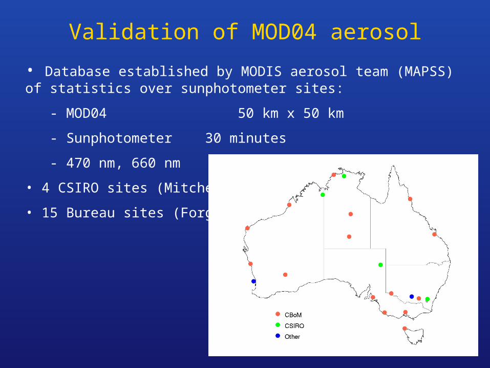
Validation of MOD04 aerosol
• Database established by MODIS aerosol team (MAPSS) of statistics over sunphotometer sites:
- MOD04 50 km x 50 km
- Sunphotometer 30 minutes
- 470 nm, 660 nm
• 4 CSIRO sites (Mitchell)
• 15 Bureau sites (Forgan)


Aerosol validationAerosol validation
• MAPSS/MODIS comparison: MODIS grossly overestimates AOD
• Next: Investigate a case in detail via MOD02, MOD09 data.
• Raw Bureau AOD data is available
• Need to extract and validate “internal AOD” of MOD09?
• Coordinate with CRC-SI aerosol validation and improvement

Validation of Total Water VapourValidation of Total Water Vapour
• Radiosondes (Bureau of Meteorology)
• GPS (Geoscience Australia, 16 sites)
Radiosonde sites

Numerical Weather Model FieldsNumerical Weather Model Fields
• Model run every 12 hours
• Forecast at 3, 6, …, 72 hours
• Resolutions 0.75º, 0.375º, 0.125º
• Forecasts for input to MOD09:
- Surface Pressure, TWV?
• Analysis for validation: TWV

Numerical Weather Model FieldsNumerical Weather Model Fields
• Surface pressure, Total Water Vapour?, Total ozone?
LAPS forecast of TWV at 3, 6, …, 72 hours. Resolution 0.75º.

Bureau near real-time MODIS processingBureau near real-time MODIS processing
• Acquaint Bureau users with products: NWP model input, forecasters
• Trial with Bureau Linux PC at ES&S antenna in Melbourne
• IMAPP: PDS → L1B → L2
• Products:
– MOD07 atmospheric temperature and humidity profiles, stability
– Truecolour images (CSIRO Marine CAPS software)

Bureau near real-time MOD07Bureau near real-time MOD07
Cloud mask Total Totals Lifted Index
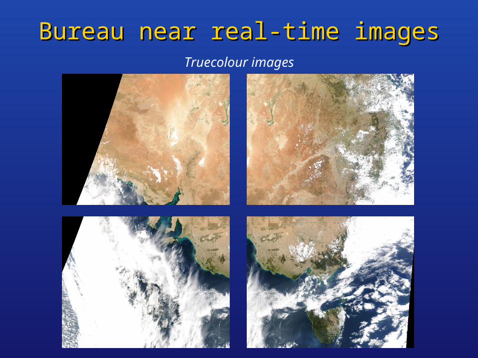
Bureau near real-time imagesBureau near real-time imagesTruecolour images
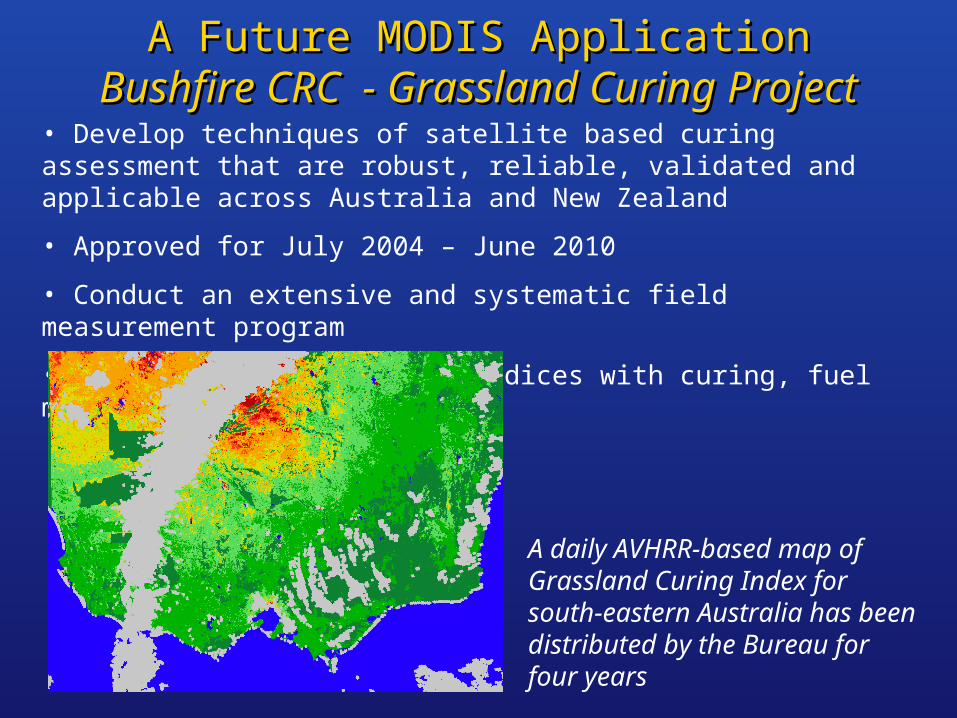
A Future MODIS ApplicationA Future MODIS ApplicationBushfire CRC - Grassland Curing ProjectBushfire CRC - Grassland Curing Project
• Develop techniques of satellite based curing assessment that are robust, reliable, validated and applicable across Australia and New Zealand
• Approved for July 2004 – June 2010
• Conduct an extensive and systematic field measurement program
• Compare MODIS vegetation indices with curing, fuel moisture content
A daily AVHRR-based map of Grassland Curing Index for south-eastern Australia has been distributed by the Bureau for four years

MODIS Direct Broadcast BRDF ProjectMODIS Direct Broadcast BRDF Project
• Coordinated by MODIS BRDF Team at Boston University
• Participants
US: Boston U, U Maryland, USDA Forest Service
Australia: CSIRO, Bureau of Meteorology, GA, DLI
China: IRSA, BNU
South Africa: CSIR
• Daily BRDF
- Detect rapid land change: burns, snow
- Track changing BRDF better: vegetation growth cycle
- Reject cloud contamination
• Funded by NASA

MODIS DB BRDFMODIS DB BRDF
• Boston University group (Alan Strahler, Crystal Schaaf et al.) developed the MODIS BRDF module MOD43. (Crystal is on the NPP team)
• NASA funded the BU group to develop a DB version of MOD43
• Groups offered to act as implementation testbeds, in:
– Australia (CSIRO, BoM, GA, DLI)
– China, South Africa, US
• DB code to aggregate MOD09 reflectances “L2Glite” is finished
• Initial implementation now happening at BNU, China
– Tuning RMSE and WoD thresholds
• Australian DB sites are welcome to be next. Crystal here in March.
• BRDF inversion and MOD43 products will follow

IWMMM-4IWMMM-4
Fourth International Workshop on
Multiangular Measurements and Models
20-24 March 2006 UniLodge Hotel, Sydney
www.eoc.csiro.au/iwmmm-4
An opportunity
- to bring key sensor scientists to Australia
- for Australian and international EO communities to interact
- for Australian users to describe requirements to EO community

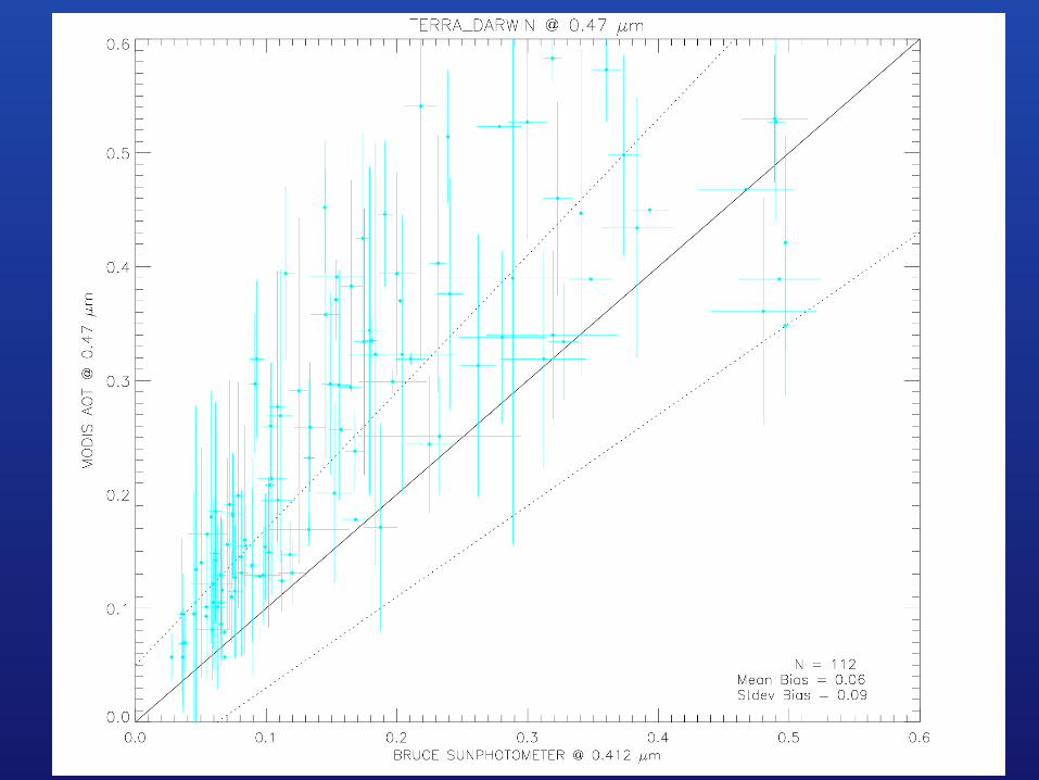


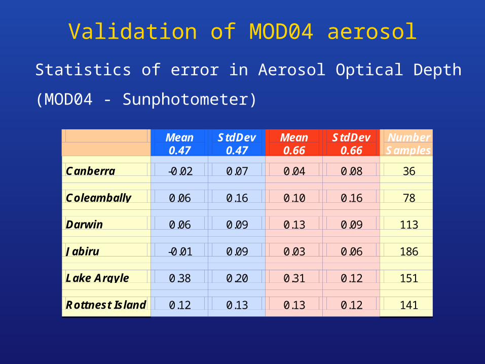
Validation of MOD04 aerosol
Statistics of error in Aerosol Optical Depth
(MOD04 - Sunphotometer)
Mean 0.47
StdDev 0.47
Mean 0.66
StdDev 0.66
Number Samples
Canberra -0.02 0.07 0.04 0.08 36
Coleambally 0.06 0.16 0.10 0.16 78
Darwin 0.06 0.09 0.13 0.09 113
Jabiru -0.01 0.09 0.03 0.06 186
Lake Argyle 0.38 0.20 0.31 0.12 151
Rottnest Island 0.12 0.13 0.13 0.12 141

DB BRDF:DB BRDF:Discussion pointsDiscussion points

Institutional MOD09_L2 to MOD43_L3:Institutional MOD09_L2 to MOD43_L3:Conceptual steps at a grid cellConceptual steps at a grid cell
• For each orbit:
- Identify which swath pixels overlap the grid cell
- Calculate pointers (line, sample, fractional overlap, etc.)
• For each UT day:
- Group pointers from all orbits
- Select swath pixels by geometry (obscov > 24%)
(Only using geometry so far - Now introduce MOD09)
- Select swath pixels by MOD09 QA (up to four)
- Aggregate swath pixels to one value per orbit
(average, weighted by obscov. This does the regridding)
• For each 16 days:
- Invert the BRDF model

BRDF - DB Issues (1)BRDF - DB Issues (1)
• Implement institutional details in DB: selection, aggregation, etc.?
- Bow-tie and IFOV increase give multiple swath pixels at a grid cell
• Window length?
• Re-use any institutional code?
• BRDF as an IMAPP module? (Multipass is new to IMAPP?)
• Process in tiles (10º10 º) for efficient memory use?
• 250-m resolution?
• Feed BRDF upstream, for aerosol and cloud mask?
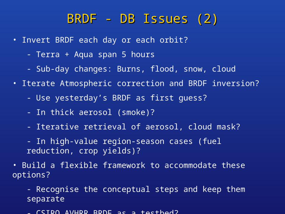
BRDF - DB Issues (2)BRDF - DB Issues (2)
• Invert BRDF each day or each orbit?
- Terra + Aqua span 5 hours
- Sub-day changes: Burns, flood, snow, cloud
• Iterate Atmospheric correction and BRDF inversion?
- Use yesterday’s BRDF as first guess?
- In thick aerosol (smoke)?
- Iterative retrieval of aerosol, cloud mask?
- In high-value region-season cases (fuel reduction, crop yields)?
• Build a flexible framework to accommodate these options?
- Recognise the conceptual steps and keep them separate
- CSIRO AVHRR BRDF as a testbed?

BRDF window length - VEGETATION approachBRDF window length - VEGETATION approach
• BRDF shape from inversion in long window (last 10 looks)
• Average normalised clear looks in short window (last 10 days)
• Reject inversion outliers (up to three, red band)
• In practice, worst cases for inversion
window length are:
>25 days in 11% of cases (Europe)
>50 days in 0.1% of cases (tropics)
• Weight more recent looks?
• Additive rather than multiplicative normalisation? (needs investigation)
Duchemin et al., Remote Sens. Env., 81 (2002) 101-113

BRDF - DB IssuesBRDF - DB Issues
• Implement institutional details in DB: selection, aggregation, etc.?
• Window length?
• Re-use any institutional code?
• BRDF as an IMAPP module?
• Process in tiles for efficient memory use?
• 250-m resolution?
• Feed BRDF upstream, for aerosol and cloud mask?
• Invert BRDF each day or each orbit?
• Iterate Atmospheric correction and BRDF inversion?
• Build a flexible framework to accommodate processing options?


