Page 1
BURGESS ENGINEERING AND
TESTING, INC.
STATE HIGHWAY 6
State Project o. STPY-028B(134), JP O.: 15023(04)
State Project o. STPY-128B(009), JP O.: 15023(08)
State Project o. STPY-128B(008), JP O.: 15023(07)
GREER COUTY, OKLAHOMA
G-00113
Page 2
BURGESS ENGINEERING AND TESTING, INC.
2603 . Shields * Moore, OK 73160 * Phone (405)790-0488 * Fax (405)790-0788
February 27, 2001
BALDISCHWILER ENGINEERING CO., P.C.
801 S.W. 89th Street, Building “B”
Oklahoma City, OK 73139
Attention: Mr. John K. Baldischwiler, P.E.
RE: Report of Pedological Soil Survey
And Pavement Evaluation
For Highway 6 In Greer County
Project No. STPY-028B(134), STPY-128B(009), STPY-128B(008)
J/P No.: 15023(04), 15023(08), 15023(07)
GN-00113
Dear Mr. Baldischwiler:
Burgess Engineering and Testing, Inc. is pleased to submit this report of Pedological Soil Survey
and Pavement Evaluation for the above referenced project. Contained in this presentation are the
results of the laboratory testing for pedological and geological description, pavement evaluation,
Falling Weight Deflectometer Tests (FWD), recommendations with regard to pavement design
on problem soils, shrinkage/swell factors for excavation, as well as general site development.
We appreciate the opportunity to have provided you with our geotechnical engineering services,
and look forward to working with you during the construction phase of this project. If you have
any questions concerning this report or if we may be of further service in any manner please
contact our office.
Respectfully;
Burgess Engineering And Testing, Inc.
Hai Ming Lim, E.I.
Geotechnical Engineer Intern
Ali H. Ebrahimi, P.E.
President
HML/amd
Page 3
REPORT OF PEDOLOGICAL SOIL SURVEY
AND PAVEMENT EVALUATION
FOR STATE HIGHWAY 6 I GREER COUTY
PROJECT: STPY-028B(134), STPY-128B(009), STPY-128B9008)
JP o.: 15023(04), 15023(08), 15023(07)
G-00113
PREPARED FOR
BALDISCHWILER ENGINEERING CO., P.C.
801 S.W. 89th STREET, BUILDING “B”
OKLAHOMA CITY, OK 73139
February 27, 2001
BY
BURGESS ENGINEERING AND TESTING, INC.
2603 N. SHIELDS BLVD.
MOORE, OKLAHOMA
73160
Page 4
TABLE OF COTET
1.0 INTRODUCTION AND RECOMMENDATION SUMMARY ………………………………. 1
1.1 Project Authorization ……………………………………………………………………… 1
1.2 Recommendation Summary……………………………………………………………….. 1
2.0 TESTING PROCEDURES ………………………………………………………………….…. 3
2.1 Field Operations …………………………………………………………………….…….. 3
2.1.1 Pedological Soil Survey …………………………………………………………… 3
2.1.2 Pavement Evaluation ……………………………………………………………… 3
2.2 Laboratory Testing ………………………………………………………………….…….. 4
3.0 SITE AND SUBSURFACE CONDITIONS ……………………………………………….…. 4
3.1 Site Description and Subsurface Conditions …………………………………………..…. 4
3.2 Ground Water Conditions ……………………………………………………………..…. 5
4.0 SOIL SERIES STATION EXTENTS ....………………………………………………..…….. 5
4.1 Soil Series Station Extents ……………………………………………………………….. 5
5.0 SHRINKAGE AND SWELL FACTORS .…………….………………………………..……. 5
5.1 Estimation of Shrink And Swell Factors of Soils .…………………………………..…… 5
6.0 RECOMMENDATIONS …………………………………………………………………….. 6
6.1 Soils Parameters Considerations ………………………………………………………… 6
6.2 Existing Pavement Conditions …………………………………………………………… 7
7.0 CONSTRUCTION CONSIDERATIONS ……………………………………………….….. 8
7.1 Site Preparation and Fill Requirements ……………………………………………..….. 8
7.2 Weather Considerations ……………………………………………………………..….. 9
8.0 GENERAL COMMENTS …………………………………………………….……….……. 9
APPENDIX
A-1 Location Map and Laboratory Test Results In Logs of Borings for Pedological Soil Survey
A-2 Laboratory Test Results In Logs of Borings for Pavement Evaluation
B PH And Resistivity Test Results
C Standard Moisture-density Relationship Test Results for Pedological Soil Survey
D Resilient Modulus Test Results for Pedological Soil Survey
E Shrink-Swell Factors
F Soil Series Station Extents
G Geological Soil Description And Recommendations
H Pavement Cores Thickness Summary
I Pavement Cores Pictures
J Falling Weight Deflectometer (FWD) Report Provided by FURGO-BRE, INC.
Page 5
S.H. 6, GREER COUTY, OKLAHOMA * BALDISCHWILER * B.E.T., Inc. Page- 1 of 10
1.0 ITRODUCTIO AD RECOMMEDATIO SUMMARY
1.1 Project Authorization
Burgess Engineering And Testing, Inc. has completed a Pedological Soil Survey and a
Pavement Evaluation including laboratory testing, geological description, pavement evaluation,
Falling Weight Deflectometer (FWD), recommendation with regard to pavement design on
problem soils and shrinkage/swell factors for excavation for proposed project on State Highway
6 in Greer County, Oklahoma. The work was authorized by Mr. John K. Baldischwiler, P.E. of
Baldischwiler Engineering Co., P.C.
According to the available information, the proposed roadway project consists of three
different sections as presented in the following table:
Project No. J/P No. Description
STPY-028B(134) 15023(04) SH 6 Grade, drain parallel lanes south of Granite
STPY-128B(009) 15023(08) Surface for 15023(04), rehab. existing lanes
STPY-128B(008) 15023(07) SH 6 Grade, drain and surface for Granite bypass
The purpose of this study was to explore the subsurface and pavement conditions at the
site of the referenced project to facilitate an evaluation of possible pavement systems for the
proposed highway project. This report briefly outlines the testing procedures, describes the site
and subsurface conditions.
The scope of this service did not include any environmental assessment for the presence
or absence of wetlands or hazardous or toxic materials in the soil, surface water, ground water, or
air, on or below or around this site. Any statement in this report or on the boring logs regarding
odors, colors, unusual or suspicious items or conditions are strictly for the information of the
client.
1.2 Recommendation Summary
The results of the subsurface exploration indicate that the soils within the limits of the
exploration are adequate for the proposed roadway construction provided the existing soils are
chemically treated. Based on the available information, the proposed project consists of
approximately 3.5 miles of existing roadway rehabilitation and approximately 2.3 miles of new
roadway alignment bypassing the town of Granite. In order to accomplish the subsurface
Page 6
S.H. 6, GREER COUTY, OKLAHOMA * BALDISCHWILER * B.E.T., Inc. Page- 2 of 10
exploration for the roadway construction, pedological soil survey and pavement evaluation were
conducted within the limit of the proposed project.
Based on the laboratory test results, Official NRSC descriptions and local experience
with the soils, the following were found:
(i) Lawton, Hollister and Spur soil series within the limit of the proposed roadway
project are very clayey with medium to high plasticity. These soils need to be
stabilized with but not limited to lime, fly ash, CKD or cement. However, the
percentage of additives should be determined during the construction phase. The
Lawton and Spur soil series need to be stabilized if they are placed any where in the
upper 24 inches (610 mm). However, since the Hollister soil series are also very
sensitive to moisture changes, they should be stabilized if they are placed any where
in the upper 36 inches (914 mm).
(ii) Hollister soil series have low permeability, high surface runoff and become unstable
when wet. Good drainage design is required in Hollister soil series extent to prevent
the weakening of the soil strength and prevent the ponding of water.
(iii) Spur soils series is subject to flooding. It is recommended to elevate the roadway to a
save elevation. Good drainage design should be provided to prevent flooding or
shorten the period of flooding.
The existing highway consists of two-lane highway. In order to simplify the stationing for
pavement evaluation, we have established Station 0+00 on the north end of the bridge over
Elm Fork Red River and extended northward to the intersection of State Highway 6 and
State Highway 9. The results of subsurface exploration indicate that the subsurface soils consist
of a layer of sandy soils underlaid by low to medium plasticity clayey soils. The existing
pavement cores thickness range from 2.5 inches to 8.25 inches. The pavement cores were
visually inspected and appear to be in fair to good condition. The existing pavement was visually
inspected and appeared in fair condition. The existing pavement consists of oil coated aggregates
layer and asphalt layer. However, the followings were found from field observation:
(iv) Cracking in the pavement with low to moderate severity level. These cracks were
treated by sealing the cracks with prime coat.
(v) Patch and patch deteriorations were found on the existing pavement. These patch
deteriorations were in low to moderate severity level.
Page 7
S.H. 6, GREER COUTY, OKLAHOMA * BALDISCHWILER * B.E.T., Inc. Page- 3 of 10
(vi) Rutting in the pavement in wheel paths.
(vii) Narrow shoulder
Details of site geology, descriptions and results of testing, recommendations with regard
to pavement design on problem soils (Appendix G), pavement road cores pictures (Appendix I)
are presented in the following sections of this report.
2.0 TESTIG PROCEDURES
2.1 Field Operations
2.1.1 Pedological Soil Survey
Burgess Engineering and Testing, Inc. field personnel performed the field operation and
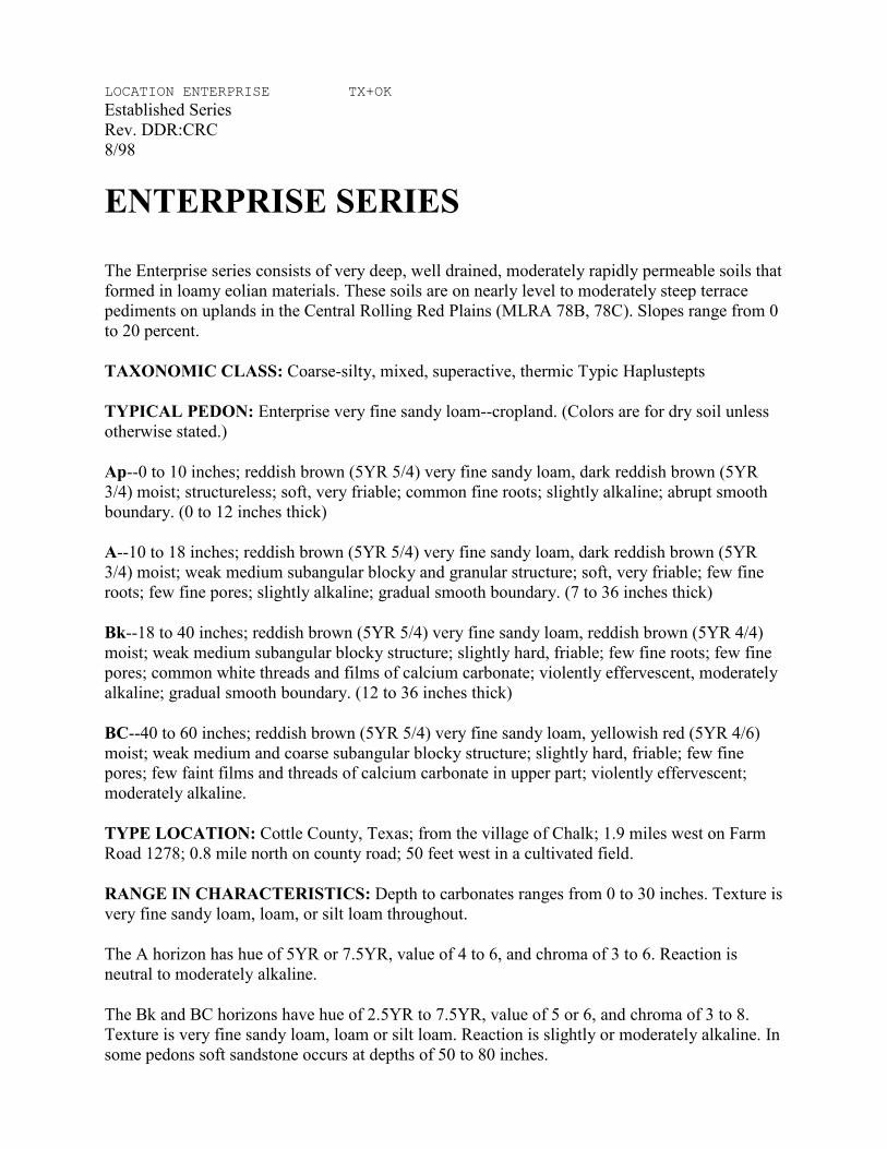
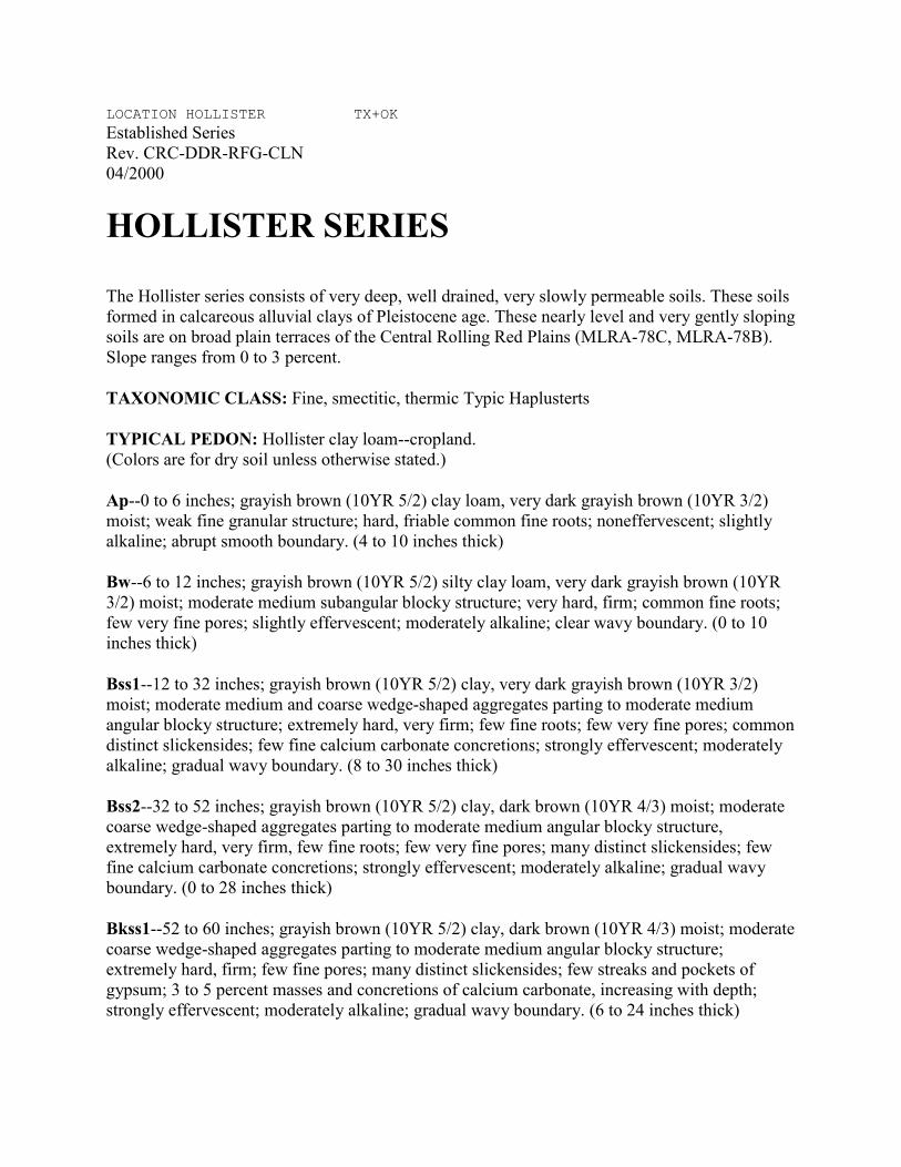
sample collection for the pedological soil survey. Total of four (4) soil series (Enterprise Series,
Hollister Series, Lawton Series and Spur Series) were encountered within the limit of the
proposed project. Total of Twenty (20) sub-horizon soil samples and four (4) composite samples
were collected from the site of the project.
The location of each soil series was approximately mapped in the “Soil Survey of Greer
County, Oklahoma” and located on the site of the project according to referenced points such as
the intersection of the county roads or the bridge structures. The subsurface soil was examined
and confirmed to be similar to the descriptions in the Official NRCS or the “Soil Survey of Greer
County, Oklahoma" by drilling pilot holes. After the soil series were confirmed, subsurface soil
was sampled using hand auger and power auger to the designated depth.
Records of subsurface exploration containing soil descriptions, stratifications, locations
of the samples and groundwater levels for pedological soil survey are presented in Appendices
A-1, B and C, respectively. The stratification shown on the boring logs represents the soil
conditions at the actual boring locations. Variations may occur between borings. The transition
between the boundaries of soil types may be gradual.
2.1.2 Pavement Evaluation
In order to accomplish the pavement evaluation, Fugro-Bre, Inc. performed Falling
Weight Deflectometer (FWD) tests and Burgess Engineering and Testing performed the
pavement coring and subgrade soil sampling. FWD tests were first performed on the existing
pavement. Pavement coring and subgrade soil sampling were performed at a later time to obtain
Page 8
S.H. 6, GREER COUTY, OKLAHOMA * BALDISCHWILER * B.E.T., Inc. Page- 4 of 10
the parameters needed for the backcalculation moduli for pavement, base and subgrade sections.
Total of nineteen (19) roadway cores were obtained. Nine (9) roadway cores and ten (10)
roadway cores were obtained at north-bound lane and south-bound lane, respectively.
In order to simplify the stationing for the FWD tests, roadway coring and subgrade
sampling, we have established Station 0+00 on the north end of the bridge over Elm Fork
Red River and extended northward to the intersection of State Highway 6 and State
Highway 9.
Records of subsurface exploration containing soil descriptions, stratifications, locations
of the samples, groundwater levels and Falling Weight Deflectometer (FWD) tests for pavement
evaluations are presented in Appendices A-2 and J, respectively. The stratification shown on the
boring logs represents the conditions at the actual boring locations. Variations may occur
between borings. The transition between the boundaries of soil types may be gradual.
2.2 Laboratory Testing
Soil samples and pavement cores obtained during the field exploration were transported
to the laboratory and examined by an engineer.
Laboratory tests were performed on representative samples of the subsurface soils in
substantial accordance with the applicable ASTM Designations or with other commonly
accepted laboratory practice. The laboratory testing schedule included determination of the soils'
natural moisture contents (ASTM D2216), Atterberg limits values (ASTM D4318), grain size
distributions (ASTM D421 and ASTM D422), pH (ASTM D4972), resistivity (ASTM G57),
Laboratory Compaction Characteristics of Soil Using Standard Effort (ASTM D698) and
Resilient Modulus (RM) (AASHTO T-307-99). These test results are presented on the boring
logs in Appendices A-1, A-2, B, C, D and H. Samples not altered by laboratory testing will be
retained at our office for sixty (60) days from the date of this report and then discarded unless we
are otherwise instructed.
3.0 SITE AD SUBSURFACE CODITIO
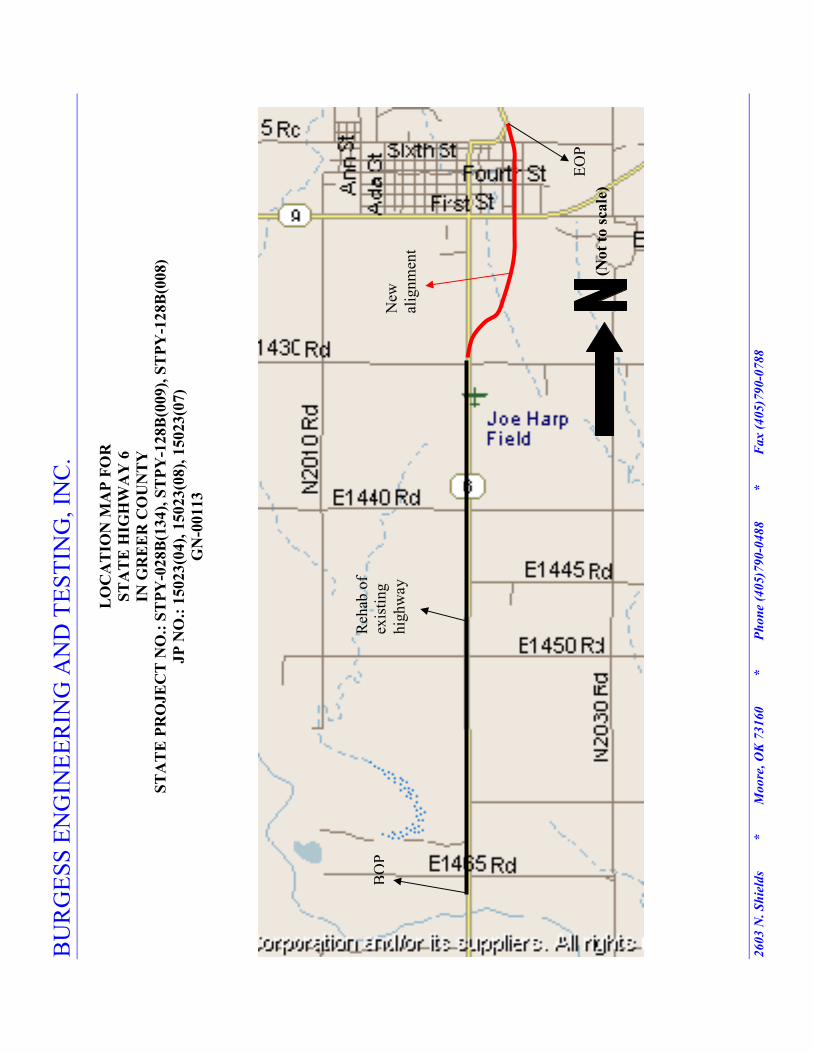
3.1 Site Description and Subsurface Conditions
The site of the referenced project is located on State Highway 6, as shown on the map
presented in Appendix A-1. The project starts approximately 1900 ft north of the bridge over
Page 9
S.H. 6, GREER COUTY, OKLAHOMA * BALDISCHWILER * B.E.T., Inc. Page- 5 of 10
Elm Fork Red River and extends northward approximate three (3) miles to the south of Granite
in Greer County. The approximate 2.3 miles new alignment on the eastside of Granite will
connect State Highway 6 from south of Granite to north of Granite.
Detailed information regarding test results at specific depths can be found in the Boring
Logs and summary of laboratory test results in Appendices A-1, A-2, B and C.
3.2 Ground Water Conditions
Burgess Engineering And Testing, Inc. field personnel did not encounter groundwater
during the field exploration in both pedological soil survey and pavement evaluation. However,
in relatively pervious soils, such as sandy soils, the indicated water table elevations are
considered reliable groundwater levels. In relatively impervious soils, the accurate determination
of the groundwater elevation may not be possible even after several days of observation.
Seasonal variations, temperature and recent rainfall conditions may influence the level of the
groundwater table and volume of water will depend on the permeability of the soils.
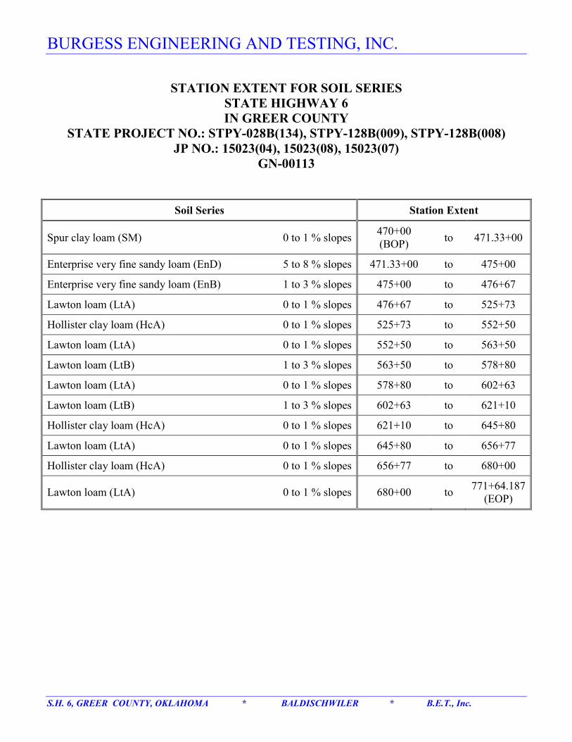
4.0 SOIL SERIES STATIO EXTETS
4.1 Soil Series Station Extents
Soil series station extents investigations were done at a later time after the completion of
the soil sampling. The approximate locations of the soil series were obtained from the “Soil
Survey of Greer County, Oklahoma”, followed by a field inspection. Field inspection consisted
of observing the plant types, soil slopes and drilling pilot holes. The detailed soil series station
extents are presented in Appendix F.
During the field verification of the soil series station extents, the station numbers were
based on the information provided by Baldischwiler Engineering Co., P.C.
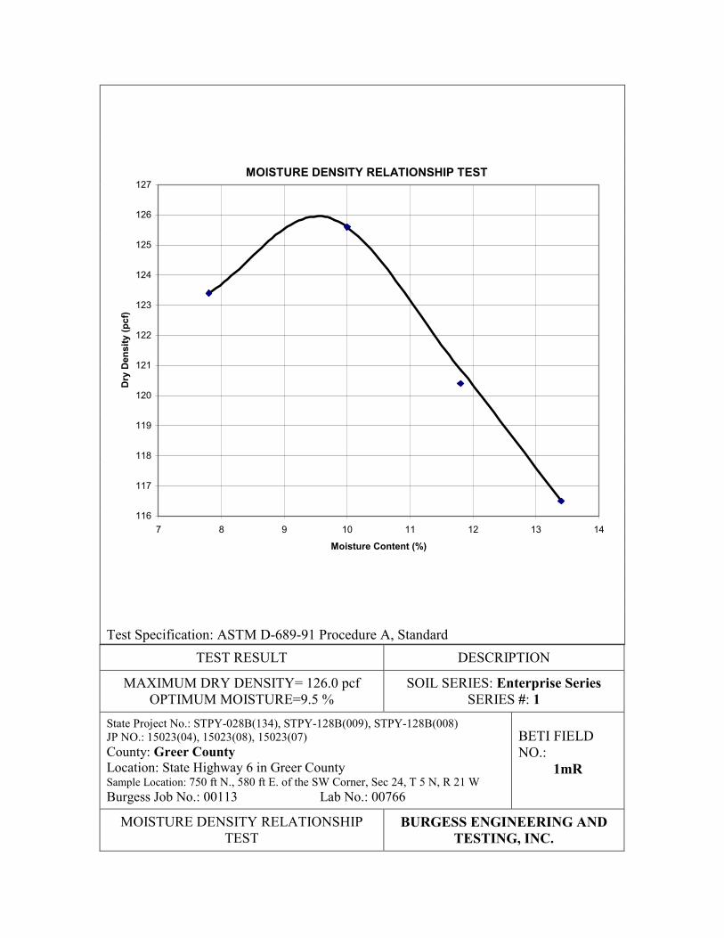
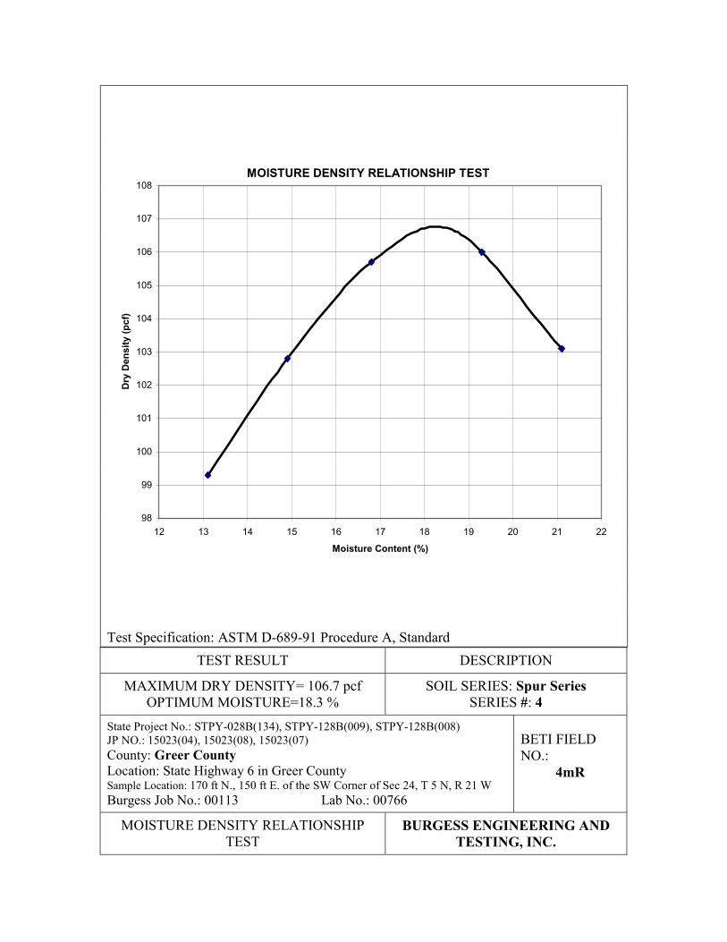
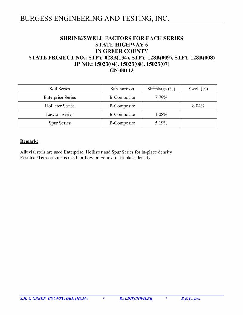
5.0 SHRIKAGE AD SWELL FACTORS
5.1 Estimation of Shrink And Swell Factors of Soils
Shrinkage and swell factors of each soil series is estimated based on the laboratory
Standard Moisture-density Relationship Test results on bulk samples for each soil series. The
method used in estimating the shrinkage and swell was developed by ODOT. Based on ODOT’s
Page 10
S.H. 6, GREER COUTY, OKLAHOMA * BALDISCHWILER * B.E.T., Inc. Page- 6 of 10
experience with residual, terrace and alluvial soils and their underlying geology, a series of in-
place densities were developed. These in-place densities are used together with the standard
moisture-density relationship test results to obtain the shrinkage or swelling factors of the soils.
Alluvial soils were used Enterprise, Hollister and Spur soil series while residual/terrace soils
were used for Lawton soil series in the calculations for the shrink and swell factors.
The detailed shrinkage and swelling factors are presented in Appendix E.
6.0 RECOMMEDATIOS
6.1 Soils Parameters Considerations
According to the pedological soil survey and laboratory testing results, the Hollister soil
series consists of high plasticity lean to fat clay; the Spur soils series and Lawton soil series
consists of moderate to high plasticity clayey soils; and the Enterprise soil series consists of low
plasticity sandy soils.
Based on the laboratory test results, Official NRSC descriptions and local experience
with the soils, the following were found:
A. The following soil series were found to have medium to high plasticity. These soils
need to be stabilized with but not limited to lime, fly ash, CKD or cement. However,
the percentage of additives should be determined during the construction phase:
A. Hollister soil series
B. Lawton soil series
C. Spur soil series
The Lawton and Spur soil series need to be stabilized if they are placed any where in
the upper 24 inches (610 mm). However, since the Hollister soil series is also very
sensitive to moisture changes, they should be stabilized if they are placed any where
in the upper 36 inches (914 mm).
B. Hollister soil series have low permeability, high surface runoff and become unstable
when wet. Good drainage design is required in the Hollister soil series extent to
prevent the weakening of the soil strength and prevent the ponding of water.
Page 11
S.H. 6, GREER COUTY, OKLAHOMA * BALDISCHWILER * B.E.T., Inc. Page- 7 of 10
C. Spur soil series are subject to flooding. It is recommended to elevate the roadway to a
save elevation. Good drainage design should be provided to prevent flooding or
shorten the period of flooding.
Detailed recommendations for each soil series for pedological soil survey are presented in
Appendix G.
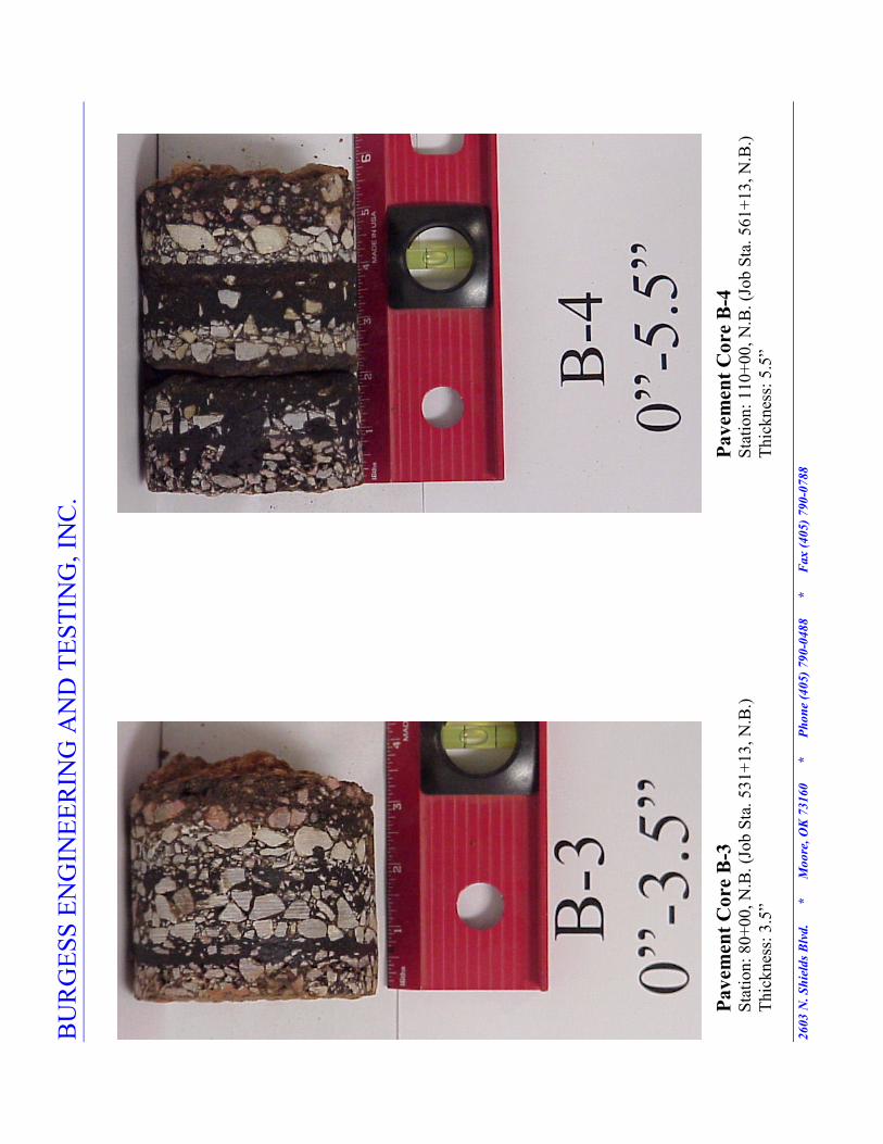
6.2 Existing Pavement Conditions
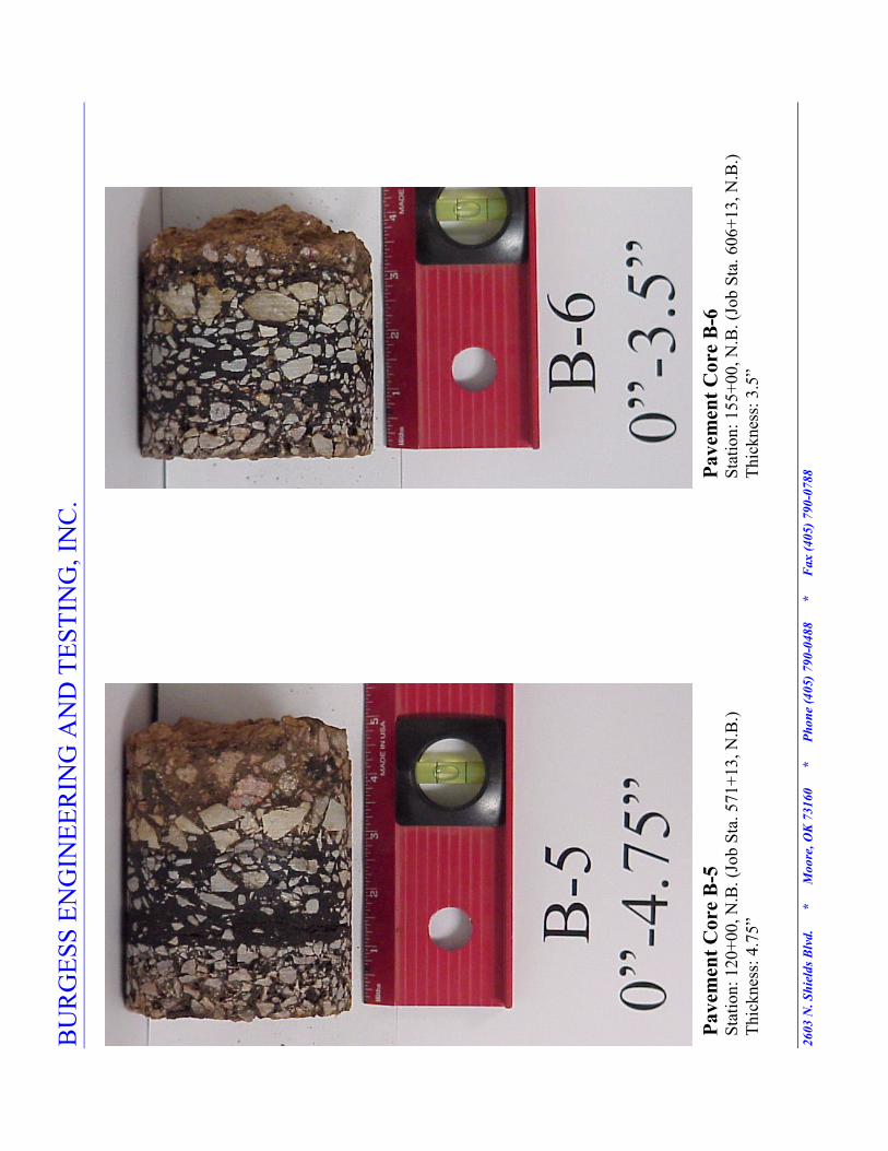
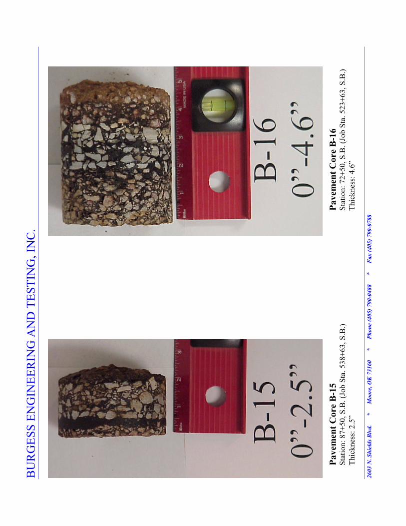
According to pavement evaluation, the existing pavement cores thickness range from 2.5
inches to 8.5 inches. The pavement cores obtained from the south end of State Highway 6 has the
lowest thickness (i.e. 2.5 inches). The thickest pavement cores were obtained near to the
intersection of State Highway 6 and State Highway 9 and are between 6.25 inches and 8.25
inches. The pavement cores obtained from the other part of the highway range from 3 inches to
5.5 inches. The existing pavement cores consist of oil coated aggregates and asphalt layer.
The results of the subsurface exploration indicate that the subsurface soils consist of a
layer of sandy soils underlaid by low to medium plasticity clayey soils. Additionally, Furgo-Bre,
Inc. has indicated that the pavement changes at the assumed Station 230+00 as presented in
Appendix J.
Visual inspection was performed on the existing pavement during the field exploration.
The followings were observed:
A. Cracking in the pavement with low to moderate severity level. These cracks were
treated by sealing the cracks with prime coat as shown in Pic. I below.
B. Patch and patch deteriorations were found on the existing pavement. These patch
deteriorations were in low to moderate severity level as shown in Pic. II below.
C. Rutting in the pavement in wheel paths.
D. Narrow shoulder
Page 12
S.H. 6, GREER COUTY, OKLAHOMA * BALDISCHWILER * B.E.T., Inc. Page- 8 of 10
7.0 COSTRUCTIO COSIDERATIOS
7.1 Site Preparation and Fill Requirements
In preparing the site for construction, we recommend that all topsoil, vegetation, roots,
and any soft soils in the new alignment and shoulder areas be stripped from the site and either
wasted or stockpiled for later use. Utilities should be located and rerouted as necessary.
After stripping and undercutting, the shoulder and new alignment area should be
proof-rolled with a moderately heavy loaded pneumatic-tired vehicle such as a twenty (20) to
twenty-five (25) ton dump truck or scraper. Soils which are observed to rut or deflect excessively
under the moving loads should be undercut and replaced with properly compacted fills. All
proof-rolling and undercutting activities should be witnessed by a qualified soil engineer and
should be performed during a period of dry weather.
After stripping and excavating where required, and proof-rolling, the exposed soils
should be scarified to a depth of six (6) inches and compacted. The moisture content should be
maintained between one (1) percentage point below and three (3) percentage points above the
optimum moisture as determined by the Standard Proctor test. The subgrade soils should be
compacted to a dry density of at least ninety-five (95) percent of the standard Proctor maximum
dry density for a depth of at least six (6) inches below the surface.
Pic. I: Prime coat sealed cracks Pic. II: Patch deteriorations
Page 13
S.H. 6, GREER COUTY, OKLAHOMA * BALDISCHWILER * B.E.T., Inc. Page- 9 of 10
If water must be added, it should be uniformly applied and thoroughly mixed into the soil
by disking or scarifying. It is recommended that field density tests be taken at a frequency of not
less than one test per 5,000 square feet of surface area per lift in the pavement areas.
7.2 Weather Considerations
The upper fine-grained and clayey soils encountered at this site are expected to be
relatively sensitive to disturbances caused by construction traffic and to changes in moisture
content. During wet weather periods, increases in the moisture content of the soil can cause
significant reduction in the soil strength and support capabilities. In addition, soils which become
wet may be slow to dry and thus significantly retard the progress of grading and compaction
activities. It will, therefore, be advantageous to perform earthwork construction activities during
dry weather. Earthwork activities performed during cooler, wetter months will certainly be more
problematic than if performed during warmer, drier climatic periods.
8.0 GEERAL COMMETS
The exploration and analysis of the pavement conditions reported herein are considered
in sufficient detail and scope to form a reasonable basis for the pavement design. The
recommendations submitted are based on the available soil information, field exploration, field
non-destructive testing results, laboratory testing results, local experience with these soils and
Taxonomy Descriptions. If deviations from the noted subsurface conditions are encountered
during construction, they should also be brought to the attention of the geotechnical engineer.
Burgess Engineering and Testing, Inc. cannot be responsible for the interpretation or
implementation of this report by others. Burgess Engineering and Testing, Inc. should be
retained to perform services sufficient to determine compliance with its recommendations. If
Burgess Engineering and Testing, Inc. is not so retained, it will not accept any responsibility.
The geotechnical engineer warrants that the findings, recommendations, specifications, or
professional advice contained herein have been made after being prepared in accordance with the
generally accepted professional engineering practice in the fields of foundation and pavement
engineering, soil mechanics, and engineering geology. No other warranties are implied or
expressed. After the plans and specifications are more complete, it is recommended that the
geotechnical engineer be provided the opportunity to review the final design and specifications
Page 14
S.H. 6, GREER COUTY, OKLAHOMA * BALDISCHWILER * B.E.T., Inc. Page- 10 of 10
in order that earthwork and pavement recommendations may be properly interpreted and
implemented. At this time, it may be necessary to submit supplementary recommendations.
This report has been prepared for the exclusive use of Baldischwiler Engineering Co.,
P.C. for the specific application to the proposed roadway construction on State Highway 6 on
south of Granite in Greer County, Oklahoma.
Respectfully,
Burgess Engineering And Testing, Inc.
Hai Ming Lim, E.I.
Geotechnical Engineering Intern
Ali H. Ebrahimi, P.E.
President
HML/amd
Page 16
BU
RG
ESS E
NG
INE
ER
ING
AN
D T
EST
ING
, IN
C.
2603 . Shields * M
oore, OK 73160 * Phone (405)790-0488 * Fax (405)790-0788
LOCATIO
M
AP FOR
STATE H
IGHWAY 6
I G
REER COUTY
STATE PROJECT O.: STPY-028B(134), STPY-128B(009), STPY-128B(008)
JP O.: 15023(04), 15023(08), 15023(07)
G-00113
BO
P
EO
P
Reh
ab o
f
exis
ting
hig
hw
ay
New
alig
nm
ent
(ot to scale)
Page 17
BURGESS EGIEERIG AD TESTIG, IC.
PEDOLOGICAL SOIL SURVEY CLASSIFICATIO
N SUMMARY
State Project No.: STPY-028B(134), STPY-128B(009), STPY-128B(008), JP NO.: 15023(04), 15023(08), 15023(07)
Surveyed by: Hai M
ing Lim
, Jason W
atson, Darryl Jenkins
Date Surveyed: 10-26-00
County: Greer County
Location: State Highway 6 in Greer County
Lab. No.: 00766
Burgess Job No.: 00113
Sam
ple Location: 750 ft N., 580 ft E. of the SW Corner, Sec 24, T 5 N, R 21 W
Bore-H
ole: Series # 1
Soil Series: Enterprise Series
Date Reported: February 19, 2001
Depth
(in)
Sub-
Horizon
Description
AASHTO
Soil
Group
Soil
Classification
MC
%
Percent Passing
LL
PI
OSI
3"
1-1/2"
3/4"
3/8"
#4
#10
#40
#200
0-10
Ap
Reddish Brown
A-2-4(0)
Clayey Sand (SC)
1.6
100
100
100
99.8 99.3 98.7 64.5 17.1
19
9
0
10-18
A
Reddish Brown
A-2-4(0)
Silty, Clayey Sand
(SC-SM)
1.8
100
100
100
99.7 99.1 98.1 58.0 13.3
17
7
0
18-40
Bk
Reddish Brown
A-1-b(0)
Well Graded Sand
With Silt
(SW-SM)
1.2
100
100
99.5 98.2 96.1 93.2 31.6
7.7
NP
NP
0
40-60
BC
Reddish Brown
A-1-b(0)
Poorly Graded
Sand (SP)
0.9
100
100
100
99.4 98.5 96.8 41.7
4.3
NP
NP
0
18-60
B-
Composite
Reddish Brown
A-1-b(0)
Poorly Graded
Sand W
ith Silt
(SW-SM)
4.7
100
100
100
98.7 97.5 96.9 43.1
8.5
NP
NP
0
NP
Non Plastic
Page 18
BURGESS EGIEERIG AD TESTIG, IC.
PEDOLOGICAL SOIL SURVEY CLASSIFICATIO
N SUMMARY
State Project No.: STPY-028B(134), STPY-128B(009), STPY-128B(008), JP NO.: 15023(04), 15023(08), 15023(07)
Surveyed by: Hai M
ing Lim
, Jason W
atson, Darryl Jenkins
Date Surveyed: 10-26-00
County: Greer County
Location: State Highway 6 in Greer County
Lab. No.: 00766
Burgess Job No.: 00113
Sam
ple Location: 2980 ft N., 790 ft W. of the SE Corner of Sec 14, T 5 N, R 21 W
Bore-H
ole: Series # 2
Soil Series: Hollister Series
Date Reported: February 19, 2001
Depth
(in)
Sub-
Horizon
Description
AASHTO
Soil
Group
Soil
Classification
MC
%
Percent Passing
LL
PI
OSI
3"
1-1/2"
3/4"
3/8"
#4
#10
#40
#200
0-6
Ap
Brown
A-6(17)
Lean Clay W
ith
Sand (CL)
9.0
100
100
100
100 99.5 97.0 90.8 76.8
39
25
18
6-12
Bw
Dark Brown
A-7-6(26)
Lean Clay W
ith
Sand (CL)
12.9 100
100
100
100 99.7 97.8 94.7 82.7
46
32
22
12-32
Bss1
Dark Brown
A-7-6(32)
Lean Clay (CL)
14.0 100
100
100
100 99.9 97.8 94.1 87.5
49
36
24
32-52
Bss2
Dark Brown
A-7-6(36)
Fat Clay W
ith
Sand (CH)
18.2 100
100
100
100 98.4 86.6 78.6 71.2
54
38
26
52-60
Bkss1
Brown and Tan
A-7-6(20)
Sandy Fat Clay
(CH)
14.4 100
100
100
100 96.4 85.0 71.8 64.5
50
35
24
60-70
Bkss2
Yellowish red
A-2-6(3)
Clayey Sand (SC)
9.1
100
100
100
98.4 87.7 60.6 42.7 34.6
39
26
7
70-75
2BCss
Reddish Brown
A-7-6(19)
Lean Clay W
ith
Sand (CL)
15.0 100
100
100
99.7 96.8 88.4 79.2 73.3
42
29
20
12-75
B-
Composite
Brown
A-7-6(22)
Lean Clay W
ith
Sand (CL)
14.5 100
100
100
99.9 98.5 92.5 79.8 71.2
48
34
23
Page 19
BURGESS EGIEERIG AD TESTIG, IC.
PEDOLOGICAL SOIL SURVEY CLASSIFICATIO
N SUMMARY
State Project No.: STPY-028B(134), STPY-128B(009), STPY-128B(008), JP NO.: 15023(04), 15023(08), 15023(07)
Surveyed by: Hai M
ing Lim
, Jason W
atson, Darryl Jenkins
Date Surveyed: 10-26-00
County: Greer County
Location: State Highway 6 in Greer County
Lab. No.: 00766
Burgess Job No.: 00113
Sam
ple Location: 95 ft S., 185 ft E. of the NW Corner of Sec 24, T 5 N, R 21 W
Bore-H
ole: Series # 3
Soil Series: Lawton Series
Date Reported: February 19, 2001
Depth
(in)
Sub-
Horizon
Description
AASHTO
Soil
Group
Soil
Classification
MC
%
Percent Passing
LL
PI
OSI
3"
1-1/2"
3/4"
3/8"
#4
#10
#40
#200
0-11
A1
Dark Brown
A-6(5)
Sandy Lean Clay
(CL)
7.7
100
100
100
100
100
99.8 90.3 61.0
25
13
8
11-18
BA
Reddish Brown
A-6(11)
Sandy Lean Clay
(CL)
10.0 100
100
100
99.9 99.9 99.6 91.9 66.8
33
21
14
18-32
Bt1
Reddish Brown
A-7-6(17)
Sandy Lean Clay
(CL)
13.7 100
100
100
100 99.9 99.7 93.1 67.8
44
29
20
32-47
Bt2
Reddish Brown
A-7-6(23)
Lean Clay W
ith
Sand (CL)
7.0
100
100
100
99.8 99.8 99.7 93.4 75.0
46
33
22
47-72
BC
Yellowish Red
A-6(11)
Sandy Lean Clay
(CL)
6.3
100
100
100
99.7 99.3 98.1 85.7 63.5
34
22
13
11-72
B-
Composite
Reddish Brown
A-7-6(16)
Lean Clay W
ith
Sand (CL)
13.8 100
100
100
100 99.9 98.7 89.9 71.0
41
25
18
Page 20
BURGESS EGIEERIG AD TESTIG, IC.
PEDOLOGICAL SOIL SURVEY CLASSIFICATIO
N SUMMARY
State Project No.: STPY-028B(134), STPY-128B(009), STPY-128B(008), JP NO.: 15023(04), 15023(08), 15023(07)
Surveyed by: Hai M
ing Lim
, Jason W
atson, Darryl Jenkins
Date Surveyed: 10-26-00
County: Greer County
Location: State Highway 6 in Greer County
Lab. No.: 00766
Burgess Job No.: 00113
Sam
ple Location: 170 ft N., 150 ft E. of the SW Corner of Sec 24, T 5 N, R 21 W
Bore-H
ole: Series # 4
Soil Series: Spur Series
Date Reported: February 19, 2001
Depth
(in)
Sub-
Horizon
Description
AASHTO
Soil
Group
Soil
Classification
MC
%
Percent Passing
LL
PI
OSI
3"
1-1/2"
3/4"
3/8"
#4
#10
#40
#200
0-15
A
Brown
A-6(14)
Lean Clay W
ith
Sand (CL)
22.7 100
100
100
99.3 98.2 97.3 94.6 84.9
34
18
14
15-38
Bw1
Brown
A-6(19)
Lean Clay (CL)
24.1 100
100
100
99.4 99.4 99.2 97.7 90.0
38
22
16
38-50
Bw2
Reddish Brown
A-6(9)
Lean Clay W
ith
Sand (CL)
21.8 100
100
100
100
100
100 96.7 83.8
31
12
11
50-60
Bw3
Light Reddish
Brown
A-6(14)
Lean Clay (CL)
22.2 100
100
100
100
100
100 98.2 94.2
31
16
13
15-60
B-
Composite
Light Reddish
Brown
A-6(14)
Lean Clay (CL)
23.2 100
100
100
99.4 98.7 98.1 96.5 89.1
34
17
10
Page 22
BURGESS EGIEERIG AD TESTIG, IC
.
INPLA
CE S
OIL
SU
RV
EY
CLA
SSIF
ICA
TIO
N S
UM
MA
RY
Sta
te P
roje
ct N
o.: S
TPY
-028B(1
34), S
TPY
-128B(0
09), JP
NO
.: 1
5023(0
4), 1
5023(0
8)
Surv
eyed
by: H
ai M
ing L
im, Ja
son W
atso
n, D
arry
l Je
nkin
s
Dat
e Surv
eyed
: 10-2
6-0
0
County
: G
reer
County
Pro
ject
Loca
tion: Sta
te H
ighw
ay 6
in G
reer
County
Lab
. N
o.: 0
0766
Burg
ess Jo
b N
o.: 0
0113
Sam
ple
Loca
tion: Sta
. 15+00, N
.B.
Bore
-Hole
: H
ole
# 1
Dat
e R
eported
: Feb
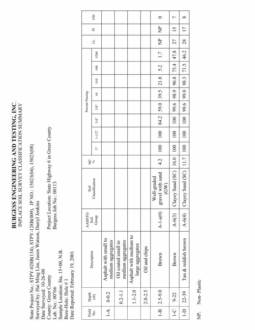
ruar
y 1
9, 2001
Fie
ld
No.
Dep
th
(in)
Des
crip
tion
AA
SH
TO
Soil
Gro
up
Soil
Cla
ssific
atio
n
MC
%
Per
cent Pas
sing
LL
PI
OSI
3"
1-1
/2"
3/4
" 3/8
" #4
#10
#40
#200
1-A
0-0
.2
Asp
hal
t w
ith sm
all to
med
ium
aggre
gat
es
0.2
-1.1
O
il c
oat
ed sm
all to
med
ium
aggre
gat
es
1.1
-2.0
A
sphal
t w
ith m
ediu
m to
larg
e ag
gre
gat
es
2.0
-2.5
O
il a
nd c
hip
s
1-B
2.5
-9.0
Bro
wn
A-1
-a(0
)
Wel
l-gra
ded
gra
vel
with san
d
(GW
)
4.2
100
100
84.2
59.0
39.5
21.8
5.2
1.7
N
P
NP
0
1-C
9-2
2
Bro
wn
A-6
(3)
Cla
yey S
and (SC
) 16.0
100
100
100
99.6
98.9
96.8
75.4
47.8
27
15
7
1-D
22-3
9
Tan
& red
dis
h b
row
n
A-6
(4)
Cla
yey S
and (SC
) 11.7
100
100
100
99.6
99.0
98.3
71.5
46.2
28
17
8
NP:
Non- Pla
stic
Page 23
BURGESS EGIEERIG AD TESTIG, IC
.
INPLA
CE S
OIL
SU
RV
EY
CLA
SSIF
ICA
TIO
N S
UM
MA
RY
Sta
te P
roje
ct N
o.: S
TPY
-028B(1
34), S
TPY
-128B(0
09), JP
NO
.: 1
5023(0
4), 1
5023(0
8)
Surv
eyed
by: H
ai M
ing L
im, Ja
son W
atso
n, D
arry
l Je
nkin
s
Dat
e Surv
eyed
: 10-2
6-0
0
County
: G
reer
County
Pro
ject
Loca
tion: Sta
te H
ighw
ay 6
in G
reer
County
Lab
. N
o.: 0
0766
Burg
ess Jo
b N
o.: 0
0113
Sam
ple
Loca
tion: Sta
. 65+00, N
.B.
Bore
-Hole
: H
ole
# 2
Dat
e R
eported
: Feb
ruar
y 1
9, 2001
Fie
ld
No.
Dep
th
(in)
Des
crip
tion
AA
SH
TO
Soil
Gro
up
Soil
Cla
ssific
atio
n
MC
%
Per
cent Pas
sing
LL
PI
OSI
3"
1-1
/2"
3/4
" 3/8
" #4
#10
#40
#200
2-A
0-1
.1
Asp
hal
t w
ith sm
all to
med
ium
aggre
gat
es
1.1
-2.3
O
il c
oat
ed sm
all to
med
ium
aggre
gat
es
2.3
-2.8
A
sphal
t w
ith sm
all
aggre
gat
es
2.8
-3.3
A
sphal
t w
ith m
ediu
m to
larg
e ag
gre
gat
es
3.3
-3.8
O
il a
nd c
hip
s
2-B
3.8
-10
Bro
wn
A-1
-a (0)
Wel
l G
raded
San
d W
ith G
ravel
(SW
)
6.7
100
100
98.5
82.4
57.5
33.2
10.6
3.2
N
P
NP
0
2-C
10-2
4
Bro
wn
A-4
(1)
Cla
yey S
and (SC
) 12.9
100
100
98.1
97.3
96.0
92.9
82.9
47.3
22
10
5
2-D
24-3
0
Tan
A
-4(0
) Silty
, C
layey
San
d (SC
-SM
) 13.0
100
100
100
100
99.5
97.1
82.2
38.8
18
7
2
2-E
30-4
0
Bro
wn
A-6
(13)
San
dy L
ean C
lay
(CL)
17.5
100
100
100
100
100
99.6
92.8
66.8
35
24
15
NP:
Non- Pla
stic
Page 24
BURGESS EGIEERIG AD TESTIG, IC
.
INPLA
CE S
OIL
SU
RV
EY
CLA
SSIF
ICA
TIO
N S
UM
MA
RY
Sta
te P
roje
ct N
o.: S
TPY
-028B(1
34), S
TPY
-128B(0
09), JP
NO
.: 1
5023(0
4), 1
5023(0
8)
Surv
eyed
by: H
ai M
ing L
im, Ja
son W
atso
n, D
arry
l Je
nkin
s
Dat
e Surv
eyed
: 10-2
6-0
0
County
: G
reer
County
Pro
ject
Loca
tion: Sta
te H
ighw
ay 6
in G
reer
County
Lab
. N
o.: 0
0766
Burg
ess Jo
b N
o.: 0
0113
Sam
ple
Loca
tion: Sta
. 80+00, N
.B.
Bore
-Hole
: H
ole
# 3
Dat
e R
eported
: Feb
ruar
y 1
9, 2001
Fie
ld
No.
Dep
th
(in)
Des
crip
tion
AA
SH
TO
Soil
Gro
up
Soil
Cla
ssific
atio
n
MC
%
Per
cent Pas
sing
LL
PI
OSI
3"
1-1
/2"
3/4
" 3/8
" #4
#10
#40
#200
3-A
0-0
.5
Asp
hal
t w
ith sm
all to
med
ium
aggre
gat
es
0.5
-1.9
O
il c
oat
ed sm
all to
med
ium
aggre
gat
es
1.9
-2.5
A
sphal
t w
ith sm
all to
med
ium
aggre
gat
es
2.5
-3.5
O
il a
nd c
hip
s
3-B
3.5
-10
Yel
low
ish b
row
n
A-2
-4(0
) C
layey S
and w
ith
Gra
vel
(SC
) 7.3
100
100
96.4
89.0
70.2
46.1
24.9
12.4
23
10
0
3-C
10-4
0
Bro
wn
A-4
(1)
San
dy S
ilty
Cla
y
(CL-M
L)
12.0
100
100
100
100
99.3
96.7
87.8
52.2
19
7
4
NP:
Non- Pla
stic
Page 25
BURGESS EGIEERIG AD TESTIG, IC
.
INPLA
CE S
OIL
SU
RV
EY
CLA
SSIF
ICA
TIO
N S
UM
MA
RY
Sta
te P
roje
ct N
o.: S
TPY
-028B(1
34), S
TPY
-128B(0
09), JP
NO
.: 1
5023(0
4), 1
5023(0
8)
Surv
eyed
by: H
ai M
ing L
im, Ja
son W
atso
n, D
arry
l Je
nkin
s
Dat
e Surv
eyed
: 10-2
6-0
0
County
: G
reer
County
Pro
ject
Loca
tion: Sta
te H
ighw
ay 6
in G
reer
County
Lab
. N
o.: 0
0766
Burg
ess Jo
b N
o.: 0
0113
Sam
ple
Loca
tion: Sta
. 110+00, N
.B.
Bore
-Hole
: H
ole
# 4
Dat
e R
eported
: Feb
ruar
y 1
9, 2001
Fie
ld
No.
Dep
th
(in)
Des
crip
tion
AA
SH
TO
Soil
Gro
up
Soil
Cla
ssific
atio
n
MC
%
Per
cent Pas
sing
LL
PI
OSI
3"
1-1
/2"
3/4
" 3/8
" #4
#10
#40
#200
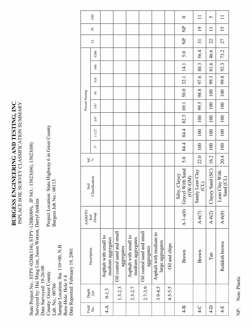
4-A
0-1
.3
Asp
hal
t w
ith sm
all to
med
ium
aggre
gat
es
1.3
-2.3
O
il c
oat
ed san
d a
nd sm
all
aggre
gat
es
2.3
-2.7
A
sphal
t w
ith sm
all to
med
ium
aggre
gat
es
2.7
-3.9
O
il c
oat
ed san
d a
nd sm
all
aggre
gat
es
3.9
-4.5
A
sphal
t w
ith m
ediu
m to
larg
e ag
gre
gat
es
4.5
-5.5
O
il a
nd c
hip
s
4-B
Bro
wn
A-1
-a(0
)
Silty
, C
layey
Gra
vel
With S
and
(GW
-GM
)
5.0
84.4
84.4
82.3
69.1
50.0
32.1
14.1
5.0
N
P
NP
0
4-C
Bro
wn
A-6
(7)
San
dy L
ean C
lay
(CL)
22.0
100
100
100
99.5
98.8
97.6
80.3
56.4
31
19
11
4-D
Tan
A
-6(2
) C
layey S
and (SC
) 16.2
100
100
100
100
100
99.3
81.6
46.6
22
11
5
4-E
Red
dis
h b
row
n
A-6
(8)
Lea
n C
lay W
ith
San
d (C
L)
20.4
100
100
100
100
100
99.8
92.3
73.2
27
15
11
NP:
Non- Pla
stic
Page 26
BURGESS EGIEERIG AD TESTIG, IC
.
INPLA
CE S
OIL
SU
RV
EY
CLA
SSIF
ICA
TIO
N S
UM
MA
RY
Sta
te P
roje
ct N
o.: S
TPY
-028B(1
34), S
TPY
-128B(0
09), JP
NO
.: 1
5023(0
4), 1
5023(0
8)
Surv
eyed
by: H
ai M
ing L
im, Ja
son W
atso
n, D
arry
l Je
nkin
s
Dat
e Surv
eyed
: 10-2
6-0
0
County
: G
reer
County
Pro
ject
Loca
tion: Sta
te H
ighw
ay 6
in G
reer
County
Lab
. N
o.: 0
0766
Burg
ess Jo
b N
o.: 0
0113
Sam
ple
Loca
tion: Sta
. 120+00, N
.B.
Bore
-Hole
: H
ole
# 5
Dat
e R
eported
: Feb
ruar
y 1
9, 2001
Fie
ld
No.
Dep
th
(in)
Des
crip
tion
AA
SH
TO
Soil
Gro
up
Soil
Cla
ssific
atio
n
MC
%
Per
cent Pas
sing
LL
PI
OSI
3"
1-1
/2"
3/4
" 3/8
" #4
#10
#40
#200
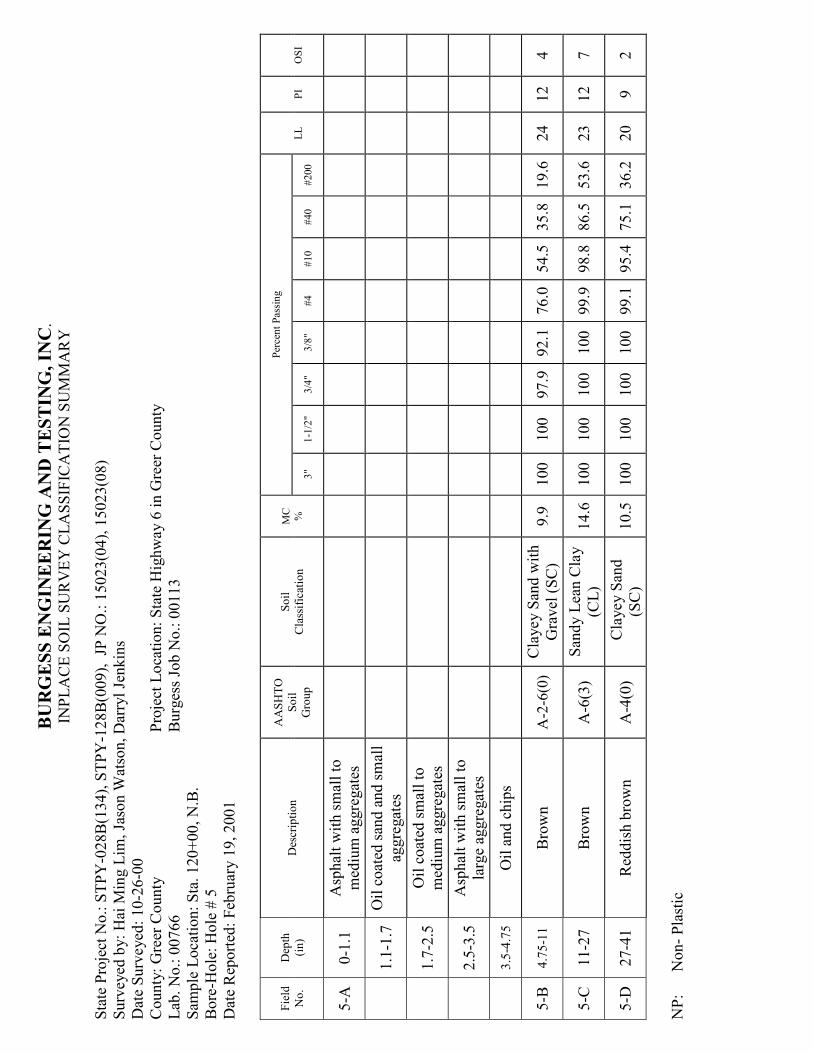
5-A
0-1
.1
Asp
hal
t w
ith sm
all to
med
ium
aggre
gat
es
1.1
-1.7
O
il c
oat
ed san
d a
nd sm
all
aggre
gat
es
1.7
-2.5
O
il c
oat
ed sm
all to
med
ium
aggre
gat
es
2.5
-3.5
A
sphal
t w
ith sm
all to
larg
e ag
gre
gat
es
3.5
-4.7
5
Oil a
nd c
hip
s
5-B
4.7
5-1
1
Bro
wn
A-2
-6(0
) C
layey S
and w
ith
Gra
vel
(SC
) 9.9
100
100
97.9
92.1
76.0
54.5
35.8
19.6
24
12
4
5-C
11-2
7
Bro
wn
A-6
(3)
San
dy L
ean C
lay
(CL)
14.6
100
100
100
100
99.9
98.8
86.5
53.6
23
12
7
5-D
27-4
1
Red
dis
h b
row
n
A-4
(0)
Cla
yey S
and
(SC
) 10.5
100
100
100
100
99.1
95.4
75.1
36.2
20
9
2
NP:
Non- Pla
stic
Page 27
BURGESS EGIEERIG AD TESTIG, IC
.
INPLA
CE S
OIL
SU
RV
EY
CLA
SSIF
ICA
TIO
N S
UM
MA
RY
Sta
te P
roje
ct N
o.: S
TPY
-028B(1
34), S
TPY
-128B(0
09), JP
NO
.: 1
5023(0
4), 1
5023(0
8)
Surv
eyed
by: H
ai M
ing L
im, Ja
son W
atso
n, D
arry
l Je
nkin
s
Dat
e Surv
eyed
: 10-2
6-0
0
County
: G
reer
County
Pro
ject
Loca
tion: Sta
te H
ighw
ay 6
in G
reer
County
Lab
. N
o.: 0
0766
Burg
ess Jo
b N
o.: 0
0113
Sam
ple
Loca
tion: Sta
. 155+00, N
.B.
Bore
-Hole
: H
ole
# 6
Dat
e R
eported
: Feb
ruar
y 1
9, 2001
Fie
ld
No.
Dep
th
(in)
Des
crip
tion
AA
SH
TO
Soil
Gro
up
Soil
Cla
ssific
atio
n
MC
%
Per
cent Pas
sing
LL
PI
OSI
3"
1-1
/2"
3/4
" 3/8
" #4
#10
#40
#200
6-A
0-0
.5
Asp
hal
t w
ith sm
all to
med
ium
aggre
gat
es
0.5
-2.1
O
il c
oat
ed sm
all to
med
ium
aggre
gat
es
2.1
-2.8
A
sphal
t w
ith m
ediu
m to
larg
e ag
gre
gat
es
2.8
-3.5
O
il a
nd c
hip
s
6-B
3.5
-11
Bro
wn
A-2
-4(0
)
Wel
l G
raded
San
d W
ith C
lay
and G
ravel
(SW
-
SC
)
6.8
100
100
91.7
77.7
56.6
35.5
15.6
6.8
21
8
0
6-C
11-2
0
Dar
k b
row
n
A-6
(9)
Lea
n C
lay W
ith
San
d (C
L)
18.3
100
100
100
100
99.8
98.7
89.7
71.8
28
16
12
6-D
20-2
4
Tan
A
-6(1
) C
layey S
and (SC
) 11.4
100
100
100
97.2
93.3
82.5
82.4
44.2
23
11
5
6-E
24-4
1
Bro
wn
A-6
(5)
San
dy L
ean C
lay
(CL)
14.7
100
100
100
99.7
98.4
92.7
77.4
55.2
26
15
9
NP:
Non- Pla
stic
Page 28
BURGESS EGIEERIG AD TESTIG, IC
.
INPLA
CE S
OIL
SU
RV
EY
CLA
SSIF
ICA
TIO
N S
UM
MA
RY
Sta
te P
roje
ct N
o.: S
TPY
-028B(1
34), S
TPY
-128B(0
09), JP
NO
.: 1
5023(0
4), 1
5023(0
8)
Surv
eyed
by: H
ai M
ing L
im, Ja
son W
atso
n, D
arry
l Je
nkin
s
Dat
e Surv
eyed
: 10-2
6-0
0
County
: G
reer
County
Pro
ject
Loca
tion: Sta
te H
ighw
ay 6
in G
reer
County
Lab
. N
o.: 0
0766
Burg
ess Jo
b N
o.: 0
0113
Sam
ple
Loca
tion: Sta
. 185+00, N
.B.
Bore
-Hole
: H
ole
# 7
Dat
e R
eported
: Feb
ruar
y 1
9, 2001
Fie
ld
No.
Dep
th
(in)
Des
crip
tion
AA
SH
TO
Soil
Gro
up
Soil
Cla
ssific
atio
n
MC
%
Per
cent Pas
sing
LL
PI
OSI
3"
1-1
/2"
3/4
" 3/8
" #4
#10
#40
#200
7-A
0-0
.5
Asp
hal
t w
ith sm
all to
med
ium
aggre
gat
es
0.5
-1.4
O
il c
oat
ed sm
all to
med
ium
aggre
gat
es
1.4
-2.8
A
sphal
t w
ith m
ediu
m to
larg
e ag
gre
gat
es
2.8
-3.3
O
il a
nd c
hip
s
7-B
3.3
-11
Bro
wn
A-1
-a(0
)
Wel
l G
raded
San
d W
ith S
ilt
and G
ravel
(SW
-
SM
)
7.5
100
100
95.5
82.2
61.0
42.5
19.2
7.0
N
P
NP
0
7-C
11-2
5
Dar
k b
row
n
A-6
(9)
Lea
n C
lay W
ith
San
d (C
L)
14.7
100
100
99.4
98.1
95.4
91.0
86.4
78.7
28
15
12
7-D
25-3
2
Bro
wn
A-6
(8)
Lea
n C
lay W
ith
San
d (C
L)
12.3
100
100
100
99.9
98.8
91.2
82.5
71.4
28
15
11
7-E
32-4
0
Red
dis
h b
row
n
A-7
-6(1
8)
Lea
n C
lay W
ith
San
d (C
L)
17.9
100
100
98.8
98.4
95.7
83.7
80.3
74.0
42
26
18
NP:
Non- Pla
stic
Page 29
BURGESS EGIEERIG AD TESTIG, IC
.
INPLA
CE S
OIL
SU
RV
EY
CLA
SSIF
ICA
TIO
N S
UM
MA
RY
Sta
te P
roje
ct N
o.: S
TPY
-028B(1
34), S
TPY
-128B(0
09), JP
NO
.: 1
5023(0
4), 1
5023(0
8)
Surv
eyed
by: H
ai M
ing L
im, Ja
son W
atso
n, D
arry
l Je
nkin
s
Dat
e Surv
eyed
: 10-2
6-0
0
County
: G
reer
County
Pro
ject
Loca
tion: Sta
te H
ighw
ay 6
in G
reer
County
Lab
. N
o.: 0
0766
Burg
ess Jo
b N
o.: 0
0113
Sam
ple
Loca
tion: Sta
. 205+00, N
.B.
Bore
-Hole
: H
ole
# 8
Dat
e R
eported
: Feb
ruar
y 1
9, 2001
Fie
ld
No.
Dep
th
(in)
Des
crip
tion
AA
SH
TO
Soil
Gro
up
Soil
Cla
ssific
atio
n
MC
%
Per
cent Pas
sing
LL
PI
OSI
3"
1-1
/2"
3/4
" 3/8
" #4
#10
#40
#200
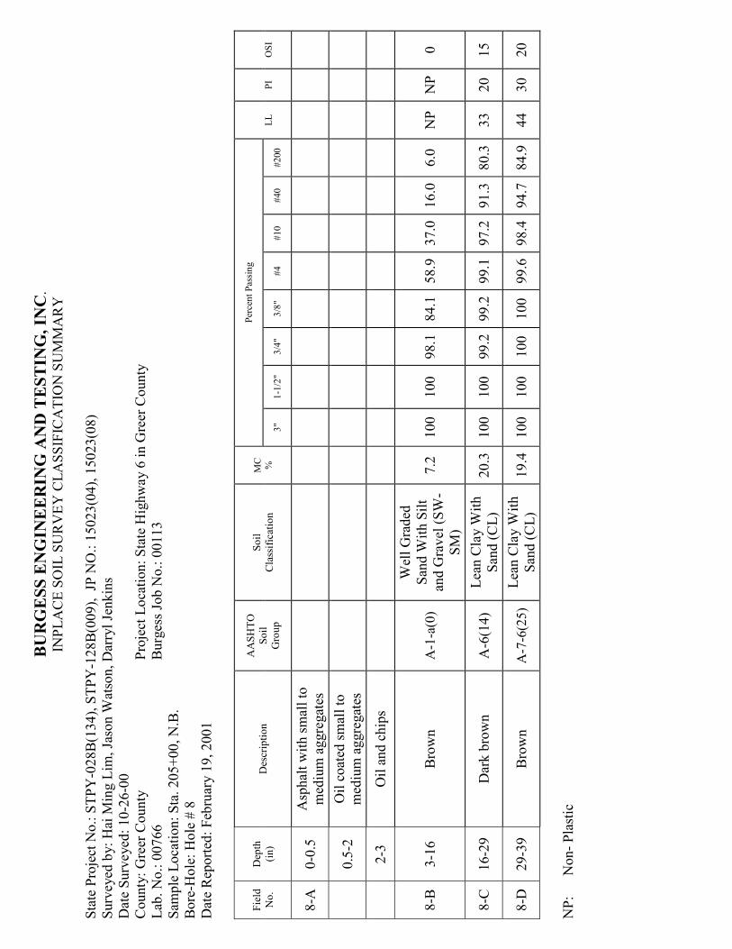
8-A
0-0
.5
Asp
hal
t w
ith sm
all to
med
ium
aggre
gat
es
0.5
-2
Oil c
oat
ed sm
all to
med
ium
aggre
gat
es
2-3
O
il a
nd c
hip
s
8-B
3-1
6
Bro
wn
A-1
-a(0
)
Wel
l G
raded
San
d W
ith S
ilt
and G
ravel
(SW
-
SM
)
7.2
100
100
98.1
84.1
58.9
37.0
16.0
6.0
N
P
NP
0
8-C
16-2
9
Dar
k b
row
n
A-6
(14)
Lea
n C
lay W
ith
San
d (C
L)
20.3
100
100
99.2
99.2
99.1
97.2
91.3
80.3
33
20
15
8-D
29-3
9
Bro
wn
A-7
-6(2
5)
Lea
n C
lay W
ith
San
d (C
L)
19.4
100
100
100
100
99.6
98.4
94.7
84.9
44
30
20
NP:
Non- Pla
stic
Page 30
BURGESS EGIEERIG AD TESTIG, IC
.
INPLA
CE S
OIL
SU
RV
EY
CLA
SSIF
ICA
TIO
N S
UM
MA
RY
Sta
te P
roje
ct N
o.: S
TPY
-028B(1
34), S
TPY
-128B(0
09), JP
NO
.: 1
5023(0
4), 1
5023(0
8)
Surv
eyed
by: H
ai M
ing L
im, Ja
son W
atso
n, D
arry
l Je
nkin
s
Dat
e Surv
eyed
: 10-2
6-0
0
County
: G
reer
County
Pro
ject
Loca
tion: Sta
te H
ighw
ay 6
in G
reer
County
Lab
. N
o.: 0
0766
Burg
ess Jo
b N
o.: 0
0113
Sam
ple
Loca
tion: Sta
. 235+00, N
.B.
Bore
-Hole
: H
ole
# 9
Dat
e R
eported
: Feb
ruar
y 1
9, 2001
Fie
ld
No.
Dep
th
(in)
Des
crip
tion
AA
SH
TO
Soil
Gro
up
Soil
Cla
ssific
atio
n
MC
%
Per
cent Pas
sing
LL
PI
OSI
3"
1-1
/2"
3/4
" 3/8
" #4
#10
#40
#200
9-A
0-2
.2
Type
B a
sphal
t
2.2
-2.6
A
sphal
t w
ith m
ediu
m to
larg
e ag
gre
gat
es
2.6
-3.2
O
il c
oat
ed san
d a
nd sm
all
aggre
gat
es
3.2
-4
Asp
hal
t w
ith sm
all to
med
ium
aggre
gat
es
4-4
.7
Oil c
oat
ed san
d
4.7
-6
Asp
hal
t w
ith sm
all to
med
ium
aggre
gat
es
6-6
.7
Oil c
oat
ed san
d
6.7
-7.7
A
sphal
t w
ith m
ediu
m to
larg
e ag
gre
gat
es
7.7
-8.2
5
Oil a
nd c
hip
s
9-B
8.2
5-1
2
Yel
low
ish b
row
n
A-1
-b(0
) Silty
San
d W
ith
Gra
vel
(SM
) 7.1
100
100
92.6
73.7
54.6
40.0
33.3
16.1
N
P
NP
0
Page 31
BURGESS EGIEERIG AD TESTIG, IC
.
INPLA
CE S
OIL
SU
RV
EY
CLA
SSIF
ICA
TIO
N S
UM
MA
RY
Sta
te P
roje
ct N
o.: S
TPY
-028B(1
34), S
TPY
-128B(0
09), JP
NO
.: 1
5023(0
4), 1
5023(0
8)
Surv
eyed
by: H
ai M
ing L
im, Ja
son W
atso
n, D
arry
l Je
nkin
s
Dat
e Surv
eyed
: 10-2
6-0
0
County
: G
reer
County
Pro
ject
Loca
tion: Sta
te H
ighw
ay 6
in G
reer
County
Lab
. N
o.: 0
0766
Burg
ess Jo
b N
o.: 0
0113
Sam
ple
Loca
tion: Sta
. 235+00, N
.B.
Bore
-Hole
: H
ole
# 9
(C
ont’)
Dat
e R
eported
: Feb
ruar
y 1
9, 2001
Fie
ld
No.
Dep
th
(in)
Des
crip
tion
AA
SH
TO
Soil
Gro
up
Soil
Cla
ssific
atio
n
MC
%
Per
cent Pas
sing
LL
PI
OSI
3"
1-1
/2"
3/4
" 3/8
" #4
#10
#40
#200
9-C
12-1
8
Tan
A
-2-4
(0)
Silty
San
d (SM
) 10.7
100
100
100
994
96.8
91.4
64.0
24.6
N
P
NP
0
9-D
18-4
5
Dar
k b
row
n
A-7
-6(2
0)
Lea
n C
lay W
ith
San
d (C
L)
20.2
100
100
100
100
99.7
97.6
90.7
81.4
44
24
18
NP:
Non- Pla
stic
Page 32
BURGESS EGIEERIG AD TESTIG, IC
.
INPLA
CE S
OIL
SU
RV
EY
CLA
SSIF
ICA
TIO
N S
UM
MA
RY
Sta
te P
roje
ct N
o.: S
TPY
-028B(1
34), S
TPY
-128B(0
09), JP
NO
.: 1
5023(0
4), 1
5023(0
8)
Surv
eyed
by: H
ai M
ing L
im, Ja
son W
atso
n, D
arry
l Je
nkin
s
Dat
e Surv
eyed
: 10-2
6-0
0
County
: G
reer
County
Pro
ject
Loca
tion: Sta
te H
ighw
ay 6
in G
reer
County
Lab
. N
o.: 0
0766
Burg
ess Jo
b N
o.: 0
0113
Sam
ple
Loca
tion: Sta
. 217+50, S.B
.
Bore
-Hole
: H
ole
# 1
0
Dat
e R
eported
: Feb
ruar
y 1
9, 2001
Fie
ld
No.
Dep
th
(in)
Des
crip
tion
AA
SH
TO
Soil
Gro
up
Soil
Cla
ssific
atio
n
MC
%
Per
cent Pas
sing
LL
PI
OSI
3"
1-1
/2"
3/4
" 3/8
" #4
#10
#40
#200
10-A
0-0
.5
Asp
hal
t w
ith sm
all
aggre
gat
es
0.5
-1
Asp
hal
t w
ith m
ediu
m to
larg
e ag
gre
gat
es
1-2
.8
Coat
ed san
d w
ith
med
ium
to lar
ge
agg.
2.8
-3.0
A
sphal
t w
ith m
ediu
m
aggre
gat
es
3.0
-3.7
C
oat
ed san
d w
ith
med
ium
aggre
gat
es
3.7
-4
Asp
hal
t w
ith m
ediu
m
aggre
gat
es
4-4
.7
Coat
ed san
d w
ith sm
all
aggre
gat
es
4.7
-5.3
A
sphal
t w
ith m
ediu
m to
larg
e ag
gre
gat
es
Page 33
BURGESS EGIEERIG AD TESTIG, IC
.
INPLA
CE S
OIL
SU
RV
EY
CLA
SSIF
ICA
TIO
N S
UM
MA
RY
Sta
te P
roje
ct N
o.: S
TPY
-028B(1
34), S
TPY
-128B(0
09), JP
NO
.: 1
5023(0
4), 1
5023(0
8)
Surv
eyed
by: H
ai M
ing L
im, Ja
son W
atso
n, D
arry
l Je
nkin
s
Dat
e Surv
eyed
: 10-2
6-0
0
County
: G
reer
County
Pro
ject
Loca
tion: Sta
te H
ighw
ay 6
in G
reer
County
Lab
. N
o.: 0
0766
Burg
ess Jo
b N
o.: 0
0113
Sam
ple
Loca
tion: Sta
. 217+50, S.B
.
Bore
-Hole
: H
ole
# 1
0 (C
ont’)
Dat
e R
eported
: Feb
ruar
y 1
9, 2001
Fie
ld
No.
Dep
th
(in)
Des
crip
tion
AA
SH
TO
Soil
Gro
up
Soil
Cla
ssific
atio
n
MC
%
Per
cent Pas
sing
LL
PI
OSI
3"
1-1
/2"
3/4
" 3/8
" #4
#10
#40
#200
5.3
-6.2
5
Oil a
nd c
hip
s
10-B
6.2
5-1
6
Yel
low
ish b
row
n
A-1
-a(0
)
Wel
l G
raded
San
d W
ith S
ilt
and G
ravel
(SW
-
SM
)
8.9
100
100
96.5
83.0
64.7
44.9
26.3
10.3
N
P
NP
0
10-C
16-4
3
Dar
k b
row
n
A-7
-6(2
3)
Lea
n C
lay W
ith
San
d (C
L)
21.5
100
100
100
100
99.9
98.4
91.8
79.7
43
30
20
NP:
Non- Pla
stic
Page 34
BURGESS EGIEERIG AD TESTIG, IC
.
INPLA
CE S
OIL
SU
RV
EY
CLA
SSIF
ICA
TIO
N S
UM
MA
RY
Sta
te P
roje
ct N
o.: S
TPY
-028B(1
34), S
TPY
-128B(0
09), JP
NO
.: 1
5023(0
4), 1
5023(0
8)
Surv
eyed
by: H
ai M
ing L
im, Ja
son W
atso
n, D
arry
l Je
nkin
s
Dat
e Surv
eyed
: 10-2
6-0
0
County
: G
reer
County
Pro
ject
Loca
tion: Sta
te H
ighw
ay 6
in G
reer
County
Lab
. N
o.: 0
0766
Burg
ess Jo
b N
o.: 0
0113
Sam
ple
Loca
tion: Sta
. 172+50, S.B
.
Bore
-Hole
: H
ole
# 1
1
Dat
e R
eported
: Feb
ruar
y 1
9, 2001
Fie
ld
No.
Dep
th
(in)
Des
crip
tion
AA
SH
TO
Soil
Gro
up
Soil
Cla
ssific
atio
n
MC
%
Per
cent Pas
sing
LL
PI
OSI
3"
1-1
/2"
3/4
" 3/8
" #4
#10
#40
#200
11-A
0-0
.7
Asp
hal
t w
ith sm
all to
med
ium
aggre
gat
es
0.7
-2
Oil c
oat
ed m
ediu
m
aggre
gat
es
2-2
.7
Asp
hal
t w
ith m
ediu
m to
larg
e ag
gre
gat
es
2.7
-3.4
O
il c
oat
ed sm
all to
med
ium
aggre
gat
es
3.4
-5
Oil a
nd c
hip
s
11-B
5-1
5
Yel
low
ish b
row
n
A-1
-a(0
)
Wel
l G
raded
San
d W
ith S
ilt
and G
ravel
(SW
-
SM
)
6.4
100
100
93.7
76.2
58.7
39.6
21.0
8.6
N
P
NP
0
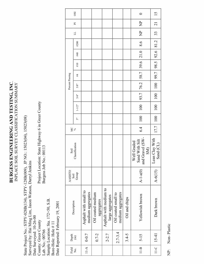
11-C
15-4
1
Dar
k b
row
n
A-6
(15)
Lea
n C
lay W
ith
San
d (C
L)
17.7
100
100
100
100
99.7
98.5
92.6
81.2
33
21
15
NP:
Non- Pla
stic
Page 35
BURGESS EGIEERIG AD TESTIG, IC
.
INPLA
CE S
OIL
SU
RV
EY
CLA
SSIF
ICA
TIO
N S
UM
MA
RY
Sta
te P
roje
ct N
o.: S
TPY
-028B(1
34), S
TPY
-128B(0
09), JP
NO
.: 1
5023(0
4), 1
5023(0
8)
Surv
eyed
by: H
ai M
ing L
im, Ja
son W
atso
n, D
arry
l Je
nkin
s
Dat
e Surv
eyed
: 10-2
6-0
0
County
: G
reer
County
Pro
ject
Loca
tion: Sta
te H
ighw
ay 6
in G
reer
County
Lab
. N
o.: 0
0766
Burg
ess Jo
b N
o.: 0
0113
Sam
ple
Loca
tion: Sta
. 162+50, S.B
.
Bore
-Hole
: H
ole
# 1
2
Dat
e R
eported
: Feb
ruar
y 1
9, 2001
Fie
ld
No.
Dep
th
(in)
Des
crip
tion
AA
SH
TO
Soil
Gro
up
Soil
Cla
ssific
atio
n
MC
%
Per
cent Pas
sing
LL
PI
OSI
3"
1-1
/2"
3/4
" 3/8
" #4
#10
#40
#200
12-A
0-2
A
sphal
t w
ith sm
all to
med
ium
aggre
gat
es
2-3
.1
Oil c
oat
ed m
ediu
m
aggre
gat
es
3.1
-3.7
A
sphal
t w
ith m
ediu
m to
larg
e ag
gre
gat
es
3.7
-4.2
5
Oil a
nd c
hip
s
12-B
4.2
5-1
6
Bro
wn
A-1
-b(0
)
Silty
, C
layey
San
d W
ith G
ravel
(SC
-SM
)
7.8
100
100
96.5
86.0
64.7
43.3
40.6
20.6
20
6
1
12-C
16-3
7
Dar
k b
row
n
A-6
(4)
San
dy L
ean C
lay
(CL)
14.2
100
100
100
100
99.6
97.4
86.0
59.5
24
12
8
12-D
37-4
1
Dar
k b
row
n
A-6
(6)
San
dy L
ean C
lay
(CL)
13.8
100
100
100
99.8
98.3
86.4
68.4
54.2
30
17
10
NP:
Non- Pla
stic
Page 36
BURGESS EGIEERIG AD TESTIG, IC
.
INPLA
CE S
OIL
SU
RV
EY
CLA
SSIF
ICA
TIO
N S
UM
MA
RY
Sta
te P
roje
ct N
o.: S
TPY
-028B(1
34), S
TPY
-128B(0
09), JP
NO
.: 1
5023(0
4), 1
5023(0
8)
Surv
eyed
by: H
ai M
ing L
im, Ja
son W
atso
n, D
arry
l Je
nkin
s
Dat
e Surv
eyed
: 10-2
6-0
0
County
: G
reer
County
Pro
ject
Loca
tion: Sta
te H
ighw
ay 6
in G
reer
County
Lab
. N
o.: 0
0766
Burg
ess Jo
b N
o.: 0
0113
Sam
ple
Loca
tion: Sta
. 142+50, S.B
.
Bore
-Hole
: H
ole
# 1
3
Dat
e R
eported
: Feb
ruar
y 1
9, 2001
Fie
ld
No.
Dep
th
(in)
Des
crip
tion
AA
SH
TO
Soil
Gro
up
Soil
Cla
ssific
atio
n
MC
%
Per
cent Pas
sing
LL
PI
OSI
3"
1-1
/2"
3/4
" 3/8
" #4
#10
#40
#200
13-A
0-0
.7
Asp
hal
t w
ith sm
all to
med
ium
aggre
gat
es
0.7
-0.9
O
il c
oat
ed sm
all
aggre
gat
es
0.9
-1.9
A
sphal
t w
ith m
ediu
m
aggre
gat
es
1.9
-2.3
O
il c
oat
ed sm
all to
med
ium
aggre
gat
es
2.3
-2.8
A
sphal
t w
ith m
ediu
m to
larg
e ag
gre
gat
es
2.8
-3.5
O
il a
nd c
hip
s
13-B
3.5
-13
Bro
wn
A-1
-a(0
)
Wel
l G
raded
San
d W
ith G
ravel
(SW
)
7.9
100
100
99.7
84.5
58.6
37.5
13.2
3.0
N
P
NP
0
13-C
13-2
0
Bro
wn
A-2
-4(0
) Silty
, C
layey
San
d (SC
-SM
) 9.0
100
100
99.3
97.6
96.0
91.5
60.7
29.4
18
7
1
13-D
20-2
7
Red
dis
h b
row
n
A-6
(12)
San
dy L
ean C
lay
(CL)
16.6
100
100
100
100
99.9
98.9
89.0
70.3
35
20
14
13-E
27-4
0
Red
dis
h b
row
n
A-6
(7)
San
dy L
ean C
lay
(CL)
14.8
100
100
100
99.7
99.3
98.0
85.4
57.2
32
18
11
NP:
Non- Pla
stic
Page 37
BURGESS EGIEERIG AD TESTIG, IC
.
INPLA
CE S
OIL
SU
RV
EY
CLA
SSIF
ICA
TIO
N S
UM
MA
RY
Sta
te P
roje
ct N
o.: S
TPY
-028B(1
34), S
TPY
-128B(0
09), JP
NO
.: 1
5023(0
4), 1
5023(0
8)
Surv
eyed
by: H
ai M
ing L
im, Ja
son W
atso
n, D
arry
l Je
nkin
s
Dat
e Surv
eyed
: 10-2
6-0
0
County
: G
reer
County
Pro
ject
Loca
tion: Sta
te H
ighw
ay 6
in G
reer
County
Lab
. N
o.: 0
0766
Burg
ess Jo
b N
o.: 0
0113
Sam
ple
Loca
tion: Sta
. 122+50, S.B
.
Bore
-Hole
: H
ole
# 1
4
Dat
e R
eported
: Feb
ruar
y 1
9, 2001
Fie
ld
No.
Dep
th
(in)
Des
crip
tion
AA
SH
TO
Soil
Gro
up
Soil
Cla
ssific
atio
n
MC
%
Per
cent Pas
sing
LL
PI
OSI
3"
1-1
/2"
3/4
" 3/8
" #4
#10
#40
#200
14-A
0-1
.1
Asp
hal
t w
ith sm
all to
med
ium
aggre
gat
es
1.1
-1.7
O
il c
oat
ed sm
all to
med
ium
aggre
gat
es
1.7
-2.4
A
sphal
t w
ith sm
all to
med
ium
aggre
gat
es
2.4
-2.6
O
il c
oat
ed san
d
2.6
-3.6
A
sphal
t w
ith sm
all to
larg
e ag
gre
gat
es
3.6
-4.5
O
il a
nd ship
s
14-B
4.5
-12
Bro
wn
A-1
-a(0
)
Wel
l G
raded
San
d W
ith S
ilt
and G
ravel
(SW
-
SM
)
6.4
100
100
97.6
80.9
57.2
38.6
21.4
10.1
N
P
NP
0
14-C
12-1
7
Dar
k b
row
n
A-4
(2)
San
dy L
ean C
lay
(CL)
13.1
100
100
100
100
99.5
96.6
86.5
55.1
21
9
6
14-D
17-2
5
Bro
wn
A-4
(9)
Cla
yey S
and (SC
) 10.2
100
100
100
99.4
97.3
90.6
72.2
44.9
21
9
4
14-E
25-4
1
Red
dis
h b
row
n
A-6
(9)
San
dy L
ean C
lay
(CL)
15.7
100
100
100
100
99.7
98.1
89.9
68.6
31
17
12
NP:
Non- Pla
stic
Page 38
BURGESS EGIEERIG AD TESTIG, IC
.
INPLA
CE S
OIL
SU
RV
EY
CLA
SSIF
ICA
TIO
N S
UM
MA
RY
Sta
te P
roje
ct N
o.: S
TPY
-028B(1
34), S
TPY
-128B(0
09), JP
NO
.: 1
5023(0
4), 1
5023(0
8)
Surv
eyed
by: H
ai M
ing L
im, Ja
son W
atso
n, D
arry
l Je
nkin
s
Dat
e Surv
eyed
: 10-2
6-0
0
County
: G
reer
County
Pro
ject
Loca
tion: Sta
te H
ighw
ay 6
in G
reer
County
Lab
. N
o.: 0
0766
Burg
ess Jo
b N
o.: 0
0113
Sam
ple
Loca
tion: Sta
. 87+50, S.B
.
Bore
-Hole
: H
ole
# 1
5
Dat
e R
eported
: Feb
ruar
y 1
9, 2001
Fie
ld
No.
Dep
th
(in)
Des
crip
tion
AA
SH
TO
Soil
Gro
up
Soil
Cla
ssific
atio
n
MC
%
Per
cent Pas
sing
LL
PI
OSI
3"
1-1
/2"
3/4
" 3/8
" #4
#10
#40
#200
15-A
0-0
.3
Asp
hal
t w
ith sm
all to
med
ium
aggre
gat
es
0.3
-0.7
O
il c
oat
ed sm
all to
med
ium
aggre
gat
es
0.7
-1.8
A
sphal
t w
ith sm
all to
med
ium
aggre
gat
es
1.8
-2.5
O
il a
nd c
hip
s
15-B
2.5
-8
Yel
low
ish b
row
n
A-2
-4(0
)
Wel
l G
raded
San
d W
ith G
ravel
(SW
)
8.0
100
100
98.2
87.0
64.8
39.8
10.2
4.2
19
7
0
15-C
8-2
5
Dar
k b
row
n
A-6
(2)
Cla
yey S
and (SC
) 12.6
100
100
100
99.6
98.8
95.6
76.2
48.5
23
12
6
15-D
25-3
9
Bro
wn
A-4
(1)
San
dy L
ean C
lay
(SC
) 10.0
100
100
100
99.6
99.0
96.1
86.5
53.4
20
8
5
NP:
Non- Pla
stic
Page 39
BURGESS EGIEERIG AD TESTIG, IC
.
INPLA
CE S
OIL
SU
RV
EY
CLA
SSIF
ICA
TIO
N S
UM
MA
RY
Sta
te P
roje
ct N
o.: S
TPY
-028B(1
34), S
TPY
-128B(0
09), JP
NO
.: 1
5023(0
4), 1
5023(0
8)
Surv
eyed
by: H
ai M
ing L
im, Ja
son W
atso
n, D
arry
l Je
nkin
s
Dat
e Surv
eyed
: 10-2
6-0
0
County
: G
reer
County
Pro
ject
Loca
tion: Sta
te H
ighw
ay 6
in G
reer
County
Lab
. N
o.: 0
0766
Burg
ess Jo
b N
o.: 0
0113
Sam
ple
Loca
tion: Sta
. 72+50, S.B
.
Bore
-Hole
: H
ole
# 1
6
Dat
e R
eported
: Feb
ruar
y 1
9, 2001
Fie
ld
No.
Dep
th
(in)
Des
crip
tion
AA
SH
TO
Soil
Gro
up
Soil
Cla
ssific
atio
n
MC
%
Per
cent Pas
sing
LL
PI
OSI
3"
1-1
/2"
3/4
" 3/8
" #4
#10
#40
#200
16-A
0-1
.4
Asp
hal
t w
ith sm
all to
med
ium
aggre
gat
es
1.4
-1.7
O
il c
oat
ed sm
all
aggre
gat
es
1.7
-2.6
A
sphal
t w
ith sm
all to
med
ium
aggre
gat
es
2.6
-3.8
A
sphal
t w
ith m
ediu
m to
larg
e ag
gre
gat
es
3.8
-4.6
O
il a
nd c
hip
s
16-B
4.6
-11
Yel
low
ish b
row
n
A-1
-a(0
)
Wel
l G
raded
San
d W
ith S
ilt
and G
ravel
(SW
-
SM
)
6.8
100
100
97.9
85.6
59.5
37.2
15.2
6.3
N
P
NP
0
16-C
11-1
9
Dar
k b
row
n
A-4
(1)
Cla
yey S
and (SC
) 10.5
100
100
100
100
99.4
96.8
83.1
45.3
21
10
4
16-D
19-4
1
Bro
wn
A-4
(0)
Silty
San
d (SM
) 8.1
100
100
100
100
99.2
95.8
81.0
37.1
N
P
NP
0
NP:
Non- Pla
stic
Page 40
BURGESS EGIEERIG AD TESTIG, IC
.
INPLA
CE S
OIL
SU
RV
EY
CLA
SSIF
ICA
TIO
N S
UM
MA
RY
Sta
te P
roje
ct N
o.: S
TPY
-028B(1
34), S
TPY
-128B(0
09), JP
NO
.: 1
5023(0
4), 1
5023(0
8)
Surv
eyed
by: H
ai M
ing L
im, Ja
son W
atso
n, D
arry
l Je
nkin
s
Dat
e Surv
eyed
: 10-2
6-0
0
County
: G
reer
County
Pro
ject
Loca
tion: Sta
te H
ighw
ay 6
in G
reer
County
Lab
. N
o.: 0
0766
Burg
ess Jo
b N
o.: 0
0113
Sam
ple
Loca
tion: Sta
. 47+50, S.B
.
Bore
-Hole
: H
ole
# 1
7
Dat
e R
eported
: Feb
ruar
y 1
9, 2001
Fie
ld
No.
Dep
th
(in)
Des
crip
tion
AA
SH
TO
Soil
Gro
up
Soil
Cla
ssific
atio
n
MC
%
Per
cent Pas
sing
LL
PI
OSI
3"
1-1
/2"
3/4
" 3/8
" #4
#10
#40
#200
17-A
0-0
.7
Asp
hal
t w
ith sm
all to
med
ium
aggre
gat
es
0.7
-1.1
O
il c
oat
ed sm
all to
med
ium
aggre
gat
es
1.1
-2
Asp
hal
t w
ith sm
all to
larg
e ag
gre
gat
es
2-3
O
il a
nd c
hip
s
17-B
3-1
0
Bro
wn
A-1
-a(0
)
Wel
l G
raded
San
d W
ith S
ilt
and G
ravel
(SW
-
SM
)
3.9
100
100
93.9
76.8
57.5
37.2
16.7
6.7
N
P
NP
0
17-C
10-1
6
Dar
k b
row
n
A-4
(0)
Silty
San
d (SM
) 8.3
100
100
100
99.7
99.5
98.0
79.6
44.1
16
3
2
17-D
16-3
0
Bro
wn
A-4
(0)
Silty
, C
layey
San
d (SC
-SM
) 8.3
100
100
100
99.7
98.2
94.7
82.2
42.1
18
6
2
17-E
30-3
9
Bro
wn
A-2
-4(0
) Silty
San
d (SM
) 6.9
100
100
100
99.7
99.3
96.9
75.8
27.1
N
P
NP
0
NP:
Non- Pla
stic
Page 41
BURGESS EGIEERIG AD TESTIG, IC
.
INPLA
CE S
OIL
SU
RV
EY
CLA
SSIF
ICA
TIO
N S
UM
MA
RY
Sta
te P
roje
ct N
o.: S
TPY
-028B(1
34), S
TPY
-128B(0
09), JP
NO
.: 1
5023(0
4), 1
5023(0
8)
Surv
eyed
by: H
ai M
ing L
im, Ja
son W
atso
n, D
arry
l Je
nkin
s
Dat
e Surv
eyed
: 10-2
6-0
0
County
: G
reer
County
Pro
ject
Loca
tion: Sta
te H
ighw
ay 6
in G
reer
County
Lab
. N
o.: 0
0766
Burg
ess Jo
b N
o.: 0
0113
Sam
ple
Loca
tion: Sta
. 32+50, S.B
.
Bore
-Hole
: H
ole
# 1
8
Dat
e R
eported
: Feb
ruar
y 1
9, 2001
Fie
ld
No.
Dep
th
(in)
Des
crip
tion
AA
SH
TO
Soil
Gro
up
Soil
Cla
ssific
atio
n
MC
%
Per
cent Pas
sing
LL
PI
OSI
3"
1-1
/2"
3/4
" 3/8
" #4
#10
#40
#200
18-A
0-0
.9
Asp
hal
t w
ith sm
all to
med
ium
aggre
gat
es
0.9
-1.1
O
il c
oat
ed sm
all to
med
ium
aggre
gat
es
1.1
-2.6
A
sphal
t w
ith sm
all to
larg
e ag
gre
gat
es
2.6
-3.5
O
il a
nd c
hip
s
18-B
3.5
-10
Bro
wn
A-1
-a(0
)
Wel
l G
raded
San
d W
ith S
ilt
and G
ravel
(SW
-
SM
)
3.9
100
100
90.2
79.2
61.2
40.1
24.3
9.2
N
P
NP
0
18-C
10-2
1
Dar
k b
row
n
A-6
(2)
San
dy L
ean C
lay
(CL)
9.2
100
100
100
99.2
98.5
95.7
78.9
50.5
22
11
6
18-D
21-4
0
Bro
wn
A-4
(0)
Silty
San
d (SM
) 7.4
100
100
100
99.6
98.4
95.5
81.4
35.5
N
P
NP
0
NP:
Non- Pla
stic
Page 42
BURGESS EGIEERIG AD TESTIG, IC
.
INPLA
CE S
OIL
SU
RV
EY
CLA
SSIF
ICA
TIO
N S
UM
MA
RY
Sta
te P
roje
ct N
o.: S
TPY
-028B(1
34), S
TPY
-128B(0
09), JP
NO
.: 1
5023(0
4), 1
5023(0
8)
Surv
eyed
by: H
ai M
ing L
im, Ja
son W
atso
n, D
arry
l Je
nkin
s
Dat
e Surv
eyed
: 10-2
6-0
0
County
: G
reer
County
Pro
ject
Loca
tion: Sta
te H
ighw
ay 6
in G
reer
County
Lab
. N
o.: 0
0766
Burg
ess Jo
b N
o.: 0
0113
Sam
ple
Loca
tion: Sta
. 7+50, S.B
.
Bore
-Hole
: H
ole
# 1
9
Dat
e R
eported
: Feb
ruar
y 1
9, 2001
Fie
ld
No.
Dep
th
(in)
Des
crip
tion
AA
SH
TO
Soil
Gro
up
Soil
Cla
ssific
atio
n
MC
%
Per
cent Pas
sing
LL
PI
OSI
3"
1-1
/2"
3/4
" 3/8
" #4
#10
#40
#200
19-A
0-0
.4
Asp
hal
t w
ith sm
all to
med
ium
aggre
gat
es
0.4
-0.9
O
il c
oat
ed sm
all to
med
ium
aggre
gat
es
0.9
-1.4
A
sphal
t w
ith sm
all to
med
ium
aggre
gat
es
1.4
-2
Asp
hal
t w
ith m
ediu
m to
larg
e ag
gre
gat
es
2-2
.5
Oil a
nd c
hip
s
19-B
2.5
-9
Yel
low
ish b
row
n
A-1
-a(0
)
Poorly G
raded
San
d W
ith S
ilt
and G
ravel
(SP-
SM
)
7.2
100
100
95.3
75.9
52.9
32.9
18.3
7.5
N
P
NP
0
19-C
9-3
9
Bro
wn
A-2
-4(0
) Silty
San
d (SM
) 6.1
100
100
99.0
97.1
91.0
81.5
58.5
21.5
N
P
NP
0
NP:
Non- Pla
stic
Page 44
BURGESS EGIEERIG AD TESTIG, IC. SUMMARY OF pH & RESISTIVITY TEST RESULTS
State Project No.: STRP-028B(134), STPY-128B(009), STPY-128B(008)
JP NO.: 15023(04), 15023(08), 15023(07)
Surveyed by: Hai Ming Lim, Jason Watson, Darryl Jenkins
Date Surveyed: 10-26-00
County: Greer County Location: State Highway 6 in Greer County
Lab. No.: 00766 Burgess Job No.: 00113
Sample Location: 750 ft N., 580 ft E. of the SW Corner, Sec 24, T 5 N, R 21 W
Bore-Hole: Series # 1
Soil Series: Enterprise Series
Date Reported: February 19, 2001
Depth
(in)
Sub-
Horizon Description
AASHTO
Soil
Group Soil Classification pH
Resistivity
(Ω* Cm)
0-10 Ap Reddish Brown A-2-4(0) Clayey Sand (SC) 6.95 5282
10-18 A Reddish Brown A-2-4(0) Silty, Clayey Sand (SC-SM) 7.30 6602
18-40 Bk Reddish Brown A-1-b(0) Well Graded Sand With Silt
(SW-SM) 7.47 10123
40-60 BC Reddish Brown A-1-b(0) Poorly Graded Sand (SP) 8.47 11004
Page 45
BURGESS EGIEERIG AD TESTIG, IC. SUMMARY OF pH & RESISTIVITY TEST RESULTS
State Project No.: STRP-028B(134), STPY-128B(009), STPY-128B(008)
JP NO.: 15023(04), 15023(08), 15023(07)
Surveyed by: Hai Ming Lim, Jason Watson, Darryl Jenkins
Date Surveyed: 10-26-00
County: Greer County Location: State Highway 6 in Greer County
Lab. No.: 00766 Burgess Job No.: 00113
Sample Location: 2980 ft N., 790 ft W. of the SE Corner of Sec 14, T 5 N, R 21 W
Bore-Hole: Series # 2
Soil Series: Hollister Series
Date Reported: February 19, 2001
Depth
(in)
Sub-
Horizon Description
AASHTO
Soil
Group Soil Classification pH
Resistivity
(Ω* Cm)
0-6 Ap Brown A-6(17) Lean Clay With Sand (CL) 6.78 528
6-12 Bw Dark Brown A-7-6(26) Lean Clay With Sand (CL) 4.74 176
12-32 Bss1 Dark Brown A-7-6(32) Lean Clay (CL) 4.48 88
32-52 Bss2 Dark Brown A-7-6(36) Fat Clay With Sand (CH) 6.39 44
52-60 Bkss1 Brown and Tan A-7-6(20) Sandy Fat Clay (CH) 6.48 44
60-70 Bkss2 Yellowish red A-2-6(3) Clayey Sand (SC) 8.00 N/A
70-75 2BCss Reddish Brown A-7-6(19) Lean Clay With Sand (CL) 6.31 44
N/A Not enough sample for testing
Page 46
BURGESS EGIEERIG AD TESTIG, IC. SUMMARY OF pH & RESISTIVITY TEST RESULTS
State Project No.: STRP-028B(134), STPY-128B(009), STPY-128B(008)
JP NO.: 15023(04), 15023(08), 15023(07)
Surveyed by: Hai Ming Lim, Jason Watson, Darryl Jenkins
Date Surveyed: 10-26-00
County: Greer County Location: State Highway 6 in Greer County
Lab. No.: 00766 Burgess Job No.: 00113
Sample Location: 95 ft S., 185 ft E. of the NW Corner of Sec 24, T 5 N, R 21 W
Bore-Hole: Series # 3
Soil Series: Lawton Series
Date Reported: February 19, 2001
Depth
(in)
Sub-
Horizon Description
AASHTO
Soil
Group Soil Classification pH
Resistivity
(Ω* Cm)
0-11 A1 Dark Brown A-6(5) Sandy Lean Clay (CL) 7.22 1452
11-18 BA Reddish Brown A-6(11) Sandy Lean Clay (CL) 6.54 968
18-32 Bt1 Reddish Brown A-7-
6(17) Sandy Lean Clay (CL) 4.58 616
32-47 Bt2 Reddish Brown A-7-
6(23) Lean Clay With Sand (CL) 6.65 792
47-72 BC Yellowish Red A-6(11) Sandy Lean Clay (CL) 8.45 660
Page 47
BURGESS EGIEERIG AD TESTIG, IC. SUMMARY OF pH & RESISTIVITY TEST RESULTS
State Project No.: STRP-028B(134), STPY-128B(009), STPY-128B(008)
JP NO.: 15023(04), 15023(08), 15023(07)
Surveyed by: Hai Ming Lim, Jason Watson, Darryl Jenkins
Date Surveyed: 10-26-00
County: Greer County Location: State Highway 6 in Greer County
Lab. No.: 00766 Burgess Job No.: 00113
Sample Location: 170 ft N., 150 ft E. of the SW Corner of Sec 24, T 5 N, R 21 W
Bore-Hole: Series # 4
Soil Series: Spur Series
Date Reported: February 19, 2001
Depth
(in)
Sub-
Horizon Description
AASHTO
Soil
Group Soil Classification pH
Resistivity
(Ω* Cm)
0-15 A Brown A-6(14) Lean Clay With Sand (CL) 5.39 704
15-38 Bw1 Brown A-6(19) Lean Clay (CL) 4.65 748
38-50 Bw2 Reddish Brown A-6(9) Lean Clay With Sand (CL) 4.63 660
50-60 Bw3 Light Reddish
Brown A-6(14) Lean Clay (CL) 6.25 660
Page 49
Test Specification: ASTM D-689-91 Procedure A, Standard
TEST RESULT DESCRIPTION
MAXIMUM DRY DENSITY= 126.0 pcf
OPTIMUM MOISTURE=9.5 %
SOIL SERIES: Enterprise Series
SERIES #: 1
State Project No.: STPY-028B(134), STPY-128B(009), STPY-128B(008)
JP NO.: 15023(04), 15023(08), 15023(07)
County: Greer County
Location: State Highway 6 in Greer County Sample Location: 750 ft N., 580 ft E. of the SW Corner, Sec 24, T 5 N, R 21 W
Burgess Job No.: 00113 Lab No.: 00766
BETI FIELD
NO.:
1mR
MOISTURE DENSITY RELATIONSHIP
TEST BURGESS EGIEERIG AD
TESTIG, IC.
MOISTURE DENSITY RELATIONSHIP TEST
116
117
118
119
120
121
122
123
124
125
126
127
7 8 9 10 11 12 13 14
Moisture Content (%)
Dry
Density (pcf)
Page 50
Test Specification: ASTM D-689-91 Procedure A, Standard
TEST RESULT DESCRIPTION
MAXIMUM DRY DENSITY= 97.8 pcf
OPTIMUM MOISTURE=16.6 %
SOIL SERIES: Hollister Series
SERIES #: 2
State Project No.: STPY-028B(134), STPY-128B(009), STPY-128B(008)
JP NO.: 15023(04), 15023(08), 15023(07) County: Greer County
Location: State Highway 6 in Greer County Sample Location: 2980 ft N., 790 ft W. of the SE Corner of Sec 14, T 5 N, R 21 W
Burgess Job No.: 00113 Lab No.: 00766
BETI FIELD
NO.:
2mR
MOISTURE DENSITY RELATIONSHIP
TEST BURGESS EGIEERIG AD
TESTIG, IC.
MOISTURE DENSITY RELATIONSHIP TEST
88
89
90
91
92
93
94
95
96
97
98
99
10 11 12 13 14 15 16 17 18 19
Moisture Content (%)
Dry
Density (pcf)
Page 51
Test Specification: ASTM D-689-91 Procedure A, Standard
TEST RESULT DESCRIPTION
MAXIMUM DRY DENSITY= 107.4 pcf
OPTIMUM MOISTURE=16.7 %
SOIL SERIES: Lawton Series
SERIES #: 3
State Project No.: STPY-028B(134), STPY-128B(009), STPY-128B(008)
JP NO.: 15023(04), 15023(08), 15023(07) County: Greer County
Location: State Highway 6 in Greer County Sample Location: 95 ft S., 185 ft E. of the NW Corner of Sec 24, T 5 N, R 21 W
Burgess Job No.: 00113 Lab No.: 00766
BETI FIELD
NO.:
3mR
MOISTURE DENSITY RELATIONSHIP
TEST BURGESS EGIEERIG AD
TESTIG, IC.
MOISTURE DENSITY RELATIONSHIP TEST
100
101
102
103
104
105
106
107
108
12 13 14 15 16 17 18 19 20
Moisture Content (%)
Dry
Density (pcf)
Page 52
Test Specification: ASTM D-689-91 Procedure A, Standard
TEST RESULT DESCRIPTION
MAXIMUM DRY DENSITY= 106.7 pcf
OPTIMUM MOISTURE=18.3 %
SOIL SERIES: Spur Series
SERIES #: 4
State Project No.: STPY-028B(134), STPY-128B(009), STPY-128B(008)
JP NO.: 15023(04), 15023(08), 15023(07) County: Greer County
Location: State Highway 6 in Greer County Sample Location: 170 ft N., 150 ft E. of the SW Corner of Sec 24, T 5 N, R 21 W
Burgess Job No.: 00113 Lab No.: 00766
BETI FIELD
NO.:
4mR
MOISTURE DENSITY RELATIONSHIP
TEST BURGESS EGIEERIG AD
TESTIG, IC.
MOISTURE DENSITY RELATIONSHIP TEST
98
99
100
101
102
103
104
105
106
107
108
12 13 14 15 16 17 18 19 20 21 22
Moisture Content (%)
Dry
Density (pcf)
Page 54
BURGESS ENGINEERING AND TESTING, INC. SUMMARY OF RESILIENT MODULUS TESTING
FOR PEDOLOGICAL SOIL SURVEY
State Project No.: STPY-028B(134), STPY-128B(009), STPY-128B(008)
JP NO.: 15023(04), 15023(08), 15023(07)
Surveyed by: Hai Ming Lim, Jason Watson, Darryl Jenkins
Date Surveyed: 10-26-00
County: Greer County Location: State Highway 6 in Greer County
Lab. No.: 00766 Burgess Job No.: 00113
Sample Location: 750 ft N., 580 ft E. of the SW Corner, Sec 24, T 5 N, R 21 W
Bore-Hole: Series # 1
Soil Series: Enterprise Series
Date Reported: February 19, 2001
Desired Moisture Content: 9.5 % Desired Dry Density: 119.7 pcf
Sample I.D.
Chamber
Pressure
(psi)
Axial
Stress
(psi)
Moisture
Content
(%)
Dry
Density
(pcf)
Resilient
Strain
(in/in)
Resilient
Modulus
(psi)
Standard
Deviation
for MR
1mR-1
6.0 1.4 9.3 119.3 0.00006 23954 1105
4.3 0.00035 12208 195
5.9 0.00050 11587 60
7.1 0.00061 11672 48
8.6 0.00078 11083 57
4.0 1.6 0.00009 17841 771
4.2 0.00036 11555 113
5.9 0.00052 11426 89
7.2 0.00060 12060 83
8.5 0.00071 12059 44
2.0 1.6 0.00008 19615 784
4.1 0.00034 11989 167
5.8 0.00049 11864 130
7.3 0.00055 13297 45
8.6 0.00066 12923 90
Page 55
LOCATION DESCRIPTION
State Project No.: STPY-028B(134),
STPY-128B(009), STPY-128B(008)
JP NO.: 15023(04), 15023(08), 15023(07) County: Greer County
Location: State Highway 6 In Greer County
Sampling Location: 750 ft N., 580 ft E. of the SW
Corner, Sec 24, T 5 N, R 21 W
Burgess Job No.: 00113
Soil Identification: 1mR-1
Enterprise Series RM=a(Sd)b
Values for Sd are:
S3=6.0 psi: 1.4, 4.3, 5.9, 7.1, 8.6 psi
S3=4.0 psi: 1.6, 4.2, 5.9, 7.2, 8.5 psi
S3=2.0 psi: 1.6, 4.1, 5.8, 7.3, 8.6 psi Calculated units of values for RM are in psi
S3 6.0 psi 4.0 psi 2.0 psi
R2 0.9302 0.7573 0.6536
a 26282 18778 20212
b -0.4366 -0.2462 -0.2508
RESILENT MODULUS TESTING
SHRP P46
BURGESS EGIEERIG AD
TESTIG, IC.
RESILENT MODULUS TESTING-SHRP P46Enterprise Series @ 95% DRY DEN. & OPT. MOIST.
1000
10000
100000
1 10
Deviator Stress (psi)
Resilent Modulus (psi)
S3=6.0 psi S3=4.0 psi S3= 2.0 psi
Page 56
BURGESS ENGINEERING AND TESTING, INC.
Resilient Modulus Testing - AASHTO T 307-99
Date:
Project:
N/A
, JP:
N/A
Client:
Project Description:
OKLAHOMA DEPARTME T OF TRA SPORTATIO
Re
sili
en
t M
od
ulu
s T
es
t
Attn: Mr. Jam
es B. Nevels, Jr., Ph.D., P.E.
SH
RP
P-4
6
200 N.E. 21st Street
Clie
nt
ID:
00
11
3
Oklahoma City, OK 73105-3204
Clie
nt
Pro
jec
t:S
.H.
6 i
n G
ree
r C
ou
nty
Lo
t N
um
be
r:1
mR
Sample Inform
ation
Sa
mp
le I
D:
1m
R-1
Sa
mp
le D
iam
ete
r, i
n:
4S
am
ple
M.C
., %
:9
.3
Sa
mp
le T
yp
e:
Sa
mp
le H
eig
ht,
in
:8
Sa
mp
le D
ry D
en
., p
cf:
11
9.3
Te
st
Da
te:
02
/05
/01
De
sir
ed
M.C
., %
:9
.5F
aile
d i
n S
he
ar?
:
Re
ma
rks
:E
nte
rpri
se
Se
rie
sD
ry D
en
., p
cf:
11
9.7
Tri
ax
ial
Sh
ea
r S
tre
ng
th,
ps
i:
CO
LU
MN
#1
23
45
67
89
10
11
12
13
14
DE
SIG
NA
TIO
NS
3S
cy
clic
cl
Pm
ax
Pc
yc
licP
co
nta
ct
Sm
ax
Sc
yc
licS
co
nta
ct
H1
H2
Ha
vg
Er
Mr
UN
ITp
si
ps
i--
-lb
slb
slb
sp
si
ps
ip
si
inc
he
sin
ch
es
inc
he
sin
/in
ps
i
PR
EC
ISIO
N--
---
--
---
---
---
---
---
---
---
---
---
---
---
12
1.4
17
.24
.21
.71
.40
.30
.00
05
20
.00
03
90
.00
04
60
.00
00
62
4,0
34
22
0.7
16
.74
.11
.71
.30
.30
.00
04
80
.00
03
60
.00
04
20
.00
00
52
5,4
14
32
1.3
17
.14
.11
.71
.40
.30
.00
05
00
.00
03
90
.00
04
50
.00
00
62
4,4
53
42
1.9
17
.94
.01
.71
.40
.30
.00
05
40
.00
04
30
.00
04
90
.00
00
62
3,3
95
52
2.5
18
.63
.91
.81
.50
.30
.00
06
00
.00
04
60
.00
05
30
.00
00
72
2,4
76
21
.61
7.5
4.0
1.7
1.4
0.3
0.0
00
53
0.0
00
41
0.0
00
47
0.0
00
06
23
,95
4
0.7
0.8
0.1
0.1
0.1
0.0
0.0
00
05
0.0
00
04
0.0
00
04
0.0
00
01
1,1
05
CO
LU
MN
AV
ER
AG
E
ST
AN
DA
RD
DE
V.
Re
co
v.
De
f. L
VD
T
#2
Re
ad
ing
Av
era
ge
Re
co
v.
De
f. L
VD
T
1 a
nd
2
Re
sili
en
t
Str
ain
Re
sili
en
t
Mo
du
lus
Se
qu
en
ce
16
.02
.0
Ac
tua
l
Ap
plie
d
Cy
clic
Lo
ad
Ac
tua
l
Ap
plie
d
Co
nta
ct
Lo
ad
Ac
tua
l
Ap
plie
d
Ma
x.
Ax
ial
Str
es
s
Ac
tua
l
Ap
plie
d
Cy
clic
Str
es
s
Ac
tua
l
Ap
plie
d
Co
nta
ct
Str
es
s
Re
co
v.
De
f. L
VD
T
#1
Re
ad
ing
2/1
9/0
1
PA
RA
ME
TE
R
Ch
am
be
r
Co
nfi
nin
g
Pre
ss
ure
No
min
al
Ma
xim
um
Ax
ial
Str
es
s
Cy
cle
No
.
Ac
tua
l
Ap
plie
d
Ma
x.
Ax
ial
Lo
ad
2603 N
. S
hie
lds B
lvd. *
Moore
, O
K 7
3160 *
TE
L (405) 790-0
488 *
FA
X (405) 790-0
788
Page 57
BURGESS ENGINEERING AND TESTING, INC.
CO
LU
MN
#1
23
45
67
89
10
11
12
13
14
16
1.4
54
.96
.64
.94
.40
.50
.00
30
70
.00
26
30
.00
28
50
.00
03
61
2,2
41
26
1.3
54
.76
.74
.94
.40
.50
.00
30
00
.00
25
70
.00
27
90
.00
03
51
2,4
80
35
9.9
53
.46
.54
.84
.20
.50
.00
30
50
.00
26
20
.00
28
30
.00
03
51
2,0
05
46
1.2
54
.76
.54
.94
.40
.50
.00
30
40
.00
26
30
.00
28
40
.00
03
51
2,2
77
56
0.0
53
.56
.54
.84
.30
.50
.00
30
40
.00
26
20
.00
28
30
.00
03
51
2,0
34
60
.85
4.2
6.6
4.8
4.3
0.5
0.0
03
04
0.0
02
62
0.0
02
83
0.0
00
35
12
,20
8
0.7
0.7
0.1
0.1
0.1
0.0
0.0
00
03
0.0
00
02
0.0
00
02
0.0
00
00
19
5
18
2.7
73
.59
.26
.65
.90
.70
.00
42
80
.00
37
70
.00
40
30
.00
05
01
1,6
31
28
2.4
73
.29
.26
.65
.80
.70
.00
43
10
.00
38
00
.00
40
60
.00
05
11
1,4
84
38
2.8
73
.59
.26
.65
.90
.70
.00
43
00
.00
37
80
.00
40
40
.00
05
01
1,5
96
48
2.9
73
.79
.26
.65
.90
.70
.00
43
10
.00
37
80
.00
40
50
.00
05
11
1,6
00
58
2.8
73
.69
.26
.65
.90
.70
.00
42
90
.00
37
70
.00
40
30
.00
05
01
1,6
25
82
.77
3.5
9.2
6.6
5.9
0.7
0.0
04
30
0.0
03
78
0.0
04
04
0.0
00
50
11
,58
7
0.2
0.2
0.0
0.0
0.0
0.0
0.0
00
01
0.0
00
01
0.0
00
01
0.0
00
00
60
11
01
.98
9.8
12
.18
.17
.21
.00
.00
52
30
.00
46
30
.00
49
30
.00
06
21
1,6
00
21
01
.38
9.4
11
.98
.17
.10
.90
.00
51
70
.00
45
60
.00
48
60
.00
06
11
1,7
00
31
01
.08
9.1
12
.08
.07
.11
.00
.00
51
40
.00
45
50
.00
48
50
.00
06
11
1,7
03
41
01
.28
9.1
12
.08
.07
.11
.00
.00
51
70
.00
45
80
.00
48
70
.00
06
11
1,6
47
51
02
.09
0.0
12
.08
.17
.21
.00
.00
52
00
.00
46
00
.00
49
00
.00
06
11
1,7
12
10
1.5
89
.51
2.0
8.1
7.1
1.0
0.0
05
18
0.0
04
58
0.0
04
88
0.0
00
61
11
,67
2
0.4
0.4
0.1
0.0
0.0
0.0
0.0
00
03
0.0
00
03
0.0
00
03
0.0
00
00
48
11
22
.41
08
.01
4.4
9.7
8.6
1.1
0.0
06
50
0.0
05
88
0.0
06
19
0.0
00
77
11
,10
8
21
22
.71
08
.41
4.3
9.8
8.6
1.1
0.0
06
54
0.0
05
90
0.0
06
22
0.0
00
78
11
,09
7
31
23
.61
09
.31
4.3
9.8
8.7
1.1
0.0
06
57
0.0
05
92
0.0
06
25
0.0
00
78
11
,14
2
41
23
.11
08
.61
4.5
9.8
8.6
1.1
0.0
06
57
0.0
05
92
0.0
06
24
0.0
00
78
11
,07
9
51
23
.31
08
.71
4.6
9.8
8.7
1.2
0.0
06
62
0.0
05
98
0.0
06
30
0.0
00
79
10
,99
1
12
3.0
10
8.6
14
.49
.88
.61
.10
.00
65
60
.00
59
20
.00
62
40
.00
07
81
1,0
83
0.5
0.5
0.1
0.0
0.0
0.0
0.0
00
04
0.0
00
04
0.0
00
04
0.0
00
00
57
CO
LU
MN
AV
ER
AG
E
ST
AN
DA
RD
DE
V.
Se
qu
en
ce
46
.08
.0
CO
LU
MN
AV
ER
AG
E
ST
AN
DA
RD
DE
V.
Se
qu
en
ce
56
.01
0.0
ST
AN
DA
RD
DE
V.
Se
qu
en
ce
36
.06
.0
CO
LU
MN
AV
ER
AG
E
ST
AN
DA
RD
DE
V.
Se
qu
en
ce
26
.04
.0
CO
LU
MN
AV
ER
AG
E
2603 N
. S
hie
lds B
lvd. *
Moore
, O
K 7
3160 *
TE
L (405) 790-0
488 *
FA
X (405) 790-0
788
Page 58
BURGESS ENGINEERING AND TESTING, INC.
CO
LU
MN
#1
23
45
67
89
10
11
12
13
14
12
4.9
19
.75
.22
.01
.60
.40
.00
08
50
.00
06
70
.00
07
60
.00
00
91
6,5
58
22
5.2
20
.05
.32
.01
.60
.40
.00
07
80
.00
06
00
.00
06
90
.00
00
91
8,4
46
32
5.2
20
.15
.12
.01
.60
.40
.00
07
90
.00
06
00
.00
07
00
.00
00
91
8,3
39
42
4.8
19
.75
.12
.01
.60
.40
.00
07
80
.00
06
10
.00
06
90
.00
00
91
8,1
56
52
4.5
19
.45
.11
.91
.50
.40
.00
07
80
.00
06
10
.00
07
00
.00
00
91
7,7
08
24
.91
9.8
5.1
2.0
1.6
0.4
0.0
00
80
0.0
00
62
0.0
00
71
0.0
00
09
17
,84
1
0.3
0.3
0.1
0.0
0.0
0.0
0.0
00
03
0.0
00
03
0.0
00
03
0.0
00
00
77
1
16
0.9
52
.98
.04
.84
.20
.60
.00
31
40
.00
26
50
.00
28
90
.00
03
61
1,6
41
26
0.9
52
.98
.04
.84
.20
.60
.00
31
30
.00
26
40
.00
28
90
.00
03
61
1,6
68
36
0.8
52
.78
.04
.84
.20
.60
.00
31
90
.00
27
10
.00
29
50
.00
03
71
1,3
83
46
0.7
52
.87
.94
.84
.20
.60
.00
31
60
.00
26
70
.00
29
10
.00
03
61
1,5
26
56
0.7
52
.58
.14
.84
.20
.70
.00
31
40
.00
26
50
.00
29
00
.00
03
61
1,5
60
60
.85
2.8
8.0
4.8
4.2
0.6
0.0
03
15
0.0
02
66
0.0
02
91
0.0
00
36
11
,55
5
0.1
0.1
0.1
0.0
0.0
0.0
0.0
00
03
0.0
00
03
0.0
00
03
0.0
00
00
11
3
18
5.6
75
.01
0.5
6.8
6.0
0.8
0.0
04
45
0.0
03
87
0.0
04
16
0.0
00
52
11
,48
4
28
4.6
74
.01
0.6
6.7
5.9
0.8
0.0
04
39
0.0
03
79
0.0
04
09
0.0
00
51
11
,52
3
38
4.2
73
.81
0.4
6.7
5.9
0.8
0.0
04
43
0.0
03
86
0.0
04
14
0.0
00
52
11
,34
1
48
4.7
74
.01
0.7
6.7
5.9
0.9
0.0
04
41
0.0
03
81
0.0
04
11
0.0
00
51
11
,45
9
58
5.1
74
.61
0.5
6.8
5.9
0.8
0.0
04
49
0.0
03
90
0.0
04
20
0.0
00
52
11
,32
5
84
.87
4.3
10
.56
.85
.90
.80
.00
44
30
.00
38
50
.00
41
40
.00
05
21
1,4
26
0.5
0.5
0.1
0.0
0.0
0.0
0.0
00
04
0.0
00
04
0.0
00
04
0.0
00
01
89
11
03
.79
0.4
13
.38
.37
.21
.10
.00
50
80
.00
44
50
.00
47
60
.00
06
01
2,0
87
21
03
.89
0.5
13
.38
.37
.21
.10
.00
50
90
.00
44
20
.00
47
50
.00
05
91
2,1
19
31
04
.19
0.7
13
.48
.37
.21
.10
.00
51
90
.00
45
10
.00
48
50
.00
06
11
1,9
15
41
04
.19
0.5
13
.68
.37
.21
.10
.00
51
10
.00
44
30
.00
47
70
.00
06
01
2,0
73
51
05
.19
1.7
13
.48
.47
.31
.10
.00
51
50
.00
45
00
.00
48
20
.00
06
01
2,1
03
10
4.2
90
.81
3.4
8.3
7.2
1.1
0.0
05
12
0.0
04
46
0.0
04
79
0.0
00
60
12
,06
0
0.6
0.5
0.1
0.0
0.0
0.0
0.0
00
04
0.0
00
04
0.0
00
04
0.0
00
01
83
11
22
.11
06
.11
6.0
9.7
8.4
1.3
0.0
05
90
0.0
05
30
0.0
05
60
0.0
00
70
12
,06
6
21
23
.81
07
.61
6.2
9.9
8.6
1.3
0.0
05
97
0.0
05
35
0.0
05
66
0.0
00
71
12
,10
2
31
22
.31
06
.11
6.2
9.7
8.5
1.3
0.0
05
91
0.0
05
28
0.0
05
60
0.0
00
70
12
,07
6
41
25
.11
09
.11
6.0
10
.08
.71
.30
.00
60
70
.00
54
40
.00
57
50
.00
07
21
2,0
69
51
23
.71
07
.51
6.2
9.8
8.6
1.3
0.0
06
04
0.0
05
39
0.0
05
71
0.0
00
71
11
,98
4
12
3.4
10
7.3
16
.19
.88
.51
.30
.00
59
80
.00
53
50
.00
56
60
.00
07
11
2,0
59
1.2
1.2
0.1
0.1
0.1
0.0
0.0
00
08
0.0
00
06
0.0
00
07
0.0
00
01
44
ST
AN
DA
RD
DE
V.
CO
LU
MN
AV
ER
AG
E
ST
AN
DA
RD
DE
V.
Se
qu
en
ce
10
4.0
10
.0
CO
LU
MN
AV
ER
AG
E
Se
qu
en
ce
84
.06
.0
CO
LU
MN
AV
ER
AG
E
ST
AN
DA
RD
DE
V.
Se
qu
en
ce
94
.08
.0
ST
AN
DA
RD
DE
V.
Se
qu
en
ce
74
.04
.0
CO
LU
MN
AV
ER
AG
E
ST
AN
DA
RD
DE
V.
Se
qu
en
ce
64
.02
.0
CO
LU
MN
AV
ER
AG
E
2603 N
. S
hie
lds B
lvd. *
Moore
, O
K 7
3160 *
TE
L (405) 790-0
488 *
FA
X (405) 790-0
788
Page 59
BURGESS ENGINEERING AND TESTING, INC.
CO
LU
MN
#1
23
45
67
89
10
11
12
13
14
12
6.6
19
.67
.02
.11
.60
.60
.00
07
50
.00
05
60
.00
06
50
.00
00
81
9,0
86
22
6.7
19
.77
.02
.11
.60
.60
.00
06
80
.00
05
40
.00
06
10
.00
00
82
0,6
27
32
6.7
19
.67
.12
.11
.60
.60
.00
07
40
.00
05
60
.00
06
50
.00
00
81
9,0
86
42
8.0
21
.36
.72
.21
.70
.50
.00
08
10
.00
06
20
.00
07
10
.00
00
91
8,9
78
52
6.5
19
.66
.92
.11
.60
.60
.00
06
90
.00
05
40
.00
06
10
.00
00
82
0,2
98
26
.91
9.9
7.0
2.1
1.6
0.6
0.0
00
73
0.0
00
56
0.0
00
65
0.0
00
08
19
,61
5
0.6
0.7
0.1
0.1
0.1
0.0
0.0
00
05
0.0
00
03
0.0
00
04
0.0
00
01
78
4
16
2.1
52
.49
.64
.94
.20
.80
.00
30
40
.00
25
20
.00
27
80
.00
03
51
2,0
21
26
1.3
51
.89
.54
.94
.10
.80
.00
29
80
.00
24
80
.00
27
30
.00
03
41
2,0
77
36
1.3
51
.99
.44
.94
.10
.70
.00
30
80
.00
25
50
.00
28
20
.00
03
51
1,7
39
45
9.5
50
.19
.44
.74
.00
.80
.00
28
70
.00
23
70
.00
26
20
.00
03
31
2,1
80
56
1.4
52
.19
.34
.94
.10
.70
.00
30
40
.00
25
30
.00
27
80
.00
03
51
1,9
25
61
.15
1.7
9.4
4.9
4.1
0.8
0.0
03
00
0.0
02
49
0.0
02
75
0.0
00
34
11
,98
9
1.0
0.9
0.1
0.1
0.1
0.0
0.0
00
08
0.0
00
07
0.0
00
08
0.0
00
01
16
7
18
4.6
72
.81
1.8
6.7
5.8
0.9
0.0
04
24
0.0
03
58
0.0
03
91
0.0
00
49
11
,85
1
28
3.7
72
.01
1.7
6.7
5.7
0.9
0.0
04
22
0.0
03
54
0.0
03
88
0.0
00
49
11
,81
3
38
4.1
72
.41
1.7
6.7
5.8
0.9
0.0
04
21
0.0
03
55
0.0
03
88
0.0
00
48
11
,88
0
48
3.8
72
.11
1.8
6.7
5.7
0.9
0.0
04
25
0.0
03
59
0.0
03
92
0.0
00
49
11
,71
0
58
4.9
73
.31
1.6
6.8
5.8
0.9
0.0
04
19
0.0
03
55
0.0
03
87
0.0
00
48
12
,06
7
84
.27
2.5
11
.76
.75
.80
.90
.00
42
20
.00
35
60
.00
38
90
.00
04
91
1,8
64
0.5
0.5
0.1
0.0
0.0
0.0
0.0
00
02
0.0
00
02
0.0
00
02
0.0
00
00
13
0
11
05
.09
0.8
14
.28
.47
.21
.10
.00
47
10
.00
39
80
.00
43
50
.00
05
41
3,3
09
21
07
.19
3.2
13
.98
.57
.41
.10
.00
48
20
.00
40
90
.00
44
50
.00
05
61
3,3
28
31
06
.39
2.2
14
.18
.57
.31
.10
.00
47
60
.00
40
40
.00
44
00
.00
05
51
3,3
39
41
06
.69
2.4
14
.28
.57
.41
.10
.00
48
00
.00
40
60
.00
44
30
.00
05
51
3,2
83
51
06
.49
2.3
14
.18
.57
.31
.10
.00
48
00
.00
40
90
.00
44
40
.00
05
61
3,2
26
10
6.3
92
.21
4.1
8.5
7.3
1.1
0.0
04
78
0.0
04
05
0.0
04
41
0.0
00
55
13
,29
7
0.8
0.9
0.1
0.1
0.1
0.0
0.0
00
04
0.0
00
05
0.0
00
04
0.0
00
01
45
11
23
.91
07
.31
6.6
9.9
8.5
1.3
0.0
05
62
0.0
05
04
0.0
05
33
0.0
00
67
12
,82
3
21
24
.31
07
.71
6.6
9.9
8.6
1.3
0.0
05
62
0.0
04
99
0.0
05
30
0.0
00
66
12
,93
4
31
24
.31
07
.71
6.6
9.9
8.6
1.3
0.0
05
63
0.0
05
05
0.0
05
34
0.0
00
67
12
,84
9
41
24
.31
07
.71
6.6
9.9
8.6
1.3
0.0
05
57
0.0
04
95
0.0
05
26
0.0
00
66
13
,04
3
51
24
.71
08
.11
6.6
9.9
8.6
1.3
0.0
05
61
0.0
05
00
0.0
05
31
0.0
00
66
12
,96
8
12
4.3
10
7.7
16
.69
.98
.61
.30
.00
56
10
.00
50
10
.00
53
10
.00
06
61
2,9
23
0.3
0.3
0.0
0.0
0.0
0.0
0.0
00
02
0.0
00
04
0.0
00
03
0.0
00
00
90
CO
LU
MN
AV
ER
AG
E
ST
AN
DA
RD
DE
V.
CO
LU
MN
AV
ER
AG
E
ST
AN
DA
RD
DE
V.
Se
qu
en
ce
15
2.0
10
.0
CO
LU
MN
AV
ER
AG
E
ST
AN
DA
RD
DE
V.
Se
qu
en
ce
14
2.0
8.0
Se
qu
en
ce
12
2.0
4.0
CO
LU
MN
AV
ER
AG
E
ST
AN
DA
RD
DE
V.
Se
qu
en
ce
13
2.0
6.0
Se
qu
en
ce
11
2.0
2.0
CO
LU
MN
AV
ER
AG
E
ST
AN
DA
RD
DE
V.
2603 N
. S
hie
lds B
lvd. *
Moore
, O
K 7
3160 *
TE
L (405) 790-0
488 *
FA
X (405) 790-0
788
Page 60
BURGESS ENGINEERING AND TESTING, INC. SUMMARY OF RESILIENT MODULUS TESTING
FOR PEDOLOGICAL SOIL SURVEY
State Project No.: STPY-028B(134), STPY-128B(009), STPY-128B(008)
JP NO.: 15023(04), 15023(08), 15023(07)
Surveyed by: Hai Ming Lim, Jason Watson, Darryl Jenkins
Date Surveyed: 10-26-00
County: Greer County Location: State Highway 6 in Greer County
Lab. No.: 00766 Burgess Job No.: 00113
Sample Location: 750 ft N., 580 ft E. of the SW Corner, Sec 24, T 5 N, R 21 W:
Bore-Hole: Series # 1
Soil Series: Enterprise Series
Date Reported: February 19, 2001
Desired Moisture Content: 11.5 % Desired Dry Density: 121.5 pcf
Sample I.D.
Chamber
Pressure
(psi)
Axial
Stress
(psi)
Moisture
Content
(%)
Dry
Density
(pcf)
Resilient
Strain
(in/in)
Resilient
Modulus
(psi)
Standard
Deviation
for MR
1mR-2
6.0 1.6 11.5 121.3 0.00002 79467 5275
4.0 0.00031 12672 135
5.6 0.00054 10377 88
7.2 0.00077 9369 676
9.1 0.00098 9193 91
4.0 1.7 0.00004 41587 2792
4.0 0.00032 12432 165
5.7 0.00054 10614 62
7.3 0.00072 10099 79
9.1 0.00091 10007 24
2.0 1.6 0.00003 49413 4323
4.0 0.00032 12589 171
5.7 0.00051 11248 158
7.3 0.00067 11001 137
9.0 0.00077 11755 112
Page 61
LOCATION DESCRIPTION
S State Project No.: STPY-028B(134),
STPY-128B(009), STPY-128B(008)
JP NO.: 15023(04), 15023(08), 15023(07) County: Greer County
Location: State Highway 6 In Greer County
Sampling Location: 750 ft N., 580 ft E. of the SW
Corner, Sec 24, T 5 N, R 21 W
Burgess Job No.: 00113
Soil Identification: 1mR-2
Enterprise Series RM=a(Sd)b
Values for Sd are:
S3=6.0 psi: 1.6, 4.0, 5.6, 7.2, 9.1 psi
S3=4.0 psi: 1.7, 4.0, 5.7, 7.3, 9.1 psi
S3=2.0 psi: 1.6, 4.0, 5.7, 7.3, 9.0 psi Calculated units of values for RM are in psi
S3 6.0 psi 4.0 psi 2.0 psi
R2 0.8915 0.8813 0.8347
a 114011 55592 60557
b -1.2847 -0.8710 -0.8741
RESILENT MODULUS TESTING
SHRP P46
BURGESS EGIEERIG AD
TESTIG, IC.
RESILENT MODULUS TESTING-SHRP P46Enterprise Series @ MAX. DEN. & 2% OVER MC.
1000
10000
100000
1 10
Deviator Stress (psi)
Resilent Modulus (psi)
S3=6.0 psi S3=4.0 psi S3= 2.0 psi
Page 62
BURGESS ENGINEERING AND TESTING, INC.
Resilient Modulus Testing - AASHTO T 307-99
Date:
Project:
N/A
, JP:
N/A
Client:
Project Description:
OKLAHOMA DEPARTME T OF TRA SPORTATIO
Re
sili
en
t M
od
ulu
s T
es
t
Attn: Mr. Jam
es B. Nevels, Jr., Ph.D., P.E.
SH
RP
P-4
6
200 N.E. 21st Street
Clie
nt
ID:
00
11
3
Oklahoma City, OK 73105-3204
Clie
nt
Pro
jec
t:S
.H.
6 i
n G
ree
r C
ou
nty
Lo
t N
um
be
r:1
mR
Sample Inform
ation
Sa
mp
le I
D:
1m
R-2
Sa
mp
le D
iam
ete
r, i
n:
4S
am
ple
M.C
., %
:1
1.5
Sa
mp
le T
yp
e:
Sa
mp
le H
eig
ht,
in
:8
Sa
mp
le D
ry D
en
., p
cf:
12
1.3
Te
st
Da
te:
02
/05
/01
De
sir
ed
M.C
., %
:1
1.5
Fa
iled
in
Sh
ea
r?:
Re
ma
rks
:E
nte
rpri
se
Se
rie
sD
ry D
en
., p
cf:
12
1.5
Tri
ax
ial
Sh
ea
r S
tre
ng
th,
ps
i:
CO
LU
MN
#1
23
45
67
89
10
11
12
13
14
DE
SIG
NA
TIO
NS
3S
cy
clic
cl
Pm
ax
Pc
yc
licP
co
nta
ct
Sm
ax
Sc
yc
licS
co
nta
ct
H1
H2
Ha
vg
Er
Mr
UN
ITp
si
ps
i--
-lb
slb
slb
sp
si
ps
ip
si
inc
he
sin
ch
es
inc
he
sin
/in
ps
i
PR
EC
ISIO
N--
---
--
---
---
---
---
---
---
---
---
---
---
---
12
3.2
20
.23
.01
.81
.60
.20
.00
01
10
.00
02
50
.00
01
80
.00
00
27
2,6
65
22
3.0
19
.93
.11
.81
.60
.20
.00
01
10
.00
02
10
.00
01
60
.00
00
27
7,5
11
32
3.3
20
.33
.01
.91
.60
.20
.00
01
00
.00
02
30
.00
01
60
.00
00
27
9,3
30
42
3.5
20
.53
.01
.91
.60
.20
.00
01
00
.00
02
20
.00
01
60
.00
00
28
0,6
25
52
2.9
19
.93
.01
.81
.60
.20
.00
00
90
.00
02
00
.00
01
50
.00
00
28
7,2
02
23
.22
0.2
3.0
1.8
1.6
0.2
0.0
00
10
0.0
00
22
0.0
00
16
0.0
00
02
79
,46
7
0.3
0.3
0.0
0.0
0.0
0.0
0.0
00
01
0.0
00
02
0.0
00
01
0.0
00
00
5,2
75
Cy
cle
No
.
Ac
tua
l
Ap
plie
d
Ma
x.
Ax
ial
Lo
ad
Ac
tua
l
Ap
plie
d
Cy
clic
Lo
ad
Ac
tua
l
Ap
plie
d
Co
nta
ct
Lo
ad
2/1
9/0
1
PA
RA
ME
TE
R
Ch
am
be
r
Co
nfi
nin
g
Pre
ss
ure
No
min
al
Ma
xim
um
Ax
ial
Str
es
s
Re
co
v.
De
f. L
VD
T
#2
Re
ad
ing
Av
era
ge
Re
co
v.
De
f. L
VD
T
1 a
nd
2
Re
sili
en
t
Str
ain
Re
sili
en
t
Mo
du
lus
Ac
tua
l
Ap
plie
d
Ma
x.
Ax
ial
Str
es
s
Ac
tua
l
Ap
plie
d
Cy
clic
Str
es
s
Ac
tua
l
Ap
plie
d
Co
nta
ct
Str
es
s
Re
co
v.
De
f. L
VD
T
#1
Re
ad
ing
ST
AN
DA
RD
DE
V.
Se
qu
en
ce
16
.02
.0
CO
LU
MN
AV
ER
AG
E
2603 N
. S
hie
lds B
lvd. *
Moore
, O
K 7
3160 *
TE
L (405) 790-0
488 *
FA
X (405) 790-0
788
Page 63
BURGESS ENGINEERING AND TESTING, INC.
CO
LU
MN
#1
23
45
67
89
10
11
12
13
14
15
5.8
50
.15
.74
.44
.00
.40
.00
22
70
.00
27
10
.00
24
90
.00
03
11
2,8
17
25
5.6
50
.25
.54
.44
.00
.40
.00
23
00
.00
27
10
.00
25
00
.00
03
11
2,7
65
35
5.9
50
.35
.64
.54
.00
.40
.00
23
30
.00
27
40
.00
25
40
.00
03
21
2,6
26
45
5.4
49
.75
.84
.44
.00
.50
.00
22
80
.00
27
10
.00
25
00
.00
03
11
2,6
84
55
5.8
50
.15
.74
.44
.00
.40
.00
23
50
.00
27
70
.00
25
60
.00
03
21
2,4
70
55
.75
0.1
5.6
4.4
4.0
0.4
0.0
02
30
0.0
02
73
0.0
02
52
0.0
00
31
12
,67
2
0.2
0.2
0.1
0.0
0.0
0.0
0.0
00
03
0.0
00
03
0.0
00
03
0.0
00
00
13
5
17
7.3
69
.77
.76
.15
.50
.60
.00
40
70
.00
46
10
.00
43
40
.00
05
41
0,2
31
27
7.7
69
.87
.86
.25
.60
.60
.00
40
10
.00
45
50
.00
42
80
.00
05
41
0,3
88
37
7.6
69
.97
.76
.25
.60
.60
.00
40
10
.00
45
50
.00
42
80
.00
05
31
0,4
02
47
8.0
70
.37
.76
.25
.60
.60
.00
40
10
.00
45
30
.00
42
70
.00
05
31
0,4
72
57
8.0
70
.37
.66
.25
.60
.60
.00
40
30
.00
46
00
.00
43
10
.00
05
41
0,3
91
77
.77
0.0
7.7
6.2
5.6
0.6
0.0
04
02
0.0
04
57
0.0
04
30
0.0
00
54
10
,37
7
0.3
0.3
0.1
0.0
0.0
0.0
0.0
00
02
0.0
00
03
0.0
00
03
0.0
00
00
88
11
00
.69
0.5
10
.18
.07
.20
.80
.00
58
50
.00
65
00
.00
61
70
.00
07
79
,33
8
29
9.9
89
.81
0.1
7.9
7.2
0.8
0.0
05
84
0.0
06
47
0.0
06
15
0.0
00
77
9,2
95
31
00
.79
0.6
10
.28
.07
.20
.80
.00
57
90
.00
64
30
.00
61
10
.00
07
69
,44
2
41
00
.39
0.4
9.9
8.0
7.2
0.8
0.0
05
85
0.0
06
48
0.0
06
17
0.0
00
77
9,3
33
51
00
.79
0.6
10
.28
.07
.20
.80
.00
57
90
.00
64
30
.00
61
10
.00
07
69
,43
8
10
0.4
90
.41
0.1
8.0
7.2
0.8
0.0
05
82
0.0
06
46
0.0
06
14
0.0
00
77
9,3
69
0.4
0.3
0.1
0.0
0.0
0.0
0.0
00
03
0.0
00
03
0.0
00
03
0.0
00
00
67
11
25
.61
14
.01
1.6
10
.09
.10
.90
.00
75
40
.00
84
80
.00
80
10
.00
10
09
,06
9
21
25
.41
13
.81
1.6
10
.09
.10
.90
.00
74
60
.00
84
10
.00
79
40
.00
09
99
,13
7
31
25
.01
13
.01
1.9
9.9
9.0
0.9
0.0
07
34
0.0
08
27
0.0
07
81
0.0
00
98
9,2
24
41
25
.81
14
.01
1.8
10
.09
.10
.90
.00
73
30
.00
82
80
.00
78
00
.00
09
89
,30
6
51
25
.31
13
.41
1.9
10
.09
.00
.90
.00
73
60
.00
82
90
.00
78
30
.00
09
89
,23
0
12
5.4
11
3.7
11
.81
0.0
9.1
0.9
0.0
07
40
0.0
08
35
0.0
07
88
0.0
00
98
9,1
93
0.3
0.4
0.2
0.0
0.0
0.0
0.0
00
09
0.0
00
09
0.0
00
09
0.0
00
01
91
Se
qu
en
ce
26
.04
.0
CO
LU
MN
AV
ER
AG
E
ST
AN
DA
RD
DE
V.
Se
qu
en
ce
46
.08
.0
CO
LU
MN
AV
ER
AG
E
ST
AN
DA
RD
DE
V.
Se
qu
en
ce
36
.06
.0
CO
LU
MN
AV
ER
AG
E
ST
AN
DA
RD
DE
V.
CO
LU
MN
AV
ER
AG
E
ST
AN
DA
RD
DE
V.
Se
qu
en
ce
56
.01
0.0
2603 N
. S
hie
lds B
lvd. *
Moore
, O
K 7
3160 *
TE
L (405) 790-0
488 *
FA
X (405) 790-0
788
Page 64
BURGESS ENGINEERING AND TESTING, INC.
CO
LU
MN
#1
23
45
67
89
10
11
12
13
14
12
3.7
21
.52
.21
.91
.70
.20
.00
02
90
.00
04
20
.00
03
60
.00
00
43
8,4
68
22
3.2
21
.22
.01
.81
.70
.20
.00
02
20
.00
03
60
.00
02
90
.00
00
44
5,9
65
32
3.2
21
.12
.11
.81
.70
.20
.00
02
60
.00
03
80
.00
03
20
.00
00
44
2,1
22
42
3.3
21
.12
.21
.91
.70
.20
.00
02
70
.00
04
00
.00
03
30
.00
00
44
0,2
51
52
3.2
21
.02
.21
.81
.70
.20
.00
02
60
.00
03
90
.00
03
20
.00
00
44
1,1
30
23
.32
1.2
2.1
1.9
1.7
0.2
0.0
00
26
0.0
00
39
0.0
00
33
0.0
00
04
41
,58
7
0.2
0.2
0.1
0.0
0.0
0.0
0.0
00
02
0.0
00
02
0.0
00
02
0.0
00
00
2,7
92
15
6.8
49
.77
.14
.54
.00
.60
.00
23
50
.00
28
10
.00
25
80
.00
03
21
2,2
90
25
7.9
50
.97
.04
.64
.00
.60
.00
23
50
.00
27
90
.00
25
70
.00
03
21
2,6
11
35
7.6
50
.37
.34
.64
.00
.60
.00
23
60
.00
27
90
.00
25
70
.00
03
21
2,4
40
45
7.5
50
.27
.34
.64
.00
.60
.00
24
10
.00
28
10
.00
26
10
.00
03
31
2,2
41
55
6.8
49
.77
.14
.54
.00
.60
.00
23
00
.00
27
30
.00
25
20
.00
03
11
2,5
76
57
.35
0.1
7.2
4.6
4.0
0.6
0.0
02
35
0.0
02
78
0.0
02
57
0.0
00
32
12
,43
2
0.5
0.5
0.1
0.0
0.0
0.0
0.0
00
04
0.0
00
03
0.0
00
03
0.0
00
00
16
5
18
0.1
71
.78
.46
.45
.70
.70
.00
40
10
.00
45
60
.00
42
90
.00
05
41
0,6
46
28
0.4
72
.28
.36
.45
.70
.70
.00
40
50
.00
46
70
.00
43
60
.00
05
41
0,5
44
37
9.7
71
.38
.46
.35
.70
.70
.00
40
10
.00
46
00
.00
43
00
.00
05
41
0,5
50
48
0.0
71
.68
.46
.45
.70
.70
.00
39
70
.00
45
60
.00
42
70
.00
05
31
0,6
81
57
9.8
71
.58
.36
.45
.70
.70
.00
39
90
.00
45
60
.00
42
80
.00
05
31
0,6
49
80
.07
1.6
8.4
6.4
5.7
0.7
0.0
04
01
0.0
04
59
0.0
04
30
0.0
00
54
10
,61
4
0.3
0.3
0.1
0.0
0.0
0.0
0.0
00
03
0.0
00
04
0.0
00
04
0.0
00
00
62
11
02
.59
1.9
10
.68
.27
.30
.80
.00
55
00
.00
62
30
.00
58
60
.00
07
39
,98
0
21
02
.29
1.4
10
.98
.17
.30
.90
.00
53
80
.00
61
40
.00
57
60
.00
07
21
0,1
09
31
02
.29
1.6
10
.68
.17
.30
.80
.00
53
80
.00
61
30
.00
57
50
.00
07
21
0,1
37
41
02
.79
1.9
10
.88
.27
.30
.90
.00
54
40
.00
61
80
.00
58
10
.00
07
31
0,0
77
51
02
.59
1.9
10
.78
.27
.30
.80
.00
53
70
.00
61
10
.00
57
40
.00
07
21
0,1
93
10
2.5
91
.71
0.7
8.2
7.3
0.8
0.0
05
41
0.0
06
16
0.0
05
79
0.0
00
72
10
,09
9
0.2
0.2
0.1
0.0
0.0
0.0
0.0
00
06
0.0
00
05
0.0
00
05
0.0
00
01
79
11
26
.61
13
.81
2.8
10
.19
.11
.00
.00
67
60
.00
77
10
.00
72
40
.00
09
01
0,0
11
21
26
.61
13
.51
3.1
10
.19
.01
.00
.00
67
40
.00
77
40
.00
72
40
.00
09
19
,98
3
31
26
.91
13
.91
3.0
10
.19
.11
.00
.00
67
50
.00
77
30
.00
72
40
.00
09
01
0,0
28
41
26
.91
13
.91
3.0
10
.19
.11
.00
.00
67
40
.00
77
20
.00
72
30
.00
09
01
0,0
32
51
26
.71
13
.81
2.8
10
.19
.11
.00
.00
67
70
.00
77
60
.00
72
60
.00
09
19
,98
1
12
6.7
11
3.8
12
.91
0.1
9.1
1.0
0.0
06
75
0.0
07
73
0.0
07
24
0.0
00
91
10
,00
7
0.2
0.2
0.1
0.0
0.0
0.0
0.0
00
01
0.0
00
02
0.0
00
01
0.0
00
00
24
Se
qu
en
ce
64
.02
.0
CO
LU
MN
AV
ER
AG
E
ST
AN
DA
RD
DE
V.
Se
qu
en
ce
84
.06
.0
CO
LU
MN
AV
ER
AG
E
ST
AN
DA
RD
DE
V.
Se
qu
en
ce
74
.04
.0
CO
LU
MN
AV
ER
AG
E
ST
AN
DA
RD
DE
V.
Se
qu
en
ce
10
4.0
10
.0
CO
LU
MN
AV
ER
AG
E
ST
AN
DA
RD
DE
V.
Se
qu
en
ce
94
.08
.0
CO
LU
MN
AV
ER
AG
E
ST
AN
DA
RD
DE
V.
2603 N
. S
hie
lds B
lvd. *
Moore
, O
K 7
3160 *
TE
L (405) 790-0
488 *
FA
X (405) 790-0
788
Page 65
BURGESS ENGINEERING AND TESTING, INC.
CO
LU
MN
#1
23
45
67
89
10
11
12
13
14
12
4.5
20
.54
.01
.91
.60
.30
.00
02
40
.00
03
60
.00
03
00
.00
00
44
3,5
27
22
3.8
19
.74
.11
.91
.60
.30
.00
01
80
.00
03
00
.00
02
40
.00
00
35
2,6
05
32
3.5
19
.63
.91
.91
.60
.30
.00
01
70
.00
02
90
.00
02
30
.00
00
35
4,4
75
42
4.0
20
.14
.01
.91
.60
.30
.00
02
00
.00
03
20
.00
02
60
.00
00
34
9,0
98
52
3.9
20
.03
.91
.91
.60
.30
.00
02
10
.00
03
20
.00
02
70
.00
00
34
7,3
62
23
.92
0.0
4.0
1.9
1.6
0.3
0.0
00
20
0.0
00
32
0.0
00
26
0.0
00
03
49
,41
3
0.3
0.3
0.1
0.0
0.0
0.0
0.0
00
03
0.0
00
03
0.0
00
03
0.0
00
00
4,3
23
15
6.5
50
.26
.34
.54
.00
.50
.00
23
80
.00
28
20
.00
26
00
.00
03
21
2,3
17
25
6.2
49
.86
.34
.54
.00
.50
.00
22
70
.00
27
00
.00
24
90
.00
03
11
2,7
72
35
6.2
49
.96
.34
.54
.00
.50
.00
23
00
.00
27
60
.00
25
30
.00
03
21
2,5
65
45
6.9
50
.66
.34
.54
.00
.50
.00
23
10
.00
27
70
.00
25
40
.00
03
21
2,6
73
55
5.9
49
.56
.44
.53
.90
.50
.00
22
70
.00
27
20
.00
25
00
.00
03
11
2,6
20
56
.35
0.0
6.3
4.5
4.0
0.5
0.0
02
30
0.0
02
76
0.0
02
53
0.0
00
32
12
,58
9
0.4
0.4
0.0
0.0
0.0
0.0
0.0
00
04
0.0
00
04
0.0
00
04
0.0
00
01
17
1
17
9.2
71
.47
.86
.35
.70
.60
.00
37
40
.00
43
20
.00
40
30
.00
05
01
1,2
77
28
0.1
72
.47
.86
.45
.80
.60
.00
38
80
.00
44
90
.00
41
80
.00
05
21
1,0
16
37
9.2
71
.47
.86
.35
.70
.60
.00
36
70
.00
42
70
.00
39
70
.00
05
01
1,4
57
47
9.3
71
.28
.06
.35
.70
.60
.00
37
40
.00
43
40
.00
40
40
.00
05
11
1,2
22
57
9.8
71
.88
.06
.45
.70
.60
.00
37
60
.00
43
50
.00
40
60
.00
05
11
1,2
68
79
.57
1.6
7.9
6.3
5.7
0.6
0.0
03
76
0.0
04
35
0.0
04
06
0.0
00
51
11
,24
8
0.4
0.5
0.1
0.0
0.0
0.0
0.0
00
08
0.0
00
08
0.0
00
08
0.0
00
01
15
8
11
03
.99
3.0
10
.98
.37
.40
.90
.00
50
90
.00
57
80
.00
54
40
.00
06
81
0,8
98
21
02
.79
1.9
10
.88
.27
.30
.90
.00
49
00
.00
56
10
.00
52
60
.00
06
61
1,1
32
31
02
.49
1.6
10
.88
.27
.30
.90
.00
50
30
.00
57
30
.00
53
80
.00
06
71
0,8
46
41
02
.99
2.0
10
.98
.27
.30
.90
.00
49
10
.00
56
00
.00
52
50
.00
06
61
1,1
52
51
03
.69
2.8
10
.88
.37
.40
.90
.00
50
20
.00
57
50
.00
53
80
.00
06
71
0,9
76
10
3.1
92
.31
0.8
8.2
7.3
0.9
0.0
04
99
0.0
05
69
0.0
05
34
0.0
00
67
11
,00
1
0.6
0.6
0.0
0.1
0.0
0.0
0.0
00
08
0.0
00
08
0.0
00
08
0.0
00
01
13
7
11
27
.31
13
.61
3.7
10
.19
.11
.10
.00
57
80
.00
65
80
.00
61
80
.00
07
71
1,7
07
21
26
.61
12
.81
3.8
10
.19
.01
.10
.00
57
80
.00
66
00
.00
61
90
.00
07
71
1,6
04
31
26
.71
13
.21
3.5
10
.19
.01
.10
.00
56
60
.00
64
50
.00
60
50
.00
07
61
1,9
03
41
26
.71
13
.11
3.6
10
.19
.01
.10
.00
57
00
.00
64
90
.00
61
00
.00
07
61
1,8
09
51
27
.11
13
.41
3.7
10
.19
.01
.10
.00
57
40
.00
65
50
.00
61
50
.00
07
71
1,7
52
12
6.9
11
3.2
13
.71
0.1
9.0
1.1
0.0
05
73
0.0
06
54
0.0
06
13
0.0
00
77
11
,75
5
0.3
0.3
0.1
0.0
0.0
0.0
0.0
00
05
0.0
00
06
0.0
00
06
0.0
00
01
11
2
CO
LU
MN
AV
ER
AG
E
ST
AN
DA
RD
DE
V.
Se
qu
en
ce
12
2.0
4.0
Se
qu
en
ce
11
2.0
2.0
CO
LU
MN
AV
ER
AG
E
ST
AN
DA
RD
DE
V.
Se
qu
en
ce
14
2.0
8.0
CO
LU
MN
AV
ER
AG
E
ST
AN
DA
RD
DE
V.
Se
qu
en
ce
13
2.0
6.0
CO
LU
MN
AV
ER
AG
E
ST
AN
DA
RD
DE
V.
CO
LU
MN
AV
ER
AG
E
ST
AN
DA
RD
DE
V.
Se
qu
en
ce
15
2.0
10
.0
2603 N
. S
hie
lds B
lvd. *
Moore
, O
K 7
3160 *
TE
L (405) 790-0
488 *
FA
X (405) 790-0
788
Page 66
BURGESS ENGINEERING AND TESTING, INC. SUMMARY OF RESILIENT MODULUS TESTING
FOR PEDOLOGICAL SOIL SURVEY
State Project No.: STPY-028B(134), STPY-128B(009), STPY-128B(008)
JP NO.: 15023(04), 15023(08), 15023(07)
Surveyed by: Hai Ming Lim, Jason Watson, Darryl Jenkins
Date Surveyed: 10-26-00
County: Greer County Location: State Highway 6 in Greer County
Lab. No.: 00766 Burgess Job No.: 00113
Sample Location: 2980 ft N., 790 ft W. of the SE Corner of Sec 14, T 5 N, R 21 W
Bore-Hole: Series # 2
Soil Series: Hollister Series
Date Reported: February 19, 2001
Desired Moisture Content: 16.6 % Desired Dry Density: 92.9 pcf
Sample I.D.
Chamber
Pressure
(psi)
Axial
Stress
(psi)
Moisture
Content
(%)
Dry
Density
(pcf)
Resilient
Strain
(in/in)
Resilient
Modulus
(psi)
Standard
Deviation
for MR
2mR-1
6.0 1.7 16.5 92.1 0.00001 141282 8172
4.4 0.00024 18366 308
6.0 0.00039 15512 227
7.2 0.00049 14889 235
8.9 0.00073 12267 281
4.0 1.8 0.00002 114784 8607
4.4 0.00022 19917 630
6.1 0.00037 16353 214
7.3 0.00047 15638 112
9.0 0.00071 12742 361
2.0 1.5 0.00002 116561 42961
4.1 0.00014 29656 3501
5.4 0.00024 23067 2032
7.2 0.00031 23174 1479
9.1 0.00033 27692 479
Page 67
LOCATION DESCRIPTION
State Project No.: STPY-028B(134),
STPY-128B(009), STPY-128B(008)
JP NO.: 15023(04), 15023(08), 15023(07) County: Greer County
Location: State Highway 6 In Greer County
Sampling Location: 2980 ft N., 790 ft W. of the SE
Corner of Sec 14, T 5 N, R 21 W
Burgess Job No.: 00113
Soil Identification: 2mR-1
Hollister Series RM=a(Sd)b
Values for Sd are:
S3=6.0 psi: 1.7, 4.4, 6.0, 7.2, 8.9 psi
S3=4.0 psi: 1.8, 4.4, 6.1, 7.3, 9.0 psi
S3=2.0 psi: 1.5, 4.1, 5.4, 7.2, 9.1 psi Calculated units of values for RM are in psi
S3 6.0 psi 4.0 psi 2.0 psi
R2 0.9276 0.9354 0.8246
a 258549 217777 136267
b -1.5024 -1.3759 -0.8877
RESILENT MODULUS TESTING
SHRP P46
BURGESS EGIEERIG AD
TESTIG, IC.
RESILENT MODULUS TESTING-SHRP P46Hollister Series @ 95% DRY DEN. & OPT. MOIST.
1000
10000
100000
1000000
1 10
Deviator Stress (psi)
Resilent Modulus (psi)
S3=6.0 psi S3=4.0 psi S3= 2.0 psi
Page 68
BURGESS ENGINEERING AND TESTING, INC.
Resilient Modulus Testing - AASHTO T 307-99
Date:
Project:
N/A
, JP:
N/A
Client:
Project Description:
OKLAHOMA DEPARTME T OF TRA SPORTATIO
Re
sili
en
t M
od
ulu
s T
es
t
Attn: Mr. Jam
es B. Nevels, Jr., Ph.D., P.E.
SH
RP
P-4
6
200 N.E. 21st Street
Clie
nt
ID:
00
11
3
Oklahoma City, OK 73105-3204
Clie
nt
Pro
jec
t:S
.H.
6 i
n G
ree
r C
ou
nty
Lo
t N
um
be
r:2
mR
Sample Inform
ation
Sa
mp
le I
D:
2m
R-1
Sa
mp
le D
iam
ete
r, i
n:
4S
am
ple
M.C
., %
:1
6.5
Sa
mp
le T
yp
e:
Sa
mp
le H
eig
ht,
in
:8
Sa
mp
le D
ry D
en
., p
cf:
92
.1
Te
st
Da
te:
02
/05
/01
De
sir
ed
M.C
., %
:1
6.6
Fa
iled
in
Sh
ea
r?:
Re
ma
rks
:H
olli
ste
r S
eri
es
Dry
De
n.,
pc
f:9
2.9
Tri
ax
ial
Sh
ea
r S
tre
ng
th,
ps
i:
CO
LU
MN
#1
23
45
67
89
10
11
12
13
14
DE
SIG
NA
TIO
NS
3S
cy
clic
cl
Pm
ax
Pc
yc
licP
co
nta
ct
Sm
ax
Sc
yc
licS
co
nta
ct
H1
H2
Ha
vg
Er
Mr
UN
ITp
si
ps
i--
-lb
slb
slb
sp
si
ps
ip
si
inc
he
sin
ch
es
inc
he
sin
/in
ps
i
PR
EC
ISIO
N--
---
--
---
---
---
---
---
---
---
---
---
---
---
12
4.8
21
.53
.32
.01
.70
.30
.00
00
30
.00
01
70
.00
01
00
.00
00
11
34
,93
4
22
4.0
20
.83
.21
.91
.70
.30
.00
00
40
.00
01
50
.00
00
90
.00
00
11
39
,57
9
32
5.2
22
.03
.22
.01
.80
.30
.00
00
30
.00
01
50
.00
00
90
.00
00
11
54
,69
7
42
4.4
21
.23
.11
.91
.70
.20
.00
00
40
.00
01
50
.00
00
90
.00
00
11
42
,44
7
52
5.0
21
.63
.42
.01
.70
.30
.00
00
50
.00
01
60
.00
01
00
.00
00
11
34
,75
3
24
.72
1.4
3.3
2.0
1.7
0.3
0.0
00
03
0.0
00
16
0.0
00
10
0.0
00
01
14
1,2
82
0.5
0.4
0.1
0.0
0.0
0.0
0.0
00
01
0.0
00
01
0.0
00
00
0.0
00
00
8,1
72
Cy
cle
No
.
Ac
tua
l
Ap
plie
d
Ma
x.
Ax
ial
Lo
ad
Ac
tua
l
Ap
plie
d
Cy
clic
Lo
ad
Ac
tua
l
Ap
plie
d
Co
nta
ct
Lo
ad
2/1
9/0
1
PA
RA
ME
TE
R
Ch
am
be
r
Co
nfi
nin
g
Pre
ss
ure
No
min
al
Ma
xim
um
Ax
ial
Str
es
s
Re
co
v.
De
f. L
VD
T
#2
Re
ad
ing
Av
era
ge
Re
co
v.
De
f. L
VD
T
1 a
nd
2
Re
sili
en
t
Str
ain
Re
sili
en
t
Mo
du
lus
Ac
tua
l
Ap
plie
d
Ma
x.
Ax
ial
Str
es
s
Ac
tua
l
Ap
plie
d
Cy
clic
Str
es
s
Ac
tua
l
Ap
plie
d
Co
nta
ct
Str
es
s
Re
co
v.
De
f. L
VD
T
#1
Re
ad
ing
ST
AN
DA
RD
DE
V.
Se
qu
en
ce
16
.02
.0
CO
LU
MN
AV
ER
AG
E
2603 N
. S
hie
lds B
lvd. *
Moore
, O
K 7
3160 *
TE
L (405) 790-0
488 *
FA
X (405) 790-0
788
Page 69
BURGESS ENGINEERING AND TESTING, INC.
CO
LU
MN
#1
23
45
67
89
10
11
12
13
14
16
1.0
55
.15
.94
.94
.40
.50
.00
16
50
.00
21
80
.00
19
20
.00
02
41
8,3
24
26
1.3
55
.26
.14
.94
.40
.50
.00
16
10
.00
21
10
.00
18
60
.00
02
31
8,9
04
36
1.2
55
.45
.84
.94
.40
.50
.00
16
70
.00
21
90
.00
19
30
.00
02
41
8,2
54
46
1.7
55
.85
.94
.94
.40
.50
.00
17
00
.00
22
00
.00
19
50
.00
02
41
8,2
04
56
0.7
54
.85
.84
.84
.40
.50
.00
16
60
.00
21
90
.00
19
20
.00
02
41
8,1
43
61
.25
5.3
5.9
4.9
4.4
0.5
0.0
01
66
0.0
02
18
0.0
01
92
0.0
00
24
18
,36
6
0.4
0.4
0.1
0.0
0.0
0.0
0.0
00
03
0.0
00
04
0.0
00
03
0.0
00
00
30
8
18
3.0
75
.67
.46
.66
.00
.60
.00
27
10
.00
34
30
.00
30
70
.00
03
81
5,6
68
28
3.8
76
.47
.46
.76
.10
.60
.00
27
10
.00
34
50
.00
30
80
.00
03
81
5,8
12
38
3.3
75
.87
.56
.66
.00
.60
.00
27
70
.00
34
70
.00
31
20
.00
03
91
5,4
80
48
3.6
76
.07
.66
.76
.00
.60
.00
27
80
.00
35
50
.00
31
70
.00
04
01
5,3
00
58
2.6
74
.97
.66
.66
.00
.60
.00
27
70
.00
34
70
.00
31
20
.00
03
91
5,3
00
83
.37
5.8
7.5
6.6
6.0
0.6
0.0
02
75
0.0
03
47
0.0
03
11
0.0
00
39
15
,51
2
0.5
0.6
0.1
0.0
0.0
0.0
0.0
00
03
0.0
00
05
0.0
00
04
0.0
00
00
22
7
11
00
.99
0.9
10
.08
.07
.20
.80
.00
34
30
.00
42
60
.00
38
40
.00
04
81
5,0
65
21
00
.79
0.8
10
.08
.07
.20
.80
.00
34
50
.00
42
80
.00
38
70
.00
04
81
4,9
56
31
01
.59
1.3
10
.18
.17
.30
.80
.00
34
90
.00
43
40
.00
39
10
.00
04
91
4,8
58
49
9.9
89
.51
0.3
7.9
7.1
0.8
0.0
03
56
0.0
04
31
0.0
03
93
0.0
00
49
14
,49
8
51
02
.59
2.4
10
.18
.27
.40
.80
.00
34
70
.00
43
40
.00
39
10
.00
04
91
5,0
67
10
1.1
91
.01
0.1
8.0
7.2
0.8
0.0
03
48
0.0
04
31
0.0
03
89
0.0
00
49
14
,88
9
1.0
1.0
0.1
0.1
0.1
0.0
0.0
00
05
0.0
00
04
0.0
00
04
0.0
00
00
23
5
11
23
.51
10
.61
2.9
9.8
8.8
1.0
0.0
05
18
0.0
06
20
0.0
05
69
0.0
00
71
12
,37
9
21
25
.11
12
.41
2.7
10
.08
.91
.00
.00
52
40
.00
62
70
.00
57
50
.00
07
21
2,4
38
31
24
.31
11
.61
2.7
9.9
8.9
1.0
0.0
05
40
0.0
06
42
0.0
05
91
0.0
00
74
12
,02
9
41
26
.11
13
.31
2.8
10
.09
.01
.00
.00
52
20
.00
62
60
.00
57
40
.00
07
21
2,5
72
51
25
.41
12
.71
2.7
10
.09
.01
.00
.00
55
00
.00
65
50
.00
60
20
.00
07
51
1,9
15
12
4.9
11
2.1
12
.89
.98
.91
.00
.00
53
10
.00
63
40
.00
58
20
.00
07
31
2,2
67
1.0
1.1
0.1
0.1
0.1
0.0
0.0
00
13
0.0
00
14
0.0
00
14
0.0
00
02
28
1
Se
qu
en
ce
26
.04
.0
CO
LU
MN
AV
ER
AG
E
ST
AN
DA
RD
DE
V.
Se
qu
en
ce
46
.08
.0
CO
LU
MN
AV
ER
AG
E
ST
AN
DA
RD
DE
V.
Se
qu
en
ce
36
.06
.0
CO
LU
MN
AV
ER
AG
E
ST
AN
DA
RD
DE
V.
CO
LU
MN
AV
ER
AG
E
ST
AN
DA
RD
DE
V.
Se
qu
en
ce
56
.01
0.0
2603 N
. S
hie
lds B
lvd. *
Moore
, O
K 7
3160 *
TE
L (405) 790-0
488 *
FA
X (405) 790-0
788
Page 70
BURGESS ENGINEERING AND TESTING, INC.
CO
LU
MN
#1
23
45
67
89
10
11
12
13
14
12
7.8
24
.23
.52
.21
.90
.30
.00
00
80
.00
02
30
.00
01
50
.00
00
21
00
,51
6
22
5.4
22
.03
.42
.01
.80
.30
.00
00
40
.00
02
00
.00
01
20
.00
00
11
18
,36
8
32
6.0
22
.53
.42
.11
.80
.30
.00
00
50
.00
01
90
.00
01
20
.00
00
21
15
,98
2
42
6.8
23
.43
.42
.11
.90
.30
.00
00
50
.00
02
00
.00
01
20
.00
00
21
23
,61
9
52
6.8
23
.43
.42
.11
.90
.30
.00
00
50
.00
02
10
.00
01
30
.00
00
21
15
,43
7
26
.62
3.1
3.4
2.1
1.8
0.3
0.0
00
05
0.0
00
20
0.0
00
13
0.0
00
02
11
4,7
84
0.9
0.9
0.1
0.1
0.1
0.0
0.0
00
01
0.0
00
02
0.0
00
01
0.0
00
00
8,6
07
15
8.7
52
.95
.84
.74
.20
.50
.00
13
60
.00
18
60
.00
16
10
.00
02
02
0,9
46
26
2.2
56
.45
.84
.94
.50
.50
.00
15
80
.00
21
30
.00
18
60
.00
02
31
9,3
41
36
2.3
56
.26
.05
.04
.50
.50
.00
15
20
.00
20
90
.00
18
00
.00
02
31
9,8
75
46
1.5
55
.75
.84
.94
.40
.50
.00
15
50
.00
21
00
.00
18
20
.00
02
31
9,4
77
56
2.0
55
.96
.04
.94
.50
.50
.00
15
20
.00
20
50
.00
17
90
.00
02
21
9,9
47
61
.35
5.4
5.9
4.9
4.4
0.5
0.0
01
51
0.0
02
05
0.0
01
78
0.0
00
22
19
,91
7
1.5
1.4
0.1
0.1
0.1
0.0
0.0
00
09
0.0
00
11
0.0
00
10
0.0
00
01
63
0
18
4.5
76
.58
.06
.76
.10
.60
.00
25
80
.00
33
00
.00
29
40
.00
03
71
6,5
69
28
4.4
76
.28
.26
.76
.10
.70
.00
26
00
.00
33
60
.00
29
80
.00
03
71
6,2
80
38
4.3
76
.38
.06
.76
.10
.60
.00
26
00
.00
33
70
.00
29
90
.00
03
71
6,2
47
48
4.3
76
.38
.06
.76
.10
.60
.00
25
60
.00
33
00
.00
29
30
.00
03
71
6,5
79
58
4.7
76
.38
.46
.76
.10
.70
.00
26
40
.00
34
10
.00
30
20
.00
03
81
6,0
90
84
.47
6.3
8.1
6.7
6.1
0.6
0.0
02
60
0.0
03
35
0.0
02
97
0.0
00
37
16
,35
3
0.2
0.1
0.2
0.0
0.0
0.0
0.0
00
03
0.0
00
05
0.0
00
04
0.0
00
00
21
4
11
02
.79
2.4
10
.38
.27
.40
.80
.00
32
90
.00
42
20
.00
37
50
.00
04
71
5,6
89
21
01
.49
1.1
10
.38
.17
.30
.80
.00
33
00
.00
41
50
.00
37
20
.00
04
71
5,5
86
31
02
.49
2.3
10
.18
.27
.40
.80
.00
32
80
.00
41
60
.00
37
20
.00
04
71
5,8
08
41
01
.49
0.9
10
.48
.17
.20
.80
.00
33
00
.00
41
60
.00
37
30
.00
04
71
5,5
25
51
03
.29
2.9
10
.38
.27
.40
.80
.00
33
40
.00
42
50
.00
38
00
.00
04
71
5,5
83
10
2.2
91
.91
0.3
8.1
7.3
0.8
0.0
03
30
0.0
04
19
0.0
03
74
0.0
00
47
15
,63
8
0.8
0.9
0.1
0.1
0.1
0.0
0.0
00
02
0.0
00
04
0.0
00
03
0.0
00
00
11
2
11
27
.21
14
.11
3.1
10
.19
.11
.00
.00
49
30
.00
59
40
.00
54
40
.00
06
81
3,3
74
21
24
.91
12
.21
2.7
9.9
8.9
1.0
0.0
05
15
0.0
06
16
0.0
05
65
0.0
00
71
12
,63
4
31
26
.81
13
.91
2.9
10
.19
.11
.00
.00
52
70
.00
62
90
.00
57
80
.00
07
21
2,5
53
41
26
.31
13
.31
3.0
10
.19
.01
.00
.00
51
90
.00
62
00
.00
57
00
.00
07
11
2,6
65
51
26
.31
13
.41
2.9
10
.19
.01
.00
.00
52
70
.00
63
00
.00
57
80
.00
07
21
2,4
82
12
6.3
11
3.4
12
.91
0.1
9.0
1.0
0.0
05
16
0.0
06
18
0.0
05
67
0.0
00
71
12
,74
2
0.9
0.8
0.1
0.1
0.1
0.0
0.0
00
14
0.0
00
14
0.0
00
14
0.0
00
02
36
1
Se
qu
en
ce
64
.02
.0
CO
LU
MN
AV
ER
AG
E
ST
AN
DA
RD
DE
V.
Se
qu
en
ce
84
.06
.0
CO
LU
MN
AV
ER
AG
E
ST
AN
DA
RD
DE
V.
Se
qu
en
ce
74
.04
.0
CO
LU
MN
AV
ER
AG
E
ST
AN
DA
RD
DE
V.
Se
qu
en
ce
10
4.0
10
.0
CO
LU
MN
AV
ER
AG
E
ST
AN
DA
RD
DE
V.
Se
qu
en
ce
94
.08
.0
CO
LU
MN
AV
ER
AG
E
ST
AN
DA
RD
DE
V.
2603 N
. S
hie
lds B
lvd. *
Moore
, O
K 7
3160 *
TE
L (405) 790-0
488 *
FA
X (405) 790-0
788
Page 71
BURGESS ENGINEERING AND TESTING, INC.
CO
LU
MN
#1
23
45
67
89
10
11
12
13
14
12
0.4
17
.33
.11
.61
.40
.20
.00
00
50
.00
01
30
.00
00
90
.00
00
11
22
,20
0
22
3.2
20
.72
.51
.81
.60
.20
.00
01
10
.00
02
30
.00
01
70
.00
00
27
5,8
55
32
0.8
17
.63
.21
.71
.40
.30
.00
00
50
.00
01
00
.00
00
80
.00
00
11
46
,69
4
42
4.1
21
.82
.31
.91
.70
.20
.00
01
30
.00
02
60
.00
02
00
.00
00
27
0,1
74
52
0.8
17
.53
.31
.71
.40
.30
.00
00
20
.00
01
10
.00
00
70
.00
00
11
67
,88
4
21
.91
9.0
2.9
1.7
1.5
0.2
0.0
00
07
0.0
00
17
0.0
00
12
0.0
00
02
11
6,5
61
1.7
2.1
0.4
0.1
0.2
0.0
0.0
00
05
0.0
00
07
0.0
00
06
0.0
00
01
42
,96
1
15
9.0
52
.76
.34
.74
.20
.50
.00
10
80
.00
13
60
.00
12
20
.00
01
52
7,4
92
25
6.0
49
.36
.74
.53
.90
.50
.00
08
60
.00
11
20
.00
09
90
.00
01
23
1,7
86
35
9.2
53
.06
.24
.74
.20
.50
.00
10
80
.00
13
90
.00
12
40
.00
01
52
7,2
54
45
3.3
47
.06
.24
.23
.70
.50
.00
07
30
.00
09
90
.00
08
60
.00
01
13
4,8
15
55
9.3
53
.06
.24
.74
.20
.50
.00
11
00
.00
14
10
.00
12
50
.00
01
62
6,9
34
57
.35
1.0
6.3
4.6
4.1
0.5
0.0
00
97
0.0
01
25
0.0
01
11
0.0
00
14
29
,65
6
2.6
2.7
0.2
0.2
0.2
0.0
0.0
00
17
0.0
00
19
0.0
00
18
0.0
00
02
3,5
01
17
8.9
70
.08
.96
.35
.60
.70
.00
19
20
.00
23
50
.00
21
30
.00
02
72
0,8
97
27
5.4
66
.49
.16
.05
.30
.70
.00
15
40
.00
19
00
.00
17
20
.00
02
12
4,5
88
37
5.7
66
.79
.16
.05
.30
.70
.00
15
90
.00
19
90
.00
17
90
.00
02
22
3,7
25
47
6.6
67
.88
.86
.15
.40
.70
.00
18
60
.00
22
60
.00
20
60
.00
02
62
0,9
35
57
6.9
67
.79
.26
.15
.40
.70
.00
15
20
.00
19
10
.00
17
10
.00
02
12
5,1
90
76
.76
7.7
9.0
6.1
5.4
0.7
0.0
01
68
0.0
02
08
0.0
01
88
0.0
00
24
23
,06
7
1.4
1.4
0.1
0.1
0.1
0.0
0.0
00
19
0.0
00
21
0.0
00
20
0.0
00
02
2,0
32
11
01
.38
9.2
12
.18
.17
.11
.00
.00
19
70
.00
25
10
.00
22
40
.00
02
82
5,3
11
21
03
.99
2.4
11
.58
.37
.40
.90
.00
24
30
.00
29
70
.00
27
00
.00
03
42
1,8
06
31
01
.28
9.2
12
.08
.07
.11
.00
.00
21
30
.00
27
00
.00
24
20
.00
03
02
3,5
14
41
03
.89
2.2
11
.68
.37
.30
.90
.00
24
30
.00
29
80
.00
27
00
.00
03
42
1,7
30
51
01
.78
9.6
12
.08
.17
.11
.00
.00
21
60
.00
27
00
.00
24
30
.00
03
02
3,5
08
10
2.4
90
.51
1.8
8.1
7.2
0.9
0.0
02
22
0.0
02
77
0.0
02
50
0.0
00
31
23
,17
4
1.4
1.6
0.3
0.1
0.1
0.0
0.0
00
20
0.0
00
20
0.0
00
20
0.0
00
02
1,4
79
11
28
.41
13
.61
4.7
10
.29
.11
.20
.00
23
00
.00
28
50
.00
25
70
.00
03
22
8,1
24
21
29
.41
14
.71
4.6
10
.39
.11
.20
.00
23
00
.00
28
70
.00
25
90
.00
03
22
8,2
19
31
29
.01
14
.21
4.8
10
.39
.11
.20
.00
23
60
.00
29
30
.00
26
40
.00
03
32
7,5
08
41
29
.71
14
.81
4.9
10
.39
.11
.20
.00
23
60
.00
29
50
.00
26
50
.00
03
32
7,5
48
51
28
.91
14
.11
4.9
10
.39
.11
.20
.00
24
00
.00
29
70
.00
26
80
.00
03
42
7,0
60
12
9.1
11
4.3
14
.81
0.3
9.1
1.2
0.0
02
34
0.0
02
91
0.0
02
63
0.0
00
33
27
,69
2
0.5
0.5
0.1
0.0
0.0
0.0
0.0
00
04
0.0
00
05
0.0
00
05
0.0
00
01
47
9
CO
LU
MN
AV
ER
AG
E
ST
AN
DA
RD
DE
V.
Se
qu
en
ce
12
2.0
4.0
Se
qu
en
ce
11
2.0
2.0
CO
LU
MN
AV
ER
AG
E
ST
AN
DA
RD
DE
V.
Se
qu
en
ce
14
2.0
8.0
CO
LU
MN
AV
ER
AG
E
ST
AN
DA
RD
DE
V.
Se
qu
en
ce
13
2.0
6.0
CO
LU
MN
AV
ER
AG
E
ST
AN
DA
RD
DE
V.
CO
LU
MN
AV
ER
AG
E
ST
AN
DA
RD
DE
V.
Se
qu
en
ce
15
2.0
10
.0
2603 N
. S
hie
lds B
lvd. *
Moore
, O
K 7
3160 *
TE
L (405) 790-0
488 *
FA
X (405) 790-0
788
Page 72
BURGESS ENGINEERING AND TESTING, INC. SUMMARY OF RESILIENT MODULUS TESTING
FOR PEDOLOGICAL SOIL SURVEY
State Project No.: STPY-028B(134), STPY-128B(009), STPY-128B(008)
JP NO.: 15023(04), 15023(08), 15023(07)
Surveyed by: Hai Ming Lim, Jason Watson, Darryl Jenkins
Date Surveyed: 10-26-00
County: Greer County Location: State Highway 6 in Greer County
Lab. No.: 00766 Burgess Job No.: 00113
Sample Location: 2980 ft N., 790 ft W. of the SE Corner of Sec 14, T 5 N, R 21 W
Bore-Hole: Series # 2
Soil Series: Hollister Series
Date Reported: February 19, 2001
Desired Moisture Content: 18.6 % Desired Dry Density: 95.4 pcf
Sample I.D.
Chamber
Pressure
(psi)
Axial
Stress
(psi)
Moisture
Content
(%)
Dry
Density
(pcf)
Resilient
Strain
(in/in)
Resilient
Modulus
(psi)
Standard
Deviation
for MR
2mR-2
6.0 1.8 18.5 94.9 0.00001 125472 8037
4.2 0.00023 18217 243
5.8 0.00039 14904 118
6.9 0.00053 12991 68
8.8 0.00084 10521 34
4.0 1.7 0.00002 104551 4139
4.2 0.00024 17544 194
5.9 0.00040 14707 149
7.0 0.00052 13387 72
8.9 0.00079 11222 73
2.0 1.8 0.00001 120399 13375
4.2 0.00023 18162 235
5.8 0.00034 16930 136
7.0 0.00046 15122 90
8.9 0.00072 12413 36
Page 73
LOCATION DESCRIPTION
State Project No.: STPY-028B(134),
STPY-128B(009), STPY-128B(008)
JP NO.: 15023(04), 15023(08), 15023(07) County: Greer County
Location: State Highway 6 In Greer County
Sampling Location: 2980 ft N., 790 ft W. of the SE
Corner of Sec 14, T 5 N, R 21 W
Burgess Job No.: 00113
Soil Identification: 2mR-2
Hollister Series RM=a(Sd)b
Values for Sd are:
S3=6.0 psi: 1.8, 4.2, 5.8, 6.9, 8.8 psi
S3=4.0 psi: 1.7, 4.2, 5.9, 7.0, 8.9 psi
S3=2.0 psi: 1.8, 4.2, 5.8, 7.0, 8.9 psi Calculated units of values for RM are in psi
S3 6.0 psi 4.0 psi 2.0 psi
R2 0.9369 0.9331 0.9052
a 260841 180681 222285
b -1.5806 -1.3679 -1.4237
RESILENT MODULUS TESTING
SHRP P46
BURGESS EGIEERIG AD
TESTIG, IC.
RESILENT MODULUS TESTING-SHRP P46Hollister Series @ MAX. DEN. & 2% OVER MC.
1000
10000
100000
1000000
1 10
Deviator Stress (psi)
Resilent Modulus (psi)
S3=6.0 psi S3=4.0 psi S3= 2.0 psi
Page 74
BURGESS ENGINEERING AND TESTING, INC.
Resilient Modulus Testing - AASHTO T 307-99
Date:
Project:
N/A
, JP:
N/A
Client:
Project Description:
OKLAHOMA DEPARTME T OF TRA SPORTATIO
Re
sili
en
t M
od
ulu
s T
es
t
Attn: Mr. Jam
es B. Nevels, Jr., Ph.D., P.E.
SH
RP
P-4
6
200 N.E. 21st Street
Clie
nt
ID:
00
11
3
Oklahoma City, OK 73105-3204
Clie
nt
Pro
jec
t:S
.H.
6 i
n G
ree
r C
ou
nty
Lo
t N
um
be
r:2
mR
Sample Inform
ation
Sa
mp
le I
D:
2m
R-2
Sa
mp
le D
iam
ete
r, i
n:
4S
am
ple
M.C
., %
:1
8.5
Sa
mp
le T
yp
e:
Sa
mp
le H
eig
ht,
in
:8
Sa
mp
le D
ry D
en
., p
cf:
94
.9
Te
st
Da
te:
02
/05
/01
De
sir
ed
M.C
., %
:1
8.6
Fa
iled
in
Sh
ea
r?:
Re
ma
rks
:H
olli
ste
r S
eri
es
Dry
De
n.,
pc
f:9
5.4
Tri
ax
ial
Sh
ea
r S
tre
ng
th,
ps
i:
CO
LU
MN
#1
23
45
67
89
10
11
12
13
14
DE
SIG
NA
TIO
NS
3S
cy
clic
cl
Pm
ax
Pc
yc
licP
co
nta
ct
Sm
ax
Sc
yc
licS
co
nta
ct
H1
H2
Ha
vg
Er
Mr
UN
ITp
si
ps
i--
-lb
slb
slb
sp
si
ps
ip
si
inc
he
sin
ch
es
inc
he
sin
/in
ps
i
PR
EC
ISIO
N--
---
--
---
---
---
---
---
---
---
---
---
---
---
12
6.9
22
.64
.32
.11
.80
.30
.00
00
40
.00
01
70
.00
01
10
.00
00
11
35
,99
8
22
6.0
21
.64
.32
.11
.70
.30
.00
00
50
.00
01
70
.00
01
10
.00
00
11
25
,79
6
32
7.0
22
.74
.32
.11
.80
.30
.00
00
60
.00
01
80
.00
01
20
.00
00
21
19
,60
0
42
6.0
21
.64
.32
.11
.70
.30
.00
00
60
.00
01
70
.00
01
20
.00
00
11
15
,89
1
52
6.2
22
.04
.22
.11
.80
.30
.00
00
40
.00
01
70
.00
01
10
.00
00
11
30
,07
4
26
.42
2.1
4.3
2.1
1.8
0.3
0.0
00
05
0.0
00
17
0.0
00
11
0.0
00
01
12
5,4
72
0.5
0.5
0.1
0.0
0.0
0.0
0.0
00
01
0.0
00
01
0.0
00
01
0.0
00
00
8,0
37
CO
LU
MN
AV
ER
AG
E
ST
AN
DA
RD
DE
V.
Re
co
v.
De
f. L
VD
T
#2
Re
ad
ing
Av
era
ge
Re
co
v.
De
f. L
VD
T
1 a
nd
2
Re
sili
en
t
Str
ain
Re
sili
en
t
Mo
du
lus
Se
qu
en
ce
16
.02
.0
Ac
tua
l
Ap
plie
d
Cy
clic
Lo
ad
Ac
tua
l
Ap
plie
d
Co
nta
ct
Lo
ad
Ac
tua
l
Ap
plie
d
Ma
x.
Ax
ial
Str
es
s
Ac
tua
l
Ap
plie
d
Cy
clic
Str
es
s
Ac
tua
l
Ap
plie
d
Co
nta
ct
Str
es
s
Re
co
v.
De
f. L
VD
T
#1
Re
ad
ing
2/1
9/0
1
PA
RA
ME
TE
R
Ch
am
be
r
Co
nfi
nin
g
Pre
ss
ure
No
min
al
Ma
xim
um
Ax
ial
Str
es
s
Cy
cle
No
.
Ac
tua
l
Ap
plie
d
Ma
x.
Ax
ial
Lo
ad
2603 N
. S
hie
lds B
lvd. *
Moore
, O
K 7
3160 *
TE
L (405) 790-0
488 *
FA
X (405) 790-0
788
Page 75
BURGESS ENGINEERING AND TESTING, INC.
CO
LU
MN
#1
23
45
67
89
10
11
12
13
14
15
9.8
53
.46
.44
.84
.20
.50
.00
16
30
.00
20
90
.00
18
60
.00
02
31
8,2
98
26
0.4
53
.76
.74
.84
.30
.50
.00
16
30
.00
20
70
.00
18
50
.00
02
31
8,5
24
35
9.6
52
.96
.74
.74
.20
.50
.00
16
30
.00
20
70
.00
18
50
.00
02
31
8,2
11
45
9.6
52
.96
.74
.74
.20
.50
.00
16
50
.00
21
20
.00
18
90
.00
02
41
7,8
50
55
9.3
52
.76
.64
.74
.20
.50
.00
16
10
.00
20
70
.00
18
40
.00
02
31
8,2
04
59
.75
3.2
6.6
4.8
4.2
0.5
0.0
01
63
0.0
02
09
0.0
01
86
0.0
00
23
18
,21
7
0.4
0.4
0.1
0.0
0.0
0.0
0.0
00
01
0.0
00
02
0.0
00
02
0.0
00
00
24
3
18
2.8
73
.89
.06
.65
.90
.70
.00
28
80
.00
34
60
.00
31
70
.00
04
01
4,8
20
28
2.0
72
.99
.16
.55
.80
.70
.00
28
20
.00
33
70
.00
31
00
.00
03
91
5,0
01
38
1.9
72
.99
.06
.55
.80
.70
.00
28
70
.00
34
30
.00
31
50
.00
03
91
4,7
53
48
2.8
73
.69
.16
.65
.90
.70
.00
28
30
.00
34
00
.00
31
20
.00
03
91
5,0
33
58
2.8
73
.69
.26
.65
.90
.70
.00
28
50
.00
34
40
.00
31
40
.00
03
91
4,9
11
82
.57
3.4
9.1
6.6
5.8
0.7
0.0
02
85
0.0
03
42
0.0
03
14
0.0
00
39
14
,90
4
0.4
0.4
0.1
0.0
0.0
0.0
0.0
00
02
0.0
00
04
0.0
00
03
0.0
00
00
11
8
19
8.3
86
.51
1.7
7.8
6.9
0.9
0.0
03
97
0.0
04
51
0.0
04
24
0.0
00
53
13
,00
6
29
8.3
86
.71
1.6
7.8
6.9
0.9
0.0
03
98
0.0
04
51
0.0
04
24
0.0
00
53
13
,00
7
39
8.0
86
.21
1.7
7.8
6.9
0.9
0.0
03
97
0.0
04
48
0.0
04
23
0.0
00
53
12
,99
1
49
9.1
87
.31
1.8
7.9
6.9
0.9
0.0
04
06
0.0
04
57
0.0
04
31
0.0
00
54
12
,88
2
59
8.4
86
.61
1.8
7.8
6.9
0.9
0.0
03
96
0.0
04
48
0.0
04
22
0.0
00
53
13
,06
9
98
.48
6.7
11
.77
.86
.90
.90
.00
39
90
.00
45
10
.00
42
50
.00
05
31
2,9
91
0.4
0.4
0.1
0.0
0.0
0.0
0.0
00
04
0.0
00
03
0.0
00
04
0.0
00
00
68
11
24
.91
10
.71
4.2
9.9
8.8
1.1
0.0
06
41
0.0
06
92
0.0
06
67
0.0
00
83
10
,57
8
21
25
.21
11
.21
4.0
10
.08
.81
.10
.00
64
80
.00
69
80
.00
67
30
.00
08
41
0,5
21
31
25
.01
11
.01
4.0
9.9
8.8
1.1
0.0
06
48
0.0
06
97
0.0
06
73
0.0
00
84
10
,51
2
41
25
.21
11
.11
4.1
10
.08
.81
.10
.00
64
90
.00
70
00
.00
67
40
.00
08
41
0,4
91
51
25
.21
11
.11
4.1
10
.08
.81
.10
.00
64
80
.00
69
90
.00
67
40
.00
08
41
0,5
02
12
5.1
11
1.0
14
.11
0.0
8.8
1.1
0.0
06
47
0.0
06
97
0.0
06
72
0.0
00
84
10
,52
1
0.2
0.2
0.1
0.0
0.0
0.0
0.0
00
03
0.0
00
03
0.0
00
03
0.0
00
00
34
CO
LU
MN
AV
ER
AG
E
ST
AN
DA
RD
DE
V.
Se
qu
en
ce
46
.08
.0
CO
LU
MN
AV
ER
AG
E
ST
AN
DA
RD
DE
V.
Se
qu
en
ce
56
.01
0.0
ST
AN
DA
RD
DE
V.
Se
qu
en
ce
36
.06
.0
CO
LU
MN
AV
ER
AG
E
ST
AN
DA
RD
DE
V.
Se
qu
en
ce
26
.04
.0
CO
LU
MN
AV
ER
AG
E
2603 N
. S
hie
lds B
lvd. *
Moore
, O
K 7
3160 *
TE
L (405) 790-0
488 *
FA
X (405) 790-0
788
Page 76
BURGESS ENGINEERING AND TESTING, INC.
CO
LU
MN
#1
23
45
67
89
10
11
12
13
14
12
6.6
21
.64
.92
.11
.70
.40
.00
00
80
.00
02
00
.00
01
40
.00
00
29
8,6
02
22
6.8
21
.94
.92
.11
.70
.40
.00
00
70
.00
02
00
.00
01
30
.00
00
21
04
,97
0
32
6.8
21
.85
.02
.11
.70
.40
.00
00
60
.00
01
90
.00
01
30
.00
00
21
07
,85
7
42
6.4
21
.54
.92
.11
.70
.40
.00
00
80
.00
01
90
.00
01
30
.00
00
21
02
,53
4
52
6.4
21
.45
.02
.11
.70
.40
.00
00
60
.00
01
90
.00
01
30
.00
00
21
08
,79
1
26
.62
1.6
5.0
2.1
1.7
0.4
0.0
00
07
0.0
00
19
0.0
00
13
0.0
00
02
10
4,5
51
0.2
0.2
0.0
0.0
0.0
0.0
0.0
00
01
0.0
00
01
0.0
00
01
0.0
00
00
4,1
39
16
1.1
53
.37
.84
.94
.20
.60
.00
16
90
.00
21
40
.00
19
20
.00
02
41
7,7
19
26
2.0
54
.27
.74
.94
.30
.60
.00
17
60
.00
22
40
.00
20
00
.00
02
51
7,2
73
35
9.9
52
.37
.74
.84
.20
.60
.00
16
50
.00
21
10
.00
18
80
.00
02
31
7,7
05
46
0.6
52
.77
.84
.84
.20
.60
.00
16
70
.00
21
50
.00
19
10
.00
02
41
7,6
06
56
0.6
52
.87
.84
.84
.20
.60
.00
17
00
.00
21
60
.00
19
30
.00
02
41
7,4
18
60
.85
3.1
7.8
4.8
4.2
0.6
0.0
01
69
0.0
02
16
0.0
01
93
0.0
00
24
17
,54
4
0.8
0.8
0.1
0.1
0.1
0.0
0.0
00
04
0.0
00
05
0.0
00
04
0.0
00
01
19
4
18
4.5
74
.31
0.2
6.7
5.9
0.8
0.0
02
87
0.0
03
45
0.0
03
16
0.0
00
40
14
,95
3
28
4.2
73
.81
0.3
6.7
5.9
0.8
0.0
02
92
0.0
03
49
0.0
03
20
0.0
00
40
14
,68
9
38
4.3
74
.01
0.3
6.7
5.9
0.8
0.0
02
93
0.0
03
54
0.0
03
23
0.0
00
40
14
,57
0
48
4.3
73
.91
0.4
6.7
5.9
0.8
0.0
02
94
0.0
03
50
0.0
03
22
0.0
00
40
14
,61
1
58
4.1
73
.41
0.6
6.7
5.8
0.8
0.0
02
89
0.0
03
47
0.0
03
18
0.0
00
40
14
,71
3
84
.37
3.9
10
.46
.75
.90
.80
.00
29
10
.00
34
90
.00
32
00
.00
04
01
4,7
07
0.2
0.3
0.2
0.0
0.0
0.0
0.0
00
03
0.0
00
03
0.0
00
03
0.0
00
00
14
9
11
00
.48
7.4
13
.18
.06
.91
.00
.00
38
80
.00
44
40
.00
41
60
.00
05
21
3,3
72
21
00
.68
7.6
13
.08
.07
.01
.00
.00
38
70
.00
44
20
.00
41
50
.00
05
21
3,4
55
31
01
.08
8.0
13
.18
.07
.01
.00
.00
39
10
.00
44
60
.00
41
90
.00
05
21
3,3
83
41
00
.38
7.3
13
.08
.06
.91
.00
.00
38
60
.00
44
10
.00
41
40
.00
05
21
3,4
46
51
00
.78
7.7
13
.18
.07
.01
.00
.00
39
40
.00
44
70
.00
42
10
.00
05
31
3,2
77
10
0.6
87
.61
3.0
8.0
7.0
1.0
0.0
03
89
0.0
04
44
0.0
04
17
0.0
00
52
13
,38
7
0.3
0.3
0.1
0.0
0.0
0.0
0.0
00
03
0.0
00
03
0.0
00
03
0.0
00
00
72
11
25
.81
10
.51
5.3
10
.08
.81
.20
.00
59
40
.00
64
80
.00
62
10
.00
07
81
1,3
36
21
26
.71
11
.31
5.4
10
.18
.91
.20
.00
60
90
.00
66
10
.00
63
50
.00
07
91
1,1
59
31
26
.81
11
.51
5.3
10
.18
.91
.20
.00
60
70
.00
65
80
.00
63
20
.00
07
91
1,2
24
41
27
.11
11
.81
5.3
10
.18
.91
.20
.00
61
20
.00
66
40
.00
63
80
.00
08
01
1,1
58
51
26
.91
11
.61
5.3
10
.18
.91
.20
.00
60
60
.00
65
90
.00
63
20
.00
07
91
1,2
35
12
6.7
11
1.3
15
.31
0.1
8.9
1.2
0.0
06
05
0.0
06
58
0.0
06
32
0.0
00
79
11
,22
2
0.5
0.5
0.0
0.0
0.0
0.0
0.0
00
07
0.0
00
06
0.0
00
07
0.0
00
01
73
ST
AN
DA
RD
DE
V.
CO
LU
MN
AV
ER
AG
E
ST
AN
DA
RD
DE
V.
Se
qu
en
ce
10
4.0
10
.0
CO
LU
MN
AV
ER
AG
E
Se
qu
en
ce
84
.06
.0
CO
LU
MN
AV
ER
AG
E
ST
AN
DA
RD
DE
V.
Se
qu
en
ce
94
.08
.0
ST
AN
DA
RD
DE
V.
Se
qu
en
ce
74
.04
.0
CO
LU
MN
AV
ER
AG
E
ST
AN
DA
RD
DE
V.
Se
qu
en
ce
64
.02
.0
CO
LU
MN
AV
ER
AG
E
2603 N
. S
hie
lds B
lvd. *
Moore
, O
K 7
3160 *
TE
L (405) 790-0
488 *
FA
X (405) 790-0
788
Page 77
BURGESS ENGINEERING AND TESTING, INC.
CO
LU
MN
#1
23
45
67
89
10
11
12
13
14
12
8.1
21
.96
.22
.21
.70
.50
.00
00
80
.00
02
00
.00
01
40
.00
00
21
02
,18
1
22
8.7
22
.66
.22
.31
.80
.50
.00
00
50
.00
01
90
.00
01
20
.00
00
21
19
,08
9
32
7.8
21
.76
.12
.21
.70
.50
.00
00
60
.00
01
80
.00
01
20
.00
00
21
14
,13
6
42
9.3
22
.96
.42
.31
.80
.50
.00
00
50
.00
01
70
.00
01
10
.00
00
11
31
,03
7
52
8.1
21
.76
.42
.21
.70
.50
.00
00
40
.00
01
70
.00
01
00
.00
00
11
35
,55
1
28
.42
2.2
6.2
2.3
1.8
0.5
0.0
00
06
0.0
00
18
0.0
00
12
0.0
00
01
12
0,3
99
0.6
0.6
0.1
0.1
0.0
0.0
0.0
00
01
0.0
00
01
0.0
00
01
0.0
00
00
13
,37
5
16
1.2
52
.78
.54
.94
.20
.70
.00
16
30
.00
21
00
.00
18
70
.00
02
31
7,9
83
26
1.4
52
.98
.64
.94
.20
.70
.00
16
20
.00
20
70
.00
18
50
.00
02
31
8,2
20
36
1.0
52
.48
.64
.94
.20
.70
.00
16
10
.00
21
10
.00
18
60
.00
02
31
7,9
31
46
2.0
53
.28
.74
.94
.20
.70
.00
16
00
.00
20
60
.00
18
30
.00
02
31
8,5
26
56
2.0
53
.18
.94
.94
.20
.70
.00
16
20
.00
21
00
.00
18
60
.00
02
31
8,1
50
61
.55
2.9
8.6
4.9
4.2
0.7
0.0
01
62
0.0
02
09
0.0
01
85
0.0
00
23
18
,16
2
0.4
0.3
0.1
0.0
0.0
0.0
0.0
00
01
0.0
00
02
0.0
00
02
0.0
00
00
23
5
18
5.8
74
.41
1.4
6.8
5.9
0.9
0.0
02
54
0.0
03
04
0.0
02
79
0.0
00
35
16
,99
8
28
4.4
72
.91
1.5
6.7
5.8
0.9
0.0
02
53
0.0
03
02
0.0
02
78
0.0
00
35
16
,72
3
38
4.7
73
.41
1.3
6.7
5.8
0.9
0.0
02
52
0.0
02
99
0.0
02
75
0.0
00
34
17
,00
6
48
4.3
72
.91
1.4
6.7
5.8
0.9
0.0
02
48
0.0
02
96
0.0
02
72
0.0
00
34
17
,05
8
58
4.5
73
.21
1.3
6.7
5.8
0.9
0.0
02
52
0.0
03
01
0.0
02
76
0.0
00
35
16
,86
6
84
.77
3.4
11
.46
.75
.80
.90
.00
25
20
.00
30
00
.00
27
60
.00
03
41
6,9
30
0.6
0.6
0.1
0.0
0.0
0.0
0.0
00
02
0.0
00
03
0.0
00
03
0.0
00
00
13
6
11
01
.28
7.2
14
.08
.06
.91
.10
.00
34
60
.00
38
90
.00
36
80
.00
04
61
5,1
01
21
01
.48
7.5
13
.98
.17
.01
.10
.00
34
70
.00
39
00
.00
36
90
.00
04
61
5,1
14
31
02
.18
8.2
13
.98
.17
.01
.10
.00
35
20
.00
39
40
.00
37
30
.00
04
71
5,0
49
41
00
.68
6.5
14
.18
.06
.91
.10
.00
34
00
.00
38
10
.00
36
10
.00
04
51
5,2
75
51
01
.78
7.8
13
.98
.17
.01
.10
.00
35
10
.00
39
10
.00
37
10
.00
04
61
5,0
69
10
1.4
87
.41
4.0
8.1
7.0
1.1
0.0
03
47
0.0
03
89
0.0
03
68
0.0
00
46
15
,12
2
0.6
0.6
0.1
0.0
0.0
0.0
0.0
00
05
0.0
00
05
0.0
00
05
0.0
00
01
90
11
28
.11
11
.91
6.2
10
.28
.91
.30
.00
55
50
.00
59
40
.00
57
50
.00
07
21
2,4
01
21
28
.11
11
.71
6.4
10
.28
.91
.30
.00
55
40
.00
59
30
.00
57
30
.00
07
21
2,4
05
31
27
.81
11
.41
6.3
10
.28
.91
.30
.00
55
20
.00
59
10
.00
57
10
.00
07
11
2,4
28
41
27
.81
11
.51
6.2
10
.28
.91
.30
.00
55
10
.00
58
90
.00
57
00
.00
07
11
2,4
63
51
28
.11
11
.61
6.4
10
.28
.91
.30
.00
55
60
.00
59
40
.00
57
50
.00
07
21
2,3
66
12
7.9
11
1.6
16
.31
0.2
8.9
1.3
0.0
05
53
0.0
05
92
0.0
05
73
0.0
00
72
12
,41
3
0.2
0.2
0.1
0.0
0.0
0.0
0.0
00
02
0.0
00
02
0.0
00
02
0.0
00
00
36
CO
LU
MN
AV
ER
AG
E
ST
AN
DA
RD
DE
V.
CO
LU
MN
AV
ER
AG
E
ST
AN
DA
RD
DE
V.
Se
qu
en
ce
15
2.0
10
.0
CO
LU
MN
AV
ER
AG
E
ST
AN
DA
RD
DE
V.
Se
qu
en
ce
14
2.0
8.0
Se
qu
en
ce
12
2.0
4.0
CO
LU
MN
AV
ER
AG
E
ST
AN
DA
RD
DE
V.
Se
qu
en
ce
13
2.0
6.0
Se
qu
en
ce
11
2.0
2.0
CO
LU
MN
AV
ER
AG
E
ST
AN
DA
RD
DE
V.
2603 N
. S
hie
lds B
lvd. *
Moore
, O
K 7
3160 *
TE
L (405) 790-0
488 *
FA
X (405) 790-0
788
Page 78
BURGESS ENGINEERING AND TESTING, INC. SUMMARY OF RESILIENT MODULUS TESTING
FOR PEDOLOGICAL SOIL SURVEY
State Project No.: STPY-028B(134), STPY-128B(009), STPY-128B(008)
JP NO.: 15023(04), 15023(08), 15023(07)
Surveyed by: Hai Ming Lim, Jason Watson, Darryl Jenkins
Date Surveyed: 10-26-00
County: Greer County Location: State Highway 6 in Greer County
Lab. No.: 00766 Burgess Job No.: 00113
Sample Location: 95 ft S., 185 ft E. of the NW Corner of Sec 24, T 5 N, R 21 W
Bore-Hole: Series # 3
Soil Series: Lawton Series
Date Reported: February 19, 2001
Desired Moisture Content: 16.7 % Desired Dry Density: 102.0 pcf
Sample I.D.
Chamber
Pressure
(psi)
Axial
Stress
(psi)
Moisture
Content
(%)
Dry
Density
(pcf)
Resilient
Strain
(in/in)
Resilient
Modulus
(psi)
Standard
Deviation
for MR
3mR-1
6.0 1.7 16.5 102.3 0.00011 15498 229
4.4 0.00041 10862 44
6.2 0.00060 10374 28
7.2 0.00074 9628 27
9.1 0.00107 8488 20
4.0 1.6 0.00008 20806 1405
4.4 0.00039 11408 149
6.3 0.00057 11013 49
7.4 0.00072 10210 35
9.1 0.00102 8934 16
2.0 1.4 0.00005 26994 2137
4.4 0.00037 11976 360
6.3 0.00056 11237 67
7.5 0.00071 10469 30
9.0 0.00098 9214 21
Page 79
LOCATION DESCRIPTION
State Project No.: STPY-028B(134),
STPY-128B(009), STPY-128B(008)
JP NO.: 15023(04), 15023(08), 15023(07) County: Greer County
Location: State Highway 6 In Greer County
Sampling Location: 95 ft S., 185 ft E. of the NW
Corner of Sec 24, T 5 N, R 21 W
Burgess Job No.: 00113
Soil Identification: 3mR-1
Lawton Series RM=a(Sd)b
Values for Sd are:
S3=6.0 psi: 1.7, 4.4, 6.2, 7.2, 9.1 psi
S3=4.0 psi: 1.6, 4.4, 6.3, 7.4, 9.1 psi
S3=2.0 psi: 1.4, 4.4, 6.3, 7.5, 9.0 psi Calculated units of values for RM are in psi
S3 6.0 psi 4.0 psi 2.0 psi
R2 0.9817 0.9698 0.9732
a 18545 25184 31407
b -0.3407 -0.4885 -0.5677
RESILENT MODULUS TESTING
SHRP P46
BURGESS EGIEERIG AD
TESTIG, IC.
RESILENT MODULUS TESTING-SHRP P46Lawton Series @ 95% DRY DEN. & OPT. MOIST.
1000
10000
100000
1 10
Deviator Stress (psi)
Resilent Modulus (psi)
S3=6.0 psi S3=4.0 psi S3= 2.0 psi
Page 80
BURGESS ENGINEERING AND TESTING, INC.
Resilient Modulus Testing - AASHTO T 307-99
Date:
Project:
N/A
, JP:
N/A
Client:
Project Description:
OKLAHOMA DEPARTME T OF TRA SPORTATIO
Re
sili
en
t M
od
ulu
s T
es
t
Attn: Mr. Jam
es B. Nevels, Jr., Ph.D., P.E.
SH
RP
P-4
6
200 N.E. 21st Street
Clie
nt
ID:
00
11
3
Oklahoma City, OK 73105-3204
Clie
nt
Pro
jec
t:S
.H.
6 i
n G
ree
r C
ou
nty
Lo
t N
um
be
r:3
mR
Sample Inform
ation
Sa
mp
le I
D:
3m
R-1
Sa
mp
le D
iam
ete
r, i
n:
4S
am
ple
M.C
., %
:1
6.5
Sa
mp
le T
yp
e:
Sa
mp
le H
eig
ht,
in
:8
Sa
mp
le D
ry D
en
., p
cf:
10
2.3
Te
st
Da
te:
02
/06
/01
De
sir
ed
M.C
., %
:1
6.7
Fa
iled
in
Sh
ea
r?:
Re
ma
rks
:L
aw
ton
Se
rie
sD
ry D
en
., p
cf:
10
2.0
Tri
ax
ial
Sh
ea
r S
tre
ng
th,
ps
i:
CO
LU
MN
#1
23
45
67
89
10
11
12
13
14
DE
SIG
NA
TIO
NS
3S
cy
clic
cl
Pm
ax
Pc
yc
licP
co
nta
ct
Sm
ax
Sc
yc
licS
co
nta
ct
H1
H2
Ha
vg
Er
Mr
UN
ITp
si
ps
i--
-lb
slb
slb
sp
si
ps
ip
si
inc
he
sin
ch
es
inc
he
sin
/in
ps
i
PR
EC
ISIO
N--
---
--
---
---
---
---
---
---
---
---
---
---
---
12
4.5
21
.92
.51
.91
.70
.20
.00
09
00
.00
08
80
.00
08
90
.00
01
11
5,6
87
22
3.2
20
.72
.51
.81
.70
.20
.00
08
40
.00
08
40
.00
08
40
.00
01
01
5,7
29
32
3.8
21
.42
.41
.91
.70
.20
.00
08
70
.00
08
80
.00
08
80
.00
01
11
5,5
57
42
3.8
21
.42
.41
.91
.70
.20
.00
09
00
.00
09
00
.00
09
00
.00
01
11
5,2
19
52
4.1
21
.72
.41
.91
.70
.20
.00
09
10
.00
09
00
.00
09
00
.00
01
11
5,2
99
23
.92
1.4
2.5
1.9
1.7
0.2
0.0
00
88
0.0
00
88
0.0
00
88
0.0
00
11
15
,49
8
0.5
0.5
0.1
0.0
0.0
0.0
0.0
00
03
0.0
00
03
0.0
00
03
0.0
00
00
22
9
Cy
cle
No
.
Ac
tua
l
Ap
plie
d
Ma
x.
Ax
ial
Lo
ad
Ac
tua
l
Ap
plie
d
Cy
clic
Lo
ad
Ac
tua
l
Ap
plie
d
Co
nta
ct
Lo
ad
2/1
9/0
1
PA
RA
ME
TE
R
Ch
am
be
r
Co
nfi
nin
g
Pre
ss
ure
No
min
al
Ma
xim
um
Ax
ial
Str
es
s
Re
co
v.
De
f. L
VD
T
#2
Re
ad
ing
Av
era
ge
Re
co
v.
De
f. L
VD
T
1 a
nd
2
Re
sili
en
t
Str
ain
Re
sili
en
t
Mo
du
lus
Ac
tua
l
Ap
plie
d
Ma
x.
Ax
ial
Str
es
s
Ac
tua
l
Ap
plie
d
Cy
clic
Str
es
s
Ac
tua
l
Ap
plie
d
Co
nta
ct
Str
es
s
Re
co
v.
De
f. L
VD
T
#1
Re
ad
ing
ST
AN
DA
RD
DE
V.
Se
qu
en
ce
16
.02
.0
CO
LU
MN
AV
ER
AG
E
2603 N
. S
hie
lds B
lvd. *
Moore
, O
K 7
3160 *
TE
L (405) 790-0
488 *
FA
X (405) 790-0
788
Page 81
BURGESS ENGINEERING AND TESTING, INC.
CO
LU
MN
#1
23
45
67
89
10
11
12
13
14
16
0.4
55
.05
.44
.84
.40
.40
.00
32
20
.00
32
30
.00
32
20
.00
04
01
0,8
65
26
0.6
55
.35
.34
.84
.40
.40
.00
32
60
.00
32
40
.00
32
50
.00
04
11
0,8
30
36
1.3
56
.25
.14
.94
.50
.40
.00
32
90
.00
32
90
.00
32
90
.00
04
11
0,8
84
46
1.0
55
.75
.34
.94
.40
.40
.00
32
40
.00
32
60
.00
32
50
.00
04
11
0,9
23
56
1.4
56
.15
.34
.94
.50
.40
.00
33
10
.00
33
10
.00
33
10
.00
04
11
0,8
11
60
.95
5.7
5.3
4.9
4.4
0.4
0.0
03
26
0.0
03
26
0.0
03
26
0.0
00
41
10
,86
2
0.5
0.5
0.1
0.0
0.0
0.0
0.0
00
03
0.0
00
03
0.0
00
03
0.0
00
00
44
18
6.4
77
.88
.66
.96
.20
.70
.00
47
40
.00
47
70
.00
47
60
.00
05
91
0,4
20
28
6.2
77
.68
.66
.96
.20
.70
.00
47
60
.00
47
80
.00
47
70
.00
06
01
0,3
70
38
6.2
77
.98
.36
.96
.20
.70
.00
47
90
.00
47
90
.00
47
90
.00
06
01
0,3
53
48
6.5
77
.98
.76
.96
.20
.70
.00
47
70
.00
47
90
.00
47
80
.00
06
01
0,3
79
58
6.1
77
.88
.36
.96
.20
.70
.00
47
70
.00
48
10
.00
47
90
.00
06
01
0,3
48
86
.37
7.8
8.5
6.9
6.2
0.7
0.0
04
76
0.0
04
79
0.0
04
78
0.0
00
60
10
,37
4
0.2
0.1
0.2
0.0
0.0
0.0
0.0
00
02
0.0
00
01
0.0
00
01
0.0
00
00
28
11
01
.29
0.1
11
.18
.07
.20
.90
.00
59
50
.00
60
10
.00
59
80
.00
07
59
,59
7
21
00
.78
9.7
11
.08
.07
.10
.90
.00
59
10
.00
59
40
.00
59
30
.00
07
49
,63
6
31
01
.39
0.2
11
.18
.17
.20
.90
.00
59
30
.00
59
60
.00
59
40
.00
07
49
,66
5
41
00
.88
9.8
11
.18
.07
.20
.90
.00
59
20
.00
59
80
.00
59
50
.00
07
49
,60
6
51
01
.49
0.3
11
.18
.17
.20
.90
.00
59
40
.00
59
90
.00
59
70
.00
07
59
,63
6
10
1.1
90
.01
1.1
8.0
7.2
0.9
0.0
05
93
0.0
05
97
0.0
05
95
0.0
00
74
9,6
28
0.3
0.3
0.0
0.0
0.0
0.0
0.0
00
02
0.0
00
03
0.0
00
02
0.0
00
00
27
11
26
.81
13
.51
3.3
10
.19
.01
.10
.00
84
30
.00
85
80
.00
85
00
.00
10
68
,50
1
21
26
.71
13
.61
3.1
10
.19
.01
.00
.00
84
60
.00
86
20
.00
85
40
.00
10
78
,46
9
31
26
.71
13
.41
3.3
10
.19
.01
.10
.00
84
20
.00
85
60
.00
84
90
.00
10
68
,50
8
41
27
.41
14
.21
3.3
10
.19
.11
.10
.00
84
80
.00
86
30
.00
85
50
.00
10
78
,50
1
51
27
.31
14
.21
3.1
10
.19
.11
.00
.00
85
20
.00
86
70
.00
85
90
.00
10
78
,46
4
12
7.0
11
3.8
13
.21
0.1
9.1
1.1
0.0
08
46
0.0
08
61
0.0
08
54
0.0
01
07
8,4
88
0.4
0.4
0.1
0.0
0.0
0.0
0.0
00
04
0.0
00
04
0.0
00
04
0.0
00
01
20
Se
qu
en
ce
26
.04
.0
CO
LU
MN
AV
ER
AG
E
ST
AN
DA
RD
DE
V.
Se
qu
en
ce
46
.08
.0
CO
LU
MN
AV
ER
AG
E
ST
AN
DA
RD
DE
V.
Se
qu
en
ce
36
.06
.0
CO
LU
MN
AV
ER
AG
E
ST
AN
DA
RD
DE
V.
CO
LU
MN
AV
ER
AG
E
ST
AN
DA
RD
DE
V.
Se
qu
en
ce
56
.01
0.0
2603 N
. S
hie
lds B
lvd. *
Moore
, O
K 7
3160 *
TE
L (405) 790-0
488 *
FA
X (405) 790-0
788
Page 82
BURGESS ENGINEERING AND TESTING, INC.
CO
LU
MN
#1
23
45
67
89
10
11
12
13
14
12
5.4
21
.24
.22
.01
.70
.30
.00
07
10
.00
07
20
.00
07
10
.00
00
91
8,9
01
22
4.0
19
.74
.41
.91
.60
.30
.00
06
10
.00
06
20
.00
06
10
.00
00
82
0,3
88
32
3.9
19
.74
.21
.91
.60
.30
.00
05
90
.00
06
00
.00
06
00
.00
00
72
1,0
30
42
3.3
19
.14
.11
.91
.50
.30
.00
05
20
.00
05
40
.00
05
30
.00
00
72
2,8
14
52
3.5
19
.44
.11
.91
.50
.30
.00
05
80
.00
06
00
.00
05
90
.00
00
72
0,8
96
24
.01
9.8
4.2
1.9
1.6
0.3
0.0
00
60
0.0
00
62
0.0
00
61
0.0
00
08
20
,80
6
0.8
0.8
0.1
0.1
0.1
0.0
0.0
00
07
0.0
00
06
0.0
00
07
0.0
00
01
1,4
05
16
2.1
55
.07
.04
.94
.40
.60
.00
30
60
.00
30
80
.00
30
70
.00
03
81
1,4
23
26
1.7
54
.87
.04
.94
.40
.60
.00
31
00
.00
31
20
.00
31
10
.00
03
91
1,2
19
36
1.5
54
.47
.14
.94
.30
.60
.00
29
70
.00
29
90
.00
29
80
.00
03
71
1,6
33
46
3.7
56
.37
.35
.14
.50
.60
.00
31
40
.00
31
60
.00
31
50
.00
03
91
1,3
87
56
2.6
55
.67
.15
.04
.40
.60
.00
31
10
.00
31
10
.00
31
10
.00
03
91
1,3
75
62
.35
5.2
7.1
5.0
4.4
0.6
0.0
03
08
0.0
03
09
0.0
03
08
0.0
00
39
11
,40
8
0.9
0.7
0.1
0.1
0.1
0.0
0.0
00
06
0.0
00
07
0.0
00
07
0.0
00
01
14
9
18
9.3
79
.69
.77
.16
.30
.80
.00
45
40
.00
46
00
.00
45
70
.00
05
71
1,0
91
28
8.0
78
.59
.67
.06
.30
.80
.00
45
20
.00
45
60
.00
45
40
.00
05
71
1,0
10
38
9.0
79
.19
.87
.16
.30
.80
.00
45
50
.00
46
00
.00
45
70
.00
05
71
1,0
17
48
8.7
79
.09
.67
.16
.30
.80
.00
45
60
.00
45
90
.00
45
80
.00
05
71
0,9
90
58
8.8
79
.39
.47
.16
.30
.80
.00
45
70
.00
46
50
.00
46
10
.00
05
81
0,9
59
88
.77
9.1
9.6
7.1
6.3
0.8
0.0
04
55
0.0
04
60
0.0
04
57
0.0
00
57
11
,01
3
0.5
0.4
0.2
0.0
0.0
0.0
0.0
00
02
0.0
00
03
0.0
00
03
0.0
00
00
49
11
04
.79
2.9
11
.78
.37
.40
.90
.00
57
50
.00
58
20
.00
57
80
.00
07
21
0,2
35
21
04
.19
2.4
11
.78
.37
.40
.90
.00
57
50
.00
58
20
.00
57
80
.00
07
21
0,1
69
31
04
.49
2.6
11
.88
.37
.40
.90
.00
57
50
.00
58
20
.00
57
80
.00
07
21
0,1
96
41
04
.69
2.9
11
.78
.37
.40
.90
.00
57
20
.00
58
10
.00
57
70
.00
07
21
0,2
56
51
04
.19
2.4
11
.78
.37
.40
.90
.00
57
30
.00
58
00
.00
57
70
.00
07
21
0,1
96
10
4.3
92
.61
1.7
8.3
7.4
0.9
0.0
05
74
0.0
05
81
0.0
05
78
0.0
00
72
10
,21
0
0.3
0.3
0.0
0.0
0.0
0.0
0.0
00
01
0.0
00
01
0.0
00
01
0.0
00
00
35
11
27
.91
14
.21
3.7
10
.29
.11
.10
.00
80
60
.00
82
10
.00
81
30
.00
10
28
,94
2
21
28
.01
14
.31
3.7
10
.29
.11
.10
.00
81
00
.00
82
30
.00
81
70
.00
10
28
,91
4
31
27
.31
13
.61
3.7
10
.19
.11
.10
.00
80
10
.00
81
50
.00
80
80
.00
10
18
,95
5
41
27
.51
13
.81
3.7
10
.29
.11
.10
.00
80
40
.00
81
80
.00
81
10
.00
10
18
,93
9
51
27
.81
13
.81
3.9
10
.29
.11
.10
.00
80
50
.00
82
00
.00
81
30
.00
10
28
,92
1
12
7.7
11
4.0
13
.71
0.2
9.1
1.1
0.0
08
05
0.0
08
19
0.0
08
12
0.0
01
02
8,9
34
0.3
0.3
0.1
0.0
0.0
0.0
0.0
00
03
0.0
00
03
0.0
00
03
0.0
00
00
16
Se
qu
en
ce
64
.02
.0
CO
LU
MN
AV
ER
AG
E
ST
AN
DA
RD
DE
V.
Se
qu
en
ce
84
.06
.0
CO
LU
MN
AV
ER
AG
E
ST
AN
DA
RD
DE
V.
Se
qu
en
ce
74
.04
.0
CO
LU
MN
AV
ER
AG
E
ST
AN
DA
RD
DE
V.
Se
qu
en
ce
10
4.0
10
.0
CO
LU
MN
AV
ER
AG
E
ST
AN
DA
RD
DE
V.
Se
qu
en
ce
94
.08
.0
CO
LU
MN
AV
ER
AG
E
ST
AN
DA
RD
DE
V.
2603 N
. S
hie
lds B
lvd. *
Moore
, O
K 7
3160 *
TE
L (405) 790-0
488 *
FA
X (405) 790-0
788
Page 83
BURGESS ENGINEERING AND TESTING, INC.
CO
LU
MN
#1
23
45
67
89
10
11
12
13
14
12
4.0
19
.34
.71
.91
.50
.40
.00
05
30
.00
05
20
.00
05
20
.00
00
72
3,5
50
22
2.5
17
.84
.71
.81
.40
.40
.00
04
20
.00
04
20
.00
04
20
.00
00
52
6,8
23
32
1.7
17
.04
.71
.71
.30
.40
.00
03
70
.00
03
70
.00
03
70
.00
00
52
9,3
59
42
2.1
17
.44
.71
.81
.40
.40
.00
03
90
.00
04
10
.00
04
00
.00
00
52
7,6
64
52
2.4
17
.84
.71
.81
.40
.40
.00
04
10
.00
04
10
.00
04
10
.00
00
52
7,5
73
22
.61
7.9
4.7
1.8
1.4
0.4
0.0
00
42
0.0
00
43
0.0
00
43
0.0
00
05
26
,99
4
0.9
0.9
0.0
0.1
0.1
0.0
0.0
00
06
0.0
00
06
0.0
00
06
0.0
00
01
2,1
37
16
0.8
53
.47
.44
.84
.20
.60
.00
27
10
.00
27
40
.00
27
20
.00
03
41
2,4
82
26
4.5
57
.27
.35
.14
.60
.60
.00
31
00
.00
31
40
.00
31
20
.00
03
91
1,6
74
36
2.0
54
.57
.54
.94
.30
.60
.00
28
70
.00
28
80
.00
28
70
.00
03
61
2,0
82
46
2.9
55
.57
.45
.04
.40
.60
.00
30
40
.00
30
60
.00
30
50
.00
03
81
1,5
86
56
1.1
53
.87
.34
.94
.30
.60
.00
28
40
.00
28
40
.00
28
40
.00
03
61
2,0
57
62
.35
4.9
7.4
5.0
4.4
0.6
0.0
02
91
0.0
02
94
0.0
02
92
0.0
00
37
11
,97
6
1.5
1.5
0.1
0.1
0.1
0.0
0.0
00
16
0.0
00
16
0.0
00
16
0.0
00
02
36
0
18
9.7
79
.71
0.0
7.1
6.3
0.8
0.0
04
45
0.0
04
51
0.0
04
48
0.0
00
56
11
,32
6
28
8.9
79
.19
.87
.16
.30
.80
.00
44
90
.00
45
30
.00
45
10
.00
05
61
1,1
72
38
8.9
78
.81
0.1
7.1
6.3
0.8
0.0
04
44
0.0
04
49
0.0
04
46
0.0
00
56
11
,23
8
48
8.8
78
.99
.97
.16
.30
.80
.00
44
70
.00
45
20
.00
45
00
.00
05
61
1,1
72
58
9.8
79
.99
.97
.26
.40
.80
.00
44
80
.00
45
40
.00
45
10
.00
05
61
1,2
75
89
.27
9.3
9.9
7.1
6.3
0.8
0.0
04
47
0.0
04
52
0.0
04
49
0.0
00
56
11
,23
7
0.5
0.5
0.1
0.0
0.0
0.0
0.0
00
02
0.0
00
02
0.0
00
02
0.0
00
00
67
11
06
.99
4.5
12
.58
.57
.51
.00
.00
57
10
.00
58
00
.00
57
60
.00
07
21
0,4
54
21
05
.69
3.3
12
.48
.47
.41
.00
.00
56
40
.00
57
40
.00
56
90
.00
07
11
0,4
44
31
06
.79
4.4
12
.38
.57
.51
.00
.00
57
30
.00
57
80
.00
57
60
.00
07
21
0,4
47
41
05
.39
2.9
12
.48
.47
.41
.00
.00
56
00
.00
56
60
.00
56
30
.00
07
01
0,5
12
51
05
.59
3.0
12
.58
.47
.41
.00
.00
56
20
.00
56
80
.00
56
50
.00
07
11
0,4
86
10
6.0
93
.61
2.4
8.4
7.5
1.0
0.0
05
66
0.0
05
73
0.0
05
70
0.0
00
71
10
,46
9
0.7
0.8
0.1
0.1
0.1
0.0
0.0
00
06
0.0
00
06
0.0
00
06
0.0
00
01
30
11
27
.31
12
.71
4.6
10
.19
.01
.20
.00
77
00
.00
78
30
.00
77
70
.00
09
79
,24
5
21
27
.21
12
.51
4.7
10
.18
.91
.20
.00
77
00
.00
78
40
.00
77
70
.00
09
79
,22
3
31
28
.21
13
.61
4.5
10
.29
.11
.20
.00
78
10
.00
79
40
.00
78
80
.00
09
89
,18
8
41
27
.41
12
.71
4.7
10
.19
.01
.20
.00
77
30
.00
78
50
.00
77
90
.00
09
79
,21
3
51
27
.81
13
.21
4.5
10
.29
.01
.20
.00
77
70
.00
79
00
.00
78
40
.00
09
89
,20
3
12
7.6
11
3.0
14
.61
0.2
9.0
1.2
0.0
07
74
0.0
07
87
0.0
07
81
0.0
00
98
9,2
14
0.4
0.5
0.1
0.0
0.0
0.0
0.0
00
05
0.0
00
05
0.0
00
05
0.0
00
01
21
CO
LU
MN
AV
ER
AG
E
ST
AN
DA
RD
DE
V.
Se
qu
en
ce
12
2.0
4.0
Se
qu
en
ce
11
2.0
2.0
CO
LU
MN
AV
ER
AG
E
ST
AN
DA
RD
DE
V.
Se
qu
en
ce
14
2.0
8.0
CO
LU
MN
AV
ER
AG
E
ST
AN
DA
RD
DE
V.
Se
qu
en
ce
13
2.0
6.0
CO
LU
MN
AV
ER
AG
E
ST
AN
DA
RD
DE
V.
CO
LU
MN
AV
ER
AG
E
ST
AN
DA
RD
DE
V.
Se
qu
en
ce
15
2.0
10
.0
2603 N
. S
hie
lds B
lvd. *
Moore
, O
K 7
3160 *
TE
L (405) 790-0
488 *
FA
X (405) 790-0
788
Page 84
BURGESS ENGINEERING AND TESTING, INC. SUMMARY OF RESILIENT MODULUS TESTING
FOR PEDOLOGICAL SOIL SURVEY
State Project No.: STPY-028B(134), STPY-128B(009), STPY-128B(008)
JP NO.: 15023(04), 15023(08), 15023(07)
Surveyed by: Hai Ming Lim, Jason Watson, Darryl Jenkins
Date Surveyed: 10-26-00
County: Greer County Location: State Highway 6 in Greer County
Lab. No.: 00766 Burgess Job No.: 00113
Sample Location: 95 ft S., 185 ft E. of the NW Corner of Sec 24, T 5 N, R 21 W
Bore-Hole: Series # 3
Soil Series: Lawton Series
Date Reported: February 19, 2001
Desired Moisture Content: 18.7 % Desired Dry Density: 105.6 pcf
Sample I.D.
Chamber
Pressure
(psi)
Axial
Stress
(psi)
Moisture
Content
(%)
Dry
Density
(pcf)
Resilient
Strain
(in/in)
Resilient
Modulus
(psi)
Standard
Deviation
for MR
3mR-2
6.0 1.5 18.9 104.9 0.00002 76368 2175
3.9 0.00031 12578 144
5.5 0.00062 8786 30
7.0 0.00105 6634 25
8.5 0.00151 5590 21
4.0 1.6 0.00005 30542 1167
3.8 0.00035 11051 56
5.4 0.00067 8110 26
7.0 0.00106 6601 13
8.5 0.00147 5783 24
2.0 1.6 0.00005 30354 989
3.9 0.00034 11322 33
5.4 0.00062 8752 24
7.0 0.00091 7675 35
8.5 0.00134 6304 2
Page 85
LOCATION DESCRIPTION
State Project No.: STPY-028B(134),
STPY-128B(009), STPY-128B(008)
JP NO.: 15023(04), 15023(08), 15023(07) County: Greer County
Location: State Highway 6 In Greer County
Sampling Location: 95 ft S., 185 ft E. of the NW
Corner of Sec 24, T 5 N, R 21 W
Burgess Job No.: 00113
Soil Identification: 3mR-2
Lawton Series RM=a(Sd)b
Values for Sd are:
S3=6.0 psi: 1.5, 3.9, 5.5, 7.0, 8.5 psi
S3=4.0 psi: 1.6, 3.8, 5.4, 7.0, 8.5 psi
S3=2.0 psi: 1.6, 3.9, 5.4, 7.0, 8.5 psi Calculated units of values for RM are in psi
S3 6.0 psi 4.0 psi 2.0 psi
R2 0.9792 0.9895 0.9863
a 126386 46395 44573
b -1.5274 -1.0068 -0.9335
RESILENT MODULUS TESTING
SHRP P46
BURGESS EGIEERIG AD
TESTIG, IC.
RESILENT MODULUS TESTING-SHRP P46Lawton Series @ MAX. DEN. & 2% OVER MC.
1000
10000
100000
1 10
Deviator Stress (psi)
Resilent Modulus (psi)
S3=6.0 psi S3=4.0 psi S3= 2.0 psi
Page 86
BURGESS ENGINEERING AND TESTING, INC.
Resilient Modulus Testing - AASHTO T 307-99
Date:
Project:
N/A
, JP:
N/A
Client:
Project Description:
OKLAHOMA DEPARTME T OF TRA SPORTATIO
Re
sili
en
t M
od
ulu
s T
es
t
Attn: Mr. Jam
es B. Nevels, Jr., Ph.D., P.E.
SH
RP
P-4
6
200 N.E. 21st Street
Clie
nt
ID:
00
11
3
Oklahoma City, OK 73105-3204
Clie
nt
Pro
jec
t:S
.H.
6 i
n G
ree
r C
ou
nty
Lo
t N
um
be
r:3
mR
Sample Inform
ation
Sa
mp
le I
D:
3m
R-2
Sa
mp
le D
iam
ete
r, i
n:
4S
am
ple
M.C
., %
:1
8.9
Sa
mp
le T
yp
e:
Sa
mp
le H
eig
ht,
in
:8
Sa
mp
le D
ry D
en
., p
cf:
10
4.9
Te
st
Da
te:
02
/06
/01
De
sir
ed
M.C
., %
:1
8.7
Fa
iled
in
Sh
ea
r?:
Re
ma
rks
:L
aw
ton
Se
rie
sD
ry D
en
., p
cf:
10
5.6
Tri
ax
ial
Sh
ea
r S
tre
ng
th,
ps
i:
CO
LU
MN
#1
23
45
67
89
10
11
12
13
14
DE
SIG
NA
TIO
NS
3S
cy
clic
cl
Pm
ax
Pc
yc
licP
co
nta
ct
Sm
ax
Sc
yc
licS
co
nta
ct
H1
H2
Ha
vg
Er
Mr
UN
ITp
si
ps
i--
-lb
slb
slb
sp
si
ps
ip
si
inc
he
sin
ch
es
inc
he
sin
/in
ps
i
PR
EC
ISIO
N--
---
--
---
---
---
---
---
---
---
---
---
---
---
12
0.9
18
.42
.61
.71
.50
.20
.00
01
10
.00
02
10
.00
01
60
.00
00
27
4,3
36
22
0.8
18
.32
.61
.71
.50
.20
.00
00
90
.00
02
10
.00
01
50
.00
00
27
7,3
70
32
0.9
18
.52
.41
.71
.50
.20
.00
00
90
.00
02
10
.00
01
50
.00
00
27
7,3
54
42
1.0
18
.62
.41
.71
.50
.20
.00
00
90
.00
02
10
.00
01
50
.00
00
27
8,9
21
52
0.9
18
.52
.41
.71
.50
.20
.00
00
90
.00
02
30
.00
01
60
.00
00
27
3,8
58
20
.91
8.5
2.5
1.7
1.5
0.2
0.0
00
10
0.0
00
21
0.0
00
15
0.0
00
02
76
,36
8
0.1
0.1
0.1
0.0
0.0
0.0
0.0
00
01
0.0
00
01
0.0
00
00
0.0
00
00
2,1
75
Cy
cle
No
.
Ac
tua
l
Ap
plie
d
Ma
x.
Ax
ial
Lo
ad
Ac
tua
l
Ap
plie
d
Cy
clic
Lo
ad
Ac
tua
l
Ap
plie
d
Co
nta
ct
Lo
ad
2/1
9/0
1
PA
RA
ME
TE
R
Ch
am
be
r
Co
nfi
nin
g
Pre
ss
ure
No
min
al
Ma
xim
um
Ax
ial
Str
es
s
Re
co
v.
De
f. L
VD
T
#2
Re
ad
ing
Av
era
ge
Re
co
v.
De
f. L
VD
T
1 a
nd
2
Re
sili
en
t
Str
ain
Re
sili
en
t
Mo
du
lus
Ac
tua
l
Ap
plie
d
Ma
x.
Ax
ial
Str
es
s
Ac
tua
l
Ap
plie
d
Cy
clic
Str
es
s
Ac
tua
l
Ap
plie
d
Co
nta
ct
Str
es
s
Re
co
v.
De
f. L
VD
T
#1
Re
ad
ing
ST
AN
DA
RD
DE
V.
Se
qu
en
ce
16
.02
.0
CO
LU
MN
AV
ER
AG
E
2603 N
. S
hie
lds B
lvd. *
Moore
, O
K 7
3160 *
TE
L (405) 790-0
488 *
FA
X (405) 790-0
788
Page 87
BURGESS ENGINEERING AND TESTING, INC.
CO
LU
MN
#1
23
45
67
89
10
11
12
13
14
15
3.4
48
.84
.74
.23
.90
.40
.00
22
90
.00
26
30
.00
24
60
.00
03
11
2,6
20
25
3.3
48
.74
.64
.23
.90
.40
.00
22
90
.00
26
50
.00
24
70
.00
03
11
2,5
65
35
3.2
48
.74
.54
.23
.90
.40
.00
22
80
.00
26
40
.00
24
60
.00
03
11
2,6
08
45
2.6
48
.24
.34
.23
.80
.30
.00
23
00
.00
26
70
.00
24
90
.00
03
11
2,3
51
55
3.3
48
.74
.64
.23
.90
.40
.00
22
40
.00
26
20
.00
24
30
.00
03
01
2,7
47
53
.24
8.6
4.5
4.2
3.9
0.4
0.0
02
28
0.0
02
64
0.0
02
46
0.0
00
31
12
,57
8
0.3
0.2
0.1
0.0
0.0
0.0
0.0
00
02
0.0
00
02
0.0
00
02
0.0
00
00
14
4
17
5.7
69
.16
.76
.05
.50
.50
.00
47
40
.00
52
40
.00
49
90
.00
06
28
,81
0
27
5.9
69
.26
.86
.05
.50
.50
.00
47
50
.00
52
30
.00
49
90
.00
06
28
,82
0
37
5.2
68
.56
.76
.05
.50
.50
.00
47
40
.00
52
40
.00
49
90
.00
06
28
,74
3
47
5.8
69
.16
.86
.05
.50
.50
.00
47
60
.00
52
60
.00
50
10
.00
06
38
,77
9
57
5.5
68
.76
.86
.05
.50
.50
.00
47
40
.00
52
30
.00
49
80
.00
06
28
,77
9
75
.66
8.9
6.7
6.0
5.5
0.5
0.0
04
75
0.0
05
24
0.0
04
99
0.0
00
62
8,7
86
0.3
0.3
0.1
0.0
0.0
0.0
0.0
00
01
0.0
00
01
0.0
00
01
0.0
00
00
30
19
6.7
87
.39
.47
.76
.90
.70
.00
80
90
.00
87
50
.00
84
20
.00
10
56
,60
1
29
6.9
87
.49
.57
.77
.00
.80
.00
80
70
.00
87
50
.00
84
10
.00
10
56
,62
0
39
6.3
86
.99
.47
.76
.90
.80
.00
79
80
.00
86
60
.00
83
20
.00
10
46
,65
3
49
6.9
87
.59
.47
.77
.00
.80
.00
80
50
.00
87
30
.00
83
90
.00
10
56
,63
7
59
7.0
87
.69
.47
.77
.00
.70
.00
80
40
.00
87
10
.00
83
80
.00
10
56
,66
2
96
.88
7.3
9.4
7.7
7.0
0.7
0.0
08
05
0.0
08
72
0.0
08
38
0.0
01
05
6,6
34
0.3
0.3
0.0
0.0
0.0
0.0
0.0
00
04
0.0
00
04
0.0
00
04
0.0
00
00
25
11
17
.41
05
.71
1.7
9.3
8.4
0.9
0.0
11
65
0.0
12
47
0.0
12
06
0.0
01
51
5,5
83
21
18
.01
06
.21
1.8
9.4
8.5
0.9
0.0
11
73
0.0
12
56
0.0
12
15
0.0
01
52
5,5
69
31
18
.11
06
.51
1.7
9.4
8.5
0.9
0.0
11
75
0.0
12
58
0.0
12
17
0.0
01
52
5,5
74
41
18
.11
06
.31
1.8
9.4
8.5
0.9
0.0
11
66
0.0
12
49
0.0
12
07
0.0
01
51
5,6
07
51
18
.71
06
.81
1.8
9.4
8.5
0.9
0.0
11
71
0.0
12
52
0.0
12
11
0.0
01
51
5,6
17
11
8.1
10
6.3
11
.89
.48
.50
.90
.01
17
00
.01
25
20
.01
21
10
.00
15
15
,59
0
0.5
0.4
0.1
0.0
0.0
0.0
0.0
00
04
0.0
00
05
0.0
00
04
0.0
00
01
21
Se
qu
en
ce
26
.04
.0
CO
LU
MN
AV
ER
AG
E
ST
AN
DA
RD
DE
V.
Se
qu
en
ce
46
.08
.0
CO
LU
MN
AV
ER
AG
E
ST
AN
DA
RD
DE
V.
Se
qu
en
ce
36
.06
.0
CO
LU
MN
AV
ER
AG
E
ST
AN
DA
RD
DE
V.
CO
LU
MN
AV
ER
AG
E
ST
AN
DA
RD
DE
V.
Se
qu
en
ce
56
.01
0.0
2603 N
. S
hie
lds B
lvd. *
Moore
, O
K 7
3160 *
TE
L (405) 790-0
488 *
FA
X (405) 790-0
788
Page 88
BURGESS ENGINEERING AND TESTING, INC.
CO
LU
MN
#1
23
45
67
89
10
11
12
13
14
12
3.5
20
.62
.91
.91
.60
.20
.00
03
60
.00
04
80
.00
04
20
.00
00
53
1,3
95
22
3.0
20
.12
.91
.81
.60
.20
.00
03
50
.00
04
90
.00
04
20
.00
00
53
0,7
49
32
3.1
20
.52
.61
.81
.60
.20
.00
03
40
.00
04
80
.00
04
10
.00
00
53
1,7
42
42
3.8
21
.12
.71
.91
.70
.20
.00
04
00
.00
05
30
.00
04
70
.00
00
62
8,8
28
52
3.9
21
.12
.81
.91
.70
.20
.00
03
80
.00
05
10
.00
04
50
.00
00
62
9,9
98
23
.52
0.7
2.8
1.9
1.6
0.2
0.0
00
37
0.0
00
50
0.0
00
43
0.0
00
05
30
,54
2
0.4
0.4
0.1
0.0
0.0
0.0
0.0
00
03
0.0
00
02
0.0
00
02
0.0
00
00
1,1
67
15
3.1
48
.15
.04
.23
.80
.40
.00
25
60
.00
29
70
.00
27
70
.00
03
51
1,0
68
25
2.7
47
.65
.04
.23
.80
.40
.00
25
40
.00
29
30
.00
27
30
.00
03
41
1,0
94
35
3.5
48
.55
.04
.33
.90
.40
.00
26
00
.00
30
00
.00
28
00
.00
03
51
1,0
24
45
3.2
48
.15
.14
.23
.80
.40
.00
25
60
.00
29
50
.00
27
60
.00
03
41
1,1
03
55
3.7
48
.94
.84
.33
.90
.40
.00
26
40
.00
30
40
.00
28
40
.00
03
61
0,9
68
53
.24
8.3
5.0
4.2
3.8
0.4
0.0
02
58
0.0
02
98
0.0
02
78
0.0
00
35
11
,05
1
0.4
0.5
0.1
0.0
0.0
0.0
0.0
00
04
0.0
00
04
0.0
00
04
0.0
00
01
56
17
5.2
68
.56
.76
.05
.50
.50
.00
50
90
.00
56
30
.00
53
60
.00
06
78
,13
5
27
5.2
68
.46
.86
.05
.40
.50
.00
51
20
.00
56
70
.00
53
90
.00
06
78
,07
6
37
5.2
68
.36
.96
.05
.40
.60
.00
50
80
.00
56
20
.00
53
50
.00
06
78
,13
2
47
5.6
68
.77
.06
.05
.50
.60
.00
51
10
.00
56
60
.00
53
90
.00
06
78
,11
8
57
5.4
68
.47
.06
.05
.40
.60
.00
51
20
.00
56
40
.00
53
80
.00
06
78
,09
0
75
.36
8.4
6.9
6.0
5.4
0.5
0.0
05
10
0.0
05
65
0.0
05
37
0.0
00
67
8,1
10
0.2
0.1
0.1
0.0
0.0
0.0
0.0
00
02
0.0
00
02
0.0
00
02
0.0
00
00
26
19
7.4
87
.89
.67
.87
.00
.80
.00
81
40
.00
88
50
.00
84
90
.00
10
66
,58
6
29
7.1
87
.49
.77
.77
.00
.80
.00
80
50
.00
87
60
.00
84
00
.00
10
56
,62
1
39
7.2
87
.59
.77
.77
.00
.80
.00
80
90
.00
88
10
.00
84
50
.00
10
66
,59
3
49
7.1
87
.49
.77
.77
.00
.80
.00
80
70
.00
87
90
.00
84
30
.00
10
56
,60
4
59
7.1
87
.29
.97
.76
.90
.80
.00
80
60
.00
87
80
.00
84
20
.00
10
56
,59
9
97
.28
7.5
9.7
7.7
7.0
0.8
0.0
08
08
0.0
08
80
0.0
08
44
0.0
01
06
6,6
01
0.1
0.2
0.1
0.0
0.0
0.0
0.0
00
03
0.0
00
04
0.0
00
04
0.0
00
00
13
11
19
.31
06
.61
2.7
9.5
8.5
1.0
0.0
11
37
0.0
12
22
0.0
11
79
0.0
01
47
5,7
58
21
19
.61
06
.81
2.8
9.5
8.5
1.0
0.0
11
37
0.0
12
19
0.0
11
78
0.0
01
47
5,7
74
31
19
.51
06
.71
2.8
9.5
8.5
1.0
0.0
11
37
0.0
12
20
0.0
11
79
0.0
01
47
5,7
65
41
19
.51
06
.61
2.9
9.5
8.5
1.0
0.0
11
28
0.0
12
09
0.0
11
68
0.0
01
46
5,8
15
51
20
.31
07
.51
2.8
9.6
8.6
1.0
0.0
11
38
0.0
12
22
0.0
11
80
0.0
01
48
5,8
02
11
9.7
10
6.9
12
.89
.58
.51
.00
.01
13
60
.01
21
80
.01
17
70
.00
14
75
,78
3
0.4
0.4
0.1
0.0
0.0
0.0
0.0
00
04
0.0
00
06
0.0
00
05
0.0
00
01
24
Se
qu
en
ce
64
.02
.0
CO
LU
MN
AV
ER
AG
E
ST
AN
DA
RD
DE
V.
Se
qu
en
ce
84
.06
.0
CO
LU
MN
AV
ER
AG
E
ST
AN
DA
RD
DE
V.
Se
qu
en
ce
74
.04
.0
CO
LU
MN
AV
ER
AG
E
ST
AN
DA
RD
DE
V.
Se
qu
en
ce
10
4.0
10
.0
CO
LU
MN
AV
ER
AG
E
ST
AN
DA
RD
DE
V.
Se
qu
en
ce
94
.08
.0
CO
LU
MN
AV
ER
AG
E
ST
AN
DA
RD
DE
V.
2603 N
. S
hie
lds B
lvd. *
Moore
, O
K 7
3160 *
TE
L (405) 790-0
488 *
FA
X (405) 790-0
788
Page 89
BURGESS ENGINEERING AND TESTING, INC.
CO
LU
MN
#1
23
45
67
89
10
11
12
13
14
12
5.0
20
.74
.32
.01
.70
.30
.00
03
70
.00
05
00
.00
04
30
.00
00
53
0,4
54
22
4.0
19
.84
.31
.91
.60
.30
.00
03
20
.00
04
90
.00
04
00
.00
00
53
1,1
43
32
4.0
19
.94
.21
.91
.60
.30
.00
03
40
.00
04
70
.00
04
00
.00
00
53
1,3
14
42
5.0
20
.84
.22
.01
.70
.30
.00
03
80
.00
05
40
.00
04
60
.00
00
62
8,8
60
52
4.5
20
.34
.21
.91
.60
.30
.00
03
60
.00
05
00
.00
04
30
.00
00
53
0,0
01
24
.52
0.3
4.2
1.9
1.6
0.3
0.0
00
35
0.0
00
50
0.0
00
43
0.0
00
05
30
,35
4
0.5
0.5
0.0
0.0
0.0
0.0
0.0
00
02
0.0
00
03
0.0
00
02
0.0
00
00
98
9
15
5.2
48
.96
.44
.43
.90
.50
.00
25
40
.00
29
80
.00
27
60
.00
03
41
1,2
85
25
4.7
48
.36
.44
.43
.80
.50
.00
25
10
.00
29
20
.00
27
20
.00
03
41
1,3
06
35
5.3
48
.96
.44
.43
.90
.50
.00
25
30
.00
29
60
.00
27
40
.00
03
41
1,3
51
45
4.7
48
.46
.34
.43
.90
.50
.00
25
00
.00
29
30
.00
27
10
.00
03
41
1,3
62
55
5.2
48
.96
.34
.43
.90
.50
.00
25
50
.00
29
60
.00
27
60
.00
03
41
1,3
04
55
.04
8.7
6.4
4.4
3.9
0.5
0.0
02
53
0.0
02
95
0.0
02
74
0.0
00
34
11
,32
2
0.3
0.3
0.1
0.0
0.0
0.0
0.0
00
02
0.0
00
02
0.0
00
02
0.0
00
00
33
17
6.5
67
.68
.96
.15
.40
.70
.00
46
00
.00
52
40
.00
49
20
.00
06
28
,75
0
27
6.5
67
.78
.86
.15
.40
.70
.00
46
30
.00
52
60
.00
49
50
.00
06
28
,71
2
37
6.5
67
.88
.76
.15
.40
.70
.00
46
10
.00
52
40
.00
49
30
.00
06
28
,76
6
47
7.1
68
.58
.76
.15
.50
.70
.00
46
70
.00
52
90
.00
49
80
.00
06
28
,75
7
57
7.3
68
.78
.66
.15
.50
.70
.00
46
80
.00
53
00
.00
49
90
.00
06
28
,77
3
76
.86
8.1
8.7
6.1
5.4
0.7
0.0
04
64
0.0
05
27
0.0
04
95
0.0
00
62
8,7
52
0.4
0.5
0.1
0.0
0.0
0.0
0.0
00
03
0.0
00
03
0.0
00
03
0.0
00
00
24
19
9.4
87
.81
1.6
7.9
7.0
0.9
0.0
06
93
0.0
07
63
0.0
07
28
0.0
00
91
7,6
83
29
9.2
87
.81
1.4
7.9
7.0
0.9
0.0
06
95
0.0
07
66
0.0
07
30
0.0
00
91
7,6
59
39
9.9
88
.51
1.3
7.9
7.0
0.9
0.0
06
93
0.0
07
65
0.0
07
29
0.0
00
91
7,7
32
49
9.6
88
.11
1.5
7.9
7.0
0.9
0.0
06
97
0.0
07
67
0.0
07
32
0.0
00
91
7,6
62
59
9.2
87
.71
1.5
7.9
7.0
0.9
0.0
06
98
0.0
07
65
0.0
07
31
0.0
00
91
7,6
39
99
.58
8.0
11
.57
.97
.00
.90
.00
69
50
.00
76
50
.00
73
00
.00
09
17
,67
5
0.3
0.3
0.1
0.0
0.0
0.0
0.0
00
02
0.0
00
01
0.0
00
02
0.0
00
00
35
11
20
.31
06
.31
4.0
9.6
8.5
1.1
0.0
10
46
0.0
11
02
0.0
10
74
0.0
01
34
6,3
03
21
20
.11
06
.31
3.7
9.6
8.5
1.1
0.0
10
47
0.0
11
02
0.0
10
75
0.0
01
34
6,3
00
31
19
.71
05
.71
4.0
9.5
8.4
1.1
0.0
10
40
0.0
10
97
0.0
10
68
0.0
01
34
6,3
03
41
20
.51
06
.51
4.0
9.6
8.5
1.1
0.0
10
48
0.0
11
04
0.0
10
76
0.0
01
35
6,3
05
51
20
.41
06
.51
3.8
9.6
8.5
1.1
0.0
10
49
0.0
11
03
0.0
10
76
0.0
01
34
6,3
06
12
0.2
10
6.3
13
.99
.68
.51
.10
.01
04
60
.01
10
20
.01
07
40
.00
13
46
,30
4
0.3
0.3
0.1
0.0
0.0
0.0
0.0
00
04
0.0
00
03
0.0
00
03
0.0
00
00
2
CO
LU
MN
AV
ER
AG
E
ST
AN
DA
RD
DE
V.
Se
qu
en
ce
12
2.0
4.0
Se
qu
en
ce
11
2.0
2.0
CO
LU
MN
AV
ER
AG
E
ST
AN
DA
RD
DE
V.
Se
qu
en
ce
14
2.0
8.0
CO
LU
MN
AV
ER
AG
E
ST
AN
DA
RD
DE
V.
Se
qu
en
ce
13
2.0
6.0
CO
LU
MN
AV
ER
AG
E
ST
AN
DA
RD
DE
V.
CO
LU
MN
AV
ER
AG
E
ST
AN
DA
RD
DE
V.
Se
qu
en
ce
15
2.0
10
.0
2603 N
. S
hie
lds B
lvd. *
Moore
, O
K 7
3160 *
TE
L (405) 790-0
488 *
FA
X (405) 790-0
788
Page 90
BURGESS ENGINEERING AND TESTING, INC. SUMMARY OF RESILIENT MODULUS TESTING
FOR PEDOLOGICAL SOIL SURVEY
State Project No.: STPY-028B(134), STPY-128B(009), STPY-128B(008)
JP NO.: 15023(04), 15023(08), 15023(07)
Surveyed by: Hai Ming Lim, Jason Watson, Darryl Jenkins
Date Surveyed: 10-26-00
County: Greer County Location: State Highway 6 in Greer County
Lab. No.: 00766 Burgess Job No.: 00113
Sample Location: 170 ft N., 150 ft E. of the SW Corner of Sec 24, T 5 N, R 21 W
Bore-Hole: Series # 4
Soil Series: Spur Series
Date Reported: February 19, 2001
Desired Moisture Content: 18.3 % Desired Dry Density: 101.4 pcf
Sample I.D.
Chamber
Pressure
(psi)
Axial
Stress
(psi)
Moisture
Content
(%)
Dry
Density
(pcf)
Resilient
Strain
(in/in)
Resilient
Modulus
(psi)
Standard
Deviation
for MR
4mR-1
6.0 1.6 18.0 101.7 0.00011 14627 895
4.2 0.00044 9635 181
5.7 0.00068 8321 19
6.8 0.00098 7018 8
8.7 0.00143 6101 10
4.0 1.6 0.00009 17878 798
4.2 0.00043 9812 114
5.6 0.00067 8409 36
6.8 0.00096 7130 13
8.7 0.00139 6286 10
2.0 1.5 0.00008 19434 1537
4.2 0.00043 9733 85
5.6 0.00067 8432 12
6.8 0.00094 7241 17
8.7 0.00137 6375 7
Page 91
LOCATION DESCRIPTION
State Project No.: STPY-028B(134),
STPY-128B(009), STPY-128B(008)
JP NO.: 15023(04), 15023(08), 15023(07) County: Greer County
Location: State Highway 6 In Greer County
Sampling Location: 170 ft N., 150 ft E. of the SW
Corner of Sec 24, T 5 N, R 21 W
Burgess Job No.: 00113
Soil Identification: 4mR-1
Spur Series RM=a(Sd)b
Values for Sd are:
S3=6.0 psi: 1.6, 4.2, 5.7, 6.8, 8.7 psi
S3=4.0 psi: 1.6, 4.2, 5.6, 6.8, 8.7 psi
S3=2.0 psi: 1.5, 4.2, 5.6, 6.8, 8.7 psi Calculated units of values for RM are in psi
S3 6.0 psi 4.0 psi 2.0 psi
R2 0.9820 0.9985 0.9982
a 19113 23968 24950
b -0.5084 -0.6207 -0.6381
RESILENT MODULUS TESTING
SHRP P46
BURGESS EGIEERIG AD
TESTIG, IC.
RESILENT MODULUS TESTING-SHRP P46Spur Series @ 95% DRY DEN. & OPT. MOIST.
1000
10000
100000
1 10
Deviator Stress (psi)
Resilent Modulus (psi)
S3=6.0 psi S3=4.0 psi S3= 2.0 psi
Page 92
BURGESS ENGINEERING AND TESTING, INC.
Resilient Modulus Testing - AASHTO T 307-99
Date:
Project:
N/A
, JP:
N/A
Client:
Project Description:
OKLAHOMA DEPARTME T OF TRA SPORTATIO
Re
sili
en
t M
od
ulu
s T
es
t
Attn: Mr. Jam
es B. Nevels, Jr., Ph.D., P.E.
SH
RP
P-4
6
200 N.E. 21st Street
Clie
nt
ID:
00
11
3
Oklahoma City, OK 73105-3204
Clie
nt
Pro
jec
t:S
.H.
6 i
n G
ree
r C
ou
nty
Lo
t N
um
be
r:4
mR
Sample Inform
ation
Sa
mp
le I
D:
4m
R-1
Sa
mp
le D
iam
ete
r, i
n:
4S
am
ple
M.C
., %
:1
8
Sa
mp
le T
yp
e:
Sa
mp
le H
eig
ht,
in
:8
Sa
mp
le D
ry D
en
., p
cf:
10
1.7
Te
st
Da
te:
02
/06
/01
De
sir
ed
M.C
., %
:1
8.3
Fa
iled
in
Sh
ea
r?:
Re
ma
rks
:S
pu
r S
eri
es
Dry
De
n.,
pc
f:1
01
.4T
ria
xia
l S
he
ar
Str
en
gth
, p
si:
CO
LU
MN
#1
23
45
67
89
10
11
12
13
14
DE
SIG
NA
TIO
NS
3S
cy
clic
cl
Pm
ax
Pc
yc
licP
co
nta
ct
Sm
ax
Sc
yc
licS
co
nta
ct
H1
H2
Ha
vg
Er
Mr
UN
ITp
si
ps
i--
-lb
slb
slb
sp
si
ps
ip
si
inc
he
sin
ch
es
inc
he
sin
/in
ps
i
PR
EC
ISIO
N--
---
--
---
---
---
---
---
---
---
---
---
---
---
12
3.4
19
.93
.51
.91
.60
.30
.00
09
20
.00
09
10
.00
09
20
.00
01
11
3,8
09
22
4.5
20
.93
.61
.91
.70
.30
.00
09
80
.00
09
80
.00
09
80
.00
01
21
3,6
19
32
3.4
19
.73
.71
.91
.60
.30
.00
08
50
.00
08
50
.00
08
50
.00
01
11
4,8
14
42
2.7
19
.13
.61
.81
.50
.30
.00
08
10
.00
07
90
.00
08
00
.00
01
01
5,1
80
52
2.1
18
.63
.61
.81
.50
.30
.00
07
50
.00
07
50
.00
07
50
.00
00
91
5,7
12
23
.21
9.6
3.6
1.8
1.6
0.3
0.0
00
86
0.0
00
86
0.0
00
86
0.0
00
11
14
,62
7
0.9
0.9
0.1
0.1
0.1
0.0
0.0
00
09
0.0
00
09
0.0
00
09
0.0
00
01
89
5
CO
LU
MN
AV
ER
AG
E
ST
AN
DA
RD
DE
V.
Re
co
v.
De
f. L
VD
T
#2
Re
ad
ing
Av
era
ge
Re
co
v.
De
f. L
VD
T
1 a
nd
2
Re
sili
en
t
Str
ain
Re
sili
en
t
Mo
du
lus
Se
qu
en
ce
16
.02
.0
Ac
tua
l
Ap
plie
d
Cy
clic
Lo
ad
Ac
tua
l
Ap
plie
d
Co
nta
ct
Lo
ad
Ac
tua
l
Ap
plie
d
Ma
x.
Ax
ial
Str
es
s
Ac
tua
l
Ap
plie
d
Cy
clic
Str
es
s
Ac
tua
l
Ap
plie
d
Co
nta
ct
Str
es
s
Re
co
v.
De
f. L
VD
T
#1
Re
ad
ing
2/1
9/0
1
PA
RA
ME
TE
R
Ch
am
be
r
Co
nfi
nin
g
Pre
ss
ure
No
min
al
Ma
xim
um
Ax
ial
Str
es
s
Cy
cle
No
.
Ac
tua
l
Ap
plie
d
Ma
x.
Ax
ial
Lo
ad
2603 N
. S
hie
lds B
lvd. *
Moore
, O
K 7
3160 *
TE
L (405) 790-0
488 *
FA
X (405) 790-0
788
Page 93
BURGESS ENGINEERING AND TESTING, INC.
CO
LU
MN
#1
23
45
67
89
10
11
12
13
14
15
9.2
53
.25
.94
.74
.20
.50
.00
34
40
.00
34
30
.00
34
40
.00
04
39
,86
8
26
0.3
54
.36
.04
.84
.30
.50
.00
36
90
.00
36
50
.00
36
70
.00
04
69
,42
7
35
7.7
51
.76
.04
.64
.10
.50
.00
34
00
.00
33
80
.00
33
90
.00
04
29
,70
3
46
0.1
54
.25
.94
.84
.30
.50
.00
36
50
.00
36
30
.00
36
40
.00
04
69
,47
8
55
9.0
53
.25
.84
.74
.20
.50
.00
35
10
.00
34
80
.00
34
90
.00
04
49
,69
7
59
.25
3.3
5.9
4.7
4.2
0.5
0.0
03
54
0.0
03
51
0.0
03
53
0.0
00
44
9,6
35
1.0
1.1
0.1
0.1
0.1
0.0
0.0
00
13
0.0
00
12
0.0
00
12
0.0
00
02
18
1
17
9.9
71
.58
.46
.45
.70
.70
.00
54
80
.00
54
70
.00
54
80
.00
06
88
,31
4
27
9.6
71
.38
.36
.35
.70
.70
.00
54
80
.00
54
50
.00
54
60
.00
06
88
,31
4
37
9.8
71
.48
.46
.45
.70
.70
.00
54
80
.00
54
40
.00
54
60
.00
06
88
,33
0
48
0.3
72
.08
.46
.45
.70
.70
.00
55
00
.00
54
80
.00
54
90
.00
06
98
,35
0
57
9.8
71
.48
.36
.45
.70
.70
.00
55
00
.00
54
60
.00
54
80
.00
06
98
,30
1
79
.97
1.5
8.4
6.4
5.7
0.7
0.0
05
49
0.0
05
46
0.0
05
47
0.0
00
68
8,3
21
0.3
0.3
0.1
0.0
0.0
0.0
0.0
00
01
0.0
00
02
0.0
00
01
0.0
00
00
19
19
6.8
85
.91
0.9
7.7
6.8
0.9
0.0
07
79
0.0
07
83
0.0
07
81
0.0
00
98
7,0
05
29
6.5
85
.41
1.0
7.7
6.8
0.9
0.0
07
73
0.0
07
75
0.0
07
74
0.0
00
97
7,0
29
39
7.5
86
.71
0.8
7.8
6.9
0.9
0.0
07
86
0.0
07
88
0.0
07
87
0.0
00
98
7,0
18
49
7.0
86
.11
0.9
7.7
6.9
0.9
0.0
07
81
0.0
07
82
0.0
07
81
0.0
00
98
7,0
21
59
6.9
86
.01
0.9
7.7
6.8
0.9
0.0
07
79
0.0
07
82
0.0
07
81
0.0
00
98
7,0
17
96
.98
6.0
10
.97
.76
.80
.90
.00
78
00
.00
78
20
.00
78
10
.00
09
87
,01
8
0.4
0.5
0.1
0.0
0.0
0.0
0.0
00
05
0.0
00
05
0.0
00
04
0.0
00
01
8
11
22
.71
09
.41
3.4
9.8
8.7
1.1
0.0
11
39
0.0
11
45
0.0
11
42
0.0
01
43
6,0
96
21
22
.61
09
.21
3.4
9.8
8.7
1.1
0.0
11
39
0.0
11
45
0.0
11
42
0.0
01
43
6,0
89
31
22
.81
09
.71
3.2
9.8
8.7
1.0
0.0
11
42
0.0
11
48
0.0
11
45
0.0
01
43
6,0
97
41
23
.41
10
.01
3.3
9.8
8.8
1.1
0.0
11
44
0.0
11
50
0.0
11
47
0.0
01
43
6,1
09
51
23
.01
09
.71
3.3
9.8
8.7
1.1
0.0
11
39
0.0
11
47
0.0
11
43
0.0
01
43
6,1
12
12
2.9
10
9.6
13
.39
.88
.71
.10
.01
14
10
.01
14
70
.01
14
40
.00
14
36
,10
1
0.3
0.3
0.1
0.0
0.0
0.0
0.0
00
02
0.0
00
02
0.0
00
02
0.0
00
00
10
CO
LU
MN
AV
ER
AG
E
ST
AN
DA
RD
DE
V.
Se
qu
en
ce
46
.08
.0
CO
LU
MN
AV
ER
AG
E
ST
AN
DA
RD
DE
V.
Se
qu
en
ce
56
.01
0.0
ST
AN
DA
RD
DE
V.
Se
qu
en
ce
36
.06
.0
CO
LU
MN
AV
ER
AG
E
ST
AN
DA
RD
DE
V.
Se
qu
en
ce
26
.04
.0
CO
LU
MN
AV
ER
AG
E
2603 N
. S
hie
lds B
lvd. *
Moore
, O
K 7
3160 *
TE
L (405) 790-0
488 *
FA
X (405) 790-0
788
Page 94
BURGESS ENGINEERING AND TESTING, INC.
CO
LU
MN
#1
23
45
67
89
10
11
12
13
14
12
4.4
20
.24
.21
.91
.60
.30
.00
07
50
.00
07
40
.00
07
40
.00
00
91
7,2
44
22
3.3
19
.04
.31
.91
.50
.30
.00
06
50
.00
06
60
.00
06
60
.00
00
81
8,4
55
32
2.7
18
.54
.11
.81
.50
.30
.00
06
20
.00
06
30
.00
06
30
.00
00
81
8,7
77
42
3.7
19
.64
.11
.91
.60
.30
.00
06
90
.00
07
00
.00
06
90
.00
00
91
8,0
27
52
4.7
20
.54
.22
.01
.60
.30
.00
07
70
.00
07
70
.00
07
70
.00
01
01
6,8
88
23
.71
9.6
4.2
1.9
1.6
0.3
0.0
00
70
0.0
00
70
0.0
00
70
0.0
00
09
17
,87
8
0.8
0.8
0.1
0.1
0.1
0.0
0.0
00
06
0.0
00
06
0.0
00
06
0.0
00
01
79
8
15
8.1
51
.46
.74
.64
.10
.50
.00
32
80
.00
32
60
.00
32
70
.00
04
11
0,0
08
26
0.8
54
.16
.74
.84
.30
.50
.00
35
20
.00
35
10
.00
35
20
.00
04
49
,80
3
35
9.6
52
.86
.84
.74
.20
.50
.00
34
70
.00
34
30
.00
34
50
.00
04
39
,74
7
45
9.3
52
.76
.64
.74
.20
.50
.00
34
50
.00
34
50
.00
34
50
.00
04
39
,71
8
55
9.4
52
.56
.94
.74
.20
.60
.00
34
30
.00
34
10
.00
34
20
.00
04
39
,78
4
59
.45
2.7
6.7
4.7
4.2
0.5
0.0
03
43
0.0
03
41
0.0
03
42
0.0
00
43
9,8
12
1.0
1.0
0.1
0.1
0.1
0.0
0.0
00
09
0.0
00
10
0.0
00
09
0.0
00
01
11
4
17
9.6
70
.78
.96
.35
.60
.70
.00
53
50
.00
53
70
.00
53
60
.00
06
78
,40
8
27
8.6
69
.88
.96
.35
.60
.70
.00
52
70
.00
52
40
.00
52
50
.00
06
68
,45
6
37
9.0
70
.18
.96
.35
.60
.70
.00
53
00
.00
53
00
.00
53
00
.00
06
68
,42
8
47
9.5
70
.49
.16
.35
.60
.70
.00
53
40
.00
53
40
.00
53
40
.00
06
78
,39
6
57
9.5
70
.59
.06
.35
.60
.70
.00
53
80
.00
53
60
.00
53
70
.00
06
78
,35
9
79
.27
0.3
8.9
6.3
5.6
0.7
0.0
05
33
0.0
05
32
0.0
05
32
0.0
00
67
8,4
09
0.4
0.4
0.1
0.0
0.0
0.0
0.0
00
04
0.0
00
05
0.0
00
05
0.0
00
01
36
19
6.9
85
.51
1.4
7.7
6.8
0.9
0.0
07
64
0.0
07
67
0.0
07
66
0.0
00
96
7,1
11
29
6.9
85
.61
1.3
7.7
6.8
0.9
0.0
07
61
0.0
07
65
0.0
07
63
0.0
00
95
7,1
45
39
7.0
85
.71
1.3
7.7
6.8
0.9
0.0
07
63
0.0
07
68
0.0
07
66
0.0
00
96
7,1
27
49
7.0
85
.71
1.3
7.7
6.8
0.9
0.0
07
63
0.0
07
69
0.0
07
66
0.0
00
96
7,1
27
59
6.6
85
.21
1.3
7.7
6.8
0.9
0.0
07
57
0.0
07
64
0.0
07
60
0.0
00
95
7,1
40
96
.98
5.5
11
.37
.76
.80
.90
.00
76
20
.00
76
70
.00
76
40
.00
09
67
,13
0
0.2
0.2
0.1
0.0
0.0
0.0
0.0
00
03
0.0
00
02
0.0
00
03
0.0
00
00
13
11
23
.11
09
.31
3.7
9.8
8.7
1.1
0.0
11
04
0.0
11
11
0.0
11
07
0.0
01
38
6,2
90
21
23
.31
09
.71
3.6
9.8
8.7
1.1
0.0
11
08
0.0
11
16
0.0
11
12
0.0
01
39
6,2
82
31
23
.41
10
.01
3.4
9.8
8.8
1.1
0.0
11
13
0.0
11
19
0.0
11
16
0.0
01
40
6,2
74
41
23
.61
09
.91
3.7
9.8
8.7
1.1
0.0
11
10
0.0
11
18
0.0
11
14
0.0
01
39
6,2
82
51
23
.71
10
.11
3.6
9.8
8.8
1.1
0.0
11
08
0.0
11
18
0.0
11
13
0.0
01
39
6,3
00
12
3.4
10
9.8
13
.69
.88
.71
.10
.01
10
90
.01
11
60
.01
11
20
.00
13
96
,28
6
0.2
0.3
0.1
0.0
0.0
0.0
0.0
00
04
0.0
00
03
0.0
00
03
0.0
00
00
10
ST
AN
DA
RD
DE
V.
CO
LU
MN
AV
ER
AG
E
ST
AN
DA
RD
DE
V.
Se
qu
en
ce
10
4.0
10
.0
CO
LU
MN
AV
ER
AG
E
Se
qu
en
ce
84
.06
.0
CO
LU
MN
AV
ER
AG
E
ST
AN
DA
RD
DE
V.
Se
qu
en
ce
94
.08
.0
ST
AN
DA
RD
DE
V.
Se
qu
en
ce
74
.04
.0
CO
LU
MN
AV
ER
AG
E
ST
AN
DA
RD
DE
V.
Se
qu
en
ce
64
.02
.0
CO
LU
MN
AV
ER
AG
E
2603 N
. S
hie
lds B
lvd. *
Moore
, O
K 7
3160 *
TE
L (405) 790-0
488 *
FA
X (405) 790-0
788
Page 95
BURGESS ENGINEERING AND TESTING, INC.
CO
LU
MN
#1
23
45
67
89
10
11
12
13
14
12
3.4
19
.73
.71
.91
.60
.30
.00
07
10
.00
07
10
.00
07
10
.00
00
91
7,7
73
22
3.5
19
.63
.81
.91
.60
.30
.00
06
90
.00
06
90
.00
06
90
.00
00
91
8,1
78
32
2.1
18
.23
.91
.81
.50
.30
.00
05
40
.00
05
40
.00
05
40
.00
00
72
1,5
69
42
2.1
18
.23
.91
.81
.50
.30
.00
05
80
.00
05
70
.00
05
80
.00
00
72
0,1
82
52
3.3
19
.43
.81
.91
.60
.30
.00
06
40
.00
06
30
.00
06
40
.00
00
81
9,4
68
22
.91
9.1
3.8
1.8
1.5
0.3
0.0
00
63
0.0
00
63
0.0
00
63
0.0
00
08
19
,43
4
0.7
0.8
0.1
0.1
0.1
0.0
0.0
00
07
0.0
00
07
0.0
00
07
0.0
00
01
1,5
37
15
8.6
52
.56
.14
.74
.20
.50
.00
34
30
.00
34
30
.00
34
30
.00
04
39
,75
1
25
8.9
52
.66
.34
.74
.20
.50
.00
34
10
.00
34
10
.00
34
10
.00
04
39
,82
9
35
9.3
52
.96
.44
.74
.20
.50
.00
34
50
.00
34
30
.00
34
40
.00
04
39
,79
6
45
9.3
53
.16
.24
.74
.20
.50
.00
35
10
.00
34
90
.00
35
00
.00
04
49
,66
1
55
8.9
52
.66
.24
.74
.20
.50
.00
34
90
.00
34
70
.00
34
80
.00
04
39
,63
1
59
.05
2.7
6.2
4.7
4.2
0.5
0.0
03
46
0.0
03
44
0.0
03
45
0.0
00
43
9,7
33
0.3
0.2
0.1
0.0
0.0
0.0
0.0
00
04
0.0
00
03
0.0
00
04
0.0
00
00
85
18
0.0
71
.28
.96
.45
.70
.70
.00
53
60
.00
53
70
.00
53
60
.00
06
78
,44
7
27
9.2
70
.28
.96
.35
.60
.70
.00
53
00
.00
52
90
.00
53
00
.00
06
68
,44
3
37
8.9
70
.18
.86
.35
.60
.70
.00
53
20
.00
52
80
.00
53
00
.00
06
68
,41
9
48
0.1
71
.38
.86
.45
.70
.70
.00
54
00
.00
53
90
.00
53
90
.00
06
78
,42
4
57
9.4
70
.39
.06
.35
.60
.70
.00
53
30
.00
53
00
.00
53
10
.00
06
68
,42
8
79
.57
0.6
8.9
6.3
5.6
0.7
0.0
05
34
0.0
05
33
0.0
05
33
0.0
00
67
8,4
32
0.5
0.6
0.1
0.0
0.0
0.0
0.0
00
04
0.0
00
05
0.0
00
04
0.0
00
01
12
19
6.3
85
.11
1.3
7.7
6.8
0.9
0.0
07
45
0.0
07
48
0.0
07
46
0.0
00
93
7,2
61
29
6.8
85
.31
1.5
7.7
6.8
0.9
0.0
07
48
0.0
07
54
0.0
07
51
0.0
00
94
7,2
33
39
7.1
85
.71
1.4
7.7
6.8
0.9
0.0
07
50
0.0
07
55
0.0
07
52
0.0
00
94
7,2
56
49
7.1
85
.51
1.6
7.7
6.8
0.9
0.0
07
53
0.0
07
56
0.0
07
54
0.0
00
94
7,2
20
59
7.0
85
.41
1.6
7.7
6.8
0.9
0.0
07
49
0.0
07
54
0.0
07
51
0.0
00
94
7,2
37
96
.98
5.4
11
.57
.76
.80
.90
.00
74
90
.00
75
30
.00
75
10
.00
09
47
,24
1
0.3
0.2
0.1
0.0
0.0
0.0
0.0
00
03
0.0
00
03
0.0
00
03
0.0
00
00
17
11
22
.71
08
.91
3.8
9.8
8.7
1.1
0.0
10
86
0.0
10
93
0.0
10
90
0.0
01
36
6,3
66
21
23
.31
09
.41
3.9
9.8
8.7
1.1
0.0
10
88
0.0
10
96
0.0
10
92
0.0
01
36
6,3
82
31
23
.11
09
.31
3.8
9.8
8.7
1.1
0.0
10
88
0.0
10
96
0.0
10
92
0.0
01
37
6,3
72
41
23
.51
09
.71
3.8
9.8
8.7
1.1
0.0
10
92
0.0
11
00
0.0
10
96
0.0
01
37
6,3
73
51
23
.51
09
.81
3.7
9.8
8.7
1.1
0.0
10
92
0.0
11
01
0.0
10
96
0.0
01
37
6,3
82
12
3.2
10
9.4
13
.89
.88
.71
.10
.01
08
90
.01
09
70
.01
09
30
.00
13
76
,37
5
0.3
0.3
0.1
0.0
0.0
0.0
0.0
00
02
0.0
00
03
0.0
00
03
0.0
00
00
7
CO
LU
MN
AV
ER
AG
E
ST
AN
DA
RD
DE
V.
CO
LU
MN
AV
ER
AG
E
ST
AN
DA
RD
DE
V.
Se
qu
en
ce
15
2.0
10
.0
CO
LU
MN
AV
ER
AG
E
ST
AN
DA
RD
DE
V.
Se
qu
en
ce
14
2.0
8.0
Se
qu
en
ce
12
2.0
4.0
CO
LU
MN
AV
ER
AG
E
ST
AN
DA
RD
DE
V.
Se
qu
en
ce
13
2.0
6.0
Se
qu
en
ce
11
2.0
2.0
CO
LU
MN
AV
ER
AG
E
ST
AN
DA
RD
DE
V.
2603 N
. S
hie
lds B
lvd. *
Moore
, O
K 7
3160 *
TE
L (405) 790-0
488 *
FA
X (405) 790-0
788
Page 96
BURGESS ENGINEERING AND TESTING, INC. FOR PEDOLOGICAL SOIL SURVEY
State Project No.: STPY-028B(134), STPY-128B(009), STPY-128B(008)
JP NO.: 15023(04), 15023(08), 15023(07)
Surveyed by: Hai Ming Lim, Jason Watson, Darryl Jenkins
Date Surveyed: 10-26-00
County: Greer County Location: State Highway 6 in Greer County
Lab. No.: 00766 Burgess Job No.: 00113
Sample Location: 170 ft N., 150 ft E. of the SW Corner of Sec 24, T 5 N, R 21 W
Bore-Hole: Series # 4
Soil Series: Spur Series
Date Reported: February 19, 2001
Desired Moisture Content: 20.3 % Desired Dry Density: 104.5 pcf
Sample I.D.
Chamber
Pressure
(psi)
Axial
Stress
(psi)
Moisture
Content
(%)
Dry
Density
(pcf)
Resilient
Strain
(in/in)
Resilient
Modulus
(psi)
Standard
Deviation
for MR
4mR-2
6.0 1.5 20.5 104.8 0.00003 47136 986
3.8 0.00036 10663 83
4.9 0.00066 7458 29
6.4 0.00119 5359 15
8.0 0.00174 4591 19
4.0 1.5 0.00003 45301 860
3.7 0.00034 11057 83
5.0 0.00063 7909 12
6.4 0.00112 5754 31
8.1 0.00168 4814 22
2.0 1.7 0.00002 87288 6764
3.6 0.00019 18641 263
5.1 0.00041 12507 46
6.5 0.00078 8447 51
8.0 0.00125 6459 28
Page 97
LOCATION DESCRIPTION
State Project No.: STPY-028B(134),
STPY-128B(009), STPY-128B(008)
JP NO.: 15023(04), 15023(08), 15023(07) County: Greer County
Location: State Highway 6 In Greer County
Sampling Location: 170 ft N., 150 ft E. of the SW
Corner of Sec 24, T 5 N, R 21 W
Burgess Job No.: 00113
Soil Identification: 4mR-2
Spur Series RM=a(Sd)b
Values for Sd are:
S3=6.0 psi: 1.5, 3.8, 4.9, 6.4, 8.0 psi
S3=4.0 psi: 1.5, 3.7, 5.0, 6.4, 8.1 psi
S3=2.0 psi: 1.7, 3.6, 5.1, 6.5, 8.0 psi Calculated units of values for RM are in psi
S3 6.0 psi 4.0 psi 2.0 psi
R2 0.9891 0.9893 0.9873
a 78700 73218 192453
b -1.4309 -1.3562 -1.6747
RESILENT MODULUS TESTING
SHRP P46
BURGESS EGIEERIG AD
TESTIG, IC.
RESILENT MODULUS TESTING-SHRP P46Spur Series @ MAX. DEN. & 2% OVER MC.
1000
10000
100000
1 10
Deviator Stress (psi)
Resilent Modulus (psi)
S3=6.0 psi S3=4.0 psi S3= 2.0 psi
Page 98
BURGESS ENGINEERING AND TESTING, INC.
Resilient Modulus Testing - AASHTO T 307-99
Date:
Project:
N/A
, JP:
N/A
Client:
Project Description:
OKLAHOMA DEPARTME T OF TRA SPORTATIO
Re
sili
en
t M
od
ulu
s T
es
t
Attn: Mr. Jam
es B. Nevels, Jr., Ph.D., P.E.
SH
RP
P-4
6
200 N.E. 21st Street
Clie
nt
ID:
00
11
3
Oklahoma City, OK 73105-3204
Clie
nt
Pro
jec
t:S
.H.
6 i
n G
ree
r C
ou
nty
Lo
t N
um
be
r:4
mR
Sample Inform
ation
Sa
mp
le I
D:
4m
R-2
Sa
mp
le D
iam
ete
r, i
n:
4S
am
ple
M.C
., %
:2
0.5
Sa
mp
le T
yp
e:
Sa
mp
le H
eig
ht,
in
:8
Sa
mp
le D
ry D
en
., p
cf:
10
4.8
Te
st
Da
te:
02
/06
/01
De
sir
ed
M.C
., %
:2
0.3
Fa
iled
in
Sh
ea
r?:
Re
ma
rks
:S
pu
r S
eri
es
Dry
De
n.,
pc
f:1
04
.5T
ria
xia
l S
he
ar
Str
en
gth
, p
si:
CO
LU
MN
#1
23
45
67
89
10
11
12
13
14
DE
SIG
NA
TIO
NS
3S
cy
clic
cl
Pm
ax
Pc
yc
licP
co
nta
ct
Sm
ax
Sc
yc
licS
co
nta
ct
H1
H2
Ha
vg
Er
Mr
UN
ITp
si
ps
i--
-lb
slb
slb
sp
si
ps
ip
si
inc
he
sin
ch
es
inc
he
sin
/in
ps
i
PR
EC
ISIO
N--
---
--
---
---
---
---
---
---
---
---
---
---
---
12
3.1
19
.04
.11
.81
.50
.30
.00
03
20
.00
01
80
.00
02
50
.00
00
34
8,0
29
22
3.4
19
.34
.11
.91
.50
.30
.00
03
40
.00
01
90
.00
02
70
.00
00
34
6,2
22
32
3.4
19
.14
.21
.91
.50
.30
.00
03
30
.00
01
80
.00
02
60
.00
00
34
7,7
48
42
3.0
18
.94
.01
.81
.50
.30
.00
03
20
.00
02
10
.00
02
60
.00
00
34
5,9
16
52
2.9
18
.84
.01
.81
.50
.30
.00
03
10
.00
01
90
.00
02
50
.00
00
34
7,7
65
23
.11
9.0
4.1
1.8
1.5
0.3
0.0
00
32
0.0
00
19
0.0
00
26
0.0
00
03
47
,13
6
0.2
0.2
0.1
0.0
0.0
0.0
0.0
00
01
0.0
00
01
0.0
00
01
0.0
00
00
98
6
CO
LU
MN
AV
ER
AG
E
ST
AN
DA
RD
DE
V.
Re
co
v.
De
f. L
VD
T
#2
Re
ad
ing
Av
era
ge
Re
co
v.
De
f. L
VD
T
1 a
nd
2
Re
sili
en
t
Str
ain
Re
sili
en
t
Mo
du
lus
Se
qu
en
ce
16
.02
.0
Ac
tua
l
Ap
plie
d
Cy
clic
Lo
ad
Ac
tua
l
Ap
plie
d
Co
nta
ct
Lo
ad
Ac
tua
l
Ap
plie
d
Ma
x.
Ax
ial
Str
es
s
Ac
tua
l
Ap
plie
d
Cy
clic
Str
es
s
Ac
tua
l
Ap
plie
d
Co
nta
ct
Str
es
s
Re
co
v.
De
f. L
VD
T
#1
Re
ad
ing
2/1
9/0
1
PA
RA
ME
TE
R
Ch
am
be
r
Co
nfi
nin
g
Pre
ss
ure
No
min
al
Ma
xim
um
Ax
ial
Str
es
s
Cy
cle
No
.
Ac
tua
l
Ap
plie
d
Ma
x.
Ax
ial
Lo
ad
2603 N
. S
hie
lds B
lvd. *
Moore
, O
K 7
3160 *
TE
L (405) 790-0
488 *
FA
X (405) 790-0
788
Page 99
BURGESS ENGINEERING AND TESTING, INC.
CO
LU
MN
#1
23
45
67
89
10
11
12
13
14
15
4.9
48
.56
.44
.43
.90
.50
.00
31
20
.00
26
90
.00
29
00
.00
03
61
0,6
41
25
4.2
47
.86
.34
.33
.80
.50
.00
31
10
.00
26
70
.00
28
90
.00
03
61
0,5
41
35
3.7
47
.46
.34
.33
.80
.50
.00
30
30
.00
26
00
.00
28
20
.00
03
51
0,7
23
45
3.4
47
.16
.44
.23
.70
.50
.00
30
20
.00
25
60
.00
27
90
.00
03
51
0,7
55
55
4.3
47
.96
.34
.33
.80
.50
.00
30
80
.00
26
50
.00
28
60
.00
03
61
0,6
56
54
.14
7.8
6.3
4.3
3.8
0.5
0.0
03
07
0.0
02
63
0.0
02
85
0.0
00
36
10
,66
3
0.6
0.6
0.0
0.0
0.0
0.0
0.0
00
05
0.0
00
05
0.0
00
05
0.0
00
01
83
17
1.0
62
.28
.95
.74
.90
.70
.00
55
50
.00
50
80
.00
53
20
.00
06
67
,45
1
27
0.6
61
.98
.75
.64
.90
.70
.00
55
00
.00
50
50
.00
52
70
.00
06
67
,47
8
37
0.2
61
.48
.85
.64
.90
.70
.00
55
10
.00
50
30
.00
52
70
.00
06
67
,42
0
47
0.7
62
.08
.75
.64
.90
.70
.00
54
90
.00
50
40
.00
52
70
.00
06
67
,49
6
57
1.2
62
.48
.95
.75
.00
.70
.00
55
60
.00
51
10
.00
53
30
.00
06
77
,44
6
70
.86
2.0
8.8
5.6
4.9
0.7
0.0
05
52
0.0
05
06
0.0
05
29
0.0
00
66
7,4
58
0.4
0.4
0.1
0.0
0.0
0.0
0.0
00
03
0.0
00
03
0.0
00
03
0.0
00
00
29
19
0.7
79
.61
1.1
7.2
6.3
0.9
0.0
09
78
0.0
09
23
0.0
09
50
0.0
01
19
5,3
34
29
0.8
79
.41
1.4
7.2
6.3
0.9
0.0
09
72
0.0
09
17
0.0
09
44
0.0
01
18
5,3
55
39
1.4
80
.01
1.4
7.3
6.4
0.9
0.0
09
80
0.0
09
20
0.0
09
50
0.0
01
19
5,3
66
49
1.8
80
.51
1.3
7.3
6.4
0.9
0.0
09
83
0.0
09
27
0.0
09
55
0.0
01
19
5,3
65
59
1.5
80
.31
1.2
7.3
6.4
0.9
0.0
09
81
0.0
09
23
0.0
09
52
0.0
01
19
5,3
74
91
.28
0.0
11
.37
.36
.40
.90
.00
97
90
.00
92
20
.00
95
00
.00
11
95
,35
9
0.5
0.4
0.1
0.0
0.0
0.0
0.0
00
04
0.0
00
04
0.0
00
04
0.0
00
00
15
11
12
.99
9.2
13
.79
.07
.91
.10
.01
42
50
.01
34
70
.01
38
60
.00
17
34
,55
7
21
13
.69
9.8
13
.89
.17
.91
.10
.01
42
20
.01
34
40
.01
38
30
.00
17
34
,59
6
31
14
.11
00
.31
3.8
9.1
8.0
1.1
0.0
14
28
0.0
13
50
0.0
13
89
0.0
01
74
4,5
96
41
14
.31
00
.51
3.8
9.1
8.0
1.1
0.0
14
29
0.0
13
52
0.0
13
91
0.0
01
74
4,6
03
51
14
.61
01
.01
3.6
9.1
8.0
1.1
0.0
14
36
0.0
13
59
0.0
13
97
0.0
01
75
4,6
03
11
3.9
10
0.2
13
.89
.18
.01
.10
.01
42
80
.01
35
00
.01
38
90
.00
17
44
,59
1
0.7
0.7
0.1
0.0
0.1
0.0
0.0
00
05
0.0
00
06
0.0
00
05
0.0
00
01
19
CO
LU
MN
AV
ER
AG
E
ST
AN
DA
RD
DE
V.
Se
qu
en
ce
46
.08
.0
CO
LU
MN
AV
ER
AG
E
ST
AN
DA
RD
DE
V.
Se
qu
en
ce
56
.01
0.0
ST
AN
DA
RD
DE
V.
Se
qu
en
ce
36
.06
.0
CO
LU
MN
AV
ER
AG
E
ST
AN
DA
RD
DE
V.
Se
qu
en
ce
26
.04
.0
CO
LU
MN
AV
ER
AG
E
2603 N
. S
hie
lds B
lvd. *
Moore
, O
K 7
3160 *
TE
L (405) 790-0
488 *
FA
X (405) 790-0
788
Page 100
BURGESS ENGINEERING AND TESTING, INC.
CO
LU
MN
#1
23
45
67
89
10
11
12
13
14
12
3.7
19
.04
.71
.91
.50
.40
.00
03
30
.00
02
00
.00
02
70
.00
00
34
5,0
59
22
3.9
19
.24
.71
.91
.50
.40
.00
03
30
.00
02
00
.00
02
60
.00
00
34
6,7
95
32
4.5
19
.74
.71
.91
.60
.40
.00
03
50
.00
02
10
.00
02
80
.00
00
44
4,8
49
42
4.0
19
.44
.71
.91
.50
.40
.00
03
40
.00
02
10
.00
02
80
.00
00
34
4,6
34
52
3.9
19
.24
.71
.91
.50
.40
.00
03
30
.00
02
10
.00
02
70
.00
00
34
5,1
68
24
.01
9.3
4.7
1.9
1.5
0.4
0.0
00
34
0.0
00
21
0.0
00
27
0.0
00
03
45
,30
1
0.3
0.3
0.0
0.0
0.0
0.0
0.0
00
01
0.0
00
01
0.0
00
01
0.0
00
00
86
0
15
3.8
46
.96
.94
.33
.70
.60
.00
29
30
.00
25
20
.00
27
20
.00
03
41
0,9
79
25
4.0
47
.17
.04
.33
.70
.60
.00
29
40
.00
25
10
.00
27
30
.00
03
41
1,0
03
35
3.5
46
.66
.94
.33
.70
.60
.00
28
70
.00
24
50
.00
26
60
.00
03
31
1,1
78
45
3.9
46
.97
.04
.33
.70
.60
.00
29
00
.00
24
80
.00
26
90
.00
03
41
1,1
07
55
4.3
47
.27
.14
.33
.80
.60
.00
29
40
.00
25
10
.00
27
30
.00
03
41
1,0
20
53
.94
7.0
7.0
4.3
3.7
0.6
0.0
02
92
0.0
02
49
0.0
02
70
0.0
00
34
11
,05
7
0.3
0.2
0.1
0.0
0.0
0.0
0.0
00
03
0.0
00
03
0.0
00
03
0.0
00
00
83
17
0.6
62
.38
.35
.65
.00
.70
.00
52
40
.00
47
80
.00
50
10
.00
06
37
,92
5
27
0.4
62
.48
.05
.65
.00
.60
.00
52
60
.00
47
90
.00
50
30
.00
06
37
,90
7
37
0.3
61
.98
.35
.64
.90
.70
.00
52
30
.00
47
70
.00
50
00
.00
06
27
,89
6
47
0.6
62
.38
.35
.65
.00
.70
.00
52
50
.00
48
00
.00
50
20
.00
06
37
,89
9
57
0.4
62
.38
.15
.65
.00
.70
.00
52
40
.00
47
80
.00
50
10
.00
06
37
,91
8
70
.56
2.2
8.2
5.6
5.0
0.7
0.0
05
24
0.0
04
78
0.0
05
01
0.0
00
63
7,9
09
0.1
0.2
0.2
0.0
0.0
0.0
0.0
00
01
0.0
00
01
0.0
00
01
0.0
00
00
12
19
1.3
80
.71
0.6
7.3
6.4
0.8
0.0
09
27
0.0
08
61
0.0
08
94
0.0
01
12
5,7
52
29
1.6
80
.91
0.8
7.3
6.4
0.9
0.0
09
28
0.0
08
62
0.0
08
95
0.0
01
12
5,7
54
39
1.5
80
.71
0.8
7.3
6.4
0.9
0.0
09
35
0.0
08
69
0.0
09
02
0.0
01
13
5,7
04
49
2.1
81
.31
0.7
7.3
6.5
0.9
0.0
09
29
0.0
08
65
0.0
08
97
0.0
01
12
5,7
74
59
2.2
81
.21
0.9
7.3
6.5
0.9
0.0
09
28
0.0
08
61
0.0
08
95
0.0
01
12
5,7
84
91
.88
1.0
10
.87
.36
.40
.90
.00
92
90
.00
86
40
.00
89
60
.00
11
25
,75
4
0.4
0.3
0.1
0.0
0.0
0.0
0.0
00
03
0.0
00
03
0.0
00
03
0.0
00
00
31
11
13
.91
00
.61
3.3
9.1
8.0
1.1
0.0
13
71
0.0
12
97
0.0
13
34
0.0
01
67
4,8
04
21
14
.21
01
.11
3.1
9.1
8.0
1.0
0.0
13
85
0.0
13
08
0.0
13
47
0.0
01
68
4,7
83
31
14
.91
01
.71
3.2
9.2
8.1
1.0
0.0
13
84
0.0
13
03
0.0
13
43
0.0
01
68
4,8
24
41
14
.51
01
.21
3.3
9.1
8.0
1.1
0.0
13
78
0.0
12
99
0.0
13
39
0.0
01
67
4,8
15
51
15
.41
02
.11
3.3
9.2
8.1
1.1
0.0
13
81
0.0
13
05
0.0
13
43
0.0
01
68
4,8
43
11
4.6
10
1.4
13
.29
.18
.11
.10
.01
38
00
.01
30
20
.01
34
10
.00
16
84
,81
4
0.6
0.6
0.1
0.0
0.0
0.0
0.0
00
06
0.0
00
04
0.0
00
05
0.0
00
01
22
ST
AN
DA
RD
DE
V.
CO
LU
MN
AV
ER
AG
E
ST
AN
DA
RD
DE
V.
Se
qu
en
ce
10
4.0
10
.0
CO
LU
MN
AV
ER
AG
E
Se
qu
en
ce
84
.06
.0
CO
LU
MN
AV
ER
AG
E
ST
AN
DA
RD
DE
V.
Se
qu
en
ce
94
.08
.0
ST
AN
DA
RD
DE
V.
Se
qu
en
ce
74
.04
.0
CO
LU
MN
AV
ER
AG
E
ST
AN
DA
RD
DE
V.
Se
qu
en
ce
64
.02
.0
CO
LU
MN
AV
ER
AG
E
2603 N
. S
hie
lds B
lvd. *
Moore
, O
K 7
3160 *
TE
L (405) 790-0
488 *
FA
X (405) 790-0
788
Page 101
BURGESS ENGINEERING AND TESTING, INC.
CO
LU
MN
#1
23
45
67
89
10
11
12
13
14
12
4.5
20
.53
.91
.91
.60
.30
.00
01
80
.00
01
00
.00
01
40
.00
00
29
2,2
50
22
4.9
21
.03
.92
.01
.70
.30
.00
02
30
.00
01
20
.00
01
70
.00
00
27
7,1
28
32
5.1
21
.23
.92
.01
.70
.30
.00
01
90
.00
01
00
.00
01
40
.00
00
29
4,2
96
42
4.5
20
.53
.91
.91
.60
.30
.00
02
00
.00
01
10
.00
01
50
.00
00
28
4,8
95
52
4.6
20
.64
.02
.01
.60
.30
.00
02
00
.00
01
00
.00
01
50
.00
00
28
7,8
70
24
.72
0.8
3.9
2.0
1.7
0.3
0.0
00
20
0.0
00
11
0.0
00
15
0.0
00
02
87
,28
8
0.3
0.3
0.0
0.0
0.0
0.0
0.0
00
02
0.0
00
01
0.0
00
01
0.0
00
00
6,7
64
15
2.6
46
.06
.64
.23
.70
.50
.00
16
70
.00
14
90
.00
15
80
.00
02
01
8,5
17
25
1.7
45
.16
.64
.13
.60
.50
.00
16
20
.00
14
20
.00
15
20
.00
01
91
8,8
49
35
1.8
45
.26
.64
.13
.60
.50
.00
16
10
.00
14
20
.00
15
20
.00
01
91
8,9
85
45
2.1
45
.66
.64
.13
.60
.50
.00
16
70
.00
14
70
.00
15
70
.00
02
01
8,4
91
55
1.7
45
.16
.64
.13
.60
.50
.00
16
70
.00
14
60
.00
15
60
.00
02
01
8,3
63
52
.04
5.4
6.6
4.1
3.6
0.5
0.0
01
65
0.0
01
45
0.0
01
55
0.0
00
19
18
,64
1
0.4
0.4
0.0
0.0
0.0
0.0
0.0
00
03
0.0
00
03
0.0
00
03
0.0
00
00
26
3
17
2.6
63
.59
.15
.85
.10
.70
.00
33
50
.00
30
80
.00
32
20
.00
04
01
2,5
85
27
2.5
63
.68
.95
.85
.10
.70
.00
33
80
.00
31
20
.00
32
50
.00
04
11
2,4
70
37
2.7
63
.88
.95
.85
.10
.70
.00
33
80
.00
31
20
.00
32
50
.00
04
11
2,5
14
47
2.9
63
.89
.15
.85
.10
.70
.00
33
80
.00
31
20
.00
32
50
.00
04
11
2,4
85
57
2.9
63
.99
.05
.85
.10
.70
.00
33
90
.00
31
40
.00
32
60
.00
04
11
2,4
82
72
.76
3.7
9.0
5.8
5.1
0.7
0.0
03
38
0.0
03
12
0.0
03
25
0.0
00
41
12
,50
7
0.2
0.2
0.1
0.0
0.0
0.0
0.0
00
02
0.0
00
02
0.0
00
02
0.0
00
00
46
19
2.9
81
.81
1.1
7.4
6.5
0.9
0.0
06
31
0.0
05
92
0.0
06
12
0.0
00
76
8,5
22
29
3.4
82
.21
1.2
7.4
6.5
0.9
0.0
06
42
0.0
06
03
0.0
06
23
0.0
00
78
8,4
08
39
3.5
82
.41
1.1
7.4
6.6
0.9
0.0
06
38
0.0
05
99
0.0
06
19
0.0
00
77
8,4
77
49
3.9
82
.81
1.1
7.5
6.6
0.9
0.0
06
45
0.0
06
08
0.0
06
26
0.0
00
78
8,4
18
59
3.2
82
.21
1.1
7.4
6.5
0.9
0.0
06
41
0.0
06
03
0.0
06
22
0.0
00
78
8,4
08
93
.48
2.3
11
.17
.46
.50
.90
.00
63
90
.00
60
10
.00
62
00
.00
07
88
,44
7
0.4
0.3
0.0
0.0
0.0
0.0
0.0
00
05
0.0
00
06
0.0
00
06
0.0
00
01
51
11
14
.41
00
.71
3.8
9.1
8.0
1.1
0.0
10
07
0.0
09
64
0.0
09
86
0.0
01
23
6,5
03
21
14
.41
00
.81
3.6
9.1
8.0
1.1
0.0
10
19
0.0
09
73
0.0
09
96
0.0
01
24
6,4
50
31
14
.81
01
.11
3.7
9.1
8.0
1.1
0.0
10
19
0.0
09
73
0.0
09
96
0.0
01
24
6,4
66
41
15
.51
01
.91
3.6
9.2
8.1
1.1
0.0
10
32
0.0
09
86
0.0
10
09
0.0
01
26
6,4
35
51
14
.91
01
.21
3.7
9.2
8.1
1.1
0.0
10
22
0.0
09
80
0.0
10
01
0.0
01
25
6,4
40
11
4.8
10
1.1
13
.79
.18
.01
.10
.01
02
00
.00
97
50
.00
99
70
.00
12
56
,45
9
0.4
0.5
0.1
0.0
0.0
0.0
0.0
00
09
0.0
00
08
0.0
00
08
0.0
00
01
28
CO
LU
MN
AV
ER
AG
E
ST
AN
DA
RD
DE
V.
CO
LU
MN
AV
ER
AG
E
ST
AN
DA
RD
DE
V.
Se
qu
en
ce
15
2.0
10
.0
CO
LU
MN
AV
ER
AG
E
ST
AN
DA
RD
DE
V.
Se
qu
en
ce
14
2.0
8.0
Se
qu
en
ce
12
2.0
4.0
CO
LU
MN
AV
ER
AG
E
ST
AN
DA
RD
DE
V.
Se
qu
en
ce
13
2.0
6.0
Se
qu
en
ce
11
2.0
2.0
CO
LU
MN
AV
ER
AG
E
ST
AN
DA
RD
DE
V.
2603 N
. S
hie
lds B
lvd. *
Moore
, O
K 7
3160 *
TE
L (405) 790-0
488 *
FA
X (405) 790-0
788
Page 103
BURGESS ENGINEERING AND TESTING, INC.
S.H. 6, GREER COU TY, OKLAHOMA * BALDISCHWILER * B.E.T., Inc.
SHRIK/SWELL FACTORS FOR EACH SERIES
STATE HIGHWAY 6
I GREER COUTY
STATE PROJECT O.: STPY-028B(134), STPY-128B(009), STPY-128B(008)
JP O.: 15023(04), 15023(08), 15023(07)
G-00113
Soil Series Sub-horizon Shrinkage (%) Swell (%)
Enterprise Series B-Composite 7.79%
Hollister Series B-Composite 8.04%
Lawton Series B-Composite 1.08%
Spur Series B-Composite 5.19%
Remark:
Alluvial soils are used Enterprise, Hollister and Spur Series for in-place density
Residual/Terrace soils is used for Lawton Series for in-place density
Page 105
BURGESS ENGINEERING AND TESTING, INC.
S.H. 6, GREER COU TY, OKLAHOMA * BALDISCHWILER * B.E.T., Inc.
STATIO EXTET FOR SOIL SERIES
STATE HIGHWAY 6
I GREER COUTY
STATE PROJECT O.: STPY-028B(134), STPY-128B(009), STPY-128B(008)
JP O.: 15023(04), 15023(08), 15023(07)
G-00113
Soil Series Station Extent
Spur clay loam (SM) 0 to 1 % slopes 470+00
(BOP) to 471.33+00
Enterprise very fine sandy loam (EnD) 5 to 8 % slopes 471.33+00 to 475+00
Enterprise very fine sandy loam (EnB) 1 to 3 % slopes 475+00 to 476+67
Lawton loam (LtA) 0 to 1 % slopes 476+67 to 525+73
Hollister clay loam (HcA) 0 to 1 % slopes 525+73 to 552+50
Lawton loam (LtA) 0 to 1 % slopes 552+50 to 563+50
Lawton loam (LtB) 1 to 3 % slopes 563+50 to 578+80
Lawton loam (LtA) 0 to 1 % slopes 578+80 to 602+63
Lawton loam (LtB) 1 to 3 % slopes 602+63 to 621+10
Hollister clay loam (HcA) 0 to 1 % slopes 621+10 to 645+80
Lawton loam (LtA) 0 to 1 % slopes 645+80 to 656+77
Hollister clay loam (HcA) 0 to 1 % slopes 656+77 to 680+00
Lawton loam (LtA) 0 to 1 % slopes 680+00 to 771+64.187
(EOP)
Page 107
ETERPRISE
Date SC Updated: 07/17/1998
MO Responsible: 9 (TEMPLE, TEXAS)
State Type Location: TX
Series Status: E
Classification
Subgroup
Soil Order: INCEPTISOLS
Suborder: USTEPTS
Great Group: HAPLUSTEPTS
Subgroup Modifier: TYPIC
Family
Particle Size: COARSE-SILTY
Particle Size Modifier:
Mineralogy: MIXED
CEC Activity: SUPERACTIVE
Reaction:
Soil Temperature: THERMIC
Other:
Series Dates
Origin Year:
Established Year: 1924
Description Date: 08/1998
Date Description Updated: 08/11/1998
States Using: OK TX
MLRAs Using: 77E 78B 78C 78D
Page 108
LOCATION ENTERPRISE TX+OK
Established Series
Rev. DDR:CRC
8/98
ETERPRISE SERIES
The Enterprise series consists of very deep, well drained, moderately rapidly permeable soils that
formed in loamy eolian materials. These soils are on nearly level to moderately steep terrace
pediments on uplands in the Central Rolling Red Plains (MLRA 78B, 78C). Slopes range from 0
to 20 percent.
TAXOOMIC CLASS: Coarse-silty, mixed, superactive, thermic Typic Haplustepts
TYPICAL PEDO: Enterprise very fine sandy loam--cropland. (Colors are for dry soil unless
otherwise stated.)
Ap--0 to 10 inches; reddish brown (5YR 5/4) very fine sandy loam, dark reddish brown (5YR
3/4) moist; structureless; soft, very friable; common fine roots; slightly alkaline; abrupt smooth
boundary. (0 to 12 inches thick)
A--10 to 18 inches; reddish brown (5YR 5/4) very fine sandy loam, dark reddish brown (5YR
3/4) moist; weak medium subangular blocky and granular structure; soft, very friable; few fine
roots; few fine pores; slightly alkaline; gradual smooth boundary. (7 to 36 inches thick)
Bk--18 to 40 inches; reddish brown (5YR 5/4) very fine sandy loam, reddish brown (5YR 4/4)
moist; weak medium subangular blocky structure; slightly hard, friable; few fine roots; few fine
pores; common white threads and films of calcium carbonate; violently effervescent, moderately
alkaline; gradual smooth boundary. (12 to 36 inches thick)
BC--40 to 60 inches; reddish brown (5YR 5/4) very fine sandy loam, yellowish red (5YR 4/6)
moist; weak medium and coarse subangular blocky structure; slightly hard, friable; few fine
pores; few faint films and threads of calcium carbonate in upper part; violently effervescent;
moderately alkaline.
TYPE LOCATIO: Cottle County, Texas; from the village of Chalk; 1.9 miles west on Farm
Road 1278; 0.8 mile north on county road; 50 feet west in a cultivated field.
RAGE I CHARACTERISTICS: Depth to carbonates ranges from 0 to 30 inches. Texture is
very fine sandy loam, loam, or silt loam throughout.
The A horizon has hue of 5YR or 7.5YR, value of 4 to 6, and chroma of 3 to 6. Reaction is
neutral to moderately alkaline.
The Bk and BC horizons have hue of 2.5YR to 7.5YR, value of 5 or 6, and chroma of 3 to 8.
Texture is very fine sandy loam, loam or silt loam. Reaction is slightly or moderately alkaline. In
some pedons soft sandstone occurs at depths of 50 to 80 inches.
Page 109
COMPETIG SERIES: These are the Deepwood (OK), Gotebo (OK), and Woodward (OK)
series. Similar soils are the Apalo, Dill, Hardeman, Minco, Noble, Quinlan, Reinach and Spade
series. Deepwood soils derived from materials weathered from Permian age sediments. Gotebo
and Woodward soils have soft bedrock at a depth of 20 to 40 inches. Apalo soils are not
calcareous in the control section. Dill, Hardeman, Noble, and Spade soils have a coarse-loamy
particle-size control section. Minco and Reinach soils have a mollic epipedon. Quinlan soils are
less than 20 inches deep to soft sandstone.
GEOGRAPHIC SETTIG: Enterprise soils are on terrace pediments of uplands having
convex to plane surfaces. Slope gradients are mostly 0 to 8 percent, but range up to 20 percent.
The soil formed in as much as 20 feet of medium textured eolian material which has blown from
the channels of nearby streams. Mean annual precipitation ranges from 20 to 28 inches, and
mean annual temperature ranges from 59 to 65 degrees F. Frost free days range from 200 to 240
days and elevation ranges from 1,000 to 2,100 feet. Thornthwaite annual P-E indices range from
32 to 44.
GEOGRAPHICALLY ASSOCIATED SOILS: These are the Hardeman, Miles, Springer, and
Tivoli series. Hardeman soils have a coarse-loamy particle-size control section and are on similar
landscapes. Miles and Springer soils have a argillic horizon and are on slightly higher
landscapes. Tivoli soils have textures coarser than loamy very fine sand throughout and are on
slightly lower landscapes.
DRAIAGE AD PERMEABILITY: Well drained. Permeability is moderately rapid. Runoff
is negligible on slopes less than 3 percent, very low on 3 to 5 percent slopes, low on 5 to 10
percent slopes, and medium on 10 to 20 percent slopes.
USE AD VEGETATIO: Used mostly for cropland; sorghum, cotton, and wheat are the main
crops. Native vegetation is mainly grama and bluestem grasses.
DISTRIBUTIO AD EXTET: Central Rolling Red Plains (MLRA 78B, 78C) and Rolling
Limestone Prairie (MLRA 78D) of Texas and Oklahoma adjacent to large streams. The soil is
extensive.
MLRA OFFICE RESPOSIBLE: Temple, Texas
SERIES ESTABLISHED: Wichita County, Texas; 1924.
REMARKS: Diagnostic horizons and features recognized in this pedon are:
Ochric epipedon - 0 to 18 inches. (Ap and A horizons)
Cambic horizon - 18 to 40 inches. (Bk horizon)
Soil Interpretation Record: TX0291
National Cooperative Soil Survey
U.S.A.
Page 110
Enterprise Series
Order:
Inceptisols
Inceptisols are the soils that are form in the cool to very warm, humid and subhumid regions with
cambic horizon and an ochric epipedon. Inceptisols can also have an anthropic, histic, mollic,
ochric, plaggen, or umbric epipedon. These soils typically have an ochric epipedon underlie by a
cambic horizon. These soils occur from equatorial to tundra regions. Inceptisols commonly occur
on landscapes that are relatively active, such as mountain slopes, where erosional processes are
actively exposing un-weathered materials. Most of these soils formed in late-Pleistocene glacial
drift.
Suborder:
Ustepts
Ustepts are mainly the more or less freely drained Inceptisols that have an ustic moisture regime.
These are the soils that receive dominantly summer precipitation, or they have an Isomesic,
hyperthermic, or warmer temperature regime. Most of these soils have an ochric epipedon and a
cambic horizon, while a few have a duripan or an umbric epipedon. Many of them are calcareous
and have a Bk or calcic horizon. These soils formed mostly in Pleistocene or Holocene deposits.
However, some of the soils that have steep slopes formed in older deposits.
Great Group:
Haplustepts
Haplustepts are the more or less freely drained Ustepts that are calcareous at some depth or have
a high base status. Some of the soils have a Bk or calcic horizon, but they do not have both a
calcic or petrocalcic horizon and a sandy particle-size class or carbonates in all horizons above
the calcic or petrocalcic horizon. These soils have a base saturation of 60 percent or more in
some horizon at a depth between 25 and 75 cm from the mineral soil surface.
Sub Group:
Typic Haplustepts
Typic Haplustepts are the Haplustepts that is fixed on thick soils that have a high base saturation
throughout layers below the surface layers but do not have a calcic horizon. These soils do not
have a lithic contact shallower than 50 cm. These soils do not have expanding clays and deep
cracks. Most of these soils are gently sloping to strongly sloping and they are of large extent on
the plains of the Western United States.
Family:
Coarse-silty, mixed, superactive, thermic, Typic Haplustepts
Coarse-silty refers to the soils that in the fraction less than 75 mm in diameter, have less than 15
percent (by weight) particles with diameters of 0.1 to 75 mm, and in the fine-earth fraction, have
less than 18 percent (by weight) of clay. Mixed refers to no one clay mineral predominating in
these soils. Active refers to the ratio of cation-exchange capacity to the percent clay by weight.
An active ratio for these soils is described as 0.6 or more. Thermic indicates that the soils have a
difference in soil temperature of 6oC between mean summer and mean winter and they have a
mean annual soil temperature of 15oC (59
oF) to 22
oC (72
oF).
Page 111
Official RCS Series Description:
The Enterprise series consists of very deep, well drained and moderately rapidly permeable soils
that formed in loamy eolian materials. These soils can have an Ap and A horizons implying a
deep A horizon (Ochric epipedon) possibly to 18 inches (457 mm). The B horizons is subscripted
with a k indicating the accumulation of pedogenic carbonates, commonly calcium carbonate.
These soils have weak medium subangular blocky structure from A sub-horizon. They have
mean annual precipitation ranges from 20 to 28 inches, and mean annual temperature ranges
from 59 to 65oF. These soils have slopes range from 0 to 20 percent. Runoff depends on slopes
but ranges from negligible to medium. These soils formed in as much as 20 feet of medium
textured eolian material which has blown from the channels of nearby streams. They occur on
nearly level to moderately steep terrace pediments on uplands in the Central Rolling Red Plains.
Recommendations:
According to the soil taxonomy description, NRCS- Enterprise soil series description and local
experience with the series, the following are recommended.
1. The A horizon for this series may be deep. For at grade pavement sections or for any
embankment section overlying the soil series, an undercut depth of a minimum of 18 inches
(457 mm) is suggested throughout the Enterprise series extents.
2. The B horizon indicates an increase in clay that with blocky structure with depth. For grading
operation, construction difficulty should be anticipated during wet seasons due to moving of
heavy construction equipment when at grade pavement sections are designed.
3. Local experience with the Enterprise Soils is that it is good for road fill and is suitable for
roadway location.
4. We do not anticipate the Enterprise series to be dispersive under normal condition.
5. In compacted fill section using any of these soil series reinforce by plan note Subsection
202.04(c) of the ODOT Standard Specifications for Highway Construction.
Page 112
HOLLISTER
Date SC Updated: 02/05/1998
MO Responsible: 9 (TEMPLE, TEXAS)
State Type Location: TX
Series Status: E
Classification
Subgroup
Soil Order: VERTISOLS
Suborder: USTERTS
Great Group: HAPLUSTERTS
Subgroup Modifier: TYPIC
Family
Particle Size: FINE
Particle Size Modifier:
Mineralogy: SMECTITIC
CEC Activity:
Reaction:
Soil Temperature: THERMIC
Other:
Series Dates
Origin Year:
Established Year: 1932
Description Date: 04/2000
Date Description Updated: 04/05/2000
States Using: OK TX
MLRAs Using: 78C 78D 80B
Page 113
LOCATION HOLLISTER TX+OK
Established Series
Rev. CRC-DDR-RFG-CLN
04/2000
HOLLISTER SERIES
The Hollister series consists of very deep, well drained, very slowly permeable soils. These soils
formed in calcareous alluvial clays of Pleistocene age. These nearly level and very gently sloping
soils are on broad plain terraces of the Central Rolling Red Plains (MLRA-78C, MLRA-78B).
Slope ranges from 0 to 3 percent.
TAXOOMIC CLASS: Fine, smectitic, thermic Typic Haplusterts
TYPICAL PEDO: Hollister clay loam--cropland.
(Colors are for dry soil unless otherwise stated.)
Ap--0 to 6 inches; grayish brown (10YR 5/2) clay loam, very dark grayish brown (10YR 3/2)
moist; weak fine granular structure; hard, friable common fine roots; noneffervescent; slightly
alkaline; abrupt smooth boundary. (4 to 10 inches thick)
Bw--6 to 12 inches; grayish brown (10YR 5/2) silty clay loam, very dark grayish brown (10YR
3/2) moist; moderate medium subangular blocky structure; very hard, firm; common fine roots;
few very fine pores; slightly effervescent; moderately alkaline; clear wavy boundary. (0 to 10
inches thick)
Bss1--12 to 32 inches; grayish brown (10YR 5/2) clay, very dark grayish brown (10YR 3/2)
moist; moderate medium and coarse wedge-shaped aggregates parting to moderate medium
angular blocky structure; extremely hard, very firm; few fine roots; few very fine pores; common
distinct slickensides; few fine calcium carbonate concretions; strongly effervescent; moderately
alkaline; gradual wavy boundary. (8 to 30 inches thick)
Bss2--32 to 52 inches; grayish brown (10YR 5/2) clay, dark brown (10YR 4/3) moist; moderate
coarse wedge-shaped aggregates parting to moderate medium angular blocky structure,
extremely hard, very firm, few fine roots; few very fine pores; many distinct slickensides; few
fine calcium carbonate concretions; strongly effervescent; moderately alkaline; gradual wavy
boundary. (0 to 28 inches thick)
Bkss1--52 to 60 inches; grayish brown (10YR 5/2) clay, dark brown (10YR 4/3) moist; moderate
coarse wedge-shaped aggregates parting to moderate medium angular blocky structure;
extremely hard, firm; few fine pores; many distinct slickensides; few streaks and pockets of
gypsum; 3 to 5 percent masses and concretions of calcium carbonate, increasing with depth;
strongly effervescent; moderately alkaline; gradual wavy boundary. (6 to 24 inches thick)
Page 114
Bkss2--60 to 70 inches; yellowish red (5YR 5/6) clay, yellowish red (5YR 4/6) moist; moderate
coarse wedge-shaped aggregates parting to moderate medium angular blocky structure; hard,
friable; few fine pores; many distinct slickensides; few pockets of gypsum; 5 to 10 percent
masses of calcium carbonate; strongly effervescent; moderately alkaline; gradual wavy
boundary. (0 to 22 inches thick)
2BCss--70 to 75 inches; red (2.5YR 5/6) clay, red (2.5YR 4/6) moist; laminated with light gray
or light olive gray weathered claystone; weak coarse angular blocky structure; very hard, firm;
common distinct slickensides; strongly effervescent; moderately alkaline.
TYPE LOCATIO: Hardeman County, Texas; from the intersection of Farm Road 2006 and
U. S. Highway 287 in Chillicothe; 3.4 miles west on U. S. Highway 287; 2.05 miles south on
county road; 130 feet east of county road in cropland. Latitude: 34 degrees, 13 minutes, 35
seconds N; Longitude 99 degrees, 34 minutes, 26 seconds W; USGS Medicine Mound
quadrangle; NAD 1927
RAGE I CHARACTERISTICS: The solum ranges from 60 to more than 80 inches thick.
The particle-size control section has 38 to 55 percent clay. In native areas this soil has a slightly
wavy surface layer that corresponds to the wavy soil layers. Microhighs are usually not visible.
They occur as circular spots 5 to 15 feet in diameter and make up less than 20 percent of the soil
area. Occasionally a microlow 4 to 8 feet in diameter occurs. The microlows are 4 to 8 inches
deeper than the surrounding surface and make up less than 5 percent of the soil area. When dry,
cracks 0.4 inches to 2 or more inches wide extend from the surface to a depth of 30 inches or
more. The cracks remain open for 150 or more cumulative days during most years. Slickensides
begin at a depth of 8 to 20 inches. Except in areas of the microhighs, the mollic epipedon ranges
from 20 to 48 inches thick and includes the upper Bss horizons in most pedons. Secondary
carbonates are within a depth of 6 to 30 inches.
The A and Bw horizons have hue of 7.5YR or 10YR, value of 3 to 5, and chroma of 2 or 3. The
chroma of 3 occurs only in areas of microhighs where the mollic epipedon is less than 20 inches
thick. Texture is clay loam, silty clay loam, silty clay, or clay. The reaction ranges neutral to
moderately alkaline and is noneffervescent to strongly effervescent. The effervescent areas occur
on microhighs.
The Bss horizons have hue of 5YR to 10YR, value of 3 to 5, and chroma of 2 or 4. Texture is
clay loam, silty clay loam, silty clay, or clay. The reaction ranges from neutral to moderately
alkaline and is noneffervescent to strongly effervescent. This layer is slightly effervescent or
strongly effervescent in the microhighs and the Bss2 horizon.
The Bkss horizons have hue of 2.5YR to 10YR, value of 4 to 6, and chroma of 2 to 6. Texture is
clay loam, silty clay loam, silty clay, or clay. Reaction is slightly alkaline or moderately alkaline
and is slightly effervescent or strongly effervescent. Concretions, masses, and films of calcium
carbonate range from about 3 to 15 percent by volume. However, the calcium carbonate
equivalent is less than 15 percent to a depth of 60 inches.
Page 115
The Bk horizon, present in some pedons, is below a depth of 60 inches. Color has hue of 2.5YR
or 5YR, value of 4 to 6, and chroma of 4 to 6. Texture is clay loam, silty clay loam, silty clay, or
clay. About 5 to 20 percent by volume of threads, masses and concretions of calcium carbonate
are present. Reaction is moderately alkaline and is strongly effervescent or violently
effervescent.
The 2BCss horizon has hue of 2.5YR to 10YR, value of 4 to 6, and chroma of 2 to 6. Weathered
grayish strata are common to some pedons. Texture is clay loam, silty clay loam, silty clay, or
clay. The reaction is slightly alkaline or moderately alkaline and is slightly effervescent or
strongly effervescent.
The 2C horizon, where encountered, has hue of 2.5YR or 5YR, value of 3 or 6, and chroma of 4
to 6. Grayish strata are common. Texture is clay or the horizon is weakly cemented claystone.
Reaction is moderately alkaline and is slightly effervescent to strongly effervescent.
COMPETIG SERIES: These are the Campwood, Indiahoma, Irion, Leeray, Lockney,
Roscoe, and Teagard series in the same family and the similar Kingco series. Campwood soils
have coarse fragments of limestone in the upper subsoil, have mean annual air temperature of 65
to 70 degrees, and are formed in Cretaceous age materials. Indiahoma soils formed in Permian
age clay, have linear shaped microhighs, with chroma 3 to 6, that comprise 25 to 50 percent of
the pedon. Also, the microhigh sola is commonly less than 60 inches thick. Irion soils have
indurated Cretaceous age platy limestone between 60 and 80 inches. Kingco soils have mixed
clay mineralogy, occur in slight depressional areas, and are moderately well drained. Leeray soils
have SAR of 8 to more than 15 within 40 inches of the surface and have an amplitude of
waviness of the boundary between the A and Bss horizons that is more than 15 inches in over
half of the pedon. Lockney soils are moderately well drained and formed in eolian sediments of
the High Plains. Roscoe soils are in flat to slightly depressional areas, are moderately well
drained, and more than one half of the surface has chroma less than 2 to a depth of 18 inches or
more. Teagard soils are less than 40 inches thick over shale.
GEOGRAPHIC SETTIG: Hollister soils are on broad flat plain terraces. Slopes are
dominantly less than 0.5 percent but some small areas have slope up to 3 percent. The soil
formed mainly in Pleistocene age calcareous alluvial clays that were deposited over Permian age
sediments. Mean annual precipitation ranges from 24 to 30 inches. Mean annual air temperature
ranges from 59 to 64 degrees F. Frost-free days range from 190 to 225 days and elevation ranges
from 1000 to 2100 feet. Thornthwaite annual P-E index ranges from 33 to 44.
GEOGRAPHICALLY ASSOCIATED SOILS: These is the competing Roscoe series and the
Abilene, Rotan, Sagerton, Tillman, Tilvern and Vernon series. Roscoe soils are slightly lower in
the landscape. Abilene, Rotan, Sagerton, Tillman, and Tilvern soils are on similar to slightly
higher landscape positions and have an argillic horizon. Vernon soils have an ochric epipedon,
are underlain by Permian age sediments within a depth of 40 inches, and are higher or lower in
the landscape.
DRAIAGE AD PERMEABILITY: Well drained. Permeability is very slow. Runoff is high
on 0 to 1 percent slopes and very high on 1 to 3 percent slopes.
Page 116
USE AD VEGETATIO: Mainly used as cropland. Crops are mostly wheat, cotton, and grain
sorghum. Native vegetation is mainly buffalograss, vine mesquite, grama species, tall dropseed,
Texas wintergrass, mesquite trees and prickleypear cactus.
DISTRIBUTIO AD EXTET: Eastern part of the Central Rolling Red Plains, LRR H;
MLRA-78C and the eastern part of MLRA-78B of northwest Texas and western Oklahoma. The
series is extensive.
MLRA OFFICE RESPOSIBLE: Temple, Texas.
SERIES ESTABLISHED: Hardeman County, Texas; 1932.
REMARKS: Classification of the Hollister series is changed from Pachic Agriustolls to Typic
Haplusterts 03/1998 based on a study across the series province in Texas and Oklahoma during
1998.
Diagnostic horizons and features recognized in this pedon are:
Mollic epipedon - 0 to 32 inches (Ap, BA and Bss horizons).
Cambic horizon - 6 to 12 inches (Bw horizon).
Vertic features - slickensides from 12 to 75 inches (Bss, Bkss, and 2BCss horizons).
Lithologic discontinuity - at the boundary of the 2BCss horizon.
Soil Interpretation Record: TX0293
Range Site: Clay Loam - 078CY096TX
ADDITIOAL DATA: NSSL lab data from Jackson County, OK (S96OK-065-006); Stonewall
County, TX(S80TX-433-001); TAMU lab data for a study of the Hollister series across the series
province; S98TX-485-01; S98OK-057-01; S98OK-075-01; S98OK-151-01; S98TX-009-01;
S98TX-155-01; S98TX-197-01; S98TX-275-01; S98TX-275-02.
TAXOOMIC VERSIO: Soil Taxonomy, Second Edition, 1999.
National Cooperative Soil Survey
U.S.A.
Page 117
Hollister Series
Order:
Vertisols
Vertisols are clay-rich soils that shrink and swell with changes in moisture content and have
deep, wide cracks. These soils shrink during the dry period of the year and cracks formed. These
soils have slickensides within 100 cm of the mineral soil surface. These soils are sticky in the
wet season and hard in the dry season. The movement of these soils due to the change of
moisture can destroy the structures built on it. These soils generally have a high clay content (50
to 70 percent) and a relatively large proportion of fine clay in the clay fraction. They generally
have gentle slopes. They also have a very slow permeability. The B horizon generally has blocky
structure.
Suborder:
Usterts
Usterts are the Vertisols that, if not irrigated, have cracks in normal years for 5 mm or more
wide, through a thickness of 25 cm pr more within 50 cm of the mineral soil surface for 90 or
more cumulative days per year. The cracks open and close once or twice during the year. Many
of these soils formed in gently sloping areas of fine textured marine deposits or alluvium but
some are derived from basic igneous rocks.
Great Group:
Haplusterts
Haplusterts are the Usterts derived from a variety of parent materials, including sedimentary
rocks, alluvium, marl, and basic igneous rocks. They do not have a calcic, gypsic, petrocalcic, or
salic horizon that has its upper boundary within 100 cm of the mineral soils surface. Slopes range
from nearly level to strongly sloping. They occur in many Western and Southwestern States, on
the northern Great Plains and in Puerto Rico and the Virgin Islands.
Sub Group:
Typic Haplusterts
Typic Haplusterts refers to Haplusterts that is deep or very deep soils that do not have significant
amounts of salts or sodium. Additionally, these soils do not have a petrocalcic horizon, do not
have soil moisture regimes that border on aridic or udic, do not have a calcic or gypsic horizon
within a depth of 150 cm or a layer with less than 27 percent of clay, and do not have a light
colored surface layers. If not irrigated during the year, these soils have cracks in normal years
that are 5 mm or more wide, through a thickness of 25 cm or more within 50 cm of the mineral
soil surface for 150 to 210 cumulative days per year.
Family:
Fine, Smectitic, Thermic Aeric Epiaquerts
Fine refers to the soils that soils that have less than 60 percent (by weight) but have 35 percent or
more clay in the fine-earth fraction. Smectitic refers to the soils that have more smestite
(montmorillonite, beidellite and nontronite) than any other single kind of clay mineral (by
weight). Thermic indicates that these soils have a difference in soil temperature of 6oC between
mean summer and mean winter and they have a mean annual soil temperature of 15oC (59
oF) to
22oC (72
oF).
Page 118
Official RCS Series Description:
The Hollister series consists of very deep, well drained, very slowly permeable soils. These soils
formed in calcareous alluvial clays of Pleistocene age. These soils can have an A horizon
possibly to a depth of 6 inches (152 mm). The B horizon can extend from 6 inches (152 mm) to
75 inches (1905 mm). The B sub-horizons are subscripted with ss indicating the presence of
slickensides. These soils are nearly level and very gently sloping, occurring on broad plain
terraces of the Central Rolling Red Plains. These soils formed mainly in Pleistocene age
calcareous alluvial clays that were deposited over Permian age sediments. Their slopes range
from 0 to 3 percent. They have mean annual precipitation ranges from 24 to 30 inches and mean
annual air temperature from 59 to 64oF. Runoff is high to very high.
Recommendations:
According to the soil taxonomy description, NRCS- Hollister soil series description and local
experience with the series, the following are recommended.
1. The A horizons for this series may be deep. For at grade pavement sections or for and
embankment section overlying the soil series, an undercut depth of a minimum of 6 inches
(152 mm) is suggested throughout the Hollister series extent.
2. The B horizon indicates an increase in clay that with blocky structure with depth. They are
sticky during the wet seasons. For grading operation, construction difficulty should be
anticipated during wet seasons due to moving of heavy construction equipment when at
grade pavement sections are designed.
3. In cut sections within the Hollister series extents, because of blocky structure and possibly of
perched water tables, pipe underdrain should be anticipated.
4. Local experience with the Hollister soils is that it has low permeability, high runoff and
becomes unstable when it is wet. Good drainage design is anticipated within the Hollister soil
series extent.
5. Local experience with the Hollister soils is that it is not suitable for road fill due to the high
shrink-swell potential of the soils.
6. Local experience with the Hollister soils is that it can have a high to very high shrink- swell
potential. Also, these soils are very sensitive to changes in moisture. Therefore, lime and/or
fly ash modification must be planned for construction if the soil unit material is placed
anywhere in the upper 36 inches (914 mm) of the grading section.
7. We do not anticipate the Hollister series to be dispersive under normal condition.
8. In compacted fill section using any of these soil series reinforce by plan note Subsection
202.04(c) of the ODOT Standard Specifications for Highway Construction.
Page 119
LAWTO
Date SC Updated: 12/03/1998
MO Responsible: 9 (TEMPLE, TEXAS)
State Type Location: OK
Series Status: E
Classification
Subgroup
Soil Order: MOLLISOLS
Suborder: USTOLLS
Great Group: ARGIUSTOLLS
Subgroup Modifier: TYPIC
Family
Particle Size: FINE
Particle Size Modifier:
Mineralogy: MIXED
CEC Activity: SUPERACTIVE
Reaction:
Soil Temperature: THERMIC
Other:
Series Dates
Origin Year:
Established Year: 1940
Description Date: 12/1998
Date Description Updated: 12/03/1998
States Using: OK
MLRAs Using: 78C 82B 85
Page 120
LOCATION LAWTON OK
Established Series
Rev. ELC:JWF
12/98
LAWTO SERIES
The Lawton series consists of deep, well drained, moderately slowly permeable soils that formed
in loamy material weathered from old alluvium from granitic material and associated mixed
rocks. These nearly level to sloping soils are on the footslopes of the Wichita mountains
predominantly in the Central Rolling Red Plains. Slopes range from 0 to 8 percent. Mean annual
precipitation is 27 inches. Mean annual temperature is 62 degrees F.
TAXOOMIC CLASS: Fine, mixed, superactive, thermic Typic Argiustolls
TYPICAL PEDO: Lawton loam--rangeland.
(Colors are for dry soil unless otherwise stated.)
A1--0 to 11 inches; brown (7.5YR 4/2) loam, dark brown (7.5YR 3/2) moist; moderate medium
granular structure; hard, friable; few fine pebbles; slightly acid; clear smooth boundary. (6 to 12
inches thick)
BA--11 to 18 inches; reddish brown (5YR 4/3) clay loam, dark reddish brown (5YR 3/3) moist;
weak medium granular structure; hard, friable; few fine pebbles; neutral; gradual smooth
boundary. (4 to 8 inches thick)
Bt1--18 to 32 inches; reddish brown (5YR 4/4) clay loam, dark reddish brown (5YR 3/4) moist;
moderate medium blocky structure; very hard, firm; nearly continuous clay films on faces of
peds; many coarse sand grains and few pebbles; neutral; gradual smooth boundary. (14 to 35
inches thick)
Bt2--32 to 47 inches; reddish brown (5YR 5/4) clay loam, reddish brown (5YR 4/4) moist; weak
medium blocky structure; very hard, firm; patchy clay films on faces of peds; many medium
sand grains and few fine pebbles; neutral; gradual smooth boundary. (10 to 30 inches thick)
BC--47 to 72 inches; yellowish red (5YR 5/6) sandy clay loam, yellowish red (5YR 4/6) moist;
weak medium blocky structure; hard, friable; many medium sand grains and few fine pebbles;
mildly alkaline.
TYPE LOCATIO: Comanche County, Oklahoma; about 1/2 mile southwest of Faxon; 1,600
feet north and 100 feet east of southwest corner of sec. 20, T. 1 S., R. 13 W.
RAGE I CHARACTERISTICS: Solum thickness is 40 to more than 60 inches. The A
horizon is brown or dark brown (7.5YR 3/2, 4/2, 5/2; 10YR 4/3, 5/3); or reddish brown (5YR
Page 121
4/3, 5/3). It is loam or silt loam and is neutral or slightly acid. Rock fragments larger than 3
inches in diameter comprise 0 to 5 percent by volume and fragments less than 3 inches comprise
1 to 10 percent by volume.
The BA horizon has color and reaction like the A horizon. Texture is loam or clay loam. Rock
fragments less than 3 inches in diameter comprise 1 to 10 percent by volume.
The Bt horizon is brown or dark brown (7.5YR 4/4, 5/4), strong brown (7.5YR 5/6), reddish
brown (5YR 4/4, 5/4; 2.5YR 4/4, 5/4), yellowish red (5YR 4/6, 5/6), red (2.5YR 4/6, 5/6), or
reddish yellow (7.5YR 6/6; 5YR 6/6). It is clay loam and the clay content ranges from 35 to 40
percent. Rock fragments less than 3 inches in diameter comprise 1 to 10 percent by volume.
Reaction ranges from slightly acid through moderately alkaline.
The BC horizon has color like the Bt horizon. It is loam, clay loam, sandy clay loam and their
gravelly counterparts. Clay content is 18 to 35 percent. Rock fragments less than 3 inches in
diameter comprise 1 to 35 percent by volume. Reaction ranges from neutral through moderately
alkaline. Soft masses of secondary carbonates and/or carbonate concretions are present in some
pedons below a depth of 48 inches.
COMPETIG SERIES: These are the Anocon, Bexar, Flatrock, Frankirk, and Scullin series of
the same family, and the Abilene, Anocon, Blanket, Brewer, Brico, Cutter, Dodson, Geuda,
LaCasa, Luckenbach, McLain, Naru, Rumple, and Tabler series of similar families. Abilene,
Blanket, Brewer, Cutter, Dodson, and McLain soils have mollic epipedons more than 20 inches
thick. Anocon soils have mottles in the Bt horizons. Bexar soils are moderately deep over
limestone. Brico, Naru, and Rumple soils have more than 35 percent coarse fragments in the Bt
horizon. Flatrock soils are mottled in the C horizon and are moist for longer periods of time.
Frankirk soils have secondary carbonate between 29 and 48 inches. Geuda soils are no redder
than 10YR hues throughout. LaCasa and Luckenbach soils have carbonates within 28 inches.
Scullin soils have a solum less than 40 inches thick. Tabler soils have COLE values more than
0.07.
GEOGRAPHIC SETTIG: Lawton soils are on nearly level to sloping uplands. Slopes are 0
to 8 percent. The soils formed in old loamy alluvium from igneous and associated mixed rocks
near the Wichita mountains. The climate is dry subhumid. The Thornthwaite annual P-E indices
are 36 to 50 and the average annual precipitation is 22 to 32 inches. The mean annual
temperature ranges from 61 degrees to 64 degrees F.
GEOGRAPHICALLY ASSOCIATED SOILS: These are the competing Abilene series and
the Hollister, St. Paul, and Tillman series. All of these soils occur at lower elevations. Hollister
and St. Paul soils have a mollic epipedon more than 20 inches thick. In addition, St.Paul soils
have a fine-silty control section. Tillman soils do not decrease in clay content within 60 inches.
DRAIAGE AD PERMEABILITY: Well drained. Slow or medium runoff; moderately slow
permeability.
Page 122
USE AD VEGETATIO: Most areas are used for wheat or other small grains. Some areas are
in cotton, sorghums and alfalfa. Native vegetation consists of tall and mid grasses.
DISTRIBUTIO AD EXTET: Southwestern Oklahoma and probably adjoining areas of
Texas.
MLRA OFFICE RESPOSIBLE: Temple, Texas
SERIES ESTABLISHED: Comanche County, Oklahoma; 1941.
REMARKS: Diagnostic horizons and features recognized in this pedon are:
Mollic epipedon - the zone from the soil surface to a depth of 18 inches. (the A and BA horizons)
Argillic horizon - the zone from 18 to 47 inches. (the Bt horizon)
National Cooperative Soil Survey
U.S.A.
Page 123
Lawton Series
Order:
Mollisols
Mollisols refers to the soils that have a soft, dark colored, base rich, minerals soils of the steppes.
It has a friable, granular structure A horizon with an illuvial B sub-horizon. The illuvial refers to
the downward movement of clay and iron oxide into lower sub- horizons. The B horizon is
generally very clayey and blocky with a mixed clay mineralogy. This soil type develops in
grassland.
Suborder:
Ustolls
Ustolls are the more or less freely drained Mollisols of subhumid to semiarid climates. These
soils have either an ustic moisture regime or an aridic moisture regime that borders on ustic.
Rainfall occurs during growing season but is erratic. However, drought is frequent and maybe
severe. They have a well-developed mollic epipedon underlain in the Lawton series by an
Argillic horizon.
Great Group:
Argiustolls
Argiustolls refers to Ustolls that have an argillic horizon in or below the mollic epipedon. They
do not have a natric or petrocalcic horizon that has its upper boundary within 150 cm of the
mineral soil surface or a duripan that has its upper boundary within 100 cm of the mineral soil
surface. These soils have an argillic horizon in which the clay decreases 20 percent or more with
increasing depth from the maximum clay content within 150 cm of the mineral soil surface. They
formed mostly in late-Pleistocene deposits or on surface of comparable age. They occur in
relatively stable positions.
Sub Group:
Typic Argiustolls
Typic Argiustolls refer to the Argiustolls that is fixed on deep, freely drained soils that have
some available moisture during most of the growing season. They do not have a calcic horizon,
an albic horizon, a glossic horizon, or a horizon that has color values too high for a mollic
epipedon above the argillic horizon. They also do not have slickensides, wedge-shaped
aggregates, a high linear extensibility or wide cracks in normal years. They are mostly on the
Great Plains but also occur in the mountains in the western part of the United States.
Family:
Fine, mixed, superactive, thermic Typic Argiustolls
Fine refers to the soils that soils that have less than 60 percent (by weight) but have 35 percent or
more clay in the fine-earth fraction. Mixed refers to no one clay mineral predominating in these
soils. Active refers to the ratio of cation-exchange capacity to the percent clay by weight. An
active ratio for these soils is described as 0.6 or more. Thermic indicates that the soils have a
difference in soil temperature of 6oC between mean summer and mean winter and they have a
mean annual soil temperature of 15oC (59
oF) to 22
oC (72
oF).
Page 124
Official RCS Series Description:
The Lawton series consists of deep, well drained, moderately slowly permeable soils that formed
in loamy material weathered from old alluvium from granitic material and associated mixed
rocks. These soils can have an A1 and BA sub-horizons implying a deep A horizon (Mollic
epipedon) possibly to 18 inches (457 mm). The B horizon is subscripted with a t indicating the
accumulation of silicate clay. The A horizon is granular in structure and the B horizon is blocky
in structure. These nearly level to sloping soils are on the footslopes of the Wichita mountains
predominantly in the Central Rolling Plains. Their slopes range from 0 to 8 percent. They have
mean annual precipitation of 27 inches and mean annual temperature of 62oF. These soils have
moderately slow to medium runoff.
Recommendations:
According to the soil taxonomy description, NRCS- Lawton soil series description and local
experience with the series, the following are recommended.
1. The A horizon for this series may be deep. For at grade pavement sections or for any
embankment section overlying the soil series, an undercut depth of a minimum of 18 inches
(457 mm) is suggested throughout the Lawton series extents.
2. The B horizon indicates an increase in clay that with blocky structure with depth. For grading
operation, construction difficulty should be anticipated during wet seasons due to moving of
heavy construction equipment when at grade pavement sections are designed.
3. In cut sections within the Lawton series extents, because of blocky structure and possibly of
perched water tables, pipe underdrain should be anticipated.
4. Local experience with Lawton soils is that the surface layer is good road fill material, but
other layers are poor due to the medium to high plasticity and stony properties.
5. Local experience with Lawton soils is that it is suitable for roadway location.
6. Local experience with the Lawton soils is that it can have a moderate shrink- swell potential.
Lime and/or fly ash modification should be planned for construction if the soil unit material
is placed anywhere in the upper 24 inches (610 mm) of the grading section.
7. We do not anticipate the Lawton series to be dispersive under normal condition.
8. In compacted fill section using any of these soil series reinforce by plan note Subsection
202.04(c) of the ODOT Standard Specifications for Highway Construction.
Page 125
SPUR
Date SC Updated: 04/20/2000
MO Responsible: 9 (TEMPLE, TEXAS)
State Type Location: TX
Series Status: E
Classification
Subgroup
Soil Order: MOLLISOLS
Suborder: USTOLLS
Great Group: HAPLUSTOLLS
Subgroup Modifier: FLUVENTIC
Family
Particle Size: FINE-LOAMY
Particle Size Modifier:
Mineralogy: MIXED
CEC Activity: SUPERACTIVE
Reaction:
Soil Temperature: THERMIC
Other:
Series Dates
Origin Year:
Established Year: 1922
Description Date: 04/2000
Date Description Updated: 04/20/2000
States Using: NM OK TX
MLRAs Using: 77C 77E 78B 78C
Page 126
LOCATION SPUR TX+NM+OK
Established Series
Rev. CRC-TLC-CLN
04/2000
SPUR SERIES
The Spur series consists of very deep, well drained, moderately permeable soils. These nearly
level to very gently sloping soils formed in loamy alluvial sediments on nearly level and gently
sloping flood plains in the Central Rolling Red Plains (MLRA 78). Slopes range from 0 to 2
percent.
TAXOOMIC CLASS: Fine-loamy, mixed, superactive, thermic Fluventic Haplustolls
TYPICAL PEDO: Spur clay loam--pasture.
(Colors are for dry soil unless otherwise stated.)
A--0 to 15 inches; dark brown (7.5YR 4/2) clay loam, dark brown (7.5YR 3/2) moist; moderate
medium granular structure; hard, friable; many fine roots; many fine and medium pores; many
wormcasts; strongly effervescent; moderately alkaline; gradual smooth boundary. (11 to 20
inches thick)
Bw1--15 to 38 inches; brown (7.5YR 5/4) clay loam, brown (7.5YR 4/4) moist; moderate fine
subangular blocky and moderate fine granular structure; hard, friable; numerous strata of slightly
darker material 1/2 to 1 inch thick; many fine roots and pores; many wormcasts; few films,
threads, and fine concretions of calcium carbonate; strongly effervescent; moderately alkaline;
gradual smooth boundary. (10 to 30 inches thick)
Bw2--38 to 50 inches; brown (7.5YR 5/4) clay loam, brown (7.5YR 4/4) moist; moderate fine
subangular blocky structure; hard, friable; few threads, films, and fine concretions of calcium
carbonate; strongly effervescent; moderately alkaline; clear smooth boundary. (8 to 20 inches
thick)
Bw3--50 to 60 inches; light reddish brown (5YR 6/4) clay loam, reddish brown (5YR 5/4) moist;
weak fine subangular blocky structure; hard, friable; few fine concretions of calcium carbonate;
strongly effervescent; moderately alkaline.
TYPE LOCATIO: Fisher County, Texas; from Texas Highway 70 in Roby; 3.5 miles west on
U. S. Highway 180; 0.8 mile south and 0.4 mile west on county road; 100 feet north in pasture.
RAGE I CHARACTERISTICS: The mollic epipedon ranges from 10 to 20 inches thick.
Reaction is moderately alkaline throughout.
Page 127
The A horizon has hue of 5YR to 10YR, value of 4 or 5, and chroma of 2 to 4. Texture is clay
loam, loam, or fine sandy loam.
The Bw1 horizon has hue of 5YR to 10YR, value of 3 to 5, and chroma of 2 to 4. Texture is
loam, sandy clay loam, or clay loam with clay content of 25 to 35 percent.
The Bw2 and lower horizons have hue of 5YR to 10YR, value of 5 to 7, and chroma of 3 or 4.
Darkened strata and lighter colored and sandier layers are common. Texture is clay loam, loam,
or sandy clay loam. Calcium carbonate accumulations are few to common in the form of films,
threads, and fine concretions. Some pedons have C horizons below 40 inches.
COMPETIG SERIES: These are the Easpur and Pursley series in the same family. Soils in
similiar families include Bippus, Bosque, Colorado, Clairemont, Gageby, Guadalupe, Paloduro,
Port, Rups, and Toyah series. The Easpur and Pursely soils are moist in the control section for
longer periods of time and have secondary carbonates below 40 inches. Clairemont and Rups
soils have less than 15 percent sand coarser than very fine sand in the control section. Bippus,
Bosque, Gageby, and Port soils have a mollic epipedon thicker than 20 inches. Colorado and
Guadalupe soils have an ochric epipedon. Paloduro soils have a regular decrease in organic
matter. Toyah soils are dry for longer periods of time.
GEOGRAPHIC SETTIG: These soils occur in nearly level and very gently sloping flood
plains of streams draining dominantly loamy soils. Slopes are 0 to 2 percent. The soil formed in
calcareous, loamy alluvium. Mean annual precipitation ranges from 22 to 28 inches. Mean
annual air temperature ranges from 57 to 64 degrees F. Thornthwaite annual P-E index from 32
to 44. Frost free days range from 180 to 230. Elevation ranges from 1,200 to 2,100 feet.
GEOGRAPHICALLY ASSOCIATED SOILS: These are the similar Colorado, Gageby, and
Rups series. These soils are on the same landscape positions.
DRAIAGE AD PERMEABILITY: Well drained; negligible to low surface runoff;
moderate permeability; rare to frequent flooding.
USE AD VEGETATIO: These soils are used for both cropland and rangeland. Principal
crops are grain sorghums, cotton, wheat, and alfalfa. Native grasses are blue grama, buffalograss,
western wheatgrass, and switchgrass.
DISTRIBUTIO AD EXTET: Central Rolling Plains of Texas, Oklahoma, and Kansas
(MLRA 78B, 78C). The series is moderately extensive.
MLRA OFFICE RESPOSIBLE: Temple, Texas
SERIES ESTABLISHED: Dickens County, Texas; 1922.
REMARKS: Diagnostic horizons and features recognized in this pedon are:
Mollic epipedon - the A horizon from 0 to 15 inches.
Page 128
Cambic horizon - the Bw horizons from 15 to 60 inches.
Fluventic feature - strata of darker alluvial material causes irregular decrease of organic matter in
the solum.
Range Site: Loamy Bottomland - 078CY050OK
ADDITIOAL DATA: none
TAXOOMIC VERSIO: Soil Taxonony, Second Edition, 1999.
National Cooperative Soil Survey
U.S.A.
Page 129
Spur Series
Order:
Mollisols
Mollisols refers to the soils that have a soft, dark colored, base rich, minerals soils of the steppes.
It has a friable, granular structure A horizon with an illuvial B sub-horizon. The illuvial refers to
the downward movement of clay and iron oxide into lower sub- horizons. The B horizon is
generally very clayey and blocky with a mixed clay mineralogy. This soil type develops in
grassland.
Suborder:
Ustolls
Ustolls are the more or less freely drained Mollisols of subhumid to semiarid climates. These
soils have either an ustic moisture regime or an aridic moisture regime that borders on ustic.
Rainfall occurs during growing season but is erratic. However, drought is frequent and maybe
severe. They have a well-developed mollic epipedon underlain in the Spur series by a cambic
epipedon.
Great Group:
Haplustolls
Haplustolls are the Ustolls that have a cambic horizon below the mollic epipedon where most
have a horizon in which carbonates or soluble salts have accumulated. Some of these soils have a
calcic horizon. Haplustolls are the Ustolls that do not have a duripan or a natric, petrocalcic, or
argillic horizon. They formed mainly in late-Pleistocene or Holocene deposits or on surface of
comparable age.
Sub Group:
Fluventic Haplustolls
These soils formed mostly in recent alluvium. The epipedon is between 25 and 50 cm thick and
either the content of organic carbon decreases irregularly with increasing depth or it is high in the
deep layers. These soils commonly are calcareous throughout their depth and they have few or
no identifiable secondary carbonates.
Family:
Fine-loamy, mixed, superactive, thermic Fluventic Haplustolls
Fine-loamy refers to the soils that have a particle size class which have 15 percent or more (by
weight) particles with diameters of 0.1 to 75 mm in the fraction that is less than 75 mm in
diameter, and have 18 to 35 percent (by weight) clay in the fine-earth fraction. Mixed refers to
no one clay mineral predominating in these soils. Active refers to the ratio of cation-exchange
capacity to the percent clay by weight. An active ratio for these soils is described as 0.6 or more.
Thermic indicates that the soils have a difference in soil temperature of 6oC between mean
summer and mean winter and they have a mean annual soil temperature of 15oC (59
oF) to 22
oC
(72oF).
Official RCS Series Description:
The Spur series consists of very deep, well drained and moderately permeable soils. These soils
can have an A horizon possibly to 15 inches (381 mm). The B horizon is subscripted with a w
indicating the development of the color or structure in a horizon but with little or no apparent
Page 130
illuvial accumulation of materials. The A horizon is friable granular in structure, and B horizon
is blocky in structure. These nearly level to very gently sloping soils formed in loamy alluvial
sediments on nearly level and gently sloping flood plains in the Central Rolling Red Plains. They
have slopes range from 0 to 2 percent. They have mean annual precipitation ranges from 22 to 28
inches and mean annual air temperature ranges from 57 to 64oF. They also have negligible to low
surface runoff and rare to frequent flooding.
Recommendations:
According to the soil taxonomy description, NRCS- Spur soil series description and local
experience with the series, the following are recommended.
1. The A horizon for this series may be deep. For at grade pavement sections or for any
embankment section overlying the soil series, an undercut depth of a minimum of 15 inches
(381 mm) is suggested throughout the Spur series extents.
2. The B horizon indicates an increase in clay that with blocky structure with depth. For grading
operation, construction difficulty should be anticipated during wet seasons due to moving of
heavy construction equipment when at grade pavement sections are designed.
3. In cut sections within the Spur series extents, because of blocky structure and possibly of
seasonal high water tables, pipe underdrain should be anticipated.
4. Spur soil series is rarely or frequently flooded. It is recommended to elevate the roadway to a
save elevation. Good drainage design should be anticipated to prevent flooding or shorten the
period of flooding.
5. Local experience with the Spur soils is that it fair for road fill material due to the moderate
plasticity of the soils.
6. Local experience with the Spur soils is that it can have moderate shrink- swell potential.
Lime and/or fly ash modification should be planned for construction if the soil unit material
is placed anywhere in the upper 24 inches (610 mm) of the grading section.
7. We do not anticipate the Spur series to be dispersive under normal condition.
8. In compacted fill section using any of these soil series reinforce by plan note Subsection
202.04(c) of the ODOT Standard Specifications for Highway Construction.
Page 132
BURGESS ENGINEERING AND TESTING, INC.
S.H. 6, GREER COU TY, OKLAHOMA * BALDISCHWILER * B.E.T., Inc.
PAVEMET CORES THICKESS SUMMARY
STATE HIGHWAY 6
I GREER COUTY
STATE PROJECT O.: STPY-028B(134), STPY-128B(009), STPY-128B(008)
JP O.: 15023(04), 15023(08), 15023(07)
G-00113
Pavement Core Thickness (inch) Assumed Station Job Station Lane
1 2.5 15+00 466+13 N.B.
2 3.8 65+00 516+13 N.B.
3 3.5 80+00 531+13 N.B.
4 5.5 110+00 561+13 N.B.
5 4.75 120+00 571+13 N.B.
6 3.5 155+00 606+13 N.B.
7 3.3 185+00 636+13 N.B.
8 3.0 205+00 656+13 N.B.
9 8.25 235+00 686+13 N.B.
10 6.25 217+50 668+63 S.B.
11 5.0 172+50 623+63 S.B.
12 4.25 162+50 613+63 S.B.
13 3.5 142+50 593+63 S.B.
14 4.5 122+50 573+63 S.B.
15 2.5 87+50 538+63 S.B.
16 4.6 72+50 523+63 S.B.
17 3.0 47+50 498+63 S.B.
18 3.5 32+50 483+63 S.B.
19 2.5 7+50 458+63 S.B.
Page 134
BU
RG
ESS E
NG
INEER
ING
AN
D T
ESTIN
G, IN
C.
2603 . Shields Blvd. * Moore, OK 73160 * Phone (405) 790-0488 * Fax (405) 790-0788
Pavement Core B-1
Sta
tion: 15+00, N
.B. (J
ob S
ta. 466+13, N
.B.)
Thic
knes
s: 2
.5”
Pavement Core B-2
Sta
tion: 65+00, N
.B. (J
ob S
ta.5
16+13, N
.B.)
Thic
knes
s: 3
.8”
Page 135
BU
RG
ESS E
NG
INEER
ING
AN
D T
ESTIN
G, IN
C.
2603 . Shields Blvd. * Moore, OK 73160 * Phone (405) 790-0488 * Fax (405) 790-0788
Pavement Core B-3
Sta
tion: 80+00, N
.B. (J
ob S
ta. 531+13, N
.B.)
Thic
knes
s: 3
.5”
Pavement Core B-4
Sta
tion: 110+00, N
.B. (J
ob S
ta. 561+13, N
.B.)
Thic
knes
s: 5
.5”
Page 136
BU
RG
ESS E
NG
INEER
ING
AN
D T
ESTIN
G, IN
C.
2603 . Shields Blvd. * Moore, OK 73160 * Phone (405) 790-0488 * Fax (405) 790-0788
Pavement Core B-5
Sta
tion: 120+00, N
.B. (J
ob S
ta. 571+13, N
.B.)
Thic
knes
s: 4
.75”
Pavement Core B-6
Sta
tion: 155+00, N
.B. (J
ob S
ta. 606+13, N
.B.)
Thic
knes
s: 3
.5”
Page 137
BU
RG
ESS E
NG
INEER
ING
AN
D T
ESTIN
G, IN
C.
2603 . Shields Blvd. * Moore, OK 73160 * Phone (405) 790-0488 * Fax (405) 790-0788
Pavement Core B-7
Sta
tion: 185+00, N
.B. (J
ob S
ta. 636+13, N
.B.)
Thic
knes
s: 3
.3”
Pavement Core B-8
Sta
tion: 205+00, N
.B. (J
ob S
ta. 656+13, N
.B.)
Thic
knes
s: 3
.0”
Page 138
BURGESS ENGIN
EERIN
G AND TESTIN
G, IN
C.
2603 . Shields Blvd. * Moore, OK 73160 * Phone (405) 790-0488 * Fax (405) 790-0788
Pavement Core B-9
Station: 235+00, N.B. (Job Sta. 686+13, N.B.)
Thickness: 8.25”
Pavement Core B-10
Station: 217+50, S.B. (Job Sta. 668+63, S.B.)
Thickness: 6.25”
Page 139
BURGESS ENGIN
EERIN
G AND TESTIN
G, IN
C.
2603 . Shields Blvd. * Moore, OK 73160 * Phone (405) 790-0488 * Fax (405) 790-0788
Pavement Core B-11
Station: 172+50, S.B. (Job Sta. 623+63, S.B.)
Thickness: 5.0”
Pavement Core B-12
Station: 162+50, S.B. (Job Sta. 613+63,S.B.)
Thickness: 4.25”
Page 140
BURGESS ENGIN
EERIN
G AND TESTIN
G, IN
C.
2603 . Shields Blvd. * Moore, OK 73160 * Phone (405) 790-0488 * Fax (405) 790-0788
Pavement Core B-13
Station: 142+50, S.B. (Job Sta. 593+63, S.B.)
Thickness: 3.5”
Pavement Core B-14
Station: 122+50, S.B. (Job Sta. 573+63, S.B.)
Thickness: 4.5”
Page 141
BURGESS ENGIN
EERIN
G AND TESTIN
G, IN
C.
2603 . Shields Blvd. * Moore, OK 73160 * Phone (405) 790-0488 * Fax (405) 790-0788
Pavement Core B-15
Station: 87+50, S.B. (Job Sta. 538+63, S.B.)
Thickness: 2.5”
Pavement Core B-16
Station: 72+50, S.B. (Job Sta. 523+63, S.B.)
Thickness: 4.6”
Page 142
BURGESS ENGIN
EERIN
G AND TESTIN
G, IN
C.
2603 . Shields Blvd. * Moore, OK 73160 * Phone (405) 790-0488 * Fax (405) 790-0788
Pavement Core B-17
Station: 47+50, S.B. (Job Sta. 498+63, S.B.)
Thickness: 3.0”
Pavement Core B-18
Station: 32+50, S.B. (Job Sta. 483+63, S.B.)
Thickness: 3.5”
Page 143
BURGESS ENGIN
EERIN
G AND TESTIN
G, IN
C.
2603 . Shields Blvd. * Moore, OK 73160 * Phone (405) 790-0488 * Fax (405) 790-0788
Pavement Core B-19
Station: 7+50, S.B. (Job Sta. 458+63, S.B.)
Thickness: 2.5”