PURCELL PROJECT 1826/5) By T. Hoy Regional mapping at a scale of 1:25 000 of an area centred on Moyie Lake in the Purceil Mountains in southeastern British Columbia was initiated in 1979. The area is underlain primarily by rocks of the Purcell Supergroup of HelikianIHadrynian age. The project is a continuation of a regionalstudy of thePurcell Supergroup that is emphasizing the depositional environmentof these rocks in order to determine the relationships between sedimentation, tectonics, and stratiform sulphide deposits. Two recently published preliminary maps with reports have been released describing the structure, stratigraphy, and depositional environment of Purcellrocks in the Hughes and Lizard Ranges on the east side of the Rocky Mountain Trench. The first, by McMechan (19791, includes the area south of the Wild Horse River; the second (Hoy, 1979). located north of Wild Horse River, is an extension of a previously released map (Hoy. 1978). The Moyie Lake project will continue in 1980 and will extend mapping north to Cranbrook, east to Gold Creek, and south to approximately 49 degrees 10 minutes north. It will concentrate on subdivision of the Aldridge Formation, location of the Lower-Middle Aldridge contact, and the relationship of the Moyie fault to Precambrian and youngertectonics.Detailedstratigraphicsection measurements and studies of lead-zinc deposits (such as the St. Eugene deposit) will augment the project. REFERENCES Hoy, T. (1978): Geology of the Esteila-Kootenay King Area, Southeastern British Columbia, 6.C. Ministry of Energy, Mines & Pet. Res., Preliminary Map 28. .......... (1979): Geology of the Estella-Kootenay King Area, Hughes Range, Southeastern British Columbia, 6.C. Ministry of Energy, Mines & Pet. Res., Preliminary Map 36. McMechan, M. E. (1979): Geology of the Mount Fisher-Sand Creek Area, B.C. MinistryofEnergv,Mines &Pet. Res., Preliminary Map 34. 16
Transcript
PURCELL PROJECT
1826/5)
By T. Hoy
Regional mapping a t a scale of 1:25 000 of an area centred on Moyie Lake in the Purceil Mountains in southeastern British Columbia was initiated in 1979. The area is underlain primarily by rocks of the Purcell
Supergroup of HelikianIHadrynian age. The project is a continuation of a regional study of the Purcell Supergroup that is emphasizing the depositional environment of these rocks in order to determine the
relationships between sedimentation, tectonics, and stratiform sulphide deposits. Two recently published preliminary maps with reports have been released describing the structure, stratigraphy, and depositional
environment of Purcell rocks in the Hughes and Lizard Ranges on the eas t side of the Rocky Mountain Trench. The first, by McMechan (19791, includes the area south of the Wild Horse River; the second (Hoy, 1979). located north of Wild Horse River, is an extension of a previously released map (Hoy. 1978).
The Moyie Lake project will continue in 1980 and will extend mapping north to Cranbrook, east to Gold Creek, and south t o approximately 49 degrees 10 minutes north. It wil l concentrate on subdivision of the Aldridge Formation, location of the Lower-Middle Aldridge contact, and the relationship of the Moyie fault to Precambrian and younger tectonics. Detailed stratigraphic section measurements and studies of lead-zinc deposits (such as the St. Eugene deposit) wi l l augment the project.
REFERENCES
Hoy, T. (1978): Geology of the Esteila-Kootenay King Area, Southeastern British Columbia, 6.C. Ministry of Energy, Mines & Pet. Res., Preliminary Map 28.
.......... (1979): Geology of the Estella-Kootenay King Area, Hughes Range, Southeastern British Columbia, 6.C. Ministry of Energy, Mines & Pet. Res., Preliminary Map 36.
McMechan, M. E. (1979): Geology of the Mount Fisher-Sand Creek Area, B.C. MinistryofEnergv,Mines &Pet. Res., Preliminary Map 34.
16
ldegroot
1979
GEOLOGY OF THE BEWS CREEK AREA
SOUTHWEST MARGIN OF FRENCHMAN CAP GNEISS DOME
(82M/2E)
By T. Hoy
INTRODUCTION
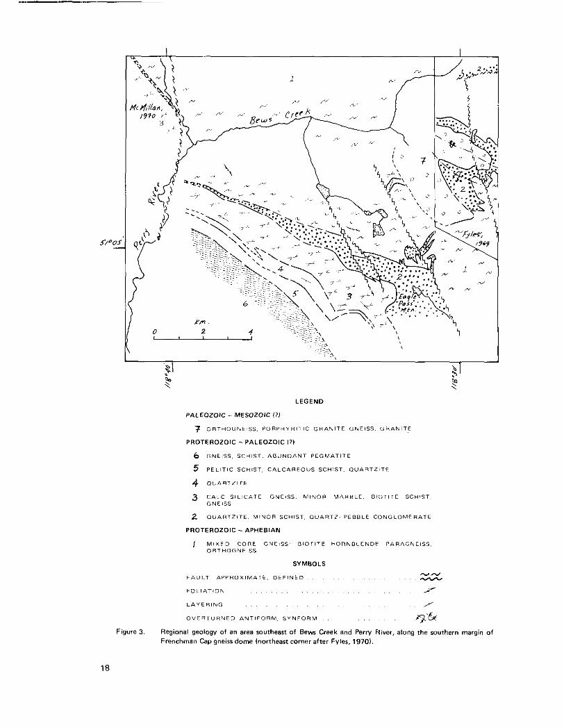
The Bews Creek area (Fig, 3) is located southeast o f the confluence of Bews Creek and Perry River, 25 kilometres west-northwest of Revelstoke. Access to the western part of the area is provided by a logging road that follows the Perry River, while the southern part is reached by a logging road ;along Crazy Creek. The area was mapped in eight days; two days of logging road geology and a swdav fly-camp.
The area was investigated in order: (1) to attempt to t ie together, both stratigraphically and structurally. the Jordan River area (Fyles, 19701 with the Perry River area (McMillan, 19731: (2) to attempt to confirm the structural and stratigraphic interpretation of the Jordan River area by Hoy and McMillin (1979): and (3) to assess the potential for stratabound lead-zinc and carbonatite occurrences which occllr elsewhere along the margins of Frenchman Cap gneiss dome.
The Bews Creek area is underlain by gneissic rock which correlates with core gneisses of Frenchman ,Cap
gneiss dome (units A and B of Wheeler, 1965). and an overlying succession constituting it basal quartzite, a calc-silicate gneiss unit, a second quartzite, and finally a mixed pelitic and calcareous sequence. This 'suc- cession correlates reasonably well with those established elsewhere in the mantling rocks of the dome.
STRATIGRAPHY
Unit 1 comprises well-layered hornblende gneiss, minor amounts of amphibolite and biotite gneiss, and rare
calc-silicate gneiss. A granitic orthogneiss occurs in the vicinity of the interference fold siructure shown on Figure 4. Unit 1 is continuous in the southeast part of the maparea with unit 10 of Fylm (1970). Unit 10 of Fyles was tentatively correlated with core gneisses (Hoy and McMillan, 1979, Fig. 8) and this correlation
is in accord with the present study.
A white, relatively pure quartzite (unit 21 overlies unit 1. It is several hundred metres th.ck north of Eagle
Pass Mountain (Fig. 3) but thins to only a few metres near Bews Creek, 8 kilometres to the northwest. A prominent quartz pebble conglomerate occurs near i t s base and micaceous quartzite lilyers are common in the Eagle Pass Mountain area.
Diopside-rich calc-silicate gneiss, biotite gneiss, impure marble, and a granular, calcite-cemented quartzite (unit 31 overlie the basal quartzite. Unit 3 is overlain by a second quartzite (unit 4). thtit is lithologically similar to unit 2, then by a heterogeneous succession comprising quartz feldspar gneiss and pelitic schist with minor amounts of calc-silicate gneiss and quartzite (unit 5).
Overlying pegmatite-laced rocks (unit 6; unit E of Wheeler, 1965) consist of well-layered biotite-hornblende gneiss, pelitic gneiss, quartz feldspar gneiss, and minor quartzite. calc-silicate gneiss, and marble. Unit 6 rocks are tectonically separated from the underlying metasedimentary rocks by a southwest-dipping fault
(as predicted by R. L. Brown, personal communication, 1979).
17
L
LEGEND
PALEOZOIC - MESOZOIC I ? )
7 O R T H O G N E I S S . P O R P H Y R l T I C G R A N I T E G N E I S S . G R A N I T E
PROTEROZOIC - PALEOZOIC I?)
6 G N E I S S S C H I S T . ABUNDANT P E G M A T I T E
5 P E L I T I C S C H I S T . CALCAREOUS SCHIST. O U A R T Z I T E
4 O V A R T T I T E
3 C A L C S I L I C A T E GNEISS. M I N O R M A R B L E . B I O T I T E SCHIST G N E I S S
2 O U A R T Z I T E . MINOR SCHIST, O U A R T Z ~ P E B B L E C O N G L O M E R a T t
PROTEROZOIC - APHEBIAN
I M l X E D C O R E GNEISS B I O T I T E HORNBLENDE P A R A G N E I S S ORTHOGNEISS
SYMBOLS
FI IUL.7 A P P R O X I M A T E . D E F l N E D
F O L l A T i O N . . . . . ry L A " E R I N G /
" - O V E R T U R N E D A N T I F O R M . S Y N F O R M . . 9 G
Figure 3. Regional geology of an area southeast of Bern Creek and Perry River, along the southern margin of Frenchman Cap gneiss dome (northeast corner after Fvler, 1970).
18
Unit 7, described as a porphyritic granite gneiss by Fyles (1970). was not visited. I t s eastern contact is taken from Fyles (1970) and i t s southwestern contact from Wheeler (1965).
Correlation of the Bews Creek succession with sequences established elsewhere along the margin of French- man Cap dome is relatively straightforward. The succession, consisting of basal quartzite, calc-silicate gneiss
and biotite gneiss, a second quartzite, and an overlying somewhat pelitic anu calcareous sequence, is recog- nized on the northwestern margin IHoy. 1979a). western margin (McMillan. 1973). and eastern margin
(Brown and Psutka. 1979). A similar stratigraphic succession is inferred (Hoy and McMillan, 1979) in the more complex Jordan River area (Fyles, 1970).
The core gneisses may represent Lower Proterozoic Aphebian crystalline basement. Samples of both (core
paragneiss and orthcgneiss from the eastern side of Frenchman Cap, collected by R. L. Brown, have yielded dates of approximately 2.1 Ga (R. L. Armstrong, personal communication, 1979). A basil quartzite, loc:ally
containing quartz pebble conglomerate, overlies core gneisses around the entire margin of the dome. Fur- thermore, in one locality fragments of gneissic rocks believed to be core gneiss clasts lie in the quari.zite near its base (Fig. 5). The margins of these fragments are diffuse and the only recognizable structure within them, the penetrative mineral foliation, parallels that of both the surrounding quartz~te and underlying
gneiss. The fragments are inferred to have a sedimentary origin, but it is possible that they have a structural origin. They could represent a fragmented impure sedimentary layer near the base of the quartzite or
perhaps a fragmented early fold nose. There are no features typical of boudinaging adiacent to the f rag ments and i t is suggested that they are clasts of basement gneiss incorporated in the quartzite during i ts deposition.
The age of basal quartzite and overlying metasedimentary succession is not known. They nay be correlative with the Middle and Upper Proterozoic Purcell Supergroup as suggested by Read (1979). or with the Upper Proterozoic Windermere Group or the Lower Paleozoic platformal succession exposed to the eas,t as suggested by a number of authors including Wheeler (1965). Fyles (1970). and Hoy and McMillan (19.791. They do not closely resemble any of these successions. Based on the platformal nature of the Frenchrnan Cap succession, correlation with the Upper Purcell Supergroup or the Lower Paleozoic lieems most likely.
STRUCTURE
The axial surface of an anticlinal fold trends west-northwest through the area. It is the western extens,ion of an early fold described by Hoy and McMillan (1979) that opens in the south and clo;es to the north in
the Jordan River area. Unit 1, correlated with core gneisses, occurs in i t s core and the overlying success,ion
is. in part, repeated on i ts limbs.
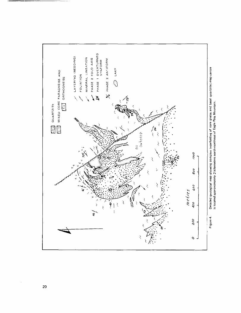
Minor structures are common in all outcrops. Mineral lineations plunge a t varying angle; to the southwest
throughout the area. They are interpreted to parallel fold axes of the earliest recognized folds and in the instances where early folds can be clearly documented by interference structures mineral lineations lie parallel t o the early fold axes. The prominent foliation is axial planar to these early (phase 1 ? ) minor folds. Relatively open to very tight (phase 2 ? ) minor folds that deform the foliation are present in most out- crops. Their axes generally trend southwesterly subparallel to the phase 1 (?) mineral lineations and their
axial surfaces are upright t o west dipping. Interference patterns between phase 1 and phase 2 folds, which are common on outcrop scale (Fig. 5). may also occur a t map scale (Fig. 4) .
19
20
Figure 5 . Detail of interference of Phase 1 and Phase 2 minor folds inwlving core gneiss (no pattern) and bitrat quartzite b i t 21. Note sharp contact between core and quartzite and c lam (?I of core gneiss near bare of quartzite (see discussion in text).
21
SUMMARY
A succession of metasedimentary rocks overlies with apparent conformity gneissic rocks correlative with core gneisses of Frenchman Cap dome. Both core gneisses and the overlying succession are complexly interfolded by at least two phases of deformation. An early (?) northwest-trending anticlinal fold dominates the structure of the area, repeating the stratigraphic succession in the south, but phase 2 minor folds are the most conspicuous folds on outcrop scale.
Stratabound lead-zinc deposits and showings occur elsewhere a t a number of horizons within the meta- sedimentary cover rocks (Hoy and McMillan, 1979; Hoy, 197913). The calcareous succession immediately
above the basal quartzite (unit 3) hosts the Cottonbelt (Hay, 1979a) and King Fissure (Boronowski, 1976) deposits further north, but no lead-zinc mineralization was seen in this succession in the Bews Creek area. A stratiform carbonatite layer containing anomalous concentrations of niobium and other rare earths occurs in the Perry River (McMillan and Moore, 19741 and Cottonbelt (Hoy, 1979b) areas within rocks
correlative with unit 3. Nepheline syenite and syenite intrusions occur in Perry River and Jordan River areas. Neither the carbonatites nor the nepheline syenites were seen in the Bews Creek area.
ACKNOWLEDGMENTS
I was ably and cheerfully assisted in the field by Peter Mustard. W. J. McMillan spent several days in the field with me, and many ideas presented in this note developed through discussion with him, and as a con- sequence of our joint paper in Geological Fieldwork, 1978.
REFERENCES
Boronowski, A. J. (1976): Geological and Geochemical Report on the King Fissure Creek Project, Revelstoke Mining District, E.C. Ministry of Energy, Mines & Pet. Res., Assessment Report 6229.
Brown, R . L. and Psutka. J. F. (1979): Stratigraphy of the East Flank of Frenchman Cap Dome, Shuswap Complex, British Columbia in Current Research, Part A, Geol. Surv., Canada, Paper 79-l A, pp. 35,
36. Fyles, J. T. (1970): The Jordon River Area near Revelstoke, British Columbia, B.C. Ministry of Energy,
Mines& Pet. Res., Bull. 57, 64 pp. Hay, T. (1979al: Cottonbelt Lead-Zinc Deposit (82M/7). E.C. Ministry of Energy, Mines& Pet. Res., Geo-
logical Fieldwork, 1978, Paper 1979-1. pp. 18-23.
.......... (1979b): Stratigraphic and Structural Setting of Stratabound Lead-Zinc Deposits in the Shuswap
Complex (Abstract), Cordilleran Section, Meeting, Geol. Assoc. Canada, Vancouver, p. 18. Hay T. and McMillan, W. J. (1979): Geology in the Vicinity of Frenchman Cap Gneiss Dome, B.C. Ministry
of Energy, Mines& Pet. Res., Geological Fieldwork, 1978, Paper 1979.1. pp, 25-30. McMillan, W. J. (1973): Petrology and Structure of the West Flank, Frenchman's Cap Dome, near Revel-
stoke, British Columbia, Geo/. Surv., Canada, Paper 71-29.
McMillan. W. J. and Moore, J. M. (1974): Gneissic Alkalic Rocks and Carbonatites in Frenchman's Cap Gneiss Dome, Shuswap Complex, British Columbia, Cdn. Jour. Earth Sci., Vol. 11, pp. 304-318.
Wheeler, J. 0. (1965): Big Bend Map-area, British Columbia, Geol. Surv., Canada, Paper 64-32. Read, P. 6. (1979): Relationship between the Shuswap Metamorphic Complex and Kootenay Arc, Vernon
East-half, Southern British Columbia, in Current Research, Part A, Geol. Surv.. Canada, Paper
79-lA, pp. 37-40.
22
CK PROSPECT
SHUSWAP METAMORPHIC COMPLEX
(82M/13E)
By T. Hoy
INTRODUCTION
The CK property includes a number of lead-zinc showings apparently confined to one stratigraphic lever. It is located between Ritchie Creek and Raft River, 37 kilometres north of Vavenby. The area is accessible by a well-maintained logging road branching north from Highway 5, 3 kilometres east of Clearwater and following Raft River.
The Main Boulder and part of the New showings were discovered by Andy Horne. the present owner, in
1973 and optioned by Rio Tinto Canadian Exploration Limited in 1974. A regional soil sampling proGIram by Rio Tinto in 1974 led to the discovery of a massive sulphide exposure, the North showing, and outlined an anomalous zone in the New showing and Main Boulder area. The North showing w a explored by geo- physical methods and subsequently drilled. Four short holes in the Main Boulder area and one in the New
showing failed to intersect significant massive sulphide mineralization (Assessment Report 5192). 'Two additional holes in the North showing intersected some lead-zinc mineralization; the bcltter assayed inter- section returned 3.98 per cent zinc, 0.71 per cent lead, 0.01 per cent copper, 0.18oun-e per tonne silver,
and 0.007 ounce per tonne gold over an approximate 1-metre thickness (Assessment Report 5631).
Cominco Ltd. optioned the property in 1978 and carried out geochemical and geophysical surveys and
trenching which led to the discovery of mineralized exposures in the Main Boulder, New, and Mist a!-eas. The company drilled 20 holes in 1978 and an additional 18 in 1979. This drill program concentrated on the New showing and to a lesser extent on the Main Boulder showing.
Five days were spent on the property in August 1979. visiting the showings and loggillg the core drilled to that time (drill hole 79-12). During this time I was cheerfully assisted by Peter Mustard. The co- operation and hospitality of Cominco Ltd. is gratefully appreciated, Access to its maps ;and reports proved
most useful, and discussions with Mike Murrel. G. Benvenuto, and Fred Gill were both stimulating and informative.
GEOLOGY
The area is underlain by metasedimentary rocks of the Shuswap Metamorphic Complex (Campbell, 19631. These include quartz feldspar4iornblende gneiss, amphibolite, calc-silicate gneiss and minor quartzite, and marble of unknown but probable Paleozoic age. Pegmatite is abundant. A fine to medium-grained grariitic intrusive rock is present in the west part of the area (Fig. 6, personal communication, G. \Yhite).
The general succession in the area includes well-layered hornblende gneiss and amph bolite exposed in canyons in the creek west of Raft River (Fig. 6) which are structurally overlain by a calcareous succes;ion that includes the sulphide layer, and then by a quartz feldspar gneiss and pelitic schist succession exposed in scattered outcrops on the hills east of the New showing (personal communications with Cominco
geoloyists). The Main Boulder showing is assumed to be the same sulphide layer that occurs in the New showing, inferring the presence of a fault in the creek separating them.
23
Figure 6. Location map showing mineralized exposures and trends of CK mineralization (after Cominco Ltd.), and some structural data (this report and unpublished data from G. Whitel.
The general structure of the area appears to be relatively simple with an east-facing succession folded into
a broad open, east-plunging (phase 3 ?) synformal structure with the New showing trending southeast on the southern limb and the North and Mist trending northeasterly on the northern limb. However, at out- crop scale and drill-section scale structures are very complex resulting in local dip reversals and repetition and omission of lilhologies. These complexities are due primarily to relatively late (phase 2 and phase 3) folding and late faulting. Minor folds related to the late (phase 3 ?J structure have upright axial planes and plunge variably to the east and west. Earlier, southeast-plunging (phase 2 ? J folds are noticeable at outcrop scale. They have a pronounced lineation parallel to their fold axes, are relatively open to quite tight, and
postdate the regional metamorphism. These folds are responsible for the flattening and apparent thickening of the sulphide layer at the New showing (see drill section, Fig. 7) and may be important elsewhere in locally thickening the sulphide layer. An earlier syn-metamorphic deformation (phase 1 ) i s indicated by the
parallelism of a regional foliation with bedding. Its effect on the distribution of lithologies is not known.
24
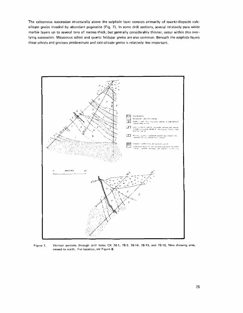
The calcareous succession structurally above the sulphide layer consists primarily of qu~tz-diopside calc- silicate gneiss invaded by abundant pegmatite (Fig. 7). In some drill sections, several rehtively pure white
marble layers up to several tens of metres thick, but generally considerably thinner, occur within this over.
lying succession. Micaceous schist and quartz feldspar gneiss are also common. Beneath the sulphide layers these schists and gneisses predominate and calc-silicate gneiss is relatively less important.
Figure 7. Vertical Sctions through drill holes CK 78-1, 78-3. 78-14, 78-15. and 78-16, New rhowing area. vlewed to north. For 1ocation.see Ftgure 8.
25
The sulphide layer in the New showing is generally less than 1 metre thick and appears to be continuous, with perhaps minor structural breaks and offsets, for a distance of a t least 1 300 metres from drill holes
78-8 to 78-19 (Fig. 8). It is also intersected in holes 79-1 1, 78.14. and 78-15, a further 800 metres to the north. It consists of massive sphalerite and pyrrhotite, minor galena. and trace chalcopyrite. Gangue quartz. diopside, calcite, amphibole, and plagioclase are common. Fluorite and vesuvianite occur locally. The con- tacts of the sulphide layer may be sharp or gradational through several metres of siliceous marble containing disseminated sphalerite and pyrrhotite. In a few holes a thin, well-layered diopside-bearing quartzite occurs structurally beneath the sulphide layer.
A 20 to 30-centimetre-thick sulphide layer at the North showing is on strike with a similar layer a t the Mist showing several hundred metres to the southwest. Structural complexities a t the Boulder showing hinder tracing a small trenched outcrop of massive sulphides for more than a few metres. It was not intersected in any of the holes drilled here.
Assays of both chip and grab samples of the sulphide layer and of a sample of mineralized marble from the Boulder showing are presented in the accompanying table. Average grades of the massive sulphide layer and immediate wallrocks reported by Cominco Ltd. range between 1 to 3 per cent lead and <5 t o 15 per cent
copper varies from 0.02 to 0.057 per cent and cadmium from <0.01 to 0.025 per cent.
zinc. The leadilead + zinc ratio varies from 0.1 to 0.2. Silver and gold are present in only trace amounts,
ASSAYS, CK PROPERTY
Showing
Main Boulder Main Boulder Main Boulder
New Main Boulder
North New
Mist
Sample Type
grab am pie 119741 grab sample 119141 grab sample 0.6 metre chip 0.6 metre chip
0.6 metre chip 0.6 metre chip
0.6 metre chip
per cen1 Pb
4.50 1.45
6.31 4.88 4.19 4.41 0.81 2.66
2" Fe per cent per cent ppm
C"
27.1 5 8
23.37 23.45
7.76 14.34
247 423
25.20 21.85 20.84
12.24 408 568
19.44 11.33
515 512
~~~~~~ <0.001 0.045 ......
8.95 20.70
ppm
Cd
..~.~. ".... 252 260 255 203
230 81
SUMMARY
Sphalerite, pyrrhotite, and minor galena occur in a massive sulphide layer generally less than 1 metre thick but locally may be several metres in thickness. This layer appears to be continuous for a t least 1 300 metres
and probably considerably further. Local structural complexities and lack of outcrop hinder tracing the layer between showings. Surrounding rocks include a dominantly calc-silicate gneiss, micaceous schist, and
quartz feldspar gneiss succession, laced by pegmatite.
The CK showings are similar in many aspects to other Shuswap lead-zinc deposits. They are thin layers but commonly very continuous and occur in a calcareous and pelitic succession. Quartzite and marble, common associated lithologies in the Cottonbelt, Jordan River, and Big Ledge successions, are less common a t CK and Ruddock Creek.
REFERENCES
B.C. Mjnistry of Energy, Mines & Pet. Res., Assessment Reports 51 92 and 5631 Campbell, R. E. (1963): Adams Lake, British Columbia, 82MiW. Geol. Surv., Canada, Map 48-1963
26
/ \
1
Figure 8. Drillrites in New rhowing and Main Boulder area (based after Corninco Ltd. data).