APPROVED ' ABTOFOAM LAW DEPT. BRAMPTON /YJ.4--v- . II Itt THE CORPORATION OF THE CITY OF BRAMPTON Number' 3.'- 2-00" To Adopt Amendment Number OP 2006- 033 To the Official Plan of the City of Brampton Planning Area The Council of The Corporation of the City of Brampton, in accordance with the provisions of the Planning Act, R.S.O. 1990, c.P. 13, hereby ENACTS as follows: 1. Amendment Number OP 2006 - 033 to the Official Plan of the City of Brampton Planning Area for Chapter 48(b) of the Countryside Villages Secondary Plan Area 48 is hereby adopted and made part of this by-law. READ a FIRST, SECOND and THIRD TIME, and PASSED in OPEN COUNCIL, this 1tk dayof 009 . Adri It I MCIP, RPP Director, Planning and Land Development Services
Transcript
APPROVED ' ABTOFOAM
LAW DEPT. BRAMPTON
/YJ.4--v- . DATE}.?~ II Itt
THE CORPORATION OF THE CITY OF BRAMPTON
BY~LAW
Number' 3.'- 2-00" To Adopt Amendment Number OP 2006- 033
To the Official Plan of the City of Brampton Planning Area
The Council of The Corporation of the City of Brampton, in accordance with the
provisions of the Planning Act, R.S.O. 1990, c.P. 13, hereby ENACTS as
follows:
1. Amendment Number OP 2006 - 033 to the Official Plan of the City of
Brampton Planning Area for Chapter 48(b) of the Countryside Villages
Secondary Plan Area 48 is hereby adopted and made part of this by-law.
READ a FIRST, SECOND and THIRD TIME, and PASSED in OPEN COUNCIL, this 1tk dayof Dec.em~ 009 .
Adri It I MCIP, RPP Director, Planning and Land Development Services
AMENDMENT NUMBER OP 2006 - 013 to the Official Plan of the
l.c)~ti()" ....•.•.•.•••••••••••..••••••...•..•.••••.••••••..•••.......••...................•.. Effect of this Chapter and its Relationship to the Official Plan •••••••••• Goals and Objectives •••.•••••••••••••••••••••• 1 ••••••••••••••••••••••••••••••••••••••••••
Development Policies ••••.•••••••••••....•....•..•••.•••••••••••••••••••••••••••••••••••. 5.0 General Provisions •••.•••••••••••••••••••••••••••••••••••••••••••••••••••••••••• 5.1 FlEt!Siclt!ntiEaI........................................................................ !i.:Z Commercial....... ................................ .......................... .... ... 5.3 Natural Heritage and Environmental Management.................. 5.4 Recreational Opt!n Space................................................... 5.5 In~itlJti()I1IlI ......................................................................... 5.Ei
Special Policy Art!8!S .....•••••••••••••••.•.•.••...••••••••••••••••••••••••••••••••••••••• 6.0 Special Policy Area 1 ..•••••••••••••••••••...••.................................. 6.1 Special Policy Area 2 ••••..•.•••••••••••••••••••••••••••••.••••..••••••••.••••••• 6.2 Spt!cial Policy Area 3 ............................................................ 6.3
Servicing and Environmental Considerations •••••••••••••••••••••••••••••••••• 8.0 Sanitary Sewage/W ater Supply .............................................. 8.1 Storrnwater Management..................................................... 8.:Z Noise and Vibration............................................................ 8.3 F'()tEtrttiEllllf C:()rttamirtEltEtci !;ites •••••••••••••••••••••••••••••••••••••••••••••• 8.4 Public Utilities and Communications.................................... 8.5
C:LlltLirElI ~erilll!Je........................................................................ Et.O Community Block Plan •...••••••••••.•••••••.•••...••••••••.••••....•...•••..•••••••..•• 10.0
General Provisions •••••••••••••..•••••••••••••••••••••••••••••••••••••.••••.•••• 10.1 Design Objectives............................................................... 10.:Z Community Structure .............................................. ~........... 10.3 Village Core...................................................................... 10.4 Open Space System............................................................ 1 0.5 Street Network................................................................... 10.6 Streetscape ........................................................................ 10.7 Edges and Gateways......................................................... 1 0.8 Eiuilt F=orl1l ........................................................................... 10.Et LEED •••••••••••••••••••••••••••••••.•••••.•••.•••••••••••••••••••••••••••••••.••.•.•• 10.10
Community Dt!sign Guidelines •••••••••••••.••••••••••••••••••••••••.•••••••••••••••• 11.0 Implementation •.•••••.••.•....•..•••....••••..•••.••..•...•••••...•••.•••••••••••••••••••• 12.0
General Provisions .............................................................. 12.1 GrQwth M~nagement •••••••••••••.•••••••••••••••••••••••••••••••...•......••••• 12.2 Small Holdings •••••••••.••••••••••••..•••••••••••...•••••••••••••••.•••••••••••••• 12.3 Cost Sharing ........................................................................ 12.4 Alternative Development Standards ••••••••••••••••••••••••••••••••••••••••• 12.5 Sustainability •••••••••••••••••••••••••••••••••••••••••• ' •••••••••••...••.••••••••••••• 12.6
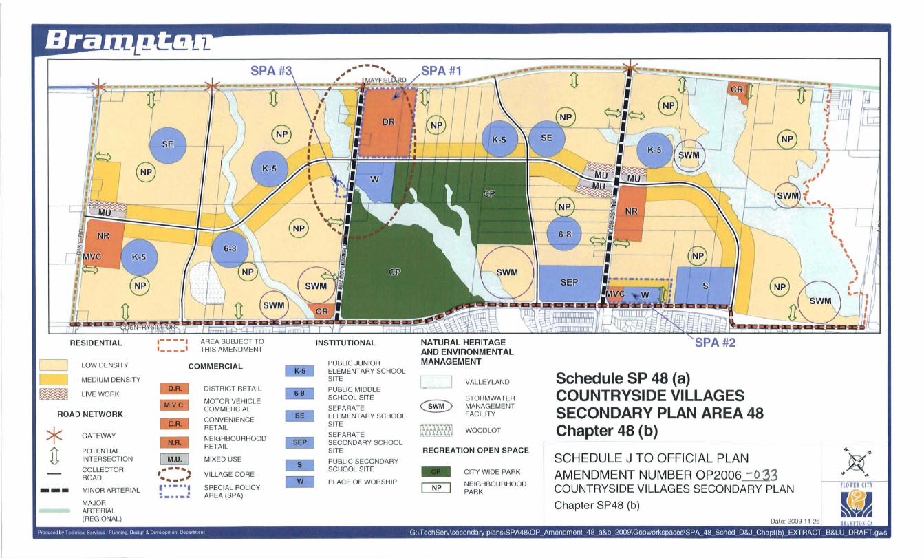
The purpose of this amendment, together with Schedule SP48(a), is to implement the policies of the Official Plan for the City of Brampton Planning Area, by establishing, in accordance with Section 5.4 of the Official Plan and the City's Growth Management Program, a policy framework and direction for detailed land use planning to guide the future development of a new community in the City of Brampton as outlined on Schedule SP48(a), and to specify desired land use patterns, a transportation network, a protected natural heritage system, and related policies to achieve superior quality, efficient, orderly and ecologically responsible urban development. Further, it sets out the development controls to be used to implement these policies at the block planning and subdivision stages of approval. This amendment will establish Chapter 48(b) of the Official Plan, as the Countryside Villages Secondary Plan.
Countryside Villages Secondary Plan shall be planned to accommodate a minimum of 50 persons and jobs per hectare in accordance with the Growth Plan density target for Greenfield areas. '
2.0 LOCATION
The lands subject to this amendment comprise an area of about 487 hectares (1,203 acres) and are bounded by Mayfield Road to the north, the easterly edge of the West Branch West Humber Tributary F to the east, Countryside Drive to the south and Dixie Road to the west. The lands are within an area described as Part of Lots 16 and 17, Concessions 4, 5, and 6, EHS, in the Geographic Township of Chinguacousy, now in the City of Brampton. The lands subject to this amendment are specifically indicated on Schedule SP48(a) to this amendment.
3.0 AMENDMENT AND POUCIES THERETO
3.1 The document known as the Official Plan of the City of Brampton Planning Area is hereby amended:
i) by changing on Schedule "1", CITY CONCEPT thereto, the designations of "OPEN SPACE" to "COMMUNITIES" as shown on Schedule 'A' to this amendment;
ii) by changing on Schedule 'A', GENERAL LAND USE DESIGNATIONS thereto, the designations "OPEN SPACE" to "RESIDENTIAL" as shown on Schedule 'B' to this amendment;
iii) by adding to Schedule A2, RETAIL STRUCTURE thereto, the retail designations shown on Schedule C to this amendment;
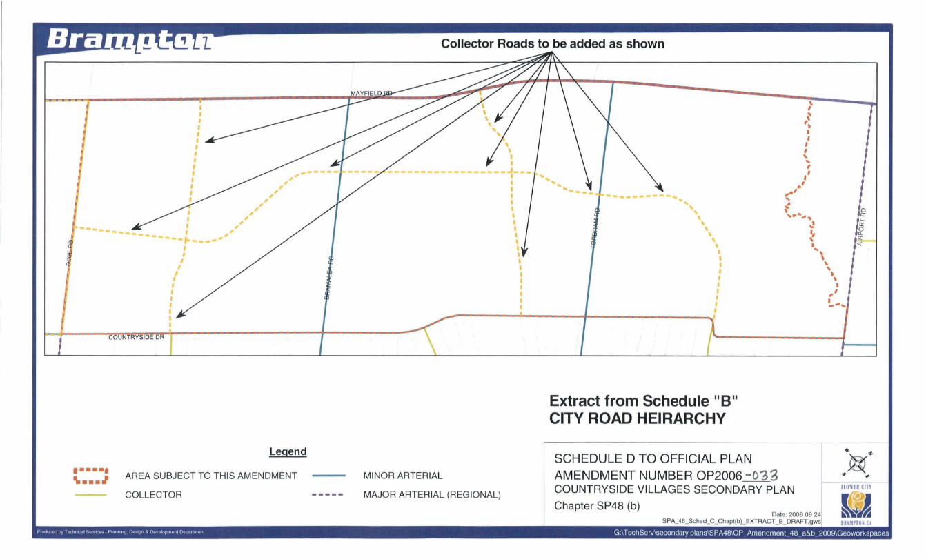
iv) by adding to Schedule 'B' & 'B1' CITY ROAD HIERARCHY and CITY ROAD RIGHT OF WAY WIDTHS thereto, the "Collector Road" rights-of-way and alignments as shown on Schedules '0' and 'E' to this amendment;
3
v) by deleting on Schedule '0' NATURAL HERITAGE FEATURES AND AREAS thereto, the "ValleylandlWatercourse" designations as shown on Schedule 'F' to this amendment;
vi) by adding to Schedule 'E' MAJOR RECREATIONAL OPEN SPACE thereto, the "City Wide Park" designation as shown on Schedule 'G' to this amendment;
vii) by changing on Schedule 'G' SECONDARY PLAN AREAS thereto, the boundaries and related titles of Secondary Plan Area 48 as shown on Schedule 'H' to this amendment;
viii) by changing on Schedule 'H' COMMUNITY BLOCK PLAN AREAS thereto, the boundaries and related titles of the Community Block Plan Areas as shown on Schedule 'I' to this amendment;
ix) by deleting therefrom, in Part II: SECONDARY PLANS under the heading "Area 48: Sandringham-Wellington North", all of the text and schedules and substituting thereof the following: "Part II, Chapters 48 (a) & (b) of the Brampton Official Plan shall constitute the CountrySide Villages Secondary Plan";
x) by adding to Part II, SECONDARY PLANS thereof, as Schedule "SP48(a)", of Chapter 48(b), Schedule 'J' to this amendment;
xi) by adding to Part II, SECONDARY PLANS thereof, as Chapter 48(b), the following text:
xi) "Chapter 48(b): THE COUNTRYSIDE VILLAGES SECONDARY PLAN (Official Plan Amendment OP2006-033 )
1.0 PURPOSE
The purpose of this amendment, together with Schedule SP48(a), is to implement the policies of the Official Plan for the City of Brampton Planning Area, by establishing, in accordance with Section 5.4 of the Official Plan and the City's Growth Management Program, a policy framework and direction for detailed land use planning to guide the development of a new community in the City of Brampton as outlined on Schedule 48(a). This amendment specifies desired land use designations, a transportation network, a protected natural heritage system and related policies to achieve superior quality, efficient, orderly and ecologically responsible urban development inspired by principles of sustainability and LEED Neighbourhood Design principles. Further, it sets out the development controls to be used in implementing these policies at the block planning and subdivision stages of approval. This amendment will establish Chapter 48(b) of the Official Plan, as the CountrySide Villages Secondary Plan.
The Planning Vision for Countryside Villages is for a distinct community incorporating the concepts of "new urbanism" where neighbourhoods are planned to be
4
pedestrian friendly and transit supportive. The Planning Vision sets out the framework for the development of a new community in terms of the following major structural elements:
i) protecting, enhancing, restoring and linking the natural heritage areas and features, and developing open space networks and views and vistas;
ii) a well ordered street network with an east-west collector spine and north-south mid-block collectors, linking the community to the rest of the City and encouraging walkable and transit supportive design;
iii) creating a Main Street along the east-west collector road that runs through the center of the community which is designated for higher density forms of ground floor orientated housing and will have higher frequency transit service;
iv) creating Community Nodes, Edges and Gateways;
v) appropriate built form transitions between land uses;
vi) Distinct connections between neighbourhoods and their surroundings;
vii) green space and natural heritage features as a focus of neighbourhood centres;
viii) a variety of built forms and land uses; ix) Mixed-Use areas consisting of residential,
commercial, retail and institutional uses located at the intersection of collector roads to serve local area residents;
x) a street network balancing function and urban design that supports the delivery of higher frequency transit services; and,
xi) centrally located amenities /intensity of uses in key areas/corridors.
The Planning Vision for Countryside Villages is in keeping with the overall principles of the sustainable City Concept in the Official Plan. The concept of sustainable development promotes a holistic approach to land use planning to achieve a balance between the social and economic needs of the community, and environmental conservation. To Implement this vision, altemative development standards may be implemented at key locations that include rear laneways" turning circles, bikeway facilities and reduced road right-of-ways. Accordingly, the financial implications and acquisition of specialized machinery and equipment that may be required to provide municipal services, within a neighbourhood based on altemative development standards must be addressed at the block plan stage of approval.
Countryside Villages as a whole shall be planned to accommodate a minimum of 50 persons and jobs per hectare in accordance with the Growth Plan density target for Greenfield areas.
5
3" I - 2.OCJcr
2.0 LOCATION
Chapter 48(b) comprises an area of 487 hectare (1203 acres) and are bounded by Mayfield Road to the north, the easterly edge of the West Branch West Humber Tributary F to the east (west of Airport Road), Countryside Dive to the south and Dixie Road to the west as outlined on Schedule SP48(a). The lands are within an area described Part of Lots 16 and 17, Concessions 4, 5 and 6 EHS, in the former Township of Chinguacousy, now in the City of Brampton, as . shown on Schedule SP48(a).
3.0 EFFECT OF THIS CHAPTER AND. ITS. RELATIONSHIP TO THE OFFICIAL PLAN
Lands subject to Chapter 48(b) outlined on Schedule SP48(a) shall be developed in accordance with the policies of this Chapter and with Schedule SP48(a) attached thereto, and also in accordance with all other relevant policies and schedules of the City of Brampton Official Plan.
Accordingly, this Chapter should not be interpreted as a free standing Official Plan document. The poliCies herein are designed to supplement those of the Official Plan, not to replace or repeat them. An accurate understanding of all the policies pertaining to this Chapter can only be achieved by reading the overall Official Plan together with Chapter 48.
4.0 GOALS" OBJECTIVES
4.1 Planning Principles
The planning principles that have guided the development of detailed policies of this Chapter are based on an ecosystem approach to land use planning, which the City of Brampton supports in its Official Plan. The Planning Vision set out herein reflects, to the greatest extent practical, an ecosystem approach to planning.
As well, this Chapter is also based on the objectives of the Growth Plan related to the planning of designated Greenfield areas including the creation of complete and compact communities, support of walking/cycling and transit, providing a diverse mix of land uses, provision of high quality public open spaces and provision of a development pattern and densities that are largely transit supportive.
The Planning Vision for Chapter 48(b) is to protect diversity of the area's natural heritage areas and features and their ecological functions, including valleys, streams, woodlands, wetlands, habitats and other significant elements that constitute the ecosystem. The relationship among the natural elements is based on the principle of ecosystem planning. The predominant form of development proposed for this community is ground floor orientated housing, with increased intensity of built form along
6
,.' - .. !-
310 f - '2.0oDJ
the east-west collector road that runs through the centre of the community, and at specific nodes and gateways. The built form include$ a recreational open space network that is integrated with the natural heritage system, as appropriate.
Together with Section 3.2 (Sustainable City Structure) of the Official Plan, the goals and objectives, which are founded on the Planning Vision and presented below, provide a sustainable planning e framework for the development of the Countryside Villages Secondary Plan. These goals and objectives will be implemented in accordance with Section 12 of this Chapter.
4.2 Goals
The goals of the Countryside Villages Secondary Plan are to:
4.2.1 Create a sustainable community that protects, restores and enhances, the diversity of natural features and their ecological functions;
4.2.2 Coordinate the staging and sequencing of development in conjunction with the provision of infrastructure including sanitary sewers, water distribution, stormwater management facilities, roads and utilities and services required to support growth, in accordance with the City's Growth Management Program;
4.2.3 Provide a residential community that is compatible with, and will benefit from, the visual and environmental features of the area's natural landscape through a built form that responds to and frames views and vistas;
4.2.4 To develop excellence in community living based on the application of the following principles:
i) a well-balanced community in terms of an appropriate mix and distribution of residential denSities, housing forms and complementary uses;
ii) creation of a healthy, livable, pedestrian friendly and sustainable community;
iii) implement urban design and built form principles from the LEED NO (Neighbourhood Design) program, where feasible;
iv) the promotion of excellence and strong character in civic design in both the public and private realm;
v) an interconnected network of open space, including recreational areas and natural heritage areas and features;
vi) a range of recreational and community facilities that facilitate shared use where practical;
vii) integration of new development with existing neighbourhoods to the south in Secondary Plan Area 28 and roads adjacent to the new
7
community through appropriate built form, road connections and linkages;
viii) an attractive and ordered built form of appropriate building heights, massing, setbacks, streetscapes,. gateways and architectural treatments; and,
ix) efficient transportation links for pedestrians, bicycles, transit and motor vehicles.
4.2.5 To implement the Countryside Villages Secondary Plan by:
i) coordinating the phasing of development with the provision of municipal services. in accordance with the City's Growth Management Program; and,
ii) achieving financial sustainability through the provision of municipal services in an efficient and financially prudent manner.
4.3 Objectives
Considering the goals outlined in the Official Plan and those set out in Section 4.2 of this Chapter, the following objectives constitute the basis for the formulation of Chapter 48(b) of the Countryside Villages Secondary Plan:
i) to identify, protect, enhance, and restore the Secondary Plan Area's natural heritage areas and features, focusing on the existing woodlands, valleys, wetlands and Provincially Significant Wetlands;
ii) to ensure that municipal and public and private services required for development of any portion of Chapter 48(b) , including components of the transportation system and municipal servicing, are provided in an orderly, cost effective and timely manner, in accordance with the City's Growth Management Program;
iii) to work jointly with Peel Region to coordinate the provision and timing of capital works;
iv) to promote financially self-supporting development using the strategic implementation of the following measures: growth management, development charges and cost sharing agreements as and where appropriate;
v) to create a well-balanced and structured community, accommodating an appropriate variety of housing types, retail uses and community facilities;
vi) to create an urban environment that provides for safe, functional and attractive residential neighbourhoods with defined centers and focal points that accommodate a variety of housing types and tenures;
vii) to create mixed-use nodes that support their neighbourhoods;
8
3(01- 'WoO(
viii) to establish urban design guidelines which encourage the development of attractive, safe, and where appropriate, pedestrian-scale built forms within the community;
ix) to establish a consistently superior level of urban design for the public and private realms through the adherence to the principles, policies and requirements of this Chapter;
x) to provide an integrated open space network with a clear functional relationship to the overall City, community and the neighbourhoods served;
xi) to provide opportunities for recreational and functional natural links to the West Humber River Tributaries, to the extent practical.
xii) to enhance the overall traffic capacity of the transportation system by improving the efficiency of the existing road network in conjunction with the construction of new links and improvements within the Secondary Plan;
xiii) to promote connective pathways, trails and onstreet bikeway facilities to assist pedestrian and bicycle accessibility;
xiv) to promote the use of public transit in conjunction with land use policies that will provide the support and ridership for an enhanced transit service;
xv) to encourage the development of a traffic circulation system that enhances personal mobility, travel choices and transit service throughout the Secondary Plan Area and the lands adjacent thereto;
xvi) to create an appropriate transition of built form that recognizes adjacent land uses; and,
xvii) To develop the east/west collector spine road with housing densities that supports a higher level of transit service.
5.0 DEVELOPMENT POLICIES
5.1 General Provision
The development policies for Countryside Villages are founded on the Planning Vision and the Goals and Objectives outlined in Section 4.0 of this Chapter. The basic land use pattern for Chapter 48(b) is outlined in Schedule "A" - Genera) Land Use Designations to the Official Plan as "RESIDENTIAL", and "OPEN SPACE". A more detailed distribution of land use is illustrated on Schedule SP48(a).
5.1.2 Density Target
To ensure conformity with the Provincial Growth Plan and the City's Growth Management objectives, Countryside Villages Secondary Plan shall be planned to achieve a population in the order of 20,000 persons and to provide approximately 7,500 jobs, resulting in a density of 54 persons and jobs per hectare. Implementing zoning and plans of subdivisions shall contain provisions to ensure the achievement of these 'targets.
9
5.2 RESIDENTIAL
5.2.1 General Provisions
5.2.1.1 The various residential designations shown on Schedule SP48(a) are categories in which the predominant use of land is ground floor oriented forms of housing. Proposals for residential development shall be considered in accordance with the policies of the Official Plan and this Chapter.
Complementary uses as set out by Section 4.1.1.1 of the Official Plan subject to their identification in the Secondary Plan or as specifically identified by other designations or policies in this Chapter, shall also be permitted in the various Residential designations provided that they are integrated in an appropriate manner with adjacent residential uses.
5.2.1.2 Where a residential use is proposed adjacent to arterial roads an appropriate built form shall be encouraged through a variety of means including: window streets, flankage conditions, laneway conditions, laneway housing and direct frontage for particular residential typologies. Reverse frontages are generally discouraged but will be considered in specific circumstances during the block plan stage of approval.
5.2.1.3 Where a residential use is proposed adjacent to arterial roads or other noise sources, studies to determine the need for noise attenuation measures shall be completed to the satisfaction of the City of Brampton and the appropriate agencies having jurisdiction.
5.2.1.4 Any proposal for residential development will have regard for the transition and physical integration with adjacent forms of development and effective separation and buffering from major roads, other noise sources or adjacent non-residential uses.
5.2.1.5 Residential lots shall be oriented toward and have primary access to the minor collector and local road network in accordance with the intended street character and shall reinforce a well structured and balanced streetscape.
5.2.1.6 Existing dwellings or buildings located on lands designated for residential development in Chapter 48(b) shall continue to have direct access to an arterial road, until such time as access from an alternative road becomes available or the property is redeveloped.
5.2.1.7 Residential designations adjacent to the natural heritage system shown on Schedule SP 48(b) shall be shaped, oriented, built and developed in a manner
10
that is compatible, complementary and supports the features and functions of the natural heritage system.
5.2.1.8 The illumination of parking facilities shall be directed away from the natural heritage system to minimize disturbance to wildlife, to the greatest extent feasible.
5.2.2 LowlMedium Density Residential
5.2.2.1 In areas designated Low/Medium Density Residential on Schedule 48 (a) , the following shall apply, subject to Section 5.2.1 of this Chapter:
i) Permitted uses include single-detached, semidetached and townhouse structural types;
ii) A minimum density of 19.5 units per net residential hectare (8 units per net residential acre) and a maximum density of 30.1 units per net residential hectare (12 units per net residential acre) shall be permitted.
In addition, approximately 50% of the overall development within the LowlMedium Density Residential designation shall be single structural units. The proportion of single detached structural units shall be determined at the Block Plan stage of approval. In attempting to achieve a minimum 50 persons and job per hectare, the City shall consider minor adjustments to the overall requirement of 50% single-detached structural units at the block plan stage of approval without the need for an amendment to this Chapter.
Umited development of day care centres is permitted without an amendment to the Plan, subject to issues such as land use compatibility, design and interface issues being addressed to the satisfaction of the City with the appropriate performance standards implemented in the Zoning By-Law.
5.2.3 Medium Density Residential
5.2.3.1 In areas designated Medium Density Residential on Schedule SP48(a), the following shall apply, subject to Section 5.2.1 of this Chapter:
i) permitted detached, duplexes, types;
uses include single-detached, semi-townhouse, walk-Up apartments,
triplexes, and townhouse structure
ii) a -minimum density of 30 units per net residential hectare (12 units per net residential acre) and a maximum density of 50 units per net residential hectare (20 units per net residential acre) shall be permitted;
iii) medium density residential is designated on either side of the east-west collector road on Schedule SP48(a). The boundary1 0f the designation shall be interpreted as being approximate and shall be
11
further refined at the Block Plan stage of approval; and,
iv) Notwithstanding the above, high density residential uses in proximity to the intersection of arterial roads may be permitted in this designation in accordance with Section 4.1.1.1 of the Official Plan. Higher density residential will be identified at the block plan of approval stage and the density and related development policies shall be implemented through a block plan initiated official plan amendment.
5.2.4 Live-Work
5.2.4.1 Areas designated Uve-Work on Schedule SP48(a), shall be subject to Section 4.2.14 of the Official Plan, and to the further provisions of this Chapter:
i) permitted uses include townhouse, walk-up apartments, duplexes, office, commercial and limited institutional uses;
ii) the range of institutional will be determined at the block plan stage of approval and implemented through a block plan official plan amendment;
iii) The first floor within any unit within the Uve-, Work designation may be used for commercial,
retail, office or limited institutional uses and must have a reSidential built form and be oriented towards a public road.
5.3 COMMERCIAL
5.3.1 General Provisions
5.3.1.1 In keeping with the hierarchical order of commercial development in the adjacent secondary plans, the commercial designations shown on Schedule 48(a) are intended to fulfill the shopping needs of the community and surrounding area. As such, only those commercial sites designated on Schedule 48(a) shall be permitted.
5.3.1.2 To ensure functionality and land use compatibility, the development of commercial designations on Schedule 48(a) shall be subject to the following policies:
i) enhanced architectural and streetscape treatments, in accordance with the urban design poliCies of this Chapter;
ii) outdoor storage of goods or materials as the principal use shall be prohibited;
iii) provision shall be made to minimize adverse impacts on adjacent residential uses through appropriate siting, orientation and design of buildings, landscaping and buffer treatments.
iv) The illumination of parking facilities shall be directed away from nearby residences to minimize intrusion and glare;
12
v) in addition to on street parking adequate offstreet parking facilities for live-work units shall be provided in accordance with acceptable standards to satisfy the requirements of employees and customers;
vi) gas bars and car washes at major arterial road intersections, Gateway locations and community edges shall not be permitted.
vii) Drive-through facilities are not permitted between buildings and streets or at Gateway locations. Drive-through facilities are not permitted on sites along the east/west collector road and Primary Transit Corridors as shown on Schedule C to the Official Plan.
5.3.1.3 The illumination of parking facilities shall be directed away from the natural heritage system to minimize disturbance to wildlife, to the greatest extent feasible.
5.3.2 Motor Vehicle Commercial
5.3.2.1 In areas designated Motor Vehicle Commercial on Schedule SP48(a), permitted uses include automobile service stations, gas bars a-nd related uses and shall be developed in accordance with Section 4.2.13 of the Official Plan and the policies of this Chapter.
5.3.2.2 Areas designated Motor Vehicle Commercial shall be designed so as to minimize the impact upon adjacent residential uses through appropriate siting, orientation, built form, landscaping and the erection of fences and walls. The iII.umination of parking facilities shall be directed away from nearby residences to minimize intrusion and glare upon adjacent residential properties. Traffic access arrangements shall be established in accordance with the requirements of the City and other road authorities having jurisdiction. Noise considerations will also affect design and shall be taken into consideration at the site plan stage of approval.
5.3.3 Convenience Retail
5.3.3.1 Areas deSignated Convenience Retail on Schedule SP48(a) permit the range of uses and shall be developed in accordance with Section 4.2.11 and other relevant policies of the Official Plan. On Schedule SP48(a), Convenience Retail sites are located in areas not served by Neighbourhood Retail, Live-Work or the Mixed-Use deSignations
5.3.4 Neighbourhood Retail
5.3.4.1 Areas deSignated Neighbourhood Retail on Schedule SP48(a) permit the range of uses and shall be developed in accordance with Section 4.2.11 and other relevant policies of the Official Plan. On Schedule 48(a), Neighbourhood Retail sites are located in proximity to neighbourhood centres as part of Live-Work, mixed-use developments and the medium density residential designation along the
13
east/west collector road. Neighbourhood Retail Sites should be integrated with these structural elements of the community, where practical.
5.3.5 District Retail
5.3.5.1 The area designated District Retail on Schedule 48(a} shall be -developed in accordance with the requirements of Special Policy Area, Section 4.2.10 and other relevant policies of the Official Plan and this Chapter
5.3.5.2 The southeast comer of Mayfield Road and Bramalea Road is designated District Retail. Its full development potential shall only be realized in accordance with the phasing of development that allows for intensification of the site based on market conditions. Development of the District Retail C~ntre shall be in accordance with Special Policy Area 1 of this Chapter (See Section 6.1).
5.3.5.3 The full realization of the subject lands to develop as a District Retail Centre must address the following requirements as part of subsequent stages of development approval:
i} a major north-south access route with the potential to evolve into a main street terminating at the new east-west collector road;
ii} a wide variety of uses including residential, office, retail and limited institutional;
iii} protected development areas suitable for buildings of greater height and density, and connectivity to surrounding lands;
iv} early establishment of the Village Core and a superior standard of urban design and pedestrian accessibility.
This policy also requires the site to develop in accordance with the provisions of the "Special Policy Area 1" and to generally follow the phasing plan which is attached hereto as an Appendix A to this Chapter.
5.3.6 Mixed-Use
5.3.6.1 Areas deSignated Mixed-Use on Schedule SP48(a} shall be developed in accordance with Section 4.10.3.4 and other relevant pOlicies of the Official Plan and this Chapter including the following provisions:
i} The Mixed-Use sites on Schedule SP48(a} may be developed with office, commerCial, retail, residential uses and limited institutional;
ii} A combined total of 9,290 square metres (100,000 square feet) of Gross Commercial Floor area is permitted at each of the sites designated Mixed-Use on Schedule SP48(a}.
iii} Uses, densities and related urban design and development policies shall be determined at the block plan stage of approval and be
14
implemented as part of a block plan official plan amendment.
5.4 NATURAL HERITAGE SYSTEM AND ENVIRONMENTAL MANAGEMENT
5.4.1 General Provisions
5.4.1.1 Areas designated within the Natural Heritage and Environmental Management designation are shown schematically or symbolically on Schedule SP48(a). The precise locations, configurations and boundaries of the natural areas, features and stormwater' management facilities shall be confirmed through detailed studies and plans such as the Master Environmental Servicing Plan (MESP) and an Environmental Implementation Report , as part of the Block Plan Process, and may be refined without further amendment to this Plan. These studies may include, but are not limited to:
i) An Environmental Implementation Report;
ii) An Environmental Impact Study; iii) A Stormwater Management Study; iv) A Functional Servicing Report; v) Woodlot Management; vi) Vegetation Assessment Study; vii) Tree Preservation Plan.
5.4.1.2 Other natural features determined, through detailed vegetation evaluation, to be worthy of preservation, shall be protected and incorporated into the open space network and development proposals, wherever practical.
5.4.1.3 It is the intent of this Chapter to ensure that the Open Space System, including the natural heritage system, parks, recreational open spaces are given a high profile within the community as visible and accessible public amenities. Homes, parks, vistas and stormwater management facilities may also be permitted adjacent to the edges of the valley where appropriate. The Block Plan Process, including the Environmental Implementation Report, will confirm the extent of road frontage adjacent to such features.
5.4.1.4 Pedestrian and cyclist linkages between the various components of the park hierarchy, school sites and the natural heritage features of the open space system such as valleylands shall be defined during the Block Plan Process.
5.4.1.5 The location of trails will be confirmed through the block plan process in consultation with the City's Community DeSign, Parks Planning & Development Division. However, additional ecological studies prepared in support of block planning will need to determine if trails are appropriate in consideration of
5.4.2.1 Areas designated Valleylands and Watercourse Corridors on Schedule SP48(a) shall be protected from development and remain primarily in a natural state, or be utilized for complementary uses in. accordance with Section 4.5.7 and other relevant policies of the Official Plan and the recommendations of the Municipal Environmental Servicing Plan (MESP). The extent of the Valleylands and Watercourse Corridors system and any permitted complementary uses shall be confirmed through the preparation of an Environmental Implementation Report to the satisfaction of the City of Brampton.
5.4.2.2 Areas designated Valleylands and Watercourse Corridors on Schedule SP48(a) includes natural stream corridors and headwater drainage features that currently contribute to the ecological integrity of the subwatersheds. The final limit of the Valleylands and Watercourse Corridors will be determined through an Environmental Impact Study to the satisfaction of the City of Brampton. The stream corridors and/or headwater drainage features may be altered, or the feature may be replaced by an alternate system, provided it is demonstrated that the current ecological function and integrity of the subwatershed is protected. Any residual lands shall revert to the adjacent land use designation without the necessity of an amendment to this Chapter.
5.4.2.3 Appropriate environmental buffers in accordance with Section 4.5.13 of the Official Plan shall be imposed from the margin of valleylands and watercourse corridors so as to have regard for ecological functions and the extent and severity of existing and potential environmental hazards. All required setbacks and opportunity for stormwater management ponds to be located within such setbacks shall be determined through the preparation of an Environmental Implementation Report to the satisfaction of the City of Brampton prior to draft approval of affected plans of subdivision and shall be incorporated into the implementing zoning by-law.
5.4.2.4 Tributary 0 of the West Branch of the West Humber River will be subject to further assessment through an Environmental Implementation Report at the block plan stage of approval, as Tributary 0 requires an appropriate stable corridor design including natural channel deSign, wetland creation, riparian and valley slope plantings. This study will also address issues of safety and hazard management, ecological remediation and restoration.
16
5.4.2.5 Sufficient flows will be maintained in Tributary G2 to support downstream features and related fishlwiJdlife habitat.
5.4.2.6 Tributary C of the West Branch of the West Humber River appears to have some definition through the development area and extends north of Mayfield Road into the Town of Caledon. Therefore, refinement of the limits of Tributary C will be undertaken through an Environmental Implementation report at the block plan stage of approval.
5.4.2.7 The details of a potential connection between the tableland woodland and Tributary A of the West Branch of the West Humber River, located north of Countryside Drive, west of Bramalea Road, will be investigated through the Environmental Implementation Report (EIR) at the block plan stage of approval, including opportunities to realign Tributary A closer to the woodland.
5.4.2.8 Tributary H1 of the West Branch of the West Humber River has been identified as a potential Redside Dace habitat. The confirmation of this tributary to provide and/or contribute to Redside dace habitat, must be determined by Ministry of Natural Resources through consultation with the Toronto Region Conservation Authority prior to the approval of the Environmental Implementation Report, and issuance of final block plan approval by the City.
5.4.2.9 The Brampton Official Plan requires a 10 metre buffer from all natural features to be protected, however, the City of Brampton may consider flexibility in the application of the 10 metre buffer based on the ecological analysis provided by the Environmental Implementation Report prepared to support the Block Plan.
5.4.4 Woodlands
5.4.4.1Areas designated as Woodlands on Schedule SP48(a) are tableland woodlands that were identified in the Master Environmental Servicing Plan (MESP) for their significance by a process of evaluation.
5.4.4.2 It is the intent of this Plan to protect and provide linkages to Woodlands wherever practical. The preservation or treatment of Woodlands shall be in accordance with Section 4.5.8 and other relevant poliCies of the Official Plan.
5.4.4.3Areas deSignated Woodlands on Schedule SP48(a) shall remain in a natural state and be used for purposes such as passive recreation and conservation. The extent of a Woodland to be protected shall be confirmed through the preparation of an Environmental Implementation Report to the satisfaction of the City of Brampton. Any residual lands shall revert to the adjacent land use designation without an amendment to this Chapter.
17
5.4.4.4Development proposals abutting Woodlands will be reviewed through an Environmental Implementation Report to the satisfaction of the City of Brampton. The EIR will evaluate the proposed boundary and edge management of the Woodland and adjacent development proposal in order to preserve the ecological function of the Woodland.
5.4.4.5 The Brampton Official Plan requires a 10 metre buffer from all natural features to be protected, however, the City of Brampton may consider flexibility in the application of the 1 0 metre buffer based on the ecological analysis provided by the Environmental Implementation Report prepared to support the Block Plan.
5.4.4.6 The City, in processing a development proposal that would retain all or part of any woodland may enact a zoning by-law authorizing increases in height and density of proposed development in accordance with Section 5.12 and other relevant policies of the Official Plan, or implement other suitable mechanisms to retain the woodlot and/or its function.
5.5 RECREATIONAL OPEN SPACE
5.5.1 General Provisions
5.5.1.1 Recreational Open Space provides green space at both a City and local scale and serves as a focal point for the City. Areas designated Recreational Open Space on Schedule SP48(a) shall be developed in accordance with the provisions of Section 4.6.3 of the Official Plan and this Chapter.
5.5.1.2. The parks and open space network shall provide a clear functional relationship to the overall City, community and neighbourhood. This shall include both north-south and east-west greenspace corridor linkages. Parks, stormwater management ponds and other open spaces shall be designed to reflect ecological-friendly principles. Park locations shall be diverse and shall be situated in a variety of contexts, such as residential surroundings, adjacent to naturalized areas and, to some extent, adjacent to schools.
5.5.1.3The Recreational Open Space system represents an opportunity to restore and enhance the long-term sustainability the recommended natural heritage system.
5.5.1.4 The illumination of recreational faCilities, including parking areas and playing fields shall be directed away from natural heritage system to minimize disturbance to wildlife, to the greatest extent feasible.
5.5.2 City Park
18
5.5.2.1 The lands designated "City Park" on Schedule SP48(a) shall be developed in accordance with the provisions of Section 4.6.3 of the Official Plan.
5.5.2.2 A 20 hectare (50 acre) expansion has been designated on the north and east sides of the existing City Park which shall be developed in accordance with the provisions of Section 4.6.3 of the Official Plan.
5.5.2.3 Should the municipality not acquire the lands designated for expansion of the City Park described as Part of Lots 16 and 17, Concession 5, E.H.S. within 5 years from the time of draft plan of subdivision approval of the lands that include the City Park, the land designated City Park may be developed for Low/Medium Density Residential uses or an alternative purpose which is compatible and suitable for integration with adjacent development without further amendment to this Plan. An additional 5 years to acquire the lands for the development of the City Park may be provided at the sole discretion of the City provided that a parkland acquisition strategy with specifiC funding commitments is approved by City Council. The municipality shall require that this policy be implemented through a condition of draft plan approval for any subdivision containing the subject land.
5.5.2.4 The City Park is traversed by Tributaries Band C of the West Branch of the West Humber River that are of the Countryside Villages natural heritage system. The environmental management of the Park shall be in accordance with Section 4.5 policies of the Official Plan, and sustainable best practices, as appropriate.
5.5.3 Neighbourhood Parks
5.5.3.1 Areas deSignated Neighbourhood Park on Schedule SP48(a} shall be developed in accordance with the provisions of Section 4.6.3 of the Official Plan and this Chapter.
5.5.3.2 Neighbourhood Parks shall be identified and further refined in terms of location, size, shape, preliminary programming and proximity to housing, at the Block Plan Stage of Approval to accommodate design or park dedication concerns. Neighbourhood parks in this community shall be distinct in design and ecological sensitivity. An appropriate distribution of Neighbourhood Parks shall be aSSigned throughout the Secondary Plan Area.
5.5.3.3 With regard to the Neighborhood Park designation in the northwest quadrant of Bramalea Road and Countryside Drive, the ultimate need and location will be determined at the block plan stage of approval.
5.5.3.4 Where Open Space facilities designated on Schedule SP48(a) abut school sites, it is the intent of the City to co-operate with the relevant School Board(s) to co-
19
ordinate the planning, development, access, maintenance and shared activity programming of school and park facilities, where feasible.
5.5.3.5 Detailed subdivision designs shall encourage pedestrian and cyclist linkages between the various components of the park hierarchy, school sites and the more natural elements of the open space network.
5.5.3.6 In further refining the open space network through block planning, subdivision or zoning stages of approval, parks shall incorporate, to the extent practicable, localized portions of existing high quality hedgerows, tree stands and woodlots.
5.6 INSmUTIONAL AND PLACES OF WORSHIP
5.6.1 General Provisions
5.6.1.1In areas deSignated under the Institutional heading on Schedule SP48(a) shall be developed in accordance with the policies of Section 4.8 of the Official Plan and this Chapter.
5.6.1.2 A superior standard of building design shall be required for all institutional development. Institutional development sites or portions of sites that are not developed shall be landscaped to achieve a finished and integrated image within the community.
, 5.6.1.3 At gateways and major intersections the appropriate
siting, orientation, site design, landscaping, buffer treatments and design of schools, places of worships and other institutional buildings will be required to recognize, establish and reinforce their civic importance and focal significance.
5.6.1.4 At major intersections, any schools, places of worship and other institutional buildings shall be sited and orientated to address the street and contribute to the establishment of a well structured community focal point. A superior standard of architectural design and detajl in addition to site design, landscaping and buffer treatments will be required to recognize, establish and reinforce their civic importance -and focal Significance.
5.6.1.5 If any Public Junior Elementary, Public Middle School and Separate Secondary School site or part thereof is not required by any of the school boards, it shall revert to the adjacent land use which is compatible and suitable for integration with abutting development Without further amendment to this Chapter.
5.6.1.6 DeSignated school sites are assigned to satisfy antiCipated long term requirements of the relevant School Board. Locational variations including the distribution and quantum of school sites will be determined at the block planning, draft plan of subdivision or zoning approval stages in order to
20
improve development design, the centrality of th~ site to its service area or its functionality.
5.6.1.7The illumination of parking facilities shall be directed away from natural heritage system to minimize disturbance to wildlife, to the greatest extent feasible.
5.6.2 Public Junior Elementary School and Public Middle School
5.6.2.1 Areas designated Public Junior Elementary or Public Middle School on Schedule SP48{a) shall be developed in accordance with the policies of Section 4.8.6 of the Official Plan and this Chapter.
5.6.2.2 Relevant draft plans of subdivision shall include designated educational facility sites as appropriate with a shape, size and frontage satisfactory to the relevant School Board. Public Junior Elementary School and Public Middle School sites shall be dual zoned and landowners will be required to submit at the draft plan of subdivision stage of approval an alternative lotting plan to facilitate development should the site not be used for a school or related purposes.
5.6.3 Separate Elementary School
5.6.3.1 Areas designated Separate Elementary School on Schedule SP48{a) shall be developed in accordance with the pol_icies of Section 4.8.6 of the Official Plan and this Chapter.
5.6.3.2Relevant draft plans of subdivision shall identify designated Separate Elementary School sites as appropriate with a shape, size and frontage satisfactory to the relevant School Board. Educational facility sites shall be dual zoned and landowners will be required to submit at the draft plan of subdivision stage of approval an alternatiye lotting plan to facilitate development should the site not be used for a school or related purposes.
5.6.4 Separate Secondary School Site
5.6.4.1 The designated Separate Secondary School Site on Schedule SP48{a) shall be developed in accordance with the policies of Section 4.8.6 of the Official Plan and this Chapter.
5.6.4.2 Relevant draft plans of subdivision shall include the designated Separate Secondary School Site as appropriate with a shape, size and frontage satisfactory to the relevant School aoard. Educational facility sites shall be dual zoned and landowners will be required to submit at the draft plan of subdivision stage of approval an alternative lotting plan to facilitate development should the site not be used for educational facility purposes.
5.6.5 Public Secondary School Site
21
5.6.5.1 The area designated Public Secondary School site on Schedule 48(a) shall be developed in accordance with the policies of Section 4.8.6 of the Official Plan and this Chapter.
5.6.5.2 In order to provide some certainty for the provision of schools in this area, should the Peel District School Board not acquire the Public Secondary School site designated on the lands described as Part of Lot 16, Concesssion 6 E.H.S. within 3 years from the time of registration of the plan or plans of subdivision in SubArea 48-2 that contain the blocks that complete the public secondary school site, the designated Public Secondary School site shall be released and may be developed for LowlMedium Density and Medium Density Residential uses or an alternative purpose which is compatible and suitable for integration with abutting development without further amendment to this Chapter.
5.6.6 Places of Worship
5.6.6.1 Areas designated Places of Worship on Schedule SP48(a) indicate sites to be reserved for such purposes subject to Section 4.8.8 of the Official Plan and the following policies:
i) include in the appropriate subdivision plan as a condition of draft approval that it shall be held for use or acquisition for worship purposes for a period of 3 years from the date of registration of the subject subdivision plan;
ii) A minimum site area of 0.6 hectares (1.5 acres);
iii) Dual zoned for Place of Worship, Low/Medium, or Medium Residential or Mixed-Use purposes at the time of draft plan of subdMsion but if not acquired or used for such purposes, may be zoned to permit suitable alternate residential or mixed-use consistent with adjoining development without further amendment to this Chapter;
iv)The Place of Worship designation shall also permit the following uses as accessory uses to the primary use of the site as a Place of Worship, subject to addressing land use compatibility issues to the satisfaction of the City: limited housing to accommodate the spiritual leader, parking and landscaping, day care, day school, gymnasium, banquet areas, pools, active outdoor recreational areas and appropriate accessory uses;
5.6.6.2 The place of worship site located at the northeast corner of Countryside Drive and Torbram Road shall be developed in accordance with the requirements of Special Policy Area 2. Special Policy Area 2 shall permit a Place of Worship in conjunction with residential uses and a motor vehicle commercial use.
22
The final arrangement of these land uses shall be detennined at the block plan stage of approval;
5.6.6 .. 3 In addition to the existing Place of Worship located at the southeast comer of the east-west collector road and Bramal~a Road, higher density residential uses to a maximum of 8 storeys in height shall be permitted. Density shall be determined at the block plan stage of approval and implemented with the Zoning By-Law with related performance standards.
6.0 SPECIAL .POLICY AREAS
6.1 Special Policy Area 1
6.1.1 Land designated as Special Policy Area 1 on Schedule SP48(a) is comprised of a 11.7 hectare (29 acre) parcel of land located at the southeast corner of Mayfield Road and Bramalea Road.
6.1.2 Special Policy Area 1 recognizes the development of these lands for a District Retail centre that will represent the focus of significant commercial development in CountrySide Villages. The preferred form of development is intended to support transit and provide a comfortable pedestrian environment in keeping with the Village Core policies of this Chapter.
6.1.3 The planned role and function of this District Retail centre is to be a focal point within SP48(a). This District Retail centre is intended to serve Countryside Villages at a sub-regional scale. A high level of access will be provided for both pedestrians and motorists.
6.1.4 This District Retail centre is intended to ultimately develop as a mixed..-use area consisting of -retail, office· and higher density residential uses, either in single or mixed-use buildings. Mixed-use buildings will be encouraged to develop throughout most of the Special Policy Area as the lands intensify over time to create an urban village.
6.1.5 Policies that direct the development of Special Policy Area 1 include:
ii) the phasing of development which allows for intensification of the site based on market conditions;
iii) the development of a major north-south access route through the subject site that has the potential to evolve into a Main Street terminating at the east-west collector road;
iv) permitting a wide variety of uses including higher density reSidential, office, retail and limited institutional;
v) protecting development areas in the implementing Zoning By-Law suitable for buildings of greater height and density;
vi) strong pedestrian connectivity to the surrounding lands;
vii) early establishment of the Village Core; and,
23
viii) a superior standard of urban design.
6.1.6 A "Main Streef shall be developed in Special Policy Area 1 in order to establish a central, pedestrianscaled shopping focus, and an attractive and walkable connection. The objective is to begin to transform the existing auto-scaled shopping centre by developing a building form and a public realm, including street parking and street related buildings which together creates the preferred human-scaled environment.
6.1.7 Phasing policies for the site require that the full development of the District Retail centre be developed in three phases, generally in accordance with the Phasing Plan attached hereto as Appendix A. Prior to proceeding with subsequent phases of development, the maximum allocated gross floor area set out per phase shall be delivered.
6.1.8 The development of Phase 1 shall establish a central, pedestrian scaled shopping focus, and an attractive and walkable environment with the development of a major north-south access road. Phase 1 shall permit apprOximately 25,547 square metres of commercial gross floor area. In Phase I, 25,547 square metres of commercial gross fl~or area shall be allocated as follows: Retail- 23,225 to 24,154 square metres and Office- 1,394 to 2,787 square metres.
6.1.9 In Phase 2, 4,645 square metres of retail space and 3,716 square metres of office space shall be permitted. As part of Phase 2, a minimum amount of residential be developed in the amount of 4,200 square metres of gross floor area.
6.1 .10 In Phase 3, 929 square metres of retail and 3,716 square metres of office shall be permitted. 8,400 square metres of residential gross floor area shall also be developed in Phase 3. In order to realize the full potential of the site, parking structures will be developed.
6.1.11 Prior to proceeding with Phase 2 and 3, the development of the subject site shall establish an urban form with a mix of uses, concentrated and arranged in a manner which encourages pedestrian movements and travel by modes other than the automobile, and which fosters and facilitates public transit.
6.1.12 The intersection of Mayfield Road and Bramalea Road as well as the intersection of the east-west spine road and Bramalea Road have been identified as Gateways on Schedule SP 48(a). Buildings at the corner shall be subject to a minimum height requirement of 4 storeys as well as upgraded streetscape deSign, lighting, planting, signage and other urban design and landscaping amenities. These performance standards will be specified in the implementing Zoning By-Law in addition to the
24
phasing of development and the allocation of gross tloor area.
6.1.13 The development of Special Policy Area 1 as a retail centre shall encourage pedestrian travel throughout the site through establishment of a network of streets, creation of a comfortable, safe and attractive walking environment with pedestrian weather protection and connectivity to the balance of SP48(a).
6.1.14 Large format, single storey retail uses are not permitted, except for the first phase of development. In addition, the following types of development shall not be permitted:
i) drive-through facilities associated with any permitted use;
ii) gas bar uses and car washes; and, iii) retail uses that require outdoor storage,
with the exception of a garden centre that is accessory to a permitted use.
6.1.15 Built form and urban design performance standards shall be implemented in the Zoning By-Law to achieve visual attractiveness and a consistent image representative of a Town Centre.
6.1.16 Given the Planning Vision for the area, reduced parking standards will be considered at the zoning stage of approval.
6.1.17 In order to advance the development of the Village Core in accordance with the policies of Section 6.1, the first phase of development is permitted to proceed on the basis of a connection with existing water and sanitary services on Bramalea Road and establishing a temporary stormwater management pond on the lands south of the east west collector road. Ultimate stormwater management will be in accordance with the approved Environmental Implementation ReportFunctional Servicing Report.
6.2 Special Policy Area 2
6.2.1 Land designated as Special Policy Area 2 on Schedule SP48(a) is located at the northeast comer of Countryside Drive and Torbram Road.
6.2.2 Special Policy Area 2 permits a Place of Worship in conjunction with residential and a motor vehicle commercial use, subject to final disposition of these land uses at the block plan stage of approval
, 6.2.3 Special Policy Area 2 permits a Place of Worship in
conjunction with the following ancillary uses: high density reSidential, day care, gymnasium, banquet hall, auditorium, outdoor recreational uses, sports fields ana playgrounds, community centre and limited local serving retail.
6.3 Special Policy Area 3
25
6.3.1 In addition to the existing residential use of the property, a Bed and Breakfast of no more than 6 bedrooms may be permitted at the property known as 11556 Bramalea Road. Renovations or new structures to accommodate the Bed and Breakfast will be limited in scale and character, remain in a residential built form and require a rezoning to implement the proposed use and associated performance standards.
7.0 TRANSPORTATION POLICIES
7.1 Roads
7.1.1 Road facilities in the Secondary Plan Area are intended to develop and function in accordance with the guidelines and classifications outlined under Section 4.4 of the Official Plan and the policies of this Chapter.
7.1.2 The final alignment of the road network shall be determined at the Block Plan stage of approval and further refined at the subdivision stage of approval. Appropriate road widenings in accordance with Schedule "0" (City Road Right-of-Way Widths) of the Brampton Official Plan, necessary to achieve the right-of-way reqUirement, shall be conveyed to the road authority having jurisdiction, as a condition of development approval. Additional right-of-way d~dications may be required at main intersections for the construction of turning lanes, medians, bus bays, utilities and on-road bike lanes in accordance with the policies of the Official Plan.
7.1.3 The collector road network, including the eastlwest collector road will be the subject of an Environmental Assessment to be undertaken together with Secondary Planning for Countryside Villages. The integrated planning and EA process will determine the role and function of the east/west collector road in accordance with the Planning Vision for Countryside Villages.
7.1.4 To protect the function of Arterial Roads, it is the policy of the City to restrict access to them from individual properties. To that end, 0.3 metre reserves or other measures, as appropriate, shall be a condition of development approval for lands abutting Arterial Roads, except at approved access locations. However, existing residences or buildings will continue to have direct access until such time as access from an alternative road becomes available or the property is redeveloped.
7.1.5 The Rpad network will be located to avoid and/or minimize encroachments into the natural heritage system and will be designed to eliminate, minimize and/or mitigate impacts to the environmental hazards and ecological sensitivities of natural features and areas, as appropriate.
26
7.1.6 The local road network will be subject to the policies of this Chapter and will require approval as part of the development approval process.
7.1.7 Future road/driveway connections, to Mayfield Road, Airport Road, Countryside Drive, Torbram Road, Bramalea Road, Dixie Road and Heart Lake Road are permitted subject to detailed traffic studies without the need for an amendment to this Chapter.
7.1.8 The determination of any future road alignments shall avoid small parcels of land which are not proposed to be developed, wherever possible.
7.1.9 Access pOints onto Mayfield Road identified on Schedule SP48(a) are identified as potential. Exact driveway and intersection locations will be determined through additional traffic work to be carried out at the block plan stage of approval.
7.1.10 The Region of Peel has identified the need for additional property requirement for Mayfield Road beyond the 50 metre right-of-way designation in the Regional Official Plan. This issue must be further addressed at the block plan and subdivision stages of approval with the Region of Peel to determine if this is still a requirement for additional property beyond the designated right-of-way in the Regional Official Plan.
7.1.11 All proposed accesses or intersections on Regional Roads shall be in accordance with the Region's Controlled Access By-laW 59-77, as amended.
7.1.12 The role and function of the east-west collector road is baSed on the policies of Section 10.6.2 of this Chapter. The final alignment of the east-west collector road will be determined at the block plan stage of approval.
7.2 Public Transit
7.2.1 Transit services shall be provided in accordance with Section 4.4.4 of the Official Plan and this Chapter:
7.2.2 The road system has been designed to to create a transit supportive community.
7.2.3 The introduction of transit service to the Secondary Plan Area will be phased, based on:
i) the required arterial and collector road network for a given phase has been completed to the point where regular transit operations are supportable, including curbs, sidewalks and street lighting;
ii) construction activity is at a level that will not interfere with safe and efficient transit operations;
iii) the occupancy of the neighbourhood will support regular service, based on
27
established Transit Service Standards criteria; and,
iv) the availability of City resources to provide transit services.
7.3 Pedestrian/Cyclist Links
7.3.1 Pedestrian and cyclist links shall be provided in accordance with Sections 4.4.6 and 4.6.9 of the Official Plan and the Pathways Master Plan to serve as a recreational, utilitarian and aesthetic amenity to the community and to integrate the elements of the Residential and Commercial Land Uses, Transportation, Recreational Open Space and natural heritage system.
7.4 Gateways
7.4.1 The development of gateways shall be undertaken in accordance with Section 4.10 of the Official Plan and this Chapter.
7.4.2 Schedule 48(a) identifies the following three Primary Gateway locations on Mayfield Road at: Dixie Road, the mid-block collector road between Dixie Road and Bramalea Road and Bramalea Road.
7.4.3 Additionally, the intersections of all major roads, Le. Mayfield Road, Dixie Road, Bramalea Road, Torbram Road and Countryside Drive, as well as both midblock north-south collector roads and the east-west collector road are identified on Schedule SP48(a) as Gateways.
7.4.4 Buildings at gateway locations shall be limited to compatible land uses. Gas bars, drive-through facilities, parking lots and highway service commercial uses shall not be permitted at gateways.
8.0 SERVICING & CONSIDERATIONS
ENVIRONMENTAL
8.1 Sanitary Sewage and Water Supply
8.1. t Development within the Secondary Plan Area shall be on full urban municipal services in accordance with Section 4.7 and other relevant policies of the Official Plan.
8.1.2 Proponents of development shall be required to enter into appropriate agreements to the satisfaction of the Region of Peel and the City of Brampton to provide protection for existing private water supply systems in the area that are to continue in use, should their operation be detrimentally impacted through the process of developing the Secondary Plan Area.
8.1.3 In accordance with Section 4.11 and other relevant policies of the Official Plan, the City of Brampton and the Region of Peel may require servicing or phasing agreements with developers as conditions of approval
28
to ensure that development only proceeds in a manner that optimiles the utilization of sewer and water services and does not outpace the ability of the Region of Peel to finance and construct new services.
8.2 Stormwater Management
8.2.1 Stormwater management facilities shall be provided in accordance with Section 4.5.3 and other relevant policies of the Official Plan and this Chapter. Stormwater Management facilities shown on Schedule SP48(a) are conceptual and are permitted in all land use designations on Schedule SP48(a) provided that such facilities are integrated with adjacent uses and subject to the preparation of an Environmental Implementation Report and Functional Servicing Report to the satisfaction of the City of Brampton.
Despite this policy, stormwater management facilities such as ponds or channels within Open Space and Institutional (school site) designations may be located without an Official Plan Amendment. Such locations will not be accepted by the City of Brampton or the School Boards unless it can be demonstrated that the long term functionality of the park or school is not impaired or the effective usable area of the site is not reduced.
8.2.2 To maintain the ecological integrity of the West Humber River watershed, particularly the predevelopment water-cycle, water balance and basefJow required by the river and natural heritage system, alternative stormwater servicing practices may be utilized, to achieve infiltration and surface storage levels in areas of the Secondary Plan where infiltration is feasible in order to compensate for areas where infiltration potential is limited.
8.2.3 Storrnwater management facilities are not permitted on designated park sites but are permitted on lands deSignated as valleylands provided permission is obtained from the City of Brampton and the local Conservation Authority.
8.3 Noise and Vibration
8.3.1 Individual subdivision based noise analysis reports in accordance with Section 4.4 and other relevant policies of the Official Plan and this Chapter shall be submitted, as necessary, at the time of draft plan of subdMsion applications so that adequate noise attenuation measures can be specified and guaranteed at the time of draft plan of subdivision approval. Site-specific noise analysis reports at the Block Plan stage of approval will only be required if it is determined that circumstances warrant a noise analysis report.
8.4 Potentially Contaminated Sites
29
8.4.1 Where there is the potential that a site may be contaminated due to the previous use of the property, a soils study shall be prepared in accordance with the provincial guidelines for the decommissioning and cleanup of contaminated sites and submitted along with any application for development Development for any contaminated site shall not be permitted until the site is decommissioned or cleaned up in accordance with provincial guidelines.
8.5 Public Utilities and Communications
8.5.1 Public utilities and other facilities such as telecommunications infrastructure, hydro transformer stations, water and sanitary pumping stations shall be provided in accordance with Section 4.7 and other relevant Sections of the Official Plan. These are permitted in any land use designation provided they are appropriately integrated and all necessary approvals from the appropriate authorities are obtained.
8.5.2 The City shall pursue opportunities for providing all services underground, where feasible, in the Secondary Plan Area. These services shall be clustered or grouped into a single utility conduit or trench, wherever possible, to minimize visual impacts. Utility providers will also be encouraged to consider innovative ways of containing infrastructure if aboveground on or within stre~tscapes.
8.5.3 The City shall confirm with all utility providers that adequate servicing networks are, or will be established, to serve the antiCipated development and that these networks can be phased in a manner that is cost-effective and efficient.
8.5.4 The City of Brampton shall endeavor to address potential impacts on existing Hydro One Brampton facilities as a result of proposed development provided that this does not restrict the City in its ability to schedule and complete road projects.
9.0 CULTURAL HERITAGE
9.1 Conservation of cultural heritage resources within the Countryside Villages Secondary Plan Area shall be undertaken in accordance with Section 4.9 and other relevant pOlicies of the Official Plan. For the purposes of this Chapter, cultural heritage resources shall include structures, Sites, cultural landscapes, environments and vegetation, and artifacts, which are of historical, architectural or archaeological value, significance or interest.
9.2 The Cultural Heritage Map attached to this Chapter identifies those cultural heritage resources identified as "Significanf by the Heritage Study completed by Archaeological Services Inc. for the Countryside Villages Secondary Plan.
30
3~ 1-200'1
9.3 The Heritage Resources designations on the Cultural Heritage Map may be removed or relocated without the need for an amendment to this Chapter.
9.4 Proponents of development are encouraged to retain and conserve buildings of architectural or historic merit on their original sites, where possible, and to promote the integration of these resources into any plans which may be prepared for such development.
9.5 All development adjacent to or incorporating a heritage resource should, from an urban design perspective, be respectful of the resource, having regard for scale, massing, setbacks, materials and design features.
9.6 All development in the Countryside Villages Secondary Plan Area will require appropriate archaeological assessment to be undertaken in accordance with, current technical guidelines and to the satisfaction of the Ministry of Culture.
10.0 COMMUNITY BLOCK PLAN
10.1 General Provisions
10.1.1 A Community Block Plan is required, in accordance with Section 5.5 and other relevant poliCies of the Official Plan, prior to draft plan of subdMsion approval for the first subdivision application in any Sub Area of the Secondary Plan. The Sub Areas shown on Schedule H of the Official Plan have been determined based on existing physical edges such as valleys, road corridors, land ownership patterns and specific civic design objectives. The Community Block Plan must meet the design objectives of the Official Plan and this Chapter and include those requirements established for open space, street network, streetscapes, edges and gateways and built form.
10.2 Design Objectives
10.2.1 The design objectives shall be in accordance with Sections 4.10 and 5.5 and other relevant poliCies of the Official Plan which set out the general criteria for the development of both the public realm and private lands to create an attractive, safe and pedestrian friendly environment
10.3 Community Structure
10.3.1 The community structure shall be in accordance with Sections 5.5 and 10.1.1 and other relevant policies of the Official Plan.
10.4 Village Core
10.4.1 The Village Core designated on Schedule SP48(a) represents the core of the community, linking Bramalea Road with important connections to
31
3(01- 200'1
Mayfield Road to the north and Secondary Plan Area 28 to the south.
10.4.2 The Village Core is comprised of a number of different land use designations, including residential, valleyland, open space, commercial and the existing Place of Worship.
10.4.3 The area shall be required to provide a superior standard of Urban Design and built form to ensure that any proposed development within the Village Core provides building facades and architectural designs that are indicative of other historic areas within the City of Brampton. The District Commercial site represents the focal point of the Village Core and its development will be guided by Section 5.3.5 and Section 6.1 of this Chapter.
10.5 Open Space System
A more detailed examination of elements of the open space network beyond what has been identified in the Countryside Villages Community Design Guidelines and Open Space Study shall be considered during the block plan stage of approval.
10.6 Street Network
10.6.1 The street network shall be in accordance with Sections 4.4.2 and 5.5 and other relevant policies of the Official Plan.
10.6.2 East/West Collector Road
10.6.2.1 The east/west collector road is proposed to be a character road linking retail centres, neighbourhoods and open spaces within Countryside Villages.
10.6.2.2 The east/west collector road will be designed for the integration and safe movement of pedestrians, transit, cyclists and vehicular traffic.
10.6.2.3 Medium density housing shall be the predetermined built form including the use of rear laneways fronting the east/west collector road between the intersections of Dixie Road and Torbram Road.
10.6.2.4 Built form will be defined at the intersection of Dixie Road and Torbram Road by higher density housing, live work units and retaiVcommercial development, including an enhanced public realm.
10.6.2.5 Opportunities for a landscaped centre median will be investigated at the Block Plan stage of approval at key pOints of entry along the east/west collector road, including Dixie Road, Bramalea Road, Torbram Road and Countryside Drive at its eastern terminus.
32
10.7 Streetscape
10.7.1 The streetscape component of the Block Plan process shall be in accordance with Section 5.5 and other relevant policies of the Official Plan and this Chapter:
10.7.2 Typical street sections shall be developed at the Block Plan stage to illustrate how the components of the streetscape combine to achieve a superior environment. These shall illustrate:
i) Width of street right-of-way; ii) Roadway pavement width; iii) Boulevard widths, boulevard
landscaping/tree locations; iv) Pedestrian sidewalks; v} Bicycle paths/lanes; vi} Streetlight locations; vii) Minimum building setbacks and
projections; and, viii} Relationship to garages.
10.7.3 Streetscape components such as street trees, street lighting, seating and signage shall be planned, coordinated and designed to enhance the public domain, reinforce pedestrian scale spaces and promote the character and identity of the community;
10.7.4 Consideration shall be given to the location of utilities within the public rights-of- way as well as on private property. Utilities shall be clustered or grouped where possible to minimize visual impact. The City encourages utility providers to consider innovative methods of containing utility services on or within streetscape features suc,h as gateways, lamp posts, transit shelters etc., when determining appropriate locations for large utility equipment and utility cluster sites.
10.8 Edges and Gateways
10.8.1 The edges and gateways shall be in accordance with Section 5.5 and other relevant poliCies of the Official Plan and this Chapter.
10.8.2 Edges have a significant role in determining the interface with adjacent land uses and development blocks. Along Arterial Roads, which are the primary edges of a community, a variety of street patterns will be encouraged including cUl-de-sacs and service roads (also known as window streets).
10.8.3 Gateways are formed at the intersection of Arterial Roads with Primary Roads of the community. At these locations the sense of entrance, arrival and movement shall be reinforced by the surrounding built form and site planning. Community image and identity should be conveyed through the detail design of the built form and entrance features.
33
3IP l- 200 or
10.8.4 Gateway intersections shall be coordinated with the City's Gateway Beautification Program.
10.8.5 Schedule SP48(a) identifies the following Primary Gateways:
• Mayfield Road and Dixie Road; • Mayfield Road and the mid-block
collector road between Dixie Road and Bramalea Road; and,
• Mayfield Road and Bramalea Road; • Mayfield Road and TOrbram Road.
10.8.6 Additionally, the intersection of all major roads i.e. Mayfield Road, Dixie Road, Bramalea Road, Torbram Road and Countryside Drive, as well as both midblock north-south collector roads and the east-west collector road are designated as Secondary Gateway locations.
10.8.7 The intent of the Gateway locations is to ensure these intersections have significant gateway features to distinguish SP 48(a) from the Town of Caledon, as well as from the existing neighbourhoods south of Countryside Drive in Secondary Plan Area 28.
10.8.8 Buildings at gateway locations shall be sited and orientated to address the intersection and contribute to the establishment of a well structured focal point. A superior form of architectural design and detail in addition to site design, landscaping and buffer treatment will be required to recognize, establish and reinforce their focal significance.
10.8.9 Buildings at gateway locations shall be limited to compatible land uses. Gas bars, drive-through facilities, parking lots and highway service commercial uses shall not be permitted at gateways.
10.8.10 Developers shall contribute financially toward gateway features that are to be provided in Countryside Villages. The design and financial obligation related to Gateway features will be determined through the block plan stage of approval.
10.9 Built Form
10.9.1 The built form shall be in accordance with Section 5.5 and other relevant policies of the Official Plan and this Chapter. '
10.9.2 In order to achieve superior streetscapes a superior standard of built form is required. In residential areas, this shall include:
i) Diversity in lot widths, house forms and lot depths;
ii) Gradual transition of height, setback, scale and massing along individual streetscapes;
iii) Streetscape variety through alternatives in facade treatment, built form massing, roof lines and architecture; and
34
iv) Innovative housing forms and housing types appropriate for the ground floor orientated housing; and,
v) Garage placement.
10.10 LEED
10.10.1 The opportunity to apply LEED certification shall be explored as part of the site plan approval stage;
10.11 Streamlined Block Planning Process
Through a modified Block Planning process, there is the potential for increased efficiency through the early initiation of a streamlined Block Plan process oriented towards a single stage final approval and increased effectiveness to avoid duplication between subdivision and Block Plan component studies.
In accordance with the objective of pursuing a modified Block Plan process in the Countryside Villages Secondary Plan Area, the following Block Plan component studies will be required:
i) Environmental Implementation Report; ii) Growth Management/Staging and
Sequencing/COre Servicing Agreement; iii) Phases 3 & 4 of the EA for the Collector Road
network; and, iv) Community Design Guidelines.
The modified Block Plan approval process is predicated on the preparation of the following studies at the time of submitting draft plan of subdivision applications.
i) Planning Justification Reports; ii) Growth Management/Staging and
Sequencing/Core Servicing Agreement; iii) Stormwater Management Studies, iv) Alternative Development Standards; v) Noise Report; vi) Environmental Site Assessment; vii) Geotechnical Studies; viii) Tree Inventory; ix) Zoning By-law; and, x) Architectural Control Compliance Process
11.0 COMMUNITY DESIGN GUIDELINES
11.1 The Community Design Guidelines, required for each of the respective Block Plan areas, shall be prepared to the satisfaction of the City, prior to draft plan of subdivision approval. They represent a further refinement of the Planning Vision of the community as outlined in the Community Block Plan and shall include, but are not necessarily limited to, the following:
i) the general intended visual character of the area as viewed from the streets and other public open spaces including the design theme
35
that will be reflected in a substantial number of the community components;
ii) the hierarchy of typical street edge treatments from major arterial roads to minor local streets including typical building orientations to the street, the style of street lighting and signage, landscape treatments, noise barriers and fencing, the placement of above-ground utilities, mail boxes, bus stops and associated streetscape furniture such as benches and litter containers;
iii) the locations and generic design of all community and neighbourhood entry features, decorative centre medians, islands, meandering sidewalks etc;
iv) the locations of and the techniques for incorporating special visual features including views, vistas and landmarks; and,
v) the intended building architecture including comprehensive design guidelines on the desired character of all types of buildings within the area, particularly as viewed from streets and other pOints of high public visibility.
11.2 The Community Design Guidelines shall be provided in one comprehensive document with one section addressing all of the aforementioned visual and landscape components of the prescribed block plan area and the other section addressing building architecture.
11.3 The Community Design Guidelines shall be in compliance with the Community Block Plan. The Guidelines shall have regard for any relevant guidelines/policies and the City of Brampton Development Design Guidelines. These submission documents shall be prepared by qualified architects and landscape architects.
11.4 Generally, the Community Design Guidelines shall reflect the boundaries of the Community Block Plans and may be submitted concurrently along with Community Block Plans.
11.5 All development within the Secondary Plan Area shall consult and give due consideration to Crime Prevention Through Environmental Design (C.P.T.E.D.) prinCiples and incorporate physical design features that promote proper design and the effective use of the built environment, as considered appropriate by the City. Particular attention shall be paid to addressing the residential land use interface with other designations.
11.6 Designated retail centres in SP48(a) shall be planned as one integrated entity, regardless of whether such centres are in more than one ownership or, in the case of the larger such centres, are to be developed in phases. All portions of such retail centres shall be developed in accordance with an integrated plan for the entire centre and no such portion shall be
36
3(' l- 2{)oCf
developed until the tertiary plan for the entire retail centre has been approved by the City.
12.0 IMPLEMENTATION
12.1 General Provisions
12.1.1 The provisions of the Official Plan relating to implementation shall apply in regard to this Chapter, except as otherwise specifically set out herein.
12.1.2 The land use pattern established in Schedule SP48(a) is schematic and may be adjusted into the Block Plan and development approval processes, taking into account such matters as the preservation of natural vegetation or other environmentally significant features, preservation of heritage resources, stormwater management requirements, detailed land use relationships and street patterns. Minor variations of land use boundaries and the local road pattern shall not require an amendment to this Chapter, provided the intent of the Chapter is maintained.
12.1.3 The limits of the Valleylands and Watercourse Corridors, Woodlands and Wetlands designations have been determined based on the findings of the Master Environmental Servicing Plan (MESP) and will be refined based on an Environmental Implementation Report prepared to the satisfaction of the City of Brampton In the event that minor modifications can be made to headwater drainage featurelwatercourses that would have the effect of reducing the extent of the Watercourse Corridor designation but continue to retain their ecological and hydrological functions to the satisfaction of the City of Brampton and the local Conservation Authority, the adjoining residential designations shall apply without further amendment to this Chapter.
12.1.4 The location of park sites and sites for other community uses shown on Schedule SP48(a) have been selected without regard to property ownership. In order to ensure that property owners contribute equally towards the provision of community and infrastructure facilities such as schools, parks and roads and road improvements, external services and stormwater management facilities, property owners shall be required to enter into a cost sharing agreement, as a condition of draft plan approval. Such a cost sharing agreement shall provide for equitable distribution of cost (including lands) of the aforementioned community and common public facilities where such costs are not covered under Development Charges.
12.1.5 During processing of development applications, the City shall require the preparation of Vegetation Assessment and/or Tree Preservation Plans by qualified professionals in core areas. Approval by the City of such plans, incorporating suitable implementation programs, shall be required prior to
37
final approval of development applications, in accordance with Section 4.5 and other relevant policies of the Official Plan and the City's Woodlot Development Guidelines.
12.1.6 Approval of development applications shall be conditional upon commitments from the appropriate authorities and the proponents of development as to the timing and funding of the required water supply, sanitary sewer, road and transportation facilities. These works shall be provided for in subdivision and site plan agreements. Phasing of development, based on the completion of required external works and facilities, may be implemented as considered appropriate or necessary by the City of Brampton.
12.2 Growth Management
12.2.1 The application of Growth Management measures shall be in accordance with Section 2.4.2 and other relevant poliCies of the Official Plan.
12.3 Small Holdings
12.3.1 Landowners of small holdings less than 8.0 hectares (20.0 acres) shall be encouraged to submit joint subdivision plans with adjacent owners in the interest of comprehensive planning and expediting their development proposals.
12.3.2 Development proposals for very small holdings of less than 1.6 hectares (4.0 acres) will be evaluated with reference to their land use designations on Schedule SP48(a), but in most cases, not until subdivision plans for larger, adjacent landholdings are submitted for approval.
12.3.3 Provision shall be made in abutting plans of subdivision to ensure compatibility of new development with existing residential holdings and, where feasible, to provide for their ultimate redevelopment in accordance with this Chapter.
12.4 Cost Sharing
12.4.1 In addition to Development Charges, the City where and as appropriate, shall require the use of areaspecifiC development charge by-laws or front-ending agreements under The Development Charges Act, Developer Cost Sharing Agreements or other suitable arrangements, among landowners, in order to implement development of the Secondary Plan Area and fairly allocate related costs of development. However, the City will not negotiate or be a party to such agreements but must be assured, and ascertain, that the document assigns cost sharing in a reasona.ble manner.
12.4.2 The City shall require that a Developer Cost Sharing Agreement sufficient to ensure the equitable implementation of this Chapter is executed with all developers within any draft plan of subdivision as
38
signatory, and copies thereof provided to the City prior to the draft approval of any subdivision plans within the Secondary Plan Area. After ascertaining that the Developer Cost Sharing Agreements deals with all pertinent matters equitably and can be reasonably imposed on all developers in the Secondary Plan area, the City will commit to doing so in each case through appropriate conditions of subdivision or development approval.
12.5 Alternative Development Standards
12.5.1 To implement the planning vision for Countryside Villages, the application of Alternative Development Standards for roads and municipal infrastructure shall be considered at key locations throughout the community where deemed appropriate. This includes, but is not limited to, the application of rear lane way based housing, modified right-of-way standards, cross walk construction and decorative treatments and pavement construction materials. Operational and maintenance requirements, acquisition and related costs arising from the implementation of Alternative Development Standards shall be identified, and addressed to the satisfaction of City Council, prior to the issuance of final block plan approval.
12.6 Sustainability
12.6.1 The principle of sustainable development represents the foundation of the Official Plan as it guides Brampton's growth. To implement the Planning Vision for Countryside Villages as a sustainable community, the processing of Block Plans and development applications shall have regard for the overall principles of the sustainable City concept in the Official Plan. The concept of sustainable development promotes a holistic approach to land use planning to achieve a balance between the social and economic needs of the community and environmental conservation. This can include making wise use of non-renewable resources and striving to protect, enhance and restore the natural heritage system so that future generations will be able to continue to enjoy and use them. It also includes the design of walkable, pedestrian orientated and healthy neighbourhopds that promote transit use, reduce car dependency, and a variety of uses and built form typologies.
1 ~ INTERPRETATION
13.1 Although the specific shapes, sizes, locations and relative positions of land use, road and other designations on Schedule SP48(a) are intended to indicate a desirable arrangement of these elements, they should be interpreted as being flexible provided that the intent of the Chapter is respected. This flexibility may be invoked by developers to achieve functional and design efficiency and by the City or other public agency to ensure implementation of the Chapter in an equitable manner relative to property
39
lines and parcel sizes, provided that the basic integrity of the Chapter is respected. Specifically, this flexibility may include an adjustment to the shape of a designation, or an adjustment to its size, or to its absolute or relative location without further amendment to this Chapter, provided the City is satisfied of the following:
i) that the fundamental effectiveness of the intended uses would not be reduced; ,
ii) that the intent and integrity of the overall plan is respected;
iii) that shortfalls or excesses are to be made up elsewhere in the Plan;
iv) that the function and centrality of services is maintained; and,
v) that the fundamental aspects of land use interrelationships are maintained.
13.2 The provisions of the Official Plan shall also apply to the interpretation of this Chapter.
Approved as to Content:
- ---Adrian SmIth, MCIP, RPP Director, Planning & Land Development Services
40
Appendix A: District Retail
Phasing Concepts
41
U R BAN 0 E S I G N R E COM MEN 0 A T ION S __________ iiiiuD.R._ecoiiiiimiiiiime."d .. 8tIO .. " ~-c_o"liiice.ptu .. 81 .. Ph;;;;;8al;;nO.;.;PI;;;;.8n;.;;-M;;:eyfl;;;;;e;.ld ;.;& B;.:ra_ma;;;;;le8;.;D~lalrl;;;ct~co:;;;;m_me:::rcl::.;81 c~en=1re
Bramalea Road ~ C,- - - - I - -~ 1[11 -~----
lll~ - - --
I , , ,I
I ' I,
- I
~ ,
CO 'I '1 l.
~ ("') Q.. -CO
II
Sl. o ..., I I I I
~
I I : I I L _____ II ~
I Q
'- - - - ,- - - - -- - - --Proposed Local Road
PHASE 1 - Conceptual Phasing Plan B\l-\QAA) 3f4'''~oo~
, , I
I~
~. ~
, I I , ,
-'
co -0..
~ Q) 0..
G
Retail 1-2 storeys
Retail/Office 2 storeys
PLANNING, DESIGN & DEVELOPMENT URBAN DESIGN AND SPECIAL PROJECTS
November,2009
U R BAN 0 E S I G N R E COM MEN 0 A T ION S ___________ U_.D.Rei�iiicoiiiiimmiiii�eniiiiid8iiiitio .. n -_c_on~cep~tu;;;.81 ~Ph=88::lng:.;PI_8n_-M=8~yfle_ld_&.:Br=Bm:::;Ble:::.8 ;;DIS;:trl:;ct c:;o;;::;mm=er=cIB~1 c;:en:;tre
Bramalea Road
",,;.;.- - -r;.----i"~ , I I
:, I I . .
,I- .
- , . ,
~ co ~ () o
, ~ ~ l.
--== Ii ' CD $l. ~-m~;:;::;::;;;:;~ g, ;0' o , 0)1 0. ,
"
~' ~ ~, Q) .. , ~
CD -0.
l~ ,~ ,
, I , "- - - '- - - - -- - - ~ -,
Proposed Local Road
PHASE 2 - Conceptual Phasing Plan
g~-I~1fJ 3(' 1- 200'1
G
Retail 1-2 storeys
Retail/Office 2 storeys
Office Minimum 4 Storeys
Residential Min 5 storeys above grade related retail
PLANNING, DESIGN & DEVELOPMENT
URBAN DESIGN AND SPECIAL PROJECTS
Novamber,2009
U R BAN DES I G N R E COM MEN D A T ION S __________ ...;u~D.;;Re~co;::mm:::e=nda:::;uo:.n ~-c;:on;;:ce:;Ptu:.;:at;:Ph::as::lng:.:;;p::len:.;.-::Ma:::yfi=eld:.:&.::Bra::m::al::.ea~Dls::tri:.ct ~co::mm:::er;:cla::.:1 c~en=tra
Bramalea Road
structured parking
-- --------Proposed Local Road
PHASE 3 - Conceptual Phasing Plan B~ -lu IN 3(' I - W()9
, , , , , -' G
Retail 1-2 storeys
Retail/Office 2 storeys
Office Minimum 4 Storeys
Residential Min 5 storeys above grade related retail
PLANNING, DESIGN & DEVELOPMENT
URBAN DESIGN AND SPECIAL PROJECTS
November,200B
Legend
r----' 1- ___ .! AREA SUBJECT TO THIS AMENDMENT COMMUNITIES
_ OPEN SPACE SYSTEM .1_ .... 1 APPEALED TO OMB
EMPLOYMENT
"Open Space" deleted and replaced with "Communities"
Extract from Schedule "1" CITY CONCEPT
SCHEDULE A TO OFFICIAL PLAN AMENDMENT NUMBER OP2006 - 033 COUNTRYSIDE VILLAGES SECONDARY PLAN
Chapter SP48 (b)
Dale: 2009 11 19
flOHR ClTl
BR\ ~ PIO \ C\
Produced by Technocal ServICes· Planning Design & Devolopmenl Deparlmenl G ITechServlsecondary planslSPA4810P _Amendmenl_ 48_a&b_20,09IGeoworkspacesISPA_ 48_Sch8d_l _ExtracLChapler_b gws
Legend
,----. I ____ J AREA SUBJECT TO THIS AMENDMENT - OPEN SPACE
RESIDENTIAL
"Open Space II deleted and replaced with II Residential II
~~--r~~~ __
INDUSTRIAL
SPECIAL STUDY AREA
I I APPEALED TO THE OMB
Extract from Schedule IIAII GENERAL LAND USE DESIGNATIONS
SCHEDULE B TO OFFICIAL PLAN AMENDMENT NUMBER OP2006 -C>33 COUNTRYSIDE VILLAGES SECONDARY PLAN
Chapter SP48 (b) Dale: 2009 09 24
SPA 48 SchedA ChaplerB gws
FLO' [I em
, J
P,oduced by TechnICal Servrces - Planning DeSign & Developmen. Depart,,,en' G I TechServlsecDndary planslSPA4810P _Amendmenl_ 48_a&b_2009IGeDworkspaces
Neighbourhood Retail designation to be added as shown
r----. 1 ___ .2
Legend
AREA SUBJECT TO THIS AMENDMENT
CONVENIENCE RETAIL
NEIGHBOURHOOD RETAIL
DISTRICT RETAIL
District Retail designation to be added as shown
Convenience Retail designation to be added s shown
Extract from Schedule 1IA211 RETAIL STRUCTURE
SCHEDULE C TO OFFICIAL PLAN AMENDMENT NUMBER OP2006-=Q.33 COUNTRYSIDE VILLAGES SECONDARY PLAN
Chapter SP48 (b)
, I
\' " I , , , , ~ , • I ,
-. .. ,' ~ , f{'
"I' ... ~ .. 'i ,. , "
Date: 2009 09 24 SPA 48 OP Scl1ed A2 Extract Chapter b gws
• , , \ ,
" \ ,
flOHR till
I
Produced by TechnICal ServICes - Plannmg Desrgn & Development Department G'\TechServ\secondary plans\SPA48\OP _Amendment_ 48_a&b_2009\Geoworkspaces
----
•••••• .......
I --t
I , I
I , , I I
I I I , I I I
I I ,
Legend
AREA SUBJECT TO THIS AMENDMENT
COLLECTOR -----
Collector Roads to be added as shown
MINOR ARTERIAL
MAJOR ARTERIAL (REGIONAL)
, , I , I I I
----
\ , I , I , ,
I , I
Extract from Schedule II B II CITY ROAD HEIRARCHY
SCHEDULE D TO OFFICIAL PLAN AMENDMENT NUMBER OP2006 -0'33 COUNTRYSIDE VILLAGES SECONDARY PLAN
Chapter SP48 (b) Dale: 2009 09
SPA_ 4B_Sched_C_Chapl (b)_EXTRACT _B_DRAFT
Cl a: Ia: ~ a: q:
fLO'ER em
1I\~PrO) C\
PlOducod by Techno"al Se"'lCes Plannong Des'gn & Development Departmen t G:\ TechServ\seconctary plans\SPA48\OP _Amer.ctment_ 48_a&b_2009\Geoworkspaces
Legend
r----. I I AREA SUBJECT TO THIS AMENDMENT -----
36 METRES (120 FEET)
23-26 METRES (76-86 FEET)
Road Right-Of-Way Widths to be added as shown
" ,.II , at
",
l ~ , , , , I , • , , ,
I
, ,,.\~\
Extract from Schedule "81" CITY ROAD RIGHT-OF-WAY-WIDTHS
SCHEDULE E TO OFFICIAL PLAN AMENDMENT NUMBER OP2006 - U 33 COUNTRYSIDE VILLAGES SECONDARY PLAN
Chapter SP48 (b) Dale: 2009 09 24
SPA_ 48_Sched_C_Chapl(bL EXTRACT _B 1_DRAFT
~ , \
' .. , \ , , • ,
I ,1
~-,
1I\ ~ r'o\.C,
Produced by TechnICal ServICes· Plannrng, Desrgn & Developmenl Deparlme,,1 G:\ TechServ\secondary plans\SPA48\OP _Amendmen,-48_a&b_2009\Geoworkspaces
o Q: w R o
r---- w ,_ - _.1
MAYFIELD RD
D COUNTRYSIDE DR
Legend
AREA SUBJECT TO THIS AMENDMENT
VALLEYLANDIWATERCOURSE CORRIDOR
~ WOODLAND
Valleyland\Watercourse designations to be deleted as shown
PROVINCIALLY SIGNIFICANT WETLAND
OTHER WETLAND
APPEALED TO THE OMB
o
EXTRACT FROM SCHEDULE 110 11
NATURAL HERITAGE FEATURES AND AREAS
SCHEDULE F TO OFFICIAL PLAN AMENDMENT NUMBER OP2006 - 033 COUNTRYSIDE VILLAGES SECONDARY PLAN
Chapter SP48 (b)
Dale: 2009 11 19
flOHR UTI
n\~rI O\ ( \
Produced by Technica l Servrces Plannrng De .. gn & Development Department G.\ TechServ\secondary plans\SPA4B\OP _Amendment_OB_21 _2009\Geoworkspaces\SPA_ 48_Sched_F _ Chapt_b_ OP _D _Extract_DRAFT _ CLEAN_AC.gws
Boundaries of Secondary Plan 48 to be revised and the following text to be added as shown
1 I SNELGROVE
f
I 3
HEART LAKE WEST
4 HEART
LAKE EAST
48 (a) COUNifR'tSIDE VILLAGES
Legend
,-----. I I AREA SUBJECT TO THIS AMENDMENT ----_.
NEWER SECONDARY PLAN AREAS OR PORTIONS THEREOF SUBJECT TO THE NEW HOUSING MIX AND DENSITY CATEGORIES OF THE OFFICIAL PLAN
49 VALES OF CASTLEMORE
NORTH
42 VALES OF CASTLEMORE
Extract from Schedule "G" SECONDARY PLAN AREAS
SCHEDULE H TO OFFICIAL PLAN AMENDMENT NUMBER OP2006 -033 COUNTRYSIDE VILLAGES SECONDARY PLAN
Chapter SP48 (b)
Date" 2009 11
HOHK CITl
. . Produced by Technocal Serv,ces - Plannong DeSIgn & Developmenl Department G ITechServlsecondary pianslSPA4810P _Amendment_ 48_a&b_2009\GeoworkspacesISPA_ 48_0P _Sched_G_ExtracLChapter_ab gws
I I r----. 1 ____ .J
Block Plan Areas to be revised and the following text to be added as shown
I
I I
I I
I
Legend
BLOCK PLAN AREA
Q 48-1 tr U1 X 6
AREA SUBJECT TO THIS AMENDMENT
Q tr
lti -J « 2
~ OJ
Extract from Schedule "H" COMMUNITY BLOCK PLAN AREAS
SCHEDULE I TO OFFICIAL PLAN AMENDMENT NUMBER OP2006 -()'33 COUNTRYSIDE VILLAGES SECONDARY PLAN
Chapter SP48 (b) Date: 2009 09 24
SPA_ 48_SchedA&B_ChapterA.gws
FLOUR tlfl
U\~PlO\ t \ PI<Xlllced by Techn~al Se",~e5 - Plannon9 DeSign & Development Departllleni G \TechServlsecondary pianslSPA4810P _Amendment_ 48_a&b_2009\Geoworl<spaces
RESIDENTIAL
LOW DENSITY
MEDIUM DENSITY
~ ~
LIVE WORK
ROAD NETWORK
* D ---
GATEWAY
POTENTIAL INTERSECTION
COLLECTOR ROAD
MINOR ARTERIAL
MAJOR ARTERIAL (REGIONAL)
1----1 AREA SUBJECT TO 1 ____ 1 THIS AMENDMENT
COMMERCIAL
DISTRICT RETAIL
MOTOR VEHICLE COMMERCIAL
CONVENIENCE RETAIL
NEIGHBOURHOOD RETAIL
M.U. MIXED USE
... ---, ~ VILLAGE CORE "'---" .-. _ ... SPECIAL POLICY . . AREA (SPA) . _ .. _.
INSTITUTIONAL
PUBLIC JUNIOR ELEMENTARY SCHOOL SITE
PUBLIC MIDDLE SCHOOL SITE
SEPARATE ELEMENTARY SCHOOL SITE
SEPARATE SECONDARY SCHOOL SITE
PUBLIC SECONDARY SCHOOL SITE
PLACE OF WORSHIP
NATURAL HERITAGE AND ENVIRONMENTAL MANAGEMENT
l_ J VALLEYLAND
STORMWATER @V MANAGEMENT
FACILITY
~~HfH~ WOODLOT
RECREATION OPEN SPACE
- CITY WIDE PARK
NEIGHBOURHOOD NP PARK
Schedule SP 48 (a) COUNTRYSIDE VILLAGES SECONDARY PLAN AREA 48 Chapter 48 (b)
SCHEDULE J TO OFFICIAL PLAN AMENDMENT NUMBER OP2006--=.Q23 COUNTRYSIDE VILLAGES SECONDARY PLAN
Chapter SP48 (b) Date· 2009 11 26
Produced by Technrcol S.rvrces· Planning Desrgn & Deveiopmenl Department G:\TechServ\secondary plans\SPA4B\OP _Amendmenl_ 4B_a&b_2009\Geoworkspaces\SPA_ 4B_Sched_D&J_Chapl(b)_EXTRACT _B&LU_DRAFT.gws