Byllesby Reservoir Site Specific Nutrient Criteria Development Public Notice Draft April 2009 Submitted to: United States Environmental Protection Agency Submitted by: Minnesota Pollution Control Agency wq-iw9-10h
Transcript
Byllesby Reservoir Site Specific Nutrient Criteria Development
Public Notice Draft
April 2009
Submitted to: United States Environmental Protection Agency
Submitted by:
Minnesota Pollution Control Agency
wq-iw9-10h
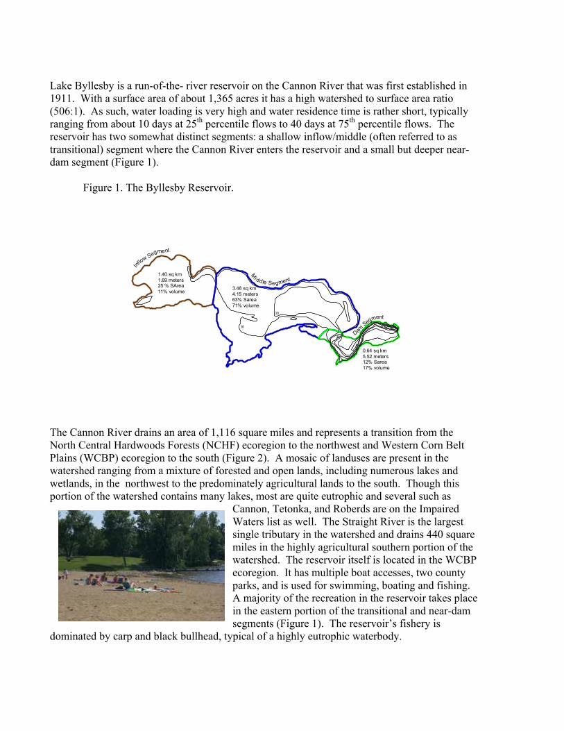
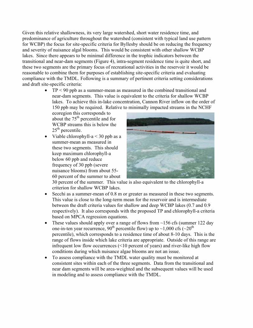
Lake Byllesby is a run-of-the- river reservoir on the Cannon River that was first established in 1911. With a surface area of about 1,365 acres it has a high watershed to surface area ratio (506:1). As such, water loading is very high and water residence time is rather short, typically ranging from about 10 days at 25th percentile flows to 40 days at 75th percentile flows. The reservoir has two somewhat distinct segments: a shallow inflow/middle (often referred to as transitional) segment where the Cannon River enters the reservoir and a small but deeper near-dam segment (Figure 1).
Figure 1. The Byllesby Reservoir.
3.48 sq km4.15 meters63% Sarea71% volume
1.40 sq km1.69 meters25 % SArea11% volume
0.64 sq km5.52 meters12% Sarea17% volume
Inflow Segment
M
iddle Segment
Dam Segment
10
20
30
40 50
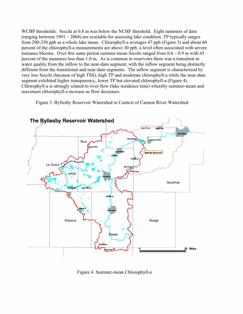
The Cannon River drains an area of 1,116 square miles and represents a transition from the North Central Hardwoods Forests (NCHF) ecoregion to the northwest and Western Corn Belt Plains (WCBP) ecoregion to the south (Figure 2). A mosaic of landuses are present in the watershed ranging from a mixture of forested and open lands, including numerous lakes and wetlands, in the northwest to the predominately agricultural lands to the south. Though this portion of the watershed contains many lakes, most are quite eutrophic and several such as
Cannon, Tetonka, and Roberds are on the Impaired Waters list as well. The Straight River is the largest single tributary in the watershed and drains 440 square miles in the highly agricultural southern portion of the watershed. The reservoir itself is located in the WCBP ecoregion. It has multiple boat accesses, two county parks, and is used for swimming, boating and fishing. A majority of the recreation in the reservoir takes place in the eastern portion of the transitional and near-dam segments (Figure 1). The reservoir’s fishery is
dominated by carp and black bullhead, typical of a highly eutrophic waterbody.
The reservoir itself, as well as the Straight River drainage (which accounts for most of the land area that drains directly to Byllesby) are within the Western Cornbelt Plains. The Byllesby Reservoir was included on the 2002 303(d) list for nutrient impairment. Mean TP and chlorophyll-a of 236 ppb and 52 ppb respectively, are far in excess of both the NCHF and
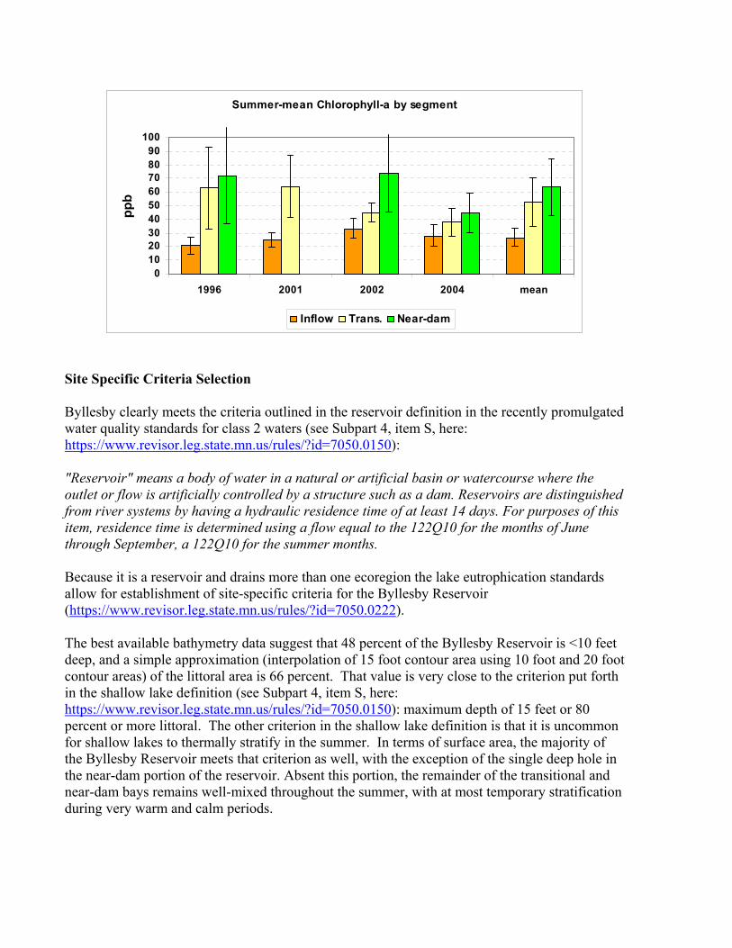
WCBP thresholds. Secchi at 0.8 m was below the NCHF threshold. Eight summers of data (ranging between 1991 – 2004) are available for assessing lake condition. TP typically ranges from 200-250 ppb as a whole lake mean. Chlorophyll-a averages 47 ppb (Figure 3) and about 60 percent of the chlorophyll-a measurements are above 30 ppb, a level often associated with severe nuisance blooms. Over this same period summer-mean Secchi ranged from 0.6 – 0.9 m with 65 percent of the measures less than 1.0 m. As is common in reservoirs there was a transition in water quality from the inflow to the near-dam segment; with the inflow segment being distinctly different from the transitional and near-dam segments. The inflow segment is characterized by very low Secchi (because of high TSS), high TP and moderate chlorophyll-a while the near-dam segment exhibited higher transparency, lower TP but elevated chlorophyll-a (Figure 4). Chlorophyll-a is strongly related to river flow (lake residence time) whereby summer-mean and maximum chlorophyll-a increase as flow decreases.
Figure 3. Byllesby Reservoir Watershed in Context of Cannon River Watershed
Figure 5. Summer-mean TP and Chlorophyll-a by Segment
Byllesby summer-mean TP by Segment
0
50
100
150
200
250
300
350
1996 2001 2002 2004 mean
TP p
pb
Inflow Trans. Near-dam
Summer-mean Chlorophyll-a by segment
0102030405060708090
100
1996 2001 2002 2004 mean
ppb
Inflow Trans. Near-dam
Site Specific Criteria Selection Byllesby clearly meets the criteria outlined in the reservoir definition in the recently promulgated water quality standards for class 2 waters (see Subpart 4, item S, here: https://www.revisor.leg.state.mn.us/rules/?id=7050.0150): "Reservoir" means a body of water in a natural or artificial basin or watercourse where the outlet or flow is artificially controlled by a structure such as a dam. Reservoirs are distinguished from river systems by having a hydraulic residence time of at least 14 days. For purposes of this item, residence time is determined using a flow equal to the 122Q10 for the months of June through September, a 122Q10 for the summer months. Because it is a reservoir and drains more than one ecoregion the lake eutrophication standards allow for establishment of site-specific criteria for the Byllesby Reservoir (https://www.revisor.leg.state.mn.us/rules/?id=7050.0222). The best available bathymetry data suggest that 48 percent of the Byllesby Reservoir is <10 feet deep, and a simple approximation (interpolation of 15 foot contour area using 10 foot and 20 foot contour areas) of the littoral area is 66 percent. That value is very close to the criterion put forth in the shallow lake definition (see Subpart 4, item S, here: https://www.revisor.leg.state.mn.us/rules/?id=7050.0150): maximum depth of 15 feet or 80 percent or more littoral. The other criterion in the shallow lake definition is that it is uncommon for shallow lakes to thermally stratify in the summer. In terms of surface area, the majority of the Byllesby Reservoir meets that criterion as well, with the exception of the single deep hole in the near-dam portion of the reservoir. Absent this portion, the remainder of the transitional and near-dam bays remains well-mixed throughout the summer, with at most temporary stratification during very warm and calm periods.
Given this relative shallowness, its very large watershed, short water residence time, and predominance of agriculture throughout the watershed (consistent with typical land use pattern for WCBP) the focus for site-specific criteria for Byllesby should be on reducing the frequency and severity of nuisance algal blooms. This would be consistent with other shallow WCBP lakes. Since there appears to be minimal difference in the trophic indicators between the transitional and near-dam segments (Figure 4), intra-segment residence time is quite short, and these two segments are the primary focus of recreational activities in the reservoir it would be reasonable to combine them for purposes of establishing site-specific criteria and evaluating compliance with the TMDL. Following is a summary of pertinent criteria setting considerations and draft site-specific criteria:
• TP < 90 ppb as a summer-mean as measured in the combined transitional and near-dam segments. This value is equivalent to the criteria for shallow WCBP lakes. To achieve this in-lake concentration, Cannon River inflow on the order of 150 ppb may be required. Relative to minimally impacted streams in the NCHF ecoregion this corresponds to about the 75th percentile and for WCBP streams this is below the 25th percentile.
• Viable chlorophyll-a < 30 ppb as a summer-mean as measured in these two segments. This should keep maximum chlorophyll-a below 60 ppb and reduce frequency of 30 ppb (severe nuisance blooms) from about 55-60 percent of the summer to about 30 percent of the summer. This value is also equivalent to the chlorophyll-a criterion for shallow WCBP lakes.
• Secchi as a summer-mean of 0.8 m or greater as measured in these two segments. This value is close to the long-term mean for the reservoir and is intermediate between the draft criteria values for shallow and deep WCBP lakes (0.7 and 0.9 respectively). It also corresponds with the proposed TP and chlorophyll-a criteria based on MPCA regression equations.
• These values should apply over a range of flows from ~156 cfs (summer 122 day one-in-ten year recurrence, 90th percentile flow) up to ~1,000 cfs (~20th percentile), which corresponds to a residence time of about 8-10 days. This is the range of flows inside which lake criteria are appropriate. Outside of this range are infrequent low flow occurrences (<10 percent of years) and river-like high flow conditions during which nuisance algae blooms are not an issue.
• To assess compliance with the TMDL water quality must be monitored at consistent sites within each of the three segments. Data from the transitional and near dam segments will be area-weighted and the subsequent values will be used in modeling and to assess compliance with the TMDL.
Attachments
(1) Agenda and notes from 4/24/06 Byllesby Reservoir Phosphorus TMDL meeting of Technical and Advisory Committee.
(2) Agenda and notes from 1/16/07 Byllesby Reservoir Phosphorus TMDL meeting of Technical and Advisory Committee.
(3) Agenda and notes from 5/24/07 Byllesby Reservoir Phosphorus TMDL Nonpoint Stakeholders and Public Meeting..
Byllesby Reservoir Phosphorus TMDL Technical and Advisory Committee Meeting Monday April 24, 2006; 9 a.m. – noon St. Olaf College, Northfield Buntrock Commons Room 142 Agenda 1. Welcome and Introductions – Beth Kallestad 2. PROJECT BACKGROUND a. Brief review of project scope, sequence, and timeline – Beth Kallestad, Lee Ganske b. Q & A related to timeline. 3. FOLLOW UP FROM PREVIOUS MEETINGS a. Literature review – Fate and transport of riverine phosphorus – Justin Watkins b. Discussion of limited monitoring in 2006 c. FLUX and BATHTUB brief review and updates - Justin Watkins, Mark Tomasek 3. SETTING THE PHOSPHORUS CONCENTRATION GOAL FOR THE BYLLESBY
RESERVOIR a. Statewide nutrient criteria development - Steve Heiskary, MPCA - Background on Lake Byllesby. Byllesby/Lake Pepin similarities.
- Current water quality trends for TP, chlorophyll –a, Secchi, and TSS. - Variability over time & flow regime. - User perception relative to Secchi and chl – a
b. Q & A c. Discussion of proposed phosphorus criteria for Byllesby Reservoir
d. Direction for the writers of the TMDL document.
4. Next steps, including group members’ perceptions of communication needs. 5. Date for next meeting- Please cross out dates/times that you would NOT be able to come
below, tear off, and return to box near exit.
Name: For the next Byllesby TMDL Technical or Technical and Advisory Committee meeting, I would NOT be able to come on the dates/times I have X’ed out below: Tuesday, May 23 a.m. p.m. Tues., June 20 a.m. p.m. Wednesday, May 24 a.m. p.m. Wed., June 21 a.m. p.m. Tuesday, June 13 a.m. p.m. Wednesday, June 14 a.m. p.m.
Terms and acronyms
TMDL – Total Maximum Daily Load. The maximum amount of a pollutant that a waterbody can receive and still meet water quality standards. TMDL also refers to the process of allocating pollutant loadings among point and nonpoint sources. TP – The amount of total phosphorus in a water sample. Units: ppb ( parts per billion; µg/L; micrograms per Liter). Also, mg/L( milligrams/ Liter; parts per million). 1000 µg/L = 1mg/L 90µg/L = .09mg/L Chlorophyll – a – A measurement of the quantity of algae present in a water sample.
Units: ppb (parts per billion)
Secchi – A measurement of the transparency of the water at a specified location in the lake. Units: meters. Lakes dominated by large, colonial algae, such as Aphanizomenon sp. (look like clumps of grass clippings), may have high transparencies relative to the phosphorus concentration. This is because these colonies of algae may form “rafts” or scums at the surface of the water which are easily displaced by wind or lowering of the Secchi disk, and hence Secchi readings may be deeper than if the algae were dispersed evenly throughout the water column. This is very common in hypereutrophic lakes and hence Secchi may not be the best indicator of trophic status in highly nutrient-rich lakes. Ecoregion abbreviations:
NLF – Northern Lakes and Forests CHF –same as NCHF – North Central Hardwood Forests WCP- Western Cornbelt Plains ( also WCBP)
NGP – Northern Glaciated Plains Lake Morphometry- The size and shape of a lake; generally includes lake area, mean and maximum depth, watershed acres, and ratio of watershed area to lake area. Residence Time – For a small volume of water, the time elapsed between entrance to the reservoir to exit from the reservoir. Residence time illustrates lake-like or river-like qualities of a reservoir. Geometric Mean - The geometric mean of 'n' samples is the nth root of their product. For example, the geometric mean of 5 values is the 5th root of the product of the 5 values.
Byllesby Reservoir Phosphorus TMDL Nonpoint Source stakeholders and public meeting Thursday, May 24, 2007; 9-11:30 A.M. (Coffee, juice, and pastries at 8:30.) South Central College, Faribault, MN. Agenda 1. 10 Minutes: Welcome and Introductions – Hilary Ziols, Beth Kallestad
2. 1 hour: How the Byllesby TMDL is shaping up – MPCA and CRWP staff
a) Site-specific in-lake goals – Steve Heiskary b) Modeling the phosphorus capacity of the lake – Dennis Wasley/Justin Watkins
c) Sources of phosphorus – Summary of Barr report to legislature – Hilary Ziols d) Point and Nonpoint Source reductions – Lee Ganske, Dennis Wasley
Break: 15 minutes 3. 1 hour: Discussion – Facilitated by Jim Klang.
a) Pros and cons of point and nonpoint source reductions - List of BMPs will be available, and attendees will add to this list - Prioritize PS and NPS BMPs - Identify pros and cons for top 3 PS and NPS BMPs
b) Input for best practices to achieve reductions c) Ideas for monitoring
- Past and current monitoring sites– Justin Watkins, Beth Kallestad - Where and what should be included in the future?
d) Questions for Technical Committee e) Conclusion
Byllesby Reservoir Phosphorus TMDL Technical and Advisory Committee Meeting Tuesday, January 16, 2007; 9 – 11:30 a.m. Buckham Library, 2nd Floor, Faribault, MN Agenda 2. Welcome and Introductions – CRWP staff 2. PROCESS AND PROGRESS TO DATE a. Notes overview – Hilary Ziols b. Modeling overview: Flux and Bathtub Results – Justin Watkins, Mark Tomasek c. Water quality standards (In-lake Goals) – Hilary Ziols, Lee Ganske d. Waste Load Allocation recommendation – Mark Knoff, Lee Ganske 3. DISCUSSION – recorders to write input on flip charts a. Pros and cons of recommended Waste Load Allocation (WLA) and Load Allocation (LA)- All b. Possible positive and negative consequences of WLA and LA c. Questions 3. NEXT STEPS a. Draft TMDL document with peer review b. Continue outreach – SWCDs, Waseca, Goodhue, and LeSueur County c. Public meeting with Non-Point Source stakeholders