City of Portland Annex D | Evacuation Plan PORTLAND BUREAU OF EMERGENCY MANAGEMENT Mayor Ted Wheeler, Commisioner-In-Charge • Carmen Merlo, Director 9911 SE Bush Street, Portland, OR 97266-2562 (503) 823-4375 • Fax (503) 823-3903 • TDD (503) 823-3947 - Updated - OCTOBER 2017
Transcript
City of PortlandAnnex D | Evacuation Plan
PORTLAND BUREAU OF EMERGENC Y MANAGEMENTMayor Ted Wheeler, Commisioner-In-Charge • Carmen Merlo, Director
9911 SE Bush Street, Portland, OR 97266-2562(503) 823-4375 • Fax (503) 823-3903 • TDD (503) 823-3947
- Updated -OCTOBER 2017
It is the policy of the City of Portland that no person shall be denied the benefits of or be subjected to discrimination in any City program, service, or activity on the grounds of race, religion, color, national origin, English proficiency, sex, age, disability, religion, sexual orientation, gender identity, or source of income. The City of Portland also requires its contractors and grantees to comply with this policy.
CITY OF PORTLAND Evacuation Plan Page 1 of 67
ACKNOWLEDGMENTS
CITY OF PORTLANDNeighborhood InvolvementNickole Cheron*, Ashley Horne, Jerry Williams*, Joanne Johnson
TransportationDave Hutson*, Carl Snyder*, Corey Maciulewicz
Parks and RecreationBryan Tierney, Barb Aguon, Galina Burley
Fire and RescueMerrill Gonterman*, Joseph Troncoso, Bryan Profit, Don Russ
This plan is written to facilitate a large-scale emer-gency evacuation and re-entry once the risk has been mitigated. Emergency evacuation is defined as the organized movement of people away from a threat or hazard. Re-entry is the planned return to an area once the risk has been abated. This plan provides a framework of expected roles, responsibilities, and response actions.
The natural hazards that would lead to an evacuation in Portland, Oregon, are few and infrequent. Unlike Gulf Coast states that have a hurricane season and pre-dictably evacuate away from the coast, Portland has never experienced a city-wide evacuation. Portland has no hazards that would necessitate this. A cata-strophic flood, dam or levee break, wildland fire, or hazardous materials (haz mat) release could require the evacuation of some portion of the City. This plan addresses these incidents.
The plan is intended to complement the City’s Basic Emergency Operations Plan, supporting documents
such as the Flood Response and Terrorism Annexes, and the standard operating procedures of responsible bureaus and agencies. Existing all-hazard plans, and the relationships among responders who implement them, would also be essential to the success of any evacuation effort.
OBJECTIVES
This plan generally defines a process for gathering information about an incident, determining appropri-ate protective actions, and coordinating evacuation and re-entry. Its objectives are to:
� Identify the major roles and responsibilities in an evacuation effort, and who will fill those roles.
� Identify key infrastructure and transportation resources, and potential temporary evacuation points.
� Describe perimeter control and security strategies for an evacuated area.
� Identify resources for the notification and transportation of all individuals within an evacuation area, including people with disabilities and other residents with access and functional needs.
� Identify resources and processes for the transportation of pets.
� Describe potential evacuation zones and egress routes.
� Develop a framework for planning re-entry to the affected area.
� Portland covers 145 square miles and had an estimated population of 632,309 people in 2016 (US Census 2016), with a population density of about 4,360 persons per square mile.
� Portland’s population increases by about 14% during the workday (US Census 2015), when people commute into the City. Visitors also swell the population, especially during special events and vacation periods.
� Portland has several unique areas, including the Central Business District (CBD), Forest Park, Hayden Island, the Linnton neighborhood, and the area protected by the Multnomah County Drainage Districts (MCDD) that have special risks and might present operational challenges for large-scale evacuations.
� Portland is susceptible to natural and human-caused hazards that could necessitate a large-scale evacuation, including: flooding, threatened or suspected terrorism, dam break, levee failure, wildland-urban interface fires, and haz mat release. Cascading effects from a large earthquake such as fire, landslide, or haz mat incident could also cause the evacuation of localized areas.
� Generally, flooding occurs in a known floodplain after periods of intense rain or snow melt. However, other hazards can occur with little or no warning.
� A large-scale evacuation will require mutual aid assistance for security and transportation resources.
� Multnomah County coordinates sheltering and mass care, public behavioral health, mental health, and emergency medical services. These services are essential to evacuees, so any large-scale evacuation of Portland residents will require close coordination with the County.
MAP 1 | CITY OF PORTLAND OVERVIEW MAP HIGHLIGHTING AREAS WITH SPECIAL PLANNING
Page 6 of 67 CITY OF PORTLAND Evacuation Plan
SCOPE
Portland is not vulnerable to hazards that would require an evacuation of the City’s entire popu-lation.4 Therefore, this plan does not address a citywide evacuation.
This plan addresses evacuations that would:
� displace more than 1,000 residents overnight, OR
� affect over 2% of the City’s population (approximately 12,000 individuals) for any amount of time, OR
� affect more than ½ mile radius for any amount of time, OR
� affect an area that is expected to be operationally challenging:
• Central Business District
• Forest Park and adjacent neighborhoods
• Hayden Island
• Linnton Neighborhood
• Multnomah County Drainage District Levee Inundation Areas.
The plan does not address:
� Limited, routine or short-term evacuations that do not meet the above criteria, for exam-ple, evacuating a city block for a gas leak or fire. These incidents are managed by on-scene police and fire incident commander(s).
� Special needs of jails, hospitals, and mental health or assisted living facilities. These facili-ties have legal requirements to plan for mov-ing the populations in their care.5
4 Portland is susceptible to megathrust earthquakes, but it will not be necessary for all residents to evacuate following this event. Generally, people should stay home if their home is safe for them to occupy. If residences are unsafe, these needs are addressed in a mass care and sheltering plan.5 ORS 409.720
� Shelter-in-place. For haz mat incidents and suspected terror attacks, the best response may be to shelter in place. Different practices and messages are used for sheltering in place. City PIOs have pre-scripted shelter-in-place messages. For reference, attachment 8 also provides a general fact sheet on shelter-ing-in-place.
Since Portland’s evacuation hazards could occur in any location, pre-identified and marked evacuation routes have not been established. Specific areas of the City with special, known hazards are addressed in Attachments.
ASSUMPTIONS
Incidents necessitating an evacuation may be slow-moving, like Columbia River flooding, or they may be fast-moving and occur with little or no warning, such as a haz mat spill.
Communication modes will generally be operable during evacuation incidents, but alternate methods of communication may also be required. Phone ser-vice in the affected area may become temporarily overloaded. Also:
� Alert and warning systems may not reach every intended evacuee.
� Not all persons within the evacuation zone will speak English or have access to cell phones, landline phones, or the internet.
� The 9-1-1 lines at BOEC will be overwhelmed with callers, many with actual emergencies, before the ECC can be activated.
The majority of the affected population is expected to evacuate once public officials issue a recom-mendation or order.6 With respect to evacuees:
� More individuals will evacuate than the targeted population.
� Individuals with disabilities or other access and functional needs may require additional resources to evacuate.
� People who rely on service animals must be evacuated with their animals.
� Some pet owners may refuse to leave without their animals.
� Family, friends, or residents may attempt to enter the evacuation zone to search for pets or valuables, or to assist their loved ones.
Transportation will be challenging, especially in a no-notice event:
� Even calling on all available mutual aid and assistance agreements, adequate transportation resources for all individuals requiring assistance may not be available for no-notice events.
� Depending on the scale of the emergency, skilled nursing facilities and other care facilities will rely on the same medical transportation resources as the City for transport of their patients.
� Evacuation may be slowed by hazardous traveling conditions or damaged infrastructure.
� Evacuees may abandon vehicles or run out of gas, creating congestion along egress routes. It may be necessary move vehicles to facilitate evacuation.
6 In locations where hurricane evacuations are more common, about 95% of residents evacuate following a mandatory order.
� First responders and many other public and contracted resources may be dedicated to incident response. These resources may be unavailable to assist in the evacuation of affected residents.
Pre-planning exists for some known hazards:
� Notification of impending or actual levee or dam failure is expected to occur in accord with established plans.
� Critical infrastructure owners and operators are expected to follow site specific plans and procedures, and make timely notification to local first responders of any emergency.
Page 8 of 67 CITY OF PORTLAND Evacuation Plan
ORGANIZATION AND ASSIGNMENT OF RESPONSIBILITIES
This section outlines roles and responsibilities specific to evacuation, in addition to the roles outlined in the Basic Emergency Operations Plan. Bureaus and agencies may also make contributions in addition to what is described. Of course, responding agencies must also continue their own essential services during an emergency.
During a large-scale evacuation that affects primarily Portland residents, the City Emergency Coordination Center will be activated jointly with the Multnomah County Emergency Coordination Center, and both the City and County will provide staff to meet the needs of the incident.
EVACUATION PLANNING TEAM
In a fast-moving incident, the first on-scene Incident Commander will determine the scale and scope of response and initiate appropriate evacuation or shel-ter-in-place procedures as necessary. The evacuation planning team will be convened as quickly as possible to support the effort. In a slow-moving incident, the evacuation planning team will be established before evacuations are initiated.
The City of Portland Evacuation Planning Team consists of members from the following bureaus and offices:
� City Attorney
� Bureau of Emergency Communications
� Bureau of Emergency Management
� Fire and Rescue
� Office of Neighborhood Involvement
� Parks and Recreation
� Police Bureau
� Bureau of Transportation
� Water Bureau
The following agencies may also participate in the evacuation planning team. They would generally co-locate or send a liaison to the City ECC:
� 2-1-1info
� American Red Cross
� Clark County Emergency Services Agency
� C-Tran
� Multnomah County Department of Human Services
� Multnomah County Emergency Management
� Multnomah County Health Department (Emergency Preparedness, Mental Health and Addictions, Emergency Medical Services)
CITY OF PORTLAND ROLES (LISTED ALPHABETICALLY AFTER DPC AND UC):
The Disaster Policy Council (DPC) is a body estab-lished in City Code. The Mayor is the chair of the DPC and the Council President is the vice president. The directors of public safety and infrastructure bureaus, and other bureaus and offices that would frequent-ly advise on emergency response, such as the City Attorney and the Director of Human Resources, are members of the DPC. During an evacuation, the DPC is expected to convene to:
� Declare a local emergency.
� Authorize an evacuation order defining the affected areas (in consultation with UC).
� Give direction on legal, financial, or policy matters related to the incident.
� Determine when re-entry can occur.
The Mayor would also likely lead a press conference and take other measures to reassure the public.
Unified Incident Command (UC) may include rep-resentatives from PBOT, PPB, PF&R, and Multnomah County. The exact make-up will respond to the needs of the incident. The UC will:
� Advise DPC on evacuation scope, type, and duration.
� Manage and coordinate emergency evacuation operations, including:
• routes,
• collection points and reception centers,
• traffic control and vehicle removal,
• perimeter control
� Manage and coordinate temporary sheltering, unless and until sheltering becomes a separate incident.
� Manage and coordinate re-entry.
Portland Bureau of Emergency Communications (BOEC) will:
� Activate the Emergency Alert System (EAS) at the request of the UC.
� Activate the “Major Incident Notification Page.”
� Assign a dispatcher as a Tactical Resource Operator, or a fire dispatcher and a police dispatcher, if staffing levels permit.
� Assign a liaison to the ECC, if staffing levels permit.
� Track first responder assets during an evacuation.
Portland Bureau of Emergency Management (PBEM) will:
� Disseminate public alerts or warnings using methods described in the Alert and Warning Annex, including the Community Emergency Notification System (CENS) system, Wireless Emergency Alerts (WEA), publicsalerts.org, media outreach, and if possible, Neighborhood Emergency Teams (NETs) for door-to-door notifications.
� Notify the Mayor and DPC; activate and support the DPC.
� Activate and support the City ECC.
� Liaise with response agencies and responsible entities.
� Help plan for the evacuation and care of people and pets, including people with access and functional needs.
Portland Fire and Rescue (PF&R) will:
� Assign an Incident Commander (IC) to the ECC and establish a Unified Command with other bureaus as necessary to manage the evacuation.
� Activate the Bureau Incident Command Post (BICP) if necessary.
� The IC will communicate incident requirements and status reports to BOEC and the City’s ECC upon its activation.
� Request additional resources through the City ECC.
� If PPB is acting as on-scene IC, facilitate evacuation or shelter-in-place procedures.
� Establish evacuation perimeters if the release of hazardous materials is the cause of the evacuation.
� Assist in evacuating additional needs populations.
� Initiate emergency and gross decontamination for evacuees and/or responders if necessary. Technical decontamination will need to be coordinated though a State Hazardous Material Team.
� Assist with alert and warning as described in Alert and Warning Annex.
� Adhere to all Multnomah EMS Protocols pertaining to Mass Casualty Incidents (MCI).
� Coordinate all Fire and EMS support activities at temporary evacuation points
� Request additional resources through the ICS structure if applicable.
� Provide for the safety and accountability of all resources assigned to their span of control.
The Joint Office of Homeless Services (JOHS) will:
� Advise on evacuating transient populations from within the evacuation zone.
� Coordinate with non-profit partners to assist with the transportation of homeless or transient populations from within the evacuation zone.
� Assist in identifying potential short- and longer-term housing options.
The Office of Neighborhood Involvement (ONI) will coordinate with Multnomah County Health and Human Services to support outreach to persons with disabilities, access, and functional needs.
Portland Parks and Recreation will:
� Provide access to buildings, equipment and resources that may be utilized to facilitate evacuation. This may include use of Parks facilities as temporary evacuation points for people awaiting transportation to mass shelters, or staging sites for resources and personnel.
� If necessary, support the operations of temporary evacuation points in Parks facilities, for example by distributing water or food to people who are waiting.
� If necessary and if staffing is available, provide qualified child care providers to supervise unaccompanied children at temporary evacuation points.
Portland Police Bureau (PPB) will:
� Assign an IC to the City’s ECC as part of UC.
� Communicate incident requirements to BOEC and the City’s ECC upon its activation.
� Request additional resources through the City ECC.
� If PF&R is acting as on-scene IC of the overall incident or as an Evacuation Group, facilitate evacuation or shelter-in-place procedures.
� Establish perimeter and containment around the evacuation zone as directed by the IC or Evacuation Group Supervisor.
� Adhere to the evacuation perimeter, unless haz mat conditions require involvement of PF&R.
� Provide traffic and crowd control.
� Document door-to-door contacts and attempted contacts, directing residents to a transportation point or temporary evacuation point outside the evacuation zone.
� Notify the City ECC of resources utilized and destination and number of people contacted and transported.
Public Information Officers (PIOs) will:
� Develop and maintain pre-scripted shelter-in-place and evacuation messages in the City of Portland’s safe harbor languages.
� Provide evacuation information to 9-1-1 and 2-1-1info, including information for people with access and functional needs.
� Work with partners to activate and operate a Joint Information System (JIS) in accordance with published plans.
� Deliver coordinated messages via social and traditional media as directed in Alert and Warning Annex.
� Monitor public feedback and conduct rumor control.
� Provide scheduled updates to the ECC and the public.
Portland Bureau of Transportation (PBOT) will:
� Activate BICP to coordinate transportation system needs.
� Provide traffic control resources including barricades, variable messaging boards, and traffic signal adjustments.
� Coordinate traffic management and evacuation route signage with County road departments, ODOT, and other transportation resources and agencies.
� Monitor traffic flow and condition of evacuation routes and notify City ECC of potential problems.
� If requested, provide available camera feeds of the evacuation zone to the City’s ECC.
Other City bureaus and offices are expected to maintain and practice evacuation procedures for their buildings and job sites, and if required, assign personnel and resources to support evacuation op-erations in the City ECC and in the field.
The City ECC will coordinate with Multnomah County Emergency Management during evacuation, and will participate in a joint ECC for an incident that primarily affects Portland residents.
Animal Control will shelter and care for evacuated animals, and provide decontamination and quarantine if needed. Multnomah County anticipates co-locating people and pets at County shelters.
Multnomah County Emergency Management (MCEM) will:
� Activate the County ECC jointly with the City ECC as needed.
� Coordinate County resources.
� Fill resource requests. If unable to do so, forward resource requests to the State EOC.
� Communicate pertinent information received from the State Office of Emergency Management to the City ECC.
Department of County Human Services (DCHS) will:
� Advise on the evacuation of persons with access and functional needs.
� Provide staffing for the Mass Care, Housing and Human Services position in the Joint City-County ECC during large scale incidents.
� Coordinate the activation of temporary evacuation points and shelter facilities necessary to meet the needs of the incident.
� Coordinate with social service organizations, faith–based communities, and advocacy groups.
Multnomah County Health Department (MCHD) will:
� In coordination with HAZMAT, assist with screening for contamination (e.g. radiological, chemical, biological) and population monitoring (for radiation), as necessary.
� Coordinate disaster behavioral health and mental health support for evacuees.
� Coordinate health screening of evacuees.
� Coordinate access to medication and assistive devices for evacuees.
� Provide county staff for the Public Health and Medical Services position in the City-County Joint ECC, as requested by MCEM.
� Coordinate with NW Oregon Health Preparedness Organization, hospitals, clinics, and care facilities regarding capabilities and resource needs.
� Multnomah County EMS will coordinate with all EMS provider agencies including PF&R and the 9-1-1 emergency ambulance provider on all medical triage, treatment and ambulance transportation activities.
� Help disseminate evacuation information to the public, including information for people with disaster behavioral health challenges.
� Help disseminate emergency shelter information to the public, including information for people with disaster behavioral health challenges.
� Conduct facility-specific environmental health and safety assessments on sanitation, food, water, solid waste, pests, sleeping areas, childcare areas, HVAC/ventilation, and other environmental or safety concerns, to prevent and control the spread of disease.
� Conduct public health surveillance to identify cases of illness, injury, and exposure following the initial incident.
� Provide epidemiological support to track movement of medical patients following an evacuation.
CITY OF PORTLAND Evacuation Plan Page 13 of 67
� Provide technical assistance to minimize exposure to hazardous substances, including advising first responders on minimizing their exposure, and approving health risk messages to the public.
Roads and Bridges will:
� Coordinate with UC for road closures and perimeter control.
� Support PBOT, ODOT, and other regional road departments with traffic control and flow responsibilities.
� Monitor Multnomah County bridges for traffic impediments.
� Provide personnel and equipment for perimeter and traffic control, as requested by MCEM.
Sheriff’s Office will:
� Support PPB, Oregon State Police (OSP) and other regional law enforcement responders to maintain perimeter, traffic control, and safety within and near the evacuation zone.
� When necessary, coordinate evacuation via the Columbia and Willamette rivers.
� Evacuate incarcerated individuals according to established plans.
STATE OF OREGON
The City of Portland must request state resources through Multnomah County.
Civil Air Patrol can provide aircraft for community notification via airborne public address systems.
Department of Corrections will coordinate the evacuation of incarcerated individuals in their custody.
Office of Emergency Management can:
� Activate the State EOC.
� Request Federal aid to support effective and interoperable communications.
� Communicate pertinent information received from Federal departments or agencies to Multnomah County Emergency Management or the Joint City - County ECC.
� Coordinate the provision of State resources.
Oregon Health Authority can:
� Provide additional EMS support to the affected area.
� Coordinate out-of-state medical evacuation operations.
Oregon National Guard can:
� Assist with door-to-door notifications.
� Provide security for evacuation routes, evacuated area, reentry, and repopulation.
� Provide transportation assets.
� Provide aviation assets.
Oregon State Police (OSP) will coordinate with local law enforcement agencies to provide personnel on-scene to assist with road closures, traffic redirection, perimeter control, and escort services to vehicles carrying sensitive equipment or supplies.
Oregon Department of Transportation (ODOT) can:
� Coordinate with UC for road closure and perimeter control.
� Employ variable message boards.
� Provide mutual aid resources for perimeter and traffic control.
� Provide evacuation information on Trip-Check website and 5-1-1.
Page 14 of 67 CITY OF PORTLAND Evacuation Plan
FEDERAL AGENCIES
Federal resources must be requested by Oregon Emergency Management through Multnomah County.
US Army Corps of Engineers will:
� Coordinate with MCDD to complete and maintain a levee breach plan.
� Provide support to MCDD Incident Command Post when activated.
� Notify OEM of a possible or impending breach.
US Coast Guard controls river traffic, and can assist with any maritime-based evacuation.
Veterans Administration can provide vehicles equipped to facilitate transportation of multiple wheelchair users and assist with out-of-state medical evacuation operations.
REGIONAL PARTNERS
Clackamas County, Washington County, Columbia County, Clark County, and the State of Washington will:
� Depending on the affected geographical area, prepare to receive evacuees.
� Provide mutual aid resources according to pre-existing agreements.
� Provide personnel to the regional JIS.
� Coordinate traffic control information with the City ECC.
Metro will maintain and practice emergency plans, including evacuation plans, for their venues including the Convention Center, the Expo Center, and the Oregon Zoo. They will coordinate venue evacuation with UC.
Multnomah County Drainage District (MCDD) will:
� Activate the MCDD ICP if there is a high-water incident or an incident threatening the integrity of the Columbia River levee system.
� Coordinate with PWB and BES to monitor levees.
� Coordinate with PBOT and Police to facilitate the closure of Marine Drive when necessary, according to pre-existing agreements.
� Notify City and County Emergency Management of a possible or impending levee breach.
The Port of Portland will:
� Maintain and practice emergency plans, including evacuation plans, for their buildings and work locations.
� Liaise with air or marine carriers for additional evacuation modes.
Public school districts will:
� Develop and maintain evacuation plans for students and faculty.
� Implement shelter-in-place options, as needed.
� Coordinate with the on-scene IC.
� Provide school facilities as staging areas or temporary evacuation points when necessary and feasible.
TriMet can:
� Transport evacuees from pick-up points to reception centers or shelters.
� Transport people with assistive mobility devices and other access and functional needs.
� Provide buses to protect evacuees waiting outside in severe weather.
CITY OF PORTLAND Evacuation Plan Page 15 of 67
PRIVATE INDUSTRY
Airbnb4 will:
� Identify hosts who are willing to help displaced individuals during an emergency.
� Provide these hosts emergency preparedness educational materials.
� Use Airbnb’s technology to notify hosts and guests about hazardous incidents.
Medical Transportation Providers will:
� Coordinate with PF&R and County EMS to provide medical transportation resources for patients with functional and access needs requiring specialized medical care or assistance during evacuation.
� Provide EMS support to temporary evacuation points.
� Adhere to all Multnomah EMS Protocols pertaining to Mass Casualty Incidents (MCI). Request additional resources though the established Incident Command Structure if necessary e.g. Medical Group or Branch.
� Coordinate all Fire and EMS support activities at temporary evacuation points. Request additional resources through the ICS structure if applicable.
Private Security Firms can provide security services in the affected evacuation zone, according to all of their contracts.
Private Transportation Providers can provide private transportation services in the affected evacuation zone (may include taxi, shuttle, limo, coach and bus transportation providers).
4 The City and Airbnb MOU outlines provisions for disaster housing options and dissemination of emergency inforfmation.
NONPROFIT ORGANIZATIONS
2-1-1info will:
� Disseminate evacuation information to callers, including information for people with access or functional needs.
� Disseminate emergency shelter information to callers, including information for people with access or functional needs.
� Support family reunification following an evacuation.
American Red Cross will:
� Provide a liaison to the Joint City-County ECC.
� Identify temporary housing and feeding facilities for displaced persons, including people with access and functional needs, when requested. Requests may be made by PHB, the Joint City-County ECC, Multnomah County, PBEM, PF&R, or others. If the request is not made by Multnomah County, MCEM should be informed of the request.
� Collaborate with the County to integrate available Red Cross resources in support of required shelter/feeding operations.
� Collaborate with the County to integrate Red Cross disaster health and mental health services as needed.
Oregon Voluntary Organizations Active in Disasters (ORVOAD) will provide trained volun-teers and coordination assistance as requested by PBEM or the Joint ECC.
Page 16 of 67 CITY OF PORTLAND Evacuation Plan
CONCEPT OF OPERATIONS
PHASE 1 | INITIAL INCIDENT AND ON-SCENE RESPONSE
The City’s first responders (PPB and PF&R) routinely issue shelter-in-place and small-scale evacuation recommendations. Each bureau has established guidelines for temporarily relocating residents, deter-mining when the threat has resolved, and facilitating residents’ return.
For a large but slow-moving incident, the City will convene the DPC to make decisions and provide policy direction about evacuations. In this case, UC
and an evacuation planning team will be identified ahead of the evacuation order, and the ECC will be activated to plan an orderly evacuation process.
During a large and fast-moving incident, the on-scene IC will evaluate the situation and identify the requirement for a larger-scale evacuation.
If any of the below criteria are met for any incident, a large-scale evacuation is required:
Factors Criteria
NUMBER OF INDIVIDUALS TO EVACUATE• More than 12,000 people for any amount of time
• More than 1,000 residents overnight
AREA AFFECTED
• More than ½ mile radius, or an area with limited ingress/egress
routes (Central Business District, Hayden Island, Linnton, MCDD
leveed areas, Forest Park neighborhoods)
OTHER FACTORS• DPC or IC on-scene determines extensive coordination
will be required
Table 1 | Criteria for a large-scale evacuation
If a large-scale shelter-in-place or evacuation is required for a fast-moving incident, the on-scene IC will notify BOEC including the emergency location, hazard, size of the area involved, and the area to be evacuated. IC will also request additional resources and ECC activation.
BOEC will perform the requested actions, including notifications as outlined in existing operating plans. Internal protocols include alerting the PBEM Duty Officer. PBEM will subsequently follow its procedures to notify the Mayor and activate the DPC.
CITY OF PORTLAND Evacuation Plan Page 17 of 67
PHASE 2 | SITUATION ANALYSIS AND EVACUATION ORDER
Several communication means may initiate notifica-tion. For a fast-moving incident, the most likely is a page from BOEC to the PBEM Duty Officer (DO). For a slow-moving incident, the National Weather Service would likely convene a conference call to inform regional emergency managers of predicted flood risk.
When the DO learns that an evacuation is recom-mended or is likely, they will inform the PBEM Director. If time permits, PBEM staff will work with subject matter experts (HazMat specialists, meteorologists, senior PPB and PF&R Chiefs) to determine the threat and risks associated with it. In many cases, partner agencies may be consulted for their expert opinions.
The PBEM Director or designee will convene the Disaster Policy Council (DPC) and inform MCEM of the situation. The PBEM Director will advise the DPC of the situation, threats associated with the hazard, and the recommended courses of action. When required, Unified Command or partner agency experts will be asked to provide their analysis to the DPC.
The City ECC, Multnomah County ECC, and regional JIS will be activated following established guidelines. The ECC will conduct situation analysis, order additional resources, and provide information or recommenda-tions to the DPC.
A complete incident analysis should include:
� Nature of the hazard: magnitude, source, and expected duration.
� Weather and environmental conditions.
� At risk populations: numbers, demographics, special needs, and transportation requirements.
� Geography and infrastructure at risk.
One course of action is “shelter-in-place.” In this situa-tion, the public will be advised of a threat and urged to stay indoors until the risk is reduced or eliminated. Shelter-in-place is necessary if the threat is greater outdoors or while in transit. Shelter-in-place is most often advised in haz mat spills and suspected ter-rorism. A shelter-in-place fact sheet is provided as Attachment 8.
A second course of action is an evacuation order. An evacuation is necessary if the risk to the population is greater if they remain in place. Evacuation orders will only be issued when there is an immediate life-safety threat to the population. This type of order is likely to be used for floods and wildland interface fires.
If the Mayor and DPC determine that an evacuation is required, the Mayor will declare a local emergency and issue an evacuation order. The evacuation order will clearly define the area to be evacuated.
In most cases the steps described in “Initial Incident and On-scene Response” and “Situation Analysis and Evacuation Order” will occur sequentially. However, during rapidly-evolving and highly threatening sit-uations (i.e. fast-moving fire) the on-scene IC may begin an evacuation prior to receiving the Mayor’s evacuation order. Conversely, during slow-moving incidents (i.e. Columbia River flooding) there may be several days and extensive analysis that is completed before an evacuation order is issued.
Page 18 of 67 CITY OF PORTLAND Evacuation Plan
PHASE 3 | ALERT AND WARNING
Public notification of a large-scale evacuation will occur in accordance with the Alert and Warning Annex.
Large-scale evacuations within the City are almost unknown. Coordinated public messaging will be required, and will be managed regionally according to the Portland Urban Area Regional Emergency Public Information Concept of Operations Plan. Non-English Speaking Households Density Map (on opposite page, pg 19)
In a slow-moving incident, successive, increasingly serious warnings will be issued using the evacuation levels established by the State of Oregon. Attachment 9 provides the state’s official descriptions of these levels. They are generally:
LEVEL 1: Be ready. Residents are urged to be aware of the hazard, prepare to move, and monitor the media for further information. People who may need additional time or assis-tance to evacuate are advised to consider preemptive action. Livestock, heavy equip-ment, and other hard-to-move property may be relocated.
LEVEL 2: Be set. The City will recommend that indi-viduals with access and functional needs, critical industries, locations with hazardous substances present, and healthcare facilities evacuate. All other residents are advised to evacuate voluntarily or be prepared to leave at a moment’s notice. They are warned that they may not receive another notice if the threat progresses quickly.
LEVEL 3: Go now. Residents should evacuate immedi-ately, not taking time to gather belongings or attempt to protect their home. No further notices will be provided, and emergency services may not be available to assist.
Direct notification to all residents will be attempted through the Community Emergency Notification System (CENS). Pre-scripted messages will be issued in English to all landlines phones and all self-registered phone numbers in English or a safe harbor language of choice. Media releases will be made in support of this message. If it is safe to do so, in-person notifications will be made to areas where people are known to camp. Other methods of warning the public may also be used, according to the scope and speed of the inci-dent. These are addressed in more detail in Alert and Warning Annex. They may include:
� Wireless Emergency Alerts.
� Emergency Alert System.
� Social media.
� Civil Air Patrol flyover with Airborne Public Address System.
� River Patrol with public address system.
� Amateur radio net call.
� Residents calling 9-1-1.
Due to the potential life safety risk of any incident ne-cessitating an evacuation order, extensive efforts will be undertaken to alert the public. If first responders’ health and well-being is not endangered by these actions, these additional means may be used:
� Emergency vehicles with sirens and public address systems.
Percent of population that speakEnglish "less than well"
0% - 3.6%
3.7% - 7.2%
7.3% - 12.6%
12.7% - 21.1%
21.2% - 38.9%
Freeway
Local Highway
Arterial/Bridge
City Boundary
September 28, 2015
MAP 2 | NON-ENGLISH SPEAKING HOUSEHOLDS DENSITY MAP
CITY OF PORTLAND Evacuation Plan Page 19 of 67
Page 20 of 67 CITY OF PORTLAND Evacuation Plan
NETs may be utilized to assist with evacuation notifications. NETs will never be expected to place themselves in a dangerous situation. When autho- rized by PBEM, NETs may act as a volunteer extension of the first responder services assisting with door-to-door notification⁶.
In an evacuation, people may be frightened or confused. To minimize this, the City will endeavor to release clear, detailed instructions to the public. Unfortunately, many mechanisms to alert the public have limitations on message content (i.e. 120 charac-ters for text messages). Social and news media should be used to deliver more detailed information. As soon as possible, the following should also be released on agency websites and to the media:
� Precise boundaries of the affected area; affected zip codes.
� Hazard information, including estimated duration.
� Evacuation routes (safe primary, secondary and one-way routes).
� Instructions for individuals who need assistance to evacuate.
� Guidance for pets and service animals.
� Encouragement to assist friends and neighbors if possible, especially anyone likely to need assistance.
� Special instructions for schools, care facilities, and hospitals.
� Locations of transportation points, temporary evacuation points, or shelter locations.
� What to take and what to leave behind.
� What to do if a loved one may be in the evacuation area.
6 Portland Bureau of Emergency Management, Neighborhood Emergency Team (NET) Guidelines
� Encouragement to take the shortest evacuation route (rather than a familiar, longer route).
� Family reunification process.
� Adverse health effects to monitor for, if any.
� Implications of not following recommended actions.
� Time and delivery method for the next available information.
� Instructions for those near, but outside of, the affected area.
In some incidents, it may be too dangerous for first responders to enter the evacuation zone e.g. hot and warm zones determined by a Hazardous Materials Response Team. In these cases, the Mayor’s evacuation order will indicate that first responders will not enter the hazard area to rescue individuals.
PHASE 4 | EVACUATION
To manage evacuation operations, the Portland ECC will be activated as a joint Emergency Coordination Center with the Multnomah County ECC. Unified Command will be established in the ECC. If sheltering later becomes a primary function, sheltering may be managed as a separate incident and managed from the County ECC, or elsewhere.
During an evacuation, the ECC may already be acti-vated because of the precipitating incident. However, hazards that could cause a large-scale evacuation with-in Portland could occur with no notice. Therefore, the evacuation will occur simultaneously with ECC staffing. It may be difficult to fully staff the ECC, especially if a no-notice incident occurs during non-business hours. Re-sponders will have to adapt and adjust their roles to best manage the incident. The below table represents ideal staffing. Realistically, these roles will not be entirely filled until several hours after the incident.
CITY OF PORTLAND Evacuation Plan Page 21 of 67
Figure 1 | ECC Staffing for Evacuation
U.C.(PF&R + MultCO)
Planning
Sit Stat GIS
Re-entry / recovery Intel (211, 911, social media, etc.)
Logis�cs Opera�ons
Mass Care Branch
Reunifica�on North Division (mirror for south)
Evacua�on point task force (MultCo,
Fire, EMS)Sheltering (MultCo)
Animals (MultCo) Public health (MultCo)
Public Works Branch Evacua�on Branch
North(mirror for south)
Fire / EMS Evac (BOEC dispatch)
Perimeter control (Law, NETs)
Transporta�on (PBOT, ODOT)
Homeless (Parks, Joint Office)
Haz Mat Branch
Entry Backup
Decon Monitoring
Finance
Command Staff JIC
Public inquiry center
ECC STAFFING FOR EVACUATION
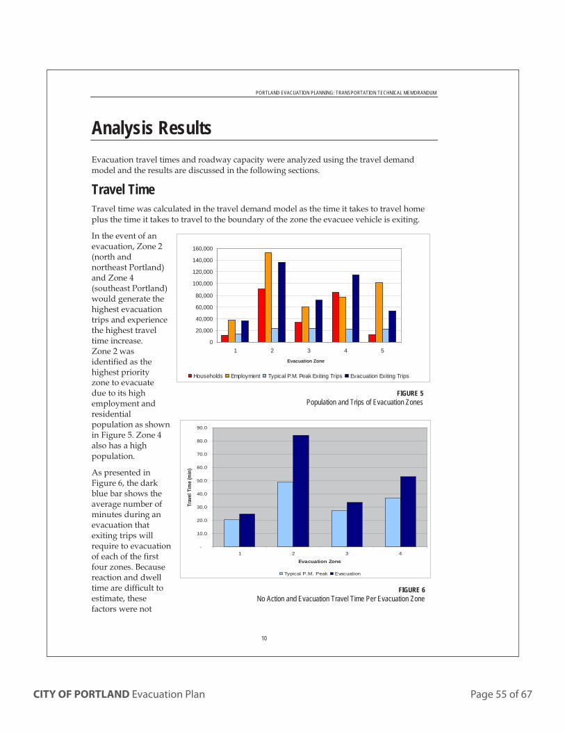
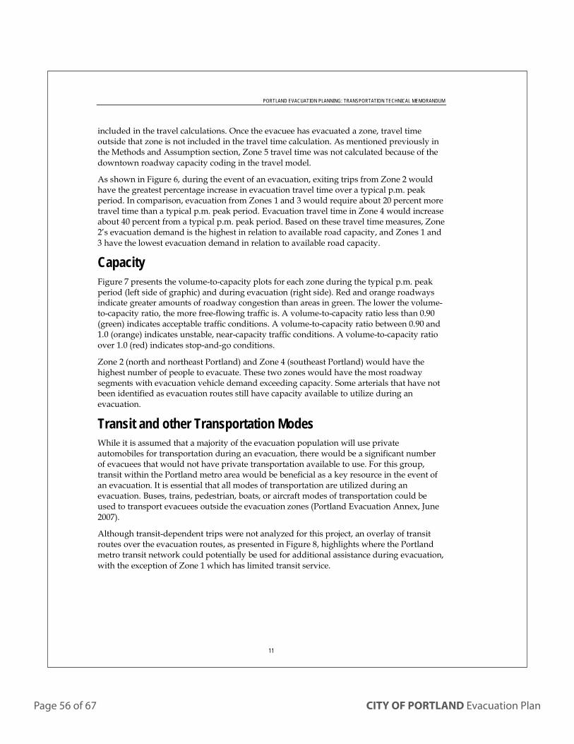
The first step in a managed evacuation is to assess the situation and determine the precise area of evacuation, the appropriate ingress and egress routes, and the location of reception center(s). Whenever possible, primary motor vehicle egress routes should be con-trolled-access highways (freeways). One tool that may assist in determining other possible routes is the Transportation Technical Memorandum (Attachment 6) which outlines travel demand modeling and iden-tifies highest capacity alternate evacuation routes.
The City has completed some additional pre-planning for neighborhoods with known hazards and access challenges. The Central Business District, Hayden Island, Linnton, the area protected by Multnomah County Drainage District levees, and the neigh-borhoods around Forest Park have possible egress routes and transportation points pre-identified. Maps and descriptions for these areas are shown in Attachments 1-5.
Page 22 of 67 CITY OF PORTLAND Evacuation Plan
Below is a list of the major road networks within or adjacent to each neighborhood and the associated zip codes. Since most residents are aware of their zip code, it will be easiest to plan and communicate an evacuation order using zip codes.
NW Portland:
North of Fremont Bridge and west of the Willamette River (Zip codes: 97209, 97210, 97229, 97231)
NE Portland:
North of E Burnside Road and east of the Willamette River (Zip codes: 97211, 97212, 97213, 97217, 97218, 97220, 97230, 97227, 97232)
SW Portland:
South of W Burnside Road/Hwy 26 and west of the Willamette River (Zip codes: 97201, 97204, 97205, 97219, 97221)
SE Portland:
South of E Burnside Road and east of the Willamette River (Zip codes: 97202, 97206, 97214, 97215, 97216, 97266)
Downtown:
City Center (405 loop) between I-405 and I-5 downtown (Zip codes: 97204, 97205, 97209, 97210)
East Portland:
East of I 205 (Zip codes: 97216, 97220, 97230, 97233,97236, 97266)
North Portland:
North of the Fremont Bridge and east of the Willamette to I-5 (Zip codes: 97203, 97217)
Once the primary and alternate evacuation routes have been chosen and communicated to the public, it is expected that most of the affected individuals will evacuate using private cars. However, other forms of transportation, including walking, bicycles, and to a limited extent maritime vessels, may also be used. Not all individuals have access to private transportation resources. The City’s ECC will request TriMet provide mass transportation for those without vehicle ac-cess, including transport accessible to people with disabilities. Evacuees requiring transportation will be directed to a pick-up point (like a bus stop) to await transportation. Pick-up points are locations where individuals can gather to await mass transit. People who are unable to get to a pick-up point will be given instructions to call 911 or another number, to request assistance at their location.
Managing traffic flow is key to efficient evacuation. To do this, PBOT will activate their bureau ICP to mon-itor road status and provide traffic control resources along evacuation routes. Necessary adjustments to resources or routes will be coordinated through PBOT personnel at the ECC. Citywide and regional coor-dination and communication will be accomplished using the crisis communication software, WebEOC. Specifically, the regional road status board will be used to share route information.
PPB will be the lead law enforcement agency. A PPB IC will likely be in the field. Additional resources such as Multnomah County Sheriff, OSP and surrounding county law enforcement agencies, contracted services, and the National Guard may be requested through the ECC. Initially, PPB will manage traffic concerns and will work with PF&R to notify residents. Once additional resources are available, PPB will establish an outer perimeter that prevents access to the affected area. This perimeter will be established outside of
£¤26
£¤30
P o r t l a n dI n t e r n a t i o n a l
A i r p o r t
SE 1
22N
D A
VENW
STHELENS
RD
N LOMBARD ST
SE DIVISION STSE POWELL BLVD
NE SANDY BLVD
SE TACOMA ST
NE
MA
RTI
N L
UTH
ER K
ING
JR
BLV
D
SWBARBUR BLVD
E BURNSIDE ST
N MARINE DR
NE
82N
D A
VE
SW SCHOLLS FERRY RD
SW CANYON RD
NE HALSEY ST
SE HWY 224
SE 1
82N
D A
VE
NW YEON AVE
NE
181S
T A
VE
SW BEAVERTON HILLSDALE HWY
SE 8
2ND
AVE
SW TUALATIN VALLEY HWY
N D
ENVE
R A
VE
SW RIVERSIDE DR
SE FOSTER RD
SE SUNNYSIDE RD
SE MC
LOU
GH
LIN B
LVD
SWFARMINGTON RD
W BURNSIDE ST
SW M
AC
AD
AM
AVE
SE STARK ST
NE LOMBARD ST
NE
1 22N
DA
VE
NW
185
TH A
VE
NE AIRPORT WAY
N COLUMBIA BLVD
SWM
UR
RA
YB
L VD
NWCO
RNE
LIUS
PASS
RD
NE MARINE DR
§̈¦5
§̈¦5
§̈¦205
§̈¦84
§̈¦205
§̈¦405
§̈¦84
£¤26
£¤26
£¤30
£¤30B
£¤30B
OP217
OP99E
OP43
OP213
OP99W
OP10
97266
98682
98665
98663
97231
97216
97236
97233
97210
98662
97030
98684
97212
9721497215
97220
97230
97008
97227
97077
97232
97205
97221
98683
98661
97239
97202
97024
97217
97211
98664
98607
97218
97213
97204
97201
97209
97080
98660
97203
97006
97229
9722597003
97007
97223
97078
9722297035
97124
97089
97005
97034
97206
97219
97015
97086
N0 1.50.75Miles
Zip Codes
Zip Code Boundaries
Freeway
Local Highway
Arterial/Bridge
City BoundarySeptember 28, 2015
MAP 3 | CITY OF PORTLAND ZIP CODES
CITY OF PORTLAND Evacuation Plan Page 23 of 67
Page 24 of 67 CITY OF PORTLAND Evacuation Plan
the hazard zone and will remain in place until the evacuation order is rescinded. Access control may be monitored and maintained using check points, mobile patrols, road blocks and/or closures. There may be numerous ingress/egress routes into the affected area, making it difficult to limit access. It may be necessary to contract with private security providers to facili-tate area security. NETs may also be used to monitor road closures.
The main responsibility of the ECC is to determine requirements, source, gather, and assign resources. An analysis of weather forecasts, time constraints, risks, and the safety of both response personnel and evacuees will help determine resource requirements. City bureaus, County agencies, and others may also re-quest resources through the ECC. The logistics section will need to work across governmental organizations and regional boundaries to gather and assign mutual aid resources. Contracting may also be necessary.
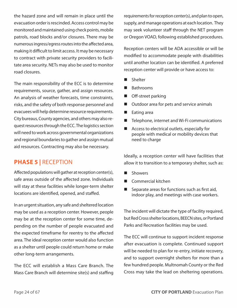
PHASE 5 | RECEPTION
Affected populations will gather at reception center(s), safe areas outside of the affected zone. Individuals will stay at these facilities while longer-term shelter locations are identified, opened, and staffed.
In an urgent situation, any safe and sheltered location may be used as a reception center. However, people may be at the reception center for some time, de-pending on the number of people evacuated and the expected timeframe for reentry to the affected area. The ideal reception center would also function as a shelter until people could return home or make other long-term arrangements.
The ECC will establish a Mass Care Branch. The Mass Care Branch will determine site(s) and staffing
requirements for reception center(s), and plan to open, supply, and manage operations at each location. They may seek volunteer staff through the NET program or Oregon VOAD, following established procedures.
Reception centers will be ADA accessible or will be modified to accommodate people with disabilities until another location can be identified. A preferred reception center will provide or have access to:
� Shelter
� Bathrooms
� Off-street parking
� Outdoor area for pets and service animals
� Eating area
� Telephone, internet and Wi-Fi communications
� Access to electrical outlets, especially for people with medical or mobility devices that need to charge
Ideally, a reception center will have facilities that allow it to transition to a temporary shelter, such as:
� Showers
� Commercial kitchen
� Separate areas for functions such as first aid, indoor play, and meetings with case workers.
The incident will dictate the type of facility required, but Red Cross shelter locations, BEECN sites, or Portland Parks and Recreation facilities may be used.
The ECC will continue to support incident response after evacuation is complete. Continued support will be needed to plan for re-entry, initiate recovery, and to support overnight shelters for more than a few hundred people. Multnomah County or the Red Cross may take the lead on sheltering operations.
CITY OF PORTLAND Evacuation Plan Page 25 of 67
If sheltering becomes a primary focus, sheltering may become a separate incident. Both Multnomah County and the Red Cross have established plans that address sheltering.
EVACUATION CONSIDERATIONS:
ADDITIONAL MOBILITY NEEDS
People with disabilities may be able to evacuate via private auto. For people without access to a car, TriMet is the City’s first choice for transportation. Every TriMet bus is equipped with a boarding ramp or power lift and space for at least two mobility devices. TriMet also has smaller buses for their “LIFT” service. These are specifically intended to serve riders with disabilities. They also accommodate at least two mobility devices. TriMet drivers are trained in operating this equipment and helping riders use it. If the need for accessible transportation exceeds the spaces available on TriMet resources assigned to the evacuation, the City’s ECC will seek additional para-transit resources, including Ride Connections, PCC para-transit services, Veterans Administration vans, and SAFE transportation. The City may also mobilize accessible private taxis and ride-sharing services to help people move out of the hazard zone.
Through PublicAlerts.org and the Community Emergency Notification System, persons with mobility issues or other additional needs who may require assistance during an emergency can also sign up for the Additional Needs Registry. The Additional Needs Registry is a voluntary program for persons that may need specific disability-related assistance and/or accommodation in the event of a major disaster. The Additional Needs Registry is currently connect-ed to land line telephone information and certain
information appears to 9-1-1 dispatchers when a call is placed from the residence. An email can also be sent to all registered individuals.
First responders will also attempt to assist those with additional needs. The initial evacuation order should prompt those who are unable to evacuate themselves, and thus have a life safety concern, to call 9-1-1 or another City/County hotline to receive assistance. If they are able, NET members may assist with the identification and transport of persons with access and functional needs.
Multnomah County Public Health and EMS will coordinate with hospitals, skilled nursing facilities, and other health care facilities within the evacua-tion zone to ensure safety of patients and residents requiring evacuation.
PETS
Pet owners have primary responsibility for the safety, care, and welfare of their animals. Whenever possible, evacuees should provide for the basic needs of any animals they evacuate including leashes, bedding, food, medication, and crates/carriers.
Animal rescue and care teams from Multnomah County Animal Services Division will deploy when needed to manage pet rescue, transportation, and temporary shelter options for people who evacuate with their pets. Multnomah County’s intention is generally to shelter pets at the same site as their owners. Deployed teams will be managed by Animal Services personnel operating in the mass care branch at the ECC. These staff will assist the logistics section in determining animal transportation requirements.
Animal Services staff will also be responsible for reuniting pets with their owners.
Service Animals are not pets. Service animals are dogs or miniature horses that are individually trained to do work or perform tasks for people with disabilities. Service animals in a harness or on a leash are legally allowed to accompany individuals with disabilities everywhere they go.
Emotional support animals, which may be of any species, are not service animals under the ADA. It is not always evident whether a dog is a pet, service animal, or support animal. The ADA provides the following guidance, which responders will adhere to:
When it is not obvious what service an animal provides,
only limited inquiries are allowed. Staff may ask two
questions: (1) is the dog/animal a service animal required
because of a disability, and (2) what work or task has the
dog/animal been trained to perform. Staff cannot ask
about the person’s disability, require medical documen-
tation, require a special identification card or training
documentation for the dog/animal, or ask that the dog/
animal demonstrate its ability to perform the work or
task. A person with a disability cannot be asked to remove
his service animal from the premises unless: (1) the dog/
animal is out of control and the handler does not take
effective action to control it or (2) the dog/animal is not
housebroken. When there is a legitimate reason to ask
that a service animal be removed, staff must offer the
person with the disability the opportunity to obtain
goods or services without the animal’s presence⁷.
Following this guidance, responders will tend to be inclusive of dogs and respectful of people with animal companions.
7 The definition and regulations described here are taken from the Department of Justice’s American with Disabilities Act (ADA) regulations.
FAMILY REUNIFICATION
During an evacuation, family members may become separated. If families are unable to reconnect via mobile phone, shelters will offer resources to connect family members. 211Info will also support family reunification.
There may be unaccompanied minors following an evacuation. Schools and day cares will be re-sponsible for reuniting all minors in their care with a proper guardian.
TEMPORARY RE-ENTRY
During an extended evacuation, residents need to make temporary re-entry to gather belongings or determine property damage. PPB will manage temporary re-entry. Residents will be allowed to return to their homes with evidence of residency, such as a driver’s license. Some people will not have a government-issued ID, or will leave it behind in an evacuation. Depending on the number of people or the duration of the evacuation, there will need be coordination with the Oregon Department of Motor Vehicles to confirm residency. Some people, including homeless individuals, will not be able to provide proof of residency, but will still need to be allowed to retrieve their belongings, and be granted access in a systematic way.
Businesses inside the evacuation zone will also need access to their locations; employees will be allowed access with personal identification and a signed letter on company letterhead listing employee names and specified tasks.
Media requests to access the evacuated area will be coordinated through the lead City PIO. PPB will determine if an escort is required.
Employees and contracted workers at critical infra-structure and key resource locations may be required to enter the evacuated zone to prepare for reentry. Regional entities completing recovery work in the evacuation zone should coordinate credentialing with the ECC.
PHASE 6 | PERMANENT RE-ENTRY
Residents and businesses will eventually be able to return to evacuation zone. Typically, this will occur once all hazards have been removed (including debris) and basic utilities are functioning. Unified Command will advise the Mayor and DPC on concerns related to re-entry. Once Unified Command recommends that re-entry can take place, the DPC will approve the decision. At this time, the ECC will be responsible for creating and executing an Incident Action Plan that describes ingress/egress routes, traffic control, transportation options for those with additional needs, and identifies the resources assigned to each task. Once an operable plan is in place, the Mayor will lift the evacuation order and the mayor or other public officials will issue a public statement informing residents of:
� Boundaries of the reopened area.
� Time that people may return.
� Mitigation of the risk.
� Ingress routes.
� Resources available.
� If applicable, safety steps that must occur (i.e. changing appliance filters).
� If applicable, adverse health effects to monitor for.
This information will be disseminated according to the Alert and Warning Annex.
Re-entry will be monitored from the ECC and may be adjusted based upon the volume of returning individuals and traffic concerns.
• On-scene IC will issue safety directives and communicate all needed information to BOEC while the DPC is being activated.
PHASE 2: Situation Analysis and Evacuation Order
• PBEM will provide situation analysis while the ECC is activated.
• The evacuation order will be issued by the Mayor in consultation with the DPC.
PHASE 3: Alert and Warning
• Unified Command will oversee public warnings through the Regional Joint Information System.
• The DPC will provide strategic direction and control.
PHASE 4: Evacuation
• Strategic direction and control will be provided by the DPC.
• Unified Command will oversee tactical evacuation operations from the ECC.
PHASE 5: Reception
• Strategic direction and control will be provided by the DPC.
• Unified Command will oversee tactical operations from the ECC.
• Multnomah County staff and / or the Red Cross will manage these points. They will fall under Unified Command in the Operations Section, Mass Care Branch.
PHASE 6: Re-entry
• Strategic direction and control will be provided by the DPC.
• Unified Command will oversee tactical operations from the ECC.
ADMINISTRATION, SUPPORT AND FINANCE
Individual bureaus will be responsible for tracking expenditures for personnel, equipment, and material resources utilized during the incident. They will report that information to the ECC Finance Section per es-tablished procedures. If applicable, the ECC Finance Section will include documentation of evacuation expenditures as Category B – Emergency Protective Measures on the Initial Damage Assessment submitted with the Emergency Declaration.
ANNEX DEVELOPMENT AND MAINTENANCE
PBEM is responsible for coordinating the review and update of this plan every three years, or more often as necessary. Other bureaus with responsibilities identified in this plan will assist according to the roles described.
All responsible bureaus and collaborating agencies should be familiar with the annex and ensure that the content is consistent with their own agency’s plans and procedures.
CITY OF PORTLAND Evacuation Plan Page 29 of 67
AUTHORITIES AND REFERENCES
Americans with Disabilities Act of 1990. Public Law 101-336. Accessed April 26, 2016.
www.ada.gov/pubs/ada.htm
ADA Best Practices Tool Kit for State and Local Governments, Chapter 7, Emergency Manage-ment under Title II of the ADA (2007); Titles II, III, and V of the Americans with Disabilities Act of 1990, 42 U.S.C. §§ 12101-12103, 12131-12134, 12181-12188, and 12201-12213, as amended by the ADA Amendments Act of 2008. Accessed April 22, 2016.
www.ada.gov/pcatoolkit/chap7emergencymgmt.htm
California Emergency Management Agency. Regional Catastrophic Earthquake Mass Transportation/Evacuation Plan, Annex to the San Francisco Bay Area Regional Emergency Coordination Plan. August 2011. Accessed August 10, 2017.
bayareauasi.org/sites/default/files/resources/
Regional%20Mass%20Transportation%20
Evacuation%20Plan_Main%20Body.pdf
Federal Emergency Management Agency. National Response Framework, Catastrophic Incident Annex. 2008. Accessed March, 2014.
www.fema.gov/pdf/emergency/nrf/nrf_
CatastrophicIncidentAnnex.pdf
Federal Emergency Management Agency. National Response Plan Mass Evacuation Incident Annex. 2008. Accessed March, 2014.
www.fema.gov/pdf/emergency/nrf/nrf_massevacua-
tionincidentannex.pdf
Kansas City, Missouri Evacuation and Transportation Service Plan – Public Version. 2008. Accessed March 1, 2014.
zru5b3x41ea3ct5vgj46zvitm.wpengine.netdna-cdn.
com/wp-content/uploads/sites/11/2013/09/KCMO-
Evacuation-Plan.pdf
Multnomah County Animal Services Division. Animals in Disaster Working Draft. March 2010.
Multnomah County Emergency Management. Comprehensive Emergency Management Plan: Emergency Operations Plan. June 2017.
Multnomah County Health Department. Emergency Response Plan. April 2016.
Nashville, Tennessee. A Guide to: Downtown Evacuation Metro-Nashville and Davidson County. Accessed May, 2014.
www.nashville.gov/Portals/0/SiteContent/OEM/docs/
Tri-Fold%20Downtown%20Evac%20brochure.pdf
National Disaster Medical System (NDMS) Operations Plan, Portland Metropolitan Area Patient Reception Plan. December 7, 2011.
National Fire Protection Agency. Standard 1616 Standard on Mass Evacuation and Sheltering Programs. 2013 Proposed Standard Edition.
Oregon Revised Statutes (ORS) Chapter 336 Conduct of Schools Generally
Pets Evacuation and Transportation Standards (PETS) Act of 2006. Public Law No: 109-308. Accessed August 10, 2017.
www.congress.gov/109/plaws/publ308/PLAW-
109publ308.pdf
Portland City Code 14C.30.010 Authority to Restrict Access to Certain Areas.
Portland City Code 15.08.020 Authority During a State of Emergency.
Portland Bureau of Emergency Management. Neighborhood Emergency Team (NET) Guidelines. Access August 10, 2017.
www.portlandoregon.gov/pbem/article/475612
Portland Police Bureau Directives (2010) 740.00 Explosive Device Incidents and EDU,
Evacuation Decision741.00 Chemical and Biological Agents/Weapons761.00 Hazardous Materials Incidents785.00 Earthquake Procedures790.00 Evacuation Procedure
Post-Katrina Emergency Management Reform Act (PKEMRA). Title VI of the Department of Homeland Security Appropriations Act. Public Law 109-295, 120 Stat. 1355 (2006).
Robert T. Stafford Disaster Relief and Emergency Assistance Act. 42 U.S.C. §§ 5121-5206, as amended. Federal Disaster Assistance, 44 C.F.R. pt. 206.
U.S. Department of Justice, Civil Rights Division, Disability Rights Section. ADA Requirements: Service Animals. July 2011. Accessed August 10, 2017.
www.ada.gov/service_animals_2010.htm
ATTACHMENTS1. Evacuation route and plan: Downtown; Central
Business District2. Evacuation route and plan: Forest Park and
adjacent areas3. Evacuation route and plan: Hayden Island4. Evacuation route and plan: Linnton5. Evacuation route and plan: Multnomah County
Drainage District6. Transportation technical memorandum7. BEEECN map8. American Red Cross Fact Sheet on
Access and Functional Need: a need for accommodation before, during, or after an incident to maintain well-being and independence, communicate, travel, access emergency assistance, or respond in the way the general population has been asked to respond. People with access and functional needs may include individuals with physical, sensory, behavioral and mental health, intellectual, developmental and cognitive disabilities; people with limited English proficiency; older adults with and without disabilities; children with and without disabilities and their parents; people who are economically or transportation disadvantaged; women who are pregnant; individuals who have acute and chronic medical conditions; those with phar-macological dependency; and any individual, group, or community whose cultural, ethnic, socio-economic status, citizenship status, or other circumstance results in their experiencing barriers to accessing services.
Basic Earthquake Emergency Communication Node (BEECN): A place to go in Portland after a major earthquake to ask for emergency assistance if phone service is down, or report severe damage or injury. A map of BEECN locations is included in Attachment 7.
Bureau Incident Command Post (BICP): Established to manage bureau-level response to an emergency incident. BICPs coordinate requests for resources and/or mutual aid with PBEM and/or the City ECC/EOC when activated. Generally, bureau-level tactical direction and control will come from the BICP, whereas citywide policy and scarce resource allocations will come from the DPC and ECC/EOC. May also be referred to as Bureau Emergency Operations Center (BEOC).
Emergency Operations/Coordination Center (EOC/ECC): The centralized location that coordinates a multiagency response to an emergency incident. The EOC/ECC supports on-scene response by facilitating emergency declarations, mobilizing resources, requesting assistance from state and federal agencies, disseminating emergency public information, organizing and implementing large-scale evacuations, coordi-nating shelter and mass care for evacuees, and providing decision-making support to elected officials. When fully activated the EOC/ECC is considered an operational extension of the Mayor’s office.
Emergency Transportation Route (ETR): Identified routes that provide primary ingress and egress for emergency response and evacuation.
Long-term mass shelter: A facility and/or site that provides temporary emergency housing to a large group of individuals. Displaced individuals will reside in these locations for over 24 hours.
On-scene incident commander: A trained Police for Fire responder who leads incident response unless and until their BICP or the ECC/EOC is activated. The on-scene IC many continue to direct tactical response following activation of the ICP or EOC.
Page 32 of 67 CITY OF PORTLAND Evacuation Plan
Reception Center: A safe staging area outside an evacuation area used by evacuees while awaiting re-entry, shelter access, transportation, or other resources.
Reentry: The return to a previously evacuated area.
Safe Harbor Languages: The languages in which a public entity must provide vital written materials, in order to comply with Title 6 of the Civil Rights Act. The City of Portland has identified the following as safe harbor languages: Spanish, Vietnamese, Chinese, Russian, Somali, Romanian, Ukrainian, Japanese and Arabic
Transportation Points: Locations identified to collect and transport evacuees without transportation resources to Temporary Evacuation Points. Transportation points would most often be transit stops.
CITY OF PORTLAND Evacuation Plan Page 33 of 67
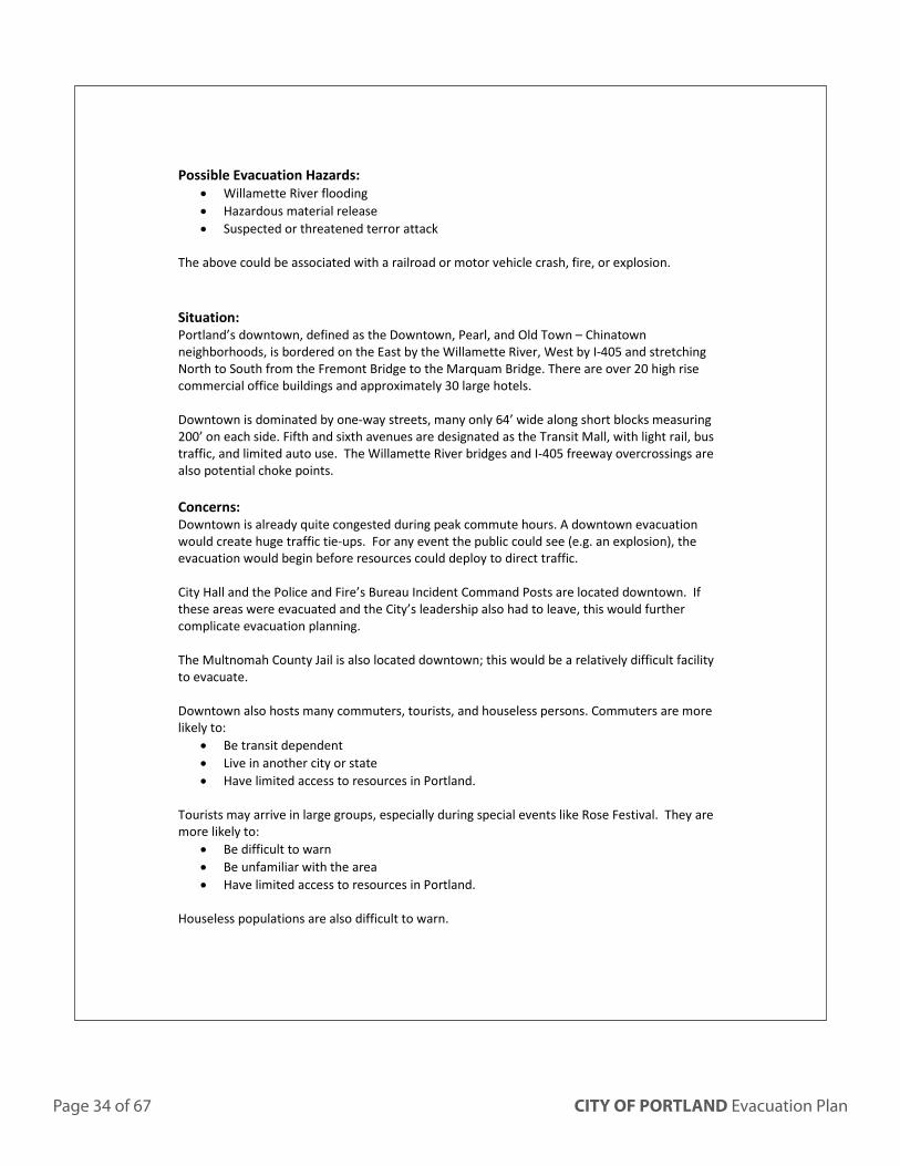
ATTACHMENT 1 | EVACUATION ROUTE AND PLAN - DOWNTOWN; CENTRAL BUSINESS DISTRICT
Downtown Central Business District
Page 34 of 67 CITY OF PORTLAND Evacuation Plan
Possible Evacuation Hazards: • Willamette River flooding • Hazardous material release • Suspected or threatened terror attack
The above could be associated with a railroad or motor vehicle crash, fire, or explosion.
Situation: Portland’s downtown, defined as the Downtown, Pearl, and Old Town – Chinatown neighborhoods, is bordered on the East by the Willamette River, West by I-405 and stretching North to South from the Fremont Bridge to the Marquam Bridge. There are over 20 high rise commercial office buildings and approximately 30 large hotels. Downtown is dominated by one-way streets, many only 64’ wide along short blocks measuring 200’ on each side. Fifth and sixth avenues are designated as the Transit Mall, with light rail, bus traffic, and limited auto use. The Willamette River bridges and I-405 freeway overcrossings are also potential choke points. Concerns: Downtown is already quite congested during peak commute hours. A downtown evacuation would create huge traffic tie-ups. For any event the public could see (e.g. an explosion), the evacuation would begin before resources could deploy to direct traffic. City Hall and the Police and Fire’s Bureau Incident Command Posts are located downtown. If these areas were evacuated and the City’s leadership also had to leave, this would further complicate evacuation planning. The Multnomah County Jail is also located downtown; this would be a relatively difficult facility to evacuate. Downtown also hosts many commuters, tourists, and houseless persons. Commuters are more likely to:
• Be transit dependent • Live in another city or state • Have limited access to resources in Portland.
Tourists may arrive in large groups, especially during special events like Rose Festival. They are more likely to:
• Be difficult to warn • Be unfamiliar with the area • Have limited access to resources in Portland.
Houseless populations are also difficult to warn.
CITY OF PORTLAND Evacuation Plan Page 35 of 67
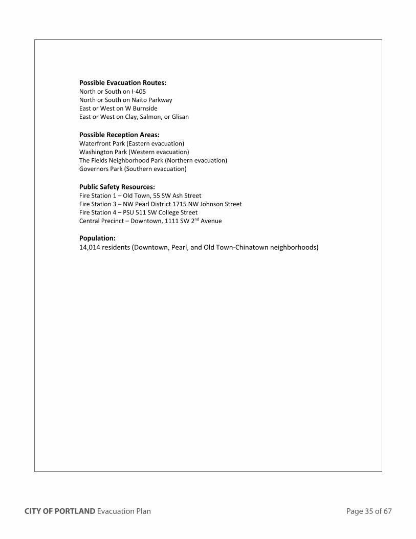
Possible Evacuation Routes: North or South on I-405 North or South on Naito Parkway East or West on W Burnside East or West on Clay, Salmon, or Glisan Possible Reception Areas: Waterfront Park (Eastern evacuation) Washington Park (Western evacuation) The Fields Neighborhood Park (Northern evacuation) Governors Park (Southern evacuation) Public Safety Resources: Fire Station 1 – Old Town, 55 SW Ash Street Fire Station 3 – NW Pearl District 1715 NW Johnson Street Fire Station 4 – PSU 511 SW College Street Central Precinct – Downtown, 1111 SW 2nd Avenue Population: 14,014 residents (Downtown, Pearl, and Old Town-Chinatown neighborhoods)
Page 36 of 67 CITY OF PORTLAND Evacuation Plan
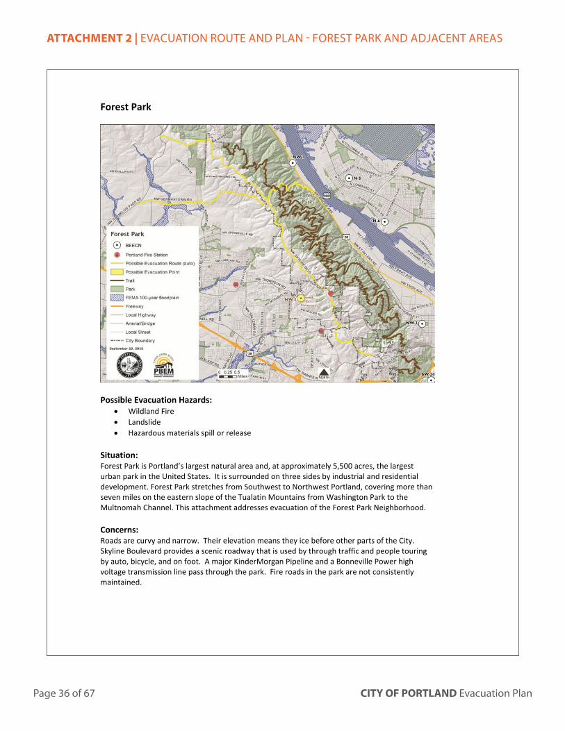
ATTACHMENT 2 | EVACUATION ROUTE AND PLAN - FOREST PARK AND ADJACENT AREAS
Forest Park
Possible Evacuation Hazards:
Wildland Fire Landslide Hazardous materials spill or release
Situation: Forest Park is Portland’s largest natural area and, at approximately 5,500 acres, the largest urban park in the United States. It is surrounded on three sides by industrial and residential development. Forest Park stretches from Southwest to Northwest Portland, covering more than seven miles on the eastern slope of the Tualatin Mountains from Washington Park to the Multnomah Channel. This attachment addresses evacuation of the Forest Park Neighborhood. Concerns: Roads are curvy and narrow. Their elevation means they ice before other parts of the City. Skyline Boulevard provides a scenic roadway that is used by through traffic and people touring by auto, bicycle, and on foot. A major KinderMorgan Pipeline and a Bonneville Power high voltage transmission line pass through the park. Fire roads in the park are not consistently maintained.
CITY OF PORTLAND Evacuation Plan Page 37 of 67
People experiencing homelessness camp in the park. Camp locations change and are may not be known to rangers or others. Campers are hard to reach and may be hard to see; they may hide from people they do not know. Possible Evacuation Routes: There are multiple routes that could be used for evacuation. The incident will dictate which routes are most suited for a neighborhood evacuation.
East or West on NW Germantown Road West on Skyline to additional outlets Via foot down pedestrian stairs
Resources: Fire Station 27 – Forest Heights 3130 NW Skyline Boulevard TVF&R Station 60 – 8585 NW Johnson Street TVF&R Station 68 – 3260 NW 147th Place Possible Temporary Evacuation Points: Washington Park Forest Park Elementary School (BEECN) Population: 9,291 Residents (Forest Park and NW Heights neighborhoods) Unknown number of campers in park
Page 38 of 67 CITY OF PORTLAND Evacuation Plan
ATTACHMENT 3 | EVACUATION ROUTE AND PLAN - HAYDEN ISLAND
Hayden Island
Hazards:
• Flood • Hazardous material release • Transportation incident: aircraft, marine, or motor vehicle • Suspected or threatened terrorism
Situation: Hayden Island is located between the Columbia River and the North Portland Harbor. It is approximately 1,400 acres (3.193 square miles). Access to the island is via I-5, with bridges north to Vancouver and south to Delta Park. The interchange on the island is frequently the site of accidents. Approximately 125,000 vehicles cross the bridge in both directions every day. Access is also possible by water, and the BNSF railroad bridge. There is no consistent pedestrian or bicycle network. The east end of the island is heavily developed with a variety of uses— a manufactured home community, floating home communities, multifamily and single-family homes, regional and local shopping areas, marinas, and industrial uses. West Hayden Island is mostly owned by the Port of
CITY OF PORTLAND Evacuation Plan Page 39 of 67
Portland. The area is undeveloped and contains wetlands, riverside forests and the Columbia River dredge material handling facility. Concerns: A ship colliding with the bridge, a motor vehicle accident on the bridge that caused a fire or hazardous materials release, or any other incident that shut down bridge traffic would leave Hayden Island isolated except for maritime access. The I-5 bridge has a lift span that could be damaged. Traffic lanes on the bridge have no shoulders, and the bike-pedestrian path is narrow. Hayden Island is the location for the largest manufactured home community in the state; manufactured home residents are on average older, less affluent, and more likely to have a disability than the general population. For this reason, they may have more difficulty in an evacuation. Possible Evacuation Routes: North or South on I-5 Via maritime vessels Reception areas: Lotus Isle City Park (on island) Sleep Country Parking Lot (BEECN) (on island) Delta Park Downtown Vancouver, Washington Resources: Fire Station 17 – Hayden Island 848 North Tomahawk Island Drive including 2 maritime vessels Small Coast Guard boats could be deployed to the area Population: 1,902 + residents and 238 businesses, employing nearly 3,000 people. 5,000 boats moored on the island. During summer there is a population influx.
Page 40 of 67 CITY OF PORTLAND Evacuation Plan
ATTACHMENT 4 | EVACUATION ROUTE AND PLAN - LINNTON
Linnton
CITY OF PORTLAND Evacuation Plan Page 41 of 67
Possible Evacuation Hazards:
• Landslide or mudslide • Hazardous material release • Wildland interface fire • Transportation incident: maritime, rail, or motor vehicle • Suspected or threatened terror attack
Situation: Linnton is located in northwest Portland. It extends from the Willamette River into the hills of Forest Park, and from the Multnomah Channel to the Guild’s Lake Industrial Sanctuary. The developed part of Linnton is approximately 5.25 miles long and only about a mile wide. Within Linnton, there are several residential areas that exist as peninsulas in Forest Park. Portland Fire and Rescue procedures direct its companies to approach hazardous material incidents uphill and upwind. So if a release occurred near the SE area of Linnton and the wind was prevailing from the NW (common at some times of year), responders would likely access and stage from the north via NW Newberry Road at the north end of Forest Park. Concerns: A haz mat incident could occur along any rail line or highway, but Linnton risks are greater than other areas in Portland. Linnton is adjacent to Oregon’s s Critical Energy Infrastructure (CEI) Hub, a six-mile stretch along the Willamette River between the Fremont Bridge and Sauvie Island Bridge. The CEI hub contains all of Oregon’s major liquid fuel port terminals, liquid fuel transfer stations, liquefied natural gas storage tanks, a high voltage electric substation, transmission lines and towers, and railroad infrastructure. Most of Linnton is also within designated Potential Landslide Hazard, Wildfire Hazard, and moderate to severe Earthquake Hazard areas. Slopes west of highway 30 are extremely steep (20% or greater in most areas) and soils are shallow and poorly drained. Additionally, Linnton hillside residential areas were not constructed to City standards. Most have only 12 feet of paving with no curb, drainage, or sidewalks. Narrow, curving, dead-end streets impede emergency vehicle access. In addition to difficult circulation within Linnton, access into and out of the area is also constrained; between Germantown Road and Newberry Road, all traffic in or out must go north or south on Highway 30, adjacent to the CEI hub. Newberry Road is only open seasonally, and during major weather events NW Germantown Road is often closed due to icy conditions and landslides. When Newberry and Germantown Roads are closed, traffic must go all the way north to Cornelius Pass Road or south to the St. Johns Bridge. Because of this constrained access and the industrial areas adjacent, shelter-in-place may be especially preferred for haz mat incidents in Linnton. (See attachment 8 for overview of shelter-in-place.)
Page 42 of 67 CITY OF PORTLAND Evacuation Plan
Possible Evacuation Routes: North or South on Highway 30 East over the St. Johns Bridge West on NW Germantown Road Via maritime vessels on the Willamette River. Possible Reception Areas: Cathedral Park (in St. Johns Neighborhood) St. Johns Community Center Scappoose High School Resources: Fire Station 6 – NW Industrial 3660 NW Front Avenue Fire Station 22 – St John’s 7205 North Alta Street Population: 1,058 residents
CITY OF PORTLAND Evacuation Plan Page 43 of 67
ATTACHMENT 5 | EVACUATION ROUTE AND PLAN - MULTNOMAH COUNTY DRAINAGE DISTRICT
Multnomah County Drainage District
Potential Evacuation Hazards:
• Flooding • Levee breach or failure • Hazardous material release • Transportation Incident: aircraft, railroad, or motor vehicle • Suspected or threatened terrorism
Situation: About 13,000 acres in north Portland is protected from Columbia River floodwaters by levees. This area extends approximately Smith and Bybee Lakes on the west, to the City limits at NE 185th Avenue on the east. There are 30 miles of levees (18 miles along the south side of the Columbia River) and 35 miles of sloughs and ditches. This area is the location for the state’s major international airport and nearly 2,500 businesses, including light and heavy industry, warehouse and distribution companies, business parks, corporate operation centers, hotel and motel facilities, restaurants, and retail establishments. There is $20 billion in commercial property in the levee-protected area, and 65,000 people work there. Union Pacific and
Page 44 of 67 CITY OF PORTLAND Evacuation Plan
BNSF railroads both pass through this area, and a portion of the levee is a railroad berm. The railroad berm is the most vulnerable portion of the levee. The Multnomah County Drainage District (MCDD) maintains levees that isolate four different basins: Peninsula Drainage District Number One (PEN 1), Peninsula Drainage District Number Two (PEN 2), Multnomah County Drainage District Number One (MCDD West) and Multnomah County Drainage District Two (MCDD East). MCDD has a Flood Emergency Action Plan (FEAP). The City of Portland support implementation of MCDD’s FEAP, which sets the following evacuation thresholds, with the numbers given as the water elevation in feet of the National Weather Service Columbia River Gage at Vancouver:
Leveed area
Mandatory evacuation of hazmat, suggested for additional-needs
Suggested evacuation for all
Mandatory evacuation for all
Peninsula Drainage District #1
23 forecasted 23 forecasted 29.7
PEN #2 25.6 25.6 29.7 MCDD – West 25.6 29.7 32.7 MCDD – East 25.6 32.7 None
MCDD maintains four stop log closures that can be closed during flood events to isolate flooding in one basin. PBOT can close the stop log closures. Concerns: Much of the area is in industrial use, so haz mat spills could become a secondary hazard during a flood or levee breach. The Portland International Airport is located in MCDD west; it would be complex and disruptive to evacuate the airport. Alderwood Road, Airport Way, and Marine Drive, all main streets leading away from the airport, are known to flood. The Columbia River Correctional Institution is located in MCDD west; this minimum-security state prison houses up to 595 inmates. This facility would also be difficult to evacuate. Houseless persons are known to camp on and adjacent to the levee. This population is also difficult to warn. Possible Evacuation Routes: East and West on Marine Drive (primarily a two lane road with turn out lanes) on the north border East and West on NE Columbia Boulevard on the south border North or South on I-205 North or South on I-5 South on 82nd Ave South on 99E (Martin Luther King Jr Blvd)
CITY OF PORTLAND Evacuation Plan Page 45 of 67
Reception Areas: Concordia University Wilshire Park Resources: Fire Station 2 – Parkrose 4800 NE 122nd Avenue Fire Station 12 – Sandy Boulevard – 8645 NE Sandy Boulevard Fire Station 14 - Alberta Park – 1905 NE Killingsworth
Portland Evacuation Planning: Attachment B Transportation Technical Memorandum
PREPARED FOR: Portland Office of Emergency Management
PREPARED BY: CH2M HILL Project Team
DATE: December 5, 2008
Introduction The purpose of this technical memorandum is to present the transportation analysis results of an orderly evacuation scenario in the Portland metro area. The intent of this analysis was to identify which existing evacuation routes are appropriate, if these routes could accommodate a vehicle evacuation, and identify excess roadway capacity in an emergency evacuation situation. These results will assist the City of Portland and key stakeholders in updating the City of Portland Evacuation Annex that will be used in preparing the City of Portland to respond to emergencies in an organized and productive manner.
For this analysis, the Portland metro area was divided into five evacuation zones to allow for the evacuation of one zone at a time. Identified evacuation routes traverse through these zones and generally follow major roadways within the Portland metro area.
A modified Portland travel demand model was used to evaluate trip types and travel times in addition to roadway capacity within the evacuation zones. A number of assumptions were applied to the model to best reflect what most evacuees would do during a two-hour evacuation scenario.
From this analysis, during an evacuation, areas north, northeast, and southeast of the Portland metro area are identified to have the highest travel time increases along major arterials, most of which have been identified as evacuation routes. Additionally, these same areas present significant roadway capacity issues during an evacuation. However, some arterials that have not been identified as evacuation routes still have available capacity that can be utilized. Although transit was not evaluated in this analysis, the extensive transit network within the City of Portland could also be utilized during an evacuation.
Evacuation Zones The City of Portland divided the Portland metro area into five evacuation zones, defined primarily by zip code. The transportation analysis further evaluated these zones to determine if the zones were appropriate or needed additional refinement to be effective in an evacuation scenario. These zones are described below and the residential and employment population of each zone is presented in Figure 1. The zone boundaries are
shown in Figure 2. Potential changes to these zones are discussed at the end of this technical memorandum.
Zone 1 includes northwest Portland, north of Burnside Road, and west of the Willamette River. Zone 1 contains zip codes 97209, 97210, 97229, and 97231. This zone is comprised of the lowest residential and employment population of the five zones and would have the least impact on the transportation network during an evacuation. Zone 1 has a number of defining unique characteristics that should be considered in the event of an evacuation; these include industrial hazards, trains, horses, and hillside hazards.
Zone 2 includes north and northeast Portland, north of Burnside Road, and east of the Willamette River. Zone 2 contains zip codes 97203, 97211, 97212, 97213, 97217, 97218, 97220, 97227, 97230, and 97232. This zone has been identified as one of the most critical zones in evacuation planning due to its high employment and residential population. As further discussed at the end of this memo, Zone 2 could potentially be split into three zones depending on the type of evacuation. Prevailing winds and flooding are two of the environmental factors that should be considered when splitting and evacuating this zone.
Zone 3 includes southwest Portland, south of Burnside Road/Highway 26 and west of the Willamette River. Zone 3 contains zip codes 97201, 97204, 97205, 97219, and 97221. This zone is has the third highest residential population of the five zones and is the fourth highest in employment population.
Zone 4 includes southeast Portland, south of Burnside Road and east of the Willamette River. Zone 4 contains zip codes: 97202, 97206, 97214, 97215, 97216, 97233, 97236, and 97266. This zone has the second highest residential population of the five zones and is the third highest in employment population.
Zone 5 includes the City center between I-405 and I-5 and contains zip codes 97204, 97205, 97209, and 97210. This zone is the fourth highest in residential population and second highest in employment population.
FIGURE 1 Evacuation Zone Residential and Employment Population
0
20,00040,000
60,00080,000
100,000
120,000140,000
160,000
1 2 3 4 5
Evacuation Zone
Households Employment
Page 48 of 67 CITY OF PORTLAND Evacuation Plan
FIGURE 2 Portland Metro Area Evacuation Zones
CITY OF PORTLAND Evacuation Plan Page 49 of 67
Evacuation Routes The City has also identified evacuation routes (Figure 3) that traverse through the evacuation zones, generally following major roadways. These evacuation routes have been categorized as primary or secondary. Primary routes would typically be evacuated before secondary routes. It is assumed that secondary routes are designated as alternate or back-up routes and feed into the primary routes. The primary and secondary routes, per zone, are described below and are further detailed in the City of Portland Evacuation Annex (June 2007). Potential changes to these routes are discussed at the end of this technical memorandum.
− Zone 1: I-405, Naito Pkwy, Highway 30, Burnside Rd.
− Zone 2: I-5, I-84, I-205, Columbia Blvd., Lombard, Airport Way, Sandy Blvd., Highway 99 (Martin Luther King Blvd.), 82nd Ave., 102nd Ave., 122nd Ave., 162nd Ave.
− Zone 5: I-405, Burnside Rd., Naito Pkwy., SW Clay
Each evacuation route could potentially be further uniquely defined such as priority for evacuation usage, priority for clearing of debris, and the application of toolbox techniques (contra flow, signage, selected closures, etc.), to name a few. The toolbox is a collection of techniques that can be used to increase the efficiency of an emergency evacuation.
Emergency Transportation Routes The City has identified emergency transportation routes for emergency vehicles. These routes generally share the same roadways as the evacuation routes shown in Figure 4. These routes are intended for primary inspection and also used by emergency vehicles after an earthquake. Emergency transportation routes have been established through a regional agreement between the five counties (Multnomah, Clackamas, Columbia, Washington, and Clark (WA)). These routes are planned to be reassessed by the Oregon Department of Transportation (ODOT) in the future. No further analysis was conducted for emergency transportation routes.
Page 50 of 67 CITY OF PORTLAND Evacuation Plan
FIGURE 3
Portland Metro Area Evacuation Routes
CITY OF PORTLAND Evacuation Plan Page 51 of 67
FIGURE 4 Portland Metro Area Evacuation and Emergency Transportation Routes
Page 52 of 67 CITY OF PORTLAND Evacuation Plan
Analysis Methodology and Assumptions
Data Geographic information systems (GIS) data, including data on transportation and transit service/facilities, was requested from the City of Portland and TriMet. This data was used in developing the maps for the Transportation Workshop and the maps included in this technical memorandum. Evacuation routes and zones were reviewed during a Transportation Workshop in August and changes were proposed to the routes and zones. The Transportation Workshop and the proposed changes, which are created in GIS, are discussed in more detail in the Transportation Workshop section later in this memorandum.
The travel demand model, as discussed in the following section, was obtained from Metro, the Portland metropolitan area planning agency. This model contains employee, population, and major arterials and their associated capacity. GIS data, including the evacuation zones, were incorporated into the model.
Travel Demand Modeling Metro maintains two travel models, one containing auto traffic, and the other containing transit demand. For the purposes of this analysis, the two models cannot be combined and only auto traffic was analyzed. This model was last calibrated in 2005. The analysis did not include transit-dependent trips.
The street network was analyzed in the travel demand model to identify how long it would take to evacuate each zone once an evacuation is declared. For this analysis, the model was adjusted by compressing traffic demand for a given evacuation zone from a typical 4-hour period, during a worst case scenario, into a 2-hour period, to represent activities already underway (such as work or shopping) being cut short in response to an evacuation order. A contrary effect was cancellation of trips that had not yet occurred once the evacuation order was given. Finally, a new trip purpose was defined to represent evacuation zone residents exiting the zone boundaries.
Assumptions The evacuation for this analysis was assumed to be an orderly evacuation of vehicles (including trucks) for an emergency scenario during the weekday afternoon time period.
A number of behavioral assumptions were incorporated into the model to reflect what the majority of evacuees and their associated trips would do in the event of an evacuation. It should be noted that some people will evacuate even if told not to, while others would remain in the evacuation zone when told to leave. These assumptions include:
− Most trips are assumed to go home first (gather belongings, etc.) and then evacuate the zone.
− Trips occurring entirely outside the evacuation zone are assumed not to change and the trip would continue to remain outside the evacuation zone.
− For home-based trips (work, shopping, school, etc.) originating from or destined to the evacuation zone, the trip is assumed to go home before evacuating.
− If home is located in the evacuation zone, the trip is assumed to exit the evacuation zone after stopping at home.
− If an evacuation trip’s home is outside the evacuation zone, it is assumed that the trip ends at home.
In addition to established assumptions, p.m. peak trips were adjusted in the model to better reflect the type of trips that would occur during an evacuation:
− Home-based work, college, and school trips that normally return home during a four-hour p.m. peak were concentrated into 2 hours. The small number of these trips leaving home during the two-hour peak would be cancelled for the most part.
− It was assumed that most home-based shopping, recreation, and other trips away from home in the four-hour p.m. peak would try to return home in a two-hour time frame. However, almost all travelers who had not yet left home for these trip purposes would cancel their trips.
− Non-home-based work trips are intermediate destinations on the way home from work. These trips were assumed either to still occur or be replaced with a new work-to-home trip, with little net change in vehicle-miles traveled. However, trips in this category were compressed from four-hour demand to two hours.
− Non-home-based non-work trips are intermediate destinations occurring between an initial leg from home and a final leg returning home. These trips were substantially reduced because they are inherently short and unlikely to occur once an evacuation is announced.
− It was assumed that some truck trips would be either be shortened or cancelled, but remaining demand would be compressed from four hours to two.
− Trips to and from outside the evacuation zones would tend to be work-related and would be compressed from the four-hour p.m. peak to two hours.
− Evacuation trips are newly generated trips and are not present in the normal p.m. peak period. It was assumed that one vehicle trip per household would be generated in an evacuation and that trip would be destined to residential areas outside the evacuation zone. Of course, destinations in a real evacuation could be any number of locations, including organized pre-identified public locations such as parks, but for the purpose of modeling, the destination was kept simple.
Generally, evacuation trip delay calculations include reaction time, travel time to home, dwell time at home, travel time to exit the evacuation zone, and travel time outside of the zone. For this analysis, only travel time to home and travel time to exit the evacuation zone was calculated. Intermediate stops between work and home were excluded from the travel model because of their inherent variable length. Also, travel time calculations for Zone 5 (downtown) are not comparable to those of other evacuation zones, because it is Metro’s
practice to code the downtown streets with higher than normal capacities. As a result, the capacity of downtown streets did not “meter” traffic in the model.
Analysis Results Evacuation travel times and roadway capacity were analyzed using the travel demand model and the results are discussed in the following sections.
Travel Time Travel time was calculated in the travel demand model as the time it takes to travel home plus the time it takes to travel to the boundary of the zone the evacuee vehicle is exiting.
In the event of an evacuation, Zone 2 (north and northeast Portland) and Zone 4 (southeast Portland) would generate the highest evacuation trips and experience the highest travel time increase. Zone 2 was identified as the highest priority zone to evacuate due to its high employment and residential population as shown in Figure 5. Zone 4 also has a high population.
As presented in Figure 6, the dark blue bar shows the average number of minutes during an evacuation that exiting trips will require to evacuation of each of the first four zones. Because reaction and dwell time are difficult to estimate, these factors were not
included in the travel calculations. Once the evacuee has evacuated a zone, travel time outside that zone is not included in the travel time calculation. As mentioned previously in the Methods and Assumption section, Zone 5 travel time was not calculated because of the downtown roadway capacity coding in the travel model.
As shown in Figure 6, during the event of an evacuation, exiting trips from Zone 2 would have the greatest percentage increase in evacuation travel time over a typical p.m. peak period. In comparison, evacuation from Zones 1 and 3 would require about 20 percent more travel time than a typical p.m. peak period. Evacuation travel time in Zone 4 would increase about 40 percent from a typical p.m. peak period. Based on these travel time measures, Zone 2’s evacuation demand is the highest in relation to available road capacity, and Zones 1 and 3 have the lowest evacuation demand in relation to available road capacity.
Capacity Figure 7 presents the volume-to-capacity plots for each zone during the typical p.m. peak period (left side of graphic) and during evacuation (right side). Red and orange roadways indicate greater amounts of roadway congestion than areas in green. The lower the volume-to-capacity ratio, the more free-flowing traffic is. A volume-to-capacity ratio less than 0.90 (green) indicates acceptable traffic conditions. A volume-to-capacity ratio between 0.90 and 1.0 (orange) indicates unstable, near-capacity traffic conditions. A volume-to-capacity ratio over 1.0 (red) indicates stop-and-go conditions.
Zone 2 (north and northeast Portland) and Zone 4 (southeast Portland) would have the highest number of people to evacuate. These two zones would have the most roadway segments with evacuation vehicle demand exceeding capacity. Some arterials that have not been identified as evacuation routes still have capacity available to utilize during an evacuation.
Transit and other Transportation Modes While it is assumed that a majority of the evacuation population will use private automobiles for transportation during an evacuation, there would be a significant number of evacuees that would not have private transportation available to use. For this group, transit within the Portland metro area would be beneficial as a key resource in the event of an evacuation. It is essential that all modes of transportation are utilized during an evacuation. Buses, trains, pedestrian, boats, or aircraft modes of transportation could be used to transport evacuees outside the evacuation zones (Portland Evacuation Annex, June 2007).
Although transit-dependent trips were not analyzed for this project, an overlay of transit routes over the evacuation routes, as presented in Figure 8, highlights where the Portland metro transit network could potentially be used for additional assistance during evacuation, with the exception of Zone 1 which has limited transit service.
FIGURE 8 Emergency Evacuation Routes and TriMet Routes
Page 60 of 67 CITY OF PORTLAND Evacuation Plan
Transportation Workshop Summary A Portland evacuation planning Transportation Workshop was held on August 20, 2008, with key stakeholders from the City of Portland (Department of Transportation, Police, Office of Emergency Management), ODOT, TriMet, Port of Portland, and Multnomah County. During this workshop, the transportation analysis results were presented and the evacuation routes and zones were further discussed. From this workshop a number of proposed evacuation route and zone changes were identified.
Evacuation Routes Skyline Boulevard (Zones 1 and 3) should be included as a new secondary route. NW Germantown Road would be used as an evacuation route if Highway 30 is not available due to blockage or damage. Additionally, all bridges in the City should be categorized as primary evacuation routes. Burnside Road is not a primary route through all the evacuation zones because this road does not have the same capacity in each zone.
The evacuation route maps presented during the Transportation Workshop displayed discontinuous evacuation routes, primarily at bridges over the Willamette River. According to the City’s Annex, evacuation zones would allow localized evacuation that could utilize the major roadways within or adjacent to each zone, but it was assumed that evacuees would not be able to cross the Willamette River, which could be impassable depending on the type of emergency. Although the Annex indicates the reason for this discontinuity of evacuation routes over the river, workshop participants indicated a need to connect these routes. The discussed potential evacuation route modifications are shown in Figure 9.
Evacuation Zones Evacuation zones were reviewed and discussed regarding their size as well as the methodology for zone evacuation procedures. Zip codes and major roadways are common features most people understand. Evacuation order instructions such as by zip code or location in relation to a street (example: “North of Lombard”) would be recognized by most people.
Two zones in particular were recommended for further division. Splitting zones with a north-south traversal was identified as the best method to split larger zones. For example, Zone 4 could be potentially split at I-205 to create two new zones (4A and 4B) as shown in Figure 10. Another example is Zone 2, which could potentially be split at I-5 and I-205 to create three new zones (2A, 2B, and 2C) as shown in Figure 11.
The workshop participants also identified the need for a future overlay analysis to identify hazards within the zones and where potential zone splits could be created for partial evacuation. Examples of hazards include the hazardous material and wildfire potential in Zone 1 and potential breeching of levees along the Columbia River in Zone 2. As an example, Columbia Boulevard in Zone 2 could be a potential zone split based on the flooding potential along the northern portion of this zone.
CITY OF PORTLAND Evacuation Plan Page 61 of 67
FIGURE 9 Evacuation Routes Including Proposed Primary and Secondary Routes
Page 62 of 67 CITY OF PORTLAND Evacuation Plan
FIGURE 11 Proposed Divisions of Evacuation Zone 2
CITY OF PORTLAND Evacuation Plan Page 63 of 67
ATTACHMENT 7 | BEECN MAP
!.
!.!.
!.!.
!.
!.
!.!.
!.
!.
!.
!. !.
!.
!.
!.
!.!.
!.
!.
!.
!.
!.
!.!.
!.
!.!.
!.
!.!.
!.
!.
!.
!.
!.
!.
!.
!.
!.
!.
!.
!.
!.
!.
!.
!.
Portland
Lake
Happy
Milwaukie
Vancouver
Beaverton
Tigard
Valley
Oswego
I-5
205
I-5
I-205
HW
Y217
I-405
I-84
US 30
LEWIS & CLARK HWY
500
HWY
McL
OU
HWY 224
HWY
99E
99-W
FOURTHFRU
ITVA
LLE
Y
AN
DR
ESE
N
PLAIN
164T
H
1ST
COLUMBIA
SANDYBLVD
82N
D
DIVISION ST
RD Orchards
WASHINGTONOREGON
Willam
ette
River
Bull
Mtn
MtTalbert
MtScott
Portland
Airport
Fo r e s t
Pa r k
Hayden Island
Government Island
S
162N
D
MILL
BLVDPLAIN
HW
SR-501
18TH ST
138T
HAV
34TH ST
REED
E
CANYON RD
LOMBARD
RD
HALL
BLVD
RD
OLESON
BA R N ES
MU
RR
AYB
LVD
HWY
HILLSDALEBEAVERTON
RD
CORNELL
D
122N
D
RD
FOSTER
182N
D
RD
SUNNYSIDE
MACADAM
AVE
SANDY
BLVD
ST
AIRPORT
WAY
HALSEY ST
KILLINGSWORTH ST
112T
HPOWELL BLVD
AVE
I NTE
RS T
ATE
BURNSIDE ST
148T
H
OATF
KING RD
RY
RD
PRESCOTT ST
GLISAN ST
172N
D
AV
190T
H D
R
MARINE
BLVD
Sauvie Island
International
Columbia
River
Smith
Lake
BybeeLake
12TH
VAUGHN
102 N
D
CES
AR E
. CH
AVEZ
M. L
. KIN
G
BARBUR BLV
D
I-5
SE-46
SE-45SE-34 SE-39SE-35
SE-36
SE-48
NE-21SW-22
NW-4
SW-23
NW-1
NW-2 NE-18
SE-44
NE-10
N-7
SW-28SW-27
NE-14
NE-13
N-9
N-8
SE-41
SE-42SE-47
SE-43
NE-20NE-16
NE-15
NE-11NE-12
NE-17
SE-40
SE-38
SE-37
N-6
N-5
SW-31SW-30
SW-26
SW-33
SW-32
SW-25
SW-29
NW-3
SW-24
NE-19
Page 64 of 67 CITY OF PORTLAND Evacuation Plan
ATTACHMENT 8 | AMERICAN RED CROSS FACT SHEET ON SHELTER-IN-PLACE
1 February, 2003
What Shelter-in-Place Means: One of the instructions you may be given in an emergency where hazardous materials may have been released into the atmosphere is to shelter-in-place. This is a precaution aimed to keep you safe while remaining indoors. (This is not the same thing as going to a shelter in case of a storm.) Shelter-in-place means selecting a small, interior room, with no or few windows, and taking refuge there. It does not mean sealing off your entire home or office building. If you are told to shelter-in-place, follow the instructions provided in this Fact Sheet. Why You Might Need to Shelter-in-Place: Chemical, biological, or radiological contaminants may be released accidentally or intentionally into the environment. Should this occur, information will be provided by local authorities on television and radio stations on how to protect you and your family. Because information will most likely be provided on television and radio, it is important to keep a TV or radio on, even during the workday. The important thing is for you to follow instructions of local authorities and know what to do if they advise you to shelter-in-place. How to Shelter-in-Place At Home: • Close and lock all windows and exterior doors. • If you are told there is danger of explosion, close the window shades, blinds, or curtains. • Turn off all fans, heating and air conditioning systems. Close the fireplace damper. • Get your family disaster supplies kit http://www.redcross.org/services/disaster/beprepared/supplies.html, and make sure the
radio is working. • Go to an interior room without windows that's above ground level. In the case of a chemical threat, an above-ground
location is preferable because some chemicals are heavier than air, and may seep into basements even if the windows are closed.
• Bring your pets with you, and be sure to bring additional food and water supplies for them. • It is ideal to have a hard-wired telephone in the room you select. Call your emergency contact and have the phone available if you need
to report a life-threatening condition. Cellular telephone equipment may be overwhelmed or damaged during an emergency. • Use duct tape and plastic sheeting (heavier than food wrap) to seal all cracks around the door and any vents into the room. • Keep listening to your radio or television until you are told all is safe or you are told to evacuate. Local officials may call for
evacuation in specific areas at greatest risk in your community. At Work: • Close the business. Bring everyone into the room(s). Shut and lock the door(s). • If there are customers, clients, or visitors in the building, provide for their safety by asking them to stay – not leave. When
authorities provide directions to shelter-in-place, they want everyone to take those steps now, where they are, and not drive or walk outdoors.
• Unless there is an imminent threat, ask employees, customers, clients, and visitors to call their emergency contact to let them know where they are and that they are safe.
• Turn on call-forwarding or alternative telephone answering systems or services. If the business has voice mail or an automated attendant, change the recording to indicate that the business is closed, and that staff and visitors are remaining in the building until authorities advise it is safe to leave.
• Close and lock all windows, exterior doors, and any other openings to the outside. • If you are told there is danger of explosion, close the window shades, blinds, or curtains. • Have employees familiar with your building’s mechanical systems turn off all fans, heating and air conditioning systems.
Some systems automatically provide for exchange of inside air with outside air – these systems, in particular, need to be turned off, sealed, or disabled.
• Gather essential disaster supplies, such as nonperishable food, bottled water, battery-powered radios, first aid supplies, flashlights, batteries, duct tape, plastic sheeting, and plastic garbage bags.
• Select interior room(s) above the ground floor, with the fewest windows or vents. The room(s) should have adequate space for everyone to be able to sit in. Avoid overcrowding by selecting several rooms if necessary. Large storage closets, utility rooms, pantries, copy and conference rooms without exterior windows will work well. Avoid selecting a room with mechanical equipment like ventilation blowers or pipes, because this equipment may not be able to be sealed from the outdoors.
• It is ideal to have a hard-wired telephone in the room(s) you select. Call emergency contacts and have the phone available if you need to report a life-threatening condition. Cellular telephone equipment may be overwhelmed or damaged during an emergency.
• Use duct tape and plastic sheeting (heavier than food wrap) to seal all cracks around the door(s) and any vents into the room.
FACT SHEET ON SHELTER-IN-PLACE
CITY OF PORTLAND Evacuation Plan Page 65 of 67
2 February, 2003
• Write down the names of everyone in the room, and call your business’ designated emergency contact to report who is in the room with you, and their affiliation with your business (employee, visitor, client, customer.)
• Keep listening to the radio or television until you are told all is safe or you are told to evacuate. Local officials may call for evacuation in specific areas at greatest risk in your community.
At School: • Close the school. Activate the school’s emergency plan. Follow reverse evacuation procedures to bring students, faculty,
and staff indoors. • If there are visitors in the building, provide for their safety by asking them to stay – not leave. When authorities provide
directions to shelter-in-place, they want everyone to take those steps now, where they are, and not drive or walk outdoors. • Provide for answering telephone inquiries from concerned parents by having at least one telephone with the school’s listed
telephone number available in the room selected to provide shelter for the school secretary, or person designated to answer these calls. This room should also be sealed. There should be a way to communicate among all rooms where people are sheltering-in-place in the school.
• Ideally, provide for a way to make announcements over the school-wide public address system from the room where the top school official takes shelter.
• If children have cell phones, allow them to use them to call a parent or guardian to let them know that they have been asked to remain in school until further notice, and that they are safe.
• If the school has voice mail or an automated attendant, change the recording to indicate that the school is closed, students and staff are remaining in the building until authorities advise that it is safe to leave.
• Provide directions to close and lock all windows, exterior doors, and any other openings to the outside. • If you are told there is danger of explosion, direct that window shades, blinds, or curtains be closed. • Have employees familiar with your building’s mechanical systems turn off all fans, heating and air conditioning systems. Some systems
automatically provide for exchange of inside air with outside air – these systems, in particular, need to be turned off, sealed, or disabled. • Gather essential disaster supplies, such as nonperishable food, bottled water, battery-powered radios, first aid supplies,
flashlights, batteries, duct tape, plastic sheeting, and plastic garbage bags. • Select interior room(s) above the ground floor, with the fewest windows or vents. The room(s) should have adequate space
for everyone to be able to sit in. Avoid overcrowding by selecting several rooms if necessary. Classrooms may be used if there are no windows or the windows are sealed and can not be opened. Large storage closets, utility rooms, meeting rooms, and even a gymnasium without exterior windows will also work well.
• It is ideal to have a hard-wired telephone in the room(s) you select. Call emergency contacts and have the phone available if you need to report a life-threatening condition. Cellular telephone equipment may be overwhelmed or damaged during an emergency.
• Bring everyone into the room. Shut and lock the door. • Use duct tape and plastic sheeting (heavier than food wrap) to seal all cracks around the door(s) and any vents into the room. • Write down the names of everyone in the room, and call your schools’ designated emergency contact to report who is in the
room with you. • Listen for an official announcement from school officials via the public address system, and stay where you are until you are
told all is safe or you are told to evacuate. Local officials may call for evacuation in specific areas at greatest risk in your community.
In Your Vehicle: If you are driving a vehicle and hear advice to “shelter-in-place” on the radio, take these steps: • If you are very close to home, your office, or a public building, go there immediately and go inside. Follow the shelter-in-
place recommendations for the place you pick described above. • If you are unable to get to a home or building quickly and safely, then pull over to the side of the road. Stop your vehicle in the safest
place possible. If it is sunny outside, it is preferable to stop under a bridge or in a shady spot, to avoid being overheated. • Turn off the engine. Close windows and vents. • If possible, seal the heating/air conditioning vents with duct tape. • Listen to the radio regularly for updated advice and instructions. • Stay where you are until you are told it is safe to get back on the road. Be aware that some roads may be closed or traffic
detoured. Follow the directions of law enforcement officials. Local officials on the scene are the best source of information for your particular situation. Following their instructions during and after emergencies regarding sheltering, food, water, and clean up methods is your safest choice. Remember that instructions to shelter-in-place are usually provided for durations of a few hours, not days or weeks. There is little danger that the room in which you are taking shelter will run out of oxygen and you will suffocate.
LEVEL 1: A Level 1 Evacuation means “BE READY” for potential evacuation. Residents should be aware of the danger that exists in their area, monitor emergency services websites and local media outlets for information. This is the time for preparation and precautionary movement of persons with special needs, mobile property and (under certain circumstances) pets and livestock. If conditions worsen, emergency services personnel may contact you via an emergency notification system.
LEVEL 2: A Level 2 Evacuation means “BE SET” to evacuate. YOU MUST PREPARE TO LEAVE AT A MOMENT’S NOTICE This level indicates there is significant danger to your area, and residents should either voluntarily relocate to a shelter or with family/friends outside of the affected area, or if choosing to remain, to be ready to evacuate at a moment’s notice. Residents MAY have time to gather necessary items, but doing so is at their own risk. THIS MAY BE THE ONLY NOTICE THAT YOU RECEIVE. Emergency services cannot guarantee that they will be able to notify you if conditions rapidly deteriorate. Area media services will be asked to broadcast periodic updates.
LEVEL 3: A Level 3 Evacuation means “GO” Evacuate NOW LEAVE IMMEDIATELY! Danger to your area is current or imminent, and you should evacuate immediately. If you choose to ignore this advisement, you must understand that emergency services may not be available to assist you further. DO NOT delay leaving to gather any belongings or make efforts to protect your home. THIS WILL BE THE LAST NOTICE THAT YOU RECEIVE. Entry to evacuated areas may be denied until conditions are safe. Area radio and TV stations have been asked to broadcast periodic updates.
This document has been reviewed and accepted by Oregon State Sheriffs’ Association, Oregon State Fire Marshal’s Office, Oregon Office of Emergency Management, Oregon Fire Chief’s Association and Oregon Department of Forestry. This document should be considered an official document for use to the public on All Hazards Evacuations.
CITY OF PORTLAND Evacuation Plan Page 67 of 67
Portland Bureau of Emergency Management
9911 SE Bush Street
Portland, OR 97266-2562 www.portlandoregon.gov/pbem
Please consider the environment before printing this document.