C3 – FORESHORE AND WATERFRONT CONTROLS KOGARAH DCP 2013 - September 2013 C3 - 1 C3 - Foreshore & Waterfront Controls 1. Foreshore Localities .....................................................................................................................................................2 2. Defining the Foreshore Localities ........................................................................................................................3 3. Development on the Foreshore Area..............................................................................................................4 4. Development below mean high water mark (MHWM) .......................................................................5 5. Heritage along the Foreshore ................................................................................................................................5 6. Foreshore & Waterfront Development ..........................................................................................................6 6.1 General Objectives & Controls ......................................................................................................................6 6.2 Jetty, ramp and pontoon structures .............................................................................................................7 6.3 Stabilisation Piles ......................................................................................................................................................9 6.4 Sliprails ........................................................................................................................................................................ 10 6.5 Boatsheds .................................................................................................................................................................. 11 6.6 Swimming Pools/Spa Pools ............................................................................................................................ 13 6.7 Seawalls ...................................................................................................................................................................... 14 6.8 Reclamation ............................................................................................................................................................. 15 6.9 Inclinators and Stairs ........................................................................................................................................... 16 6.10 Landscaping.............................................................................................................................................................. 16 6.11 Dredging .................................................................................................................................................................... 17
Transcript
C3 – FORESHORE AND WATERFRONT CONTROLS
KOGARAH DCP 2013 - September 2013 C3 - 1
C3 - Foreshore & Waterfront Controls
1. Foreshore Localities .....................................................................................................................................................2 2. Defining the Foreshore Localities ........................................................................................................................3 3. Development on the Foreshore Area..............................................................................................................4 4. Development below mean high water mark (MHWM).......................................................................5 5. Heritage along the Foreshore................................................................................................................................5 6. Foreshore & Waterfront Development ..........................................................................................................6 6.1 General Objectives & Controls ......................................................................................................................6 6.2 Jetty, ramp and pontoon structures.............................................................................................................7 6.3 Stabilisation Piles ......................................................................................................................................................9 6.4 Sliprails ........................................................................................................................................................................10 6.5 Boatsheds..................................................................................................................................................................11 6.6 Swimming Pools/Spa Pools ............................................................................................................................13 6.7 Seawalls ......................................................................................................................................................................14 6.8 Reclamation .............................................................................................................................................................15 6.9 Inclinators and Stairs...........................................................................................................................................16 6.10 Landscaping..............................................................................................................................................................16 6.11 Dredging....................................................................................................................................................................17
C3 – FORESHORE AND WATERFRONT CONTROLS
KOGARAH DCP 2013 - September 2013 C3 - 2
C3 - Foreshore & Waterfront Controls
The Kogarah waterways and foreshore areas have both local and regional significance as they represent a valuable estuarine environment that provides the community with opportunities for passive and active recreation. This Part provides performance standards and controls for ancillary development that is below the Foreshore Building Line (FBL) and/or along the waterfront, above, on, or below Mean High Water Mark (MHWM). The objectives of these controls are to ensure the visual and environmental qualities of the foreshore and waterfront areas are maintained and enhanced. These detailed controls must be read in conjunction with the specific Foreshore Locality controls contained in Section C4. Some Locality controls may override what is generally permitted under this Part.
1. Foreshore Localities
The Kogarah waterfront is extensively, if not completely urbanised. Much of the development is intensive and varies both in quality and scale. The Foreshore is broken down into localities based on distinctive geographical features such as bays and associated headlands or physically distinctive areas. There are 10 Foreshore Localities, being: 1. Georges River Estuary: Rocky Point Road to Wellington Street 2. Kogarah Bay: Wellington Street to Torwood Street 3. Claydon Reserve to Carss Park 4. Carss Park to Shipwright’s Bay 5. Shipwright’s Bay to Pleasant Way 6. Kyle Bay 7. Harness Cask Point to Connells Point 8. Oatley Bay: Connells Point to Poulton Park 9. Oatley Bay: Poulton Park to Oatley Point Reserve; and 10. Oatley Point Reserve to Neverfail Bay In preparing a development application for any waterfront property, you must firstly refer to the Foreshore Locality Controls in Part C4. These provide the detailed objectives and design controls for each of the foreshore localities. Where the Foreshore Locality Controls are inconsistent with the following generic controls, then the Foreshore Locality Guides take precedence.
C3 – FORESHORE AND WATERFRONT CONTROLS
KOGARAH DCP 2013 - September 2013 C3 - 3
2. Defining the Foreshore Localities
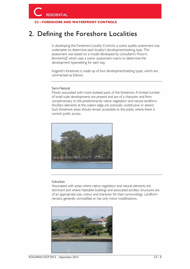
In developing the Foreshore Locality Controls, a scenic quality assessment was undertaken to determine each locality’s development/setting type. This assessment was based on a model developed by consultant’s Parson’s Brinckerhoff, which uses a scenic assessment matrix to determine the development type/setting for each bay. Kogarah’s foreshore is made up of four development/setting types, which are summarised as follows:
Semi-Natural Mostly associated with more isolated parts of the foreshore. A limited number of small scale developments are present and are of a character and form complimentary to the predominantly native vegetation and natural landform. Ancillary elements at the waters edge are scenically unobtrusive or absent. Such foreshore areas should remain accessible to the public where there is current public access.
Suburban Associated with areas where native vegetation and natural elements are dominant and where habitable buildings and associated ancillary structures are of an appropriate size, colour and character for their surroundings. Landform remains generally unmodified or has only minor modifications.
C3 – FORESHORE AND WATERFRONT CONTROLS
KOGARAH DCP 2013 - September 2013 C3 - 4
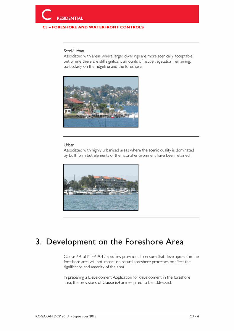
Semi-Urban Associated with areas where larger dwellings are more scenically acceptable, but where there are still significant amounts of native vegetation remaining, particularly on the ridgeline and the foreshore.
Urban Associated with highly urbanised areas where the scenic quality is dominated by built form but elements of the natural environment have been retained.
3. Development on the Foreshore Area
Clause 6.4 of KLEP 2012 specifies provisions to ensure that development in the foreshore area will not impact on natural foreshore processes or affect the significance and amenity of the area. In preparing a Development Application for development in the foreshore area, the provisions of Clause 6.4 are required to be addressed.
C3 – FORESHORE AND WATERFRONT CONTROLS
KOGARAH DCP 2013 - September 2013 C3 - 5
4. Development below mean high water mark (MHWM)
Clause 5.7 of KLEP 2012 specifies provisions for development below mean high water mark and states the following:
5.7 Development below mean high water mark
(1) The objective of this clause is to ensure appropriate environmental assessment for development carried out on land covered by tidal waters.
(2) Development consent is required to carry out development on any land
below the mean high water mark of any body of water subject to tidal influence (including the bed of any such water).
Where it is proposed to undertake development (generally any development below MHWM) or erect any structure over foreshore crown land, owner’s consent is required from the Department of Lands prior to lodging a development application with Council. Prior to the Department of Lands accepting an application for owner’s consent the written consent of the NSW Department of Primary Industries and the NSW Maritime is required. It should be noted that NSW Department of Primary Industries will not support any waterfront development that will impact on aquaculture facilities or recreational fishing access.
5. Heritage along the Foreshore
Cultural Heritage The Georges River and tributaries contain a diverse array of items and areas considered to possess non-Aboriginal cultural heritage significance. The nature and extent of heritage items and areas range from houses and gardens to large continuous areas of foreshore in parks, recreation reserves, ’pleasure grounds’, and oyster farms. These require analysis and sensitive conservation and management to retain their values for present and future generations. Aboriginal Heritage The Georges River foreshore has varied types of Aboriginal heritage. This heritage is significant and is still very much a part of the living Aboriginal tradition or culture. Development in the vicinity of these known Aboriginal archaeological sites is to be in accordance with Clause 5.10 of KLEP 2012. The Foreshore Locality Controls include, where relevant, a list of recorded sites.
C3 – FORESHORE AND WATERFRONT CONTROLS
KOGARAH DCP 2013 - September 2013 C3 - 6
6. Foreshore & Waterfront Development
6.1 General Objectives & Controls
Objectives
(a) Minimise the impact of development on the natural landform of the foreshore and waterway by integrating structures into the site with a minimum change to the natural topography.
(b) Minimise the visual impact of development when viewed from adjacent
land and waterways. (c) Blend developments into the foreshore and waterfront environment by
using designs and materials which complement the natural landscape. (d) Retain and enhance endemic native vegetation along the foreshore and
ensure that development does not adversely affect any estuarine flora or fauna habitat.
(e) Achieve an appropriate balance between private development and the
alienation of the waterways, which is a public resource, from public use.
(f) Council will not permit waterfront structures on land that does not have frontage to a waterway.
Controls (1) Council will not grant consent for residential waterfront structures to
land which does not have frontage to the waterway. This includes allotments which only have a right of way to the waterway.
(2) Where an existing allotment has a water frontage of less than 9 metres,
Council will not permit waterfront structures unless they are shared.
C3 – FORESHORE AND WATERFRONT CONTROLS
KOGARAH DCP 2013 - September 2013 C3 - 7
6.2 Jetty, ramp and pontoon structures
Jetty, ramp and pontoon structures are designed to facilitate access to private recreational vessels where a reasonable depth of water is available. These structures are intended only to be used for short stay embarking and disembarking of passengers and the transfer of personal goods. They are not intended to be used to permanently moor or park a vessel. The specific Foreshore Locality Controls also need to be referred to in order to determine whether this type of development is permitted in a specific bay/locality. Objectives
(a) The design of jetty, ramp and pontoon structures should not obstruct
or interfere with navigation within the waterway.
(b) Structures should blend in the natural environment
(c) Structures are to be designed to protect and enhance natural features and vegetation.
(d) Public access along the foreshore is not restricted
(e) The cumulative impact of waterfront structures is to be reduced, particularly in areas where it is difficult to attain reasonable water depths or adequate riparian rights.
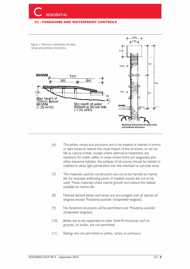
Controls (1) A fixed jetty is not to exceed a length of 9m from MHWM including
any existing reclamations. The jetty may have a maximum width of 1500mm and a maximum height of 750mm above MHWM (1.29 AHD) (Figure 1).
(2) A ramp and pontoon extension to a jetty may be permitted provided
that the total length of the ramp and jetty does not exceed 15m from MHWM (Figure 1).
(3) Pontoons are to be a maximum of 3.6m x 2.4m, constructed to the
appropriate Australian Standard and only used as a facility to provide access to the water (Figure 1).
(4) In all cases, the length of the structure is to be confined to the
minimum needed to reach useable water, which is 600mm depth at 00 low tide (-1.53m AHD) (Figure 1).
(5) The construction of “L” or “T” ends or other types of elongations or
steps at right angles to jetties are not permitted.
C3 – FORESHORE AND WATERFRONT CONTROLS
KOGARAH DCP 2013 - September 2013 C3 - 8
(6) The jetties, ramps and pontoons are to be treated or stained in brown
or dark tones to reduce the visual impact of the structure, or can be left as natural timber, except where alternative treatments are necessary for public safety. In areas where there are seagrasses and other estuarine habitats, the surfaces of structures should be slatted or meshed to allow light penetration into the intertidal or sub-tidal zone.
(7) The materials used for construction are not to be harmful to marine
life, for example antifouling paints or treated woods are not to be used. These materials inhibit marine growth and reduce the habitat available to marine life.
(8) Meshed decked jetties and ramps are encouraged over all species of
seagrass except ‘Posidonia australis’ (strapweed seagrass). (9) No foreshore structures will be permitted over ‘Posidonia australis’
(strapweed seagrass). (10) Jetties are to be supported on piles. Solid fill structures such as
groynes, or similar, are not permitted. (11) Railings are not permitted on jetties, ramps or pontoons.
Figure 1. Maximum dimensions for Jetty ramps and pontoon structures.
C3 – FORESHORE AND WATERFRONT CONTROLS
KOGARAH DCP 2013 - September 2013 C3 - 9
(12) Council does not permit the construction of jetties, ramps or other structures in areas where they may interfere with public access along the waterfront. In exceptional circumstances where a jetty is allowed across a public waterfront, the design must allow for pedestrian access across the structure by providing timber steps on either side of the jetty.
(13) The Foreshore Locality Controls specify where foreshore access must
be maintained and in some areas the placement of jetties may be restricted.
(14) Council strongly supports the use of shared facilities for two or more
adjoining residential waterfront properties. This particularly applies in confined bays and/or bays characterised by shallow water, which would otherwise tend to create a demand for long structures to attain reasonable water depths.
(15) The Foreshore Locality Controls specify the circumstances where
shared facilities are encouraged.
6.3 Stabilisation Piles
The sinking of piles requires the consent of Council and may necessitate consultation with the NSW Maritime Authority to determine the impact upon navigation. Stabilisation piles are used for reinforcing pontoons and facilitating access in areas exposed to high tidal run-outs and heavy wave exposure. Council may consider stabilisation piles in certain circumstances, but these should be designed to be integrated with any pontoon structure. The Foreshore Locality Controls identify the areas where stabilisation piles are permitted. Objectives (a) Stabilisation piles may be permitted in areas subject to heavy wave
exposure to stabilise jetties and pontoons (b) Stabilisation piles must be designed as an integral part of the pontoon
structure.
C3 – FORESHORE AND WATERFRONT CONTROLS
KOGARAH DCP 2013 - September 2013 C3 - 10
Controls (1) Council will generally only permit a maximum of two freestanding end
piles to stabilise a jetty or a pontoon in areas subject to moderate to heavy wave exposure. The Foreshore Locality Controls specify the circumstances when stabilisation piles are permitted.
(2) Stabilisation piles must be an integral part of the pontoon (not free
standing). Applications for stabilisation piles must be supported by a report from a civil engineer demonstrating their need, design and location.
(3) Where stabilisation piles are permitted, no permanent berthing of
vessels is permitted. (4) Stabilisation piles are to be of timber. Any other material will be
considered on merit. (5) The maximum height of stabilisation piles above MHWM is 1.75m and
timber piles should have a minimum diameter of 250mm. (6) All stabilisation piles are to be treated in dark, natural colours above
MHWM in order to minimise the visual impact. (7) Stabilisation end piles shall be painted white along the top (0.5m) to
facilitate visual prominence when viewed from the water at night and minimise any hazard to navigation. The use of alternative measures, such as reflective materials, to facilitate visual prominence may also be supported.
6.4 Sliprails
Sliprails are intended to facilitate access to and from the water for vessels that are stored within a boatshed. Objectives Sliprails must only facilitate access to and from the water for vessels that are stored within a boatshed. Controls (1) Sliprails are to be in the form of two parallel rails located as close as
practical to the seabed and must be recessed into any seawall or reclamation to minimise the height of the sliprails.
C3 – FORESHORE AND WATERFRONT CONTROLS
KOGARAH DCP 2013 - September 2013 C3 - 11
(2) In all cases, the length of the structure is to be only the minimum needed to reach useable water which is 600mm depth at 00 low tide (-1.53 AHD) to a maximum length of 15m from MHWM and a maximum width of 2m.
(3) There are to be no timber infill walkways, or timber ramps on the
sliprails. (4) Slipways are to be constructed so as not to reduce or impact on
riparian vegetation or estuarine habitats, including the removal of mangroves.
(5) Sliprails are not to be used for the storage of boats. (6) The Foreshore Locality Controls identify the areas where sliprails may
be restricted.
6.5 Boatsheds
Boatsheds are specifically intended for the storage/maintenance of small boats and boating equipment only. Council will not permit the use of the boatshed for any other purpose. Boatsheds are generally only permitted in the area between the foreshore building line (FBL) and Mean High Water Mark (MHWM). Despite a general permissibility, each proposal needs to be considered having regard to the local site conditions and possible adverse impacts on visual or environmental aspects of the site. Boatsheds may be permitted below MHWM in certain circumstances. The Foreshore Locality Controls specify the areas where boatsheds below MHWM may be permitted.
Objectives (a) Minimise the visual impact of boatsheds when viewed from the water. (b) Boatsheds that reflect a scale and character in keeping with traditional
style boatsheds are preferred.
Controls (1) Boatsheds are to be single storey and will generally only be permitted
at or above MHWM.
C3 – FORESHORE AND WATERFRONT CONTROLS
KOGARAH DCP 2013 - September 2013 C3 - 12
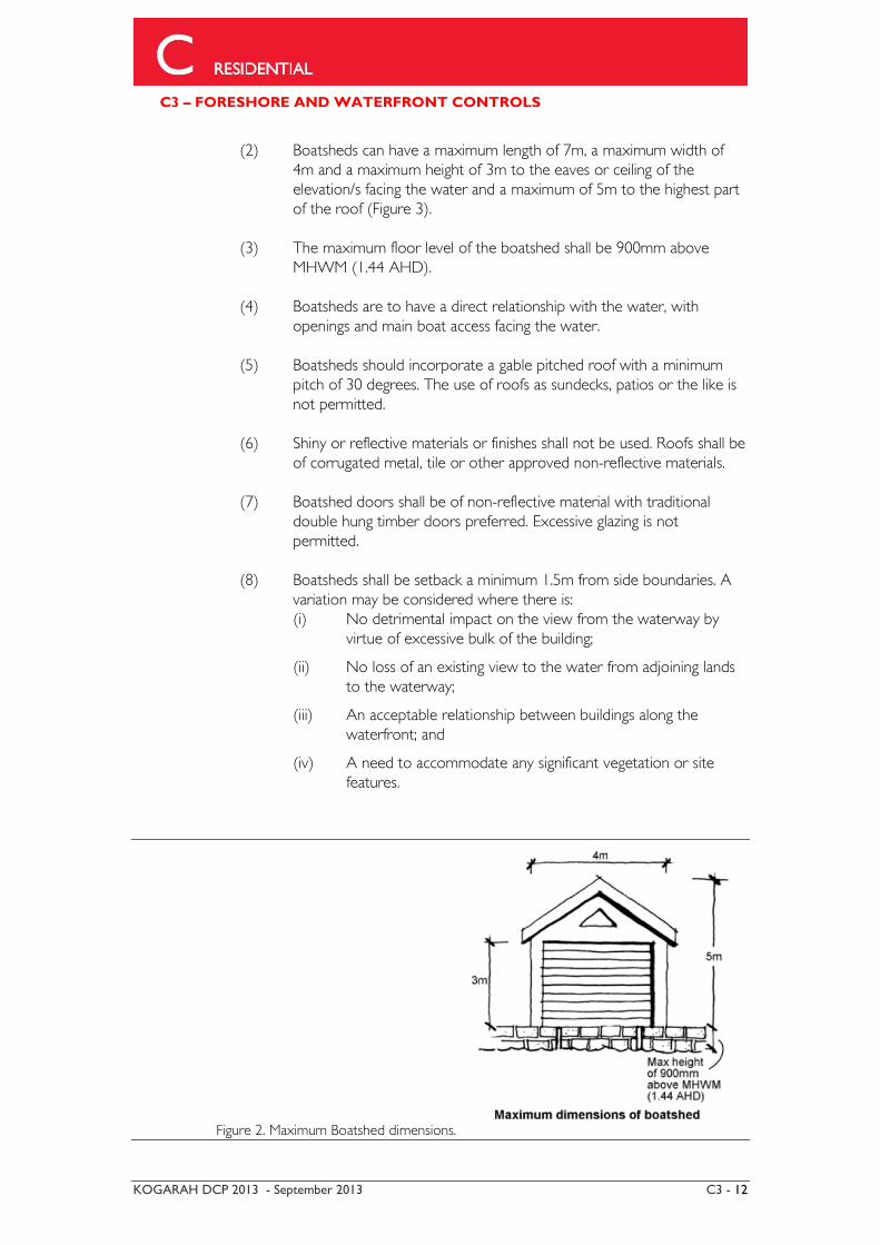
(2) Boatsheds can have a maximum length of 7m, a maximum width of 4m and a maximum height of 3m to the eaves or ceiling of the elevation/s facing the water and a maximum of 5m to the highest part of the roof (Figure 3).
(3) The maximum floor level of the boatshed shall be 900mm above
MHWM (1.44 AHD). (4) Boatsheds are to have a direct relationship with the water, with
openings and main boat access facing the water. (5) Boatsheds should incorporate a gable pitched roof with a minimum
pitch of 30 degrees. The use of roofs as sundecks, patios or the like is not permitted.
(6) Shiny or reflective materials or finishes shall not be used. Roofs shall be
of corrugated metal, tile or other approved non-reflective materials. (7) Boatshed doors shall be of non-reflective material with traditional
double hung timber doors preferred. Excessive glazing is not permitted.
(8) Boatsheds shall be setback a minimum 1.5m from side boundaries. A
variation may be considered where there is: (i) No detrimental impact on the view from the waterway by
virtue of excessive bulk of the building;
(ii) No loss of an existing view to the water from adjoining lands to the waterway;
(iii) An acceptable relationship between buildings along the waterfront; and
(iv) A need to accommodate any significant vegetation or site features.
Figure 2. Maximum Boatshed dimensions.
C3 – FORESHORE AND WATERFRONT CONTROLS
KOGARAH DCP 2013 - September 2013 C3 - 13
6.6 Swimming Pools/Spa Pools
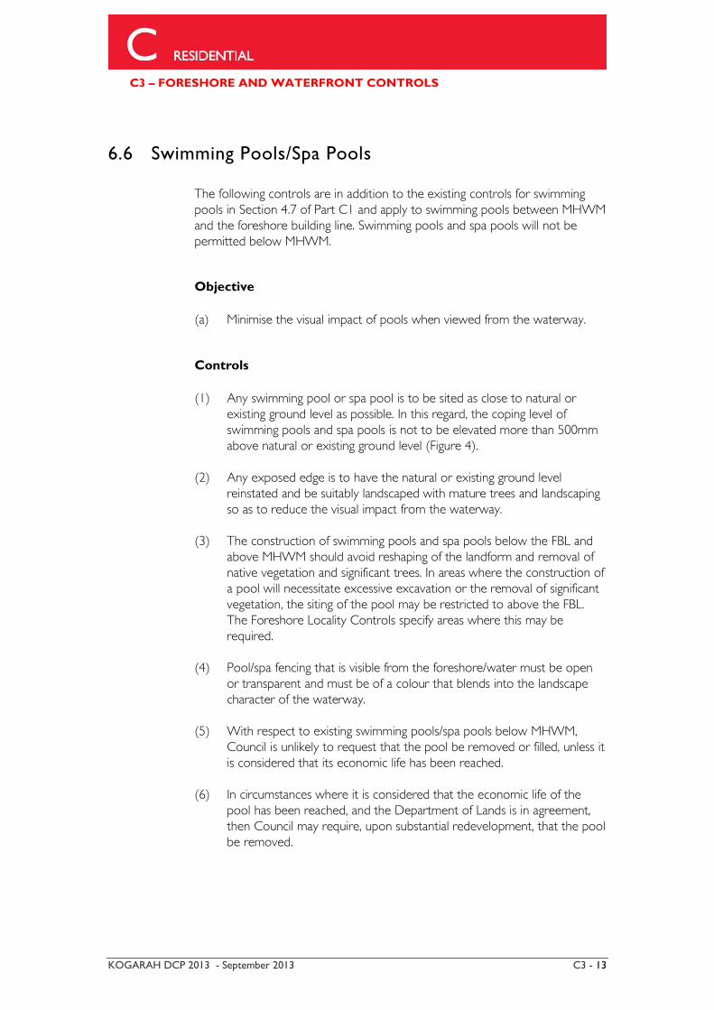
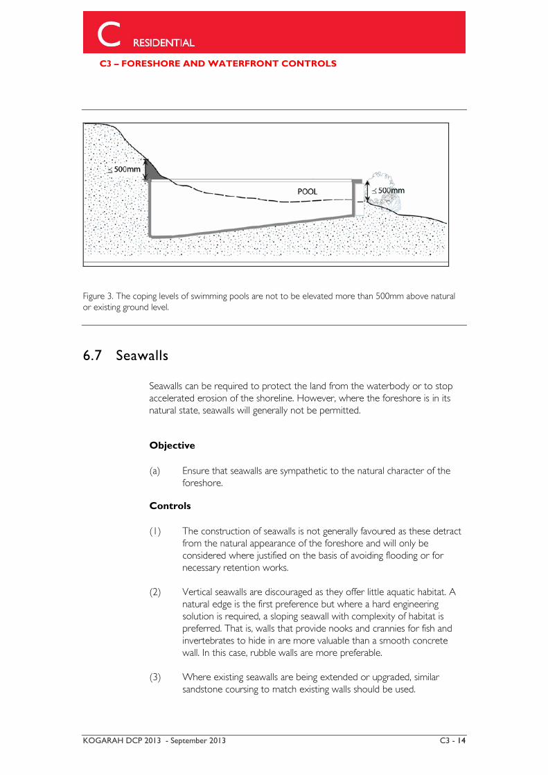
The following controls are in addition to the existing controls for swimming pools in Section 4.7 of Part C1 and apply to swimming pools between MHWM and the foreshore building line. Swimming pools and spa pools will not be permitted below MHWM. Objective (a) Minimise the visual impact of pools when viewed from the waterway. Controls (1) Any swimming pool or spa pool is to be sited as close to natural or
existing ground level as possible. In this regard, the coping level of swimming pools and spa pools is not to be elevated more than 500mm above natural or existing ground level (Figure 4).
(2) Any exposed edge is to have the natural or existing ground level
reinstated and be suitably landscaped with mature trees and landscaping so as to reduce the visual impact from the waterway.
(3) The construction of swimming pools and spa pools below the FBL and
above MHWM should avoid reshaping of the landform and removal of native vegetation and significant trees. In areas where the construction of a pool will necessitate excessive excavation or the removal of significant vegetation, the siting of the pool may be restricted to above the FBL. The Foreshore Locality Controls specify areas where this may be required.
(4) Pool/spa fencing that is visible from the foreshore/water must be open
or transparent and must be of a colour that blends into the landscape character of the waterway.
(5) With respect to existing swimming pools/spa pools below MHWM,
Council is unlikely to request that the pool be removed or filled, unless it is considered that its economic life has been reached.
(6) In circumstances where it is considered that the economic life of the
pool has been reached, and the Department of Lands is in agreement, then Council may require, upon substantial redevelopment, that the pool be removed.
C3 – FORESHORE AND WATERFRONT CONTROLS
KOGARAH DCP 2013 - September 2013 C3 - 14
Figure 3. The coping levels of swimming pools are not to be elevated more than 500mm above natural or existing ground level.
6.7 Seawalls
Seawalls can be required to protect the land from the waterbody or to stop accelerated erosion of the shoreline. However, where the foreshore is in its natural state, seawalls will generally not be permitted. Objective (a) Ensure that seawalls are sympathetic to the natural character of the
foreshore. Controls
(1) The construction of seawalls is not generally favoured as these detract
from the natural appearance of the foreshore and will only be considered where justified on the basis of avoiding flooding or for necessary retention works.
(2) Vertical seawalls are discouraged as they offer little aquatic habitat. A
natural edge is the first preference but where a hard engineering solution is required, a sloping seawall with complexity of habitat is preferred. That is, walls that provide nooks and crannies for fish and invertebrates to hide in are more valuable than a smooth concrete wall. In this case, rubble walls are more preferable.
(3) Where existing seawalls are being extended or upgraded, similar
sandstone coursing to match existing walls should be used.
C3 – FORESHORE AND WATERFRONT CONTROLS
KOGARAH DCP 2013 - September 2013 C3 - 15
(4) Seawalls must be located wholly within private land above MHWM. Council will only permit the replacement of an existing seawall below MHWM where there is an existing seawall and the reclamation has been authorised under a permissive occupancy.
(5) The height of the seawall is to be flush with the retained ground level
or the reclamation level located behind it. (6) Natural sandstone blocks or sandstone facing over concrete walls are
preferable to other materials.
6.8 Reclamation
Reclamation can have significant effects on water circulation, water quality and the well being of existing natural estuarine habitats and can also aggravate shoreline erosion. Generally, reclamations will only be considered where there is a public benefit to be gained by the work, for example, providing for public access along the foreshore. Objective (a) Minimise any adverse impact upon the marine flora, fauna or water
quality. Controls (1) Council will only consider reclamations where there are exceptional
circumstances. (2) In considering an application for a reclamation, Council’s assessment
will include, but may not be limited to consideration of the following factors:
(i) appearance of the development from both the waterway and
adjacent foreshore areas; (ii) whether the reclamation will cause pollution or siltation of the
waterway; (iii) whether the reclamation will have any adverse effects on
surrounding uses and marine habitat; (iv) whether the reclamation will have an adverse effect on
drainage patterns; (v) the desirability of ensuring continuous public access along the
foreshore and to the waterway. Reclamations must not be landscaped so as to impede or constrain public access;
C3 – FORESHORE AND WATERFRONT CONTROLS
KOGARAH DCP 2013 - September 2013 C3 - 16
(vi) whether seawalls are required as part of any reclamation; and (vii) the continuity and presence of other adjacent and nearby
reclamations.
6.9 Inclinators and Stairs
Stairs and inclinators may be required to enable pedestrian access on some steeply sloping sites however these should be constructed so as not to necessitate the removal of natural features and vegetation. Objective (a) Minimise the impact of development on the natural landform of the
foreshore by integrating inclinators and stairs into the topography of the site.
Controls (1) Inclinators and stairs to enable pedestrian access to the waterfront are
permitted between the FBL and MHWM. (2) Inclinators and stairs shall generally be constructed as close as practical
to natural ground level. However, natural features along the foreshore are to be retained and the removal of natural rock, trees and vegetation to enable the construction of an inclinator and stairs will not be supported.
(3) Stairs should be a maximum of 1.2m wide and constructed in timber,
masonry or stone.
6.10 Landscaping
Vegetation in the form of bushland, remnant native species and cultural planting has important ecological and landscape values, and Council highly encourages that this be protected and enhanced, where applicable and relevant in the context of the foreshore. Objective
(a) Retain and enhance endemic native vegetation and ensure that any
new landscaping complements the existing landscape character.
C3 – FORESHORE AND WATERFRONT CONTROLS
KOGARAH DCP 2013 - September 2013 C3 - 17
Controls
(1) Natural features along the foreshore are to be retained and the removal of natural rock, trees and vegetation to enable the construction of landscaping will not be supported.
(2) Natural ground levels are to be retained with minimal use of retaining
walls. Where retaining walls are constructed, materials and colours that blend into the character and landscape of the area shall be used.
(3) Endemic native species should be used in areas where native
vegetation is present or has the potential to be regenerated. (4) Exotic species that have the potential to spread into surrounding
bushland should be avoided. (5) Existing mature trees should be retained where possible and
incorporated into the design of new developments. (6) Vegetation along ridgelines and on hillsides should be retained and
supplemented with additional planting to provide a backdrop to the waterway.
(7) A landscape plan is to be submitted for any development between FBL
and MHWM. The level of detail required will depend on the level of works being undertaken. Where a landscape plan is submitted it should indicate the existing and proposed changes in contours, existing trees/vegetation to be retained and removed, measures to protect vegetation during construction and proposed planting including species and common names.
6.11 Dredging
Dredging requires the removal of material from the bed of a river for the purpose of constructing or maintaining a navigational area or channel. Objective (a) Dredging generally has an adverse impact on the estuarine habitat of
the waterway and any dredging proposal would be stringently assessed with regard to any possible impacts.
Controls
(1) Council will generally not support dredging in the W2 Recreational
Waterways zone unless a Public Authority is undertaking the work or there is a general public benefit to be gained by the work.