64
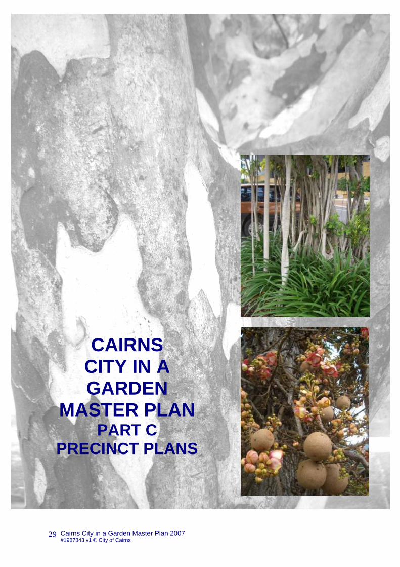
Cairns City in a Garden Master Plan 2007 #1987843 v1 © City of Cairns 29 CAIRNS CITY IN A GARDEN MASTER PLAN PART C PRECINCT PLANS
Cairns City in a Garden Master Plan 2007 #1987843 v1 © City of Cairns
29
CAIRNS CITY IN A GARDEN
MASTER PLAN PART C
PRECINCT PLANS

Cairns City in a Garden Master Plan 2007 #1987843 v1 © City of Cairns
30
City in a Garden Master Plan Part C- Precinct Plans This section of the Cairns City in a Garden Master Plan provides a template for future tree planting in the key city streets (for a summary list of priority streets and tree species palettes refer to City in a Garden Master Plan Part E-Appendices) The precinct approach is in line with the Cairns Plan and addresses local issues and provides a guide to appropriate tree species selection for each precinct and outlines key objectives. For Central Cairns, the area defined by Florence Street to the north, the western footpath of the Esplanade to the east, the CBD side of the Wharf Street footpath to the south, and Bunda Street (east side of street) to the west, please refer to the Cairns CBD Master Plan 2007 for full planting details.
CITY IN A GARDEN MASTER PLAN 2007 2
Vision Statement Error! Bookmark not defined.
Context 2
CAIRNS CITY IN A GARDEN PART A-INTRODUCTION 10
CITY IN A GARDEN MASTER PLAN PART B-TREE SPECIES SELECTION 14
CITY IN A GARDEN MASTER PLAN PART C- PRECINCT PLANS 30
1. Cairns Beaches 32
1.1. Palm Cove 32
1.2. Clifton Beach 34
1.3. Kewarra Beach 36
1.4. Trinity Beach 38
2. Barron Smithfield 40
2.1. Trinity Park 40
2.2. Yorkeys Knob 42
2.3. Holloways Beach 44
2.4. Machans Beach 46
2.5. Smithfield 48
2.6. Caravonica 51
3. Redlynch Valley 53
3.1. Kamerunga 53
Table of Contents
Cairns City in a Garden Master Plan 2007 Part C Precinct Plans

Cairns City in a Garden Master Plan 2007 #1987843 v1 © City of Cairns
31
3.2. Redlynch 55
4. Freshwater Stratford & Aeroglen 57
4.1. Freshwater 57
4.2. Stratford & Aeroglen 59
5. Cairns North and CBD 61
5.1. CBD refer to Cairns CBD Streetscape Master Plan 61
5.2. Cairns North 61
6. Portsmith Woree Industrial 65
6.1. Portsmith and Woree Industrial 65
7. Inner Suburbs 67
7.1. Edge Hill and Whitfield 67
7.2. Kanimbla & Brinsmead 69
7.3. Paramatta Park 71
7.4. Manunda & Manoora 73
7.5. Westcourt & Bungalow 75
7.6. Earlville & Mooroobool 77
7.7. Bayview Heights & Woree 79
8. White Rock & Edmonton 81
8.1. White Rock 81
8.2. Edmonton 83
9. Gordonvale & Goldsborough 86
9.1. Gordonvale 86
10. Babinda 88
10.1. Babinda 88
11. Rural Lands 90
11.1. Rural Lands 90
CITY IN A GARDEN MASTER PLAN PART D TECHNICAL GUIDELINES 99
CITY IN A GARDEN PART E- APPENDICES 128
CITY IN A GARDEN PART F-STREETSCAPE TEMPLATES 178
Cairns City in a Garden Master Plan 2007 Part C Precinct Plans
Table of Contents
Cairns City in a Garden Master Plan 2007 #1987843 v1 © City of Cairns
32
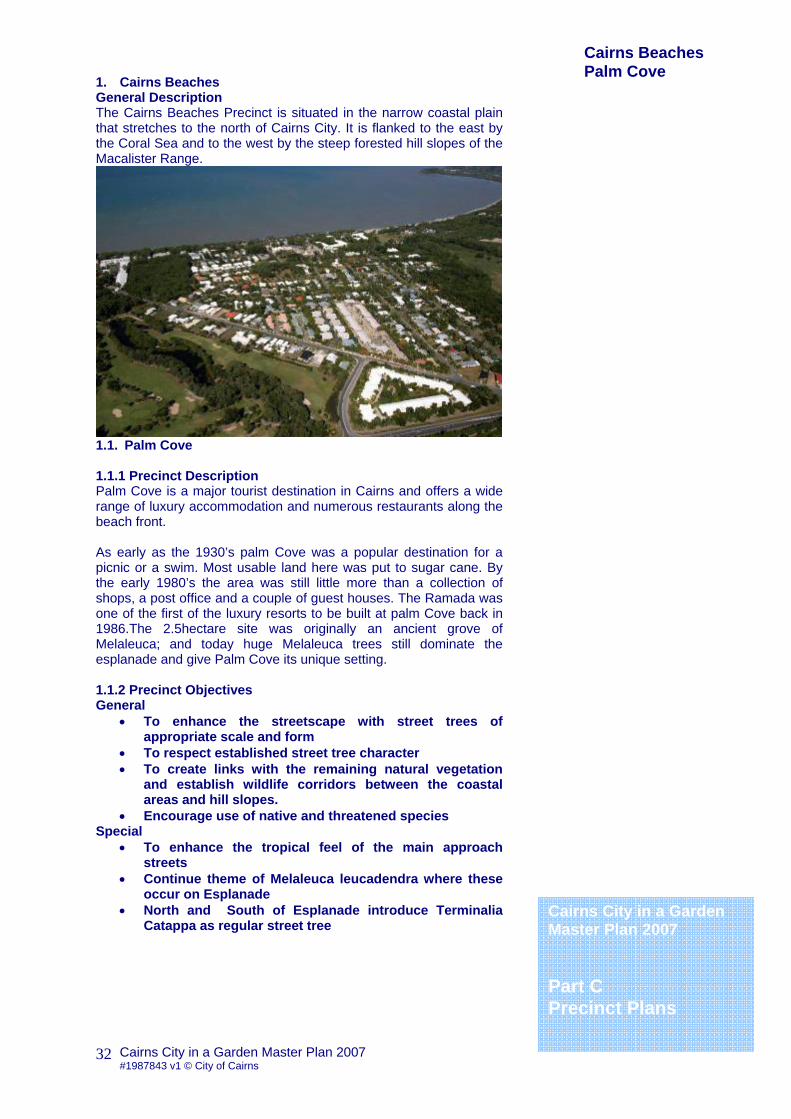
1. Cairns Beaches General Description The Cairns Beaches Precinct is situated in the narrow coastal plain that stretches to the north of Cairns City. It is flanked to the east by the Coral Sea and to the west by the steep forested hill slopes of the Macalister Range.
1.1. Palm Cove 1.1.1 Precinct Description Palm Cove is a major tourist destination in Cairns and offers a wide range of luxury accommodation and numerous restaurants along the beach front. As early as the 1930’s palm Cove was a popular destination for a picnic or a swim. Most usable land here was put to sugar cane. By the early 1980’s the area was still little more than a collection of shops, a post office and a couple of guest houses. The Ramada was one of the first of the luxury resorts to be built at palm Cove back in 1986.The 2.5hectare site was originally an ancient grove of Melaleuca; and today huge Melaleuca trees still dominate the esplanade and give Palm Cove its unique setting. 1.1.2 Precinct Objectives General
• To enhance the streetscape with street trees of appropriate scale and form
• To respect established street tree character • To create links with the remaining natural vegetation
and establish wildlife corridors between the coastal areas and hill slopes.
• Encourage use of native and threatened species Special
• To enhance the tropical feel of the main approach streets
• Continue theme of Melaleuca leucadendra where these occur on Esplanade
• North and South of Esplanade introduce Terminalia Catappa as regular street tree
Cairns City in a Garden Master Plan 2007 Part C Precinct Plans
Cairns Beaches Palm Cove

Cairns City in a Garden Master Plan 2007 #1987843 v1 © City of Cairns
33
1.1.3 Precinct Conditions Existing Street Trees Planting is a major component of the Esplanade and contributes greatly to the resort character. Dominant Species Melaleuca leucadendron Weeping Paperbark Cocos nucifera Coconut Palm 1.1.4 Built Form and Road Widths 1.1.5 Microclimate The area is exposed to strong coastal influences with prevailing south-easterly winds during the winter months. 1.1.6 Geological/Soil Conditions The precinct comprises of beaches, fore dunes and swales together with riparian corridors. Soils are dominantly fine grained sands and clays. 1.1.7 Street Name Themes Palms & Ferns, Tranquillity 1.1.8 Street and Park Tree Species Palette Guide for Palm Cove Acmena hemilampra Blush Satinash Calophyllum sil Blush Touriga Deplanchea tetraphylla Golden Bouquet Dictyosperma album Princess Palm Dillenea alata Red Beech Gmelina fasciculiflora White Beech Guettarda speciosa Indian Funeral Flower Gulubia costata Gulubia Palm Melaleuca leucadendra Weeping Paperbark Podocarpus grayae Weeping Brown pine Randia fitzalani Native Gardenia Syzygium angophoroides Yarrabah Satinash Syzygium forte ssp forte White Apple
1.1.9 Street Tree Species Palette for Palm Cove Street Name Between Median Verge Footpath P
Capt. CookArgentea Triton
Syzygium in var. Deplanchea tetraphylla
Warren Cedar Williams
Tabebuia pallida P
Veivers Tibouchina (shrub) Randia fitzalanii P
P-indicates selected species for planting under power lines
Cairns City in a Garden Master Plan 2007 Part C Precinct Plans
Cairns Beaches Palm Cove

Cairns City in a Garden Master Plan 2007 #1987843 v1 © City of Cairns
34
1. Cairns Beaches General description The Cairns Beaches Precinct is situated in the narrow coastal plain that stretches to the north of Cairns City. It is flanked to the east by the Coral Sea and to the west by the steep forested hill slopes of the Macalister Range.
1.2. Clifton Beach 1.2.1 Precinct Description In the 1930’s Clifton had no transport to town and a one lane road into the city with no shops or schools, however people were attracted here by the surrounding rich soils and they settled to farm. Unlike much of Cairns many farms here grew bananas, mangos and pineapples. It is primarily a residential area, with some scattered tourist accommodation concentrated along the Arlington Esplanade. 1.2.2 Precinct Objectives General
• To enhance the streetscape with street trees of appropriate scale and form
• To respect established street tree character • To create links with the remaining natural vegetation
and establish wildlife corridors between the coastal areas and hill slopes.
• Encourage use of native and threatened species Special
• New street tree plantings of regular Terminalia muelleri on Upolu Esplanade when power lines are placed underground
• Replace Melaleuca leucadendron in tree islands along Endeavour Road with Randia fitzalanii
1.2.3 Precinct Conditions Existing Street Trees Dominant Species 1.2.4 Built Form and Road Widths
Cairns City in a Garden Master Plan 2007 Part C Precinct Plans
Cairns Beaches Clifton Beach

Cairns City in a Garden Master Plan 2007 #1987843 v1 © City of Cairns
35
1.2.5 Microclimate The area is exposed to strong coastal influences with prevailing south-easterly winds during the winter months. 1.2.6 Geological/Soil Conditions The precinct comprises of beaches, fore dunes and swales together with riparian corridors. Soils are dominantly fine grained sands and clays. 1.2.7 Street Name Themes Reefs 1.2.8 Street and Park Tree Species Palette Guide for Clifton Beach Acmena hemilampra Blush Satinash Calophyllum sil Touriga Deplanchea tetraphylla Golden Bouquet Dictyosperma album Princess Palm Dillenea alata Red Beech Gmelina fasciculiflora White Beech Guettarda speciosa Indian Funeral Flower Gulubia costata Gulubia Palm Melaleuca leucadendra Weeping Paperbark Podocarpus grayae Weeping Brown pine Randia fitzalani Native Gardenia Syzygium angophoroides Yarrabah Satinash Syzygium forte ssp forte White Apple
1.2.9 Street Tree Species Palette for Clifton Beach Street Name Between Median Verge Footpath P
Capt. Cook Endeavor Upolu
Cerbera manghas Acmena hemilampra P
P-indicates selected species for planting under power lines
Cairns City in a Garden Master Plan 2007 Part C Precinct Plans
Cairns Beaches Clifton Beach

Cairns City in a Garden Master Plan 2007 #1987843 v1 © City of Cairns
36
1.0 Cairns Beaches General description The Cairns Beaches Precinct is situated in the narrow coastal plain that stretches to the north of Cairns City. It is flanked to the east by the Coral Sea and to the west by the steep forested hill slopes of the Macalister Range.
1.3. Kewarra Beach 1.3.1 Precinct Description Kewarra is the youngest of all of Cairn’s Beach suburbs and has remained largely non-commercial throughout its years of development. In 1967 Cairns engineer Euan Bruce saw the potential at Kewarra and decided to acquire land. The name Kewarra was first used by local Aborigines and literally means “foot of the rainbow”, because they often saw rainbows here while they dug for “pippies” at nearby Clifton Beach. The first house was built in 1972 but it was not until the 1980’s that the area really grew into the suburb we see today. It is primarily a residential area, with some scattered tourist accommodation concentrated along the Arlington Esplanade. 1.3.2 Precinct Objectives General
To enhance the streetscape with street trees of appropriate scale and form
To respect established street tree character To create links with the remaining natural vegetation
and establish wildlife corridors between the coastal areas and hill slopes.
Encourage use of native and threatened species
Special Respect existing Paradise Palms and Discovery Drive
Themes Esplanade road to be planted with Deplanchea
tetraphylla Rainbow Theme to include Bush Food
Cairns City in a Garden Master Plan 2007 Part C Precinct Plans
Cairns Beaches Kewarra Beach
Cairns City in a Garden Master Plan 2007 #1987843 v1 © City of Cairns
37
1.3.3 Precinct Conditions Existing Street Trees Few Street Trees and landscaping to the frontages of private gardens provide most of the planting interest. Dominant Species 1.3.4 Built Form and Road Widths Uniquely Kewarra has no esplanade and the beach front is dominated by luxury housing, locally known as millionaire‘s row. 1.3.5 Microclimate The area is exposed to strong coastal influences with prevailing south-easterly winds during the winter months. 1.3.6 Geological/Soil Conditions The precinct comprises of beaches, fore-dunes and swales together with riparian corridors. Soils are dominantly fine-grained sands and clays. 1.3.7 Street Name Themes Beaches, Birds and Native Bush Food Special Areas
• Vacant land at southern end of beach has good remnant woodland with mature Melaleuca, Deplanchea, Pandanus & Livistonia muelleri
1.3.8 for Street and Park Tree Species Palette Guide Kewarra Beach Acmena hemilampra Blush Satinash Barringtonia acutangula Freshwater Mangrove Barringtonia calyptrata Cassowary Pine Carallia brachiata Corky bark Corymbia ptychocarpa Swamp Bloodwood Deplanchea tetraphylla Golden Bouquet Dillenea alata Red Beech Ficus congesta Red Leaf Fig Gmelina fasciculiflora White Beech Melaleuca leucadendra Weeping Paperbark Melaleuca viridiflora “Burgundy” Melicope elleryana Ulysses Butterfly Tree Syzygium angophoroides Yarrabah Satinash
1.3.9 Street Tree Species Palette for Kewarra Beach Street Name Between Median Verge Footpath P
Capt. Cook Poolwood Kewarra
Deplanchea tetraphylla Barringtonia acutangula
start Kewarra finish
Plumeria rubra var. P
P-indicates selected species for planting under power lines
Cairns City in a Garden Master Plan 2007 Part C Precinct Plans
Cairns Beaches Kewarra Beach

Cairns City in a Garden Master Plan 2007 #1987843 v1 © City of Cairns
38
1.0 Cairns Beaches General description The Cairns Beaches Precinct is situated in the narrow coastal plain that stretches to the north of Cairns City. It is flanked to the east by the Coral Sea and to the west by the steep forested hill slopes of the Macalister Range.
1.4. Trinity Beach 1.4.1 Precinct Description Trinity beach began life as Double Island Beach back in the early 1920’s, it was so named because of the views it offered to the island. There was little more than a dirt road in to town in those days and it could lake two hours to reach Cairns, that is, if the road was not flooded. The name persisted until the early 1970’s During WW2 troops were stationed here for training in preparation for the invasion of Borneo. In the 1970’s and 80’s the areas transformation from cane land to residential attracted many ex-Pats, hence the numerous street names that connect to Papua New Guinea. Tourist accommodation all but dominates the beachfront and many of the streets behind. This is a popular beach suburb and a gathering place for tourists and locals alike. 1.4.2 Precinct Objectives General
To enhance the streetscape with street trees of appropriate scale and form
To respect established street tree character To create links with the remaining natural vegetation
and establish wildlife corridors between the coastal areas and hill slopes.
Encourage use of native and threatened species Special
To respect planting theme of WWII Regimental Colours along Trinity Beach Road
Esplanade planting to be Barringtonia calyptrata and Terminalia muelleri
1.4.3 Precinct Conditions Existing Street Trees There is a highly landscaped entry road, and the volume of resort style apartments and complexes results over all in a highly landscaped streetscape.
Cairns City in a Garden Master Plan 2007 Part C Precinct Plans
Cairns Beaches Trinity Beach
Cairns City in a Garden Master Plan 2007 #1987843 v1 © City of Cairns
39
Dominant Species Barringtonia calyptrata Cassowary Pine Terminalia Muelleri Queensland Blue Almond Peltophorum pterocarpum Copper Pod Melaleuca leucadendron Paperbark 1.4.4 Built Form and Road Widths 1.4.5 Microclimate The area is exposed to strong coastal influences with prevailing south easterly winds during the winter months. 1.4.6 Geological/Soil Conditions The precinct comprises of beaches, fore-dunes and swales together with riparian corridors. Soils are dominantly fine-grained sands 1.4.7 Street Name Themes Seashells and Papua New Guinea Locales 1.4.8 Street and Park Tree Species Palette Guide for Trinity Beach Acmena hemilampra Blush Satinash Barringtonia acutangula Freshwater Mangrove Barringtonia calyptrata Cassowary Pine Callistemon viminalis Weeping Bottlebrush Cupaniopsis anacardioides Bush Tuckeroo Decaspermum humile Silky Myrtle Melaleuca leucadendra Weeping Paperbark Peltophorum pterocarpum Copper Pod Syzygium jambos Rose Apple Terminalia arenicola Beach Almond Terminalia Muelleri Queensland Blue Almond
1.4.9 Street Tree Species Palette for Trinity Beach Street Name Between Median Verge Footpath P
Esplanade Trinity Bch Jameson
Melaleuca Acalypha/Gardenia Callistemon viminalis P
Jameson Trinity Bch Cstwatchers
Callistemon viminalis Hymenocallis/Allamanda Randia fitzalanii
Cstwatchers Trinity Bch Rabaul
Peltophorum pterocarpum Xanthostemon chrysantha
Rabaul Trinity Bch Clayley
Peltophorum pterocarpum Barringtonia acutangula
Clayley Trinity Bch Nautilus
Callistemon viminalis Xanthostemon chrysantha
Nautilus Trinity Bch Cook Hwy
Bouganvillea/jasmine Callistemon viminalis
Poolwood Miami Nova Peltophorum pterocarpum Cupaniopsis anacardioides
Nova Miami Trinity park Link to Centenary Park
P-indicates selected species for planting under power lines
Cairns City in a Garden Master Plan 2007 Part C Precinct Plans
Cairns Beaches Trinity Beach

Cairns City in a Garden Master Plan 2007 #1987843 v1 © City of Cairns
40
2. Barron Smithfield General description The dominant natural features of the Barron-Smithfield precinct are the wetlands adjacent to the coastline and waterways; the floodplain of the Barron Delta with its extensive cane fields; and the extensive views across the floodplain to the Barron Gorge and the forested hill slopes of the Kuranda Range
2.1. Trinity Park 2.1.1 Precinct Description 2.1.2 Precinct Objectives General
To enhance the streetscape with street trees of appropriate scale and form
To respect existing natural vegetation with suitable indigenous species.
Special
Esplanade tree theme Ficus drupacea and Sterculia quadrifida, and Intsia bijuga (wet areas only)
Replace Maniltoa lenticillata from median on Reed Road as proving unsuitable to local conditions, replace with Peltophorum pterocarpum.
2.1.3 Precinct Conditions Existing Street Trees Dominant Species 2.1.4 Built Form and Road Widths 2.1.5 Microclimate The area is exposed to strong coastal influences with prevailing south-easterly winds during the winter months. 2.1.6 Geological/Soil Conditions The precinct comprises of beaches, fore-dunes and swales together with riparian corridors. Soils are dominantly fine-grained sands and clays.
Cairns City in a Garden Master Plan 2007 Part C Precinct Plans
Barron Smithfield Trinity Park

Cairns City in a Garden Master Plan 2007 #1987843 v1 © City of Cairns
41
2.1.7 Street Name Themes Yachts 2.1.8 Street and Park Tree Species Palette Guide for Trinity Park Acmena hemilampra Blush Satinash Agathis robusta Kauri Pine Barringtonia acutangula Freshwater Mangrove Barringtonia calyptrata Cassowary Pine Callistemon viminalis Weeping Bottlebrush Canarium australianum Scrub Turpentine Cupaniopsis anacardioides Tuckeroo Deplanchea tetraphylla Golden Bouquet Tree Erythrina variegata Mountain Ebony Melaleuca leucadendra Weeping Paperbark Peltophorum pterocarpum Copper Pod Saraca thaipingensis Tabebuia ochracea Greater Golden Trumpet Tree
2.1.9 Street Tree Species Palette for Trinity Park Street Name Between Median Verge Footpath P
Cook Hwy Reed Rd Harbour
Peltophorum pterocarpum Deplanchea tetraphylla Cupaniopsis anacardioides P
Trinity Park Smithfield Village Dr Reed Rd
Agathis robusta Deplanchea tetraphylla
Reed Rd Smithfield Village Dr McGregor
Agathis robusta Deplanchea tetraphylla
McGregor Cheviot Reed
Saraca thaipingensis
P-indicates selected species for planting under power lines
Barron Smithfield Trinity Park
Cairns City in a Garden Master Plan 2007 Part C Precinct Plans

Cairns City in a Garden Master Plan 2007 #1987843 v1 © City of Cairns
42
2.0 Barron Smithfield General description The dominant natural features of the Barron-Smithfield precinct are the wetlands adjacent to the coastline and waterways; the floodplain of the Barron Delta with its extensive cane fields; and the extensive views across the floodplain to the Barron Gorge and the forested hill slopes of the Kuranda Range
2.2. Yorkeys Knob 2.2.1 Precinct Description 2.2.2 Precinct Objectives General
• To enhance the streetscape with street trees of appropriate scale and form
• To respect established street tree character • To reflect the natural environment through the
appropriate selection of tree species • To create links with the remaining natural vegetation
and establish wildlife corridors between the coastal areas and hill slopes.
• Encourage use of native and threatened species Special
• Esplanade tree themes Barringtonia calyptrata and Terminalia catappa
2.2.3 Precinct Conditions Existing Street Trees Dominant Species Barringtonia calyptrata Cassowary Pine Terminalia catappa Pacific Almond 2.2.4 Built Form and Road Widths 2.2.5 Microclimate The area is exposed to strong coastal influences with prevailing south-easterly winds during the winter months. 2.2.6 Geological/Soil Conditions The precinct comprises of beaches, fore-dunes and swales together with riparian corridors. Soils are dominantly fine-grained sands and clays.
Cairns City in a Garden Master Plan 2007 Part C Precinct Plans
Barron Smithfield Yorkeys Knob
Cairns City in a Garden Master Plan 2007 #1987843 v1 © City of Cairns
43
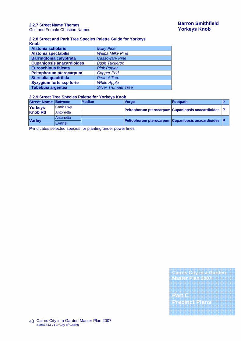
2.2.7 Street Name Themes Golf and Female Christian Names 2.2.8 Street and Park Tree Species Palette Guide for Yorkeys Knob Alstonia scholaris Milky Pine Alstonia spectabilis Weipa Milky Pine Barringtonia calyptrata Cassowary Pine Cupaniopsis anacardioides Bush Tuckeroo Euroschinus falcata Pink Poplar Peltophorum pterocarpum Copper Pod Sterculia quadrifida Peanut Tree Syzygium forte ssp forte White Apple Tabebuia argentea Silver Trumpet Tree
2.2.9 Street Tree Species Palette for Yorkeys Knob Street Name Between Median Verge Footpath P
Cook Hwy Yorkeys Knob Rd Antonetta
Peltophorum pterocarpum Cupaniopsis anacardioides P
Antonetta Varley Evans
Peltophorum pterocarpum Cupaniopsis anacardioides P
P-indicates selected species for planting under power lines
Barron Smithfield Yorkeys Knob
Cairns City in a Garden Master Plan 2007 Part C Precinct Plans

Cairns City in a Garden Master Plan 2007 #1987843 v1 © City of Cairns
44
2.0 Barron Smithfield General description The dominant natural features of the Barron-Smithfield precinct are the wetlands adjacent to the coastline and waterways; the floodplain of the Barron Delta with its extensive cane fields; and the extensive views across the floodplain to the Barron Gorge and the forested hill slopes of the Kuranda Range
2.3. Holloways Beach 2.3.1 Precinct Description 2.3.2 Precinct Objectives General
To enhance the streetscape with street trees of appropriate scale and form
To respect established street tree character
Special Esplanade tree theme Terminalia catappa
2.3.3 Precinct Conditions Existing Street Trees Holloways has a natural feel with mangroves and Melaleuca swampland trees along foreshore Dominant Species 2.3.4 Built Form and Road Widths 2.3.5 Microclimate The area is exposed to strong coastal influences with prevailing south-easterly winds during the winter months. 2.3.6 Geological/Soil Conditions The precinct comprises of beaches, fore-dunes and swales together with riparian corridors. Soils are dominantly fine-grained sands and clays. 2.3.7 Street Name Themes Trees and Plant Names
Cairns City in a Garden Master Plan 2007 Part C Precinct Plans
Barron Smithfield Holloways Beach

Cairns City in a Garden Master Plan 2007 #1987843 v1 © City of Cairns
45
2.3.8 Street and Park Tree Species Palette Guide for Holloways Beach Acacia leptoloba Irvinebank Wattle Acacia oraria Banksia dentata Canarium vitiense Clerodendron longiflorum Corymbia phoenicea Scarlet Gum Corymbia tesselaris Moreton Bay Ash Darlingia darlingiana Brown Silky Oak Deplanchea tetraphylla Golden Bouquet Euroschinus falcata Pink Poplar Melaleuca dealbata Blue Paperbark Melaleuca leucadendra Weeping Paperbark Millettia pinnata Indian Beech Mimusops elengi Tanjong Plumeria rubra Frangipani
2.3.9 Street Tree Species Palette for Holloways Beach Street Name Between Median Verge Footpath P
Capt. Cook Holloways Bch Cassia
Corymbia tesselaris
P-indicates selected species for planting under power lines
Barron Smithfield Holloways Beach
Cairns City in a Garden Master Plan 2007 Part C Precinct Plans

Cairns City in a Garden Master Plan 2007 #1987843 v1 © City of Cairns
46
2.0 Barron Smithfield General description The dominant natural features of the Barron-Smithfield precinct are the wetlands adjacent to the coastline and waterways; the floodplain of the Barron Delta with its extensive cane fields; and the extensive views across the floodplain to the Barron Gorge and the forested hill slopes of the Kuranda Range
2.4. Machans Beach 2.4.1 Precinct Description Machans Beach is one of the oldest beach suburbs in Cairns, but the physical constraints of it’s’ surroundings has meant that development here has had less impact. Richard Machan first camped here with his family in 1924; and later settled here, moving from the Atherton tableland in search of a new life. Richard made his living by cutting timber from the almost impenetrable bloodwood forests that surrounded Machans at that time. Much of this timber was used for telephone poles between Stratford and Smithfield. Until the construction of the bridge in 1925 the only access was via boat across the Barron River at Stratford. In 1932 land was subdivided into building allotments. Machans Beach is a small residential community with the distinctive character of a coastal village. 2.4.2 Precinct Objectives General
To enhance the streetscape with street trees of appropriate scale and form
To respect established street tree character To reflect the natural environment through the
appropriate selection of tree species To create links with the remaining natural vegetation
and establish wildlife corridors between the coastal areas and hill slopes.
Encourage use of native and threatened species Special 2.4.3 Precinct Conditions Existing Street Trees
Cairns City in a Garden Master Plan 2007 Part C Precinct Plans
Barron Smithfield Machans Beach

Cairns City in a Garden Master Plan 2007 #1987843 v1 © City of Cairns
47
Dominant Species 2.4.4 Built Form and Road Widths 2.4.5 Microclimate The area is exposed to strong coastal influences with prevailing south-easterly winds during the winter months. 2.4.6 Geological/Soil Conditions The precinct comprises of beaches, fore-dunes and swales together with riparian corridors. Soils are dominantly fine-grained sands and clays. 2.4.7 Street Name Themes 2.4.8 Street and Park Tree Species Palette Guide for Machans Beach Acacia oraria Acmena hemilampra Blush Satinash Archidendron grandiflorum Pink Lace Flower Banksia dentata Barringtonia asiatica Box Fruit Carallia brachiata corky bark Cerbera manghas Sea Mango Cerbera odolham Pong-Pong Tree Cirdia sebestena Clerodendron longiflorum Clusia rosea Pork Fat Tree Coccoloba uvifera Sea Grape Cordia subcordiata Sea Trumpet Guettarda speciosa Indian Funeral Flower Hernandia nymphaefolia Sea Hearse Leptospermum madidum Tea Tree Ochrosia elliptica Pokosola Planchonia careyi Cocky Apple Pleiogynium timoriense Burdekin Plum Plumeria rubra Frangipani Syzygium suborbiculare Lady Apple
2.4.9 Street Tree Species Palette for Machans Beach Street Name Between Median Verge Footpath P
Capt. Cook Machans Beach Rd O’Shea
Cerbera manghas P
P-indicates selected species for planting under power lines
Cairns City in a Garden Master Plan 2007 Part C Precinct Plans
Barron Smithfield Machans Beach

Cairns City in a Garden Master Plan 2007 #1987843 v1 © City of Cairns
48
2.0 Barron Smithfield General description The dominant natural features of the Barron-Smithfield precinct are the wetlands adjacent to the coastline and waterways; the floodplain of the Barron Delta with its extensive cane fields; and the extensive views across the floodplain to the Barron Gorge and the forested hill slopes of the Kuranda Range
2.5. Smithfield 2.5.1 Precinct Description Smithfield was founded as a small township established near the banks of the Barron River by the surveyor Warner who believed the high banks would protect the area during floods. The township was named in the 1870’s after Bill Smith, a local hotel owner, miner and beche-de-mer fisherman. Smithfield grew so rapidly that it eclipsed Cairns. However its success was short-lived, as new tracks were opened up, and by 1877 Smithfiled was all but abandoned; until in 1879 the settlement was finally washed out to sea by the rising currents of the Barron River. In the 1900’s the area began to attract pioneering families, who sought land for sugarcane farming. Sugar cane still dominates this area today; but development has been such that Smithfield is now a thriving satellite town with a growing commercial centre, which serves the entire northern beaches area. There are significant remnants of natural wetland vegetation along the coastal districts including the Cattana Wetlands. The area is at the widest point in the coastal strip but limited by the flood waters of the Barron Delta. The landscape character of open floodplains and cane farms is still very dominant and gives this sub-precinct a unique character, with strong links to its natural and cultural heritage. Smithfield is the centre for the growing campus of the James Cook University and the popular tourist attractions of Skyrail and Tjapukai Aboriginal Cultural Park.
Cairns City in a Garden Master Plan 2007 Part C Precinct Plans
Barron Smithfield Smithfield

Cairns City in a Garden Master Plan 2007 #1987843 v1 © City of Cairns
49
2.5.2 Precinct Objectives To enhance the streetscape with street trees of
appropriate scale and form To respect established street tree character To respect local native vegetation and enhance the
character of local fauna To reflect the natural environment through the
appropriate selection of tree species To create links with the remaining natural vegetation
and establish wildlife corridors between the coastal areas and hill slopes.
Encourage use of native and threatened species Special
To increase local Aboriginal heritage values around Tjapuakai with selected tree planting
Compliment the existing plantings around Smithfield Library
2.5.3 Precinct Conditions 2.5.4 Built Form and Road Widths 2.5.5 Microclimate The area is still exposed to strong coastal influences with prevailing south-easterly winds during the winter months. Some protection is found along the numerous Creeks. 2.5.6 Geological/Soil Conditions The precinct is set mainly within the Barron River Flood plain. Soils are dominated by marine sands and muds. 2.5.7 Street Name Themes Mountains, Scottish Christian Names, Scholasticism and Learning 2.5.8 Street and Park Tree Species Palette Guide for Smithfiled Cordia dichotoma Glue Berry Carallia brachiata Corkwood Cassia fistula Diploglottis diphyllostegia Native Tamarind Ganophyllum falcatum Scaly Ash Glochidion herveyanum Daphne Buttonwood Harpullia pendula Tulipwood Randia fitzalanii Native Gardenia Syzygium jambos Rose Apple Syzygium tierneyanum River Cherry Tabebuia chrysantha Golden Trumpet Tree Xanthostemon chrysanthus Golden Penda
Smithfield East of McGregor Acmena hemilampra Blush Satinash Acmena smithii Lily Pilly Cryptocarpa triplinervis Brown Laurel Darlingia darlingiana Brown Silky Oak Pongamia pinnata Indian Beech Syzygium angophoroides Yarrabah Satinash Syzygium jambos Rose Apple Syzygium leuhmannii Cherry Satinash Syzygium tierneyanum River Cherry Tabebuia chrysantha Golden Trumpet Tree Terminalia sericocarpa Damson Xanthostemon chrysanthus Golden Penda
Cairns City in a Garden Master Plan 2007 Part C Precinct Plans
Barron Smithfield Smithfield
Cairns City in a Garden Master Plan 2007 #1987843 v1 © City of Cairns
50
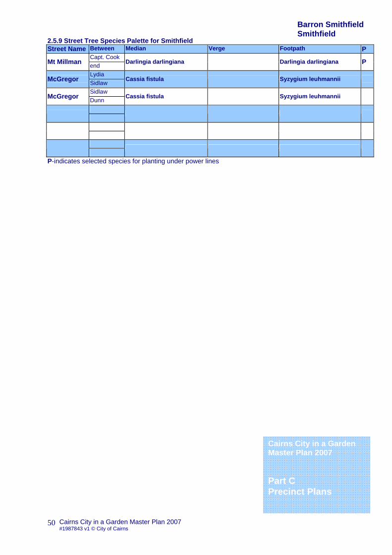
2.5.9 Street Tree Species Palette for Smithfield Street Name Between Median Verge Footpath P
Capt. Cook Mt Millman end
Darlingia darlingiana Darlingia darlingiana P
Lydia McGregor Sidlaw
Cassia fistula Syzygium leuhmannii
Sidlaw McGregor Dunn
Cassia fistula Syzygium leuhmannii
P-indicates selected species for planting under power lines
Barron Smithfield Smithfield
Cairns City in a Garden Master Plan 2007 Part C Precinct Plans

Cairns City in a Garden Master Plan 2007 #1987843 v1 © City of Cairns
51
2.0 Barron Smithfield General description The dominant natural features of the Barron-Smithfield precinct are the wetlands adjacent to the coastline and waterways; the floodplain of the Barron Delta with its extensive cane fields; and the extensive views across the floodplain to the Barron Gorge and the forested hill slopes of the Kuranda Range
2.6. Caravonica 2.6.1 Precinct Description Caravonica and the neighbouring Lake Placid are small residential suburbs somewhat removed from the remaining precinct, nestled as they are among the foothills of the Kamerunga Range. Caravonica was named by its most famous resident Italian doctor of science and agriculture David Thomatis. Some believe the name derives from the Italian for “my dearest” and the shortened Vonica after his wife who died in 1884. At this same time Thomatis moved to Caravonica to make a fresh start, creating very successful new strains of cotton and coffee, as wells as experimenting with rice and cocoa. Caravonica is dominated by the Barron Gorge and the Barron River. There are extensive areas of remnant rainforest higher on the slopes of what is now the Barron Gorge National Park. Below lies the charming Lake Placid which offers boating and swimming, as well as camping. The area has few shops but does have the Caravonica State School. It is a low density residential area developed mainly during the 1970’s when former sugar cane farm land was sub-divided. 2.6.2 Precinct Objective General
To enhance the streetscape with street trees of appropriate scale and form
To respect established street tree character To respect natural vegetation To reflect the natural environment through the
appropriate selection of tree species Encourage use of native and threatened species
Special 2.6.3 Precinct Conditions Existing Street Trees Dominant Species
Cairns City in a Garden Master Plan 2007 Part C Precinct Plans
Barron Smithfield Caravonica

Cairns City in a Garden Master Plan 2007 #1987843 v1 © City of Cairns
52
2.6.4 Built Form and Road Widths 2.6.5 Microclimate The area can suffer from drought and exposure. 2.6.6 Geological/Soil Conditions The precinct comprises of floodplain and hill slopes together with riparian corridors. Soils are dominantly well drained sands and heavy clays and clay loam mixes.
2.6.7 Street Name Themes Aboriginal Words and Butterfly Names 2.6.8 Street and Park Tree Species Palette Guide for Caravonica Argyrodendron polyandrum Tulip Oak Arytera divaricata Rose Tamarind Barringtonia acutangula Freshwater Mangrove Brachychiton acerifolius Flame Tree Cryptocarya triplinervis Diploglottis diphyllostegia Wild Tamarind Endiandra hypotephra Blue Walnut Grevillea baileyana Findlay’s Silky Oak Neolitsea dealbata Bolly Gum Syzygium alliiligneum Onionwood Syzygium cormiflorum Bumpy Satinash Tabebuia argentea Silver trumpet tree
2.6.9 Street Tree Species Palette for Caravonica Street Name Between Median Verge Footpath P
P
P-indicates selected species for planting under power lines
Cairns City in a Garden Master Plan 2007 Part C Precinct Plans
Barron Smithfield Caravonica

Cairns City in a Garden Master Plan 2007 #1987843 v1 © City of Cairns
53
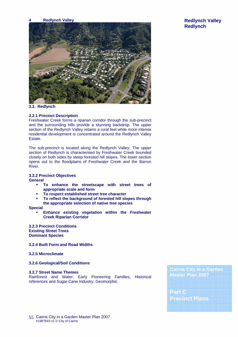
3. Redlynch Valley
3.1. Kamerunga 3.1.1 Precinct Description Kamerunga was first established in what was then known as Barronville in 1887. It was set up by the State Government as the site of an experimental nursery; to determine what crops could be suitable for cultivation in Far North Queensland. The name was soon after changed to Kamerunga, believed to be an Aboriginal name for the Barron River and its falls. The nursery operated by a Mr Ebenezer Crowley, featured vanilla and oil palms; rubber producing plants; fibre plants including cotton, sisal, jute and kapok; and a host of fruits. Sadly most of these crops proved unreliable and were abandoned, but the nursery did test sugar cane during the 1890’s and promoted the use of the Badilla variety that has had huge success. During the construction of the railway line to Kuranda Kamerunga flourished as hundreds of workers and their families settled. By 1908 however the rail had reached Kuranda and the workers had moved on, leaving behind nothing but four meter high piles of empty bottles. 3.1.2 Precinct Objectives General
To enhance the streetscape with street trees of appropriate scale and form
To respect established street tree character To enhance remnant Riverine Vegetation
Special
To enhance Exotic Fruit Tree Plantings at Kamerunga Station
3.1.3 Precinct Conditions Existing Street Trees Dominant Species 3.1.4 Built Form and Road Widths 3.1.5 Microclimate The area can suffer from drought and exposure.
Cairns City in a Garden Master Plan 2007 Part C Precinct Plans
Redlynch Valley Kamerunga

Cairns City in a Garden Master Plan 2007 #1987843 v1 © City of Cairns
54
3.1.6 Geological/Soil Conditions The precinct comprises of floodplain and hill slopes together with riparian corridors. Soils are dominantly well drained sands and heavy clays and clay loam mixes with areas of water logging and thin skeletal soils.
3.1.7 Street Name Themes 3.1.8 Street and Park Tree Species Palette Guide for Kamerunga Buckinghamia celsissima Ivory Curl Castanospora alphandi Brown tamarind Dimocarpus australianus Native Lychee Diploglottis diphyllostegia Native Tamarind Dysoxylum gaudichaudianum Ivory Mahogany Euphoria longan Longan Ficus adenosperma Creek Fig Ficus virgata Large Leaf Weeping Fig Flacourtia inermis Lovi Lovi Gomphandra australianum Millettia pinnata Creek Pongamia Syzygium jambos Rose Apple Syzygium malaccense Malay Apple Syzygium samarangense Wax Jambu Syzygium tierneyaum River Cherry Tectona grandis Teak
3.1.9 Street Tree Species Palette for Kamerunga Street Name Between Median Verge Footpath P
P
P-indicates selected species for planting under power lines
Cairns City in a Garden Master Plan 2007 Part C Precinct Plans
Redlynch Valley Kamerunga
Cairns City in a Garden Master Plan 2007 #1987843 v1 © City of Cairns
55
4 Redlynch Valley
3.2. Redlynch 3.2.1 Precinct Description Freshwater Creek forms a riparian corridor through the sub-precinct and the surrounding hills provide a stunning backdrop. The upper section of the Redlynch Valley retains a rural feel while more intense residential development is concentrated around the Redlynch Valley Estate. The sub-precinct is located along the Redlynch Valley. The upper section of Redlynch is characterised by Freshwater Creek bounded closely on both sides by steep forested hill slopes. The lower section opens out to the floodplains of Freshwater Creek and the Barron River. 3.2.2 Precinct Objectives General
To enhance the streetscape with street trees of appropriate scale and form
To respect established street tree character To reflect the background of forested hill slopes through
the appropriate selection of native tree species Special
Enhance existing vegetation within the Freshwater Creek Riparian Corridor
3.2.3 Precinct Conditions Existing Street Trees Dominant Species 3.2.4 Built Form and Road Widths 3.2.5 Microclimate 3.2.6 Geological/Soil Conditions 3.2.7 Street Name Themes Rainforest and Water, Early Pioneering Families, Historical references and Sugar Cane Industry, Geomorphic
Cairns City in a Garden Master Plan 2007 Part C Precinct Plans
Redlynch Valley Redlynch

Cairns City in a Garden Master Plan 2007 #1987843 v1 © City of Cairns
56
3.2.8 Street and Park Tree Species Palette Guide for Redlynch Bischofia javanica Java Cedar Cerbera floribunda Cassowary Plum Darlingia darlingiana Brown Silky Oak Evodiella Muelleri Dwarf Ulysses Butterfly Tree Flindersia ifflaiana Cairns Hickory Miliusa horsefieldii Palaquium galactoxylon Pencil Cedar Stockwellia quadrifida Stockwell’s Puzzle Streblus brunonianus Whalebone Tree Syzygium bamagense Bamaga Satinash Syzygium cormiflorum Bumpy Satinash Syzygium cryptophlebia Powderpuff Lilly Syzygium leuhmanii Small Leaf Lilly Pilly Wrightia laevis ssp millgar Millgar
3.2.9 Street Tree Species Palette for Redlynch Street Name Between Median Verge Footpath P
West Arterial Redlynch Intake Jungara
Evodiella Muelleri P
Jungara Redlynch Intake Redlynch Co
Darlingia darlingiana Flindersia ifflaiana
Redlynch Co Redlynch Intake Crystal Casc
Flindersia ifflaiana
P-indicates selected species for planting under power lines
Cairns City in a Garden Master Plan 2007 Part C Precinct Plans
Redlynch Valley Redlynch

Cairns City in a Garden Master Plan 2007 #1987843 v1 © City of Cairns
57
4. Freshwater Stratford & Aeroglen
4.1. Freshwater 4.1.1 Precinct Description Freshwater was named after the creek that provided fresh clean water to the bullock teams that journeyed these racks in the 1890’s. The area was first settled by the Chinese in the 1880’s, they grew rice, bananas and pineapples, but in time the rich soil was given over to growing sugar cane. The area really began to change in the 1970’s with the building of the shopping centre and the sub-division of farms for residential development. 4.1.2 Precinct Objectives General
• To enhance the streetscape with street trees of appropriate scale and form
• To respect established street tree character • To compliment established gardens with North
Queensland Rainforest Species
4.1.3 Precinct Conditions Existing Street Trees Dominant Species 4.1.4 Built Form and Road Widths 4.1.5 Microclimate The area can suffer from drought and exposure. 4.1.6 Geological/Soil Conditions The precinct comprises of valley floor and hill slopes together with riparian corridors. Soils are dominantly well drained sands and heavy clays and clay loam mixes. 4.1.7 Street Name Themes Geographical Features dealing with Water, Significant Early Residents, Sites of WWII Battlefields
Cairns City in a Garden Master Plan 2007 Part C Precinct Plans
Freshwater, Stratford & Aeroglen Freshwater

Cairns City in a Garden Master Plan 2007 #1987843 v1 © City of Cairns
58
4.1.8 Street and Park Tree Species Palette Guide for Freshwater Acmena hemilampra Blush Satinash Arytera divaricata Pink Tamarind Archidendron lucyi Scarlet Bean Arytera lautereriana Corduroy Tamarind Argyrodendron polyandrum Tulip Oak Bischofia javanica Java Cedar Buchanania arborescens Diploglottis smithii Pleated Tamarind Elaeocarpus bancroftii Kuranda Quandong Melicope rubra Dwarf Ulysses Butterfly Bush Gmelina fasciculiflora White Beech Harpullia ramiflora Claudie Tulipwood Neolitsea dealbata Hairy Leaf Bolly Gum Ormosia ormondii Yellow Bean Storckiella australiensis White Bean Syzygium fibrosum Fibrous Satinash Terminalia sericocarpa Damson
1..1.1 4.1.9 Street Tree Species Palette for Freshwater Street Name Between Median Verge Footpath P
P
P-indicates selected species for planting under power lines
Cairns City in a Garden Master Plan 2007 Part C Precinct Plans
Freshwater, Stratford & Aeroglen Freshwater

Cairns City in a Garden Master Plan 2007 #1987843 v1 © City of Cairns
59
1..1.2 4.0 Freshwater Stratford & Aeroglen
4.2. Stratford & Aeroglen 4.2.1 Precinct Description Stratford and Aeroglen are two of the oldest suburbs of Cairns. They are bounded by the Barron River and the Mount Whitfield Environmental Park; with the Cook Highway, Kuranda Rail and Cairns International Airport to the east following the thin coastal strip. Aeroglen used to be called simply Quarry Siding, and indeed this area was used to generate fill for Central Cairns. The quarries were later used as Cairns Rubbish Tip, only being filled in to create the sports fields in the mid 1980’s. In the 1940’s the area was quite a rural setting with only a dairy and a paw-paw farm. Even by the 1960’s only about 100 people were living here and remains to this day a small community. Stratford was a small community centred around the timber industry back in the early 1920s’; and workers would gather at the Stratford Hotel to cash pay cheques. 4.2.2 Precinct Objectives General
To enhance the streetscape with street trees of appropriate scale and form
To respect established street tree character To compliment established gardens with North
Queensland Rainforest Species
4.2.3 Precinct Conditions Existing Street Trees Dominant Species 4.2.4 Built Form and Road Widths Stratford is typified by the older style housing; relatively narrow streets and remaining pockets of vegetation along numerous gullies. Stratford Village is designated as a character precinct with several key heritage buildings. There is some industrial activity and large scale retail outlets focused along the highway and rail line. Aeroglen is dominated by detached dwellings but has lost much of its heritage character.
Cairns City in a Garden Master Plan 2007 Part C Precinct Plans
Freshwater, Stratford & Aeroglen Stratford & Aeroglen

Cairns City in a Garden Master Plan 2007 #1987843 v1 © City of Cairns
60
4.2.5 Microclimate In spite of its proximity to the ocean Stratford and Aeroglen are quite sheltered from coastal influences. 4.2.6 Geological/Soil Conditions The area where the airport now sits was once a series of salt pans and the remnants of mangrove swamps sill remain. The numerous wet gullies testify to the natural heritage of the area and former swamps. 4.2.7 Street Name Themes 4.2.8 Street and Park Tree Species Palette Guide for Stratford and Aeroglen Acmena hemilampra Blush Satinash Albizzia procera Forest Siris Archidendron lucyi Scarlet Bean Arytera divaricata Pink Tamarind Arytera Lautereriana Corduroy Tamarind Brachychiton acerifolius Flame Tree Bischofia javanica Java Cedar Buchanania arborescens Diploglottis smithii Pleated Tamarind Elaeocarpus bancroftii Kuranda Quandong Melicope rubra Dwarf Ulysses Butterfly Bush Gmelina fasciculiflora White Beech Harpullia ramiflora Claudie Tulipwood Neolitsea dealbata Hairy Leaf Bolly Gum Ormosia ormondii Yellow Bean Storckiella australiensis White Bean Syzygium fibrosum Fibrous Satinash Terminalia sericocarpa Damson
4.2.9 Street Tree Species Palette for Stratford and Aeroglen Street Name Between Median Verge Footpath P
P
P-indicates selected species for planting under power lines
Cairns City in a Garden Master Plan 2007 Part C Precinct Plans
Freshwater, Stratford & Aeroglen

Cairns City in a Garden Master Plan 2007 #1987843 v1 © City of Cairns
61
5. Cairns North and CBD 5.1. CBD refer to Cairns CBD Streetscape Master Plan
5.2. Cairns North 5.2.1 Precinct Description Cairns North is the northern most part of the original settlement of Cairns. The early settlers were forced to build their city atop the many parallel sand ridges that had formed along the coastal strip. The remaining low-lying swamps were later filled with quarry spoil form the Kuranda Railway and from nearby Edge Hill. The precinct also contains several Historic Buildings and fine examples of Traditional Queenslander Homes from the early part of the last century. These mingle with luxury apartment blocks and Hotels. There are key areas of public open space including the Esplanade and Munroe Park as well as remnant mangrove swamp at the northern most ends, adjacent to the Lily Street Reserves. Swamps, mudflats, creeks and waterholes dominated the area prior to settlement. A series of parallel sand ridges follow the main streets north and south; the areas between having been extensively filled with sand and quarry spoil. 5.2.2 Precinct Objectives General
To enhance the streetscape with street trees of appropriate scale and form
To respect heritage street tree character To enhance the tropical character To enhance views to the sea To create a high quality landscape that reflects the
central location of the area. To protect and enhance growing conditions for existing
street trees
View of Lake Street
Cairns City in a Garden Master Plan 2007 Part C Precinct Plans
Cairns North & CBD

Cairns City in a Garden Master Plan 2007 #1987843 v1 © City of Cairns
62
Special
Lake St (and other inner suburban streets) verges feature distinct Cassia javanica putative hybrids gradually being lost.
Special Plantings to frame the historic churches and church buildings on Lake Street
Allow the borrowed landscape to take precedence around the Tobruk Memorial Gardens and adjacent remnant swamp on Lake Street.
Enhance existing native planting along Lily Creek corridor
5.2.3 Precinct Conditions Existing Street Trees Streets generally have a distinct tree theme, with a strong emphasis on flowering species both native and exotic. There is however a general lack of verge plantings; with little shade being provided for the pedestrian or cyclist alike. Many of the existing street trees exhibit signs of stress and are struggling in the harsh conditions. Extensive hard surfacing and increased pressure from urban redevelopment has resulted in hostile environmental conditions. Planting within this area must refer to Primary Light Control Plan and Bird and Bat Strike Overlay, Cairns Plan. Dominant Species Delonix regia Poinciana Cassia in var. Cassia in variety 5.2.4 Built Form and Road Widths The precinct is an area of high-density residential use for both locals and tourists. The streets follow a strong grid typical of early colonial settlement patterns, with wide road reserves (40 meters being typical). The area has heavy pedestrian use and footpaths throughout. 5.2.5 Microclimate The area is exposed to strong coastal influences with prevailing south-easterly winds during the winter months. 5.2.6 Geological/Soil Conditions The area consists of sand ridges running north south parallel with the esplanade, and infill throughout the remaining area. 5.2.7 Street Name Themes Historic early Settlers and High Profile Personages from the Cairns of the 1800’s.
Cairns North & CBD
Cairns City in a Garden Master Plan 2007 Part C Precinct Plans
Cairns City in a Garden Master Plan 2007 #1987843 v1 © City of Cairns
63
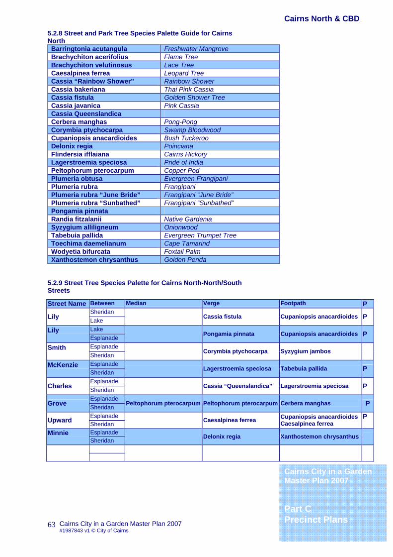
5.2.8 Street and Park Tree Species Palette Guide for Cairns North Barringtonia acutangula Freshwater Mangrove Brachychiton acerifolius Flame Tree Brachychiton velutinosus Lace Tree Caesalpinea ferrea Leopard Tree Cassia “Rainbow Shower” Rainbow Shower Cassia bakeriana Thai Pink Cassia Cassia fistula Golden Shower Tree Cassia javanica Pink Cassia Cassia Queenslandica Cerbera manghas Pong-Pong Corymbia ptychocarpa Swamp Bloodwood Cupaniopsis anacardioides Bush Tuckeroo Delonix regia Poinciana Flindersia ifflaiana Cairns Hickory Lagerstroemia speciosa Pride of India Peltophorum pterocarpum Copper Pod Plumeria obtusa Evergreen Frangipani Plumeria rubra Frangipani Plumeria rubra “June Bride” Frangipani “June Bride” Plumeria rubra “Sunbathed” Frangipani “Sunbathed” Pongamia pinnata Randia fitzalanii Native Gardenia Syzygium alliligneum Onionwood Tabebuia pallida Evergreen Trumpet Tree Toechima daemelianum Cape Tamarind Wodyetia bifurcata Foxtail Palm Xanthostemon chrysanthus Golden Penda
5.2.9 Street Tree Species Palette for Cairns North-North/South Streets
Street Name Between Median Verge Footpath P Sheridan
Lily Lake Cassia fistula Cupaniopsis anacardioides P
Lake Lily Esplanade
Pongamia pinnata Cupaniopsis anacardioides P
Esplanade Smith Sheridan
Corymbia ptychocarpa Syzygium jambos
Esplanade McKenzie Sheridan
Lagerstroemia speciosa Tabebuia pallida P
Esplanade Charles Sheridan
Cassia “Queenslandica” Lagerstroemia speciosa P
Esplanade Grove Sheridan
Peltophorum pterocarpum Peltophorum pterocarpum Cerbera manghas P
Esplanade Upward Sheridan Caesalpinea ferrea Cupaniopsis anacardioides
Caesalpinea ferrea P
Esplanade Minnie Sheridan
Delonix regia Xanthostemon chrysanthus
Cairns City in a Garden Master Plan 2007 Part C Precinct Plans
Cairns North & CBD

Cairns City in a Garden Master Plan 2007 #1987843 v1 © City of Cairns
64
5.2.9 Street Tree Species Palette for Cairns North-East/West Streets Street Name Between Median Verge Footpath P
Airport Dr Lake Moffitt
Pongamia pinnata Cassia fistula Barringtonia acutangula
Moffitt Lake Rutherford
Pongamia pinnata Cassia javanica Barringtonia acutangula
Rutherford Lake Lilly
Link to Tobruk Memorial Gardens
Lilly Lake Grove
Pongamia pinnata Cassia “Rainbow Shower” Barringtonia acutangula
Grove Lake Kerwin
Pongamia pinnata Cassia “Rainbow Shower” Barringtonia acutangula
Kerwin Lake Florence
Pongamia pinnata Cassia “Rainbow Shower Barringtonia acutangula
Florence Lake Wharf Refer to Cairns CBD Streetscape Master Plan
Upward Grafton Florence Syzygium alliligneum Brachychiton
acerifolius Randia fitzalanii
Florence Grafton Wharf Refer to Cairns CBD Streetscape Master Plan
Lily Digger Upward
Brachychiton velutinosus Tabebuia pallida P
Airport Dr Sheridan Rutherford Gateway Caesalpinea ferrea
Rutherford Sheridan Lily Gateway Caesalpinea ferrea
Lily Sheridan Minnie Gateway Caesalpinea ferrea
Minnie Sheridan Florence Gateway/Link to Munro Martin Park
Florence Sheridan Wharf Refer to Cairns CBD Streetscape Master Plan
Arthur McLeod Grove Cassia
“Rainbow Shower” Toechima daemelianum
Grove McLeod Gatton Link to Pioneers Cemetery
Gatton McLeod Florence Cassia
“Rainbow Shower” Toechima daemelianum
Florence McLeod Wharf Refer to Cairns CBD Streetscape Master Plan
P-indicates selected species for planting under power lines
Cairns City in a Garden Master Plan 2007 Part C Precinct Plans
Cairns North & CBD

Cairns City in a Garden Master Plan 2007 #1987843 v1 © City of Cairns
65
6. Portsmith Woree Industrial
6.1. Portsmith and Woree Industrial 6.1.1 Precinct Description Portsmith is the industrial face of Cairns. Industry is focused around the wharves and the railway yards, where in the early days families lived and worked among the mills and factories. Cairns Timber was established here in 1909 and was one of the largest in Queensland, preparing logs from rainforests at Redlynch, Freshwater and Fishery falls. Another large employer here before WW2 was the Great Northern Brewery, sadly all brewing ceased here in 1992. Much of the area was reclaimed during the 1950’s by using fill produced from the dredging of Trinity Bay. The area became known as “Perfume Creek” because of the smell of the stagnant sludge. There is some public access, mainly to the boat ramps along the bay. These are very popular at the weekends. Railway staff, who misunderstood the aboriginal word for shallow water or “wurree” to mean little girl, coined the name Woree. In the early part of the last century this was a largely farming area, with dairy and cane farms dominating the landscape. Swamps, mudflats, creeks and waterholes dominated the area prior to settlement. The precinct still contains significant mangrove and wetland areas adjacent to Chinaman Creek and Smith’s Creek, these form a vital part of the Trinity Inlet ecosystem. 6.1.2 Precinct Objectives General
To reflect the remnant vegetation with the selection of appropriate species (minimum 75% natives)
To enhance views to the surrounding mountains and the Bay.
Selected tree species should be tolerant of the growing conditions of the area.
Special Comport should maintain and reflect adjacent open
space and remnant vegetation such as Chinaman Creek.
Cairns City in a Garden Master Plan 2007 Part C Precinct Plans
Portsmith Woree Industrial

Cairns City in a Garden Master Plan 2007 #1987843 v1 © City of Cairns
66
6.1.3 Precinct Conditions Existing Street Trees This area is exposed to heavy vehicular use and trees are in a high stress environment. Dominant Species Terminalia catappa Beach Almond 6.1.4 Built Form and Road Widths The precinct is an industrial area with a mix of modern and historic industrial structures. Road reserves are wide but there are remnants of disturbed natural vegetation and some spectacular views to the mountains and glimpses of the Trinity Bay. These elements form an interesting, if uneasy relationship, which is unique to Portsmith and Woree. 6.1.5 Microclimate The area is exposed to strong coastal influences with prevailing south-easterly winds during the winter months. 1..1.3 6.1.6 Geological/Soil Conditions Much of this area is reclaimed swamp and soils here can be very heavy and waterlogged with a high salt water table. 6.1.7 Street Name Themes 6.1.8 Street and Park Tree Species Palette Guide for Portsmith and Woree Agathis robusta Kauri Pine Calophyllum inophyllum Cassia fistula Goleden Shower Tree Casuarina glauca Swamp She-oak Cathormion umbellatum Dolichandrone spathacea Mangrove Trumpet Flower Ficus microcarpa Heretiera littoralis Looking Glass Mangrove Hibiscus tiliaceus ‘rubra’ Purple Leaf Cottonwood Livistonia decipiens Weeping Cabbage Palm Lysiloma latisiliqum Melaleuca leucadendra Terminalia catappa Beach Almond
6.1.9 Street Tree Species Palette for Portsmith and Woree Industrial Street Name Between Median Verge Footpath P
P
P-indicates selected species for planting under power lines Cairns City in a Garden
Master Plan 2007 Part C Precinct Plans
Portsmith Woree Industrial
Cairns City in a Garden Master Plan 2007 #1987843 v1 © City of Cairns
67
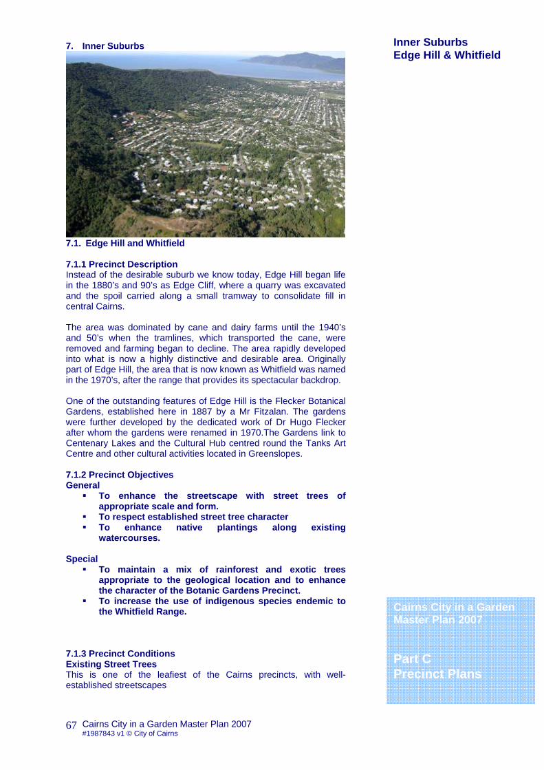
7. Inner Suburbs
7.1. Edge Hill and Whitfield 7.1.1 Precinct Description Instead of the desirable suburb we know today, Edge Hill began life in the 1880’s and 90’s as Edge Cliff, where a quarry was excavated and the spoil carried along a small tramway to consolidate fill in central Cairns. The area was dominated by cane and dairy farms until the 1940’s and 50’s when the tramlines, which transported the cane, were removed and farming began to decline. The area rapidly developed into what is now a highly distinctive and desirable area. Originally part of Edge Hill, the area that is now known as Whitfield was named in the 1970’s, after the range that provides its spectacular backdrop. One of the outstanding features of Edge Hill is the Flecker Botanical Gardens, established here in 1887 by a Mr Fitzalan. The gardens were further developed by the dedicated work of Dr Hugo Flecker after whom the gardens were renamed in 1970.The Gardens link to Centenary Lakes and the Cultural Hub centred round the Tanks Art Centre and other cultural activities located in Greenslopes. 7.1.2 Precinct Objectives General
To enhance the streetscape with street trees of appropriate scale and form.
To respect established street tree character To enhance native plantings along existing
watercourses. Special
To maintain a mix of rainforest and exotic trees appropriate to the geological location and to enhance the character of the Botanic Gardens Precinct.
To increase the use of indigenous species endemic to the Whitfield Range.
7.1.3 Precinct Conditions Existing Street Trees This is one of the leafiest of the Cairns precincts, with well-established streetscapes
Cairns City in a Garden Master Plan 2007 Part C Precinct Plans
Inner Suburbs Edge Hill & Whitfield

Cairns City in a Garden Master Plan 2007 #1987843 v1 © City of Cairns
68
Dominant Species 7.1.4 Built Form and Road Widths Edge Hill has been designated as a character precinct because of the distinctive cultural significance of its built form. The precinct is almost entirely residential with a scattering of local shops. Street patterns follow the rising contours of the lower slopes of the Whitfield Range. 7.1.5 Microclimate In spite of its proximity to the ocean the precinct is quite sheltered from coastal influences. 7.1.6 Geological/Soil Conditions The precinct comprises of remnant swamp floor and hill slopes together with riparian corridors. Soils are dominantly well drained sands and heavy clays and clay loam mixes. 7.1.7 Street Name Themes 7.1.8 Street and Park Tree Species Palette Guide for Edge Hill and Whitfield Buckinghamia celsissima Ivory Curl Corymbia ptychocarpa Swamp Bloodwood Flindersia ifflaiana Cairns Hickory Gustavia augusta Membrillo Lophanthera lactescens Golden Chain Tree Melaleuca leucadendra Paperbark Mesua ferrea Ceylon Ironwood Podocarpus grayae Narrow-leaf Brown Pine Randia fitzalanii Native Gardenia Saraca thiapingensis Saffron Saraca Taberbaemontana sp. Madang ‘Orange Twister’
7.1.9 Street Tree Species Palette for Edge Hill and Whitfield Street Name Between Median Verge Footpath P
Reservoir McManus Woodward
Lophanthera lactescens Flindersia ifflaiana
Sheridan Greenslopes Pease
Melaleuca leucadendra Corymbia ptychocarpa Randia fitzalanii
P
Greenslopes Pease Anderson
Corymbia ptychocarpa Buckinghamia celsissima
Anderson Pease Hoare
Corymbia ptychocarpa Buckinghamia celsissima
Greenslopes McNamara Behan Link to Watsons Park
Behan McNamara Anderson Corymbia ptychocarpa Flindersia ifflaiana
P-indicates selected species for planting under power lines Cairns City in a Garden
Master Plan 2007 Part C Precinct Plans
Inner Suburbs Edge Hill & Whitfield

Cairns City in a Garden Master Plan 2007 #1987843 v1 © City of Cairns
69
7.0 Inner Suburbs
7.2. Kanimbla & Brinsmead 7.2.1 Precinct Description These suburbs were once populated by a few farming families during the 1930’s Chinese farmers used the rich soils to grow vegetables until the landscape eventually became dominated by the production of sugar cane. The area was only opened to residential living in the late 1970’s when the first sub-divisions of the valley began. Kanimbla is named after the supply ship, built in 1936 that serviced the Australian coast from 1950 but was sold in Taiwan for scrap in 1973. Brinsmead is named after the Cairns pioneer Horace Brinsmead who started sugar farming in the Freshwater Estate in 1882. 7.2.2 Precinct Objectives General
To enhance the streetscape with street trees of appropriate scale and form
To respect established street tree character 7.2.3 Precinct Conditions Existing Street Trees Dominant Species 7.2.4 Built Form and Road Widths 7.2.5 Microclimate In spite of its proximity to the ocean Stratford and Aeroglen are quite sheltered from coastal influences. 7.2.6 Geological/Soil Conditions The precinct comprises of reclaimed cane farms and hill slopes. Soils are unusually rich and fertile. 7.2.7 Street Name Themes Early Explorers of the North Queensland Coast, Reef fish, Environmental Flora and Fauna
Cairns City in a Garden Master Plan 2007 Part C Precinct Plans
Inner Suburbs Kanimbla & Brinsmead

Cairns City in a Garden Master Plan 2007 #1987843 v1 © City of Cairns
70
7.2.8 Street and Park Tree Species Palette Guide for Kanimbla and Brinsmead Acmenospernum claviflorum Grey Satinash Castanospora alphandii Brown Tamarind Darlingia darlingiana Brown Silky Oak Diospyros cupulosa Diploglottis diphyllostegia Native Tamarind Dysoxylum pettegrewianum Spur Mahogany Flindersia ifflaiana Cairns Hickory Ganophyllum falcatum Scaly Ash Homalium circumpinnatum Neonauclea gordoniana Hard Leichhardt Tree Pararchidendron pruinosum Snow Wood Phyllanthus cuscutiflorus Polyalthea longifolia Indian Mast Tree Synima cordierorum Syzygium cormiflorum Bumpy Satinash Syzygium leuhmanii Small Leaf Lilly Pilly Toechima erythrocarpum Pink Tamarind
7.2.7 Street Tree Species Palette for Kanimbla and Brinsmead Street Name Between Median Verge Footpath P
Irene Ramsay Reservoir
Flindersia ifflaiana
P-indicates selected species for planting under power lines
Cairns City in a Garden Master Plan 2007 Part C Precinct Plans
Inner Suburbs Kanimbla & Brinsmead
Cairns City in a Garden Master Plan 2007 #1987843 v1 © City of Cairns
71
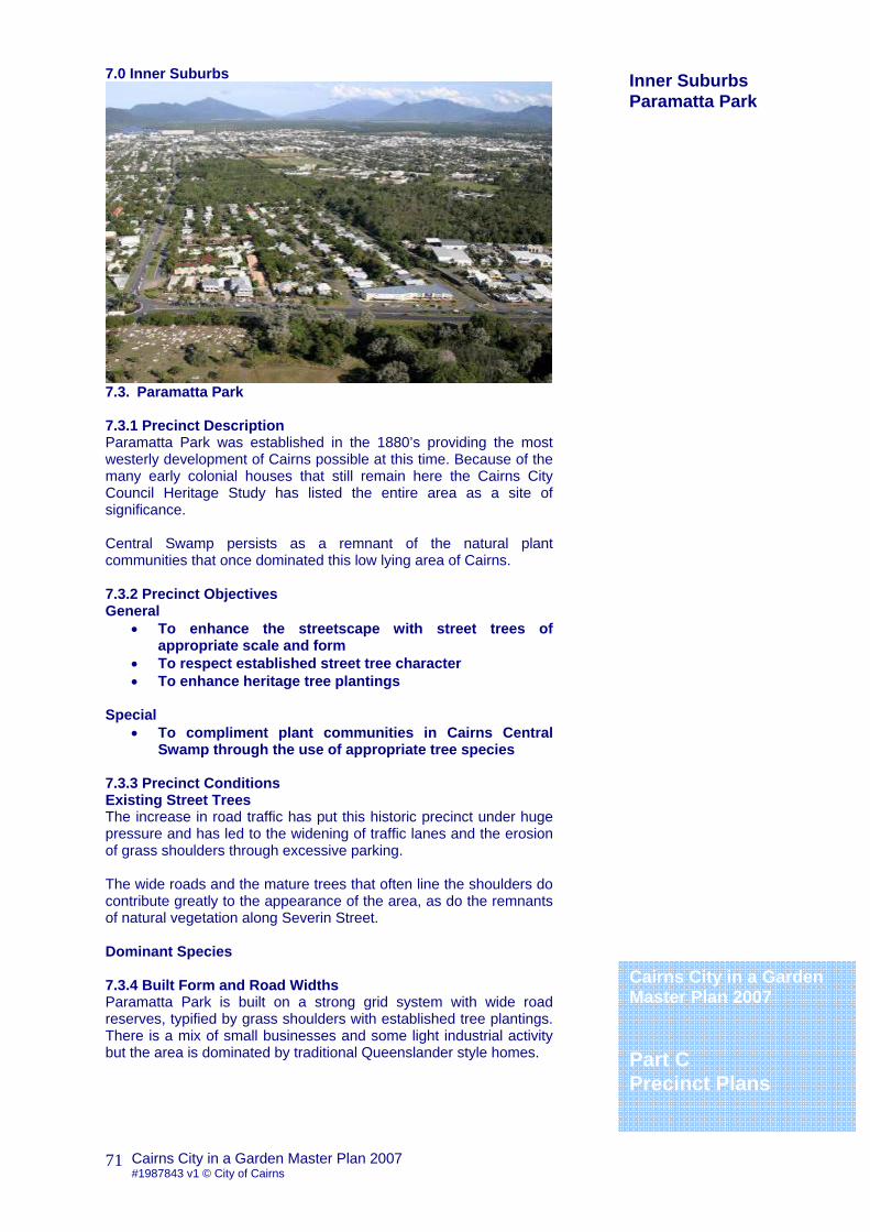
7.0 Inner Suburbs
7.3. Paramatta Park 7.3.1 Precinct Description Paramatta Park was established in the 1880’s providing the most westerly development of Cairns possible at this time. Because of the many early colonial houses that still remain here the Cairns City Council Heritage Study has listed the entire area as a site of significance. Central Swamp persists as a remnant of the natural plant communities that once dominated this low lying area of Cairns. 7.3.2 Precinct Objectives General
• To enhance the streetscape with street trees of appropriate scale and form
• To respect established street tree character • To enhance heritage tree plantings
Special
• To compliment plant communities in Cairns Central Swamp through the use of appropriate tree species
7.3.3 Precinct Conditions Existing Street Trees The increase in road traffic has put this historic precinct under huge pressure and has led to the widening of traffic lanes and the erosion of grass shoulders through excessive parking. The wide roads and the mature trees that often line the shoulders do contribute greatly to the appearance of the area, as do the remnants of natural vegetation along Severin Street. Dominant Species 7.3.4 Built Form and Road Widths Paramatta Park is built on a strong grid system with wide road reserves, typified by grass shoulders with established tree plantings. There is a mix of small businesses and some light industrial activity but the area is dominated by traditional Queenslander style homes.
Cairns City in a Garden Master Plan 2007 Part C Precinct Plans
Inner Suburbs Paramatta Park

Cairns City in a Garden Master Plan 2007 #1987843 v1 © City of Cairns
72
7.3.5 Microclimate The area is exposed to strong coastal influences with prevailing south-easterly winds during the winter months. 7.3.6 Geological/Soil Conditions The precinct comprises of remnant swamp floor with dominantly well drained sands and water logged and disturbed soils. 7.3.7 Street Name Themes 7.3.8 Street and Park Tree Species Palette Guide for Paramatta Park Andira inerme Angelin Barringtonia acutangula Freshwater Mangrove Cassia sp Paluma Range Paluma Golden Shower Tree Cerbera manghas Sea Mango Delonix regia cv Yellow Royal Poinciana Dillenea alata Red Beech Melaleuca dealbata Peltophorum pterocarpum Copper Pod Peltphorum dubium Brasiletto Syzygium jambos Rose Apple Tabebuia argentea Silver Trumpet Tree
7.3.7 Street Tree Species Palette for Paramatta Park Street Name Between Median Verge Footpath P
Tingara Aumuller Hartley
Melaleuca dealbata Cassia sp Paluma Range
Melaleuca dealbata Barringtonia acutangula
P
Hartley Aumuller Mulgrave
Melaleuca dealbata Cassia sp Paluma Range
Melaleuca dealbata Barringtonia acutangula
P
Mulgrave Aumuller Hoare
Melaleuca dealbata Cassia sp Paluma Range Barringtonia acutangula
James Martyn Florence
Peltphorum pterocarpum
Peltphorum dubium Delonix regia cv Cerbera manghas
James Severin Charles
Cerbera manghas Barringtonia acutangula
Charles Severin Upward
Link to Cairns Central Swamp
Upward Severin Mulgrave
Cerbera manghas Barringtonia acutangula
Sheridan James Martyn Archontophoenix alexandrae Tabebuia argentea
P-indicates selected species for planting under power lines
Cairns City in a Garden Master Plan 2007 Part C Precinct Plans
Inner Suburbs Paramatta Park

Cairns City in a Garden Master Plan 2007 #1987843 v1 © City of Cairns
73
7.0 Inner Suburbs
7.4. Manunda & Manoora 7.4.1 Precinct Description Manunda and Manoora were once part of the area known as Western Cairns, and started life as agricultural land with dairy and chicken farms and lush fields of cane. The suburbs began to be developed in the 1950’ and 1960’s and were renamed in the 1970’s after ships that were part of the war effort during WW2. The TAFFE College is located in Manunda along the northern end of Gatton Street behind Cairns Central Swamp. 7.4.2 Precinct Objectives General
• To enhance the streetscape with street trees of appropriate scale and form
• To respect established street tree character 7.4.3 Precinct Conditions Existing Street Trees Hoare St Footpaths feature Leptospermum madidum (both ssp), with Tabebuia argentea & Sabal palmetto in the median, some of the best specimens occur in residential gardens (possibly due to high water table?) Syzygium jambos are common large trees around Macnamara St. Good specimens of Barringtonia acutangula on the Pease St verge are also present as street trees in this area. Dominant Species 7.4.4 Built Form and Road Widths 7.4.5 Microclimate The area is exposed to strong coastal influences with prevailing south-easterly winds during the winter months. 7.4.6 Geological/Soil Conditions The precinct comprises of remnant swamp floor with dominantly well drained sands and water logged and disturbed soils. 7.4.7 Street Name Themes Ships
Cairns City in a Garden Master Plan 2007 Part C Precinct Plans
Inner Suburbs Manunda & Manoora

Cairns City in a Garden Master Plan 2007 #1987843 v1 © City of Cairns
74
7.4.8 Street and Park Tree Species Palette Guide for Manunda and Manoora
Acmenospernum claviflorum Grey Satinash Barringtonia acutangula Freshwater Mangrove Caesalpina ferrea Leopard tree Castanospora alphandii Brown Tamarind Darlingia darlingiana Brown Silky Oak Diospyros cupulosa Diploglottis diphyllostegia Native Tamarind Dysoxylum pettegrewianum Spur Mahogany Flindersia ifflaiana Cairns Hickory Ganophyllum falcatum Scaly Ash Homalium circumpinnatum Leptospernum madidum Weeping Tea Tree Nauclea orientalis Leichhardt Tree Neonauclea Gordoniana Hard Nauclea Pararchidendron pruinosum Snow Wood Peltophorum pterocarpum Copper Pod Synima cordierorum Syzygium cormiflorum Bumpy Satinash Syzygium forte ssp. forte Syzygium jambos Rose Apple Syzygium leuhmanii Small Leaf Lilly Pilly Toechima erythrocarpum Pink Tamarind
7.4.7 Street Tree Species Palette for Manunda and Manoora
Street Name Between Median Verge Footpath P Hoare
Moody Swallow Peltophorum pterocarpum Syzygium forte ssp. forte P
Swallow McGregor Irene
Peltophorum pterocarpum Syzygium forte ssp. forte P
Aumuller Hoare Pease
Tabebuia argentea Sabal palmetto Syzygium jambos P
Sheridan James Martyn
Livistonia
Severin Anderson Fearnley
Fearnley Anderson Pease
P-indicates selected species for planting under power lines
Cairns City in a Garden Master Plan 2007 Part C Precinct Plans
Inner Suburbs Manunda & Manoora
Cairns City in a Garden Master Plan 2007 #1987843 v1 © City of Cairns
75
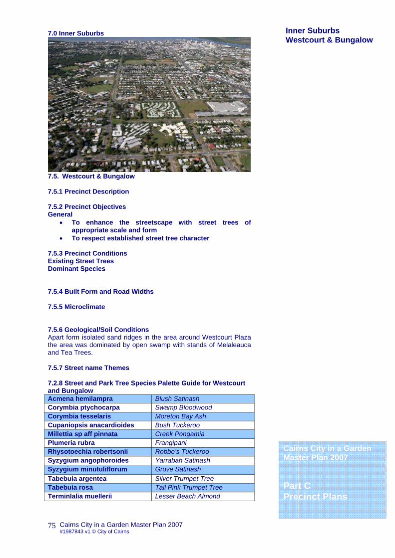
7.0 Inner Suburbs
7.5. Westcourt & Bungalow 7.5.1 Precinct Description 7.5.2 Precinct Objectives General
• To enhance the streetscape with street trees of appropriate scale and form
• To respect established street tree character 7.5.3 Precinct Conditions Existing Street Trees Dominant Species 7.5.4 Built Form and Road Widths 7.5.5 Microclimate 7.5.6 Geological/Soil Conditions Apart form isolated sand ridges in the area around Westcourt Plaza the area was dominated by open swamp with stands of Melaleauca and Tea Trees. 7.5.7 Street name Themes 7.2.8 Street and Park Tree Species Palette Guide for Westcourt and Bungalow Acmena hemilampra Blush Satinash Corymbia ptychocarpa Swamp Bloodwood Corymbia tesselaris Moreton Bay Ash Cupaniopsis anacardioides Bush Tuckeroo Millettia sp aff pinnata Creek Pongamia Plumeria rubra Frangipani Rhysotoechia robertsonii Robbo’s Tuckeroo Syzygium angophoroides Yarrabah Satinash Syzygium minutuliflorum Grove Satinash Tabebuia argentea Silver Trumpet Tree Tabebuia rosa Tall Pink Trumpet Tree Terminlalia muellerii Lesser Beach Almond
Cairns City in a Garden Master Plan 2007 Part C Precinct Plans
Inner Suburbs Westcourt & Bungalow
Cairns City in a Garden Master Plan 2007 #1987843 v1 © City of Cairns
76
7.5.7 Street Tree Species Palette for Westcourt & Bungalow Street Name Between Median Verge Footpath P
Bunda Scott McCoombe
Corymbia ptychocarpa Tabebuia argentea P
P-indicates selected species for planting under power lines
Cairns City in a Garden Master Plan 2007 Part C Precinct Plans
Inner Suburbs Westcourt & Bungalow
Cairns City in a Garden Master Plan 2007 #1987843 v1 © City of Cairns
77
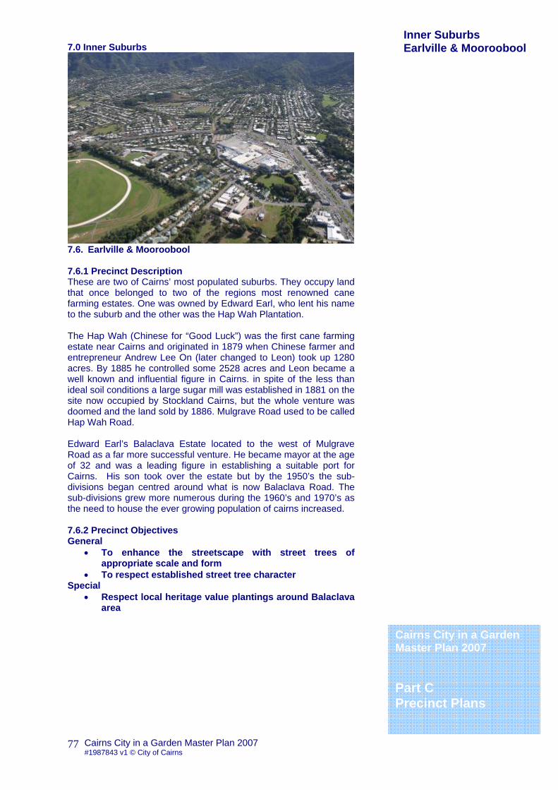
7.0 Inner Suburbs
7.6. Earlville & Mooroobool 7.6.1 Precinct Description These are two of Cairns’ most populated suburbs. They occupy land that once belonged to two of the regions most renowned cane farming estates. One was owned by Edward Earl, who lent his name to the suburb and the other was the Hap Wah Plantation. The Hap Wah (Chinese for “Good Luck”) was the first cane farming estate near Cairns and originated in 1879 when Chinese farmer and entrepreneur Andrew Lee On (later changed to Leon) took up 1280 acres. By 1885 he controlled some 2528 acres and Leon became a well known and influential figure in Cairns. in spite of the less than ideal soil conditions a large sugar mill was established in 1881 on the site now occupied by Stockland Cairns, but the whole venture was doomed and the land sold by 1886. Mulgrave Road used to be called Hap Wah Road. Edward Earl’s Balaclava Estate located to the west of Mulgrave Road as a far more successful venture. He became mayor at the age of 32 and was a leading figure in establishing a suitable port for Cairns. His son took over the estate but by the 1950’s the sub-divisions began centred around what is now Balaclava Road. The sub-divisions grew more numerous during the 1960’s and 1970’s as the need to house the ever growing population of cairns increased. 7.6.2 Precinct Objectives General
• To enhance the streetscape with street trees of appropriate scale and form
• To respect established street tree character Special
• Respect local heritage value plantings around Balaclava area
Cairns City in a Garden Master Plan 2007 Part C Precinct Plans
Inner Suburbs Earlville & Mooroobool
Cairns City in a Garden Master Plan 2007 #1987843 v1 © City of Cairns
78
7.6.3 Precinct Conditions Existing Street Trees Balaclava Rd: Tabebuia spp mixed floral ‘avenue’ Carnation Dr: good mature Caesalpina ferrea (on red soil?) Dominant Species Tabebuia pallida Evergreen Trumpet Tree Tabebuia argentea Silver Trumpet Tree Tabebuia palmeri Tabebuia chrysantha Golden Trumpet Tree 7.6.4 Built Form and Road Widths Earlville and Mooroobool both have strong grid patterns with reasonably wide roads. Earlville still has much of its original housing and this contributes to the general character of the streets. Mooroobool is typified by few street trees. 7.6.5 Microclimate 7.6.6 Geological/Soil Conditions Poor sandy soils once open swamp and forest. Heavy, often stony clays on foothills, ridge of red soils through parts of City View & Koppen’s Hill 7.6.7 Street Name Themes Tropical Fruits, Ancient Rome, Floral Theme, Birds, Female Christian Names, Gemstones, Spain, Italian Christian Names, Plants and Trees Special Areas 7.6.8 Street and Park Tree Species Palette Guide for Earlville and Mooroobool Caesalpina ferrea Leopard Tree Cassia sp Paluma Range Paluma Golden Shower Tree Lagerstroemia floribunda Pride of India Newboldia laevis Boundary Tree Parachidendron pruinosum Snow Wood Tabebuia argentea Silver Trumpet tree Tabebuia chrysantha Golden trumpet Tree Tabebuia palmeri Xanthostemon chrysanthus Golden Penda 7.6.9 Street Tree Species Palette for Earlville & Mooroobool Street Name Between Median Verge Footpath P
Balaclava Irene Beatrice
Cassia sp Paluma Range Xanthostemon chrysanthus
Beatrice Irene McGregor
Cassia sp Paluma Range Tabebuia argentea
Mulgrave Balaclava Irene
Tabebuia var. Tabebuia var.
Balaclava De Jarlais Toogood
Tabebuia chrysantha Syzygium jambos P
P-indicates selected species for planting under power lines
Inner Suburbs Earlville & Mooroobool
Cairns City in a Garden Master Plan 2007 #1987843 v1 © City of Cairns
79
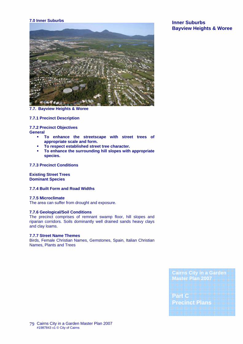
7.0 Inner Suburbs
7.7. Bayview Heights & Woree 7.7.1 Precinct Description 7.7.2 Precinct Objectives General
To enhance the streetscape with street trees of appropriate scale and form.
To respect established street tree character. To enhance the surrounding hill slopes with appropriate
species. 7.7.3 Precinct Conditions Existing Street Trees Dominant Species 7.7.4 Built Form and Road Widths 7.7.5 Microclimate The area can suffer from drought and exposure. 7.7.6 Geological/Soil Conditions The precinct comprises of remnant swamp floor, hill slopes and riparian corridors. Soils dominantly well drained sands heavy clays and clay loams. 7.7.7 Street Name Themes Birds, Female Christian Names, Gemstones, Spain, Italian Christian Names, Plants and Trees
Cairns City in a Garden Master Plan 2007 Part C Precinct Plans
Inner Suburbs Bayview Heights & Woree

Cairns City in a Garden Master Plan 2007 #1987843 v1 © City of Cairns
80
7.7.8 Street and Park Tree Species Palette Guide for Bayview Heights and Woree Caesalpina ferrea Leopard Tree Castanospora alphandii Brown Tamarind Darlingia darlingiana Brown Silky Oak Diploglottis smithii Native Tamarind Eleaocarpus bancroftii Kuranda Quandong Melicope elleryana Ulysses Butterfly Tree Melicope rubra Dwarf Ulysses Butterfly Tree Mischocarpus pyriformis Pear Fruit Ormosia ormondii Yellow Bean Syzygium alliiligneum Onionwood Syzygium cormiflorum Bumpy Satinash Syzygium fibrosum Fibrous satinash Toechimia erythrocarpum Pink Tamarind Xanthostemon chrysanthus Golden Penda
7.7.9 Street Tree Species Palette for Bayview Heights and Woree Street Name Between Median Verge Footpath P
Mulgrave Toogood Yarra
Darlingia darlingiana Xanthostemon chrysanthus P
Yarra Toogood Fairview
Xanthostemon chrysanthus Xanthostemon chrysanthus
Bruce Hwy Anderson Rd Windarra
Windarra Anderson Rd Fairview
Mulgrave Tills/Lennon Gatton Caesalpina ferrea Xanthostemon chrysanthus
Gatton Tills/Lennon English Xanthostemon chrysanthus Xanthostemon chrysanthus
English Tills/Lennon McCormack Xanthostemon chrysanthus
P-indicates selected species for planting under power lines
Cairns City in a Garden Master Plan 2007 Part C Precinct Plans
Inner Suburbs Bayview Heights & Woree
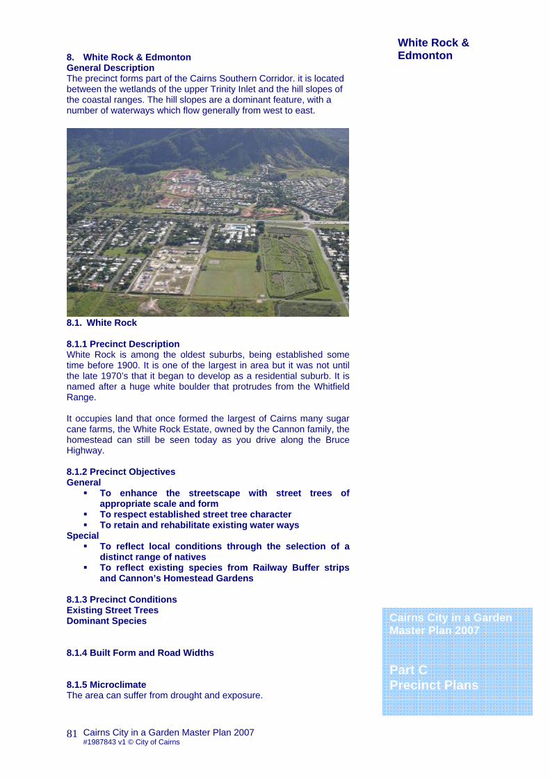
Cairns City in a Garden Master Plan 2007 #1987843 v1 © City of Cairns
81
8. White Rock & Edmonton General Description The precinct forms part of the Cairns Southern Corridor. it is located between the wetlands of the upper Trinity Inlet and the hill slopes of the coastal ranges. The hill slopes are a dominant feature, with a number of waterways which flow generally from west to east.
8.1. White Rock 8.1.1 Precinct Description White Rock is among the oldest suburbs, being established some time before 1900. It is one of the largest in area but it was not until the late 1970’s that it began to develop as a residential suburb. It is named after a huge white boulder that protrudes from the Whitfield Range. It occupies land that once formed the largest of Cairns many sugar cane farms, the White Rock Estate, owned by the Cannon family, the homestead can still be seen today as you drive along the Bruce Highway. 8.1.2 Precinct Objectives General
To enhance the streetscape with street trees of appropriate scale and form
To respect established street tree character To retain and rehabilitate existing water ways
Special To reflect local conditions through the selection of a
distinct range of natives To reflect existing species from Railway Buffer strips
and Cannon’s Homestead Gardens
8.1.3 Precinct Conditions Existing Street Trees Dominant Species 8.1.4 Built Form and Road Widths 8.1.5 Microclimate The area can suffer from drought and exposure.
Cairns City in a Garden Master Plan 2007 Part C Precinct Plans
White Rock & Edmonton
Cairns City in a Garden Master Plan 2007 #1987843 v1 © City of Cairns
82
8.1.6 Geological/Soil Conditions White Rock east typically has white clay soils with impeded drainage, which supports a distinctive range of native species. 8.1.7 Street Name Themes Hollywood Films, Trees, North America 8.1.8 Street and Park Tree Species Palette Guide for White Rock Barringtonia acutangula Freshwater mangrove Brachychiton acerifolius Flame Tree Callistemon viminalis Weeping Bottlebrush Carallia brachiata Corky bark Corymbia ptychocarpa Swamp Bloodwood Deplanchea tetraphylla Golden Bouquet Dillenea alata Red Beech Eucalyptus tereticornis Ficus congesta Red Leaf Fig Gmelina dalrympleana Darymple’s White Beech Lagerstroemia speciosa Pride of India Melaleuca dealbata Blue Paperbark Melaleuca viridiflora “Burgundy” Melicope elleryana Ulysses Butterfly Tree Polyalthia longifolia Indian Mast Tree Stenocarpus sinuatus Firewheel Tree 8.1.7 Street Tree Species Palette for White Rock Street Name Between Median Verge Footpath P
Robert Hardy Foster
Polyalthia longifolia Stenocarpus sinuatus Randia fitzalanii
P
Bruce Hwy Foster Hardy
Brachychiton acerifolius Randia fitzalanii P
P-indicates selected species for planting under power lines
White Rock & Edmonton
Cairns City in a Garden Master Plan 2007 Part C Precinct Plans

Cairns City in a Garden Master Plan 2007 #1987843 v1 © City of Cairns
83
8.0 Whiterock & Edmonton General Description The precinct forms part of the Cairns Southern Corridor. it is located between the wetlands of the upper Trinity Inlet and the hill slopes of the coastal ranges. The hill slopes are a dominant feature, with a number of waterways which flow generally from west to east.
8.2. Edmonton 8.2.1 Precinct Description Edmonton fringes what was once the old Cairns Road, now relocated east to where the Bruce Highway is today. In the early days the journey to Edmonton from Cairns was a hard one, with eight major creeks to cross, with banks crowded with thickets of rainforest trees, with hickory and cedar. In 1879 an Englishman called Thomas Kingsford Swallow came to find his fortune in the gold fields of Mount Peter. The Aplina was one of the richest mines and attracted many prospectors who lived in tents at the foot of the mountain. After just two years he purchased some 95 square miles of land to the south of the township and named it Hambledon (perhaps in memory of Surrey where he came from). Here he started to grow sugar cane becoming the biggest producer in Cairns and establishing Swallows Biscuits that was later sold to Arnotts. The Hambledon valley proved to be perfect for growing cane, and by 1883 Swallow was able to open the Swallows Sugar Mill, later sold to the giant CSR Company and eventually closed down in 1991. Part of the old Sugar World Gardens that once surrounded the mill is now owned by Cairns City Council has a growing collection of tropical fruit trees, building on the orchards that once stood here. With the construction of the Cairns Road the township shifted south and changed its name to Edmonton. This is one of the major growth areas of the city with an expanding population and plans for a new commercial heart. The precinct forms part of the southern corridor that will eventually extend to Gordonvale on the western side of the Bruce Highway. The area is located between the wetlands of the upper reaches of the trinity Inlet and the hill slopes of the coastal ranges.
Cairns City in a Garden Master Plan 2007 Part C Precinct Plans
White Rock & Edmonton
Cairns City in a Garden Master Plan 2007 #1987843 v1 © City of Cairns
84
8.2.2 Precinct Objectives General
To enhance the streetscape with street trees of appropriate scale and form
To respect established street tree character To enhance local heritage and cultural associations with
appropriate tree species. To reflect the local landscape character through the
appropriate selection of tree species To retain and rehabilitate existing water ways
Special Edmonton North to be dominated by yellow flowering
species Edmonton Central to reflect mature planting on former
Hambledon Estate (Flowering and fruiting trees and timber species)
8.2.3 Precinct Conditions Existing Street Trees Hambledon estate features remnant Mango, Samanea & Delonix. Dominant Species 8.2.4 Built Form and Road Widths 8.2.5 Microclimate The area can suffer from drought and exposure. 8.2.6 Geological/Soil Conditions Reclaimed cane farming land, once open swamp and forest with riparian corridors. Soils dominantly red clays. 8.2.7 Street Name Themes Early District Settlers, Early England, Orchids, Scottish names historically linked to the Mann Family, Hambledon Employees, Sugar Cane. 8.2.8 Street and Park Tree Species Palette Guide for Edmonton North Deplanchea tetraphylla Golden Bouquet Dillenea alata Red Beech Diploglottis diphyllostegia Wild Tamarind Eucalyptus abergiana Range Bloodwood Ficus benjamina ‘Aurea’ Golden Weeping Fig Harpullia arborea Cooktown Tulipwood Harpullia pendula Polyscias nodosa Noah’s Basswood Storckelia australiensis White Bean Tababuia argentea Silver Trumpet Tree Tabebuia chrysantha Golden trumpet Tree Xanthostemon chrysanthus Golden Penda Xanthostemon whitei Greater Golden Penda
Cairns City in a Garden Master Plan 2007 Part C Precinct Plans
White Rock & Edmonton

Cairns City in a Garden Master Plan 2007 #1987843 v1 © City of Cairns
85
Street and Park Tree Species Palette Guide Edmonton Central Agathis robusta Kauri Pine Brachychiton acerifolius Flame Tree Buchanania arborescens Gooseberry Tree Corymbia tesselaris Moreton Bay Ash Euphoria longan Longan Flacourtia inermis Lovi-Lovi Flindersia ifflaiana Cairns Hickory Lophanthera latescens Golden Chain Tree Melaleuca dealbata Blue Papaerbark Melaleuca quinquenervea Melicope elleryana Ulysses Butterfly Tree Michelia champaca Himalayan magnolia Pachira aquatica Guyana Chestnut Polyscias nodosa Noah’s Basswood Syzygium alliligneum Onionwood
8.2.7 Street Tree Species Palette for Edmonton Street Name Between Median Verge Footpath P
Bruce Hwy Peterson Mt Peter
Flindersia ifflaiana Melicope elleryana P
Bruce Hwy Mill Woodlock
Tabebuia chrysantha Syzygium forte ssp.forte P
Hambledon Walker Timberlea
Flindersia ifflaiana Flindersia ifflaiana
Bruce Hwy Robert Hardy
Agathis robusta Brachychiton acerifolius
Robert Bicentennial Ravizza
Flindersia ifflaiana Melaleuca quinquenervea
Ravizza Flindersia ifflaiana Flindersia ifflaiana
Randia fitzalanii P
Mill Hambledon Isabella
Tabebuia chrysantha Syzygium alliligneum
P-indicates selected species for planting under power lines
White Rock & Edmonton Edmonton

Cairns City in a Garden Master Plan 2007 #1987843 v1 © City of Cairns
86
9. Gordonvale & Goldsborough 9.1. Gordonvale 9.1.1 Precinct Description Gordonvale nestles at the foot of the Pyramid Mountain flanked by the Mulgrave River. It took its name from prominent landowner John Gordon, whose main business was to supply meat to the miners of the Goldsborough Valley and the tin miners at Herberton. However when first settled in 1885 it was known as Nelson, after the then State Premier. Under an agreement with sister city in New Zealand both agreed that one would have to change names, and Nelson Queensland became Gordonvale in 1886. The township quickly grew on both the success of the sugar cane industry and the trade which flowed up Gillies to the mining town of the Tablelands. While some made their fortunes in mining others made theirs from “red gold”, that is to say from the Red Cedar and the Kauri Pine that grew in this area. Large areas were felled and the local Yidindji Tribe were dispossessed of their traditional hunting grounds. 9.1.2 Precinct Objectives General
• To enhance the streetscape with street trees of appropriate scale and form
• To respect established street tree character • To reference pre-settlement plant communities through
appropriate tree selection • A general colour theme of “Gold” flowers and foliage
Special • Use of hardy species to compliment the hill slopes of The
Pyramid 9.1.3 Precinct Conditions Existing Street Trees The older town area is dominated by more traditional exotic flowering trees or figs, including some unusual species such as Kigelia africana (Sausage Tree)) in the old mill manager’s house garden. The newer areas west of the highway tend to feature more native species.
Cairns City in a Garden Master Plan 2007 Part C Precinct Plans
Gordonvale & Goldsborough
Photo currently unavailable

Cairns City in a Garden Master Plan 2007 #1987843 v1 © City of Cairns
87
The ‘Green Patch’ flood terrace recreation reserve features mature gallery vegetation (Melaleuca leucadendra, Syzygium tierneyanum, Ficus racemosa etc, with Delonix regia and Cassia fistula interplanted beside the highway. Dominant Species Melaleuca leucadendra Paperbark Syzygium tierneyanum River Cherry 9.1.4 Built Form and Road Widths 9.1.5 Microclimate Lower rainfall levels 9.1.6 Geological/Soil Conditions The precinct is characterised by the natural feature of the Mulgrave River, the Pyramid and adjacent ranges. Soils can often be poor and skeletal. 9.1.7 Street Name Themes Early District settlers, Gold Mining Special Areas 9.1.8 Street and Park Tree Species Palette Guide for Gordonvale and Goldsborough Acacia leptoloba Irvinebank Wattle Agathis robusta Kauri Pine Barringotina calyptrata Cassowary Pine Blepharocarya involucrigera
Rose Butternut
Bombax ceiba Kapok Tree Calliandra ‘rosea’ Hot-pink Powderpuff Tree Calliandra surinamensis Powderpuff Tree Callitris macleayana Stringybark Cyprus Cassia fistula Golden Shower Tree Casuarina torulosa Rose She Oak Delonix regia var. flava Yellow Royal Poinciana Eucalyptus torelliana Cadaghi Ficus racemosa Cluster Fig Grevillea baileyana Findlay’s Silky Oak Lophostemon confertus Brush Box Parachidendron prunosum Snow Wood Paraserianthes toona Red Siris Peltophorum dubium Brasiletto Syncarpia glomulifera Turpentine Xanthostemon chrysanthus Golden Penda
9.1.8 Street Tree Species Palette for Gordonvale and Goldsborough Street Name Between Median Verge Footpath P
Gillies Goldsbrgh Pan
Cassia fistula Xanthostemon chrysanthus
Bruce Hwy Draper Hickling
Agathis robusta Cassia fistula Xanthostemon chrysanthus
P-indicates selected species for planting under power lines
Gordonvale & Goldsborough
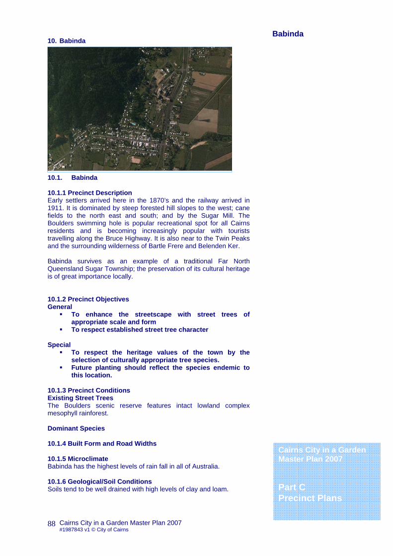
Cairns City in a Garden Master Plan 2007 #1987843 v1 © City of Cairns
88
10. Babinda 10.1. Babinda 10.1.1 Precinct Description Early settlers arrived here in the 1870’s and the railway arrived in 1911. It is dominated by steep forested hill slopes to the west; cane fields to the north east and south; and by the Sugar Mill. The Boulders swimming hole is popular recreational spot for all Cairns residents and is becoming increasingly popular with tourists travelling along the Bruce Highway. It is also near to the Twin Peaks and the surrounding wilderness of Bartle Frere and Belenden Ker. Babinda survives as an example of a traditional Far North Queensland Sugar Township; the preservation of its cultural heritage is of great importance locally. 10.1.2 Precinct Objectives General
To enhance the streetscape with street trees of appropriate scale and form
To respect established street tree character Special
To respect the heritage values of the town by the selection of culturally appropriate tree species.
Future planting should reflect the species endemic to this location.
10.1.3 Precinct Conditions Existing Street Trees The Boulders scenic reserve features intact lowland complex mesophyll rainforest. Dominant Species 10.1.4 Built Form and Road Widths 10.1.5 Microclimate Babinda has the highest levels of rain fall in all of Australia. 10.1.6 Geological/Soil Conditions Soils tend to be well drained with high levels of clay and loam.
Cairns City in a Garden Master Plan 2007 Part C Precinct Plans
Babinda
Photo currently unavailable

Cairns City in a Garden Master Plan 2007 #1987843 v1 © City of Cairns
89
10.1.7 Street Name Themes Early local family names 10.1.8 Street and Park Tree Species Palette Guide for Babinda Acmena graveolens Cassowary Satinash Backhousia bancroftii Johnstone River Hardwood Diploglottis bernieana Bernie’s Tamarind Diploglottis harpullioides Babinda Tamarind Diploglottis smithii Smith’s Tamarind Lindsayomyrtus racemoides
Daintree Penda
Placospermum coriaceum Rose Silky Oak Prunus turnerana Almond Bark Ristantia pachysperma Yellow penda Storckelia australiensis White Bean Synima cordierom Pink Tamarind Syzygium fibrosum Fibrous Satinash Syzygium gustavioides Grey Satinash Waterhousia hedraiophylla Gully Satinash Xanthostemon chrysanthus Golden Penda
10.1.9 Street Tree Species Palette for Babinda Street Name Between Median Verge Footpath P
P
P-indicates selected species for planting under power lines
Cairns City in a Garden Master Plan 2007 Part C Precinct Plans

Cairns City in a Garden Master Plan 2007 #1987843 v1 © City of Cairns
90
11. Rural Lands 11.1. Rural Lands 11.1.1 Precinct Description The Rural Lands incorporate the lowland areas of the Mulgrave and Russell River Valleys: the rainforested coastal ranges; and the wetlands and coastline extending from Russell Heads to Bramston Beach. It is an area of high landscape value, with significant remnants of natural vegetation, many of which are included in the Wet Tropics World Heritage Area. It is sparsely populated and retains a distinctly rural quality that once typified the Cairns region. 11.1.2 Precinct Objectives General
To enhance the streetscape with street trees of appropriate scale and form
To respect established street tree character To reflect the natural environment through the
appropriate selection of tree species Special
Bramston Beach foreshore reserves include remnant trees from a coast rainforest on sand dunes with very high rainfall. Conspicuous spp include Barringtonia asiatica, Barringtonia calyptrata, Acmena hemilampra, Calophyllum inophyllum, Syzygium forte ssp forte, Deplanchea tetraphylla, Macadamia whelanii
Many of the scattered hamlets & townships are often
close to gallery and swamp forest remnants. Conspicuous spp include: Alstonia scholaris, Barringtonia calyptrata, Barringtonia racemosa, Elaeocarpus angustifolius, Nauclea orientalis, Ormosia ormondii, Ristantia pachysperma, Syzygium tierneyanum, Terminalia sericocarpa, Tristaniopsis exiliflora, Archontophoenix alexandrae, Pandanus sp aff gemmifer (Russell River), and the highly invasive Annona glabra (Pond Apple)
11.1.3 Precinct Conditions Existing Street Trees Dominant Species
Cairns City in a Garden Master Plan 2007 Part C Precinct Plans
Rural Lands
Photo currently unavailable

Cairns City in a Garden Master Plan 2007 #1987843 v1 © City of Cairns
91
11.1.4 Built Form and Road Widths 11.1.5 Microclimate 11.1.6 Geological/Soil Conditions 11.1.7 Street Name Themes Christian Names and Surnames, Trees Special Areas 11.1.8 Street and Park Tree Species Palette Guide Mirriwinni Acmena graveolens Cassowary satinash Bischofia javanica Java Cedar Cardwellia sublimis Northern Silky oak Diploglottis benieana Bernie’s Tamarind Ficus virgata Large Leaf Weeping Fig Palaquium galactoxylum Pencil Cedar Sphaerantia discolor Tully Penda Syzygium australe Creek Cherry Syzygium cannicortex Yellow Satinash Syzygium cormiflorum Bumpy Satinash Syzygium gustaviodes Grey Satinash
Street and Park Tree Species Palette Guide Bramston Beach Acmena hemilampra Blush Satinash Antidesma bunius Herbert River Cherry Barringtonia asiatica Boxfruit Barryngtonia calyptrata Cassowary Pine Buchaniana arborescens Bursaria tenuifolia Deplanchea tetraphylla Golden Bouquet Dillenea alata Red Beech Disoxylum oppositifolum Pink Mahogany Euroschinus falcata Pink Poplar Gmelina dalrympleana Dalrymple’s White Beech Melaleuca leucadendra Weeping Paperbark Randia fitzalanii Native Gardenia Sterculia quadrifida Peanut Tree Syzygium angophoroides Yarrabah Satinash Syzygium forte ssp forte White Apple Terminalia arenicola Beach Almond
11.1.9 Street Tree Species Palette for Rural Lands Street Name Between Median Verge Footpath P P P-indicates selected species for planting under power lines
Rural Lands
Cairns City in a Garden Master Plan 2007 Part C Precinct Plans

Cairns City in a Garden Master Plan 2007 #1987843 v1 © City of Cairns
92


![Melicope Moluccana T.G. Hartley yl)oxy]quinolin-2(1H)-one ...](https://static.documents.pub/doc/80x56/620abfa94641010f784c1458/melicope-moluccana-tg-hartley-yloxyquinolin-21h-one-.jpg)
