National Weather Service Serving the weather needs of Interior Northern California [email protected]National Weather Service – Sacramento California Climate and its impacts to fire conditions
Transcript
National Weather Service Serving the weather needs of Interior Northern California
California Climate and its impacts to fire conditions
LET’S LOOK BACK AT PRECIPITATION AND DROUGHT
2
California’s Water Story:
• Mediterranean Climate – About half the annual precipitation
total arrives from December through February
• Winter storms come off the Pacific Ocean delivering rain and snow to California. – Some of these storms include
moisture from Atmospheric Rivers (AR)
• On average 5-7 ARs contribute most of the precipitation during the wet months. – Last 4 water years, CA avg. was 2
• When more storms arrive, conditions are wetter; when fewer storms arrive, conditions are drier
3
4
Past 3 Water Years – Big Picture After three winters of below normal precipitation – 2014-15 is continuing that trend. We’ve also been very warm, with many month’s breaking records for well above average temperatures. This results in high snow levels and much less snowpack in reserve
5 http://cdec.water.ca.gov
Northern Sierra 8-Station Index So far this year 31.9” precipitation Last year 31.3” precipitation Average (1922-2008) = 50” precipitation
6 http://cdec.water.ca.gov
Central Sierra 5-Station Index So far this year 13.7” precipitation Last year 20.4” precipitation Average (1961-2010) = 40.8” precipitation
California Snowpack April 1st 2011-2015
Why is this Significant?
• Mountain snowpack act’s as another giant reservoir
• Snowpack typically holds ~ 1/3 of CA water supply for the year
• Gradually melts off in the late spring and summer months, replenishing reservoirs
• No snowpack, no refill/reserve
• Impacts to economy (tourism) and environmental (fires)
7 www.nohrsc.noaa.gov
What are the Latest Snow Water Content Numbers?
8
http://cdec.water.ca.gov
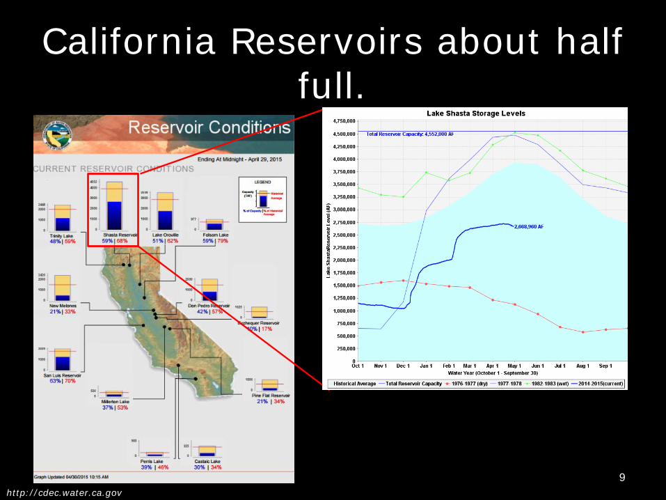
California Reservoirs about half full.
9 http://cdec.water.ca.gov
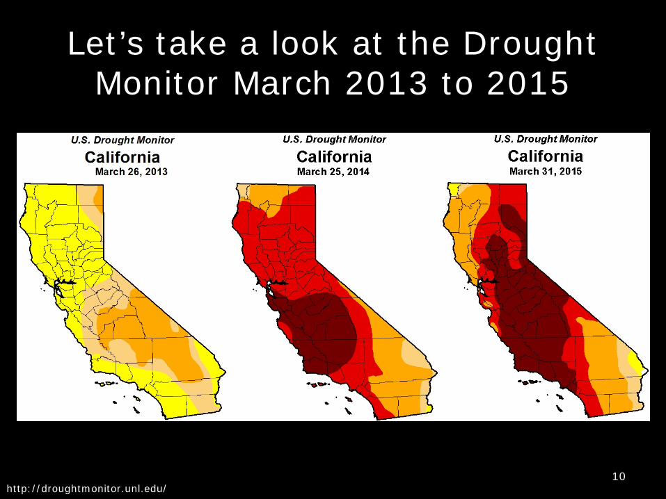
Let’s take a look at the Drought Monitor March 2013 to 2015
10
http://droughtmonitor.unl.edu/
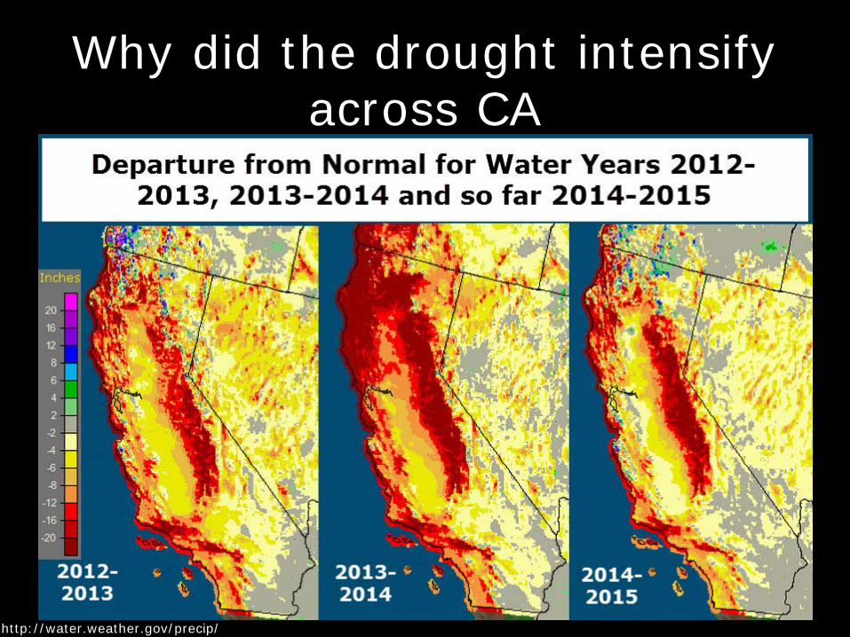
Why did the drought intensify across CA
11
http://water.weather.gov/precip/
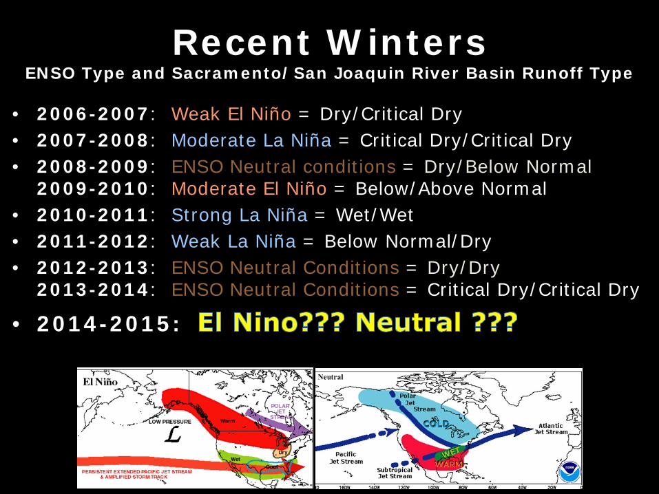
Recent Winters ENSO Type and Sacramento/San Joaquin River Basin Runoff Type
• 2006-2007: Weak El Niño = Dry/Critical Dry • 2007-2008: Moderate La Niña = Critical Dry/Critical Dry • 2008-2009: ENSO Neutral conditions = Dry/Below Normal
2009-2010: Moderate El Niño = Below/Above Normal • 2010-2011: Strong La Niña = Wet/Wet • 2011-2012: Weak La Niña = Below Normal/Dry • 2012-2013: ENSO Neutral Conditions = Dry/Dry
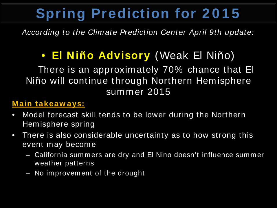
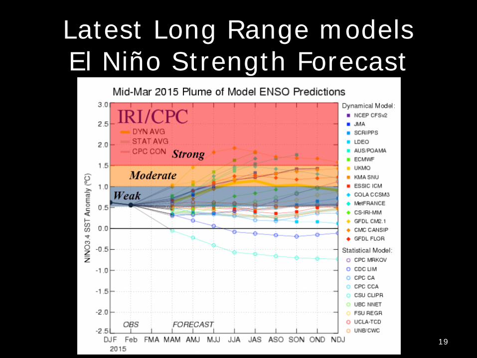
Spring Prediction for 2015 According to the Climate Prediction Center April 9th update:
• El Niño Advisory (Weak El Niño) There is an approximately 70% chance that El Niño will continue through Northern Hemisphere
summer 2015 Main takeaways: • Model forecast skill tends to be lower during the Northern
Hemisphere spring • There is also considerable uncertainty as to how strong this
event may become – California summers are dry and El Nino doesn’t influence summer
weather patterns – No improvement of the drought
Latest Long Range models El Niño Strength Forecast
19
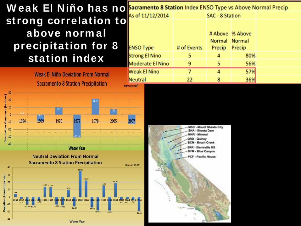
Weak El Niño has no strong correlation to
above normal precipitation for 8
station index
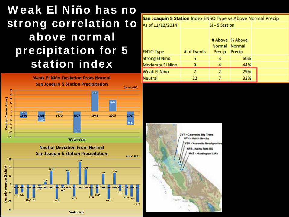
Weak El Niño has no strong correlation to
above normal precipitation for 5
station index
22 droughtmonitor.unl.edu
Seasonal Drought Outlook Drought impacts to persist or intensify after this past dry winter
now ending our fourth dry winter in a row!
D3-D4 Drought intensity…Extreme-Exceptional Drought covers 67% of the state Can we predict when the drought will end? – no.
Spring/Summer Outlook Official outlook – Since El Nino isn’t a spring/summer player, and Summer season is traditionally dry, no good indicator for precipitation outlook. Above normal temperatures are favored – moderate confidence. Forecast skill of these outlooks is not great. Plan for anything.
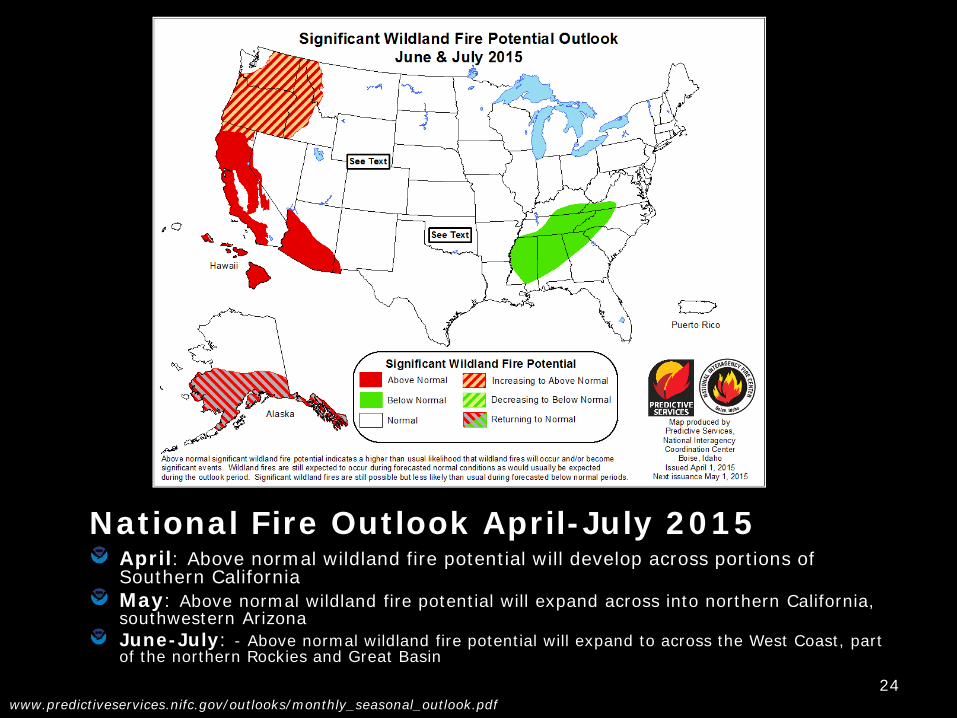
National Fire Outlook April-July 2015 April: Above normal wildland fire potential will develop across portions of Southern California May: Above normal wildland fire potential will expand across into northern California, southwestern Arizona June-July: - Above normal wildland fire potential will expand to across the West Coast, part of the northern Rockies and Great Basin
Fire Outlook for Nor Cal: April-July 2015 April: Grasses in the lower elevations have already greened and are starting to cure across most aspects
Live Fuels in the higher elevations, normally under snow cover, are currently greening up about 6-8 weeks ahead of schedule
May-July: Live fuels nearly 2 months ahead of schedule in the higher terrain as well as the expectation of curing of grasses in the lower elevations within the next few weeks, ABOVE NORMAL LARGE FIRE POTENTIAL in May for lower elevations below 3500 ft (top left)…expanding to most other areas in June and July (top right)
No significant additional precipitation expected during the remainder of “rainy season” Above or much average temperatures likely through July Large fire potential expanding from south to north during the period High amount of bug kill trees and diseased forests will add to a high large fire potential in alpine areas
NWS PRODUCTS & SERVICES
27
• Critical fire weather conditions are imminent or occurring
• High confidence will occur within 24-36 hours.
• Upgrade of a Watch or issued as is.
• Potential Red Flag
Warning Event • Reasonable
confidence of critical fire weather
• Issued about 24-72 hours before the predicted start of the event
Fire Weather Watch
Red Flag Warning VS
Web Access weather.gov/sacramento
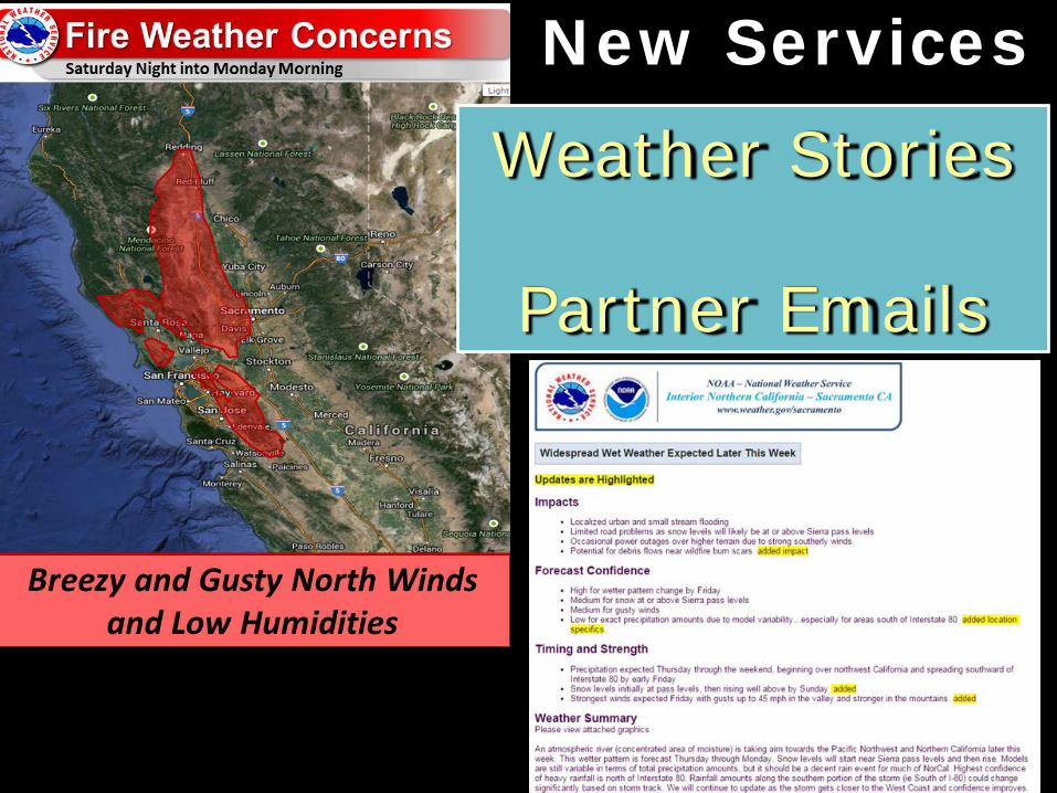
New Services
Weather Stories
Partner Emails
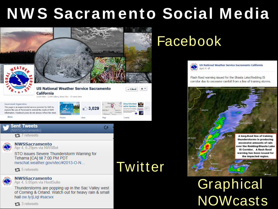
NWS Sacramento Social Media
Twitter
Facebook
Graphical NOWcasts
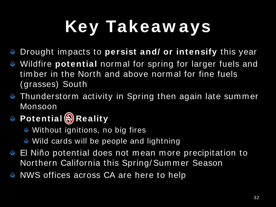
Key Takeaways Drought impacts to persist and/or intensify this year Wildfire potential normal for spring for larger fuels and timber in the North and above normal for fine fuels (grasses) South Thunderstorm activity in Spring then again late summer Monsoon Potential = Reality
Without ignitions, no big fires Wild cards will be people and lightning
El Niño potential does not mean more precipitation to Northern California this Spring/Summer Season NWS offices across CA are here to help