24
8/7/2019 California Geology Magazine August 1990
http://slidepdf.com/reader/full/california-geology-magazine-august-1990 1/24
8/7/2019 California Geology Magazine August 1990
http://slidepdf.com/reader/full/california-geology-magazine-august-1990 2/24
APU8L1CATION OF THEDEPARTMENT Of CONSERVATIONDIVISION OF MINES AND GEOLOGY
Stal.olCaM",n,a GEORGE DEUKMEJIANGoVllf/ lO.
The Resoorces Agency GORDON K VAN VLECKSecrelary for Resovrces
In This Issue IAEG 33RD ANNUAL MEETING . 170
COASTAL CONFERENCE . 170
GEOLOGICAL REMOTE SENSING CONFERENCE 170
SEA CLIFF EROSION . 171
HUNGRY VALLEY FORMATION. LOWER MEMBER DEPOSiTION 178
CALIFORNIA GEOLOGY EDITOR·IN-CHIEF RETIRES 184
SURVEY OF CALIFORNIA GEOLOGY READERS . 185BOOK REVIEWS •.•..•.... . 187
MAIL ORDER FORM •.. .189
CALIFORNIA GEOLOGY SUBSCRIPTION FORM .190
RESOURCES FOR EARTH SCIENCE TEACHERS .191
MEMORIAL-DR. ADOLF PABST. .192
CALIfORNIA GEOLOGY sial!
Oepa,'ment 01 General ServicesOUoce 01 Slal(l Pnntlng
OejIarlmenl 01 Cooserval,on
Graphics and DeSign:Publicallons Supervisor:
RANDALL M. WARDlJ,rocIO'
JAMES F DAVISSiale Geoklglsl
Don Dupras
Louise Huckaby
Jeff Tamberl
Cove r: Examp le o f s ea cliff erosion a long the Cal if ornia coast . Shore li ne
retreal is a continuing natural geologic process along 86% of the 1.1OO·mile·
long California coast. Waves, t ides. wind, rain, and waler runoff from human
activities combine to wear down and reshape sea cliffs. Allhough consider·
able money and ellort is spent on protecllve structures-such as concrete
seawal ls . wooden seawal ls, gabions. and r ip·rap-Io withstand di rect wave
attack, such slructures eventual ly fail over geo logi c l ime. Engineers com
monly bui ld wel l-devi sed protect ive s truc tures w ith des ign l ives of 20 to 25
years. This considerat ion is somet imes overlooked when planning long-term
cl if f top st ructures along California's coastline. An ar ticle about this problem
starts on page' 71. Photo by Robert Norris.
Geological
Remote Sensing Conference
Oov,SIOtl He&OQuarl(l'S: 1416 N,nlh SlrMI. Room 1341.SaCtamenlO. CA 95814(Telel>hOne 916-<l45-1825)
PubhCllI,on. and InlormaHon Olloce660 se'CUI D''''e. SacramenlO. CA 95814-(1131CALIFORNIA GEOLOGYPutMlC InlOfmatlOr1· 916-445-5716
lo s A"9"Ie. 0l11Ce 107 Soulh Il<ollto'.vay. Room 1065.Los Angeles, CA 90012-4402(Telephone 213-620-3560)
Pleasanl HIli OUICe 380 C,v,e Dnve. Suite 100.Pleasanl H,II. CA 9<1523·1921
{Telep/'lON 415-646-5920}
CALIFORNIA GEOLOGY (lSSN 0026 (555) IS pubbJhed
monthly by the DeI'll'lment 01 Conse'''''I",n. D,v,s"," 01
Mines andGeology The Record. OUoce I' at 1721·2OthSlfeet, Sacramento. CA 9S814 Second class postagepaid at SacramenlO. CA Poslmasle" Sllnd add,.,.ChangelllQ CALIFORNIA GEOLOGY (USPS 35 0 840).
Sox 2980. S&cramenlo. CA 95812-2980
RGPOft. eonc.rn'ng Olvlloon 01 M,n.s and GeologyP'Ojects and arllCleS and newllllllm. '1I1atlld 10 lhe lIarthSCHIncGSlnCahlo'lIIa are Indu<led;nlhe magaz,"e. Con·lnbuled a,IICIe•. »hOlographs, news,tems, and geoIog;cslhIIIIIhng announce"'ll<lls It....... ICOfT1(I
THECONCLUSIONS ANDOPINIONS EXPRESSED INARTICLES ARE SOLelY THOSE OF THE AUTHORSAND ARE NOT NECESSARILY ENOORSED 8'1' THEDEPARTMENT OF CONSERVATION
AEG 33rdAnnual Meeting
The Aliegheny·Ohio Seclion of the
Association of Engineering GeoIogiS1S
(AEG) will hasl the 33rd Annual Meeling
of the Association of Engineering Geolo
9iSls on October 1-5. 1990 in Pittsburg.
Pennsylvania. The theme of this nalional
meeting is "Engineering Geology for lhe
9O·s." The program irlCludes technicalsessions. symposia, and short courses.
To receive a brochure and infonnation
for registralion and exhibits contact:
AEG. MEMS
P.O. Box 270Greensburg. PA 15601
(412) 836·6813, (800) 343-5129
or (800) 441-1674 (in PAl
CoastalConference
The 1welfth intemalionaJ conference titled"Our Coastal Experience: Assessing lhe
Past, Confronting the FUlUre" will be heldfrom October 21-24. 1990 in San Antonio.Texas. The conference is sponsored by the
CoaslaJ Society. Shoreline retreat ;s
occurring along 86% of California's 1.100
mile-long coast. An eslimated $100 millionin damage occurred to ocean fronl properly
in Cali fornia during 1983 storms. M·vance<! planning will help miligale future
losses. For additional information contact,
William Wise
Slate University of New York
Stony Brook. NY 11794
(516} 632-8656
COulI,pondance ,hllVld ba addtllsud tll Ed'lo'CALIFORNIAGEOLOGY. 660 llII,eut Or.ve. Sac:remenlo.CA 95814-0131
Subscnpllnns. $1000 pe ' yell'. S'ngle copies: $1.00Gect1 send S4JDSC"plit>l1 ord&rS and c ~ a n g e llt add'ess,nlOfmelron IIICALIfORNIA GEOlOGY. PO, Sox 2980,
SacrllfTlentll.CA 95812-2980.
AugUSl 199ONolume 43/Number 8
CGEOA 43 (8) 169·192 (1990)
The "ConfererlCe on Geologic Remote $ensing: Exploralion. Engineerin9 and the
Environmen1" will be held from April 29 to May 2. 1991 at the Marriot t City Center.
Denver. Colorado. The conference will include applications of remote sensing lechnoJogy directed tOVJard mineral and hydrocarbon (oil and gas) exploration. engineering
geology problems. and environmental applicalions. There will be over 200 technical
presentations by experts from more than 30 countries. During the past 10 years there
has been significanl application of remote sensing towards eat1h science. For additional
information contad:
Nancy J. Wallman. ERIMP.O. Box 8618Ann Arbor. MI48107
(313) 994-1200. Ext. 3234
'7 0 CALIFORNIA GEOLOGY AUGUST 1990
8/7/2019 California Geology Magazine August 1990
http://slidepdf.com/reader/full/california-geology-magazine-august-1990 3/24
A Photo Essay
Sea Cliff Erosion:
A Major DilemmaBy
ROBEAT M. NOARIS,
Professor 01 Geology. EmentusUniversity of California. Santa Barbara
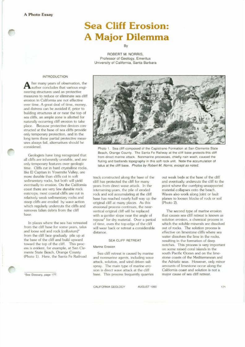
Photo 1. se a elill composed oltha Capistrano Formalion at San Clemente Stale
Beach. Orange CounlY. The Santa Fe Railway at the cliff base prolects this clilt
from direct manne allack. Nonmanne processes. chiefly rain wash. caused the
!Iutmg and badlands topography In this soft rock unit. Note the accumulation of
lalus al the cliff base. Photos by Robert M. Noms, except as noted.
INTRODUCTION
A her many years or observation. theauthor concludes that various engi-
neering structures used as protective
measures to reduce or eliminate sea cliff
erosion in California are not effective
over time. A great deal of time. money.
and dislress can be avoided if. prior 10
buikling structures at or near the top of
sea cliffs. an ample zone is allolted fornaturally occurring cliff erosion to lake
place. Because protective devkes con-
structed at the base of sea cliffs provide
only temporary protection. and in the
long term these partial protective meas-
ures always fail. alternatives should be
considered.
Geologists have long recognized that
all cliffs are inherently unstable. and are
only temporary features over geologic
time. Cliffs cut in hard crystalline rocks.like El Capitan in Yosemite Valley, are
more durable than cliffs cut in soft
sedimentary rocks. but both will yield
eventually 10 erosion. On the California
coaSI there are very few durable rock
outcrops: most coastal cliffs are cut in
relatively weak sedimentary rocks and
steep cliffs are eroded by wave action
which regularly undercuts the cliffs and
removes fallen debris from the cliff
00.. .
In places where the sea has retreatedfrom the cliff base for some years. talus
and loose soil and rock (colluvium)"
from the cliff lace gradually pile up at
the base of the cliff and build upward
toward the lop of the cliff. This proc-
ess is evident. for example. a t San CIe-
menle Stale Beach, Orange County
(PhOtO 1). Here, the Santa Fe Railroad
'SeII Glos.sary. page 177
track constructed along the base of the
cliff has protected the cliff for many
years Irom direct wave attack. In the
intervening years. Ihe pile 01 eroded
rock and soil accumulating at the cliff
base has reached nearly half way up the
original cliff al many places. As this
erosional process continues, the near,
verfical original cliff will be replaced
with a gentler slope near the angle of
repose· for dry material. Over a period
of time, even the top edge of the cliff
will wear back or retreat a considerable
distance.
SEA CLIFF RETREAT
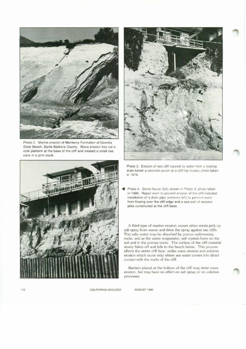
Marine ErOSIon
Sea cliff retreal is caused by marine
and nonmarine agents, including wave
altack. solution, and wind driven salt
spray. The main type of marine ero-
sion is direct wave altack at the cliff
base. This process frequently quarries
out weak beds at the base of the cliff
and eventually undercuts the cliff to the
point where the overlying unsupported
material collapses onlo the beach.
Waves also work along joint or fault
planes 10 loosen blocks of rock or soil
(Photo 2).
The second type of marine erosion
that causes sea cliff retreat is known as
solution erosion. a chemical process in
which the soluble minerals are dissolved
out of rocks. The solution process is
effective on limestone cliffs where seawater dissolves the lime in the rocks.
resulting in the formation of deep
notches. This process is very important
on some raised coral islands in the
south Pacific Ocean and on the lime-
stone coasts of the Mediterranean and
the Adriatic seas. However. only minor
amounts of limestone occur along the
California coast and solution is not amajor cause of sea cliff retreat,
CAlIFORNIAGEOlOGY AUGUST 1990
8/7/2019 California Geology Magazine August 1990
http://slidepdf.com/reader/full/california-geology-magazine-august-1990 4/24
Photo 2. Marine erosion of Monlerey Formation at Gaviota
State Beach. Santa Barbara County. Wave erosion has cut a
rock plalform at the base of the cliH and created a small sea
cave in a joint crack.
CALIFORNIA GEOlOGY
Photo 3. Erosion of sea cliff caused by waler from a leaking
drain below a concrete porch at a cliff-lOP house: photo taken
in1974.
... Photo 4. Same house (lefl) shown in Photo 3; photo taken
in 1980. Repair work to prevent erosion of the cliff included
installafion of a drain pipe (extreme left) to prevent water
from flowing over the cliff edge and a sea wall of wooden
piles constructed at the cliff base.
A third type of marine erosion occurs when winds pick up
salt spray from waves and drive the spray against sea cliffs.
This salty water may be absorbed by porous sedimentaryrocks. and as the water evaporates. sal! crystals form on the
soil and in the porous rocks. The surface of the cliff malerial
slowly flakes of f and falls 10 the beach below. This process
affects the enfire cliff face. unlike wave erosion and solution
erosion which occur only where sea water comes into direct
contact with the rocks of the cliff.
Barriers placed at the bottom of the cliff may defer wave
erosion, but may have no effect on saIl spray or on solution
processes.
AUGUST 1990
8/7/2019 California Geology Magazine August 1990
http://slidepdf.com/reader/full/california-geology-magazine-august-1990 5/24
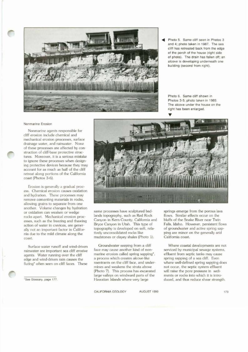
.... Photo 5. Same clill seen in Photos 3
and 4; photo taken in 1987. The sea
cliff has retreated back Irom the edge
01 the porch ollhe house (right side
01 photo). The drain has lallen oil: an
alcove is developing underneath one
building (second 'rom right).
Photo 6. Same cliff shown in
Photos 3-5; photo taken in 1989.
The alcove under the house on lhe
right has been enlarged.
Nonmarine Erosion
Nonmarine agents responsible for
cliff erosion include chemical and
mechanical erosion processes. surface
drainage water. and rainwater. Noneof these processes are affected by con
struction of cliff-base protective struc
tures. Moreover, it is a serious mistake
to ignore these processes when design
ing protective devices because they may
account for as much as half of the cliff
retreat along portions of the California
coast (Photos 3-6).
Erosion is generally a gradual proc
ess. Chemical erosion causes oxidationand hydration. These processes may
remove cementing materials in rocks,
allowing grains to separate from one
another. Volume changes by hydration
or oxidation can weaken or W€dge
rocks apart. Mechanical erosion proc>
esses. such as the freezing and thawing
action of water in crevices. are gener
ally not an important factor in Califor
nia due to the mild climate along the
coast.
Surface water runoff and wind-drivenrainwater are important sea cliff erosive
agents. Water running over the cliff
edge and wind-driven rain causes thefluting· often seen on cliff faces. These
'See G l o $ ~ r y . pag8 177.
same processes have sculptured bad
lands topography. such as Red Rock
Canyon in Kern County. Califomia and
Bryce Canyon in Utah. This type of
topography is developed on soft. rela
tively unconsolidated rocks like
mudstones or clayey shales (Photo 1).
Groundwater seeping from a cliff
face may cause another kind of non
marine erosion called spring sapping·.a process which creates alcove-like
reentrants on the cliff face. and undermines and weakens the strata above
(Photo 7). This process has excavated
large valleys on windward parts of theHawaiian Islands where very large
springs emerge from the porous lava
flows. Similar effects occur on the
bluffs of the Snake River near Twin
Falls. Idaho. However. persistent flowsof groundwaler and active spring sap
ping are minor on the generally arid
Califomia coast.
Where coastal developments are not
serviced by municipal sewage systems.
effluent from septic tanks may cause
spring sapping of a sea cliff. Evenwhere well-defined spring sapping does
not occur, the septic system effluent
will raise the pore pressure in sedi
ments or rocks Into which it is introduced. and thus reduce shear strength
CALIFORNIA GEOLOGY AUGUST 1990
8/7/2019 California Geology Magazine August 1990
http://slidepdf.com/reader/full/california-geology-magazine-august-1990 6/24
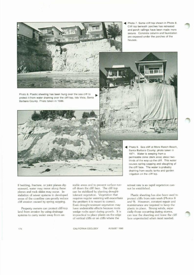
Photo 8. Plastic sheeting has been hung over the sea cliff to
protect it from water draining over the cliff top, Isla Vista, Santa
Barbara County. Photo taken in 1986.
-
..... Photo 7. Same c\iU top shown in Photo 8.
CliU top beneath porches has retreated
and porch raillngs have been made more
secure. Concrete column and foundation
are exposed under the porches of the
houses.
..... Photo 9. Sea c1ilf at More Ranch Beach.
Santa Barbara County; photo taken in
1971. Water is seeping from a
permeable zone (dark area) about two·
thirds of the way up the clill. This water
causes spring sapping and sloughing of
the eli!! face. The water is probably
draining from septic tanks and garden
irrigation on the cliff top.
If bedding. fracture, or joint planes dipseaward, water may move along these
planes and rock slides may occur. In
stallation of sewer systems in developed
areas of the coastline can greatly reduce
cliff erosion caused by spring sapping.
Property owners can protect cliff-top
land from erosion by using drainage
systems to carry water away from un-
stable areas and to prevent surface runoff down the cli ff face. The cli ff top
can be stabilized by planting drought
tolerant vegetation, Vegetation that
requires regular watering will exacerbate
the problem it is meant to correct.
Even drought-resistant vegetation may
have undesirable effects because roots
wedge rocks apart during growth. It is
impractical to place plants on the edge
of vertical cliffs or on cliffs where the
retreat rate is so rapid vegetation cannot be established.
Plastic sheeting has also been used to
protect cliffs from rain wash (Photos 8
and 9). However, constant repair and
maintenance are required to keep the
plastic in place. Strong winds, espe
cially those occurring during storms,
can tear the sheeting and leave the cliff
face unprotected when most needed.
'"CALIFORNIA GEOLOGV AUGUST 1990
8/7/2019 California Geology Magazine August 1990
http://slidepdf.com/reader/full/california-geology-magazine-august-1990 7/24
,
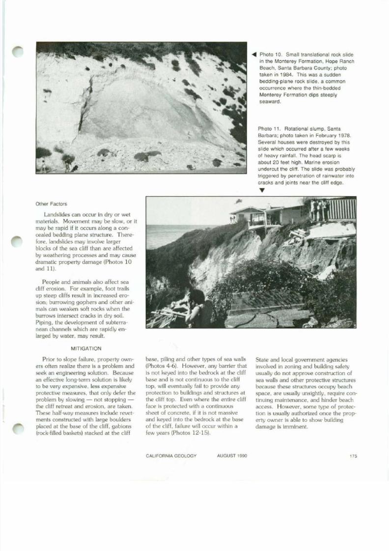
-Photo 11. Rotational slump. Santa
Barbara: photo taken in February 1978.
Several houses were destroyed by this
slide which occurred aher a lew weeks
01 heavy rainfalt. The head scarp IS
about 20 feet high. Marine erOSion
undercut the cliff. The slide was probably
triggered by penetration 01 rainwater imo
cracks and joints near the chI! edge.
"
. . Photo 10. Small translational rock slide
in the Monterey Formation, Hope Ranch
Beach, Santa Barbara County; photo
taken in 1984. This was a sudden
bedding·plane rock slide, a common
occurrence where the thin-bedded
MOnlerey Formation dips steeply
seaward.
..
--,.•
,.-. '.'" , , ~ - u ..
.,
••
Other Faclors
Landslides can occur in dry or wet
materials. Movement may be slow. or it
may be rapid if it occurs along a con·
cealed bedding plane structure. There-
fore. landslides may involve larger
blocks of me sea cliff than are affectedby weathering processes and may cause
dramatic property damage (Photos 10and 11).
People and animals also affect sea
cliff erosion. For example. foot trailsup steep cliffs result in increased ero
sion; burrowing gophers and other ani
mals can weaken soft rocks when the
burrows intersect cracks in dry soil.
Piping. the development of subterra
nean channels which are rapidly en
larged by water. may result.
MITIGATION
Prior to slope failure. property own-
ers often realize there is a problem and
seek an engineering solution. Becausean effective long-term solution is likely
to be very expensive. less expensive
protective measures. that only defer the
problem by slowing - not stopping
the cliff retreat and erosion. are taken.
These half-way measures include revet
ments constructed with large boulders
placed at the base of the cliff. gabions
(rock-filled baskets) stacked at the cliff
base. pil ing and other types of sea walls
(Photos 4-6). However. any barrier that
is not keyed into the bedrock at the cli ffbase and is not continuous to the cliff
top. wil l eventually fail to provide any
protection to buildings and structures at
the c li ff top. Even where the ent ire c li ff
face is protected with a continuous
sheet of concrete, if it is not massive
and keyed into the bedrock at the base
of the cUff. fai lure Vlill occur within a
few years (Photos 12-15).
State and local government agencies
involved in zoning and building safety
usually do not approve construction ofsea walls and other protective structures
because these structures occupy beach
space. are usually unsightly. require con
tinuing maintenance. and hinder beach
access. However. some type of protec
tion is usually authorized once the prop
eny owner is able to show building
damage is imminent.
CALIFORNIA GEOLOGY AUGUST 1990
8/7/2019 California Geology Magazine August 1990
http://slidepdf.com/reader/full/california-geology-magazine-august-1990 8/24
SUMMARY
1lIere is no simple engineering s0 -
lution to save a diff-top building
threatened by erosion. Most remedial
measures that are affordable for an
individual property OIAIIler will only
reduce the rate or erosion. nol stop
it. In the long tenn. the same prob
lems will occur again and ultimately it
will be necessary to condemn anddemolish the structure because diff
erosion is part of the on-going ge0-
logical process. Geologic conditions
and common sense suggest that it
would be less costly for both prop
erty owners and taxpayers if a stripseveral hundred feet wide landward of
all cliff lOps was carefully managed.Photo 12. View 01 a cliff showing a porch projected out Irom a cliff-top house. Isla
Vista. Santa Barbara County. Photo was laken in 1971. Groul was sprayed onto the
cliH face to protect the cliff from wave erOSion. Pharo courtesy of Duke UnIVersity Press.
Photo 13. Same sea cliff and prOjectmg porch shown In Photo
12: photo taken in 1978. Wave erOSIon has atlacked the base
0' the grout covering. and drainage over the cliff edge has
eroded the upper ooges 01 the coaling. A covering at jute
sacking has been added at the cliff top (left of grout cover).
Photo courtesy of Duke Universiry Press.
Photo 14. Sea cliff and prOJectmg porch; photo taken tn 1980.
Only a remnanl of the concrete grout cover remains. held in place
by lhe porch support. The concrete covering reduced the tale 01
cliff relreat as shown by the slight seaward butge in the lower part
of the cliff. but il 'ailed 10 SlOP lhe erosion. Photo courtesy of
Duke University Press.
'"CALIFORNIA GEOLOGY AUGUST 1990
8/7/2019 California Geology Magazine August 1990
http://slidepdf.com/reader/full/california-geology-magazine-august-1990 9/24
•
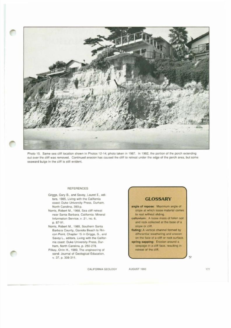
Photo 15. Same sea cIiH locatIOn shown In Photos 12-14; photo laken In 1987 In 1982, the portIon of the porch extending
oul Ollef the cli ff was removed. Continued erOSion has caused the di l lO relreal under the edge 01 the porch area. but some
seaward bulge In the eli'! is ShU evident.
REFERENCES
Griggs. Gary e., and savoy, laurel E., edl-
lors. 1985, l iving with the CaUforrwa
coast; Duke Umverslty Press, Dumam,
North Carolina. 393 p.
Noms. RObert M.• 1968. sea all retreatnear santa Barbara. California: Mineral
Information $ervk::e, v. 21. 00. 6 ,
p. 87-91,Noms. Robel1 M.. 1985. Southern ~ n l aBarbara County. Gaviola Beach 10 Rln·
con Point. Chapter 15 in Gnggs, G and
Savoy L. editors. LMng WIth the Cahlor-
rlla coast Duke UmVer5lry Press. Dur-
ham, North CarolIna. p. 250-278.
Pilkey. Omn H .. 1989, The engmeem'lg of
sand: Journal 01 Geological Education.
\/. 37. P 308-311
CAlIFOflNIA GEOlOOY
GLOSSARY
angle 01 repose "wumum a"lgle oj
slope al whICh loose malena! comes
to rest wllhoUl sliding,
colluvium: A loose mass 01 lalJen sot!
and redo; collected al the base01a
slope or chft.
l lutlng: A venteaJ channellormed by
d,HerenbaJ weathenrog and erOSIOn
on me lace 01 a el," or rock surface.sp"lng sapplng EroSlOl'l around a
seepage '" a ell" face, resulting In
retreat 01 the chff.
AUGUST 1990 1n
8/7/2019 California Geology Magazine August 1990
http://slidepdf.com/reader/full/california-geology-magazine-august-1990 10/24
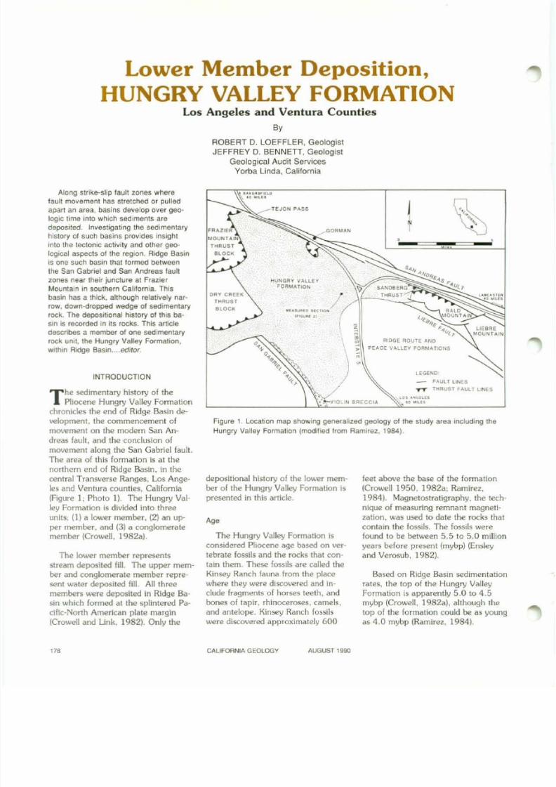
Lower Member Deposition,
HUNGRY VALLEY FORMATIONLos Angeles and Ventura Counties
By
ROBERT D. LOEFFLER, Geologist
JEFFREY D. BENNETI, GeologistGeological Audit Services
Yorba linda, California
Figure 1. Location map showing generalized geology 01 the study area including the
Hungry Valley Formation (modified trom Ramirez. 1984).
'.'.:'.
LEGEtlD
- FAULT L ~ E STT TfiRUsr FAULT LUIES
N
j
.0 0 • •0
..." ..
•
Based on Ridge Basin sedimentationrates. the top of the Hungry ValleyFormation is apparently 5.0 to 4.5mybp (Crowell. 1982a). although thetop of the formation could be as youngas 4.0 mybp (Ramirez. 1984).
feet above the base of the formation(Crowell 1950. 1982a; Ramirez.1984). Magnetostratigraphy. the technique of measuring remnant magneti
zation. was used to date the rocks that
contain the fossils. The fossils werefound to be between 5.5 to 5.0 millionyears before present (mybp) (Ensleyand Verosub. 1982).
RIDGE ROUTE AND
,. PEACE VALLEY FORMATlOtlS
"
.........GORUAN
TEJON PASS
HUNGRY VALLEYFORMATION
DRY CREEK
THRUST
llLOCK
Age
The Hungry Valley Formation isconsidered Pliocene age based on vertebrate fossils and the rocks that contain them. These fossils are called theKinsey Ranch fauna from the placewhere they were discovered and in-clude fragments of horses teeth. andbones of tapir. rhinoceroses. camels.and antelope. Kinsey Ranch fossilswere discovered approximately 600
depositional history of the lower member of the Hungry Valley Formation ispresented in this article.
The sedimentary history of thePliocene Hungry Valley Formation
chronicles the end of Ridge Basin development. the commencement ofmovement on the modern San An-
dreas fault. and the conclusion ofmovement along the San Gabriel fault.
The area of this formation is at thenorthern end of Ridge Basin. in thecentral Transverse Ranges, Los Angeles and Ventura counties. California(Figure L Photo I) . The Hungry Val-ley Formation is divided into threeunits; (1) a lower member. (2) an up
per member. and (3) a conglomeratemember (Crowell. 1982a).
The lower member representsstream deposited fill. The upper member and conglomerate member represent water deposited fill. All threemembers were deposited in Ridge Basin which formed at the splintered Pacific-North American plate margin(Crowell and Link, 1982). Only the
INTRODUCTION
Along strike-slip 'ault zones wherefault movement has stretched or pulled
apart an area. basins develop over geo
logic l ime inlo which sediments are
deposited. Investigating the sedimentary
history of such basins provides insight
into the tectonic activity and other geo
logical aspects altha region. Ridge Basin
is one such basin thaI tormed betweenthe San Gabriel and San Andreas faull
zones near their juncture at Frazier
Mountain in southern California. Thisbasin has a thick. although relatil lely nar
row, down-dropped wedge 01 sedimentary
rock. The deposit ional history of this ba
sin is recorded in i ts rocks. This art ic le
describes a member of one sedimentary
rock Unll, the Hungry Valley Formation,
wIthin Ridge Basin....editor.
'"CALIFORNIA GEOLOGY AUGUST 1990
8/7/2019 California Geology Magazine August 1990
http://slidepdf.com/reader/full/california-geology-magazine-august-1990 11/24
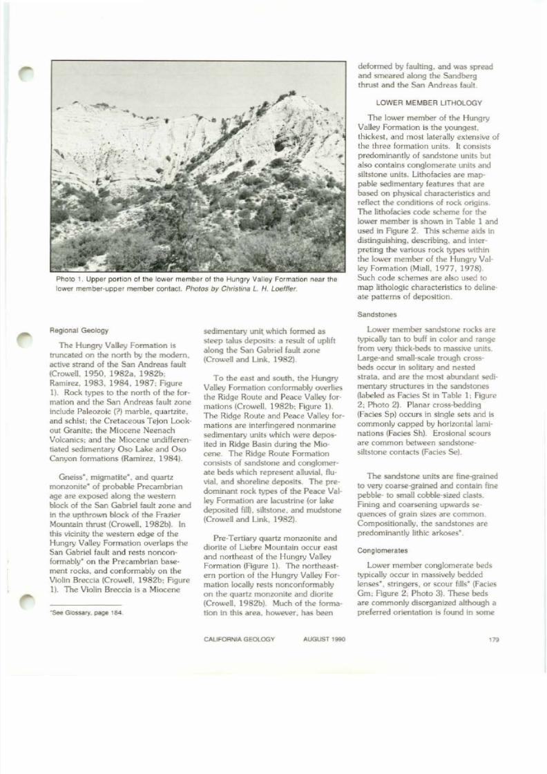
Photo 1. Upper ponion of the lower member 01 the Hungry Valley Formation near thelower member-upper member contact. Photos by Christina L. H. Loeffler.
deformed by faulting, and was spreadand smeared along the Sandbergthrust and the San Andreas fault.
LOWER MEMBER LITHOLOGY
The lower member of the Hungry
Valley Formation is the youngest.thickest. and most laterally el<tensive ofthe three formation units. It consists
predominantly of sandstone units butalso contains conglomerate units andsiltstone units. Lithofacies are mappable sedimentary features that arebased on physical characteristics andreflect the conditions of rock origins.The lithofacies code scheme for the
lower member is shown in Table 1 andused in FIgure 2. This scheme aids in
distinguishing. describing, and inlerpreting the various rock types within
the lower member of the Hungry Val-ley Formation (Miall. 1977. 1978).Such code schemes are also used tomap lithologic characteristics to delineate patterns of deposition.
Sandstones
RegIonal Geology
The Hungry Valley Formation is
truncated on the north by the modem,active strand of the San Andreas fault(Crowell, 1950. 1982a. 1982b:Ramirez, 1983, 1984. 1987; FIgure
1). Rock types to the north of the for-mation and the San Andreas fault zoneinclude Paleozoic (?) marble. quartzite.and schist: the Cretaceous Tejon Lookout Granite; the Miocene NeenachVolcanics; and the Miocene undifferen
tiated sedimentary Oso Lake and OsoCanyon formations (Ramirez. 1984).
Gneiss·. migmatite", and quartz
monzonite" of probable Precambrianage are exposed along the westernblock of the San Gabriel fault zone andin the upthrown block of the Frazier
Mountain thrust {Crowell. 1982bJ. Inthis vicinity the western edge of theHungry Valley Formation overlaps theSan Gabriel fault and rests nonconformably· on the Precambrian base
ment rocks. and conformably on theViolin Breccia (Crowell. 1982b: FigureI) . The Violin Breccia is a Miocene
0.see Glossary. page 184
sedimentary u n i ~ which formed as
steep talus deposits; a result of uplih
along the San Gabriel fault zone(Crowell and Link. 1982).
To the east and south, the Hungry
Valley Formation conformably overliesthe Ridge Route and Peace Valley for-
mations (Crowell. 1982b; Figure 1).
The Ridge Route and Peace Valley for-
mations are interfingered nonmarinesedimentary units which were deposited in Ridge Basin during the Mio-
cene. The Ridge Route Formationconsists of sandstone and conglomerate beds which represent alluvial, flu-
vial. and shoreline deposits. The predominant rock types of the Peace Val-
ley Formation are lacustrine (or lakedeposited fill), siltstone, and mudstone
(Crowell and Link. 1982).
Pre-Tertiary quartz monzonite anddiorite of Liebre Mountain occur eastand northeast of the Hungry ValleyFormation (Figure 1). The northeastern portion of the Hungry Valley Formation locally rests nonconformablyon the quartz monzonite and diorite(Crowell, 1982b). Much of the formation in thIs area. however. has been
Lower member sandstone rocks aretypically tan to buff in color and rangefrom very thick-beds to massive units.Large-and small-scale trough crossbeds occur In solitary and nestedstrata. and are the most abundant sedimentary structures in the sandstones(labeled as Facies 5t in Table 1: Rgure2; Photo 2). Planar cross-bedding(Facies Sp) occurs in single sets and is
commonly capped by horizontal lami-nations (Facies Sh). Erosional scoursare common between sandstonesiltstone contacts (Facies Se).
The sandstone units are fine-grainedto very coarse-grained and contain fine
pebble- to small cobble-sized clasts.Fining and coarsening upwards sequences of grain sizes are common.
Compositionally. the sandstones arepredominantly lithic arkoses·.
Conglomerales
Lower member conglomerate bedstypically occur in massively beddedlenses·, stringers. or scour fills' (Facies
Gm: Figure 2: Photo 3). These bedsare commonly disorganized although apreferred orientatIon is found in some
CAUFORNlA GEOlOOY AUGUST 1990 ''''

8/7/2019 California Geology Magazine August 1990
http://slidepdf.com/reader/full/california-geology-magazine-august-1990 12/24
TABLE 1. LITHOFACIES SCHEME FOR LOWER MEMBER SEDIMENTARY UNITS (From Mlall. 1977. 1976).
Facies
Code lithofacies Sedimentary Structures Interpretations
Gm, massive. malrlx supported gravel none debris flow deposits
Gm massive or crudely bedded hOrizontal bedding. imbrication' longitUdinal bars. lagdeposits sieve depoSits
GI gravel, stratified trough cross-beds minor channel fills
Gp gravel, stratified planar cross-beds tongue-shaped bars or deltaicgrowths from older bar remnants
SI sand, medium to very coarse. solitary or grouped trough cross·beds dunes (lower flow regime)may be pebbly
Sp sand, medium to very coarse, solitary or grouped planar cross·beds tongue·shaped, transverse bars,may be pebbly sand waves (lower flow regime)
S, sand, very fine to coarse ripple marks of aU types ripples (lower flow regime)
Sh sand, very line to very coarse hOrizontal lamination, parting or planar bed flow (lower andmay be pebbly streaming linealion upper flow regime)
SI sand, fine low angle «10 degrees) cross-beds scour fil ls, crevasse splays,antldunes'
S . erOSional scours With clasts crude cross-beds scour fills
S, sand, line to coarse, may be broad. shallow scours Including scour Iillpebbly cross-stratificatIon
Sse, Sne, sand analogous to Ss, Sh, Sp eolian depoSitsSp .
F! sand, Silt. mud line lamination. very small ripples overbank or waning t100ddeposits
F" silt. mud laminated to massive backswamp depoSits
F" m,d massive, with fresh water molluscs backswamp pond deposits
Fm mud, silt massive, deSSicatIon cracks overbank or drape deposits
F, silt. mud rootlets seat earth'
C coal, carbonaceous mud plants. mud films swamp deposits
p carbonate pedogenIC feature soil
-''.
"" :•", -
II
••')1 \,
Photo 2. Nested trough crOSS-bedding in
sandstone (Facies St) in the lower member
of Hungry Valley Formation,
'Se9 Glossary. page 184
units. Lens and stringer thicknesses
range from 1 inch to 1.5 feet thick.
Scour f il ls are typically 1 to 2 feet
thick and 5 to 7 feet wide. Planar
conglomerate cross-beds (Facies Gp;
Figure 2: Photo 3) are rare. Clasts in
the cross-beds show a preferred orien-
tation paral lel to the roreset· beds.
Cross-bed sets range from 5 feet to 7
feet In thickness. Foreset beds dip at
angles ranging from 10 degrees to 15
degrees.
180 CALIFORNIA GEOlOOV AUGUST 1990
8/7/2019 California Geology Magazine August 1990
http://slidepdf.com/reader/full/california-geology-magazine-august-1990 13/24
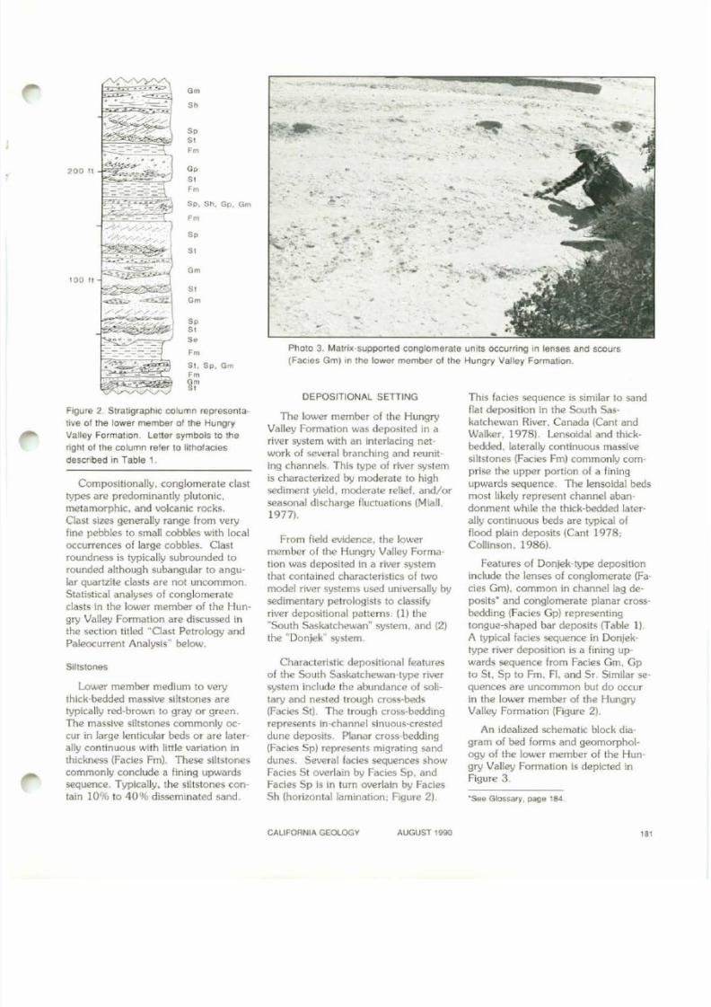
•
'&:Ie Glossary, J;lage '84.
This facies sequence is similar to sand
flat deposition in the South Sas
katchewan River. Canada (Cant and
Walker, 1978), Lensoidal and thick
bedded. laterally continuous massive
siltstones (Facies Fm) commonly com
prise the upper portion of a fining
upwards sequence. The lensoidal beds
most likely represent channel aban·
donment while the thick-bedded laterally continuous beds are typical of
flood plain deposits (Cant 1978:
Collinson, 1986).
Features of Donjek-type deposition
include the lenses of conglomerate (Fa
cies Gml. common in channel lag de
posits' and conglomerate planar cross
bedding (Facies Gp) representing
tongue-shaped bar deposits (Table 1).
A typical facies sequence in Donjek
type river deposition is a lining up
wards sequence from Facies Gm. Gp
to St. Sp to Fm. FI. and Sf. Similar sequences are uncommon but do occur
in the lower member of the Hungry
Valley Formation (Figure 2).
An idealized schematic block dia
gram of bed forms and geomorphol
ogy of the lower member 01 the Hun
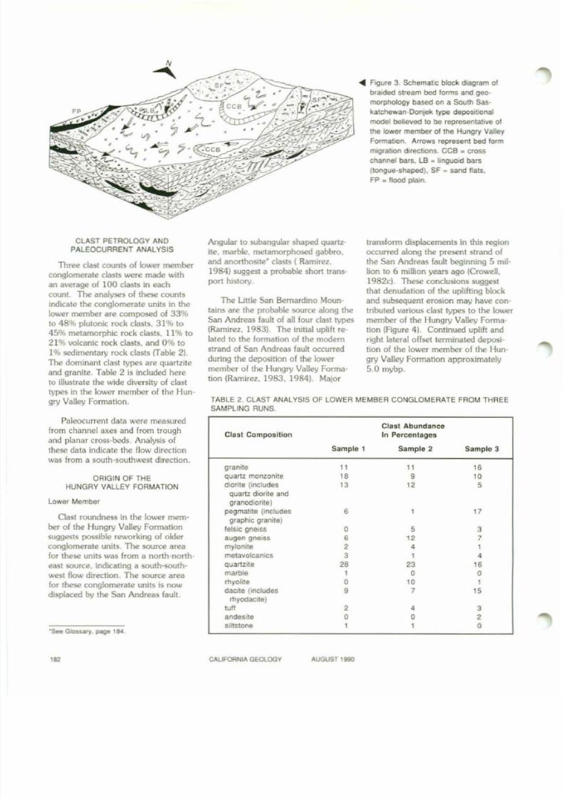
gry Valley Formation is depicted inFigure 3.
,
.-
:..... . . , ~ .
-.
. ~ • •-
• 0;. .... '. .,,
. ,-
• -4
-'~
:. - s..--,
'.
.-,..- ~ " : -
.-.-
,
Photo 3. Ma1nlt-supported conglomerate units occurring 10 lenses and scours
(FaCies Gm) in the lower member of the Hungry Valley Formation.
DEPOSITIONAL SETTING
The lower member of the Hungry
Valley Formation was deposited in a
river system with an interlacing net
work of several branching and reunit
ing channels. This type of river system
is characterized by moderate to high
sediment yield, moderate relief. and/or
seasonal discharge fluctuations (Mian,
1977).
From field evidence, the lower
member of the Hungry Valley Forma
tion was deposited in a river system
that contained characteristics of two
model river systems used universally by
sedimentary petrologists to classify
river deposilional patterns: (I ) the
"South Saskatchewan" system. and (2)
the "Donjek" system,
Characteristic depositional features
of the South Saskatchewan·type riversystem include the abundance of soli
tary and nested trough cross·beds
(Facies St). The trough cross-bedding
represents in-channel sinuous-crested
dune deposits. Planar cross-bedding
(Facies Sp) represents migrating sand
dunes. Several facies sequences showFacies St overlain by Facies Sp, and
Facies Sp is in turn overlain by FaciesSh (horizontal lamination: Figure 2).
So
"Gm
"Gm
Gm
50
So
"Fm
So
"So
Fm
51, 5p , GmFm
gr
Go
"Fm
Siltstones
Figure 2. Stratigraphic column representa
tive of the lower member 01 the Hungry
Valley Formation. Leller symbols to the
right of the column refer to l ithofacies
described in Table 1.
5p . Sh . Gp, am
Fm
Lower member medium to very
thick-bedded massive siltstones are
typically red-brown to gray or green_
The massive siltstones commonly oc
cur in large lenticular beds or are laterally continuous with little variation in
thickness (Facies Fm). These siltstones
commonly conclude a fining upwards
sequence. Typically, the siltstones con
tain 1096 to 4096 disseminated sand.
Compositionally, conglomerate clast
types are predominantly plutonic.
metamorphic. and volcanic rocks.Clast sizes generally range from very
fine pebbles to small cobbles with local
occurrences of large cobbles. Clast
roundness is typically subrounded to
rounded although subangular to angu
lar quartzite clasts are nOI uncommon.
Statistical analyses of conglomerate
clasts in the lower member of the Hun
gry Valley Formation are discussed in
the section titled MClasl Petrology and
Paleocurrent AnalysisM
below.
CALIFORNIA GEOlOGY AUGUST 1990
'"
8/7/2019 California Geology Magazine August 1990
http://slidepdf.com/reader/full/california-geology-magazine-august-1990 14/24
. . FlQure 3, SChematiC block dIagram of
braided Stream bed forms and geo
morphology based on a South Sas·
katchewan-Donlek type depositIonal
model believed to be representattlle 01
the lower member01the Hungry Valley
FormatIOn. Arrows repfesent bed form
m'OratlOn directIOns. CCB _ cross
channel bars, LB • IlngUOld bars
(longue-shaped). SF • sand flats.
FP • flood plain
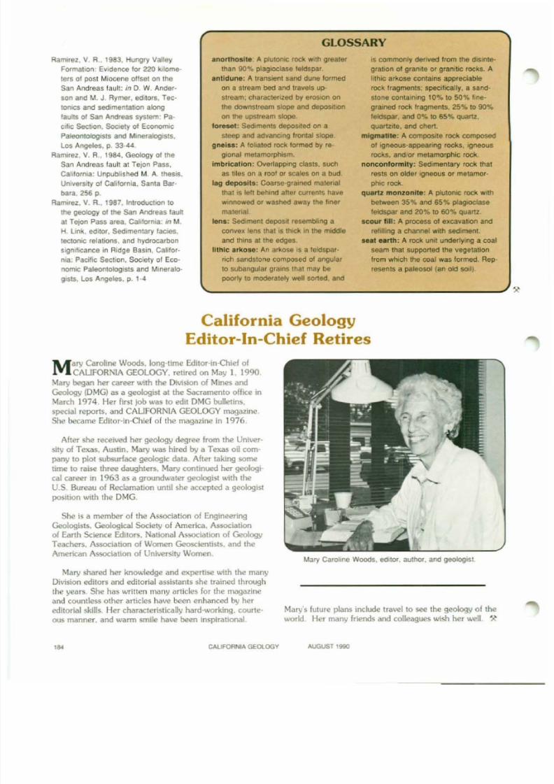
TABLE 2. CLAST ANALYSIS OF LOWER MEMBER CONGLOMERATE FROM THREESAMPLING RUNS.
Clast AbundanceClast Composition In Percentages
Sample 1 Sample 2 Sample 3
granite 11 11 I.quartz monzoMe I. • I.diorlle (Includes 13 12 5quanz dlorlle and
granodiorite)
pegmatIte (includes • 17graphIC granite)felsic gnetss
•5 3
augen gneiSS • " 7mylOnite • , 1
metavolcaniCS 3 1 ,quanzlte •• '3 I.marble 1 • •rhyoille • I. 1
daate (includes • 7 15rhyodaCIte)
"" • , 3andesIte • • •Siltstone 1 1 •
CLAST PETROlOGY ANDPALEOCURRENT ANALYSIS
Three clast counts of lower memberconglomerate clasls were made with
an average of 100 clasts in each
coon!. The analyses of these counts
indicate the conglomerate uni ts in the
k>wer member are composed of 33 %
to 48 % plulonic. rock clasts. 31% to
45% metamorphic rock clasts. 11% to
21% volcanic rock clasts. and 0% to
1% sedimentary rock clasts crable 2).
The dominant clast Iypes are quartzite
and grani te. Table 2 is included here
to Illustrate the wide diversity of clast
types In the lower member of Ihe Hun
gry Valley Formation.
Paleocurrent data were measured
from channel axes and f rom trough
and planar cross-beds. Analysis of
these dala indicate Ihe f low direction
was from a south-southwest direction.
ORIGIN OF THEHUNGRY VALLEY FORMATION
Lower Member
Clast roundness in Ihe lower mem
ber of Ihe Hungry Valley Formation
suggesls possible rSlNOrking of olderconglomerate unUs. The source area
for Ihese units was from a north-north
east source. indicating a south-soulh
west flow direction. The source area
for these conglomerate units is nowdisplaced by the San Andreas faull.
Angular to subangular shaped quartz-
Ite. marble. metamorphosed gabbro.
and anorthosite' claSIS ( Ramirez.
1984) suggest a probable short lTans
pori history.
The Uule San Bernardino Moun
tains are Ihe probable source along the
San Andreas fault of all four clast types
(Ramirez. 1983) The initial uplift re
lated 10 the formation of the modem
Strand of San Andreas fault occurred
during the deposition of the lower
member of the Hungry Valley Forma
tion (Ramirez. 1983. 1984), Ma}or
trandorm displacements in this region
occurred along the present strand of
the San Andreas fault beginning 5 mil
lion to 6 million years ago {Crowell.
1982cl. These conclusions suggest
that denudation of the uplifting block
and subsequent erosion may have con
lTibuted various clast types to the lower
member of the Hungry Valley Forma
tion (Rgure 4). Continued uplift and
right lateral offset terminated deposi
tion of the lower member of Ihe Hun
gry Valley Formation approximately
5.0 mybp.
". CALIFORNIA GEOlOGV AUGUST Ilil90

8/7/2019 California Geology Magazine August 1990
http://slidepdf.com/reader/full/california-geology-magazine-august-1990 15/24
Cant, D. J" and Walker. R. G.. 1978. Flu
vial processes and lacles sequences In
the sandy braided South Saskatchewan
River, Canada: Sedimentology, v. 25,
p. 625-648.
Collinson, J. D., 1986, Alluvial sediments:
in H. G. Reading. editor. Sedimentary
environments and facies. second edition: Blackwell Scientific Publications.
Oxford. p. 20·62.
Crowell. J. C.. 1950. Geology 01 the Hun·
gry Valley area, southern Calilornia:
American ASSOCiation ot Petroleum Ge·
ologists Bulletin, v. 34, p. 1623·1646.
Crowell, J. C.. 1982a. Pliocene Hungry
Valley Formation. Ridge Basin, south
ern Calilornia: In J. C. Crowell and M.
H. Link, editors. GeologiC history of
Ridge Basin. southern California: Pa·
cific Section. Society or Economic Pale
onlologists and Mineralogists, Los An·
geles, p. 89·98.Crowell, J. C., 1982b. GeologiC map or
Ridge Basin, southern Cahrornia: Pa
cilic Section. Society or EconomiC Pale
ontologists and Mineralogists, 2 sheels.
scale 1:24,000.
Crowell, J. C., 1982c, The teclonlcs or
Ridge BaSin, southern California: InJ. C. Crowell and M. H. Link. editors.
Geologic history 01 Ridge Basin. south
ern California: Pacific Section. Society
o! EconomiC Paleontologists and Miner
alogists. Los Angeles. p. 89-98.
Crowell. J.C" and Link M. H., editors,
1982, Geologic history of Ridge Basin,southern Cahlornia: Pacific Section.
Society of Economic Paleontologists
and Mineralogists. Los Angeles. 304 p.
Ensley, R. A., and Verosub K L..1982,
Biostratigraphy and magnetostratigra·
phy of southern Ridge BaSin. central
Transverse Ranges. California: In J. C.
Crowell and M. H. Link, editors, Geo·
logic history of Ridge Basin, southern
Calitornia: Pacific Seclion, Sociely of
Economic Paleontologists and Miner·
aloglsts, Los Angeles. p. 89·98.
Miall, A.D., 1977, A review 01 the braided
river depositional environment: Earth
Sciences Reviews. v. 13. p. 1·62.
Miall, A. D., 1978, Lithofacies types and
verlical profile models in braided river
depoSits. a summary: in A. D. Mlall.
editor, Fluvial sedimentology: Canadian
Society of Petroleum Geologists. Mem
oir 5, p. 597-604.
,
Cant, D. J.. 1978, Bed torms and bar types
in the South Saskatchewan River: Jour,
nal ot Sedimentary Petrology, v. 48. p.
1321·1330.
REFERENCES
The Pliocene lower member of the
Hungry Valley Formation represents
river sediment fil l of Ridge Basin after
cessation of offset along the San Gab
riel fault. This South Saskatchewan
Donjek type of river system reworked
lower member conglomerate units lo
cated north-northeast of lhe San An-
dreas fault. The modern strand of the
San Andreas faul t formed pre- to syn
deposilionally with the lower memberof the Hungry Valley Formation. Uplift
during the formation of the San An·
dreas fault is indicated by the occur
rence of subangular to angular quartz
ite. meta-gabbro. anorthosite. and
marble clasts possibly originating from
the Little San Bernardino Mountains.
The change from fluvial to alluvial
deposition in the upper member of the
Hungry Valley Formation indicates
massive uplift and erosion of the
upthrown block and the coincident
truncation of the sediment load from
the north.
CONCLUSIONS
SAN ANDREAS
These interpretations were based on
petrographic comparisons of marble
and quartzite clasts in the upper mem-
ber with those from the Uttle San Ber
nardino Mountains (Ramirez. 1983.1984).
Figure 4. Regional block
diagram showing primary
source area and transport RIDGE BASIN GROUPmedium ror sediments or the
lower member or the Hungry Valley Formation during the Pliocene Epoch.
Diagram restores 135 miles 01 right·lateral ollset along the San Andreas fault.
Conglomerate Member
The conglomerate member is the
youngest member of the Hungry Valley
Formation. A possible source terrane
for unique olivine basalt clasts in the
conglomerate member of the Hungry
Valley Formation has also been identi
fied (Ramirez. 1983. 1984) as occur
r ing in the Santa Ana drainage (sug
gesting 110 miles of right-lateral offset
since deposition of this member).
Upper Member
Upper member deposition is char
acterized by alluvial sedimentation shed
from the unstable uplifted flanks of the
Little San Bernardino Mountains
(Ramirez. 1983.1984). The source terrane of the upper member of the Hun-
gry Valley Formation also occurs in the
l i l lIe San Bernardino Mountains and
the Morongo Valley area. suggesting
135 miles of right-lateral offset along
the San Andreas faul t since depositionof the upper member (Ramirez. 1983.1984. 1987).
LOWER MEMBERHUNGRY VALLEY
F O R M A T I O N ~ _ - l ' c
{continued ,I
CALIfORNIA GEOLOGY AUGUST 1990
'"
8/7/2019 California Geology Magazine August 1990
http://slidepdf.com/reader/full/california-geology-magazine-august-1990 16/24
GLOSSARY
Ramirez, V. R., 1983, Hungry Valley
Formation: Evidence for 220 kilome
ters 01 post Miocene ollset on the
San Andreas lault: in O. W. Ander
son and M. J. Rymer, editors, Tec
100lcs and sedimentation along
laults of San Andreas system: Pa
aIlC SectIOn, SoCIety of EconomIC
PaleonlologlSts and MmeraJoglsts,
Los Angeles, p 33-44.
Ramirez, V. R., 1984, Geology of the
San Andreas faull at Tejon Pass,
CaMornla: Unpublished M. A Ihesis.
UmverSlly 01 Calilornia. Santa Bar
bara, 256 p.
Ramirez, V. R.. 1987, 100rodl.lC11On to
the geology of lhe San Andreas fault
at Telon Pass area, Cal ifornia; In M.
H Link. editor, Sedimentary faCIes,
tectoniC relations, and hydrocarbon
Significance in Ridge Basin, Calilor·
nla' Pacif ic Section, Society ot Eco
nomIC Paleontologists and Mineralo
gists. Los Angeles. p. 1-4
anortho.lte A plutOfllC rock With grealer
lhan go.,.-. plagioclase feldspar
antidune: A tranSient sand dune tormed
on a stream bed and travels up
stream; charactenzed by erosion on
the downstream Slope and dePOSitIOn
on the upstream slope,
foreset: Sediments dePOSited on a
steep and advan<:lng frontal slope
gneiss: A fchated rock lormed by reo
glonal melamorptusm,
Imbrication: Overlapping clasts. such
as hies on a rool or scales on a bud,
lag depo.lt . : Coarse-grained matenal
that ts left behind alter currents have
WInnowed or washed away the Itner
matenal
lans: sediment deposit resembling a
convex lens lhat IS IhlCk in the middle
and Ihlns at Ihe edges.
lithic arkose: An arltosa IS a feldspar·
rich sandstone composed 01 angular
to subangular grains that may be
poorly to moderately well sorted. and
15 commonly denved Irom Ihe diSInte
gration of graOite or granitic rocks. A
lithic arltose conlams appreciable
rock fragments; specilically. a sand
stone contalmng 10% to 50% hne
grained rock fragments. 25"4 to 90%
feldspar, and 0% 10 65% quartz.
quartzite. and chen
mlgmlltite: A compoStte rock composed
01 Jgl'l8OUs-appearlng rocks, Jgneoos
rocks, and/or metamorphic rock.
nonconformity: SedlmeOlary rock that
rests on older Igneous or metamor
phic rock
quartz monzonite: A plutol\lC rock Wllh
between 35% and 65% plag.oclase
I ~ s p a r and 20% to 60% quartz
.coyr till: A process of excavatIOn and
rer. Ing a channel with sediment
...t earth: A rock uM undertylng a coal
seam thaI supported the vegetation
from which lhe coal was formed Rep·
resents a paleosol (an old soil).
California Geology
Editor-In-Chief Retires
M ary Caroline Woods, long-time Editor-in-ehief of
CALIFORNIA GEOLOGY, retired on May 1. 1990,
Mary began her career with Ihe Division of Mines and
Geology (DMG) as a geologist at the Sacramento oUice in
March 1974. Her first job was 10 edit DMG bulletins,special reports. and CALIFORNIA GEOLOGY magaZine.
She became Editor-In-Chief of the magazine in 1976.
After she received he r geology degree from the Univer
sity of Texas. Austin. Mary was hired by a Texas oil com
pany 10 plot subsurface geologic data After taking some
time to raise three daughters. Mary continued her geologi
cal career in 1963 as a groundwater geologist with theU.S. Bureau of Reclamation unlil she accepted a geologist
position with the DMG.
She is a member o f t he Association of Engineering
Geologists. Geological Society of America. Association
of Earth Science Editors. National Association of GeologyTeachers. ASSOCiation of Women Geoscientists. and the
American Association of University Women,
Mary shared her knowledge and experu5e wilh the many
Division editors and editorial assistants she Irained through
the years. She has written many art icles for the magazine
and countless other articles have been enhanced by her
editorial skills Her characteristically hard-working, coone
oos manner. and wann smile have been inspirational
Mary Carolme Woods, editor, author, and geologist
Mary's future plans include travel to see the geology of the
world, Her many friends and colleagues wish her well
,.. C A U F O R N ~ G E O L O G Y AUGUST 1990
8/7/2019 California Geology Magazine August 1990
http://slidepdf.com/reader/full/california-geology-magazine-august-1990 17/24
Survey of
California Geology Readers
T he intent of CALIFORNIA GEOLOGY is to inform and enlighten the citizens of Califomia aboutdiverse earth science subjects. Geologic material of educational and scientific value is presented
ina format that
isuseful for both novice and professional alike. This magazine
isalso a forum fordisseminating geologic information about California from investigations by professional earth scien
tists. To better serve our readership. the staff of CALIFORNIA GEOLOGY is conducting a survey.
Your valuable response to this questionnaire is requested to assist us in designing future issues. We
welcome your ideas.
When completed. cut along dashed line. fold into thirds. place In the prepaid envelope stapled in
the center of this issue. and mai l.
o Geologist/Earth Scientist 0 Teacher, K-7
o Non-technical Articles About GeologiC Subjects
o Landslide Hazards
o Mining Industry
o Historical Geology
o Mimng Hislory
o Volcanology
o PhySical Geology/Geomorphology
o GeophySICs! Minerals E ~ p l o r a t i o n
(C) Which 01 the following subjects are of greatest interestto you? (Select 3)
o Seismology/Earthquakes
o Teacher,a-12
o College/University
Sludenl
o Librarian
o High School Student
(A) Background
(B) Which features of CALIFORNIA GEOLOGY
areofgreatest Inlerest
toyou? (Select 3)
o Geolechnical Engineer
o Miner/Prospector
o Mining Engineer
o Interested Lay Person
o Other _
I
IIIIIIIIII
IIIIIIII1
1
III1
1
1
1,II
11
rl31°1
S1
o In-Depth Feature Articleso Mineralogy
o Shorter Articles o Paleontology
o Brief Reviews of New DMG Publications o Petroleum Geology
o Tflvial Quizzes
o Earth Science Teacher'S Page
o Notices of Conferences and Events
o Book Reviews
o Field Trip Guides
o SOil Science
oEngineering Geology
o Hydrology/Hydrogeology
o Mined Land ReclamatiOn/Environmental Engineering
o Articles about DMG Investigations o Prospecting For Gold And Other Minerals
o Other (specify) _ o Olher (specllyl _
CALIFORNIA GEOLOGY AUGUST 1990
'"
8/7/2019 California Geology Magazine August 1990
http://slidepdf.com/reader/full/california-geology-magazine-august-1990 18/24
(O} What kinds of art ic les would you want more of?
2 _
3 __ _
(E) Do you have suggestions for how CALIFORNIA GEOLOGY can beller serve you? Are artIcles too technical? Should more articles
be written for interested lay persons? What subjects interesl you least?
Commenls: _
CALIFORNIA
GEOLOGYThe eont. science mogcu.ine lor
evet"fOOe in the GoIderl StoteColifornia has hvndreds offaSCinating geologic leotures
hoispnng$.
Foull$, coves.glociers, Fossil beds, gold deposits ,
Eve<)' issue brings geologiC odYlffilure.
Nome _
A d d , ~ _
C"' """ Zip__
'"CALIFORNIA GEOlOGY
Moke check payoble 10:
DIVISION OF MINES AND GEOLOGY
P!eose moil check ond order
fOrlTl in !he postage p<IId
en.."lope provoded.
'''"'''''''o 110 (1 year)- 120 ('2 )'eOf$)
PAYMENT REQUIRED
W1THOROER.
AUGUST 1990
8/7/2019 California Geology Magazine August 1990
http://slidepdf.com/reader/full/california-geology-magazine-august-1990 19/24
BOOK REVIEWSBooks reviewed in this section are not available lor purchase from OMG.
GEOLOGY OF CALIFORNIA. Sec-
ond Edit ion. By Robert M. Norris
and Robert W. Webb. 1990. JohnWiley & Sons. Inc .. 1 Wiley Drive,
Somerset. NJ 08875-1272. 541 p ..
$43.95. hard cover.
This edition includes over 100 more
pages than the first editlon. an e x panded glossary. and mOTe photos and
illustrations. This widely used college
geology lext is designed for anyone
wishing to learn more about the geol-
ogy of California. No previous training
in earth science is needed to under
stand the concepts. The photos and
diagrams have been chosen to illus-
trate and instruct readers about geo-
logic features in this state.
Two introductory chapters familiar-
ize readers with basic geologic con-
cepts. The following chapters describe
the geology of each of California's 11
geomorphic provinces; the San An-
dreas fault and offshore geology are
discussed in two separate chapters.
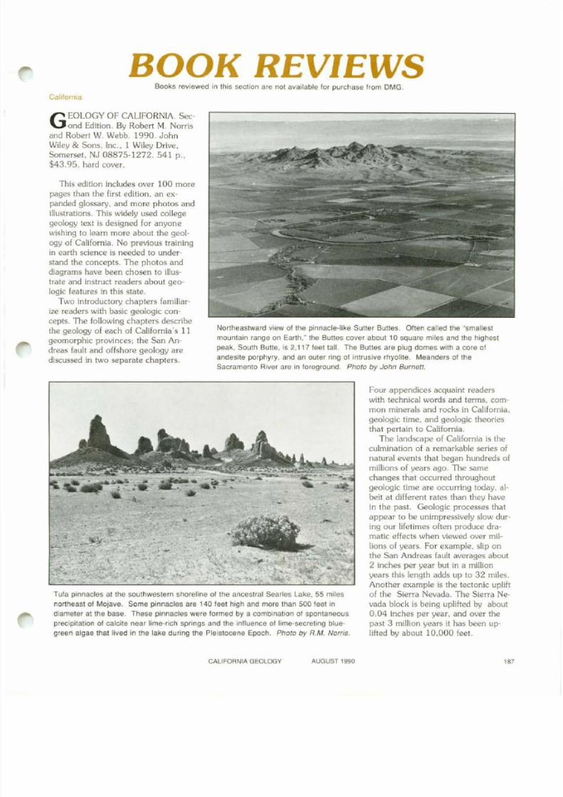
Northeastward vIew of the pinnacle-like Sutler BUlles. Often called the "smallest
mountain range on Earth," the Bunes cover about 10 square miles and the highest
peak, South BUlle, IS 2,117 feet tall. The Buttes are plug domes With a core of
andesite porphyry, and an outer f1ng of intrusive rhyolite. Meanders 01 the
Sacramento River are in loreground. Photo by John Burnell.
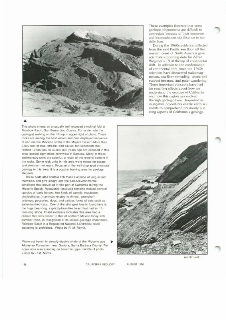
Tufa pInnacles at the southwestern shoreline of the ancestral Searles lake. 55 miles
northeast of Mojave. Some pinnacles are 140 leet high and more than 500 teet In
diameter at the base. These pinnacles were tormed by a combinallon of spontaneous
precipitation of calcite near Iime·riCh springs and the Influence of lime'secrellng blue'
green algae that lived in the lake during the Pleistocene Epoch. Photo by RM. Norris.
Four appendices acquaint readers
with technical words and terms. common minerals and rocks in California.
geologic time. and geologic theories
that pertain to California.
The landscape of California is the
culmination of a remarkable series of
natural events that began hundreds of
millions of years ago. The same
changes that occurred throughout
geologic time are occurring today. al
beit at dif ferent rates than they have
in the past. Geologic processes that
appear to be unimpressively slow dur
ing our lifetimes olten produce dra
matic effects when viewed over millions of years. For example. slip on
the San Andreas fault averages about
2 inches per year but in a mil li on
years this length adds up to 32 miles.
Another example is the tectonic upl if t
of the Sierra Nevada. The Sierra Ne
vada block is being uplifted by about
0.04 inches per year. and over the
past 3 mil lion years it has been up
lifted by about 10.000 feet.
CALIFORNIA GEOLOOY AUGUST 1990'"
8/7/2019 California Geology Magazine August 1990
http://slidepdf.com/reader/full/california-geology-magazine-august-1990 20/24
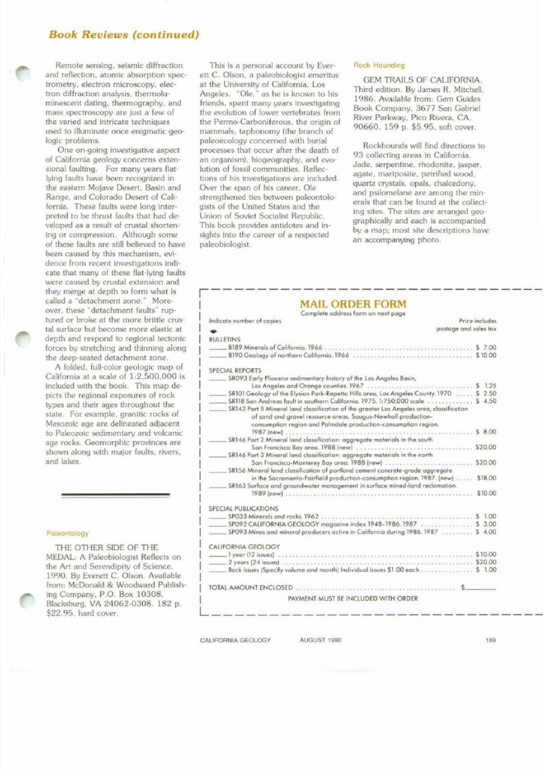
This photo shows an unusually well exposed syl'ldinalfold at
Rainbow Basin. San Bernardino County. For scale note the
geologIst walkmg on the hili top In upper nght 01 photo. These
rocks are among the best known and best displayed sequence
of non·manne Miocene strata In the MOlave Desert. More than
3.000 feet 01 lake. stream, and attuvlal fan sedIments that
formed 10,000.000 to 30,000,000 years ago are exposed in thIS
area located eight mites northwest of Barstow. Many 01 these
sedimentary units are colorful, a result 01 the mineral content In
the rocks. Some rock units in thiS area were mined for borateand strontium minerals. Because of the well·displayed structural
geology in th is area, il is a popular training area for geology
students.
These beds also contain rich fossil evidence of long-extinct
mammals and give insight into the paleoenvironmental
conditions that prevailed In this part 01 California during the
Miocene Epoch. Recovered fossilized remains include severat
species of early horses, two kinds oj camels. mastodon.
chahcotheres (mammals relaled to rhmos). pronghorn
antelope, peccaries. dogs, and various forms of cats such as
saber·tOOlhed cats. One of the strangest fossIls found here IS
the huge bear-dog, a gnzzly·bear-bke beast that had an 11-
loot·long stnde. Fossil evidence IndIcates thIS area had a
climate that was similar to that 01 northern MexICO today WIthsummer (alns. In recogmtlOn 01 rts umque geologIC Importance.
Rambow BaSIn IS a Registered Nabonal landmar1t; lossll
collecllng IS prOhltlited. Photo by R. IrA Noms.
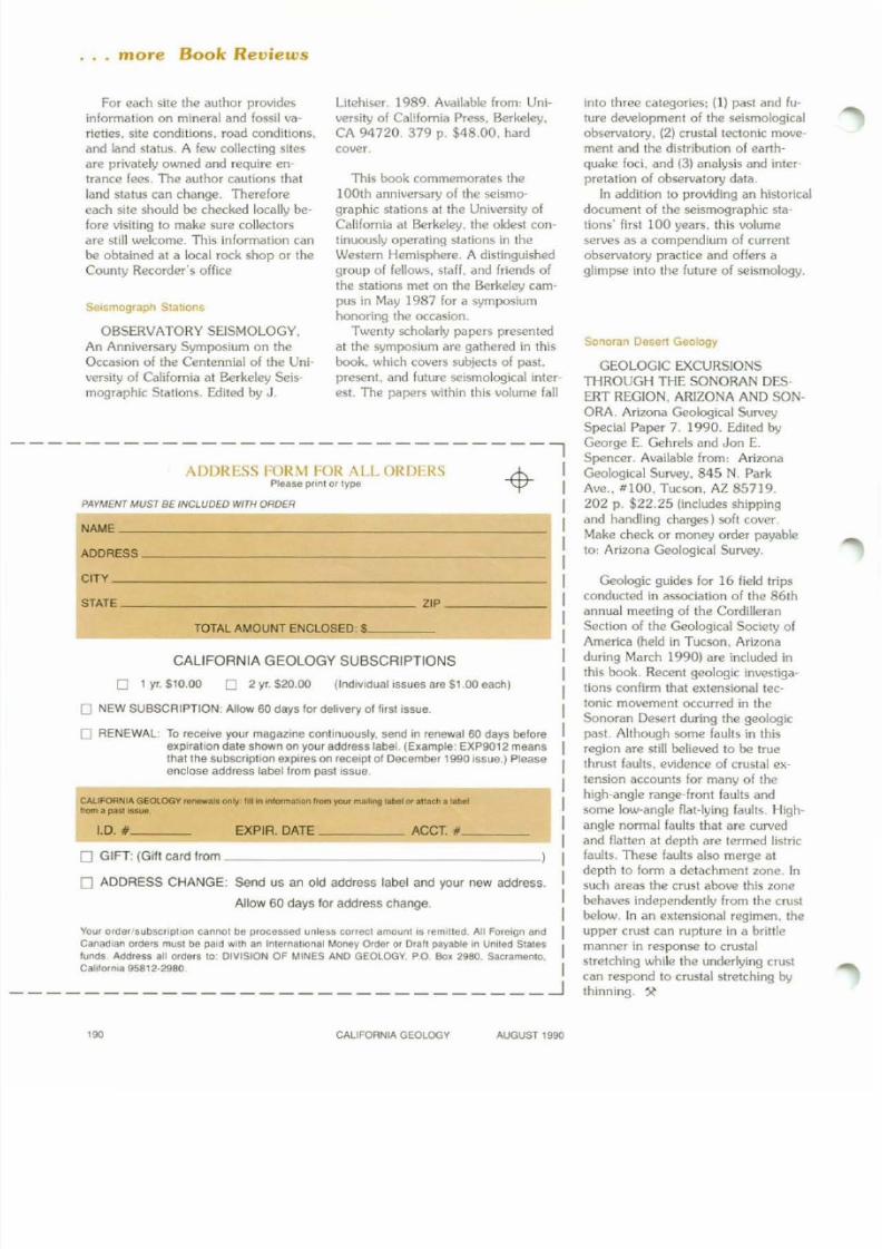
Wave'cut bench in steeply-dipping shale of the Miocene age
Monterey Formation, near Gaviota. Santa Barbara County. For
scale note man standing on bench in upper middle 01 photo.
Photo by R.M. Norris.
These examples illustrate that some
geologic phenomena are difficult to
appreciate because o f their immense
and inconspicuous significance t o o ur
daily lives.
During th e 1960s evidenc.e collected
from the east Pacific sea floor of f the
western coast o f N or th America gavescientists supporting data f o r A lf re d
Wegener's 1910 theory o f continental
drifl. In addition to the confirmation
o f continental drift. since th e 1960s
scientists have discovered paleomag
netism. sea-floor spreading, exotic and
suspect terranes, and polar wandering.
These important concepts have had
far reaching effects about ho w we
understand the geology of California
and ho w this region has evolved
through geologic time. Improved in
vestigative procedures enable earth sci
entists to comprehend previously pUZ-zling aspects o f California's geology.
(continued), , ,
". CALIFORNIA GEOLOGY AUGUST t990
8/7/2019 California Geology Magazine August 1990
http://slidepdf.com/reader/full/california-geology-magazine-august-1990 21/24
Book Reviews (continued)
, - - - - - - - - - - - - - - - - - - - - - - - - - - -MAIL ORDER FORM
1.003.00
'.00
510,00
518.00
. . .• S20.oo
._-. . . . . S10.00
520.00
. .• S 1.00
. . . . . . S. . . 5. . . S
. . . . . . S20.oo
Price includes
poslage ond !oles tox
. . . . . . • • . . . S 7.00
....... 510.00
Rock Hounding
GEM TRAILS OF CALIFORNIA.Third edition. By James R. Mitchell.1986. Available from: Gem GuidesBook Company, 3677 San GabrielRiver Parkway. Pico Rivera. CA,
90660. 159 p. $5.95. soft cover.
Rockhounds will find directions to93 collecting areas in California.Jade. serpentine. rhodonite. jasper.agate. mariposite. petrified wood,quartz crystals. opals. chalcedony.and psllomelane are among the min·erals that can be found at the collecting sites. The sites are arranged geographically and each is accompaniedby a map: most site descriptions havean accompanying photo.
Indicote number of cople!
•BULLETINS
__ 8189 Mlnerols of Col,fornlo. 1966 .• . • . . .__ B190G.ology of northern Coliforn'o.1966
Complele oddrfll.s form on nU l page
SPECIAL REPOIHS
__ SR093 Eorly PI,o<:eneledimenlary hl!tory of .he Los Angeles Bosin,
Lo. Angeles ond Oronge counlles.1967 . . . . • . . • . . . . . . • . . . • S 1.25
__ 5R101 Geology of the Elysion Park.Repello H,lls oreo, Lo! Angele! County. 1970 . 5 2.50
__ SR118 Son Andreos foult In southern Colifornoo. 1975. 1:750,000 Kole . • . . . • . . • • • . . 5 4.50
__ SR143 Pori 5 Mlnerollond c1osslficolion of lhe greoter Los Angeles oreo, clossificollon
of sand ond grovel re.ource orfICIs. 50ugu!-Newholl production·conwmption r&glon ond Polmdole production·conlUf'l'lptlon region.
1987 (new) . . . • . . . . . . • . . • . . . . . • • . . • • . . • . . . . . . . . • • . S 8.00
__ SR146 Pori 2 Minerol lond c1oSSlfieollon: oggregole rnoteriols In lhe south
Son Fronc.Ko Bay oreO 1988 (new] . . . . . . . . • . . • . . . . . • . . . • • . .
__ SR146 Port 3 Minerollond clos.ifiColion: oggregote molerlols in the norlh
Son Froncisco·Monterey Boy oreo. 1988 (newl__ SR156 Minerollond c101llficolion of portlond cemenl concrele-grode oggregote
in the Socromento-Foirfield prodUclion·conwmphon region. 1987 (new)__ SR163 Surfoce ond groundwoter monagementln surfoce mined-lof\d redomotion.
1989 (new) . . . . . . . • . . • • • . . • .
SPECIAL PUBLICATIONS
__SP033Minerols ond roc:ks. 1962 . . . . . • .. •
. .
__ SP092 CALIFORNIA CEOlOGY mogoz.ine index 1948·1986. 1987 ._
__ SP093M,nes ond mlnerol produce" octive in Colifornio during 1986.1987
CALIFORNIA GEOLOGY__ 1yeor (12 isollfl')
__ 2 yeorsl24 IUlIfI') . • . .
__ Bock ;s!ues (Specify volume ond month] Indiv,duot,swes 51.00 eoch .
This is a personal account by Everett C. Olson. a paleobiologist emeritusat Ihe University of California. LosAngeles. "Ole. W as he is known to hisfriends. spent many years investigatingthe evolution of lower vertebrates fromthe Permo-Carboniferous. the origin of
mammals. taphonomy (the branch ofpaleoecology concerned with burialprocesses that occur after the death ofan organism). biogeography. and evolution of fossil communities. Reflections of his investigations are included.Over the span of his career. Olestrengthened ties between paleontolo'gists of the United States and theUnion of Soviet Socialist Republic.This book provides antidotes and in
sights into the career of a respectedpaleobiologist.
IIII
IIIIIII TOTAL AMOUNT ENCLOSED . .
I PAYMENT MUST BE INCLUDfOWlTH ORDERL
THE OTHER SIDE OF THEMEDAL: A Paleobiologist Reflects onthe Art and Serendipity of Science.1990. By Everell C. Olson. Availablefrom: McDonald & Woodward Publishing Company. P.O. Box 10308.Blacksburg. VA 24062-0308. 182 p.$22.95. hard cover.
Paleontology
Remote sensing, seismic diffractionand reflection, atomic absorptlon spectrometry, electron microscopy, electron diffraction analysis. thermoluminescent dating. thermography. andmass spectroscopy are Just a few ofthe varied and intricate techniques
used to illuminate once enigmatic geologic problems.
One on-going investigative aspectof California geology concerns extensional faulting. For many years flatlying faults have been recognized inthe eastern Mojave Desert. Basin andRange. and Colorado Desert of California. These faults were long interpreted to be thrust faults that had developed as a result of crustal shortening or compression. Although someof these faults are still believed to havebeen caused by this mechanism. evidence from recent investigations indicate that many of these flat-lying faultswere caused by crustal extension andthey merge at depth to form what iscalled a "detachment zone." Moreover. these "detachment faults" ruptured or broke at the more brittle crustal surface but become more elastic atdepth and respond to regional tectonicforces by stretching and thinning alongthe deep·seated detachment zone.
A folded. full-color geologic map ofCalifornia at a scale of 1:2.500,000 is
included with the book. This map depicts the regional exposures of rocktypes and their ages throughout thestate. For example, granitic rocks ofMesozoic age are delineated adjacentto Paleozoic sedimentary and volcanicage rocks. Geomorphic provinces areshown along with major faults. rivers.and lakes.
CALIFORNIA GEOLOGY AUGUST 1990
'"
8/7/2019 California Geology Magazine August 1990
http://slidepdf.com/reader/full/california-geology-magazine-august-1990 22/24
· .. more Book Reviews
PAYMENT MUST BE INCLUDED WITH ORDER
ADDRESS _
NAME _
ADDRESS FORM FOR ALL ORDERS 1f-LPlease pnnl or lype V
into three categories; (I ) past and fu
ture development of the seismological
observatory. (2) crustal tectonic move·
ment and the distribution of earth
quake foci. and (3) analysis and inter
pretation of observatory data.
In addit ion 10 providing an historical
document of the seismographic sta-tions' first 100 years. this volume
serves as a compendium of current
observatory practice and offers a
glimpse into the future of seismology.
SollOfan DeSert Geology
GEOLOGIC EXCURSIONS
THROUGH THE SONORAN DES·ERT REGION. ARIZONA AND SON·
ORA. Arizona Geological Survey
Special Paper 7. 1990. Edited by
George E. Gehrels and Jon E.
Spencer. Available from: Arizona
Geological Survey. 845 N. Park
Ave .. 11100. Tucson. AZ 85719.
202 p. $22.25 (includes shipping
and handling charges) soft cover.
Make check or money order payable
to: Arizona Geological Survey.
Litehiser. 1989. Available from: Uni
versity of California Press. Berkeley.
CA 94720. 379 p. $48.00. hard
cover.
This book commemorates the
100th anniversary of the seismO"-
graphic stations at the University ofCalifornia at Berkeley. the oldest con
tinuously operating stations in the
Western Hemisphere. A distinguished
group of fellows, staff. and friends of
the stations met on the Berkeley cam
pus in May 1987 lo r a symposium
honoring the occasion.
Twenty scholarly papers presented
at the symposium are gathered in this
book. which covers subjects of past.
present. and luture seismological inter
est. The papers within this volume fall
For each site the author provides
informatlon on mineral and fossil va
rieties. site conditions. road conditions.
and land status. A few col lect ing sites
are privately owned and require en
trance fees. The author cautions that
land status can change. Therefore
each site should be checked locally belore visit ing to make sure collectors
are still welcome. This information can
be obta ined at a local rock shop or the
County Recorder's office
Seismograph StaMns
OBSERVATORY SEISMOLOGY.
An Anniversary Symposium on the
Occasion of the Centennial of the Uni-
versity of California at Berkeley Seis
mographic Stations. Edited by J.
CALIFORNIA GEOLOGY SUBSCRIPTIONS
TOTAL AMOUNT ENCLOSED: .$ _
- - - - - - - ~
CAUFORNIA GEOLOGV r ~ only j,lIln Inlormat>On Ifom your......-.g '-beI« allael! a t.oelffom a pnl In .. .
Geologic guides for 16 field trips
conducted in association of the 861h
annual meeting of the Cordilleran
Section of the Geological Society ofAmerica (held in Tucson. Arizona
dur ing March 1990) are included in
this book. Recent geologic investiga
tions confirm that extensional tec
tonic movement occurred in the
Sonoran Desert during the geologic
past. Although some faults in this
region are still believed to be true
thrust faults. evidence of crustal ex
tension accounts for many of the
high-angle range-front faults and
some low-angle flat-lying faults. High-
angle normal faults that are curved
and f latten at depth are termed l istr icfaults. These faults also merge at
depth to form a detachment zone. In
such areas the crust above this zone
behaves independently from the crust
below. In an extensional regimen. the
upper crust can rupture in a britt le
manner in response to crustal
stretching while the underlying crust
can respond to crustal stretching by
thinning.
(IndiVidual issues are 51.00 each)
EXPIA. DATE ACCT • _
o 2 yr. 520.00o 1 yr. 510.00
1.0. ' _
Your order subscrlpllon cannOl be processed unless COrr\K:1 amounl IS rem'lled All Foreign and
Canadian Ofders muSI be paid Wilt! an Inlemotlonal Money o.der or Drall payable In Unlled Slales
lundS Address ali orders 10 DIVISION OF MINES AND GEOLOGY. PO Box 2960. Sacramento.
Cailler",a 95812·2960
o NEW SUBSCRIPTION: Allow 60 days 10f delivery 01 lirsllssue.
o RENEWAL: To receive your magazine continuously. send In renewal 60 days beloreeXpiratIon dale shown on youraddress label. (Example: EXP9012 meansthat the subscnptlon expires on receipt of Decembef 1990 Issue.) Pleaseenclose address label Irom past Issue.
CITY _
STATE ZIP _
o GIFT: (Gift card from _
o ADDRESS CHANGE: Send us an old address label and yoUf new address.
Allow 60 days lor address change.
""
CALIFORNIAGEOLOGY AUGUST 1990
8/7/2019 California Geology Magazine August 1990
http://slidepdf.com/reader/full/california-geology-magazine-august-1990 23/24
A Page for Teachers
Resources for Earth Science Teachers
Professional organizations that distribute materials aboutgeology and related subjects for classroom use are in-
cluded in this list. The information that is available, such as
catalogs, publication lists, teacher packets. books, and journals, is described under each organizational listing. Whenrequesting free materials, use school stationery.
AMERICAN ASSOCIATION OF PETROLEUM GEOLOGISTS. P.O. Box 979. Tulsa. OK 74101. (918) 584-2555.Geological Highway Mops. illuSlrated multicolored maps for
major highways in each region of the United States; information printed on both sides of map. $5.00 each plus$1.75 shipping and handling. A Manual for Technical
Presentations, a full-color guide to the preparation anduse of 35mm slides for effective presentations. $5.00.
AMERICAN GEOPHYSICAL UNION. Attention; Circulation Department, 2000 Florida Avenue NW. Washington,D.C. 20009. Geodesy, Geophysics, Oceanography. careerbooklets. free. The Earth In Space. journal. 9 issues peryear (September-May). $10.00 per year. Scientific Event
Alerr Network (SEAN) Bulletin. a source of informationconcerning meteoric. seismic, and volcanic activity worldwkie (monthly). $18.00 per year.
AMERICAN INSTITUTE OF PROFESSIONAL GEOLOGISTS, 7828 Vance Drive, Suite 103. AlVada. CO 80003.
(3031431-0831. Ground Water: Issues and Answers. apamphlet on topics concerning ground water. $3.50 each(50 copies or more. $2.25 each). Similar pamphlets arealso available for radioactive waste and hazardous waste.
FEDERAL EMERGENCY MANAGEMENT AGENCY(FEMA). Earthquake Program. 500 C Street SW, Washington. D.C. 20472. Earthquakes: A Teacher's Package for
K-6. developed by the National Science Teachers Association (NSTA) with grant from FEMA. This six-unit book is acomplete earthquake curriculum containing activities. lessonplans. line master. and background information. One freecopy per school while supplies lasl. Additional copies maybe purchased from NSTA (see address below).
GEOLOGICAL SOCIETY OF AMERICA (GSA), 3300Penrose Place. P.O. Box 9140. Boulder. CO 80301. (303)447-2020; (800)472-1988. Geological Publications Catalog. free. Future Employment Opportunities In the Geo·logical Sclellces. free pamphlet. The Earth Has A History,
a 20-minute program on geologic time. The concept ofgeologic time is explained by "walking the viewer throughtime" in the Rocky Mountain Front Range near Boulder.Colorado. VHS cassette. $25.00: 16mm film. $200.00.
NATIONAL ASSOCIATION OF GEOLOGY TEACHERS(NAGn. P.O. Box 368. Lawrence. KS 66044, (913) 8431234. NAGT sponsors regional meetings with field tripsand workshops. The annual meeting is held in conjunctionwith the Geological Society of America annual meeting.NAGT membership. $20.00. Journal of GeologicalEducation. source of information, ideas. and reviews for
high school and and college teachers: five issues per yearwith membership. ActivllY Source Book For Earth&iellce, $7.99 to members.
NATIONAL EARTH SCIENCE TEACHERS ASSOCIATION (NESTA). Publications/Sales; Art Weinle. 733 Lo-
raine, Grosse Point. MI48230-1235. (313) 882-2569.NESTA meets in conjunction with the National ScienceTeachers Association (NSTA). National meeting includesworkshops. Share-A-Thon. and Rock Raffle. NESTA mem
bership is $10.00. includes quarterly newsletter. Slide Sets.wide variety of subjects for upper elementary through introductory college levels: free brochure. Nesta Computer Pro
gram. Coordinator: Dee E. Drake. Huron High School.Ann Arbor. Ml 48104. (313) 665-7964. Public domainsoftware, 3 disks containing 5 to 6 programs each. with
tutorial and demonstration. Single disk. $2.00 plus $1.00shipping and handling: 3 disks. $7.00.
NATIONAL SCIENCE TEACHERS ASSOCIATION(NSTA). 1742 Connecticut Avenue NW. Washington. D.C.20009. (202) 328-5800. NSTA sponsors regional and na·tional conventions and produces a wide variety of publications. Membership is $35.00 per year: includes subscription
to &/ence and Children. designed for the elementaryschool teacher. Science Scope. designed for the middleschool/junior high schoolteacher. is $15.00 per year. Supplement to &ience Education Suppliers. an annual list of
suppliers' names. addresses. and telephone numbers for
materials in all sciences: free to members.
NATURESCOPE, National Wildlife Federation. 140016th Street NW, Washington. D.C. 20036. Digging fnto
DIllosaurs, Geology-The Active Earth. AstronomyAdventures, and Wild About Weather. a series of activitygUides dealing with natural science topics. Materials includebackground information. activities. master worksheets to du-
plicate for students. and additional sources of information.
Write for free brochure.
U.S. Geological Survey. Geological Inquiries Group.907 National Center, Reston. VA 22092. (702) 648-4383.Teacher Packet of Geological Materials. pamphlets andinformation sheets. and how to order topographic. geologic. and special interest maps. Free; send request onschool stationery and specify grade level.. ..Compiled by
American Geologico/Institute. National Center for Earlh&ience Education. 4220 King Street, Alexandria, VA
22302. (703) 379·2480; (800) 336·4 746.
CAUFOANIA GEOLOGY AUGUST 1990 ,g ,
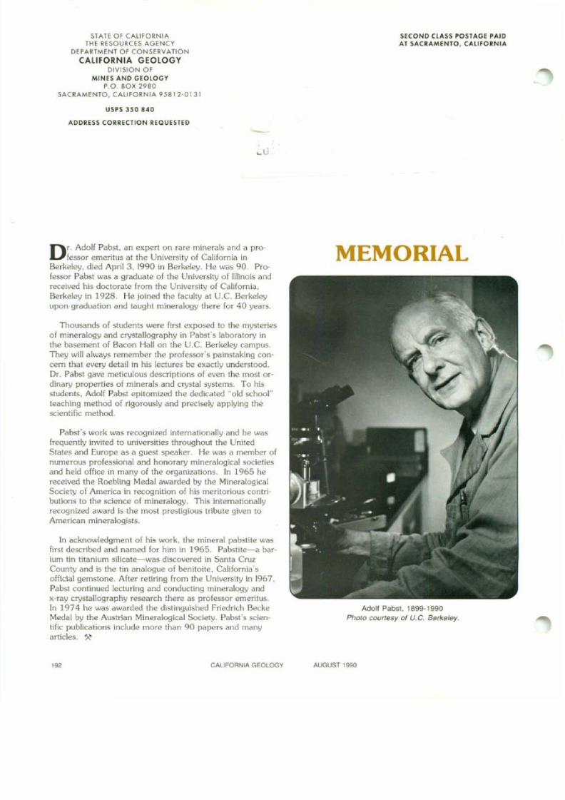
8/7/2019 California Geology Magazine August 1990
http://slidepdf.com/reader/full/california-geology-magazine-august-1990 24/24
SlAte Of CAlifORNIA
lHE RESOURCES AGENCY
DEPAR1MENl Of CONSERVAliON
CAliFORNIA GEOLOGY
DIVISION OF
MINES AND GEOlOGYPOBOX 2980
SACRAMENlO, CALIFORNIA 9.5812·0131
USPS 3S0 840
AOORESS COUEcnON REOUEStED
... l:
Dr. Adolf Pabst. an expert on rare minerals and a professor emeritus at the University of California in
Berkeley. died April 3. 1990 in Berkeley. He was 90. Professor Pabst was a graduate of the University of Illinois andreceived his doctorate from the University of California,Berkeley in 1928. He joined the facuhy at V.C. Berkeleyupon graduation and taught mineralogy there for 40 years.
Thousands of students were first exposed to the mysteriesof mineralogy and crystallography in Pabst's laboratory inthe basement of Bacon Hall on ihe V.C. Berkeley campus.They will always remember the professor's painstaking concern that every detail in his lectures be exactly understood.
Dr. Pabst gave meticulous descriptions of even the most ordinary properties of minerals and crystal systems. To hisstudents. Adolf Pabst epitomized the dedicated Mold school"
teaching method of rigorously and precisely applying thescientific method.
Pabst's work was recognized internationally and he wasfrequently invited to universities throughout the UnitedStates and Europe as a guest speaker. He was a member of
numerous professional and honorary mineralogical societiesand held office in many of the organizations. [n 1965 he
received the Roebling Medal awarded by the MineralogicalSociety of America in recognition of his meritorious contributions to the science of mineralogy. This internationallyrecognized award is the most prestigious tribute given toAmerican mineralogists.
In acknowledgment of his work. the mineral pabstite wasfirst described and named for him in 1965. Pabslite-a bar
ium tin titanium silicate-was discovered in Santa CruzCounty and is the tin analogue of benitoite. California'sofficial gemstone. After retiring from the University in 1967.Pabst continued lecturing and conducting mineralogy andx-ray crystallography research there as professor emeritus.
In 1974 he was awarded the distinguished Friedrich BeckeMedal by the Austrian Mineralogical Society. Pabst's scientific publications include more than 90 papers and manyarticles.
SECOND ClASS POSTAGE PAIDAT SACRAMENTO, CAltfORNIA
MEMORIAL
Adolf Pabst. 1899-1990
Photo courtesy of V.C. Berkeley.


