2
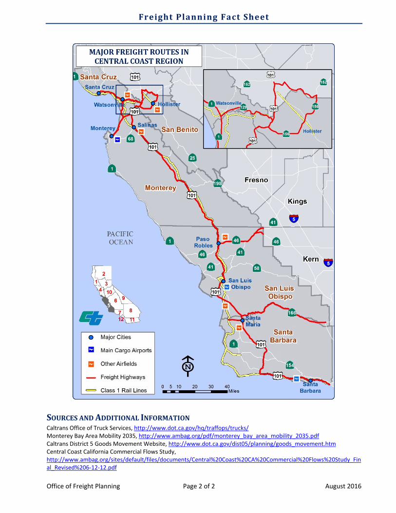
Freight Planning Fact Sheet Office of Freight Planning Page 1 of 2 August 2016 Caltrans District 5 District Address 50 Higuera Street San Luis Obispo, CA 93401‐5415 Goods Movement Contacts District 5: Kelly McClendon, [email protected], (805) 549‐3510 HQ: Shannon Roberts, [email protected], (916) 653‐0808 District 5 covers five counties along California’s Central Coast: Monterey, San Benito, San Luis Obispo, Santa Barbara, and Santa Cruz. The region’s key freight‐dependent industries are agriculture, manufacturing, and truck transportation/warehousing. TRUCKING Primary North‐South Routes: US 101, SR 1, SR 135, SR 152, SR 156, SR 17, SR 217 Primary East‐West Routes: SR 129, SR 166, SR 198, SR 41, SR 46, SR 58, SR 68 The primary artery running north‐south through the region is US 101, which provides direct connectivity to major markets and intermodal facilities in the Los Angeles and San Francisco Bay Area regions. The majority of goods in this region, in terms of tonnage and value, are moved by trucks. A variety of east‐west highways connect the region with Interstate 5 and intermodal distribution centers in the Central Valley. The bulk of the Central Coast region’s freight is either coming from or heading to other parts of California. Key Warehousing & Distribution Centers Santa Maria, Santa Barbara County: Industrial commercial areas of Blosser Road and Betteravia Road; products that arrive from agricultural production centers or manufacturers use SR 166 and Betteravia Road to access US 101. Salinas, Monterey County: Distribution occurs from farms, greenhouses, and manufacturing. Major freight‐dependent industries are strategically located near US 101 for maximum efficiency. Watsonville, Santa Cruz County: Distribution shares geography with manufacturing and agricultural processing. Freight flows are concentrated in south Watsonville along SR 129 and SR 1. RAIL LINES Class I Railroads: The Central Coast is served by one Class I railroad, the Union Pacific (UP) Coast mainline. The UP mainline runs north and south along the coast through District 5 and connects with UP trackage in the Los Angeles Basin. Rail is able to provide freight connectivity to the Ports of Oakland and Los Angeles/Long Beach. Freight on this route is generally carload traffic rather than intermodal. This rail route serves import and export traffic in California, Oregon, and Washington. Short Line Freight Railroads: Santa Maria Valley Railroad is a private 14‐mile system that connects to the UP mainline in Guadalupe. The east‐west spur connects to central Santa Maria while two north‐south spurs serve the Betteravia area and the Santa Maria Airport area. Other branch lines, include the UP Hollister Spur, UP Lompoc Spur, and Santa Cruz Branch Line. These lines serve freight and have speed limits limited to 20 mph due to rail class. AIR CARGO AIRPORTS In 2014, the following three airports carried the most metric tons of cargo within the district: Santa Barbara (SBA) – 1,777 tons San Luis Obispo (SBP) – 1,548 tons Monterey Peninsula (MRY) – 511 tons