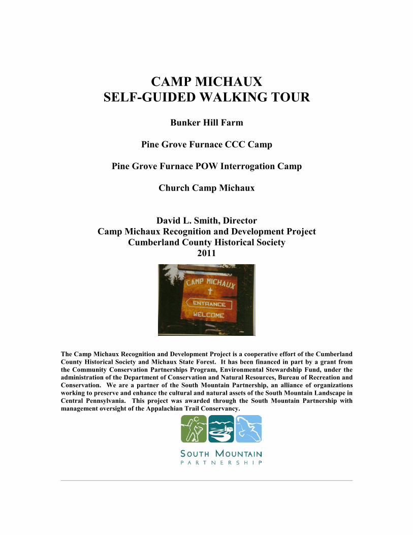
CAMP MICHAUX SELF-GUIDED WALKING TOUR Bunker Hill Farm Pine Grove Furnace CCC Camp Pine Grove Furnace POW Interrogation Camp Church Camp Michaux David L. Smith, Director Camp Michaux Recognition and Development Project Cumberland County Historical Society 2011 The Camp Michaux Recognition and Development Project is a cooperative effort of the Cumberland County Historical Society and Michaux State Forest. It has been financed in part by a grant from the Community Conservation Partnerships Program, Environmental Stewardship Fund, under the administration of the Department of Conservation and Natural Resources, Bureau of Recreation and Conservation. We are a partner of the South Mountain Partnership, an alliance of organizations working to preserve and enhance the cultural and natural assets of the South Mountain Landscape in Central Pennsylvania. This project was awarded through the South Mountain Partnership with management oversight of the Appalachian Trail Conservancy.
Transcript
CAMP MICHAUX
SELF-GUIDED WALKING TOUR
Bunker Hill Farm
Pine Grove Furnace CCC Camp
Pine Grove Furnace POW Interrogation Camp
Church Camp Michaux
David L. Smith, Director
Camp Michaux Recognition and Development Project
Cumberland County Historical Society
2011
The Camp Michaux Recognition and Development Project is a cooperative effort of the Cumberland
County Historical Society and Michaux State Forest. It has been financed in part by a grant from
the Community Conservation Partnerships Program, Environmental Stewardship Fund, under the
administration of the Department of Conservation and Natural Resources, Bureau of Recreation and
Conservation. We are a partner of the South Mountain Partnership, an alliance of organizations
working to preserve and enhance the cultural and natural assets of the South Mountain Landscape in
Central Pennsylvania. This project was awarded through the South Mountain Partnership with
management oversight of the Appalachian Trail Conservancy.
2
Dedication
This booklet is dedicated to the following:
The farmers and their families who lived at and worked Bunker Hill Farm from 1787-1919 The staff and young men who built Pine Grove Furnace CCC Camp S-51-PA, and lived and worked in the South Mountain region, 1933-1942. The staff and interrogators of the Pine Grove Furnace POW Interrogation Camp, 1943-1945 The staff and campers from the United Church of Christ and the United Presbyterian Churches at Camp Michaux, 1947-1972
AND
All of the volunteers who made improvements to the accessibility of the site during April of 2011 including: John Bland, Andre Weltman, Vince Montano, David Smith, Rich Beistline, Mike Emanuel, Ron Kutz, Gary Cribbs, Begee Staub, Diane Batt, Mary Beth Zeigler, Bob Shenk, Diane Shenk, Ann Smith, Dan Sheaffer, Pat Leinbach, Carl Leinbach, Jay Sexton, Jerry Cutshall, Tony Bushey, Wayne Bushey, Roger Bushey, Brandan Bushey, Art Herrold and Pastor Kim Blocker and the Zion UCC Church, Arendtsville, PA.
CAUTION
Persons planning to visit Camp Michaux should be aware of the following:
1. Although newly cleared trails and sites make the camp more
accessible, the trails are rough with rocks, holes, small stumps, and
protruding roots along its length. There are also sections that in
rainy weather can be very wet. Sturdy shoes should be worn and
care should be taken when walking along the trails.
2. In warm weather, there are both copperhead snakes and
rattlesnakes in the area. Use care.
3. Be aware that poison ivy is prevalent in the area, particularly if
you wander off the trail
3
Camp Michaux Self-guided Walking Tour
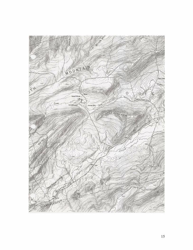
Nestled in the ridges of South Mountain, two miles northwest of Pine Grove Furnace State Park along Michaux Road, lies the site of Camp Michaux. This church camp, formerly shared by the United Presbyterian Church and The United Church of Christ, has an unusual history that is linked to the iron industry in the late 18th, 19th and early 20th centuries when the area was a working farm known as Bunker Hill Farm. The history continues with a Civilian Conservation Corps Camp (CCC) during the Great Depression and a secret Prisoner of War Interrogation Camp during World War II before the advent of the church camp. More details on the history can be found at the end of this booklet.
Directions
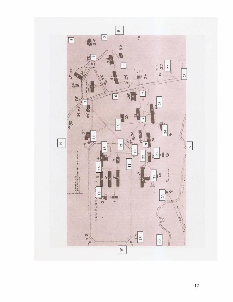
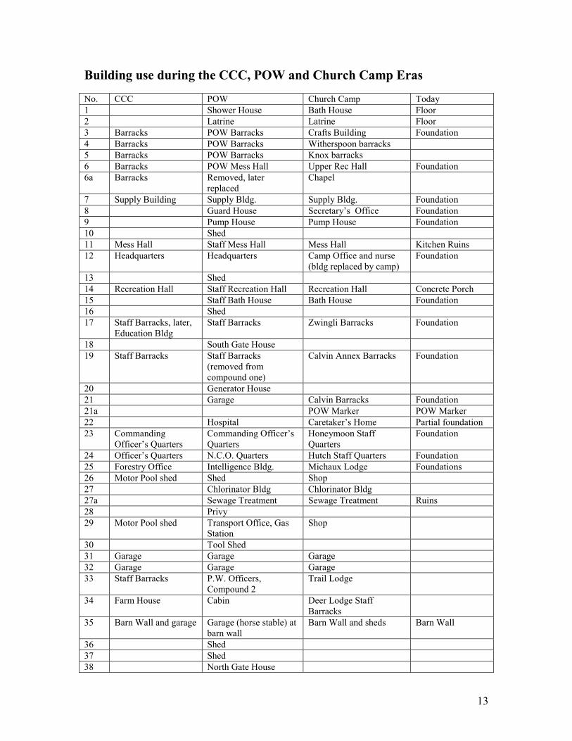
From I-81 take exit 37, Newville, Rt. 233, Centerville Rd. Turn south on Rt. 233 and proceed 7 miles to Pine Grove Furnace State Park. Centerville Rd. ends at Pine Grove Rd. Turn right onto Pine Grove Rd. and follow one mile west to Michaux Rd. Turn right onto Michaux Rd. and proceed one mile north to Bunker Hill Rd. Turn right onto Bunker Hill Rd. and park in the parking area on the left. An additional parking area is also available along Michaux Rd. Locate the first marker post in the middle of the Bunker Hill Road parking area and begin the tour. NOTE: The building numbers referenced in the text refer to the numbers in column one on the building use chart found on pages 13 and 14. The same numbers are used on the US Army camp map found on page 12. The map will help with orientation as you proceed with your self-guided tour. The numbers in the white boxes match the Marker Posts located along this self-guided walking tour.
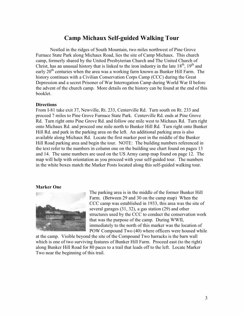
Marker One
The parking area is in the middle of the former Bunker Hill Farm. (Between 29 and 30 on the camp map) When the CCC camp was established in 1933, this area was the site of several garages (31, 32), a gas station (29) and other structures used by the CCC to conduct the conservation work that was the purpose of the camp. During WWII, immediately to the north of this marker was the location of POW Compound Two (40) where officers were housed while
at the camp. Visible beyond the site of the Compound Two barracks is the barn wall which is one of two surviving features of Bunker Hill Farm. Proceed east (to the right) along Bunker Hill Road for 80 paces to a trail that leads off to the left. Locate Marker Two near the beginning of this trail.
4
Marker Two
For many years this trail segment was part of the Appalachian Trail (AT). From Pine Grove Furnace State Park the AT follows the old road that led to the farm before the CCC constructed Michaux Road. It then followed Bunker Hill Road to this trail until it intersects with Michaux Road. The AT then followed Michaux Road for several hundred yards where it turned off the road to the left. In 2010, the AT was officially moved off of both Bunker Hill Road and Michaux Road. It now crosses the area north of where the former farm and camp were located. At Marker Two turn right onto the trail that leads to the ruins of the old farm house (34). In the spring you will notice daffodils and forsythia blooming in the area around the farm house. The building was used by the CCC, the POW camp, and the church camp for housing staff. The foundations of the porch were built during the POW era. A name, Erich John Berlin (a German prisoner?), can be seen in the top right of the porch foundation. Proceed directly north from the farm house for 125 paces to Marker Three. Ignore the arrow post on the left about half way up the hill.
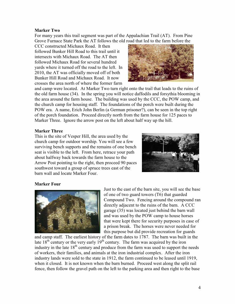
Marker Three
This is the site of Vesper Hill, the area used by the church camp for outdoor worship. You will see a few surviving bench supports and the remains of one bench seat is visible to the left. From here, retrace your path about halfway back towards the farm house to the Arrow Post pointing to the right, then proceed 90 paces southwest toward a group of spruce trees east of the barn wall and locate Marker Four.
Marker Four
Just to the east of the barn site, you will see the base of one of two guard towers (T6) that guarded Compound Two. Fencing around the compound ran directly adjacent to the ruins of the barn. A CCC garage (35) was located just behind the barn wall and was used by the POW camp to house horses that were kept there for security purposes in case of a prison break. The horses were never needed for this purpose but did provide recreation for guards
and camp staff. The earliest history of the farm dates to 1787. The barn was built in the late 18th century or the very early 19th century. The farm was acquired by the iron industry in the late 18th century and produce from the farm was used to support the needs of workers, their families, and animals at the iron industrial complex. After the iron industry lands were sold to the state in 1912, the farm continued to be leased until 1919, when it closed. It is not known when the barn burned. Proceed west along the split rail fence, then follow the gravel path on the left to the parking area and then right to the base
5
of the second guard tower (T5) for Compound Two. Two of the four base structures of this guard tower are visible. The other two are buried in Michaux Road. Cross the road and locate Marker Five.
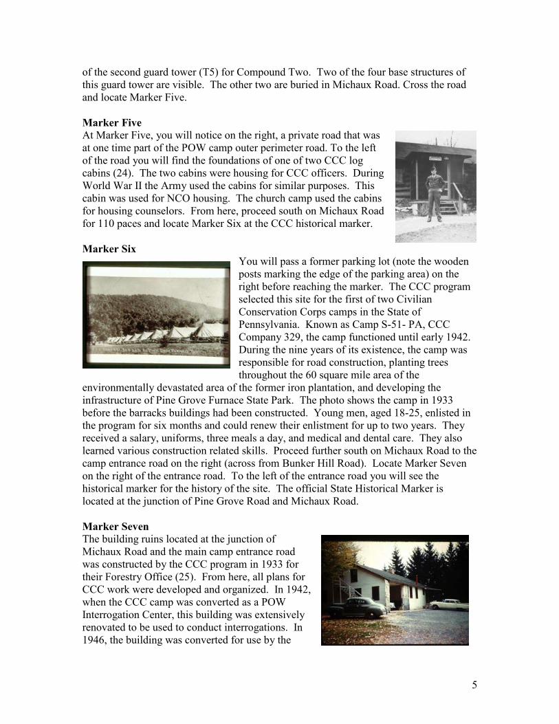
Marker Five At Marker Five, you will notice on the right, a private road that was at one time part of the POW camp outer perimeter road. To the left of the road you will find the foundations of one of two CCC log cabins (24). The two cabins were housing for CCC officers. During World War II the Army used the cabins for similar purposes. This cabin was used for NCO housing. The church camp used the cabins for housing counselors. From here, proceed south on Michaux Road for 110 paces and locate Marker Six at the CCC historical marker.
Marker Six
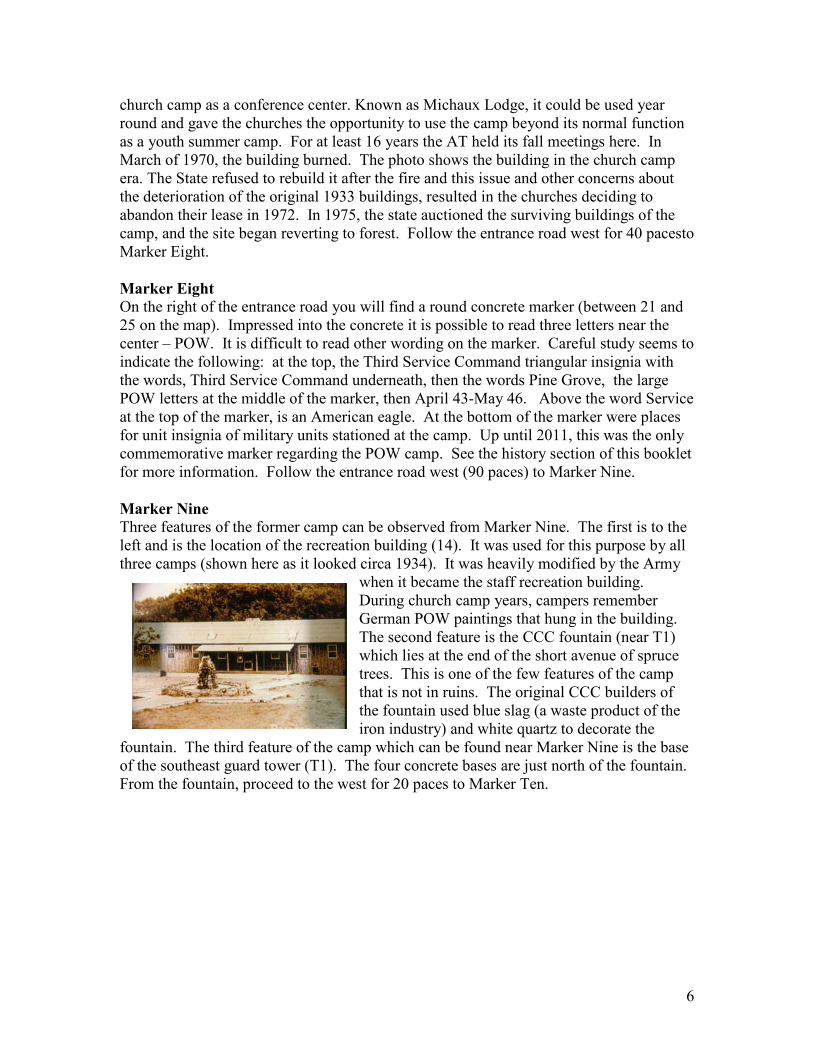
You will pass a former parking lot (note the wooden posts marking the edge of the parking area) on the right before reaching the marker. The CCC program selected this site for the first of two Civilian Conservation Corps camps in the State of Pennsylvania. Known as Camp S-51- PA, CCC Company 329, the camp functioned until early 1942. During the nine years of its existence, the camp was responsible for road construction, planting trees throughout the 60 square mile area of the
environmentally devastated area of the former iron plantation, and developing the infrastructure of Pine Grove Furnace State Park. The photo shows the camp in 1933 before the barracks buildings had been constructed. Young men, aged 18-25, enlisted in the program for six months and could renew their enlistment for up to two years. They received a salary, uniforms, three meals a day, and medical and dental care. They also learned various construction related skills. Proceed further south on Michaux Road to the camp entrance road on the right (across from Bunker Hill Road). Locate Marker Seven on the right of the entrance road. To the left of the entrance road you will see the historical marker for the history of the site. The official State Historical Marker is located at the junction of Pine Grove Road and Michaux Road.
Marker Seven
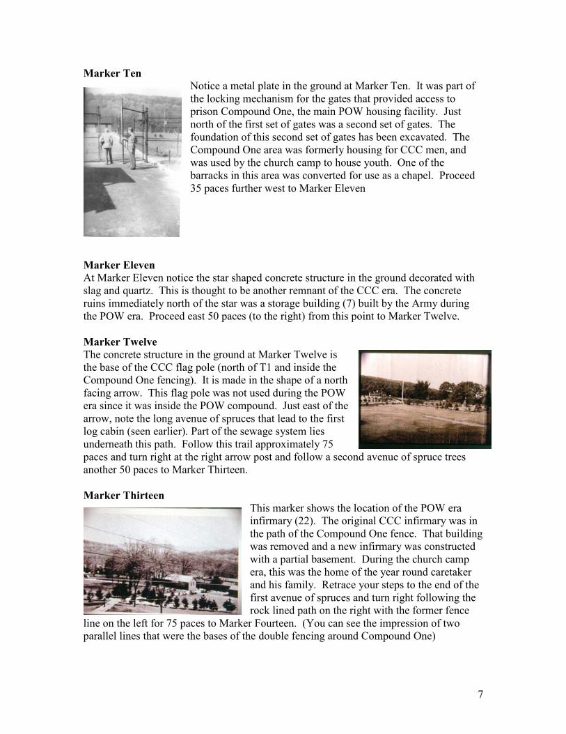
The building ruins located at the junction of Michaux Road and the main camp entrance road was constructed by the CCC program in 1933 for their Forestry Office (25). From here, all plans for CCC work were developed and organized. In 1942, when the CCC camp was converted as a POW Interrogation Center, this building was extensively renovated to be used to conduct interrogations. In 1946, the building was converted for use by the
6
church camp as a conference center. Known as Michaux Lodge, it could be used year round and gave the churches the opportunity to use the camp beyond its normal function as a youth summer camp. For at least 16 years the AT held its fall meetings here. In March of 1970, the building burned. The photo shows the building in the church camp era. The State refused to rebuild it after the fire and this issue and other concerns about the deterioration of the original 1933 buildings, resulted in the churches deciding to abandon their lease in 1972. In 1975, the state auctioned the surviving buildings of the camp, and the site began reverting to forest. Follow the entrance road west for 40 pacesto Marker Eight.
Marker Eight
On the right of the entrance road you will find a round concrete marker (between 21 and 25 on the map). Impressed into the concrete it is possible to read three letters near the center – POW. It is difficult to read other wording on the marker. Careful study seems to indicate the following: at the top, the Third Service Command triangular insignia with the words, Third Service Command underneath, then the words Pine Grove, the large POW letters at the middle of the marker, then April 43-May 46. Above the word Service at the top of the marker, is an American eagle. At the bottom of the marker were places for unit insignia of military units stationed at the camp. Up until 2011, this was the only commemorative marker regarding the POW camp. See the history section of this booklet for more information. Follow the entrance road west (90 paces) to Marker Nine.
Marker Nine
Three features of the former camp can be observed from Marker Nine. The first is to the left and is the location of the recreation building (14). It was used for this purpose by all three camps (shown here as it looked circa 1934). It was heavily modified by the Army
when it became the staff recreation building. During church camp years, campers remember German POW paintings that hung in the building. The second feature is the CCC fountain (near T1) which lies at the end of the short avenue of spruce trees. This is one of the few features of the camp that is not in ruins. The original CCC builders of the fountain used blue slag (a waste product of the iron industry) and white quartz to decorate the
fountain. The third feature of the camp which can be found near Marker Nine is the base of the southeast guard tower (T1). The four concrete bases are just north of the fountain. From the fountain, proceed to the west for 20 paces to Marker Ten.
7
Marker Ten
Notice a metal plate in the ground at Marker Ten. It was part of the locking mechanism for the gates that provided access to prison Compound One, the main POW housing facility. Just north of the first set of gates was a second set of gates. The foundation of this second set of gates has been excavated. The Compound One area was formerly housing for CCC men, and was used by the church camp to house youth. One of the barracks in this area was converted for use as a chapel. Proceed 35 paces further west to Marker Eleven
Marker Eleven
At Marker Eleven notice the star shaped concrete structure in the ground decorated with slag and quartz. This is thought to be another remnant of the CCC era. The concrete ruins immediately north of the star was a storage building (7) built by the Army during the POW era. Proceed east 50 paces (to the right) from this point to Marker Twelve.
Marker Twelve
The concrete structure in the ground at Marker Twelve is the base of the CCC flag pole (north of T1 and inside the Compound One fencing). It is made in the shape of a north facing arrow. This flag pole was not used during the POW era since it was inside the POW compound. Just east of the arrow, note the long avenue of spruces that lead to the first log cabin (seen earlier). Part of the sewage system lies underneath this path. Follow this trail approximately 75 paces and turn right at the right arrow post and follow a second avenue of spruce trees another 50 paces to Marker Thirteen.
Marker Thirteen
This marker shows the location of the POW era infirmary (22). The original CCC infirmary was in the path of the Compound One fence. That building was removed and a new infirmary was constructed with a partial basement. During the church camp era, this was the home of the year round caretaker and his family. Retrace your steps to the end of the first avenue of spruces and turn right following the rock lined path on the right with the former fence
line on the left for 75 paces to Marker Fourteen. (You can see the impression of two parallel lines that were the bases of the double fencing around Compound One)
8
Marker Fourteen
Two features are visible at Marker Fourteen. The first is the Northeast Guard Tower (T4) and the second is the foundation of the second CCC log cabin (23). This building housed the commander of the CCC camp and also the commander of the POW camp. The last commander of the camp, Major Laurence Thomas had a talented German POW artist paint a picture (shown here) of his home and office. From here retrace your steps south for 25 paces and turn right for another 25 paces to Marker Fifteen.
Marker Fifteen
The ruins at Marker Fifteen are the site of an original CCC barracks (6). The Army renovated this building to become the German POW Dining Hall. This included the construction of a kitchen ell on the south side of the building, the ruins of which are clearly visible. The church camp used the building for arts and crafts. Just south of these ruins you can locate a stone and earth embankment. Another star was located in front of this embankment (probably built by the US Army or by the German prisoners). The photo shows the building during the POW era. Proceed to the far end of the old POW dining hall and move west 10 paces to Marker Sixteen.
Marker Sixteen
The ruin here is the location of one of the CCC barracks (3) and northernmost one of the barracks used to house German prisoners (the photo shows the row of barracks during the CCC era). No ruins of the other barracks survive. Later the church camp used this building for youth campers. There were originally four identical CCC barracks (4 and 5) arranged north to south in this section of the camp. One of them was removed during the conversion of the camp for POWs because it was considered too close to the compound fence. Later, when the demand for prisoner housing increased, a new barracks was rebuilt to replace the one that had been torn down. Proceed further west for 25 paces past a blacktopped recreation area and another 20 paces to Marker Seventeen.
Marker Seventeen
From this location several features of the camp can be seen. The ruins to the left in this area are the latrine and bath house (1 and 2) structures of the camp. Each subsequent version of the camp made improvements to these structures. Just north (to the right) of these ruins is the base of the pavilion built by the church camp, and further north of that are the “steps to nowhere.” These steps were built by the CCC camp and were used by
9
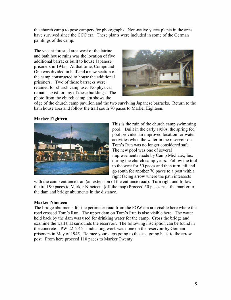
the church camp to pose campers for photographs. Non-native yucca plants in the area have survived since the CCC era. These plants were included in some of the German paintings of the camp. The vacant forested area west of the latrine and bath house ruins was the location of five additional barracks built to house Japanese prisoners in 1945. At that time, Compound One was divided in half and a new section of the camp constructed to house the additional prisoners. Two of those barracks were retained for church camp use. No physical remains exist for any of these buildings. The photo from the church camp era shows the edge of the church camp pavilion and the two surviving Japanese barracks. Return to the bath house area and follow the trail south 70 paces to Marker Eighteen.
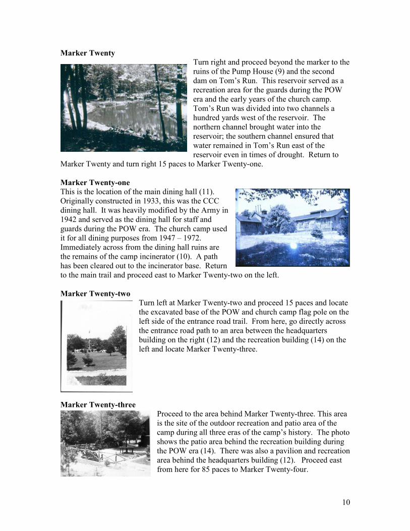
Marker Eighteen
This is the ruin of the church camp swimming pool. Built in the early 1950s, the spring fed pool provided an improved location for water activities when the water in the reservoir on Tom’s Run was no longer considered safe. The new pool was one of several improvements made by Camp Michaux, Inc. during the church camp years. Follow the trail to the west for 50 paces and then turn left and go south for another 70 paces to a post with a right facing arrow where the path intersects
with the camp entrance trail (an extension of the entrance road). Turn right and follow the trail 90 paces to Marker Nineteen. (off the map) Proceed 50 paces past the marker to the dam and bridge abutments in the distance.
Marker Nineteen
The bridge abutments for the perimeter road from the POW era are visible here where the road crossed Tom’s Run. The upper dam on Tom’s Run is also visible here. The water held back by the dam was used for drinking water for the camp. Cross the bridge and examine the wall that surrounds the reservoir. The following inscription can be found in the concrete – PW 22-5-45 – indicating work was done on the reservoir by German prisoners in May of 1945. Retrace your steps going to the east going back to the arrow post. From here proceed 110 paces to Marker Twenty.
10
Marker Twenty
Turn right and proceed beyond the marker to the ruins of the Pump House (9) and the second dam on Tom’s Run. This reservoir served as a recreation area for the guards during the POW era and the early years of the church camp. Tom’s Run was divided into two channels a hundred yards west of the reservoir. The northern channel brought water into the reservoir; the southern channel ensured that water remained in Tom’s Run east of the reservoir even in times of drought. Return to
Marker Twenty and turn right 15 paces to Marker Twenty-one.
Marker Twenty-one
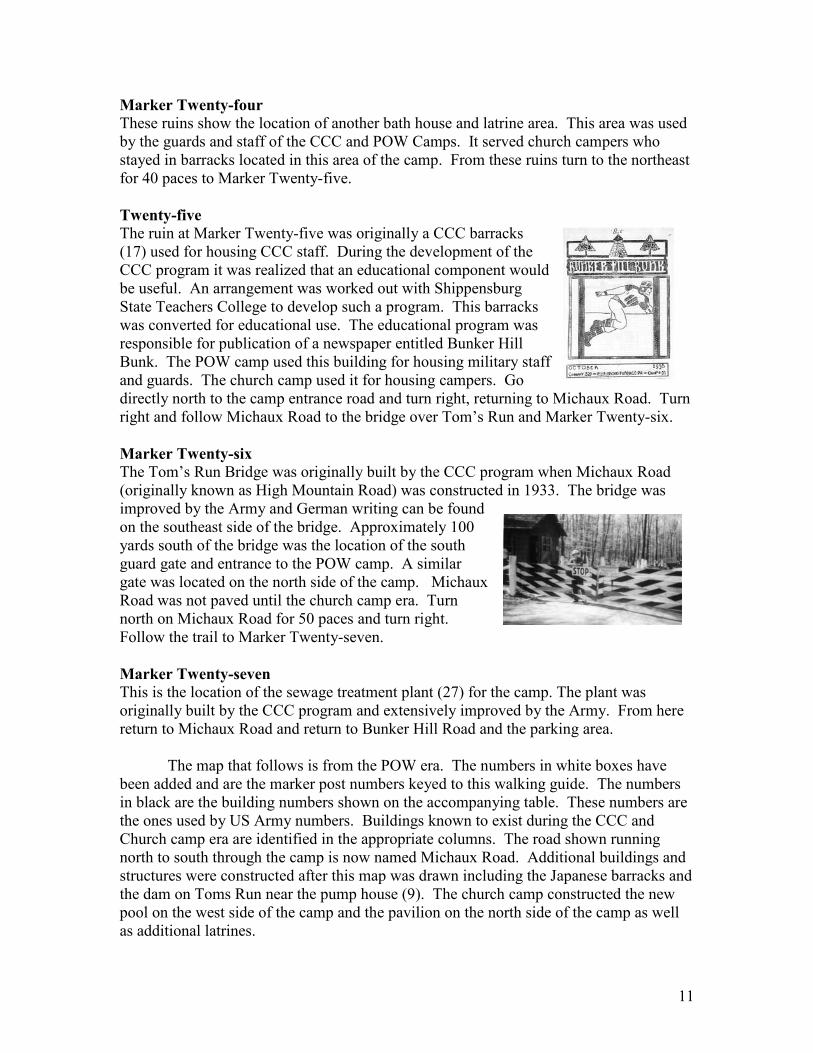
This is the location of the main dining hall (11). Originally constructed in 1933, this was the CCC dining hall. It was heavily modified by the Army in 1942 and served as the dining hall for staff and guards during the POW era. The church camp used it for all dining purposes from 1947 – 1972. Immediately across from the dining hall ruins are the remains of the camp incinerator (10). A path has been cleared out to the incinerator base. Return to the main trail and proceed east to Marker Twenty-two on the left.
Marker Twenty-two Turn left at Marker Twenty-two and proceed 15 paces and locate the excavated base of the POW and church camp flag pole on the left side of the entrance road trail. From here, go directly across the entrance road path to an area between the headquarters building on the right (12) and the recreation building (14) on the left and locate Marker Twenty-three.
Marker Twenty-three
Proceed to the area behind Marker Twenty-three. This area is the site of the outdoor recreation and patio area of the camp during all three eras of the camp’s history. The photo shows the patio area behind the recreation building during the POW era (14). There was also a pavilion and recreation area behind the headquarters building (12). Proceed east from here for 85 paces to Marker Twenty-four.
11
Marker Twenty-four
These ruins show the location of another bath house and latrine area. This area was used by the guards and staff of the CCC and POW Camps. It served church campers who stayed in barracks located in this area of the camp. From these ruins turn to the northeast for 40 paces to Marker Twenty-five.
Twenty-five
The ruin at Marker Twenty-five was originally a CCC barracks (17) used for housing CCC staff. During the development of the CCC program it was realized that an educational component would be useful. An arrangement was worked out with Shippensburg State Teachers College to develop such a program. This barracks was converted for educational use. The educational program was responsible for publication of a newspaper entitled Bunker Hill Bunk. The POW camp used this building for housing military staff and guards. The church camp used it for housing campers. Go directly north to the camp entrance road and turn right, returning to Michaux Road. Turn right and follow Michaux Road to the bridge over Tom’s Run and Marker Twenty-six.
Marker Twenty-six
The Tom’s Run Bridge was originally built by the CCC program when Michaux Road (originally known as High Mountain Road) was constructed in 1933. The bridge was improved by the Army and German writing can be found on the southeast side of the bridge. Approximately 100 yards south of the bridge was the location of the south guard gate and entrance to the POW camp. A similar gate was located on the north side of the camp. Michaux Road was not paved until the church camp era. Turn north on Michaux Road for 50 paces and turn right. Follow the trail to Marker Twenty-seven.
Marker Twenty-seven
This is the location of the sewage treatment plant (27) for the camp. The plant was originally built by the CCC program and extensively improved by the Army. From here return to Michaux Road and return to Bunker Hill Road and the parking area.
The map that follows is from the POW era. The numbers in white boxes have been added and are the marker post numbers keyed to this walking guide. The numbers in black are the building numbers shown on the accompanying table. These numbers are the ones used by US Army numbers. Buildings known to exist during the CCC and Church camp era are identified in the appropriate columns. The road shown running north to south through the camp is now named Michaux Road. Additional buildings and structures were constructed after this map was drawn including the Japanese barracks and the dam on Toms Run near the pump house (9). The church camp constructed the new pool on the west side of the camp and the pavilion on the north side of the camp as well as additional latrines.
12
13
Building use during the CCC, POW and Church Camp Eras
No. CCC POW Church Camp Today
1 Shower House Bath House Floor
2 Latrine Latrine Floor
3 Barracks POW Barracks Crafts Building Foundation
4 Barracks POW Barracks Witherspoon barracks
5 Barracks POW Barracks Knox barracks
6 Barracks POW Mess Hall Upper Rec Hall Foundation
6a Barracks Removed, later replaced
Chapel
7 Supply Building Supply Bldg. Supply Bldg. Foundation
8 Guard House Secretary’s Office Foundation
9 Pump House Pump House Foundation
10 Shed
11 Mess Hall Staff Mess Hall Mess Hall Kitchen Ruins
12 Headquarters Headquarters Camp Office and nurse (bldg replaced by camp)
Foundation
13 Shed
14 Recreation Hall Staff Recreation Hall Recreation Hall Concrete Porch
15 Staff Bath House Bath House Foundation
16 Shed
17 Staff Barracks, later, Education Bldg
Staff Barracks Zwingli Barracks Foundation
18 South Gate House
19 Staff Barracks Staff Barracks (removed from compound one)
Calvin Annex Barracks Foundation
20 Generator House
21 Garage Calvin Barracks Foundation
21a POW Marker POW Marker
22 Hospital Caretaker’s Home Partial foundation
23 Commanding Officer’s Quarters
Commanding Officer’s Quarters
Honeymoon Staff Quarters
Foundation
24 Officer’s Quarters N.C.O. Quarters Hutch Staff Quarters Foundation
35 Barn Wall and garage Garage (horse stable) at barn wall
Barn Wall and sheds Barn Wall
36 Shed
37 Shed
38 North Gate House
14
39 Generator House
40 Guard House
41 Barber Shop
T1 SE Guard Tower by fountain
Foundation Foundation
T2 Guard Tower
T3 Guard Tower
T4 NE Guard Tower by Commander’s Quarters
Foundation Foundation
T5 Coumpound 2 Guard Tower (by Michaux Rd.)
Foundation Foundation
T6 Compound 2 Guard Tower (east of barn)
Foundation Foundation
Japanese Barracks Building 52
Japanese Barracks Building 51
Japanese Barracks Removed
Japanese Barracks Removed
Steps Steps Steps Steps
Pavilion (west of bldg 3) Concrete base
Pavilion (south of bldg 14)
Ball Court
Ball Court (south of bldg 14)
Ball Court Blacktop base
Camp Office Foundation
CCC Flag Pole Flag Pole Base Flag Pole Base Flag Pole Base
POW Flag Pole (east of main dining hall, bldg 11)
POW Flag Pole Base POW Flag Pole Base
Star and Embankment in front of Bldg 6
Embankment Embankment
Star Star (in front of bldg. 7 Star Star
POW Compound One Entrance (west of fountain)
Concrete entrance Concrete entrance
Incinerator Incinerator Foundation
Old Pool and dam Old Pool and dam Old Pool and dam
New Pool Ruins
Fountain (near T1) Fountain Fountain Fountain
Upper dam (west of camp on Tom’s Run)
Upper dam Upper Dam
15
16
History Bunker Hill Farm
The history of the site begins in 1787 with the establishment of a family farm that came to be known as Bunker Hill Farm. The farm consisted of approximately 250 acres and was acquired before the end of the 18th century by the growing iron industrial complex at Pine Grove Furnace and Laurel Forge. It was one of several farms owned by the iron industry and was used to supply food for men and their families who worked for the company as well as food for animals that were part of the mining operation. The extensive farm operation led the owners of the South Mountain Mining Company to hire a farm expert in 1878 to assist with management of the farms. J.D. North was an expert planter and fruit culturist from North Carolina. Later in 1887, three of the farms including Bunker Hill Farm were leased to William F. Swigert. The iron industry failed in the late 19th century but for a time a brick works at Pine Grove kept the company town alive until 1912 when the State of Pennsylvania acquired the entire iron industry estate’s sixty square miles for $29,827.00.
The last lease holder of the farm was John Gardner who leased it from the Commonwealth. Because of this some locals refer to the farm as the Gardner Farm. The only surviving features of the farm are the large stone barn wall and the foundations of the farm house nearby. Gardner gave up his lease in 1919 even though a year before it was reported that 1,000 bushels of wheat had been produced there.
Pine Grove Furnace Civilian Conservation Corps Camp
The land remained idle for the next 13 years. In 1933, with the Great Depression gripping the country, Franklin Roosevelt created the Civilian Conservation Corps (CCC) as part of his New Deal. The Corps’ purpose was to provide employment and training for young men ages 18 – 25. Sites across the country were selected for this program and it was not uncommon for former iron plantations to be selected because the iron industry had not been
environmentally kind to the land that it occupied therefore the land was in need of reclamation. The former Bunker Hill farm was selected for the first CCC camp on state land in Pennsylvania. (Another site in western Pennsylvania was selected about the same time and was on federal land in the Allegheny National Forest.)
The first CCC men arrived to construct the camp on the old farm in May of 1933. They arrived from Fort Monroe, Virginia (116 men) and Carlisle Barracks (82 men) using the railroad that still operated between Hunter’s Run and Pine Grove. The men stayed adjacent to the railroad station and set up their dining tent in front of the iron furnace stack. They walked the four miles round trip each day to the farm site to begin construction of the camp. Once they had a dining hall constructed, a tent camp was set up at the farm and from that time on the CCC camp operated at the new site. By late December of 1933, the 200 men and their leaders could move into newly constructed barracks. During the course of the nine years Pine Grove Furnace Civilian Conservation Corp Camp S-51-PA was open, the men built roads (including Michaux Road, the road that leads to the camp today) installed telephone lines, reforested land throughout the region, built infrastructure in the state park, and continually made improvements to the CCC camp. By the time the camp closed there were more than 40 buildings at the site.
17
With the advent of World War II in late 1941, the men were now needed for national defense and the CCC program came to an end.
Pine Grove Furnace POW Interrogation Camp
In 1942, the War Department was faced with the need to house prisoners of war. There was also need to learn strategic information from the prisoners regarding weaponry, and the operation of the Nazi war machine. Similar needs would emerge regarding the Japanese as the war progressed. Interrogation sites were set up at Ft. Hunt, Virginia and Byron Hot Springs, California in addition to over 660 internment camps across the country to house prisoners for the duration of the war. It was evident early on that Ft. Hunt could not handle the interrogation demands and a second site was selected from among three that were considered. That site was the former CCC camp at Pine Grove Furnace.
The Pine Grove Furnace CCC Camp was remodeled and two prison compounds were erected, one for officers and one for enlisted men. Prison Compound One was the larger of the compounds and was located near the CCC Fountain. Compound Two was located by the old barn wall. Compound One had four guard towers (the bases of two of them survive today), and Compound Two had two guard towers (both bases can be seen today.) Prisoners were interrogated in the former renovated Forestry Office building located along Michaux Road (at that time called High Mountain Road) near the former entrance to the CCC camp. Fencing around the entire 100+ acre site plus guarded entrance gates on High Mountain road prevented any non-military persons from gaining access to the camp. Thousands of prisoners (possibly as many as 7,000) were interrogated there during the course of the war including Japanese prisoners toward the end of the war. A separate area for the Japanese was created by erecting a fence in the middle of Compound One and constructing new barracks in the formerly unoccupied western area of the compound.
The Pine Grove Furnace Prisoner of War Interrogation Camp operated until the November of 1945. The land reverted back to the Commonwealth at that time. The land on which it was located was part of Michaux State Forest which was named for Andre Michaux, a French naturalist sent to North America by Louis XIV in the 18th century. He was commissioned to study the plant life of the Appalachian region and gather plants for the Royal Gardens. Pennsylvania chose to recognize his contributions to the understanding of the plants of the region by naming the forest for him.
Camp Michaux
In 1947 representatives of the United Presbyterian Church and the Evangelical and Reformed Church (later the United Church of Christ) formed an alliance and arranged with the State to lease the former POW camp. The Boy Scouts of America also submitted a proposal to use the camp. In 1948 a formal lease arrangement was worked out with Camp Michaux, Incorporated (this is the first time the name Michaux was given to the property). The organization ran summer church camps here until 1972 in addition to other activities throughout the year. The Appalachian Trail held its annual fall meeting at the site for 16 years. The churches were responsible for maintaining the buildings and grounds. Leases ran for 10 years with a $600.00 annual payment. The lease was renewed in 1958 and again in 1968. In early 1970 one of the few winterized buildings on
18
the site burned due to a malfunctioning furnace. That building, called Michaux Lodge, had been the CCC Forestry Office and the POW Interrogation Building. The churches did not want to replace the building since they did not own the property. The State was not interested in replacing it either. Without the revenue that could be realized from the use of the camp year round and the rapid deterioration of many of the former CCC barracks buildings, the churches finally decided to abandon the lease in 1972. The camp closed at that time.
The Commonwealth was unable to find other uses for the site and the buildings rapidly deteriorated. In 1975, an auction of the surviving buildings was held (some of the buildings had already been dismantled). Purchasers of the buildings removed what they could take away. What remained of the camp was then removed by the State. Today foundations of several of the buildings remain as well as the CCC fountain, the dams on Tom’s Run and the deck and control room for the swimming pool that had been built by Camp Michaux, Inc. These surviving ruins and structures make a fairly detailed analysis of the site possible.
Additional Information
Extensive research has been done about the history of the site and can be found in a book published by the Cumberland County Historical Society (CCHS) entitled Secret War at Home, The Pine Grove Furnace Prisoner of War Interrogation Camp by John Paul Bland. The book is available for sale at CCHS and at Pine Grove Furnace State Park. John spent untold hours at the National Archives and Records Administration in Adelphi, Maryland, reviewing the original records regarding the site. Information can also be learned by going to the following web site posted by Lee Schaeffer, a former church camp counselor: www.schaeffersite.com/michaux . Guided tours of the site sponsored by CCHS are given by David Smith and John Bland each spring and fall. Contact the Society (249-7610) for information about registering for the tours. Other interested people including Andre Weltman, Bill and Carol Jones, and Vince Montano have made significant contributions to assist interested persons with understanding of the site. In addition, 25 volunteers worked one or more Saturdays during April of 2011 to clear trails, erect the numbered posts, and clear various sites within the former camp.