Canterbury Water Management Strategy Canterbury Mayoral Forum He puna wai, he puna tangata The pool of water sustains the pool of people Strategic Framework - November 2009 Targets updated July 2010. Interim Targets for 2025 and 2030 added August 2019 R19/122 E19/7624 Canterbury Water
Transcript
Canterbury Water Management Strategy
Canterbury Mayoral Forum
He puna wai, he puna tangataThe pool of water sustains the pool of people
Strategic Framework - November 2009Targets updated July 2010.Interim Targets for 2025 and 2030 added August 2019
R19/122 E19/7624
CanterburyWater
1
Preface
It is with great pleasure that we are today publishing the Canterbury Water
Management Strategy – Framework Document. On behalf of the Canterbury
Mayoral Forum we would like to thank Government Ministers, our steering group,
our officials and consultants, and all stakeholders and members of the public who
have supported us in developing this strategy.
This document is a considerable update on the draft strategy (published in
September 2009), and summarises the overall approach and the delivery models
we have adopted for the sustainable management and development of the
region’s water resources in the years ahead.
In the last decade pressure on Canterbury’s water resource has increased
significantly and with it has emerged a highly adversarial approach to allocation
and management, infrastructure provision, and related land management
practices which has exacerbated the situation leading to sub-optimal outcomes.
It is not in the best interests of anyone in Canterbury for this situation to
continue. The work done in compiling this strategy has demonstrated there is a
better way forward, based on collaboration and integrated management that will
maximise the opportunities for the environment, economy and community of
Canterbury in the years ahead.
Consultation with stakeholders and the general public earlier this year has
demonstrated there is a strong support for this initiative. The Ministers of
Agriculture and Environment have been closely engaged throughout the
development of the strategy and have given their support to the strategy
development exercise and its general thrust.
The Canterbury Water Management Strategy will not be implemented overnight.
The problems are complex and multi-layered. Ongoing leadership will be required
at local, regional and national levels, and the different interest groups will need to
cooperate over a sustained period of years to improve management of this vital
resource.
In publishing this strategy today, we are committing ourselves to provide the
sustained and collaborative leadership that will be needed to turn this strategy
into reality.
Bob Parker Bede O’Malley
Chairman Chairman
Mayoral Forum Steering Group
2
Contents
Executive Summary
Section 1 Role of the strategy 18
• Need for a strategy
• The status of the strategy
• How the strategy has been developed
• Vision - what would success look like?
• Principles that must be met
Section 2 Key challenges 23
• Canterbury’s dependence on water
• Key issues
• Future trends
• Implications of further land use intensification
• Will the current approach address the problems and deliverthe desired outcomes?
• Paradigm shift needed in water management
• What are the risks?
Section 3 Achieving the vision 35
• Options considered
• Sustainability assessment
• Outcome of consultation and engagement with stakeholders
• Strategic approach and targets
Section 4 Coordination and delivery framework 40
• Implementation drivers
• Integrated water management
• Water management zones
• Implementation programmes
• Governance arrangements
• Water Executive
• Water infrastructure and services entity
• Managing the risks
3
Section 5 Issues to be covered by the implementation
programmes 49
• Overview
• Ecosystem protection and restoration
• Investment in new infrastructure
• Allocation and use of groundwater
• Water allocation and charging regime
• Land management practices
• Water use efficiency
• Implications for hydro-electricity generators
• Auditing and enforcement
Section 6 Legislative implications 56
• Background
• Maori rights and interests
• Empowering water management committees
• Legal status of implementation programmes
• Summary of overall approach
Section 7 Implementation – next steps 59
• Legal powers
• Zone and Regional Committees
• Targets
• Economic assessment
• Endorsement by District Councils, Environment Canterburyand Te Runanga o Ngāi Tahu
• Implementation programmes
• Water Executive
• Resolution of national issues
• “Immediate Steps” ecosystem protection and restorationprogramme
• Supply-side arrangements
• Implementation timetable
Section 8 Monitoring implementation of the strategy 65
4
Annexes
67
68
71
87
88
99
104
127
135
141
147
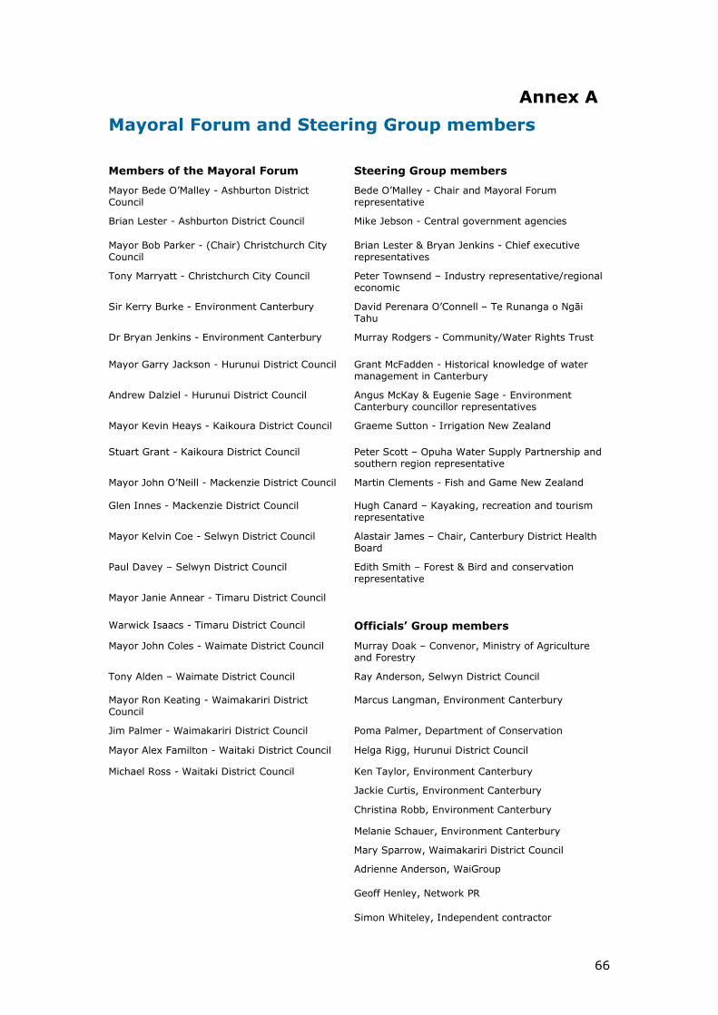
A. Mayoral Forum and Steering Group members
B. Fundamental Principles
C. Background and current trends
D. Consultation process to date
E. Results of the sustainability appraisal
F. List of submitters and summary of consultation
G. Draft targets in detail
H. Integrated management framework
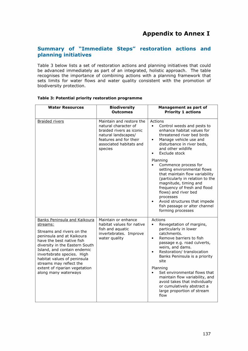
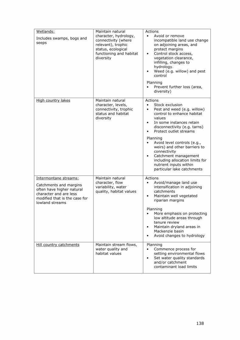
I. Biodiversity protection and restoration- Appendix - Summary of “Immediate Steps” restoration actions and planning initiatives
J. Infrastructure options
K. Regulatory backing to the strategy
L. Role, structure and funding of the Water Executive
M. Interim Targets for 2025 and 2030151
152
5
Executive Summary
Role of the strategy
How the strategy has been developed
The Mayoral Forum has provided overall leadership for the project. A multi-stakeholder Steering Group has supervised the preparation of the strategy.
Need for a strategy
Canterbury’s water resources are vitally important to the region and to the nation. Lakes, rivers, streams and aquifers are used for hydro electricity generation, agricultural production and drinking water, as well as for a range of customary and recreational uses. Water is an essential and integral part of the connection between Ngāi Tahu, as indigenous peoples of the region, and their tribal territory. In recent years Canterbury’s water resources have been coming under pressure. Aquatic health of lowland streams, high country lakes and groundwater has continued to decline, there has been a loss of cultural and recreational opportunities, and the availability of water for use by agriculture is becoming less reliable.
There is now a widely held view among stakeholders and the general public that continuing along the present path for managing water will lead to unacceptable environmental, social, cultural and economic outcomes. The challenges are outlined in the next section.
Key challenges
Pressure on river systems
� Run-of-river takes are near the limit of what can be safely abstracted while maintaining environmental flows.
� Restrictions are already widely in use, with the greatest pressure on lowland streams.
Pressure on aquifer systems
� There are now ten red zones in Canterbury, where water has been fully allocated, and four “yellow zones”, where allocation exceeds 80% of the allocation limit.
Cumulative effects on ecosystems
• In lowland and coastal areas, remaining indigenous vegetation tends to occur in small, scattered fragments.
• Less than 10% of the region’s previously extensive wetlands remain.
• There is a general decline in freshwater biodiversity.
• In parts of the hill and high country, accelerating land use change and intensification is threatening the important indigenous habitat that remains.
6
Cultural health of waterways
� The cultural health of freshwater in Te Waipounamu is moderate to poor.
Water use efficiency
� Some substantial efficiency gains can be made.
Climate change
� Projections of climate change suggest the region will become drier and need more irrigation simply to maintain existing outputs from the land.
� Natural systems for delivering water will become less reliable and therefore less able to support current levels of output.
Water quality impairment issues
• If there are to be substantial increases in land-uses associated withnitrogen leaching, then there must be a corresponding decrease in nutrientleaching from existing land.
• Modelling suggests it will be possible to substantially increase agriculturaloutput while maintaining groundwater quality within acceptable limits aslong as land management practices and technologies that reduce nutrientsand other contaminants are applied across the region.
• To achieve this outcome will require existing users of water as well as newusers to adopt the improved land management practices and technologies.
Infrastructure issues
� New infrastructure needs to be introduced in conjunction with much more efficient use of water, both by existing users and new users. This will reduce the scale of new infrastructure that has to be built to manageable levels.
� New ways must be found to harness the knowledge and experience of existing irrigators in conjunction with external world class engineering, financial and management resources to build the next generation of storage.
The Vision
What would success look like?
The desired outcome of the strategy is:
To enable present and future generations to gain the greatest social,
economic, recreational and cultural benefits from our water resources
within an environmentally sustainable framework.
If the strategy is successful, the following features should be evident within 10
years:
• people will feel they are being treated fairly and involved in decision-making
• allocation decisions will be resolved in most cases without resorting to thecourts
• there will be a high level of audited self management, and complianceaction will be targeted on a minority of non-complying water users
7
• ecosystems, habitats and landscapes will be protected and progressivelyrestored, and indigenous biodiversity will show significant improvement
• water quality will be protected and starting to return to within healthylimits for human health and ecosystems
• opportunities to exercise kaitiakitanga1 and rangitiratanga2 will beoperative, and increasing
• opportunities for recreational activities will be returning and improving
• water users will have access to reliable water, which will be used efficientlyand productively
• primary production and employment will be increasing, and the net valueadded by irrigation to the Canterbury economy and the national balance ofpayments will be increasing
• opportunities for tourism activities based on and around water will bereturning and improving, and the net value to Canterbury’s economy fromthese activities will be increasing
• efficiency in the use of energy will be improving
• rural community viability will be improving and community cohesion willbe maintained
• understanding and empathy between rural and urban dwellers will beincreasing
• the water management system will be better able to adapt to climatechange in the future.
Paradigm shift needed in water management
There is a need for new paradigm in the way water is allocated and managed. There is capacity for further development but it will require existing users and new users to improve the way they use water.
The key changes will be:
• a shift from effects-based management of individual consents tointegrated management based on water management zones
• management of the cumulative effects of water abstraction and land useintensification
• water allocation decisions that address sustainable environmental limitsand climate variability
• actions to protect and restore freshwater biodiversity, amenity values andnatural character.
Regulatory action to deal with environmental problems will need to be complemented with incentive mechanisms that progressively drive efficiency in the use of water and responsible land management practices.
1 Kaitiakitanga. Traditional guardianship - the active protection and responsibility for natural and physical resources by tangata whenua
2 Rangitiratanga - having the mana or authority to exercise the relationship between Māori, and their culture and traditions, with the natural world. Iwi management plans and the active involvement of tāngata whenua in resource management decision-making processes are practical expressions of rangitiratanga
8
The key incentive mechanism to drive these changes will be the availability of reliable water from new storage and distribution infrastructure. However, this water must not be over-allocated for production purposes, as some water resources have been, but instead used to achieve balanced outcomes. In particular, protection of ecosystems, recreational and customary uses, and environmental conservation can no longer be seen as “add-ons” to development, but mainstream elements of a sustainable agenda.
Achieving the vision
Principles that must be met
Fundamental principles have been developed to underpin the strategy.
First order priorities: environment, customary use, community supplies and stock water.
Second order priorities: irrigation, renewable electricity generation, recreation and amenity
Primary principles – sustainable management, regional approach, and tangata whenua
Supporting principles – natural character, indigenous biodiversity, access, quality drinking water, recreational opportunities, and community and commercial use.
These are designed to ensure that our water resource is managed sustainably.
Targets
The strategy will focus on delivering a balanced set of quantified outcome targets by specified dates. The measurable outcome targets will be in the following areas:
• drinking water
• irrigated land area
• energy security and efficiency
• ecosystem health/biodiversity
• water use efficiency
• kaitiakitanga
• regional and national economic growth
• natural character of braided rivers
• recreational and amenity opportunities.
These targets will give the strategy a sense of direction and balance and ensure that all aspects of the solution are advanced in parallel. They will also enable progress with implementing the strategy to be monitored and measured over time. There will be further engagement with stakeholders before the targets are finalised by the end of 2009.
9
Parallel development
A total solution is required. Piecemeal or fragmented approaches will not work. To effect such a solution a balanced programme of parallel development is required that will look like this:
• in the short term (0-2 years)
o setting up governance and implementation structures
o establishing environmental limits
o developing implementation programmes
o developing protocols for actively engaging Ngāi Tahu
• in the short to medium term (0-5 years)
o implementing programmes to deliver efficiency gains
o restoration of ecological health and functioning
o undertaking detailed infrastructure feasibility and investigation
• in the medium to long term (0-30 years)
o commissioning infrastructure, technologies and practices that will progressively improve environmental, social, economic, recreational and cultural outcomes.
Integrated Management
A total solution will involve integrated management both horizontally across all of Canterbury, and vertically from the locality through to Central Government. This section outlines the proposed structure.
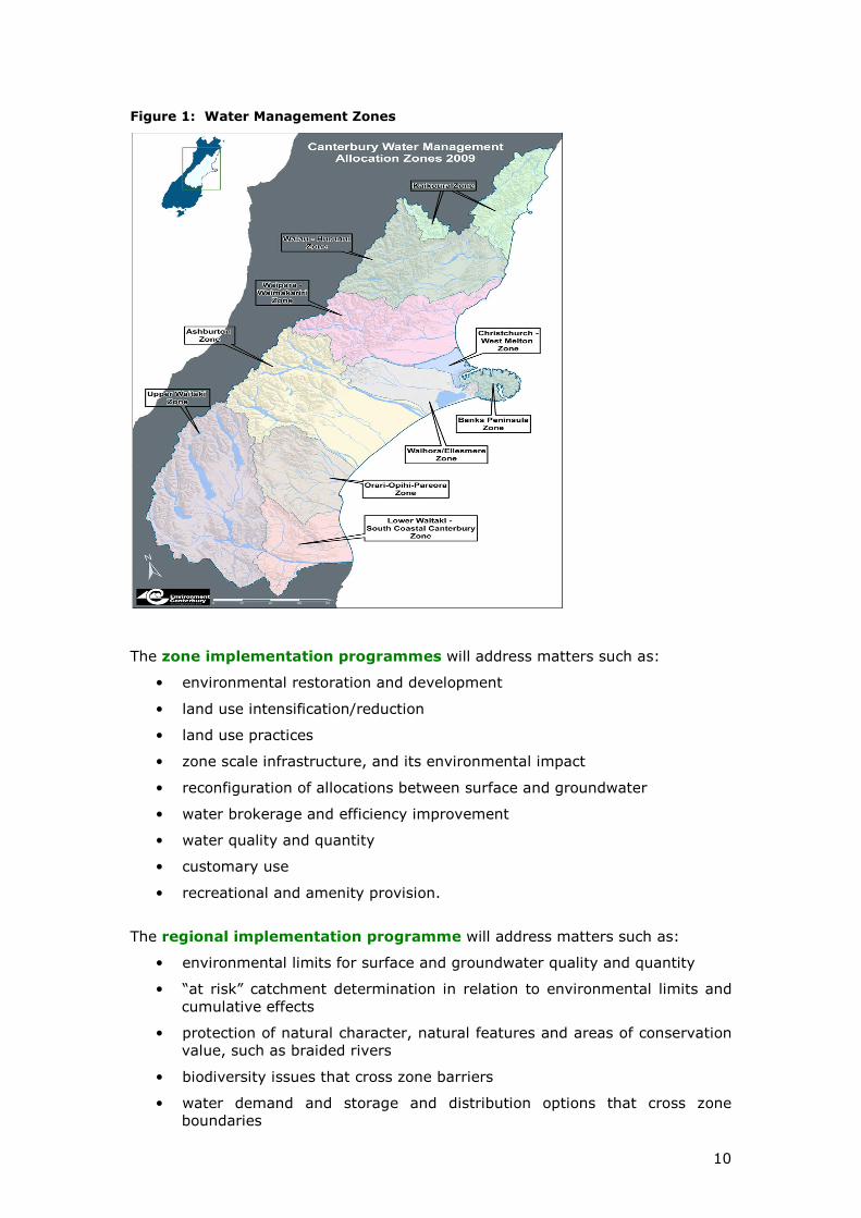
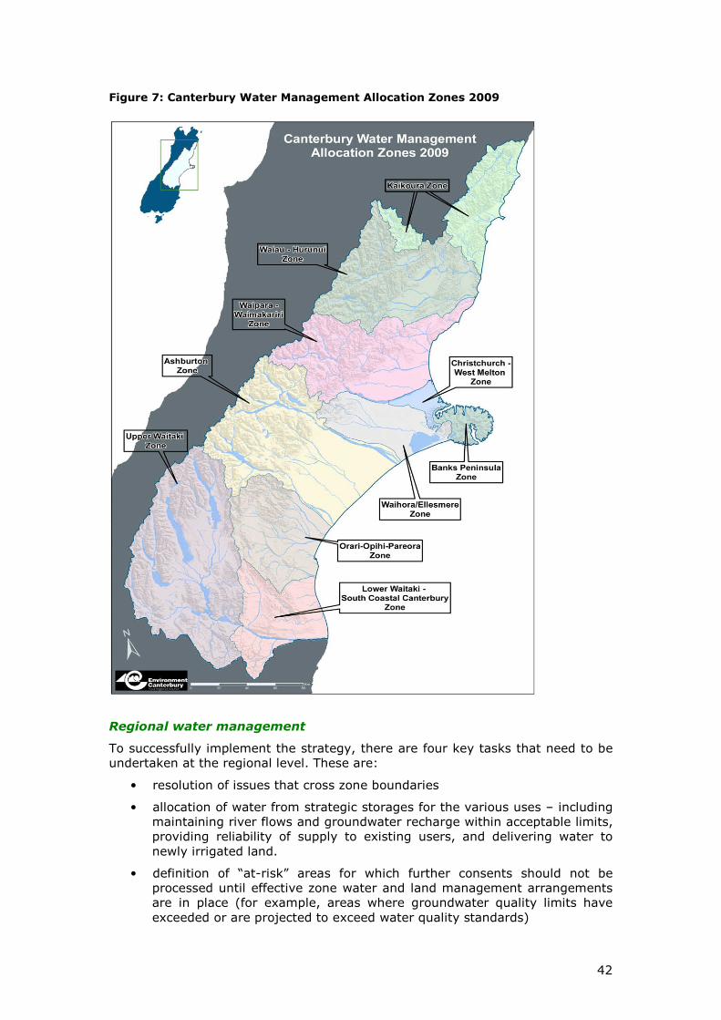
At the locality level 10 water management “zones” are envisaged but not finalised. Each is sufficiently large to enable the management of abstraction from surface and groundwater systems to be integrated with the management of the irrigated areas where the water is used. On the other hand the zone areas are also small enough to avoid becoming remote from local catchment issues or allowing people from outside the relevant area to have a say in matters that are not directly related to their interests. (See Figure 1 below for the proposed water management zones).
We will be holding discussions with those affected in the coming months to finalise the number and boundaries of the zones.
Implementation programmes
Implementation programmes will be developed for each zone and at the regional level. Central government, Ngāi Tahu as tangata whenua, and all relevant stakeholders will be involved in developing the programmes as well as local government. The general public will also be encouraged to influence the development of these programmes.
There will also be regional level of integrated management to deal with regional issues and set the regional context for the zones.
10
Figure 1: Water Management Zones
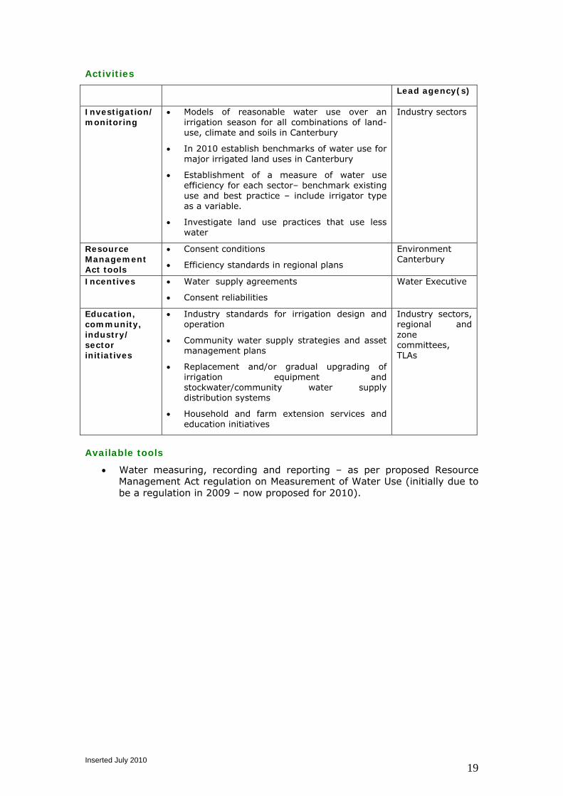
The zone implementation programmes will address matters such as:
• environmental restoration and development
• land use intensification/reduction
• land use practices
• zone scale infrastructure, and its environmental impact
• reconfiguration of allocations between surface and groundwater
• water brokerage and efficiency improvement
• water quality and quantity
• customary use
• recreational and amenity provision.
The regional implementation programme will address matters such as:
• environmental limits for surface and groundwater quality and quantity
• “at risk” catchment determination in relation to environmental limits and cumulative effects
• protection of natural character, natural features and areas of conservation value, such as braided rivers
• biodiversity issues that cross zone barriers
• water demand and storage and distribution options that cross zone boundaries
11
• rules to ensure water allocation is managed in the public interest, includinglevies to fund environmental restoration
• water brokerage, transfer/allocation of consents and charging regimes toencourage reconfiguration of existing consents, and to drive efficiency ofwater use
• ensuring relevant Iwi Management Plans are taken into account in watermanagement planning.
The programmes will be reviewed every three years and rolled forward. They will
avoid over-prescription and instead as far as possible specify performance
criteria, such as nitrate leaching rates, within which land owners should operate.
Incentives and charging mechanisms, rather than compulsion will be used as far
as practicable to deliver change over time.
Water governance structure
At local level a Zone Water Management Committee will be established for each zone to co-ordinate the development of the zone implementation programme. Zone committees will comprise some 7-10 members who are locally based or have a special relationship with the zone3. Members will be drawn from Environment Canterbury, territory authorities with an interest in the zone, Ngāi Tahu/runanga, consent-holder representatives and stakeholders, and respected members of the community. A single person may have several different interests. The Chair will be a stakeholder representative appointed by the Committee. In practice, the members of the Zone Committee will need to create networks around them.
This will be the level at which many decisions affecting water management can be made efficiently and effectively.
A Regional Water Management Committee is also proposed to handle issues that are common across the region or cannot be managed satisfactorily at zone level. This committee of between 10 and 20 people will bring together representatives of local government, central government nominees, Ngāi Tahu and stakeholders. The Chair would be nominated by the Canterbury regional and district councils.
There is also a need for national tripartite forum to address issues that are unlikely to be resolved by the zone and regional committees. These issues include:
• the expression of the rights of Ngāi Tahu as protected by the Treaty ofWaitangi, and the operation of a Treaty based relationship overCanterbury’s water
• integrating the strategy with water conservation orders, national policystatements, national environmental standards
• other national strategic issues, such as the integration of water allocatedfor hydro generation and irrigation.
This Forum would be made up of the relevant Cabinet ministers responsible for the national policy issues together with representatives of Ngāi Tahu and the Canterbury regional and district councils.
3 It will also be possible to co-opt ex officio members onto the committee where expertise is required which is not available from locally based people
12
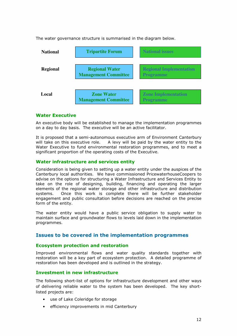
The water governance structure is summarised in the diagram below.
Water Executive
An executive body will be established to manage the implementation programmes on a day to day basis. The executive will be an active facilitator.
It is proposed that a semi-autonomous executive arm of Environment Canterbury will take on this executive role. A levy will be paid by the water entity to the Water Executive to fund environmental restoration programmes, and to meet a significant proportion of the operating costs of the Executive.
Water infrastructure and services entity
Consideration is being given to setting up a water entity under the auspices of the Canterbury local authorities. We have commissioned PricewaterhouseCoopers to advise on the options for structuring a Water Infrastructure and Services Entity to take on the role of designing, building, financing and operating the larger elements of the regional water storage and other infrastructure and distribution systems. Once this work is complete there will be further stakeholder engagement and public consultation before decisions are reached on the precise form of the entity.
The water entity would have a public service obligation to supply water to maintain surface and groundwater flows to levels laid down in the implementation programmes.
Issues to be covered in the implementation programmes
Ecosystem protection and restoration
Improved environmental flows and water quality standards together with restoration will be a key part of ecosystem protection. A detailed programme of restoration has been developed and is outlined in the strategy.
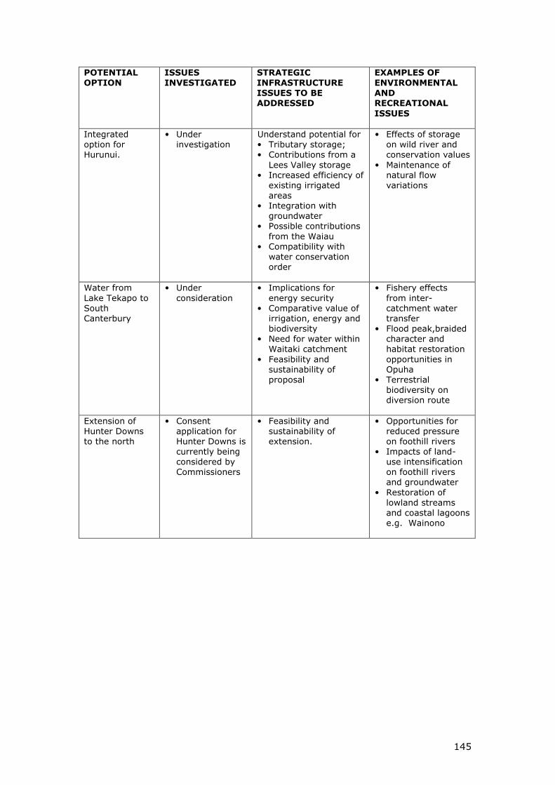
Investment in new infrastructure
The following short-list of options for infrastructure development and other ways
of delivering reliable water to the system has been developed. The key short-
listed projects are:
• use of Lake Coleridge for storage
• efficiency improvements in mid Canterbury
Zone Implementation
Programme
Regional Implementation
Programme
Regional Water
Management Committee
Tripartite Forum National issues
Zone Water
Management Committee
Committees
Regional
National
Local
13
• groundwater storage in Central Plains
• Hurunui integrated option
• Lees Valley storage
• Lake Tekapo water for South Canterbury
• extension of Hunter Downs to north.
The detailed hydrological modelling that has been done has demonstrated that it is likely a combination from the above will be able to meet community needs and provide substantially more water for productive purposes.
There are number of strategic issues still to be resolved. In particular, these projects have yet to receive detailed assessments for consistency with the fundamental principles and the targets, and this may rule them out or significantly reduce their benefits from a purely water-use perspective.
Allocation and use of groundwater
Increasing numbers of wells are being sunk for irrigation purposes in the upper parts of the Canterbury catchments because of the unreliability of flows in the foothill rivers. Unfortunately this groundwater abstraction is reducing the flow of water through the groundwater system down to the aquifers in the lowland areas (not to mention the energy costs of pumping deep water). This in turn is reducing flows into spring-fed streams in the lowland areas, and the problem is being further compounded by surface water abstraction in the lowland areas.
This uncoordinated granting of water consents is damaging the ecosystems of the surface rivers and streams, and water quality in the aquifers. Farmers in the lowland areas are also suffering unreliable water supplies in dry years.
Reconfiguration of water consents in conjunction with additional water from storage will be used to solve this problem. This will make it possible to use stored water for irrigation purposes in the upper part of the catchment instead of groundwater, restoring healthy flows in the lowland streams.
Water allocation and charging regime
The Water Executive in conjunction with the water entity will also develop a charging regime to remunerate the investment in infrastructure and enable supply and demand to be managed in an efficient and effective manner. This will be considered by the regional and zone committees for incorporation in the implementation programmes.
A key issue to be resolved in the implementation programmes will be the charging regime to apply to existing consent holders. Clearly this regime will need to have regard to the value of existing water consents.
Land management practices
The potential for improvements to water quality by changing land management practices is being trialled and monitored in a number of catchments. Diffuse discharges of nitrates and other contaminants are highly dependent on water and land management practices and land use.
There are four key processes within the strategy aimed at addressing improvements in land management:
• working collaboratively with sectors and stakeholders to define andimplement catchment limits for nitrate and other contaminants consistentwith water quality objectives
14
• primary sector initiatives around improved land management including riparian planting and fencing waterways
• zone implementation programmes to address land-use working in collaboration with primary sector initiatives
• linking land-use practice to access to reliable water from new and improved existing infrastructure.
Water use efficiency
Studies show there are substantial gains to be made in on-farm water efficiency – but it is recognised that there is usually a cost in doing so which farmers will naturally weigh against the benefits before changing.
There are already some incentives to improve efficiency and improvements have been, and continue to be made.
A key part of the strategy is to improve the provision of the necessary signals to consent holders and infrastructure providers. There are three key processes within the strategy aimed at addressing water efficiency improvements:
• linking efficiency requirements to access reliable water from new and, in the medium term, improved existing infrastructure
• zone implementation programmes to address water-use efficiency
• a brokering system that would allow inefficient or unproductive use of water to be “bought out” and the water reallocated for environmental purposes, or for more efficient irrigation uses.
• localised transfer of water allocations between consent holders will continue to be possible, subject to safeguards to prevent unintended consequences for the environment or other users.
Implications for hydro-electricity generators
Co-operation and participation from hydro-electricity generators will be critical to the success of the strategy. For instance, where hydro electricity impacts on the natural character of waterways, adequate mitigation will be essential. As with other consent holders, there is no intention to change consents for hydro-electricity generation without consent-holder agreement.
There could be some positive opportunities to improve integration between the energy and irrigation sectors. Essentially the implementation programmes will constrain how the generators will supply water for irrigation purposes if they choose to do so. It is unlikely to affect the operation of existing consents for electricity generation unless there is agreement to do so by the consent holder.
Auditing and enforcement
Mechanisms will be introduced to improve monitoring performance including:
• audited self-management programmes to encourage farmers and others to monitor and improve their own performance, to demonstrate their cumulative environmental effects are within acceptable environmental limits
• the operation of a performance rating system by Environment Canterbury to assess performance of property owners at below standard/above standard/excellent and publish the results
• reduced water charges for those rated “above standard” or “excellent” - this would provide an incentive for “better than compliance” performance by abstractors.
15
Legislative implications
Planning activities will be carried out in “nested” zone/regional/national levels where issues can be allocated to the most appropriate level for consideration while ensuring coherence between the levels.
Overall there will be an increase in pre-planning activity (informal processes) and a reduction in the need for hearings and other formal processes. This should produce better outcomes with less compliance costs.
Existing powers and/or new legislation will be used to ensure the implementation programmes are given appropriate legal status under the Local Government Act and the Resource Management Act, and effectively provide a link between the two Acts.
The key objective will be to provide long term planning stability. The implementation programmes will be social contracts in which all parties agree on a balanced way forward that will enable community and economic wellbeing whilst safeguarding the ecosystems on which they depend. Once the programmes have been put in place stakeholders and investors must both be confident that all elements will be delivered in their entirety. Legal processes that follow in the wake of the adoption of the programmes should not be allowed to undermine this balanced, holistic approach to managing water resources in each zone and across the region as a whole.
Next Steps
This document provides the broad outline of the Canterbury Water Management Strategy’s vision for the operation of water management for Canterbury. However there are number of important details still to be decided. These will be resolved in implementation projects which will take each of the elements of the strategy through a design, development and implementation process.
Stakeholders will be engaged throughout this process and the results will be written up in progress papers, which will be published on the website and notified through the e-newsletter. The immediate programme of development is:
• Legal powers – discussions with the Government, to be completed byFebruary 2010
• Zone and regional water management committees – Onceendorsement is gained from the councils and Te Rūnanga o Ngāi Tahu thenext move would be the appointment of the zone and regional committeesand getting them working by March 2010
• Targets – further work with stakeholders, targets to be finalised inDecember 2009
• Economic assessment – refine model and datasets behind it byDecember 2009
• Endorsement – of the Canterbury regional and district councils and TeRūnanga o Ngāi Tahu for the strategy by March 2010
• Water Executive – establishment of the executive by February 2010
• “Immediate Steps” ecosystem protection and restoration programme – planning underway, to be completed by March 2010
16
• Regional Policy Statement – release revised water chapter forconsultation with stakeholders under the Resource Management Act byDecember 2009
• Environmental limits - ongoing implementation of environmental limits(environmental flows and water quality) through RMA plans, developedwith community and stakeholder collaboration
• Supply-side arrangements – develop a feasibility proposal and businessplan/model around a Water Infrastructure and Services Entity byDecember 2010.
Monitoring implementation of the strategy
Monitoring progress against the strategy’s targets will be critical to ensuring that the strategy is able to adapt to changing circumstances and new information, while at the same time maintaining the confidence and trust of all the parties.
Accordingly the Mayoral Forum, in partnership with Ngāi Tahu, will formally review progress with implementing the strategy and delivering outcomes against the targets on an annual basis. The first review will be completed by the end of 2010.
17
Section 1 Role of the strategy
Need for a strategy
Canterbury’s water resources are vitally important to the region and to the nation. Lakes, rivers, streams and aquifers are used for hydro electricity generation, agricultural production and drinking water, as well as for a range of customary and recreational uses.
In addition, water is considered an essential and integral part of the connection between Ngāi Tahu, as indigenous peoples of the region, and their tribal territory. Wai Māori, or fresh water, is considered a taonga4 of supreme importance within the Ngāi Tahu worldview. The life-giving and life-sustaining properties of water are intrinsically linked to the spiritual, cultural, environmental and social wellbeing, survival and identity of Ngāi Tahu whānui.
In recent years Canterbury’s water resources have been coming under pressure from increasing demands from these various uses. Aquatic health of lowland streams and groundwater quality has continued to decline, there has been a loss of cultural and recreational opportunities, and the availability of water for use by agriculture is becoming less reliable.
Along with number of deficiencies in the execution of the Resource Management Act over many years there has been a lack of clear policy and direction in the management of water, largely as a product of the applicant driven approach to implementation of the Resource Management Act. There is little (or no) meaningful reflection of kaitaikitanga values in formal decision making processes. In order to implement the strategy, local government is faced with difficult challenges within the current legislation framework.
There is now a widely held view among stakeholders and the general public that continuing along the present path for managing water will lead to unacceptable environmental, social, cultural and economic outcomes.
The Canterbury Water Management Strategy is an initiative of the Canterbury Mayoral Forum to provide a strategic response to this situation. The work done by the Forum has demonstrated that there is a way forward that will progressively improve the management and use of water resources to maximise the opportunities for the environment, economy and community of Canterbury.
The problems are complex and multi-layered. Ongoing leadership will be required at local, regional and national levels, and the different interest groups will need to cooperate over a sustained period of years to make it happen.
This strategy therefore provides a long-term direction for the management of all water in the region, combining current and contemplated projects and activities. It will integrate infrastructure, environmental flows, water quality, land-use, water allocation, ecosystem protection and restoration, and demand management.
Key elements of the strategy include a governance framework, use of private sector and community skills and initiative, implementation programmes that will evolve and adapt to changing circumstances, and measurable targets to enable progress to be monitored over time.
4 Taonga – Treasure, things highly prized and important to tangata whenua.
18
The status of the strategy
Essentially this is a leadership document. Successful water management will be dynamic. This document is intended to set off a programme of activity which will in turn set off further actions and cumulatively a solution will be arrived at.
The Ministers of Agriculture and Environment have been closely engaged throughout the development of the strategy and have given their support to the strategy development exercise and its general thrust.
The strategy will also serve as a guiding document for ongoing collaboration between Ngāi Tahu and other key decision makers within the territory. As signatories to the Treaty of Waitangi, and indigenous peoples to Te Waipounamu, Ngāi Tahu are acknowledged as having mana whenua5 in relation to their traditional tribal territory. The nature of this mana includes, among other rights, kaitiakitanga status in relation to water and waterways throughout the tribal territory.
The Ngāi Tahu Claims Settlement Act 1998 contains a number of mechanisms which seek to improve the effectiveness of Ngāi Tahu’s participation in the management of freshwater ecosystems. In addition resource managers have to meet the obligations set out in Part II of the Resource Management Act 1991. Part 2 requires that anyone exercising functions and powers under the Act shall ‘recognise and provide for’ matters of national importance including “the relationship of Māori and their cultures and traditions with their ancestral lands, water, sites, wāhi tapu and other taonga” (s6). They are also required to have particular regard to kaitiakitanga.
Furthermore the Resource Management Act requires that “in relation to managing the use, development and physical resources”, anyone exercising functions and powers under the Act “take into account the principles of the Treaty of Waitangi (Te Tiriti o Waitangi)” (s8).
This document presents an analysis of the scientific data from technical reports and the advice and opinion from public consultation and makes extensive recommendations for change.
The body of the document describes the proposals. To maintain the flow of the strategy in the main body, the detail has been transferred to annexes. The key points of the strategy appear at the front of the document in the executive summary.
Because the subject is complex and the solutions are evolutionary there are significant remaining areas of investigation and planning to be completed. These have been specifically identified in Section 7 (Next Steps) and will be the subject of continuing work until they are resolved.
How the strategy has been developed
The Mayoral Forum, which is chaired by Mayor Bob Parker of Christchurch City Council, comprises the Mayors and Chief Executives of the city and district councils, and the Chairman and Chief Executive of the Regional Council. The Forum has provided overall leadership for the project. The Steering Group, which
5 Mana whenua Traditional authority – determined by whakapapa (genealogical ties) and applies to a particular area or resource.
19
reports regularly to the Mayoral Forum, developed the strategy and recommended it to the Mayoral Forum.
The Steering Group was chaired by Mayoral Forum member Mayor Bede O’Malley (Ashburton District Council) and included representatives of local and central government and tangata whenua and community group representatives including environmental, farming, industry, and recreational interests. The Steering Group was supported by an expert Officials Group drawn from central and local government.
More details of the membership of the Mayoral Forum, the Steering Group and the Officials Group are at Annex A.
The preparation of the strategy has been in four stages:
• the first stage looked at potential demands and availability of waterresources, the water resources that would come under most stress, andthe reliability, over the long term, of water supplied from natural systemsfor abstractive use
• The second stage identified potential water storage options in Canterburyand their hydrological feasibility, including the area they could irrigate andtheir impacts on river flows
• The third stage involved a preliminary evaluation by stakeholder groups ofthe environmental, social, cultural and economic impacts of the waterstorage options identified in stage two. This established that to securecommunity support for new water storage, rigorous scientific and publicconsideration was required in the following areas:
o the impacts of land-use intensification and its effects on waterquality
o mitigation and management systems for water quality
o ways of safeguarding recreation and ecological values
o methods for maintaining or improving flow variability and low flowsin major rivers
• The fourth and final stage involved further stakeholder and communityengagement in the latter half of 2008, and in March and April of 2009, andpublic consultation on strategic options over May and early June this year.Around 1100 submissions were received with over 100 heard at publicsessions by Steering Group members. The responses received played asignificant role in the formulation of the chosen approach. Sustainabilityappraisal of options was carried out.
To inform these various stages of the strategy development a number of strategic investigations were set in train including:
• impact of land use intensification on water quality
• identification of priority ecosystem restoration programmes
• storage options that are most likely to be sustainable
• efficiency and ecological enhancements through integrated watermanagement
• economic modelling of production and ecosystem services
• governance structures for sustainable management.
20
Vision - what would success look like?
The desired outcome of the strategy has been agreed by the Mayoral Forum as:
To enable present and future generations to gain the greatest social,
economic, recreational and cultural benefits from our water resources
within an environmentally sustainable framework
If the strategy is successful, the following features should be evident in 10 years:
• people will feel they are being treated fairly and involved in decision-making
• allocation decisions will be resolved in most cases without resorting to thecourts
• there will be a high level of audited self management, and complianceaction will be targeted on a minority of non-complying water users
• ecosystems, habitats and landscapes will be protected and progressivelyrestored, and indigenous biodiversity will show significant improvement
• water quality will be protected and starting to return to within healthylimits for human health and ecosystems
• opportunities to exercise kaitiakitanga6 and rangitiratanga7 will beoperative, and increasing
• opportunities for recreational activities will be returning and improving
• water users will have access to reliable water, which will be used efficientlyand productively
• primary production and employment will be increasing, and the net valueadded by irrigation to the Canterbury economy and the national balance ofpayments will be increasing
• opportunities for tourism activities based on and around water will bereturning and improving, and the net value to Canterbury’s economy fromthese activities will be increasing
• efficiency in the use of energy will be improving and renewable electricitygeneration will be well integrated with irrigation infrastructure
• rural community viability will be improving and community cohesion willbe maintained
• understanding and empathy between rural and urban dwellers will beincreasing
• the water management system will be better able to adapt to climatechange in the future.
6 Kaitiakitanga. Traditional guardianship - the active protection and responsibility for
natural and physical resources by tangata whenua 7 Rangitiratanga - having the mana or authority to exercise the relationship between Māori, and their culture and traditions, with the natural world. Iwi management plans and the active involvement of tāngata whenua in resource management decision- making processes are practical expressions of rangitiratanga
21
Principles that must be met
Fundamental principles have been developed to underpin the strategy. These are set out in Annex B. They comprise:
• supporting principles – natural character, indigenous biodiversity, access,quality drinking water, recreational opportunities, and community andcommercial use.
First and foremost our water resource must be sustainable. This means water quality and water levels and flows must be maintained for future generations. Both surface and groundwater must be given equal importance.
Second, the Mayoral Forum has quite deliberately set priorities. So the first order priorities are environment, customary use, community supplies and stock water. The second order priorities are irrigation, renewable electricity generation, recreation and amenity. This prioritisation has been strongly influenced by the stakeholder consultation undertaken to date.
The principles seek a consistent approach across the region, recognising Ngāi Tahu traditional and cultural guardianship to all water and lakes, rivers, waterways and wetlands.
The intention is that the strategy must address these principles. Some of the principles will be included in rules or standards, while others will be incorporated into targets.
22
Section 2 Key challenges
Canterbury’s dependence on water
Canterbury is a region with a high dependency on both the quality and quantity of its water.
Water creates and sustains Canterbury’s world-famous braided rivers, high country and coastal lakes, and lowland streams and wetlands. The region’s groundwater systems provide a high quality drinking water supply to many settlements including its major city, Christchurch, and flows to lowland ecosystems. This aquatic system has developed an ecology that is sensitive to flow variability and the contaminants generated by land use practices in the catchment areas.
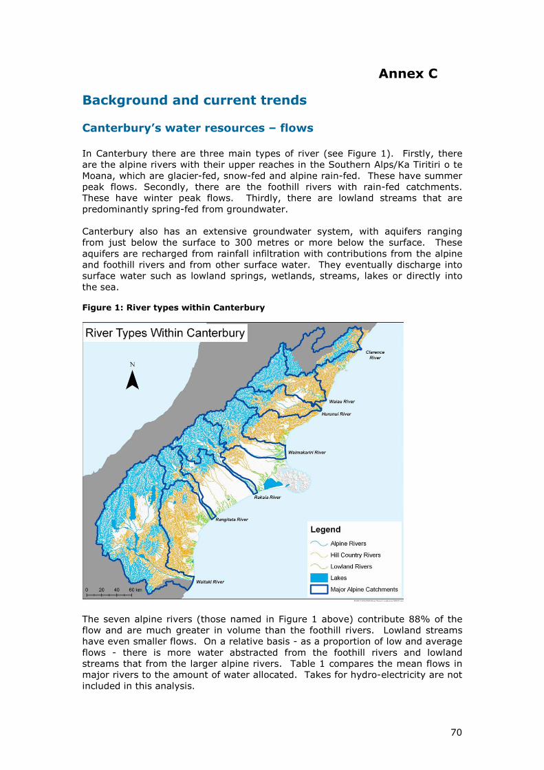
There are three main types of river (see Figure 1 below). Firstly, there are the alpine rivers with their upper reaches in the Southern Alps/Ka Tiritiri o te Moana, which are snow-fed and alpine rain-fed. These have early summer peak flows. Secondly, there are the foothill rivers with rain-fed catchments. These have winter peak flows. Thirdly, there are lowland streams that are spring-fed from groundwater.
Figure 1:
Canterbury also has an extensive groundwater system, with aquifers ranging from just below the surface to 300 metres or more deep. These aquifers are recharged from rainfall infiltration with contributions from the alpine and foothill rivers and from other surface water. They eventually discharge into surface water such as lowland springs, wetlands, streams, lakes or directly into the sea.
23
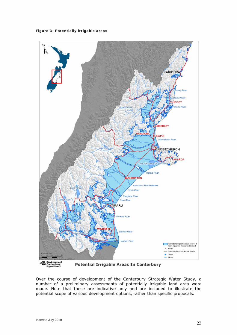
The seven alpine rivers (those named in Figure 1 above) contribute 88% of the flow from Canterbury’s rivers, and are much greater in volume than its foothill rivers. Lowland streams have even smaller flows. Over recent years Canterbury’s agricultural sector has made increasing use of water to increase productivity. The irrigated area in Canterbury is 500,000 ha8, which contributed an estimated net $800 million at farmgate9 (see Table 1 below) to national GDP and $1.1 billion of exports in 2007/08.
Table 1 - Contribution of irrigation to farmgate GDP
Canterbury Net farmgate
GDP
Irrigated Area
(hectares)
$GDP farmgate
per irrigated hectare
2002 $335m 287,000 $1200
2008 $800m 500,000 $1700
The Canterbury region now allocates 58% of total water allocated in New Zealand, and has 70% of the country’s irrigated land and 65% of the nation’s storage capacity for hydroelectricity. On a relative basis - as a proportion of low and average flows - there is more water abstracted from the foothill rivers and lowland streams than from the larger alpine rivers. Not only is Canterbury the region with the greatest allocation of water in New Zealand, it is also the region with the highest dependency on irrigation during dry periods. With relatively low rainfall, high temperatures, and strong winds Canterbury experiences high levels of evaporation. These climatic factors are reflected in its “potential evaporation deficit”, which is the highest in the country.
Key issues
Pressure on river systems
Environmental flows in Canterbury’s rivers need to be maintained if river character, ecosystems and recreational uses are to be protected. The following types of flows need to be considered while retaining the general shape and nature of the flow duration curve over the course of the year:
• low flows – river ecosystems can tolerate occasional low flows but if these low flows occur frequently the ecosystems will decline
• flushing flows – sufficiently frequent flushing flows (typically about three times the mean flow) are needed to dislodge and prevent build up of algae
• flood flows – sufficiently frequent flood flows (greater than once a year) are needed to ensure turnover of gravel in the river bed in order to maintain the braided character of Canterbury’s major rivers.
8 Environment Canterbury has consented 600,000ha for irrigation. Some consented areas are not irrigated, and some land comes under more than one consent. From satellite mapping, about 80% of this is believed to be irrigated. Agricultural Production Statistics 2007 identify 390,000ha of irrigation in Canterbury. 9 Farmgate GDP is almost the same as the revenue minus costs of production, before the value added in processing etc beyond the Farmgate. The $800m is the sum of the dairy, arable, horticulture and pastoral production in the table, minus the value that would have been produced without irrigation ($220m) to give a net GDP from irrigation.
24
Run-of-river takes are near the limit of what can be abstracted while maintaining acceptable flows. Restrictions are already widely in use. Table 2 sets out the number of rivers on restriction during January 2006 for the different river types. The greatest pressure is on lowland streams and this is reflected in restrictions imposed.
Table 2: Withdrawal restrictions during January 2006
Number of rivers with withdrawal restrictions
Lowland Streams
28 of 57 on partial or full restriction
Foothill Rivers
13 of 36 on partial restriction
Alpine Rivers
2 of 7 on partial restriction
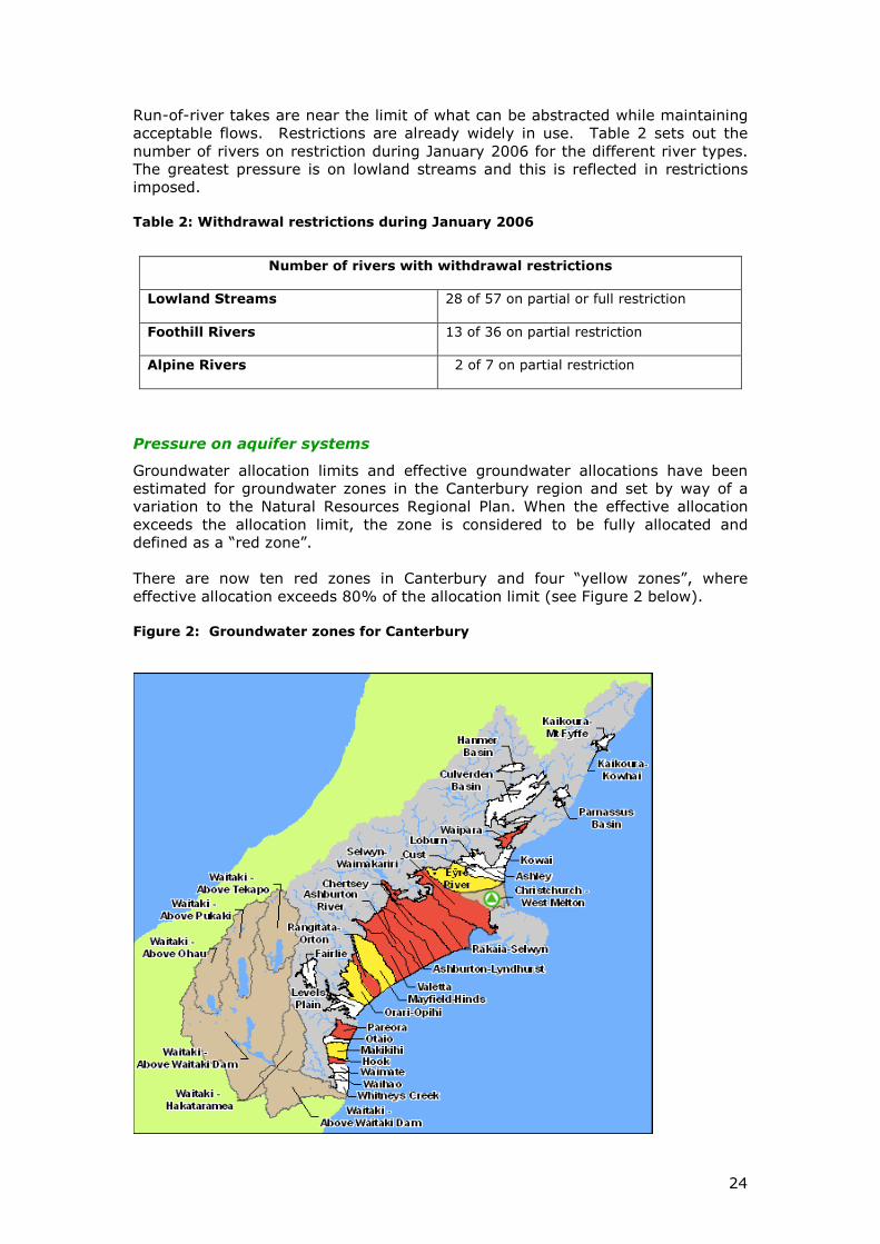
Pressure on aquifer systems
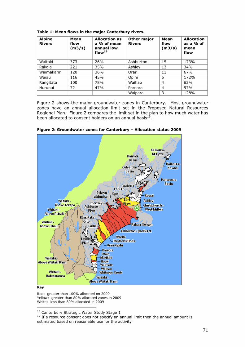
Groundwater allocation limits and effective groundwater allocations have been estimated for groundwater zones in the Canterbury region and set by way of a variation to the Natural Resources Regional Plan. When the effective allocation exceeds the allocation limit, the zone is considered to be fully allocated and defined as a “red zone”. There are now ten red zones in Canterbury and four “yellow zones”, where effective allocation exceeds 80% of the allocation limit (see Figure 2 below). Figure 2: Groundwater zones for Canterbury
25
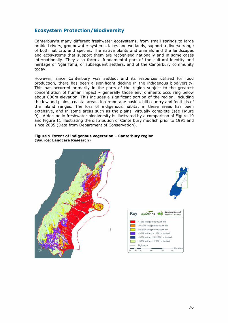
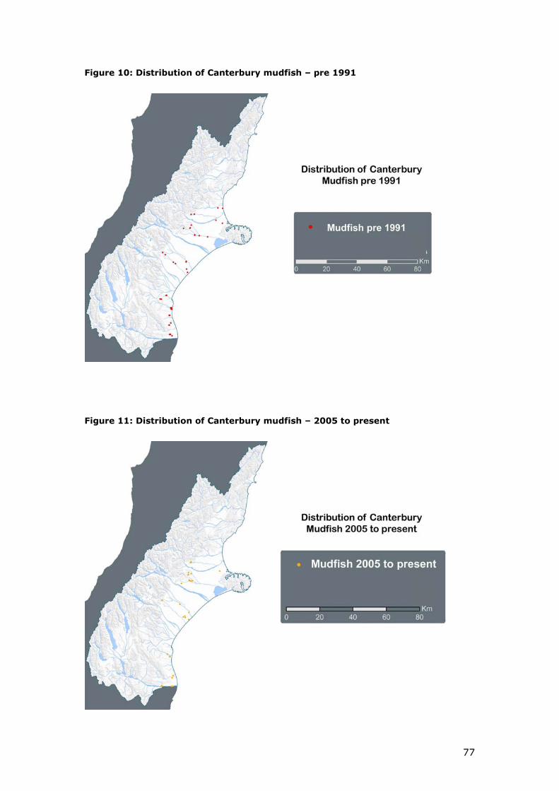
Cumulative effects on ecosystems
Canterbury’s many different freshwater ecosystems, from small springs to large braided rivers, groundwater systems, lakes and wetlands, support a diverse range of both habitats and species. The native plants and animals and the landscapes and ecosystems that support them are recognised nationally and in some cases internationally. They also form a fundamental part of the cultural identity and heritage of Ngāi Tahu, of subsequent settlers, and of the Canterbury community today.
Results of monitoring the aquatic ecosystem health in Canterbury lowland streams, indicates declining health (see Annex C) in a number of key areas:
• in lowland and coastal areas, remaining indigenous vegetation tends tooccur in small, scattered fragments
• less than 10% of the region’s previously extensive wetlands remain
• there is a general decline in freshwater biodiversity
• in parts of the hill and high country, accelerating land use change andintensification is threatening the important indigenous habitat thatremains.
The situation has been exacerbated by a combination of a series of dry winters for the period 2000 to 2005, with low recharge of the aquifers which feed the lowland streams, and increasing levels of abstraction from groundwater. This illustrates the vulnerability of Canterbury’s lowland streams with current levels of abstraction.
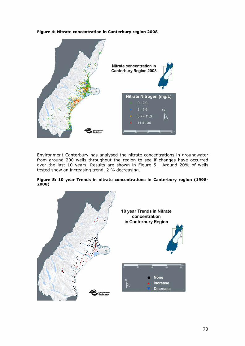
One of the prime concerns with land use intensification is the potential for water quality impairment, in particular nitrate contamination of surface water and groundwater. Water quality is an important component of freshwater ecosystems but its quality is also critical for its human and stock uses. In 2008/9, 10% of wells monitored by Environment Canterbury had nitrate levels that exceed the New Zealand Drinking Water Standard. Nitrate concentrations in surface waters are also higher than acceptable concentrations based on criteria for toxicity to fish and the avoidance of nuisance plant growths.
Cultural health of waterways
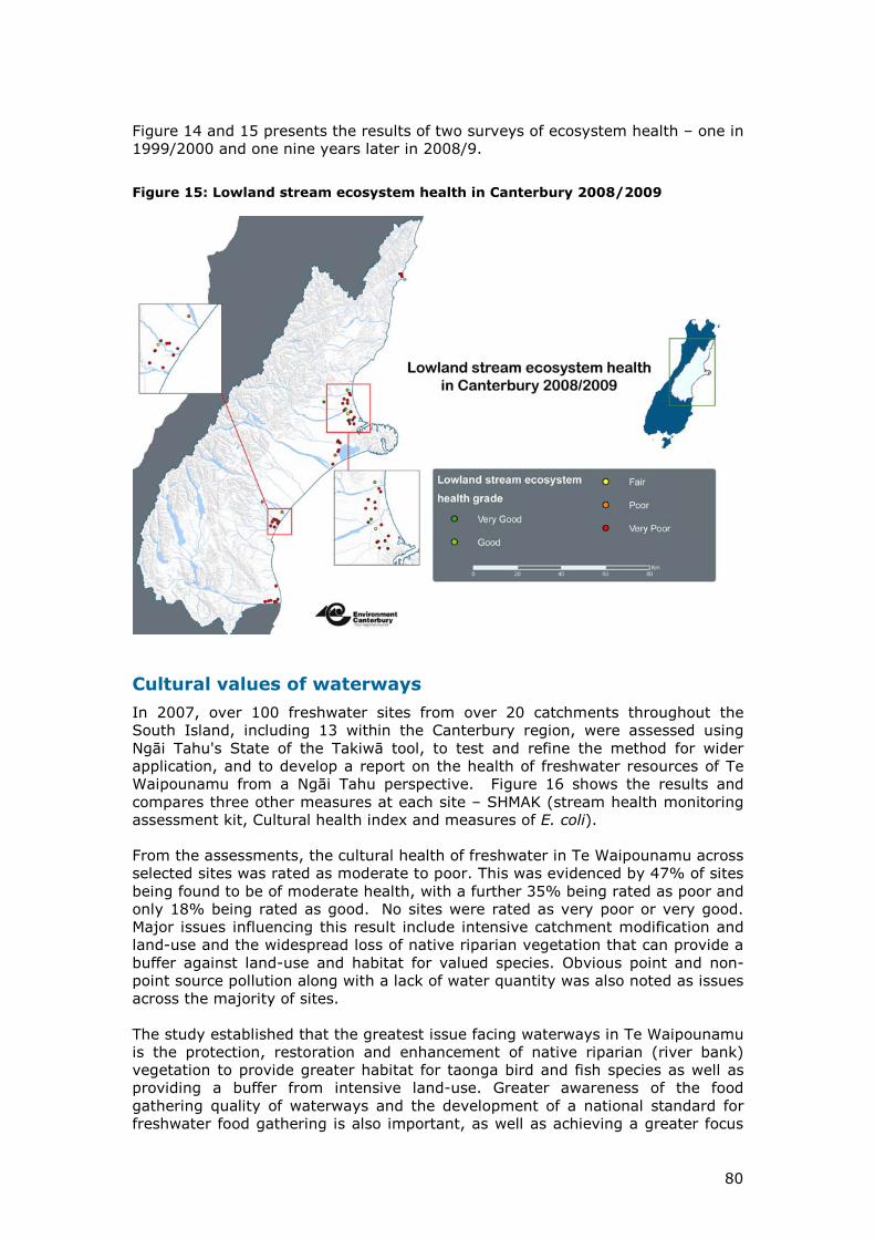
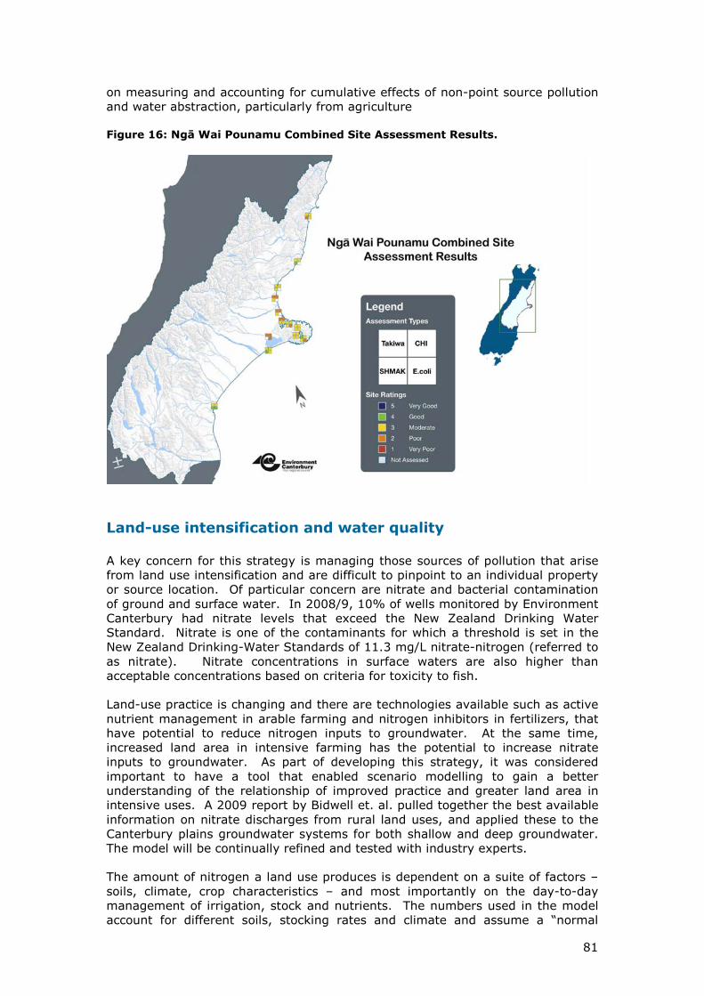
In 2007, over 100 freshwater sites from over 20 catchments throughout the South Island, including 13 within the Canterbury region, were assessed using Ngāi Tahu's State of the Takiwā tool. From the assessments, the cultural health of freshwater in Te Waipounamu across selected sites was rated as moderate to poor.
Major issues influencing this result include intensive catchment modification and land-use and the widespread loss of native riparian vegetation that can provide a buffer against land-use and habitat for valued species. Obvious point and non-point source pollution along with a lack of water quantity were also noted as issues across the majority of sites.
The study established that the greatest issue facing waterways in Te Waipounamu is the protection, restoration and enhancement of native riparian (river bank) vegetation to provide greater habitat for taonga bird and fish species as well as providing a buffer from intensive land-use. Greater awareness of the food gathering quality of waterways and the development of a national standard for freshwater food gathering is also important, as well as achieving a greater focus on measuring and accounting for cumulative effects of non-point source pollution and water abstraction, particularly from agriculture.
26
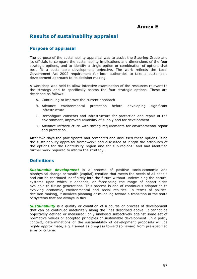
Water use efficiency
As water availability is coming under pressure, it is important to consider the efficiency of water use for irrigation purposes from a demand management perspective. Improvements in the efficiency of water use would enable existing water allocations to be used to restore river flows and groundwater recharge, reducing the extent to which investment would be needed in water storage facilities, with their inherent environmental and social impacts and high capital costs.
There are some substantial efficiency gains that can be made by addressing efficiency at property, scheme and catchment scale in an integrated way. The key is to improve the reliability of the supply so that the availability of water can be matched more precisely to the needs of the crop or pasture being irrigated. This in turn encourages greater investment in improving efficiency of water use on farms. Recent development on farms served by the Rangitata Diversion Race has demonstrated the benefits.
In town or city supplies there is potential to reduce consumption. Christchurch has a relatively high per capita consumption of water, which can be addressed through supply-side management (such as leaking control) or demand-side management (such as incentives for water-efficient devices)10. Stock water systems are another area where there is potential for efficiency improvements, particularly when the design of these delivery systems is incorporated into irrigation infrastructure.
Stage 4 of the Canterbury Strategy Water Study illustrated the potential gains from a combination of property, scheme and catchment efficiency measures for mid- Canterbury. The study found that if all efficiency gains were realised then the size of storage needed to provide reliable irrigation to the district is one-third of that needed if no efficiency gains were made.
Achieving these benefits will require a far more substantial improvement in the scale and extent of efficiency than is currently occurring.
Future trends
Reliability of the supply of agricultural products to customers overseas and
environmental integrity are likely to be increasingly important factors in New
Zealand exports in the future. New Zealand will increasingly need to seek a
higher price for each unit of production. Providing the quantity and quality of
product the market seeks, with the level of environmental integrity demanded in
that market, will be vital in the years ahead.
However, projections of climate change suggest:
• generally more variable rainfall within any year (and therefore furtherreductions in reliability)
• decreases in winter rainfall on the east coast (and therefore a decrease ingroundwater recharge from rainfall)
• increases in rain in the Alps and less snow (and therefore reduced summerbase flows and greater variability of flows in alpine rivers).
10 Christchurch City Council Water Supply Strategy 2009
27
Thus, on the demand side, the region will become drier and need more irrigation simply to maintain existing outputs from the land. On the supply side, the natural systems for delivering water will become less reliable and therefore less able to support current levels of output. Furthermore, there are increasing expectations in relation to environmental quality, integration of kaitiakitanga across all areas of water management, increased recreational and cultural opportunities, further irrigation and land use intensification, and additional renewable energy generation. If current trends are allowed to continue, therefore, the pressures on Canterbury’s water management system will increase. Figure 3 below summarises what the worsening future supply and demand situation if current trends continue.
Figure 3: Summary Map of Supply and Demand Situation in Canterbury (Source: Stage 1 Canterbury Strategic Water Study)
Legend
Striped blue - Demand can be reliably met from groundwater
Striped green - Demand can be reliably met from groundwater with the proviso that there is some plains irrigation which enhances recharge
Blue - Demand can be reliably met from run of river supply
Green - Unreliable run of river. Supply/demand ratio in worst irrigation season >1. Minimal storage needed.
Yellow - Supply/demand ration in worse case year >1. Moderate storage needed. Require river flows outside irrigation season to fully replenish storage.
Orange - Average annual supply/demand rate >1. Storage possible but less likely. Large storage required which would not fully replenish every year.
Red - Average annual supply demand ratio <1. No amount of storage replenished from within the zone can provide for the demand.
Grey - There is insufficient data to compare with demand
28
Implications of further land use intensification
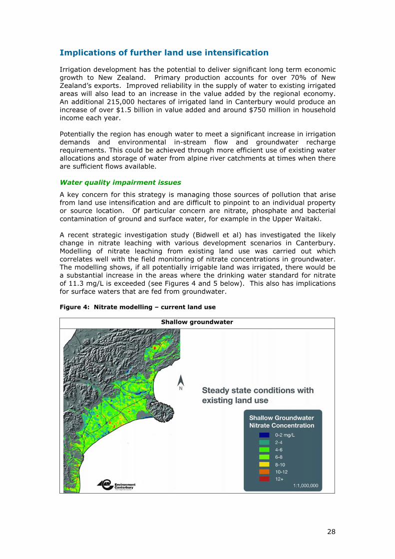
Irrigation development has the potential to deliver significant long term economic growth to New Zealand. Primary production accounts for over 70% of New Zealand’s exports. Improved reliability in the supply of water to existing irrigated areas will also lead to an increase in the value added by the regional economy. An additional 215,000 hectares of irrigated land in Canterbury would produce an increase of over $1.5 billion in value added and around $750 million in household income each year. Potentially the region has enough water to meet a significant increase in irrigation demands and environmental in-stream flow and groundwater recharge requirements. This could be achieved through more efficient use of existing water allocations and storage of water from alpine river catchments at times when there are sufficient flows available. Water quality impairment issues
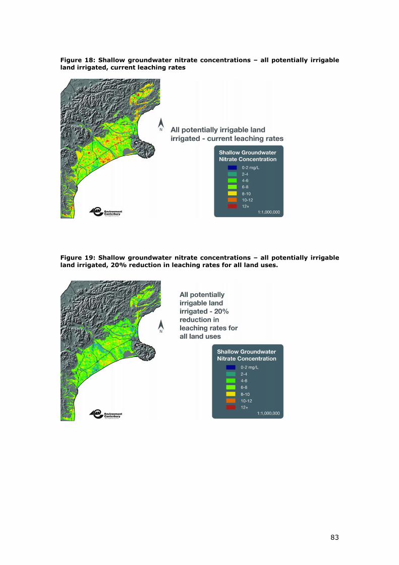
A key concern for this strategy is managing those sources of pollution that arise from land use intensification and are difficult to pinpoint to an individual property or source location. Of particular concern are nitrate, phosphate and bacterial contamination of ground and surface water, for example in the Upper Waitaki. A recent strategic investigation study (Bidwell et al) has investigated the likely change in nitrate leaching with various development scenarios in Canterbury. Modelling of nitrate leaching from existing land use was carried out which correlates well with the field monitoring of nitrate concentrations in groundwater. The modelling shows, if all potentially irrigable land was irrigated, there would be a substantial increase in the areas where the drinking water standard for nitrate of 11.3 mg/L is exceeded (see Figures 4 and 5 below). This also has implications for surface waters that are fed from groundwater.
Figure 4: Nitrate modelling – current land use
Shallow groundwater
29
Figure 5: Nitrate modelling – full intensification of land use
Shallow ground water
The groundwater systems have a limit on how much nitrogen (or other contaminants) can go into them before drinking water standards and surface water quality is exceeded. If there are to be substantial increases in land-uses associated with nitrogen leaching, then there must be a corresponding decrease in nutrient leaching from existing land.
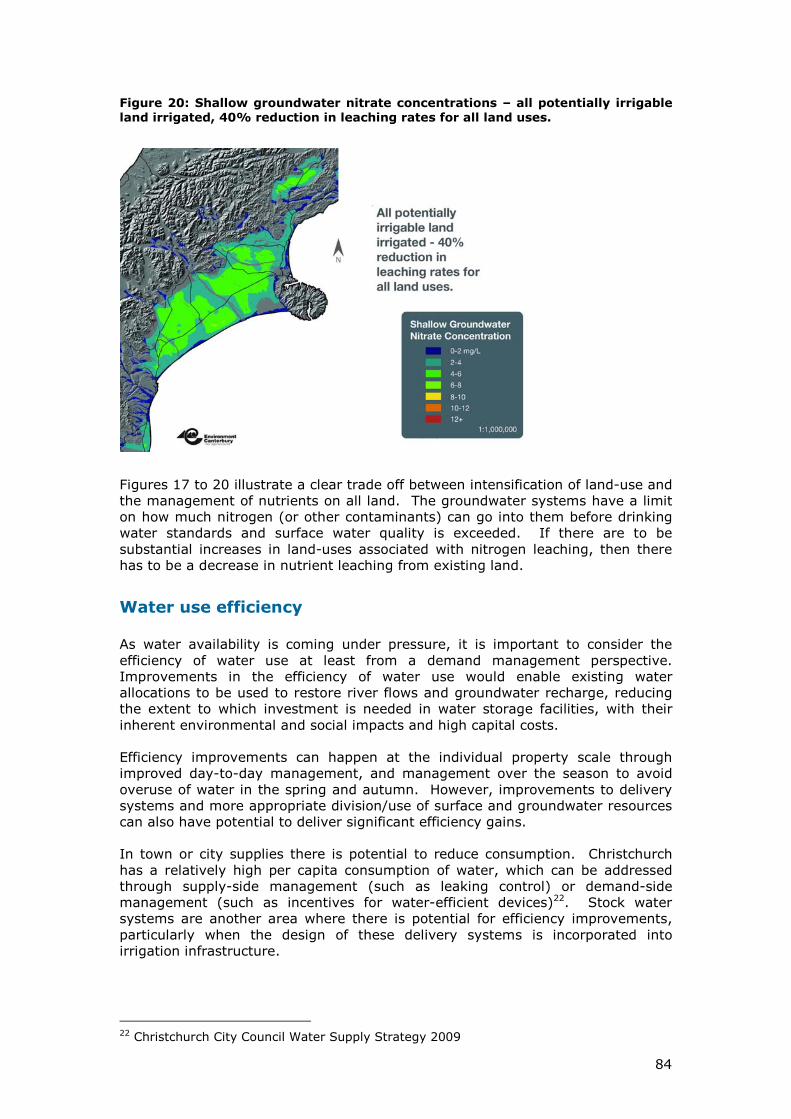
Figure 6 below shows the modelling results for full intensification of irrigable land assuming a 20% reduction in nitrate discharges is achieved through improved land management practices.
This illustrates a clear trade-off between intensification of land-use and the management of nutrients on all land. Since it is technically and economically feasible to achieve a 20% reduction in nitrate discharge rates, the modelling suggests it will be possible to substantially increase agriculture output while maintaining groundwater quality within acceptable limits as long as nitrogen inhibiting technologies are applied across the region.
To achieve this outcome will require existing users of water as well as new users to adopt the improved land management practices. Land-use practice is changing and there are technologies available such as active nutrient management in arable farming and nitrogen inhibitors in fertilisers that have potential to reduce nitrogen inputs to groundwater. Use of spray irrigation similarly reduces leaching.
30
Figure 6: Nitrate modelling – full intensification with a 20% reduction in discharge rates
Shallow ground water
A significant issue for water management in Canterbury, therefore, will be the need for integration of land use with water quality and quantity, requiring close co-operation between the regional council, territorial authorities and the primary production sector.
Infrastructure issues
With the current inefficiencies in the use of water, a huge investment in infrastructure would be needed to provide enough water to restore environmental flows to surface and groundwater systems, ensure reliable supplies for existing users, and deliver additional water for further land use intensification. Even if resource consents could be obtained for new infrastructure on this scale it would be uneconomic to build. The high costs of financing the investment would price Canterbury’s agricultural products out of international markets. To be viable, therefore, new infrastructure must be introduced in conjunction with much more efficient use of water, both by existing users and new users. This will reduce the scale of new infrastructure that has to be built to manageable levels. Mechanisms will also be needed to encourage water to be transferred from low value use to uses that will produce the highest return to the economy. A further issue is the irrigation industry’s capacity to finance, build and operate the next generation of storage and distribution infrastructure. Current attempts to build new water storage facilities and distribution systems - as a way of providing additional, reliable water - are being stymied by the risks associated with obtaining the necessary resource consents and the high up-front capital costs.
31
There are 34 irrigation schemes in Canterbury over 500 hectares. Most of them were originally funded with substantial public sector capital assistance. They are relatively small and were established with the needs of particular catchments and localities in mind. As currently configured their governance and funding structures are not generally suited to achieving the economies of scale which will be necessary if the infrastructure investment is to be economically viable, nor to providing environmental flows and the other features that will make them environmentally acceptable.
To deliver the next generation of irrigation schemes in Canterbury, new ways must be found to harness the knowledge and experience of existing irrigators in conjunction with external world class engineering, financial and management resources.
Will the current approach address the problems and deliver
the desired outcomes?
The current method for allocating water requires property owners to seek resource consent under the Resource Management Act. Applications are assessed for their individual effects on the environment and other water users and consent conditions are imposed to mitigate adverse environmental impacts.
While there was a surplus of water available for allocation, this was a reasonable basis for water allocation. However, in Canterbury, where water availability has become rapidly constrained, and cumulative environmental effects are already at unacceptable levels, the current applicant-driven method of allocation is no longer able to deliver satisfactory outcomes. An example of this is the large number of consents granted in recent years to abstract groundwater from aquifers under Canterbury plains, and the knock-on adverse effects these have had on the flows in spring-fed lowland streams.
Regulatory action to deal with these problems in Canterbury has proved ineffective and is imposing high compliance costs on the public and the productive sector. The adverse affects are invariable more than “minor” and therefore under the Resource Management Act involve legal proceedings.
Increasingly the system is becoming highly adversarial. This, more than anything, is an illustration of the breakdown of trust and confidence between environmental/conservation and farming/irrigation interests in the context of unprecedented pressure on the water resource and the lack of a clear strategic approach to water management. A very important part of this strategy is to improve the collaborative input of stakeholders to the integrated management of Canterbury’s water resources.
The fundamental problem is that the effects-based, first-come/first-served water allocation process allows existing consent holders to use water resources up to their allocation. There is little incentive for them to “make room” for further development by rationalising their consents and becoming more efficient in their use of water and land management practices.
Given Canterbury has reached this point, continuation with the current allocation system will hinder the ability of the collaborative governance approaches put forward in this strategy to restore the necessary trust and confidence, and so deliver the strategy in timely manner.
32
Paradigm shift needed in water management
It is now widely recognised in Canterbury that there is a need for new paradigm in the way water is allocated and managed. There is capacity for further development but it will require existing users and new users to improve the way they use water.
The key changes will be:
• a shift from effects-based management of individual consents to integrated management based on water management zones
• management of the cumulative effects of water abstraction and land use intensification
• water allocation decisions that address sustainable environmental limits and climate variability
• actions to protect and restore freshwater biodiversity, amenity values and natural character.
Regulatory action to deal with environmental problems will need to be complemented with incentive mechanisms that progressively drive efficiency in the use of water and responsible land management practices.
The key incentive mechanism will be the availability of reliable water from new storage and distribution infrastructure. However, this must not be over-allocated for production purposes, as some water resources have been in the past, but instead used to achieve balanced outcomes:
• restoring environmental flows to surface and ground water systems
• providing reliability of supply of water in exchange for investment in efficient irrigation systems and improved land management practices
• generating revenue to fund environmental restoration and ongoing ecological, recreational and cultural development.
In particular, protection of ecosystems, recreational and customary uses, and environmental conservation can no longer be seen as “add-ons” to development, but mainstream elements of a sustainability agenda.
What are the risks?
This strategy seeks to integrate the processes of water management, making them more effective and restoring trust between the parties involved. It is imperative stakeholders and the public have confidence that fundamental changes are being made to regulatory and economic mechanisms to ensure the water from new storage will be used in a way that:
• protects and repairs the environment
• balances economic growth with social and cultural needs
• makes effective and efficient use of the resources employed.
33
The key to success will be building public and stakeholder confidence that the various strands of the strategy will be implemented in an integrated manner, in particular:
• influencing the Government’s reforms to the Resource Management Act to provide a mandate for integrated management of water in Canterbury and to speed up the implementation of the strategy
• genuinely involving and engaging Ngāi Tahu
• ensuring that environmental protection and restoration will happen
• reassuring consent holders that existing water allocations will not be forcibly removed
• providing leadership on the development of water infrastructure and securing agreement to a combination of options that will meet legislative requirements and satisfy stakeholder expectations
• attracting finance to fund infrastructure with high up-front costs
• managing a smooth transition to a strategic approach for allocating water, including risks around major water allocation decisions that are under consideration
• avoiding heavy administrative and compliance costs on water users and general ratepayers.
The remaining sections of this document explain the options the Mayoral Forum has considered for managing these risks, and the strategic approach that has been adopted to achieve the desired outcomes and meet the fundamental principles.
34
Section 3 Achieving the vision
Options considered
The collaborative work done by the Mayoral Forum in developing the Canterbury Water Management Strategy suggests there is now a willingness among stakeholders to work together to deliver a strategic approach.
The current emphasis on applicant initiative and regulation of effects under the current Resource Management Act framework will be replaced with a strategic, collaborative approach which will include the following key elements:
• restoration and repair of habitats and ecosystems
• restoration of river flows where they have fallen below acceptable levels as a result of over-allocation
• managing the cumulative effects of land use intensification within environmental limits that can be adapted to changing circumstances over time
• incentives, transferable permits, brokerage, charges and other economic mechanisms to encourage more efficient and productive use of existing water allocations, improved land management practices, and a better balance in abstraction between surface water and groundwater
• a co-ordinated plan for increasing water storage and supply to improve river flows for environmental, recreational and cultural purposes, to minimise impacts on outstanding natural features and landscapes, and to reduce planning risk for investors
• audited self-management systems to encourage water consent holders and others to monitor and improve their own performance.
Strategic options
A combination of interventions will be required to achieve the desired outcome and the fundamental principles. With this in mind, four alternative strategic options (A, B, C and D) were discussed with stakeholders in March and April of 2009 and, following stakeholder feedback, they were refined for public consultation in May and June. (See Annex D for details of consultation exercise.)
Option A – Business-as-Usual (the base case)
This option would make use of the current Local Government Act and Resource Management Act methods, processes and approaches. This would be an applicant-driven approach, based on trying to prevent adverse effects. There would be:
• a tightening of some requirements for the future, particularly for protection of the environment
• no integration of development proposals – ad-hoc development would take place as and when developers were ready
• a mixture of statutory, industry and community initiatives, all of which would seek to protect the environment and manage infrastructure.
35
Option B – Advance environmental protection then infrastructure development
This option would addressing degraded environments, waterways under pressure from abstraction and decline in threatened species, before consideration was given to future major infrastructure development.
In the short-term the focus would be on:
• setting environmental limits
• initiating restoration, recovery and repair of environmental values
• improving efficiency of water use for existing consents
In this option infrastructure development would only happen once agreed environmental values were secure and compliance with environmental limits could be demonstrated.
Option C – Reconfigure consents and infrastructure to provide further
water for irrigation and to improve reliability of supply while looking to protect and enhance the environment.
Unlike strategies A, B and D this strategy would take the opportunity to reconsider existing consents and operation of infrastructure, and redistribute water across the region for both surface and groundwater. Environmental flows, water quality standards, catchment limits for nutrients and sediment, and demand management would all be advanced as part of the reconfiguration of consents and infrastructure.
Option D – Advance infrastructure development alongside environmental repair and protection
This option would create an infrastructure platform involving storage of water of sufficient scope to meet the water needs to achieve production, agriculture, recreation and environmental values. It would aim to design the best “plumbing” arrangement for parts of the region by increasing the supply of usable water to alleviate short-term supply concerns while addressing drinking water, biodiversity, recreational and ecological concerns as part of any development proposals. In this option:
• there would be a new set of requirements for any new infrastructure development relating to environmental limits, efficiency, recreational enhancement, biodiversity initiatives and land-use management
• there would be a more reliable water supply created through storage with earlier economic growth compared to other options, leading to more capacity to fund and provide water.
Difference between the options
Unlike Option A, the three alternative strategic options (B, C and D) would involve a significant degree of coordination and evolution of governance. The differences between Options B, C and D are largely around the priority given to the three elements of an approach. The options can be characterised as Environment led
(Option B); Efficiency led (Option C); and Storage led (Option D).
36
“Coordination” in this context does not mean the elimination of private sector initiative. Instead the aim would be to provide a framework that would reduce unmanageable risks and uncertainties for all participants.
Nor does a co-ordinated approach imply risk transfer from the private sector to the public sector. Instead a coordination process is needed that would allow regulators, investors, water users and other stakeholders to work together to manage risks, and identify “win-wins” and reasonable trade-offs.
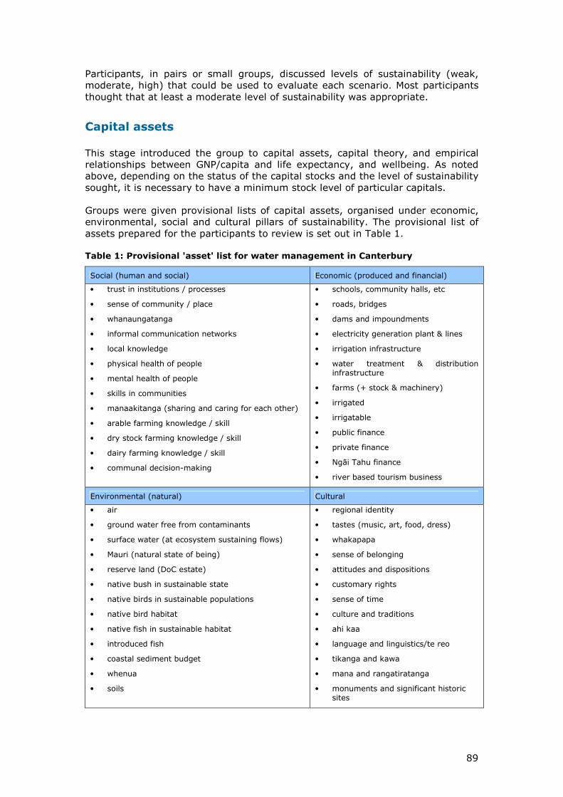
Sustainability appraisal
The four options were subject to a Sustainability Appraisal by the Steering Group and officials Group (technical Advisors) using a framework developed by Sadler and Ward (2008)11 to reflect New Zealand institutional arrangements. The framework is founded on four pillars of sustainability (social, economic, environmental and cultural) which correspond to the four well beings of the Local Government Act. The appraisal was conducted as a two day workshop. Participants reviewed evaluation criteria and scale descriptions on a 5 point scale (from -2 strong negative impact to +2 strong positive impact with the neutral position 0 representing the status quo). Once the evaluation criteria had been amended, each group was asked to identify points on the five-point scale that represented an acceptable minimum position for the four pillars (quadruple bottom line) and a desirable objective position (quadruple top line). The four options were then scored against the amended evaluation criteria. Some of the key findings of this appraisal were as follows:
• The bottom line is higher than Option A – Business as Usual
• Option B (environment-led) scores well on environmental criteria but is below the bottom line on economic criteria
• Option D (storage-led) scores well on economic criteria but is below the bottom line on environmental criteria
• Option C (efficiency-led) scores above the bottom line on nearly all criteria.
When considered at the sub-regional level the workshop participants considered that combinations of Option B, C and D were most likely to achieve sustainability at the sub-regional level.
More details about the Sustainability Appraisal are given at Annex E.
Outcome of consultation and engagement with stakeholders
Around 1100 submissions were received in response to the public consultation exercise – see Annex F for details. For the most part the submissions recognised there is a serious problem and a need to find a solution. Submitters did not appear to be strongly polarised – for instance along rural and urban lines. There was strong support for Options B and D, with Option C a strong second choice. A key point to emerge from consultation was the strong consensus in favour of a
11 Sadler, B. Ward, M. and Frame, B (2008), A Framework for Sustainability Appraisal in New Zealand. Landcare Research Contract Report LC0708/090.
37
coordinated, collaborative approach that would combine the best features of all the options.
Accordingly the Mayoral Forum released a revised strategic approach in early
September 2009, involving the following parallel strands of activity:
• explicit recognition of environmental limits
• programmes to restore ecological health and functioning to sustainable levels
• development of infrastructure, technologies and practices to progressively deliver improving environmental, social, commercial, recreational and cultural outcomes for Canterbury
• evolution of water management structures to enable local government to better integrate the management of water resources to meet the challenges identified.
The first two points (environmental limits and ecological restoration) are a precondition for making progress on the third (sustainable development of water resources). The fourth (integrated management) will provide for a more collaborative and effectively regulated approach.
The strategy is holistic in its approach rather than sequential because:
• reliable water can be used to incentivise more efficient irrigation and land management practices, and so improve river flows and groundwater recharge
• no further allocation will be permitted in “at-risk” areas and, where there are serious threats to the environment, regulatory action to review consents may have to be taken
• all parties have an interest in minimising the environmental impacts, especially in areas with conservation values
• the degree of success in implementing efficiency and reconfiguration measures will determine how much new infrastructure will be needed, and at what cost
• the holistic approach is consistent with a Ngāi Tahu worldview, which, as articulated in the Te Rūnanga o Ngāi Tahu Freshwater Policy, states “Water is a holistic resource. The complexity and interdependency of different parts of the hydrological system should be considered when developing policy and managing the water resource”.
Given the inter-dependencies between these factors – and the long lead times for planning of infrastructure – it is vital that water infrastructure planning proceeds in parallel with measures to improve water use efficiency, water quality and biodiversity.
There was further engagement from stakeholders during October. A further 70 detailed submissions were received. Overall there was strong endorsement of the approach set out above, though there were some reservations about the details, for instance the number and size of the implementation zones, and the relationship of the implementation programmes with existing Resource Management Act processes. The key issues raised by stakeholders are summarised in Annex F, along with the Steering Group’s responses. Many of the issues will be the subject of ongoing engagement with stakeholders over the next few months. This is discussed in more detail in Section 7.
38
Strategic approach and targets
To effect a total solution a balanced programme of parallel activities is required
that will look like this:
• in the short term (0-2 years)
o setting up coordination and delivery structures
o establishing environmental limits
o developing implementation programmes (these are described in Section 4)
o developing protocols for actively engaging Ngāi Tahu in the exercise of their kaitiakitanga role
• in the short to medium term (0-5 years)
o implementing programmes to deliver water use efficiency gains
o restoration of ecological health and functioning
o undertaking detailed infrastructure feasibility and investigation
• in the medium to long term (0-30 years)
o commissioning infrastructure, technologies and practices that will progressively improve environmental, social, economic, recreational and cultural outcomes.
The strategy will focus on delivering a balanced set of quantified outcome targets
by specified dates. The measurable outcome targets will be in the following areas
(draft targets are set out in detail in Annex G):
• drinking water
• irrigated land area
• energy security and efficiency
• ecosystem health/biodiversity
• water use efficiency
• kaitiakitanga
• regional and national economic growth
• natural character of braided rivers
• recreational and amenity opportunities.
The draft targets have been developed in consultation with environmental, conservation, farming and irrigation interest groups. They will give the strategy a sense of direction and balance and ensure that all aspects of the solution are advanced in parallel. They will also enable progress with implementing the strategy to be monitored and measured over time.
The targets will be finalised by the end of 2009 following further engagement with industry and environment stakeholders. One issue that will need to be decided is the extent to which the targets will be mandatory or aspirational in the way they affect the implementation of the strategy.
39
Section 4 Coordination and delivery framework
Implementation drivers
Consultation with the stakeholders and the general public has shown a strong preference for a “mixed economy” approach to implementing the strategy. This will mean developing a coordination framework that works with the grain of market forces to provide incentives to drive efficiency and innovation within the Resource Management Act’s regulatory framework. The Mayoral Forum has therefore adopted this approach, which it believes will be far more effective than the alternatives of “laissez faire” reliance on market forces, or heavy handed regulation.
A list of key drivers for the proposed coordination framework of water and land management is set out below.
Strategic drivers
Canterbury Water Management Strategy - its chosen strategic option and its fundamental principles
Treaty of Waitangi partnership – Ngāi Tahu rights as protected under the Treaty of Waitangi
Resource Management Act reforms - outcome of Phases 1 and 2 of the reforms to the Resource Management Act 1991
Other national strategic issues – such as the Government’s energy policy and water conservation orders.
Operational drivers
Collaboration – implementation to be developed collaboratively by local and central government, Ngāi Tahu as tangata whenua, and stakeholder interest groups, with the general public to be given the opportunity to influence the development of the programmes
Knowledge – implementation to provide for sharing of knowledge and scientific evidence so that all participants can work off a common factual base
Subsidiarity – individual consent holders, user groups, communities and stakeholders to be empowered to resolve issues and develop implementation programmes at the lowest practicable level in the coordination hierarchy
Restoration – implementation to actively promote improved ecological health and functioning in degraded and over-allocated catchments
Reliability – implementation to ensure the water and land management system operates reliably in delivering improving social, economic, recreational and cultural benefits while cumulative environmental impacts remain within acceptable limits
Dynamic/flexible – implementation to provide a robust framework that will encourage innovation in the use of technologies and practice, leading progressively to better outcomes
Efficiency – implementation to signal opportunity cost of inefficient use of water and energy use, and the assimilative capacity of natural systems through charges, incentives and other mechanisms
40
Confidence – water users, investors, stakeholders and the public to have a high a level of confidence that implementation programmes will be delivered in their entirety, and effectively enforced.
Whilst all of these drivers are important, one stands out and that is collaboration. The public consultation document asked submitters whether they thought such an approach is important – 85% said it was. This same sentiment dominated stakeholder discussions. Stakeholders, whether environment or production-driven, repeatedly asked that they be given the opportunity to resolve their differences and find solutions together. They demonstrated a strong sense of confidence that this will be possible.
The collaborative governance model needs to be contrasted to other governance models for resource management (Ostrom, 1990):
• the “leviathan model” where a central agency manages the resource – this is similar to the old Ministry of Works approach in New Zealand
• the “property rights model” where the resource is allocated incrementally with conditions that are specific to the individual allocations – this is similar to current approach in Canterbury.
Instead the strategy proposes an approach in which zone collaborative management is the foundation.
Integrated water management
Accordingly, under the proposed approach (more details at Annex H):
• implementation programmes will be developed to implement environmentally sustainable limits and targets on water use efficiency and reconfiguration
• activities to restore ecological health and functioning will be instituted in accordance with the planned timetable outlined the targets
• incentives will be provided to progressively improve the efficiency of water use, reconfigure allocations in accordance with the relevant implementation programmes, and implement environmentally responsible land management practices
• measures to address water quality and the impact on it of land use practices will be implemented
• localised transfer of water between consent holders will continue to be possible, subject to safeguards to prevent unintended consequences for the environment or other users.
• investment in new infrastructure will be guided by the implementation programmes, which will identify options for additional storage including integrated development of hydro electricity generation and irrigation infrastructure
• activities and processes to provide for kaitiakitanga will be identified and instituted in accordance with the targets
• applications for resource consents under the Resource Management Act that comply with the relevant implementation programme will avoid the need to revisit matters that had already been approved in the programme
• self-monitoring, auditing and reporting will ensure a level playing field for the users and suppliers of water within the set environmental limits
• ongoing establishment of environmental limits through RMA plans
41
• a blend of regulatory and market mechanisms, and voluntary approaches will be used.
This approach has some challenges, notably:
• the capacity of Local Government and Ngāi Tahu to fully integrate Tangata Whenua provisions
• the development of implementation programmes will require a willingness by all parties to accept reasonable trade-offs after first order priorities are met. This will be a challenge given the scale and complexity of Canterbury’s water system. However there will be an incentive for co-operation because the status quo is unattractive to most stakeholders
• there will be a cost in developing the implementation programmes which would have to be recovered from water users and/or ratepayers.
• the implementation programmes will need to be given appropriate status under the Local Government Act and the Resource Management Act
• incentives for existing users to reconfigure water allocations and phase out inefficient systems will, in some cases require a new revenue stream.
Water management zones
It will be important to develop a planning system that is matched to the spatial
scale of the resources to be managed. Where there are decisions relating to take
and use of water then the areas from which water is taken, and the areas in
which the water is used would be the appropriate scale. Where the decisions
relate to multiple catchments and groundwater zones, such as the allocation of
water from strategic storages, then the decisions should be made at the regional
scale.
Local water management
Canterbury’s catchments cannot be managed in an integrated fashion because
groundwater zones can overlap surface water catchments. For example, the
Culverden groundwater basin overlaps the Hurunui and Waiau catchments. There
are also inter-basin transfers, for example the Rangitata Diversion Race scheme
takes water from the Rangitata for use in the Ashburton catchment and
discharges excess flow to the Rakaia.
The zone areas will need to be sufficiently large to enable the management of
abstraction from surface and groundwater systems to be integrated with the
management of the irrigated areas where the water is used. On the other hand
the zone areas will need to be small enough to avoid becoming remote from local
catchment issues or allowing people from outside the relevant area to have a say
in matters that are not directly related to their interests.
Ten water management “zones” have been proposed initially - see Figure 7 below
for the details. A number of well argued submissions were received during
October requesting changes to these initial proposals. We recognize the need to
consider these suggestions very carefully. Accordingly, the Steering Group will be
holding discussions with those affected in the coming months and the precise
design will be finalised following this further engagement in the areas concerned.
42
Figure 7: Canterbury Water Management Allocation Zones 2009
Regional water management
To successfully implement the strategy, there are four key tasks that need to be undertaken at the regional level. These are:
• resolution of issues that cross zone boundaries
• allocation of water from strategic storages for the various uses – including maintaining river flows and groundwater recharge within acceptable limits, providing reliability of supply to existing users, and delivering water to newly irrigated land.
• definition of “at-risk” areas for which further consents should not be processed until effective zone water and land management arrangements are in place (for example, areas where groundwater quality limits have exceeded or are projected to exceed water quality standards)
43
• development of charging regimes that recognise the public interest in water.
These key controls should provide incentives and constraints for integrated management at zone level to work with minimal interference from the region.
Implementation programmes
The implementation programmes will be developed at zonal and regional levels.
Central government, Ngāi Tahu as tangata whenua, and all relevant stakeholders
will be involved in developing the programmes as well as local government. The
general public will also be encouraged to influence the development of the
programmes.
There are a number of key requirements that need to be met:
• decision making frameworks must be matched to the geographical scale needed for the decision - for example if the cumulative effects of land use practices create water quality problems at the catchment scale then this will be translated into land use practice requirements at the property level
• information provision for decision making and management must be structured so that the information is available to all stakeholders in a time frame needed for resource management, and can be audited for its authenticity - for example, in managing the flow regime in a river, the real-time measurement of individual takes, the combined take and the instantaneous flow in the river should be available to all water users and the regulator
• the use of audited self management12 must be developed to enable the reduction in compliance costs to be achieved through applying the subsidiarity principle.
The zone implementation programmes will address matters such as:
• environmental restoration and development
• economic development, land use intensification/reduction
• land use practices
• wastewater discharge
• zone scale infrastructure, and its environmental impact
• reconfiguration of allocations between surface and groundwater
• water brokerage and efficiency improvement
• water quality and quantity
• customary use
• recreational and amenity provision
• commercial use.
12 Note that this is not self regulation or voluntary compliance
44
The regional implementation programme will address matters such as:
• environmental limits for surface and groundwater quality and quantity
• “at risk” catchment determination in relation to environmental limits and cumulative effects
• protection of natural character, natural features and areas of conservation value, such as braided rivers
• biodiversity issues that cross zone barriers
• water demand and storage and distribution options that cross zone boundaries
• rules to ensure water allocation is managed in the public interest, including levies to fund environmental restoration
• water brokerage, transfer/allocation of consents and charging regimes to encourage reconfiguration of existing consents, and to drive efficiency of water use
• ensuring relevant Iwi Management Plans are taken into account in water management planning.
The programmes will be reviewed every three years and rolled forward. They will
avoid over prescription - for instance telling land owners what type of crops to
grow, or whether and when to switch into or out of dairying etc. The
programmes will as far as possible specify performance criteria, such as nitrate
leaching rates, within which land owners should operate. Incentives and charging
mechanisms, rather than compulsion will be used as far as practicable to deliver
change over time.
Governance arrangements
Water management committees will set up to develop, adopt, monitor and review the proposed water & land implementation programmes. The committees will develop the implementation programmes collaboratively so that they have a broad measure of stakeholder support – locally, regionally and nationally.
At local level a Zone Water Management Committee will be established for each zone to co-ordinate the development of the zone implementation programme. This will be the level at which many decisions affecting water management can be made efficiently and effectively. Zone committees will comprise some 7-10 members who are locally based or have a special relationship with the zone13. Members will be drawn from Environment Canterbury, territory authorities with an interest in the zone, Ngāi Tahu/runanga, consent-holder representatives and stakeholders, and respected members of the community. A single person may have several different interests. The Chair will be a stakeholder representative appointed by the Committee. In practice, the members of the Zone Committee will need to create networks around them.
A Regional Water Management Committee is also proposed to handle issues that are common across the region or cannot be managed satisfactorily at zone level or through joint working between them. This committee of between 10 and 15 people will bring together representatives of each of the zone committees,
13 It will also be possible to co-opt ex officio members onto the committee where expertise is required which is not available from locally based people
45
local and central government nominees, Ngāi Tahu and other stakeholders. The Chair will be nominated by the Canterbury regional and district councils.
There is also a need for national tripartite forum to address issues that are unlikely to be resolved by the zonal and regional committees. These issues include:
• the expression of the rights of Ngāi Tahu as protected by the Treaty of Waitangi, and the operation of a Treaty based relationship over Canterbury’s water
• integrating the strategy with water conservation orders, national policy statements, national environmental standards
• other national strategic issues, such as the integration of infrastructure for hydro generation and irrigation.
We therefore propose a national level forum that would involve the relevant Cabinet ministers responsible for the national policy issues together with representatives of Ngāi Tahu and the Canterbury regional and district councils.
Water Executive
As explained above, the water governance structure will not exist as a separate organisation as such, but will comprise committees operating in an integrated fashion at zone, regional and national levels. It is envisaged that this structure will need an executive body to manage the implementation programmes on a day to day basis, in particular:
• to provide policy, technical, and administrative support for the committees
• to establish ecosystem protection and repair activities
• to liaise with the irrigators on the management of surface and groundwater flows
• to work with water infrastructure developers to jointly develop resource consent applications and to develop a charging regime
• to broker new water consents and reviews of existing water consents.
The executive will be an active facilitator. It would provide comment and advice on the implementation programmes forwarded by the zone and regional committees. However, it will not be able to overturn them as long as they conform to the fundamental principles and the targets.
It is proposed that a semi-autonomous executive arm of Environment Canterbury will take on this executive role. With freedom to act within a commission agreed by the local authorities including Environment Canterbury, it will be guided by the Regional Water Management Committee to whom it will report regularly. For the remainder of this paper, Environment Canterbury will be referred to as the “Water Executive” when it is acting on behalf of the water governance structure (as distinct from carrying out the Regional Council’s regulatory functions). See Annex L for more details.
Water Infrastructure and Services Entity
Some new water storage is essential to give effect to the Strategy because the reliability of supply it will bring will provide the incentives necessary to gain greater efficiencies from existing users as well as any new users. Any new water
46
storage proposals of any scale will therefore require private investor-involvement and will have to be “bankable”. They will have to demonstrate a reasonable economic rate of return.
We have commissioned PriceWaterhouseCoopers to advise on the options for structuring a Water Infrastructure and Services Entity to take on the role of designing, building, financing and operating the larger elements of the regional water storage and distribution system. Once this work is complete there will be further stakeholder engagement and public consultation before decisions are reached on the precise form of the entity.
Subject to this further work, it is likely the water entity will have a range of public and private sector investors. The entity will be subject to constraints to ensure it operated in accordance with the implementation programmes and the fundamental principles. For example, the regional implementation programme will determine where the new infrastructure is to be built, and prescribe the rules governing allocation of water for environmental and productive purposes.
Irrigators already operating in Canterbury will, if they so choose, be able to merge with the water entity in return for an equity stake. Irrigators not wishing to merge with the water entity will be able to integrate their operations with the company through contractual arrangements.
A charging regime will be developed to allow the water entity to earn a reasonable return on its investment and to encourage efficient use of water, especially when it is in short supply in dry years. This charging regime will be incorporated into the regional implementation programme.
The water entity will have a public service obligation to supply water to maintain surface and groundwater flows to levels laid down in the implementation programmes. A levy will be paid to the Water Executive to fund ecosystem restoration programmes, and to meet a significant proportion of the operating costs of the Executive.
This model represents a form of public private partnership. As such there will be an element of risk-sharing between the public and private sectors. The skill in designing the detailed structure of the water entity will be in allocating risks to the parties that are best able to manage them. Placing too much risk with a party that is not able to manage it will result in a sub-optimal result from an economic efficiency perspective.
Managing the risks
The approach outlined above is not without risks. These include:
• there is potential for duplication between implementation programmes andResource Management Act plans. In particular zonal programmes couldcut across the investment of time and resources, science and communityinvolvement in developing and progressing the Natural Resources RegionalPlan
• there needs to be clarity about the extent to which engagement with thepublic on implementation programmes will substitute for formal publicconsultation processes and statutory review under the ResourceManagement Act
• there is a risk of a "plethora of plans" with programmes at zone level aswell as regional level as well as Resource Management Act plans - the
47
same issues may be debated in each zone committee, with potential implications for high administration and servicing costs.
• stakeholder organisations will have to work across all ten zones all of thetime, and may not have the resources to do so effectively
• there may be a tendency for zonal parochial perspectives to dominatedecisions.
Much of the detail of how to manage these risks has yet to be worked through. The solutions will include the following:
• National Environmental Standards and National Policy Statements will be“givens” – they will set the parameters within which the implementationprogrammes will be formulated
• implementation programmes will also have to be consistent with thepolicies, standard and requirements of the other Resource ManagementAct instruments, such as Canterbury Regional Policy Statement andregional plans including the Natural Resources Regional Plan
• the implementation programmes will aim to “smooth the passage” for theapproval of Resource Management Act instruments by winning publicsupport for a balanced strategic way forward, in contrast to the currentreliance on adversarial processes
• one of the roles of the regional water management committee will be toguard against parochialism. The adoption of subsidiarity principle willinvolve a degree of delegation but not abdication by the region. Inparticular the zone implementation programmes will need to be consistentwith regional programmes
• a key role of the Water Executive will be to aid regional integration acrossall the implementation programmes, avoid duplication of technical effort,and quickly identify any emerging inconsistencies with national andregional policies and standards.
Concerns about multiple management layers leading to inefficiency and added cost would be valid for the defined model if the “leviathan” style of governance was being proposed. However for a collaborative governance model, efficiency will be achieved by bringing decision making to the lowest possible level to include those who need to be involved in decision making.
Many of these risks will be considered and addressed in the progress papers that are contemplated over the next year and are outlined in Section 7.
48
Section 5 Issues to be covered in the implementation programmes
Overview
This section explains the issues that will need to be covered in the implementation programmes, and which agency will be responsible for taking the lead in implementing the various elements. In particular it explains how the Water Executive and the Water Infrastructure and Services Entity will work collaboratively with the sector to pro-actively drive the system towards meeting the targets set in the strategy.
Ecosystem protection and restoration
In recent years there has been an increase in understanding of the importance of maintaining healthy habitats and ecosystems to protect indigenous biodiversity. This has resulted in an increase in biodiversity initiatives at all levels. However, biodiversity in Canterbury continues to decline overall. Halting this decline will be very important to maintaining quality of life, preserving cultural heritage, and ensuring a sustainable future.
At the national scale, tools are available for prioritising ecosystem protection. Application of tools for prioritisation has identified many of Canterbury’s main river catchments as priorities for biodiversity. At the regional scale, the main vehicle guiding action is the Canterbury Biodiversity Strategy aimed at protecting and maintaining the health of all significant habitats and ecosystems. Improved environmental flows and water quality standards will be a key part of ecosystem protection but restoration activities will also contribute through:
• increasing programmes of pest and weed control,
• fencing streams and wetland areas, restoration and reinstatement
• riparian planting and/or management
• modifying and removing in-stream structures
• protection of freshwater fauna.
Annex I sets out the proposed approach in more detail. The Water Executive will take the lead in:
• monitoring the water entity to ensure water flows in surface and ground water systems are managed in accordance with the implementation programmes
• recommending release of water from storage to “at-risk” areas, once reasonable progress has been made with delivering the reconfiguration of consents set out in the implementation programmes
• establishing and overseeing ongoing ecosystem restoration activities.
It is envisaged the Water Executive will incur substantial costs in the early years for ecosystem protection and restoration projects when there will be limited scope to levy water charges. These costs will be met in the early stages by ratepayers, but in later years could be funded from the water levy once the water entity is generating revenue.
49
It is possible that some funding for ecosystem protection and restoration may be obtained, for instance through grants from other organisations and trusts. Where national legacy issues can be identified, funding may be forthcoming from central government, but the Mayoral Forum does not want to predicate the strategy on this type of central government funding.
Investment in new infrastructure
As a result of Stages 2 and 3 (of the Canterbury Strategic Water Study) and
subsequent work, the following short-list of options for infrastructure
development and other ways of delivering reliable water to the system has been
developed. The key short-listed projects are:
• Use of Lake Coleridge for storage
• Efficiency improvements in mid Canterbury
• Groundwater storage in Central Plains
• Hurunui integrated option
• Lees Valley storage
• Lake Tekapo water for South Canterbury
• Extension of Hunter Downs to north.
The detailed hydrological modelling that has been done has demonstrated that it is likely a combination from the above will be able to meet community needs and provide substantially more water for productive purposes. The remaining issues to be resolved are set out in Annex J. It should be noted in particular that these projects have yet to receive detailed assessments for consistency with the fundamental principles and the targets, and this may rule them out or significantly reduce their benefits from a purely water-use perspective. The implementation programmes will integrate infrastructure development with security and efficiency of energy supply, more efficient irrigation and land management practices, and improved river flows and groundwater recharge. The water entity will be responsible for preparing resource consent applications for infrastructure development in accordance with the implementation programmes. The aim will be to reduce planning risk and ensure resource consent applications that comply with the implementation programmes need not revisit matters that have already been approved in the programmes.
Allocation and use of groundwater
Increasing numbers of wells are being sunk for irrigation purposes in the upper parts of the Canterbury catchments because of the unreliability of flows available from rivers. Unfortunately this groundwater abstraction is reducing the flow of water through the groundwater system down to the aquifers in the lowland areas (not to mention the energy costs of pumping deep water). This in turn is reducing flows into spring-fed streams in the lowland areas, and the problem is being further compounded by surface water abstraction in the lowland areas.
This uncoordinated granting of water consents is damaging the ecosystems of the surface rivers and streams, and water quality in the aquifers. Farmers in the lowland areas are also suffering unreliable water supplies in dry years.
Reconfiguration of water consents in conjunction with additional water from storage will be used to solve this problem. This will make it possible to use
50
stored water for irrigation purposes in the upper part of the catchment instead of groundwater. Aquifers in the upper parts of the catchment will be recharged, and so generate increased flows through the groundwater system down to the aquifers in the lowland areas. This in turn will recharge the aquifers in the lowland areas, allowing groundwater there to be used for irrigating land instead of surface water, and also restoring healthy flows in the lowland streams.
The net result will be much improved environmental flows in lowland streams, allowing water quality and ecosystems to be restored and protected. The groundwater system will also be recharged at a higher rate, diluting contaminants and allowing water quality in the aquifers to return to safe levels. In addition there will be improved reliability and availability of water for irrigation purposes in both upland and lowland areas.
The Water Executive will take the lead in brokering reconfiguration of consents in accordance with the implementation programmes. Financial incentives may be needed to secure agreement from consent holders to change the way they abstract water from the system and change the terms and conditions of their resource consents. These incentives could be funded from a levy on water users.
Water allocation and charging regime
The previous sections have explained how consents for new water storage in the future will be conditional upon compliance with implementation programmes that specify environmentally sustainable flow regimes and land management practices tailored to local circumstances and needs. This should provide a broad planning framework within which participants will be able to manage risks and uncertainties.
In addition to this a charging mechanism for water will also be needed to remunerate the investment in new infrastructure and enable supply and demand to be managed in an efficient and effective manner. Failure to deal with this issue would result in wasteful investment in infrastructure needed to meet inelastic demand, or a regulatory regime to ration the supply of water in dry years. The former would make the strategy impossible to finance on a commercial basis; the latter would result in inefficient allocation decisions.
The Water Executive in conjunction with the water entity will be required to develop a charging regime to address this issue. This will be considered by the regional and zone committee for incorporation in the implementation programmes. It is likely the charging regime will include a range of options for water consent holders to choose from, including:
• fixed price contracts where users will pay a fixed water charge irrespective of the availability of water – this will provide the Water Infrastructure and Services Entity with guaranteed revenue streams and enable users to make investments with the confidence that they have security of supply
• variable priced contracts where users will pay charges that vary with the availability of water – this will provide the Water Executive with a demand management tool for the purpose of balancing supply and demand.
A key issue to be resolved in the implementation programmes will be the charging regime to apply to existing consent holders. The charging regime will need to have regard to the value of existing water permits and recognise that hydro-electricity takes are non-consumptive. The charges must also recognise existing restoration activities that consent holders have implemented already.
51
However it would be unfair if the charges to existing consent holders did not take into account their “share” of the costs of environmental restoration and the benefits they will derive from new water storage, such as the reliability of supply in dry periods.
Land management practices
The potential for improvements to water quality by changing land management practices is being trialled and monitored in a number of catchments. For example, bacterial concentrations in the Pahau River have been reduced to a third of the levels measured 2005/6 by a ‘resource care’ programme which led to changes in irrigation and land practices by farmers in the catchment. Diffuse discharges of nitrates are highly dependent on water and land management practices and land use. Bidwell et al demonstrated that managing nitrates in Canterbury’s groundwater will require improvements on existing agricultural land, not just on newly developed land. There are also likely to be some locations where land-use with high leaching rates will be inconsistent with water quality standards.
Monitoring of Lincoln University dairy farms has shown that nitrate concentrations in leachate can be significantly reduced by good pasture, irrigation, fertiliser and stock management practices while maintaining above average production. High yielding cereal and potato crops can be grown with minimal nitrate leaching risk through the use of deep-soil N tests, efficient irrigation practices and appropriate crop rotations.
There are four key processes within the strategy aimed at addressing improvements in land management:
• defined catchment limits for nitrate and other contaminants consistent with water quality objectives
• primary sector initiatives around improved land management
• zone implementation programmes to address land-use working in collaboration with primary sector initiatives, including incentives, pilot studies, monitoring, improved understanding of feasibility and cost of options, and training
• linking land-use practice to access to reliable water from new and (in the medium term) improved existing infrastructure.
The Water Executive will be empowered to broker release of water for productive purposes from the new storage and distribution system to water management zones, subject to progress being made with delivering the land management practices set out in the implementation programmes. This will provide an incentive for water users in each zone to agree on appropriate land management practices for their areas and to start to take the practical steps needed to deliver them.
52
Water use efficiency
Efficiency improvements can occur at:
• individual property scale through improved day-to-day management, and management over the season to avoid overuse of water in the spring and autumn
• at scheme or delivery system scale such as increased use of piping and more flexibility in timing and volume of water delivery
• at catchment scale by more appropriate division/use of surface and groundwater resources.
Studies show there are substantial gains to be made in on-farm water efficiency – but it is recognised that there is usually a cost in doing so which farmers will naturally weigh against the benefits before changing.
There are already some incentives to improve efficiency and improvements have been, and continue to be made. For example:
• farmers changing from border dyke irrigation to spray irrigation due to production, labour and capital efficiency signals
• consent-holders improving the efficiency of groundwater takes, especially deep ones, due to the cost of electricity.
Addressing irrigation efficiency at property-scale also provides the opportunity to improve the design and management of farm irrigation systems, thus reducing the total amount of nutrient leaching into groundwater. Reduction of nitrate discharge by improving existing practices has the most effect on the availability of safe drinking water from shallow groundwater. Shallow groundwater also contributes to the quality of surface waters, particularly in the lowland areas. There are further efficiency gains that can be made by addressing efficiency at property, scheme and catchment scale in an integrated way. Improving reliability of the supply enables more efficient on-farm practices and also is a powerful incentive to invest in improving current infrastructure. Stage 4 of the Canterbury Strategy Water Study illustrated the potential gains from a combination of property, scheme and catchment efficiency measures for mid-Canterbury. The study found that if all efficiency gains were realised then the size of storage needed to provide reliable irrigation to the district was one-third of that needed if no efficiency gains were made. The scenario modelled included removing some takes from the Ashburton River to restore some flow. Achieving these benefits will require an improvement in the scale and extent of efficiency than is currently occurring.
Because the costs of improving efficiency are generally much lower than the costs of building storage, there is a strong case for providing incentives to water users to find more efficient and productive ways of using allocated water. A key part of the Strategy is to improve the provision of the necessary signals to consent holders and infrastructure providers. The strategy will set the efficiency targets and the boundaries within which implementation programmes must aim to operate in the future. It should be noted the scope for making efficiency gains is not evenly distributed across the region.
53
There are three key processes within the strategy aimed at addressing water efficiency improvements:
• linking efficiency requirements to access reliable water from new and, in the medium term, improved existing infrastructure
• zone implementation programmes to address water-use efficiency using a combination of Resource Management Act consent options such as transfer of consent or change of conditions, small-scale infrastructure projects, improved reliability and irrigation industry initiatives and training. Each water management zone is likely to have a different set of opportunities to improve reliability and efficiency
• the Water Executive will work with consent holders to reallocate water that is being used inefficiently. A brokering system that would allow inefficient or unproductive use of water to be “bought out” and the water reallocated for environmental purposes, or for more efficient irrigation uses. This will mean environmental and economic objectives will be achieved while minimising the costs and environmental damage of new storage capacity in the region
• localised transfer of water between consent holders will continue to be possible, subject to safeguards to prevent unintended consequences for the environment or other users.
Implications for hydro-electricity generators
During engagement with stakeholders in October, concerns were raised about how the implementation programmes will affect uses of water for hydro-electricity generation purposes. Co-operation and participation from hydro-electricity generators will be critical to the success of this strategy. As with other consent holders, there is no intention to change consents for hydro-electricity generation without consent holder agreement.
There could be some positive opportunities to improve integration between the energy and irrigation sectors. The inception of water charges could facilitate new opportunities for electricity generators to supply water for irrigation purposes where this was commercially attractive for them to do so and consistent with the Government’s energy policies.
Essentially the implementation programmes will constrain how the generators will supply water for irrigation purposes if they choose to do so. It is unlikely to affect the operation of existing consents for electricity generation unless there is agreement to do so from the consent holder.
Hydro-electricity takes will need to be treated differently to other takes. For example the water charging regime will need to recognise that, in general, hydro-electricity generation is a non-consumption use of water. It will also be important to recognise existing investment by consent holders in ecosystem protection, for example Meridian Energy’s funding of Project River Recovery in the Upper Waitaki.
Auditing and enforcement
The current approach to compliance monitoring and enforcement involves inspecting properties to assess compliance with Resource Management Act consent conditions, and responding to complaints of adverse effects. This is followed by enforcement action in relation to identified non-compliance.
54
While consent conditions and their enforcement are powerful tools, there are some limitations:
• the focus is on the management of the effects that are explicitly associated with the consent conditions, rather than on land use practices
• conditions are good at setting limits but not at encouraging best practice - there are no drivers for improved performance to achieve “better than compliance”
• the final decisions on contentious conditions are usually decided on an adversarial basis in the courts.
These are all problematic in relation to monitoring efficiency in the use of water, and the impact of diffuse discharges on water quality.
Mechanisms will be introduced to improve monitoring performance including:
• audited self-management programmes to encourage farmers and others to monitor and improve their own performance, to demonstrate their cumulative environmental effects are within acceptable environmental limits
• the operation of a performance rating system by Environment Canterbury to assess performance of property owners at below standard/above standard/excellent and publish the results
• reduced water charges for those rated “above standard” or “excellent” - this would provide an incentive for “better than compliance” performance by abstractors.
55
Section 6 Legislative implications
Background
The feedback we received from stakeholders during October asked for greater clarity about the roles and responsibilities of the proposed water management committees in relation to the existing functions exercised by local government and others under the Resource Management Act and the Local Government Act.
It is not clear at this stage whether amendments to the Resource Management Act will be needed to give effect to this new regime. This is the subject of ongoing dialogue with the Government. Existing Resource Management Act mechanisms that could be used to give legal status to implementation programmes include national and regional policy statements, and regional plans.
Pending the resolution of these issues, the Government has given its support to the collaborative approach of the zone and regional committees concept. These will be established in early 2010 using Local Government Act powers, and the development of detailed implementation programmes will proceed in advance of decisions about the best way to give legal effect to the strategy.
The legal issues that will need to be addressed are discussed below.
Maori rights and interests
In acknowledgement of their Treaty partnership, central government has committed to work with Iwi leaders and advisers on a joint work programme on defining and resolving iwi rights and interests in New Zealand's freshwater resources. The work involves the exploration of co-management, allocation mechanisms and incorporation of tangata whenua perspectives in policy development. The final form of the legislation, committee roles and approval processes within this strategy is likely to be influenced by this central government work.
Empowering water management committees
The zone and regional water management committees will act as facilitators and contribute to plan and policy making. Their prime function of the committees will be to develop the zone and regional implementation programmes. They will not be regulators nor will they deal with individual resource consent applications – that role will continue to be carried out by Environment Canterbury as will the approval of regional plans under the Resource Management Act.
This clear differentiation of roles will enhance the ability of the water management committees to proactively influence the sector by resolving conflicts and negotiating compromises.
It is proposed that the zone and regional water management committees will be joint committees of the regional council and the relevant district councils. The committees will operate in accordance with Local Government Act14 powers and terms of reference drawn up by their parent councils. Decisions will be made on a consensus basis rather than by majority voting.
14 Local Government Act instruments set the funding and priority of regulation, incentives, investigations and other actions which in combination will support the strategy.
56
This should make for streamlined working of the committees and enable the first iteration of the draft implementation programmes to be developed and submitted for approval by the end of 2010.
To give effect to this approach, it is likely the Local Government Act will provide sufficient powers for the water management committees to:
• function effectively as committees of the relevant councils in accordance with Local Government Act procedures and terms of reference agreed by the relevant councils
• develop the implementation programmes in accordance with a set of collaborative principles
• review the implementation programmes every three years
• carry out consultation and submit the draft programmes for approval.
Legal status of implementation programmes
The Resource Management Act will continue to apply, with national, regional and district planning instruments, individual water consent applications, appropriate conditions, and compliance action remaining key features.
In particular existing national and regional Resource Management Act instruments will continue to play a vital role:
• at national level, the Minister for the Environment will continue to make national policy statements, national environmental standards and water conservation orders
• at regional level, the Regional Council will continue to make regional policy statements and regional plans – these are discussed in more detail in Annex K
• at district level the territorial authorities would continue to be able to make district plans.
These Resource Management Act instruments govern the management of water resources and set the environmental limits (environmental flows and levels and water quality standards), efficiency requirements, guide resource consent decisions, and provide for the review and transfer of existing water permits.
However, individual water allocation decisions will also need to be influenced by the implementation programmes. In particular applications for water consents conforming to the relevant implementation programme should be considered under a more enabling set of criteria than applications that do not. There should also be a presumption that further allocation will not be permitted in “at-risk” areas unless they conform to the implementation programmes.
The issue to be resolved therefore is how best to give the regional and zone implementation programmes appropriate legal weight in the Resource Management Act processes (plans and resource consents), so as to:
• ensure development is cumulatively constrained within the environmental limits set
• enable existing consents to be reviewed and aligned with the water use efficiency, configuration and land use requirements in the implementation programmes
57
• speed up plan and resource consent processes when a Resource Management Act plan or a resource consent is consistent with the programmes
• manage the consideration of new consent applications during the transition to the new system.
Summary of overall approach
Under the above approach the roles of the facilitator (the water management committees, supported by the Water Executive) and the regulator (Environment Canterbury) will be clearly differentiated. This will empower each to adopt processes and procedures best suited to its role.
There will be an integrated approach to managing water resources across the region that will provide for:
• congruence between allocation and use rules and the local issues to be managed
• opportunities for those affected by rules to participate in formulating them
• low cost, non adversarial ways of resolving conflicts.
Planning activities will be carried out in “nested” zone/regional/national levels where issues can be allocated to the most appropriate level for consideration while ensuring coherence between the levels.
Overall there will be an increase in pre-planning activity (informal processes) and a reduction in the need for hearings and other formal processes. This should produce better outcomes with less compliance costs.
Existing powers or new legislation will be used to ensure the implementation programmes are given appropriate legal status under the Local Government Act and the Resource Management Act, and effectively provide a link between the two Acts.
The key objective will be to provide long term planning stability. The implementation programmes will be social contracts in which all parties agree on a balanced way forward that will enable community and economic wellbeing to occur whilst safeguarding the ecosystems on which they depend. Once the programmes have been put in place stakeholders and investors must both be confident that all elements will be delivered in their entirety. Legal processes that follow in the wake of the adoption of the programmes should not be allowed to undermine this balanced, holistic approach to managing water resources in each zone and across the region as a whole.
58
Section 7 Implementation - Next Steps
This document provides the broad outline of the Canterbury Water Management Strategy’s vision for the operation of water management for Canterbury. However there are number of important details still to be decided, notable the legal framework for the implementation programmes, the charging and funding regime, the boundaries of the water management zones, and the design of the water infrastructure and services entity.
These remaining issues will be resolved in implementation projects which will take each of the elements of the strategy through a design, development and implementation process. Stakeholders will be engaged throughout this process and the results will be written up in progress papers, which will be published on the website and notified through the e-newsletter.
A programme of development for each of the key areas of the project is outlined below to ensure there is a clear pathway forward. The initial deadlines for initiating the implementation of the programme are set out below. A longer term timetable will be developed to ensure that all elements of the strategy move forward in a timely manner.
Legal powers
The question of the legal mandate for the water management committees and their implementation programmes is outlined in Section 6. Further work is required to ensure adequate powers are available:
� to put in place Terms of Reference of the zone and regional committees under Local Government Act procedures
� to give appropriate legal status to the programmes under the Resource Management Act.
It is hoped discussions with the Government on these matters will be completed by February 2010.
Zone and Regional Committees
The powers and operations of the zone and regional committees has been outlined in this report. A “nested” system has been proposed.
The water management committees will be established in early 2010 using existing Local Government Act powers so that work can start immediately on the preparation of implementation programmes. Getting these committees underway is now a priority because they will provide the detailed activity programme that will achieve the objectives of the strategy.
There is further work required before these committees can be fully functional. This includes:
� finalising the boundaries of the zones in response to matters raised in submissions
� devising a method of selection of committee members
� finalising a Terms of Reference for each committee
� preparing a practice guide for the committees.
59
It is likely the timing of the start up of the committees will vary from zone to zone depending on the urgency of the problems facing particular zones and the capacity of the Water Executive to provide the initial start up support that will be needed. An orderly sequence for launching the committees will be developed with the district councils and other interests involved by the end of 2009.
Targets
The targets will form a key part of the brief to the zone and regional water management committees. They represent a firm commitment in practice to the parallel development concept which is fundamental to the success of the strategy.
Significant initial work has been done on the targets with interest groups of environmentalists and farmers/irrigators working independently and together. It is envisaged that these groups of stakeholders will continue the refinement process although it is now well advanced.
The further work required will include:
� joint meetings with irrigators/farmers and environmental interests
� peer reviewing of the targets by third party experts
� consideration of the targets by the regional committee once it is formed.
This further work and the finalisation of the targets will be completed by December 2009.
Economic assessment
The first draft of an economic study has been completed. This provides a modelling instrument for the comparison of various scenarios. The scenarios will emerge from the work of the zone and regional committees. As it evolves this instrument will be a vital ingredient in the assessment of the priority and feasibility of different development options.
The further work required for the economic instrument is as follows:
� refine the instrument and the dataset behind it – by December 2009
� canvass the methodology of the economic instrument with government and particularly Treasury to assess its credibility with such agencies – by February 2010
• formulate scenarios that can be used for testing the instrument and informing the decision-making process – by June 2010.
Endorsement by District Councils, Environment Canterbury
and Te Runanga o Ngāi Tahu
An early requirement is to gain the endorsement of the Canterbury regional and district councils, and Te Rūnanga o Ngāi Tahu for the strategy. While there will remain some uncertainties, endorsement of the strategy is essential for it to proceed.
This will involve the following:
� formal presentations to each of the local authorities (including Environment Canterbury) and a request for their endorsement
60
� formal presentations to Ngāi Tahu and a request for their endorsement.
It is hoped these discussions and endorsements will be completed by March 2010.
Implementation programmes
Once endorsement is gained from the councils and Te Rūnanga o Ngāi the next move in the transition would be the appointment of the zone and regional committees and getting them working on the development of the implementation programmes. The implementation programmes will integrate infrastructure development with security and efficiency of energy supply, more efficient irrigation and land management practices, and for improved river flows and groundwater recharge.
The following steps will be taken over the next 12 months:
� completion of Terms of Reference for the committees
� preparation of a practice guide for the committees (including a template for implementation programmes)
� nomination of membership
� formal appointment of committees
� orientation of new committees
� development of implementation programmes.
The implementation programmes are expected to be completed by the end of 2010. At that point formal applications for the necessary legal approvals under the Resource Management Act that will be associated with the programmes will be initiated.
Water Executive
The Water Executive will be crucial to the appointment, orientation and support of the implementation committees.
In particular, the Water Executive will develop a practice guide for the water management committees to provide for a consistent approach to implementing the strategy and to avoid duplication of effort.
More details about the role, structure and funding of the Water Executive are set out in Annex L. The Executive will be established by February 2010.
Resolution of national issues
There are a number of issues that will need direction from a national level - between Central government, Ngāi Tahu and the Canterbury regional and district councils as the zonal and regional water management committees develop the implementation programmes. These issues will include:
• the expression of the rights of Ngāi Tahu as protected by the Treaty of Waitangi, and the operation of a Treaty based relationship over Canterbury’s water
• integrating the implementation programmes with water conservation orders and with national policy statements and national environmental standards
61
• other national strategic issues such as the balance in allocating water between hydro generation and irrigation.
It is likely these national level discussions will take place in the third quarter of 2010 prior to the draft implementation programmes being issued for public consultation.
“Immediate Steps” ecosystem protection and restoration
programme
Trust and confidence in the strategy is important and vital to that is the introduction of an immediate steps programme. It will:
• assume that environmental protection and restoration is a key part of this strategy
• provide action-based activity on biodiversity protection and restoration that the regional and zone committees can address in the short-term.
More details about the Immediate Steps programme, costing options and funding sources are set out in Annex I.
Further actions required include:
� resolution of the final scale of the protection and restoration activity
� costing of the total programme
� identification of the source of funding for this activity both for an immediate and long term programme.
The Immediate Steps programme will be finalised by March 2010.
Supply-side arrangements
The recommendations in the strategy referring to governance and development on the supply-side cannot be implemented without the full participation of all parties – district councils, farmers, irrigation companies and even potential funders. To date, exploratory discussions have taken place to gauge support for the approach and a generally “interested’ response has been forthcoming.
Pending responses from the district councils indicating interest in following through on this proposal, there is a need to develop a feasibility proposal and business plan/model around a Water Infrastructure and Services Entity. It is envisaged that this would take well into 2010 to be completed and consulted with all relevant parties.
In the event that there are early indications either of lack of interest or a high degree of difficulty in establishing an entity, then alternative feasibility work would be required on supply management and infrastructure development.
Further action will comprise:
� development of a funding model in consultation with stakeholders
� finalisation of a detailed proposal
� presentation to potential parties to such an entity.
It is envisaged that this will be consulted on with all relevant parties and completed by December 2010.
Preparation and release of consultative draft water chapter Regional Policy Statement Decisions on how to progress, Conway,Hurunui15, Waimakariri, Lake Ellesmere/ Waihora tributaries, Waihao/Wainono lagoon tributaries
Further submissions called for on plan change to Waimakariri River regional plan
Hearings on Kaikoura variation
Formal notification and call for submissions on Waipara and Waiau proposed Environmental Flow plans
Waimakariri Plan change progresses
Formal notification and call for submissions on Pareora proposed Environmental Flow plan
Formal notification and call for submissions on Regional Policy Statement Decision on proposed NRRP expected including groundwater zones, Ashburton, Avon/heathcote, Ashley and Motunau environmental flows Formal notification and call for submissions on Orari proposed Environmental Flow plan Work starts with community advisory groups for Banks Peninsula, Hinds and remaining Kaikoura streams Work starts on plan changes for Opihi and Waitaki16 plans Work starts on Waimkariri tribuaties (lower plains)
15 Timing may be influenced by Water Conservation Order proceedings 16 Plan change to address changes to allocation table highlighted as necessary during consent process for lower Waitaki river.
64
Section 8 Monitoring implementation of the strategy
Implementing this strategy will be challenging, the solutions will be evolutionary, and there are some remaining areas of uncertainty which will be the subject of continuing work until they are resolved.
While the overall approach of the strategy will not change – including in particular the vision and fundamental principles – successful water management will be dynamic. Tactical decisions will be needed for instance around the extent to which new infrastructure is needed and the timing of its construction.
Monitoring progress against the strategy’s targets will therefore be critical to ensuring that the strategy is able to adapt to changing circumstances and new information, while at the same time maintaining the confidence and trust of all the parties involved.
Accordingly the Mayoral Forum, in partnership with Ngāi Tahu, will formally review progress with implementing the strategy and delivering outcomes against the targets on an annual basis. The first review will be completed by the end of 2010.
65
Annexes
A. Mayoral Forum and Steering Group members
B. Fundamental Principles
C. Background and current trends
D. Consultation process to date
E. Results of the sustainability appraisal
F. List of submitters and summary of consultation
G. Draft targets in detail
H. Integrated management framework
I. Biodiversity protection and restoration
- Appendix - Summary of “Immediate Steps” restoration actions and planning initiatives
J. Infrastructure options
K. Regulatory backing to the strategy
L. Role, structure and funding of the Water
Executive
66
Annex A
Mayoral Forum and Steering Group members
Members of the Mayoral Forum Steering Group members
Mayor Bede O’Malley - Ashburton District Council
Bede O’Malley - Chair and Mayoral Forum representative
Brian Lester - Ashburton District Council Mike Jebson - Central government agencies
Mayor Bob Parker - (Chair) Christchurch City Council
Brian Lester & Bryan Jenkins - Chief executive representatives
Tony Marryatt - Christchurch City Council Peter Townsend – Industry representative/regional economic
Sir Kerry Burke - Environment Canterbury David Perenara O’Connell – Te Runanga o Ngāi Tahu
Dr Bryan Jenkins - Environment Canterbury Murray Rodgers - Community/Water Rights Trust
Mayor Garry Jackson - Hurunui District Council Grant McFadden - Historical knowledge of water management in Canterbury
Andrew Dalziel - Hurunui District Council Angus McKay & Eugenie Sage - Environment Canterbury councillor representatives
Mayor Kevin Heays - Kaikoura District Council Graeme Sutton - Irrigation New Zealand
Stuart Grant - Kaikoura District Council Peter Scott – Opuha Water Supply Partnership and southern region representative
Mayor John O’Neill - Mackenzie District Council Martin Clements - Fish and Game New Zealand
Glen Innes - Mackenzie District Council Hugh Canard – Kayaking, recreation and tourism representative
Mayor Kelvin Coe - Selwyn District Council Alastair James – Chair, Canterbury District Health Board
Paul Davey – Selwyn District Council Edith Smith – Forest & Bird and conservation representative
Mayor Janie Annear - Timaru District Council
Warwick Isaacs - Timaru District Council Officials’ Group members
Mayor John Coles - Waimate District Council Murray Doak – Convenor, Ministry of Agriculture and Forestry
Tony Alden – Waimate District Council Ray Anderson, Selwyn District Council
Mayor Ron Keating - Waimakariri District Council
Marcus Langman, Environment Canterbury
Jim Palmer - Waimakariri District Council Poma Palmer, Department of Conservation
Mayor Alex Familton - Waitaki District Council Helga Rigg, Hurunui District Council
Michael Ross - Waitaki District Council Ken Taylor, Environment Canterbury
Jackie Curtis, Environment Canterbury
Christina Robb, Environment Canterbury
Melanie Schauer, Environment Canterbury
Mary Sparrow, Waimakariri District Council
Adrienne Anderson, WaiGroup
Geoff Henley, Network PR
Simon Whiteley, Independent contractor
67
Annex B
Fundamental Principles
Primary Principles 1. Sustainable management
• Water is a public resource which must be managed in accordance with sustainability principles and be consistent with the Resource Management and Local Government Acts.
2. Regional Approach
• The planning of natural water use is guided by the following:
o first order priority considerations: the environment, customary uses, community supplies and stock water
o second order priority considerations: irrigation, renewable electricity generation, recreation, tourism and amenity
• A consistent regulatory approach to water is applied throughout the Canterbury region, recognising these principles
• Both surface and groundwater are given equal importance
• Further development of scientific knowledge of the region’s water resources and the impacts of climate change are given priority
• The actual or potential cumulative effects the taking and using water can have on waterways are recognised and managed within defined standards
• A cautious approach is taken when information is uncertain, unreliable or inadequate
• The need for efficient use of water in existing and new infrastructure is recognised
• There is strong emphasis on the integration of water and land management including protection of indigenous biodiversity and enhancement of water quality
• Current and potential effects of land use intensification is an integral part of decision-making on water takes. This may mean amending regional and district plans.
3. Kaitiakitanga
• The exercise of kaitiakitanga by Ngāi Tahu applies to all water and lakes, rivers, hapua, waterways and wetlands, and shall be carried out in accordance with tikanga Maori.
68
Supporting Principles
4. Natural Character
The natural character (mauri17) of Canterbury’s rivers, streams, lakes, groundwater and wetlands is preserved and enhanced:
• natural flow regimes of rivers are maintained and, where they have been adversely affected by takes, enhanced where possible
• the dynamic processes of Canterbury’s braided rivers define their character and are protected
• environmental flow regimes are established for every waterway where abstraction occurs
• that restoration of natural character and biodiversity, is a priority for degraded waterways, particularly lowland streams and lowland catchments
• the interdependence of waterways and coastal ecosystems is recognised.
5. Indigenous Biodiversity
• Indigenous flora and fauna and their habitats in rivers, streams, lakes, groundwater and wetlands are protected and valued.
• The aims of the Canterbury Biodiversity Strategy are recognised and supported.
6. Access
• Public access to and along rivers, lakes, waterways and wetlands is maintained and, where appropriate, enhanced. Access may need to be limited in situations including where environmental risk, public safety, security of assets, cultural values, biodiversity and farm management require.
7. Quality Drinking Water
• All those living in Canterbury have access to high quality drinking water:
• The region’s high quality aquifer-sourced drinking water is protected.
• Where Canterbury’s drinking water is currently untreated and safe for drinking, it is maintained at that high standard.
• 8. Recreational and tourism opportunities
• Rivers, lakes, groundwater and wetlands provide opportunities for enjoyment, recreation and tourism:
• High quality water ensures contact recreation such as swimming, fishing, boating and other water sports are able to be enjoyed throughout Canterbury.
• Adequate environmental flows should ensure that recreational users and tourists can enjoy Canterbury rivers.
17 Mauri – the life force. In the environment, mauri is used to describe the intrinsic values of all resources and of the total ecosystem.
69
8. Recreational and amenity opportunities
• Rivers, lakes, groundwater and wetlands provide opportunities for enjoyment, recreation and tourism:
• High quality water ensures contact recreation such as swimming, fishing, boating and other water sports are able to be enjoyed throughout Canterbury.
• Adequate environmental flows should ensure that recreational users and tourists can enjoy Canterbury rivers.
• Eco-tourism opportunities are recognised and encouraged.
9. Community and Commercial Use
Water resources are used sustainably to enhance quality of life:
• where water is abstracted, it is used effectively and efficiently.
• land use, industry and business practices do not adversely impact on natural water quality.
• discharges to waterways are minimised and do not compromise quality.
• land use practices are monitored and best practice approaches are required.
• agricultural stock is excluded from all waterways in catchments where irrigated farming is practised and all lowland streams.
• where acclimatised wildlife in lowland streams cause contamination, they are appropriately managed.
• degraded waahi taonga are enhanced to restore tangata whenua cultural wellbeing
70
Annex C
Background and current trends Canterbury’s water resources – flows
In Canterbury there are three main types of river (see Figure 1). Firstly, there are the alpine rivers with their upper reaches in the Southern Alps/Ka Tiritiri o te Moana, which are glacier-fed, snow-fed and alpine rain-fed. These have summer peak flows. Secondly, there are the foothill rivers with rain-fed catchments. These have winter peak flows. Thirdly, there are lowland streams that are predominantly spring-fed from groundwater. Canterbury also has an extensive groundwater system, with aquifers ranging from just below the surface to 300 metres or more below the surface. These aquifers are recharged from rainfall infiltration with contributions from the alpine and foothill rivers and from other surface water. They eventually discharge into surface water such as lowland springs, wetlands, streams, lakes or directly into the sea. Figure 1: River types within Canterbury
The seven alpine rivers (those named in Figure 1 above) contribute 88% of the flow and are much greater in volume than the foothill rivers. Lowland streams have even smaller flows. On a relative basis - as a proportion of low and average flows - there is more water abstracted from the foothill rivers and lowland streams that from the larger alpine rivers. Table 1 compares the mean flows in major rivers to the amount of water allocated. Takes for hydro-electricity are not included in this analysis.
71
Table 1: Mean flows in the major Canterbury rivers.
Alpine Rivers
Mean flow (m3/s)
Allocation as a % of mean annual low
flow18
Other major Rivers
Mean flow (m3/s)
Allocation as a % of mean
flow
Waitaki 373 26% Ashburton 15 173%
Rakaia 221 35% Ashley 13 34%
Waimakariri 120 36% Orari 11 67%
Waiau 116 45% Opihi 5 172%
Rangitata 100 78% Waihao 4 63%
Hurunui 72 47% Pareora 4 97%
Waipara 3 128%
Figure 2 shows the major groundwater zones in Canterbury. Most groundwater zones have an annual allocation limit set in the Proposed Natural Resources Regional Plan. Figure 2 compares the limit set in the plan to how much water has been allocated to consent holders on an annual basis19.
Figure 2: Groundwater zones for Canterbury – Allocation status 2009
Key
Red: greater than 100% allocated on 2009 Yellow: greater than 80% allocated zones in 2009 White: less than 80% allocated in 2009
18 Canterbury Strategic Water Study Stage 1 19 If a resource consent does not specify an annual limit then the annual amount is estimated based on reasonable use for the activity
72
Water quality issues
Rivers, lakes and groundwater receive inputs of nutrients from fertilizers, grazing stock and sewage. Microbial inputs come from stock, sewage, urban stormwater, birdlife and industrial discharges. Toxic compounds, including metals, pesticides and hydrocarbons, come from residential and industrial stormwater, industrial discharges and some agricultural activities. Sedimentation, including that arising from channel modifications and stock access, is another source of contamination of water quality. Many of these enter water bodies at a known or single point and can be controlled as point-source pollution through resource consents. However, non-point, or diffuse contamination is the greatest challenge for water quality management in the region.
Current quality and trends in water quality are shown in Figures 3 to 8. Figure 3 describes the “trophic state” or degree of nutrient enrichment of lakes in Canterbury. Lakes described as microtrophic have very low concentrations of nutrients, while hypertrophic lakes have high concentrations. Generally, the more lakes are enriched, the greater the risks of adverse environmental impacts such as algal blooms or periodic fish kills, although the latter is a rare occurrence in Canterbury.
Figure 3: Canterbury Lake Water Quality 2009
Nitrate-nitrogen (referred to here as nitrate) is a contaminant of concern from both a public health and an aquatic ecosystems perspective. The New Zealand drinking water standards require concentrations to be below 11.3 mg/L. Figure 4 shows the results of sampling of groundwater in 2008, and the colours relate to measured concentrations relative to the drinking water standard. Concentrations much lower than 11.3 mg/L in surface waters can have significant impacts on stream health20.
20 For example the guideline value for the maintenance of aesthetic and recreational values is 0.034 mg/L, and for avoidance of chronic aquatic toxicity effects is 7.2 mg/L. A recent review (NIWA, 2009) has suggested that the latter value should be revised downwards to 1.7 to 3.6 mg/L.
73
Figure 4: Nitrate concentration in Canterbury region 2008
Environment Canterbury has analysed the nitrate concentrations in groundwater from around 200 wells throughout the region to see if changes have occurred over the last 10 years. Results are shown in Figure 5. Around 20% of wells tested show an increasing trend, 2 % decreasing.
Figure 5: 10 year Trends in nitrate concentrations in Canterbury region (1998-2008)
74
Occasional blooms of toxic algae have been recorded over many years in coastal lakes in Canterbury. More recently, similar issues have arisen in rivers, generally in late summer when flows are low and water temperatures warm. In flowing water these blooms have appeared as slimy growths on the stream bed of waterways in Canterbury, and in the coastal lakes as blooms of toxic phytoplankton (free-floating algae). Locations of toxic blooms in northern Canterbury since 2006 are shown in Figure 6.
Figure 6: Waterways with reported blooms of toxic algae since 2006
Water quality is an important component of freshwater ecosystems but its quality is also critical for its human and stock uses. Figures 7 and 8 relate to drinking and recreational use of water, and the suitability of existing water quality for those uses. Both figures present the results of gradings, which are based on an assessment of the likely health risk to users, as well as the results of monitoring21.
21 Note that only a small proportion of the surface waters used for recreation have a grading. This is because monitoring is generally limited to sites that are either currently or previously popular for swimming. Because these are often close to settlements or in the lower reaches of rivers they do not necessarily reflect the quality of waters elsewhere in the region. For example, monitoring has shown that water quality in alpine areas is of very high quality for all types of contact recreation.
75
Figure 7: Drinking water status in Canterbury (Source: Environmental Science and Research (ESR)
Figure 8: Canterbury Freshwater quality at recreational sites 2008-2009
76
Ecosystem Protection/Biodiversity
Canterbury’s many different freshwater ecosystems, from small springs to large braided rivers, groundwater systems, lakes and wetlands, support a diverse range of both habitats and species. The native plants and animals and the landscapes and ecosystems that support them are recognised nationally and in some cases internationally. They also form a fundamental part of the cultural identity and heritage of Ngāi Tahu, of subsequent settlers, and of the Canterbury community today. However, since Canterbury was settled, and its resources utilised for food production, there has been a significant decline in the indigenous biodiversity. This has occurred primarily in the parts of the region subject to the greatest concentration of human impact – generally those environments occurring below about 800m elevation. This includes a significant portion of the region, including the lowland plains, coastal areas, intermontane basins, hill country and foothills of the inland ranges. The loss of indigenous habitat in these areas has been extensive, and in some areas such as the plains, virtually complete (see Figure 9). A decline in freshwater biodiversity is illustrated by a comparison of Figure 10 and Figure 11 illustrating the distribution of Canterbury mudfish prior to 1991 and since 2005 (Data from Department of Conservation).
Figure 9 Extent of indigenous vegetation – Canterbury region
(Source: Landcare Research)
77
Figure 10: Distribution of Canterbury mudfish – pre 1991
Figure 11: Distribution of Canterbury mudfish – 2005 to present
78
Braided rivers are a defining characteristic of Canterbury’s biodiversity. Their beds, riparian wetland/springs, riparian margins and floodplains support many of the regions endangered and rare species – birds, plants, fish, lizards and insects. Loss of braided river biodiversity is illustrated in figures 12 and 13 (Data from Department of Conservation). Wrybill rely on these rivers systems for habitat, and their distribution has declined markedly over the last 100 years or so. Maintaining the braided characteristics of these rivers requires much more than control of water flows and water quality. The flow of sediment and river bed material is critical to the braided nature of these rivers, so making sure the bed and floodplains are reworked by floods at close to a natural frequency is important. Gravel management, weed control, land-use on the floodplains, river control works are also key influences on the state of braided rivers. Figure 12: Distribution of Wrybill c1900
79
Figure 13: Distribution of Wrybill 2007
In lowland and coastal areas, remaining indigenous vegetation tends to occur in small, scattered fragments, waterways have been significantly modified, and less than 10% of the region’s previously extensive wetlands remain. In parts of the hill and high country, where habitat loss has not been quite as extensive, accelerating land use change and intensification is threatening the important indigenous habitat that remains.
Figure 14: Lowland stream ecosystem health in Canterbury 1999/2000
80
Figure 14 and 15 presents the results of two surveys of ecosystem health – one in 1999/2000 and one nine years later in 2008/9.
Figure 15: Lowland stream ecosystem health in Canterbury 2008/2009
Cultural values of waterways
In 2007, over 100 freshwater sites from over 20 catchments throughout the South Island, including 13 within the Canterbury region, were assessed using Ngāi Tahu's State of the Takiwā tool, to test and refine the method for wider application, and to develop a report on the health of freshwater resources of Te Waipounamu from a Ngāi Tahu perspective. Figure 16 shows the results and compares three other measures at each site – SHMAK (stream health monitoring assessment kit, Cultural health index and measures of E. coli).
From the assessments, the cultural health of freshwater in Te Waipounamu across selected sites was rated as moderate to poor. This was evidenced by 47% of sites being found to be of moderate health, with a further 35% being rated as poor and only 18% being rated as good. No sites were rated as very poor or very good. Major issues influencing this result include intensive catchment modification and land-use and the widespread loss of native riparian vegetation that can provide a buffer against land-use and habitat for valued species. Obvious point and non-point source pollution along with a lack of water quantity was also noted as issues across the majority of sites.
The study established that the greatest issue facing waterways in Te Waipounamu is the protection, restoration and enhancement of native riparian (river bank) vegetation to provide greater habitat for taonga bird and fish species as well as providing a buffer from intensive land-use. Greater awareness of the food gathering quality of waterways and the development of a national standard for freshwater food gathering is also important, as well as achieving a greater focus
81
on measuring and accounting for cumulative effects of non-point source pollution and water abstraction, particularly from agriculture
Figure 16: Ngā Wai Pounamu Combined Site Assessment Results.
Land-use intensification and water quality A key concern for this strategy is managing those sources of pollution that arise from land use intensification and are difficult to pinpoint to an individual property or source location. Of particular concern are nitrate and bacterial contamination of ground and surface water. In 2008/9, 10% of wells monitored by Environment Canterbury had nitrate levels that exceed the New Zealand Drinking Water Standard. Nitrate is one of the contaminants for which a threshold is set in the New Zealand Drinking-Water Standards of 11.3 mg/L nitrate-nitrogen (referred to as nitrate). Nitrate concentrations in surface waters are also higher than acceptable concentrations based on criteria for toxicity to fish.
Land-use practice is changing and there are technologies available such as active nutrient management in arable farming and nitrogen inhibitors in fertilizers, that have potential to reduce nitrogen inputs to groundwater. At the same time, increased land area in intensive farming has the potential to increase nitrate inputs to groundwater. As part of developing this strategy, it was considered important to have a tool that enabled scenario modelling to gain a better understanding of the relationship of improved practice and greater land area in intensive uses. A 2009 report by Bidwell et. al. pulled together the best available information on nitrate discharges from rural land uses, and applied these to the Canterbury plains groundwater systems for both shallow and deep groundwater. The model will be continually refined and tested with industry experts.
The amount of nitrogen a land use produces is dependent on a suite of factors – soils, climate, crop characteristics – and most importantly on the day-to-day management of irrigation, stock and nutrients. The numbers used in the model account for different soils, stocking rates and climate and assume a “normal
82
practice” for irrigation and nutrient management. For example, measurements of nitrate concentrate from arable crops range from 2 to 24mg/litre and measurements for dairy range from 2 to 12mg/litre. Using these “normal practice” numbers, the anticipated concentrations of nitrate in shallow groundwater are shown in Figure 17 below. Orange and red results indicates a water quality close to or exceeding the New Zealand Drinking-Water Standards.
For the area between the Waimakariri and Rakaia rivers, the model can simulate the effect of land-use on deeper groundwater. For this part of the study the AquiferSim model was used, alongside a regional groundwater model. AquiferSim was developed as part of a joint six year programme by five Crown research institutes and industry groups. Groundwater quality generally improves with depths below the groundwater surface because of mixing with high quality groundwater from river recharge from the major alpine rivers. In the equivalent scenario for deep groundwater to that shown for shallow groundwater in Figure 17 below, the highest concentration at depths below 100 metres is 8 mg/L, and much of the area has concentrations below 4mg/L.
Figure 17: Shallow groundwater nitrate concentration. Steady state conditions with existing land use. Model prediction of nitrate concentration in shallow groundwater for Canterbury Plains under existing land uses and management (Source: Bidwell, et. al. Lincoln Ventures et al, 2009)
Figure 18 indicates the predicted nitrate concentration if all potentially irrigable land is irrigated using the same land-use practice as in Figure 17.
Figure 19 and 20 are the same as Figure 18 but assume a 20% and 40% reduction respectively in nitrate inputs. This set of figures illustrates that increased irrigated area in Canterbury can be accommodated within water quality standards and guidelines if accompanied by improved land-use practice across all land uses.
83
Figure 18: Shallow groundwater nitrate concentrations – all potentially irrigable land irrigated, current leaching rates
Figure 19: Shallow groundwater nitrate concentrations – all potentially irrigable land irrigated, 20% reduction in leaching rates for all land uses.
84
Figure 20: Shallow groundwater nitrate concentrations – all potentially irrigable land irrigated, 40% reduction in leaching rates for all land uses.
Figures 17 to 20 illustrate a clear trade off between intensification of land-use and the management of nutrients on all land. The groundwater systems have a limit on how much nitrogen (or other contaminants) can go into them before drinking water standards and surface water quality is exceeded. If there are to be substantial increases in land-uses associated with nitrogen leaching, then there has to be a decrease in nutrient leaching from existing land.
Water use efficiency
As water availability is coming under pressure, it is important to consider the efficiency of water use at least from a demand management perspective. Improvements in the efficiency of water use would enable existing water allocations to be used to restore river flows and groundwater recharge, reducing the extent to which investment is needed in water storage facilities, with their inherent environmental and social impacts and high capital costs.
Efficiency improvements can happen at the individual property scale through improved day-to-day management, and management over the season to avoid overuse of water in the spring and autumn. However, improvements to delivery systems and more appropriate division/use of surface and groundwater resources can also have potential to deliver significant efficiency gains.
In town or city supplies there is potential to reduce consumption. Christchurch has a relatively high per capita consumption of water, which can be addressed through supply-side management (such as leaking control) or demand-side management (such as incentives for water-efficient devices)22. Stock water systems are another area where there is potential for efficiency improvements, particularly when the design of these delivery systems is incorporated into irrigation infrastructure.
22 Christchurch City Council Water Supply Strategy 2009
85
The following example indicates considerable potential to improve the efficiency of irrigated water use:
• Piping of a delivery race within the Rangitata Diversion Race in 2009 allowed a 15% decrease in water use and an increase in irrigated area. Farmers on the new pipe were also delivered water at pressure preventing the need to pump and lowering energy costs.
The most detailed study of the potential for efficiency improvements has been done for Mid-Canterbury. Stage 4 of the Canterbury Strategic Water Study illustrated the potential gains from a combination of property, scheme and catchment efficiency measures for mid- Canterbury. The study found that if all efficiency gains were realised then the size of storage needed to provide reliable irrigation to the district is one-third of that needed if no efficiency gains were made. The scenario modelled included removing some takes from the Ashburton River to restore some flow. Achieving these benefits will require a far more substantial improvement in the scale and extent of efficiency than is currently occurring.
86
Annex D
Consultation process to date
The Canterbury Strategic Water Study and its Stage 4 programme the Canterbury Water Management Strategy (CWMS), have been subject to active stakeholder and public consultation. In particular, the Stage 4 work involved two major consultation programmes and the draft strategy contained in this document has been prepared for public discussion and debate. Details of the consultation can be found on the web site: www.canterburywater.co.nz.
Schedule of consultation to date:
2006 – Stage 3 multi-stakeholder consultation. This raised a wide range of stakeholder concerns about water and land management and led directly to the Stage 4 CWMS.
Result: The preparation of the Canterbury Water Management Strategy
2008 – multi-stakeholder consultation on the uses and benefits of water. This involved over 300 stakeholders with meetings across the region and on specific topics.
Result: Preparation of the fundamental principles which underpin the Canterbury Water Management Strategy
2009 – multi-stakeholder and public consultation on the options for water management
Result: The first draft of the Canterbury Water Management Strategy
2009 – multi-stakeholder discussion on the Targets. Interest groups from environmental, conservation, recreation, farming and irrigation backgrounds have participated. This work is not yet complete but it is anticipated it will be ready for the publication of the final strategy in October 2009.
Result: A draft outline of targets which is soon to be published for public review
2009 – public and stakeholder discussion of the Canterbury Water Management Strategy – public discussion of this document and engagement with stakeholders prior to finalisation of the strategy in October.
Result: The Canterbury Water Management Strategy Framework Document – this document
87
Annex E
Results of sustainability appraisal
Purpose of appraisal
The purpose of the sustainability appraisal was to assist the Steering Group and its officials to compare the sustainability implications and dimensions of the four strategic options, and to identify a single option or combination of options that best fit a sustainable development objective. The work reflects the Local Government Act 2002 requirement for local authorities to take a sustainable development approach to its decision making. A workshop was held to allow intensive examination of the resources relevant to the strategy and to specifically assess the four strategic options. These are described as follows:
A. Continuing to improve the current approach
B. Advance environmental protection before developing significant infrastructure
C. Reconfigure consents and infrastructure for protection and repair of the environment, improved reliability of supply and for development
D. Advance infrastructure with strong requirements for environmental repair and protection.
After two days the participants had compared and discussed these options using the sustainability appraisal framework; had discussed at length the attributes of the options for the Canterbury region and for sub-regions; and had identified further work required to inform the strategy.
Definitions
Sustainable development is a process of positive socio-economic and biophysical change or wealth (capital) creation that meets the needs of all people and can be continued indefinitely into the future without undermining the natural systems upon which it depends, or foreclosing the range of opportunities available to future generations. This process is one of continuous adaptation to evolving economic, environmental and social realities. In terms of political decision-making, it involves planning or muddling toward a transition in the state of systems that are always in flux. Sustainability is a quality or condition of a course or process of development that can be continued indefinitely along the lines described above. It cannot be objectively defined or measured; only analysed subjectively against some set of normative values or accepted principles of sustainable development. In a policy context, determinations of the sustainability of development proposals will be highly approximate, e.g. framed as progress toward (or away) from pre-specified aims or criteria.
88
Appraisal is the process or act of evaluating the worth, significance or status of a work, action or, in this instance, the sustainability of a broad course of development activity. This term is often used interchangeably with ‘assessment’ to describe a broad field of professional analysis of the impacts and issues of development. In this paper, appraisal refers to the generic approach, and assessment connotes a formal procedure or methodology that is applied ex ante to proposed policies, plans or projects.
Sustainability appraisal workshop The workshop comprised a series of linked activities or stages involving all the participants:
• selecting a level of sustainability with reference to trade off decisions between stocks of capital assets
• compiling, annotating and prioritising the capital assets involved in the management of water resources in Canterbury
• preparing space-time analyses to record sub-regional and short-term (intra-generational) and long-term (intergenerational) impacts
• reviewing and revising a set of evaluation criteria
• agreeing and recording safe minima and desirable objectives. The safe minima are ‘bottom lines’, beneath which activities would be considered unsustainable considering options on a sub-regional basis for the best overall outcome.
Levels of sustainability The stage introduced definitions and concepts of ‘sustainability’, the notion of “pillars” aligned with the four well-beings of the Local Government Act, the principles of inter- and intra-generational equity and the analytical approaches to be used for appraisal. The first step was to select a level of sustainability, recognising that while there will be a mix of capital assets to be maintained for current and future generations and trade-offs might be made between them, stocks of some assets (particularly natural assets) need to be maintained at safe minimum levels. A relatively conservative source was chosen for the definitions of sustainability: the World Bank (2005). Definitions are as follows:
• Weak sustainability involves maintaining total capital without regard to its composition and allows natural capital to be freely converted into economic capital and output (governed only by existing environmental policies, regulations and guidelines)
• Moderate sustainability requires that attention is also given to the mix of capital stocks with natural capital considered substitutable only up to certain critical limits or thresholds (which are not yet known but can be formulated using the precautionary principle)
• Strong sustainability means maintaining natural capital more or less at current levels (no net loss) so that losses and damages from development must be replaced or offset in kind (which represent a stringent interpretation of the precautionary and polluter-pays principles).
89
Participants, in pairs or small groups, discussed levels of sustainability (weak, moderate, high) that could be used to evaluate each scenario. Most participants thought that at least a moderate level of sustainability was appropriate.
Capital assets This stage introduced the group to capital assets, capital theory, and empirical relationships between GNP/capita and life expectancy, and wellbeing. As noted above, depending on the status of the capital stocks and the level of sustainability sought, it is necessary to have a minimum stock level of particular capitals.
Groups were given provisional lists of capital assets, organised under economic, environmental, social and cultural pillars of sustainability. The provisional list of assets prepared for the participants to review is set out in Table 1.
Table 1: Provisional 'asset' list for water management in Canterbury
Social (human and social) Economic (produced and financial)
• trust in institutions / processes
• sense of community / place
• whanaungatanga
• informal communication networks
• local knowledge
• physical health of people
• mental health of people
• skills in communities
• manaakitanga (sharing and caring for each other)
• arable farming knowledge / skill
• dry stock farming knowledge / skill
• dairy farming knowledge / skill
• communal decision-making
• schools, community halls, etc
• roads, bridges
• dams and impoundments
• electricity generation plant & lines
• irrigation infrastructure
• water treatment & distribution infrastructure
• farms (+ stock & machinery)
• irrigated
• irrigatable
• public finance
• private finance
• Ngāi Tahu finance
• river based tourism business
Environmental (natural) Cultural
• air
• ground water free from contaminants
• surface water (at ecosystem sustaining flows)
• Mauri (natural state of being)
• reserve land (DoC estate)
• native bush in sustainable state
• native birds in sustainable populations
• native bird habitat
• native fish in sustainable habitat
• introduced fish
• coastal sediment budget
• whenua
• soils
• regional identity
• tastes (music, art, food, dress)
• whakapapa
• sense of belonging
• attitudes and dispositions
• customary rights
• sense of time
• culture and traditions
• ahi kaa
• language and linguistics/te reo
• tikanga and kawa
• mana and rangatiratanga
• monuments and significant historic sites
90
Each group was allocated the list of capital associated with one pillar and asked to add to and amend the list as necessary. They were also asked to identify any assets that were important for inter- and/or intra-generational equity. Each group rotated, to review and amend the capital asset lists prepared by the others. Finally, individual participants were asked to choose the six most important assets under each pillar. The tables of assets that were generated – with ranking of important assets and labelling of those important for consideration of inter- and intra-generational equity – provided the foundation for subsequent assembly of evaluation criteria. These were used in the final stage of the workshop, when regional characteristics were assembled.
Space and time dimensions This stage built on the inter-generational and intra-generational equity work of the previous stage and sought participants’ understandings of impacts of the scenarios in different time and space fields. Sub-regional particularities were looked for as well. The participants, in small groups, were asked to identify and discuss the space and time dimensions of each option and record it in a grid similar to Table 2 below.
Table 2: Space and Time matrix
SCENARIO Economic Environmental Social Cultural
Sub-regionally & short-term
Regionally & long-term
Later, to safeguard future generations
A matrix was completed for each scenario. Each group reviewed the work of the others. While there was some material that was conflicting in part, there were no significant areas of disagreement.
Review of evaluation criteria
This stage comprised the review of evaluation criteria and their five scale descriptors for later use in assessing the relative merits of the four scenarios. The criteria and scale descriptors were prepared in advance by members of the Canterbury Water Management Strategy Officials Group assisted by selected specialist experts in social, economic and environmental matters The activity in this segment comprised two steps and was undertaken by small groups. First, the groups were asked to review the criteria. This involved amending criteria generated by the expert group and generating new criteria (and scale descriptors) with reference to the capital assets. Second, groups had to set top- and bottom-lines, which involved discussion to identify from the five stage scale descriptors the base minima and objectives for each criteria. The base minima were the levels of asset loss/resource status that the groups believed should not be breached. The objectives being the asset or resource status that either could be reasonably achieved or should be strived for to ensure the asset remained viable.
Identify top and bottom lines
Once the evaluation criteria had been amended, each group was asked to work through the list and identify the points on the five-point scale that would be safe
91
base minima position (quadruple bottom line/QBL) and desirable objective position (quadruple top-line/QTL). These top and bottom lines were agreed by the participants (with compromise in some instances) as being the sustainable scale limits for each criterion for this sustainability appraisal.
Scoring options
In this stage the scenario options were scored using the amended evaluation criteria. Individual groups were tasked with scoring one of the four scenarios using the amended evaluation criteria following the –2 to +2 five-point scale. Compromises were made to achieve a consensus. The scoring in Table 3 illustrates the sustainability profile of each option in relation to the bottom line and the top line. Note the scoring activity here related to the options for Canterbury as a whole. Scores were not assigned by some groups or for some criteria for a variety of reasons.
Table 3: All criteria developed
Strategy QBL QTL A B C D
1 Opportunity for Kaitiakitanga 1 2 0 1 1 0.5
2 Opportunity for Rangatiratanga 1 2 0 1 1 0.5
3
Culture
Sense of experience 1 2 -1 1 1 0
4 Employment impacts 0 1.5 -1 0 1 1.5
5 Household Income 0.5 2 0 0 1 1.5
6 Balance total financial benefits to financial costs
While the workshop format did not allow sufficient time for work on option evaluation in relation to the top lines, it is clear that the participants believed were a more desirable level to maintain capital assets were not met by any of the scenarios and were approached by only Scenario C.
The results are summarised in figures 1-7.
Figure 1 – Current situation measured against Sustainability Criteria
Current Situation
Knowledge26
Trust and Legitimacy - processes25
Trust and Legitimacy- institutions24
Recreation 23
Landscapes22
Urban – Rural Cohesion21
Community Cohesion20
Social
Resilience – flexibility of regulation and control19
Resilience – adaptability to long term change18
Feasibility – public funds17
Feasibility – alignment with policies and plans16
Equity of water allocation - costs15
Equity of water allocation - access 14
Processes
Water Quality for Recreation13
Water Quality for Human Health12
Water Quality for Ecosystem Health11
Terrestrial Biodiversity10
Aquatic and Riparian Ecosystems9
Aquatic and Riparian Biodiversity8
Environmental
Regional value added7
Balance of total financial benefits to financial costs 6
Household income5
Employment impacts4
Economic
Sense of Experience3
Opportunities for Rangatiratanga2
Opportunities for Kaitiakitanga1
Culture
-2.5 -2 -1.5 -1 -0.5 0 0.5 1 1.5 2 2.5 3
93
Figure 2 – Quadruple Bottom and Top Lines measured against
Sustainability Criteria
QBL = Quadruple
Bottom Line
QTL =
Knowledge26
Trust and Legitimacy - processes25
Trust and Legitimacy- institutions24
Recreation 23
Landscapes22
Urban – Rural Cohesion21
Community Cohesion20
Social
Resilience – flexibility of regulation and control19
Resilience – adaptability to long term change18
Feasibility – public funds17
Feasibility – alignment with policies and plans16
Equity of water allocation - costs15
Equity of water allocation - access 14
Processes
Water Quality for Recreation13
Water Quality for Human Health12
Water Quality for Ecosystem Health11
Terrestrial Biodiversity10
Aquatic and Riparian Ecosystems9
Aquatic and Riparian Biodiversity8
Environmental
Regional value added7
Balance of total financial benefits to financial costs 6
Household income5
Employment impacts4
Economic
Sense of Experience3
Opportunities for Rangatiratanga2
Opportunities for Kaitiakitanga1
Culture
Current Situation
-2 -1.5 -1 -0.5 0 0.5 1 1.5 2 2.5
Quadruple
Top LineQBL QTL
Figure 3: Scoring of Option A
QBL = Quadruple
Bottom Line
QTL = Quadruple
Top LineKnowledge26
Trust and Legitimacy - processes25
Trust and Legitimacy- institutions24
Recreation 23
Landscapes22
Urban – Rural Cohesion21
Community Cohesion20
Social
Resilience – flexibility of regulation and control19
Resilience – adaptability to long term change18
Feasibility – public funds17
Feasibility – alignment with policies and plans16
Equity of water allocation - costs15
Equity of water allocation - access 14
Processes
Water Quality for Recreation13
Water Quality for Human Health12
Water Quality for Ecosystem Health11
Terrestrial Biodiversity10
Aquatic and Riparian Ecosystems9
Aquatic and Riparian Biodiversity8
Environmental
Regional value added7
Balance of total financial benefits to financial costs 6
Household income5
Employment impacts4
Economic
Sense of Experience3
Opportunities for Rangatiratanga2
Opportunities for Kaitiakitanga1
Culture
Current Situation
-2 -1.5 -1 -0.5 0 0.5 1 1.5 2 2.5
= ABusiness As Usual
QBL QTL
94
Figure 4: Scoring of Option B
QBL = Quadruple
Bottom Line
QTL = Quadruple
Top LineKnowledge26
Trust and Legitimacy - processes25
Trust and Legitimacy- institutions24
Recreation 23
Landscapes22
Urban – Rural Cohesion21
Community Cohesion20
Social
Resilience – flexibility of regulation and control19
Resilience – adaptability to long term change18
Feasibility – public funds17
Feasibility – alignment with policies and plans16
Equity of water allocation - costs15
Equity of water allocation - access 14
Processes
Water Quality for Recreation13
Water Quality for Human Health12
Water Quality for Ecosystem Health11
Terrestrial Biodiversity10
Aquatic and Riparian Ecosystems9
Aquatic and Riparian Biodiversity8
Environmental
Regional value added7
Balance of total financial benefits to financial costs 6
Household income5
Employment impacts4
Economic
Sense of Experience3
Opportunities for Rangatiratanga2
Opportunities for Kaitiakitanga1
Culture
Current Situation
-2 -1.5 -1 -0.5 0 0.5 1 1.5 2 2.5
= BEnvironment
Enhancement Before
Infrastructure
QBL QTL
Figure 5: Scoring of Option C
QBL = Quadruple
Bottom Line
QTL = Quadruple
Top LineKnowledge26
Trust and Legitimacy - processes25
Trust and Legitimacy- institutions24
Recreation 23
Landscapes22
Urban – Rural Cohesion21
Community Cohesion20
Social
Resilience – flexibility of regulation and control19
Resilience – adaptability to long term change18
Feasibility – public funds17
Feasibility – alignment with policies and plans16
Equity of water allocation - costs15
Equity of water allocation - access 14
Processes
Water Quality for Recreation13
Water Quality for Human Health12
Water Quality for Ecosystem Health11
Terrestrial Biodiversity10
Aquatic and Riparian Ecosystems9
Aquatic and Riparian Biodiversity8
Environmental
Regional value added7
Balance of total financial benefits to financial costs 6
Household income5
Employment impacts4
Economic
Sense of Experience3
Opportunities for Rangatiratanga2
Opportunities for Kaitiakitanga1
Culture
Current Situation
-2 -1.5 -1 -0.5 0 0.5 1 1.5 2 2.5
= CReconfigure for
Efficiency and Enhancement
QBL QTL
95
Figure 6: Scoring of Option D
QBL = Quadruple
Bottom Line
QTL = Quadruple
Top LineKnowledge26
Trust and Legitimacy - processes25
Trust and Legitimacy- institutions24
Recreation 23
Landscapes22
Urban – Rural Cohesion21
Community Cohesion20
Social
Resilience – flexibility of regulation and control19
Resilience – adaptability to long term change18
Feasibility – public funds17
Feasibility – alignment with policies and plans16
Equity of water allocation - costs15
Equity of water allocation - access 14
Processes
Water Quality for Recreation13
Water Quality for Human Health12
Water Quality for Ecosystem Health11
Terrestrial Biodiversity10
Aquatic and Riparian Ecosystems9
Aquatic and Riparian Biodiversity8
Environmental
Regional value added7
Balance of total financial benefits to financial costs 6
Household income5
Employment impacts4
Economic
Sense of Experience3
Opportunities for Rangatiratanga2
Opportunities for Kaitiakitanga1
Culture
Current Situation
-2 -1.5 -1 -0.5 0 0.5 1 1.5 2 2.5
= DAdvance
Infrastructure with Environmental
Mitigation
QBL QTL
Figure 7: Scoring for all four Strategic Options
QBL = Quadruple
Bottom Line
QTL = Quadruple
Top LineKnowledge26
Trust and Legitimacy - processes25
Trust and Legitimacy- institutions24
Recreation 23
Landscapes22
Urban – Rural Cohesion21
Community Cohesion20
Social
Resilience – flexibility of regulation and control19
Resilience – adaptability to long term change18
Feasibility – public funds17
Feasibility – alignment with policies and plans16
Equity of water allocation - costs15
Equity of water allocation - access 14
Processes
Water Quality for Recreation13
Water Quality for Human Health12
Water Quality for Ecosystem Health11
Terrestrial Biodiversity10
Aquatic and Riparian Ecosystems9
Aquatic and Riparian Biodiversity8
Environmental
Regional value added7
Balance of total financial benefits to financial costs 6
Household income5
Employment impacts4
Economic
Sense of Experience3
Opportunities for Rangatiratanga2
Opportunities for Kaitiakitanga1
Culture
Current Situation
-2 -1.5 -1 -0.5 0 0.5 1 1.5 2 2.5
= ABusiness As Usual
= BEnvironment
Enhancement Before
Infrastructure
= CReconfigure for
Efficiency and Enhancement
= D
A D C
A D C
A D C
A B C D
A B C D
A CD
A D C B
A D C B
AD CB
A D C B
A D C B
A D CB
A B D C
D C A
A C
A C
A D C
A D C
D A B C
A D C
A C
A C
A D B C
A B C D
A B D C
QBL QTL
96
Sub-region options
Sub-groups were formed and allocated the task to consider options with reference to sub-regions in Canterbury. Each group was asked to list the sub-region’s assets and characteristics and to think of opportunities for the area before considering which option, or mix of options would be most suitable (‘best fit’) for the sub-regions. In this section we present a summary of the discussion. The sub-regions were demarcated as follows for this work:
• north of the Waimakariri River is North Canterbury
• south of the Rangitata River and including the Waitaki River catchment is South Canterbury.
• between these two lies Mid Canterbury.
Overall, these discussions highlighted that:
• there is presently competition for and conflict around water resources allocation and management; that any water management strategy may involve a combination of Options B, C and D to address the specific attributes of the sub-region
• it is essential to build trust among stakeholders.
North Canterbury
The group agreed that:
• there are fewer opportunities for large scale development that is characteristic of Scenario D.
• there is a need to consider the possible contribution of Lees Valley for water storage
• there is general consensus that conflict is likely with development of water storage on the Hurunui South Branch.
The group concluded that preferred strategy for water management in North Canterbury would be a combination of Option B with smaller scale developments under Option D. Smaller means that that the scale of individual developments is small, not that the overall level of development is small.
Central-mid Canterbury
The group stated that any strategy would be based on the fundamental and supporting principles. In addition, the group observed that any strategy needed to actively build and demonstrate trust to the public to avoid confusion and suspicion by different stakeholders. They gave an example of building trust involving Te Waihora buying out farmlands to reinstate wetlands and contribute to healthy environmental flows. The group proposed that various initiatives need to be developed to address different aspects of water management. The group concluded that the preferred strategy for water management in Central/Mid-Canterbury would be a combination of Options B, C and D. Specifically, strategies may support targeted initiatives in line with Option B, long-term term reconfiguration under Option C, with initial development of small-scale infrastructure under Option D, possibly leading to bigger scale infrastructure in the longer-term.
97
South Canterbury
The group noted that there was need to address environment concerns and build trust under Option B. They also noted that there are limited opportunities for intensification of land use in the Mackenzie at present, due to limited access to water. They observed that there is likely to be conflict due to the high natural values of dry land and grassland. Their preferred strategy for water management in South Canterbury would be first, Option B to address environmental concerns; second, Option C to reconfigure the balance of water allocation; and third, Option D.
Acknowledgements This Annex is précis of a report prepared by Landcare Research for Canterbury Water Management Steering Group23. The authors of the report were Shona Russell and Martin Ward.
The workshop was run by Martin Ward (Environmental Advisor), Barry Sadler (Consultant), Mary Richardson (Consultant) and Shona Russell (Landcare Research).
23 Landcare Research Contract Report: LC0809/XXX
98
Annex F
List of submitters and summary of consultation
While it is traditional practice to publish the list of submitters in a strategy document such as this, in the interests of controlling the size of this document the Steering Group has decided to follow common modern practice and use electronic publication.
Accordingly, full lists of submitters to the Canterbury Water Management Strategy are on the web site together with summaries of the analysis of the various consultation activities.
The key issues raised by stakeholders in response to the draft strategy published in September 2009 are summarised in Table 1 below, along with the Steering Group’s comments. Many of the issues will be the subject of ongoing engagement with stakeholders over the next few months. This is discussed in more detail in Section 7.
Table 1: Issues raised by stakeholders in September 2009
Decision points raised in submissions
Steering Group’s response
Governance issues � Should more detail be included in the
strategy on the role, purpose, and processes for establishment and appointment, and the decision making powers of the zone committees?
� How do you avoid complexity and
duplication of functions between committees?
� Will zone committees be able to set
targets for their regions which take account of the particular circumstances of their zone, or could this undermine the regional focus?
� How were the zone boundaries drawn? � Is there a risk that 10 zones each with
between 10 and 20 members will spread available human resource too thinly?
� Should zone committee members have
to live within the zone?
� More detail has been included in
Section 4, new Section 6 and Annex H. Further work is needed and this will be progressed as an implementation project – see Section 7
� This is now discussed more fully in
Section 4 and Annex H � The targets will be set at the strategy
level by the Steering Group, and reviewed by the Regional Water Management Committee. The zone implementation programmes will explain the extent to which each zone will contribute to the regional target
� This is explained more fully in Section
4. The detailed design of the zone water management areas will be progressed as an implementation project – see Section 7
� The size of the zone water
management committees has been reduced to 7-10 members – see Section 4
� The Steering Group remains of the view
that the zone committees should be locally based or have a very strong affinity with the area, but acknowledges that they should be able to co-opt outside experts onto the committees as ex officio members
99
Governance issues continued � How will cross zone issues be dealt
with? � How can special interest capture be
mitigated? � Should a couple of areas be selected
and piloted? � What is the role of the Water Executive
and its relationship with Environment Canterbury, and the Regional Water Management Committee?
� What alternative options to the Water
Infrastructure and Services Entity have been considered?
� Is it feasible to appoint the zone and
tripartite committees within the first quarter of 2010?
� This is now discussed in more detail
Section 4. In essence the regional committee is there to address issues that cross zones.
� There will be a balance in committee
membership and the committees will operate on the basis of consensus decision making
� Start up of the water management
committees will be managed sequentially and the lessons learned from the early movers fed back to other committees through the Water Executive
� This is now set out in more detail in
new Annex L � A range of options was considered
including relying on existing irrigators. It is possible there may be more than one water entity. The detailed design of the entity (or entities) will be progressed as an implementation project – see Section 7
� The Steering Group has reviewed this
and believes it is feasible
Biodiversity
� Should “indigenous biodiversity” be elevated in status in the principles and priorities?
� The Steering Group has reviewed this
but believes the fundamental principles are soundly based and logically structured. They will provide a high level of protection and enhancement opportunities to indigenous biodiversity
Efficiency gains � In the ordering of projects should
efficiency measures be developed first, and only then following by storage facilities?
� What is meant by efficiency and will
ratings developed take in to account not simply the type of irrigation system used but also, soil types, period of irrigation, irrigation types etc?
� As explained in Section 3, the adopted
approach is an holistic one in which all the elements will be pursued in an integrated way rather than sequentially. However, efficiency measures will necessarily need to be considered and established early in the planning process
� The term water use efficiency is used to
describe the amount of irrigation water used to produce a given level of output. The Steering Group recognises that the costs and benefits of achieving efficiency gains in particular locations will determine when and where efficiency gains can be made
100
Auditing and monitoring � What level of regulation, monitoring,
and enforcement, if any, is needed in addition to self-auditing?
� The Strategy proposes self
management with external auditing by the regulator (Environment Canterbury). RMA plans will be necessary to give statutory backing to those parts of the zone and regional implementation programmes that need to influence consent decisions.
Land use practices � Should there be more of a focus in the
strategy on land management practices?
� Is the strategy focusing too narrowly on
the effects of nitrogen losses on water quality? How should the ecological risk of phosphorous be reflected in the strategy?
� What is known of the local effectiveness
or negative environmental effects of nitrification inhibitors?
� The Steering Group agrees that land
management practices will be a key element in the integrated management of water resources. However, it believes this is adequately explained in sections 4 and 5 of the document.
� The Steering Group agrees that the
strategy needs to consider all risks to ecological and drinking water uses including phosphorus.
• That is an important science question
which will need addressing as part of assessing land management solutions.
Existing consent holders � How will the principle of ‘non-derogation
of grant’ be recognised and reflected within the strategy?
� Will existing consent holders be
required to subsidise infrastructure investment in other parts of the region that will be for the benefit of other users (such as irrigators)?
� Should new users have to contribute to
environmental restoration caused by existing users?
� Should existing users be compensated
for efficiency improvements i.e. be able to trade their surplus water?
� The law on non-derogation of grant
cannot be overridden by this strategy. � The intention is that the charges paid
by consent holders should as far as possible reflect the costs they impose and the benefits they receive in taking and using water from the system
� See comment above � The possibility of the Water Executive
compensating consent holders who give up water allocations is certainly one that will be considered during the implementation phase.
101
Water Conservation Orders � Will existing Water Conservation Orders
(WCO) remain in place under the strategy?
� The significant community investment
in achieving WCOs and the certainty they provide for instream and abstractive users is acknowledged.
� It is possible that the development of
implementation programmes will lead to requests for amendments to water conservation orders. Any such requests would need to be discussed with stakeholders and agreed by the zone and regional water management committees before being discussed with the Government in the Tripartite Group.
� Decisions on whether to change water
conservation orders are made by the Government. Any amendments are likely to be considered only as a last resort and accompanied by strict mitigation.
Minimum flows versus environmental flows � How will environment flows be defined? � Will the strategy identify flows –
minimum low, flushing, and flood – for all significant water ways so that baselines could be established?
� Is there currently sufficient available
information on the flow regimes and requirements of Canterbury streams and rivers?
� They will be defined in the Natural
Resources Regional Plan � The setting of environmental flows is
part of Environment Canterbury’s ongoing preparation of regional plans. Schedule K sets out the timetable for these.
� Environmental flow regimes need to be
set based on existing information with community input because consent decisions cannot be delayed. It is reasonable to include a process of adjustment as more information becomes available
Trading/transfer of water � What should the options be for consent
holders who do not use their full allocation of water?
� What would the effect be of requiring
that unused allocation remain in the river or stream?
� How will the proposed “brokering
system” operate, and what differences are envisaged from the current transfer system?
� The details of how the brokering
system will work will be developed as an implementation project – see Section 7
� See comment above • See comment above
102
Infrastructure � Should the emphasis in the strategy be
on minimum environmental impact rather than ruling out particular storage options?
� The options for storage have been
narrowed down in the course of developing the strategy. However the remaining details around infrastructure development will be developed collaboratively in the implementation programmes. There are number of strategic issues still to be resolved. In particular, these projects have yet to receive detailed assessments for consistency with the fundamental principles and the targets, and this may rule them out or significantly reduce their benefits from a purely water-use perspective.
Special legislation/legal validity � How does the strategy fit in with other
legislative and regulatory frameworks – policies, plans, and other entities?
� Could the objectives of the strategy be
achieved without changing the Resource Management Act and without implementing all of the new bureaucratic structure proposed?
� This is now discussed in new Section 6
of the document. Further work is needed and this will be progressed as an implementation project – see Section 7
� See comment above
Targets � Should the targets be clearer, more
specific, and measurable? For example, is the goal of 95% reliability too vague to be meaningful?
� The target will be finalised as an
implementation project with stakeholder involvement – see Section 7
New water � Is the use of the term “new water”
valid? Does the meaning of the term in the document need to be clarified as it could have a number of possible meanings?
� The references to “new water” have
been amended to make the meaning clearer
Annex G Final July 2010
Inserted July 2010
Canterbury Water Management Strategy
Revised targets
Background
The desired outcome of the CWMS is: To enable present and future generations to gain the greatest social, economic, recreational and cultural benefits from our water resources within an environmentally sustainable framework.
The targets are an agreed way to measure progress toward this outcome. The targets include a set of goals applying from 2010 that reflect the fundamental principles. Targets are then set for 2015, 2020 and 2040 to provide a set of long-term environment, social, economic and cultural targets reflecting a sustainable development approach. The approval of zone and regional implementation programmes will be dependent on the programmes addressing all targets relevant to the zone or region.
What do targets cover?
Targets have been developed for:
1. Ecosystem health/biodiversity
2. Natural character of braided rivers
3. Kaitiakitanga
4. Drinking water
5. Recreational and amenity opportunities
6. Water-use efficiency
7. Irrigated land area
8. Energy security and efficiency
9. Regional and national economies
10. Environmental limits
For each target area, a list of possible activities is included covering investigations, monitoring, RMA tools, infrastructure, and industry/education/community initiatives. These tables set out how the zone and regional actions align with and complement existing activities of Environment Canterbury, district/city councils and other agencies.
Environmental limits
The first nine topic areas covered by the targets are strongly influenced by the policy and planning framework of the Resource Management Act, and instruments under the Act – national water conservation orders, national environmental standards, regional policy statement, regional plans and district plans. A critical role of these instruments is to establish the environmental limits for water bodies. To recognise this role, a tenth target area covers the setting of environmental limits. Environmental limits are, in a water quantity context, environmental flows or water levels and, in a water quality context, catchment load limits or water quality outcomes/standards.
Inserted July 2010 2
Many environmental limits are already in place through proposed and operative regional plans (refer Annex K), and Water Conservation Orders on the Ahuriri, Rakaia, Rangitata Rivers and Lake Ellesmere/Waihora. The CWMS places a priority on having environmental limits in place on all water bodies within the first two years of the strategy.
Environmental limits are set for the purpose of sustainable management as set out in Part 2 of the RMA, and require the decision-maker (usually the regional council) to consider all values in its decision-making. Environmental limits have been separated out as, by their nature, they integrate over all other target areas, with the final decision made through RMA instruments rather than zonal or regional implementation programmes.
Role of the targets
The targets will:
• Guide actions by the zone and regional committees
• Set a reporting framework for the strategy – progress towards the targets will be reported annually
• Set clear direction to infrastructure proposals and to the development of efficiency and land management solutions by the regional and zone committees
• Apply in both urban and rural areas to all sources of contaminants. However there is an emphasis on irrigation-related effects as this is a key focus of the strategy.
The first nine target areas apply in each zone – it will be up to each zone committee to set out a programme of actions that best achieve the targets in their zone. These actions will be contained in the zone and regional implementation programmes. Achieving the targets will require liaison across boundaries and between the regional and zone committee.
How were the targets created?
The Targets have been subject to extensive stakeholder and public discussion as outlined:
• Stakeholder meetings Groups of stakeholders with common interests – farming, environment and recreation – were gathered to input into the initial draft of the targets. About 70 people were involved in this activity in mid/late 2009.
• Publication in the November 2009 Strategy Framework document
This document contained a first draft of the Targets and was published in November 2009 with the endorsement of the Mayoral Forum.
• Interest Groups
Interest groups such as Dairy NZ, Horticulture NZ, Forest and Bird, Fish and Game, representatives of irrigation companies and many others individually considered the Targets and made comment. Special meetings were held with energy generators and with parties interested in economic targets to agree those particular targets. This involved 10-12 organisations in early 2010.
• Public Consultation
The draft Targets were then distributed for wide stakeholder consultation and were listed on the web site for comment. They were sent to 800 people and organisations in February 2010 and 45 submissions were received and changes made to the Targets as appropriate.
Inserted July 2010 3
• Joint Collaboration
In April-June 2010 farming, recreation, conservation and environmental groups got together and further reviewed the Targets as one group. The total group was around 25 with sub-groups working on particular topics in early to mid 2010.
• Steering Group
The CWMS Steering Group signed off the Targets in June 2010.
What are (and aren’t) the Targets?
The Targets: • Are the best attempt, within current knowledge, to specify commonly
agreed achievement targets for the CWMS. • Will experience “real world” testing in the zone and regional committees
and with stakeholders and will be gradually refined • Should be read as a whole, taking account of their general thrust as well
as specific direction • Are committed collaborative actions that will be genuinely and honestly
pursued • Reflect the parallel development ethos of the Strategy • Will be reviewed in three years in the light of experience and new
knowledge. The Targets are not:
• Regulation or legislation • Rules as in an RMA sense • Just hopes, wishes or visions.
How will they be reviewed?
All of the strategy including the targets will be reviewed every three years by the Mayoral Forum and Ngāi Tahu. Regional and zone committees will be able to make recommendations into this review. The targets are based on best available information and current understanding of future climate and land-uses. New information, markets trends and other changes may necessitate changes in the targets. Completeness To apply these targets effectively, it is essential that they are viewed as a whole and not each separately and in isolation. Targets inform each other and are designed to build a whole picture. In addition, these are regional targets. It is anticipated that there will be issues of application in specific zones due to particular zone characteristics. Commonsense is required in the interpretation of these targets in specific situations.
Inserted July 2010 4
1. Ecosystem health/ biodiversity
The importance of healthy ecosystems is a key plank of the Canterbury Water Management Strategy as reflected in the fundamental principles. Protection and restoration of biodiversity/ecosystems requires a dual approach of action on-the-ground (for example, planting and covenants) and improved planning frameworks. A systems approach is needed because freshwater habitats and ecosystems are generally part of larger, connected systems, and biodiversity depends on wider decision on environmental flows and water quality standards. Over time, restoration and protection of biodiversity will become a pre-requisite of any new or reconfigured development. In the meantime, the Immediate Steps Protection and Restoration Programme outlined in Annex I of the strategy will provide funding in the first five years for biodiversity protection and restoration. This funding will allow the regional and zone committees to address biodiversity outcomes in the short-term.
Braided rivers are a defining characteristic of Canterbury’s biodiversity and landscapes. They are addressed in a separate suite of targets.
Goals
From 2010:
• Implement actions to correct the decline in freshwater species, habitat quality or ecosystems
• Implement actions to prevent further loss of ecosystem health in river mouth and coastal lagoons
• Prevent further loss of area of naturally occurring wetlands1
• Maintain existing high quality indigenous aquatic and dryland ecosystems in intermontane basins and on the plains
• Identify and prioritise for protection lowland streams ecosystems in each zone.
By 2015:
• Protected and enhanced the ecological health of the best examples of lowland streams ecosystems in each zone
• Improved ecosystem condition in at least another 10% of lowland streams in each zone.
1 A naturally occurring wetland includes:
(a) wetlands which are part of river, stream and lake beds; (b) natural ponds, swamps, marshes, fens, bogs, seeps, brackish areas,
mountain wetlands, and other naturally wet areas that support an indigenous ecosystem of plants and animals specifically adapted to living in wet conditions, and provide a habitat for wildlife;
(c) coastal wetlands above mean high water springs; but excludes: (d) wet pasture or where water temporarily ponds after rain (e) artificial
wetlands used for wastewater or stormwater treatment except where they are noted for high ecological values;
(f) artificial farm dams, drainage canals and detention dams; (h) reservoirs for firefighting, domestic or community water supply
Inserted July 2010 5
• Highlighted any high country spring-fed or foothill streams where ecosystem health is declining, and identified the cause with an action plan in place
• Protected all and restored at least two significant wetlands in each zone
• Identified where environmental flows are not met or require change to meet ecosystem health and biodiversity outcomes and implemented actions to rectify
• Identified areas where catchment load limits for nutrients are not met, prioritised areas and implemented actions to ensure there is no further enrichment
• Demonstrated, and included in implementation programmes, how land within the zone will be managed to achieve catchment load limits
• Achieved nutrient efficiency targets for the zone on all new irrigated land and 50% of other rural properties (and of properties within urban boundaries that apply nutrients over significant areas)
• Increasing annual trout spawning counts in identified important areas (based on a 5-year average) as an indicator of habitat availability for salmonid and indigeneous fish species
• No further reduction in the number and areas of existing salmon spawning sites2
• Understood any emerging contaminant risks and identified any at risk areas for targeted management
• Accelerated the current riparian restoration and management programme for Waihora/Lake Ellesmere and tributary streams.
By 2020:
• Improved condition and water quality in at least 60% of lowland streams and 60% of lowland lakes in each zone
• All foothill rivers and high country rivers and/or lakes either in good ecological health3 or better, or showing upwards trends
• An upward trend in diversity and abundance of native fish populations
• Protected all existing wetlands4
• A significant protection and restoration programme is in place on the most ecologically significantly river mouth or coastal lagoon in each management zone
• Increased the length of waterway with riparian management appropriate to aquatic ecosystem protection by 50% from 2010 figures
• Achieved nutrient efficiency targets for the zone on all new irrigated land and 80% of other land in major rural land uses (pasture, major5 arable and major horticulture crops), and have 100% of rural properties working towards those targets (and of properties within urban boundaries that apply nutrients over significant areas)
2 Refer Unwin, M. (2006) Assessment of significant salmon spawning sites in the Canterbury Region, Environment Canterbury U06/59 3 Environment Canterbury Ecological Health Annual survey 4 This target may need to be revisited on basis on wetland inventory 5 Arable crops that cover at least 10% of arable area in Canterbury, horticulture crops that cover at least 10% of horticultural area in Canterbury.
Inserted July 2010 6
• Made progress towards achieving environmental flow and catchment load limits.
By 2040:
• Achieved all environmental flow and catchment load limits
• Examples of thriving coastal lagoons, and lowland or spring-fed ecosystems in each water management zone
• Protected all wetlands
• 100% of lowland and spring-fed streams with at least good aquatic ecosystem health or showing an upward trend
• 80% of other rivers/streams and lakes with very good aquatic ecosystem health
• Maintained upland spring-fed streams and lakes in very good aquatic ecosystem health (no decline from 2010)
• Achieved nutrient efficiency targets for the zone on all new irrigated land and 100% of other rural properties (and of properties within urban boundaries that apply nutrients over significant areas)
• Understood any emerging contaminant risks and identified any at-risk areas for targeted management.
Activities
Lead agency(s)
Investigation/ Monitoring
• State of environment monitoring of all potential contaminants
• Investigate opportunities to maintain and enhance biodiversity associated with water races and other water infrastructure (but giving recognition to the purpose for which they were designed)
• Ecosystem health monitoring of all river types, lake ecosystem monitoring
• Inventory of wetlands
• Development of indicators for ecosystem health of coastal lagoons and lakes
• Understand drivers of change in lowlands eco-system health and viability of restoration/repair
• Baseline information on extent of riparian vegetation
• Improving understanding how land cover in upper catchment influences water yield
• Develop other measures of the availability of fish habitat particularly for indigenous species
Environment Canterbury
RMA tools • Water quality standards and catchment limits for contaminants for surface and groundwater
• Environmental flows for surface and groundwater
• Resource consents - conditions and monitoring
• National policy statements and national
Environment Canterbury
Inserted July 2010 7
environmental standards
• Control of vehicle access to and use of riverbeds
• Control of structure that may be barriers to fish passage
• Fish screen guidelines and conditions
• Management of limits in response to monitoring results
Incentives • Link to water supply agreement for individual properties
• Use and classification of artificial and modified water bodies – water races/drains
• Reinstate/construct wetlands
• Translocation of species
• Management of land-use adjacent to rivers to protect/enhance aquatic biodiversity
• Prevention of stock access to waterways
• Extension services re riparian options
• Management of water use to prevent loss of indigenous dryland ecosystems
• Living Streams
Regional committee Zone committee
Tools
• Immediate Steps restoration programme and funding (funded in initial stages by Environment Canterbury)
• Canterbury Biodiversity Strategy (partnership facilitated by Environment Canterbury)
• Environment Enhancement Fund and Living Streams (Environment Canterbury initiatives)
• Biodiversity protection and restoration funding through development levy
• AquiferSim - Understanding aquifer flows – tool developed by collaboration of Crown Research Institutes
• Nutrient models- Understanding nitrate contributions from land uses and potential for best practice to reduce contaminants
• Department of Conservation Waters Of National Importance and other databases and analysis tools
Comment
Environment Canterbury Annual Report 08/09 showed 55% of foothill streams and 10% of lowland streams were graded with fair, good or very good ecosystem health. For 2009-10 the equivalent statistics are 81% of foothill streams and 24% of lowland stream were graded with fair, good or very good ecosystem health
Inserted July 2010 8
2. Natural character, processes and ecological health of braided rivers
Braided rivers are a defining characteristic of Canterbury’s biodiversity and landscapes. The seven alpine rivers that contribute 88% of the flow within the region - Clarence, Waiau, Hurunui, Waimakariri, Rakaia, Rangitata, Waitaki - are all braided. Other foothill rivers are braided or have braided reaches. The beds, riparian wetland/springs, riparian margins and floodplains of braided rivers support many of the regions endangered and rare species – birds, plants, fish, lizards and insects. The flow of sediment and river bed material is critical to the braided nature of these rivers, so making sure the bed and floodplains are reworked by floods at close to a natural frequency is important. Similarly water quality is a key feature of a braided river. In addition, to control of water flows and water quality there is a need to manage gravel extraction weed control, land-use on the floodplains and river control works because these are also key influences on the state of braided rivers. The Immediate Steps Protection and Restoration Programme outlined in Annex I recommends weed and pest control, management of vehicle use and other bed disturbances, and stock exclusion as priority actions for braided rivers. Goals
From 2010:
• Maintain the braided character of all Canterbury’s braided rivers by
• Maintaining the upper catchments of Canterbury’s alpine braided rivers as largely natural ecosystems and landscapes
• No new dams on the mainstem of major alpine braided rivers
• Maintaining the extent of active floodplains, flow variability and sediment flow processes including when undertaking river protection works, land-use change or deliberate vegetation stabilisation
• Supporting the dynamics of river mouths and coastal processes
• Implement actions to correct the decline in useable braided river bird habitat.
By 2015:
• Identified where environmental flows do not include flood peaks, flow variability, flood periodicity, and channel forming flows and implemented actions to rectify
• Protected the indigenous habitats in riparian wetlands, springs and the lagoons associated with braided rivers
• Enhanced and protected of breeding population of indigenous braided river birds.
(Note restoration of lowland streams covered under biodiversity)
By 2020:
• Protected significant habitat for a full range of indigenous braided river flora and fauna
• Protected and enhanced the habitats in riparian wetlands, springs and the lagoons associated with braided rivers
• Made progress towards achieving environmental flows.
Inserted July 2010 9
By 2040:
• Achieved all environmental flows
• Canterbury’s braided rivers show the dynamic, braided nature typical of such rivers
• All indigenous braided river-dependent species are showing positive trends in abundance and health
• Increase habitat area usable by all species of braided river indigenous birds.
Activities
Lead agency(s)
Investigation/ Monitoring
• Land tenure mapping
• Mapping and clear definition of floodplains including recognition of stopbanks
• Mapping of river bed habitat status
• The habitat of the full range of braided river flora and fauna and associated habitat is mapped
Environment Canterbury
Resource Management Act tools
• Environmental flows, particularly variability at high flows
• Regional storage plan sets strategic requirements for new water storage
• Water supply agreements
Water Executive and Environment Canterbury
• Immediate Steps restoration programme
• River bed activities
• Vegetation clearance/management
• Pest control (animal and vegetation)
• Riparian management
Regional and zone committee Education, community, industry/ sector initiatives
• Design of river control works
• Use of flood protection/river control works consistent with braided river character
• Prevention of stock access
• Control of vehicle access
• Managing gravel extraction
Environment Canterbury
Inserted July 2010 10
3. Kaitiakitanga Kaitiakitanga entails the active protection and responsibility for natural and physical resources by tangata whenua. Exercise of kaitiakitanga requires both a role in decision making and the achievement of environmental outcomes. The governance at zonal, regional and national scales under this strategy is therefore very important to the achievement of kaitiakitanga. Ongoing tripartite discussions between Ngāi Tahu, the Crown and Canterbury local government will lead to increased clarity around the arrangements and commitments needed to give effect to the Treaty of Waitangi relationship as it relates to water management in Canterbury. That process may require changes and adjustments in these targets.
Goals
From 2010:
• Prevent further decline in the quality or quantity of water bodies used as a drinking water supply to marae and associated papakāinga
• Prevent further loss or degradation of Ngāi Tahu nominated wāhi taonga
• Increase understanding in each zone of the customary values and uses associated with specific waterbodies or parts of waterbodies
• Involve Papatipu Rūnanga in the Immediate Steps restoration programme and the setting of priorities
• Formally recognise Te Rūnanga o Ngāi Tahu Freshwater Policy and, in each zone, work towards resolving issues related to Ngāi Tahu policies on:
o environmental flows that afford protection to instream values
o direct discharge of point source contaminants to water
o the unnatural mixing of water sourced from different waterbodies
o addressing non point source pollution through a range of measures including regulatory control.
By 2015:
• Protocols for the recognition and exercise of mana, including kaitiakitanga within the Ngāi Tahu rohe, are implemented
• All degraded wāhi taonga and mahinga kai6 waterways nominated by Ngāi Tahu have an active restoration programme in place that responds to cultural priorities
• A report on the health of all Ngāi Tahu nominated waterbodies using Ngāi Tahu Cultural Health Monitoring Tool
• Identified customary uses (current and potentially restored) for all waterways
• Iwi Management Plans in place for all zonal areas
• Institutional capability within local government to adequately recognise and provide for the principle of kaitiakitanga in water management
6 Mahinga kai - traditional food and other resources and the areas that they are sourced from.
Inserted July 2010 11
• A formal co-governance arrangement (developed in partnership by Ngāi Tahu, the Crown and Canterbury local government) for the active management of Te Waihora (Lake Ellesmere) and its catchment
• A programme for identifying cultural preferences for river and stream flow agreed in each zone
• A system for appointing Ngāi Tahu tangata tiakiwai (water guardians) that have formal recognition and support from local government is established
• Work and research has commenced on establishing a mahinga kai food gathering standard
By 2020:
• Increased the abundance of, access to and use of mahinga kai
• Further co-governance arrangements (developed in partnership by Ngāi Tahu, the Crown and Canterbury local government) for the active management of a nominated waterbodies in North and South Canterbury
• Integrated Ki Uta Ki Tai7 environmental management philosophies into zonal and regional management planning
• All marae and associated papakāinga have access to high quality drinking water
• At least one Ngāi Tahu tangata tiakiwai is appointed within each zone
• A mahinga kai food gathering standard is confirmed and implemented as a water quality monitoring tool.
By 2040:
• Protection, in accordance with Ngāi Tahu values and practices, of waahi taonga and mahinga kai waterways
• Kaitiakitanga is a normalised and an integrated practice of water management.
Activities
Lead agency(s)
Investigations/ Monitoring
• Cultural mapping - identification of wahi taonga and mahinga kai, including opportunity mapping
• Implementation and ongoing/regularly programmed application of Ngāi Tahu cultural health monitoring system
• Reports on the state of waterways in a takiwā
Environment Canterbury and Ngāi Tahu
Resource Management Act tools
• Engagement regarding the practical means by which resource management agencies and users can integrate into their own resource management practice the restrictions imposed by a rahui8, and the outcomes sought by the rahui (or other cultural management mechanism).
Environment Canterbury and Ngāi Tahu
7 A mountains to the sea approach to water management 8 Rahui Restrictions on use of a resource for purposes of conservation, to ensure the sustainability of a resource, and safeguard long-term availability.
Inserted July 2010 12
• Development of protocols for the recognition and exercise of mana including kaitiakitanga.
• Identify the full range of mechanisms that support or limit the exercise of kaitiakitanga under the Act
Incentives • Immediate Steps restoration programme and access of papatipu runanga to funds for protection and restoration of waahi taonga.
Water Executive
Education, community, industry/sector initiatives
• Information is available to stakeholders regarding the position of Ngāi Tahu on important water issues and appropriate management strategies for water resources over which they are kaitiaki.
• Development of information and training for resource management staff and the general public regarding the importance of cultural indicators, honourable implementation of the treaty relationship and kaitiakitanga values.
• Education of resource users and wider public by Ngāi Tahu of the existence of rahui, its purpose and means for the restriction is to be observed.
Ngāi Tahu
Inserted July 2010 13
4. Drinking water
The quality and quantity of drinking water supply depends on management of point sources and non-point sources of contaminants in drinking water supply catchments/aquifers, land-use in the catchment/recharge area and on the treatment provided by the local authority. Management of non-point source contaminants from land-use is a key focus of this strategy. This target has an emphasis on nitrate in groundwater, complemented by investigations into new and emerging contaminants. The activities recognise the important role water supply and treatment infrastructure, and health authority/regulation in the provision of drinking water.
Goals
From 2010:
• For those communities that currently have access to untreated and safe drinking water, implement actions to ensure the source water quality remains high enough to meet the current Drinking Water Standards for New Zealand9 without treatment
• Prevent further decline in source water quality for those communities that currently have to treat drinking water, such that this requires increased level of treatment or monitoring requirements
• No new activities in a drinking water catchment that reduce access to sufficient quantities of drinking water supplies.
By 2015:
• Set catchment load limits for nitrate consistent with drinking water quality targets for each zone, identified priority areas where targets are not met and implemented actions to ensure there is no further enrichment
• Demonstrated, and included in implementation programmes, how land within the zone will be managed to achieve catchment load limits
• Emerging contaminant risks are understood and any at risk areas identified for targeted management, and a remedial programme underway.
By 2020:
• Achieved nutrient efficiency targets for the zone on all new irrigated land and 80% of other land in major rural land uses (pasture, major10 arable and major horticulture crops), and have 100% of rural properties working towards those targets (and of properties within urban boundaries that apply nutrients over significant areas)
• A demonstrable decrease in nitrate concentrations in shallow groundwater in priority areas is achieved
• There is an increase in the percentage of the population supplied with water that meets the New Zealand Drinking Water Standards for health-based determinants
• Understood any emerging contaminant risks and identified any at risk areas for targeted management and a remedial programme underway.
9 Drinking water standards for New Zealand 2005 Ministry of Health, New Zealand 10 Arable crops that cover at least 10% of arable area in Canterbury, horticulture crops that cover at least 10% of horticultural area in Canterbury.
Inserted July 2010 14
By 2040:
• Average annual nitrate levels in all groundwater wells11 in Canterbury are below 50% of the maximum allowable value for drinking water
• Nitrate levels in community drinking wells are below the maximum allowable value of drinking water
• Achieved nutrient efficiency targets for the zone on all new irrigated land and 100% of other rural properties (and of properties within urban boundaries that apply nutrients over significant areas)
• Understood any emerging contaminant risks and identified any at risk areas for targeted management and a remedial programme underway
Activities
Lead agency(s) Investigations/monitoring
• Two – four years to apply AquiferSim throughout region and understand carrying capacity of N for each groundwater zone – will help understand present and projected dynamics in groundwater and impacts of increasing land-use intensification
• Ministry of Health information on current status and risks to drinking water
• Shallow groundwater monitoring programme (understanding risks to private water supply wells)
• Obtain better Canterbury-specific information on leaching rates and best practice potential and appropriate nutrient models and install lysimeter network to give relevant data to test
• Catchment load limits defined for nitrates in all groundwater zones
• Assess the need for limits of other contaminants – microbial, chemical
• Research programmes looking at emerging contamination issues
• Identification of hot spots where land use may need local-specific control
• Investigations re availability, feasibility and cost of alternative or improved land use practices
• Ongoing monitoring of aquifer and river water quality
• State of environment monitoring of all potential contaminants – and of aquifer flows, farm management practices
Environment Canterbury supported by Crown Research Institutes, health authorities and industry research
11 The average of all the measurements taken in each well in the year...
Inserted July 2010 15
• Drinking water risk management plans
• Intervention studies for drinking water catchments (surface water) to understand economics of treatment in relation to improving water source quality
TLAs/health authorities
Resource Management Act tools
• Land-use practice improvements encouraged by resource consent
• Point source resource consents
• Link water quality considerations into environmental flow decisions
• Regulatory framework to complement other initiatives
• Management of limits in response to monitoring results
Environment Canterbury and zone committees
Incentives • Water supply agreements – land use practices requirements
Water Executive
Infrastructure • Investment in water treatment, stormwater and waste water systems
• Promoting nutrient budgeting and management such as primary sector water partnership, fertilizer companies
• Industry extension/advisory services
• Education for wider community about expectations and standards of drinking water
• Education programmes regarding the present and projected dynamics in groundwater and impacts of increasing land-use intensification
Zone committees Sector groups and TLAs
Available tools
• AquiferSim - Understanding aquifer flows – tool developed by collaboration of Crown Research Institutes
• Nutrient models to understanding nitrate contributions from land uses and potential for best practice to reduce contaminants
• National Environmental Standard for Sources of Human Drinking Water (operative 2008)
• Intervention studies for drinking water catchments (surface water) to understand economics of treatment in relation to improving water source quality
• Central government – fund for small communities to improve drinking water supply.
Inserted July 2010 16
5. Recreational and amenity opportunities
Recreational and amenity opportunities provided by Canterbury’s water bodies are of social, cultural and economic benefit to the region. There is no consistent information source on the extent and quality of water-related recreational activities in Canterbury, with the exception of the angler surveys by Fish and Game. Without this information, the benefits of recreation including tourism benefits cannot be accurately described/measured. Information on existing recreational use is an important first step in developing more detailed targets.
Goals
From 2010:
• Maintain the existing diversity and quality of water-based recreational sites, opportunities and experiences.
By 2015:
• At least 80% of river bathing sites graded as suitable for contact recreation
• A positive trend in the availability and/or quality of fresh water angling opportunities. An increase in freshwater angler numbers (or catch rate) assessed over a 5 year average
• A positive trend in the availability and/or quality of recreational opportunities 12 in each zone
• Identified where environmental flows are not met or require change to meet recreational outcomes and implemented actions to rectify.
By 2020:
• Of the lake and river sites used for contact recreation13, an increase in the percentage of them that meet recreational water quality guidelines
• A positive trend in the availability and/or quality of recreational opportunities in each zone
• Made progress towards achieving environmental flows.
By 2040:
• Achieved all environmental flows
• Restored fishing opportunities in most lowland streams in each water management zone
• Restored at least one major fresh water recreational opportunity in each zone that is not currently available in 2010.
Activities
Lead agency(s)
Investigation/ Monitoring
• Need to map and better understand recreational opportunities available at present, where activities occur and trends
• Better understanding what contributes to the quality of recreational experiences and differences among natural and artificially
TLAs Zone and regional committees
12 Following on from a baseline survey of existing opportunities (see activities) 13 Contact recreation sites are selected by local authorities
Inserted July 2010 17
created environments)
• Identify key recreational sites in the region
• State of environment monitoring of all potential contaminants
• Results of Fish and Game angler survey
• New Zealand Guidelines for Cyanobacteria in Recreational Fresh Waters (2009
Environment Canterbury
Resource Management Act tools
• Environmental flows, particularly variability at high flows
• Control of structures
• Water quality standards and catchment limits for contaminants
• Fish screen and passage (Fisheries act)
Environment Canterbury Department of Conservation
Incentives • Regional storage plan sets strategic requirements for new water storage some of which relate to protection, restoration and provision of new recreational opportunities, and to identify recreational opportunities that may be lost (substitutability principle)
Regional committee
Education, community, industry/sector initiatives
• Prevention of stock access
• Management of vehicle access
Environment Canterbury
Comment
Environment Canterbury 2008/9 Annual report – 85% of lakes and 55% of river bathing sites were graded as suitable for contact recreation. The equivalent statistics for 2009/10 are 85% of lakes and 56% of river bathing sites were graded as suitable for contact recreation.
Inserted July 2010 18
6. Water use efficiency Efficiency of water use is a major theme of the Canterbury Water Management Strategy alongside Infrastructure and Biodiversity protection and restoration. Defining “efficiency” is not straightforward, particularly in irrigation where water use varies, with soil type, crop type, and varies from month to month and year to year with climate. Water use efficiency must be addressed in context of the other targets because some actions that improve water use efficiency can be detrimental to energy efficiency and biodiversity protection. Development of benchmarks is therefore part of the targets. There is a concentration on irrigation water use but targets for community water supplies and other uses have been included.
Goals
From 2010:
• No decline in the efficiency of water use • Initiate the development of models/benchmarks of reasonable and efficient
use of water in irrigation.
By 2015:
• Established and reported against a benchmark of current water use efficiency for irrigation, community (potable, industrial and commercial) and stockwater
• 60% of water used for irrigation is operating according to best practice water use.
By 2020: • 80% of water used for irrigation and stockwater is operating according to
best practice water use
• Reduced water used for community water supply by 10% (measured in litres per person per day) compared to that used in 2010
• Increased the benefits gained per unit of water so that the volume of water beneficially used (used in production of crops, electricity, or commercial uses) in each zone as a proportion of the volume of water taken is, on average, 5% greater than that achieved in 2010.
By 2040:
• Implemented best practice water use on all irrigation, stockwater and industrial/commercial use in Canterbury
• Increased the benefits gained per unit of water so that the volume of water beneficially used (used in production of crops, electricity, or commercial uses) in each zone as a proportion of the volume of water taken is, on average, 25% greater than that achieved in 2010
• Reduced water used for community water supply by 20% (measured in litres per person per day) compared to that used in 2010.
Inserted July 2010 19
Activities
Lead agency(s)
Investigation/ monitoring
• Models of reasonable water use over an irrigation season for all combinations of land-use, climate and soils in Canterbury
• In 2010 establish benchmarks of water use for major irrigated land uses in Canterbury
• Establishment of a measure of water use efficiency for each sector– benchmark existing use and best practice – include irrigator type as a variable.
• Investigate land use practices that use less water
• Industry standards for irrigation design and operation
• Community water supply strategies and asset management plans
• Replacement and/or gradual upgrading of irrigation equipment and stockwater/community water supply distribution systems
• Household and farm extension services and education initiatives
Industry sectors, regional and zone committees, TLAs
Available tools
• Water measuring, recording and reporting – as per proposed Resource Management Act regulation on Measurement of Water Use (initially due to be a regulation in 2009 – now proposed for 2010).
Inserted July 2010 20
7. Irrigated land area
Increasing irrigated area and reliability is a key driver for this strategy. There is an estimated 1.3 million hectares of irrigable land in Canterbury, of which 500,000 hectares is currently irrigated. The target for irrigated area and reliability will be refined through:
• the regional storage plan and zonal implementation programmes
• more definite location-specific knowledge on the potential for efficiency improvements
• testing of infrastructure proposals against the fundamental principles
• setting of environmental limits and
• refining of financial viability/funding mechanisms.
Goals
From 2010:
• No reduction in irrigated land area in Canterbury or in overall reliability with each zone.
By 2015:
• A system of regionally distributed rural water infrastructure for the storage and distribution of water that provides reliable water to all irrigated land has been designed, timetabled, costed and staged. The system has been demonstrated to align with the principles and targets of this strategy
• Decided mechanisms for funding infrastructure and the ongoing operation of the strategy
• Started on infrastructure (or reconfiguration of existing consents) that facilitates efficiency improvements and is linked into the regional storage plan
• Specified, for each zone, their infrastructure requirements consistent with the regional storage plan, and the principles and targets of the strategy
• Increased the area of irrigated land and/or reliability of irrigation.
By 2020:
• Started construction of regional storage and improved reliability of supply for at least 50% of irrigated land
• Started construction of infrastructure identified in zonal implementation programmes.
By 2040:
• A substantial increase in the reliability of supply and the area of land irrigated in Canterbury all of which has demonstrated high standards of riparian, nutrient and water use management, and has been shown to be consistent with the principles of the strategy. An indicative target is 850,000 hectares of irrigated land with at least 95% reliability
• Improved reliability of supply for all irrigated land.
Inserted July 2010 21
Activities
Activities Lead agency(s)
Investigations • Understand reliability of existing irrigation given improved/revised environmental flows for surface and groundwater
• Understand potential for managed aquifer recharge
• Clear delineation of areas where irrigation/intensification is not appropriate given biodiversity, water quality or other issues
• Regional storage plan – sustainability and financial viability assessment of storage and distribution options
• Understand potential for efficiency improvements – where and how much and by what means
• Storage planning will be thoroughly researched regarding water availability, geological suitability and environmental impacts
Environment Canterbury with industry
Water Executive/ Regional committee Zone committees
Resource Management Act tools
• Consents – tested against strategy and implementation programmes
Environment Canterbury
Incentives • Reliable water supply Water Executive
Education, community, sector initiatives
• Link to water use efficiency Zone committees
Available tools
• Data on water use
• Water measuring, recording and reporting – as per proposed Resource Management Act regulation on Measurement of Water Use (due to be a regulation in 2009 – now scheduled 2010)
• Agricultural production statistics and resource consent information to understand irrigated area.
Inserted July 2010 22
Figure 1: Central Canterbury irrigation areas from satellite imagery
Figure 2: Location of all irrigation takes in Canterbury, classified by consented irrigated area
a
Inserted July 2010 23
Figure 3: Potentially irrigable areas
Over the course of development of the Canterbury Strategic Water Study, a number of a preliminary assessments of potentially irrigable land area were made. Note that these are indicative only and are included to illustrate the potential scope of various development options, rather than specific proposals.
Inserted July 2010 24
8. Energy security and efficiency
Canterbury’s water bodies play a critical role in the provision of renewable energy and security of electricity supply in New Zealand. The existing hydro-electricity infrastructure in Canterbury is nationally important and its use, because it is already in place and paid for, is economically efficient for New Zealand. Canterbury’s storage capacity can also act as an enabler for other renewable generation technologies, such as wind, which rely on the generation from hydro storage being available on demand. Hydro generation with storage is key to wider implementation of renewable generation technologies. New infrastructure and additions to existing irrigation infrastructure has considerable potential to increase electricity generated in the region. These targets require that the zone and regional committees preserve the existing contributions of hydro-generation, the potential for new generation, and changes to demands for electricity. In addition, they promote the ability for new infrastructure to provide both electricity and irrigation water. Energy use is very closely linked to water user efficiency and many of the activities under water use efficiency relate to energy use (but have not been repeated in this section)
Goals
From 2010:
• Maintain Canterbury’s existing contribution to New Zealand’s security of electricity supply
• Seek opportunities, as part of design and planning for new infrastructure, to reduce electricity used in the use of water, to provide for multiple use, and to factor generation into existing irrigation infrastructure.
By 2015:
• Identified and implemented opportunities to reduce electricity used in the use of water
• Started projects to generate electricity from existing irrigation infrastructure.
By 2020:
• Increased the productivity per unit of electricity – per hectare consumption for irrigation sector and equivalent measures in other sectors.
By 2040:
• Factored efficient use of electricity in all irrigation infrastructure
• Reduced the energy used per hectare for irrigation in Canterbury compared to that used in the 2010/11 season
• Generate at least 40-45% of the power used by irrigation in Canterbury from irrigation infrastructure (including multi-use hydro and irrigation systems) within Canterbury14 and other renewable on-farm sources.
• Maintain or increase Canterbury’s contribution to New Zealand’s security of electricity supply.
14 This target will require adjustment once regional infrastructure plan and the potential for efficiency and generation gains are known.
Inserted July 2010 25
Activities
Lead agency(s)
Investigation/ monitoring
• Understand current electricity use and potential for efficiency gains
• Understand projected irrigation and energy profile up to 2040
Water Executive Power companies Environment Canterbury
Resource Management Act tools
• Make energy production (and complementary use of water) part of development proposals to store water
• Enable consenting of multi-use proposals
• Reconfiguration of consents (noting that the strategy seeks reconfiguration on a voluntary basis)
• Scope and prioritise Combined hydro-electricity and irrigation projects
• Understanding contribution of existing hydro-electricity infrastructure to New Zealands electricity system
• Installation of generation facilities on existing irrigation infrastructure
• Use of pipes to deliver water to properties under pressure from gravity
Irrigation/hydro-electricity sectors Regional and zone committees
Comment: The viability of generating electricity from irrigation supply systems has recently improved. The main barriers are information and capital. There is potential to better integrate irrigation water supply and energy generation, as well as reducing energy use.
Inserted July 2010 26
9. Indicators of regional and national economies
All actions in this strategy should contribute to improved quality of life and economic prosperity in Canterbury. This set of targets measures the combined effects of many of the other targets. It is acknowledged that some of these targets such as regional GDP are influenced by initiatives outside this strategy, but it is considered important that the zone and regional committees evaluate how their implementation programmes will contribute to economic wealth. These economic targets will require reassessment as the regional infrastructure programme, economic assessments, potential for efficiency improvement, ecosystem services and recreational benefits are further understood.
Goals
From 2010:
No decline in the contribution water makes to Canterbury economy “as measured through value added” (economic impact)
Any assessment of regional economic value factors in externalities (e.g. water quality treatment costs, climate change emissions, changed recreational values) and the cost of environmental repair and restoration
By 2015:
Increased the “value added” and employment per unit of water
By 2020:
• Increased production through the direct application of water to agriculture contributes an additional $0.4 billion per annum value-added to the Canterbury economy. Note this is an indicative target and will need revision as the regional infrastructure plan and associated externalities are fully evaluated, designed and costed
• Measures in place to assess the economic wealth benefits of freshwater biodiversity (and other ecosystem services) and recreational use of water.
By 2040:
• Increased production through the direct application of water to agriculture contributes an additional $1.7 billion per annum value-added to the Canterbury economy. Note this is an indicative target and will need revision as the regional infrastructure plan and associated externalities are fully evaluated, designed and costed
• Recognised and reported on the employment benefits (direct and indirect) that arose from the CWMS
• Increased Canterbury’s contribution to national GDP from 15% to 20%, of which 2% is attributable to increased production and better water management
• A demonstrable increase in economic wealth due to biodiversity protection and improvement, and increased recreational use of water resulting from implementation of the CWMS.
Inserted July 2010 27
10 Environmental Limits
The Environmental limits referred to in this target are- • Environmental flows and water levels (water quality) • Catchment load limits or water quality outcomes/standards (water quality)
Water quantity and quality limits are interconnected. Limits therefore need to be set and reviewed with regard to these complex relationships. Environmental limits are set for the purpose of sustainable management as set out in Part 2 of the RMA, and require the decision-maker (usually the regional council) to consider all values in its decision-making.
Implementation of environmental limits for all waterbodies is a priority for this strategy. Some are already in RMA planning documents. This is predominantly a role for the regional council (other than when a national RMA instrument such as a Water Conservation Order, National Policy Statement or National Environmental Standard is used).
Alignment between the implementation programmes and RMA instruments will occur through:
• Incorporating the fundamental principles and approach of the CWMS in the water quantity and quality part of the Regional Policy Statement (refer Annex). Regional plans must give effect to the RPS
• Both regional and local councils will be asked to approve implementation programmes before they are finalised. This reduces potential for development of options that conflict with council policy
• Regional and Zone Committees can recommend changes to regional or district plans for consideration by councils.
Goals
By 2015:
• Set environmental flows15 for surface streams, rivers and groundwater that are consistent with the fundamental principles of the CWMS and that:
o are consistent with ecosystem health and biodiversity targets
o for all braided rivers include flood peaks, flow variability, flood periodicity, and channel forming flows to maintain their braided character and ecosystems
o afford protection to instream values identified in Ngāi Tahu policies
o are consistent with the recreational uses of the water body; and
o consider all the target areas of this strategy.
• Set catchment load limits for nutrients for each water management zone that are consistent with the fundamental principles of the CWMS and that:
o are consistent with ecosystem health, drinking water and biodiversity targets
o afford protection to instream values identified in Ngāi Tahu policies
o are consistent with the recreational uses of the water body; and
15 Many of these are already in place through RMA plans
Inserted July 2010 28
o consider all the target areas of this strategy.
• Established and begun to implement a programme to apply environmental flows to existing consents.
By 2020:
• Review of environmental flows and catchment load limits in response to changing monitoring information, new understanding and technologies, and if requested by regional and zone committees
• Established and begun to implement a programme to review existing consents where such review is necessary in order to achieve catchment load limits.
By 2040:
• Review of environmental flows and catchment load limits in response to changing monitoring information, new understanding and technologies, and if requested by regional and zone committees
• Environmental flow and catchment load limits achieved in all waterbodies.
126
Annex H
Integrated management framework
This annex provides more details about how the integrated management framework will work in practice.
1. Implementation programmes
Zone Implementation Programme
Each zone will develop a draft Zone Implementation Programme during the first year of operation (proposed for 2010) to deliver to the strategy’s fundamental principles and achieve the Targets. The content of the Zone Implementation Programme is envisaged as follows:
• a stocktake of water supplies and uses (both in and out of stream) within the zone
• a stocktake of current community initiatives and Resource Management Act plans that operate in or affect the zone, eg resource care groups, water user groups, relevant Iwi Management Plans, Resource Management Act plans, environmental restoration activities, etc
• identification of performance criteria for the zone to meet the target. This will involve projecting future needs/trends, covering:
o urban/town/rural domestic supply
o environmental restoration
o zone scale infrastructure and its environmental impact
o reconfiguration of allocations between surface and groundwater
o water efficiency improvement
o customary use
o recreational provision
o land use intensification/reduction
o land use practices
• identification of deficiencies/barriers to achieving the targets, covering the following issues:
o flow regimes
o land use impacts
o infrastructure provision, governance and operation
o current allocations to all uses
o other barriers specific to the zone (eg weed and pest control on riverbeds)
o a research plan that assists in the above
o an income (via targeted rate and/or other sources) and expenditure plan
o a program of priority actions (with caveats).
127
Programme development process
The Zone Water Management Committee will then co-ordinate the development of the Zone Implementation Programme, actively supported by staff from the Water Executive with administration provided by the relevant TLA. The Committee will invite expert comment, analyse existing information and invite community input.
The draft Zone Implementation Programme will be further consulted on with the community over a 2 month period following the draft release. Zone Committee members will be actively engaged with the community in this period.
Once finalised, the Zone Implementation Programme will be forwarded to the Regional Water Management Committee.
Regional Implementation Programme
The regional priorities identified in the Zone Implementation Programmes will form the basis of the Regional Implementation Programme (Region Implementation Programme).
In addition, the Regional Implementation Programme will include issues that are regional and national in nature, and cross-boundary issues that arise from the Zone Implementation Programme process.
The Regional Implementation Programme will address issues that cannot be effectively addressed at the zone level and where there is commonality across the region. These may include (in order of issues most critical to address regionally to those that can be addressed at zone level):
• water demand and storage and distribution options that cross zone boundaries
• protection of outstanding landscapes, natural features and areas of conservation value, such as braided rivers
• tools to ensure water allocation is managed in the public interest
• water brokerage tools for improving the configuration of existing consents, efficiency of water use, and land management practices.
• biodiversity issues that cross zone barriers
• environmental limits for surface and groundwater quality and quantity
• “at risk” catchment determination in relation to environmental limits and cumulative effects.
The final three points could be addressed between Zone Water Management Committees rather than at a regional level.
The Regional Implementation Programme will:
• combine the priority list of projects from Zone Implementation Programmes
• identify what is needed at the regional level to:
o ensure the Zone Implementation Programme’s priorities can be achieved
o ensure the strategy targets can be met
o ensure progress to the targets can be monitored and measured
128
• identify barriers to progress
• provide policy direction to zones on:
o meeting fundamental principles
o management of braided rivers
o transfer/reallocation of consents
o inter-zone transfer of water
o provision of significant infrastructure
o the range and quality of recreational experiences sought
o interaction of Zone Implementation Programmes/ Regional Implementation Programme with regional planning processes – Regional Policy Statement, Natural Resources Regional Plan
o engagement with national policy and planning processes – energy strategy, National Infrastructure Plan
o monitoring, cost assignment
• identify priorities, bring together mutually beneficial projects, sequence projects
• formulate a budget
• recommend funding options for regional level activity (eg general water rate)
• specify operation rules and procedures for Zone Water Management Committees
o rules of engagement
o setting honoraria
o appointing chair of Zone Water Management Committee.
2. Water Governance structure
The greatest challenge for the Strategy is to formulate a committee structure that is representative and operable, and that is trusted and accepted by the wider community as being in everyone’s best interest.
The proposed structure wherever possible will formalise and build on existing community stakeholder-based groups. It will not dismantle or takeover from existing voluntary groups that work well.
Rather than adding another level of bureaucracy, this structure and the process of developing a Zone Implementation Programme will:
• replace and improve upon the current approach to building community consensus
• improve the current adversarial statutory planning processes by identifying and resolving conflict earlier in the process and at a level closer to the “grass roots”.
Key requirements of the governance structure:
• functions must have legal status
• must achieve outcomes more effectively and efficiently than the current approach
129
• must increase the level of effective community engagement in the water management system
• must be cost effective to operate compared to alternatives.
Zone Water Management Committees
Composition
The balance and spread of interests of abstractive and non-abstractive users on the committee will be a contentious issue, given the varying levels of trust evident currently. Facilitation, leadership and communication will be the tools used to ensure the balance of interests is fair and workable. Furthermore, the use of targets, monitoring and transparent reporting will over time improve trust across the community and alleviate concerns.
Evidence and experience suggests the key to success is more about the level of resources and support provided to the processes and the Committee than its composition.
Some members could be specified:
• Environment Canterbury representative(s) for the Zone – ex officio
• Mayor(s) or elected Councillor of TLA(s) covered by the Zone – ex officio
• Ngāi Tahu Papatipu Runanga associated with the Zone – ex officio.
Other members would represent the full range of water interests in the zone:
• major abstractive users eg energy generators, irrigation schemes
• environment, biodiversity, recreation, regional development, irrigated farming, dryland farming, and from the general community concerned.
A key condition is that all stakeholder appointees must live in or have a very close affinity with the Zone.
The principle of requiring people to live in or have a very close affinity with the zone is based on findings from social research literature. Working together over time in a relatively small community tends to foster broader perspectives, integrity and honesty. Connection to the “place” is a key catalyst for self-governance. Those who live within the target community are more likely to “own” the process and work out a win-win approach, possibly with very innovative ways, that everyone can agree to. The relatively close proximity of neighbours facilitates both monitoring and enforcement.
It recognised that the committees will need access to expertise which may not be available from people within the zone itself. This expertise will be provided by the Water Executive and paid professionals. It will also be possible to co-opt outside experts onto the committees in an ex officio roles.
Process of initial formation
The composition, and more importantly, the process of formation of the Zone Water Management Committee s is the key part of achieving this.
Two different ways of forming the Zone Water Management Committees were considered:
� from community facilitation
� from an appointment process by the Canterbury regional and district councils, and/or the Minister.
130
Process of regeneration
• Council representatives may change due to local body elections
• Once Zone Implementation Programmes are developed members may change on rotational basis.
Appointment of Chairperson
� By Zone Water Management Committee from local community.
Payments to Committee members
Membership of the Committee will be a critically important factor in the success of the strategy, in particular ensuring that the process is collaborative and robust.
The options are:
• entirely voluntary
• provide an honorarium
• provide a meeting allowance
• fully paid at an agreed amount.
It is difficult to see the scale of work required being done completely voluntarily. Some sort of honorarium would seem to be a minimum requirement.
Zone Water Management Committee servicing
It will be critically important that the Zone Water Management Committees are adequately serviced and supported, especially in the early stages of development.
This could include:
� facilitation – by Water Executive staff
� servicing (organisation, recording etc) – by territorial local authority staff.
Technical information - provided by planning and science staff from Territorial local authorities and Environment Canterbury.
On-going functions (post Zone Implementation Programme)
Following provision of the initial Zone Implementation Programme, the function of the Zone Water Management Committee will adjust to an overview role. Specific activities will include:
• review and update the Zone Implementation Programme on 3 year cycle
• monitoring income from targeted rate and expenditure, recommend rate adjustments if necessary
• monitoring of outcomes of the Zone Implementation Programme against the Targets
• input into Resource Management Act and Local Government Act planning processes applicable to the zone
• on-going role in communication with community and “soft policing” the audited self-management approaches.
131
Regional Water Management Committee
Composition
In practice, this Committee would be similar in nature and composition to the current Steering Group.
The Regional Water Management Committee will consist of:
• Chair - appointed by the Canterbury regional and district councils
The Regional Water Management Committee will be serviced by the Water Executive.
Functions
• Produce the Region Implementation Programme
• Co-ordinate updating of the Region Implementation Programme on a 3yearly cycle
• Monitor and review Targets
• Monitor revenue and make recommendations.
132
Nesting of Governance to Match Water Management Issues
Tables 1 and 2 below set out what a possible framework could look like for the institutional arrangements for managing water quantity and water quality including the role of water user groups, and irrigation and property management plans.
TABLE 1: Water allocation
Rules
Requirements
Boundaries Choice
arrangements
Monitoring Sanctions Conflict
resolution
Property Consent
Property management plan
Compliance metering
ASM30 metering
RMA enforcement
Restorative justice
Court
Negotiated agreement
Extraction
Irrigation scheme
Irrigation management plan
ASM metering Contract penalty
Contract arbitration
Management of takes from rivers while on partial restriction
Consents connected to environmental flow monitoring point
Water user group
Aggregate of metered takes
Environmental flow monitoring
Take restrictions
Negotiated take reductions
Allocation from:
• Alpine rivers (norestriction)
• foothill streams
• lowland streams• groundwaterzones
Zones based on source and use of water
Zone implementation programmes, RMA plans
Catchment water balance
Seasonal adjustments
Sharing agreements
Allocation from
interzone storages or alpine rivers that supply more than one zone
National National strategies, national RMA instruments
Contribution to national economy
Availability of water
Sharing agreements during scarcity
30 Audited self management
133
TABLE 2: Water quality
Rules Requirements
Boundaries Choice arrangements
Monitoring Sanctions Conflict resolution
Property
Consent Property management plan
Compliance monitoring of effects ASM on land use practices
RMA enforcement Restorative justice
Court Negotiated agreement
Discharge to land and water
Irrigation scheme
Irrigation management plan
ASM on scheme management
Contract penalty
Contract arbitration
Local contribution to contamination
Tributary catchment, stream reach
Living Streams Action Plan
Upstream/ Downstream monitoring of aggregate effects
Social pressure with RMA enforcement as back-up
Community negotiation with court as back-up
Catchment water quality
Zones based on source and use of water
Zone implementation Programmes RMA plans
Catchment contaminant balance, SOE monitoring
Land use and water use adjustments
Sharing agreements
Inter-zone transfers
Canterbury region
Regional implementation programmes RMA plans
Regional water quality monitoring
Availability of water
Inter-zone agreements
National water
quality standards
National National strategies adopted by zone and regional implementation plans National RMA instruments
Regional water quality monitoring
Land use and water use adjustments
Catchment and inter-zone agreements
134
Annex I
Biodiversity protection and restoration
Overall approach
Stakeholder and public consultation on this strategy indicates that the declining health of aquatic ecosystems is of high concern to many people in Canterbury. In addition, healthy ecosystems are key to many other issues raised in submissions relating to cultural and recreational uses of waterways, and in turn cultural, economic and social well-being. In response, the importance of healthy ecosystems is reflected in the fundamental principles and the targets that drive this strategy. Protection and restoration of biodiversity/ecosystems requires a dual approach of action on-the-ground (for example, planting and covenants) and improved planning frameworks. A systems approach is needed because freshwater habitats and ecosystems are generally part of larger, connected systems, and biodiversity depends on wider decision on environmental flows and water quality standards. Over time, restoration and protection of biodiversity will become a pre-requisite of any new or reconfigured development. However, it is likely to be a few years before there is significant action through this channel, and there is therefore also a need for an “immediate steps” protection and restoration programme over the first 5 years of this strategy.
“Immediate Steps” protection and restoration programme
A programme to protect and restore freshwater biodiversity and water–use affected terrestrial biodiversity in Canterbury will involve:
• specific programmes for endangered and at-risk species – including
braided river birds, Canterbury mudfish, eels and native fish
• priority sites – reflecting the Biodiversity Strategy for Canterbury approach
• holistic protection across each of:
o braided rivers
o Banks Peninsula and Kaikoura streams
o wetlands
o groundwater
o high country lakes
o intermontane streams
o hill country catchments
o hapua, lagoons and estuaries
o artificial and modified water bodies
o lowland streams. The table in the Appendix to this Annex lists a set of restoration actions and planning matters that could be advanced immediately as part of an integrated, holistic approach. This recognises the importance of combining actions with a planning framework that sets limits for water flows and water quality consistent with the promotion of biodiversity protection.
135
Restoration and repair as part of sustainable development
In addition to the more immediate actions outlined in the Appendix, the following could be included as part of advancing the strategy’s infrastructure development:
• identify opportunities for biodiversity/ecosystem health gains (and possible
losses) from flow augmentation
• build “environmental share” components into infrastructural design to
enhance flows in rivers, spring-fed streams, and/or lowland drainage
systems, directly or via managed groundwater recharge
• build flow share and coastal erosion components into infrastructure that
allows in coastal lagoon, estuaries and hapua for:
o natural opening regimes
o natural mouth dynamics
o maintenance of water levels that are optimal for biodiversity values
o coastal retreat of lagoons, estuaries and hapua and any
surrounding stopbanks
• provide for flows from storage or other water delivery enhancements that
would contribute to enhanced biodiversity/ecosystem health outcomes in
water races
• identify areas for restoration and re-creation of wetlands
• identify sites where wetlands could be used for nutrient stripping
• investigate the potential for wetlands as “natural” storage mechanisms.
Cost of the Immediate Steps Programme
Three options have been developed based on a suite of indicative projects that have been priced, and these are set out in the Table 1 below. The costs are the total costs for on-the-ground works and would be spread over a 5 year period. Table 1: Total expenditure over 5 years1
$2 million
$ 5 million $10 million $20 million
Upper basin ecosystem protection and pest control
2 alpine catchments
2 alpine catchments
3 alpine catchments
3 alpine catchments, 5 foothills catchments
Protection of a substantial wetland
2 wetlands 2 wetlands 10 wetlands 20 wetlands
Protection and restoration of a coastal lake or lagoon
Willow removal for 1 lake
Willow removal and riparian planting for 1 lake
Willow removal and riparian planting for 2 lakes
Willow removal and riparian planting for 3 lakes
Streamside and wetland fencing and planting2
90 to 200 km of stream fencing and planting
230 to 500 km of stream fencing and planting
550 to 600 km of stream fencing and planting
1 Excludes cost of administration, technical advice and monitoring 2 As a reference point Lake Forsyth/Wairewa contains 180 km of streams in its catchment
136
Options for funding the Immediate Steps Programme The funding option for the Immediate Steps programme would be:
• district rates
• regional rates
• targeted regional rate supported by the Canterbury regional and district councils
• central government support
• land-owners/local community pay for some of the works.
A range of options is summarised in Table 2 below.
Table 2: Funding options
Size of fund over five years3
Annual cost - includes costs to establish, advise
and administer
Local government rates assuming 1/3 contribution
from land owners and community
Local government rates assuming 1/3 contribution from land
owners and community and 1/3 from central government
$2 million $0.48 million
$0.288 million $0.144 million
$5 million $1.20 million
$0.72 million $0.36 million
$10 million $2.40 million
$1.44 million $0.72 million
$20 million $4.80 million $2.88 million
$1.44 million
3 Each $1 million dollars equates to 80c per $100,000 capital value if across all Canterbury
137
Appendix to Annex I
Summary of “Immediate Steps” restoration actions and
planning initiatives
Table 3 below lists a set of restoration actions and planning initiatives that could be advanced immediately as part of an integrated, holistic approach. The table recognises the importance of combining actions with a planning framework that sets limits for water flows and water quality consistent with the promotion of biodiversity protection.
Table 3: Potential priority restoration programme
Water Resources Biodiversity
Outcomes
Management as part of
Priority 1 actions
Braided rivers Maintain and restore the natural character of braided rivers as iconic natural landscapes/ features and for their associated habitats and species
Actions • Control weeds and pests to
enhance habitat values forthreatened river bed birds
• Manage vehicle use anddisturbance in river beds,and other wildlife
• Exclude stock
Planning • Commence process for
setting environmental flowsthat maintain flow variability(particularly in relation to themagnitude, timing andfrequency of fresh and floodflows) and river bedprocesses
• Avoid structures that impedefish passage or alter channelforming processes
Banks Peninsula and Kaikoura streams:
Streams and rivers on the peninsula and at Kaikoura have the best native fish diversity in the Eastern South Island, and contain endemic invertebrate species. High habitat values of peninsula streams may reflect the extent of riparian vegetation along many waterways
Maintain or enhance habitat values for native fish and aquatic invertebrates. Improve water quality
Actions • Revegetation of margins,
particularly in lowercatchments.
• Remove barriers to fishpassage e.g. road culverts,weirs, and dams.
• Restoration/ translocationBanks Peninsula is a prioritysite
Planning • Set environmental flows that
maintain flow variability, andavoid takes that individuallyor cumulatively abstract alarge proportion of streamflow
incompatible land use change on adjoining areas, and protect margins
• Control stock access, vegetation clearance, infilling, changes to hydrology.
• Weed (e.g. willow) and pest control
Planning • Prevent further loss (area,
diversity)
High country lakes
Maintain natural character, levels, connectivity, trophic status and habitat diversity
Actions • Stock exclusion • Pest and weed (e.g. willow)
control to enhance habitat values
• In some instances retain disconnectivity (e.g. tarns)
• Protect outlet streams
Planning • Avoid level controls (e.g.,
weirs) and other barriers to connectivity
• Catchment management including allocation limits for nutrient inputs within particular lake catchments
Intermontane streams:
Catchments and margins often have higher natural character and are less modified that is the case for lowland streams
Maintain natural character, flow variability, water quality, habitat values
Actions • Avoid/manage land use
intensification in adjoining catchments
• Maintain well vegetated riparian margins
Planning • More emphasis on protecting
low altitude areas through tenure review
• Maintain dryland areas in Mackenzie basin
• Avoid changes to hydrology
Hill country catchments
Maintain stream flows, water quality and habitat values
Planning • Commence process for
setting environmental flows • Set water quality standards
and/or catchment contaminant load limits
139
Groundwater:
Braided rivers are intimately connected with groundwater resources – part of the same body of water. Springs are “hotspots” for biodiversity
Maintain water quality, quantity, velocities and levels. Retain ecological integrity of unconnected aquifers
Actions • Maintain or restore
environmental flows and levels in contributing water bodies
• Control abstractions to retain hydrological head – important for springs and spring fed streams and groundwater velocities (important for groundwater quality)
• Avoid establishing hydrological connections between isolated aquifers
Planning • Groundwater management
zones to protect water quality and quantity
Hapua, lagoons, estuaries
Maintain natural character, connectivity, trophic status and habitat diversity
Actions • Stock exclusion (fencing) • Pest and weed (e.g. willow)
control to enhance habitat values
• Riparian planting of tributaries
Planning • Set water quality standards
and catchment contaminant load limits.
• Avoid barriers to connectivity • Allow for coastal retreat on
eroding coastlines • Integrate across
district/regional council boundaries
Artificial and modified waterbodies:
Water races can be a last repository of biodiversity, particularly on the Plains, and also provide connectivity Lowland streams
Many lowland springs and streams have been highly modified and are considered to be drains. However, these modified waterways often have high potential or actual biodiversity value
Retain key sites for biodiversity Clearly identify as natural water, and protect and restore key habitats for biodiversity
Actions • Investigate biodiversity gains
and losses where water races are to be shut down or replaced with piped water supplies
• Where retained, investigate whether reduced flows could maintain values
Planning • Identify important sites • Protect and enhance
waterbodies with high biodiversity functions
• Investigate requirements for flow and habitat maintenance
140
Annex J
Infrastructure options
Water availability has been a central issue throughout the development of the Canterbury Water Management Strategy (CWMS). The first stage concluded that:
• without the development of water storage, the irrigated areas in
Canterbury can be expected to reach a plateau well short of the full
potential for irrigated areas
• there are few suitable storage sites and district councils need to work
alongside Environment Canterbury to identify possible sites and ensure
these sites are not foreclosed for future development by ad-hoc planning
• the region needs a strategic plan that integrates both long-term
development and environmental protection
• the future development of Canterbury’s water resources will require
strategic integrated water resource management.
This led to the second stage of the strategy to explore major storage sites. The key output of CSWS Stage 2 was a suite of water supply options for each part of Canterbury. Each system option comprised the physical components such as water sources, storage and water conveyance facilities and management components such as river allocation rules. Hydrological performance was evaluated by computer, simulating the day-to-day operation of each system option over long periods using historical data to test practicality and determine effects on river flow regimes. The work of CSWS Stage 2 was been extended by multi-stakeholder evaluation undertaken for CSWS Stage 3. This identified additional options and variations on the options analysed for CSWS Stage 2. The multi-stakeholder groups in Stage 3 evaluated water storage options based on 12 major reservoirs from Hurunui to Pareora Rivers. Environmental, social, economic and cultural impacts of each site were assessed at stakeholder meetings. The group’s evaluations indicated that some options, including Lake Sumner, Lake Coleridge, Lake Opuha, and reservoirs in a mid Hurunui River tributary, Lees Valley, Stour River and Pareora River, were more likely to meet a range of expectations and requirements than other options considered. Other options were rejected because of strong concerns raised by the stakeholders, or because another option (or combination) provided a better opportunity to meet environmental and economic expectations. For the sub-region from Ashley River to Rangitata River, the group considered that an integrated system, combining several individual options, was desirable and should be investigated further. CSWS Stage 3 only considered options based on major reservoirs (more than 50,000,000m3). Limited consideration was given to on-farm storage. The option of “no more major storage” was also evaluated. Other potential options include off-river storage, tributary storage, galleries for high flows, groundwater storage and storage within irrigation schemes. Stage 3 also recognised that there were other important considerations to be dealt with as well as storage such as environmental and recreational impacts of these infrastructure projects and the consequential effects of further land use intensification.
141
Some further investigations have been undertaken for Stage 4 and the sustainability appraisal work has identified the need for additional work to test the sustainability of options that are considered to have the greatest potential. A summary is set out below of storage opportunities for mid/central Canterbury, north Canterbury and south Canterbury.
Mid-central Canterbury options The CSWS Stage 2 evaluated the following tributary storages with diversions from major rivers to provide sufficient volume for irrigation:
• storage on the Stour River with diversions from the South Branch of the
Ashburton River (up to 10cumecs)
• storage on the Stour River with diversions from the Rakaia River (up to
17cumecs)
• storage in Lees Valley in the Ashley River catchment with diversions from
the Esk River (a tributary of the Waimakariri River)
• storage in the Wainiwaniwa valley with diversions from the Waimakariri
River (up to 40 cumecs).
A storage in Lees Valley was seen to be more likely to be sustainable than other storage options. The use of Lake Coleridge as a storage was also considered. The CSWS Stage 3 evaluation also indicated a desire for an integrated and reasonably equitable solution to Canterbury’s future water that addresses water demand in mid-central Canterbury regions including south of Rangitata River, minimises the major storages required, puts water back into lowland streams, protects flow variability and low-flows in major alpine rivers, and fully and properly accounts for environmental and social impacts. Further investigations in Stage 4 analysed what could be achieved in mid Canterbury by incorporating efficiency gains from piped distribution and improved irrigation efficiencies, and from re-allocation so that irrigation from surface water supply was used in the upper part of the catchment and groundwater was used in the lower part of the catchment. These investigations showed that instead of requiring two storages (Lake Coleridge and Stour Valley) of 312Mm3 to irrigate all of the 146,300ha of potentially irrigable areas in mid Canterbury, Lake Coleridge alone in conjunction with efficiency gains and re-allocation could achieve the same result with half the storage (158Mm3). In addition the volume taken from the Ashburton River could be substantially reduced thereby improving environmental flows and river habitat. At the time of writing of this report, commissioners have indicated that they would decline the Central Plains Water proposal for a storage in the Wainiwaniwa Valley. Consideration is now being given to other options that do not involve surface water storage, including run-of-river schemes and managed aquifer recharge.
142
More detailed investigations are needed to:
• assess the feasibility and sustainability of a Lees Valley storage
• check the sustainability of the use of Lake Coleridge for storage,
particularly in relation to the water clarity effects from additional inflow
from the Wilberforce and the lake fishery viability; and the integration of
power generation and irrigation supply
• test the feasibility of efficiency improvements and re-allocation in Mid
Canterbury, and of the technical feasibility and governance arrangements
for groundwater storage in the Central Plains.
North Canterbury options The North Canterbury evaluation in CSWS Stage 2 looked at use of lakes as the cheapest means of storage, storage on the main tributaries, and storage on smaller tributaries with diversions from main stems as well as storages on smaller catchments. The short listed storage sites from a hydrological perspective were:
• storage on the South branch of the Hurunui River (96Mm3)
• control structure on Lake Sumner managed within its normal natural
operating range (37 Mm3)
• combinations of storage on the South Branch and controls on Lake Sumner
• storage on the Waitohi (130Mm3) with pumping from the Hurunui or
Seaward Rivers
• storage on the Mandamus (35Mm3): two possible sites
• storage on the Pahau (20Mm3)
• storage on the Waipara North Branch (30Mm3).
CSWS Stage 3 considered a wider variety of Lake Sumner and Hurunui South Branch combinations. It also considered the effects on the salmon fishery, braided river bird habitat, kayaking and jet boating with mixed views about the sustainability of the outcomes. The Hurunui water project is proposing a combination of a control structure on Lake Sumner and storage on the Hurunui South Branch and has recently submitted a consent application for the project. A Board of Inquiry has recently reported to the Minister for the Environment recommending that there be a Water Conservation Order on the Hurunui including Lake Sumner. At the time of writing, the decision has been appealed to the Environment Court. Investigations as part of Stage 4 are underway to look at less controversial options which could involve tributary storage, contributions from a Lees Valley storage, increased efficiency of existing irrigated areas, integration with groundwater and possible contributions from the Waiau River.
143
South Canterbury Options The South Canterbury evaluation confirmed how ‘water short’ the area is unless it can access water from alpine rivers (Waitaki and Rangitata Rivers). The current Opuha scheme is unlikely to meet demand from its existing irrigators in all years. In very dry years, like 1988, the lake may not refill in autumn/winter leading to irrigation restrictions of three months or more. The main options that were considered were as follows:
• raise Opuha dam by 6m to 56m (active storage raised from 83Mm3 to
133Mm3): this would improve the substandard reliability for existing
consent holders but only small additional area of irrigation (2,810ha)
• raise Opuha dam and add 45m dam on Opihi River (active storage
157Mm3): flow variability affected and full command area (41,00ha)
cannot be reliably irrigated
• Opuha dam with Lake Tekapo inflow (10 cumecs peak diversion; 94 Mm3
average seasonal volume)
• Pareora dam (35m): Storage (54Mm3) able to reliably irrigate 6,250ha
• off-channel storage (Stoneleigh Road): up to 80Mm3 possible.
There is also the Hunter Downs scheme which is currently in the consenting process and the Rangitata South proposal for off-river storage of high flows from the Rangitata River, the consent for which has been recently granted by commissioners. From a strategic perspective the most likely options for storage for further irrigation development in South Canterbury are either:
• the addition of water from Lake Tekapo to improve the reliability of Opuha
dam; or
• the extension of Hunter Downs to the north to supply parts of South
Canterbury.
Further investigation is needed on the effect of using water from Lake Tekapo for irrigation on energy security, and the viability of extending the Hunter Downs scheme.
Summary The options that have the greatest potential to meet a range of expectations are summarised in Table 1. The table indicates issues that were highlighted during Stage 3 and have been investigated; a set of strategic issues that need to be addressed to test the strategic viability of the infrastructure; and examples of biodiversity and recreation issues that have been raised for each option. The issues in Table 1 will, with other issues, form part of testing and redesigning the options against the fundamental principles and targets of this strategy through regional and zone implementation programmes, and the regional storage plan. Detailed environmental, economic, social and cultural assessment will be needed. Ultimately any options that proceed will be required to obtain resource consents under the Resource Management Act.
144
The Stage 3 work highlighted three major issues common to all options – the impacts of land use intensification on water quality; mitigation and management systems for water quality; and methods for maintaining and improving flow variability and low flows in major rivers. There is a strong emphasis on these issues within the strategy through fundamental principles and actions on environmental protection and restoration, and further detail will be need for each option. Table 1: Potential strategic options POTENTIAL
OPTION
ISSUES
INVESTIGATED
STRATEGIC
INFRASTRUCTURE ISSUES TO BE ADDRESSED
EXAMPLES OF
ENVIRONMENTAL AND RECREATIONAL ISSUES
Lees Valley storage
• Few land holders
• Minor loss of productive or high conservation land
• Long lag time to fill reservoir
• Assess the feasibility and sustainability of high and low dam options, and water delivery
• Fishery effects from inter-catchment water transfer
• Effects on Esk River, Ashley gorge, river mouth ecology and opportunities to enhance flows and emulate natural fluctuations
Use of Lake Coleridge for storage
• Can be managed in current operating range
• Integration of power generation with existing user
• Sedimentation effects on water clarity
• Compatibility with WCO
• Fishery and other sustainability effects of varying lake levels and water clarity
• Effects on lakeside vegetation, baches and recreation
Efficiency improvements and re-allocation in Mid Canterbury
• Reduces storage required by half
• Reduces pressure on Ashburton River
• Piped distribution needed
• Reconfiguration of consents
• Viability of reconfiguring consents
• Transitional arrangements for implementation
• Avoiding suboptimal outcomes with current proposals
• Effects on storage requirements, and consequential infrastructure
• Ability to use to restore flows in some waterbodies
Groundwater storage in the Central Plains.
• Preliminary investigation into feasibility underway
• Test the feasibility and governance arrangements
• Ecology of groundwater systems given role of stygofauna in protecting groundwater purity
• Restoration of aquifer levels and lowland stream flows
145
POTENTIAL OPTION
ISSUES INVESTIGATED
STRATEGIC INFRASTRUCTURE ISSUES TO BE ADDRESSED
EXAMPLES OF ENVIRONMENTAL AND RECREATIONAL
ISSUES
Integrated option for Hurunui.
• Under investigation
Understand potential for • Tributary storage; • Contributions from a Lees Valley storage
• Increased efficiency of existing irrigated areas
• Integration with groundwater
• Possible contributions from the Waiau
• Compatibility with water conservation order
• Effects of storage on wild river and conservation values
• Maintenance of natural flow variations
Water from Lake Tekapo to South Canterbury
• Under consideration
• Implications for energy security
• Comparative value of irrigation, energy and biodiversity
• Need for water within Waitaki catchment
• Feasibility and sustainability of proposal
• Fishery effects from inter-catchment water transfer
• Flood peak,braided character and habitat restoration opportunities in Opuha
• Terrestrial biodiversity on diversion route
Extension of Hunter Downs to the north
• Consent application for Hunter Downs is currently being considered by Commissioners
• Feasibility and sustainability of extension.
• Opportunities for reduced pressure on foothill rivers
• Impacts of land-use intensification on foothill rivers and groundwater
• Restoration of lowland streams and coastal lagoons e.g. Wainono
146
Annex K
Regulatory backing to the Strategy
Overview
Regulatory backing will be required to implement the Canterbury Water Management Strategy.
Resource Management Act instruments govern the management of water resources and set the environmental limits (environmental flows and levels and water quality standards), efficiency requirements, guide resource consent decisions, and provide for the review and transfer of existing water permits.
Local Government Act instruments set the funding and priority of regulation, incentives, investigations and other actions which in combination support the strategy.
A priority for the implementation of the Canterbury Water Management Strategy is the setting of environmental limits within the first two years. Resource Management Act instruments will be required to do this.
This Annex sets out Environment Canterbury’s programme of Resource Management Act instruments that will give effect to the strategy. Table 1 summarises the actions over the next 18 months.
Regional Policy Statement
Regional policy statements are prepared by regional councils to address significant resource management issues in their region. Regional policy statements are compulsory and their provisions must be reviewed every 10 years. All regional plans and district plans must give effect to the regional policy statement. Resource consents must have regard to the regional policy statement.
The Canterbury Regional Policy Statement (RPS) was made operative in 1998 and is currently under review. It contains chapters on a variety of topics. Of particular relevance to this strategy are the chapters relating to:
• water, beds or lakes and rivers and their margins
• soils and land use
• landscape, ecology and heritage
• provision for the relationship of tangata whenua with resources.
One of the key roles of the revised water chapter will be to incorporate the fundamental principles and other parts of this strategy that are best implemented through the Resource Management Act.
The consultation draft of a revised water chapter will be released by the end of 2009, with the aim of releasing the proposed RPS (all chapters) for formal submissions under Resource Management Act hearing processes in the 3rd quarter of 2010.
Once submissions have been considered by council (or commissioners appointed by council) the RPS will be made operative, subject to appeal to the Environment
147
Court. If it is appealed only those parts not subject to appeal can become operative.
Regional Plans
Canterbury Natural Resources Regional Plan (NRRP)
This is a region-wide plan prepared by Environment Canterbury that sets up a consistent framework for water management in Canterbury. It establishes a framework to guide resource consent decisions and the development of more detailed local or catchment plans. The proposed NRRP contains guiding objectives and policies for:
• environmental flows and levels and water quality limits for surface and groundwater
• efficiency requirements
• measures for wetlands and beds of lakes and rivers
• identification of areas to be protected in their current state (generally waterbodies which are in, or close to, their natural state).
The NRRP contains environmental flows for the Ashburton, Ashley, Avon and Heathcote rivers, and allocation limits (the equivalent of environmental flows) for groundwater zones. For other water bodies, it contains a set of provisions that apply in the absence of a local or catchment plan. It also sets out detailed water quality limits for groundwater and surface water throughout the region.
Current status of NRRP
Commissioners appointed by Council have heard submission on the proposed Natural Resources Regional Plan and will release decisions in 2010. The exact timing is subject to change but is expected to be during the 3rd quarter of 2010. Variations to proposed NRRP that set environmental flows for the following rivers have all been notified: Kaikoura (some rivers), Conway, Motunau, Hurunui, Waihao and for some streams/rivers in part of the Ellesmere/Te Waihora catchment. While they have separate submission and hearing processes, some of these variations will proceed as part of the wider proposed NRRP process with decisions released once decisions on the proposed NRRP are available; while others are likely to be replaced by a “stand-alone” flow plan for the catchment31. These “stand-alone” plans are being developed with a community advisory group with membership open to any interested party as it was for the variations to the NRRP. For some rivers where an NRRP variation was notified, council has yet to
31 In March 2009, Environment Canterbury decided to complete some of these environmental flow processes through “stand alone” plans. The drivers for this decision were to provide a specific plan that would clearly deal with local issues, and to hasten the environmental flows and the NRRP process by not adding further variations to the NRRP. They also provide an opportunity to set groundwater and surface water environmental limits in a more integrated way than the proposed NRRP, which will help give effect to the integrated management principle of this strategy.
148
decide whether it is quicker to pursue the variation or to issue a separate environmental flow plan. These decisions will be made in 2009.
There are currently three plans that are equivalent to a “stand-alone” catchment plan – Opihi River Regional Plan (2000), Waimakariri River Regional Plan (2004), and Waitaki Catchment Water Allocation Regional Plan (2006).
Table 1 at the end of this section (see over) lists all catchments involved in a variation or plan change over the next 12 months and details the timing of decisions and actions.
Role of zone and regional water management committees
Understanding the current planning framework and processes will be a key requirement for zone and regional water management committees. Development of plans including decisions on scope, the need for and timing of plan changes, and, most importantly, plan implementation can all be undertaken with local input through the zone and regional committees.
149
Timetable
Table 1: Overall regulatory timetable for 2009 and 2010
Timetable for 2009 and 2010
4th quarter 2009 (Oct to Dec) • Preparation and release of consultative draftwater chapter Regional Policy Statement
• Decisions on how to progress Conway,Hurunui32, Waimakariri, Lake Ellesmere/Waihoratributaries, Waihao/Wainono lagoon tributaries
• Further submissions called for on plan changeto Waimakariri River regional plan
• Hearings on Kaikoura variation
1st quarter 2010 (Jan to Mar) • Formal notification and call for submissions onWaipara and Waiau proposed EnvironmentalFlow plans
• Waimakariri Plan change progresses to hearing
2nd quarter 2010 (Apr to June) • Formal notification and call for submissions onPareora proposed Environmental Flow plan
3rd quarter 2010 (July to Sept) • Formal notification and call for submissions onRegional Policy Statement
• Decision on proposed NRRP expected includinggroundwater zones, Ashburton, Avon/heathcote,Ashley and Motunau environmental flows
• Formal notification and call for submissions onOrari proposed Environmental Flow plan
• Work starts with community advisory groups forBanks Peninsula, Hinds and remaining Kaikourastreams
• Work starts on plan changes for Opihi andWaitaki33 plans
• Work starts on Waimkariri tribuaties (lowerplains)
4th quarter 2010 (Oct to Dec)
32 Timing may be influenced by Water Conservation Order proceedings 33 Plan change to address changes to allocation table highlighted as necessary during consent process for lower Waitaki river.
150
Annex L
Role, structure and funding of the Water Executive
Role of the water executive
The initial role of the Water Executive will be:
• enabling the zonal and regional committees and supporting thepreparation of implementation programmes, including drawing up apractice guide for the committees.
• establishment of immediate steps ecosystem restoration programme andthe role of zonal and regional committees (note once established work willbe delivered by other parts of Environment Canterbury consistent with theCanterbury Biodiversity Strategy)
• facilitation of a working group that will oversee the development of waterentity concept
• facilitation of a process to establish legislative change required toimplement the strategy
• liaison with central government, Ngāi Tahu on the establishment of thenational tripartite forum.
Within the first 12 months the role will extend to include:
• providing facilitation, policy and technical advice to the zonal and regionalcommittee - this will need to be strongly supported by other EnvironmentCanterbury staff
• coordination of recommendations from and to the mayoral forum andtripartite forum
• linking the regional and zonal implementation programmes withEnvironment Canterbury work programmes (investigations, monitoring,planning resource consents, biodiversity, and community/sector projects)
• development of funding mechanisms
• development of the regional storage plan
• involvement in establishment of water entity or entities
• ongoing liaison with Ngāi Tahu, local authorities, land and water users,and other stakeholder organisations.
Overtime the role will extend to:
• developing incentive and brokering programmes for water use efficiencyand land management in combination with industry sectors
• liaison with the water entity or entities to ensure infrastructure proposalsaligned with the fundamental principles, targets and zonal/regionalimplementation programmes
• monitoring and reporting on the strategy.
151
Structure of the water executive
The Water Executive will be a new unit within Environment Canterbury but separate from the current seven Environment Canterbury directorates. The proposed structure is an Executive Director, with five senior staff and up to five support staff.
The Executive Director will be responsible to the Regional Water Management Committee and report to the Chief Executive of Environment Canterbury. The Executive’s key role will be to drive the implementation of the strategy, championing the strategy in Canterbury community, and liaison with the Mayoral Forum and central government.
The five senior staff will have expertise in:
• facilitation
• commercial arrangements
• sustainability approaches to water management
• policy and implementation across social, cultural, economic and ecologicaloutcomes
• technical linking between social, cultural, economic and ecologicalknowledge
• relationship management and iwi liaison.
Support staff are likely to include administrative support, project management and up to 3 community facilitators who are located throughout the region.
Funding of the water executive
The Executive Director and the senior roles in the Water Executive roles are additional to Environment Canterbury’s existing activities and will require a new funding stream. As for the Immediate Steps restoration programme, public funding will be required to establish the executive and for the first few years of its operation. Funding will need approval through a consultative process under the Local Government Act. Over time it is intended to be funded through a development levy.
Annex M August 2019
Canterbury Water Management Strategy
Targets and Goals, including 2025 and 2030
Target Area: Ecosystem Health & Biodiversity Theme: Drylands
Theme: Freshwater species and their habitat Freshwater environments and their inhabitants have considerable ecological and cultural value. Several of our native freshwater species are in decline, or are nationally threatened. Other introduced species are of significant value to recreational fisheries but can pose a threat to native freshwater fish. A regional habitat restoration programme is underway and takes a catchment-based approach to restoring the habitat of freshwater fish species.
By 2010: Actions implemented to correct decline in freshwater species, habitat quality or ecosystems.
By 2015: No target set for 2015.
By 2020: An upward trend in diversity and abundance of native fish populations.
By 2025: Reduction in threatened or at-risk status of indigenous fish species compared to 2020.
By 2030: Reduction in threatened or at-risk status of indigenous fish species compared to 2025.
By 2040: No Target Set for 2040.
Theme: Drylands Drylands are unique ecosystems that provide habitat for rare and threatened species. Presently only around 3% (60,000ha) of dryland ecosystems in Canterbury are protected. Projects for protection and restoration are underway. Priority needs to be given to effective planning and regulatory mechanisms to ensure no further loss of remaining dryland biodiversity.
By 2010: Maintain existing high-quality indigenous aquatic and dryland ecosystems in intermontane basins and on the plains.
By 2015: No Target set for 2015.
By 2020: No Target Set for 2020.
By 2025: Maintain or improve existing high-quality indigenous dryland ecosystems in intermontane basins and on the plains.
Water use (irrigation and changing hydrology as a result of water use) results in no further loss of indigenous dryland ecosystems.
By 2030: Maintain or improve existing high-quality indigenous dryland ecosystems in intermontane basins and on the plains.
Water use (irrigation and changing hydrology as a result of water use) results in no further loss of indigenous dryland ecosystems.
By 2040: No Target Set for 2040.
Theme: Wetlands Wetlands, riparian margins and other areas of indigenous vegetation create habitats for indigenous fauna and have important natural character values. In Canterbury, less than 10 percent of the region’s previously-extensive freshwater natural wetlands remain. Drivers of change, particularly wetland loss since European settlement, include drainage, diversion of water, infilling, reclamation, urban development, flooding, fire, vegetation clearance, cultivation, grazing and spread of introduced species. The mapping of the wetlands, and wetland projects helps us paint a picture of where remaining wetlands are, whether they are protected and identification of gaps to be filled. Planning provisions that protect the biodiversity values of natural wetlands are critical and are included in Canterbury’s regional policy statement and plans. The Canterbury Land and Water Regional Plan (LWRP) requires the protection and maintenance of wetlands that contribute to cultural and community values, biodiversity, water quality, mahinga kai, water cleansing and flood mitigation.
By 2010: Prevent further loss of area of naturally occurring wetlands.
By 2015: Protected all and restored at least two significant wetlands in each zone.
By 2020: Protected all existing wetlands.
By 2025: All existing 2020 wetlands are physically protected through active management.
By 2030: All prioritised wetlands are under active management where required and are in the process of being restored to a self-sustaining system.
By 2040: Protected all wetlands.
Theme: Hāpua, lagoons, estuaries Hāpua, lagoons and estuaries are examples of coastal aquatic environments where the mix of coastal, surface water and groundwater systems produce an often dynamic environment from freshwater through to brackish and saline conditions. These areas provide an important habitat for a diverse array of native plant and animal species including mahinga kai species such as tuangi (cockles), pipi which is endemic to New Zealand, harakeke (flax), and tuna (eel). They also provide important nursery and spawning grounds for marine and freshwater fish species such as īnanga (whitebait), tuna (eel), pātiki (flounder) and margin habitats for the kōwaro (Canterbury mudfish). Examples in Canterbury include hāpua river mouth lagoons such as the Rakaia and Ashburton river mouths, Waituna type lagoons or coastal lakes such as Te Waihora/Lake Ellesmere and Wainono Lagoon, tidal estuaries such as the Avon-Heathcote/Ihutai or freshwater river mouths such as the Clarence River.
By 2010: Implement actions to prevent further loss of ecosystem health in river mouths and coastal lagoons.
By 2015: Accelerate the current riparian restoration and management programme for Te Waihora/Lake Ellesmere and tributary streams.
By 2020: A significant protection and restoration programme is in place on the most ecologically significant river mouth or coastal lagoon in each management zone.
By 2025: All coastal lagoons, hāpua and estuaries show improvement in key ecosystem health indicators compared to 2010.
By 2030: All coastal lagoons, hāpua and estuaries show improvement in key ecosystem health indicators compared to 2010.
By 2040: Examples of thriving coastal lagoons, and lowland or spring-fed ecosystems in each water management zone.
Theme: Lowland streams and lakes Lowland streams and rivers have lower ecosystem health and habitat quality than those in the high country as they are impacted by multiple stressors. These include low flows, habitat degradation and declines in water quality due to diffuse discharges of agricultural and urban contaminants. Land use is of greater intensity in the flatter low country. Contaminants accumulate in groundwater, which re-emerges in lowland streams. Spring-fed streams tend to meander through farms and urban areas, and are susceptible to both localised and diffuse contaminant sources. Actions are underway at numerous sites, catchment-wide, to effect change in land use management that will support all waterways.
By 2010: Identify and prioritise protection for lowland streams ecosystems in each zone.
By 2015: Protect and enhance the ecological health of the best examples of lowland streams ecosystems in each zone.
Improve ecosystem condition in at least another 10% of lowland streams in each zone.
By 2020: Increased the length of waterway with riparian management appropriate to aquatic ecosystem protection by 50% from 2010 figures.
Improved condition and water quality in at least 60% of lowland streams and 60% of lowland lakes in each zone.
By 2025: Increase in extent of riparian management to protect aquatic ecosystems along prioritised waterways from 2020 figures.
70% of lowland and spring-fed streams with at least good aquatic ecosystem health or showing an upward trend.
By 2030: Increase in extent of riparian management to protect aquatic ecosystems along prioritised waterways from 2020 figures.
80% of lowland and spring-fed streams with at least good aquatic ecosystem health or showing an upward trend.
By 2040: 100% of lowland and spring-fed streams with at least good aquatic ecosystem health or showing an upward trend.
Theme: High country and foothill streams and lakes Water quality in the high country is variable among river types, predominantly influenced by sediment inputs and associated contaminants from overland run-off and stock access. Aquatic ecosystem health and water quality is typically higher than in lowland streams, particularly for streams that receive a large volume of flow from higher up in the catchment. Spring-fed streams in the high country are particularly vulnerable to habitat degradation and siltation through stock access, upwelling of groundwater and associated contaminants or runoff from intensive land use. Hill-fed streams may be hampered by inflowing spring-fed tributaries or fluxes of contaminant sources during high flows. Alpine and hill sourced rivers are generally less impacted by contamination sources due to a large volume of flow originating high up in the catchment.
By 2010: No Targets set for 2010.
By 2015: Highlighted any high-country spring-fed or foothill streams where ecosystem health is declining, and identified the cause with an action plan in place.
By 2020: All foothill rivers and high-country rivers and/or lakes either in good ecological health or better, or showing upward trend.
By 2025: Maintain or improve aquatic ecosystem health of all foothill and high-country rivers and high-country lakes.
By 2030: Maintain or improve aquatic ecosystem health of all foothill and high-country rivers and high-country lakes.
By 2040: Maintained upland spring-fed streams and lakes in very good aquatic ecosystem health (no decline from 2010).
80% of other rivers/streams and lakes with very good aquatic ecosystem health.
Theme: Understanding emerging contaminant risks Managing emerging contaminants is fundamental to ensuring safe drinking water. District health boards, Environment Canterbury, territorial authorities and water suppliers are conducting ongoing monitoring and reporting, are implementing and enforcing catchment load limits and are working with communities to improve water quality
By 2010: No Targets set for 2010.
By 2015: Understood any emerging contaminant risks and identified any at-risk areas for targeted management.
Emerging contaminant risks are understood and any at risk areas identified for targeted management, and a remedial programme underway.
By 2020: Understood any emerging contaminant risks and identified any at-risk areas for targeted management and a remedial programme underway.
By 2025: Emerging contaminant risks are understood, and limits are set where appropriate; at risk areas are managed with targeted remedial programme in place.
Emerging contaminant risks are identified with targeted remedial programmes in place and evaluated.
By 2030: Emerging contaminant risks are understood, and limits are set where appropriate; at risk areas are managed with targeted remedial programme in place.
Emerging contaminant risks are identified with targeted remedial programmes in place and evaluated.
By 2040: Understood any emerging contaminant risks and identified any at-risk areas for targeted management.
Understood any emerging contaminant risks and identified any at-risk areas for targeted management and a remedial programme underway.
Theme: Catchment Load Limits Managing emerging contaminants is fundamental to ensuring safe drinking water. District health boards, Environment Canterbury, territorial authorities and water suppliers are conducting ongoing monitoring and reporting, are implementing and enforcing catchment load limits and are working with communities to improve water quality.
By 2010: No Targets set for 2010.
By 2015: Achieved nutrient efficiency targets for the zone on all new irrigated land and 50% of other rural properties (and of properties within urban boundaries that apply nutrients over significant areas).
Identified where environmental flows are not met or require change to meet ecosystem health and biodiversity outcomes and implemented actions to rectify.
Identified areas where catchment load limits for nutrients are not met, prioritised areas and implemented actions to ensure there is no further enrichment.
Demonstrated and included in implementation programmes, how land within the zone will be managed to achieve catchment load limits.
By 2020: Achieved nutrient efficiency targets for the zone on all new irrigated land and 80% of other land in major rural uses (pasture, major arable and major horticulture crops) and have 100% of rural properties working towards those targets (and of properties within urban boundaries that apply nutrients over significant areas).
Made progress towards achieving environmental flow and catchment load limits.
By 2025: Achieved nutrient efficiency targets for the zone on all new irrigated land and 90% of other land in major rural uses (pasture, major arable and major horticulture crops) and have 100% of rural properties working towards those targets (and of properties within urban boundaries that apply nutrients over significant areas).
Made progress towards achieving environmental flow and catchment load limits.
By 2030: Environmental flow regimes and catchment load limits are in place for all catchments and significant rivers affected by abstraction.
By 2040: Achieved nutrient efficiency targets for the zone on all new irrigated land and 100% of other rural properties (and of properties within urban boundaries that apply nutrients over significant areas).
Achieved all environmental flow and catchment load limits.
Target Area: Natural Character of Braided Rivers
Theme: Braided river character Braided rivers are iconic features of the Canterbury landscape. The braided river floodplain, or braid plain, comprises both the active channels, less recently disturbed islands and lateral areas with more mature vegetation. The active riverbed includes the network of braided channels, islands and river margins that are inundated during flood events. There are a number of programmes underway to assist with maintenance of the braided rivers.
By 2010: Maintain the braided character of all Canterbury's braided rivers by:
(1) maintaining the upper catchments of Canterbury's alpine braided rivers as largely natural ecosystems and landscapes
(2) no new dams on the mainstem of major alpine braided rivers
(3) maintaining the extent of active floodplains, flow variability and sediment flow processes including when undertaking river protection works, land-use change or deliberate vegetation stabilisation
(4) supporting the dynamics of river mouths and coastal processes.
By 2015: Identified where environmental flows do not include flood peaks, flow variability, flood periodicity, and channel forming flows and implemented actions to rectify.
By 2020: Made progress towards achieving environmental flows.
By 2025: Made progress towards achieving environmental flows that maintain and enhance the dynamic, braided nature and indigenous ecosystems of braided rivers.
Continue to report on Target for 2010.
By 2030: Continue to report on Target for 2010.
Continue to report on Target for 2025.
By 2040: Canterbury’s braided rivers show the dynamic, braided nature typical of such rivers.
Achieved all environmental flows.
Theme: Ecosystems, habitats & species/riparian wetlands, springs & lagoons Braided rivers are a distinctive feature of New Zealand’s eastern South Island and have considerable biodiversity value. The braided rivers are characterised by ever-changing channels which are home to many species of birds, fish, invertebrates and plants that have adapted to live in this challenging and dynamic environment. Rare native birds such as wrybill, black-billed gull and black-fronted tern depend on braided rivers for their survival, but they are increasingly under threat. The riverbeds, riparian margins, floodplains and associated wetlands and springs support many of the region's endangered and rare species.
By 2010: Implement actions to correct the decline in useable braided river bird habitat.
By 2015: Protect the indigenous habitats in riparian wetlands, springs and the lagoons associated with braided rivers.
Enhance and protect breeding populations of indigenous braided river birds.
By 2020: Protected significant habitat for a full range of indigenous braided river flora and fauna.
Protected and enhanced the habitats in riparian wetlands, springs and the lagoons associated with braided rivers.
By 2025: Five priority braided rivers are under active management to increase the area of habitat for a full range of indigenous braided river flora and fauna.
Increase area of actively managed habitat for indigenous flora and fauna in riparian wetlands, springs and lagoons associated with braided rivers compared to 2020.
Five priority braided rivers are under active management to increase habitat area usable by all species of indigenous braided river birds.
By 2030: Nine priority braided rivers are under active management to increase the area of habitat for a full range of indigenous braided river flora and fauna.
Increase area of actively managed habitat for indigenous flora and fauna in riparian wetlands, springs and lagoons associated with braided rivers compared to 2025.
Nine priority braided rivers are under active management to increase habitat area usable by all species of indigenous braided river birds.
More than 50% of indigenous braided river-dependent species are showing positive trends in abundance and health.
By 2040: All indigenous braided river-dependent species are showing positive trends in abundance and health.
Increase habitat area usable by all species of braided river indigenous birds.
Target Area: Kaitiakitanga Theme: Working together in partnership
Theme: Marae water supply Ensuring good quality drinking water at marae is an important Kaitiakitanga target. Looking after visitors/manaakitanga includes ensuring a safe drinking water supply. Previously this target has been measured by compliance with the drinking water standards. This has proved to be a complicated measure as the standards include criteria that are unrelated to the quality of the water and so a rating of 'non-compliant' can be misleading. The targets will now be measured using indicators more closely related to the quality/quantity of the water bodies used as the drinking water supply.
By 2010: Prevent further decline in the quality or quantity of water bodies used as a drinking water supply to marae and associated papakāinga.
By 2015: No Target set for 2015.
By 2020: All marae and associated papakāinga have access to high quality drinking water.
By 2025: Maintain or improve, compared to 2020 levels, in the quality or quantity of water bodies used as a drinking water supply to marae and associated papakāinga.
By 2030: All marae and associated papakāinga have access to high quality drinking water that meets Drinking Water Standards.
By 2040: No Target Set for 2040.
Theme: Working together in partnership Since signing the Tuia Relationship Agreement between Ngā Papatipu Rūnanga and Environment Canterbury in December 2012, the nature and extent of the relationship continues to grow and develop. Investing in the relationship by bringing capacity and capability to bear, ensures all parties continue to move closer to achieving partnership in the management of the region’s natural, physical and freshwater resources. The cultural values return, from mana whenua engagement and participation in the CWMS collaborative process, will continue to be challenged by the inevitably slow and incremental pace of any real or tangible improvement at the flax roots level in terms of mahinga kai and customary use.
By 2010: Formally recognise Te Rūnanga o Ngāi Tahu Freshwater Policy and, in each zone, work towards resolving issues related to Ngāi Tahu policies on:
o environmental flows that afford protection to instream values o direct discharge of point source contaminants to water o the unnatural mixing of water sourced from different waterbodies o addressing non-point source pollution through a range of measures including regulatory control.
By 2015: Protocols for the recognition and exercise of mana, including kaitiakitanga within the Ngāi Tahu rohe, are implemented.
A report on the health of all Ngāi Tahu nominated water-bodies using the Ngāi Tahu Cultural Health Monitoring Tool.
Iwi Management Plans in place for all zonal areas.
Institutional capability within local government to adequately recognise and provide for the principle of kaitiakitanga in water management.
A formal co-governance arrangement for the active management of Te Waihora (Lake Ellesmere) and its catchment.
A system for appointing Ngāi Tahu tangata tiaki wai (water guardians) who have formal recognition and support from local government is established.
By 2020: Integrated Ki Uta Ki Tai environmental management philosophies into zonal and regional management planning.
Further co-governance arrangements (developed in partnership by Ngāi Tahu, the Crown and Canterbury local government) for the active management of nominated waterbodies in North and South Canterbury.
At least one Ngāi Tahu tangata tāikāwai is appointed in each zone.
By 2025: Develop an integrated Te Rūnanga O Ngāi Tahu/papatipu rūnanga reporting mechanism.
An annual mātauranga informed report is provided for rūnanga on the health of all waterways to inform water management decision-making (by councils and Ngāi Tahu).
All Iwi Management Plans more than 5 years old are refreshed.
A review of the level at which Ki Uta Ki Tai environmental management philosophies have been integrated into zone and regional planning is completed.
Institutional capability within local government to adequately recognise and provide for the principle of kaitiakitanga in water management.
Succession plans and rangatahi forums are in place to enable the next generation to participate in zone committees and other water management processes.
Co-governance arrangements developed and being implemented for at least one nominated waterbody in North Canterbury and one in South Canterbury.
At least one Ngāi Tahu Tangata tiaki wai is appointed in each zone.
By 2030: Integrated Te Rūnanga O Ngāi Tahu/papatipu rūnanga reporting mechanism in place.
Outcomes reporting is being informed by Mātauranga Maori Report.
All Iwi Management Plans are refreshed in relation to the integrated ki uta ki tai action plan and responded to.
An integrated ki uta ki tai strategic plan is completed for all catchments that sets out the agreed actions for all participants.
Institutional capability within local government to adequately recognise and provide for the principle of kaitiakitanga in water management.
Intergenerational representation is evident and supported, and ongoing development occurs in the CWMS process.
Co-governance arrangements implemented for at least one nominated waterbody in North Canterbury and one in South Canterbury.
All zones are sufficiently resourced by Tangata tāikāwai.
Papatipu Rūnanga are decision makers for allocations of Ngāi Tahu water in each catchment.
By 2040: Kaitiakitanga is a normalised and an integrated practice of water management.
Theme: Wāhi Taonga and Mahinga Kai Kaitiakitanga is about the active protection, sustainable use and responsibility for freshwater bodies and their related natural and physical resources by tangata whenua. Active participation of Papatipu Rūnanga in CWMS activities and decision-making is pivotal to success. Iwi Management Plans, co-governance of environmental resources and restoration of mahinga kai and wāhi taonga are pioneering examples of shared governance and management responsibilities between Ngāi Tahu and Environment Canterbury.
By 2010: Prevent further loss or degradation of Ngāi Tahu nominated wāhi taonga.
Increasing understanding in each zone of the customary values and uses associated with specific waterbodies or parts of waterbodies.
Involve Papatipu Rūnanga in the Immediate Steps restoration programme and the setting of priorities.
By 2015: Identified customary uses (current and potentially restored) for all waterways.
All degraded wāhi taonga and mahinga kai waterways nominated by Ngāi Tahu have an active restoration programme in place that responds to cultural priorities.
Work and research have commenced on establishing a mahinga kai food gathering standard.
A programme for identifying cultural preferences for river and stream flow agreed in each zone.
By 2020: A mahinga kai food gathering standard is confirmed and implemented as a water quality monitoring tool.
By 2025: Identified customary uses are mapped for all catchments in Canterbury.
Five sites in each papatipu rūnanga area (including freshwater mātaitai and Fenton Reserves) are being restored or protected in recognition of them as wāhi taonga and/or to support and be accessible to papatipu rūnanga for mahinga kai and resource gathering purposes.
At risk freshwater taonga species (e.g. kekewai, kākahi, long finned and short finned tuna) are identified and protection zones are identified and put in place.
Environmental flows provided for through regional planning processes afford protection to instream values identified in Ngāi Tahu policies.
No further loss of intergenerational cultural knowledge and practice.
By 2030: 10 sites in each papatipu rūnanga area (including freshwater mātaitai and Fenton Reserves) are being restored or protected in recognition of them as wāhi taonga and/or to support and be accessible to papatipu rūnanga for mahinga kai and resource gathering purposes.
Mahinga kai is available that is of high quality.
At risk species are increasing in abundance and the number of at-risk species is declining.
An increase in the number of papatipu rūnanga whanau who are learning and carrying forward intergenerational cultural knowledge and practice.
By 2040: Protection, in accordance with Ngāi Tahu values and practices, of wāhi taonga and mahinga kai waterways.
Target Area: Drinking water
Theme: Source water quality The quality and quantity of drinking-water supplies depends on the management of point sources and non-point sources of contaminants in drinking water supply catchments and aquifers, land-use in the catchment and/or recharge area, and on the treatment provided by the local authority. Actions to protect drinking water differ for groundwater from a secure source and surface water sources. The percentage of the region’s population with access to safe drinking-water is high, but there are numerous smaller water supplies, supplying smaller communities, that are non-compliant.
By 2010: For those communities that currently have access to untreated and safe drinking water, implement actions to ensure the source water quality remains high enough to meet the current Drinking Water Standards for New Zealand without treatment.
Prevent further decline in source water quality for those communities that currently have to treat drinking water, such that this requires increased level of treatment or monitoring requirements.
No new activities in a drinking water catchment that reduce access to sufficient quantities of drinking water supplies.
By 2015: No Target set for 2015.
By 2020: There is an increase in the percentage of the population supplied with water that meets the New Zealand Drinking Water Standards for health-based determinants.
By 2025: Communities that, at 2010, had access to untreated and safe drinking water continue to have access to source water that does not require treatment.
Communities that, at 2010, were treating drinking water supplies require no new treatment or increased monitoring requirements.
Priority is given to drinking water (including stockwater) over other uses in LWRP.
All community drinking water supplies and self-supplied bores meet the New Zealand Drinking Water Standards for health-based determinants.
Emerging contaminant risks are identified with targeted remedial programmes in place and evaluated.
No new activities in a drinking water catchment/ groundwater zone that reduce access to sufficient quantities of drinking water supplies including stockwater.
Drinking water has priority over other uses in the Land and Water Regional Plan and territorial authorities' district plans.
By 2030: Communities that, at 2010, had access to untreated and safe drinking water continue to have access to source water that does not require treatment.
All drinking water supplies and self-supplied bores meet the New Zealand Drinking Water Standards for health-based determinants.
Drinking water supplies (community use and stockwater) are maintained as a first order priority when reviewing regional policies and planning.
By 2040: Understood any emerging contaminant risks and identified any at-risk areas for targeted management and a remedial programme underway.
Theme: Catchment nutrient loads Intensification of land use has necessitated the need to set catchment loads, limiting the amount of nitrate and phosphate that can be leached or discharged from farmland. Environment Canterbury continues to monitor water surface quality and groundwater flows to improve understanding of risks to drinking and recreational water quality and make this information publicly available. Work continues with water supply and health authorities and CWMS committees to meet a range of outcomes including the CWMS drinking water targets.
By 2010: No Targets set for 2010.
By 2015: Demonstrated, and included in implementation programmes, how land within the zone will be managed to achieve catchment load limits.
Set catchment load limits for nitrate consistent with drinking water quality targets for each zone, identified priority areas where targets are not met and implemented actions to ensure there is no further enrichment.
By 2020: Achieved nutrient efficiency targets for the zone on all new irrigated land and 80% of other land in major rural land uses (pasture, major arable and major horticulture crops), and have 100% of rural properties working towards those targets (and of properties within urban boundaries that apply nutrients over significant areas).
A demonstrable decrease in nitrate concentrations in shallow groundwater in priority areas is achieved.
By 2025: Detailed dynamic groundwater modelling provides data that ensures policy recognises impact of contaminants, land use and climate change.
Implementation programmes in place for each zone to achieve catchment load limits.
Reviewed progress towards achieving catchment load limits in catchments where limits have been in place for at least five years.
Achieved nutrient efficiency targets for the zone on all new irrigated land and 80% of other land in major rural land uses (pasture, major arable and major horticulture crops), and have 100% of rural properties working towards those targets (and of properties within urban boundaries that apply nutrients over significant areas).
Decrease in the number of wells with increasing trends in nitrate level concentrations from 2020.
By 2030: Refine, define and utilise detailed dynamic groundwater modelling to provide data that informs regional and district policies and rules that recognise impact of contaminants, land use and climate change.
Catchment load limits are met (timeframes set in implementation programmes).
Achieved nutrient efficiency targets for all zones as set out in plans.
Decrease in the number of wells with increasing trends in nitrate level concentrations from 2025.
By 2040: Achieved nutrient efficiency targets for the zone on all new irrigated land and 100% of other rural properties (and of properties within urban boundaries that apply nutrients over significant areas).
Average annual nitrate levels in all groundwater wells in Canterbury are below 50% of the maximum allowable value for drinking water.
Nitrate levels in community drinking water wells are below the maximum allowable values of drinking water.
Target Area: Recreation and Amenity Opportunities
Theme: Water Based Recreational Opportunities Canterbury’s rivers and lakes are highly prized for recreation and used throughout the year by locals and visitors. Recreational and amenity opportunities provide social, cultural, health and economic benefits. CWMS Zone Committees have identified actions and desired outcomes for recreational opportunities and information is being gathered to advance work programmes to support recreation targets.
By 2010: Maintain the existing diversity and quality of water-based recreational sites, opportunities and experiences
By 2015: A positive trend in the availability and/or quality of recreational opportunities in each zone.
By 2020: A positive trend in the availability and/or quality of recreational opportunities in each zone.
By 2025: A continuing and measurable positive trend, against baseline information, in the diversity, availability and quality of recreational opportunities in each zone.
Identify the restoration of priority freshwater recreational opportunities in each zone, developing plans to achieve and show measurable progress.
Understand threats and act to reduce risk to freshwater recreational opportunities.
By 2030: A continuing and measurable positive trend, against baseline information, in the diversity, availability and quality of recreational opportunities in each zone.
Plans in place that recognise the values and provide protection for recreation and amenity opportunities.
Priority freshwater recreational opportunities in each zone (identified by 2025) show progress towards restoration and protection.
Potential threats to freshwater recreational opportunities are understood and plans in place to reduce risk.
By 2040: Restored at least one major fresh water recreational opportunity in each zone that was not currently available in 2010.
Theme: Recreational Water Flows Different recreational activities, interests, and users require different water flows at different times. Some require a wilderness experience; others need white-water conditions or safer flows and tranquil places. Most rivers and streams in Canterbury are at, or near, full allocation for reliable ‘run-of-river’ takes.
By 2010: No Targets set for 2010.
By 2015: Identify where environmental flows are not met or require change to meet recreational outcomes and implemented actions to rectify.
By 2020: Made progress toward achieving environmental flows.
By 2025: Environmental flows, which support recreational requirements, are set as part of the rule setting process in new plans and included in existing plans when up for review.
By 2030: Environmental flows, which support recreational requirements, are set as part of the rule setting process in new plans and included in existing plans when up for review.
All new and existing consents in review are linked to environmental flows.
By 2040: Achieved all environmental flows.
Theme: Freshwater Angling Freshwater angling is a popular recreational activity in Canterbury rivers with brown trout, rainbow trout and Chinook salmon a sought-after catch. The Rakaia River is one of the best salmon fisheries in New Zealand and the upper reaches are set amidst spectacular scenery. Lake Coleridge is a large, exposed high country lake that is heavily fished for its landlocked Chinook salmon. Both the Waiau River and the Hurunui River have some of the most productive reaches of trout fishing in New Zealand and are popular for their seasonal sea run salmon. The Waimakariri River is an excellent trout and salmon fishery in close proximity to Christchurch. Canterbury high country lakes provide fishing in a remote and uniquely scenic environment. Smaller, localised fisheries also exist for other introduced salmonids.
By 2020: No Targets set for 2010.
By 2015: A positive trend in the availability and/or quality of freshwater angling opportunities.
An increase in freshwater angler numbers (or catch rate) assessed over a 5-year average.
No further reduction in the number and areas of existing salmon spawning sites.
Increasing annual trout spawning counts in identified important areas (based on a 5-year average) as an indicator of habitat availability for salmonid and indigenous fish species.
By 2020: No Target Set for 2020.
By 2025: Advocate for and support measures to effectively restore and protect fishing opportunities in each water management zone.
Health of lowland streams, rivers and lakes in Canterbury show improving habitat and an increase in fishing opportunities.
20% increase in the number and area of protected salmonid spawning sites from 2009 baseline in identified important areas.
By 2030: Freshwater fishing opportunities in each zone are restored and protected.
Sustained improvement in health of lowland streams, rivers and lakes in Canterbury.
40% increase in the number and area of protected salmonid spawning sites from 2009 baseline in identified important areas.
By 2040: Restored fishing opportunities in most lowland streams in each water management zone.
Theme: Recreational Water Quality The recreational water quality monitoring programme follows the national guidelines for marine and freshwater recreational areas, assessing the microbiological quality of water bodies and associated health risks to water users. Monitoring is conducted in the summer seasons at popular river and lake bathing sites throughout Canterbury.
By 2010: No Targets set for 2010.
By 2015: At least 80% of river bathing sites graded as suitable for contact recreation.
By 2020: Of the lake and river sites used for contact recreation, an increase in the percentage that meet recreational water quality guidelines.
By 2025: Improve on percentage of rivers and lakes being swimmable since 2020 using consistent water quality monitoring and real-time results.
Cyanobacteria risk for priority contact recreation sites in Canterbury rivers and lakes is understood and managed for public health.
By 2030: Achieve the National Policy Statement for Freshwater Management target of 92 percent of rivers and 81 percent of lakes in Canterbury being swimmable by 2030.
Progress is made towards achieving identified reduction targets for cyanobacteria.
By 2040: No Target Set for 2040.
Target Area: Water-use Efficiency
Theme: Best Practice and Benchmarking In Canterbury, irrigation complements variable rainfall. Careful water application boosts productivity while minimising drainage and water abstracted from aquifers. Minimising drainage helps to minimise nutrient losses as required by regional planning rules across Canterbury. Investment by farmers in modern overhead spray systems has displaced less efficient surface methods. Region wide benchmarks for water use, based on water metering data, are now beginning to inform policy rather than volumes historically allocated or consented. Improvements in application methods and irrigation systems are being driven by Irrigation schemes, Irrigation New Zealand, Industry sector organisations using industry led applied research, practical field programmes and irrigation efficiency testing on-farm
By 2010: Initiate the development of models/benchmarks of reasonable and efficient use of water in irrigation.
No decline in the efficiency of water use.
By 2015: Established and reported against a benchmark of current water use efficiency for irrigation, community (potable, industrial and commercial) and stockwater.
60% of water used for irrigation is operating according to best practice water use.
By 2020: 80% of water used for irrigation and stockwater is operating according to best practice water use.
Reduced water used for community water supply by 10% (measured in litres per person for day) compared to that used in 2010.
Increased the benefits gained per unit of water so that the volume of water beneficially used (used in production of crops, electricity, or commercial uses) in each zone as a proportion of the volume of water take is, on average, 5% greater than that achieved in 2010.
By 2025: 90% of water users meeting or exceeding the agreed water use benchmarks.
100% of water used for irrigation and stockwater is operating according to water use Good Management Practices
Continued updating of best practice as industry makes advances.
Drinking water suppliers have demand management programmes in place as part of good infrastructure practices.
Policy mechanisms are in place to ensure that efficiency gains are returned to the environment where there is over-allocation of the water resource.
By 2030: 100% of water users meeting or exceeding the agreed water use benchmarks.
100% of water used for irrigation and stockwater is operating according to water use Good Management Practices.
Drinking water suppliers implementing demand management programmes as part of good infrastructure practices.
A percentage of the water saved through water use efficiency is returned back to the environment or is allocated to other uses.
Increased the benefits gained per unit of water so that the volume of water beneficially used (used in production of crops, electricity, or commercial uses) in each zone as a proportion of the volume of water take is, on average, 10% greater than that achieved in 2020.
By 2040: Implemented best practice water use on all irrigation, stockwater and industrial/commercial use in Canterbury.
Reduced water used for community water supply by 20% (measured in litres per person per day) compared to that used in 2010.
Increased the benefits gained per unit of water so that the volume of water beneficially used (used in production of crops, electricity, or commercial uses) in each zone as a proportion of the volume of water take is, on average, 25% greater than that achieved in 2010.
Target Area: Irrigated Land Area
Theme: Land Area and Reliability The CWMS sets an indicative outcome for 2040 of at least 95% reliability of water supply. Increasing irrigated area and reliability requires progress to be made in water management at farm and scheme levels. This includes developing cooperative arrangements between the various water management interests, adopting improved management systems, improving the operation of existing infrastructure and the development and reliability capacity (storage) within these systems. Methods being used include the piping of formerly leaky unlined earth canals and the use of small and medium scale storage as well as improved methods for operating existing large-scale storages. Efficient on farm water use results in water storage being able to supply reliability to larger irrigated areas. More land benefitting from irrigation, both directly and indirectly through mixed irrigation and dryland farming systems, builds resilience into the local economy making it less susceptible to both long-term climate change and short-term dry spells, while widening the range of land use options.
By 2010: No reduction in irrigated land area in Canterbury or in overall reliability with each zone.
By 2015: Increased the area of irrigated land and/or reliability of irrigation.
By 2020: Improved reliability of supply for at least 50% of irrigated land.
By 2025: Improved reliability of supply for at least 65% of irrigated land.
By 2030: Achieved 95% reliability of supply for 75% of irrigated land while also ensuring all target area water uses (including ecosystem health/ biodiversity, drinking water and kaitiakitanga targets) are met as per CWMS priorities.
By 2040: A substantial increase in the reliability of supply and the area of land irrigated in Canterbury all of which has demonstrated high standards of riparian, nutrient and water use management, and has been shown to be consistent with the principles of the strategy. An indicative target is 850,000 hectares of irrigated land with at least 95% reliability
Improved reliability of supply for all irrigated land.
Theme: Infrastructure The CWMS identifies infrastructure as a means to contribute to all CWMS target areas, not just the supply of water for irrigation and hydro-electricity. Infrastructure can also address future-proofing issues such as ecosystem support in a changing climate and water quality management through enhanced reliability and distribution efficiency. While the CWMS is a collaborative process involving all councils across Canterbury, infrastructure development is based on cooperation and coordination, while recognising the commercial goals of the parties involved. Infrastructure options are being considered and progressed with a vision for an integrated water infrastructure across Canterbury.
By 2010: No Targets set for 2010.
By 2015: A system of regionally distributed rural water infrastructure for the storage and distribution of water that provides reliable water to all irrigated land has been designed, timetabled, costed and staged.
The system has been demonstrated to align with the principles and targets of this strategy.
Decided mechanisms for funding infrastructure and the ongoing operation of the strategy.
Started on the infrastructure (or reconfiguration of existing consents) that facilitates efficiency improvements and is linked into the regional storage plan.
Specified, for each zone, their infrastructure requirements consistent with the regional storage plan, and the principles and targets of the strategy.
By 2020: Started construction of regional storage and improved reliability of supply for at least 50% of irrigated land.
Started construction of infrastructure identified in zonal implementation programmes
By 2025: Reviewed regional infrastructure needs (including storage and distribution) based on revised supply and demand factors (including climate change) to meet 2040 goals with a focus on reliability.
Establish a "reliability of supply" metric methodology for economic and environmental outcomes of this strategy.
Reviewed progress on the funding of infrastructure development and/or the reconfiguration of existing consents that aligns with the principles and targets of this strategy.
Reviewed progress on infrastructure development and/or the reconfiguration of existing consents that facilitates reliability improvements and is linked into the regional storage plan.
Progress made in construction of integrated infrastructure identified in zone implementation programmes (Integrated - both irrigation and environmental).
By 2030: Reviewed regional infrastructure needs (including storage and distribution) based on revised supply and demand factors (including climate change) to meet 2040 goals with a focus on reliability.
Establish a "reliability of supply" metric methodology for economic and environmental outcomes of this strategy.
Reviewed progress on the funding of infrastructure development and/or the reconfiguration of existing consents that aligns with the principles and targets of this strategy
Reviewed progress on infrastructure development and/or the reconfiguration of existing consents that facilitates reliability improvements and is linked into the regional storage plan.
Progress made in construction of integrated infrastructure identified in zone implementation programmes (Integrated - both irrigation and environmental)
By 2040: No Target Set for 2040.
Target Area: Energy Security and Efficiency
Theme: Energy Security and Efficiency Canterbury’s high-country lakes provide a largely natural water storage capacity that can act as an enabler for other renewable generation technologies, such as wind, which rely on the generation from hydro storage being available on demand. Electricity generation is generally, but not always, a non-consumptive use, making it highly complementary to irrigation. Investigating hydro power options, particularly where they have additional benefits or dual use of the water (e.g. in combination with farm irrigation) is encouraged. New infrastructure options must include consideration for hydro-electric power generation and where possible, feature design that utilises the landscape to convey water under pressure. This can minimise the need for pumping and, as a result, can improve energy efficiency
By 2010: Maintain Canterbury’s existing contribution to New Zealand’s security of electricity supply.
Seek opportunities, as part of design and planning for new infrastructure, to reduce electricity used in the use of water, to provide for multiple use, and to factor generation into existing irrigation infrastructure.
By 2015: Started projects to generate electricity from existing irrigation infrastructure.
Identified and implemented opportunities to reduce electricity used in the use of water.
By 2020: Increased the productivity per unit of electricity – per hectare consumption for irrigation sector and equivalent measures in other sectors.
By 2025: Established measures for the productivity of electricity - per hectare consumption for irrigation sector and equivalent measures in other sectors.
Factored efficient use of electricity in all irrigation infrastructure.
Continue to maintain or increase Canterbury’s contribution to New Zealand’s security of electricity supply.
By 2030: Increased the productivity per unit of energy by 10% from 2025 (downward trend in energy use per hectare).
Factored efficient use of electricity in all irrigation infrastructure.
Continue to maintain or increase Canterbury’s contribution to New Zealand’s security of electricity supply.
By 2040: Factored efficient use of electricity in all irrigation infrastructure.
Reduced the energy used per hectare for irrigation in Canterbury compared to that used in the 2010/11 season.
Generate at least 40-45% of the power used by irrigation in Canterbury from irrigation infrastructure (including multi-use hydro and irrigation systems) within Canterbury and other renewable on-farm sources.
Maintain or increase Canterbury’s contribution to New Zealand’s security of electricity supply.
Target Area: Indicators of Regional and National Economies
Theme: Added-value from Water Indicators for Regional Gross Domestic Product (GDP) and employment growth are readily available, regularly updated and show positive trends. However, direct measures of the ‘value added’ impact of water on the regional economy are not yet readily available.
By 2010: No decline in the contribution water makes to Canterbury economy “as measured through value added” (economic impact).
By 2015: Increase the “value added” and employment per unit of water.
By 2020: Increased production through the direct application of water to agriculture contributes an additional $0.4 billion per annum value added to the Canterbury economy. (Note this is an indicative target and will need revision as the regional infrastructure plan and associated externalities are fully evaluated, designed and costed.)
By 2025: Increase the value-add per unit of water uses in consumptive activities.
Productivity of water use grows by 3% per annum.
No decline in rural economic and social vitality from that measured at 2010.
Canterbury household income is maintained or expanded relative to national household income.
By 2030: Increase the value-add per unit of water uses in consumptive activities.
Productivity of water use grows by 3% per annum.
No decline in rural economic and social vitality from that measured at 2010.
Canterbury household income is maintained or expanded relative to national household income.
By 2040: Increased Canterbury's contribution to national GDP from 15% to 20% of which 2% is attributable to increased production and better water management.
Increased production through the direct application of water to agriculture contributes an additional $1.7 billion per annum value-added to the Canterbury economy. (Note this is an indicative target and will need revision as the regional infrastructure plan and associated externalities are fully evaluated, designed and costed.)
Recognised and reported on the employment benefits (direct and indirect) that arose from the CWMS.
Theme: Externalities and Opportunity Costs The opportunity cost is the value of something that is forgone in order to achieve something else. In resource management this is the value that is lost by pursuing one use of a resource at the expense of a possible alternative use. All resources can have an alternative use, which means that every action has an associated opportunity cost.
An externality arises if the activity of one person is affecting another person without compensation. An adverse effect is called a negative externality and a beneficial effect is known as a positive externality. The discharge of nutrients from farmland can end up in water bodies which then contributes to declining water quality. This can have negative impacts on the users of water bodies (e.g. use for drinking water or recreational activities) which is an example of a negative externality.
By 2010: Any assessment of regional economic value factors in externalities (e.g. water quality treatment costs, climate change emissions, changed recreational values) and the cost of environmental repair and restoration.
By 2015: No Target Set for 2015.
By 2020: Measures in place to assess the economic wealth benefits of freshwater biodiversity (and other ecosystem services) and recreational use of water.
By 2025: Develop a way of assessing costs and benefits using a capitals approach that recognises externalities and opportunity costs.
Develop options (including a preferred option) for funding the reinvestment in natural capital, including addressing legacy issues and future opportunity costs.
Measures in place to assess the economic wealth benefits of freshwater biodiversity (and other ecosystem services) and recreational use of water.
By 2030: Develop a way of assessing costs and benefits using a capitals approach that recognises externalities and opportunity costs.
Develop options (including a preferred option) for funding the reinvestment in natural capital, including addressing legacy issues and future opportunity costs.
Measures in place to assess the economic wealth benefits of freshwater biodiversity (and other ecosystem services) and recreational use of water.
By 2040: A demonstrable increase in economic wealth due to biodiversity protection and improvement and increased recreational use of water resulting from implementation of the CWMS.
Target Area: Environmental Limits
Theme: Environmental Flows and Catchment Load Limits Collaborative process is at the heart of the CWMS. It empowers communities to make their own decisions about how best to meet agreed, region wide and local targets. Through the CWMS, the process of setting Environmental Limits (including environmental flows, allocation limits and nutrient loads) provides an opportunity for the community to take local ownership of water management, and to work together through complex information, to reach decisions around priority outcomes and values.
By 2010: No Targets set for 2010.
By 2015: Set environmental flows for surface streams, rivers and groundwater that are consistent with the fundamental principles of the CWMS and that:
o are consistent with ecosystem health and biodiversity targets; o for all braided rivers include flood peaks, flow variability, flood periodicity, and channel forming flows to maintain their
braided river character and ecosystems; o afford protection to instream values identified in Ngāi Tahu policies; o are consistent with recreational uses of the water body; o consider all the target areas of this strategy.
Set catchment load limits for nutrients for each water management zone that are consistent with the fundamental principles of the CWMS and that:
o are consistent with ecosystem health, drinking water and biodiversity targets; o afford protection to instream values identified in Ngāi Tahu policies; o are consistent with recreational uses of the water body; o consider all the target areas of this strategy.
Established and begun to implement a programme to apply environmental flows to existing consents.
By 2020: Review of environmental flows and catchment load limits in response to changing monitoring information, new understanding and technologies, and if requested by regional and zone committees.
Established and begun to implement a programme to review existing consents where such review is necessary in order to achieve catchment load limits.
By 2025: All catchments have planning frameworks that include both environmental flows and catchment load limits that are consistent with the fundamental principles of the CWMS and that:
o are consistent with ecosystem health and biodiversity targets; o for all braided rivers include flood peaks, flow variability, flood periodicity, and channel forming flows to maintain their
braided river character and ecosystems; o afford protection to instream values identified in Ngāi Tahu policies; o are consistent with recreational uses of the water body; o consider all the target areas of this strategy.
All planning processes include consideration of how environmental flows and catchment load limits will be achieved by a mix of regulatory and non-regulatory means that may include consent reviews.
Of those consents that do not comply with plan environmental flows and catchment load limits, 20% have been reviewed to apply plan limits.
By 2030: Review environmental flows and catchment load limits in response to changing monitoring information, new understanding and technologies, and if requested by regional and zone committees.
All planning processes include consideration of how environmental flows and catchment load limits will be achieved by a mix of regulatory and non-regulatory means that may include consent reviews.
Of those consents that do not comply with plan environmental flows and catchment load limits, 50% have been reviewed to apply plan limits.
By 2040: Review of environmental flows and catchment load limits in response to changing monitoring information, new understanding and technologies, and if requested by regional and zone committees.
Environmental flow and catchment load limits achieved in all waterbodies.