17
Capital Region Transportation Planning Agency Multimodal Corridor Strategies E‐1 APPENDIX E: Multimodal Corridors and Strategies

Capital Region Transportation Planning Agency Multimodal Corridor Strategies
E‐1
APPENDIX E:
Multimodal Corridors and Strategies
Capital Region Transportation Planning Agency Multimodal Corridor Strategies
E‐2
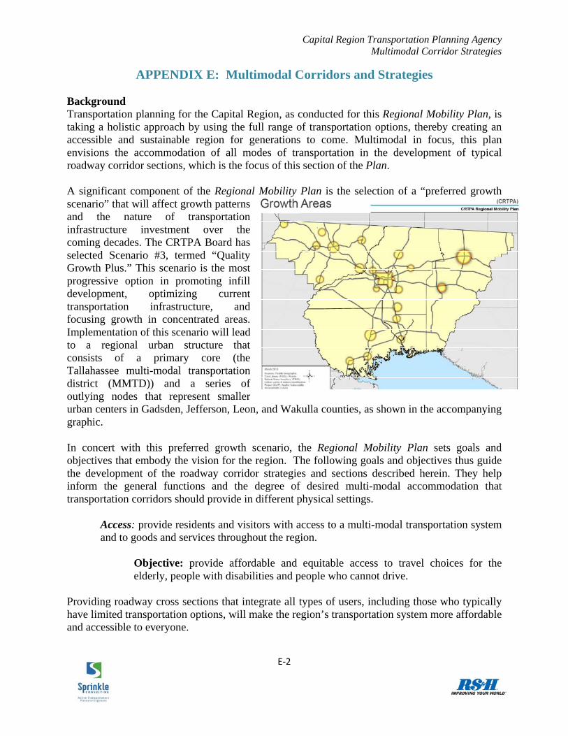
APPENDIX E: Multimodal Corridors and Strategies Background Transportation planning for the Capital Region, as conducted for this Regional Mobility Plan, is taking a holistic approach by using the full range of transportation options, thereby creating an accessible and sustainable region for generations to come. Multimodal in focus, this plan envisions the accommodation of all modes of transportation in the development of typical roadway corridor sections, which is the focus of this section of the Plan. A significant component of the Regional Mobility Plan is the selection of a “preferred growth scenario” that will affect growth patterns and the nature of transportation infrastructure investment over the coming decades. The CRTPA Board has selected Scenario #3, termed “Quality Growth Plus.” This scenario is the most progressive option in promoting infill development, optimizing current transportation infrastructure, and focusing growth in concentrated areas. Implementation of this scenario will lead to a regional urban structure that consists of a primary core (the Tallahassee multi-modal transportation district (MMTD)) and a series of outlying nodes that represent smaller urban centers in Gadsden, Jefferson, Leon, and Wakulla counties, as shown in the accompanying graphic. In concert with this preferred growth scenario, the Regional Mobility Plan sets goals and objectives that embody the vision for the region. The following goals and objectives thus guide the development of the roadway corridor strategies and sections described herein. They help inform the general functions and the degree of desired multi-modal accommodation that transportation corridors should provide in different physical settings.
Access: provide residents and visitors with access to a multi-modal transportation system and to goods and services throughout the region.
Objective: provide affordable and equitable access to travel choices for the elderly, people with disabilities and people who cannot drive.
Providing roadway cross sections that integrate all types of users, including those who typically have limited transportation options, will make the region’s transportation system more affordable and accessible to everyone.

Capital Region Transportation Planning Agency Multimodal Corridor Strategies
E‐3
Connectivity: Enhance local and regional connectivity to effectively and safely move people and goods using multiple modes of transportation
Objective: Maximize the interconnectivity of streets, sidewalks, trails, and transit to provide safe and convenient pedestrian, bicycle, transit, and motor vehicle mobility.
Objective: Enhance regional connectivity to employment, education, and activity centers.
Objective: Develop context sensitive design standards for transportation facilities to protect community character, provide for “complete streets,” enhance connectivity, and encourage the use of multiple modes of transportation.
Connectivity is critical to the efficient flow of people and goods throughout the region. Integration of all modes into the transportation network will allow the efficient, cost-effective, and widespread use of the entire system. Local and regional connectivity will be facilitated by the design and implementation of facilities that accommodate all modes. Context sensitive design and complete streets are critical to determining the appropriate character, hence physical mix of facilities, for the users of the corridors.
Multimodalism: There are many forms of transportation in the region, some untapped and to be utilized in the future. The Regional Mobility Plan must create and maintain opportunities to facilitate the movement of and connections among people, jobs, goods and services.
Objective: Provide infrastructure to facilitate and support transit riders, pedestrians, bicyclists, carpools and vanpools.
This section of the Regional Mobility Plan describes corridor-based strategies for providing an appropriate level of accommodation for all four primary modes of travel (auto, bicycle, pedestrian, and transit) within roadway environments. The recommendations are based on the purposes and functions that the respective corridor types will serve. Corridor strategies have been developed for four primary corridor types that are envisioned in the future regional character: 1) urban arterial roadways located in or near a dense urban center; 2) suburban arterial roadways; 3) urban arterials roadways in a smaller outlying downtown area; and 4) rural arterial roadways located between two urban nodes. In each case, the corridor type’s function within the preferred growth scenario is described, followed by a summary of typical existing conditions, future trends, and recommendations to help achieve the identified goals and objectives. Graphics are provided illustrating typical future roadway corridors and representative cross sections. Finally, a section outlining a representative quantification of the “livability benefits” (e.g., mode shift, fuel savings, greenhouse gas reductions, increased “active transportation,” and corresponding health care benefits) of each future corridor type is included.

Capital Region Transportation Planning Agency Multimodal Corridor Strategies
E‐4
Urban Arterials (Dense Urban Center) Function within the RMP Vision More so than with any other setting, arterials serving travel within dense urban environments such as the Tallahassee MMTD have vast potential for becoming highly successful complete streets corridors, those in which all four primary modes are integrated and well-utilized. Within the “Quality Growth Plus” scenario, the majority of trips in this setting would be relatively short and many could have both their origins and destinations located within the MMTD. A significant portion of those trips could be made by bicycle or on foot. The dense and well mixed land uses can also be well served by public transit, both for local trips and for commute trips that originate in outlying areas. Many other trips that originate in smaller satellite urban nodes may be made by car, but the accommodation of these longer trips should be secondary to accommodating the shorter-distance internal trips. Existing Conditions and Trends The desired function of urban arterials described above, while not yet consistently implemented today, is achieved in some existing roadway corridors. The auto mode is generally well accommodated. Sidewalks are common and transit routes with relatively frequent service are prevalent. However, bicycling is not well accommodated; there are not many distinct bicycle facilities (either on-street or physically separated from the roadway). This is problematic in the Capital Region, particularly due to the substantial “market demand” for bicycling resulting from the significant student populations of FSU, FAMU, and TCC. If the adopted growth scenario is to be reality in the coming decades, the region’s urban arterial corridors must undergo significant changes in their multi-modal accommodation. While it is not the intent of the Regional Mobility Plan to perform detailed operational analyses of the region’s existing roadways, FDOT’s multi-modal level of service techniques, as outlined in the 2009 Quality/Level of Service Handbook, nonetheless provide a convenient way to get a snapshot of
how well corridors meet the needs of their varied users. These techniques produce a letter grade for each of the modes on an easily understood A-F grading scale. The accompanying table shows the level of accommodation provided to travelers by a typical urban downtown arterial using assumed input values. 156 With the exception of the pedestrian mode, these conditions meet the current MMTD performance standards identified in the Tallahassee-Leon County Comprehensive Plan’s Transportation Element.157
156 4 lanes; dense signal spacing; 30,000 vehicles per day; 2% trucks; 35 mph posted speed limit; 12‐foot travel lanes; no bike lanes; good surface pavement condition; no on‐street parking; 5‐foot sidewalks separated from the road by a 5‐foot buffer area; bus frequency of 30 minutes provided for 14 hours daily 157 “C” for pedestrian and transit, “D” for bicycle, and “E” (+50%) for auto
Travel Mode
LOS
Auto D Bicycle D Pedestrian D Transit D

Capital Region Transportation Planning Agency Multimodal Corridor Strategies
E‐5
These results, which are in line with the City of Tallahassee-reported areawide conditions for the MMTD study area,158 indicate that urban arterials in the Capital Regional typically do not yet fully achieve the access, connectivity, and multimodalism objectives of the Regional Mobility Plan. Specifically, access and connectivity to the numerous population, employment, and activity centers common to the MMTD area is not yet comfortably accessed by active transportation means. This indicates that urban arterial corridors need to offer users improved multi-modal accommodation. To help achieve this, the following section makes mode-specific recommendations that will lead to better implementation of the adopted growth scenario for the Capital Region. These recommendations include general roadway cross-section characteristics and specific discussion of an innovative treatment that can simultaneously enhance the bicycling, transit, and walking environments. Recommendations for Action Pedestrian needs, which are paramount in dense urban settings, are generally met through the provision of sidewalks. From a pedestrian’s perspective, full sidewalk coverage on both sides of the roadway should be included on all urban arterials to help achieve the desired function of these streets. Furthermore, use of the right-of-way should be optimized to create a sufficiently wide or landscaped buffer zone between the outside travel lane and the sidewalk. If traffic volumes are relatively high, even the presence of a well-buffered sidewalk may not always provide a high level of accommodation (i.e., sense of safety or comfort) for pedestrians walking along the corridor. In this event on-street parking, which is common on roadways in dense urban settings, may provide additional perceived accommodation, and trees planted in the buffer zone can further enhance the sense of separation between the pedestrian and the parallel motor vehicle traffic. As with the pedestrian mode, providing a good bicycling environment in this setting is essential for access, mobility, and an energy-efficient transportation system in dense urban areas; it further helps connectivity within the overall transportation system. While all urban streets technically are shared lanes that can be used by bicyclists, better bicycling accommodation and, unless adjacent parallel routes are suitable, exclusive bicycle facilities (bike lanes, etc.) are needed to provide a high level of accommodation unless the roadways’ traffic volumes and/or speeds are especially low. Roadway restriping projects, in which lane widths are reduced, and road diet projects, in which the total number of lanes is reduced, are two common ways to retrofit roadways to better accommodate bicycling. These techniques are most easily applied in urban areas where truck volumes are low and where accommodation of the auto mode is secondary to the other modes. Urban transportation corridors within the Capital Region should provide optimum transit accommodation to existing and potential riders to meet the region’s goals. Using FDOT’s primary evaluation procedure, the highest level of accommodation is met when the corridor is served by six or more transit vehicles per hour, which equates to an average service frequency of ten minutes or less. This level of accommodation for people using transit can also be achieved 158 The reported areawide transit level of service is actually “E”; however, this is readily acknowledged not to reflect actual conditions because the incorporated methodology only considers the streets on which routes run as providing transit service (not the many nearby parallel streets that the routes also serve).

Capital Region Transportation Planning Agency Multimodal Corridor Strategies
E‐6
with somewhat longer wait times if transit span of service, general walking conditions, and pedestrian mid-block crossing conditions are ideal. Constrained rights-of-way are a well-established challenge to providing enhanced livability along dense urban arterial corridors. However, several innovative approaches are arising throughout the United States that can enhance the sustainable transportation modes given limited space. Two highlighted here are the hybrid bus-bikeway and the bicycle boulevard. The hybrid bus-bikeway can significantly improve bicycling conditions while concurrently enhancing transit operations and making the pedestrian environment more comfortable and safer. While conventional bus/bike lanes have been implemented in several forms around the United States, this potential application for the CRTPA is an enhanced striping design for outside lanes to be signed and more effectively marked for bikes and buses only. The outer half of the space is the surface for bicyclists while the inner half, which is marked with chevrons, includes the additional space needed for bus operations. From the bicyclist’s perspective, the effect is a “buffered bike lane” in which bicyclists are separated from the outside general use lane by a clearly visible space into which through motor vehicles should not encroach. This extra buffering also further buffers pedestrians from automobile traffic, thereby enhancing the walking experience and the safety of pedestrians, particularly in areas where there is no existing buffer for the sidewalk. Transit reliability improves as well because buses may bypass some longer through movement queues at signalized intersections. The bus-bikeway is open to motorists for right turns at those intersections to help preserve motor vehicle capacity and to facilitate orderly right turns by all vehicles. Bicycle boulevards are another type of facility that can provide significant benefits to bicyclists in urban areas. A bicycle boulevard is typically a local street segment, or series of contiguous street segments, that is parallel to, and within a block or so of, a constrained urban arterial; the “boulevard” has been modified to accommodate through bicycle traffic but discourage through motor traffic. These facilities take advantage of streets that already have bike friendly characteristics - low speeds and traffic volumes. Local streets, however, typically are either not continuous or have numerous interruptions which make them inconvenient as through routes, even to bicyclists. Consequently, to be a bike boulevard the local street(s) needs to be improved to promote safe and efficient bicycling while at the same time preventing motorist cut through traffic. Such improvements could include -
motor vehicle traffic diverter treatments at some intersections that allow for through bicycle movements;

Capital Region Transportation Planning Agency Multimodal Corridor Strategies
E‐7
shared lane markings; removal of STOP signs for the through movement along the bike boulevard; bike friendly traffic calming to keep motor vehicle speeds low; improvements to major roadway crossings along the bike boulevard, such as curb
extensions, raised median refuge islands (preferably at least 10 feet wide) and activated crossing traffic control devices; and
wayfinding signage. Not all of the above are needed on all bike boulevards, but effective combinations of the above will help create a low stress bicycling facility. An example is shown in the accompanying figure.
Implementation of these various recommendations would lead to urban arterial corridor environments in which bicyclists, pedestrians, and transit users are all well-accommodated. These recommended roadway characteristics would result in the multi-modal conditions shown in the accompanying table. These conditions show the emphasis on transit and active transportation that is an essential function of the corridors in this setting. Successfully implementing these corridor “performance goals” will be a significant step toward achieving the vision of the Regional Mobility Plan. Furthermore, a more energy efficient transportation system will result, along with the associated benefits of lower individual transportation costs, improved health (and lower health care costs), reduced reliance on scarce energy sources, and improved air quality. Livability Benefits of This Future Corridor Type New bicycle and pedestrian activity will result from implementation of the identified
recommendations. These increased levels of bicycling and walking in turn create more livable communities in which individuals who choose active transportation (as well as the broader community) experience numerous economic and other benefits. The Florida Department of Transportation, though its recent Conserve by Bicycling and Walking research initiative, established a methodology for quantifying several of these livability benefits: fuel cost savings, health benefits savings, and
Travel Mode
LOS
Auto D Bicycle A Pedestrian B Transit A

Capital Region Transportation Planning Agency Multimodal Corridor Strategies
E‐8
emissions reductions.159 Livability benefits result from two new non-auto trip types:
1) mode shift - choosing to bicycle, walk, or ride transit for a utilitarian (destination-based) trip instead of driving because of facility improvements, and
2) induced recreational travel - walking or bicycling recreationally when no trip would have been made if a non-motorized facility improvement had not been made.
The FDOT methodology enables roadway corridor-based quantification of both of these trip types based on numerous characteristics of the corridor itself and the surrounding area. These characteristics include the following:
Multi-modal operating conditions (corridor); Average traveler trip length (corridor); Bicycle or pedestrian facility length (corridor); Aesthetics (corridor); Access to points of interest (corridor); Quality and connectivity of the surrounding bicycle transportation network; Quality and connectivity of the surrounding pedestrian transportation network; Quantity and density of nearby population and employment; and Household income of the surrounding area.
Livability benefits can then be estimated based on the number of calculated new non-auto trips that would result from changes in these characteristics. The typical action recommendations for arterials in dense urban areas (as described in the previous section) would significantly improve bicycling, walking, and transit conditions (via the introduction of bike lanes, a wider buffer area between the roadway and sidewalk, the installation of trees in the buffer zone, and more frequent transit service), while also improving corridor aesthetics. A before-and-after comparison of commonly found existing conditions for urban arterials and the proposed recommendations shows the increase in annual active transportation and corresponding benefits. The values shown in the table found on the following page are for a single five-mile corridor; these values have the potential to increase significantly if applied across numerous corridors of this type throughout the Capital Region.
159 Conserve by Bicycling and Walking Phase II Report, Florida Department of Transportation, 2009, http://www.dot.state.fl.us/Safety/ped_bike/ped_bike_reports.shtm#Conserve by Bicycle Phase 2 Study.

Capital Region Transportation Planning Agency Multimodal Corridor Strategies
E‐9
Annual Changes and Benefits160
New Utilitarian Bicycling Trips 14,128
New Recreational Bicycle Trips 19,558
New Utilitarian Walking Trips 15,501
New Recreational Walking Trips 10,616
Fuel Cost Savings $13,104
Health Care Cost Savings $134,977
CO2 Emissions Reduction 68,890 lbs.
Suburban Arterials Function within the RMP Vision Providing an efficient transportation system of suburban arterials is key to meeting regional transportation goals, but doing so represents a significant challenge. Many suburban arterials are currently (and will be until the long range planning horizon) among the highest-volume corridors in the Capital Region, and they have great importance in providing mobility and accessibility between major residential areas and numerous commercial destinations. In the preferred growth scenario, these corridors also serve those who are traveling between identified growth areas. Those who live in suburban locations are traditionally among the least likely to explore the use of non-SOV travel. While implementation of the envisioned growth scenario is intended in part to curb the spread of typical suburban land development, existing suburban areas will remain in place through the plan horizon date; improving multi-modal conditions along these corridors is an integral component of achieving the broader regional transportation objectives. Existing Conditions and Trends Many existing suburban arterial corridors fail to provide adequate accommodation to any of the four primary modes, including the auto mode. Increasing traffic volumes and the proliferation of traffic signals has led to more delay and longer travel times for motorists. These same trends make the environment more challenging for most bicyclists and pedestrians. Dedicated bicycle facilities are being added on many new construction projects, but are still largely absent within most suburban arterial corridors. Sidewalks are fairly common, but are frequently not sufficiently buffered from the adjacent motor vehicle traffic. Fixed transit service is common, but low demand keeps headways between buses long, which adds to the inconvenience for those who do ride, either by necessity or by choice.
160 Future year (2035) projections of fuel costs and health expenditures are based on data from the U.S. Department of Energy and the U.S. Department of Health and Human Services, respectively. http://www.eia.gov/forecasts/aeo/pdf/0383er(2011).pdf https://www.cms.gov/NationalHealthExpendData/downloads/NHEProjections2009to2019.pdf

Capital Region Transportation Planning Agency Multimodal Corridor Strategies
E‐10
While the implementation of the adopted growth scenario may effectively reduce the amount of additional suburban growth, the existing traffic conditions will largely remain unchanged for some time. These conditions, which are summarized in the accompanying table,161 suggest that much can and should be done to make suburban arterials a more accommodating setting for users of all transportation, and particularly the “active,” modes. This will be especially important if existing residential suburban areas also become employment centers, which would lead to shorter trip lengths that are conducive to the use of non-auto modes. Recommendations for Action Suburban roadway corridors have the unique characteristic of serving transportation and land use functions that bridge urban and rural areas. They need to be versatile and should have the capability to function adequately (without major reconstruction) if the corridor eventually
transitions from a suburban character to an urban character. Accordingly, many of the recommendations prescribed for arterials in dense urban areas (e.g., sidewalks with maximum buffering, provision of bike lanes, increased transit service, and general optimization of available right of way) are also applicable and appropriate for suburban arterials. These recommendations, if implemented, will enable more bicycle and
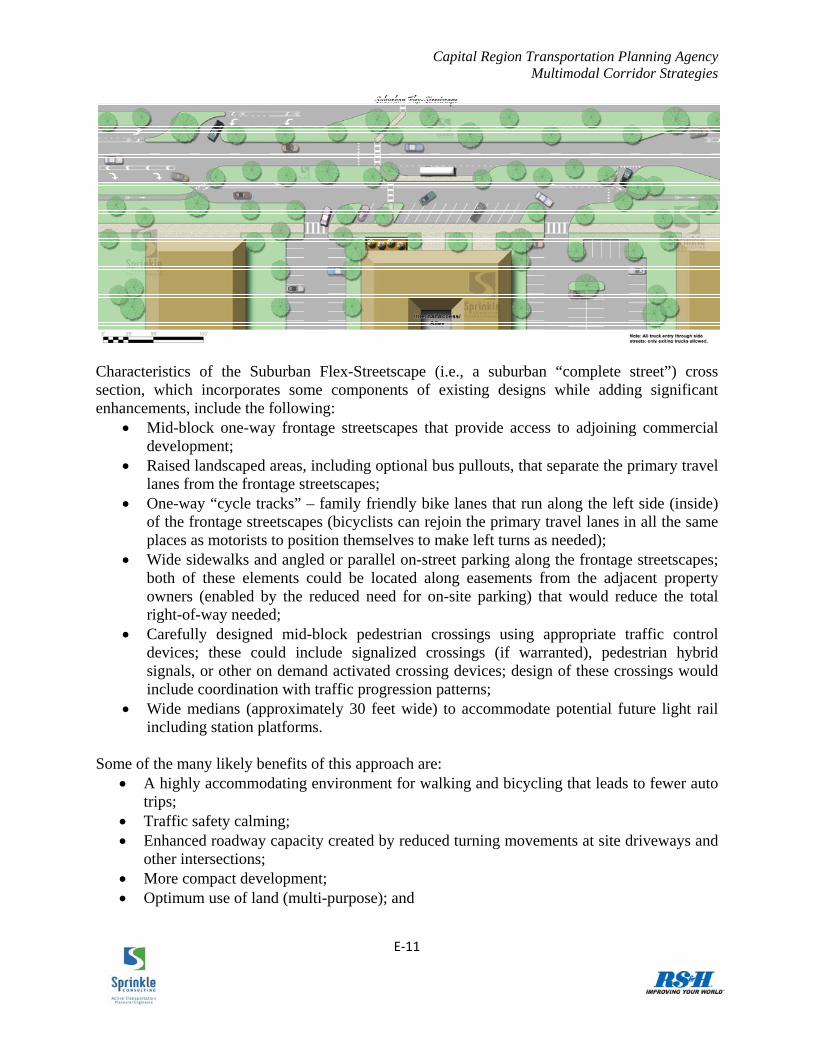
pedestrian travel as trip lengths in suburban areas get shorter (while simultaneously accommodating longer distance auto travel that will still exist). One particular approach to a roadway cross-section that goes beyond the basic facility improvement recommendations is described and illustrated below to show the potential that exists for these types of roadways to perform the needed multi-modal functions. The implementation of a “Suburban Flex-Streetscape” shows promise for simultaneously accommodating all travel modes in a suburban environment while also creating a more visually attractive roadway environment. Having cars exit the main thoroughfare onto parallel one-way land access streets serves both transportation and aesthetic functions. An illustration of the concept is shown in the accompanying graphic.
161 Typical characteristics: 4 lanes with 35,000 vehicles per day or 6 lanes with 53,000 vehicles per day; relatively dense signal spacing; 3% trucks; 45 mph posted speed limit; 12‐foot travel lanes; no bike lanes; good surface pavement condition; no on‐street parking; 6‐foot sidewalks adjacent to the outside travel lane; bus frequency of 30 minutes provided for 14 hours daily
Travel Mode
LOS
Auto E Bicycle E Pedestrian E Transit E
Capital Region Transportation Planning Agency Multimodal Corridor Strategies
E‐11
Characteristics of the Suburban Flex-Streetscape (i.e., a suburban “complete street”) cross section, which incorporates some components of existing designs while adding significant enhancements, include the following:
Mid-block one-way frontage streetscapes that provide access to adjoining commercial development;
Raised landscaped areas, including optional bus pullouts, that separate the primary travel lanes from the frontage streetscapes;
One-way “cycle tracks” – family friendly bike lanes that run along the left side (inside) of the frontage streetscapes (bicyclists can rejoin the primary travel lanes in all the same places as motorists to position themselves to make left turns as needed);
Wide sidewalks and angled or parallel on-street parking along the frontage streetscapes; both of these elements could be located along easements from the adjacent property owners (enabled by the reduced need for on-site parking) that would reduce the total right-of-way needed;
Carefully designed mid-block pedestrian crossings using appropriate traffic control devices; these could include signalized crossings (if warranted), pedestrian hybrid signals, or other on demand activated crossing devices; design of these crossings would include coordination with traffic progression patterns;
Wide medians (approximately 30 feet wide) to accommodate potential future light rail including station platforms.
Some of the many likely benefits of this approach are:
A highly accommodating environment for walking and bicycling that leads to fewer auto trips;
Traffic safety calming; Enhanced roadway capacity created by reduced turning movements at site driveways and
other intersections; More compact development; Optimum use of land (multi-purpose); and

Capital Region Transportation Planning Agency Multimodal Corridor Strategies
E‐12
High visibility of commercial buildings by travelers (and associated economic and aesthetic benefits).
This general concept is not new to the Capital Region, a basic version of such a system was used when Apalachee Parkway (shown at left) was reconstructed in the 1950s to help create a “parkway” setting that provided a signature approach to downtown Tallahassee and the State Capitol. This objective was certainly accomplished by the design that is still in place today, particularly in comparison to more typical suburban arterial corridors such as the example shown at right, Dale Mabry Highway, in the Tampa Bay region. However, it does leave significant room for improvement for multi-modal accommodation and other functions that are addressed in the Suburban Flex-Streetscape. A modification of that early concept also exists along a section of Palm Beach Lakes Boulevard in Palm Beach County. This application includes parallel on-street parking within the frontage roads. This parking creates the
potential to reduce the need for adjacent on-site commercial parking, which is an important feature of the recommended concept for the Capital Region. This on-street parking also has the advantage of providing an improved walking setting caused by a more compact built environment and increased separation from auto traffic. The numerous benefits of the Suburban Flex-Streetscape, which builds on these more basic existing examples, illustrate the potential that exists to create suburban roadway environments that are appealing to all users and that have advantages beyond their transportation-related functions. The concept clearly indicates the possibilities for highly sought multi-function “livable corridors” within the Capital Region. While not every suburban arterial will
be a candidate for this type of streetscape, significant improvements to bicycling and walking conditions can be implemented universally to achieve the target multi-modal conditions shown in the accompanying table.
Travel Mode
LOS
Auto E Bicycle E Pedestrian E Transit E

Capital Region Transportation Planning Agency Multimodal Corridor Strategies
E‐13
Livability Benefits of This Future Corridor Type Numerous livability benefits will result from implementation of the recommended actions. Achieving the desired level of improved multi-modal accommodation on suburban arterial corridors will lead to increased active transportation and associated reductions in emissions, fuel expenditures, and health care expenditures. Using the same methodology described in the Urban Arterials (Dense Urban Center) section, these livability benefits have been calculated and are shown in the table below.
Annual Changes and Benefits
New Utilitarian Bicycling Trips 1,090
New Recreational Bicycle Trips 19,832
New Utilitarian Walking Trips 2,725
New Recreational Walking Trips 33,375
Fuel Cost Savings $1,055
Health Care Cost Savings $126,670
CO2 Emissions Reduction 5,544 lbs.
Rural Arterials Function within the RMP Vision Within the “Quality Growth Plus” long range planning scenario for the Capital Region, the primary function of rural arterial roadway corridors is to carry travelers between urban nodes. In this sense, these corridors should be designed to move travelers quickly over long distances. Local trips are infrequent because the scenario identifies the majority of the land along these routes as remaining undeveloped or otherwise being developed at very low densities. These characteristics help establish the typical multi-modal accommodation that should be provided within rural arterial cross sections. Existing Conditions and Trends The multi-modal transportation conditions common to the region’s rural arterial corridors are
generally in line with their envisioned future functions. These corridors are typically designed to move people (and goods) quickly. If bicycle and pedestrian facilities are provided, they are intermittent and/or less accommodating to their users than what is often found in suburban or urban areas. Fixed transit service is rare; if it exists, it takes the form of express bus service with limited stops. Using typical characteristics for this rural setting,162 the accompanying table shows the level of multi-modal accommodation experienced by travelers. The auto mode level of
service meets all local government standards; the region’s implementing jurisdictions do not
162 4 lanes; infrequent signal spacing; 20,000 vehicles per day; 9% trucks; 55 mph posted speed limit; 12‐foot travel lanes; 5‐foot paved shoulders; good surface pavement condition; no on‐street parking; no sidewalks; no transit service
Travel Mode
LOS
Auto B Bicycle E Pedestrian E Transit F
Capital Region Transportation Planning Agency Multimodal Corridor Strategies
E‐14
generally set targets or standards for the non-auto modes in their growth management or comprehensive planning documents. While these conditions do not represent the accomplishment many of the stated goals and objectives, they do represent the expectations of many users along these routes if the selected growth scenario comes to fruition. As the relative percentage of inter-city trips decreases, non-auto trips become less common and the function of the auto mode remains the primary objective of rural arterial corridors. Nonetheless, there are additional considerations that can be made to ensure safe travel for all modes and to provide improved multi-modal access where needed, as shown in the recommendations in the following section. Recommendations for Action Pedestrian travel along rural arterial routes is typically infrequent due to the dispersion of attractors and generators and the associated long-distance trips that are common to these roads, both currently and in the anticipated future scenario. While sidewalks may be constructed along some sections of rural arterials, in general the overall infrequency of use suggests that sidewalk benefits are relatively low compared to their costs.163 In comparison, the provision of paved shoulders has much greater financial feasibility. Paved shoulders are specified in the FDOT typical section for four-lane rural collectors and arterials, and this specification is also typically used by the region’s local jurisdictions. While such paved shoulders do not provide the same level of accommodation to pedestrians as sidewalks that are separated from the roadway, they do allow the occasional pedestrian to travel on an even surface located outside of the general use travel lane. These paved shoulders can also provide a sufficient facility for many bicyclists in this rural setting, depending on traffic conditions. While utilitarian bicycle trips (i.e. non-recreational trips that have destinations) are not expected to be common along rural arterials, recreational trips will likely occur, especially among experienced cyclists. The paved shoulders provide those cyclists a space that will not generally be encroached upon by motor vehicle traffic, which is especially important given the higher truck volumes that are common along rural arterials. While a separated shared use path may be used by certain cyclists, and may be desirable in some instances, they would only be included in rural sections if sufficient demand were evident. The majority of rural arterials will likely remain un-served by fixed route transit in the future scenario, again because of the low density of trip generators and attractors that lead to transit demand. However, if a rural corridor serves as the primary link between two urban activity centers, the corridor may host an express route such as the recently introduced Gadsden Express. By their nature, express bus routes have limited stops between the route’s termini. However, if isolated stops are present, short sections of sidewalks and the associated curb ramps should be provided between the stop itself and the nearby intersection or destination that the stop serves. The same holds true for school bus stops, which are more likely to be prevalent in this corridor setting.
163 There are a number of exceptions to this general condition, among them school locations and other areas of concentrated activity.

Capital Region Transportation Planning Agency Multimodal Corridor Strategies
E‐15
These characteristics produce the same multi-modal conditions shown in the preceding table, although they do lead to some small benefits in multi-modal accommodation. The provision of better accommodation for the auto mode than for the non-motorized modes in this setting is rooted in the rural arterial’s scenario-based purpose of moving people long distances quickly. In locations where these rural areas transition to suburban settings, where the potential for active transportation is higher, corridors should better accommodate bicyclists, pedestrians, and transit users. Furthermore, rural corridors that may transition into the suburban character should be designed to allow for the provision of new bicycle and pedestrian facilities. Such allowances include 1) paved shoulders that are both properly located (i.e. to the inside of right turn lanes at intersections) and wide enough to later be signed and marked as designated bike lanes, and 2) preservation of a flat surface outside the edge of pavement that minimizes the amount of grading needed for potential future sidewalk construction. Urban Arterials (Smaller Downtowns) Function within the RMP Vision The Capital Region currently includes many urban places that are located far from the primary regional economic center in otherwise rural areas. These smaller downtowns, which already perform numerous important functions within their respective communities, will become even more significant as the Regional Mobility Plan growth scenario plays out. In this scenario, in which new growth is concentrated in certain areas, existing urban places would grow more than their suburban counterparts. In addition, more intra-city trips would take place, replacing current inter-city trips. These downtown areas (and the roads that serve them) would take on many of the characteristics of the Tallahassee MMTD, albeit on a smaller scale. In this sense, and for the preservation and promotion of local economic vitality, multi-modal transportation accommodation in such locations will be increasingly important. Existing Conditions and Trends Existing transportation characteristics and conditions of arterials in urban places vary considerably throughout the region. Some such corridors function merely as components of long rural highways with the only difference in the urban area being a small decrease in posted speed limit. In contrast, those located in the heart of historic downtowns may operate as low-speed
corridors with wide sidewalks and on-street parking that help provide access to adjacent commercial destinations. As these areas become more populous and more densely developed over time, multi-modal accommodation will help preserve the economic strength of such places by promoting access to local businesses. Transit routes and exclusive bicycle facilities are generally absent in most small urban settings, but will have a greater purpose in the coming decades. The prevailing transportation accommodation provided by arterials in smaller urban
areas shown in the table on the following page164 indicates that there is some room for improvement. The following section highlights multi-modal facility/service recommendations 164 2 lanes; 14,000 vehicles per day; 4% trucks; 45 mph posted speed limit; 12‐foot travel lanes; no bike lanes; good surface pavement condition; on‐street parking (75% occupied); 5‐foot sidewalks separated from the road by a 5‐foot buffer area; no transit service
Travel Mode
LOS
Auto D Bicycle D Pedestrian C Transit F

Capital Region Transportation Planning Agency Multimodal Corridor Strategies
E‐16
for this corridor type, the implementation of which would represent an important step in regional access and connectivity. Recommendations for Action Pedestrian needs, which are paramount in small downtown settings, are generally met through the provision of sidewalks. From a pedestrian’s perspective, full sidewalk coverage on both sides of the roadway should help achieve the desired function of these streets. Use of the right-of-way should be optimized to create a sufficiently wide buffer zone between the outside travel lane and the sidewalk, and to maximize the width of the sidewalk itself. If traffic volumes are relatively high, even the presence of a well-buffered sidewalk may not always provide a high level of accommodation (i.e., sense of safety or comfort) for pedestrians walking along the corridor. In this event on-street parking, which is common on roadways in small downtown settings, may provide additional perceived accommodation, and the presence of trees planted in the buffer zone can further enhance the sense of separation between the pedestrian and the parallel motor vehicle traffic. In the particular setting of small urban places that quickly transition to neighboring rural areas, sidewalks should continue throughout the transitioning area, after which intermittent sidewalks may be needed for school-related or transit-related access (see Rural Arterials section for more detail). The corresponding provision of good bicycling conditions improves access within downtown areas and offers connectivity to local destinations. Again, while all streets in small urban places are technically shared lanes that can be used by bicyclists, exclusive bicycle facilities (bike lanes, etc.) are needed to provide a high level of accommodation unless the roadways’ traffic volumes and/or speeds are especially low. Most rural arterial cross sections should include paved shoulders as they approach urban places. Efforts should be made to carry this delineated space through the suburban transition area and into the adjacent urban area (perhaps signed and marked as a designated bike lane) to provide facility continuity (and access to commercial destinations) for bicyclists. Provision of increased transit options in smaller downtowns would offer local residents a useful complement to improved bicycling and walking conditions. In their existing forms, smaller downtowns generally lack the population and employment density to support fixed route transit service. While the number of attractors and generators would be expected to increase as these areas become more significant on the regional scale, regular and widespread fixed transit service will likely remain absent. Nonetheless there will be a growing market for transit among those who still commute from an outlying urban node into the Tallahassee MMTD, which suggests an opportunity for express bus service. Such service was recently introduced via the Gadsden Express, a route that makes limited stops between Quincy and Tallahassee. More similar routes could be introduced, particularly focusing on providing service during the AM and PM commute periods. In addition, local communities should investigate the potential ridership of smaller circulator routes that run throughout the downtown area and implement such routes if sufficient user needs exist.

Capital Region Transportation Planning Agency Multimodal Corridor Strategies
E‐17
As with the dense urban setting, implementation of these various recommendations would lead to an environment in which bicyclists and pedestrians are well-accommodated. These recommended roadway characteristics would produce the multi-modal conditions shown in the accompanying table. These conditions show the emphasis on transit and active transportation that is an essential function of the corridors in this setting. Successfully implementing these corridor “performance goals” will be a significant step toward achieving the vision of the Regional Mobility Plan and,
more importantly, will create livable smaller urban areas that are viewed by existing and potential residents as “life-long communities.” Livability Benefits of This Future Corridor Type Numerous livability benefits will result from implementation of the recommended actions. Achieving the desired level of improved multi-modal accommodation on suburban arterial corridors will lead to increased recreational active transportation and associated reductions in health care expenditures, as shown in the table below. Because of the long average trip lengths associated with this setting and the relatively low density of population and employment, mode shift and corresponding fuel cost and emissions savings are negligible.
Annual Changes and Benefits
New Recreational Bicycle Trips 2,843
New Recreational Walking Trips 1,576
Health Care Cost Savings $10,331
Travel Mode
LOS
Auto D Bicycle C Pedestrian B Transit E


