DISTINCTIVELY LOCAL 76 We have selected 15 case studies featuring projects which illustrate some or all of the issues and themes in our report. All but one are completed and occupied. They range in size from just 25 to over 650 homes, and they point the way towards creating good homes and places at a much larger scale. Within the chapters there are examples of masterplans for 1,000 homes and more, which show how to scale up the approach to placemaking shown in the case studies. We acknowledge that most of our case studies are in relatively high value areas in London, the South-East and Cambridge, although we also have examples in the West Country, Midlands and Scotland. We understand that financial viability in lower value areas is very challenging, but we also know that good outcomes can be achieved through holistic design (thinking about the ‘means of production’ from the outset) and the intelligent application of funds towards the things which people really value: comfort, convenience and beauty. The case study projects have been endorsed by numerous design award juries, and, more importantly, they are popular with the people who live in and around them. CASE STUDIES page 78 page 80 page 82 page 84 page 86 page 88 page 90 page 92 page 94 page 96 page 98 page 100 page 102 page 104 page 106 The Avenue, Saffron Walden Pollard Thomas Edwards Cane Hill Park, Coulsdon HTA Design Ninewells, Cambridge PRP Horsted Park, Chatham Proctor & Matthews Hanham Hall, Bristol HTA Design Mountfield Park, Canterbury Proctor & Matthews New Ground, High Barnet Pollard Thomas Edwards Kings Weald, Burgess Hill PRP Polnoon, Eaglesham, East Renfrewshire Proctor & Matthews Upton, Northampton HTA Design Beechwood West, Basildon Pollard Thomas Edwards Windlebrook Park, Longcross, Surrey PRP Officers Field, Portland HTA Design Woodside Square, Muswell Hill Pollard Thomas Edwards Abode, Great Kneighton, Cambridge Proctor & Matthews
Transcript
DISTINCTIVELY LOCAL76
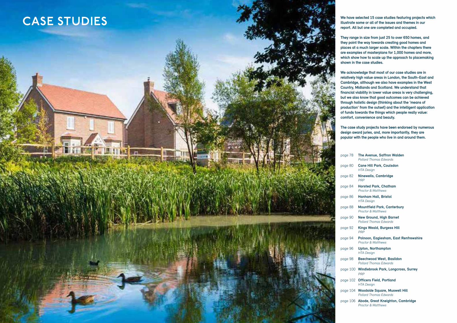
We have selected 15 case studies featuring projects which illustrate some or all of the issues and themes in our report. All but one are completed and occupied.
They range in size from just 25 to over 650 homes, and they point the way towards creating good homes and places at a much larger scale. Within the chapters there are examples of masterplans for 1,000 homes and more, which show how to scale up the approach to placemaking shown in the case studies.
We acknowledge that most of our case studies are in relatively high value areas in London, the South-East and Cambridge, although we also have examples in the West Country, Midlands and Scotland. We understand that financial viability in lower value areas is very challenging, but we also know that good outcomes can be achieved through holistic design (thinking about the ‘means of production’ from the outset) and the intelligent application of funds towards the things which people really value: comfort, convenience and beauty.
The case study projects have been endorsed by numerous design award juries, and, more importantly, they are popular with the people who live in and around them.
CASE STUDIES
page 78
page 80
page 82
page 84
page 86
page 88
page 90
page 92
page 94
page 96
page 98
page 100
page 102
page 104
page 106
The Avenue, Saffron Walden Pollard Thomas Edwards
Cane Hill Park, CoulsdonHTA Design
Ninewells, Cambridge PRP
Horsted Park, Chatham Proctor & Matthews
Hanham Hall, Bristol HTA Design
Mountfield Park, Canterbury Proctor & Matthews
New Ground, High Barnet Pollard Thomas Edwards
Kings Weald, Burgess Hill PRP
Polnoon, Eaglesham, East Renfrewshire Proctor & Matthews
Upton, Northampton HTA Design
Beechwood West, Basildon Pollard Thomas Edwards
Windlebrook Park, Longcross, Surrey PRP
Officers Field, Portland HTA Design
Woodside Square, Muswell Hill Pollard Thomas Edwards
Abode, Great Kneighton, Cambridge Proctor & Matthews
DISTINCTIVELY LOCALDISTINCTIVELY LOCAL78 79
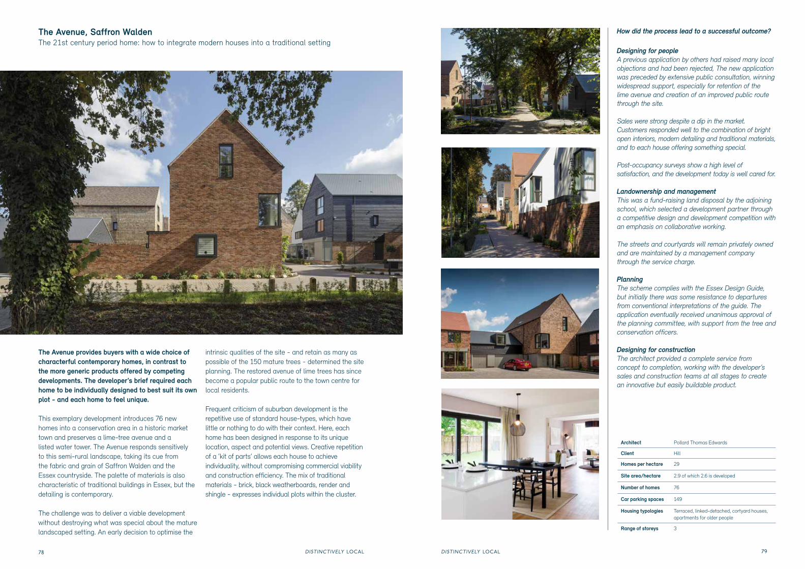
The Avenue provides buyers with a wide choice of characterful contemporary homes, in contrast to the more generic products offered by competing developments. The developer’s brief required each home to be individually designed to best suit its own plot - and each home to feel unique.
This exemplary development introduces 76 new homes into a conservation area in a historic market town and preserves a lime-tree avenue and a listed water tower. The Avenue responds sensitively to this semi-rural landscape, taking its cue from the fabric and grain of Saffron Walden and the Essex countryside. The palette of materials is also characteristic of traditional buildings in Essex, but the detailing is contemporary.
The challenge was to deliver a viable development without destroying what was special about the mature landscaped setting. An early decision to optimise the
intrinsic qualities of the site - and retain as many as possible of the 150 mature trees - determined the site planning. The restored avenue of lime trees has since become a popular public route to the town centre for local residents.
Frequent criticism of suburban development is the repetitive use of standard house-types, which have little or nothing to do with their context. Here, each home has been designed in response to its unique location, aspect and potential views. Creative repetition of a ‘kit of parts’ allows each house to achieve individuality, without compromising commercial viability and construction efficiency. The mix of traditional materials - brick, black weatherboards, render and shingle - expresses individual plots within the cluster.
The Avenue, Saffron WaldenThe 21st century period home: how to integrate modern houses into a traditional setting
Architect Pollard Thomas Edwards
Client Hill
Homes per hectare 29
Site area/hectare 2.9 of which 2.6 is developed
Number of homes 76
Car parking spaces 149
Housing typologies Terraced, linked-detached, cortyard houses, apartments for older people
Range of storeys 3
How did the process lead to a successful outcome?
Designing for people A previous application by others had raised many local objections and had been rejected, The new application was preceded by extensive public consultation, winning widespread support, especially for retention of the lime avenue and creation of an improved public route through the site.
Sales were strong despite a dip in the market. Customers responded well to the combination of bright open interiors, modern detailing and traditional materials, and to each house offering something special.
Post-occupancy surveys show a high level of satisfaction, and the development today is well cared for.
Landownership and managementThis was a fund-raising land disposal by the adjoining school, which selected a development partner through a competitive design and development competition with an emphasis on collaborative working.
The streets and courtyards will remain privately owned and are maintained by a management company through the service charge.
PlanningThe scheme complies with the Essex Design Guide, but initially there was some resistance to departures from conventional interpretations of the guide. The application eventually received unanimous approval of the planning committee, with support from the tree and conservation officers.
Designing for constructionThe architect provided a complete service from concept to completion, working with the developer’s sales and construction teams at all stages to create an innovative but easily buildable product.
DISTINCTIVELY LOCALDISTINCTIVELY LOCAL80 81
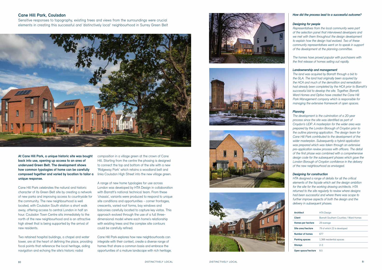
At Cane Hill Park, a unique historic site was boughtback into use, opening up access to an area ofunderused Green Belt. The development showshow common typologies of home can be carefullycomposed together and varied by location to tailor aunique response.
Cane Hill Park celebrates the natural and historiccharacter of its Green Belt site by creating a networkof new parks and improving access to countryside forthe community. The new neighbourhood is well located, with Coulsdon South station a short walk away, offering access to central London in half an hour. Coulsdon Town Centre sits immediately to the north of the new neighbourhood and is an attractive high street that is being supported by the arrival of new residents.
Two retained hospital buildings, a chapel and watertower, are at the heart of defining the place, providingfocal points that reference the local heritage, aidingnavigation and echoing the site’s historic radial
composition in a village green at the crown of Cane Hill. Starting from the centre the phasing is designed to connect the top and bottom of the site with a new‘Ridgeway Park’ which retains a woodland belt andlinks Coulsdon High Street into the new village green.
A range of new home typologies for use across London was developed by HTA Design in collaboration with Barratt’s national technical team. From these ‘chassis’, variants were produced to respond to unique site conditions and opportunities - corner frontages, crescents, varied roof forms, bay windows and balconies carefully located to capture key vistas. This approach evolved through the use of a full three-dimensional model where each home’s relationship with existing trees and the complex site contours could be carefully refined.
Cane Hill Park explores how new neighbourhoods canintegrate with their context, create a diverse range ofhomes that share a common basis and embrace theopportunities of a mature landscape with rich heritage.
Cane Hill Park, CoulsdonSensitive responses to topography, existing trees and views from the surroundings were crucial elements in creating this successful and ‘distinctively local’ neighbourhood in Surrey Green Belt
How did the process lead to a successful outcome?
Designing for people Representatives from the local community were partof the selection panel that interviewed developers andwe met with them throughout the design developmentto explain how the design had evolved. Two of thesecommunity representatives went on to speak in supportof the development at the planning committee.
The homes have proved popular with purchasers withthe first release of homes selling out rapidly.
Landownership and managementThe land was acquired by Barratt through a bid tothe GLA. The land had originally been acquired bythe HCA and much of the demolition and remediationhad already been completed by the HCA prior to Barratt’ssuccessful bid to develop the site. Together, Barratt,Ward Homes and Optivo have created the Cane HillPark Management company which is responsible formanaging the extensive framework of open spaces.
PlanningThe development is the culmination of a 20-yearprocess since the site was identified as part ofCroydon’s UDP. A masterplan for the wider area wasprepared by the London Borough of Croydon prior tothe outline planning application. The design team forCane Hill Park contributed to the development of thewider masterplan. Subsequently a hybrid applicationwas prepared which was taken through an extensivepre-application review process with officers. The detailof the first phase was combined with a comprehensivedesign code for the subsequent phases which gave theLondon Borough of Croydon confidence in the deliveryof the new neighbourhood as envisaged.
Designing for constructionHTA designed a range of details for all the criticalelements of the façade which set the design ambitionfor the site for the working drawing architects. HTAreturned to the site regularly to review where designshad been successful and where there was scope tofurther improve aspects of both the design and thedelivery in subsequent phases.
Architect HTA Design
Client Barratt Southern Counties / Ward Homes
Homes per hectare 29 average
Site area/hectare 79 of which 23 is developed
Number of homes 677
Parking spaces 1,366 residential spaces
Storeys 2-3
Open space/hectare 8.5
DISTINCTIVELY LOCALDISTINCTIVELY LOCAL82 83
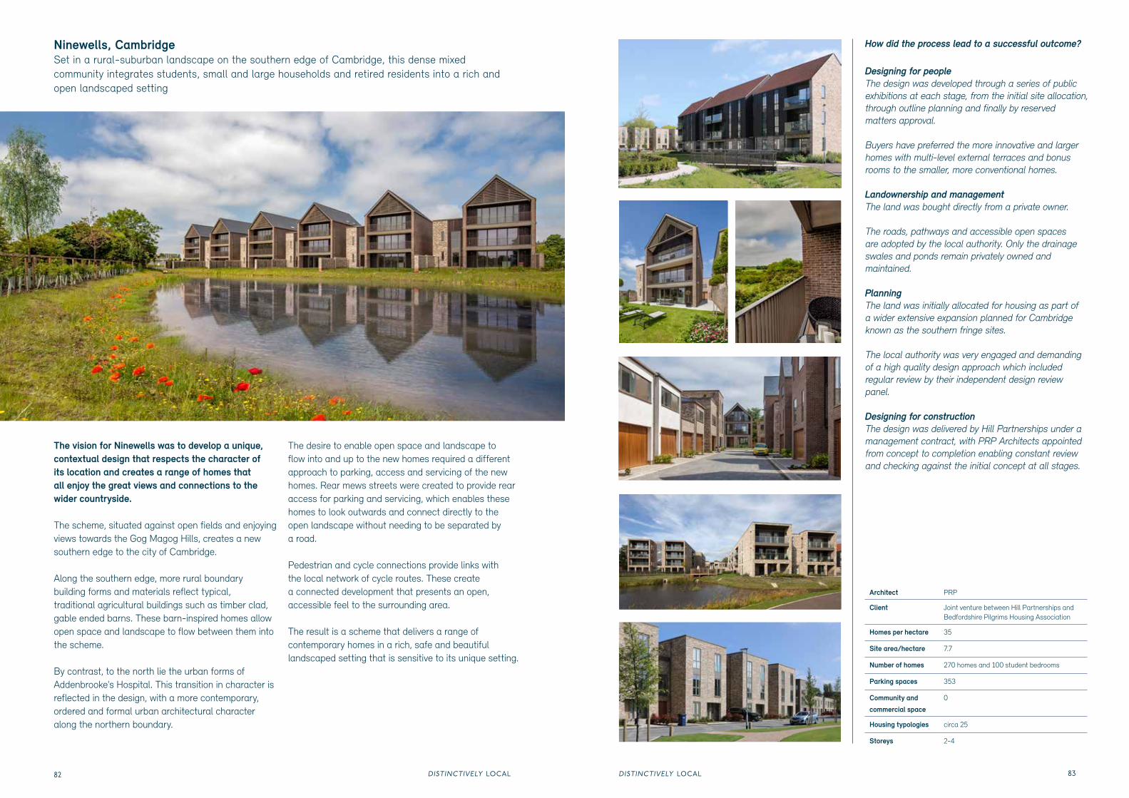
The vision for Ninewells was to develop a unique, contextual design that respects the character of its location and creates a range of homes that all enjoy the great views and connections to the wider countryside.
The scheme, situated against open fields and enjoying views towards the Gog Magog Hills, creates a new southern edge to the city of Cambridge.
Along the southern edge, more rural boundary building forms and materials reflect typical, traditional agricultural buildings such as timber clad, gable ended barns. These barn-inspired homes allow open space and landscape to flow between them into the scheme.
By contrast, to the north lie the urban forms of Addenbrooke's Hospital. This transition in character is reflected in the design, with a more contemporary,ordered and formal urban architectural character along the northern boundary.
The desire to enable open space and landscape to flow into and up to the new homes required a different approach to parking, access and servicing of the new homes. Rear mews streets were created to provide rear access for parking and servicing, which enables these homes to look outwards and connect directly to the open landscape without needing to be separated by a road.
Pedestrian and cycle connections provide links with the local network of cycle routes. These create a connected development that presents an open,accessible feel to the surrounding area.
The result is a scheme that delivers a range of contemporary homes in a rich, safe and beautiful landscaped setting that is sensitive to its unique setting.
Ninewells, CambridgeSet in a rural-suburban landscape on the southern edge of Cambridge, this dense mixed community integrates students, small and large households and retired residents into a rich and open landscaped setting
How did the process lead to a successful outcome?
Designing for people The design was developed through a series of public exhibitions at each stage, from the initial site allocation, through outline planning and finally by reserved matters approval.
Buyers have preferred the more innovative and larger homes with multi-level external terraces and bonus rooms to the smaller, more conventional homes.
Landownership and managementThe land was bought directly from a private owner.
The roads, pathways and accessible open spaces are adopted by the local authority. Only the drainage swales and ponds remain privately owned and maintained.
PlanningThe land was initially allocated for housing as part of a wider extensive expansion planned for Cambridge known as the southern fringe sites.
The local authority was very engaged and demanding of a high quality design approach which included regular review by their independent design review panel.
Designing for constructionThe design was delivered by Hill Partnerships under a management contract, with PRP Architects appointed from concept to completion enabling constant review and checking against the initial concept at all stages.
Architect PRP
Client Joint venture between Hill Partnerships and Bedfordshire Pilgrims Housing Association
Homes per hectare 35
Site area/hectare 7.7
Number of homes 270 homes and 100 student bedrooms
Parking spaces 353
Community and
commercial space 0
Housing typologies circa 25
Storeys 2-4
DISTINCTIVELY LOCALDISTINCTIVELY LOCAL84 85
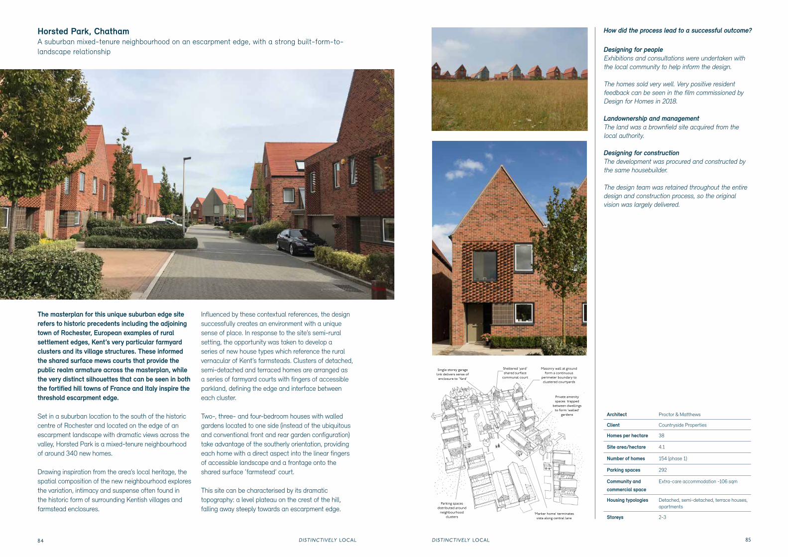
The masterplan for this unique suburban edge site refers to historic precedents including the adjoining town of Rochester, European examples of rural settlement edges, Kent’s very particular farmyard clusters and its village structures. These informed the shared surface mews courts that provide the public realm armature across the masterplan, while the very distinct silhouettes that can be seen in both the fortified hill towns of France and Italy inspire the threshold escarpment edge.
Set in a suburban location to the south of the historic centre of Rochester and located on the edge of an escarpment landscape with dramatic views across the valley, Horsted Park is a mixed-tenure neighbourhood of around 340 new homes.
Drawing inspiration from the area’s local heritage, the spatial composition of the new neighbourhood explores the variation, intimacy and suspense often found in the historic form of surrounding Kentish villages and farmstead enclosures.
Influenced by these contextual references, the design successfully creates an environment with a unique sense of place. In response to the site’s semi-rural setting, the opportunity was taken to develop a series of new house types which reference the rural vernacular of Kent’s farmsteads. Clusters of detached, semi-detached and terraced homes are arranged as a series of farmyard courts with fingers of accessible parkland, defining the edge and interface between each cluster.
Two-, three- and four-bedroom houses with walled gardens located to one side (instead of the ubiquitous and conventional front and rear garden configuration) take advantage of the southerly orientation, providing each home with a direct aspect into the linear fingers of accessible landscape and a frontage onto the shared surface ‘farmstead’ court.
This site can be characterised by its dramatic topography: a level plateau on the crest of the hill, falling away steeply towards an escarpment edge.
Horsted Park, Chatham A suburban mixed-tenure neighbourhood on an escarpment edge, with a strong built-form-to-landscape relationship
How did the process lead to a successful outcome?
Designing for people Exhibitions and consultations were undertaken with the local community to help inform the design.
The homes sold very well. Very positive resident feedback can be seen in the film commissioned by Design for Homes in 2018.
Landownership and managementThe land was a brownfield site acquired from the local authority.
Designing for constructionThe development was procured and constructed by the same housebuilder.
The design team was retained throughout the entire design and construction process, so the original vision was largely delivered.
Architect Proctor & Matthews
Client Countryside Properties
Homes per hectare 38
Site area/hectare 4.1
Number of homes 154 (phase 1)
Parking spaces 292
Community and
commercial space Extra-care accommodation -106 sqm
Hanham Hall, BristolHow we can meet the crucial challenge for 21st century homes of reducing our impact on the environment while creating attractive places to live
Architect HTA Design
Client Barratt Bristol
Homes per hectare 33
Site area/hectare 9 of which 3.8 ha is developed
Number of homes 187
Parking spaces 252 residential spaces
Storeys 2-3
Open space/ hectare
4.4
How did the process lead to a successful outcome?
Designing for people The homes have proved very popular, particularly among those not usually attracted to new build homes. Many cited the environmental credentials and reduced running costs as reasons for purchasing. In post-occupancy assessments, 95 per cent said they appreciated the beauty of their surroundings. The community are active, running their own Facebook page and staging regular events including summer fairs. Much use is made of the community room in the restored hall. The parish council also use the hall for committee meetings.
Landownership and managementThe land was acquired by Barratt through a bid process to the HCA under its pioneering Carbon Challenge programme. The development is now managed by a Community Interest Company (CIC) which was set up in partnership between Barratt and the housing association Sovereign. The CIC continues to work with the Hanham Hall Residents Group to manage the evolution of the neighbourhood.
PlanningThe site was allocated for housing by South Gloucestershire. A number of other planning applications had come forward for the site prior to the HCA competition, including one approval for the site, so the principle of development had been agreed. However, the impact on the setting of the hall remained a critical concern and the delivered proposals reinstrate it as a community use withouth seeking to add housing within the listed hall.
Designing for constructionHTA Design was retained throughout the detailed design and helped prepare a number of prototypes, both to test the innovative construction and the performance. Kingspan was extensively involved from the competition stage through to completion as were many of the design team. The HCA was actively involved in ensuring the development delivered the original vision. As a result of the collaboration, the homes have performed better than their design predicted.
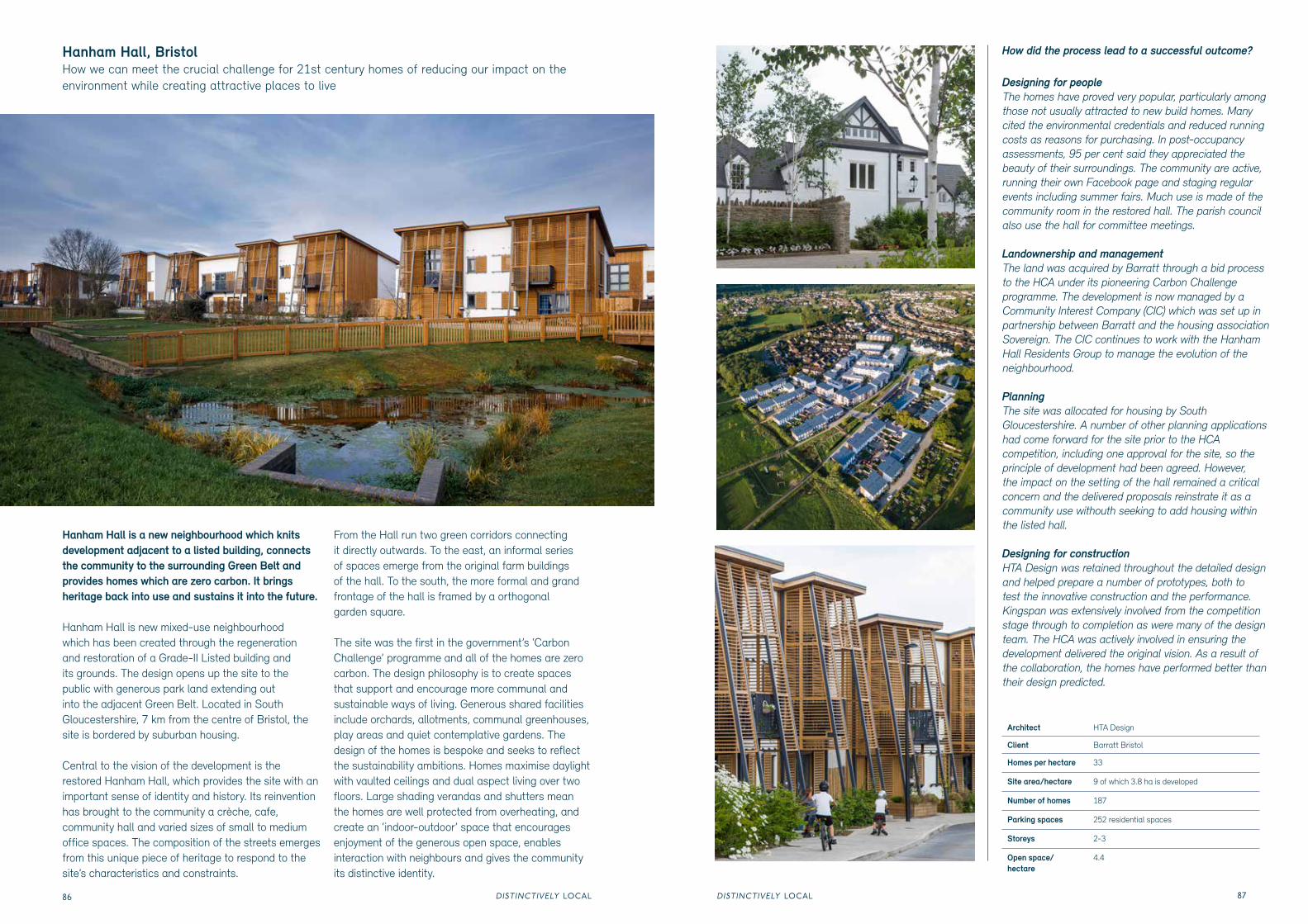
Hanham Hall is a new neighbourhood which knits development adjacent to a listed building, connects the community to the surrounding Green Belt and provides homes which are zero carbon. It brings heritage back into use and sustains it into the future.
Hanham Hall is new mixed-use neighbourhood which has been created through the regeneration and restoration of a Grade-II Listed building and its grounds. The design opens up the site to the public with generous park land extending out into the adjacent Green Belt. Located in South Gloucestershire, 7 km from the centre of Bristol, the site is bordered by suburban housing.
Central to the vision of the development is the restored Hanham Hall, which provides the site with an important sense of identity and history. Its reinvention has brought to the community a crèche, cafe, community hall and varied sizes of small to medium office spaces. The composition of the streets emerges from this unique piece of heritage to respond to the site’s characteristics and constraints.
From the Hall run two green corridors connecting it directly outwards. To the east, an informal series of spaces emerge from the original farm buildings of the hall. To the south, the more formal and grand frontage of the hall is framed by a orthogonal garden square.
The site was the first in the government’s ‘Carbon Challenge’ programme and all of the homes are zero carbon. The design philosophy is to create spaces that support and encourage more communal and sustainable ways of living. Generous shared facilities include orchards, allotments, communal greenhouses, play areas and quiet contemplative gardens. The design of the homes is bespoke and seeks to reflect the sustainability ambitions. Homes maximise daylight with vaulted ceilings and dual aspect living over two floors. Large shading verandas and shutters mean the homes are well protected from overheating, and create an ‘indoor-outdoor’ space that encourages enjoyment of the generous open space, enables interaction with neighbours and gives the community its distinctive identity.
DISTINCTIVELY LOCALDISTINCTIVELY LOCAL88 89
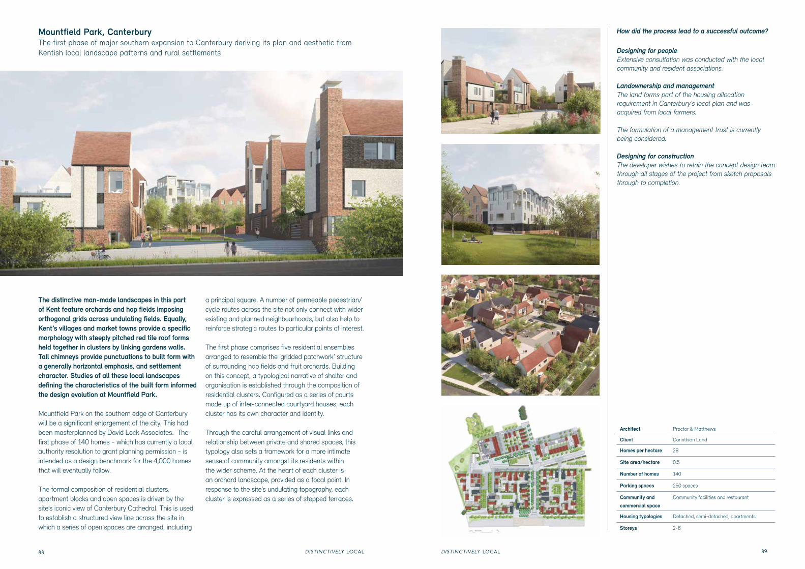
The distinctive man-made landscapes in this part of Kent feature orchards and hop fields imposing orthogonal grids across undulating fields. Equally, Kent’s villages and market towns provide a specific morphology with steeply pitched red tile roof forms held together in clusters by linking gardens walls. Tall chimneys provide punctuations to built form with a generally horizontal emphasis, and settlement character. Studies of all these local landscapes defining the characteristics of the built form informed the design evolution at Mountfield Park.
Mountfield Park on the southern edge of Canterbury will be a significant enlargement of the city. This had been masterplanned by David Lock Associates. The first phase of 140 homes - which has currently a local authority resolution to grant planning permission - is intended as a design benchmark for the 4,000 homes that will eventually follow.
The formal composition of residential clusters, apartment blocks and open spaces is driven by the site’s iconic view of Canterbury Cathedral. This is used to establish a structured view line across the site in which a series of open spaces are arranged, including
a principal square. A number of permeable pedestrian/cycle routes across the site not only connect with wider existing and planned neighbourhoods, but also help to reinforce strategic routes to particular points of interest.
The first phase comprises five residential ensembles arranged to resemble the ‘gridded patchwork’ structure of surrounding hop fields and fruit orchards. Building on this concept, a typological narrative of shelter and organisation is established through the composition of residential clusters. Configured as a series of courts made up of inter-connected courtyard houses, each cluster has its own character and identity.
Through the careful arrangement of visual links and relationship between private and shared spaces, this typology also sets a framework for a more intimate sense of community amongst its residents within the wider scheme. At the heart of each cluster is an orchard landscape, provided as a focal point. In response to the site’s undulating topography, each cluster is expressed as a series of stepped terraces.
Mountfield Park, Canterbury The first phase of major southern expansion to Canterbury deriving its plan and aesthetic from Kentish local landscape patterns and rural settlements
How did the process lead to a successful outcome?
Designing for people Extensive consultation was conducted with the local community and resident associations.
Landownership and managementThe land forms part of the housing allocation requirement in Canterbury’s local plan and was acquired from local farmers.
The formulation of a management trust is currently being considered.
Designing for constructionThe developer wishes to retain the concept design team through all stages of the project from sketch proposals through to completion.
Architect Proctor & Matthews
Client Corinthian Land
Homes per hectare 28
Site area/hectare 0.5
Number of homes 140
Parking spaces 250 spaces
Community and
commercial space Community facilities and restaurant
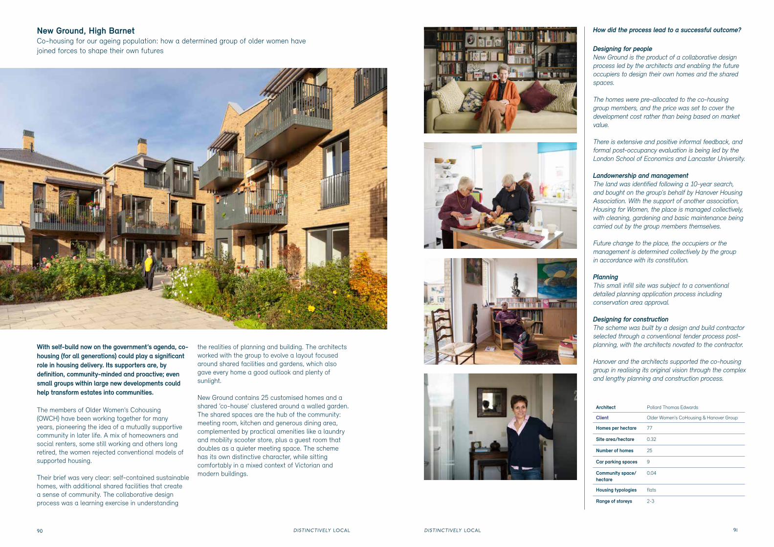
New Ground, High Barnet Co-housing for our ageing population: how a determined group of older women have joined forces to shape their own futures
With self-build now on the government’s agenda, co-housing (for all generations) could play a significant role in housing delivery. Its supporters are, by definition, community-minded and proactive; even small groups within large new developments could help transform estates into communities.
The members of Older Women’s Cohousing (OWCH) have been working together for many years, pioneering the idea of a mutually supportive community in later life. A mix of homeowners and social renters, some still working and others long retired, the women rejected conventional models of supported housing.
Their brief was very clear: self-contained sustainable homes, with additional shared facilities that create a sense of community. The collaborative design process was a learning exercise in understanding
the realities of planning and building. The architects worked with the group to evolve a layout focused around shared facilities and gardens, which also gave every home a good outlook and plenty of sunlight.
New Ground contains 25 customised homes and a shared ‘co-house’ clustered around a walled garden. The shared spaces are the hub of the community: meeting room, kitchen and generous dining area, complemented by practical amenities like a laundry and mobility scooter store, plus a guest room that doubles as a quieter meeting space. The scheme has its own distinctive character, while sitting comfortably in a mixed context of Victorian and modern buildings.
Architect Pollard Thomas Edwards
Client Older Women’s CoHousing & Hanover Group
Homes per hectare 77
Site area/hectare 0.32
Number of homes 25
Car parking spaces 9
Community space/hectare
0.04
Housing typologies flats
Range of storeys 2-3
How did the process lead to a successful outcome?
Designing for people New Ground is the product of a collaborative design process led by the architects and enabling the future occupiers to design their own homes and the shared spaces.
The homes were pre-allocated to the co-housing group members, and the price was set to cover the development cost rather than being based on market value.
There is extensive and positive informal feedback, and formal post-occupancy evaluation is being led by the London School of Economics and Lancaster University.
Landownership and managementThe land was identified following a 10-year search, and bought on the group's behalf by Hanover Housing Association. With the support of another association, Housing for Women, the place is managed collectively, with cleaning, gardening and basic maintenance being carried out by the group members themselves.
Future change to the place, the occupiers or the management is determined collectively by the group in accordance with its constitution.
PlanningThis small infill site was subject to a conventional detailed planning application process including conservation area approval.
Designing for constructionThe scheme was built by a design and build contractor selected through a conventional tender process post-planning, with the architects novated to the contractor.
Hanover and the architects supported the co-housing group in realising its original vision through the complex and lengthy planning and construction process.
DISTINCTIVELY LOCALDISTINCTIVELY LOCAL92 93
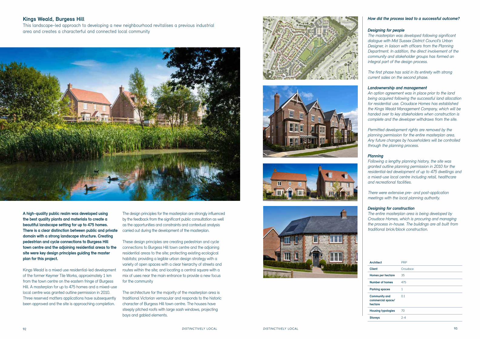
A high-quality public realm was developed using the best quality plants and materials to create a beautiful landscape setting for up to 475 homes. There is a clear distinction between public and private domain with a strong landscape structure. Creating pedestrian and cycle connections to Burgess Hill town centre and the adjoining residential areas to the site were key design principles guiding the master plan for this project.
Kings Weald is a mixed use residential-led development of the former Keymer Tile Works, approximately 1 km from the town centre on the eastern fringe of Burgess Hill. A masterplan for up to 475 homes and a mixed-use local centre was granted outline permission in 2010. Three reserved matters applications have subsequently been approved and the site is approaching completion.
The design principles for the masterplan are strongly influenced by the feedback from the significant public consultation as well as the opportunities and constraints and contextual analysis carried out during the development of the masterplan.
These design principles are creating pedestrian and cycle connections to Burgess Hill town centre and the adjoining residential areas to the site; protecting existing ecological habitats; providing a legible urban design strategy with a variety of open spaces with a clear hierarchy of streets and routes within the site; and locating a central square with a mix of uses near the main entrance to provide a new focus for the community
The architecture for the majority of the masterplan area is traditional Victorian vernacular and responds to the historic character of Burgess Hill town centre. The houses have steeply pitched roofs with large sash windows, projecting bays and gabled elements.
Kings Weald, Burgess HillThis landscape-led approach to developing a new neighbourhood revitalises a previous industrial area and creates a characterful and connected local community
How did the process lead to a successful outcome?
Designing for people The masterplan was developed following significant dialogue with Mid Sussex District Council’s Urban Designer, in liaison with officers from the Planning Department. In addition, the direct involvement of the community and stakeholder groups has formed an integral part of the design process.
The first phase has sold in its entirety with strong current sales on the second phase.
Landownership and managementAn option agreement was in place prior to the land being acquired following the successful land allocation for residential use. Croudace Homes has established the Kings Weald Management Company, which will be handed over to key stakeholders when construction is complete and the developer withdraws from the site.
Permitted development rights are removed by the planning permission for the entire masterplan area. Any future changes by householders will be controlled through the planning process.
PlanningFollowing a lengthy planning history, the site was granted outline planning permission in 2010 for the residential-led development of up to 475 dwellings and a mixed-use local centre including retail, healthcare and recreational facilities.
There were extensive pre- and post-application meetings with the local planning authority.
Designing for constructionThe entire masterplan area is being developed by Croudace Homes, which is procuring and managing the process in-house. The buildings are all built from traditional brick/block construction.
Architect PRP
Client Croudace
Homes per hectare 35
Number of homes 475
Parking spaces 1
Community and commercial space/hectare
0.1
Housing typologies 70
Storeys 2-4
DISTINCTIVELY LOCALDISTINCTIVELY LOCAL94 95
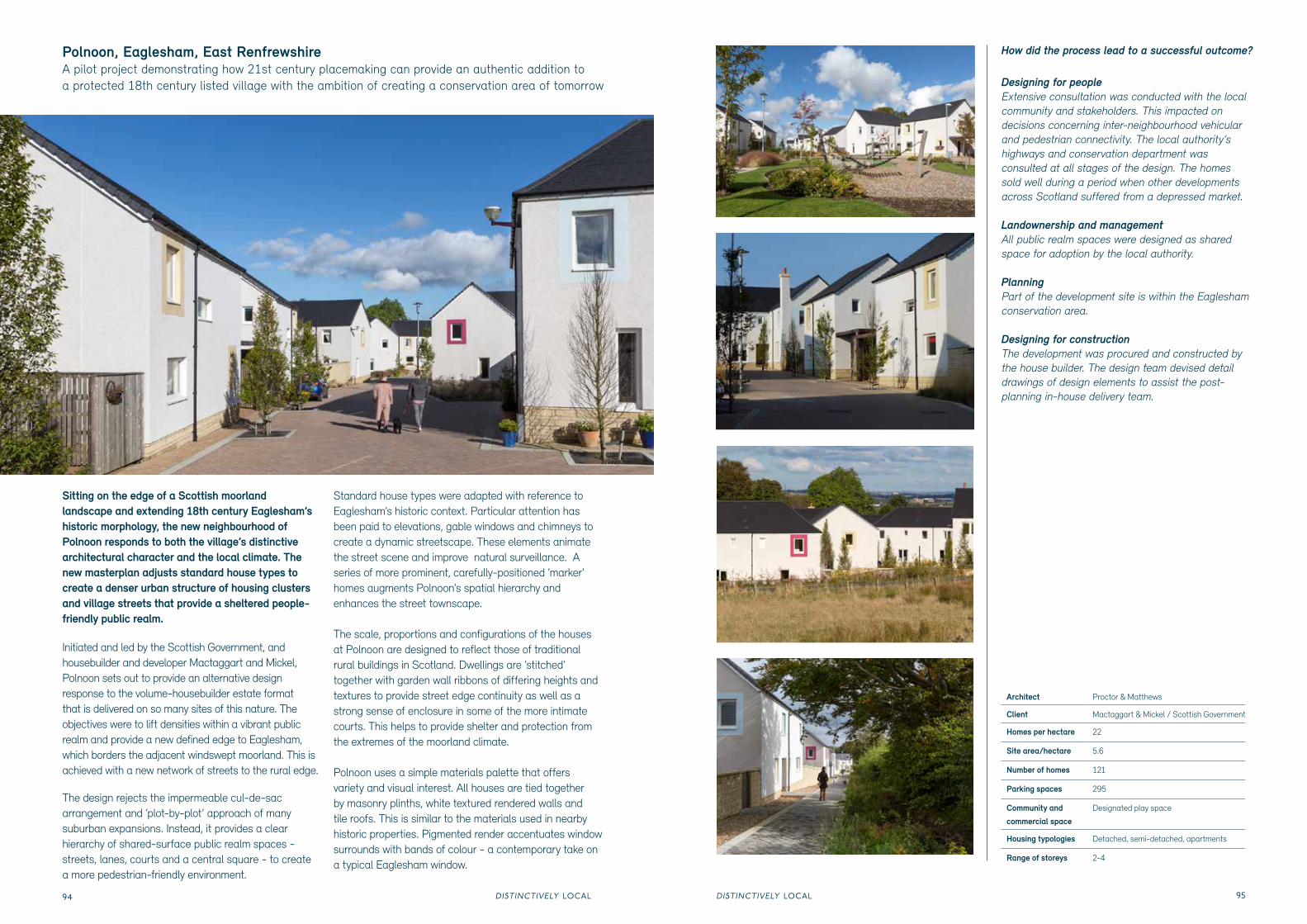
Sitting on the edge of a Scottish moorland landscape and extending 18th century Eaglesham’s historic morphology, the new neighbourhood of Polnoon responds to both the village’s distinctive architectural character and the local climate. The new masterplan adjusts standard house types to create a denser urban structure of housing clusters and village streets that provide a sheltered people-friendly public realm.
Initiated and led by the Scottish Government, and housebuilder and developer Mactaggart and Mickel, Polnoon sets out to provide an alternative design response to the volume-housebuilder estate format that is delivered on so many sites of this nature. The objectives were to lift densities within a vibrant public realm and provide a new defined edge to Eaglesham, which borders the adjacent windswept moorland. This is achieved with a new network of streets to the rural edge.
The design rejects the impermeable cul-de-sac arrangement and ‘plot-by-plot’ approach of many suburban expansions. Instead, it provides a clear hierarchy of shared-surface public realm spaces - streets, lanes, courts and a central square - to create a more pedestrian-friendly environment.
Standard house types were adapted with reference to Eaglesham’s historic context. Particular attention has been paid to elevations, gable windows and chimneys to create a dynamic streetscape. These elements animate the street scene and improve natural surveillance. A series of more prominent, carefully-positioned ‘marker’ homes augments Polnoon’s spatial hierarchy and enhances the street townscape.
The scale, proportions and configurations of the houses at Polnoon are designed to reflect those of traditional rural buildings in Scotland. Dwellings are ‘stitched’ together with garden wall ribbons of differing heights and textures to provide street edge continuity as well as a strong sense of enclosure in some of the more intimate courts. This helps to provide shelter and protection from the extremes of the moorland climate.
Polnoon uses a simple materials palette that offers variety and visual interest. All houses are tied together by masonry plinths, white textured rendered walls and tile roofs. This is similar to the materials used in nearby historic properties. Pigmented render accentuates window surrounds with bands of colour - a contemporary take on a typical Eaglesham window.
Polnoon, Eaglesham, East Renfrewshire A pilot project demonstrating how 21st century placemaking can provide an authentic addition to a protected 18th century listed village with the ambition of creating a conservation area of tomorrow
How did the process lead to a successful outcome?
Designing for people Extensive consultation was conducted with the local community and stakeholders. This impacted on decisions concerning inter-neighbourhood vehicular and pedestrian connectivity. The local authority’s highways and conservation department was consulted at all stages of the design. The homes sold well during a period when other developments across Scotland suffered from a depressed market.
Landownership and managementAll public realm spaces were designed as shared space for adoption by the local authority.
PlanningPart of the development site is within the Eaglesham conservation area.
Designing for constructionThe development was procured and constructed by the house builder. The design team devised detail drawings of design elements to assist the post-planning in-house delivery team.
Upton, NorthamptonModern homes need to be full of light but also highly sustainable. This urban development combines both, thanks to design cross-fertilisation between engineers and architects
Architect HTA Design
Client David Wilson Homes
Homes per hectare 34.5
Site area/hectare 0.87
Number of homes 30
Parking spaces 45
Storeys 2-3
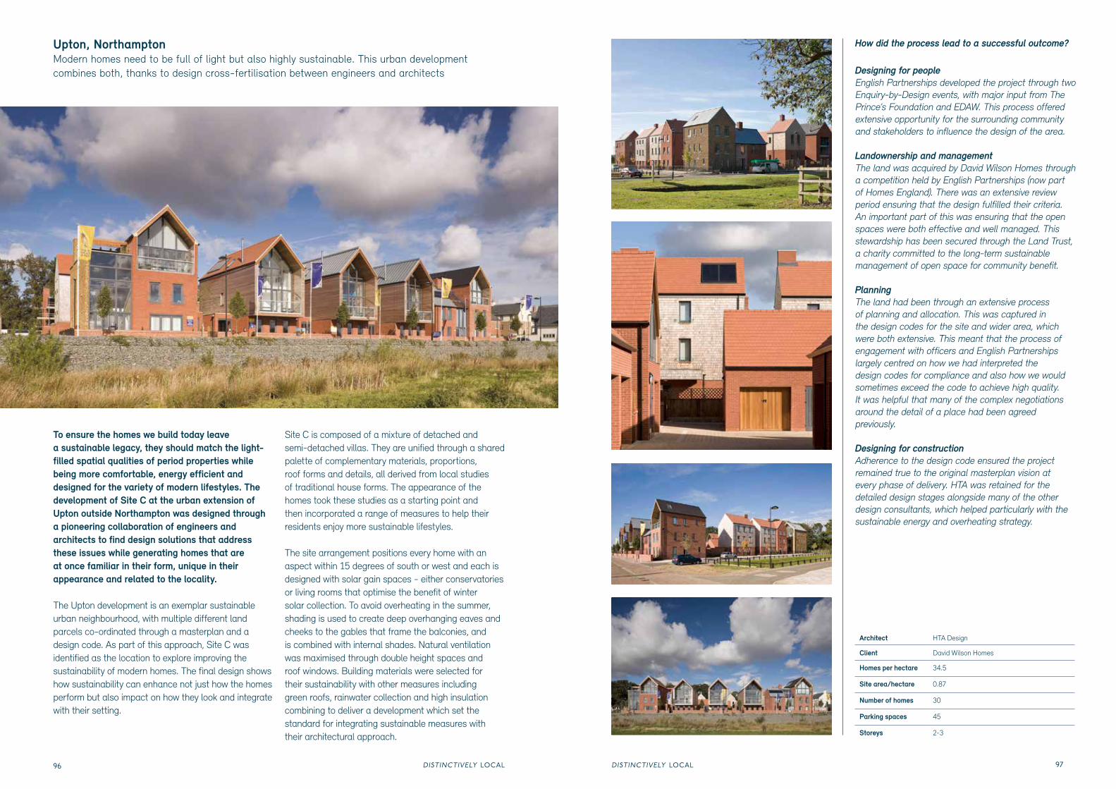
To ensure the homes we build today leave a sustainable legacy, they should match the light-filled spatial qualities of period properties while being more comfortable, energy efficient and designed for the variety of modern lifestyles. The development of Site C at the urban extension of Upton outside Northampton was designed through a pioneering collaboration of engineers and architects to find design solutions that address these issues while generating homes that are at once familiar in their form, unique in their appearance and related to the locality.
The Upton development is an exemplar sustainable urban neighbourhood, with multiple different land parcels co-ordinated through a masterplan and a design code. As part of this approach, Site C was identified as the location to explore improving the sustainability of modern homes. The final design shows how sustainability can enhance not just how the homes perform but also impact on how they look and integrate with their setting.
Site C is composed of a mixture of detached and semi-detached villas. They are unified through a shared palette of complementary materials, proportions, roof forms and details, all derived from local studies of traditional house forms. The appearance of the homes took these studies as a starting point and then incorporated a range of measures to help their residents enjoy more sustainable lifestyles.
The site arrangement positions every home with an aspect within 15 degrees of south or west and each is designed with solar gain spaces - either conservatories or living rooms that optimise the benefit of winter solar collection. To avoid overheating in the summer, shading is used to create deep overhanging eaves and cheeks to the gables that frame the balconies, and is combined with internal shades. Natural ventilation was maximised through double height spaces and roof windows. Building materials were selected for their sustainability with other measures including green roofs, rainwater collection and high insulation combining to deliver a development which set the standard for integrating sustainable measures with their architectural approach.
How did the process lead to a successful outcome?
Designing for people English Partnerships developed the project through two Enquiry-by-Design events, with major input from The Prince’s Foundation and EDAW. This process offered extensive opportunity for the surrounding community and stakeholders to influence the design of the area.
Landownership and managementThe land was acquired by David Wilson Homes through a competition held by English Partnerships (now part of Homes England). There was an extensive review period ensuring that the design fulfilled their criteria. An important part of this was ensuring that the open spaces were both effective and well managed. This stewardship has been secured through the Land Trust, a charity committed to the long-term sustainable management of open space for community benefit.
PlanningThe land had been through an extensive process of planning and allocation. This was captured in the design codes for the site and wider area, which were both extensive. This meant that the process of engagement with officers and English Partnerships largely centred on how we had interpreted the design codes for compliance and also how we would sometimes exceed the code to achieve high quality. It was helpful that many of the complex negotiations around the detail of a place had been agreed previously.
Designing for constructionAdherence to the design code ensured the project remained true to the original masterplan vision at every phase of delivery. HTA was retained for the detailed design stages alongside many of the other design consultants, which helped particularly with the sustainable energy and overheating strategy.
DISTINCTIVELY LOCALDISTINCTIVELY LOCAL98 99
Beechwood West, BasildonCustom-build family houses: how buyers can create their own homes from one million potential design combinations
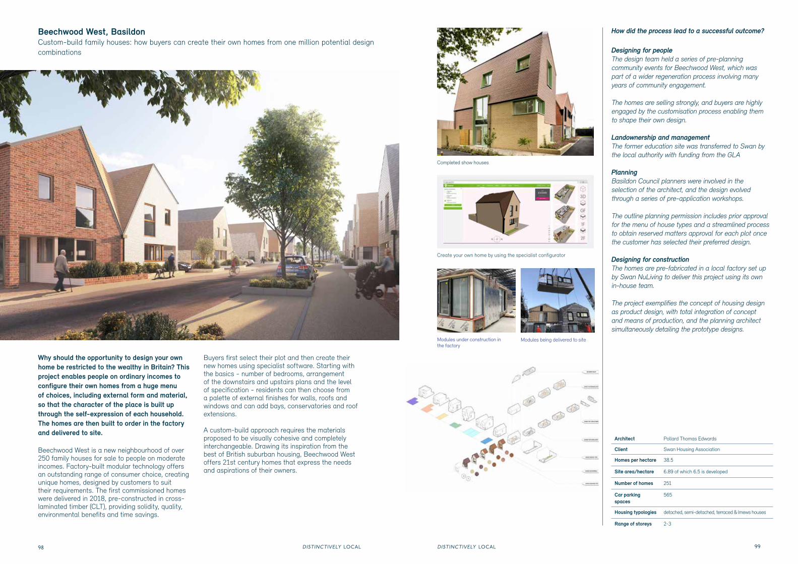
Why should the opportunity to design your own home be restricted to the wealthy in Britain? This project enables people on ordinary incomes to configure their own homes from a huge menu of choices, including external form and material, so that the character of the place is built up through the self-expression of each household. The homes are then built to order in the factory and delivered to site.
Beechwood West is a new neighbourhood of over 250 family houses for sale to people on moderate incomes. Factory-built modular technology offers an outstanding range of consumer choice, creating unique homes, designed by customers to suit their requirements. The first commissioned homes were delivered in 2018, pre-constructed in cross-laminated timber (CLT), providing solidity, quality, environmental benefits and time savings.
Buyers first select their plot and then create their new homes using specialist software. Starting with the basics - number of bedrooms, arrangement of the downstairs and upstairs plans and the level of specification - residents can then choose from a palette of external finishes for walls, roofs and windows and can add bays, conservatories and roof extensions.
A custom-build approach requires the materials proposed to be visually cohesive and completely interchangeable. Drawing its inspiration from the best of British suburban housing, Beechwood West offers 21st century homes that express the needs and aspirations of their owners.
Create your own home by using the specialist configurator
Designing for people The design team held a series of pre-planning community events for Beechwood West, which was part of a wider regeneration process involving many years of community engagement.
The homes are selling strongly, and buyers are highly engaged by the customisation process enabling them to shape their own design.
Landownership and managementThe former education site was transferred to Swan by the local authority with funding from the GLA
PlanningBasildon Council planners were involved in the selection of the architect, and the design evolved through a series of pre-application workshops.
The outline planning permission includes prior approval for the menu of house types and a streamlined process to obtain reserved matters approval for each plot once the customer has selected their preferred design.
Designing for constructionThe homes are pre-fabricated in a local factory set up by Swan NuLiving to deliver this project using its own in-house team.
The project exemplifies the concept of housing design as product design, with total integration of concept and means of production, and the planning architect simultaneously detailing the prototype designs.
DISTINCTIVELY LOCALDISTINCTIVELY LOCAL100 101
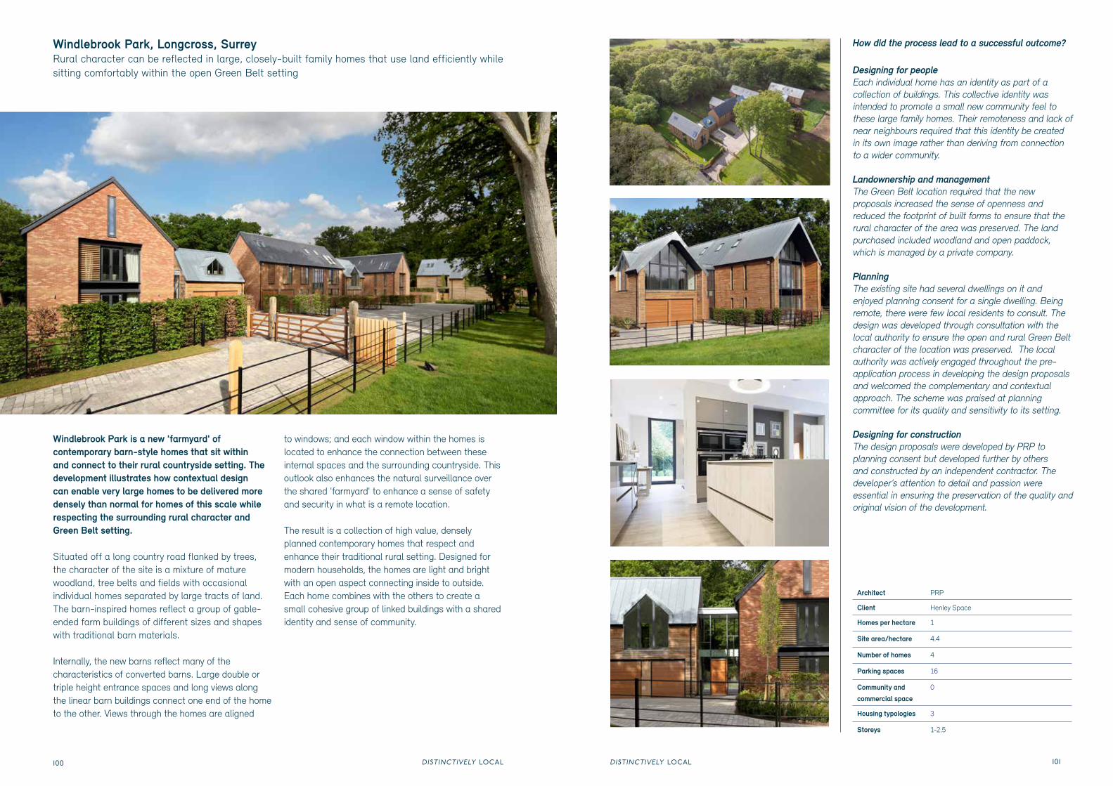
Windlebrook Park is a new 'farmyard' of contemporary barn-style homes that sit within and connect to their rural countryside setting. The development illustrates how contextual design can enable very large homes to be delivered more densely than normal for homes of this scale while respecting the surrounding rural character and Green Belt setting.
Situated off a long country road flanked by trees, the character of the site is a mixture of mature woodland, tree belts and fields with occasional individual homes separated by large tracts of land. The barn-inspired homes reflect a group of gable-ended farm buildings of different sizes and shapes with traditional barn materials.
Internally, the new barns reflect many of the characteristics of converted barns. Large double or triple height entrance spaces and long views along the linear barn buildings connect one end of the home to the other. Views through the homes are aligned
to windows; and each window within the homes is located to enhance the connection between these internal spaces and the surrounding countryside. This outlook also enhances the natural surveillance over the shared 'farmyard' to enhance a sense of safety and security in what is a remote location.
The result is a collection of high value, densely planned contemporary homes that respect and enhance their traditional rural setting. Designed for modern households, the homes are light and bright with an open aspect connecting inside to outside. Each home combines with the others to create a small cohesive group of linked buildings with a shared identity and sense of community.
Windlebrook Park, Longcross, SurreyRural character can be reflected in large, closely-built family homes that use land efficiently while sitting comfortably within the open Green Belt setting
How did the process lead to a successful outcome?
Designing for people Each individual home has an identity as part of a collection of buildings. This collective identity was intended to promote a small new community feel to these large family homes. Their remoteness and lack of near neighbours required that this identity be created in its own image rather than deriving from connection to a wider community.
Landownership and managementThe Green Belt location required that the new proposals increased the sense of openness and reduced the footprint of built forms to ensure that the rural character of the area was preserved. The land purchased included woodland and open paddock, which is managed by a private company.
PlanningThe existing site had several dwellings on it and enjoyed planning consent for a single dwelling. Being remote, there were few local residents to consult. The design was developed through consultation with the local authority to ensure the open and rural Green Belt character of the location was preserved. The local authority was actively engaged throughout the pre-application process in developing the design proposals and welcomed the complementary and contextual approach. The scheme was praised at planning committee for its quality and sensitivity to its setting.
Designing for constructionThe design proposals were developed by PRP to planning consent but developed further by others and constructed by an independent contractor. The developer’s attention to detail and passion were essential in ensuring the preservation of the quality and original vision of the development.
Architect PRP
Client Henley Space
Homes per hectare 1
Site area/hectare 4.4
Number of homes 4
Parking spaces 16
Community and
commercial space 0
Housing typologies 3
Storeys 1-2.5
DISTINCTIVELY LOCALDISTINCTIVELY LOCAL102 103
Officers Field, Portland This redevelopment of an old military base in Dorset shows how a simple range of home designs can be composed and varied to create a sympathetic response to the surroundings and makes the most of a challenging site
Architect HTA Design
Client ZeroC
Homes per hectare 39
Site area/hectare 1.97
Number of homes 77
Parking spaces 118
Storeys 2-4
Open space/hectare 0.86
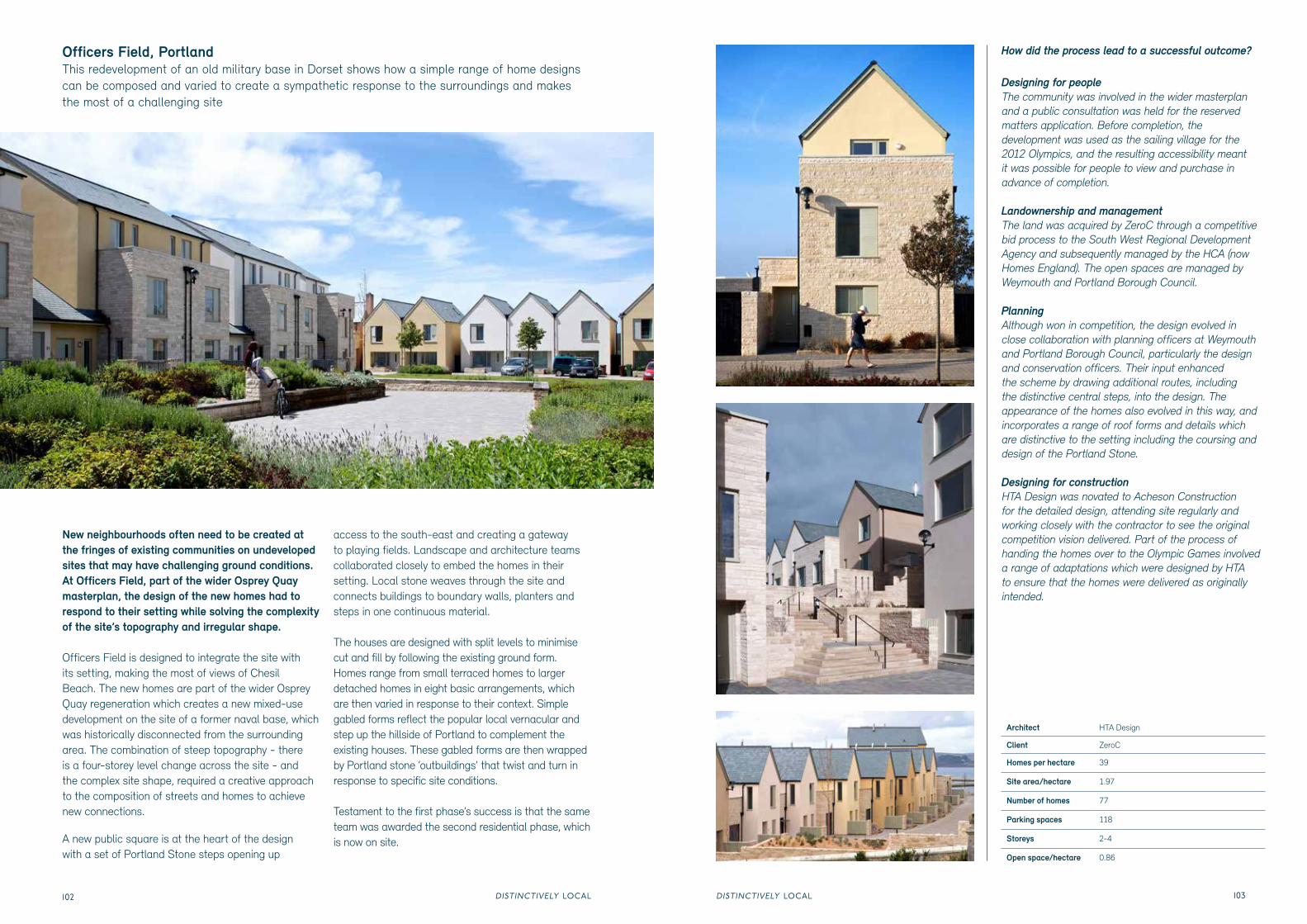
New neighbourhoods often need to be created at the fringes of existing communities on undeveloped sites that may have challenging ground conditions. At Officers Field, part of the wider Osprey Quay masterplan, the design of the new homes had to respond to their setting while solving the complexity of the site’s topography and irregular shape.
Officers Field is designed to integrate the site with its setting, making the most of views of Chesil Beach. The new homes are part of the wider Osprey Quay regeneration which creates a new mixed-use development on the site of a former naval base, which was historically disconnected from the surrounding area. The combination of steep topography - there is a four-storey level change across the site - and the complex site shape, required a creative approach to the composition of streets and homes to achieve new connections.
A new public square is at the heart of the design with a set of Portland Stone steps opening up
access to the south-east and creating a gateway to playing fields. Landscape and architecture teams collaborated closely to embed the homes in their setting. Local stone weaves through the site and connects buildings to boundary walls, planters and steps in one continuous material.
The houses are designed with split levels to minimise cut and fill by following the existing ground form. Homes range from small terraced homes to larger detached homes in eight basic arrangements, which are then varied in response to their context. Simple gabled forms reflect the popular local vernacular and step up the hillside of Portland to complement the existing houses. These gabled forms are then wrapped by Portland stone ‘outbuildings’ that twist and turn in response to specific site conditions.
Testament to the first phase’s success is that the same team was awarded the second residential phase, which is now on site.
How did the process lead to a successful outcome?
Designing for people The community was involved in the wider masterplan and a public consultation was held for the reserved matters application. Before completion, the development was used as the sailing village for the 2012 Olympics, and the resulting accessibility meant it was possible for people to view and purchase in advance of completion.
Landownership and managementThe land was acquired by ZeroC through a competitive bid process to the South West Regional Development Agency and subsequently managed by the HCA (now Homes England). The open spaces are managed by Weymouth and Portland Borough Council.
PlanningAlthough won in competition, the design evolved in close collaboration with planning officers at Weymouth and Portland Borough Council, particularly the design and conservation officers. Their input enhanced the scheme by drawing additional routes, including the distinctive central steps, into the design. The appearance of the homes also evolved in this way, and incorporates a range of roof forms and details which are distinctive to the setting including the coursing and design of the Portland Stone.
Designing for constructionHTA Design was novated to Acheson Construction for the detailed design, attending site regularly and working closely with the contractor to see the original competition vision delivered. Part of the process of handing the homes over to the Olympic Games involved a range of adaptations which were designed by HTA to ensure that the homes were delivered as originally intended.
DISTINCTIVELY LOCALDISTINCTIVELY LOCAL104 105
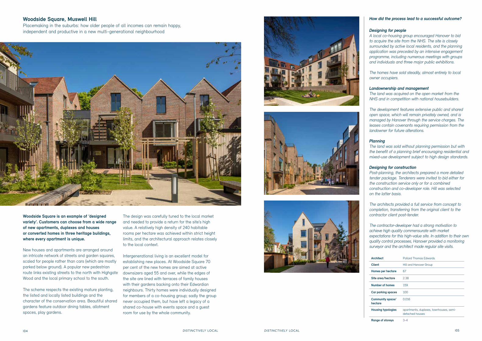
Woodside Square is an example of ‘designed variety’. Customers can choose from a wide range of new apartments, duplexes and houses or converted homes in three heritage buildings, where every apartment is unique.
New houses and apartments are arranged around an intricate network of streets and garden squares, scaled for people rather than cars (which are mostly parked below ground). A popular new pedestrian route links existing streets to the north with Highgate Wood and the local primary school to the south.
The scheme respects the existing mature planting, the listed and locally listed buildings and the character of the conservation area. Beautiful shared gardens feature outdoor dining tables, allotment spaces, play gardens.
The design was carefully tuned to the local market and needed to provide a return for the site’s high value. A relatively high density of 240 habitable rooms per hectare was achieved within strict height limits, and the architectural approach relates closely to the local context.
Intergenerational living is an excellent model for establishing new places. At Woodside Square 70 per cent of the new homes are aimed at active downsizers aged 55 and over, while the edges of the site are lined with terraces of family houses with their gardens backing onto their Edwardian neighbours. Thirty homes were individually designed for members of a co-housing group; sadly the group never occupied them, but have left a legacy of a shared co-house with events space and a guest room for use by the whole community.
Woodside Square, Muswell Hill Placemaking in the suburbs: how older people of all incomes can remain happy, independent and productive in a new multi-generational neighbourhood
Designing for people A local co-housing group encouraged Hanover to bid to acquire the site from the NHS. The site is closely surrounded by active local residents, and the planning application was preceded by an intensive engagement programme, including numerous meetings with groups and individuals and three major public exhibitions.
The homes have sold steadily, almost entirely to local owner occupiers.
Landownership and managementThe land was acquired on the open market from the NHS and in competition with national housebuilders.
The development features extensive public and shared open space, which will remain privately owned, and is managed by Hanover through the service charges. The leases contain covenants requiring permission from the landowner for future alterations.
PlanningThe land was sold without planning permission but with the benefit of a planning brief encouraging residential and mixed-use development subject to high design standards.
Designing for constructionPost-planning, the architects prepared a more detailed tender package. Tenderers were invited to bid either for the construction service only or for a combined construction and co-developer role. Hill was selected on the latter basis.
The architects provided a full service from concept to completion, transferring from the original client to the contractor client post-tender.
The contractor-developer had a strong motivation to achieve high quality commensurate with market expectations for this high-value site. In addition to their own quality control processes, Hanover provided a monitoring surveyor and the architect made regular site visits.
DISTINCTIVELY LOCALDISTINCTIVELY LOCAL106 107
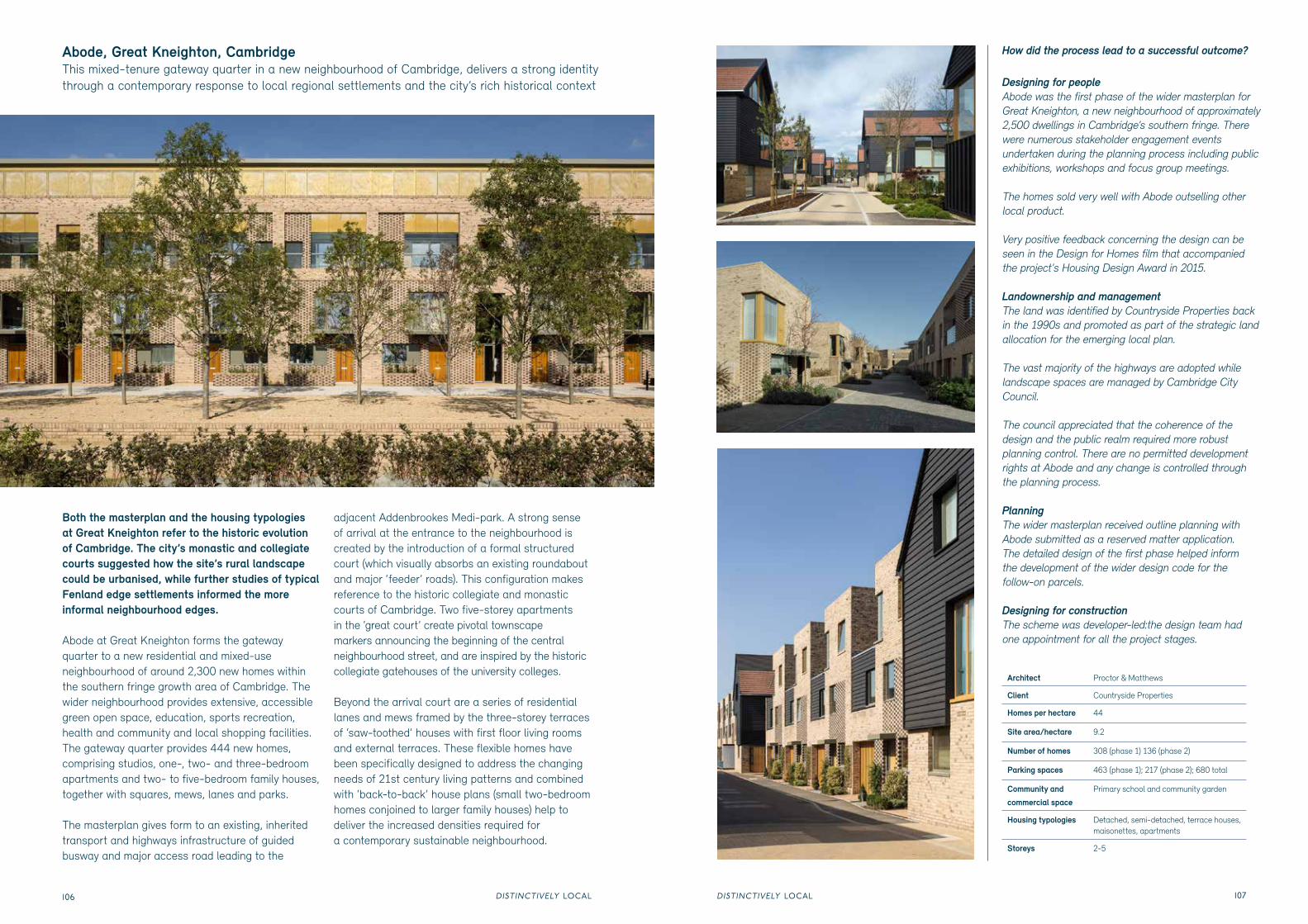
Both the masterplan and the housing typologies at Great Kneighton refer to the historic evolution of Cambridge. The city’s monastic and collegiate courts suggested how the site’s rural landscape could be urbanised, while further studies of typical Fenland edge settlements informed the more informal neighbourhood edges.
Abode at Great Kneighton forms the gateway quarter to a new residential and mixed-use neighbourhood of around 2,300 new homes within the southern fringe growth area of Cambridge. The wider neighbourhood provides extensive, accessible green open space, education, sports recreation, health and community and local shopping facilities. The gateway quarter provides 444 new homes, comprising studios, one-, two- and three-bedroom apartments and two- to five-bedroom family houses, together with squares, mews, lanes and parks.
The masterplan gives form to an existing, inherited transport and highways infrastructure of guided busway and major access road leading to the
adjacent Addenbrookes Medi-park. A strong sense of arrival at the entrance to the neighbourhood is created by the introduction of a formal structured court (which visually absorbs an existing roundabout and major ‘feeder’ roads). This configuration makes reference to the historic collegiate and monastic courts of Cambridge. Two five-storey apartments in the ‘great court’ create pivotal townscape markers announcing the beginning of the central neighbourhood street, and are inspired by the historic collegiate gatehouses of the university colleges.
Beyond the arrival court are a series of residential lanes and mews framed by the three-storey terraces of ‘saw-toothed’ houses with first floor living rooms and external terraces. These flexible homes have been specifically designed to address the changing needs of 21st century living patterns and combined with ‘back-to-back’ house plans (small two-bedroom homes conjoined to larger family houses) help to deliver the increased densities required for a contemporary sustainable neighbourhood.
Abode, Great Kneighton, Cambridge This mixed-tenure gateway quarter in a new neighbourhood of Cambridge, delivers a strong identity through a contemporary response to local regional settlements and the city’s rich historical context
How did the process lead to a successful outcome?
Designing for people Abode was the first phase of the wider masterplan for Great Kneighton, a new neighbourhood of approximately 2,500 dwellings in Cambridge’s southern fringe. There were numerous stakeholder engagement events undertaken during the planning process including public exhibitions, workshops and focus group meetings.
The homes sold very well with Abode outselling other local product.
Very positive feedback concerning the design can be seen in the Design for Homes film that accompanied the project's Housing Design Award in 2015.
Landownership and managementThe land was identified by Countryside Properties back in the 1990s and promoted as part of the strategic land allocation for the emerging local plan.
The vast majority of the highways are adopted while landscape spaces are managed by Cambridge City Council.
The council appreciated that the coherence of the design and the public realm required more robust planning control. There are no permitted development rights at Abode and any change is controlled through the planning process.
PlanningThe wider masterplan received outline planning with Abode submitted as a reserved matter application. The detailed design of the first phase helped inform the development of the wider design code for the follow-on parcels.
Designing for constructionThe scheme was developer-led:the design team had one appointment for all the project stages.
Architect Proctor & Matthews
Client Countryside Properties
Homes per hectare 44
Site area/hectare 9.2
Number of homes 308 (phase 1) 136 (phase 2)
Parking spaces 463 (phase 1); 217 (phase 2); 680 total
Community and
commercial space Primary school and community garden