35
Wilderness Ridge Fire The most destructive wildfire in Central Texas A Case Study Bastrop County
Wilderness Ridge FireThe most destructive wildfire in Central Texas
A Case Study
Bastrop County
Wilderness Ridge FireBastrop County
The most destructive wildfire in Central Texas
A case study
March 25, 2009
Wilderness Ridge Fire Case Study © 2009 Texas Forest Service
This document was prepared by Texas Forest Service. Any reproduction of the document should be copyrighted to Texas Forest Service. For more information or to order additional copies of this report, contact Texas Forest Service, 301 Tarrow, Suite 304, College Station, TX 77840-7896.
Texas Forest Service was created in 1915 by the 34th Legislature as an integral part of The Texas A&M University System. It is mandated by law to “assume direction of all forest interests and all matters pertaining to forestry within the jurisdiction of the state.”
Acknowledgements This report could not have been prepared without the diligent field collection work done by the East
Texas WUI Team. Special thanks to those team members.
Justice Jones – Mitigation and Prevention CoordinatorKaren Stafford – Regional Wildland Urban Interface Coordinator
Jan Amen – Wildland Urban Interface Specialist and PhotographerTammy Russell – Office Associate II/Wilderness Ridge Project Assistant
Table of Contents
Prepared byRich Gray - Wildland Urban Interface State Coordinator
Karen Ridenour – GIS Specialist IIMisty Wilburn – Communications Specialist
Abstract.........................................................
Dedication.....................................................
Definitions.....................................................
Introduction .................................................
Wilderness Ridge Fire Event......................
Case Study Methodology............................
Results............................................................
Conclusions...................................................
References......................................................
1
2
3
4
5
12
21
28
29
Abstract
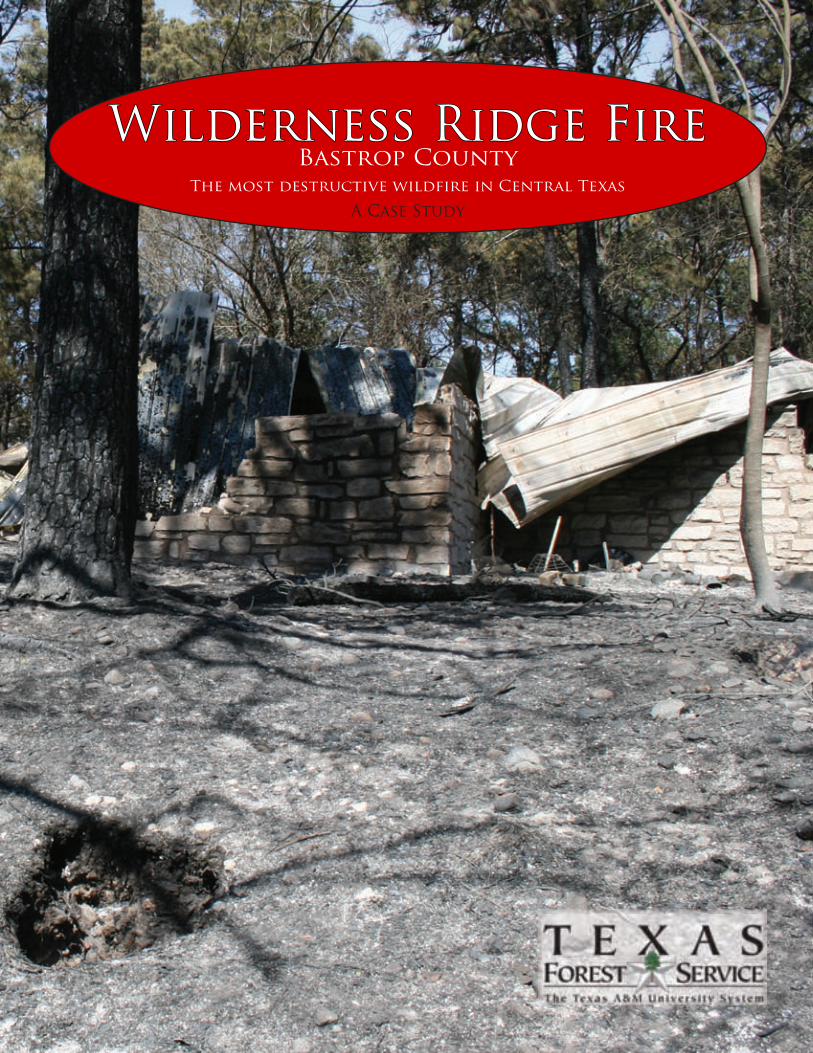
The purpose of this publication is to examine the destruction that occurred on Feb. 28, 2009, in Bastrop County, Texas, during the Wilderness Ridge Fire. Drought conditions, extremely dry and windy weather, and a small spark all came together to form the devastating wildfire. Sparks from downed power lines ignited the Wilderness Ridge Fire, the most destructive wildfire in Central Texas. Fuels were critically dry due to the entrenched drought that was present across Central Texas. The fast-moving timber wildfire immediately threatened homes and thousands of acres in the Lost Pines of Central Texas. The Wilderness Ridge Fire ultimately destroyed 26 homes, 20 businesses and 1,491 acres of endangered species habitat.
1
Dedication
This report is dedicated to the families who lost their homes and the business whose contribution to the community will be missed. We extend our thanks to all the firefighters and agencies who worked diligently to protect hundreds of homes and prevent the loss lives.
2
Definitions Air attack – Small, fixed-wing aircraft that has an air tactical group supervisor along with the pilot. These “eyes in the sky” assist ground resources with information about the wildfire.
Aerial supervision module – A combination of lead plane and air attack.
Air tanker – A fixed-wing aircraft that has been certified by FAA to carry and deliver fire retardant.
Crown fire – A fire that is burning in the treetops.
Engine – A ground vehicle that can provide a specific level of pumping, water and hose capacity.
FEMA Declared Wildfire (FMAG – FEMA Management Assistance Grant) – Provides partial reimbursement to the state for the cost of the wildfire.
Fuel – Any combustible material; includes trees, grass, needles, wood, etc.
Ladder fuels – Provide a vertical link between fuels. They allow the fire to move from the ground to shrubs and trees easily. They also help start crown fires.
Litter – Composed of twigs, branches, dead sticks and fallen leaves or needles.
Needle drape – Dead pine needles that have fallen down and are now hung on other vegetation.
Single engine air tanker (SEAT) – More commonly known as crop dusters. These aircraft drop water or retardant at lower levels than large air tankers.
Spotting – Embers from the main wildfire land in receptive fuel beds ahead of the main fire and start new ignitions.
TFS – Texas Forest Service
TPWD – Texas Parks and Wildlife Department
TXANG – Texas Army National Guard
Type (1-6) – generally refers to dozers, engines and water tender capabilities. A Type 1 resource is larger in size, power, capacity, etc., than a Type 6. Typing allows managers to pick the best resource for the job at hand.
VFD – Volunteer Fire Department
Water tenders – Any ground vehicle that can transport a large amount of water – generally 2,000 to 5,000 gallons.
WUI – The line, area or zone where structures and other human development meet or intermingle with wildland.
3
Introduction
Historical WUI fires across the country
In October 1991, the Oakland/Berkeley Hill Fire destroyed 2,449 single-family dwellings and burned more than 1,600 acres in Oakland, California. A five-year drought, wooden decks extending out from homes, and pine trees overhanging homes were noted as factors underlying home loss. Some of the recent significant WUI wildfires that destroyed homes were Hayman Fire in Denver, Mack Lake Fire near Mio, Michigan, Cedar Fire in San Diego County, California, Rodeo-Chediski Fire in East Central Arizona, and the list will continue to grow. Knowledge about why homes are destroyed is gained from examining those lost homes. However, more knowledge can be found by examining homes that were only damaged or unaffected where no mitigation efforts occurred during the wildfire.
Historical WUI fires in Texas
On Dec. 27, 2005, 110 homes, numerous outbuildings and a local church were lost in Cross Plains, Texas, to a wildfire. This wildfire occurred in a prairie ecosystem. According to a case study conducted by Texas Forest Service, the X-factors that were possible causes for the loss of homes in the Cross Plains Fire were analogous to the Wilderness Ridge Fire. The X-factors in the Cross Plains Fire were:
- Open wooden decks- Wooden fences connected to structures- No skirting on open foundations- Combustible materials near structure- Open soffits and eaves
4
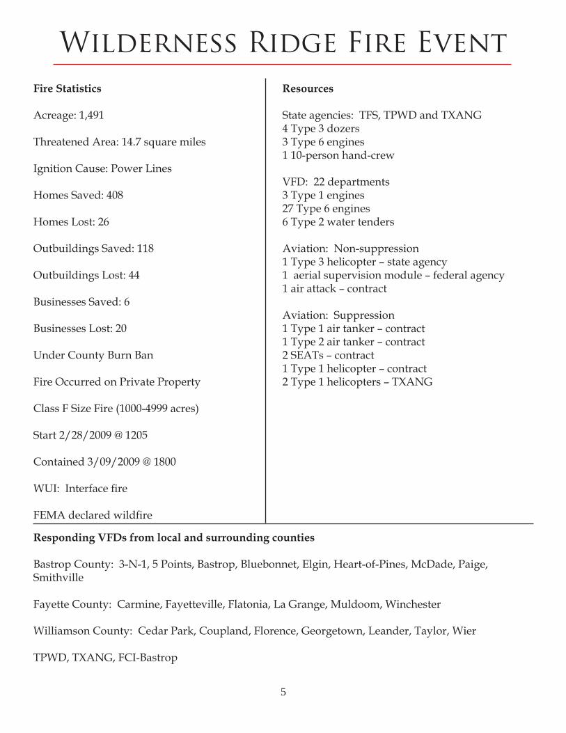
Wilderness Ridge Fire EventFire Statistics
Acreage: 1,491
Threatened Area: 14.7 square miles
Ignition Cause: Power Lines
Homes Saved: 408
Homes Lost: 26
Outbuildings Saved: 118
Outbuildings Lost: 44
Businesses Saved: 6
Businesses Lost: 20
Under County Burn Ban
Fire Occurred on Private Property
Class F Size Fire (1000-4999 acres)
Start 2/28/2009 @ 1205
Contained 3/09/2009 @ 1800
WUI: Interface fire
FEMA declared wildfire
Resources
State agencies: TFS, TPWD and TXANG4 Type 3 dozers3 Type 6 engines1 10-person hand-crew
VFD: 22 departments3 Type 1 engines 27 Type 6 engines6 Type 2 water tenders
Aviation: Non-suppression1 Type 3 helicopter – state agency1 aerial supervision module – federal agency1 air attack – contract Aviation: Suppression1 Type 1 air tanker – contract 1 Type 2 air tanker – contract2 SEATs – contract1 Type 1 helicopter – contract2 Type 1 helicopters – TXANG
Responding VFDs from local and surrounding counties Bastrop County: 3-N-1, 5 Points, Bastrop, Bluebonnet, Elgin, Heart-of-Pines, McDade, Paige, Smithville
Fayette County: Carmine, Fayetteville, Flatonia, La Grange, Muldoom, Winchester
Williamson County: Cedar Park, Coupland, Florence, Georgetown, Leander, Taylor, Wier
TPWD, TXANG, FCI-Bastrop
5
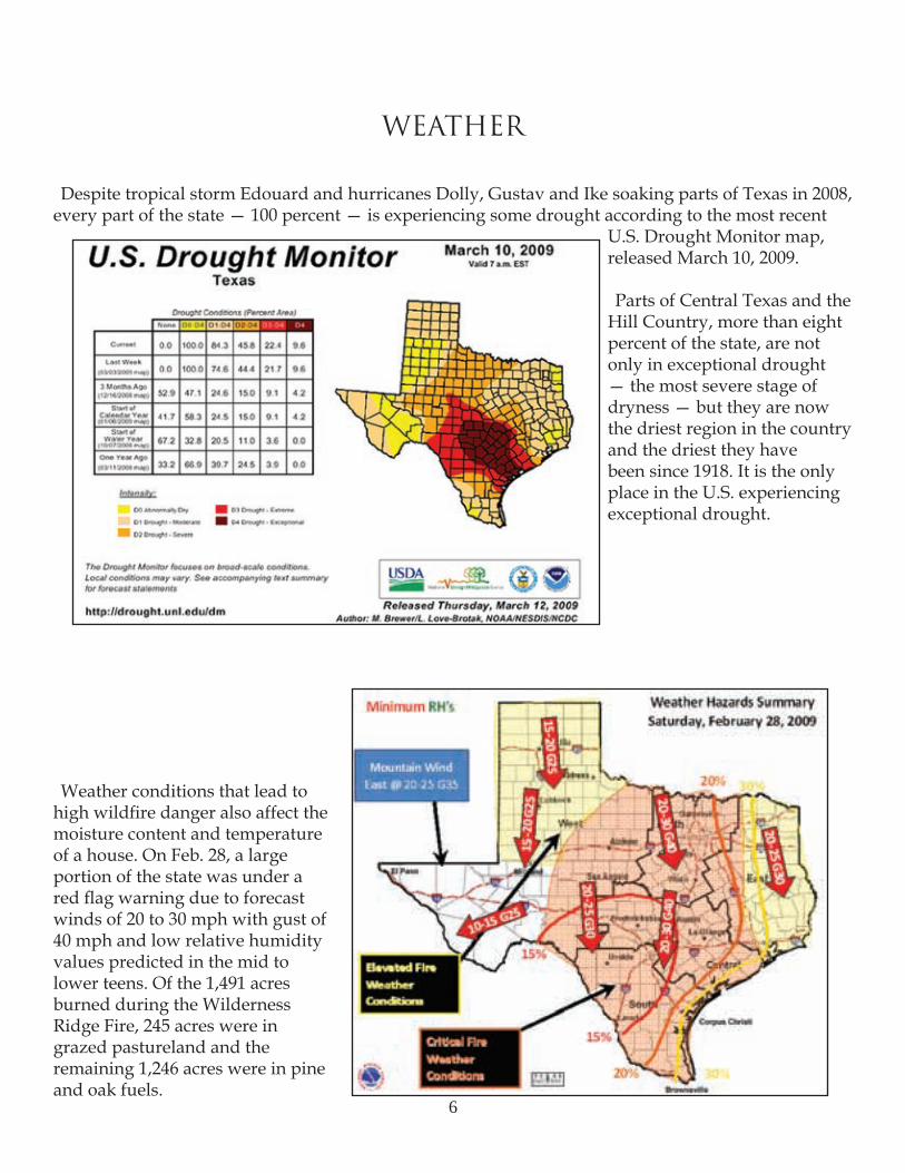
WEATHER
Despite tropical storm Edouard and hurricanes Dolly, Gustav and Ike soaking parts of Texas in 2008, every part of the state — 100 percent — is experiencing some drought according to the most recent
U.S. Drought Monitor map, released March 10, 2009.
Parts of Central Texas and the Hill Country, more than eight percent of the state, are not only in exceptional drought — the most severe stage of dryness — but they are now the driest region in the country and the driest they have been since 1918. It is the only place in the U.S. experiencing exceptional drought.
Weather conditions that lead to high wildfire danger also affect the moisture content and temperature of a house. On Feb. 28, a large portion of the state was under a red flag warning due to forecast winds of 20 to 30 mph with gust of 40 mph and low relative humidity values predicted in the mid to lower teens. Of the 1,491 acres burned during the Wilderness Ridge Fire, 245 acres were in grazed pastureland and the remaining 1,246 acres were in pine and oak fuels.
6
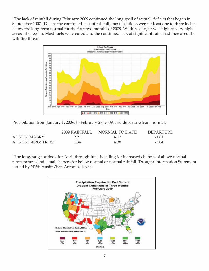
The lack of rainfall during February 2009 continued the long spell of rainfall deficits that began in September 2007. Due to the continued lack of rainfall, most locations were at least one to three inches below the long-term normal for the first two months of 2009. Wildfire danger was high to very high across the region. Most fuels were cured and the continued lack of significant rains had increased the wildfire threat.
Precipitation from January 1, 2009, to February 28, 2009, and departure from normal:
2009 RAINFALL NORMAL TO DATE DEPARTUREAUSTIN MABRY 2.21 4.02 -1.81AUSTIN BERGSTROM 1.34 4.38 -3.04
The long-range outlook for April through June is calling for increased chances of above normal temperatures and equal chances for below normal or normal rainfall (Drought Information Statement Issued by NWS Austin/San Antonio, Texas).
7
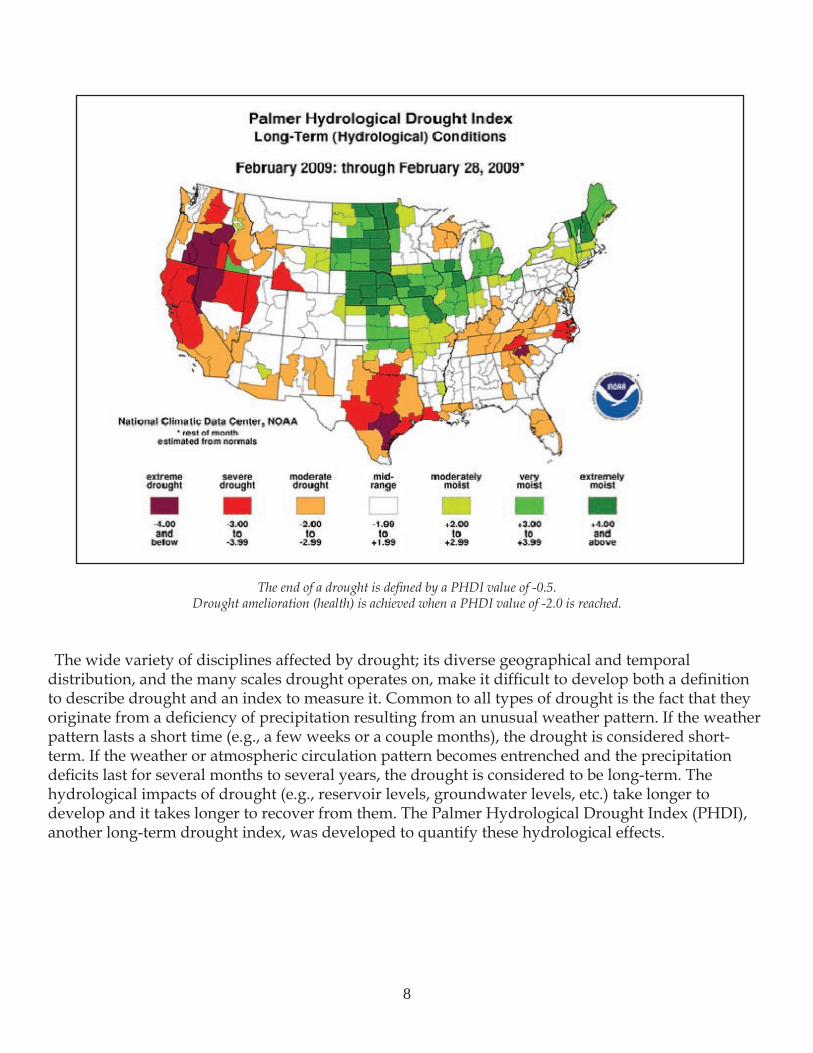
The end of a drought is defined by a PHDI value of -0.5.Drought amelioration (health) is achieved when a PHDI value of -2.0 is reached.
The wide variety of disciplines affected by drought; its diverse geographical and temporal distribution, and the many scales drought operates on, make it difficult to develop both a definition to describe drought and an index to measure it. Common to all types of drought is the fact that they originate from a deficiency of precipitation resulting from an unusual weather pattern. If the weather pattern lasts a short time (e.g., a few weeks or a couple months), the drought is considered short-term. If the weather or atmospheric circulation pattern becomes entrenched and the precipitation deficits last for several months to several years, the drought is considered to be long-term. The hydrological impacts of drought (e.g., reservoir levels, groundwater levels, etc.) take longer to develop and it takes longer to recover from them. The Palmer Hydrological Drought Index (PHDI), another long-term drought index, was developed to quantify these hydrological effects.
8
Location of Fire
Why was this one different?
Texas has begun seeing shorter, wetter winters and warmer, drier summers. Due to prolonged drought and effects of climate change, ecosystems will be altered significantly in structure, composition and distribution of species within the next 30 years. This change will result in wildfires occurring in geographic areas throughout the state that have not traditionally experienced such events.
Build up of mid-story fuel loads, such as young trees, in forests and woodlands, plus flammable invasive species in rangelands and grasslands, will alter traditional wildfire behavior. This behavior alteration will result in unprecedented wildfire activity, which will make control of these wildfires difficult.
Historically
The Wilderness Ridge Fire occurred in the Lost Pines of Bastrop County. This area is a disjunct population of Pinus taeda located in Central Texas near Bastrop at the westernmost edge of the species’ natural range. Historically (Pre-Euro-American Settlement), this area’s forest composition was dominated by loblolly pine (50 to 70 feet tall) and widely scattered oak species, such as post oak and black oak on xeric, or extremely dry habitat, sites. In areas with frequent natural wildfires, the understory would have been dominated by native perennial grasses and forbs such as little bluestem, big bluestem (Andropogon gerardii), pinewoods dropseed (Sporobolus junceus), asters (Symphiotrichum sp.) and bracken fern (Pteridium aquilinum).
Currently
Due to urban development and protection of endangered species’ habitat, fire has been absent in this area, which has allowed the understory to change. The current state of the Lost Pines is primarily closed canopy, with a dense understory of yaupon. This closed condition and understory component, have lead to excessive needle drape, increased fuel loading and ladder fuels. These elements have created conditions favorable for extreme wildfire behavior.
9
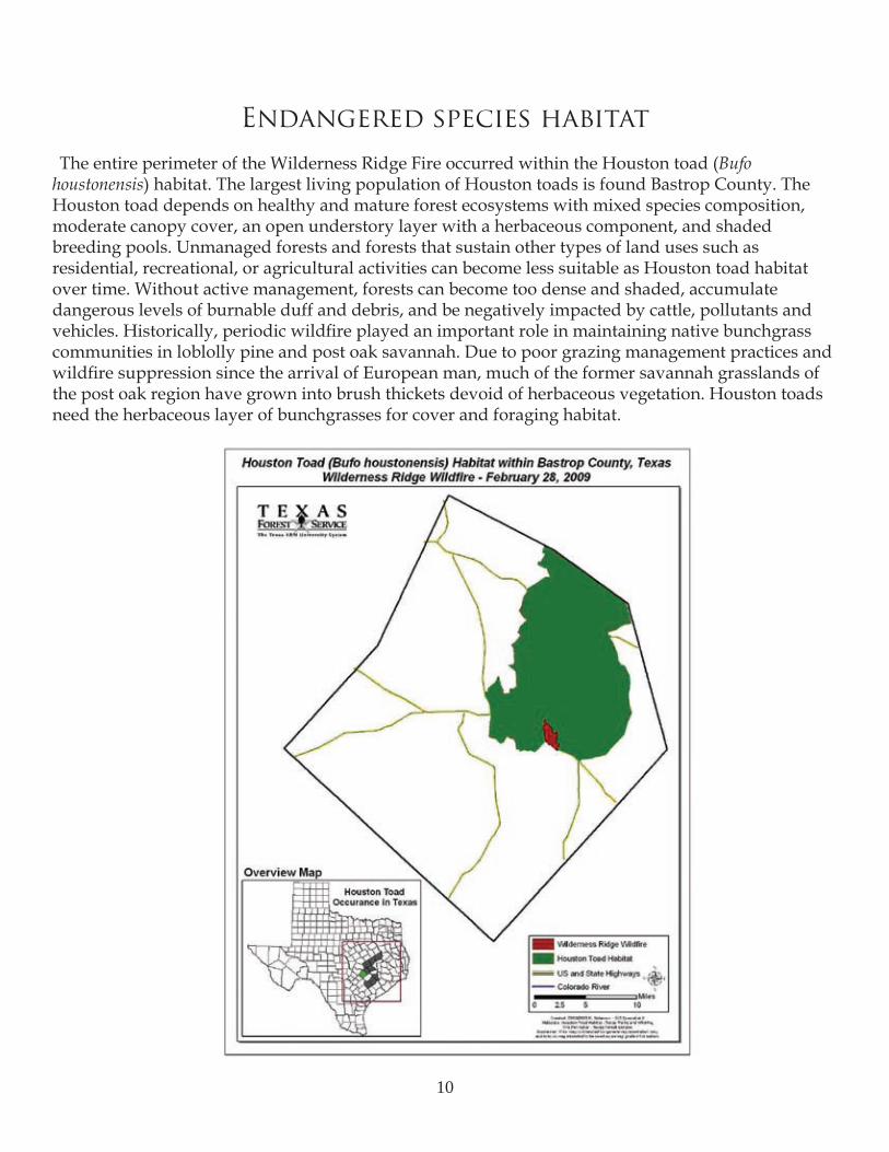
Endangered species habitat
The entire perimeter of the Wilderness Ridge Fire occurred within the Houston toad (Bufo houstonensis) habitat. The largest living population of Houston toads is found Bastrop County. The Houston toad depends on healthy and mature forest ecosystems with mixed species composition, moderate canopy cover, an open understory layer with a herbaceous component, and shaded breeding pools. Unmanaged forests and forests that sustain other types of land uses such as residential, recreational, or agricultural activities can become less suitable as Houston toad habitat over time. Without active management, forests can become too dense and shaded, accumulate dangerous levels of burnable duff and debris, and be negatively impacted by cattle, pollutants and vehicles. Historically, periodic wildfire played an important role in maintaining native bunchgrass communities in loblolly pine and post oak savannah. Due to poor grazing management practices and wildfire suppression since the arrival of European man, much of the former savannah grasslands of the post oak region have grown into brush thickets devoid of herbaceous vegetation. Houston toads need the herbaceous layer of bunchgrasses for cover and foraging habitat.
10
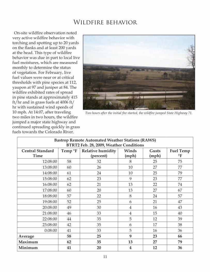
Wildfire behavior
On-site wildfire observation noted very active wildfire behavior with torching and spotting up to 20 yards on the flanks and at least 200 yards at the head. This type of wildfire behavior was due in part to local live fuel moistures, which are measured monthly to determine the status of vegetation. For February, live fuel values were near or at critical thresholds with pine species at 112, yaupon at 97 and juniper at 84. The wildfire exhibited rates of spread in pine stands at approximately 415 ft/hr and in grass fuels at 4006 ft/hr with sustained wind speeds of 10 mph. At 14:07, after traveling two miles in two hours, the wildfire jumped a major state highway and continued spreading quickly in grass fuels towards the Colorado River.
Bastrop Remote Automated Weather Stations (RAWS)BTRT2 Feb. 28, 2009, Weather Conditions
Central Standard Time
Temp °F Relative humidity (percent)
Winds (mph)
Gusts (mph)
Fuel Temp °F
12:08:00 58 32 8 25 7513:08:00 60 26 10 27 7714:08:00 61 24 10 25 7915:08:00 62 23 9 23 7716:08:00 62 21 13 22 7417:08:00 60 20 13 27 6718:08:00 57 22 8 24 5719:08:00 52 25 6 21 4720:08:00 49 30 4 16 4321:08:00 46 33 4 15 4022:08:00 44 35 5 12 3923:08:00 42 35 6 17 380:08:00 41 33 5 16 36
Average 58 25 9 23 66Maximum 62 35 13 27 79Minimum 41 20 4 12 36
Two hours after the initial fire started, the wildfire jumped State Highway 71.
11
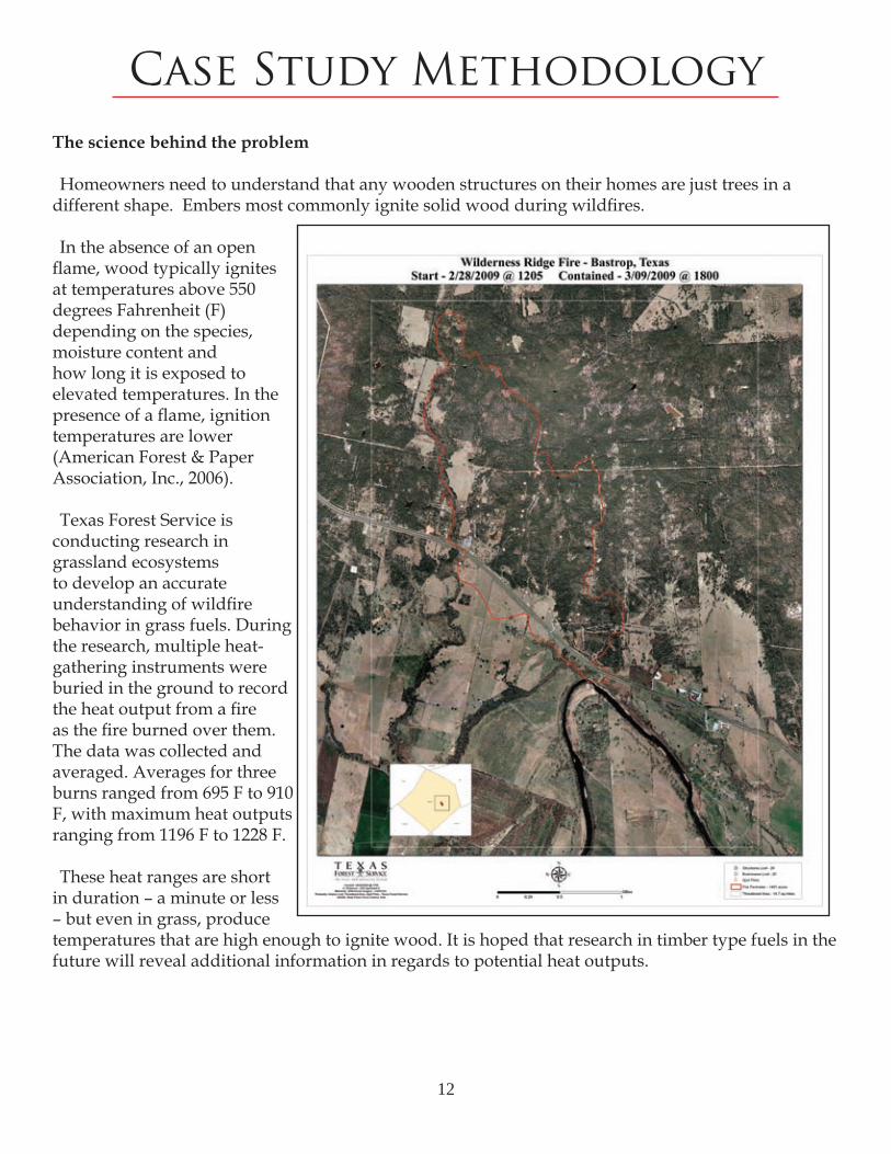
Case Study MethodologyThe science behind the problem
Homeowners need to understand that any wooden structures on their homes are just trees in a different shape. Embers most commonly ignite solid wood during wildfires.
In the absence of an open flame, wood typically ignites at temperatures above 550 degrees Fahrenheit (F) depending on the species, moisture content and how long it is exposed to elevated temperatures. In the presence of a flame, ignition temperatures are lower (American Forest & Paper Association, Inc., 2006).
Texas Forest Service is conducting research in grassland ecosystems to develop an accurate understanding of wildfire behavior in grass fuels. During the research, multiple heat-gathering instruments were buried in the ground to record the heat output from a fire as the fire burned over them. The data was collected and averaged. Averages for three burns ranged from 695 F to 910 F, with maximum heat outputs ranging from 1196 F to 1228 F.
These heat ranges are short in duration – a minute or less – but even in grass, produce temperatures that are high enough to ignite wood. It is hoped that research in timber type fuels in the future will reveal additional information in regards to potential heat outputs.
12
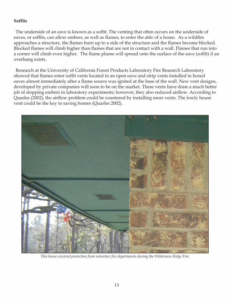
Soffits
The underside of an eave is known as a soffit. The venting that often occurs on the underside of eaves, or soffits, can allow embers, as well as flames, to enter the attic of a home. As a wildfire approaches a structure, the flames burn up to a side of the structure and the flames become blocked. Blocked flames will climb higher than flames that are not in contact with a wall. Flames that run into a corner will climb even higher. The flame plume will spread onto the surface of the eave (soffit) if an overhang exists.
Research at the University of California Forest Products Laboratory Fire Research Laboratory showed that flames enter soffit vents located in an open eave and strip vents installed in boxed eaves almost immediately after a flame source was ignited at the base of the wall. New vent designs, developed by private companies will soon to be on the market. These vents have done a much better job of stopping embers in laboratory experiments; however, they also reduced airflow. According to Quarles (2002), the airflow problem could be countered by installing more vents. The lowly house vent could be the key to saving homes (Quarles 2002).
This house received protection from volunteer fire departments during the Wilderness Ridge Fire.
13
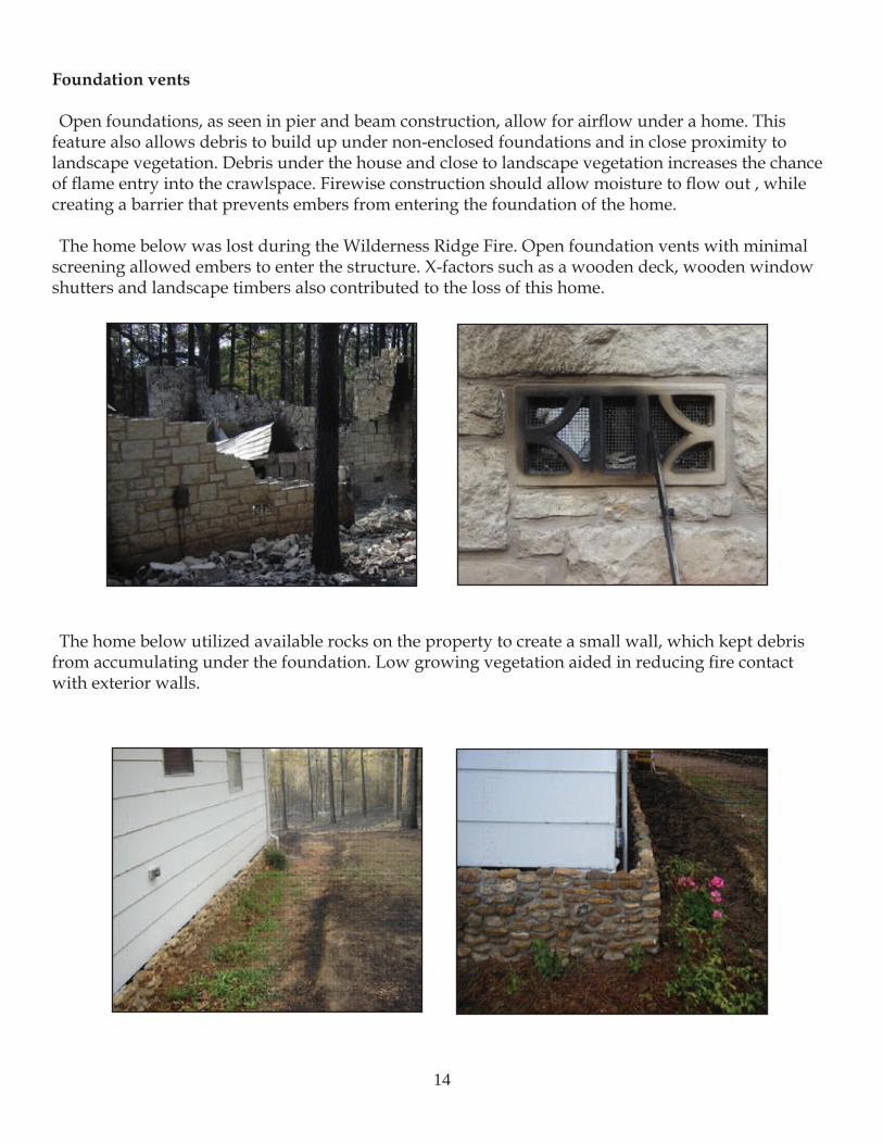
Foundation vents
Open foundations, as seen in pier and beam construction, allow for airflow under a home. This feature also allows debris to build up under non-enclosed foundations and in close proximity to landscape vegetation. Debris under the house and close to landscape vegetation increases the chance of flame entry into the crawlspace. Firewise construction should allow moisture to flow out , while creating a barrier that prevents embers from entering the foundation of the home.
The home below was lost during the Wilderness Ridge Fire. Open foundation vents with minimal screening allowed embers to enter the structure. X-factors such as a wooden deck, wooden window shutters and landscape timbers also contributed to the loss of this home.
The home below utilized available rocks on the property to create a small wall, which kept debris from accumulating under the foundation. Low growing vegetation aided in reducing fire contact with exterior walls.
14
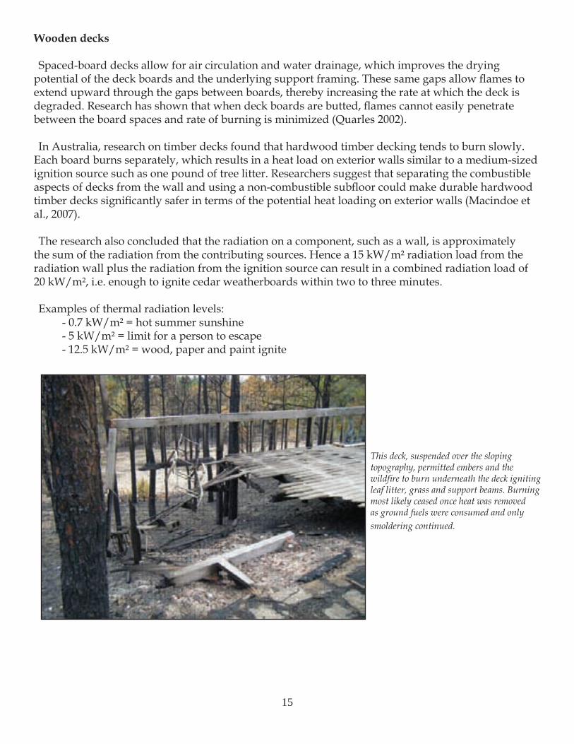
Wooden decks
Spaced-board decks allow for air circulation and water drainage, which improves the drying potential of the deck boards and the underlying support framing. These same gaps allow flames to extend upward through the gaps between boards, thereby increasing the rate at which the deck is degraded. Research has shown that when deck boards are butted, flames cannot easily penetrate between the board spaces and rate of burning is minimized (Quarles 2002).
In Australia, research on timber decks found that hardwood timber decking tends to burn slowly. Each board burns separately, which results in a heat load on exterior walls similar to a medium-sized ignition source such as one pound of tree litter. Researchers suggest that separating the combustible aspects of decks from the wall and using a non-combustible subfloor could make durable hardwood timber decks significantly safer in terms of the potential heat loading on exterior walls (Macindoe et al., 2007).
The research also concluded that the radiation on a component, such as a wall, is approximately the sum of the radiation from the contributing sources. Hence a 15 kW/m² radiation load from the radiation wall plus the radiation from the ignition source can result in a combined radiation load of 20 kW/m², i.e. enough to ignite cedar weatherboards within two to three minutes.
Examples of thermal radiation levels:- 0.7 kW/m² = hot summer sunshine- 5 kW/m² = limit for a person to escape- 12.5 kW/m² = wood, paper and paint ignite
This deck, suspended over the sloping topography, permitted embers and the wildfire to burn underneath the deck igniting leaf litter, grass and support beams. Burning most likely ceased once heat was removed as ground fuels were consumed and only smoldering continued.
15
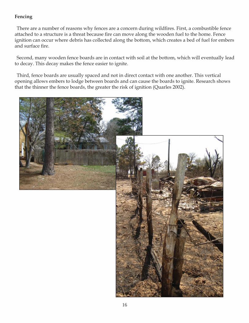
Fencing
There are a number of reasons why fences are a concern during wildfires. First, a combustible fence attached to a structure is a threat because fire can move along the wooden fuel to the home. Fence ignition can occur where debris has collected along the bottom, which creates a bed of fuel for embers and surface fire.
Second, many wooden fence boards are in contact with soil at the bottom, which will eventually lead to decay. This decay makes the fence easier to ignite.
Third, fence boards are usually spaced and not in direct contact with one another. This vertical opening allows embers to lodge between boards and can cause the boards to ignite. Research shows that the thinner the fence boards, the greater the risk of ignition (Quarles 2002).
16
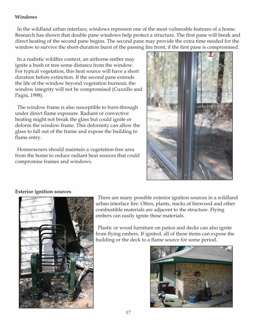
Windows
In the wildland urban interface, windows represent one of the most vulnerable features of a home. Research has shown that double pane windows help protect a structure. The first pane will break and direct heating of the second pane begins. The second pane may provide the extra time needed for the window to survive the short-duration burst of the passing fire front, if the first pane is compromised.
In a realistic wildfire context, an airborne ember may ignite a bush or tree some distance from the window. For typical vegetation, this heat source will have a short duration before extinction. If the second pane extends the life of the window beyond vegetation burnout, the window integrity will not be compromised (Cuzzillo and Pagni, 1998).
The window frame is also susceptible to burn-through under direct flame exposure. Radiant or convective heating might not break the glass but could ignite or deform the window frame. This deformity can allow the glass to fall out of the frame and expose the building to flame entry.
Homeowners should maintain a vegetation-free area from the home to reduce radiant heat sources that could compromise frames and windows.
Exterior ignition sourcesThere are many possible exterior ignition sources in a wildland
urban interface fire. Often, plants, stacks of firewood and other combustible materials are adjacent to the structure. Flying embers can easily ignite these materials.
Plastic or wood furniture on patios and decks can also ignite from flying embers. If ignited, all of these items can expose the building or the deck to a flame source for some period.
17
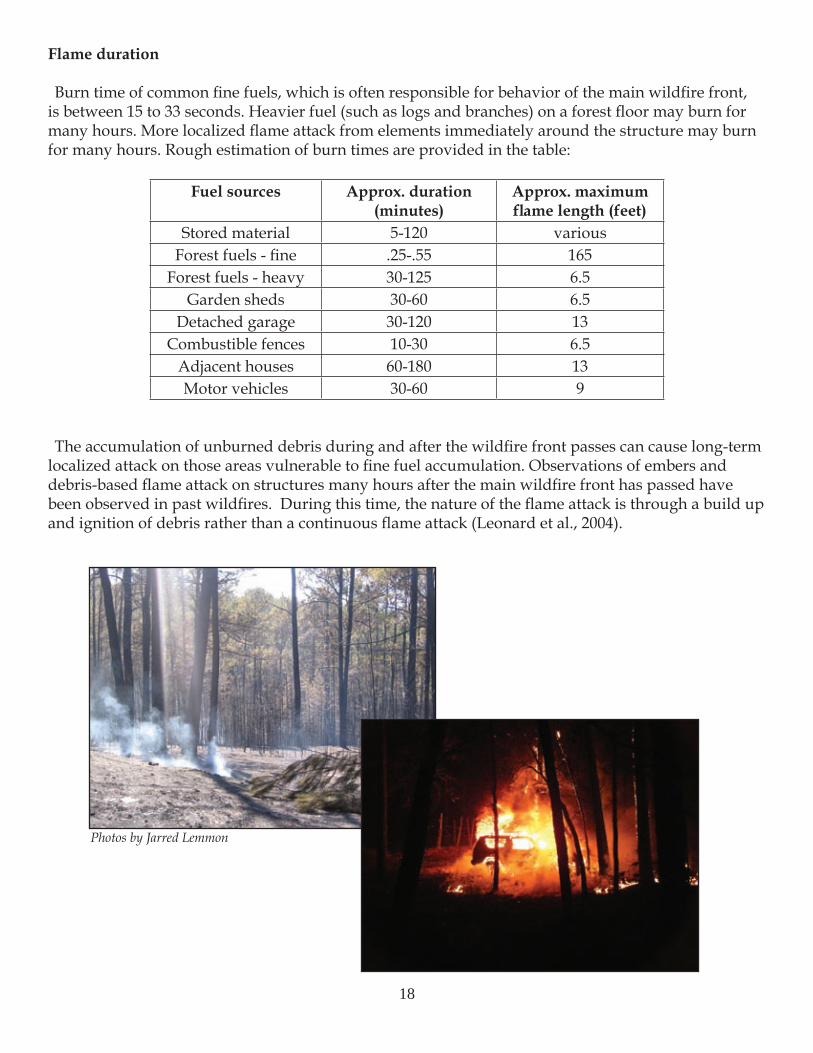
Flame duration
Burn time of common fine fuels, which is often responsible for behavior of the main wildfire front, is between 15 to 33 seconds. Heavier fuel (such as logs and branches) on a forest floor may burn for many hours. More localized flame attack from elements immediately around the structure may burn for many hours. Rough estimation of burn times are provided in the table:
Fuel sources Approx. duration (minutes)
Approx. maximum flame length (feet)
Stored material 5-120 variousForest fuels - fine .25-.55 165
Forest fuels - heavy 30-125 6.5Garden sheds 30-60 6.5
Detached garage 30-120 13Combustible fences 10-30 6.5
Adjacent houses 60-180 13Motor vehicles 30-60 9
The accumulation of unburned debris during and after the wildfire front passes can cause long-term localized attack on those areas vulnerable to fine fuel accumulation. Observations of embers and debris-based flame attack on structures many hours after the main wildfire front has passed have been observed in past wildfires. During this time, the nature of the flame attack is through a build up and ignition of debris rather than a continuous flame attack (Leonard et al., 2004).
Photos by Jarred Lemmon
18
Embers
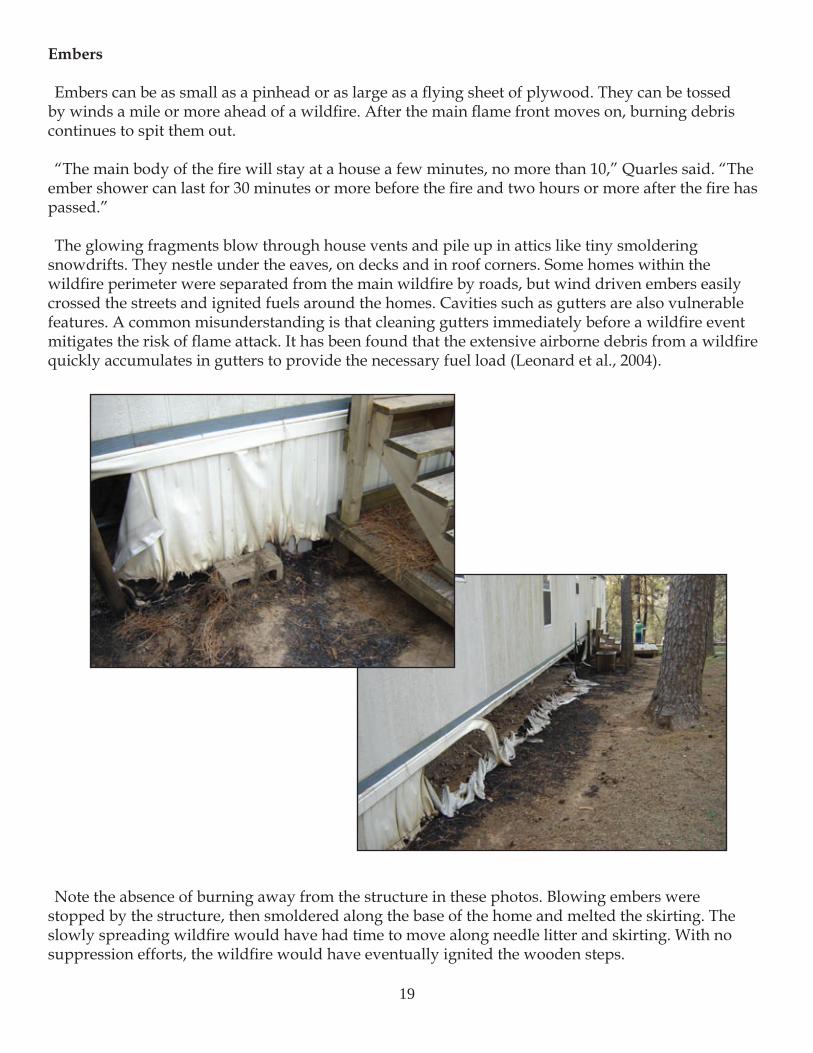
Embers can be as small as a pinhead or as large as a flying sheet of plywood. They can be tossed by winds a mile or more ahead of a wildfire. After the main flame front moves on, burning debris continues to spit them out.
“The main body of the fire will stay at a house a few minutes, no more than 10,” Quarles said. “The ember shower can last for 30 minutes or more before the fire and two hours or more after the fire has passed.”
The glowing fragments blow through house vents and pile up in attics like tiny smoldering snowdrifts. They nestle under the eaves, on decks and in roof corners. Some homes within the wildfire perimeter were separated from the main wildfire by roads, but wind driven embers easily crossed the streets and ignited fuels around the homes. Cavities such as gutters are also vulnerable features. A common misunderstanding is that cleaning gutters immediately before a wildfire event mitigates the risk of flame attack. It has been found that the extensive airborne debris from a wildfire quickly accumulates in gutters to provide the necessary fuel load (Leonard et al., 2004).
Note the absence of burning away from the structure in these photos. Blowing embers were stopped by the structure, then smoldered along the base of the home and melted the skirting. The slowly spreading wildfire would have had time to move along needle litter and skirting. With no suppression efforts, the wildfire would have eventually ignited the wooden steps.
19
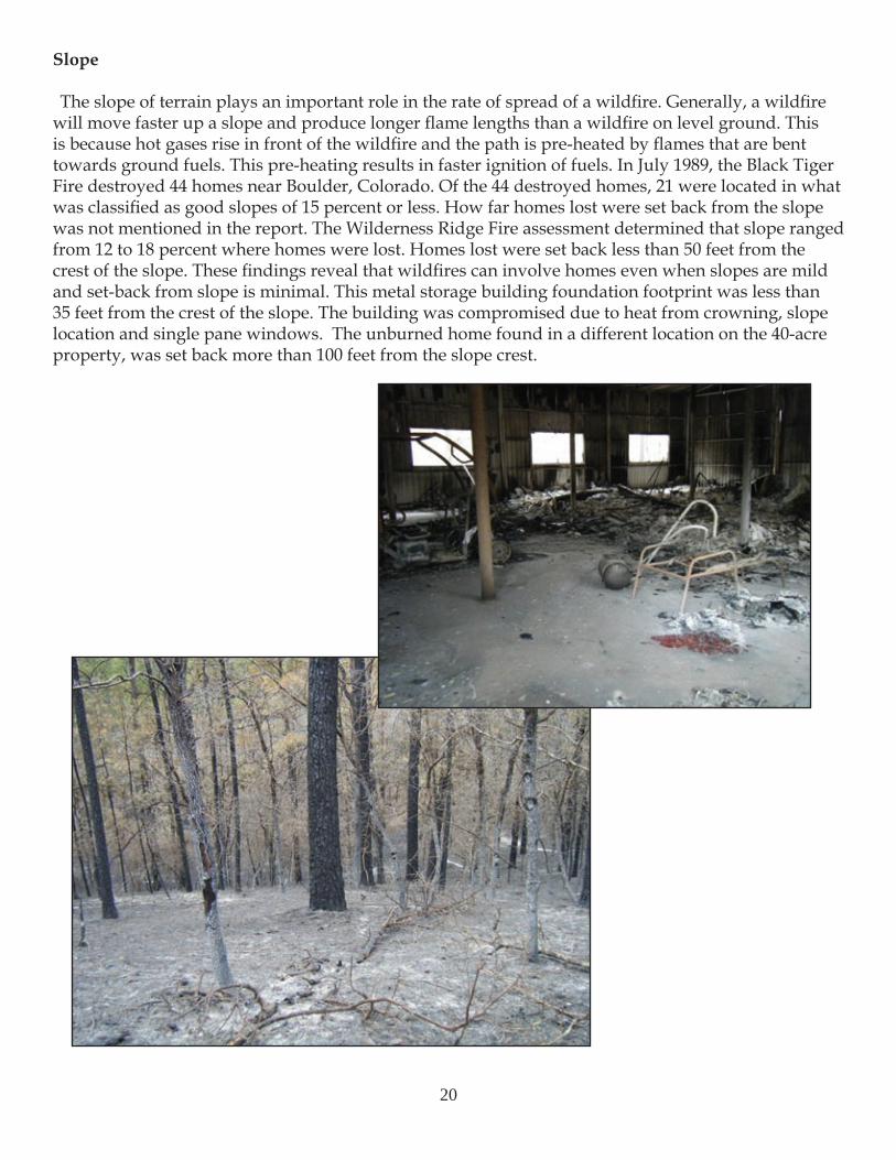
Slope
The slope of terrain plays an important role in the rate of spread of a wildfire. Generally, a wildfire will move faster up a slope and produce longer flame lengths than a wildfire on level ground. This is because hot gases rise in front of the wildfire and the path is pre-heated by flames that are bent towards ground fuels. This pre-heating results in faster ignition of fuels. In July 1989, the Black Tiger Fire destroyed 44 homes near Boulder, Colorado. Of the 44 destroyed homes, 21 were located in what was classified as good slopes of 15 percent or less. How far homes lost were set back from the slope was not mentioned in the report. The Wilderness Ridge Fire assessment determined that slope ranged from 12 to 18 percent where homes were lost. Homes lost were set back less than 50 feet from the crest of the slope. These findings reveal that wildfires can involve homes even when slopes are mild and set-back from slope is minimal. This metal storage building foundation footprint was less than 35 feet from the crest of the slope. The building was compromised due to heat from crowning, slope location and single pane windows. The unburned home found in a different location on the 40-acre property, was set back more than 100 feet from the slope crest.
20
ResultsA Closer Look – Homes that survived
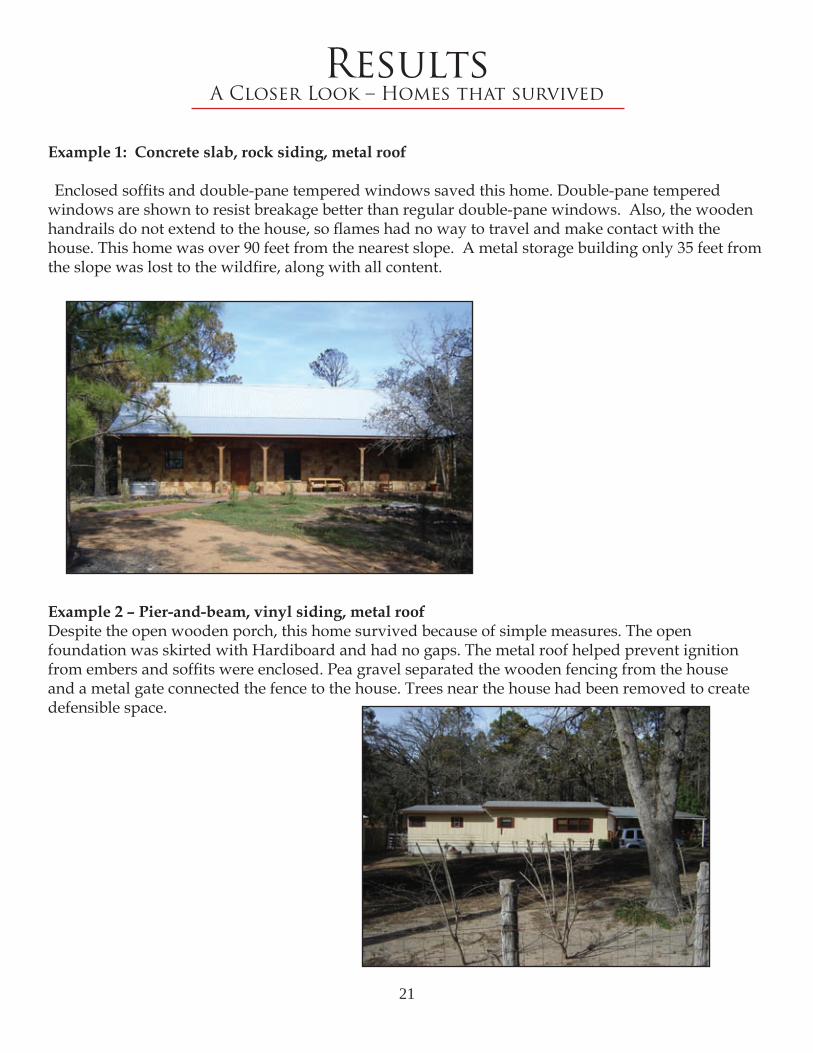
Example 1: Concrete slab, rock siding, metal roof
Enclosed soffits and double-pane tempered windows saved this home. Double-pane tempered windows are shown to resist breakage better than regular double-pane windows. Also, the wooden handrails do not extend to the house, so flames had no way to travel and make contact with the house. This home was over 90 feet from the nearest slope. A metal storage building only 35 feet from the slope was lost to the wildfire, along with all content.
Example 2 – Pier-and-beam, vinyl siding, metal roofDespite the open wooden porch, this home survived because of simple measures. The open foundation was skirted with Hardiboard and had no gaps. The metal roof helped prevent ignition from embers and soffits were enclosed. Pea gravel separated the wooden fencing from the house and a metal gate connected the fence to the house. Trees near the house had been removed to create defensible space.
21
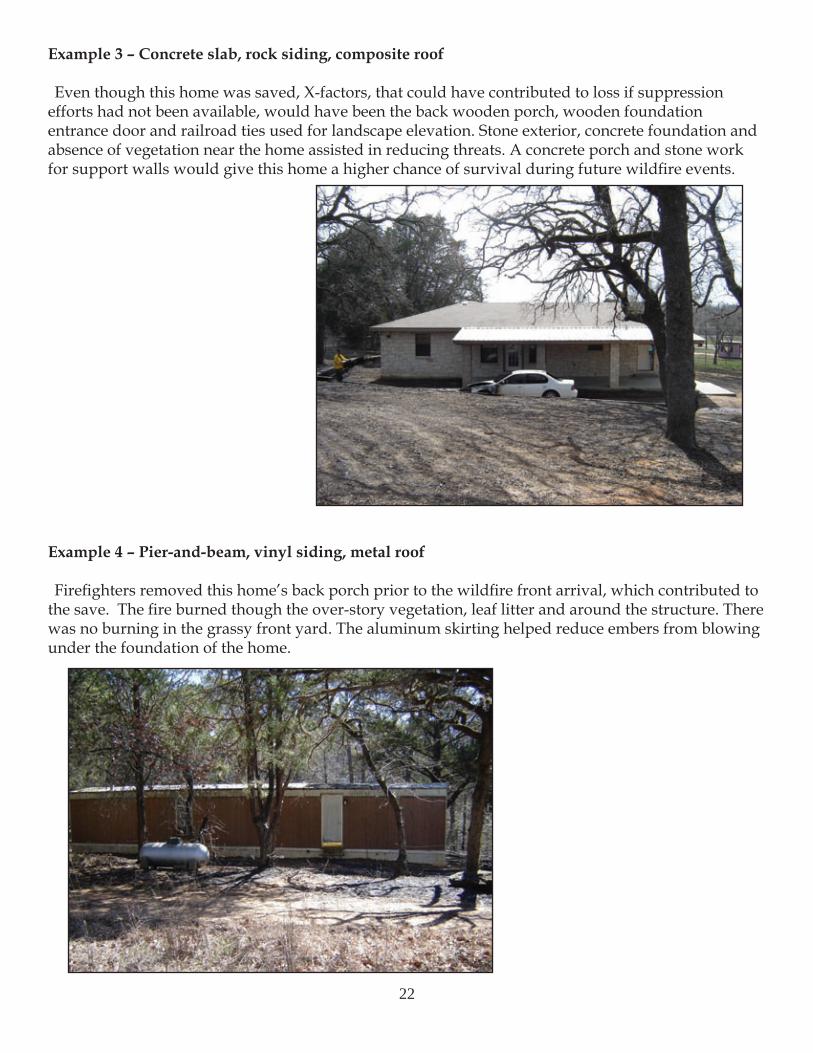
Example 3 – Concrete slab, rock siding, composite roof
Even though this home was saved, X-factors, that could have contributed to loss if suppression efforts had not been available, would have been the back wooden porch, wooden foundation entrance door and railroad ties used for landscape elevation. Stone exterior, concrete foundation and absence of vegetation near the home assisted in reducing threats. A concrete porch and stone work for support walls would give this home a higher chance of survival during future wildfire events.
Example 4 – Pier-and-beam, vinyl siding, metal roof
Firefighters removed this home’s back porch prior to the wildfire front arrival, which contributed to the save. The fire burned though the over-story vegetation, leaf litter and around the structure. There was no burning in the grassy front yard. The aluminum skirting helped reduce embers from blowing under the foundation of the home.
22
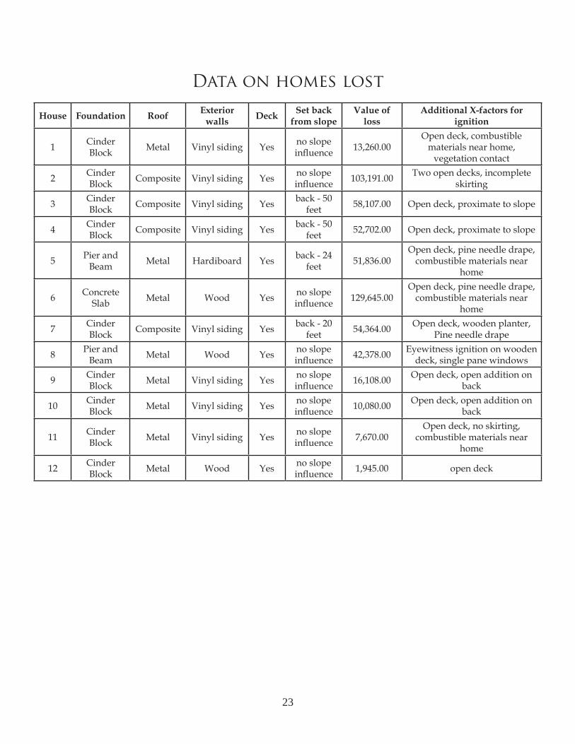
House Foundation Roof Exterior walls Deck Set back
from slopeValue of
lossAdditional X-factors for
ignition
1 Cinder Block Metal Vinyl siding Yes no slope
influence 13,260.00Open deck, combustible
materials near home, vegetation contact
2 Cinder Block Composite Vinyl siding Yes no slope
influence 103,191.00 Two open decks, incomplete skirting
3 Cinder Block Composite Vinyl siding Yes back - 50
feet 58,107.00 Open deck, proximate to slope
4 Cinder Block Composite Vinyl siding Yes back - 50
feet 52,702.00 Open deck, proximate to slope
5 Pier and Beam Metal Hardiboard Yes back - 24
feet 51,836.00Open deck, pine needle drape,
combustible materials near home
6 Concrete Slab Metal Wood Yes no slope
influence 129,645.00Open deck, pine needle drape,
combustible materials near home
7 Cinder Block Composite Vinyl siding Yes back - 20
feet 54,364.00 Open deck, wooden planter, Pine needle drape
8 Pier and Beam Metal Wood Yes no slope
influence 42,378.00 Eyewitness ignition on wooden deck, single pane windows
9 Cinder Block Metal Vinyl siding Yes no slope
influence 16,108.00 Open deck, open addition on back
10 Cinder Block Metal Vinyl siding Yes no slope
influence 10,080.00 Open deck, open addition on back
11 Cinder Block Metal Vinyl siding Yes no slope
influence 7,670.00Open deck, no skirting,
combustible materials near home
12 Cinder Block Metal Wood Yes no slope
influence 1,945.00 open deck
Data on homes lost
23
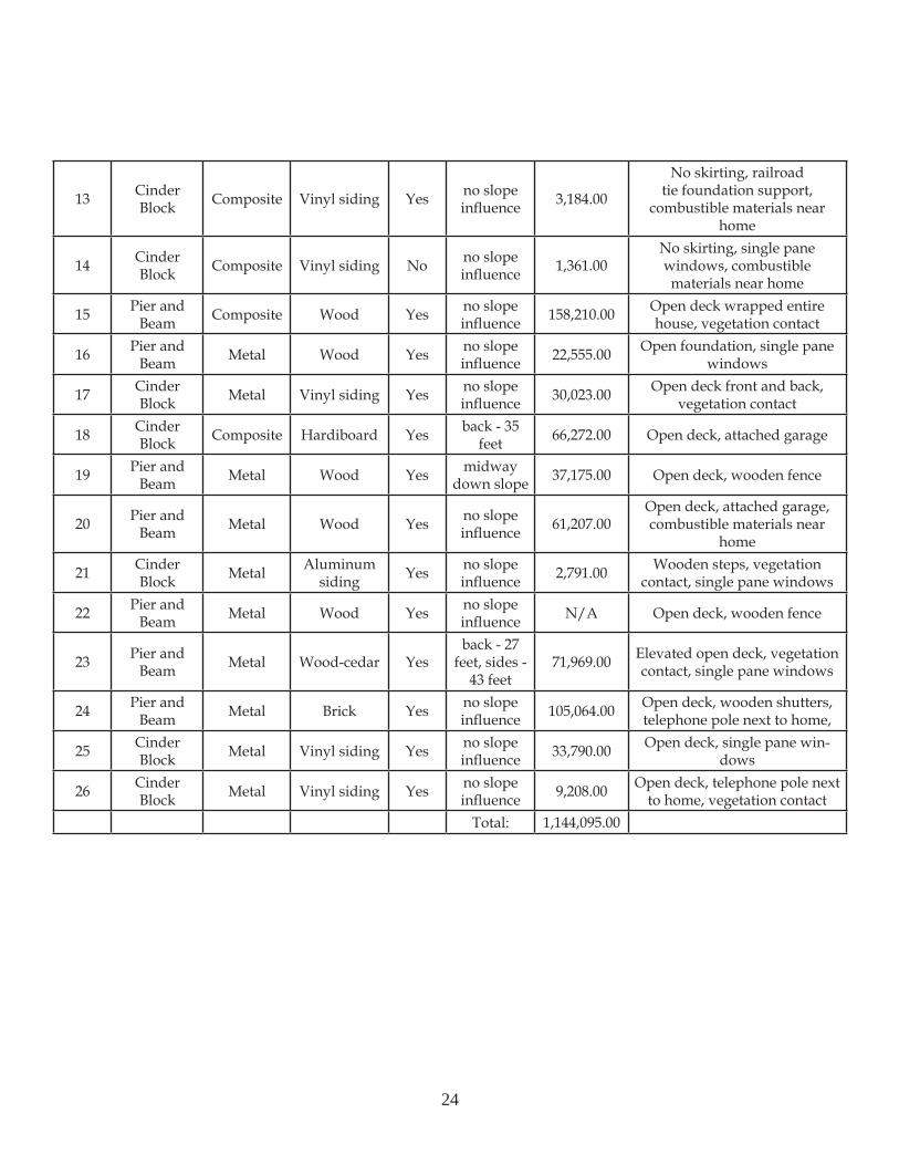
13 Cinder Block Composite Vinyl siding Yes no slope
influence 3,184.00
No skirting, railroad tie foundation support,
combustible materials near home
14 Cinder Block Composite Vinyl siding No no slope
influence 1,361.00No skirting, single pane windows, combustible materials near home
15 Pier and Beam Composite Wood Yes no slope
influence 158,210.00 Open deck wrapped entire house, vegetation contact
16 Pier and Beam Metal Wood Yes no slope
influence 22,555.00 Open foundation, single pane windows
17 Cinder Block Metal Vinyl siding Yes no slope
influence 30,023.00 Open deck front and back, vegetation contact
18 Cinder Block Composite Hardiboard Yes back - 35
feet 66,272.00 Open deck, attached garage
19 Pier and Beam Metal Wood Yes midway
down slope 37,175.00 Open deck, wooden fence
20 Pier and Beam Metal Wood Yes no slope
influence 61,207.00Open deck, attached garage, combustible materials near
home
21 Cinder Block Metal Aluminum
siding Yes no slope influence 2,791.00 Wooden steps, vegetation
contact, single pane windows
22 Pier and Beam Metal Wood Yes no slope
influence N/A Open deck, wooden fence
23 Pier and Beam Metal Wood-cedar Yes
back - 27 feet, sides -
43 feet71,969.00 Elevated open deck, vegetation
contact, single pane windows
24 Pier and Beam Metal Brick Yes no slope
influence 105,064.00 Open deck, wooden shutters, telephone pole next to home,
25 Cinder Block Metal Vinyl siding Yes no slope
influence 33,790.00 Open deck, single pane win-dows
26 Cinder Block Metal Vinyl siding Yes no slope
influence 9,208.00 Open deck, telephone pole next to home, vegetation contact
Total: 1,144,095.00
24
Economic Impacts
Texas has building codes, but it is left up to local jurisdictions (counties, cities) to either opt-in or opt-out of adopting the state code. In some cases, should a local jurisdiction choose to enforce a building code, it could be the adopted state code or something similar. The level of state support varies widely. Without constant coding regulations for homes built in wildfire prone areas, substandard homes will continue to be built in areas of high wildfire risk. Construction materials and elements are assigned fire ratings, usually in terms of hours until structural failure would occur in a fire. The fire ratings are for ignitions that occur within the home as a single structural fire that will be controlled by multiple fire departments. Ideally, construction codes should address materials that can sustain burning conditions for several hours in the event that no mitigation efforts are available for extended periods of time. As development continues to take place in rural areas throughout the state, the wildland urban interface risk will continue to increase. Efforts need to be made to examine past wildfire events to start developing building code standards in Texas that regulate the manufacturing and use of building materials designed to withstand wildfire attacks.
Owners often start the blame game when their home was lost. Why did I lose my home? Why did my neighbors’ homes survive? Did the fire department try to save my home? Reports continue to show from past case studies involving wildfires in all types of ecosystems and weather extremes that little things can determine the survivability of a home.
The number of homes and businesses destroyed by a wildfire is always tragic to the community and homeowners. It is almost impossible to know for certain why a particular home is destroyed by a wildfire. Using reverse risk assessment allows specialists to hypothesize the reasons one home was lost and another was spared. Using a questionnaire, specialists examine construction, ingress/egress, defensible space, topography, fuels, weather components and analysis of fire behavior to develop a fire chronology of events that contribute to home loss.
25
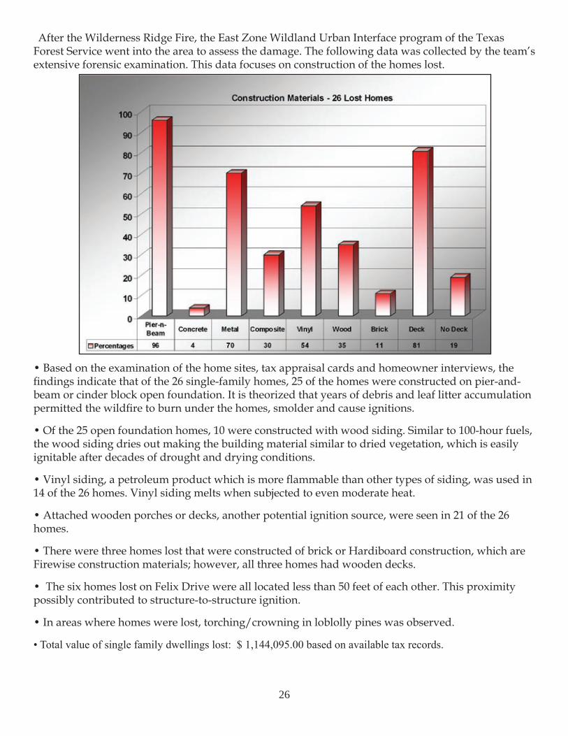
After the Wilderness Ridge Fire, the East Zone Wildland Urban Interface program of the Texas Forest Service went into the area to assess the damage. The following data was collected by the team’s extensive forensic examination. This data focuses on construction of the homes lost.
• Based on the examination of the home sites, tax appraisal cards and homeowner interviews, the findings indicate that of the 26 single-family homes, 25 of the homes were constructed on pier-and-beam or cinder block open foundation. It is theorized that years of debris and leaf litter accumulation permitted the wildfire to burn under the homes, smolder and cause ignitions.
• Of the 25 open foundation homes, 10 were constructed with wood siding. Similar to 100-hour fuels, the wood siding dries out making the building material similar to dried vegetation, which is easily ignitable after decades of drought and drying conditions.
• Vinyl siding, a petroleum product which is more flammable than other types of siding, was used in 14 of the 26 homes. Vinyl siding melts when subjected to even moderate heat.
• Attached wooden porches or decks, another potential ignition source, were seen in 21 of the 26 homes.
• There were three homes lost that were constructed of brick or Hardiboard construction, which are Firewise construction materials; however, all three homes had wooden decks.
• The six homes lost on Felix Drive were all located less than 50 feet of each other. This proximity possibly contributed to structure-to-structure ignition.
• In areas where homes were lost, torching/crowning in loblolly pines was observed.
• Total value of single family dwellings lost: $ 1,144,095.00 based on available tax records.
26
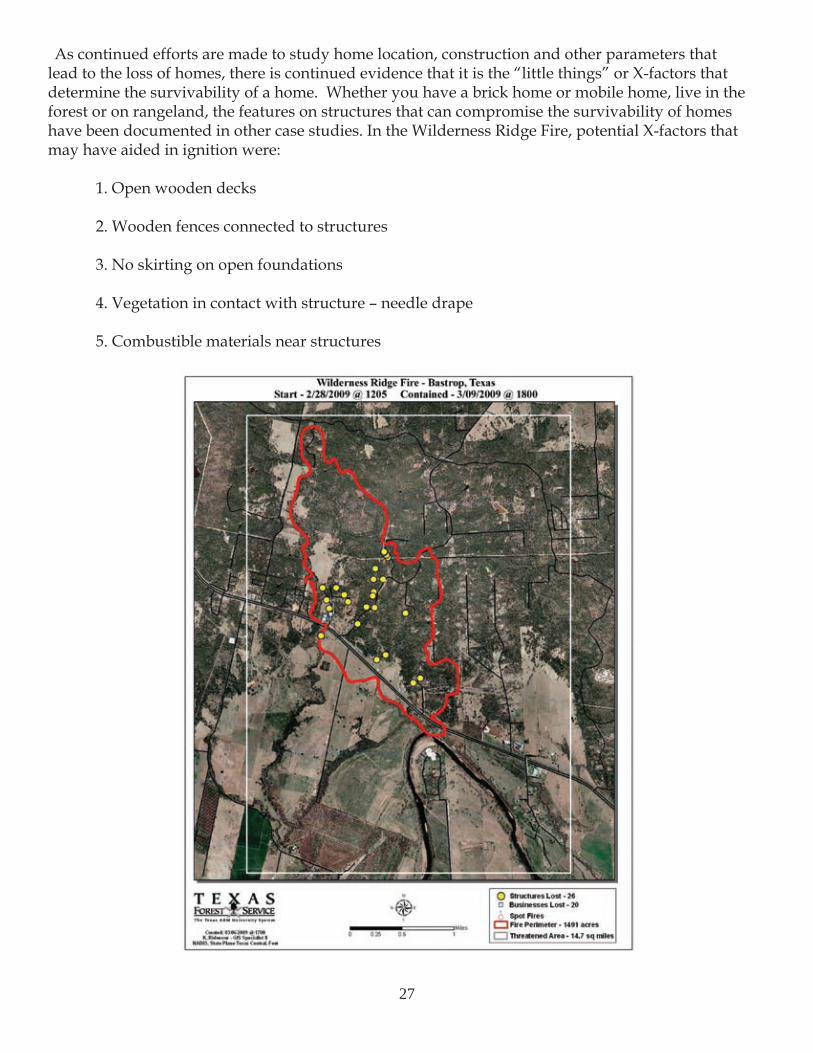
As continued efforts are made to study home location, construction and other parameters that lead to the loss of homes, there is continued evidence that it is the “little things” or X-factors that determine the survivability of a home. Whether you have a brick home or mobile home, live in the forest or on rangeland, the features on structures that can compromise the survivability of homes have been documented in other case studies. In the Wilderness Ridge Fire, potential X-factors that may have aided in ignition were:
1. Open wooden decks
2. Wooden fences connected to structures
3. No skirting on open foundations
4. Vegetation in contact with structure – needle drape
5. Combustible materials near structures
27
ConclusionsThe Wilderness Ridge Fire was a result of “perfect storm” conditions. In Feb. 2009, the Central Texas
region was entrenched in a severe drought. The day of the wildfire, relative humidity values fell to 20 percent and wind speeds average was nine mph with average gusts of 23 mph. The spark from power lines was the final piece needed to complete this destructive puzzle.
The Wilderness Ridge Fire is the largest wildfire to affect Central Texas to date. It is hoped that this study will inform both the private and public sectors on the importance of wildfire mitigation and preparedness. This study is just part of a learning process that began in 1915 for Texas Forest Service. TFS will continue to do its part to conserve, protect and lead the citizens of Texas.
Protection of human life is the first priority in wildland fire management. Property and resources are the second priority.
Agencies and the public cannot expect that all wildfires can be controlled or suppressed. No organization, technology or equipment can provide absolute protection when unusual fuel build-ups, extreme weather conditions, multiple ignitions and extreme wildfire behavior come together to form catastrophic events. The Wilderness Ridge Fire effortlessly jumped major highways and roads. In many cases, spotting occurred hundreds of feet ahead of the main fire. At times, wildfire behavior was beyond the limit of control because of crowning and torching in the pine trees. In some instances, structure protection was the only option because of the intensity of the fire.
During a major wildfire, rarely are there enough resources to defend every structure threatened by the advancing blaze. The only feasible strategy for preventing losses in the wildland urban interface is utilizing fire resistant building materials and modifying fuels in the home ignition zone.
The responsibility rests with all of us when dealing with wildland fire issues within our community. Homeowners need to maintain regular maintenance and prepare their home prior to a wildfire event. Contractors need to request the development of building codes for Firewise construction materials. Developers need to design and implement plans for communities that are Firewise. Local officials need to support prescribed burning programs and the development and implementation of building code regulations. State government support is needed to fund mitigation projects and research within Texas.
Fuel load concentrations will continue to build because of changing land uses. This is not only true for communities in brush and timber areas but for grasslands as well. As Texas continues through the current drought cycle, we will most likely experience more of these wildland urban interface fires. To prevent devastating loss to a community, homeowners must become informed on how to protect their homes. Community leaders should develop and implement Community Wildfire Protection Plans (CWPP). Local response agencies should train for, plan and execute a rapid, coordinated response to all wildland incidents.
Continued wildfire occurrence is assured; it will take cooperation and action from homeowners, community leaders and response agencies prior to a wildland event to most effectively protect homes and lives in the wildland urban interface.
28
29
References American Forest & Paper Association, Inc. (2006). Fire Performance of Wood Products Awareness Guide. Washington, DC: American Forest & Paper Association, Inc.
Hyde, A., Lasko, R., Murphy, T., McManus, B., Smith, D., Artley, D., & Hilbruner, M. (2009). Quadrennial Fire Review 2009.
Leonard, J. E., Blanchi R., Bowditch, P.A. (2004). Bushfire impact from a house’s perspective. Earth Wind and Fire –Bushfire 2004 Conference, Adelaide.
Macindoe, L., Sargeant, A., Bowditch P. A., & Lenoard J. (2007). Fire Tests at the Interface between Timber Decks and Exterior Walls.
Quarles, S.L. (2002 March). Conflicting design issues in wood frame construction. Paperpresented at 9th Durability Building Materials Conference, Brisbane, Australia.