www.dugeo.com | www.dugsw.com The Monodon multi-client study Case Study Summary DownUnder GeoSolutions’ Monodon multi-client project is a massive regional study covering approximately 14,700 square kilometers in prospective Northern Carnarvon Basin of the North West Shelf, Western Australia. The study now includes the reprocessing from field tapes of seventeen surveys using a state-of-the-art flow and cutting edge algorithms that include industry leading linear noise removal and regularization (DUG REG ® ). The reprocessed data has been merged prior to anisotropic (TTI) pre-stack depth migration incorporating multi-iteration tomographic model building. Data from all stages of the processing are available including image gathers and angle stacks. Some 41 regional wells have undergone petrophysical interpretation and analysis. These data have been used in a statistical rock physics and forward modeling study of the area. The study assesses the rock property and expected amplitude and AVA variability for all relevant geological scenarios. Access to such a large and comprehensive data set is typically very difficult and often not possible. Large-scale 3D surveys of this size are invaluable for geological interpretation and basin modeling applications. There is no doubt that exploration risk can be mitigated from the utilisation of this dataset. A map of the study area is given in Figure 1. Reprocessing and Imaging The high-end processing and imaging flow is summarised below. 1. Reformat from SEGD to internal format 2. Navigation merge, trace edits and tidal statics, instrument delay 3. Source signature zero phasing 4. Low-cut filter 5. Spherical divergence 6. Swell noise attenuation 7. Linear Noise Removal (DUG LNR) 8. Shallow water multiple prediction (DUG SWaMP) 9. Tau-P deconvolution 10. Merge/match various surveys 11. Regularisation (DUG REG ® ) 12. Acquisition footprint removal 13. Four (so far) iterations of tomographic velocity analysis 14. Anisotropic TTI Pre-stack Kirchhoff depth migration 15. Output spacing: 25 m x 25 m 16. Predictive deconvolution 17. Post migration Radon demultiple 18. Residual moveout correction 19. Angle stack • Full stack: 5-35 degrees • Near stack: 5-15 degrees • Mid stack: 15-25 degrees • Far stack: 25-35 degrees • Ultra-far stack: 35-45 degrees 20. Frequency enhancement 21. Inverse Q filtering 22. Gun and cable correction to MSL 23. Lateral continuity filter 24. Output to SEGY Reprocessing and depth imaging of 17 surveys (~14,700km 2 ) Petrophysics and statistical rock physics of 41 wells
Transcript
www.dugeo.com | www.dugsw.com
The Monodon multi-client study
Case Study
Summary
DownUnder GeoSolutions’ Monodon multi-client project is a massive regional study covering approximately 14,700 square kilometers in prospective Northern Carnarvon Basin of the North West Shelf, Western Australia. The study now includes the reprocessing from field tapes of seventeen surveys using a state-of-the-art flow and cutting edge algorithms that include industry leading linear noise removal and regularization (DUG REG®). The reprocessed data has been merged prior to anisotropic (TTI) pre-stack depth migration incorporating multi-iteration tomographic model building. Data from all stages of the processing are available including image gathers and angle stacks. Some 41 regional wells have undergone petrophysical interpretation and analysis. These data have been used in a statistical rock physics and forward modeling study of the area. The study assesses the rock property and expected amplitude and AVA variability for all relevant geological scenarios.
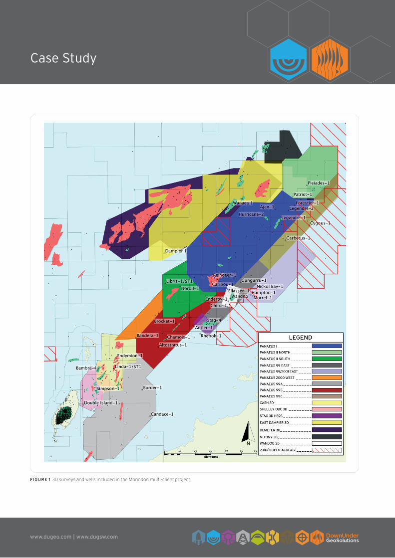
Access to such a large and comprehensive data set is typically very difficult and often not possible. Large-scale 3D surveys of this size are invaluable for geological interpretation and basin modeling applications. There is no doubt that exploration risk can be mitigated from the utilisation of this dataset. A map of the study area is given in Figure 1.
Reprocessing and Imaging
The high-end processing and imaging flow is summarised below.
1. Reformat from SEGD to internal format
2. Navigation merge, trace edits and tidal statics, instrument delay
3. Source signature zero phasing
4. Low-cut filter
5. Spherical divergence
6. Swell noise attenuation
7. Linear Noise Removal (DUG LNR)
8. Shallow water multiple prediction (DUG SWaMP)
9. Tau-P deconvolution
10. Merge/match various surveys
11. Regularisation (DUG REG®)
12. Acquisition footprint removal
13. Four (so far) iterations of tomographic velocity analysis
Reprocessing and depth imaging of 17 surveys (~14,700km2)Petrophysics and statistical rock physics of 41 wells
www.dugeo.com | www.dugsw.com
Case Study
Figure 1 3D surveys and wells included in the Monodon multi-client project.
www.dugeo.com | www.dugsw.com
Case Study
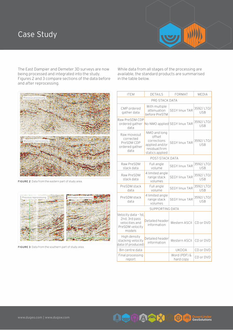
The East Dampier and Demeter 3D surveys are now being processed and integrated into the study. Figures 2 and 3 compare sections of the data before and after reprocessing.
While data from all stages of the processing are available, the standard products are summarised in the table below.
ITEM DETAILS FORMAT MEDIA
PRE-STACK DATA
CMP ordered gather data
With multiple attenuation
before PreSTMSEGY linux TAR
3592/ LTO/USB
Raw PreSDM CDP ordered gather
dataNo NMO applied SEGY linux TAR
3592/ LTO/USB
Raw moveout corrected
PreSDM CDP ordered gather
data
NMO and long offset
corrections applied and/or residual/trim
statics applied
SEGY linux TAR3592/ LTO/
USB
POST-STACK DATA
Raw PreSDM stack data
Full angle volume
SEGY linux TAR3592/ LTO/
USB
Raw PreSDM stack data
4 limited angle range stack
volumesSEGY linux TAR
3592/ LTO/USB
PreSDM stack data
Full angle volume
SEGY linux TAR3592/ LTO/
USB
PreSDM stack data
4 limited angle range stack
volumesSEGY linux TAR
3592/ LTO/USB
SUPPORTING DATA
Velocity data – 1st, 2nd, 3rd pass velocities and
PreSDM velocity models
Detailed header information
Western ASCII CD or DVD
High density stacking velocity
data (if produced)
Detailed header information
Western ASCII CD or DVD
Bin centre data UKOOA CD or DVD
Final processing report
Word (PDF) & hard copy
CD or DVD
Figure 2 Data from the eastern part of study area.
Figure 3 Data from the southern part of study area.
Previous processing
Monodon reprocessing
Previous reprocessing Monodon reprocessing
www.dugeo.com | www.dugsw.com
Case Study
Petrophysics and rock physics
A total of 41 wells from the Dampier and Barrow Sub-basins have been integrated into this study. The wells have been separated into areas (South, East, North, Central, North-West and West), in order to capture the variations in rock properties across the region. The complete well list is summarised below.
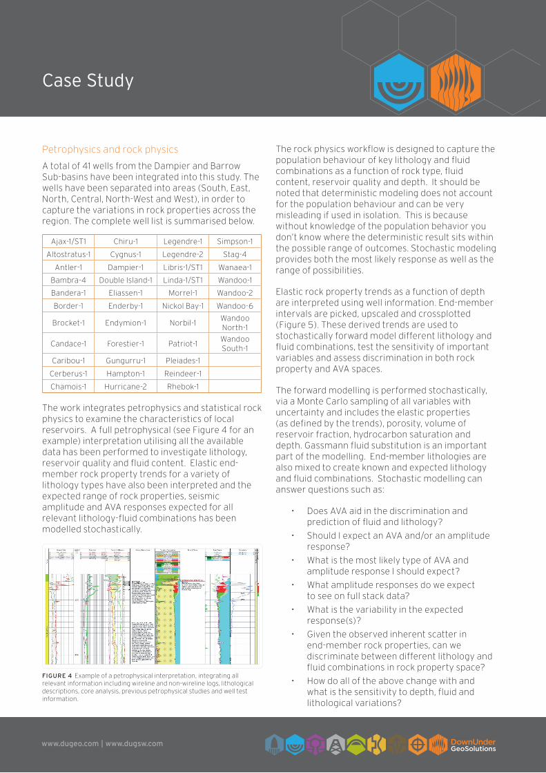
The work integrates petrophysics and statistical rock physics to examine the characteristics of local reservoirs. A full petrophysical (see Figure 4 for an example) interpretation utilising all the available data has been performed to investigate lithology, reservoir quality and fluid content. Elastic end-member rock property trends for a variety of lithology types have also been interpreted and the expected range of rock properties, seismic amplitude and AVA responses expected for all relevant lithology-fluid combinations has been modelled stochastically.
The rock physics workflow is designed to capture the population behaviour of key lithology and fluid combinations as a function of rock type, fluid content, reservoir quality and depth. It should be noted that deterministic modeling does not account for the population behaviour and can be very misleading if used in isolation. This is because without knowledge of the population behavior you don’t know where the deterministic result sits within the possible range of outcomes. Stochastic modeling provides both the most likely response as well as the range of possibilities.
Elastic rock property trends as a function of depth are interpreted using well information. End-member intervals are picked, upscaled and crossplotted (Figure 5). These derived trends are used to stochastically forward model different lithology and fluid combinations, test the sensitivity of important variables and assess discrimination in both rock property and AVA spaces.
The forward modelling is performed stochastically, via a Monte Carlo sampling of all variables with uncertainty and includes the elastic properties (as defined by the trends), porosity, volume of reservoir fraction, hydrocarbon saturation and depth. Gassmann fluid substitution is an important part of the modelling. End-member lithologies are also mixed to create known and expected lithology and fluid combinations. Stochastic modelling can answer questions such as:
• Does AVA aid in the discrimination and prediction of fluid and lithology?
• Should I expect an AVA and/or an amplitude response?
• What is the most likely type of AVA and amplitude response I should expect?
• What amplitude responses do we expect to see on full stack data?
• What is the variability in the expected response(s)?
• Given the observed inherent scatter in end-member rock properties, can we discriminate between different lithology and fluid combinations in rock property space?
• How do all of the above change with and what is the sensitivity to depth, fluid and lithological variations?
Figure 4 Example of a petrophysical interpretation, integrating all relevant information including wireline and non-wireline logs, lithological descriptions, core analysis, previous petrophysical studies and well test information.
Ajax-1/ST1 Chiru-1 Legendre-1 Simpson-1
Altostratus-1 Cygnus-1 Legendre-2 Stag-4
Antler-1 Dampier-1 Libris-1/ST1 Wanaea-1
Bambra-4 Double Island-1 Linda-1/ST1 Wandoo-1
Bandera-1 Eliassen-1 Morrel-1 Wandoo-2
Border-1 Enderby-1 Nickol Bay-1 Wandoo-6
Brocket-1 Endymion-1 Norbil-1Wandoo North-1
Candace-1 Forestier-1 Patriot-1Wandoo South-1
Caribou-1 Gungurru-1 Pleiades-1
Cerberus-1 Hampton-1 Reindeer-1
Chamois-1 Hurricane-2 Rhebok-1
www.dugeo.com | www.dugsw.com
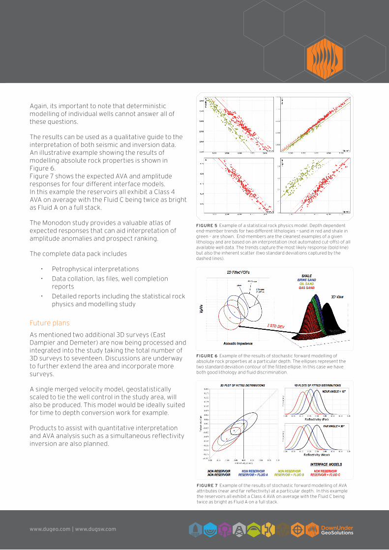
Again, its important to note that deterministic modelling of individual wells cannot answer all of these questions.
The results can be used as a qualitative guide to the interpretation of both seismic and inversion data. An illustrative example showing the results of modelling absolute rock properties is shown in Figure 6. Figure 7 shows the expected AVA and amplitude responses for four different interface models. In this example the reservoirs all exhibit a Class 4 AVA on average with the Fluid C being twice as bright as Fluid A on a full stack.
The Monodon study provides a valuable atlas of expected responses that can aid interpretation of amplitude anomalies and prospect ranking.
The complete data pack includes
• Petrophysical interpretations
• Data collation, las files, well completion reports
• Detailed reports including the statistical rock physics and modelling study
Future plans
As mentioned two additional 3D surveys (East Dampier and Demeter) are now being processed and integrated into the study taking the total number of 3D surveys to seventeen. Discussions are underway to further extend the area and incorporate more surveys.
A single merged velocity model, geostatistically scaled to tie the well control in the study area, will also be produced. This model would be ideally suited for time to depth conversion work for example.
Products to assist with quantitative interpretation and AVA analysis such as a simultaneous reflectivity inversion are also planned.
Figure 5 Example of a statistical rock physics model. Depth dependent end-member trends for two different lithologies – sand in red and shale in green – are shown. End-members are the cleanest examples of a given lithology and are based on an interpretation (not automated cut-offs) of all available well data. The trends capture the most likely response (bold line) but also the inherent scatter (two standard deviations captured by the dashed lines).
Figure 6 Example of the results of stochastic forward modelling of absolute rock properties at a particular depth. The ellipses represent the two standard deviation contour of the fitted ellipse. In this case we have both good lithology and fluid discrimination.
Figure 7 Example of the results of stochastic forward modelling of AVA attributes (near and far reflectivity) at a particular depth. In this example the reservoirs all exhibit a Class 4 AVA on average with the Fluid C being twice as bright as Fluid A on a full stack.


![New Diseases of P. Monodon and L. Vannamei [Compatibility Mode]](https://static.documents.pub/doc/80x56/577d1f301a28ab4e1e90119a/new-diseases-of-p-monodon-and-l-vannamei-compatibility-mode.jpg)