Catch Me If You Can: Predicting Mobility Patterns of Public Transport Users Stefan Foell, Santi Phithakkitnukoon, Gerd Kortuem, Marco Veloso and Carlos Bento Abstract— Direct and easy access to public transport infor- mation is an important factor for improving the satisfaction and experience of transport users. In the future, public trans- port information systems could be turned into personalized recommender systems which can help riders save time, make more effective decisions and avoid frustrating situations. In this paper, we present a predictive study of the mobility patterns of public transport users to lay the foundation for transport information systems with proactive capabilities. By making use of travel card data from a large population of bus riders, we describe algorithms that can anticipate bus stops accessed by individual riders to generate knowledge about future transport access patterns. To this end, we investigate and compare different prediction algorithms that can incorporate various influential factors on mobility in public transport networks, e.g., travel distance or travel hot spots. In our evaluation, we demonstrate that by combining personal and population-wide mobility patterns we can improve prediction accuracy, even with little knowledge of past behavior of transport users. I. INTRODUCTION In an era of rapid urbanization, public transport plays a key role in managing the balance between increasing demand for mobility and the environmental impact of mass transport. Nevertheless, in order to ensure that public transport is a viable option for many travelers, there is a constant need to stimulate its use. In particular, cars are still the most widely used mode of transportation valued for their comfort, ownership and controllability [12]. Therefore, identifying and overcoming barriers of transport use are key priorities of many public transport providers [23]. Information technology has great potential to improve the visibility and accessibility of public transport services [5]. Over the recent years, the wide-spread adoption of smart phones has provided transport providers new channels to engage with travelers [9]. As a result, transport users are able to request journey information regardless of their current location. In a survey with bus riders, various positive effects are attributed to enhanced information availability, e.g., better satisfaction and increased ridership [10]. Easy access to relevant travel information is therefore a decisive factor for the success and adoption of public transport systems. 1 Stefan Foell is with the Computing Department, The Open University, Milton Keynes, UK [email protected]2 Santi Phithakkitnukoon is with the Department of Computer Engineer- ing, Chiang Mai University, Thailand [email protected]3 Gerd Kortuem is with the Computing Department, The Open University, Milton Keynes, UK [email protected]4 Marco Veloso is with Centro de Informtica e Sistemas da Universidade de Coimbra, Coimbra, Portugal [email protected]5 Carlos Bento is with Centro de Informtica e Sistemas da Universidade de Coimbra, Coimbra, Portugal [email protected]In the future, public transport information systems could be turned into personalized recommender systems to provide even better support and guidance. For instance, in order to alert travelers about incidents or changes affecting their journeys, suggestions for better routes could be sent to them prior to their departures. Similarly, public transport users could receive recommendations about events and offers near by the transport stops that they visit. However, a main prerequisite for the development of such intelligent services is accurate knowledge of individual travel patterns. With the deployment of automatic fare collection systems, large-scale data becomes available about real-world transport usage [18]. However, studies of individual travel patterns are sparse in public transport research. In the past, research has mainly focused on aggregate demand forecast [7]. In order to fill this gap, we describe in this paper al- gorithms to extract and predict mobility patterns of public transport users with a specific focus on bus ridership. Bus networks in urban areas create complex mobility systems with a large number of stops and routes. Identifying and ranking the stops used by individual bus riders provides useful knowledge for information personalization. However, given the large variety of users with different mobility needs, ranging from frequent to occasional riders, an approach is required which can guarantee effective predictions for all rider types. To find a suitable approach that exhibits these characteristics, we explore in this work a range of algorithms that can incorporate various influential factors on mobility decisions in public transport networks including a) personal travel habits and popular travel hot spots, b) geography and structure of the transport network and c) collective information of transport use from other travelers. In our evaluation, we use large-scale bus ride data from Lisbon, Portugal to analyze the predictability of different riders. As our analysis shows, the ability to adapt to varying degrees of knowledge of a user’s past rides is essential to achieve high prediction accuracies. While knowledge from personal ride histories is valuable especially for more habitual riders, information from collective transport usage patterns of other riders is important to new or infrequent bus users for which data histories are limited. By showing that both beneficial features can be combined into a single approach, we provide a powerful tool that can be applied to foresee mobility behaviors of any rider type. As a result, this work contributes important methods and insights for the design and development of more intelligent public transport information systems that can incorporate accurate knowledge of mobility patterns of public transport users.
Transcript
Catch Me If You Can:Predicting Mobility Patterns of Public Transport Users
Stefan Foell, Santi Phithakkitnukoon, Gerd Kortuem, Marco Veloso and Carlos Bento
Abstract— Direct and easy access to public transport infor-mation is an important factor for improving the satisfactionand experience of transport users. In the future, public trans-port information systems could be turned into personalizedrecommender systems which can help riders save time, makemore effective decisions and avoid frustrating situations. In thispaper, we present a predictive study of the mobility patternsof public transport users to lay the foundation for transportinformation systems with proactive capabilities. By making useof travel card data from a large population of bus riders, wedescribe algorithms that can anticipate bus stops accessed byindividual riders to generate knowledge about future transportaccess patterns. To this end, we investigate and comparedifferent prediction algorithms that can incorporate variousinfluential factors on mobility in public transport networks,e.g., travel distance or travel hot spots. In our evaluation, wedemonstrate that by combining personal and population-widemobility patterns we can improve prediction accuracy, evenwith little knowledge of past behavior of transport users.
I. INTRODUCTION
In an era of rapid urbanization, public transport plays akey role in managing the balance between increasing demandfor mobility and the environmental impact of mass transport.Nevertheless, in order to ensure that public transport is aviable option for many travelers, there is a constant needto stimulate its use. In particular, cars are still the mostwidely used mode of transportation valued for their comfort,ownership and controllability [12]. Therefore, identifyingand overcoming barriers of transport use are key prioritiesof many public transport providers [23].
Information technology has great potential to improve thevisibility and accessibility of public transport services [5].Over the recent years, the wide-spread adoption of smartphones has provided transport providers new channels toengage with travelers [9]. As a result, transport users areable to request journey information regardless of their currentlocation. In a survey with bus riders, various positive effectsare attributed to enhanced information availability, e.g., bettersatisfaction and increased ridership [10]. Easy access torelevant travel information is therefore a decisive factor forthe success and adoption of public transport systems.
1Stefan Foell is with the Computing Department, The Open University,Milton Keynes, UK [email protected]
2Santi Phithakkitnukoon is with the Department of Computer Engineer-ing, Chiang Mai University, Thailand [email protected]
3Gerd Kortuem is with the Computing Department, The Open University,Milton Keynes, UK [email protected]
4Marco Veloso is with Centro de Informtica e Sistemas da Universidadede Coimbra, Coimbra, Portugal [email protected]
5Carlos Bento is with Centro de Informtica e Sistemas da Universidadede Coimbra, Coimbra, Portugal [email protected]
In the future, public transport information systems couldbe turned into personalized recommender systems to provideeven better support and guidance. For instance, in orderto alert travelers about incidents or changes affecting theirjourneys, suggestions for better routes could be sent to themprior to their departures. Similarly, public transport userscould receive recommendations about events and offers nearby the transport stops that they visit. However, a mainprerequisite for the development of such intelligent servicesis accurate knowledge of individual travel patterns. With thedeployment of automatic fare collection systems, large-scaledata becomes available about real-world transport usage [18].However, studies of individual travel patterns are sparse inpublic transport research. In the past, research has mainlyfocused on aggregate demand forecast [7].
In order to fill this gap, we describe in this paper al-gorithms to extract and predict mobility patterns of publictransport users with a specific focus on bus ridership. Busnetworks in urban areas create complex mobility systemswith a large number of stops and routes. Identifying andranking the stops used by individual bus riders providesuseful knowledge for information personalization. However,given the large variety of users with different mobility needs,ranging from frequent to occasional riders, an approach isrequired which can guarantee effective predictions for allrider types. To find a suitable approach that exhibits thesecharacteristics, we explore in this work a range of algorithmsthat can incorporate various influential factors on mobilitydecisions in public transport networks including a) personaltravel habits and popular travel hot spots, b) geographyand structure of the transport network and c) collectiveinformation of transport use from other travelers.
In our evaluation, we use large-scale bus ride data fromLisbon, Portugal to analyze the predictability of differentriders. As our analysis shows, the ability to adapt to varyingdegrees of knowledge of a user’s past rides is essentialto achieve high prediction accuracies. While knowledgefrom personal ride histories is valuable especially for morehabitual riders, information from collective transport usagepatterns of other riders is important to new or infrequentbus users for which data histories are limited. By showingthat both beneficial features can be combined into a singleapproach, we provide a powerful tool that can be appliedto foresee mobility behaviors of any rider type. As a result,this work contributes important methods and insights for thedesign and development of more intelligent public transportinformation systems that can incorporate accurate knowledgeof mobility patterns of public transport users.
The rest of the paper is organized as follows. In SectionII, we report on prior studies of travel card data patterns.Then, in Section III, we introduce the datasets analyzed inour work. The problem addressed in this paper is formallydescribed in Section IV. In Section V, we present algorithmsfor the prediction of mobility behaviors of transport users.Subsequently, we describe in Section VI the results of ouranalysis. Finally, a conclusion is given in Section VII.
II. RELATED WORK
This work seeks to extract novel added values from thedata generated by today’s public transport systems. As moreand more sensors have been integrated into public transportinfrastructures, and electronic ticketing systems are widelydeployed today, large-scale transport data is produced athigh rates [24]. Especially, the data recorded by AutomatedFare Collection (AFC) and Automated Vehicle Location(AVL) systems are valuable assets for strategic, tactical andoperational planning of public transport systems [18]. In thefollowing, we present prior work in this space.
Ferrari et al. have leveraged on AFC data to build aridership demand model and investigate accessibility barriersfor wheelchair users [8]. They discovered that measurablebarriers are prevailing both in terms of travel time andnumber of required interchanges. Moreover, AFC data hasbeen used to characterize passenger flows in intra-urban en-vironments [21]. Based on a gravity model it could be shownthat some of the variation in mobility flows is influencedby distance and population of local residents. Ceapa et al.have analyzed time series of AFC data to identify events ofovercrowding at public transport stations [6]. Their analysisrevealed that overcrowding situations follow regular patternsassociated with peak travel times that can be well predicted.Bejan et al. showed that AVL data can be exploited toestimate journey times experienced by road users [2]. Thisway, information about traffic conditions in urban areas canbe provided without the need for additional costly sensingand monitoring infrastructure.Over the recent years, personalized transport informationsystems have moved into the focus of research [9]. Thesesystems benefit from predictions of travel decisions of indi-vidual travelers. Foell et al. have analyzed temporal patternsin large-scale bus ridership data [11]. In this work, temporalfeatures are mined for the prediction of transport access,e.g., day of the week, but spatial movements patterns arenot considered. Li et al. have analyzed travel flow directionsat peak hours in relation to stops classified according tosurrounding land usage characteristics [15]. Furthermore, Liuet al. have mined spatial and temporal patterns of transportbehavior to quantify degrees of regularity inherent to travel[16]. However, the patterns explored in these works charac-terize aggregated usage, and cannot be used as effective toolto forecast mobility of individual riders.
Understanding human mobility patterns has been thesubject of research in various domains beyond transportsystems. For instance, Belik et al. explore the role of hu-man movements in spatial epidemics and analyze how the
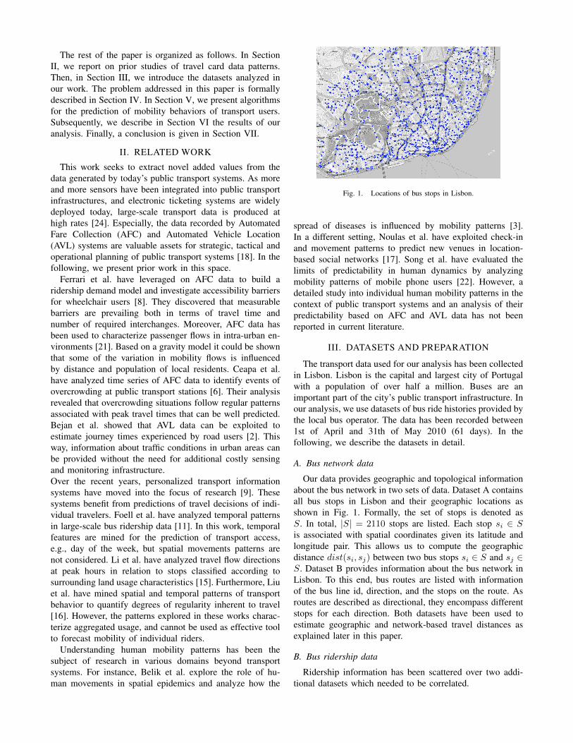
Fig. 1. Locations of bus stops in Lisbon.
spread of diseases is influenced by mobility patterns [3].In a different setting, Noulas et al. have exploited check-inand movement patterns to predict new venues in location-based social networks [17]. Song et al. have evaluated thelimits of predictability in human dynamics by analyzingmobility patterns of mobile phone users [22]. However, adetailed study into individual human mobility patterns in thecontext of public transport systems and an analysis of theirpredictability based on AFC and AVL data has not beenreported in current literature.
III. DATASETS AND PREPARATION
The transport data used for our analysis has been collectedin Lisbon. Lisbon is the capital and largest city of Portugalwith a population of over half a million. Buses are animportant part of the city’s public transport infrastructure. Inour analysis, we use datasets of bus ride histories provided bythe local bus operator. The data has been recorded between1st of April and 31th of May 2010 (61 days). In thefollowing, we describe the datasets in detail.
A. Bus network data
Our data provides geographic and topological informationabout the bus network in two sets of data. Dataset A containsall bus stops in Lisbon and their geographic locations asshown in Fig. 1. Formally, the set of stops is denoted asS. In total, |S| = 2110 stops are listed. Each stop si ∈ Sis associated with spatial coordinates given its latitude andlongitude pair. This allows us to compute the geographicdistance dist(si, sj) between two bus stops si ∈ S and sj ∈S. Dataset B provides information about the bus network inLisbon. To this end, bus routes are listed with informationof the bus line id, direction, and the stops on the route. Asroutes are described as directional, they encompass differentstops for each direction. Both datasets have been used toestimate geographic and network-based travel distances asexplained later in this paper.
B. Bus ridership data
Ridership information has been scattered over two addi-tional datasets which needed to be correlated.
100
101
102
100
101
102
103
104
105
106
Num
ber
of u
sers
Number of rides
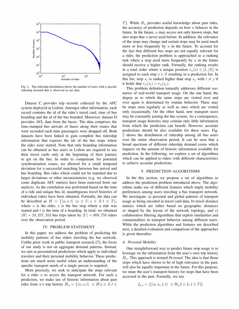
Fig. 2. The ridership distribution shows the number of users with a specificridership demand that is observed in our data.
Dataset C provides trip records collected by the AFCsystem deployed in Lisbon. Amongst other information, eachrecord contains the id of the rider’s travel card, time of busboarding and the id of the bus boarded. Moreover, dataset Dprovides AVL data from the buses. The data comprises thetime-stamped bus arrivals of buses along their routes thatwere recorded each time passengers were dropped off. Bothdatasets have been linked to gain complete bus ridershipinformation that exposes the ids of the bus stops wherethe rides were started. Note that only boarding informationcan be obtained as bus users in Lisbon are required to usetheir travel cards only at the beginning of their journeyto get on the bus. In order to compensate for potentialsynchronization issues, we allowed for a small temporaldeviation for a successful matching between bus arrival andbus boarding. Bus rides which could not be matched due tolarger deviations or other inconsistencies (e.g. we observedsome duplicate AFC entries) have been removed from ouranalysis. As the correlation was performed based on the timeof a ride and unique bus id, unambiguous travel histories ofindividual riders have been obtained. Formally, the data canbe described as H = {〈u, s, t〉 |u ∈ U, s ∈ S, t ∈ T},where u is the rider, s is the bus stop where a ride wasstarted and t is the time of a boarding. In total, we obtained|H| = 24, 257, 353 bus trips taken by |U | = 809, 758 ridersover the observation period.
IV. PROBLEM STATEMENT
In this paper, we address the problem of predicting themobility patterns of bus riders traveling the bus network.Unlike prior work in public transport research [7], the focusof our study is not on aggregate demand patterns. Instead,we aim at personalized predictions which apply to individualtravelers and their personal mobility behavior. These predic-tions are much more useful when an understanding of thespecific transport needs of a single person is required.
More precisely, we seek to anticipate the stops relevantfor a rider u to access the transport network. For such aprediction, we make use of historic information about pastrides from u’s trip history Hu = {〈u, s, t〉 ∈ H|s ∈ S, t ∈
T}. While Hu provides useful knowledge about past rides,the accuracy of prediction depends on how u behaves in thefuture. In the future, u may access not only known stops, butalso stops that u never used before. In addition, the relevanceof the stops may change and certain stops may be used muchmore or less frequently by u in the future. To account forthe fact that different bus stops are not equally relevant fora rider, the prediction problem is approached as a rankingtask where a stop used more frequently by u in the futureshould receive a higher rank. Formally, the ranking resultsin a total order where a unique position ru(s) ∈ [1, |S|] isassigned to each stop s ∈ S resulting in a prediction list. Inthis list, stop si is ranked higher than stop sj with i 6= j ifit holds that ru(si) > ru(sj).
This problem definition naturally addresses different sce-narios of real-world transport usage. On the one hand, thedegree as to which the same stops are visited over andover again is determined by routine behavior. There maybe stops seen regularly as well as ones which are visitedonly occasionally. On the other hand, new transport usersmay be constantly joining the bus system. As a consequence,transport usage histories may contain only little informationfrom which the prediction can benefit. However, accuratepredictions should be also available for these users. Fig.2 shows the distribution of ridership among all bus usersover the entire observation period. It can be seen that abroad spectrum of different ridership demand exists whichimpacts on the amount of historic information available forprediction. In the following, we explore a set of algorithmswhich can be applied to riders with different characteristicsto achieve accurate predictions.
V. PREDICTION ALGORITHMS
In the this section, we propose a set of algorithms toaddress the prediction problem introduced above. The algo-rithms make use of different features which imply mobilitypreferences among users traveling a bus transport network.We investigate: a) personal and global patterns of transportusage as being encoded in travel card data, b) travel distancemetrics which are either based on geographic distancesor shaped by the layout of the network topology, and c)collaborative filtering algorithms that exploit similarities andcommonalities in transport behavior among different users.While the prediction algorithms and features are describednext, a detailed evaluation and comparison of the approachesis given thereafter.
A. Personal Mobility
One straightforward way to predict future stop usage is toleverage on the information from the user’s own trip historyHu. This approach is termed Personal. The idea is that thosestops which have shown to be of high relevance in the past,will also be equally important in the future. For this purpose,we mine the user’s transport history for stops that have beenaccessed in the past. Formally, we use
fu,i = |{〈u, si, l, t〉 ∈ Hu|l ∈ L, t ∈ T}|
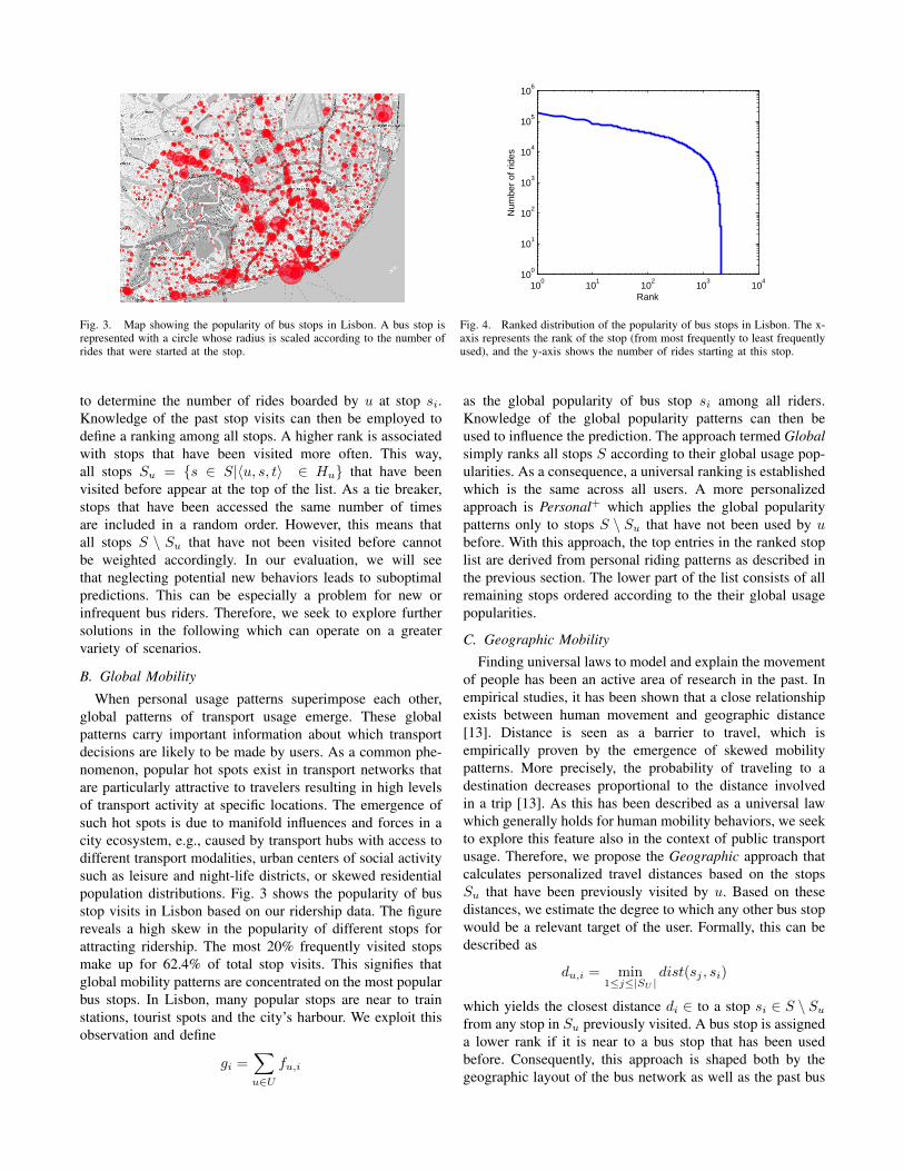
Fig. 3. Map showing the popularity of bus stops in Lisbon. A bus stop isrepresented with a circle whose radius is scaled according to the number ofrides that were started at the stop.
100
101
102
103
104
100
101
102
103
104
105
106
Rank
Num
ber
of r
ides
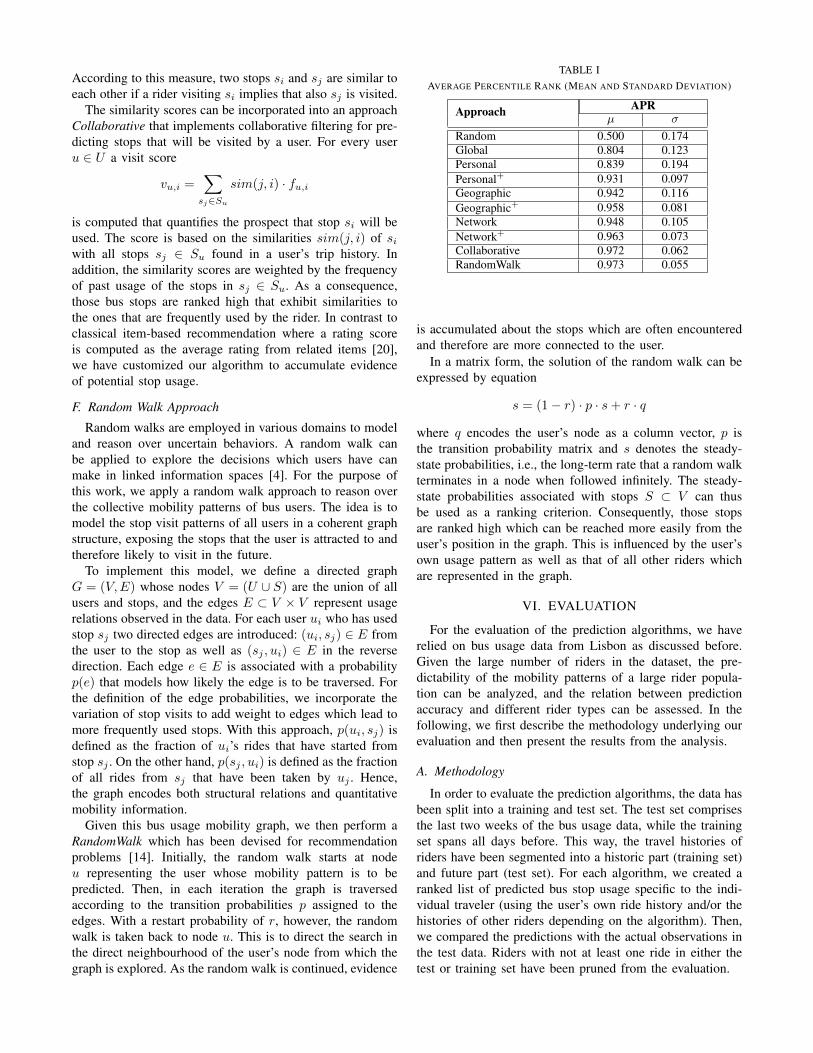
Fig. 4. Ranked distribution of the popularity of bus stops in Lisbon. The x-axis represents the rank of the stop (from most frequently to least frequentlyused), and the y-axis shows the number of rides starting at this stop.
to determine the number of rides boarded by u at stop si.Knowledge of the past stop visits can then be employed todefine a ranking among all stops. A higher rank is associatedwith stops that have been visited more often. This way,all stops Su = {s ∈ S|〈u, s, t〉 ∈ Hu} that have beenvisited before appear at the top of the list. As a tie breaker,stops that have been accessed the same number of timesare included in a random order. However, this means thatall stops S \ Su that have not been visited before cannotbe weighted accordingly. In our evaluation, we will seethat neglecting potential new behaviors leads to suboptimalpredictions. This can be especially a problem for new orinfrequent bus riders. Therefore, we seek to explore furthersolutions in the following which can operate on a greatervariety of scenarios.
B. Global Mobility
When personal usage patterns superimpose each other,global patterns of transport usage emerge. These globalpatterns carry important information about which transportdecisions are likely to be made by users. As a common phe-nomenon, popular hot spots exist in transport networks thatare particularly attractive to travelers resulting in high levelsof transport activity at specific locations. The emergence ofsuch hot spots is due to manifold influences and forces in acity ecosystem, e.g., caused by transport hubs with access todifferent transport modalities, urban centers of social activitysuch as leisure and night-life districts, or skewed residentialpopulation distributions. Fig. 3 shows the popularity of busstop visits in Lisbon based on our ridership data. The figurereveals a high skew in the popularity of different stops forattracting ridership. The most 20% frequently visited stopsmake up for 62.4% of total stop visits. This signifies thatglobal mobility patterns are concentrated on the most popularbus stops. In Lisbon, many popular stops are near to trainstations, tourist spots and the city’s harbour. We exploit thisobservation and define
gi =∑u∈U
fu,i
as the global popularity of bus stop si among all riders.Knowledge of the global popularity patterns can then beused to influence the prediction. The approach termed Globalsimply ranks all stops S according to their global usage pop-ularities. As a consequence, a universal ranking is establishedwhich is the same across all users. A more personalizedapproach is Personal+ which applies the global popularitypatterns only to stops S \ Su that have not been used by ubefore. With this approach, the top entries in the ranked stoplist are derived from personal riding patterns as described inthe previous section. The lower part of the list consists of allremaining stops ordered according to the their global usagepopularities.
C. Geographic Mobility
Finding universal laws to model and explain the movementof people has been an active area of research in the past. Inempirical studies, it has been shown that a close relationshipexists between human movement and geographic distance[13]. Distance is seen as a barrier to travel, which isempirically proven by the emergence of skewed mobilitypatterns. More precisely, the probability of traveling to adestination decreases proportional to the distance involvedin a trip [13]. As this has been described as a universal lawwhich generally holds for human mobility behaviors, we seekto explore this feature also in the context of public transportusage. Therefore, we propose the Geographic approach thatcalculates personalized travel distances based on the stopsSu that have been previously visited by u. Based on thesedistances, we estimate the degree to which any other bus stopwould be a relevant target of the user. Formally, this can bedescribed as
du,i = min1≤j≤|SU |
dist(sj , si)
which yields the closest distance di ∈ to a stop si ∈ S \ Su
from any stop in Su previously visited. A bus stop is assigneda lower rank if it is near to a bus stop that has been usedbefore. Consequently, this approach is shaped both by thegeographic layout of the bus network as well as the past bus
rides of travelers. In our evaluation, we have tried differentoptions to define a set of anchor points upon which thedistance calculation is based. As one alternative, we haveused the most popular stop as an approximation of a user’shome location to center the geographic search. However, theaccuracy was higher when incorporating the user’s entiremobility radius given by the full set of Su.
Moreover, we have adapted the distance metric to accountfor variations in popularity among the bus stops in the city.The idea is that popularity represents a complementary factorwhich changes how distance is experienced by travelers. Forthis purpose, Geographic+
d+u,i = (1 + log(max1≤r≤|S| gr
gi)) · du,i
incorporates the global usage gi as part of the weight factorto calculate the adjusted distance d+u,i. The weight factoris based on the inverse ratio of a stop’s popularity to thehighest stop popularity. We apply a logarithmically scaling tocreate a smoother weighing effect. The weight factor can beconsidered as a pulling or pushing force on the distance du,i.If the stop is unpopular, the distance is pushed further away,making it less reachable. In contrast, if the stop has a highpopularity, the stop is pushed closer to the user. These factorstherefore distort the geographic space to account for morerealistic transport usage patterns. A similar technique hasbeen applied in information retrieval where the tf-idf factoris used to quantify the degree of unique words in documents[1]. However, the relevance of popular stops is increasedwith our weighting scheme whereas information retrievalconsiders more popular documents as less important.
D. Network Mobility
While geographic distance represents an unbiased distanceestimator in free spaces, public transport networks repre-sent planned and more constrained environments. Insteadof arbitrary travel paths that can be followed through thecity, public transport systems are based on predefined routeswhich guide the travel flows. Consequently, the topology ofa route network may significantly differ from relations foundin geographic space: while stops may be geographically closeto each other, short and direct connections may not alwaysbe guaranteed among them in a public transport network.Beyond geographic distance, we therefore explore a moremeaningful distance metric to identify preferred travel pathsof riders that are revealed by routes which are well-connectedin terms of the layout of the transport network.
To create this metric, we derive an adjacency matrix Athat maps the neighborhood relations in the public transportnetwork topology. Each entry aij ∈ A of the matrix repre-sents a binary variable which encodes whether stops si andsj are connected through a direct bus route segment. Moreprecisely, we set aij = 1 if there is at least one bus routewhich links stops si and sj as successive stops in the samedirection, and aij = 0 otherwise. Then, we use A as input toa shortest path algorithm (i.e., Dijkstra) to compute logicaltravel distances in the public transport network. The result
is a matrix L whose entries lij denote the minimum numberof hops required to travel between any stops si and sj . Notethat different refinements of this algorithm are feasible, e.g.penalizing interchanges or considering the actual travel timeon route segments. However, in our work, we have focusedon the basic network topology for a direct comparison withthe geographic distance space.
For the Network approach we then calculate
nu,i = min1≤j≤|SU |
lji
to determine the minimum distance to reach stop si ∈ S \Su
from any stop in Su previously visited. Hence, stops whichare easily reachable through a path in the network topologyfrom stops visited in the past receive a higher rank.
Following the same rationale as before, Network+ take thisidea one step further and adjusts the distances to account forthe varying popularity of bus stops. Formally, we determine
n+u,i = (1 + log(
max1≤r≤|S| gr
gi)) · nu,i
which is the hop-based travel distance to reach si frompreviously visited stops offset by its popularity. As a conse-quence, a stop is considered to be of high relevance if it hasa good link to the user’s stops visited in the past and if it isattracting a large number of rides.
E. Collaborative Filtering
On an abstract level, the prediction problem studied inthis paper fits the purpose of recommender systems [19].For suggesting relevant items to users, recommender systemprovide algorithms to analyze the users’ ratings of itemsand find common patterns among the collective ratings ofall users. In the following, we apply a similar strategy tocapture travel decisions in public transport networks. Theidea is that when bus stops are seen as items, stop visitsdefine implicit ratings that can be mined to determine thestrength as to which different stops are similar in usageamong users. Knowledge of the similarity in stop usagethen can be exploited to identify stops with strong relationsthat are likely to become relevant to the user in the future.To this end, we leverage on item-based recommendation[20] which allows us to manage the complexity of therecommendation algorithm despite the high number of users.Item-based recommendation is preferred over a user-basedapproach when the number of items outweighs the numberof users. In our scenario, this premise is satisfied as the setof stops in the public transport network is much smaller thanthe large population of riders. According to this approach,we determine for each stop si a visit vector
ti = 〈fu1,i, fu2,i, . . . , fu|U|,i〉
where the i-th component encodes the number of visits ofthe user ui ∈ U at this stop. Given two visit vectors ti and tjassociated with stops si and sj , a similarity score sim(i, j)can be computed to indicate if both stops have similar usagepatterns. In our work, we have used the Cosine similaritywhich measures the cosine of the angle between the vectors.
According to this measure, two stops si and sj are similar toeach other if a rider visiting si implies that also sj is visited.
The similarity scores can be incorporated into an approachCollaborative that implements collaborative filtering for pre-dicting stops that will be visited by a user. For every useru ∈ U a visit score
vu,i =∑
sj∈Su
sim(j, i) · fu,i
is computed that quantifies the prospect that stop si will beused. The score is based on the similarities sim(j, i) of siwith all stops sj ∈ Su found in a user’s trip history. Inaddition, the similarity scores are weighted by the frequencyof past usage of the stops in sj ∈ Su. As a consequence,those bus stops are ranked high that exhibit similarities tothe ones that are frequently used by the rider. In contrast toclassical item-based recommendation where a rating scoreis computed as the average rating from related items [20],we have customized our algorithm to accumulate evidenceof potential stop usage.
F. Random Walk Approach
Random walks are employed in various domains to modeland reason over uncertain behaviors. A random walk canbe applied to explore the decisions which users have canmake in linked information spaces [4]. For the purpose ofthis work, we apply a random walk approach to reason overthe collective mobility patterns of bus users. The idea is tomodel the stop visit patterns of all users in a coherent graphstructure, exposing the stops that the user is attracted to andtherefore likely to visit in the future.
To implement this model, we define a directed graphG = (V,E) whose nodes V = (U ∪ S) are the union of allusers and stops, and the edges E ⊂ V × V represent usagerelations observed in the data. For each user ui who has usedstop sj two directed edges are introduced: (ui, sj) ∈ E fromthe user to the stop as well as (sj , ui) ∈ E in the reversedirection. Each edge e ∈ E is associated with a probabilityp(e) that models how likely the edge is to be traversed. Forthe definition of the edge probabilities, we incorporate thevariation of stop visits to add weight to edges which lead tomore frequently used stops. With this approach, p(ui, sj) isdefined as the fraction of ui’s rides that have started fromstop sj . On the other hand, p(sj , ui) is defined as the fractionof all rides from sj that have been taken by uj . Hence,the graph encodes both structural relations and quantitativemobility information.
Given this bus usage mobility graph, we then perform aRandomWalk which has been devised for recommendationproblems [14]. Initially, the random walk starts at nodeu representing the user whose mobility pattern is to bepredicted. Then, in each iteration the graph is traversedaccording to the transition probabilities p assigned to theedges. With a restart probability of r, however, the randomwalk is taken back to node u. This is to direct the search inthe direct neighbourhood of the user’s node from which thegraph is explored. As the random walk is continued, evidence
TABLE IAVERAGE PERCENTILE RANK (MEAN AND STANDARD DEVIATION)
is accumulated about the stops which are often encounteredand therefore are more connected to the user.
In a matrix form, the solution of the random walk can beexpressed by equation
s = (1− r) · p · s+ r · q
where q encodes the user’s node as a column vector, p isthe transition probability matrix and s denotes the steady-state probabilities, i.e., the long-term rate that a random walkterminates in a node when followed infinitely. The steady-state probabilities associated with stops S ⊂ V can thusbe used as a ranking criterion. Consequently, those stopsare ranked high which can be reached more easily from theuser’s position in the graph. This is influenced by the user’sown usage pattern as well as that of all other riders whichare represented in the graph.
VI. EVALUATION
For the evaluation of the prediction algorithms, we haverelied on bus usage data from Lisbon as discussed before.Given the large number of riders in the dataset, the pre-dictability of the mobility patterns of a large rider popula-tion can be analyzed, and the relation between predictionaccuracy and different rider types can be assessed. In thefollowing, we first describe the methodology underlying ourevaluation and then present the results from the analysis.
A. Methodology
In order to evaluate the prediction algorithms, the data hasbeen split into a training and test set. The test set comprisesthe last two weeks of the bus usage data, while the trainingset spans all days before. This way, the travel histories ofriders have been segmented into a historic part (training set)and future part (test set). For each algorithm, we created aranked list of predicted bus stop usage specific to the indi-vidual traveler (using the user’s own ride history and/or thehistories of other riders depending on the algorithm). Then,we compared the predictions with the actual observations inthe test data. Riders with not at least one ride in either thetest or training set have been pruned from the evaluation.
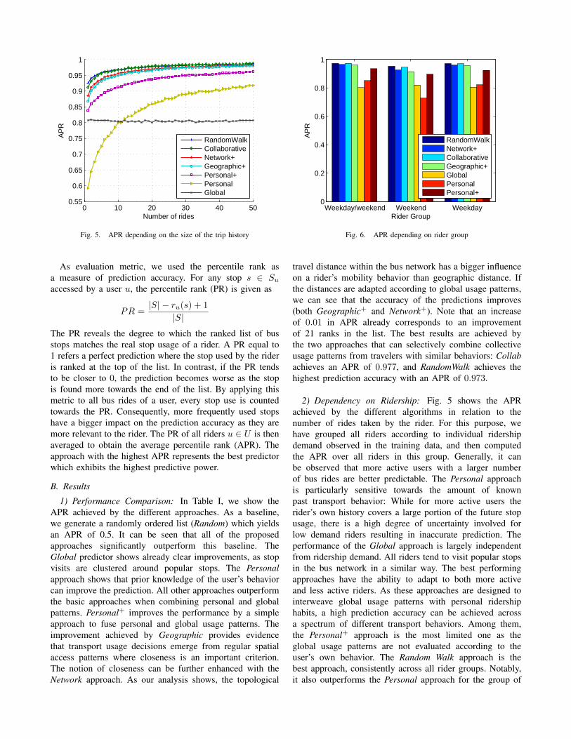
Fig. 5. APR depending on the size of the trip history
As evaluation metric, we used the percentile rank asa measure of prediction accuracy. For any stop s ∈ Su
accessed by a user u, the percentile rank (PR) is given as
PR =|S| − ru(s) + 1
|S|The PR reveals the degree to which the ranked list of busstops matches the real stop usage of a rider. A PR equal to1 refers a perfect prediction where the stop used by the rideris ranked at the top of the list. In contrast, if the PR tendsto be closer to 0, the prediction becomes worse as the stopis found more towards the end of the list. By applying thismetric to all bus rides of a user, every stop use is countedtowards the PR. Consequently, more frequently used stopshave a bigger impact on the prediction accuracy as they aremore relevant to the rider. The PR of all riders u ∈ U is thenaveraged to obtain the average percentile rank (APR). Theapproach with the highest APR represents the best predictorwhich exhibits the highest predictive power.
B. Results
1) Performance Comparison: In Table I, we show theAPR achieved by the different approaches. As a baseline,we generate a randomly ordered list (Random) which yieldsan APR of 0.5. It can be seen that all of the proposedapproaches significantly outperform this baseline. TheGlobal predictor shows already clear improvements, as stopvisits are clustered around popular stops. The Personalapproach shows that prior knowledge of the user’s behaviorcan improve the prediction. All other approaches outperformthe basic approaches when combining personal and globalpatterns. Personal+ improves the performance by a simpleapproach to fuse personal and global usage patterns. Theimprovement achieved by Geographic provides evidencethat transport usage decisions emerge from regular spatialaccess patterns where closeness is an important criterion.The notion of closeness can be further enhanced with theNetwork approach. As our analysis shows, the topological
travel distance within the bus network has a bigger influenceon a rider’s mobility behavior than geographic distance. Ifthe distances are adapted according to global usage patterns,we can see that the accuracy of the predictions improves(both Geographic+ and Network+). Note that an increaseof 0.01 in APR already corresponds to an improvementof 21 ranks in the list. The best results are achieved bythe two approaches that can selectively combine collectiveusage patterns from travelers with similar behaviors: Collabachieves an APR of 0.977, and RandomWalk achieves thehighest prediction accuracy with an APR of 0.973.
2) Dependency on Ridership: Fig. 5 shows the APRachieved by the different algorithms in relation to thenumber of rides taken by the rider. For this purpose, wehave grouped all riders according to individual ridershipdemand observed in the training data, and then computedthe APR over all riders in this group. Generally, it canbe observed that more active users with a larger numberof bus rides are better predictable. The Personal approachis particularly sensitive towards the amount of knownpast transport behavior: While for more active users therider’s own history covers a large portion of the future stopusage, there is a high degree of uncertainty involved forlow demand riders resulting in inaccurate prediction. Theperformance of the Global approach is largely independentfrom ridership demand. All riders tend to visit popular stopsin the bus network in a similar way. The best performingapproaches have the ability to adapt to both more activeand less active riders. As these approaches are designed tointerweave global usage patterns with personal ridershiphabits, a high prediction accuracy can be achieved acrossa spectrum of different transport behaviors. Among them,the Personal+ approach is the most limited one as theglobal usage patterns are not evaluated according to theuser’s own behavior. The Random Walk approach is thebest approach, consistently across all rider groups. Notably,it also outperforms the Personal approach for the group of
active riders, demonstrating that incorporating knowledgebeyond the user’s own travel history is beneficial for allriders. Consequently, the Random Walk approach can beregarded as the most generic predictor suitable for any levelof ridership demand.
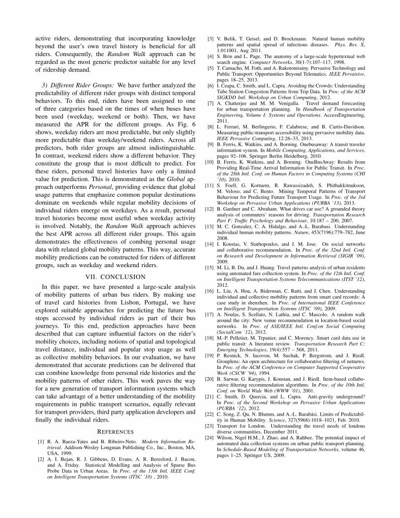
3) Different Rider Groups: We have further analyzed thepredictability of different rider groups with distinct temporalbehaviors. To this end, riders have been assigned to oneof three categories based on the times of when buses havebeen used (weekday, weekend or both). Then, we havemeasured the APR for the different groups. As Fig. 6shows, weekday riders are most predictable, but only slightlymore predictable than weekday/weekend riders. Across allpredictors, both rider groups are almost indistinguishable.In contrast, weekend riders show a different behavior. Theyconstitute the group that is most difficult to predict. Forthese riders, personal travel histories have only a limitedvalue for prediction. This is demonstrated as the Global ap-proach outperforms Personal, providing evidence that globalusage patterns that emphasize common popular destinationsdominate on weekends while regular mobility decisions ofindividual riders emerge on weekdays. As a result, personaltravel histories become most useful when weekday activityis involved. Notably, the Random Walk approach achievesthe best APR across all different rider groups. This againdemonstrates the effectiveness of combing personal usagedata with related global mobility patterns. This way, accuratemobility predictions can be constructed for riders of differentgroups, such as weekday and weekend riders.
VII. CONCLUSION
In this paper, we have presented a large-scale analysisof mobility patterns of urban bus riders. By making useof travel card histories from Lisbon, Portugal, we haveexplored suitable approaches for predicting the future busstops accessed by individual riders as part of their busjourneys. To this end, prediction approaches have beendescribed that can capture influential factors on the rider’smobility choices, including notions of spatial and topologicaltravel distance, individual and popular stop usage as wellas collective mobility behaviors. In our evaluation, we havedemonstrated that accurate predictions can be delivered thatcan combine knowledge from personal ride histories and themobility patterns of other riders. This work paves the wayfor a new generation of transport information systems whichcan take advantage of a better understanding of the mobilityrequirements in public transport scenarios, equally relevantfor transport providers, third party application developers andfinally the individual riders.
REFERENCES
[1] R. A. Baeza-Yates and B. Ribeiro-Neto. Modern Information Re-trieval. Addison-Wesley Longman Publishing Co., Inc., Boston, MA,USA, 1999.
[2] A. I. Bejan, R. J. Gibbens, D. Evans, A. R. Beresford, J. Bacon,and A. Friday. Statistical Modelling and Analysis of Sparse BusProbe Data in Urban Areas. In Proc. of the 13th Intl. IEEE Conf.on Intelligent Transportation Systems (ITSC ’10) , 2010.
[3] V. Belik, T. Geisel, and D. Brockmann. Natural human mobilitypatterns and spatial spread of infectious diseases. Phys. Rev. X,1:011001, Aug 2011.
[4] S. Brin and L. Page. The anatomy of a large-scale hypertextual websearch engine. Computer Networks, 30(1-7):107–117, 1998.
[5] T. Camacho, M. Foth, and A. Rakotonirainy. Pervasive Technology andPublic Transport: Opportunities Beyond Telematics. IEEE Pervaisive,pages 18–25, 2013.
[6] I. Ceapa, C. Smith, and L. Capra. Avoiding the Crowds: UnderstandingTube Station Congestion Patterns from Trip Data. In Proc. of the ACMSIGKDD Intl. Workshop on Urban Computing, 2012.
[7] A. Chatterjee and M. M. Venigalla. Travel demand forecastingfor urban transportation planning. In Handbook of TransportationEngineering, Volume I: Systems and Operations. AccessEngineering,2011.
[8] L. Ferrari, M. Berlingerio, F. Calabrese, and B. Curtis-Davidson.Measuring public-transport accessibility using pervasive mobility data.IEEE Pervasive Computing, 12:26–33, 2013.
[9] B. Ferris, K. Watkins, and A. Borning. Onebusaway: A transit travelerinformation system. In Mobile Computing, Applications, and Services,pages 92–106. Springer Berlin Heidelberg, 2010.
[10] B. Ferris, K. Watkins, and A. Borning. OneBusAway: Results fromProviding Real-Time Arrival Information for Public Transit. In Proc.of the 28th Intl. Conf. on Human Factors in Computing Systems (CHI’10), 2010.
[11] S. Foell, G. Kortuem, R. Rawassizadeh, S. Phithakkitnukoon,M. Veloso, and C. Bento. Mining Temporal Patterns of TransportBehaviour for Predicting Future Transport Usage. In Proc. of the 3rdWorkshop on Pervasive Urban Applications (PURBA ’13), 2013.
[12] B. Gardner and C. Abraham. What drives car use? A grounded theoryanalysis of commuters’ reasons for driving. Transportation ResearchPart F: Traffic Psychology and Behaviour, 10:187 – 200, 2007.
[13] M. C. Gonzalez, C. A. Hidalgo, and A.-L. Barabasi. Understandingindividual human mobility patterns. Nature, 453(7196):779–782, June2008.
[14] I. Konstas, V. Stathopoulos, and J. M. Jose. On social networksand collaborative recommendation. In Proc. of the 32nd Intl. Conf.on Research and Development in Information Retrieval (SIGIR ’09),2009.
[15] M. Li, B. Du, and J. Huang. Travel patterns analysis of urban residentsusing automated fare collection system. In Proc. of the 12th Intl. Conf.on Intelligent Transportation Systems Telecommunications (ITST ’12),2012.
[16] L. Liu, A. Hou, A. Biderman, C. Ratti, and J. Chen. Understandingindividual and collective mobility patterns from smart card records: Acase study in shenzhen. In Proc. of International IEEE Conferenceon Intelligent Transportation Systems (ITSC ’09), 2009.
[17] A. Noulas, S. Scellato, N. Lathia, and C. Mascolo. A random walkaround the city: New venue recommendation in location-based socialnetworks. In Proc. of ASE/IEEE Intl. Conf.on Social Computing(SocialCom ’12), 2012.
[18] M.-P. Pelletier, M. Trpanier, and C. Morency. Smart card data use inpublic transit: A literature review. Transportation Research Part C:Emerging Technologies, 19(4):557 – 568, 2011.
[19] P. Resnick, N. Iacovou, M. Suchak, P. Bergstrom, and J. Riedl.Grouplens: An open architecture for collaborative filtering of netnews.In Proc. of the ACM Conference on Computer Supported CooperativeWork (CSCW ’94), 1994.
[20] B. Sarwar, G. Karypis, J. Konstan, and J. Riedl. Item-based collabo-rative filtering recommendation algorithms. In Proc. of the 10th Intl.Conf. on World Wide Web (WWW ’01), 2001.
[21] C. Smith, D. Quercia, and L. Capra. Anti-gravity underground?In Proc. of the Second Workshop on Pervasive Urban Applications(PURBA ’12), 2012.
[22] C. Song, Z. Qu, N. Blumm, and A.-L. Barabasi. Limits of Predictabil-ity in Human Mobility. Science, 327(5968):1018–1021, Feb. 2010.
[23] Transport for London. Understanding the travel needs of londonsdiverse communities, December 2011.
[24] Wilson, Nigel H.M., J. Zhao, and A. Rahbee. The potential impact ofautomated data collection systems on urban public transport planning.In Schedule-Based Modeling of Transportation Networks, volume 46,pages 1–25. Springer US, 2009.