29 Number 71, December 2010 Abstract New evidence from Lene Hara Cave, East Timor, demonstrates that it was first occupied by modern humans by 42,454±450 cal BP at approximately the same time as nearby Jerimalai shelter. Together these sites constitute the earliest evidence for modern human colonisation of Island Southeast Asia east of the Sunda Shelf. Here we report on the dating and stratigraphy from the 2000 and 2002 test excavations at Lene Hara, as well as new dates obtained by sampling breccia deposits in 2009. The post-2000 excavations and sampling demonstrate that different areas of the cave preserve different sedimentary sequences and necessitate a revision of our earlier interpretations of the occupation history of the cave. At Lene Hara, and other caves with complex depositional histories in tropical regions, the occupation sequence will only be revealed through integrating information from extensive areal sampling. When calibrated, the early dates from East Timor now align closer to the oldest evidence for occupation in northern Australia, with substantial implications for current theories on the colonisation of this region by modern humans. The Nusa Tenggara (Lesser Sunda) island chain emerges as a likely passage for modern human entry into Greater Australia. In view of the short water crossings required to reach Flores from Timor, the apparent absence of modern humans on Flores prior to the Holocene appears highly anomalous. Introduction The initial human peopling of Australia is now generally accepted to have occurred between 45,000 and 50,000 years ago, and was possibly as early as 60,000 years ago (O’Connor 2007; Roberts et al. 1994; Veth et al. 2009). The earliest age estimates have resulted from the use of techniques such as thermoluminescene (TL), optically-stimulated luminesence (OSL) and electron spin resonance (ESR). In the absence of cross-dating on cultural materials, the reliability of these estimates has been questioned by some researchers (Allen and O’Connell 2003). TL, OSL and ESR have also not been widely applied in archaeological contexts in Southeast Asia, making comparison with sites only dated by the radiocarbon technique problematic. The Niah Caves of Sarawak and Tabuhan Cave in Java were first used by modern foragers about 45,000 years ago when these islands were part of the Asian mainland (Barker 2005; Sémah et al. 2004). AMS radiocarbon dates in the same general age range – between about 51,890±3310 cal BP and 46,738±1550 cal BP – have been obtained for occupation levels in caves in both northern and southern Australia (Table 1) (McConnell and O’Connor 1997; O’Connor and Chappell 2003; Turney et al. 2001). Islands to the east of New Guinea requiring further water crossings were also first settled by at least 43,772±448 cal BP (Table 1) (Leavesley and Chappell 2004). However, until recently, islands on potential migration routes between Sunda and Sahul have failed to produce dates for modern human colonisation on a par with those obtained for Australia and Papua New Guinea, with earliest settlement registered at c.36,000 cal BP (O’Connor 2007). The lowest level in Golo Cave, Halmahera is dated to 36,194±457 cal BP (Bellwood et al. 1998; Szabó et al. 2007). Habitation at Leang Burung 2 and Leang Sakapao 1 in Sulawesi is currently dated no earlier than 35,837±578 cal BP (Glover 1981, Bulbeck et al. 2004). Liang Lemdubu in the Aru Islands, far eastern Maluku, was first occupied about 27,020±290 cal BP (O’Connor et al. 2002a; O’Connor et al. 2005). Even Liang Sarru, in the remote Talaud Islands, between Mindanao and North Sulawesi, has an early occupation phase dating to 35,109±429 cal BP (Tanudirjo 2001). Morwood and colleagues have recently re-excavated Leang Burung 2 and significantly extended the depth of Glover’s earlier excavation (Kira Westaway, Department of Environment and Geography, Macquarie University, pers. CAVE ARCHAEOLOGY AND SAMPLING ISSUES IN THE TROPICS: A Case Study from Lene Hara Cave, a 42,000 Year Old Occupation Site in East Timor, Island Southeast Asia Sue O’Connor 1 , Anthony Barham 1 , Matthew Spriggs 2 , Peter Veth 3 , Ken Aplin 4 and Emma St Pierre 5 1 Archaeology and Natural History, School of Culture, History and Language, College of Asia and the Pacific, The Australian National University, Canberra, ACT 0200, Australia [email protected], [email protected]2 School of Archaeology and Anthropology, College of Arts and Social Sciences, The Australian National University, Canberra, ACT 0200, Australia [email protected]3 National Centre for Indigenous Studies, The Australian National University, Canberra, ACT 0200, Australia [email protected]4 Australian National Wildlife Collection, CSIRO Division of Ecosystem Sciences, PO Box 284, Canberra, ACT 2601, Australia [email protected]5 School of Earth Sciences, The University of Queensland, Brisbane, QLD 4072, Australia [email protected]Figure 1 Map of Island Southeast Asia showing East Timor and surrounding islands and Lene Hara Cave.
Transcript
29Number 71, December 2010
AbstractNew evidence from Lene Hara Cave, East Timor, demonstrates that it was first occupied by modern humans by 42,454±450 cal BP at approximately the same time as nearby Jerimalai shelter. Together these sites constitute the earliest evidence for modern human colonisation of Island Southeast Asia east of the Sunda Shelf. Here we report on the dating and stratigraphy from the 2000 and 2002 test excavations at Lene Hara, as well as new dates obtained by sampling breccia deposits in 2009. The post-2000 excavations and sampling demonstrate that different areas of the cave preserve different sedimentary sequences and necessitate a revision of our earlier interpretations of the occupation history of the cave. At Lene Hara, and other caves with complex depositional histories in tropical regions, the occupation sequence will only be revealed through integrating information from extensive areal sampling.
When calibrated, the early dates from East Timor now align closer to the oldest evidence for occupation in northern Australia, with substantial implications for current theories on the colonisation of this region by modern humans. The Nusa Tenggara (Lesser Sunda) island chain emerges as a likely passage for modern human entry into Greater Australia. In view of the short water crossings required to reach Flores from Timor, the apparent absence of modern humans on Flores prior to the Holocene appears highly anomalous.
IntroductionThe initial human peopling of Australia is now generally accepted
to have occurred between 45,000 and 50,000 years ago, and was
possibly as early as 60,000 years ago (O’Connor 2007; Roberts
et al. 1994; Veth et al. 2009). The earliest age estimates have
resulted from the use of techniques such as thermoluminescene
(TL), optically-stimulated luminesence (OSL) and electron spin
resonance (ESR). In the absence of cross-dating on cultural
materials, the reliability of these estimates has been questioned
by some researchers (Allen and O’Connell 2003). TL, OSL and
ESR have also not been widely applied in archaeological contexts
in Southeast Asia, making comparison with sites only dated by
the radiocarbon technique problematic.
The Niah Caves of Sarawak and Tabuhan Cave in Java were
first used by modern foragers about 45,000 years ago when these
islands were part of the Asian mainland (Barker 2005; Sémah
et al. 2004). AMS radiocarbon dates in the same general age
range – between about 51,890±3310 cal BP and 46,738±1550
cal BP – have been obtained for occupation levels in caves in
both northern and southern Australia (Table 1) (McConnell
and O’Connor 1997; O’Connor and Chappell 2003; Turney et al.
2001). Islands to the east of New Guinea requiring further water
crossings were also first settled by at least 43,772±448 cal BP
(Table 1) (Leavesley and Chappell 2004). However, until recently,
islands on potential migration routes between Sunda and Sahul
have failed to produce dates for modern human colonisation on
a par with those obtained for Australia and Papua New Guinea,
with earliest settlement registered at c.36,000 cal BP (O’Connor
2007). The lowest level in Golo Cave, Halmahera is dated to
36,194±457 cal BP (Bellwood et al. 1998; Szabó et al. 2007).
Habitation at Leang Burung 2 and Leang Sakapao 1 in Sulawesi
is currently dated no earlier than 35,837±578 cal BP (Glover
1981, Bulbeck et al. 2004). Liang Lemdubu in the Aru Islands,
far eastern Maluku, was first occupied about 27,020±290 cal BP
(O’Connor et al. 2002a; O’Connor et al. 2005). Even Liang Sarru,
in the remote Talaud Islands, between Mindanao and North
Sulawesi, has an early occupation phase dating to 35,109±429
cal BP (Tanudirjo 2001). Morwood and colleagues have recently
re-excavated Leang Burung 2 and significantly extended the
depth of Glover’s earlier excavation (Kira Westaway, Department
of Environment and Geography, Macquarie University, pers.
CAVE ARCHAEOLOGY ANd SAMPLING ISSUES IN THE TROPICS:A Case Study from Lene Hara Cave, a 42,000 Year Old Occupation Site in East Timor, Island Southeast AsiaSue O’Connor1, Anthony Barham1, Matthew Spriggs2, Peter Veth3, Ken Aplin4
and Emma St Pierre5
1 Archaeology and Natural History, School of Culture, History and Language, College of Asia and the Pacific, The Australian National University, Canberra, ACT 0200, Australia [email protected], [email protected]
2 School of Archaeology and Anthropology, College of Arts and Social Sciences, The Australian National University, Canberra, ACT 0200, Australia [email protected]
3 National Centre for Indigenous Studies, The Australian National University, Canberra, ACT 0200, Australia [email protected]
4 Australian National Wildlife Collection, CSIRO Division of Ecosystem Sciences, PO Box 284, Canberra, ACT 2601, Australia [email protected]
5 School of Earth Sciences, The University of Queensland, Brisbane, QLD 4072, Australia [email protected]
Figure 1 Map of Island Southeast Asia showing East Timor and surrounding islands and Lene Hara Cave.
30 Number 71, December 2010
Cave Archaeology and Sampling Issues in the Tropics
comm., 2010), however dates for the extended excavation have
not yet been published.
Flores and Timor are two of the largest islands in Wallacea
and the closest to the Sahul Shelf (Figure 1) and should have
been settled early by modern humans if migration to Sahul
proceeded via a southern route through the Nusa Tenggara island
chain and onto the expanded northern Australian coastline;
the route regarded as most likely by Birdsell (1977) and others
(Butlin 1993:15, 44-51; O’Connor and Chappell 2003). One of
Ian Glover’s primary goals when he undertook his pioneering
research in East Timor in the 1960s was to investigate this
question. Glover’s research produced a baseline cultural sequence
for East Timor, but his oldest site dated to only 16,129±802 cal
BP (Table 1) (Glover 1986). Recent work in Flores, which is
closer to the Asian mainland than Timor, indicates that it was
occupied by the pre-modern hominin Homo floresiensis until
after 18,473±284 cal BP (Table 1) (Morwood et al. 2004:1090),
and that definite evidence for modern human arrival did not
occur until c.10,000 BP (Brumm et al. 2006:628; Morwood and
van Oosterzee 2007:224) (the date of 10,000 BP is uncalibrated
as we have been unable to locate a radiocarbon measurement to
confirm it). The East Timor Archaeological Project initiated in
2000 by three of the authors (SOC, MS and PV) took up afresh
some of Glover’s unresolved research aims, most prominently
the goal of testing for early maritime voyaging to this important
area of Wallacea.
The first field season in 2000 focused on a test excavation
at Lene Hara Cave and a survey programme to locate other
prospective caves and middens. Lene Hara Cave was first
excavated in 1963 by the Portuguese anthropologist Antonio
de Almeida who reported an 80cm deep cultural assemblage
with marine shells and stone artefacts to the base. A brief
report on the stone artefacts described them as typologically
‘pre-Neolithic’ (Almeida and Zbyszewski 1967:57-58). However,
the site was never dated and the molluscan and terrestrial
fauna were not described. In 1966 Glover visited the site with
John Mulvaney and photographed Almeida’s still open trench
(Glover 1972:Vol. 1:40, Vol. 2:Plate 3.2). Glover observed that
the pottery seemed to be confined to the surface and that the
stone artefacts were unlike the ‘distinctive tool types’ found
elsewhere in Timor (Glover 1986:40). He surmised that the
Lene Hara assemblage might be ‘far older’ than those from
his own excavations in the Baucau and Venilale regions in
central East Timor (Glover 1986:7). Our 2000 test excavations
aimed to follow up these observations. A brief report on the
dates and finds from this test excavation was published in
2002 (O’Connor et al. 2002b) and the rock art has also been
published (O’Connor 2003; O’Connor et al. 2010). Here we
report in more detail on the dating and stratigraphy of the 2000
excavation at Lene Hara as well as providing preliminary results
of excavation and dating of three other test pits (B, D and F)
and dates on cultural material in breccia deposits sampled in
Site Material Lab No. Age BP Mean Calibrated
Age (68%
probability)
Reference
AustraliaCarpenter’s Gap 1 charcoal OZD-161 42,800±1850 46,738±1550 McConnell and O’Connor
1997
Devil’s Lair charcoal ANU-11511* 48,130+2590/-1960 51,890±3310 Turney et al. 2001
Papua New GuineaBuang Merabak Turbo
argyrostomaANUA-15809 40,090±550 43,772±448 Leavesley and Chappell
Aru IslandLiang Lemdubu flowstone LC28 (Site Code) 27,020±290¥ O’Connor et al. 2002a
Table 1 Dates from sites discussed in the text. Radiocarbon ages were calibrated using OxCal (Version 4.1) (Bronk Ramsey 2009) and the IntCal09 and Marine09 calibration datasets (Reimer et al. 2009), except for the age marked with an asterisk from Devil’s Lair, which exceeds the limit of IntCal09 and was calibrated with CalPal-2007 using the error range of 2590 (download version) (Weninger et al. 2010). ¥=Uranium-Thorium date.
31Number 71, December 2010
Sue O’Connor et al.
2009. These new data necessitate major revision of our initial
interpretations regarding the occupation history of the cave.
The Environmental Context, Structural Morphology and Present Sedimentation Patterns of Lene Hara CaveLene Hara is a large limestone solution cave (Figures 2-3) at the
extreme eastern tip of East Timor (Figure 1). It is situated at
c.100m altitude in an uplifted coral terrace, which is less than 1km
from the current coastline. As the offshore profile in this region is
steeply shelving, the cave would always have been within walking
distance of coastal resources, even when sea-level was at its lowest
during the Last Glacial Maximum (28,000-18,000 cal BP).
The cave entrance faces east, with a well-developed dripline
overhanging a partly vegetated terrace at the front of the cave.
The limestone forming the cave is well-bedded, with folding
in the limestone providing a structural control on much of
the curvature of the walls, panel areas free of speleothem, and
the arched cave roof. The cave is elliptical in cross-section and
broadly open, possibly reflecting an early phreatic origin. Some
modern tree roots have penetrated down through the cave roof
but these are not sites of contemporary carbonate deposition.
Isolated large speleothem deposits occur as 2–4m wide columns
and 1–2m high mounds within the interior of the cave, and as
both thin columns, and massive columnar complexes overlain
by more recent flowstone veneer. Some speleothem columns are
tilted, possibly reflecting tectonic activity. Many show elevated
pedestals, suggesting past erosion of unconsolidated sediments
from around the base of the columns, and net lowering of the
cave floor abutting these structures. Contemporary speleothem
growth appears to be restricted to minor stalactite formation and
an area of active flowstone accretion on the southern side of a
large speleothem column, adjacent to Pit B (Figure 3).
The present cave floor is inclined, highest in the south and
sloping away to the north and northeast. The northern entrance
is significantly lower than the floor of the southern chamber.
Surficial cave floor sediment is generally a loose organic cave
earth, comprised of fine sands to silt. High areas around the
speleothem columns serve to channel episodic surface flow in
washways that drain to outlets located near the northeast end
wall of the cave entrance. Winnowing along the washways has
produced small areas of gravel pavement and some exposure of
flowstone deposits (Figure 3).
The dripline area at the mouth of the entrance is over 40m wide,
and the main cave extends more than 50m into the hillside before
entering narrow fissure systems. Under the dripline, large mounded
areas of block fall, comprising both limestone and fallen speleothem,
form 2–5m high piles of block debris, particularly towards the
central area and extreme north of the entrance (Figure 3).
Patterns of recent sedimentation within the cave have been
further complicated by the construction of linear stone walls.
The walls have been built by collecting and piling up boulder
rock fall, and in places by incorporating in situ speleothem
columns into them. The walls are generally <0.5m in height,
and extensive. One well-defined continuous arcuate wall crosses
the cave floor about 2–5m inside the dripline in the south, and
another lies 15m inside the dripline in the north. Despite the
substantial nature of the stone walling, the cave does not appear
to have ever been used to corral domestic animals, unlike some
others recorded in East Timor (Pannell and O’Connor 2005).
The main wall shows evidence for repeated reconstruction
where it intersects the washways suggesting episodic water
flows at these points, and some antiquity for the construction
itself. A constructed ceremonial stone platform in the northern
chamber lies outside the area enclosed by the wall and supports
a prominent standing stone (Figures 2-3). This area is still used
by the current Fataluku-speaking landowners for ritual purposes.
The central outer mounded rampart area of rock fall and, further
inside, the large speleothem column, effectively separate the mouth
of the cave into two main entrance routes which lead into different
areas; the southern entrance opens into a broad deep chamber that
contains most of the painted rock art. The art occurs in panels on the
roof just inside the cave entrance and above the main speleothem
formation in the central area of the cave (Figures 2-3).
Figure 2 Lene Hara Cave entrance showing ritual platform and stone walling looking towards Test Pits D and F in the northern chamber (Photograph: Sue O’Connor, 2002).
Figure 3 Lene Hara Cave plan showing stone walling, location of Test Pits A, B, D and F and the large speleothem column between the northern and southern chambers where the dated breccia deposit is located.
32 Number 71, December 2010
Cave Archaeology and Sampling Issues in the Tropics
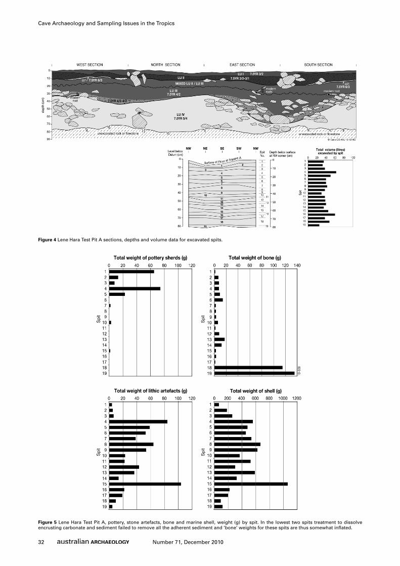
Figure 4 Lene Hara Test Pit A sections, depths and volume data for excavated spits.
Figure 5 Lene Hara Test Pit A, pottery, stone artefacts, bone and marine shell, weight (g) by spit. In the lowest two spits treatment to dissolve encrusting carbonate and sediment failed to remove all the adherent sediment and ‘bone’ weights for these spits are thus somewhat inflated.
33Number 71, December 2010
Sue O’Connor et al.
Lene Hara Cave 2000 ExcavationIn 2000 two of the authors (SOC and MS) positioned a 1m x 1m
test pit (Pit A) adjacent to Almeida’s trench near the southern
entrance, which we located by reference to Glover’s (1972:Vol.
2:Plate 3.2) published photograph and an area of surface
disturbance indicating its approximate position (Figure 3). Pit
A was located very close to the southern wall of the cave, where
the roof is low. The sediments in this part of the cave floor are
significantly higher than most other parts of the cave, and the
surface slopes down toward the eroded pedestal base of the large
speleothem to the north (Figure 3).
Our testing confirmed the depth of deposit in this region
of the cave at c.80cm (Figure 4). The deposit was excavated in
spit removals ranging from 3–6cm in depth (see Figure 4) and
comprised poorly sorted sandy sediments, with large boulders
and cobbles throughout the sequence. However, a broad
lithostratigraphic division into an upper and lower deposit
was noted during excavation, subsequently to be confirmed by
radiocarbon dating.
The upper deposits (broadly from surface to 10 to 15cm) are
comprised of dark brown sandy silts, which are subhorizontal,
soft and generally well-sorted. Well-defined hearth features,
preserved organics, and discrete areas of associated fire ash occur
within this part of the profile. The lower deposits, from 25–30cm
down to 80cm, consist of much coarser, poorly sorted and denser
sediments, ranging from gravelly silty sands to very coarse clast-
supported cobble gravels and boulder rubble. These sediments
are clay-rich in places, and contain high proportions of clastic
roof fall. In the southeast corner of the square these deposits are
very coarse and are comprised of a well-defined cobble-filled
depression (see Figure 4). The deposits become progressively
more lithified below 60cm, where roof fall and cultural material
are cemented together by carbonates to form a weakly to
moderately lithified, very coarse breccia extending to the base
of the test pit. These deposits were broken up with a geological
pick. The stratigraphic contact between the ‘upper’ group of
finer deposits and ‘lower’ more clastic deposits is gradational,
undulating and difficult to define when excavating in plan.
The excavated deposit was first dry-sieved and then wet-
sieved through fine mesh (<2mm). Only large fragments of roof
fall were sorted and discarded at the cave, all remaining material
being sorted after further washing and drying in good light. This
ensured excellent recovery of small items including small lithic
debitage, small pottery fragments and shell beads and probably
accounts for the differences between our cultural assemblage and
those of Almeida and Glover. Most pottery occurred in the top
25cm of the deposit along with stone artefacts, shell and bone
(Figure 5). Two shell artefacts were recovered from Spits 7 and
10; these have been directly dated, as reported below (O’Connor
et al. 2002c). Stone artefacts, marine shell and bone continue to
bedrock at c.80–82cm (Figure 4). The faunal remains indicate
a heavy reliance on marine resources such as turtle, fish and
shellfish; especially in the Pleistocene levels (O’Connor and
Aplin 2007). The pottery consists mostly of small sherds from
globular vessels with rounded bases – in all probability simple
undecorated cooking pots. The stone artefact assemblage is
dominated by small unretouched flakes made on chert nodules.
The Sediment Stratigraphy at Test Pit ADetailed recording, section drawing and sample analysis showed
that the upper and lower groups of sediments are further
divisible into a sequence of four stratified lithostratigraphic units
(LUI–LUIV). The relationships between the drawn stratigraphy,
lithostratigraphic units and excavation unit data (spit depths
and volumes) are shown in Figure 4.
The surficial sediments (LUI) of Pit A consist of well-sorted
sandy silt with near horizontal bedding. This unit is very soft,
unconsolidated and variable in thickness, ranging from 0–5/8cm,
and conformably overlies the slightly undulating surface of LUII,
comprised of denser and more organic stained darker brown
sandy silts. Unit LUII includes a small, well-defined hearth
feature (9.5cm depth), which together with other discrete
areas of charcoal, ash and preserved organics, suggest minimal
bioturbation within this unit (Figure 4). LUII extends variably
to 5–15cm below surface, and is in places disrupted as a laterally
continuous deposit by patches of large cobbles and boulders.
Larger clasts are both vertically and horizontally orientated
and often concentrated together (e.g. south corner of Pit A),
suggesting some winnowing and/or rotational movement of the
larger clasts may be taking place within the finer sediment matrix.
LUIII consists of coarse to fine sandy silts, mixed with variable
proportions of coarser gravels and shell; there is a general upward
coarsening trend. LUIII extends from 8cm to 15cm below the
surface, down to a highly undulating contact that stands as high
as 25cm (in the west section), down to as low as 55–60cm in
the southeast corner of the square. The lower part of LUIII is
coarse and clast-supported and shows significant preferred dip
and orientation of larger clasts associated with the sides of the
depression in the southeast corner. Bioturbation by modern
roots is common at 20–35cm depth, reflecting moisture storage.
LUIV comprises the underlying coarse shelly gravels which
grade into a cemented breccia below 60cm. As shown in Figure
4, the surface of LUIV bears a broad trough-like feature, around
which larger rock fall clasts are concentrated, running broadly
southeast-northwest through the test pit. This feature is infilled
by a loose rubbly lag of LUIII deposits, overlying denser and
partly cemented gravels of LUIV.
Radiometric Dating of Test Pit AAlthough all excavated material was wet-sieved and organics
removed by floatation for each spit, charcoal was only recovered
in small quantities from the upper two spits. Marine shell was
therefore used to date the deposit. All marine shell described in
the analysis and used for dating is anthropogenic. Occasional
fossil casts of shell from the cave roof are found in the deposit.
However these are easily distinguishable from the ‘midden’
material. All marine shells selected for radiocarbon dating were
first thin-sectioned and examined by John Chappell (Research
School of Earth Sciences, Australian National University) to
ensure that no carbonate recrystallisation had occurred within
the shell.
The eight radiocarbon dates obtained in 2001 (O’Connor
et al. 2002b) indicated that most of the marine shell within the
sampled sequence was of Pleistocene age, dating to the period
39,325±831 to 34,279±394 cal BP (Table 2). A single sample of
Trochus sp. from Spit 2 (5-10cm depth) produced a late Holocene
age. This suggested either that occupation of the cave was
34 Number 71, December 2010
Cave Archaeology and Sampling Issues in the Tropics
discontinuous or spatially uneven, or that substantial erosion
of the deposit had occurred, creating a 30,000 year hiatus in a
formerly more complete sequence.
In our preliminary report on the site it was suggested that
changes in sea-level may have made the cave less accessible
during the terminal Pleistocene and early-to-mid-Holocene
(O’Connor et al. 2002b:48). Subsequently a programme of direct
dating of shell artefacts from Pit A produced mid-Holocene
dates of 4559±74 cal BP and 3517±57 cal BP on two drilled
beads from Spits 7 and 10 (O’Connor et al. 2002c:19). This
demonstrated that at least some use had been made of the cave
during the mid-Holocene and that fragments of Holocene-aged
cultural materials were emplaced within the predominantly late
Pleistocene lower units of Pit A.
Chronostratigraphic Interpretation of Test Pit AThe lithostratigraphy indicates a cave floor deposit accumulated
largely as a result of clastic roof fall. This material has weathered
in situ and has been reworked to create a steeply undulating
topography, either through local scour activity or perhaps
through subsidence. The lower part of LUIV is interpreted
as contemporary with, or slightly earlier than, initial human
occupation at c.39,000 cal BP. Subsequent infilling of that
topography (to approximately 25cm below present surface)
was associated with a c.5000 year phase of human occupation,
with deposition of shell, bone and lithic material. A phase
of very low net sediment accumulation, possibly without
associated human occupation, is represented by the sediments
from 8–15cm to around 25cm depth. Further localised rock fall
Breccia sample B – Trochidae Wk-26405 2.5±0.2 38,207±610 42,454±450
Table 2 Radiocarbon determinations from Test Pits A, B, D and F and breccia deposit at Lene Hara Cave. The values of δ13C are assumed if followed by ‘e’. As the natural range of δ13C for marine carbonates is -3‰ to +2‰ (VPDB scale) the potential impact of the δ13C correction on the 14C age is very small. A 1‰ change in δ13C makes an 8 year difference in the reported age. Dates were calibrated using Oxcal (version 4.1) (Bronk Ramsey 2009; Reimer et al. 2009).
35Number 71, December 2010
Sue O’Connor et al.
and minor sedimentation have taken place since the terminal
Pleistocene, along with some deposition of cultural material
related to human activity during the late Holocene. No erosional
unconformity is indicated. Rather, the unconsolidated nature
of the upper part of the late Pleistocene unit would account for
the incorporation of some more recent artefacts into this unit
through minor local disturbance associated with human activity
in the site. Downward movement of larger materials might also
result from bioturbation by insects, with associated upwards
movements of fines. Deeper root bioturbation might also lead
to vertical mixing.
The two shallow, surficial units (LUI and II) are interpreted as
the only in situ Holocene deposits in this part of the cave. However,
they may well derive in part from winnowing and reworking of
the underlying deposits, especially by upwards movement of
fines through the profile (e.g. through bioturbation by insects).
Dipping interfaces and thin beds dominate much of the
stratigraphy from 15–65cm. This suggests that excavation
in approximate 5cm spits would have sliced across some
chronostratigraphic units (time surfaces) around the steeply
dipping margins of the trough. Stratigraphic integrity of
lithic artefact and bioassemblages is probably highest for
levels from 0–15cm (Spits 1-3) and below 55cm (Spits 11-19),
but compromised to varying degrees from 25–55cm depth
(i.e. Spits 6-11) by mixing during excavation of different
chronostratigraphic units.
The 2002 Excavations, Test Pits B, D and FIn September 2002 further test-pitting was carried out at Lene
Hara by authors SOC and PV with the aims of sampling other
parts of the extensive floor area and clarifying the chronology
of cave use. In particular, we wished to compare the litho- and
chrono-stratigraphy present in Pit A with adjacent, higher parts
of the cave floor, and also with deposits in the northern part of
the cave floor, where the cave floor lies at a much lower level.
Three further test pits were excavated in 2002 (Figure 2). Pit
B was located in the same southern higher area of the cave as
Pit A. Two other pits excavated in 2002, D and F, were located
in the lower, northern chamber outside the walled region of
the deposit and northeast of the stone ceremonial platform
surrounding a large carbonate column (Figures 2-3). The broad
stratigraphic results and chronology from these test squares are
presented here for comparison with Pit A, and for exemplifying
the chronostratigraphic variability across the cave.
Pit B was situated on a gently sloping area of the inner cave
floor, c.12m out from the southern wall. The square was 4m east
of the large (9m diameter) speleothem column, with two large
stalagmite columns positioned 4–5m further west into the cave.
The loose, surficial sediments of Pit B are comprised of 0–6cm
of well-sorted fine sands and silts, with some fine gravel (Figure
6). This upper unit is interpreted as a recent wash accumulation.
This unit overlies denser deposits on a largely planar contact.
J. van der Plicht and C.E. Weyhenmeyer 2009 IntCal09 and Marine09 radiocarbon
age calibration curves, 0-50,000 years cal BP. Radiocarbon 51(4):1111-1150.
40 Number 71, December 2010
Cave Archaeology and Sampling Issues in the Tropics
Roberts, R.G., R. Jones, N.A. Spooner, M.J. Head, A.S. Murray and M.A. Smith 1994
The human colonisation of Australia: Optical dates of 53,000 and 60,000 years
bracket human arrival at Deaf Adder Gorge, Northern Territory. Quaternary
Geochronology 13:575-583.
Sémah, F., A-M. Sémah, C. Falgueres, F. Détroit, X. Gallet, S. Hameau, A-M. Moigne
and T. Simanjuntak. 2004 Chronology and significance of the Punung area. In
S.G. Keates and J.M. Pasveer (eds), Quaternary Research in Indonesia, pp.162-
190. Modern Quaternary Research in Southeast Asia 18. Leiden: A.A. Balkema.
Szabó, K., A. Brumm and P. Bellwood 2007 Shell artefact production at 32,000
to 28,000 BP in Island Southeast Asia: Thinking across Media? Current
Anthropology 48(5):701-723.
Tanudirjo, D. 2001 Islands in Between: Prehistory of the Northeastern Indonesian
Archipelago. Unpublished PhD thesis, Australian National University, Canberra.
Turney, C.S.M., M.I. Bird, L.K. Fifield, R.G. Roberts, M.A. Smith, C.E. Dortch, R.
Grün, E. Lawson, L.K. Ayliffe, G.H. Miller, J. Dortch and R.G. Cresswell 2001
Early human occupation at Devil’s Lair, southwestern Australia 50,000 years
ago. Quaternary Research 55:3-13.
Veth, P., M.A. Smith, J. Bowler, K.E. Fitzsimmons, A. Williams and P. Hiscock 2009
Excavations at Parnkupirti, Lake Gregory, Great Sandy Desert: OSL ages for
occupation before the Last Glacial Maximum. Australian Archaeology 69:1-10.
Weninger, B., O. Jöris and U. Danzeglocke 2010 CalPal-2007. Cologne Radiocarbon
Calibration & Palaeoclimate Research Package. Retrieved 10 March 2010 from
http://www.calpal.de/.
number 71 December 2010
EditorialSean Ulm & Annie Ross ii
ARTICLESA Minimum Age for Early Depictions of Southeast Asian Praus in the Rock Art of Arnhem Land, Northern TerritoryPaul S.C. Taçon, Sally K. May, Stewart J. Fallon, Meg Travers, Daryl Wesley & Ronald Lamilami 1
A Dingo Burial from the Arnhem Land PlateauR.G. Gunn, R.L. Whear & L.C. Douglas 11
Painting the Police: Aboriginal Visual Culture and Identity in Colonial Cape York PeninsulaNoelene Cole 17
Cave Archaeology and Sampling Issues in the Tropics: A Case Study from Lene Hara Cave, a 42,000 Year Old Occupation Site in East Timor, Island Southeast AsiaSue O’Connor, Anthony Barham, Matthew Spriggs, Peter Veth, Ken Aplin & Emma St Pierre 29
Historicising the Present: Late Holocene Emergence of a Rainforest Hunting Camp, Gulf Province, Papua New GuineaIan J. McNiven, Bruno David, Ken Aplin, Max Pivoru, William Pivoru, Alex Sexton, Jonathan Brown, Chris Clarkson, Kate Connell, John Stanisic, Marshall Weisler, Simon Haberle, Andrew Fairbairn & Noel Kemp 41
Painting History: Indigenous Observations and Depictions of the ‘Other’ in Northwestern Arnhem Land, AustraliaSally K. May, Paul S.C. Taçon, Daryl Wesley & Meg Travers 57
SHORT REPORTSEarliest Evidence for Ground-Edge Axes: 35,400±410 cal BP from Jawoyn Country, Arnhem LandJean-Michel Geneste, Bruno David, Hugues Plisson, Chris Clarkson, Jean-Jacques Delannoy, Fiona Petchey & Ray Whear 66
The Age of Australian Rock Art: A ReviewMichelle C. Langley & Paul S.C. Taçon 70
Buggering Around in the Backyard: Creating Attachment to Place through Archaeology and Material CultureSteve Brown 74
BOOK REVIEWSRoonka: Fugitive Traces and Climatic Mischief edited by Keryn WalsheReviewed by Eleanor Crosby 79
Archaeological Investigation by Martin CarverReviewed by David Frankel 80
The Politics of Suffering: Indigenous Australia and the End of the Liberal Consensus by Peter SuttonReviewed by Luke Godwin 81
Managing Archaeological Resources: Global Context, National Programs, Local Actions edited by Francis P. McManamon, Andrew Stout & Jodi A. BarnesReviewed by Thomas F. King 84
Arrernte Present, Arrernte Past: Invasion, Violence, and Imagination in Indigenous Central Australia by Diane Austin-BroosReviewed by John White 85
THESIS ABSTRACTS 87
In this issue
nu
mb
er 712010
BACKFILLRock Art and Modified Tree Tracings Digitisation: Background, Sites, Issues and AccessEmma Lees 89
Lectures 93
List of Referees 95
NOTES TO CONTRIBUTORS 97
ISSN 0312-2417
AUSTRALIAN ARCHAEOLOgICAL ASSOCIATION INC.Office Bearers for 2010
Position Name Address
ExecutivePresident Lynley Wallis Aboriginal Environments Research Centre, The University of Queensland,
Margaret Conkey University of California, Berkeley
Bruno David Monash University
Andrew Fairbairn The University of Queensland
Richard Fullagar Scarp Archaeology
Martin Gibbs University of Sydney
Luke Godwin Central Queensland Cultural Heritage
Management Pty Ltd
Chris Gosden University of Oxford
Simon Holdaway University of Auckland
Susan Lawrence La Trobe University
Judith Littleton University of Auckland
Jo McDonald JMcD CHM Pty Ltd
& The Australian National University
Tim Murray La Trobe University
Jim O’Connell University of Utah
Fiona Petchey University of Waikato
Lynette Russell Monash University
Robin Torrence Australian Museum
Peter Veth The Australian National University
David Whitley ASM Affiliates Inc.
Editorial Assistant
Linda Terry The University of Queensland
Short Report Editors
Lara Lamb University of Southern Queensland
Catherine Westcott Department of Transport
& Main Roads (Qld)
Book Review Editors
Jon Prangnell The University of Queensland
Jill Reid Department of Transport & Main Roads (Qld)
Thesis Abstract Editor
Stephen Nichols The University of Queensland
iNumber 71, December 2010
EditorialSean Ulm & Annie Ross ii
ARTICLESA Minimum Age for Early Depictions of Southeast Asian Praus in the Rock Art of Arnhem Land, Northern TerritoryPaul S.C. Taçon, Sally K. May, Stewart J. Fallon, Meg Travers, Daryl Wesley & Ronald Lamilami 1
A Dingo Burial from the Arnhem Land PlateauR.G. Gunn, R.L. Whear & L.C. Douglas 11
Painting the Police: Aboriginal Visual Culture and Identity in Colonial Cape York PeninsulaNoelene Cole 17
Cave Archaeology and Sampling Issues in the Tropics: A Case Study from Lene Hara Cave, a 42,000 Year Old Occupation Site in East Timor, Island Southeast AsiaSue O’Connor, Anthony Barham, Matthew Spriggs, Peter Veth, Ken Aplin & Emma St Pierre 29
Historicising the Present: Late Holocene Emergence of a Rainforest Hunting Camp, Gulf Province, Papua New GuineaIan J. McNiven, Bruno David, Ken Aplin, Max Pivoru, William Pivoru, Alex Sexton, Jonathan Brown, Chris Clarkson, Kate Connell, John Stanisic, Marshall Weisler, Simon Haberle, Andrew Fairbairn & Noel Kemp 41
Painting History: Indigenous Observations and Depictions of the ‘Other’ in Northwestern Arnhem Land, AustraliaSally K. May, Paul S.C. Taçon, Daryl Wesley & Meg Travers 57
SHORT REPORTSEarliest Evidence for Ground-Edge Axes: 35,400±410 cal BP from Jawoyn Country, Arnhem LandJean-Michel Geneste, Bruno David, Hugues Plisson, Chris Clarkson, Jean-Jacques Delannoy, Fiona Petchey & Ray Whear 66
The Age of Australian Rock Art: A ReviewMichelle C. Langley & Paul S.C. Taçon 70
Buggering Around in the Backyard: Creating Attachment to Place through Archaeology and Material CultureSteve Brown 74
BOOK REVIEWSRoonka: Fugitive Traces and Climatic Mischief edited by Keryn WalsheReviewed by Eleanor Crosby 79
Archaeological Investigation by Martin CarverReviewed by David Frankel 80
The Politics of Suffering: Indigenous Australia and the End of the Liberal Consensus by Peter SuttonReviewed by Luke Godwin 81
Managing Archaeological Resources: Global Context, National Programs, Local Actions edited by Francis P. McManamon, Andrew Stout & Jodi A. BarnesReviewed by Thomas F. King 84
Arrernte Present, Arrernte Past: Invasion, Violence, and Imagination in Indigenous Central Australia by Diane Austin-BroosReviewed by John White 85
THESIS ABSTRACTS 87
BACKFILLRock Art and Modified Tree Tracings Digitisation: Background, Sites, Issues and AccessEmma Lees 89