38
CCEA GCE Specification in Geography For first teaching from September 2008 For first award of AS Level in Summer 2009 For first award of A Level in Summer 2010 Subject Code: 3910

CCEA GCE Specifi cation in
Geography
For fi rst teaching from September 2008
For fi rst award of AS Level in Summer 2009For fi rst award of A Level in Summer 2010
Subject Code: 3910

Foreword This booklet contains CCEA’s Advanced Subsidiary (AS) and Advanced GCE Geography specification for first teaching from September 2008. The AS is the first part of the full advanced GCE course and will be assessed at a standard appropriate for candidates who have completed the first half of the full Advanced GCE course. The full Advanced GCE comprises the AS and the second half of the Advanced GCE course referred to as A2. However, the AS can be taken as a “stand-alone” qualification without progression to A2. The A2 will be assessed at a standard appropriate for candidates who have completed a full advanced GCE course and will include synoptic assessment and an element of stretch and challenge. The Advanced GCE award will be based on aggregation of the marks from the AS (50%) and the A2 (50%). An A* will be awarded to the candidates who attain an overall grade A in the qualification and an aggregate of at least 90% of the uniform marks across the A2 units.

Subject Code 3910 QAN 500/2579/X QAN 500/2537/5 A CCEA Publication © 2007
Further copies of this publication may be downloaded from www.ccea.org.uk

Contents 1 Introduction 3 1.1 Aims 3 1.2 Key features 4 1.3 Prior attainment 4 1.4 Prohibited combinations 4 2 Specification at a Glance 5 3 Subject Content 6 3.1 Unit AS 1: Physical Geography 7 3.2 Unit AS 2: Human Geography 12 3.3 Unit A2 1: Human Geography and Global Issues 16 3.4 Unit A2 2: Physical Geography and Decision-Making 24 4 Scheme of Assessment 29 4.1 Assessment opportunities 29 4.2 Assessment objectives 29 4.3 Assessment objective weightings 29 4.4 Nature of assessment units 29 4.5 Quality of written communication 31 4.6 Synoptic assessment 31 4.7 Stretch and challenge 31 4.8 Reporting and grading 32 5 Links 33 5.1 Support materials 33 5.2 Curriculum objectives 33 5.3 Key skills 33 5.4 Performance descriptions 33 5.5 Examination entries 34 5.6 Students with particular requirements 34 5.7 Disability Discrimination Act (DDA) 34 5.8 Contact details 35
CCEA AS and A Level Geography from September 2008
3
1 Introduction This specification sets out the content and assessment details for our Advanced Subsidiary (AS) and Advanced Level (A Level) courses in Geography. This specification is for first teaching from September 2008. You can view and download the latest version of this specification from our website at www.ccea.org.uk. Students can take the AS course as a final qualification or as the first half of the A Level qualification. Students who wish to obtain a full A Level qualification must also complete the second half of the course, which is referred to as A2. We will make the first AS awards for this specification in 2009 and will make the first A Level awards in 2010. The specification builds on the broad objectives of the revised Northern Ireland Curriculum. It is also relevant to key curriculum concerns in England and Wales. This specification contributes to spiritual, moral and cultural education by requiring students to study issues in physical and human geography. It also contributes to environmental and sustainable development education by requiring students to develop an understanding of processes and issues in the human environment. Furthermore, the specification has both a European and global dimension requiring students to study geographical processes and their outcomes in places and contexts at a range of scales from local to global.
1.1 Aims Students should be encouraged to: • develop and apply their understanding of geographical concepts and processes to
understand and interpret our changing world; • develop their awareness of the complexity of interactions within and between
societies, economies, cultures and environments at scales from local to global; • develop as global citizens who recognise the challenges of sustainability and the
implications for their own and others’ lives; • improve as critical and reflective learners aware of the importance of attitudes and
values, including their own; • become adept in the use and application of skills and new technologies through their
geographical studies both in and outside the classroom; and • be inspired by the world around them, gain enjoyment and satisfaction from their
geographical studies and understand their relevance.

CCEA AS and A Level Geography from September 2008
4
1.2 Key features • There are four assessment units each with 25-50 percent weighting:
AS 1: Physical Geography with fieldwork skills; AS 2: Human Geography with skills and techniques; A2 1: to include two sections:
(i) Human Geography: three options – students need to study two from: − Impact of Population Change; − Issues in Ethnic Diversity; and − Planning for Sustainable Settlements; and
(ii) Global Issues: the study of global debates and their context – students need to study one from: − The Global Warming Debate; − The Nuclear Debate; − The GM Crops Debate; and − The Ecotourism Debate;
A2 2 to include two sections: (i) Physical Geography: three options – students need to study two from:
− Fluvial and Coastal Environments; − Nature and Sustainability of Tropical Ecosystems; and − The Dynamic Earth; and
(ii) Decision-Making. • Stretch and challenge takes the form of open-ended questions on A2 1 and
A2 2. • The study of this specification provides a sound basis for progression to higher
education. • Exemplar schemes of work, a resource list and specimen papers/mark schemes
accompany the specification.
1.3 Prior attainment We recommend that students enrol for this qualification following the completion of a course of study for GCSE Geography. However, it is possible for students to enrol without any prior learning or attainment in geography.
1.4 Prohibited combinations In any one series of examinations, a student may not take examinations on this specification together with examinations on another specification of the same title. Every specification is assigned to a national classification code indicating the subject area to which it belongs. The classification code for this specification is 3910.

CCEA AS and A Level Geography from September 2008
5
2 Specification at a Glance The table below summarises the structures of the AS and A Level courses: Unit
Assessment Format
Duration Weightings
Availability
AS 1: Physical Geography (including fieldwork skills)
External examination paper (to include an assessment of fieldwork)
1 hour 30 minutes
50% of AS 25% of A Level
January and Summer
AS 2: Human Geography (including skills and techniques)
External examination paper (to include an assessment of skills and techniques)
1 hour 30 minutes
50% of AS 25% of A Level
January and Summer
A2 1: Human Geography and Global Issues
External examination paper
1 hour 30 minutes
25% of A Level January and Summer
A2 2: Physical Geography and Decision-Making
External examination paper (to include a decision-making exercise)
2 hours 30 minutes
25% of A Level Summer only

CCEA AS and A Level Geography from September 2008
6
3 Subject Content Skills and techniques The required skills and techniques are listed below. These skills and techniques should be incorporated into the teaching of the subject content. Where possible, students should be encouraged to use Geographical Information Systems (GIS) and the internet. They should also be encouraged to use ICT for collecting, sorting, recording and presenting geographical information. Through their geographical studies, AS students are required to become conversant with the following skills and techniques: (a) Data collection
Students need to know how to behave safely in the field and should be able to demonstrate how their planning involves discussion of strategies to avoid accident or injury while collecting data. They should also be able to describe contingencies they have made for dealing with accidents while in the field. In GCE Geography, data collection includes:
• the observation and collection of primary data at first hand from physical and
human environments using equipment, surveys or questionnaires; and • the analysis and interpretation of public maps at a range of scales and of
photographs, remotely sensed images and data, both quantitative and qualitative, from secondary sources.
(b) Data processing
Students must also develop their data processing skills. This includes developing an ability to: • map distributions, densities and flows using dot, flow line, choropleth and
isoline images; • draw annotated sketch maps; • construct, analyse and interpret scatter graphs, line graphs, bar graphs, pie
charts, proportional graphs and triangular graphs (NB: all mapping, drawing and graphical techniques should follow geographical conventions with regard to title, key, scale, frame, direction arrow);
• carry out sampling methods including: random, systematic, stratified (point, line and quadrat) and pragmatic; and
• use methods of statistical analysis including: mean, median, mode and range, Spearman’s rank correlation and nearest neighbour analysis.
In addition, A2 students should develop the following: • methods of statistical analysis including Chi-squared and Location Quotient.

CCEA AS and A Level Geography from September 2008
7
Course structure The AS course is divided into two units: AS 1 and AS 2. Students following the A Level course must study two further units: A2 1 and A2 2. The content of each of these units is set out below.
3.1 Unit AS 1: Physical Geography This unit comprises two sections. Section A Section A concerns skills relating to fieldwork. This section requires students to: • identify geographical questions and issues, select appropriate sources and methods,
and establish effective approaches to inquiry in their geographical studies; • show awareness of fieldwork safety both in preparation and in the field; • identify, select and collect, using a range of techniques, quantitative and qualitative
evidence from primary and secondary sources; • organise, record and present evidence in cartographic and diagrammatic form,
making use of ICT and GIS where appropriate; • describe, analyse, evaluate and interpret evidence and draw conclusions; and • evaluate their methods and approaches to enquiry and the limitations of the evidence
collected and conclusions drawn. Topic for investigation Students should choose an issue, hypothesis or question for investigation related to or arising from study as part of Units 1 or 2. They should, individually, in small groups or as a class, identify appropriate sources and methods for the collection of data. These must be from both primary and secondary sources (eg databases, maps, texts, census data). Census data is acceptable as primary or secondary data. The written report Following the gathering of data, students must provide a summary statement of approximately 100 words on the cover sheet we provide. This must include: • title; • details of the location of the study (a map may be included if appropriate); and • a statement of the aims and hypotheses to be tested or questions to be answered. Candidates must not address any other elements of the fieldwork investigation in this summary statement. Questions will be set which require the candidate to draw on their knowledge and experience of fieldwork as detailed above. Section B This section is concerned with physical processes and systems and human interaction with them. It also requires the study of those processes, systems and interactions at a range of scales and in a range of places. The study of this section provides a range of opportunities to use Geographical Information Systems and the internet, for example to investigate aspects of drainage basins (size and shape) or to follow the track of weather systems including hurricanes.

CCEA AS and A Level Geography from September 2008
8
Study of this section should enable students to demonstrate a knowledge and understanding of: • natural systems, their dynamic nature and the interactions between them; • processes and forms associated with fluvial, biological and meteorological activities in
different environments over time; • the effects of human activities on natural systems and the opportunities, challenges
and constraints that face people in different places; and • the need for management strategies governed by sustainability and consideration of
the direct and indirect effects of human interaction with the earth and the atmosphere.
Elements Learning Outcomes
Spatial Context Requirement
1(a) Processes and features in fluvial environments
Students should be able to: (i) understand that the drainage basin
is an open system involving inputs, outputs, stores and transfers of energy and matter;
(ii) explain how the following factors
affect discharge and the storm hydrograph: relief, basin size and shape, soil, geology, land use, drainage density and precipitation;
(iii) understand river processes:
including erosion (abrasion/corrasion, attrition, hydraulic action, solution/ corrosion); transportation (suspension, solution, saltation, traction); deposition (Hjulstrom curves); and
(iv) explain the formation of river
landforms: waterfalls, meanders, pools and riffles, oxbow lakes, floodplains, levees, deltas (arcuate and bird’s foot).
(i)-(iv) general reference to places for illustration purposes only

CCEA AS and A Level Geography from September 2008
9
Elements Learning Outcomes
Spatial Context Requirement
1(b) Human interaction with the fluvial environment
Students should be able to analyse the causes of floods and their effects on people, property and the land.
The beneficial and detrimental effects of flooding in a large-scale drainage basin or its delta, eg Ganges valley or its delta (national/ regional scale)
2(a) The ecosystem as an open system
Students should be able to demonstrate knowledge and understanding of the ecosystem as an open system to include: (i) biotic and abiotic components; (ii) inputs, outputs, transfers and
stores of energy and matter; (iii) trophic structure, autotrophs,
heterotrophs, decomposers, trophic levels, trophic pyramid; and
(iv) general cycling of nutrients
between soil, litter and biomass; nutrient cycling model.
(i)-(iv) Study of a small scale ecosystem, eg a woodland or lake, including its physical characteristics and examples of food chains
2(b) Plant succession
Students should be able to demonstrate knowledge and understanding of plant succession to include seral stages, climatic climax vegetation, and plagioclimax vegetation.
Study of one vegetation succession, eg Krakatoa – a lithosere (small/ regional scale)

CCEA AS and A Level Geography from September 2008
10
Elements Learning Outcomes
Spatial Context Requirement
2(c) Human interaction with ecosystems
Students should be able to: (i) demonstrate knowledge and
understanding of:
• the characteristics of mollisols/chernozems;
• the characteristics of mid-
latitude grasslands; and (ii) evaluate the impact of human
activity on and attempts to manage an area of mid-latitude grassland (monoculture, soil erosion and soil conservation).
(i)-(ii) Study of the impact of human activity and attempts to manage an area of mid-latitude grassland, eg N. American Prairies (national/regional scale)
3(a) Atmospheric processes
Students should be able to demonstrate knowledge and understanding of: (i) the global energy balance including
vertical and horizontal heat transfers including the role of ocean currents;
(ii) the factors which control wind
speed and direction; (iii) the general circulation of
atmosphere including spatial variations in pressure, resulting surface winds and the tri-cellular model;
(iv) the distinction between absolute
and relative humidity; and (v) dew point temperature and the
various causes of precipitation.
(i)-(iii) study of global patterns of precipitation and surface temperature, pressure and winds (global scale study)

CCEA AS and A Level Geography from September 2008
11
Elements Learning Outcomes Spatial Context
Requirement
3(b) Mid-latitude weather systems
Students should be able to: (i) demonstrate knowledge and
understanding of mid-latitude frontal depressions, their structure, formation and associated air masses;
(ii) analyse the impact of frontal
depressions on people; (iii) understand the formation of
anticyclones and their associated weather; and
(iv) contrast the impacts of winter and
summer anticyclones on people.
(ii) and (iv) study of the effects of low and high pressure systems on the weather at the small or regional scale, eg Northern Ireland
3(c) Extreme weather events
Students should be able to: (i) understand the formation and
structure of hurricanes; (ii) analyse the effects of hurricanes
on people and property; and (iii) evaluate the protective measures
used to reduce loss of life and damage to property.
For (ii) and (iii) A study of the effects of one hurricane/ tropical cyclone, eg Hurricane Katrina (2005) (national/ regional scale)

CCEA AS and A Level Geography from September 2008
12
3.2 Unit AS 2: Human Geography This unit comprises two sections. Section A This section is concerned with skills and techniques. Students are required to respond to data of a quantitative and qualitative nature provided from secondary sources. A detailed list of the necessary skills and techniques is set out on page 6. Section B This section is concerned with human processes, systems and outcomes and how these change both spatially and temporally. It requires the study of these processes, systems and outcomes in a range of places, at a variety of scales and must include places in various states of development. The study of this section provides a range of opportunities to utilise Geographical Information Systems and the internet, for example to investigate the nature of inner city areas. Study of this section should enable students to: • understand basic issues in human geography as expressed through the themes of
population, settlement and development; • understand that the demographic characteristics of any area are the result of the
relationship between births, deaths and migration; • describe and explain population distribution in relation to physical and human
factors; • understand the complex relationships that exist between urban and rural areas; • understand the need for management and the role of development agencies in rural
areas; • understand that urban areas present challenges in MEDCs and LEDCs; • appreciate the complexities in measuring development; • gain awareness and understanding of regional differences in development; and • understand that LEDCs are affected positively and negatively by issues such as
globalisation, aid and trade.
Elements Learning Outcomes Spatial Context Requirement
1(a) Population data
Students should be able to distinguish between: (i) national census taking; and (ii) vital registration.
For (i) and (ii) contrasts between MEDCs and LEDCs in terms of the reliability of data and how it is collected

CCEA AS and A Level Geography from September 2008
13
Elements Learning Outcomes Spatial Context
Requirement
1(b) Population structure
Students should be able to: (i) understand components of
population change – and define crude birth rate, crude death rate, natural increase/decrease and migration balance;
(ii) analyse population pyramids
including comparisons over time and space; and
(iii) understand the economic, social
and political implications of dependency ratios in MEDCs and LEDCs.
For (ii) one national case study
1(c) Population and resources
Students should be able to: (i) explain the relationship between
population distribution and resources.
(i) one national case study of population distribution
2(a) Challenges for rural environ-ments
Students should be able to demonstrate knowledge and understanding of: (i) issues in the rural urban fringe
including green field developments, suburbanisation, counterurbanisation and transport infrastructure; and
(ii) issues in remote rural
environments including population change, service provision including transport.
For (i) and (ii) general reference to places for illustration purposes only

CCEA AS and A Level Geography from September 2008
14
Elements Learning Outcomes Spatial Context
Requirement
2(b) Planning issues in rural environ-ments
Students should be able to explain how: (i) the countryside is managed for
conservation, recreation and tourism eg AONB, National Parks, SSIs; and
(ii) economic re-generation is
delivered to remote rural areas by regional development agencies.
A case study for either (i) those aspects of management that affect one area that is being protected at the local/regional scale eg The Peak District National Park or (ii) one case study of a regional development agency at the local/regional scale, eg Norfolk Development Agency
2(c) Challenges for the urban environ-ment
Students should be able to demonstrate knowledge and understanding of: (i) issues of the inner city in
MEDCs including social and economic deprivation in inner cities, re-urbanisation and gentrification; and
(ii) issues of rapid urbanisation in
LEDCs including informal settlements, service provision and economic activity.
Two urban case studies to illustrate these issues: one from a MEDC. eg Belfast, and one from LEDC, eg Rio de Janeiro
3(a) The nature and measure-ment of develop-ment
Students should be able to: (i) explain the problems of defining
development; (ii) explain and evaluate two
economic, two social and two composite measures of development; and
(iii) identify and explain regional
contrasts in development.
For (i) and (ii) general reference to places to illustrate global contrasts For (iii) one case study at the national scale which demonstrates distinct regional variations in development
CCEA AS and A Level Geography from September 2008
15
Elements Learning Outcomes Spatial Context
Requirement
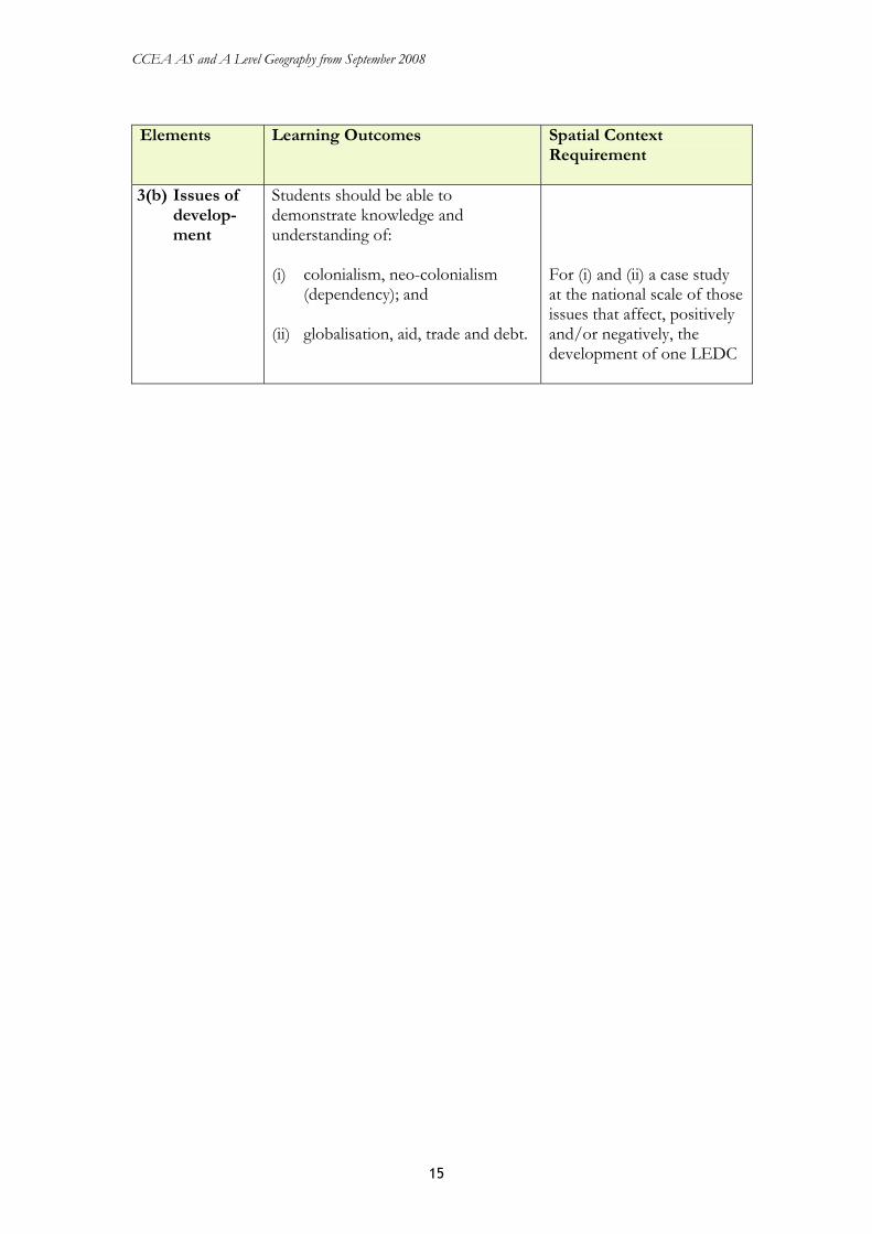
3(b) Issues of develop-ment
Students should be able to demonstrate knowledge and understanding of: (i) colonialism, neo-colonialism
(dependency); and (ii) globalisation, aid, trade and debt.
For (i) and (ii) a case study at the national scale of those issues that affect, positively and/or negatively, the development of one LEDC

CCEA AS and A Level Geography from September 2008
16
3.3 Unit A2 1: Human Geography and Global Issues This unit comprises two sections. Section A: Human Geography This section comprises three optional units from which students must choose two. Each option provides opportunities for the use of Geographical Information Systems and the internet. Option A: Impact of Population Change This option should enable students to: • understand that the demographic characteristics of any area are the result of the
relationship between births, deaths and migration; • appreciate that migration is a complex process which gives rise to distinctive streams
within and between nations; and • understand that population policies aim to alter the balance between population and
resources within a country.
Elements Learning Outcomes Spatial Context Requirement
1 Natural population change
Students should be able to: (i) explain fertility and mortality
measures, their geographical patterns and trends over time;
(ii) explain factors influencing
fertility and mortality: economic; social; political; cultural; environmental; HIV/AIDS;
(iii) evaluate the theories and issues
of population sustainability put forward by Malthus and Boserup; and
(iv) demonstrate knowledge and
understanding of the demographic transition model including the impact of the epidemiological transition.
For (i)-(iv): global contrasts

CCEA AS and A Level Geography from September 2008
17
Elements Learning Outcomes Spatial Context
Requirement
2 Migration: causes, streams and impacts
Students should be able to: (i) explain push/pull processes in
migration (economic, social, political, cultural and environmental factors); and barriers to migration;
(ii) demonstrate knowledge and
understanding of migration streams: internal and international; economic migrants: illegal migrants, asylum seekers and refugees;
(iii) demonstrate knowledge and
understanding of migrant characteristics: age; gender; ethnicity; socio-economic status; and
(iv) demonstrate knowledge and
understanding of the implications of migration for service provision, economic activity and social stability.
For (iv) those implications that are relevant to one small-scale case study of out-migration, eg Achill Island, and one small-scale case study of in-migration, eg Dublin or Delhi
3 Population policies
Students should be able to: (i) understand fertility and
migration policies in relation to: resource balance; economic, social, cultural and moral considerations; and
(ii) evaluate the impact of the
policies.
For (i) and (ii) one national fertility policy, eg China and one national migration policy, eg Canada

CCEA AS and A Level Geography from September 2008
18
Option B: Planning for Sustainable Settlements This option should enable students to: • understand the rationale underpinning sustainability; • appreciate the impact of settlements on the environment; • understand the processes which put pressure on sustainability within settlements; and • appreciate the role of people in planning within settlements to make them more
efficient and sustainable.
Elements Learning Outcomes Spatial Context Requirement
1 Sustainable development
Students should be able to: (i) explain sustainable
development with reference to social; economic; and environmental considerations;
(ii) demonstrate knowledge and
understanding of urban ecological and carbon footprints; and
(iii) demonstrate knowledge and
understanding of Local Agenda 21 and its impact on planning for sustainability.
For (i) and (ii) general reference to places for illustration purposes For (iii) one small-scale case study where Local Agenda 21 has influenced planning, eg Bexley
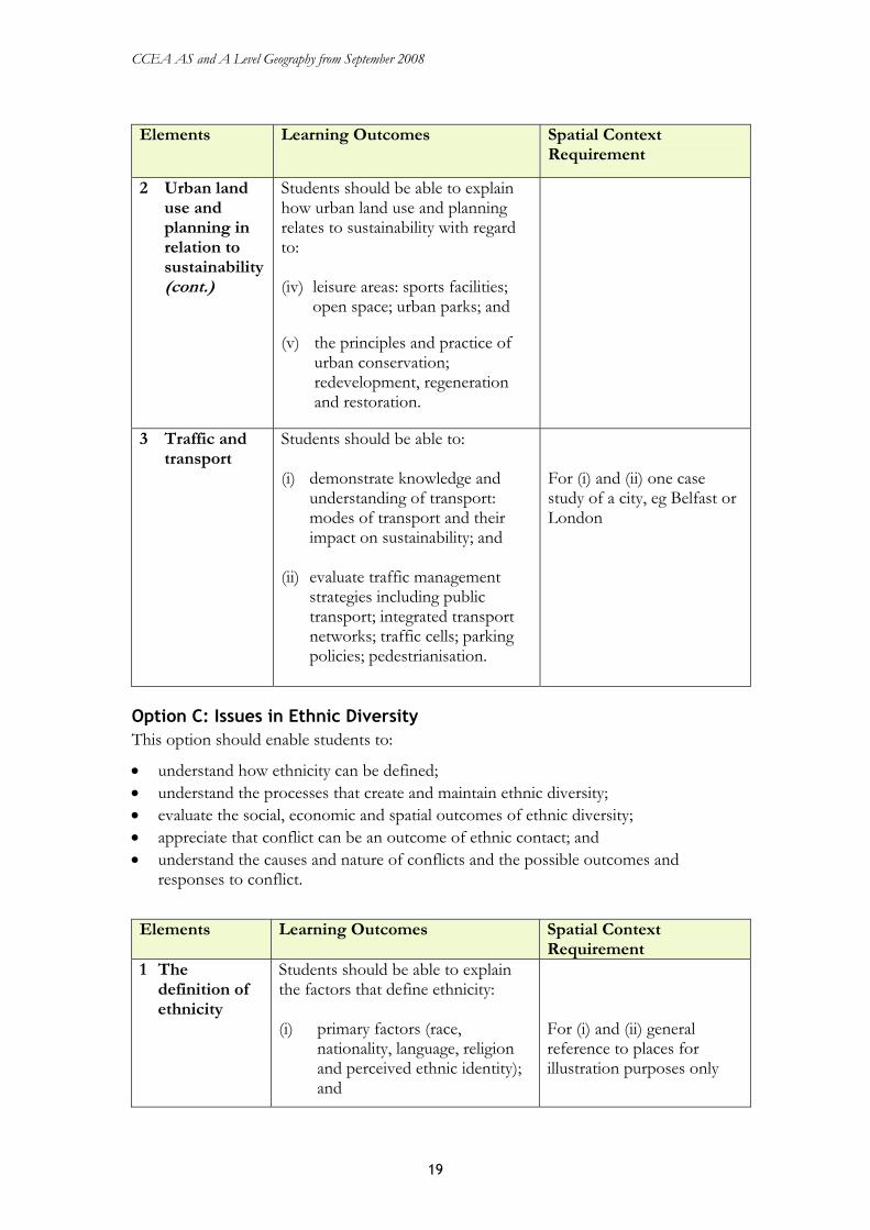
2 Urban land use and planning in relation to sustainability
Students should be able to explain how urban land use and planning relates to sustainability with regard to: (i) the management of residential
areas: neighbourhood units; defensible space;
(ii) the re-use of industrial areas:
the impact of de-industrialisation; brownfield developments; and
(iii) retail change: competition
between out-of-town shopping and town centres; environmental and social consequences.
For (i)-(v) those characteristics that affect or have affected land use and planning issues and policies in one small-scale case study, eg Curitiba or Los Angeles
CCEA AS and A Level Geography from September 2008
19
Elements Learning Outcomes Spatial Context
Requirement
2 Urban land use and planning in relation to sustainability (cont.)
Students should be able to explain how urban land use and planning relates to sustainability with regard to: (iv) leisure areas: sports facilities;
open space; urban parks; and (v) the principles and practice of
urban conservation; redevelopment, regeneration and restoration.
3 Traffic and transport
Students should be able to: (i) demonstrate knowledge and
understanding of transport: modes of transport and their impact on sustainability; and
(ii) evaluate traffic management
strategies including public transport; integrated transport networks; traffic cells; parking policies; pedestrianisation.
For (i) and (ii) one case study of a city, eg Belfast or London
Option C: Issues in Ethnic Diversity This option should enable students to:
• understand how ethnicity can be defined; • understand the processes that create and maintain ethnic diversity; • evaluate the social, economic and spatial outcomes of ethnic diversity; • appreciate that conflict can be an outcome of ethnic contact; and • understand the causes and nature of conflicts and the possible outcomes and
responses to conflict.
Elements Learning Outcomes Spatial Context Requirement
1 The definition of ethnicity
Students should be able to explain the factors that define ethnicity: (i) primary factors (race,
nationality, language, religion and perceived ethnic identity); and
For (i) and (ii) general reference to places for illustration purposes only
CCEA AS and A Level Geography from September 2008
20
Elements Learning Outcomes Spatial Context
Requirement
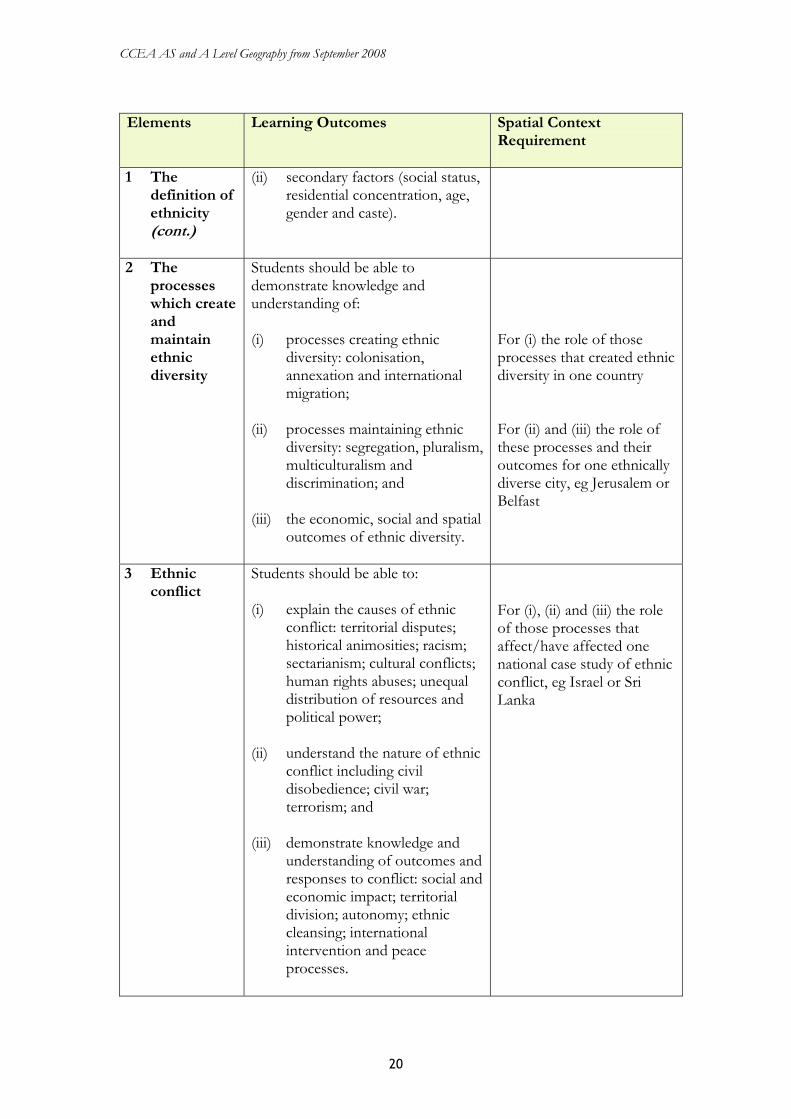
1 The definition of ethnicity (cont.)
(ii) secondary factors (social status, residential concentration, age, gender and caste).
2 The processes which create and maintain ethnic diversity
Students should be able to demonstrate knowledge and understanding of: (i) processes creating ethnic
diversity: colonisation, annexation and international migration;
(ii) processes maintaining ethnic
diversity: segregation, pluralism, multiculturalism and discrimination; and
(iii) the economic, social and spatial
outcomes of ethnic diversity.
For (i) the role of those processes that created ethnic diversity in one country For (ii) and (iii) the role of these processes and their outcomes for one ethnically diverse city, eg Jerusalem or Belfast
3 Ethnic conflict
Students should be able to: (i) explain the causes of ethnic
conflict: territorial disputes; historical animosities; racism; sectarianism; cultural conflicts; human rights abuses; unequal distribution of resources and political power;
(ii) understand the nature of ethnic
conflict including civil disobedience; civil war; terrorism; and
(iii) demonstrate knowledge and
understanding of outcomes and responses to conflict: social and economic impact; territorial division; autonomy; ethnic cleansing; international intervention and peace processes.
For (i), (ii) and (iii) the role of those processes that affect/have affected one national case study of ethnic conflict, eg Israel or Sri Lanka
CCEA AS and A Level Geography from September 2008
21
Section B: Global Issues In this section, students have an opportunity to investigate global issues and debates relating to our sustainable future. Students are required to study one of the four elements below. Study of this section gives students the opportunity to: • conduct fieldwork using primary data collection techniques; • develop an understanding and awareness of the nature of sustainability; • understand the need for, and desirability of, sustainable solutions to the
consequences of modern living; • appreciate that pollution is a major issue and that different opinions, attitudes and
values can be held about its nature; • recognise that compromise is needed to address pollution problems; and • appreciate that the development of economic resources has environmental
consequences that require careful management.
Elements Learning Outcomes Spatial Context Requirement
1 Air pollution Students should be able to: (i) appreciate the problems of
defining pollution; (ii) demonstrate knowledge and
understanding of air pollution sources: primary gaseous pollutants (carbon dioxide, methane, sulphur dioxide, CFCs); secondary gaseous pollutants (ozone and PANs);
(iii) use primary data collection
techniques to measure air pollution or to investigate local attitudes to/experience of air pollution;
(iv) understand and evaluate
strategies to manage environmental and health impacts of air pollution; and
(v) evaluate evidence and express
opinions concerning the climate change/global warming debate: should development be curtailed to counteract climate change/global warming?
For (iv) one small scale case study of air pollution and its management, eg photochemical smog in Los Angeles

CCEA AS and A Level Geography from September 2008
22
Elements Learning Outcomes Spatial Context
Requirement
2 Nuclear energy
Students should be able to: (i) demonstrate knowledge and
understanding of the uses of nuclear energy, power generation, nuclear weapons and medical;
(ii) demonstrate knowledge and
understanding of radio-active contamination and its impacts: nuclear weapons and their testing; long term health issues; accidents at power stations; nuclear waste and its management;
(iii) use primary data collection
techniques to investigate local attitudes/issues relating to nuclear energy; and
(iv) evaluate evidence and express
opinions concerning the nuclear debate: do its actual and potential problems mean nuclear energy should not be used?
For (i) to (iv): evidence relating to nuclear energy issues in the British Isles. Reference to places other than the British Isles for illustration purposes
3 Agricultural change and its impact
Students should be able to: (i) demonstrate knowledge and
understanding of agricultural change and its impact: technologically advanced inputs and processes, agribusiness, GM crops;
(ii) demonstrate knowledge and
understanding of the environmental consequences of change and their management (pollution, reduction of biodiversity, and maintaining fertility);
For (i) and (ii) those aspects of agricultural change and management which affect one regional scale case study, eg Brittany
CCEA AS and A Level Geography from September 2008
23
Elements Learning Outcomes Spatial Context
Requirement
3 Agricultural change and its impact (cont.)
Students should be able to:
(iii) use primary data collection techniques to investigate local attitudes/issues relating to agricultural change; and
(iv) evaluate evidence and express
opinions concerning the GM crops debate: do the benefits of GM crops outweigh potential damage to the environment from their use?
For (iv) general reference to places for illustration purposes only
4 Issues in tourism
Students should be able to: (i) demonstrate knowledge and
understanding of the changing nature and characteristics of tourism (pleasure periphery, product cycle, Butler Model);
(ii) appreciate the consequences of
change and how it may be managed (pollution, carrying capacity; competition for resources and social sustainability);
(iii) use primary data collection
techniques to investigate aspects of tourism and its management; and
(iv) evaluate evidence and express
opinions concerning the ecotourism debate: can ecotourism exist?
For (i) and (ii) those aspects of tourism change and management which affect one regional or national scale case study, eg Mallorca or Nepal For (iv) general reference to places for illustration purposes only

CCEA AS and A Level Geography from September 2008
24
3.4 Unit A2 2: Physical Geography and Decision-Making This unit comprises two sections. Section A: Physical Geography This section comprises three optional units from which students must choose two. Each option provides opportunities for the use of Geographical Information Systems and the internet. Option A: Fluvial and Coastal Environments This option should enable students to: • gain a deeper understanding of physical systems and processes; • understand the nature of, and reasons for, human use and interaction with fluvial and
coastal environments in space and over time; • understand how and why decisions are made about environmental resources and
appreciate that human management control is a feature of the modern world; • identify the changing methods/strategies used over time as well as the direct and
indirect consequences and associated issues within spatial contexts; and • evaluate the effectiveness of selected schemes, understand how environments and
issues change and appreciate the increasing need for sensitivity and sustainability with regard to human activities in natural systems.
Elements Learning Outcomes Spatial Context Requirement
1 Human demands on fluvial and coastal environments
Students should be able to understand the increasing demands on coasts, rivers and their valleys: domestic/residential, agricultural, industrial, energy production and leisure activities.
General reference to places for illustration only
2 River and basin management strategies
Students should be able to demonstrate knowledge and understanding of river and basin management strategies including: (i) the need for and impact of
channelisation; (ii) the challenge of creating
environmentally sensitive engineering solutions; and
(iii) the aims, strategies and impact of
basin management processes including beneficial outcomes, conflicts of interest and interdependence between places.
For (i) and (ii) – general reference to places for illustration only (iii) One regional scale case study, eg Colorado river basin

CCEA AS and A Level Geography from September 2008
25
Elements Learning Outcomes Spatial Context
Requirement
3 Coastal processes, features and management
Students should be able to: (i) understand the formation of
landforms within dynamic coastal environments: erosional (stacks, arches and headlands) and depositional (spits, tombolos and dunes);
(ii) evaluate the arguments for and
against coastal protection; and (iii) understand the nature and impact
of hard and soft engineering strategies on the human and physical environment.
For (ii) and (iii) – one regional case study, eg East Sussex or East Anglia
Option B: The Nature and Sustainability of Tropical Ecosystems This option should enable students to: • further develop their understanding of physical systems and processes at work within
the tropical environments of the world; • enhance their awareness of the distinctiveness of places created by the interaction of
natural factors and by human activity within physical systems; • appreciate the role of human activity in modifying tropical soils and ecosystems as
people seek opportunities and face constraints within natural resource systems; and • understand the significance and effects of changing attitudes and values in
geographical issues and appreciate that management strategies increasingly require a consideration of long-term sustainability within fragile environments.
Elements Learning Outcomes Spatial Context Requirement
1 Location and climatic characteristics of major tropical biomes
Students should be able to apply knowledge of atmospheric processes (including global circulation, Hadley Cell and ITCZ) to explain the location and climatic characteristics of tropical forests, tropical grasslands and desert zones.
Global scale distribution

CCEA AS and A Level Geography from September 2008
26
Elements Learning Outcomes Spatial Context
Requirement
2 Ecosystem processes in the tropical forest environment
Students should be able to understand the processes in the Tropical Rain Forest, including: (i) biomass and productivity; (ii) trophic structure; (iii) nutrient cycling; and (iv) zonal soil profile and
characteristics of an oxisol (ie latosol).
For (i)-(iv) – one regional scale case study of a tropical forest ecosystem, eg Amazon
3 Management and sustainability within tropical ecosystems
Students should be able to: (i) demonstrate knowledge and
understanding of the problem of salinisation in an arid or semi-arid tropical environment – causes, impact on environment and people, possible solutions; and
(ii) evaluate attempts to achieve
sustainable development in the tropical forest ecosystem.
(i) one regional scale case
study, eg a region within Pakistan or Sudan
(ii) one small scale case
study, eg SW Cameroon (the Korup project) or within the Peruvian Amazon

CCEA AS and A Level Geography from September 2008
27
Option C: The Dynamic Earth This option should enable students to: • understand the dynamic nature of events related to crustal movements; • increase their knowledge of processes responsible for selected hazards; • appreciate both the beneficial and detrimental outcomes of natural hazards; and • evaluate the effectiveness of human strategies to predict and/or reduce the impact of
hazards in selected areas of the developed and developing world. Elements Learning Outcomes Spatial Context
Requirement
1 Plate tectonics and resulting landforms
Students should be able to demonstrate knowledge and understanding of plate tectonics including: (i) the theory of plate tectonics,
types of plate margins (conservative, constructive, destructive and collision) and evidence for plate movement including magnetic striping, jigsaw fit and geological evidence;
(ii) causes and distribution of
earthquake and volcanic hazards in relation to plate boundaries and hot spots; and
(iii) resulting landforms (fold
mountains, ocean ridges, deep sea trenches and island arcs).
For (i)-(iii) general reference to places for illustration purposes only
2 Volcanic activity and its management
Students should be able to: (i) understand and evaluate the
hazards and benefits associated with volcanic activity: social, economic and environmental; and
(ii) demonstrate knowledge
concerning efforts to predict volcanic activity and the limitations of those predictions.
For (i) general reference to places for illustration purposes only For (ii) – one small-scale case study, eg Pinatubo (1991), Merapi (1987 onwards)

CCEA AS and A Level Geography from September 2008
28
Elements Learning Outcomes Spatial Context
Requirement
3 Earthquake activity and its management
Students should be able to: (i) understand the effects of
earthquake activity (ground deformation, seismic shaking, landslides, liquefaction, fire, floods and tsunami);
(ii) demonstrate knowledge
concerning efforts to predict earthquake activity and the limitations of those predictions; and
(iii) recognise that the impact and
management of the effects of earthquake activity reflect knowledge, perception and stage of development.
For (iii) – two small-scale case studies: one from a MEDC, eg Kobe in Japan and one from a LEDC, eg northern Pakistan
Section B: The Decision-Making Exercise Section B of this unit requires students to prepare for a compulsory decision-making exercise. This takes the form of a case study. Students are presented with a variety of resources which may include maps, statistics, reports, diagrams and photographs. They must then identify and analyse appropriate material and are required to use particular skills and techniques and to evaluate the results of analysis. Students are asked to take on a particular role for answering part of the exercise and to examine conflicting values which may be apparent in the case study. They are required to consider alternative choices and to make and justify recommendations.

CCEA AS and A Level Geography from September 2008
29
4 Scheme of Assessment 4.1 Assessment opportunities Students can choose to be assessed in stages during their AS and A Level courses or to leave all assessment to the end of the courses. Section 2 of the specification shows the availability of assessment units. Students can choose to resit AS and A2 assessment units. The best result for each assessment unit will count towards the AS and A Level qualifications. Results for each assessment unit can continue to contribute to an AS or A Level qualification while the specification is offered.
4.2 Assessment objectives The assessment objectives of the specification are listed below. Students must: • demonstrate knowledge and understanding of the content, concepts and processes
(AO1); • analyse, interpret and evaluate geographical information, issues and viewpoints and
apply understanding in unfamiliar contexts (AO2); and • select and use a variety of methods, skills and techniques (including the use of new
technologies) to investigate questions and issues, reach conclusions and communicate findings (AO3).
4.3 Assessment objective weightings The assessment objective weightings for each assessment unit and the overall AS and A Level qualifications are set out in the table below:
Assessment Unit Weightings Overall Weightings Assessment Objective AS 1 AS 2 A2 1 A2 2 AS A Level
AO1 50% 50% 60% 30% 50% 47% AO2 20% 20% 20% 40% 20% 25% AO3 30% 30% 20% 30% 30% 28%
4.4 Nature of assessment units The assessment units that make up the AS and full A Level awards are described below: Assessment Unit 1: Themes in Physical Geography This assessment unit takes the form of a 90-minute examination. Students must bring to the examination a table of data and a summary statement covering the aims and context for the fieldwork. Students must answer six questions from three sections. Section A comprises a multi-part compulsory question which will assess fieldwork skills. Parts of this question may require the student to analyse, interpret and evaluate the data presented and the techniques used to collect it. We expect students to demonstrate their understanding of, and ability to apply, fieldwork techniques. They must also demonstrate graphical, cartographic, statistical, analytical, interpretative and evaluative skills. A

CCEA AS and A Level Geography from September 2008
30
detailed list of the necessary skills and techniques is set out on page 6. The question will have an allocation of 30 marks. Section B comprises three compulsory short structured questions. Each question has a total of 12 marks. In Section C, students choose two out of three questions that require extended writing. Each question has a total of 12 marks. In both Sections B and C, questions focus mainly on one of the three main elements in the unit content. However, parts of questions may be used to assess the relationship between the elements. Assessment Unit 2: Themes in Human Geography This assessment unit takes the form of a 90-minute examination. Students must answer six questions from three sections. Section A comprises a multi-part compulsory question. Parts of this question may require the student to respond to quantitative or qualitative data provided from secondary sources. Students must demonstrate their understanding of graphical, cartographic, statistical, analytical, interpretative and evaluative skills. The question has an allocation of 30 marks. Section B comprises three compulsory, short, structured questions. Each question has a total of 12 marks. In Section C, students must choose two out of three questions that require extended writing. Each question has a total of 12 marks. In both Sections B and C, questions focus mainly on one of the three main elements in the unit content. However, parts of questions may be used to assess the relationship between the elements. Assessment Unit 3: Human Geography and Global Issues This assessment unit takes the form of a 90-minute examination consisting of two sections. Section A has three subsections. Each subsection corresponds to one of the optional units in Unit 3 and comprises two structured questions. Students must answer two questions: one from each of their chosen subsections. Each question has a total allocation of 30 marks. These questions have at least one extended element with a minimum mark allocation of 10 marks. Section B comprises four structured questions corresponding to Section B of the unit content. Students must answer one question corresponding to their chosen Global Issue. Each question has a total of 30 marks. Each question also has at least one extended element with a minimum mark allocation of 10 marks. This part of Unit 3 contributes to synoptic assessment. Assessment Unit 4: Physical Geography and Decision-Making This assessment unit takes the form of a 150-minute examination and consists of two sections. Section A has three subsections. Each corresponds to one of the optional units in Unit 3 and comprises two structured questions. Students must answer two questions: one from

CCEA AS and A Level Geography from September 2008
31
each of their chosen subsections. Each question has a total allocation of 30 marks and has at least one extended element with a minimum mark allocation of 10 marks. Section B requires students to undertake a decision-making exercise. This takes the form of a case study, which has an allocation of 50 marks. We will present students with a variety of resources, and they must use particular skills and techniques to evaluate the results of the analysis. We may ask them to take on a particular role for answering part of the exercise. We may also ask them to examine conflicting values that may be apparent in the case study. Students must consider alternative choices and to make and justify recommendations. This part of Unit 4 contributes to synoptic assessment.
4.5 Quality of written communication Some assessment units in AS and A Level qualifications in Geography require students to demonstrate their quality of written communication. In particular, students are required to:
• ensure that text is legible and that spelling, punctuation and grammar are accurate so that meaning is clear;
• select and use a form and style of writing appropriate to their purpose and to complex subject matter; and
• organise information clearly and coherently, using specialist vocabulary where appropriate.
Examiners assess the quality of students’ written communication in their responses to questions or tasks that require extended writing. Quality of written communication will be assessed within assessment objective AO3.
4.6 Synoptic assessment The A2 assessment units include an element of synoptic assessment. This allows students to demonstrate expertise in the essential knowledge, understanding and skills of Geography. In GCE Geography, synoptic assessment requires that students demonstrate that they can:
• draw on their understanding of the connections between different aspects of the subject represented in the specification; and
• demonstrate their ability to ‘think like a geographer’.
4.7 Stretch and challenge The A2 assessment units Human Geography and Global Issues and Physical Geography and Decision-Making will include opportunities for stretch and challenge. This will be achieved by:
• using a variety of command words, for example analyse, evaluate, discuss, compare – to elicit a full range of response types;
• the use of case studies (decision-making in A2 2); • the use of open-ended questions (A2 1 and A2 2); and • the use of resource materials (A2 1 and A2 2).
CCEA AS and A Level Geography from September 2008
32
4.8 Reporting and grading We report the results of individual assessment units on a uniform mark scale that reflects the assessment weighting of each unit. AS qualifications are awarded on a five grade scale from A to E with A being the highest. A Level qualifications are awarded on a six grade scale from A* to E with A* being the highest. We determine the AS and A Level grades awarded by aggregating the uniform marks obtained on individual assessment units. To be awarded an A*, candidates will need to achieve a grade A on their full A level qualification and an A* on the aggregate of their A2 units. For students who fail to attain a grade E, we report their results as unclassified (U). The grades we award match the performance descriptions published by the regulatory authorities (see Section 5.4).

CCEA AS and A Level Geography from September 2008
33
5 Links 5.1 Support materials We currently provide the following materials to support this specification:
• specimen papers; • mark schemes; and • a resource list. You can access these materials from our website at www.ccea.org.uk or in printed format from the CCEA Distribution Section. We will expand our range of support materials to include exemplar schemes of work. We will make these available via our website and, where appropriate, in printed form. You can find details of our Annual Support Programme of events and materials for Geography on our website: www.ccea.org.uk.
5.2 Curriculum objectives This specification addresses and builds upon the broad curriculum objectives for Northern Ireland, England and Wales. In particular, it allows students to:
• develop as individuals and in their roles as contributors to society, the economy and the environment;
• address moral, ethical and social issues associated with the use and management of resources; and
• develop skills and dispositions that will enhance their employability, for example communication, numeracy, the ability to think logically and rationally, decision-making, problem-solving, ICT skills and teamwork.
5.3 Key skills This specification provides students with opportunities to develop the following skills at level 3:
• Application of Number – all units • Communication – all units • Improving Own Learning and Performance – all units • Information and Communication Technology – all units • Problem-Solving – A2 • Working with Others – AS. You can find details of the current standards and guidance for each of these skills on the QCA website at www.qca.org.uk.
5.4 Performance descriptions You can obtain performance descriptions for the AS and A2 judgemental A/B and E/U boundaries from the QCA website: www.qca.org.uk.

CCEA AS and A Level Geography from September 2008
34
5.5 Examination entries The following entry codes apply to individual assessment units and the overall AS and A Level cash-ins in Geography: AS 1 AAG11 AS 2 AAG12 AS cash-in S3912 A2 1 AAG21 A2 2 AAG22 A Level cash-in A3912 You can view details of how to make entries on our website. Alternatively, you can contact our Entries Team using the details provided in Section 5.8.
5.6 Students with particular requirements We have designed this specification to minimise the need to adjust the assessment of students who have particular requirements. Details of the arrangements you can make for such students are available in the Joint Council for Qualifications document Access Arrangements and Special Consideration: Regulations and Guidance Relating to Candidates Who Are Eligible for Adjustments in Examinations.
5.7 Disability Discrimination Act (DDA) AS/A Levels often require assessment of a broad range of competences. This is because they are general qualifications and, as such, prepare candidates for a wide range of occupations and higher level courses. The revised AS/A Level qualification and subject criteria were reviewed to identify whether any of the competences required by the subject presented a potential barrier to any disabled candidates. If this was the case, the situation was reviewed again to ensure that such competences were included only where essential to the subject. The findings of this process were discussed with disability groups and with disabled people. Reasonable adjustments are made for disabled candidates in order to enable them to access the assessments. For this reason, very few candidates will have a complete barrier to any part of the assessment. Information on reasonable adjustments is found in the Joint Council for Qualifications document Access Arrangements and Special Consideration: Regulations and Guidance Relating to Candidates Who are Eligible for Adjustments in Examinations. Candidates who are still unable to access a significant part of the assessment, even after exploring all possibilities through reasonable adjustments, may still be able to receive an award. They would be given a grade on the parts of the assessment they have taken and there would be an indication on their certificate that not all of the competences have been addressed. This will be kept under review and may be amended in the future. In A Level Geography requirements for fieldwork are sufficiently flexible for all candidates to participate.

CCEA AS and A Level Geography from September 2008
35
5.8 Contact details The following list provides contact details for relevant members of our staff: • Specification Support Officer: Arlene Ashfield
(telephone: (028) 9026 1200, extension 2291, email: [email protected]) • Officer with Subject Responsibility: Margaret McMullan
(telephone: (028) 9026 1200, email: [email protected]) • Examination Entries, Results and Certification: Philip Macauley
(telephone: (028) 9026 1262, email: [email protected]) • Examiner Recruitment
(telephone: (028) 9026 1243, email: [email protected]) • Distribution (past papers and support materials)
(telephone: (028) 9026 1228, email: [email protected]) • Support Events Administration: Events Information Service
(telephone: (028) 9026 1401, email: [email protected]) • Information Section (including Freedom of Information requests)
(telephone: (028) 9026 1200, email: [email protected]) • Business Assurance (appeals): Jeffrey Hamilton
(telephone: (028) 9026 1205, email: [email protected]).


![CCEA Draft GCE Specification in [Subject]](https://static.documents.pub/doc/80x56/61aaa800635c7e5518387204/ccea-draft-gce-specification-in-subject.jpg)


