26
PLANNING COMMISSION Agenda Item # 3.
PLANNING COMMISSION
Agenda Item # 3.

CASE SUMMARY Conditional District Rezoning Planning Commission February 4, 2015
CD-9-215 Jeff Walton, 341-3260, [email protected] Staff recommendation CONDITIONAL APPROVAL Planning Commission recommendation PENDING; 2/4/15 City Council Action PENDING; 3/3/15
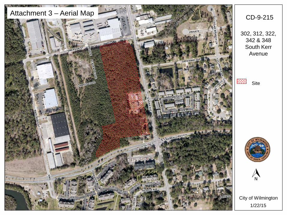
Request Address(es) 302, 312, 322, 342 & 348 South Kerr Avenue Acreage 12.64 acres Request IND, Industrial District, CS, Community Service District, & R-10, Residential
District to MF-L (CD) Multi-family Residential-Low Density (Conditional District) to allow construction of an apartment complex housing 118 units for a total of 400 bedrooms.
Property Owners
RPP Holdings, LLC [email protected] P.O. Box 7332, Wilmington, NC 28406 (910) 352-2846
Applicant Design Solutions/Cindee Wolf [email protected] P.O. Box 7221, Wilmington, NC 28405 (910) 620-2374
Property Current Proposed Zoning IND, CS & R-10 MF-L (CD) Land Use Vacant, single-family 118 multi-family units Residential Density N/A 9.2 units/acre
Land Planning Data Applicable Plans/Policies
Wilmington Future Land Use Plan (FLUP) City of Wilmington Adopted Focus Areas
CAMA Land Use Urban Surrounding Area North South East West Zoning RB R-10, MF-M (SD) R-10, MF-L (CD) MF-M (CD) Current Land Use Retail Multi-family Single-family,
multi-family Multi-family
Aerial Map (2010) Current land use and zoning

CD-9-215; 302, 312, 322, 342 & 348 South Kerr Avenue
2
Case Overview PROPOSAL and ANALYSIS
Rezone seven parcels totaling 12.64 acres from IND, Industrial District, CS, Community Service District, & R-10, Residential District to MF-L (CD) Multi-family Residential-Low Density (Conditional District) to allow construction of an apartment complex housing 118 units for a total of 400 bedrooms.
Eighty-two buildings are proposed consisting of 72, 3-bedroom and 46, 4-bedroom units.
At 12.64 acres, the maximum build out under the proposed zoning would be 126 units; the applicant proposes a total of 118 units in the development; a density of 9.2 dwelling units per acre.
1. Zoning History
The seven parcels of the proposed development were annexed into the city on December 27, 1964.
2. Existing Zoning
CS, Commercial Services District – This district is established to accommodate a mixture of light manufacturing, wholesale, storage, commercial service and repair, and distributive business type uses. It functions as a supportive district to surrounding intensive industrial and commercial uses. The district is designed to locate near major transportation facilities (road, rail, air and port) and act as a transitional land use between intensive industrial and commercial development and office and residential areas.
IND, Industrial District – This district is established to accommodate basic industries and other uses that produce noise, odor, smoke, dust, airborne debris, and other impacts that might be detrimental to the health, safety, and welfare of surrounding uses and neighborhoods in accordance with adopted plans and policies. The district is designed to be located near major transportation facilities (road, rail, air and/or port) and in areas adequately served by public or private utilities. It should not be located in a manner that adversely affects existing or planned non-industrial uses.
R-10, Residential District – This district is established for moderate and low density residential development and other compatible uses. It may act as a transition between higher density urban development located on the edges of the 1945 corporate limits and lower density suburban residential development located elsewhere within the city limits. Land uses considered harmful to the health, safety and welfare of district residents shall be prohibited from infringing upon the livability of residential areas within the district.
o Maximum density is 4.4 lots per acre. 3. Proposed Zoning
MF-L, Multiple-family Residential District – This district is established for moderate density single family and multiple family developments of varying types and designs. It functions as a transitional land use between intensive nonresidential uses or higher density residential areas and lower density residential areas. The district is designed to respond to the varying housing needs of the community while affording a reasonable range of choice, type and location of housing units within the City.
o Maximum density is 10 units per acre

CD-9-215; 302, 312, 322, 342 & 348 South Kerr Avenue
3
4. Impacts on Public Services, Facilities, and Infrastructure
4.1 Traffic Ingress and egress to the site would be provided by driveways from South Kerr
Avenue, Emerson Street and Campus Cove Road. The project will be impacted by proposed improvements to South Kerr Avenue as
a part of plans by the NCDOT to widen South Kerr Avenue in 2015. As part of the widening project, the NCDOT will install a median along the South
Kerr Avenue frontage of the subject site. The proposed driveway on South Kerr Avenue will function as a right-in/right-out only.
A TIA is not required for the proposed development based on the number of projected trips.
The proposed development will be a gate-restricted community. There are no transportation bond related improvements affecting the proposed
development. The proposed development is on the Wave Transit Seahawk Shuttle Map and
includes a stop along Emerson Street.
Table 4.1.1 Estimated Trip Generation
Zoning Land Use Intensity AM Peak
Hour Trips PM Peak
Hour Trips
Average Weekday 2-way Volume Trips
(ADT)
Existing R-10 Single Family Residential 10 lots 8 10 95
Existing CS & IND* Commercial 111,000 Square
Feet 208 203 1,421
Proposed MF-L (CD)
Apartments 118 units 62 83 839 * Based on potential development based on 25% lot coverage Source: Institute of Transportation Engineers Trip Generation, 9th Edition, 2012. TRIP GENERATION BY Trafficware TripGen 2013 8.0
Driveway off Campus Cove Road
Driveway off Emerson Street
Driveway off South Kerr Avenue
CD-9-215; 302, 312, 322, 342 & 348 South Kerr Avenue
4
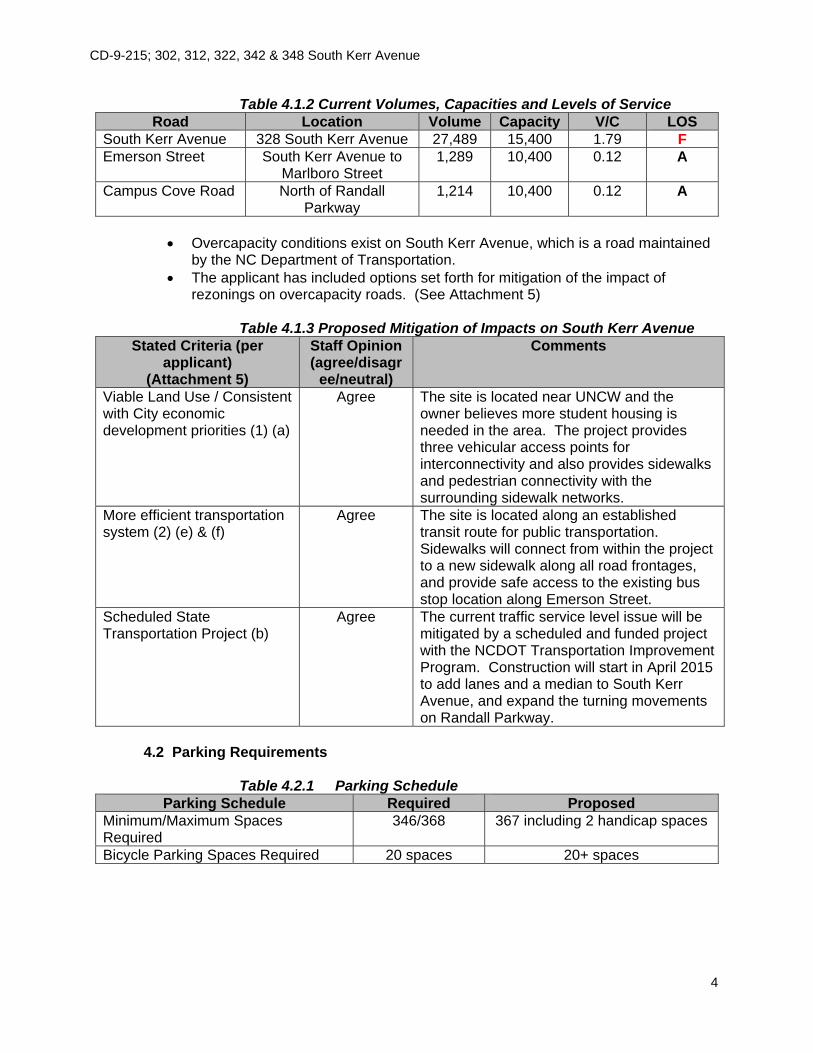
Table 4.1.2 Current Volumes, Capacities and Levels of Service Road Location Volume Capacity V/C LOS
South Kerr Avenue 328 South Kerr Avenue 27,489 15,400 1.79 F Emerson Street South Kerr Avenue to
Marlboro Street 1,289 10,400 0.12 A
Campus Cove Road North of Randall Parkway
1,214 10,400 0.12 A
Overcapacity conditions exist on South Kerr Avenue, which is a road maintained
by the NC Department of Transportation. The applicant has included options set forth for mitigation of the impact of
rezonings on overcapacity roads. (See Attachment 5)
Table 4.1.3 Proposed Mitigation of Impacts on South Kerr Avenue Stated Criteria (per
applicant) (Attachment 5)
Staff Opinion (agree/disagr
ee/neutral)
Comments
Viable Land Use / Consistent with City economic development priorities (1) (a)
Agree The site is located near UNCW and the owner believes more student housing is needed in the area. The project provides three vehicular access points for interconnectivity and also provides sidewalks and pedestrian connectivity with the surrounding sidewalk networks.
More efficient transportation system (2) (e) & (f)
Agree The site is located along an established transit route for public transportation. Sidewalks will connect from within the project to a new sidewalk along all road frontages, and provide safe access to the existing bus stop location along Emerson Street.
Scheduled State Transportation Project (b)
Agree The current traffic service level issue will be mitigated by a scheduled and funded project with the NCDOT Transportation Improvement Program. Construction will start in April 2015 to add lanes and a median to South Kerr Avenue, and expand the turning movements on Randall Parkway.
4.2 Parking Requirements
Table 4.2.1 Parking Schedule Parking Schedule Required Proposed
Minimum/Maximum Spaces Required
346/368
367 including 2 handicap spaces
Bicycle Parking Spaces Required 20 spaces 20+ spaces

CD-9-215; 302, 312, 322, 342 & 348 South Kerr Avenue
5
4.3 Public Utilities Table 4.3.1 Cape Fear Public Utilities (CFPUA)
Type Ownership Size Location Water Main (Existing) CFPUA 8-inch Campus Cove Road Sewer Main (Existing) CFPUA 8-inch Emerson Street
4.4 Landscaping, Buffering, Tree Protection and Open Space
The subject site consists of seven parcels, three of which are heavily wooded. The project design would preserve a number of trees along the perimeter of the
site, recreation space, and in the streetyards. Several landscape islands have been designed to incorporate existing trees.
Approval of the landscape plan is required prior to release of the project for construction.
Table 4.4.1 Open Space
Open Space Requirement Required Proposed Total Open Space 181,427 square feet (35%) 223,296 square feet (40%) Active/Passive Space 90,713 square feet 95,814 square feet Open Space 90,713 square feet 127,482 square feet
4.5 Stormwater
The project would create approximately 282,161 square feet (51.3%) of built-upon area. Designs for on-site stormwater management would be reviewed for compliance with the city’s stormwater management regulations.
4.6 Other Reviews
TRC – Concept plan review 6/26/14 & 12/30/14; a full TRC review will be required.
5. Consistency with Adopted Plans
5.1 2001-2025 Wilmington Future Land Use Plan (FLUP) Chapter I – Infill- Development of Vacant Land
o Objective 1.3: Randall Parkway generally between Covil Avenue and South Kerr Avenue. Preferred development patterns in this area are varied use area,
primarily multi-family residential uses with some office uses at a height of 3 to 5 stories. Offices should be located along thoroughfares with high intensity of use located at intersections.
o Provide interconnectivity and shared access between adjacent nonresidential developments.
o Encourage assemblage of land parcels to facilitate effective roadway connections and improved internal circulation.
Chapter I – Transitioning Residential Areas
o Objective 1.2: Northwest corner of South Kerr Avenue and Randall Parkway.
CD-9-215; 302, 312, 322, 342 & 348 South Kerr Avenue
6
Acceptable development patterns are nonresidential uses and duplex, triplex, quadraplex and low-density multi-family uses.
o Consider the transition to greater intensity uses on existing single-family residential lots on major or minor thoroughfares or surrounded by encroaching uses of greater intensity, which reduce the desirability of land for single-family uses.
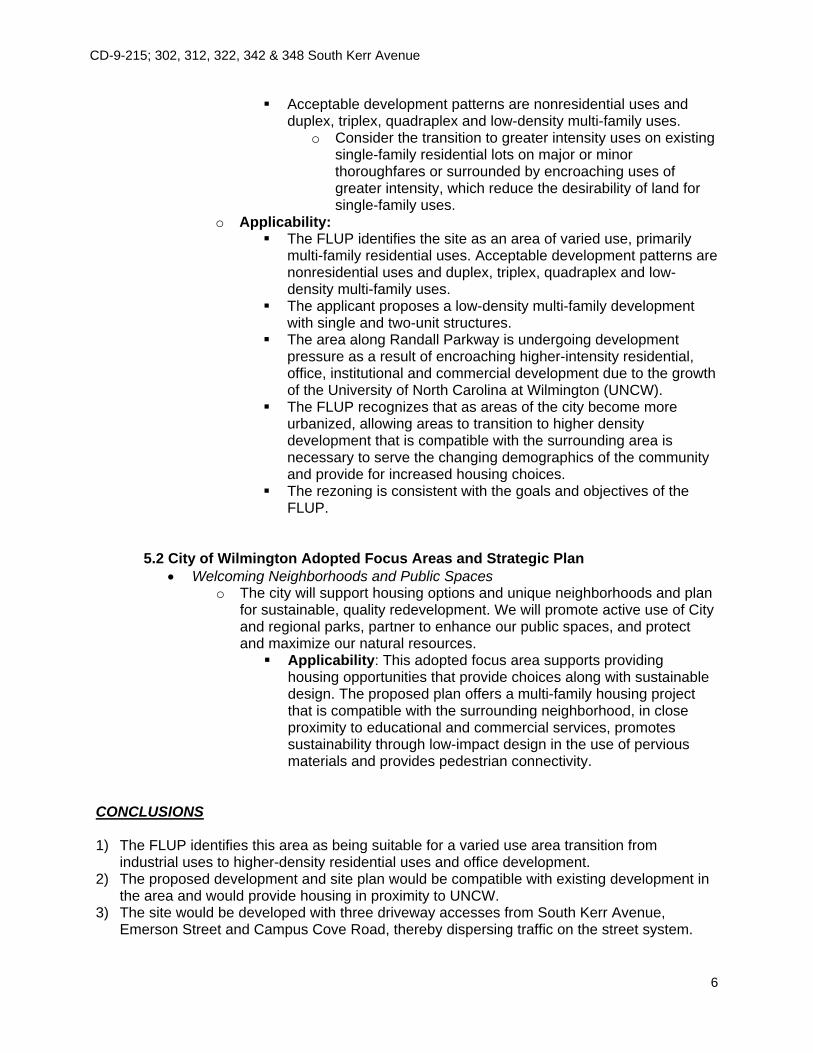
o Applicability: The FLUP identifies the site as an area of varied use, primarily
multi-family residential uses. Acceptable development patterns are nonresidential uses and duplex, triplex, quadraplex and low-density multi-family uses.
The applicant proposes a low-density multi-family development with single and two-unit structures.
The area along Randall Parkway is undergoing development pressure as a result of encroaching higher-intensity residential, office, institutional and commercial development due to the growth of the University of North Carolina at Wilmington (UNCW).
The FLUP recognizes that as areas of the city become more urbanized, allowing areas to transition to higher density development that is compatible with the surrounding area is necessary to serve the changing demographics of the community and provide for increased housing choices.
The rezoning is consistent with the goals and objectives of the FLUP.
5.2 City of Wilmington Adopted Focus Areas and Strategic Plan
Welcoming Neighborhoods and Public Spaces o The city will support housing options and unique neighborhoods and plan
for sustainable, quality redevelopment. We will promote active use of City and regional parks, partner to enhance our public spaces, and protect and maximize our natural resources. Applicability: This adopted focus area supports providing
housing opportunities that provide choices along with sustainable design. The proposed plan offers a multi-family housing project that is compatible with the surrounding neighborhood, in close proximity to educational and commercial services, promotes sustainability through low-impact design in the use of pervious materials and provides pedestrian connectivity.
CONCLUSIONS 1) The FLUP identifies this area as being suitable for a varied use area transition from
industrial uses to higher-density residential uses and office development. 2) The proposed development and site plan would be compatible with existing development in
the area and would provide housing in proximity to UNCW. 3) The site would be developed with three driveway accesses from South Kerr Avenue,
Emerson Street and Campus Cove Road, thereby dispersing traffic on the street system.
CD-9-215; 302, 312, 322, 342 & 348 South Kerr Avenue
7
Buildings are oriented toward South Kerr Avenue with parking located in the interior of the site and pedestrian connectivity has been provided.
4) South Kerr Avenue is overcapacity at a level of service F. Improvements installed by the NCDOT for the South Kerr Avenue widening project would improve the level of service upon completion of the construction.
5) The applicant submitted options set forth for mitigation of the impact of rezonings on overcapacity roads and addressed several criteria, such as, more efficient transportation systems and scheduled state transportation project of widening South Kerr Avenue.
6) The proposed widening of South Kerr Avenue will improve the level of service of South Kerr Avenue and enhance access to the project site.
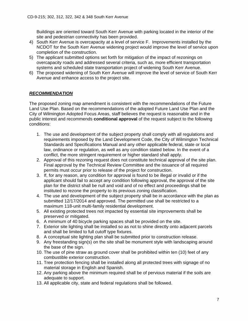
RECOMMENDATION The proposed zoning map amendment is consistent with the recommendations of the Future Land Use Plan. Based on the recommendations of the adopted Future Land Use Plan and the City of Wilmington Adopted Focus Areas, staff believes the request is reasonable and in the public interest and recommends conditional approval of the request subject to the following conditions:
1. The use and development of the subject property shall comply with all regulations and requirements imposed by the Land Development Code, the City of Wilmington Technical Standards and Specifications Manual and any other applicable federal, state or local law, ordinance or regulation, as well as any condition stated below. In the event of a conflict, the more stringent requirement or higher standard shall apply.
2. Approval of this rezoning request does not constitute technical approval of the site plan. Final approval by the Technical Review Committee and the issuance of all required permits must occur prior to release of the project for construction.
3. If, for any reason, any condition for approval is found to be illegal or invalid or if the applicant should fail to accept any condition following approval, the approval of the site plan for the district shall be null and void and of no effect and proceedings shall be instituted to rezone the property to its previous zoning classification.
4. The use and development of the subject property shall be in accordance with the plan as submitted 12/17/2014 and approved. The permitted use shall be restricted to a maximum 118-unit multi-family residential development.
5. All existing protected trees not impacted by essential site improvements shall be preserved or mitigated.
6. A minimum of 40 bicycle parking spaces shall be provided on the site. 7. Exterior site lighting shall be installed so as not to shine directly onto adjacent parcels
and shall be limited to full cutoff type fixtures. 8. A conceptual site lighting plan shall be submitted prior to construction release. 9. Any freestanding sign(s) on the site shall be monument style with landscaping around
the base of the sign. 10. The use of pine straw as ground cover shall be prohibited within ten (10) feet of any
combustible exterior construction. 11. Tree protection fencing shall be installed along all protected trees with signage of no
material storage in English and Spanish. 12. Any parking above the minimum required shall be of pervious material if the soils are
adequate to support. 13. All applicable city, state and federal regulations shall be followed.

CD-9-215; 302, 312, 322, 342 & 348 South Kerr Avenue
8
NEIGHBORHOOD CONTACT Planning Commission City Council Signs Posted 1/20/15 2/17/15 Property Owner Letters 1/20/15 2/17/15 Advertisement Date(s) 1/30/15 2/20/15 & 2/27/15 Other – Contact(s) None None
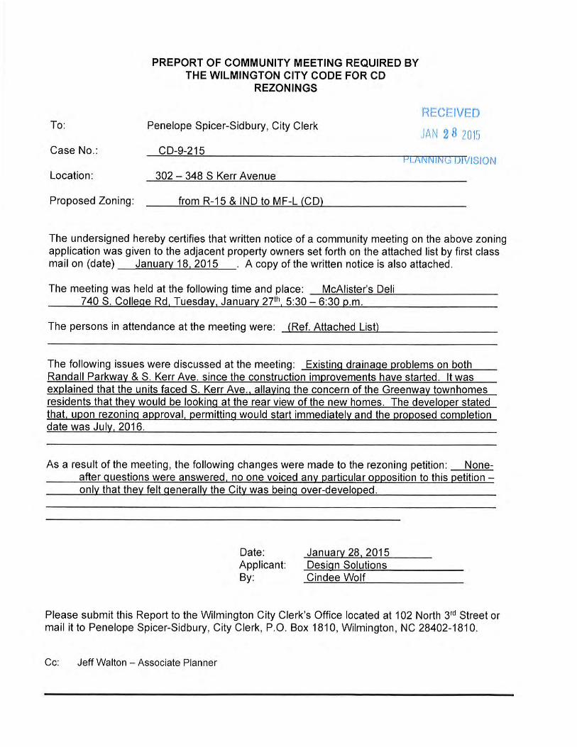
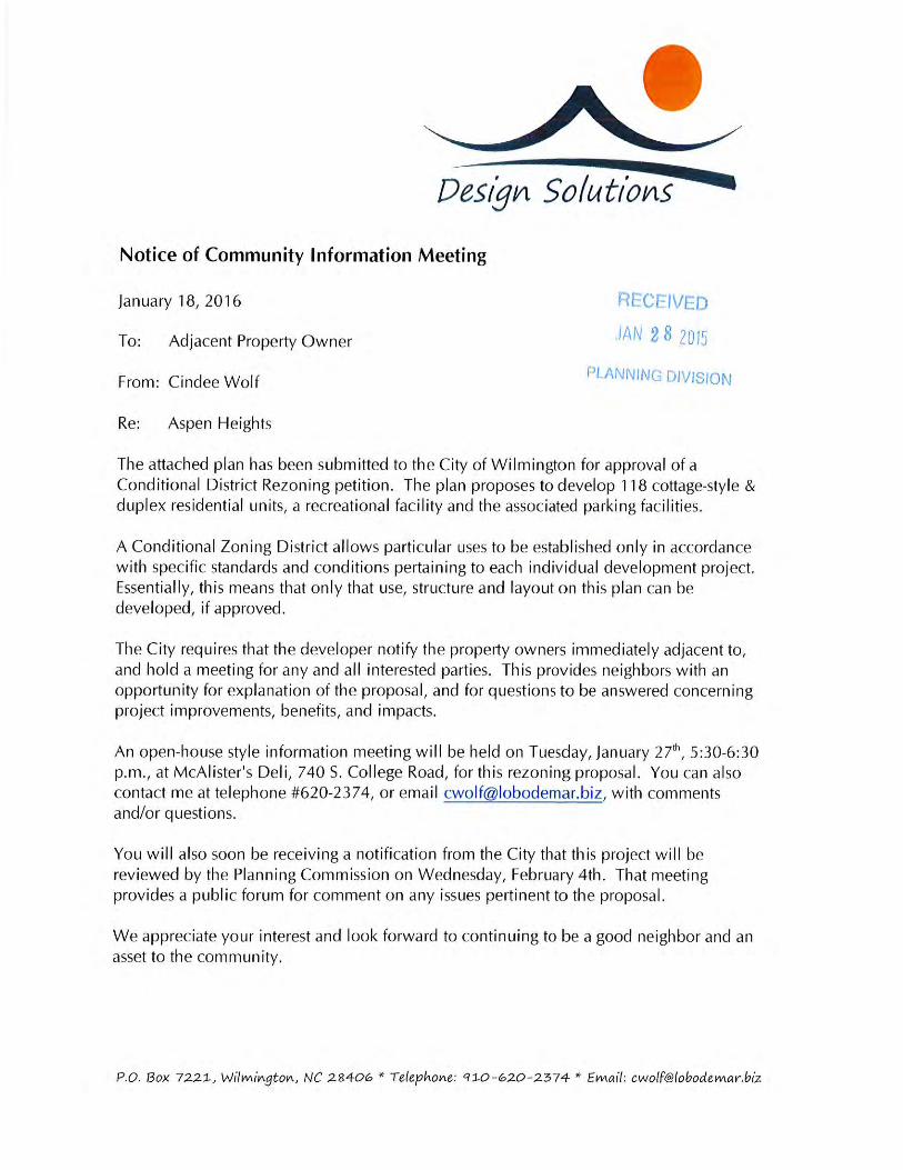
Community Meeting: January 27, 2015 ACTIONS TO DATE Planning Commission PENDING; 2/4/15 City Council PENDING; 3/3/15
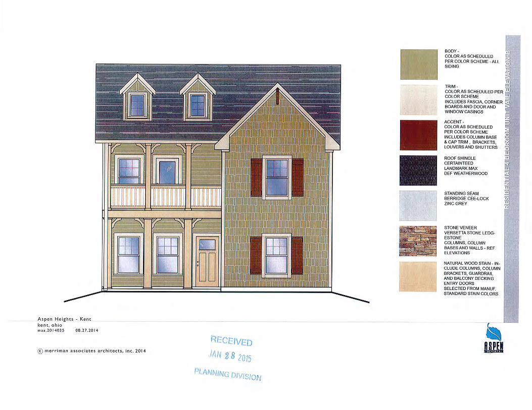
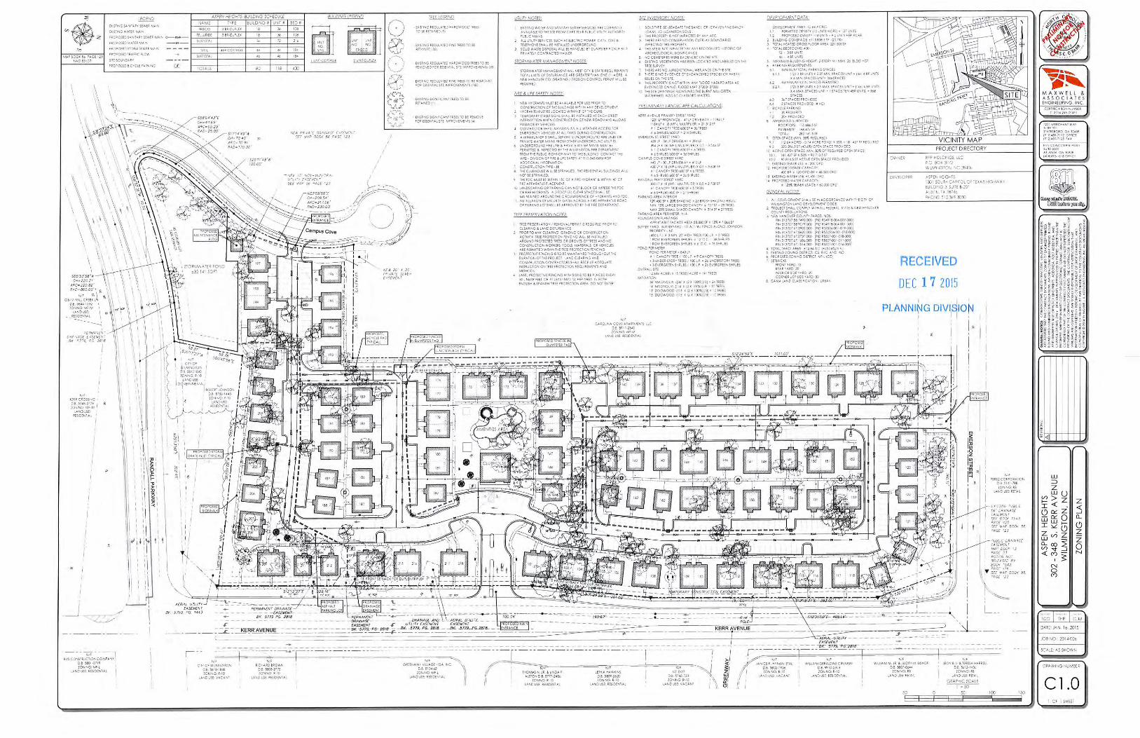
ATTACHMENTS 1. Conditional District Rezoning Application (Dated Received 12/17/14) 2. Location and Land Use Map (Dated 1/22/15) 3. Aerial Map (Dated 1/22/15) 4. Future Land Use Plan Transition Map (Dated 1/22/15) 5. Applicant’s Response to Overcapacity Roads (Dated Received 1/22/15) 6. Community Meeting Report (Dated Received 1/28/15) 7. Proposed Building Elevation (Dated Received 1/28/15) 8. Proposed Site Plan (Dated Received 12/17/14; 1/28/15)


City of Wilmington
CD-9-215
302, 312, 322, 342 & 348 South Kerr
Avenue
1/22/15
Single Family
Multi Family
Utilities
Vacant
Agriculture
Office & Institutional
Site
Mobile Home/Park
Industrial
Commercial
Parks
Cemetery
Attachment 2 – Land Use & Zoning Map
Site
CD-9-215
302, 312, 322, 342 & 348 South Kerr
Avenue
City of Wilmington 1/22/15
Attachment 3 – Aerial Map

Varied Use Area – Large Tract Infill Transition to Commercial and/or Higher Density Residential (Acceptable Transition to Higher Density Residential (Acceptable)
Site
CD-9-215
302, 312, 322, 342 & 348 South Kerr
Avenue
City of Wilmington 1/22/15
Attachment 4 – Future Land Use Plan Map