Cedar Lake Watershed Management Plan Summary The Roadmap for Watershed Protection & Improvement A watershed management plan has been developed for the Cedar Lake Watershed by local stakeholders, riparian landowners, government officials, state agencies and environmental professionals. This plan is part of the dedicated efforts of local stakeholders and was funded in whole by Cedar Lake lakefront property owners. Moving forward, this plan will serve as a roadmap for implementing the projects and approaches that will protect and improve natural resources of the watershed.
Transcript
Cedar Lake Watershed
Management Plan Summary
The Roadmap for Watershed Protection & Improvement
A watershed management plan has been developed for the Cedar
Lake Watershed by local stakeholders, riparian landowners,
government officials, state agencies and environmental
professionals. This plan is part of the dedicated efforts of local
stakeholders and was funded in whole by Cedar Lake lakefront
property owners. Moving forward, this plan will serve as a
roadmap for implementing the projects and approaches that will
protect and improve natural resources of the watershed.
What is a Watershed?
A watershed is the area of land that drains into a particular body
of water. Imagine a bathtub when the shower is turned on. All
the water that falls into the bathtub runs to a single drain. While
watersheds in nature can be a bit more complicated, the same
principle holds. The majority of the land draining to Cedar Lake
is the large cedar swamp on the northwest side of the lake and
residential lots around the lakeshore.
What is Watershed Management Planning?
Watershed management involves two major steps: planning and
implementation. Planning involves identifying and addressing
threats and impairments to water quality and quantity.
Watershed planning is not an exact science. It is an iterative
process that involves evaluating the plan and making
adjustments over time. This plan lays out the framework in
which watershed implementation and evaluation will take place
to tackle and resolve future problems and needs. The
implementation phase involves executing the actual tasks laid
out in the plan.
The Cedar Lake watershed management plan focuses on
protecting natural resources of the watershed for lake enjoyment
and recreation, aesthetic, property values, wildlife, and natural
habitat. A steering committee made up of representatives from
the Cedar Lake Improvement Board, Lake Association, state
and local government, and lake riparians met regularly for two
years to develop this plan. The state and federally approved
plan will be implemented by the Cedar Lake Board and the
public. This booklet summarizes the plan. A full version of the
plan can be downloaded at www.cedar-lake.org.
Stakeholders
Any organization, government entity, or individual that has a stake in or may be affected by a given approach to environmental regulation, pollution prevention, or conservation measures is considered to be a stakeholder. Lakefront property owners, or lake “riparians” are stakeholders. Tax dollars from each riparian paid for this watershed management project. Their efforts have gained the attention of state officials and demonstrate their commitment to Cedar Lake.
Source: EPA Handbook for Developing Plans to Restore & Protect Our Waters (2008).
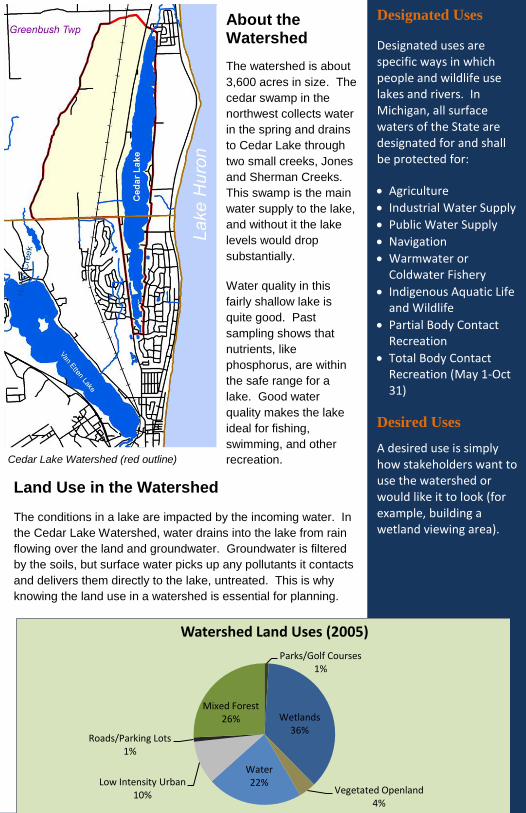
Cedar Lake Watershed (red outline)
Land Use in the Watershed The conditions in a lake are impacted by the incoming water. In
the Cedar Lake Watershed, water drains into the lake from rain
flowing over the land and groundwater. Groundwater is filtered
by the soils, but surface water picks up any pollutants it contacts
and delivers them directly to the lake, untreated. This is why
knowing the land use in a watershed is essential for planning.
Designated Uses
Designated uses are specific ways in which people and wildlife use lakes and rivers. In Michigan, all surface waters of the State are designated for and shall be protected for:
Agriculture
Industrial Water Supply
Public Water Supply
Navigation
Warmwater or Coldwater Fishery
Indigenous Aquatic Life and Wildlife
Partial Body Contact Recreation
Total Body Contact Recreation (May 1-Oct 31)
Desired Uses
A desired use is simply how stakeholders want to use the watershed or would like it to look (for example, building a wetland viewing area).
About the Watershed
The watershed is about
3,600 acres in size. The
cedar swamp in the
northwest collects water
in the spring and drains
to Cedar Lake through
two small creeks, Jones
and Sherman Creeks.
This swamp is the main
water supply to the lake,
and without it the lake
levels would drop
substantially.
Water quality in this
fairly shallow lake is
quite good. Past
sampling shows that
nutrients, like
phosphorus, are within
the safe range for a
lake. Good water
quality makes the lake
ideal for fishing,
swimming, and other
recreation.
Parks/Golf Courses 1%
Wetlands 36%
Vegetated Openland 4%
Water 22% Low Intensity Urban
10%
Roads/Parking Lots 1%
Mixed Forest 26%
Watershed Land Uses (2005)
Key Watershed Concerns & Issues
The steering committee gained input from stakeholders about
major watershed concerns through a survey done by the Alcona-
Iosco Cedar Lake Association. The committee developed a list of
the watershed concerns and gave them a priority ranking (high,
medium, or low). It is important to identify the suspected and
known sources and causes of these pollutants or problems in the
watershed. Once these pollutants or problems are identified, they
can be used to develop a more detailed plan of how to address the
key concerns.
What’s an Impaired
Waterbody?
The State of Michigan is working to assess each waterbody to confirm all designed uses are being met. When a lake or river is not meeting all designated uses, it is “impaired”. An example is when a lake has an outbreak of blue-green algae that prohibits lake users from swimming in the lake. At that point the lake is considered “impaired” for total body contact recreation.
CEDAR LAKE CONCERNS
PRIORITY SUSPECTED SOURCES/ CAUSES
Sediments HIGH Historical organic material
Habitat Loss HIGH Development, filling wetlands, low lake levels
Biota - Fish & Other Wildlife
HIGH Non-native invasives, nuisance aquatic plants in excess
Hydrologic Modification HIGH Drainage/filling of wetlands, stormwater drains, pumping from lake
Recreation HIGH Low water level, nuisance aquatic plants in excess
Wetland Loss HIGH Development, filling wetlands (especially for smaller parcels)
Urbanization/ Development
HIGH Filling wetlands, improper building/driveways, excessive removal of natural vegetation
Nutrients MEDIUM Lawn fertilizers, leaking septic systems, stormwater, leaves
Litter/Yards MEDIUM Dumping leaves/litter into lake
1. Restore and protect warmwater fishery for native fish
2. Maintain balanced and healthy aquatic plants and wildlife
3. Maintain open and clear waterways for recreation
4. Preserve good water quality and minimize muck for recreation
5. Protect groundwater for lake recharge to achieve balanced lake levels
6. Maintain legal lake level by protecting wetland and creek surface inputs
7. Conserve and restore wetland and aquatic habitat
Goals & Objectives The goals set in the watershed management plan are focused
on restoring and protecting the designated and desired uses for
the watershed. Watershed concerns, pollutants and other
issues were taken into consideration when developing these
broad goals.
Watershed objectives were set to outline in more detail how the
watershed goals will be met:
Objective I: Protect critical wetlands identified along the
northwest side of Cedar Lake from drainage or diversion (and loss of wetland function).
Objective II: Prevent additional groundwater loss from the
lake on the southeast side due to storm sewer infrastructure.
Objective III: Pursue augmentation feasibility study to
choose (suite of) lake level management options for implementation.
Objective IV: Improve sport fishery in Cedar Lake through
enhanced lake levels, creek levels, habitat, and wetland protection.
Objective V: Work to stop the spread of invasive, non-
native species to the Cedar Lake Watershed and control existing nuisance species.
Objective VI: Seek ways to improve composition of lake
bottom sediments (determine feasibility of muck reduction).
Objective VII: Continue water quality monitoring of
pathogens and nutrients to protect good water quality and recreational value of Cedar Lake.
Objective VIII: Educate lake riparians about natural
lakescaping, green buffers, and other Best Management Practices (BMPs) that benefit the lake.
Objective IX: Utilize conservation options with local land
conservancy for habitat protection.
Critical Areas
A critical area is a geographic location in the watershed that is contributing a majority of pollutants or has a major impact on water quality or quantity. For watershed management planning, critical areas help reduce the geographic scope of your watershed projects and focus your attention on the most important parts of the watershed that need restoration or protection. Critical areas can range from a severely eroding stream bank that needs to be repaired to a prairie habitat used by an endangered species that needs to be protected.
Critical Areas in the Cedar Lake Watershed
Critical Areas for Protection & Restoration
The steering committee identified specific locations in the
watershed that are high priority for protection. The eight critical
areas listed below were identified and are shown on the map
above.
1) Sherman Creek and its corridor
2) Jones Creek and its corridor
3) Sherman Creek drainage area
4) Kings Corner Culvert - water diversion
5) Lakewood Shores drainage district
6) In-lake habitat
7) Cedar Lake outlet
8) Developed areas along the lakeshore
Spillway
Recommendation
The Steering Committee recognized the aging of the concrete spillway structures on the north end of the lake. The committee determined that future replacement of the structure should be engineered in a way that lake level can be controlled. Being able to fluctuate the lake level will help control flooding and assist in the aquatic plant management program.
Spillway
Recommendations
Add text from WMP here regarding spillway
Implementing Priority Projects & Action Items After assessing the watershed as a whole and identifying
specific critical areas, a strategy on how to meet each of the
watershed objectives was developed. The watershed
management plan has a complete table with each project and
action item, a priority ranking (1-3), key steps to complete,
outcomes, organizations that will be involved, watershed
benefits, technical assistance needed, costs, and potential
funding sources.
A very brief summary of each of the recommended projects and
actions is included here. For more details, see the full
watershed management plan, Attachment D.
Protecting Wetlands 1) Support and implement a wetlands protection ordinance to
protect critical wetlands and their function. (Model language
for an ordinance is included in the plan.)
2) Restore hydrology in NW wetlands (select option from
augmentation pilot recommendations).
3) Acquire property in the NW wetlands (priority is Sherman
Creek drainage area) to protect and restore hydrology and
habitat and create public wetland viewing area/preserve.
Photo Credit: Allegan County Conservation District
Watershed Tip:
What goes on the lawn
goes into the lake! Rain
and lawn irrigation will wash fertilizers and
pesticides into the lake
and can encourage
rapid growth of aquatic plants and algae. Do not
apply these chemicals
within 30 feet of the lake.
Prevent Additional Water Loss to Subsurface Drainage on SE Side of Cedar Lake
1) Hold meetings with county building inspector(s) and other
regulators to ensure residential building codes are enforced
and buildings are constructed in areas above high groundwater
mark.
2) Modify Lakewood Shores Property Owners’ Association
Architectural Standards to ensure homes are built above high
groundwater mark (to avoid flooding issues that will require an
increase in subsurface drainage by Drain Commissioner).
3) Hold workshops to educate homeowners and potential builders
on practices, measures, and techniques that will reduce the risk
of flooding in new and existing homes.
Choose and Implement Lake Level Management Options
A final report on the augmentation pilot project with
recommendations for lake level management strategies will be
complete in 2011. As part of the pilot project, a large
augmentation well was installed and tested to determine whether
groundwater can be pumped and used during dry years to lessen
significant drops in lake level. One implementation project involves
reviewing the report recommendations and selecting the preferred
strategy for restoring hydrology in the watershed and lessening
significant drops in lake level in the future.
Protect and Improve the Cedar Lake Fishery
1) Protect, restore, and/or enhance hydrology of NW wetlands for
fish spawning.
2) Protect wetlands through policy or ordinances and conservation
easements.
3) Pursue and fund recommendations of the fishery management
studies and reports through Lake Board contracts.
4) Continue aquatic plant management and control nuisance
species.
5) Continue relationship with Michigan DNR so walleye stocking
continues on an “as needed” basis.
Fishery
Recommendations
Conduct fish population study
Perform fish habitat surveys
Enhance habitat enhancement (walleye and catfish)
Maintain/increase size and number of adult bass
Re-assess stocking of Redear sunfish for bluegill habitat
Continue walleye stocking
Monitor benefits of spawning benches (and install more if successful)
Control Existing Invasive and Excessive Aquatic Plants and Prevent New Invasions
1) Use the prescriptive and selective plant management agents
and strategies from current Cedar Lake Management Program
to mitigate against cultural and natural disturbances.
2) Improve opportunities for recreation, increase aesthetic
values, and provide improvements in the structure of flora for
critical fish habitat.
3) Target problematic aquatic plants, such as Eurasian water
milfoil, and other nuisance species that that have appeared
more recently.
4) Use aquatic plant and algae surveys as an indicator of general
water quality and the effect on the lake’s fishery.
Muck Removal and Prevention
1) Conduct sediment thickness study and bathymetric mapping
of the lake.
2) Use study results to determine if dredging will be a cost-
effective muck removal option.
3) Work to prevent riparians and others from dumping leaves and
lawn material into lake.
4) Create an incentive program for riparians to adopt good
stewardship practices (e.g., buffer along lakeshore).
Water Quality Monitoring
Collecting water samples and taking lake measurements is an
important part of keeping a lake healthy. Like going to the doctor
for a checkup or taking your car in for regular maintenance,
water quality monitoring can catch early signs that problems
are brewing. Action items for this objective include:
1) Continue participation and involvement with Michigan’s
Cooperative Lakes Monitoring Program.
2) Further develop Lake Association’s E. coli monitoring
program.
3) Continue providing feedback to stakeholders and tailor
education plan to pertinent topics.
More on Muck
Dr. Douglas Pullman served on the Steering Committee and provided information on lake bottom muck. The creation and build up of muck is a complex process. Organic material that falls into or grows in a lake is broken down by micro-organisms. Almost 2/3 of the organic material from trees and plants is broken down in less than a few days. Sometimes the breakdown of this material is slowed and muck starts to accumulate slowly. Studies show that aeration can do little to “jump start” this break down process. In the end, the only way to get rid of muck is to remove or displace it. So keeping leaves and soil from entering the lake is all part of good lake stewardship.
Watershed Tip:
Don’t feed waterfowl.
Nuisance geese and ducks add excess
nutrients to the lake and
can play a role in
swimmer’s itch. Keep tall grass and plants
along the shoreline as a
buffer to deter waterfowl like geese.
Education on Stewardship and BMPs
The development of a Lake Stewards Program that will guide,
educate, and recognize residents for use of BMPs for their
lakefront properties. The program will focus on encouraging
the use of shoreline buffers of native plants, no-mow
practices, avoidance of harmful chemicals, and erosion control
methods.
A second action item is completing a native buffer
demonstration project in a visible area around the lake. This
project will give riparians and lake users a better idea of what
an attractive buffer can look like along with its many benefits.
Land Conservation for Habitat Protection
1) Work with land protection organization or land
conservancy to get voluntary conservation easements on
privately owned parcels in the northwest wetland
2) Explore options to purchase critical areas around Sherman
Creek to permanently protect and manage for fish and
wildlife habitat and hydrology
Healthy Lakes
Natural shorelines with buffers to filter pollutants
Well vegetated to provide shade
Good water quality with low levels of pollutants or excess nutrients
Water clarity remains constant or normal
Relatively low invasive species
Abundant and healthy fish and wildlife
Lake conditions change gradually or naturally over time
Source: Lakeland Alliance, Ontario CAN
Watershed Tip:
Get your septic
system pumped regularly. Besides
avoiding expensive
septic backups,
regular cleanouts can extend the life of
your septic and stop
excess nutrients from
leaking into the lake through
groundwater. It’s
recommended that
you get it pumped out every 3-5 years.
Watershed Costs Estimating the cost of watershed implementation can be
challenging. To get a plan approved at the state and federal level
requires providing the costs of projects and action items. In the
Cedar Lake Watershed these costs will be shared by a number of
stakeholders, including local governments, lake improvement
board, lake association, and riparians that voluntarily change
practices (e.g., townships will spend time and money to get
wetland ordinance passed). Stakeholders will have to work within
existing budgets, but the approved watershed management plan
will make some of the projects eligible for grant funding.
The following is a summary of cost for implementing the
Watershed Management Plan over time. More detailed cost
information is available in the full plan, Attachment D.
Objective I: Wetland Ordinance $5,000-20,000 Restore Wetland Hydrology $100K-500K Protect Sherman Creek Critical Areas $150K-500K Objective II: Building Meetings & Architectural Standards $3,000-10,000 Conservation Easements $1K-2,500/acre Objective III: Lake Level Management Project(s) $150K-500K (some costs may overlap with Objective I) Objective IV: Fisheries Management Tasks (over 5+ years) $26,000 Objective V: Public Education $7,000-12,000 Lake Manager $50K-100K/yr Aquatic Plant Management Program $50,000/yr Objective VI: Sediment Study $10-30K Dredging Project $500K-1M Public Education & Lake Stewards Program $6,500 Objective VII: Public Education $1,000-3,000 Annual Stewardship Activities $300-500/yr Native Buffer Demonstration Project $5,000-10,000 Objective VIII: Public Education & Membership Costs $1,500-3,500 Water Quality Monitoring Program $1K-5K/yr Objective IX: Conservation Easements $1K-2,500/ac Purchase Property for Permanent Protection (overlap Objective I)
[$1K = $1,000, $1M = $1,000,000]
Get Involved!
For more on what you can do and how to get involved, check out: Cedar Lake Association www.cedar-lake.org MSU Extension www.msue.msu.edu Michigan DNR www.michigan.gov/dnr
What’s Next? The Cedar Lake Improvement Board will take the lead on
implementing the Cedar Lake Watershed Management Plan.
But to fully implement the plan and achieve the goals and
objectives, the public will need to get involved. Your
involvement in supporting projects and taking actions on your
property will be vital in improving and protecting the watershed
and Cedar Lake.
The Lake Board will work with other local stakeholder groups,
such as the Lake Association and local governments to tackle
the projects and action items in the watershed management
plan. Starting in the summer of 2011, the Lake Board will start
assigning specific tasks in order to start implementing projects.
A complete schedule for implementation is included in Chapter
7 of the plan. Some of the first priority tasks will be to select
lake level management options from the augmentation pilot
study and start on-the-ground projects.
A watershed management plan is often referred to as a “living”
document. It will be periodically evaluated and updated
throughout the implementation phase. The main purpose of the
plan is to serve as a roadmap to reach the watershed goals.
As some projects are check of the list, others will be added to
address current issues that will ensure the watershed and
Cedar Lake are permanently protected for future generations to
enjoy.
More Resources
The following resources are cited in this brochure: Michigan DEQ, Developing a Watershed Management Plan for Water Quality: An Introductory Guide (February 2000) EPA Handbook for Developing Watershed Plans to Restore & Protect Our Waters (March 2008) Lakeland Alliance, A Shoreline Owner’s Guide to Lakeland Living
Source: EPA Handbook for Developing Plans to Restore & Protect Our Waters (2008)