Company: TETUAN RESOURCES WINN EXPLORATION Well: MARYS RIVER 34-26 Field: WILDCAT County: ELKO State: NEVADA ELKO WILDCAT SHL: 294' FSL & 1631' FEL MARYS RIVER 34-26 TETUAN RESOURCES WINN CEMENT BOND LONG VDL, GR Location: SHL: 294' FSL & 1631' FEL Elev. K.B. 5561.00 ft G.L. 5540.00 ft D.F. 5560.00 ft Permanent Datum: Ground Level Elev.: 5540.00 f County: Field: Location: Well: Company: Log Measured From: Kelly Bushing 21.00 ft above Perm.Datum Drilling Measured From: Kelly Bushing API Serial No. Section: Township: Range: 27-007-05265 26 38N 61E Logging Date 17-Feb-2012 16-Feb-2012 Run Number S2R3 S2R1 Depth Driller 6780.00 ft 6780.00 ft Schlumberger Depth 6787.00 ft 6787.00 ft Bottom Log Interval 2000.00 ft 6787.00 ft Top Log Interval 200.00 ft 1850.00 ft Casing Driller Size @ Depth 9.625 in @ 4095.00 ft 9.625 in @ 4095.00 ft Casing Schlumberger 4092 ft 4092 ft Bit Size 8.75 in 8.75 in Type Fluid In Hole Salt Brine Salt Brine MUD Density Viscosity 8.8 lbm/gal 12 s 8.8 lbm/gal 12 s Fluid Loss PH 6.6 cm3 8.9 6.6 cm3 8.9 Source of Sample Active Tank Active Tank RM @ Meas Temp 0.56 ohm.m @ 75 degF 0.56 ohm.m @ 75 degF RMF @ Meas Temp 0.46 ohm.m @ 75 degF 0.46 ohm.m @ 75 degF RMC @ Meas Temp 0.54 ohm.m @ 80 degF 0.54 ohm.m @ 75 degF Source RMF RMC Calculated Calculated Calculated Calculated RM @ BHT RMF @ BHT 0.17 @ 245 0.13 @ 245 0.17 @ 245 0.13 @ 245 Max Recorded Temperatures 247 degF 247 degF Circulation Stopped Time 16-Feb-2012 06:00:00 16-Feb-2012 06:00:00 Logger on Bottom Time 17-Feb-2012 00:49:44 16-Feb-2012 16:55:35 Unit Number Location: 2211 VERNAL 2211 VERNAL Recorded By Curtis Schaaf Curtis Schaaf Witnessed By Bill Ehni Bill Ehni THE USE OF AND RELIANCE UPON THIS RECORDED-DATA BY THE HEREIN NAMED COMPANY (AND ANY OF ITS AFFILIATES, PARTNERS, REPRESENTATIVES, AGENTS, CONSULTANTS AND EMPLOYEES) IS SUBJECT TO THE TERMS AND CONDITIONS AGREED UPON BETWEEN SCHLUMBERGER AND THE COMPANY, INCLUDING: (a) RESTRICTIONS ON USE OF THE RECORDED- DATA; (b) DISCLAIMERS AND WAIVERS OF WARRANTIES AND REPRESENTATIONS REGARDING COMPANY'S USE AND RELIANCE UPON THE RECORDED-DATA; AND (c) CUSTOMER'S FULL AND SOLE RESPONSIBILITY FOR ANY INFERENCE DRAWN OR DECISION MADE IN CONNECTION WITH THE USE OF THIS RECORDED-DATA. 1. Header 2. Disclaimer 3. Contents 4. Operational Run Summary 5. Borehole Fluids 6. Remarks and Equipment Summary 7. Depth Summary 8. Composite1 8.1 Integration Summary 8.2 Software Version 8.3 Composite Summary 8.4 Log ( Sonic CBL with VDL ) 8.5 Parameter Listing 9. Calibration Report 10. Tail
Transcript
Com
pany:T
ET
UA
N R
ES
OU
RC
ES
WIN
N E
XP
LOR
AT
ION
Well:
MA
RY
S R
IVE
R 34-26
Field:
WILD
CA
T
County:
ELK
OS
tate:N
EV
AD
A
ELKO
WILDCAT
SHL: 294' FSL & 1631' FEL
MARYS RIVER 34-26
TETUAN RESOURCES WINN
CE
ME
NT
BO
ND
LON
G
VD
L, GR
Location:
SH
L: 294' FS
L & 1631' F
EL
Elev.
K.B
.5561.00 ft
G.L.
5540.00 ft
D.F
.5560.00 ft
Perm
anent Datum
:G
round LevelE
lev.:5540.00 f
County:
Field:
Location:
Well:
Company:
Log Measured F
rom:
Kelly B
ushing21.00 ft
above Perm
.Datum
Drilling M
easured From
:K
elly Bushing
AP
I Serial N
o.S
ection:T
ownship:
Range:
27-007-0526526
38N61E
Logging Date
17-Feb-20
1216-F
eb-2012
Run N
umber
S2R
3S
2R1
Depth D
riller6780.00 ft
6780.00 ft
Schlum
berger Dep
th6787.00 ft
6787.00 ft
Bottom
Log Interval2000.00 ft
6787.00 ft
Top Log Inte
rval200.00 ft
1850.00 ft
Casing D
riller Size @
Depth
9.625 in @ 4095.00 ft
9.625 in @ 4095.00 ft
Casing S
chlumberger
4092 ft4092 ft
Bit S
ize8.75 in
8.75 in
Type F
luid In Hole
Salt B
rineS
alt Brine
MUD
Density
Viscosity
8.8 lbm/gal
12 s8.8 lbm
/gal12 s
Fluid Loss
PH
6.6 cm3
8.96.6 cm
38.9
Source of S
ample
Active T
ankA
ctive Tank
RM
@ M
eas Tem
p0.56 ohm
.m @
75 degF0.56 ohm
.m @
75 degF
RM
F @
Meas T
emp
0.46 ohm.m
@ 75 degF
0.46 ohm.m
@ 75 degF
RM
C @
Me
as Tem
p0.54 ohm
.m @
80 degF0.54 ohm
.m @
75 degF
Source R
MF
RM
CC
alculatedC
alculatedC
alculatedC
alculated
RM
@ B
HT
RM
F @
BH
T0.17 @
2450.13 @
2450.17 @
2450.13 @
245
Max R
ecorded Tem
peratures247 deg
F
247 degF
Circulation S
topped T
ime
16-Feb-20
12 06:00:0016-F
eb-2012 06:00:00
Logger on Bottom
Tim
e17-F
eb-2012 00:49:44
16-Feb-20
12 16:55:35
Unit N
umber
Location:2211
VE
RN
AL
2211V
ER
NA
L
Recorded B
yC
urtis Schaaf
Curtis S
chaaf
Witnessed B
yB
ill Ehni
Bill E
hni
THE USE OF AND RELIANCE UPON THIS RECORDED-DATA BY THE HEREIN NAMED COMPANY (AND ANY OF ITS AFFILIATES, PARTNERS, REPRESENTATIVES, AGENTS, CONSULTANTS AND EMPLOYEES) IS SUBJECT TO THE TERMS AND CONDITIONS AGREED UPON BETWEEN SCHLUMBERGER AND THE COMPANY, INCLUDING: (a) RESTRICTIONS ON USE OF THE RECORDED-DATA; (b) DISCLAIMERS AND WAIVERS OF WARRANTIES AND REPRESENTATIONS REGARDING COMPANY'S USE AND RELIANCE UPON THE RECORDED-DATA; AND (c) CUSTOMER'S FULL AND SOLE RESPONSIBILITY FOR ANY INFERENCE DRAWN OR DECISION MADE IN CONNECTION WITH THE USE OF THIS RECORDED-DATA.
1. Header
2. Disclaimer
3. Contents
4. Operational Run Summary
5. Borehole Fluids
6. Remarks and Equipment Summary
7. Depth Summary
8. Composite1
8.1 Integration Summary
8.2 Software Version
8.3 Composite Summary
8.4 Log ( Sonic CBL with VDL )
8.5 Parameter Listing
9. Calibration Report
10. Tail
Date Log Started 16-Feb-2012 17-Feb-2012
Time Log Started 15:26:54 00:51:52
Date Log Finished 16-Feb-2012 17-Feb-2012
Time Log Finished 18:49:29 01:38:38
Top Log Interval ( ft ) 1850.00 200.00
Bottom Log Interval ( ft ) 6787.00 2000.00
Total Depth ( ft ) 6787.00 6787.00
Max Hole Deviation ( deg ) 0.00 0.00
Azimuth of Max Deviation ( deg ) 0.00 0.00
Bit Size ( in ) 8.750 8.750
Logging Unit Number 2211 2211
Logging Unit Location VERNAL VERNAL
Recorded By Curtis Schaaf Curtis Schaaf
Witnessed By Bill Ehni Bill Ehni
Service Order Number BY8P-00016 BY8P-00016
Fluid Type Water Water
Fluid Name Salt Brine Salt Brine
Max Recorded Temperatures ( degF )
247 247
Salinity ( ppm ) 1320 1320
Density ( lbm/gal ) 8.8 8.8
Date Logger on Bottom 16-Feb-2012 17-Feb-2012
Time Logger on Bottom 16:55:35 00:49:44
Total Solid ( % ) 3 3
High Gravity Solids ( % )
S2R1: Remarks S2R3: Remarks
RUN NUMBER 2 RUN NUMBER 3
TOOL RAN AS PER TOOL SKETCH TOOL RUN AS PER TOOL SKETCH
HGNS RAN ECCENTERED WITH BOWSPRI DSLT RUN W/ 2 X CME-Z CENTRALIZERS
AIT RAN ECCENTRALIZED W/ 2 X 1.5" STANDOFFS
LOG SPLICED AT 1950' (CBL-VDL LOG ONLY)
CORRECTIONS: HOLE SIZE AND STANDOF
MATRIX TYPE: STANDSTONE ABOVE 6100', LIMESTONE FROM 6100' TO TD
MDEN = 2.51 ABOVE 6100', 2.71 FROM 6100' TO TD
DSLT RUN W/ 2 X CME-Z CENTRALIZERS
THANK YOU FOR CHOOSING SCHLUMBERGER!
THANK YOU FOR CHOOSING SCHLUMBERGER!
Equip name Length MP name OffsetLEH-QT :2603 6 4.2LEH-Q T:2603
DT C-H:9466 6 1.28EC H-KCDTC -H:9466
T elStatus 58.28T oolStatus 58.28
HV 0.00CT EM 60.38
HGNS-H:3 799 5 8.28HGNH:2795NPV -NNSR-F :5138HA C C Z-H:1614HMC A -HHGNS-H:3799
A ccelerometer
0 .00HGNS 48.88HMCA 48.88
CNL Porosity
51.21
GR 57.54
T emperature
58.26
HDRS-H:3 969 4 8.88EC H-MEBHRC C -H:4863HRMS-H:3969GPV -QLong Spacing:28475HRGD-H:3799Short SpacingGSR-J:5234Backscatter
HRCC 44.88
T LD Density 38.57Caliper 38.96MCFL 39.44
DSLT -H:8156 3 6.63EC H-KHDSLC -H:8156SLS-E:1396
Equip name Length MP name OffsetLEH-QT :2603 36 .42LEH-Q T:2603
DT C-H:9466 33 .5EC H-KCDTC -H:9466
T oolStatus 30.5T elStatus 30.5
HV 0.00CT EM 32.6
HGNS-H:3 799 30 .5HGNH:2795NPV -NNSR-F :5138
GR 29.76
T emperature 30.47
SLS-E 16.00
Lower-Near 19.42
Lower-Far 20.42
Delta-T 21.79
Upper-Far 23.17VDL 5ft 23.17
Upper-Near 24.17CBL 3ft 24.17
A IT -H:295 1 6.00A HIS:295A HRM:295
T emperature
7.91Induction 7.91
Power Supply
7 .91
Head T ension
Mud Resistivity
0 .00SP 0.08
TO O L_ZEROLengths are in ft
Maximum O uter Diameter = 6.625 inLine: Sensor Location, V alue: Gating O ffset
A ll measurements are relativ e to TO O L_ZERO
HA C C Z-H:1614HMC A -HHGNS-H:3799
A ccelerometer
0 .00HGNS 21.09HMCA 21.09
CNL Porosity 23.42
DSLT -H:8156 21 .09EC H-KHDSLC -H:8156SLS-E:1396
SLS-E 0.46
Lower-Near 3 .88
Lower-Far 4 .88
Delta-T 6.25
Upper-Far 7 .62VDL 5ft 7 .62
Upper-Near 8 .62CBL 3ft 8 .62
BNS-ST D 0.46 Head T ensionTO O L_ZERO
Lengths are in ftMaximum O uter Diameter = 4.750 in
Conveyance Type Wireline Wireline
Log Sequence SUBSEQUENT TRIP
Stretch Correction ( ft ) 2.50
Rig Type LAND LAND
Depth Remark 1 ALL SCHLUMBERGER DEPTH PROCEDURES FOLLOWED
Depth Remark 2 IDW USED AS PRIMARY DEPTH MEASUREMENT DEVICE
Depth Remark 3 Z-CHART USED FOR SECONDARY DEPTH CONTROL
Type IDW-B IDW-B
Serial Number 6122 6122
Calibration Date 11-OCT-2011 11-OCT-2011
Calibrator Serial Number 33 33
Calibration Cable Type 7-46A XS 7-46A XS
Wheel Correction 1 -6 -6
Wheel Correction 2 -5 -5
Type CMTD-B/A CMTD-B/A
Serial Number 2054 2054
Calibration Date 04-FEB-2012 04-FEB-2012
Calibrator Serial Number 100518 100518
Calibration Points 10 10
Calibration RMS 15 15
Calibration Peak Error 32 32
Type 7-46A-XS 7-46A-XS
Serial Number 710065 710065
Logging Cable Length ( ft ) 16700.00 16700.00
MaxWell 3.0.9609.0
Application Patch SP-20111012-3.0.9609.1274
EXP_APL-SEC-3.0.9609.1645
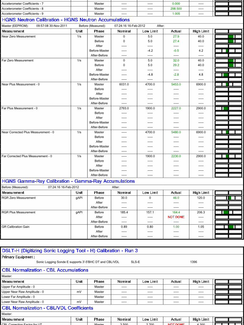
Sonic Cement Evaluation Computation Ensemble provides common Parameters and Channels
CEVAL 3.0.9609.1274
DepthCorrectionDepthCorrection 3.0.9609.1274
HILT Gamma-Ray and Neutron Sonde, 150 degCHGNS-H 3.0.9609.0
Sonic Logging Sonde E supports 3'-5'BHC DT and CBL/VDL
SLS-E 3.0.9609.1274
S2R1 Log[7]:Up Up 200.00 ft 4201.83 ft 16-Feb-2012 6:01:14 PM 16-Feb-2012 6:40:56 PM 0.00 ft false
S2R3 Log[1]:Up Up 200.00 ft 4201.83 ft 17-Feb-2012 1:04:04 AM 17-Feb-2012 1:38:31 AM 0.00 ft false
All depths are referenced to toolstring zero
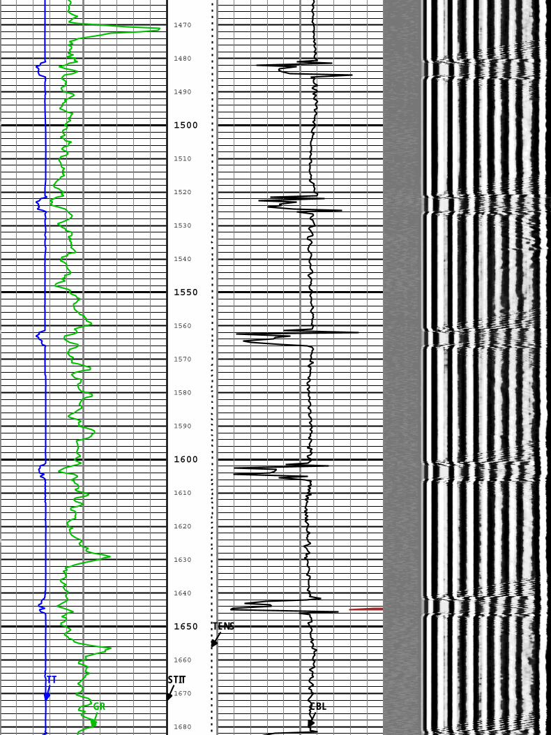
Description: CBL_VDL Format: Log ( Sonic CBL with VDL ) Index Scale: 5 in per 100 ft Index Unit: ft Index Type: Measured Depth Creation Date: 18-Feb-2012 04:16:43 Channel Source Sampling
BIEP DSLT-H[1]:SLS-E[1]:SLS-E[1] 6in
CBL DSLT-H[1]:SLS-E[1]:SLS-E[1] 6in
GR HGNS[1]:HGNS-H[1]:HGNS-H[1] 6in
STIT DepthCorrection 6in
TENS WLWorkflow 1in
TIME_1900 WLWorkflow 0.1in
TT DSLT-H[1]:SLS-E[1]:SLS-E[1] 6in
Gamma Ray (GR) HGNS[1]
0 200gAPI
Transit Time for CBL (TT) DSLT-H[1]
400 200us
CBL Amplitude (CBL) DSLT-H[1]
0 100mV
CBL Amplitude (CBL) DSLT-H[1]
0 10mV
Min MaxAmplitude
Variable Density Log (VDL) DSLT-H[1]
200 1200us
Stuck ToolIndicator,
Total (STIT)
0 50ft
CableTension(TENS)
10000 0lbf
BIEP - Bond Index Event Pips DSLT-H[1]
TIME_1900 - Time Marked every 60.00 (s)
210
220
230
240
260
270
280
290
310
320
330
340
360
200
250
300
350
GR
TT
CBL
STIT
TENS
370
380
390
410
420
430
440
460
470
480
490
510
520
530
540
560
570
580
400
450
500
550
GR
TT
CBL
STIT
TENS
590
610
620
630
640
660
670
680
690
710
720
730
740
760
770
780
790
600
650
700
750
800
GR
TT
CBL
STIT
TENS
810
820
830
840
860
870
880
890
910
920
930
940
960
970
980
990
1010
1020
850
900
950
1000
GR
TT
CBL
STIT
TENS
1030
1040
1060
1070
1080
1090
1110
1120
1130
1140
1160
1170
1180
1190
1210
1220
1230
1240
1050
1100
1150
1200
GR
TT
CBL
STIT
TENS
1260
1270
1280
1290
1310
1320
1330
1340
1360
1370
1380
1390
1410
1420
1430
1440
1460
1250
1300
1350
1400
1450
GR
TT
CBL
STIT
TENS
1470
1480
1490
1510
1520
1530
1540
1560
1570
1580
1590
1610
1620
1630
1640
1660
1670
1680
1500
1550
1600
1650
GR
TT
CBL
STIT
TENS
1690
1710
1720
1730
1740
1760
1770
1780
1790
1810
1820
1830
1840
1860
1870
1880
1890
1700
1750
1800
1850
1900
TENS
1910
1920
1930
1940
1960
1970
1980
1990
2010
2020
2030
2040
2060
2070
2080
2090
2110
2120
1950
2000
2050
2100
GR
TT
CBL
STIT
2130
2140
2160
2170
2180
2190
2210
2220
2230
2240
2260
2270
2280
2290
2310
2320
2330
2340
2150
2200
2250
2300
GR
TT
CBL
CBLSTIT
TENS
2360
2370
2380
2390
2410
2420
2430
2440
2460
2470
2480
2490
2510
2520
2530
2540
2560
2350
2400
2450
2500
2550
GR
TT
CBL
STIT
TENS
2570
2580
2590
2610
2620
2630
2640
2660
2670
2680
2690
2710
2720
2730
2740
2760
2770
2780
2600
2650
2700
2750
GR
TT
CBL
STIT
TENS
2790
2810
2820
2830
2840
2860
2870
2880
2890
2910
2920
2930
2940
2960
2970
2980
2990
2800
2850
2900
2950
3000
GR
TT
CBL
STIT
TENS
3010
3020
3030
3040
3060
3070
3080
3090
3110
3120
3130
3140
3160
3170
3180
3190
3210
3220
3050
3100
3150
3200
GR
TT
CBL
CBLSTIT
TENS
3230
3240
3260
3270
3280
3290
3310
3320
3330
3340
3360
3370
3380
3390
3410
3420
3430
3440
3250
3300
3350
3400
GR
TT
CBL
CBLSTIT
TENS
3460
3470
3480
3490
3510
3520
3530
3540
3560
3570
3580
3590
3610
3620
3630
3640
3660
3450
3500
3550
3600
3650
GR
TT
CBL
CBLSTIT
TENS
3670
3680
3690
3710
3720
3730
3740
3760
3770
3780
3790
3810
3820
3830
3840
3860
3870
3880
3700
3750
3800
3850
GR
TT
CBL
STIT
TENS
3890
3910
3920
3930
3940
3960
3970
3980
3990
4010
4020
4030
4040
4060
4070
4080
4090
3900
3950
4000
4050
4100
GR
TT
CBL
CBLSTIT
TENS
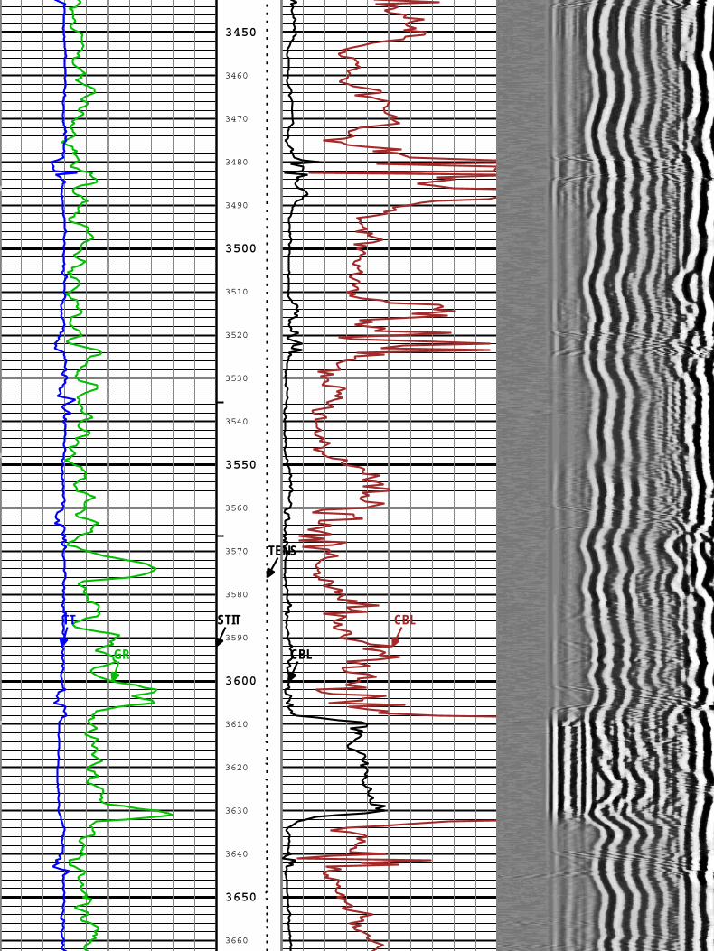
CSG SHOE @ 4092'
4110
4120
4130
4140
4160
4170
4180
4190
4150
4200
Description: CBL_VDL Format: Log ( Sonic CBL with VDL ) Index Scale: 5 in per 100 ft Index Unit: ft Index Type: Measured Depth Creation Date: 18-Feb-2012 04:16:43
Gamma Ray (GR) HGNS[1]
0 200gAPI
Transit Time for CBL (TT) DSLT-H[1]
400 200us
CBL Amplitude (CBL) DSLT-H[1]
0 100mV
CBL Amplitude (CBL) DSLT-H[1]
0 10mV
Min MaxAmplitude
Variable Density Log (VDL) DSLT-H[1]
200 1200us
Stuck ToolIndicator,
Total (STIT)
0 50ft
CableTension(TENS)
10000 0lbf
BIEP - Bond Index Event Pips DSLT-H[1]
TIME_1900 - Time Marked every 60.00 (s)
S2R1: Parameters
Auxiliary Minimum Sliding GateAMSG DSLT-H:SLS-E:SLS-E 336 us
Barite Mud Presence FlagBARI Borehole No
Borehole Status (Open or Cased Hole)BHS Borehole Open
Bit SizeBS COMPLETION 8.75 in
CALI Supplementary OffsetCALI_SHIFT HDRS-H:HRCC-H:HRCC-H 0.3 in