23
Colorado Department of Public Health and Environment Hazardous Materials and Waste Management Division 4300 Cherry Creek Drive South, B2 Denver, CO 80246-1530 303-692-3373

Colorado Department of Public Health and Environment Hazardous Materials and Waste Management Division
4300 Cherry Creek Drive South, B2 Denver, CO 80246-1530
303-692-3373

- 1 -
Central City/Clear Creek Community Involvement Plan Update SECTION 1 Background This Community Involvement Plan revision for the Central City/Clear Creek Superfund Site (Site) is intended to reflect the changes, both actual and as perceived by the community, since the original 1989 plan was last revised in September 2009. This Central City/Clear Creek Community Involvement Plan (CIP)* has been prepared pursuant to Sections 113(k)(13)(i-v) and 117 of the Comprehensive Environmental Response, Compensation and Liability Act of 1980 (CERCLA), as amended by the Superfund Amendments and Reauthorization Act of 1986 (SARA) and in accordance with the current U.S. Environmental Protection Agency (EPA) Superfund guidance, including the Superfund Community Involvement Handbook (2005). The handbook outlines the community involvement requirements of CERCLA and regulations that interpret the Superfund legislation, i.e., the National Oil and Hazardous Substances Pollution Contingency Plan (NCP). Once the Site has been listed on the National Priorities List (NPL) for Superfund, community involvement efforts become an integral part of Site activities. The Site was originally listed on the NPL September 8, 1983. The Superfund Study Area covers the 400-square-mile mine drainage basin of Clear Creek, which includes parts of Clear Creek and Gilpin counties. The water quality of the watershed is compromised by metals contamination from historic mining operations. The Site, originally made up of five mines, was modified to encompass the entire basin as its study area in 1998. For the first two Records of Decision (RODs), the EPA was the lead agency. For RODs 3 and 4, the state assumed the lead. This Community Involvement Plan, based on community interviews, describes the community involvement and public participation program developed for the Central City/Clear Creek Superfund Site by the EPA and the Colorado Department of Public Health and Environment (CDPHE). The original plan was developed by the EPA in 1987; a new plan was produced by the state again in June 1989, followed by a broad communications strategy in November 1990. The plan was revised by the state in 1994 and again in 2004 and 2009. The current revision was triggered by the Five Year Review of the whole Site. Purpose The purpose of community involvement is to provide opportunities for the community to learn about the Site, to provide the public adequate opportunities for public involvement in remediation decisions and to determine, based on community interviews and other relevant information, appropriate community involvement *An acronym list appears in Appendix F.

- 2 -
activities. The community interviews form the foundation for developing the most effective means of disseminating information to the community. Objectives of the Community Involvement Plan
To ensure communication among the community, EPA and CDPHE
To develop and maintain open communication with community leaders and any other interested or affected groups
To provide appropriate opportunities for the community to learn about the Central City/Clear Creek Superfund Site and to inform community members about the environmental remediation actions and administrative matters at the various locations within the Site
To ensure appropriate opportunities for public involvement and to receive feedback from the community
To identify and monitor community concerns and information needs SECTION 2 Site Location and Description Since this Site was listed on the NPL in 1983, focus has shifted from the original task of dealing with five specific mining tunnels, recommending passive water treatment (Phase I, Record of Decision (ROD) 1). A second ROD addressed the waste piles of those five tunnels. In both of those efforts, EPA was the lead agency. Phase II of the project included reassessing the Site using a watershed approach and included the Phase II the Remedial Investigation/Feasibility Study (RI/FS). The Operable Unit 3 (OU3) ROD calls for remediation of the Argo Tunnel and approximately 20 waste piles, as well as an assessment of private drinking water wells in the area, with the state of Colorado in the lead role. The Operable Unit 4 (OU4) ROD called for the treatment of contaminated mine discharges and remediation of mine waste rock piles and tailings through erosion control, capping or removal. The remedial actions for Operable Unit 4 was initiated in 2007. Sediment dams and other water-control structures were constructed in Russell and Nevada gulches. Additionally, the state acquired a mining-impacted property in 2008 for the purpose of constructing a Site-wide mine waste repository. The repository was constructed to consolidate and manage mine waste rock and tailings on-site, opposed to transporting the wastes off-site to a landfill. In 2012, CDPHE constructed a mine drainage pipeline to convey historic mine drainage and mining-impacted water to the site of a future water treatment plant. The Quartz Hill Tailings Pile was stabilized during the summer of 2014. In 2010-2013, CDPHE and EPA implemented certain components of the OU4 ROD (e.g., removal of mill tailings, sediment reduction measures and preparation for a future water treatment facility site) by funding CDOT to construct these three projects while constructing the State Highway 119 Main Street South Project.

- 3 -
Despite the significant progress made, remedial actions are not complete at this Site. An active water treatment plant to treat discharges from the Gregory Incline, National Tunnel and Gregory Gulch is on hold due to the uncertainty of ongoing water use negotiations. A flow-through bulkhead, considered under OU3 for the Argo Tunnel to eliminate future surge events, will be constructed in 2014. Site History Joint remediation efforts on this Site have been cooperative between EPA and CDPHE, regardless of which agency has had the lead on a particular aspect of the project. Much has changed in the area since the original Site investigation in 1983. In November 1990 limited stakes gambling was approved by Colorado voters for the towns of Black Hawk and Central City, both in Gilpin County. Relying increasingly on a tourism, rather than a mining economy, Gilpin County began low-stakes gaming in October 1991, and much of the property in those towns was bought for casino development and related uses, such as parking, administrative offices, etc. Land, which had been held by families for years, or which had been bought with a view toward future reprocessing of mine tailings, increased in value many times over, as did property taxes. Relatively unusable parcels of land within the gaming district were reassessed, and in some cases the new taxes were prohibitive for the owner, even though there was no perceived market for the property at the new price. Over the years since, large casinos have come to dominate Black Hawk, while many smaller casinos, in some cases preserving the original store fronts, are more the norm in Central City. As the economy shifted quickly toward gaming, local community shops and services, many in buildings from the early 1900s, were rapidly converted to casinos, and the characteristics of the historic mining towns changed dramatically. In 2008, voters approved Amendment 50, which allowed the gaming towns of Black Hawk, Cripple Creek and Central City to vote to keep casinos open 24 hours a day, seven days a week, increase the betting limit to $100, and to add roulette and craps to the previously allowed poker, black jack and slot machines. Citizens of the three towns voted overwhelmingly for the change, which took effect July 1, 2009, further changing the character of Black Hawk, in particular.
The results of increased land values also affected the Superfund process in the area. Casino developers eagerly excavated soil and rock, removed tailings, and rerouted water in consultation with state and EPA project staff to make room for the ancillary services they needed. Roadways were expanded, and Black Hawk and Central City experienced a building boom. The state proposed that a consortium of town and Gilpin County officials draft procedures and criteria for property development that would be provided to individuals along with their building permits, informing them about the Superfund cleanup and the problems and legal liabilities in moving contaminated soils.

- 4 -
A step-by-step document developed with the assistance of the state became an ordinance for the town of Black Hawk in 1993. Soil metals concentrations were taken from that document and now are used as a standard in Gilpin County. Central City adopted the soil concentration levels via a City Council resolution. Because visitors taking State Highway 119 must drive through Black Hawk to get to Central City, the Central City Business Improvement District spearheaded the construction of the Central City Parkway to take cars directly to Central City from I-70 at exit 243. The 8.4-mile, four-lane highway cost an estimated $38 million, and was built through a combination of private funding and bonds. The parkway opened in November 2004. Search for Potentially Responsible Parties (PRPs) As with many Superfund sites, the question, “who is responsible,” is difficult. Investigations to identify PRPs seek to find out whether property has a financially viable owner to bear the costs of necessary cleanup. Are the owners of problematic former mining sites liable, even if they did nothing to contribute to the contamination? Should anyone be surprised that the ground is laden with minerals in the Colorado Mineral Belt? At all stages of work on theses sites, some local residents have said that the Superfund process, devised for industrial sites, is not appropriate for mining sites. Early on, residents required convincing that the metals in the soil could potentially cause human health problems, such as learning and behavioral deficits in children and other neurological problems continuing into later life. The desire for historic preservation sometimes clashed with cleanup proposals, and it was important to avoid interfering with tourist activities and traffic whenever possible. No PRPs were identified in Phase I. In Phase II and following phases, EPA and the state have treated each property individually, location by location. Developers and some mining companies conducted their own cleanups, approved by the state and EPA, using their own funds. Site Description The Site is about 30 to 40 miles directly west of Denver. The Site name refers to the town of Central City and the Clear Creek watershed. Because the two Colorado counties involved are Clear Creek and Gilpin, some of those interviewed previously have said that the site name was a source of some confusion. Elevations at the Site range from about 5,700 feet at the Golden gauging station to more than 14,000 feet along the Continental Divide. Average annual precipitation ranges from less than 15 inches per year in the foothills to more than 40 inches in the high mountains. The basin is drained by Clear Creek, which has three major tributaries, the South Fork, West Fork and North Fork.

- 5 -
Figure 2

- 6 -
Clear Creek water is used for recreational, industrial, agricultural and municipal purposes. Most of the water appropriations occur between Idaho Springs and Golden. A number of Colorado cities (Georgetown, Idaho Springs, Black Hawk, Arvada, Golden, Northglenn, Thornton and Westminster) use Clear Creek water or water from tributaries of Clear Creek for public purposes. Recreational use includes fishing, kayaking, rafting, picnicking, camping and hiking. Ground water in the Clear Creek basin is found in alluvial aquifers along streams, and in shallow fractures, faults and joints that form the fractured bedrock aquifer. The extensive network of mine workings throughout the area provides preferred pathways for ground water. Vegetation includes Ponderosa pine, juniper and mountain mahogany grasslands on south facing slopes and lower elevations, with Douglas fir communities established on north-facing slopes and at higher elevations. Aspen groves are interspersed, and valley bottom vegetation includes blue spruce, narrow-leaf cottonwood, with willow and river birch at the edge of the floodplains. Alpine tundra is found above the 11,800-foot timberline. Site Study Organization Central City/Clear Creek was proposed for the National Priorities List in 1982, and was listed in 1983. At that time the focus was on five mine tunnels: the Gregory Incline and the National (near the Black Hawk), the Argo and the Big Five in Idaho Springs, and the Quartz Hill near Central City, plus a remedy for potential surge events at the Argo tunnel near Idaho Springs. The five mine tunnels were classified as Operable Unit (OU) 1, and its Record of Decision was signed in September 1987. The ROD called for passive treatment of mine discharges as the preferred remedial alternative, if passive treatment could be shown via treatability studies to be effective. The ROD allowed the flexibility to install active and passive treatment systems in combination, if necessary. Passive treatment was tested in a project with the Colorado School of Mines in constructed wetlands at the Big Five Tunnel in Idaho Springs and at the Burleigh tunnel with a large pilot-scale test. The results showed that passive treatment at the Burleigh was not practical. Subsequently, pilot test results paired with data from other aspects of the project showed that the Burleigh’s contribution to elevated metals in Clear Creek (zinc, lead and manganese being of greatest concern) was not as significant as originally thought. A no action remedy was selected as part of OU3. The Operable Unit 2 (OU2) remedy, which addressed the waste piles adjacent to the five original tunnels, was established by a Record of Decision signed in March 1988, calling for run-on and run-off controls and slope stabilization of the mine tailings and waste rock piles.

- 7 -
Originally OU3 was intended to address surge events at the Argo tunnel. Its Record of Decision was delayed pending the outcome of what became the Phase II Remedial Investigation/Feasibility Study (RI/FS), which looked at the Site using a watershed approach. Several additional waste piles were selected for remediation, along with the five original tunnels. The need for OU4 was identified in the OU3 ROD and was developed specifically for the North Fork of the Clear Creek sub-watershed. The OU4 remedial actions address contaminated surface water, ground water and sediment. The cleanup strategies address threats through the capping or removal of waste piles and treatment of point and non-point sources of surface water contamination. Potential Risks The threat to public health and the environment at the site derives from heavy metals liberated by mining and the effects of acid mine drainage (AMD) into Clear Creek. The metals of primary concern for aquatic life include aluminum, arsenic, cadmium, chromium, copper, manganese, silver and zinc. The metals of primary concern for human health are arsenic and lead. Ingested lead can delay and impede neurological growth in children from birth to 72 months. Exposure to high amounts of lead can be responsible for reductions in gross intelligence and for other neurological deficits. Although in extreme cases action may be taken to purge lead from the body, the primary recommendation to reduce effects in humans is to remove the source of the lead. Lead can cause many symptoms, including fatigue, paleness, irritability, loss of appetite, sleep disturbance, behavior change, kidney damage and abdominal pain. Symptoms of arsenic exposure include both carcinogenic (cancerous) and noncarcinogenic effects associated with long-term low-level exposures to arsenic. The effects include lung cancer (through inhalation), skin cancer (through ingestion), non-cancerous skin lesions, peripheral nervous system effects and cardiovascular changes. There also is an association between ingestion of inorganic arsenic and lung, liver, kidney and bladder cancers. In parts of the study area, drinking water from private wells was of concern and, as part of OU3, EPA and CDPHE offered to test wells at no charge and to provide bottled water as a short-term solution if water was not drinkable. Beginning in 1994, 60 homes were tested, and four were found to have water significantly contaminated by metals from the Site. Those four homes received bottled water at no charge until August 2003, when reverse osmosis and other water treatment systems were installed at three homes, and one home was connected to a municipal water supply. No one is being supplied with bottled water currently. Danger from falls into open mine shafts also was mentioned as a human health risk in the 2004 interviews. Problems with abandoned mines are neither in the scope of EPA

- 8 -
nor CDPHE and are addressed to the Division of Reclamation, Mining and Safety (DRMS) in the Colorado Department of Natural Resources (DNR). Under an interagency agreement with CDPHE, DRMS closed four mine adits that are located at mine waste piles where CDPHE is or has implemented erosion-protection measures. The State Historical Preservation Office provided coordination and concurrence. These closures were completed in summer 2009. Heavy metals present a significant risk to aquatic species. Zinc concentrations consistently exceed aquatic-life criteria at many locations in the basin, and copper, cadmium and manganese concentrations frequently exceed standards in specific stream segments. Contamination also poses a threat to macroinvertebrates, the small insects that are a food source for fish. The water quality in some sections of Clear Creek and its tributaries may be lethal to some species of macroinvertebrates, and acute (short-term) effects can be expected in some areas. Other areas have chronic effects that result in less population diversity than would be expected without mining impacts. Community Background Clear Creek and Gilpin counties historically had mining as the basis of their economies, with a lesser emphasis on ranching. Gold was discovered near Idaho Springs in 1859 and in the Black Hawk/Central City area in 1860. For the next 20 years, the Black Hawk/Central City area was the leading mining center in Colorado with the construction of mills to process the gold and silver found through placer and hard rock mining. The decline of mining in the area began with the silver crash in the 1890s and the rise of mining in Leadville. However, mining continued to be an important industry in Clear Creek and Gilpin counties from the turn of the century until approximately 1950. Since 1950, mining in the area has been limited, with only a handful of mines currently operating. Tourism and recreation have become an increasingly important part of the counties’ economies. Clear Creek County Clear Creek County is located 35 miles west of Denver on Interstate 70. The U.S. Census Bureau estimates the 2013 population at 9,031, while the Colorado State Demography Office puts the 2013 estimate at 9,029, making Clear Creek County the state’s 39th most populous county. Major towns include the county seat of Georgetown (population: 3007), Idaho Springs (population 1,717), Empire (population 282) and Silver Plume (population 170). The population is predominately Caucasian, with Hispanics, American Indians and Asians forming the largest minority groups. The population is split evenly between males (51.7 percent) and females (48.3 percent). The Bureau of Economic Analysis estimates the 2012 per capita personal income to be $60,556. Tourism and retail
- 9 -
services play a significant role in the county’s economy, particularly in Idaho Springs and Empire. Gilpin County Gilpin County is a rural community in Colorado’s high country, neighboring the Continental Divide less than an hour west of downtown Denver. It is the state’s second-smallest county in geographical area, and ranks 50th in population out of Colorado’s 64 counties. The U.S. Census Bureau estimates the 2013 population at 5,601, while the Colorado State Demography Office estimates the 2013 population at 5,588. Major towns are the county seat of Central City (population: 663) and Black Hawk (population 118). The population is predominately Caucasian, with Hispanics and American Indians forming the largest minority groups. Males outnumber females only slightly. The Bureau of Economic Analysis estimates the 2012 per capita personal income to be $44,375. The most recent statistics available showed adjusted gross proceeds from gaming of $553,082,797 in Black Hawk for 2013, and $67,592,801 in Central City in the same year. Community Issues and Concerns During the early years much of the planning and development for this Site was discussed and developed with the assistance of a Technical Review Committee consisting of local residents and mining professionals committed to improving the watershed. A later group, which received an EPA Technical Advisory Group (TAG) grant, was referred to as the Watershed Advisory Group. Their guidance, input and time commitment should be acknowledged as an essential part of the development of sound and practical clean-up plans. At this time there is no active Community Advisory Group (CAG) for the Site. The Upper Clear Creek Watershed Association (UCCWA), which meets monthly, is an active forum in which project issues are discussed. Many watershed stakeholders and opinion leaders participate in this group, and it has been a sounding board for clean-up possibilities for Superfund site projects. Updates are provided frequently by the state and EPA. The Clear Creek Watershed Foundation (CCWF) also is a major clearinghouse of information. The organization operates under an action memorandum from EPA, designating the foundation as a Good Samaritan Action Agent. With funding from EPA, the U.S. Forest Service and the state’s Water Quality Control Division, the foundation has conducted a number of small clean-up projects that have had a positive effect on water quality in Clear Creek. Since 2009, CCWF has hosted the Clear Creek Watershed Festival, an annual public education and outreach fair. EPA and CDPHE have participated during most years of the event.
- 10 -
Historic Issues It appears that there has always been competition between Gilpin and Clear Creek counties. In the early phases of this project, some Gilpin County residents felt that undue attention was paid to Clear Creek issues, at their expense. The easy access to some Clear Creek destinations that can be seen from I-70 may have given that county more ability to attract tourists than Gilpin County, which was reachable only by Highway 119, a moderately twisting mountain road, until the Central City Parkway was opened in November 2004. In the early years of this project, there was lively debate over whether the habitat in the North Fork of Clear Creek itself could ever support fish and whether or not it was worth cleaning up in terms of cost/benefit. It was doubtful that a trout fishery could be established. That debate continued, both in the community and within the regulatory agencies, over many years, until a Remedial Investigation/Feasibility Study was conducted for OU4 (North Fork of Clear Creek), beginning in 2000. Findings showed that with cleanup of mine waste piles and sediment reduction, it is anticipated that fish could at least survive in the North Fork, if not breed there. The proposed plan was made available to the public July 23, 2004 and proposed combined active and passive water treatment with sediment reduction in the tributaries and the North Fork of Clear Creek itself. Several public meetings were held to present the proposed alternatives to citizens and elected officials in July and August 2004. Another public meeting was held in January 2010 to present EPA and CDPHE’s proposal to amend the OU4 ROD to change the location of active water treatment for the Gregory Incline and Gregory Gulch water and to replace passive treatment at the National Tunnel discharge with active treatment. A ROD amendment was finalized in April 2010. Remedial construction projects in OU4 focused on mine waste remediation and sediment control, including consolidation of mine wastes at the Church Placer Repository. During 2014, capping and stabilization of the Quartz Hill Tailings Pile in Central City was completed. The only remaining uncompleted projects in OU4 are construction of an active water treatment plant for the North Fork of Clear Creek and the construction of a bulkhead in the Argo Tunnel. Due to the uncertainty of ongoing water rights negotiations with the City of Black Hawk and Gilpin County, construction of the North Clear Creek mine water treatment plant is on hold. CDPHE and the EPA will issue an Explanation of Significant Differences for the Argo Tunnel Discharge Flow Control Bulkhead. The bulkhead will not change the performance of the existing treatment technology or function of the Argo Tunnel Water Treatment Plant in Idaho Springs. The bulkhead will prevent future surge events from impacting Clear Creek and control flow volume to the plant, resulting in reduced treatment costs.

- 11 -
Project Perception During the summer of 2014 community involvement professionals from CDPHE and EPA interviewed a cross section of community members including public officials, watershed activists, a wastewater treatment plant operator and a business owner. Interview questions appear in Appendix B. The information obtained through community interviews represents the interviewee’s opinions, concerns and preferences, regardless of whether the responses are factually accurate or technically correct. Comments, while sometimes quoted exactly, are not attributed to individuals in order to promote candor. People interviewed seemed to have a positive attitude about the project, although many expressed concern that more could be done. Information Transfer Several interview subjects commented that project communication from the agencies has been lacking recently, largely because there was no Update Fact Sheet published during 2013. A 2014 edition is in the works. Citizens in both counties read the Denver Post and their local county weeklies, including the Clear Creek Courant, the Mountain-Ear and the Weekly Register-Call. More and more people are getting the majority of their general information from the Internet. Much of the stakeholder information comes through the Upper Clear Creek Watershed Association and the Clear Creek Watershed Foundation, and people value the ongoing contacts with CDPHE and EPA project managers. Summary of Most Frequent Comments 1. Many of the people we spoke to were concerned that the agencies would declare the project completed prematurely. Several people spoke of the need to stabilize or remove additional waste rock piles in OU4. 2. Many interview subjects stressed the importance of completing the proposed North Clear Creek Water Treatment Plant, while acknowledging that there were significant issues to overcome during water use negotiations. 3. UCCWA members who have been involved with the project for many years expressed satisfaction with how much has been accomplished, yet remain concerned about the 2003 decision to change the selected remedial action for the Burleigh Tunnel from passive treatment to no action. Stakeholders also cited several discharging mines that add metals load to Clear Creek. 4. Asked about project impacts on the surrounding community, many people cited positive effects, including:
An improved tourism and recreation economy with thriving rafting and fishing industries, as well as greater use of the trail system;

- 12 -
Better drinking water quality affecting 300,000 people in Clear Creek, Gilpin and Jefferson counties, along with lower costs of treating water for public supplies;
Increased awareness of Clear Creek as an environmental resource; and
Increased property values, including previously unusable properties that now are both usable and valuable.
One respondent said: “Colorado Parks and Wildlife now views Clear Creek as an important resource... It’s a highly valued sport fishery; a robust, reproducing brown trout fishery with a proximity to a major metropolitan area, which increases its value.” Highlights of the CIP/Recommendations
Project managers should continue to attend UCCWA meetings to brief the membership and should continue to provide informal updates to UCCWA, the CCWF and local officials as needed.
Community involvement staff should continue to publish an annual fact sheet detailing milestones from the previous construction season and plans for the upcoming construction season.
Staff should continue to update the CDPHE and EPA websites.
The agencies should distribute e-mail updates to UCCWA, CCWF, local officials and other stakeholders as needed.
Community involvement staff should send project updates, fact sheets and other materials to the media, as well as to the public.
Community involvement staff should make courtesy calls to the local media as appropriate.
- 13 -
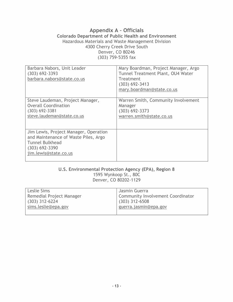
Appendix A – Officials Colorado Department of Public Health and Environment
Hazardous Materials and Waste Management Division 4300 Cherry Creek Drive South
Denver, CO 80246 (303) 759-5355 fax
Barbara Nabors, Unit Leader (303) 692-3393 [email protected]
Mary Boardman, Project Manager, Argo Tunnel Treatment Plant, OU4 Water Treatment (303) 692-3413 [email protected]
Steve Laudeman, Project Manager, Overall Coordination (303) 692-3381 [email protected]
Warren Smith, Community Involvement Manager (303) 692-3373 [email protected]
Jim Lewis, Project Manager, Operation and Maintenance of Waste Piles, Argo Tunnel Bulkhead (303) 692-3390 [email protected]
U.S. Environmental Protection Agency (EPA), Region 8
1595 Wynkoop St., 80C Denver, CO 80202-1129
Leslie Sims Remedial Project Manager (303) 312-6224 [email protected]
Jasmin Guerra Community Involvement Coordinator (303) 312-6508 [email protected]

- 14 -
Federal Elected Officials
Senate House of Representatives Second Congressional District
Mark Udall Hart Office Building, Suite SH-730 Washington D.C. 20510 (202) 224-5941 1-877-768-3255 (CO residents only) Denver Office 999 Eighteenth Street, Ste. N1525 Denver, CO 80202 (303) 650-7820 [email protected]
Mike Bennett 458 Russell Senate Office Building Washington, DC 20510 (202) 224-5852 Denver Office 1127 Sherman St., Suite 150 Denver, Colorado 80203 (303) 455-7600 [email protected]
Jared Polis 1433 Longworth House Office Building Washington, DC 20515 (202) 225-2161 Boulder Office 4770 Baseline Drive #220 Boulder, CO 80303 (303) 484-9596
State Elected Officials
State Senate District 16
State House of Representatives District 13
Senator Jeanne Nicholson (303) 866-4873 [email protected]
Representative KC Becker (303) 866-2578 [email protected]

- 15 -
County Elected Officials
Clear Creek County Gilpin County
Tom Hayden, (D-2), Commission Chair Tim Mauck, (D-1), Commissioner Phil Buckland, (D-3), Commissioner
Clear Creek County Courthouse Box 2000 Ph: (303) 679-2312 Fax: (303) 679-2440
Gail Watson, (D-3), Commission Chair Connie McLain, (D-2), Commissioner Buddy Schmalz, (D-1), Commissioner Gilpin County Courthouse P.O. Box 366 203 Eureka Central City, CO 80427 (303) 582-5214 (303) 582-5440 (fax)
City Officials
Black Hawk Central City
David Spellman, Mayor Jack D. Lewis, City Manager Linda Armbright, Alderman Paul G. Bennett, Alderman Jim Johnson, Alderman Hal Midcap, Alderman Greg Moates, Alderman Benito Torres, Alderman City of Black Hawk P.O. Box 68 Black Hawk, CO 80422 (303) 582-5221 (303) 582-0429 (fax)
Ron Engels, Mayor Vacant, City Manager Bob Spain, Councilman Shirley Voorhies, Councilwoman Gloria Gaines, Councilwoman Kathy Heider, Councilwoman Central City City Hall P.O. Box 249 Central City, CO 80427 (303) 582-5251 (303) 582-5817 (fax)

- 16 -
City Officials, continued
Georgetown Idaho Springs
Craig Abrahamson, ex officio Mayor Tom Hale, Town Administrator Selectmen Craig Abrahamson, Police Judge Keith D. Holmes, Ward I Henry Ehrgott, Ward I Bob Smith, Ward II, Police Judge pro tem Lynette Kelsey, Ward II James Billingsley, Ward III Ed Hoover, Ward III Town Hall 406 6th Street P.O. Box 426 Georgetown, CO 80444 (303) 569-2555 (303) 569-2705 (fax)
Michael Hillman , Mayor Phyllis Adams, City Administrator Council Members Marilyn Anderson, Ward I Denise Deese, Ward I Kate Collier, Ward II Deloris Munchiando, Ward II Robert Bowland, Ward III Lisa Highley, Ward III City of Idaho Springs P.O. Box 907 Idaho Springs, CO80452-0907 (303) 567-4421 (303) 567-4955 (fax)

- 17 -
Appendix B – 2014 Interview Questions What do you know about the Central City Clear Creek Superfund Site? What cleanup activities are you aware of involving the site? What is your overall impression of the cleanup? What impact, if any have the cleanup operations had on the surrounding community? Do you have any concerns about the cleanup? Have you been satisfied with communication and coordination relating to the cleanup? Have you asked for information? Where did you go or who did you ask, and what information did you get? Where do you get your news and information? Can you recommend other people we should talk to? Do you have anything to add?

- 18 -
Appendix C – Media
Canyon Courier 27902 Meadow Drive #200 Evergreen, CO 80439 www.canyoncourier.com Doug Bell, Editor 303-350-1039 Ian Neligh, Clear Creek Editor 303-567-4491
KCNC - CBS4 1044 Lincoln Street Denver, CO 80203 303-861-4444 www.cbs4denver.com Mountain Bureau Jeff Todd, Reporter
Clear Creek Courant 1634 Miner Street PO Box 2020 Idaho Springs, CO 80452-2020 www.clearcreekcourant.com Ian Neligh, Clear Creek Editor 303-567-4491 Doug Bell, Editor 303-350-1039 Fax 303-567-0520
KUSA – 9NEWS 500 Speer Blvd. Denver, CO 80203 303-871-1491 www.9news.com Mountain Newsroom Nick McGurk
Denver Post 1560 Broadway Denver, CO 80202 www.denverpost.com 303-954-1201 [email protected]
The Mountain-Ear P.O. Box 99 Nederland, CO 80466 www.themountainear.com Linn Hirshman, Editor [email protected]
Golden Transcript 1000 10th St. Golden, CO 80401 fax 303-279-7157 Mikkel Kelly, Golden Editor 303-279-5541 [email protected]
Weekly Register-Call/Gilpin County News P.O. Box 93 Black Hawk, CO 80422 303-582-0133 www.gilpincountynews.com Aaron Storms, Co-Publisher & Managing Editor David Spellman, Co-Publisher

- 19 -
Appendix D – Information Repositories Gilpin County Court House 203 Eureka Street Central City, CO 80427
Clear Creek Watershed Foundation 2060 Miner Street Idaho Springs, CO 80452 (303) 567-2699 Please call to schedule an appointment.
Colorado Department of Public Health and Environment Hazardous Materials and Waste Management Division 4300 Cherry Creek Drive South Denver, CO 80246 (303) 692-3331 M-F, 8 a.m.-Noon and 1 p.m.-5 p.m. An appointment is recommended.
EPA Superfund Records Center 1595 Wynkoop Street Denver, CO 80202 (303) 312-6473 M-F, 8 a.m.-4:30 p.m. An appointment is recommended. View Documents on the Web at: https://www.colorado.gov/pacific/cdphe/central-city-clear-creek www.epa.gov/region08/superfund/co/ccclearcreek

- 20 -
Appendix E – Publications since Last Community Involvement Plan Colorado Water Quality Control Commission. 2010. Aquatic Life Use Attainment. Methodology to Determine Use Attainment for Rivers and Streams. Policy Statement 10-1. Colorado Department of Public Health and Environment. April 2010. Central City/Clear Creek Superfund Site, Amendment to the Operable Unit 4 Record of Decision for the Active Treatment of the National Tunnel, Gregory Incline and Gregory Gulch. United States Environmental Protection Agency. June 2010. Action Memorandum. Documentation of a Removal Action at the Central City/Clear Creek NPL Site (OU3 – Williams, Rio Grande, Trio, Lower Clarissa, and Diamond Joe Mines’ Waste Rock Piles) located between Central City and Idaho Springs in Virginia Canyon, Clear Creek County, Colorado. Update Fact Sheet, August 2010 Colorado Department of Public Health and Environment. Water Quality Control Division. 2011. Section 303(d) Listing Methodology. 2012 Listing Cycle. Colorado Department of Public Health and Environment. June 14, 2011. Mine Waste Remediation and Sediment Control Project and North Fork Constructed Wetland and Stream Bank Restoration Project and Preliminary Interim Remedial Action Completion Report for the On-Site Repository and Church Placer Restoration. United States Environmental Protection Agency. November 3, 2011. Action Memorandum. Documentation of Approval of a Classic Emergency Removal Action at the Burleigh Tunnel, Operable Unit 3 (OU3) of the Central City/Clear Creek NPL Site, Silver Plume, Clear Creek County, Colorado. Update Fact Sheet, November 2011 Update Fact Sheet, November 2012 Colorado Water Quality Control Commission. 2013. Regulation No. 31. The Basic Standards and Methodologies for Surface Water. 5 CCR 1002-31. Colorado Water Quality Control Commission. 2013. Regulation No. 38. Classifications and Numeric Standards for South Platte River Basin, Laramie River Basin, Republican River Basin, Smoky Hill River Basin. 5 CCR 1002-38. Colorado Department of Public Health and Environment. May 9 2013. Mine Drainage Pipeline Project Remedial Action Completion Report.

- 21 -
Colorado Department of Transportation. September 2013. I-70 Clear Creek Corridor Sediment Control Action Plan. United States Environmental Protection Agency. October 2013. Sampling and Analysis Plan/Quality Assurance Project Plan, Central City/Clear Creek Superfund Site, Clear Creek and Gilpin Counties, CO. TDS Consulting Inc. December 18, 2013. Upper Clear Creek Watershed Trace-Metals Data Assessment – Clear Creek/Central City Superfund Investigative Area: 2013 Addendum: Prepared for Clear Creek Foundation. Fact Sheet, Executive Summary, and Excel spreadsheet. (Project No. 0411-11) United States Environmental Protection Agency. May 2014. Regional Screening Level (RSL) Summary Table (TR=1E-6, HQ=1). Colorado Department of Public Health and Environment. July 9, 2014. Remedial Action Completion Report, Argo Tunnel Water Treatment Facility High Density Sludge Treatment System Modifications, Central City/Clear Creek Superfund Site Operable Unit 3. Colorado Department of Public Health and Environment. July 28, 2014. Clear Creek/Central City Superfund Site 2013 Operation & Maintenance Report.

- 22 -
Appendix F – Acronyms AMD Acid Mine Drainage
CAG Community Advisory Group
CCWF Clear Creek Watershed Foundation
CDOT Colorado Department of Transportation
CDPHE Colorado Department of Public Health and Environment
CERCLA Comprehensive Environmental Response, Compensation, and Liability Act of 1980 (the Superfund law)
CIP Community Involvement Plan
DNR Department of Natural Resources
DRMS Division of Reclamation Mining and Safety
EPA United States Environmental Protection Agency
HMWMD Hazardous Materials and Waste Management Division
NCP National Oil and Hazardous Substances Contingency Plan
NPL National Priorities List
OU Operable Unit
PRP Potentially Responsible Party
RI/FS Remedial Investigation/Feasibility Study
ROD Record of Decision
SARA Superfund Amendments and Reauthorization Act of 1986
SDMD Silver Dollar Metropolitan District
TAG Technical Assistance Grant
UCCWA Upper Clear Creek Watershed Association


