97
Centre for Geo-Information Thesis Report GIRS-2015-25 Improving Access to Reference Data for Global Land Cover Map Validation Fahima Amin August 2015

Centre for Geo-Information
Thesis Report GIRS-2015-25
Improving Access to Reference Data for Global Land Cover Map Validation
Fahima Amin
August
2015


Improving Access to Reference Data for Global Land Cover Map Validation
Fahima Amin
(810721014090)
Supervisors:
Dr. Ir. Ron van Lammeren
Ing. Willy ten Haaf
A thesis submitted in partial fulfilment of the degree of Master of Science
At Wageningen University and Research Centre,
The Netherlands.
August 2015
Wageningen, the Netherlands
Thesis code number: GRS-80436 Thesis Report: GIRS-2015 -25 Wageningen University and Research Centre Laboratory of Geo-Information Science and Remote Sensing

ii

iii
Abstract
Global Land Cover (GLC) datasets and available reference datasets for its validation are an
important issue now a days for worldwide research related with global changes in relation to
agriculture, climate or urban planning. The GOFC-GOLD Land Cover Project Office took a
good initiative to support those researches by providing standard quality GLC reference
datasets with the detail of validation criteria for free. These reference datasets are reusable;
multiple groups of researchers, government and nongovernmental officials use them for
different purposes. This thesis presents an exploratory study to web GIS technology to
improve the accessibility of reference datasets for GLC maps validation. A vast literature
study has been performed to understand the differences between regular reference datasets
and the reference datasets GOFC-GOLD offers. An online questionnaire survey has been
done with the participation of 12 experts of different research backgrounds to evaluate the
existing situation and to identify the lacking of the GOFC-GOLD website. A server side
geoportal development has been completed to improve the accessibility of datasets
validation with a qualitative approach. However, the evaluation survey of existing and new
geo-portal focus on client-side oriented. Evaluation of the server side development has not
done yet. The evaluation survey showed clearly that redevelopment of GOFC-GOLD
geoportal is essential. Moreover, from the qualitative validation survey, I found, 75% of total
respondents said that from the proposed geoportal it’s easier to find the reference datasets
whereas 67% of total respondents had difficulties to find the datasets from existing geoportal.
The new interface is highly appreciated by the 91.66% respondents. Additionally, the overall
user satisfaction has improved from 33% to 75%. The participants appreciate the new
design. Despite several imperfections of the proposed geoportal, the results allow the
conclusion that the methods used to develop a new geoportal, work well. Based on the study
outcomes of the proposed server side interface further development of a prototype version is
required to reach an implementation stage of the GOFC-GOLD geoportal.
Key Words: GOFC-GOLD, global land cover (GLC) datasets, geoportal, validation, GLC
reference data, accessibility.

iv

v

vi
Acknowledgement:
Foremost, I would like to express my sincere gratitude from the deepest part of my heart to
my supervisors Dr. Ron van Lammeren and Ing. Willy ten Haaf for their patience, continuous
support and guidance with valuable tips and comments. It was great to have supervisors who
gave me a lot of motivation and new ideas for further work. Their guidance helped me to
finish my research and writing of the thesis.
I would also like to express gratitude to the government of the People’s Republic of
Bangladesh for giving permission me to continue the study and to the Netherlands
Fellowship Program (NFP) to select me for the funding.
I am also using this opportunity to thank all my teachers and members of the laboratory of
Geo-Information Science and Remote Sensing department. I enjoyed every single moment
of my MSc at Wageningen University because most of the courses are inspiring, interesting,
and student friendly teachers. I learned a lot from them.
Furthermore, I like to thank the participants in my survey, who have enthusiastically shared
their precious time during the process of questionnaire survey. In addition, I appreciate that a
Ph. D. candidate of Geo-Information Science, Arun Pratihast, helps me for programming.
Special thanks to Dr. Brice Mora to provide all the GOFC-GOLD data and documents for my
research experiment.
I express thanks to all my friends and fellow students for their encouragement to continue the
research and for many great moments. A special thanks goes to Kristin Abraham for
proofreading of my report. If you find any mistake in this report, most likely I added it after her
revision.
Last but not the least; I would like to thank my parents and my sisters for supporting me
spiritually throughout continuing this study.
Fahima Amin
August 2015

vii

viii
Contents ............................................................................................................................................... I
Abstract ................................................................................................................................. iii
Acknowledgement: ................................................................................................................ vi
Contents .............................................................................................................................. viii
List of Figures ......................................................................................................................... x
List of Tables ......................................................................................................................... xi
Glossary ............................................................................................................................... xii
1. Introduction .................................................................................................................... 1
1.1 Context .................................................................................................................... 1
1.2 Problem Definition: .................................................................................................. 4
1.3 Objectives and Research Questions: ...................................................................... 5
1.4 Outline of the Thesis: .............................................................................................. 6
2. Review ........................................................................................................................... 7
2.1 Global Land Cover (GLC) Map: ............................................................................... 7
2.2 Validation Strategies of GLC Maps: ......................................................................... 7
2.3 Improving Accessibility by Geoportal Design: .......................................................... 8
2.3.1 Database Management System ......................................................................10
2.3.2 Server: ............................................................................................................10
2.3.3 Interface: .........................................................................................................10
2.3.4 Tools: ..............................................................................................................10
2.3.5 User Applications: ...........................................................................................11
2.3.6 Example of online platform to improve accessibility of GLC reference datasets:
11
2.4 Usability Study of Geoportal ...................................................................................11
2.5 Conclusion .............................................................................................................12
3. Methodology ..................................................................................................................13
3.1 Overall Methodology ..............................................................................................13
3.2 Case Study GOFC-GOLD ......................................................................................15
3.2.1 Reference Data and validation process of GLC datasets ................................15
3.3 Analysis of the accessibility of GOFC-GOLD portal to reference data for GLC
validation: .........................................................................................................................20
3.3.1 Accessibility: ...................................................................................................20
3.3.2 Analysis of the accessibility of existing GOFC-GOLD portal: ...........................22
3.4 Design to improve GOFC-GOLD portal: .................................................................25
3.4.1 The planning process: .....................................................................................25

ix
3.4.2 Geoportal Design: ...........................................................................................26
3.5 Usability test of conceptual design: ........................................................................30
4. Results ..........................................................................................................................32
4.1 Findings from Literature Research: ........................................................................32
4.2 Analysis the accessibility of GOFC-GOLD portal: ...................................................33
4.3 Design of GOFC-GOLD portal: ...............................................................................37
4.4 Usability analysis of new designed GOFC-GOLD portal: ........................................40
5. Conclusion, Discussion and Recommendation ..............................................................43
5.1 Conclusion: ............................................................................................................43
5.2 Discussion ..............................................................................................................44
5.3 Recommendations: ................................................................................................45
References: ..........................................................................................................................48
Appendix A ...........................................................................................................................54
Appendix B ...........................................................................................................................61
Appendix C ...........................................................................................................................66
Appendix D ...........................................................................................................................69
Appendix E ...........................................................................................................................72
Appendix F ...........................................................................................................................75

x
List of Figures
Figure 1: Relation between SDI components (Rajabifard et al. 2002). ................................... 3
Figure 2: Geoportal design comprised of GIS database, technology generally used tools and
user applications. Adopted from (Souza et al. 2009).............................................................. 9
Figure 3: Flow chart of Methodology .....................................................................................13
Figure 4: Suitability of status of GOFC-GOLD GLC reference datasets for different users
(Tsendbazar et al. 2014) ......................................................................................................19
Figure 5: User Accessibility (based on geoportal and accessibility literature) .......................20
Figure 6: Concept to increase accessibility on the basis of literature from (Wachowicz 2006)
.............................................................................................................................................21
Figure 7: existing GOFC-GOLD reference data portal (13th of April 2015) ............................23
Figure 8: Test procedure and steps ......................................................................................24
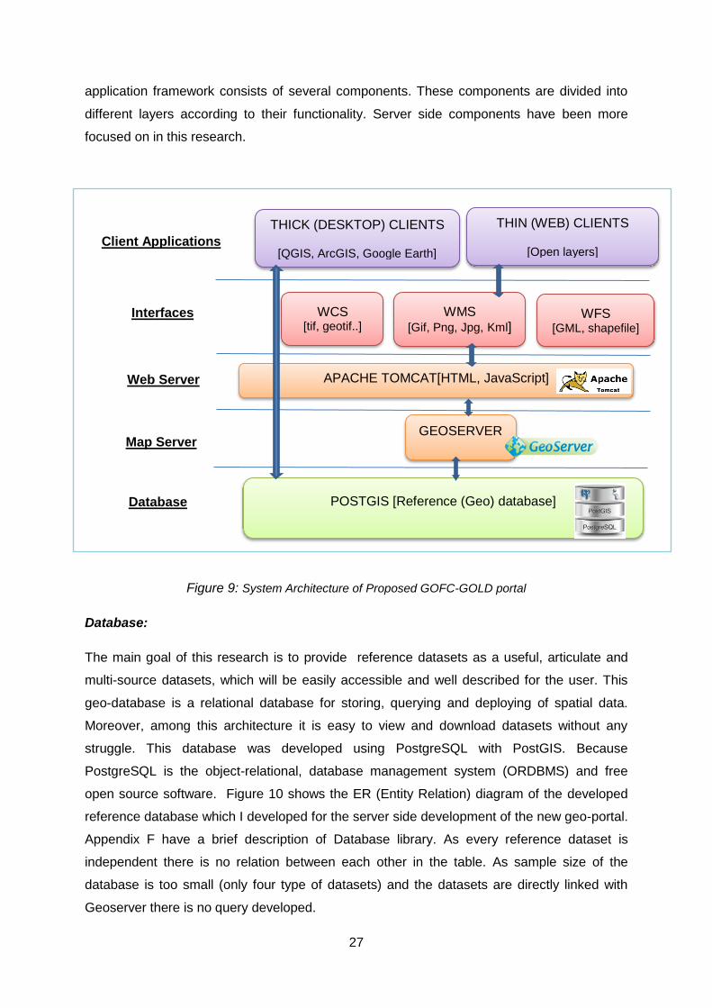
Figure 9: System Architecture of Proposed GOFC-GOLD portal ..........................................27
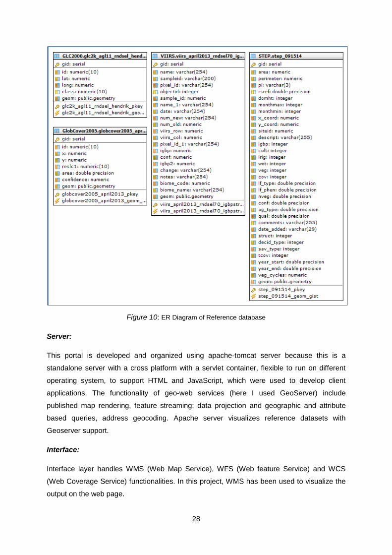
Figure 10: ER Diagram of Reference database ....................................................................28
Figure 11: ER sequence diagram of the prototype geoportal ................................................29
Figure 12: Survey procedure and steps ................................................................................31
Figure 13: First step after entering a geoportal .....................................................................34
Figure 14: Function usages more in a Geoportal ..................................................................34
Figure 15: Completeness of the datasets and Information availability and updates of the
datasets ...............................................................................................................................35
Figure 16: Rate of this existing GOFC-GOLD reference data portal .....................................36
Figure 17: Availability of informative metadata information ...................................................36
Figure 18: about the design of the existing portal and user interface ....................................37
Figure 19: New prototype interface of the portal, the start-up screen with different
functionalities combination with pop-up button (the right side white screen with a name list of
the reference maps), left side zoom in and zoom out option, on the top a navigation bar. ....38
Figure 20: All datasets are in same list and visualized on the same interface together. ........39
Figure 21: Navigation bar with different buttons. ...................................................................39
Figure 22: Easy to find reference maps from pop-up button .................................................40
Figure 23: Improved enough than the previous GOFC-GOLD portal ....................................41
Figure 24: question about new user interface .......................................................................41
Figure 25: Easy access to download data ............................................................................42
xi
List of Tables
Table 1: Levels of Validation adopted from (Townshend et al. 2006) ..................................... 8
Table 2: Characteristics considered generating and assessing reference maps. Based on the
literature of Olofsson et al. (2012) and Stehman et al. (2012) ...............................................17
Table 3: Available Reference datasets of GOFC-GOLD adopted from (Mora et al. 2014c) ...18
Table 4: specification of different GLC reference datasets based on different user
requirement. .........................................................................................................................18
Table 5: Main concern to increase accessibility of a reference data portal (from literature
study) ...................................................................................................................................22
Table 6: the title describes the list of improvement for the geoportal. The second column
represents the number of programmer points (PPs). A priority is given according to the
MoSCoW-principle in third column. .......................................................................................26
Table 7: Specification of the dimension. Adopted from (Abugessaisa and Ostman 2011) .....30

xii
Glossary
AVHRR – Advanced Very High Resolution Radiometer
DBMS – Data Base Management System
EC JRC – European Commission Joint Research Centre
ESA – European Space Agency
ER - Entity Relation
FAO-FRA-RSS – Food And Agriculture Organization – Forest Resource Assessment –
Remote Sensing Survey
GDAL - Geospatial Data Abstraction Library
GI – Geographic Information
GIS – Geographic Information System
GLC – Global Land Cover
GLCNMO – Global Land Cover by National Mapping Organizations
GML - Geographic Markup Language
GOFC-GOLD – Global Observation of Forest and Land Cover Dynamics
HTTP - Hypertext Transmission Protocol
IGBP – International Geosphere-Biosphere Programme
ISO - International Organization for Standardization
IT – Information Technology
LC CCI – Land Cover Climate Change Initiative
LCCS - Land Cover Classification System
LC PO – Land Cover Project Office
MERIS - MEdium Resolution Imaging Spectrometer
MODIS – Moderate Resolution Imaging Spectroradiometer
NELDA – Northern Eurasia Land Dynamics Analysis
OGC - Open Geospatial Consortium
OSS – Open Source Software
PPs – Program Points
RS – Remote Sensing
SDI – Spatial Data Infrastructure
SOA - Service Oriented Architecture
SPOT - Satellite for observation of Earth
UN - United Nations
UI – User Interface
UML - Unified Modeling Language
UN-FAO – United Nations Food and Agriculture Organization
VHSR – Very High Spatial Resolution
WMS – Web Map Service
WFS – Web feature Service
WCS – Web Coverage Service
WUR – Wageningen University and Research Centre
WWW – World Wide Web

xiii

1
1. Introduction
1.1 Context
Scientific communities that study forestry and agriculture land use (Fritz et al. 2012), ecology
and geographical relations (Belward et al. 1999), climate change (Hese et al. 2005), urban
planning, and environmental modelling (Myneni et al. 2002) use Global Land Cover (GLC)
datasets for their research work in global, regional and national scale. They use these GLC
datasets for natural resource assessments; parameterizing land process models for climate,
hydrology, carbon cycle; public health; ecosystem assessment or agricultural activities (Zhao
et al. 2014). These datasets are derived by different types of satellite-mounted sensors,
which lead to differences in classification methods, and temporal and spatial resolutions (Wu
et al. 2008). There is a significant amount of disagreement when these products are
compared, because different users have different requirement about the resolution and
accuracy level of GLC datasets (Tsendbazar et al. 2014).
GLC datasets have been constructed from the data of Advanced Very High Resolution
Radiometer (AVHRR (Loveland et al. 1999)), Satellite for observation of Earth (SPOT-4
VEGETATION (Durpaire et al. 1995)), Moderate-Resolution Imaging Spectroradiometer
(MODIS (Friedl et al. 2002)), MEdium Resolution Imaging Spectrometer (MERIS (GlobCover
2000-2011)), and Land Cover Climate Change Initiative (ESA 2011). GLC datasets are
evolved for information about land cover and land cover dynamics (Herold et al. 2006).
These land cover datasets at global scale are the base line datasets which are important
assets for the scientists who do their research on global change on different perspective
such as climate change, land cover type, urban planning for sustainable development,
natural resource management, environmental studies and related fields (Foley et al. 2005,
Zell et al. 2012, Sterling et al. 2013).
Most of the GLC datasets are developed with 250m to 1km resolution (Alan H. Strahler et al.
2006). These GLC datasets are increasing with the availability of remotely sensed datasets
at global scale. 1 km GLC dataset named GLC2000 was developed from 1km AVHRR
(Hansen et al. 2000, Loveland et al. 2000) and 1km SPOT-4 VEGETATION satellite data
(Bartholomé and Belward 2005). 500m GLC maps (Friedl et al. 2010) and 250m GLC maps
(Zhan et al. 2000) produced from MODIS. 300m GLC maps named GlobeCover developed
from MERIS (Arino et al. 2008).
Depending on the input quality, spatial resolution, legend and classification algorithm every
GLC data has different limitations such as the resolution of AVHRR is 1km; GlobCover

2
datasets have been produced using unsupervised classification methods. Noteworthy
amount of disagreement arises when these datasets are compared. One of the reasons of
this disagreement is the lacking of sufficient real time reference datasets for validation and
calibration of GLC datasets (Fritz et al. 2012). Another important reason of disagreement is
the lack of interoperability and inter-comparability between the datasets (Herold et al. 2008a).
Data users and data producers are frustrated because all GLC datasets are designed as
independent dataset and lacking of sufficient information on accuracy of those datasets.
Producers need to understand and identify the lacking, which make this disagreement for
further development. Furthermore they need to acknowledge that users are confused which
dataset is more appropriate for their use purpose (Herold et al. 2008a).
Before using the GLC datasets, a validation is necessary, for studies at regional to global
scales. It will help to reduce user’s confusion and will help developers to understand the
weakness of the datasets for further development. Validation exercises can provide a
quantitative accuracy assessment of satellite‐derived global land cover datasets (Wu et al.
2008). Validation is the suite of techniques to assess the accuracy of given datasets based
on overall accuracy, errors of omission and commission by land cover class, errors analysed
by region, and fuzzy accuracy (Alan H. Strahler et al. 2006). Different scientific communities
have different requirements for accuracy assessment of GLC datasets (Bontemps et al.
2011, Herold et al. 2011). For the accuracy assessment of GLC datasets high quality
reference datasets are needed which will be independent and also their accuracy level will
be higher (Tsendbazar et al. 2014). Reference datasets define some standard values to be
used by other data sets. These datasets are used only to categorize data or relate data in a
database to information beyond the boundaries of the initiative (Inc 2003). “The position or
class label of the accuracy assessment site, which is derived from data collected that are
assumed to be corrected is known as reference data” (Congalton and Green 2009). These
reference datasets are known as independent validation datasets.
Accuracy assessment of GLC datasets should be interpreted for different user needs and
use suitable independently validated reference datasets in the assessments. For the efficient
use of reference datasets for GLC datasets validation a set of new reference datasets is
proposed jointly by Global Observation of Forest and Land Cover Dynamics (GOFC-GOLD)
and Boston University (Olofsson et al. 2012). Currently there is no assessment providing
information on the use of these datasets beyond their original scope and no implications for
specific user applications having different requirements on GLC datasets and their
validations (Tsendbazar et al. 2014). Users are demanded frequent and easy accessibility
and reusability of GLC reference datasets. Recently GOFC-GOLD has proposed a
framework to make a guideline for the user based on their needs, establish the new

3
database and make it available online to the GLC mapping community and engage partners
in the effort of producing reference data for global scale land cover mapping activity (Mora et
al. 2014b).
Accessibility of the reference data portal depends on reliability (the server’s ability to fulfil the
user request), availability (fraction of time a service is available) and performance (how fast
the geoserver can fulfil client request) (Boundless 2015). Therefore, accessibility techniques
make the reference data portal accessible to all users.
Nowadays Geoportals are used for earth and planetary science, social science, medical
science, environmental science and so forth. Web GIS (Geographic Information Science) is
the map-centric management system which supports, organize, protect and facilitate access
to geographic information products (Esri 2013). The map, product from Web GIS, becomes
dynamic, interactive and accessible to a wide selection of users as a visual communication
tool in the environment of Web-based GIS functionalities. The highly functional Web-based
architecture provides easy access to spatial raster data and facilitates image analysis and its
spatial decision support system framework uses for exploratory visual analysis and mapping
of the obtained results (Dragićević 2004).
A geoportal is the most open and easy access of the geo-information and remote sensing
data for the potential end users which includes World Wide Web (WWW) data, metadata and
geo-processing capabilities. Furthermore, it acts as an information providing single access
point for discovery, visualization, data retrieval and geo spatial web services (De Longueville
2010). GOFC-GOLD Land Cover Project Office (LC PO) is contributing to provide better
information, methods and tools toward the global land cover (GLC) reference datasets and
for land cover map accuracy assessment (LCPO 2012-2013). Therefore, there is a need of a
Web based Geographic Information System (GIS) solution for these spatial datasets like
storage, retrieval and visualization. Figure1 describes the core components of SDI (Spatial
Data Infrastructure) which relates to this study and tries to provide a concept about a new
reference data portal with an organized data base management system which will facilitates
to collect, archive, share, analyse, visualize and simulate GIS and remote sensing data,
information and knowledge over the web (Shen et al. 2008).
Figure 1: Relation between SDI components (Rajabifard et al. 2002).
Users
Technology
Standards
Policies Spatial Data and
Services

4
A number of GLC datasets have been produced and more are coming in future. In addition,
these datasets are very useful for different research field, and can also use for government
work purpose or for some social work. To validate these GLC datasets scientific communities
need reference datasets. Development of a new set of reference data is expensive. Some
reference datasets can be found from different sources that are not authentic enough to use
and some of them can be used only once. Reference maps from GOFC-GOLD LC PO are
reusable and augmented for different GLC map validation. Furthermore, this study is based
on information and datasets of 2014.
1.2 Problem Definition:
There are different geoportals or web based applications to support validation of GLC
reference datasets like Geo-Wiki (Fritz et al. 2012) or View-IT (Clark and Aide 2011). They
developed web tools to interpret crowd sourced reference datasets, which have limited
flexibility like users are allowed to visually estimate the land cover percentage (Clark and
Aide 2011, Fritz et al. 2012). On the other hand GOFC-GOLD is providing independent GLC
reference datasets with an extensive suit of characteristics (like sample design, response
design and level of classifications) for free of cost and easily downloadable (Olofsson et al.
2012, Mora et al. 2014b). The intention of GOFC-GOLD is to provide independent reference
datasets. However, currently the GOFC-GOLD portal is not well known to the user
community and not well organized. Especially the structural design of this portal is not good
enough structured to attract the users. Moreover, I talked with the project personnel about
the storage capacity and retrieval system, which seems to cause problems. They do not
have any storage facility for the reference datasets nor is their retrieval system user friendly.
The re-usability of these GLC reference maps would be greatly enhanced by making them
publicly available in an expert framework that supports users 1) to choose the most suitable
reference map based on their needs, and 2) to use the map appropriately for a robust
statistically accuracy assessment. An information system for this GOFC-GOLD project
requires the storage, retrieval and visualization of the sample plots facilities. This system will
allow tracking the progress made on the interpretation of these sites and all reference
datasets will be available to the users in a spatial database form from the GOFC-GOLD
Project Office data portal.
It is good news for the scientists who use GLC maps for their research work, that reference
datasets to validate GLC datasets are available for free in GOFC-GOLD website. The
website of GOFC-GOLD PO hosts the first version of a reference data portal to inform on

5
and support validation of global land cover datasets (Mora et al. 2014b). After visiting the
GOFC-GOLD portal, I found that the current version of their reference data portal has been
set up with basic features enabling the access to the home page. The home page leads to
other pages, which consist of lots of document files and downloadable datasets in zip, pdf or
text format. However, these links should be presented in a more prominent way, so that the
user can easily spot them.
GOFC-GOLD website is a hosting data portal and does not own the datasets (Townshend et
al. 2006). They are contributing to provide better information, methods and tools toward the
global land cover (GLC) reference datasets and for land cover dataset accuracy assessment.
But the problem is, they didn’t explain clearly any information about assessment or
consequences of those GLC reference datasets and it limits the value of these datasets to
the users requirements in their website (Tsendbazar et al. 2014). Therefore, clear and well-
organized metadata of these GLC datasets is the strong requirement of this portal .
Four consolidated reference datasetss (GLC 2000, GlobCover 2005, STEP and VIIRS) are
publicly available on the current version of GOFC-GOLD data portal with incomplete
metadata information, others are available upon request and access to the others should be
based on agreements (Mora et al. 2014b). The problems users are currently facing with this
portal are that very few references maps can be found on the GOFC-GOLD website, a lack
of user friendly guidance in the portal, the lack of tools for the users and finally there is no
option for a user survey to get information about current user needs (Tsendbazar et al.
2014). GOFC-GOLD LC PO did not do any user survey or other experiment to understand
the lacking of their data portal.
Along this, the main aim of this research is to determine the present situation and lacking of
the GOFC-GOLD geoportal to improve the accessibility of the reference datasets and near
future geoportal components according to the technical requirements and user needs as a
case study. The outcomes of this study can be the basis of a new geoportal establishment.
1.3 Objectives and Research Questions:
The overall aim of this research is to “improve access of reference datasets for global land
cover map validation”. To fulfil this objective the following research questions are proposed:
RQ1: What are reference data and how do they validate the global land cover (GLC)
datasets?
6
RQ2: Does the current (2014 version) geoportal of GOFC-GOLD facilitate the access of
GLC reference datasets?
RQ3: How to improve the accessibility of reference datasets for validating GLC datasets?
RQ4: Does the geoportal (upgrade) design of GOFC-GOLD geoportal indeed increase
accessibility of GLC reference datasets?
1.4 Outline of the Thesis:
Chapter 2 contains a literature review, related to this research, of the validation studies of
GLC datasets, improve accessibility of reference data portals, user interface of that reference
data portals and research strategies which are important to understand before the research
experiment
Chapter 3 describes the methods and techniques that were used to evaluate the current
GOFC-GOLD reference data portal, to develop a prototype GOFC-GOLD data portal and to
validate this new prototype portal.
Chapter 4 presents the results of the research experiment and provide answers to all
research questions.
The last chapter (5) presents the conclusions, discussion and recommendations for future
work.
7
2. Review
2.1 Global Land Cover (GLC) Map:
Global mapping of land cover exists since the last two decades and serves to
characterize baseline terrestrial information, which is one of the most important variables
for a wide range of societal benefits (GEOSS 2005, Fritz et al. 2011). Nowadays, a
number of global land cover datasets are developed to explore the information about
land cover and land cover dynamics (Alan H. Strahler et al. 2006, Herold et al. 2008a).
As discussed in chapter 1, GLC datasets are independent datasets because they are
the product of different national and international initiatives and their standards varies
because of using purpose (Herold et al. 2008a, Bontemps et al. 2012). The users are
confused about the accuracy and metadata information of different GLC datasets when
they want to use these datasets for their research work or other development work. So,
both, data producers and users are stressed about different types of land cover
datasets, difference in thematic legend and lack of accuracy information (Herold et al.
2008a). To reduce this confusion a well-designed geoportal of reference datasets may
have important contribution.
2.2 Validation Strategies of GLC Maps:
“Validation is the cognitive process of establishing a valid proof or the act of validating,
finding or testing the truth of something” (Dictionary 2007). A validation process is an
ongoing process, which provides a high degree of assurance on the quality of the processed
data by establishing scientific evidence.
To use GLC datasets for any research or practical experiences we need to assess the
accuracy of that datasets. Accuracy assessment is expensive which force the International
Geosphere-Biosphere Programme (IGBP) to develop integrated global validation schemes
for multiple GLC datasets (Olofsson et al. 2012). There are several steps of validation
processes in GIS (Geo Information Science) and RS (Remote Sensing) research such as i)
sampling design, ii) reference data collection, iii) extracting the interpretation results from the
reference data, iv) reference data and interpreted data comparison by using appropriate
statistical technique, and finally analysing the result (causes and distribution of errors) from
different interpretation technique (Chuvieco and Huete 2009).

8
Quality assessment of maps is known as validation which include assessing the overall
accuracy, errors of omission and commission and fuzzy accuracy (Alan H. Strahler et al.
2006, Herold et al. 2009). For the determination of the quality of a map generated from
remotely sensed data, accuracy assessment is prerequisite. Positional and thematic
accuracy are two types of map accuracy assessment. Positional accuracy uses reference
data to estimate the accuracy of the location of map feature (Congalton and Green 2009).
Townshend et al. (2006) note that it’s sensible for GOFC-GOLD to adopt the MODIS Land
Team proposed scheme in Table 1, because accuracy assessment of global land cover
datasets is expensive and time consuming. Furthermore, international cooperation helps to
get expertise for data collection and the international standard.
Table 1: Levels of Validation adopted from Townshend et al. (2006)
To perform an accuracy assessment suitable reference datasets are needed, which are in
good quality. For the scarcity of validation data, reference datasets should be re-useable. An
investigation on the efficient use of all available validated and calibrated datasets for GLC
datasets is a very new user requirement (Tsendbazar et al. 2014). GOFC-GOLD and Boston
University together are generating reference datasets for the validation of GLC dataset,
which is possible to use for different and multiple GLC datasets validation (Olofsson et al.
2012, Stehman et al. 2012).
2.3 Improving Accessibility by Geoportal Design:
A geoportal (i.e. combined product of GIS and internet technologies) is the gateway to
access geographic data and information available with directories, search tools and support
resources (Maguire and Longley 2005). A geoportal is like a ‘one-stop-shop’ where users can
get access of multiple datasets. It provides online access, visualization and analysis of the
Stage 1 Validation: Map accuracy has been estimated using a small number of independent measurements obtained from selected locations and time periods. Validation assessed locally under a limited range of geographic conditions for a limited period of time.
Stage 2 Validation: Map accuracy has been assessed over a widely distributed set of locations and time periods. Validation assessed over a significant range of geographic conditions and for multiple time periods and seasons.
Stage 3 Validation: Map accuracy has been assessed and the uncertainties in the map well established via independent measurements in a systematic and statistically robust way representing global conditions. Validation assessed over the full range of global conditions for all time periods.

9
GLC datasets (Han et al. 2015). Fritz et al. (2012) developed a crowdsourcing tool named
Geo-Wiki by using web map service (WMS) to increase the availability of GLC training data
for validation. The design of a geoportal for spatial datasets has many advantages like easy
accessibility, data transparency, independent platform, better visualisation and also cost
effectiveness (Kulkarni et al. 2014). Geoportals and SDI encourage and assist people to use
Geo-Information (GI) concepts, databases, models and techniques in their work. It also
connects GI data provider and user via the medium of internet. Geoportal design depends on
the purpose of the use and product of that portal. From my observation on existing GOFC-
GOLD portal has been set up with basic features enabling the visualization of metadata
information and download of the datasets in a zip or text format, which does not look like
user friendly. It is complicated and time consuming for the users to find the reference
datasets in that website. Geoportal design should be a user centric web application with
applying geo-visualization methods(Figure: 2). However there are always client and server
side design involved in a geoportal development.
GLC Reference
Data
Database
Geo-Information
PostgreSQLWith PostGIS
Geoserver
PHPHTML
OpenLayersAJAX
Apache
Technology
QGIS
Web Browser
Visualization
Querying
Spatial Analysis
Data Access (Download)
InterfaceTools
Monitoring
Planning
Conservation
User Applications
Suitability of Store, Retrieval, Display
Guidance to users and facilitate data display and access
Database Development
Figure 2: Geoportal design comprised of GIS database, technology generally used tools and user
applications. Adopted from Souza et al. (2009)
In the following described concept (from Figure 2) of geoportal can help to improve
accessibility of GLC reference maps.

10
2.3.1 Database Management System
The purpose of a geoportal and SDI is to save time, effort, money and unnecessary
duplication in standardization of required reference datasets (Groot 1997). Metadata records
are extremely important for SDI to maintain information about the content, source and origin
of the data (Crompvoets 2006). SDI aims to create an environment to access and retrieve
spatial data sets in an ample, reliable and protected manner. It can also create a setting
where participants, users, and spatial data producer can collaborate, and utilize information
and communication in a cost-effective way (Manisa and Nkwae 2007). A spatial Database
Management System (Spatial DBMS) such as Oracle, PostGIS, SpatialLite and MySQL
Spatial extension can store the reference datasets.
2.3.2 Server:
Geo server and map server are free servers to visualize maps and images stored in a
database on the web. These servers can be used as a development environment for
constructing spatial applications on the internet (Souza et al. 2009). The server component
expresses user rights to access various functionalities of the portal.
2.3.3 Interface:
Geoportals are built using underlying World Wide Web (WWW) infrastructure technology and
network communication between clients and web servers uses Hypertext Transmission
Protocol (HTTP). Thus, a geo-portal is the entrance to collection of information resources
which include data sets, facilities, news, tools, tutorials and organized collection of links of
other sites (Maguire and Longley 2005).
2.3.4 Tools:
For visualization, to query and to conduct spatial analysis user-friendly tools are essential.
Menu bar, different kind of fields, markers, pop-ups, query buttons, layer selections or
hyperlinks are the tools users can use to fulfil their requirement. A library is also a searching
tool. GDAL (Geospatial Data Abstraction Library) is an open source raster utilities set in a
Python wrapper (Zimmerman 2014) which is known as translator library for raster and vector
geospatial data formats. As a library it presents a single raster abstract data model and
vector data model to the calling application for all supported formats (Doxygen 2005). GDAL
will design the raster library which will be easy accessible for the user. There are also some
other essential tools for maps such as pan, zoom or get attribute information on the feature.

11
2.3.5 User Applications:
An application server is the crucial part to visualize the geoweb portal and to prove that the
web portal is serving the needs of the user. GeoServer and GeoWebCache are the two most
popular open source application servers. The Geographic Markup Language (GML) is a
framework to encode features with specific support for geographic information in accordance
with the conceptual framework specified in the ISO (International Organization for
Standardization) 19100 series of International Standers. GML is designed for the WWW and
Web Services. WWW creates possibilities and increased requests for on-demand access to
all kinds of information including geographic information (Inc. 2007).
2.3.6 Example of online platform to improve accessibility of GLC reference
datasets:
As mentioned before, two good examples for geo-platforms are Geo-Wiki and VIEW-IT. Fritz
et al. (2012) developed Geo-Wiki, an online platform, for improving accessibility of GLC
datasets for training, calibration and validation to get more accurate land cover information.
Geo-Wiki has four classes of services of portal, portrayal, data and catalogue that fulfils the
OGC (Open Geospatial Consortium) requirements. Han et al. (2015) designed and
developed a web-based system for 30-meter resolution of GLC datasets using a 3-tier SDI
(Spatial Data Infrastructure) system model. This web-based system provides online access,
visualization of GLC datasets as map, ancillary data; integrate heterogeneous data and
services required for GLC data production.
Clark and Aide (2011) introduce Virtual Interpretation of the Earth Web-Interface Tool (VIEW-
IT). VIEW-IT is the google Earth plug-in with a web-based application, which has an in-built
user interface, basic interpretation criteria, server side storage and automated error
checking.
All the platforms discussed above use open source software to develop their geoportal for
the GLC datasets.
2.4 Usability Study of Geoportal
Usability study is one of the most important parts of evaluating an information system. This is
a system to support people perform their task competently and successfully. Usability
depends on several elements like learnability, memorability, effectiveness, efficiency and
satisfaction (Henry 2011) and is a very important aspect for map based geoportal
12
applications. Usability is concern for language, layout and graphics, information architecture,
user interface and navigation (Bai et al. 2008). A geoportal has a complex involvement with
user interaction like textual search, data retrieval or map interface and geo-search. According
to ISO 9241-11 (Al-Kilidar et al. 2005) and ISO 25010 (Bevan 2009) the quality of use of the
system including tool, user, tasks and environment is the standard of the usability.
A geoportal is the access point of shared public Geographic Information (GI). Geoportal
requires different design than other type of web applications (Peterson 2001, Wachowicz et
al. 2008). And it should have at least four basic functions including searching, mapping,
publishing and administration of the infrastructure (Tait 2005) in its design list. The simplest
use case of a geoportal is to discover the most relevant datasets and a search function is the
best option for that. GIS data visualization is also important function because users want to
examine the data content before using it (He et al. 2012).
2.5 Conclusion
Nowadays different GLC datasets are available and more are coming in different resolution.
Different researchers have different requirement to validate those GLC datasets. Reference
datasets are necessary for validation of a datasets. The development of reference datasets
is expensive and time consuming. Some international standard GLC reference datasets are
freely available on the internet. However, there is a problem of lacking of the easy
accessibility of those reference datasets. A clear understanding of GLC datasets and its
validation criteria is the prerequisite to do a research on how to improve the accessibility of
reference datasets to validate these GLC datasets. To improve the accessibility of GLC
reference datasets geoportal development is a solution because a geoportal is the gateway
to access all kind of GIS and remote sensing datasets. One hypothesis constructed in this
research to solve this problem is to develop/reorganize the portal intotal, which may help to
improve the accessibility.

13
3. Methodology
3.1 Overall Methodology
From the literature study in second chapter, I have found a first impression of accessibility
and usability limitations of GLC reference datasets from GOFC-GOLD geoportal. To improve
this situation an overall methodology to know more about the existing GOFC-GOLD
geoportal is presented along with a questionnaire survey to evaluate the portal. Based on all
the collected information, the problems and potentials related to the use of existing GOFC-
GOLD portal and accessibility to the reference datasets, a new prototype geoportal will be
developed and validated by a small and limited questionnaire survey.
An overall methodology is presented in the following chart-
Concept Development
Objective and research question
formulation
Literature Review
decision for further steps
An usability test is
required
An improvement of the existing
portal is necessary
Need a validation of the new Geoportal
Methodology
Public opinion Survey to test
the new GOFC-GOLD geo portal
Literature research about GOFC-GOLD
and their GLC reference data
Usability test to identify the lacking of
the existing GOFC-GOLD geoportal
Construct a prototype GOFC-GOLD geoportal
for better access to the reference data
Analysis the outputs and
feedback
Results from the experiment
RQ1 RQ2 RQ3 RQ4
Figure 3: Flow chart of Methodology
14
RQ1: What are reference data and how do they validate the global land cover (GLC)
datasets?
A scientific literature study through internet and university library has been made by using the
scientific papers, e-books and websites to examine the reference data and their validation
process on global land cover dataset, the users of this data, about GOFC-GOLD and its
support to the scientific world by providing GLC reference datasets.
RQ2: Does the current (2014 version) geoportal of GOFC-GOLD facilitate the access
of GLC reference datasets?
A usability survey of existing GOFC-GOLD portal has been done to understand the lacking of
the portal and identified the weaknesses of the portal needs to be developed.
RQ3: How to improve the accessibility of reference datasets for validating GLC
datasets?
A conceptual geoportal with high storage capacity and nice design principle has been made
to test if it increases accessibility of the GLC reference datasets. To develop the conceptual
portal the following criteria have been considered
- Database management system should have high storage facility, free GIS data
loader, free desktop viewers and editor, web-mapping toolkits and free of cost data
download facilities.
- Server with known and easy programing language, different output format, easy to
connect virtual world, open standard interoperability, open source server.
- Availability of tools to download, scale, pop up information and others.
RQ4: Does the geoportal (upgrade) design of GOFC-GOLD geoportal indeed increase
accessibility of GLC reference datasets?

15
A questionnaire survey on the functionality performance of the new conceptual portal,
especially the user interface, has been done to evaluate if it increases the accessibility of
GLC reference datasets.
3.2 Case Study GOFC-GOLD
GOFC-GOLD is a coordinated international effort to better understand global changes for
forest and land cover observations (LCPO 2012-2013, Mora and Herold 2013). The main
goal of GOFC-GOLD is to provide a forum for international information exchange, reflection,
data coordination and a framework for establishing the necessary long-term monitoring
system of forest, biodiversity and land cover dynamics (GOFC-GOLD and Team 2014). The
GOFC-GOLD LCPO is funded by the European Space Agency (ESA) and is located
currently on the campus of Wageningen University, to support international assessments of
land cover management and environmental treaties and to contribute to natural resources
management (Herold et al. 2008b). GOFC-GOLD LCPO provides reference datasets to
inform on and support validation of global land cover datasets. Along with understanding the
lacking of the GOFC-GOLD portal I would like to explore more about reference datasets, the
spatiality and exception of reference datasets GOFC-GOLD offered than others.
3.2.1 Reference Data and validation process of GLC datasets
The reference data acquisition involves collecting measurements and observations about the
remotely sensed objects, areas or phenomena and are used to calibrate a sensor or verify
information extracted from remote sensing data (Lillesand et al. 2014). Reference data
always use for accuracy assessment. Reference data have permissible values, which can be
used to validate other data field. This validation is done by comparing reference and
interpreted data. Appropriate statistical techniques helps this comparison (Chuvieco and
Huete 2009).
The very common procedure to collect the reference data is the principle of statistical
sampling design that estimates the possible number of samples, sampling technique, and
duration of study. Time critical (for rapid change of ground with time) and time stable
(observed materials do not change noticeable with time) are two different ways to measure
reference data. There are different methods to collect the reference data like ground base
measurement, laboratory spectroscopy, field measurement and spectral reflectance
measurement (Lillesand et al. 2014).

16
GOFC-GOLD LC PO applied UN (United Nations) Land Cover Classification System (LCCS)
and IGBP classification schemes (Loveland et al. 2000) to characterize and validate GLC
datasets. Legend, sampling design and response design are the baseline validation criteria
of GOFC-GOLD (Olofsson et al. 2012). Selecting a large global baseline sample is the first
initiative of the global validation database. The sample size will be increased by several
iterations and must include a protocol to achieve acceptable precision for any accuracy
estimation (Stehman et al. 2012).
For the scarcity of validated data, reference datasets should be re-useable. An investigation
on the efficient use of all available validated and calibrated datasets for GLC dataset is a
very new user requirement (Tsendbazar et al. 2014). The global validation datasets provide
reference data for descriptive and relative accuracy analysis (Olofsson et al. 2012).
GOFC-GOLD adopted area units for reference datasets which are not dependent on a pixel
or a block of pixel (Tsendbazar et al. 2014). They can be easily applied for the validation of
different datasets because GOFC-GOLD reference datasets are not map dependent. This is
one of the most important stratification, which makes this datasets an exception, and which is
independent of any GLC dataset and applicable to many datasets. Olofsson et al. (2012) and
Stehman et al. (2012) fixed several standards to select the sample blocks for sampling
design such as
(1) it satisfies meaning of a probability sampling design to select the baseline sample,
augmented sample and combined samples from both of the samples;
(2) it provides adequate sample sizes for rare land-cover classes which is achieved by
stratification to assess multiple datasets (these datasets differ from each other in legend
and support);
(3) it allows flexibility to change sample size (either 5km x 5km or 1km x 1km) in response to
random funding or revised accuracy assessment objectives;
(4) it focuses sample sites in the areas most difficult for land-cover mapping because of two
important characteristics one is consistency of the accuracy estimation protocol (sample
size increase over time) and the other one is minimize the complexities (related with
sample data weight).
Stehman et al. (2012) describe elaborately of all these standards of stratified sampling
design for global land cover validation to estimate accuracy by region and land cover
classes. Following characteristics (in Table 2) are considered for generating and assessing
reference datasets, which are accessible from GOFC-GOLD portal.

17
1. Legend Classification Scheme Number of class Classifier information provided
2. Sample Design (cost and statistical precision)
Sample unit type and size Sample size Sample selection scheme Sample stratification Inclusion probability Minimum Mapping Unit
3. Response Design (reflection
on the agreement between
map and reference
classification)
Source of information Temporal coverage Location accuracy Labelling procedure Sample verification Confidence in interpretation Majority classes and their fraction
4. Current use Intended application Other applications Applied pre-processing Derived accuracy estimates
Table 2: Characteristics considered generating and assessing reference maps. Based on the
literature of Olofsson et al. (2012) and Stehman et al. (2012)
In GOFC-GOLD project, stratified sampling based datasets doesn’t use stratifications that
are targeted to particular land cover maps (Tsendbazar et al. 2014). In sampling design,
stratification (strata represent land-cover classes) incorporates accuracy assessment
because it specifies the allocated sample size of stratum (Olofsson et al. 2012). From
GlobeCover and LC-CCI (Land Cover Climate Change Initiative) GLC user requirements
surveys accuracy, stability, spatial resolution thematic content are most stressed user
requirements (Bontemps et al. 2012).
18
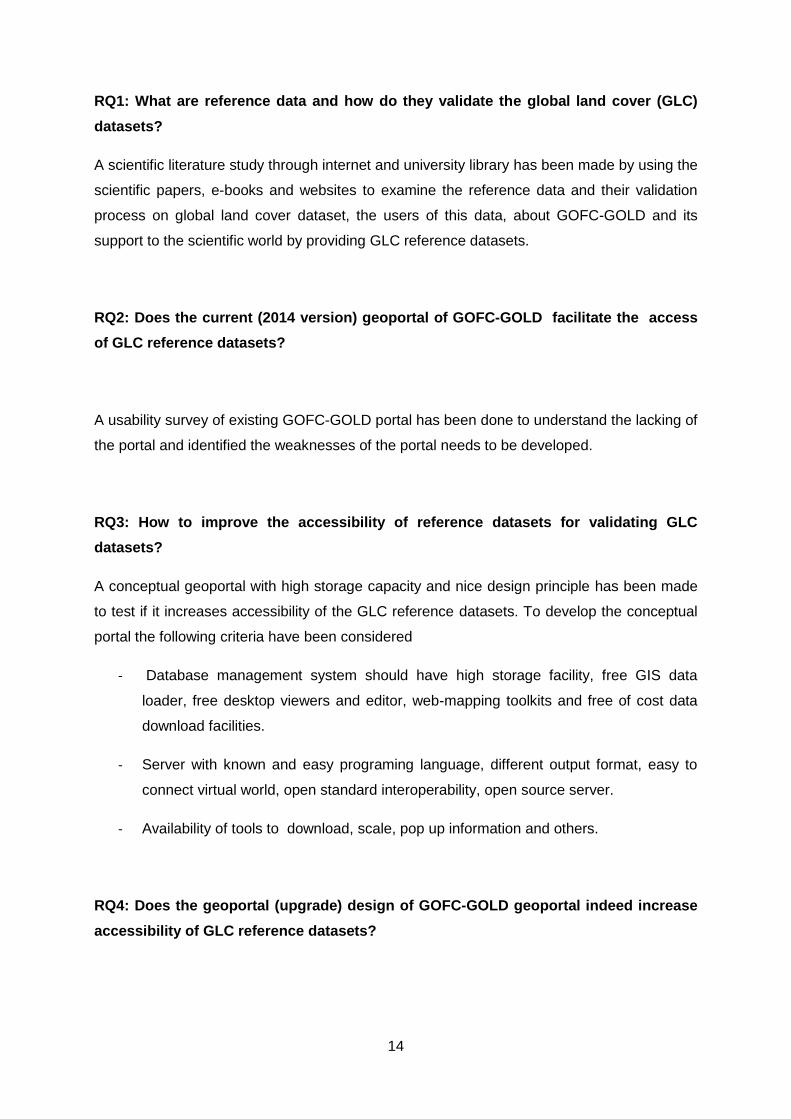
Table 3: Available Reference datasets of GOFC-GOLD adopted from (Mora et al. 2014c)
Table 3 describes the list of reference datasets with the specifications GOFC-GOLD portal
provides for the GLC datasets users.
An accurate global land cover dataset is very important for different kind of scientific or
research work such as forest resource assessment (Zhu and Waller 2003, GOFC-GOLD
2011, Townshend et al. 2012), climate change and modelling (Hese et al. 2005, Hibbard et
al. 2010, Verburg et al. 2011, Bontemps et al. 2012), global agricultural (Ramankutty et al.
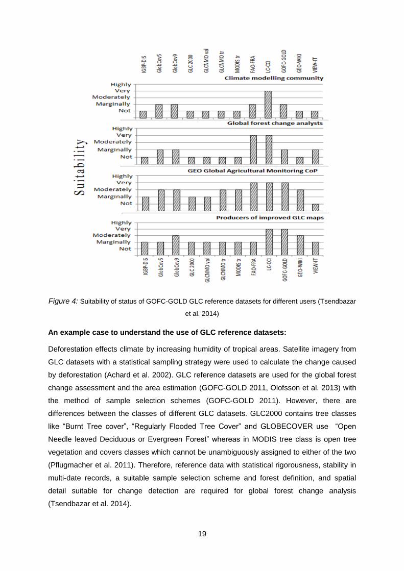
2008) and land use monitoring (Foley et al. 2005). Based on Tsendbazar et al. (2014) figure
4 shows the suitability of different GLC reference datasets for different user/research
purposes and Table 4 shows the specification of the datasets for different users.
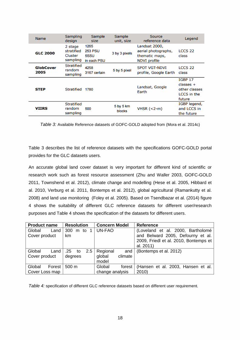
Product name Resolution Concern Model Reference
Global Land Cover product
300 m to 1 km
UN-FAO (Loveland et al. 2000, Bartholomé and Belward 2005, Defourny et al. 2009, Friedl et al. 2010, Bontemps et al. 2011)
Global Land Cover product
.25 to 2.5 degrees
Regional and global climate model
(Bontemps et al. 2012)
Global Forest Cover Loss map
500 m Global forest change analysis
(Hansen et al. 2003, Hansen et al. 2010)
Table 4: specification of different GLC reference datasets based on different user requirement.
19
Figure 4: Suitability of status of GOFC-GOLD GLC reference datasets for different users (Tsendbazar
et al. 2014)
An example case to understand the use of GLC reference datasets:
Deforestation effects climate by increasing humidity of tropical areas. Satellite imagery from
GLC datasets with a statistical sampling strategy were used to calculate the change caused
by deforestation (Achard et al. 2002). GLC reference datasets are used for the global forest
change assessment and the area estimation (GOFC-GOLD 2011, Olofsson et al. 2013) with
the method of sample selection schemes (GOFC-GOLD 2011). However, there are
differences between the classes of different GLC datasets. GLC2000 contains tree classes
like “Burnt Tree cover”, “Regularly Flooded Tree Cover” and GLOBECOVER use “Open
Needle leaved Deciduous or Evergreen Forest” whereas in MODIS tree class is open tree
vegetation and covers classes which cannot be unambiguously assigned to either of the two
(Pflugmacher et al. 2011). Therefore, reference data with statistical rigorousness, stability in
multi-date records, a suitable sample selection scheme and forest definition, and spatial
detail suitable for change detection are required for global forest change analysis
(Tsendbazar et al. 2014).

20
Reference Data
Portal
Catalogue Service
(Data Publication Facilities)
Different format of Reference Datasets resources
(Directory of Resources)
Users
WMS WFS
GLC datasets are commonly validated by using higher quality independent reference
datasets. Before using reference, datasets users have to know the thematic and geometric
precision and accuracy of the reference datasets as well as the thematic class distribution
and the necessary (Meta) information like time labels and classification procedure. From
Olofsson et al. (2012) and Stehman et al. (2012) it’s clear that GOFC-GOLD provided
reference datasets are independent and also provide all those information.
3.3 Analysis of the accessibility of GOFC-GOLD portal to reference
data for GLC validation:
3.3.1 Accessibility:
The very common strategy to give access to the datasets of a geoportal is to offer users
three questions: “Where”, to specify the latitude and longitude or name of the place; “What”,
to search term related to attribute; and “When”, to limit the search to a specific range (Aditya
and Kraak 2009). That means user interface should be operational, well organized and
satisfying. Improvement of style sheet and script are the technical parts to increase the
accessibility of a geoportal.
Figure 5: User Accessibility (based on geoportal and accessibility literature)

21
Accessibility refers to the quality of being available when needed (Vocabulary.com 2015).
Web accessibility refers equal access to online content and services for users (Glossary
2005) where user interface should be remarkable, operable and logical (Henry 2007).
Geoportals organize directories, tools, support resources, data and application to access
Geospatial resources (Maguire and Longley 2005). A successful plan to improve accessibility
of the reference data portal addresses reliable source that means a nicely constructed
database directory for data storage with a catalogue service to make them available to the
user and a user-friendly interface with content development and orientation (Figure 5) of a
project. Maximum usability, Design practice and Context & orientation are the main content
to increase the accessibility of a geoportal (Figure 6).
Figure 6: Concept to increase accessibility on the basis of literature from (Wachowicz 2006)
Usability:
Designing a user interface that is effective, usable and simple is known as usability (Henry
2007). Maximizing usability with technical aspects is important for accessibility.
Accessibility
User Need Easily accessible and easy download facility to the user
Technology to
Address the need
The presentation of the content of the reference datasets, a
simple description of the datasets (Crompvoets 2006) which
means a well-organized infrastructure easy to access and use
Increase
Accessibility Maximize
Usability Context &
Orientation
Design
Practice

22
Evaluation UI should be with catalogue service to publish meta
information and tools to search, query and download
reference datasets.
Table 5: Main concern to increase accessibility of a reference data portal (from literature study)
Usability depends on several elements like learnability, memorability, effectiveness,
efficiency and satisfaction (Henry 2011) and is a very important aspect for map based
geoportal applications. Usability focusses especially on language, layout and graphics,
information architecture, user interface and navigation (Bai et al. 2008). Because a geoportal
has a complex involvement with user interaction like textual search, data retrieval or map
interfaces geo-search.
Design Process:
User interface design is focussing on usability areas, user characteristics, background,
responsibilities and workflow (Henry 2007). Two main concept of accessibility design are i)
ensure smooth transformation by separating content from structure and the presentation
style. And ii) content should be logical and navigable which means language should be clear
and simple.
Context and Orientation:
W3C provide some guidelines about context and orientation of web accessibility. The title is
the most important part of web orientation, which helps to facilitate frame identification and
navigation. Moreover, associate labels clearly with their switchers (W3C 1999). Orientation
of service/products information, purchase information (free of cost), quality and context
information are also important (Bai et al. 2008).
3.3.2 Analysis of the accessibility of existing GOFC-GOLD portal:
An online usability evaluation survey was done to analyse the existing situation of the GOFC-
GOLD reference data portal (13th to 17th of April 2015, figure 7) to identify weaknesses and
area for further improvement. It was a controlled experiment focused on user needs. The
usability test method was a mix of quantitative data and qualitative remarks (Granic et al.
2008) with a less strict heuristic evaluation (Nielsen 1994).

23
The goal of this usability evaluation survey is to prove our hypothesis that a good interface
design helps users discovering, navigating and executing their anticipated data and
information. The usability evaluation survey was constructed to discourse, which key features
of the portal need to be improved.
The study involved 12 participants with high skills and knowledge about geoportal and
geodatabase. According to their working experience and field of work, they are classified in
three different groups. Usability test appliance was pilot tested with three participants as first
group who are doing MSC thesis (major on GIS and Remote Sensing) to understand the
user understanding. Moreover, I received prior feedback to improve and make user
understandable survey questions. The other two groups consist of six experts’ evaluators
from forestry, ecology and agriculture research background who use global land cover maps
for their research work and a group of 1st year master students of ‘Geo-Information Science’
department.
Figure 7: existing GOFC-GOLD reference data portal1 (2014 Version )
The questionnaire (appendix A) comprised 33 questions in total: four open questions, four
task related questions, eleven assertive questions, seven quantitative questions, four general
questions and three for personal information. The main purpose of this usability test is to
1 http://www.gofcgold.wur.nl//

24
identify user requirements including the use context, tasks to be performed, reasons for
using geo-portals, user requirements related with geodatabase and their Meta information,
necessary search potentials, and other potential improvements of existing geo-portals. In
quantitative questions, the score for every question was calculated as an average mark on a
five point Likert scale and every point has a different value. In order to understand the
importance of geoportal design in a simple work situation, I created an exercise, a typical
task and some user actions. The task was looking for a specific dataset in the existing
geoportal of GOFC-GOLD and the participants had to find and download that datasets.
The whole usability test procedure is shown in figure 8.
Develop an online questionnaire
Define usability measure and
heuristic
Develop a scenario of test case
Divide the questionnaire into five parts
Contact and Interview the
user
Data collection and reporting
Figure 8: Test procedure and steps

25
3.4 Design to improve GOFC-GOLD portal:
From the literature research on GOFC-GOLD and its’ reference datasets, it is clear that
GOFC-GOLD provided reference datasets are potential assets for the research society.
However, to access those reference datasets is time consuming and confusing because they
do not have structured metadata information or a designed user-friendly geoportal.
“Development of a new geoportal” is the third experiment to answer research question 3.
3.4.1 The planning process:
A good plan and a to-do list is the prerequisite of designing a geoportal. I made a priority list
of functionalities to design the portal, which is given bellow-
list the existing GLC reference datasets together in same pop-up button
view the datasets of the reference plots
a navigation bar with the facilities of different buttons
request/search background information of different reference datasets
report issues along the given reference datasets, e.g. by sending the lack of
information, by asking about different datasets that are not in list to upload or update.
In order to be able to develop the necessary functionalities, a good planning is very
important. For this reason, the development process was started by developing storage in
PostgreSQL to store, retrieve and display the datasets, then build connections between the
storage and QGIS for local use purpose and between the storage and GeoServer for online
use purpose. After uploading all the reference datasets in GeoServer, for the next step is to
write scripts by using JavaScript and HTML for online visualization and related tools to
search the information. This is done by aid of a ‘planning poker’ card deck. This card deck
consists of cards with several numbers like 0, 1⁄2, 1, 2, 3, 5 and 8. These numbers represent
programmer points (PPs). One programmer point was defined as being two-day part of
programming for a single person. A card deck was used to assess the required PP’s for each
user story. Besides this, also priorities were defined, so that more essential data storage is
developed first. Priorities were given according to the MoSCoW-principle: M = Must-have, S
= Should-have, C = Could-have and W = Would-like, with Must-haves being the most
important and Would-likes the least. In addition, I worked on all the functionalities of the
prototype Geoportal based on the following priority points.
26
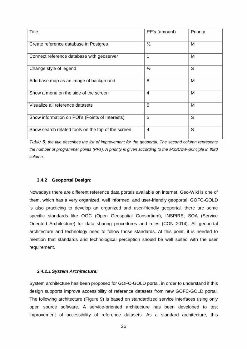
Title PP’s (amount) Priority
Create reference database in Postgres ½ M
Connect reference database with geoserver 1 M
Change style of legend ½ S
Add base map as an image of background 8 M
Show a menu on the side of the screen 4 M
Visualize all reference datasets 5 M
Show information on POI’s (Points of Interests) 5 S
Show search related tools on the top of the screen 4 S
Table 6: the title describes the list of improvement for the geoportal. The second column represents
the number of programmer points (PPs). A priority is given according to the MoSCoW-principle in third
column.
3.4.2 Geoportal Design:
Nowadays there are different reference data portals available on internet. Geo-Wiki is one of
them, which has a very organized, well informed, and user-friendly geoportal. GOFC-GOLD
is also practicing to develop an organized and user-friendly geoportal. there are some
specific standards like OGC (Open Geospatial Consortium), INSPIRE, SOA (Service
Oriented Architecture) for data sharing procedures and rules (CON 2014). All geoportal
architecture and technology need to follow those standards. At this point, it is needed to
mention that standards and technological perception should be well suited with the user
requirement.
3.4.2.1 System Architecture:
System architecture has been proposed for GOFC-GOLD portal, in order to understand if this
design supports improve accessibility of reference datasets from new GOFC-GOLD portal.
The following architecture (Figure 9) is based on standardized service interfaces using only
open source software. A service-oriented architecture has been developed to test
improvement of accessibility of reference datasets. As a standard architecture, this
27
application framework consists of several components. These components are divided into
different layers according to their functionality. Server side components have been more
focused on in this research.
Figure 9: System Architecture of Proposed GOFC-GOLD portal
Database:
The main goal of this research is to provide reference datasets as a useful, articulate and
multi-source datasets, which will be easily accessible and well described for the user. This
geo-database is a relational database for storing, querying and deploying of spatial data.
Moreover, among this architecture it is easy to view and download datasets without any
struggle. This database was developed using PostgreSQL with PostGIS. Because
PostgreSQL is the object-relational, database management system (ORDBMS) and free
open source software. Figure 10 shows the ER (Entity Relation) diagram of the developed
reference database which I developed for the server side development of the new geo-portal.
Appendix F have a brief description of Database library. As every reference dataset is
independent there is no relation between each other in the table. As sample size of the
database is too small (only four type of datasets) and the datasets are directly linked with
Geoserver there is no query developed.
THICK (DESKTOP) CLIENTS
[QGIS, ArcGIS, Google Earth]
APACHE TOMCAT[HTML, JavaScript]
GEOSERVER
WCS [tif, geotif..]
WMS [Gif, Png, Jpg, Kml]
WFS [GML, shapefile]
THIN (WEB) CLIENTS
[Open layers]
POSTGIS [Reference (Geo) database] Database
Web Server
Map Server
Interfaces
Client Applications
28
Figure 10: ER Diagram of Reference database
Server:
This portal is developed and organized using apache-tomcat server because this is a
standalone server with a cross platform with a servlet container, flexible to run on different
operating system, to support HTML and JavaScript, which were used to develop client
applications. The functionality of geo-web services (here I used GeoServer) include
published map rendering, feature streaming; data projection and geographic and attribute
based queries, address geocoding. Apache server visualizes reference datasets with
Geoserver support.
Interface:
Interface layer handles WMS (Web Map Service), WFS (Web feature Service) and WCS
(Web Coverage Service) functionalities. In this project, WMS has been used to visualize the
output on the web page.

29
Client Applications
Client side applications like full screen view, list of datasets in a pop-up menu, screen zoom
level and base layer are developed by using JavaScript, which access the WMS (Web Map
Service) data along with background satellite image. Finally, all these functionalities work
with the HTML (Hyper Text Markup Language). A client can request GLC reference data
from the geo-server using the HTTP-GET method. This method actually sends a request by
sending an URL with the server address and a parameter to specify the data a client wants
to get access to. The server returns an XML file that contains all requested reference data.
The following diagram (Figure 11) is known as UML (Unified Modeling Language) sequence
diagram. This diagram will help to understand the interaction of messages between objects
in the prototype geoportal and also will describe the sequence of actions which will be
performed to complete a task. There are two types of dimensions of this diagram: a vertical
dimension and a horizontal dimension. The vertical dimension represents the passage time
and horizontal dimension represents the objects involved in the interaction. This sequence
diagram in figure 11 represents four main objects, namely: Bing Maps Panel, WMS Layer
Panel, GeoServer and Database.
In the beginning, a user has to access the map presentation by using correct web address.
After a user has successfully entered into the system, the Bing map panel displays a satellite
image of the world. Then, thematic maps are displayed on top of the satellite image. There is
an option for the user to select a specific map for his use purpose.
Bing Map Panel WMS Layer Panel GeoServer Database
1. Access the geoportal
2. Request for datasets 4. Get Datasets
5. Return Datasets6. Get map
3. Display basic image
7. Return Images8. Display overlaid images
9. Select WMS layer 10. Get map
11. Return Images12. Display overlaid images
User
Figure 11: ER sequence diagram of the prototype geoportal

30
All the software and applications I used to develop the new prototype geoportal are open
source software. In appendix E there is a brief discussion about my choice.
3.5 Usability test of conceptual design:
Usability test gives feedback to the system developer and owner about the product, to say
whether it is good enough or needs more improvement or to identify the weakest part of the
development or the strong part. The following specification in Table 7 shows how to test the
design of new geoportal services for GOFC-GOLD.
Table 7: Specification of the dimension. Adopted from (Abugessaisa and Ostman 2011)
In usability perspective, different demonstration which allow users to search particular
dataset and give the result as a map in a specific scale is known as user satisfaction. It
improves the efficiency and effectiveness within a spatial context. Time spent is also an
important part to determine user satisfaction. To design a usability test questionnaire all the
points discussed in table 7 are important.
The focus of this test is to get feedback on content and satisfaction from the users. For the
technical design of a geoportal it is important to mention that usability criteria is not enough
to fulfil the user needs because usability is only a set of technical guidelines to develop a
geoportal (Resch and Zimmer 2013). User experiences and opinions are also very important.
In addition, after developing a new geoportal I need to validate my work. So I performed a
user survey, to the same persons that have participated in the usability test for accessibility
analysis of old GOFC-GOLD portal, to identify if the development is going in a right direction.
Survey procedure and steps are shown in figure 11. This questionnaire survey is identical to
the procedure of the questionnaire survey I did to find the answer of research question 2, but
Content 1. Completeness of datasets
2. Relevance with user needs
3. Status about datasets availability and updates
Satisfaction 1. Awareness of possibilities
2. Time necessary to master a new function
Interaction 1. Access to meta data
2. Tools like Zoom IN/Out, Pan, Identify, Proximity,
Layer Selection etc.
3. Use functionality to link with the user and datasets.

31
with only a very limited number of questions (4 questions) because the development is not
fully done. Only the development of the server side SDI has been completed, while the user
side development is still remaining. The questions are based on the pictures of the new
server side interfaces , because this is a prototype geoportal with limited server access.
Develop a questionnaire
Define usability measure and
heuristic
Add screenshot of the new portal
A very small questionnaire was developed
Contact and Interview the
user
Data collection and reporting
Figure 12: Survey procedure and steps

32
4. Results
4.1 Findings from Literature Research:
From the study for research question 1 - “What are reference data and how do they
validate the global land cover (GLC) datasets?”, the most important user requirement
for this GLC map is to assess the accuracy. Because of the scarcity of validation data,
reference datasets should be re-useable. An investigation on the efficient use of all
available validated and calibrated datasets for GLC map is a very new user requirement.
The sample size of the reference datasets should be large enough to achieve
acceptable precision for accuracy estimation of any certain map. Below are some
specifications of GOFC-GOLD datasets.
1. GOFC-GOLD adopted area units for their reference datasets which are not
dependent on a pixel or a block of pixel. They can be easily applied for different
map validation.
2. The sample size of reference datasets are of 500 reference sites with 5x5 km
block and can be increased for small secondary sampling unit.
3. Stratified sampling based datasets do not use stratifications that are targeted at
particular land cover maps.
4. Reference datasets provided by GOFC-GOLD are not map dependent. This is
one of the most important specifications which makes these datasets exception
from other reference datasets which is independent of any specific GLC dataset
and applicable to different GLC datasets.
5. From GOFC-GOLD LCPO provided reference datasets are suitable for re-use
and also examine the characteristics of the datasets. GOFC-GOLD is an ongoing
project. They are still improving their reference datasets for validation.
From the summary above about reference datasets and their use some important
findings are
Reference maps should be easily accessible in different format like shape files
with supporting files, KML, WMS and WFS.
Users of GLC maps need clear detailed information of the validated reference
maps. It will help users to select a suitable reference map and will reduce the
uncertainty in their applications.
33
Visual interpretation makes reference data more transparent, which will
envisage the location accuracy.
The list of essential information should be included in metadata information of
the reference datasets in an organized way for different applications of
different analysis.
To increase the acceptance of the reference datasets you need to describe
focus/aim of evaluation, map used for evaluation, corresponding year, spatial
resolution, thematic detail, quality flag information and classification scheme in
the metadata information.
4.2 Analysis the accessibility of GOFC-GOLD portal:
A usability test for the evaluation of the existing portal was performed with a sample size
of 12 participants. Four persons are experts in different research areas of Forestry,
Agriculture and Remote Sensing and eight students. There are several issues in
practice of the current geoportal implementation, such as missing search options,
missing link between datasets and metadata descriptions, and missing filter, sorting and
selection functions. In this test, user’s satisfaction should not only based on user
interface design and guidance but also consider the functional capability and Meta data
information.
The respondents could not answer properly to the questions in the section referring to
“task performed” (Appendix A) about timing and counting the clicks in the task.
Therefore, I skipped those four questions during analysis. From first four open questions
I tried to understand how popular the GOFC-GOLD geoportal is and if researchers use
this portal frequently or not. Also I examined whether they use the geoportal to get their
required datasets, and they were asked to rank the importance of interface or datasets
or tools facilities.
From the graph (Figure 13), it is possible to make the priority list of the functionality of a
geoportal. The question was “What do you look for at first step when you open a
geoportal?”

34
Figure 13: First step after entering a geoportal
It is clear from figure 13, when people enter into a geoportal most of them look for the
geo-database. Nevertheless, it is surprising that only a very few of them looks for
metadata information which is most important for the datasets. Metadata information
proves the authentication of a datasets.
From the question, “Which function of a geoportal you use frequently?” (Figure 14) I
tried to predict the user demand about the functionality from a geoportal. Half of the
respondents looked for the GIS datasets. Second popular function is the search dialog.
Users frequently use these functions in their operational procedures.
Figure 14: Function usages more in a Geoportal
25%
42%
17%
8%
8%
First step after entering a GeoPortal
Interface
GIS datasets
search dialog
tools (download/ zoomin/ zoom out)
meta data information
8%
50%
34%
8%
Function usages more in a Geoportal
Interface
GIS datasets
search dialog
tools (download/zoom in/ zoom out)

35
The participant performed a small task when they participate in this questionnaire
survey. They had to look for the reference datasets in existing GOFC-GOLD portal. And
following analysis are based on the related questions with that task.
In figure 15 most of the users were not satisfied with the visual appearance, interface
design, scattered and incomplete information, lacking of tools functionality and so on.
Regarding the content 67% of all respondents have objections about the completeness
of the datasets in figure 15. 42% of the respondents didn’t find any information about
regular updates.
Figure 15: Completeness of the datasets and Information availability and updates of the
datasets
To understand the user satisfaction about the portal I asked a question in the
questionnaire survey using Likert Scale “On a scale of 1 to 10 (1 = lowest and 10 =
highest), how would you rate this GOFC-GOLD reference data portal?”
33%
67%
Completeness of the Datasets
Yes
No
42%
33%
17%
8%
Information about availability and Updates of the datasets
1(Not really)
2(Poor)
3(Need MoreImprovement)
4(Clear)
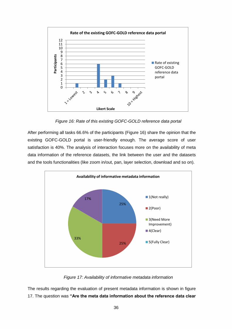
36
Figure 16: Rate of this existing GOFC-GOLD reference data portal
After performing all tasks 66.6% of the participants (Figure 16) share the opinion that the
existing GOFC-GOLD portal is user-friendly enough. The average score of user
satisfaction is 40%. The analysis of interaction focuses more on the availability of meta
data information of the reference datasets, the link between the user and the datasets
and the tools functionalities (like zoom in/out, pan, layer selection, download and so on).
Figure 17: Availability of informative metadata information
The results regarding the evaluation of present metadata information is shown in figure
17. The question was “Are the meta data information about the reference data clear
0123456789
101112
Par
tici
pan
ts
Likert Scale
Rate of the existing GOFC-GOLD reference data portal
Rate of existingGOFC-GOLDreference dataportal
25%
25%
33%
17%
Availability of informative metadata information
1(Not really)
2(Poor)
3(Need MoreImprovement)
4(Clear)
5(Fully Clear)

37
for you?”. Figure 17 shows that 25% of the respondent score the meta data information
is totally unclear. 25% believe the metadata information is poorly explained. 33% of
them think it’s need more improvement. However 17% of the respondents judge it is
clear. But no one said it’s fully clear for them.
To understand the link between user and datasets I asked about the design of the portal
“Is the portal organized enough to find your required datasets?” and about the
user interface “Is the interface of the portal user friendly?” And the result is mostly
negative, as can be seen below in figure 18.
Figure 18: about the design of the existing portal and user interface
Additional results are presented in Appendix “B” which describes more clearly the
situation of existing GOFC-GOLD geoportal and the actions needed to improve the
accessibility.
4.3 Design of GOFC-GOLD portal:
A new geoportal (Figure 19) has been developed using open source software to check if
it helps to improve the accessibility of GLC reference maps provided by GOFC-GOLD.
There are two parts of a geoportal design. First part is Server side design and the
second part is client side design. In my work, I focus more on server side development
that include database construction, user-friendly viewing interface. Because to develop a
new geoportal first need to assure the data storage, retrieval and display capacity which
0
2
4
6
8
10
12
Yes No
Par
tici
pan
ts
User's Dicission
Design of the portal and user interface
Is the portal organizedenough to find yourrequired map?
Is the interface of theportal user friendly?

38
belongs to server side design development. The script to develop new interface are
given in Appendix C.
Figure 19: New prototype interface of the portal, the start-up screen with different
functionalities combination with pop-up button (the right side white screen with a name
list of the reference maps), left side zoom in and zoom out option, on the top a
navigation bar.
When starting the new GOFC-GOLD geoportal on different browsers, the first screen
that is visualized, displayed in figure 18, shows a satellite image from Bing map. It also
shows reference datasets (mainly in this figure the green spots are the GLC2000
reference points), a pop-up button with a list of reference datasets, zoom in zoom out
button and a navigation bar with search tool, download button, link with home page, FTP
and disclaimer button. To see all datasets you need to use zoom in and out tools. In
figure 20 all marked points represents different reference datasets; the arrows indicate
the datasets content. With the pop-up button layers of a reference dataset can be turned
on or off by clicking on the box underneath the name of the reference dataset.

39
Figure 20: All datasets are in same list and visualized on the same interface together.
A navigation bar in Figure 21 was created which holds different links such as a link to
the home page, contact addresses, disclaimer, FTP. A search engine, a dropdown
button named Tools, a help button and most important a download button was included
in that navigation bar. The Home button links the portal to the GOFC-GOLD website.
The FTP link downloads all reports, newsletters and other necessary documents. from
the contact button provides access to a list of contact persons of this project. The other
three important tools are search engine, which facilitates a data or information search
related with GOFC-GOLD Land Cover Project, a download button with the facilities of
data download in different format such as KML, GML, WFS, WMS or WPS file. Lastly a
help button is created to help the user to navigate through the portal.
Figure 21: Navigation bar with different buttons.

40
4.4 Usability analysis of new designed GOFC-GOLD portal:
A small questionnaire survey was prepared for the validation of the new prototype
GOFC-GOLD geoportal aimed to understand the user acceptance. This survey was the
follow up of the evaluation test of the existing GOFC-GOLD geoportal. Only four
questions were held in this survey to evaluate the visualization improvement and
different kind of tools facilities. All questions are presented in Appendix D.
The first question was about visualization, asking if it is easier for the user to find the
reference datasets. The majority of the participants answered this questions with yes, as
seen in figure 22.
Figure 22: Easy to find reference maps from pop-up button
This graph describes, that out of 12 respondents 9 persons found it was easier to find
the reference datasets. For 3 people, 25% of the respondent, it was still difficult, to find
their required reference datasets from this new geoportal. However, this is an
improvement to the old situation where 67% respondents face difficulties to find their
required datasets from the existing GOFC-GOLD geoportal in figure 15 (completeness
of the datasets).
The second question was about the comparison between the existing GOFC-GOLD
portal and the new designed portal to understand if this change helps to improve the
accessibility of reference datasets. And the result is following figure 23.
0 2 4 6 8 10 12
Yes
No
Participants
Par
tici
pan
t's
Dic
issi
on
Easy to find reference datasets from pop up button

41
Figure 23: Improved enough than the previous GOFC-GOLD portal
Most of the participants agreed that the prototype portal is improved enough than the
existing one. The participants didn’t have another option then answering with yes or no.
However, to gain insight into more need for improvement, open questions might have
been more suitable.
The third question was aiming to evaluate the user-friendly interface. The user interface
is one of the most important parts of a geoportal which can visualize a large amount of
information interactively. The response from the respondents is presented in figure 24.
Figure 24: question about new user interface
This graph represents that the new user interface is highly appreciated by the user. If we
compare the result from figure 18 and figure 24 it’s clear that there is a big change in the
results, which shows that the user interface has improved with the new concepts that
have been used. In figure 17 41.66% of total respondents like the existing user interface
and from figure 24 91.66% of total respondents like the new interface of the prototype
geoportal.
0 2 4 6 8 10 12
Yes
No
Participants
Par
tici
pan
t's
Dic
issi
on
improved enough than the previous GOFC-GOLD portal
0 2 4 6 8 10 12
Yes
No
Participants Par
tici
pan
t's
Dic
issi
on
About user interface

42
The fourth and last question evaluate the user tools (download button as an example)
that were created to facilitate the users by providing different tools like pan, zoom in/out,
pop up button, download button, search engine and so on. The outcome is shown in
figure 25.
Figure 25: Easy access to download data
From the result of this graph it can be seen that, a large improvement on the client side
of the application is required. One third of the total sample group is not satisfied with
these tools.
0 2 4 6 8 10 12
Yes
No
Participants PA
rtic
ipan
t's
De
ciss
ion
About Easy Access to Download data

43
5. Conclusion, Discussion and Recommendation
5.1 Conclusion:
For research work and for the accuracy assessment of GLC datasets we need suitable
reference datasets which offer in good quality. To check the quality of GLC datasets the
user should have knowledge about the error structure of land cover data to improve their
product and prediction. To meet the user requirement well-informed, appropriate GLC
reference datasets and a well described validation procedure should be included in the
geoportal. This information will be important for the users to select their required
reference datasets and is useful to increase the re-usability of the reference datasets.
Multi-data records of reference datasets can provide accurate error estimation and
uncertainty assessment.
The aim of this research was to improve access of reference datasets for global land
cover map validation. To reach the aim four research questions were formulated to
examine and evaluate the existing geoportal and a new prototype version of an
improved geoportal.
A literature study has shown that GOFC-GOLD provided reference datasets are
valuable assets for the researchers of the whole world. However, currently these
datasets are not easily accessible or fully authentic.
To understand the situation of the existing GOFC-GOLD geoportal an evaluation
survey was performed. The test consisted of a small task with several related
questions. All the participants could finish the task well and the results indicated that
there are serious issues that need to be change in the existing GOFC-GOLD geoportal.
On the subject of data retrieval and data access, results of the questionnaire expressed
that most of the users were in agreement about weak map interface, a lack of search
dialogue and unorganized metadata information. The results also identified several
problems related to spatial data access and worldwide sharing. In order to provide GLC
reference datasets with the given facilities from GOFC-GOLD reference data portal, the
existing portal has to be improved, including the creation of an organized database
management system with sufficient data storage capacity and guidelines with structured
Meta information for the user. A user-friendly interface with flexible tools developed
which enable users to download reference datasets for their scientific research purpose.
A prototype geoportal has been developed as an example case there are two parts of
geoportal development, server side development and client-application side

44
development. I focused more on server side development which consists of database
development, connection with a geoserver and visualisation of datasets as web maps
with satellite background image. However, it has been difficult to validate the server side
work. So only the server side interface get more focus for the validation. A design for
client applications still needs to be developed. A sequence diagram was delivered to
visualize the detail of the reference datasets I used for my research purpose. The
sequence diagram was delivered to visualize series of actions that can be performed by
the user in the prototype geoportal. SDI, geoportal and geospatial web service concepts
and technologies were used.
A usability test has been performed on the prototype geoportal interface. The result
shows that more than 75% participants believed that the new geoportal (prototype) was
capable to improve the accessibility of the reference datasets and the overall user
satisfaction increase remarkable.
5.2 Discussion
Nowadays, Global Land Cover datasets takes a very special place in the research fields
related with different global changes, agriculture, urban planning and so forth. GOFC-
GOLD Land Cover Project Office took a good initiative to support those researches by
providing standard quality GLC reference datasets with the detail of validation criteria.
An in-depth study which is reported in chapter 2 has been done to understand clearly
about reference data and the validation criteria. Normally most of the reference datasets
are developed from field surveys and on a specific research purpose, which is
expensive and make it unsuitable to use for validation in other research work GOFC-
GOLD provided reference datasets are free for use and are applicable for different GLC
datasets. From the GOFC-GOLD website, I found only the shape files of reference
datasets with a brief description of their validation process. However, reference datasets
provided by GOFC-GOLD are re-useable but the metadata framework is not organized.
An organized metadata framework help user as a guideline to use the proper reference
datasets for specific applications.
In the 3rd GOFC-GOLD land monitoring symposium the GOFC-GOLD geoportal issue
was discussed and they mention the existing portal as a prototype stage (Mora and
Herold 2013). The aim of my research was to understand how a web based GIS solution

45
related with spatial data storage, retrieval and visualization of the datasets can improve
access to these GOFC-GOLD reference datasets for global land cover data validation.
Han et al. (2015) developed a web-based system to support the GLC data production.
For the development he used Open Source Software (OSS) and off-the-shelf
(commercial). Fritz et al. (2012) also use OSS. Like them, I decided to use open source
software because OSS are for free. More about my decision is described in Appendix E.
But both of them developed the web-GIS architecture for commercial purposes and to
collect and provide crowed sourcing GLC reference data. Thus, they focus more on the
client-side application part of geoportal development whereas I focussed more on the
server side architecture development. Their work is in implementation level and my one
is in formal level. At this state, search tool, download tool (need more development),
catalogue service, metadata design (over all client side design development) is still
missing, and can be achieved in implementation level with a nice client-application side
design development.
GOFC-GOLD LCPO start reorganizing their geoportal with a new concept from July
2015. The GOFC-GOLD website which leads access to the geoportal is still available
during this time. They will added a download option of reference datasets in different
formats. Within the map they divided the sample area in different classifications but
there is no clear explanation about this classification, which might cause confusion. In
my prototype geoportal design, maps are underplayed with a background satellite
image, which is the start page of the portal. Also there is a link with the home page of
the website a download button. The search option and different user tools on the
navigation bar which have been proposed in my prototype are still missing in their new
redevelopment. Another important difference between the redeveloped and the
prototype version is that the redevelopment is based on CartoDB software service which
is known as cloud computing platform to get GIS and Web mapping tools. Unlike the
proposed OSS solution. GOFC-GOLD have to pay for that service.
5.3 Recommendations:
Recommendations for further improvement of Geoportal:
1. A user comments/needs a survey form, blog page; problem and solution page
should be in the portal to know about the updates, regular contact with the users,

46
about new research who are interested to use GOFC-GOLD reference datasets
and what are their requirement.
2. By adding a dropdown options for the entire list of datasets to give an easy access
to the users.
3. A download button with several download options like pdf, jpg, img, shp, kml is
required.
4. Each and every dataset should have individual pages with clear metadata
information which will be linked with the dropdown button to collect the metadata
and validated reference datasets.
All these recommendations should be included as part of a client-side application
design.
Recommendations for Assessment improvement of GLC reference datasets:
5. To meet the user requirement a well-informed appropriate GLC reference datasets
and map validation procedure should be well described. This information will be
important for user selection and also useful for increasing the re-usability of the
reference datasets. Multi-data record of reference datasets can provide accurate
error estimation and uncertainty assessment. Standard baseline validation criteria
should be described in detail in metadata information. Like
Legend
Classification Scheme
Number of class
Classifier information provided
Sampling Design (cost and statistical precision)
Sample unit type and size
Sample size
Sample selection scheme
Sample stratification
Inclusion probability
Minimum Mapping Unit

47
Response design (reflection on the agreement between map and reference
classification)
Source of information
Temporal coverage
Location accuracy
Labelling procedure
Sample verification
Confidence in interpretation
Majority classes and their fraction
Current use
Intended application
Other applications
Applied pre-processing
Derived accuracy estimates
The given proposed structure is for the further development of the metadata information of
GOFC-GOLD provided reference datasets. From my research point of view it would be user
friendly and easy accessible if the future development will follow these recommendations.
48
References:
Abugessaisa, I. and A. Ostman (2011). "Testing-sdi: e-government prospective, requirements, and challenges." International Journal of Public Information Systems 7.
Achard, F., et al. (2002). "Determination of Deforestation Rates of the World's Humid Tropical Forests." Science 297: 999-1002.
Aditya, T. and M. J. Kraak (2009). Geoportals and the GDI Accessibility. Handbook of Research on Geoinformatics. H. A. Karimi: 42-50.
Al-Kilidar, H., et al. (2005). The use and usefulness of the ISO/IEC 9126 quality standard. Empirical Software Engineering, 2005. 2005 International Symposium on, IEEE.
Alan H. Strahler, et al. (2006). "GLOBAL LAND COVER VALIDATION: RECOMMENDATIONS FOR EVALUATION AND ACCURACY ASSESSMENT OF GLOBAL LAND COVER MAPS."
Arino, O., et al. (2008). "GlobCover: The most detailed portrait of Earth." European Space Agency Bulletin 2008: 24-31.
Bai, B., et al. (2008). "The impact of website quality on customer satisfaction and purchase intentions: Evidence from Chinese online visitors." International Journal of Hospitality Management 27: 391-402.
Bartholomé, E. and A. S. Belward (2005). "GLC2000: a new approach to global land cover mapping from Earth observation data." International Journal of Remote Sensing 26: 1959-1977.
Belward, A. S., et al. (1999). "The IGBP-DIS global 1-km land-cover data set DISCover: A project overview." Photogrammetric Engineering and Remote Sensing 65: 1013-1020.
Bevan, N. (2009). "International standards for usability should be more widely used." Journal of usability Studies 4: 106-113.
Bontemps, S., et al. (2011). GlobCover 2009: Products description and validation report. ESA Glovecover project. O. Arino and K. V.
Bontemps, S., et al. (2011). "Revisiting land cover observations to address the needs of the climate modelling community." Biogeosciences Discuss. 8: 7713-7740.
Bontemps, S., et al. (2012). "Revisiting land cover observation to address the needs of the climate modeling community." Biogeosciences 9: 2145-2157.
Boundless (2015). "GeoServer in Production ". Retrieved 18-02-2015, from http://boundlessgeo.com/whitepaper/geoserver-production-2/.
Chuvieco, E. and A. Huete (2009). Accuracy Assessment. Fundamentals of Satellite Remote Sensing CRC press.
Clark, M. L. and T. M. Aide (2011). "Virtual Interpretation of Earth Web-Interface Tool (VIEW-IT) for Collecting Land-Use/Land-Cover Reference Data." Remote Sensing 3: 601.
CON, E. (2014). EVALUATING GEOPORTALS. Geodetic and Geographic Information Technologies Department. THE GRADUATE SCHOOL OF NATURAL AND APPLIED SCIENCES, MIDDLE EAST TECHNICAL UNIVERSITY: 108.

49
Congalton, R. G. and K. Green (2009). Assessing the accuracy of remotely sensed data: principles and practices, CRC press.
Crompvoets, J. W. H. C. (2006) Global Developments of National Spatial Data Clearinghouses.
De Longueville, B. (2010). "Community-based geoportals: The next generation? Concepts and methods for the geospatial Web 2.0." Computers, Environment and Urban Systems 34: 299-308.
Defourny, P., et al. (2009). "Accuracy assessment of a 300 m global land cover map: the GlobCover experience." Proceedings of the 33rd International Symposium on Remote Sensing of Environment.
Dictionary (2007). Validation. The Free Dictionary by Farlex.
Doxygen (2005). "Geospatial Data Abstraction Library ". Retrieved 25-09-2014, 2014, from http://www.gdal.org/index.html.
Dragićević, S. (2004). "The potential of Web-based GIS." 6: 79-81.
Durpaire, J. P., et al. (1995). "Spot-4 vegetation instrument: Vegetation monitoring on a global scale." Acta Astronautica 35: 453-459.
ESA (2011). "First official release of a new generation of satellite-derived global land cover products." Retrieved 08-10-2014, 2014, from http://www.esa-landcover-cci.org/?q=node/156.
Esri (2013). "Esri International User Conference." from http://events.esri.com/uc/QandA/index.cfm?fuseaction=answer&conferenceId=CCAEEE69-1422-2418-7F1D0EB8490B776D&questionId=4881.
Foley, J. A., et al. (2005). "Global Consequences of Land Use." Science 309: 570-574.
Friedl, M. A., et al. (2002). "Global land cover mapping from MODIS: algorithms and early results." Remote Sensing of Environment 83: 287-302.
Friedl, M. A., et al. (2010). "MODIS Collection 5 global land cover: Algorithm refinements and characterization of new datasets." Remote Sensing of Environment 114: 168-182.
Fritz, S., et al. (2012). "Geo-Wiki: An online platform for improving global land cover." Environmental Modelling & Software 31: 110-123.
Fritz, S., et al. (2011). "Highlighting continued uncertainty in global land cover maps for the user community." Environmental Research Letters 6: 044005.
GEOSS (2005). The Global Earth Observation System of Systems GEOSS 10-Year Implementation Plan.
GlobCover (2000-2011). "Welcome to the European Space Agency GlobCover Portal." Retrieved 8-10-2014, 2014, from http://due.esrin.esa.int/globcover/.
Glossary, M. (2005). "The Motive Web Design Glossary ". Retrieved 23-02-2015, 2015, from http://www.motive.co.nz/glossary/web-access.php#afterMenu.
GOFC-GOLD (2011). A sourcebook of methods and procedures for monitoring and reporting anthropogenic greenhouse gas emissions and removals caused by deforestation, gains and losses of carbon stocks in forests remaining forests, and deforestation. F. Achard, S. Brown, R. D. Fries et al. GOFC-GOLD Project Office, hosted by Natural Resources Canada, Alberta, Canada.
50
GOFC-GOLD and F. M. a. M. Team (2014). "Fire Monitoring & Mapping Implementation Team." Retrieved 27-08-2014, 2014, from http://gofc-fire.umd.edu/.
Granic, A., et al. (2008). Experience with Usability Testing of Web Portals. WEBIST 2008, Proceedings of the Fourth International Conference on Web Information Systems and Technologies, Volume 2, Funchal, Madeira, Portugal, May 4-7, 2008.
Groot, R. (1997). "Spatial data infrastructure (SDI) for sustainable land management." ITC Journal: 287-294.
Han, G., et al. (2015). "A web-based system for supporting global land cover data production." ISPRS Journal of Photogrammetry and Remote Sensing 103: 66-80.
Hansen, M. C., et al. (2003). "Global Percent Tree Cover at a Spatial Resolution of 500 Meters: First Results of the MODIS Vegetation Continuous Fields Algorithm." Earth Interactions 7: 1-15.
Hansen, M. C., et al. (2000). "Global land cover classification at 1 km spatial resolution using a classification tree approach." International Journal of Remote Sensing 21: 1331-1364.
Hansen, M. C., et al. (2010). "Quantification of global gross forest cover loss." Proceedings of the National Academy of Sciences 107: 8650-8655.
He, X., et al. (2012). "Geoportal usability evaluation." Int. J. Spat. Data Infrastruct. Res 7: 88-106.
Henry, S. L. (2007). "Just Ask: Integrating Accessibility Throughout Design." from http://www.uiaccess.com/accessucd/background.html.
Henry, S. L. (2011). "Understanding Web Accessibility ". Retrieved 20-02-2015, 2015, from http://www.adobe.com/macromedia/accessibility/pub/acc_sites_chap01.pdf
Herold, M., et al. (2009). Translating and evaluating land cover legends using the UN Land Cover Classification System (LCCS).
Herold, M., et al. (2008a). "Some challenges in global land cover mapping: An assessment of agreement and accuracy in existing 1 km datasets." Remote Sensing of Environment 112: 2538-2556.
Herold, M., et al. (2008b). Report of the GOFC-GOLD/CEOS Working on Land Cover Change Accuracy Assessment as part of the Third GOFC-GOLD Land Cover Symposium Friedrich-Schiller University.
Herold, M., et al. (2011). "User Requirements Documents: Land Cover CCI." Université Catholique de Louvain (UCL)-Geomatics, Louvain-la-Neuve, Belgium.
Herold, M., et al. (2006). "A joint initiative for harmonization and validation of land cover datasets." Geoscience and Remote Sensing, IEEE Transactions on 44: 1719-1727.
Hese, S., et al. (2005). "Global biomass mapping for an improved understanding of the CO2 balance - the Earth observation mission Carbon-3D." Remote Sensing of Environment 94: 94-104.
Hibbard, K., et al. (2010). "Research priorities in land use and land-cover change for the Earth system and integrated assessment modelling." International Journal of Climatology 30: 2118-2128.

51
Inc, A. (2003). "What is Reference data?" Reference Data Portal. Retrieved 04-03-2015, 2015, from http://www.refdataportal.com/index.cfm?fuseaction=refdata&mode=whatisit.
Inc., O. G. C. (2007). OpenGIS® Geography Markup Language (GML) Encoding Standard. C. Portele. 3.2.1.
Kulkarni, A. T., et al. (2014). "A web GIS based integrated flood assessment modeling tool for coastal urban watersheds." Computers & Geosciences 64: 7-14.
LCPO, G.-G. (2012-2013). "Welcome to the GOFC-GOLD Reference Data Portal Beta version opened on April 2013 ". Retrieved 12-09-2014, 2014, from http://www.gofcgold.wur.nl/sites/gofcgold_refdataportal.php.
Lillesand, T., et al. (2014). Remote Sensing and Image Interpretation, Wiley.
Loveland, T. R., et al. (2000). "Development of a global land cover characteristics database and IGBP DISCover from 1 km AVHRR data." International Journal of Remote Sensing 21: 1303-1330.
Loveland, T. R., et al. (1999). "An analysis of the IGBP global land-cover characterization process." 65: 1021-1032.
Maguire, D. J. and P. A. Longley (2005). "The emergence of geoportals and their role in spatial data infrastructures." Computers, Environment and Urban Systems 29: 3-14.
Manisa, M. and D. B. Nkwae (2007). Developing Botswana Spatial Data Infrastructure: From Concept to Reality. Hong Kong SAR.
Mora, B. and M. Herold (2013). Report of the 3rd GOFC-GOLD Land Monitoring Symposium. Annual Report 2012, Wageningen University.
Mora, B., et al. (2014b). A Framework for the Validation of Global Land Cover Reference Datasets, Wageningen University and Research Center.
Mora, B., et al. (2014c). "GOFC-GOLD EFFORTS IN SUPPORT OF GLOBAL LAND COVER MAPPING ACTIVITIES." Retrieved 07-04-2015, 2015, from http://lcluc.umd.edu/Documents/ScienceTeamMtg/2014APR/Poster/Brice_Mora_Poster.pdf.
Myneni, R. B., et al. (2002). "Global products of vegetation leaf area and fraction absorbed PAR from year one of MODIS data." Remote Sensing of Environment 83: 214-231.
Nielsen, J. (1994). Usability inspection methods. Conference companion on Human factors in computing systems, ACM.
Olofsson, P., et al. (2013). "Making better use of accuracy data in land change studies: Estimating accuracy and area and quantifying uncertainty using stratified estimation." Remote Sensing of Environment 129: 122-131.
Olofsson, P., et al. (2012). "A global land-cover validation data set, part I: fundamental design principles." International Journal of Remote Sensing 33: 5768-5788.
Peterson, M. P. (2001). "the development of map distribution through the internet." Department of Geography University of Nebraska at Omaha.
Pflugmacher, D., et al. (2011). "Comparison and assessment of coarse resolution land cover maps for Northern Eurasia." Remote Sensing of Environment 115: 3539-3553.
Rajabifard, A., et al. (2002). "Future directions for SDI development." International Journal of Applied Earth Observation and Geoinformation 4: 11-22.

52
Ramankutty, N., et al. (2008). "Farming the planet: 1. Geographic distribution of global agricultural lands in the year 2000." Global Biogeochemical Cycles 22.
Resch, B. and B. Zimmer (2013). "User Experience Design in Professional Map-Based Geo-Portals." ISPRS International Journal of Geo-Information 2: 1015-1037.
Shen, S., et al. (2008). Sensor web oriented web-based GIS. Lecture Notes in Computer Science (including subseries Lecture Notes in Artificial Intelligence and Lecture Notes in Bioinformatics). 5373 LNCS: 86-95.
Souza, C., Jr., et al. (2009). "Web-oriented GIS system for monitoring, conservation and law enforcement of the Brazilian Amazon." Earth Science Informatics 2: 205-215.
Stehman, S. V., et al. (2012). "A global land-cover validation data set, II: augmenting a stratified sampling design to estimate accuracy by region and land-cover class." International Journal of Remote Sensing 33: 6975-6993.
Sterling, S. M., et al. (2013). "The impact of global land-cover change on the terrestrial water cycle." Nature Climate Change 3: 385-390.
Tait, M. G. (2005). "Implementing geoportals: applications of distributed GIS." Computers, Environment and Urban Systems 29: 33-47.
Townshend, J. R., et al. (2006). "A revised strategy for GOFC-GOLD." GOFC-GOLD Report 24.
Townshend, J. R., et al. (2012). "Global characterization and monitoring of forest cover using Landsat data: opportunities and challenges." International Journal of Digital Earth 5: 373-397.
Tsendbazar, N. E., et al. (2014). "Assessing global land cover reference datasets for different user communities." ISPRS Journal of Photogrammetry and Remote Sensing.
Verburg, P. H., et al. (2011). "Challenges in using land use and land cover data for global change studies." Global Change Biology 17: 974-989.
Vocabulary.com (2015). accessibility The dictionary
W3C (1999). "Web Content Accessibility Guidllines." Retrieved 23-02-2015, 2015, from http://www.w3.org/WAI/GL/WD-WAI-PAGEAUTH/
Wachowicz, M. (2006). On a conceptual framework for multimodal interaction on the Web: a usability perspective. Proceedings First International Workshop on Mobile Geospatial Augmented Reality, Alberta, Canada.
Wachowicz, M., et al. (2008). The effects of web mapping applications on user satisfaction: an empirical study. International perspectives on maps and the Internet, Springer: 397-415.
Wu, W., et al. (2008). "Validation and comparison of 1 km global land cover products in China." International Journal of Remote Sensing 29: 3769-3785.
Zell, E., et al. (2012). "A user-driven approach to determining critical earth observation priorities for societal benefit." IEEE Journal of Selected Topics in Applied Earth Observations and Remote Sensing 5: 1594-1602.
Zhan, X., et al. (2000). "The 250 m global land cover change product from the Moderate Resolution Imaging Spectroradiometer of NASA's Earth Observing System." International Journal of Remote Sensing 21: 1433-1460.

53
Zhao, Y., et al. (2014). "Towards a common validation sample set for global land-cover mapping." International Journal of Remote Sensing 35: 4795-4814.
Zhu, Z. and E. Waller (2003). "Global Forest Cover Mapping for the United Nations Food and Agriculture Organization Forest Resources Assessment 2000 Program " Forest Science 49.
Zimmerman, C. (2014). "Software Options for Seeding and Tiling." Retrieved 16-09-2014, 2014, from http://opengeoportal.org/software/resources/software-options-for-seeding-and-tiling/.
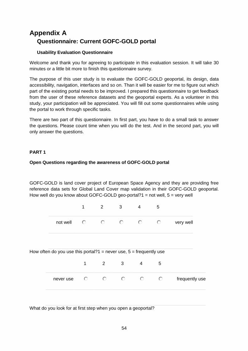
54
Appendix A
Questionnaire: Current GOFC-GOLD portal
Usability Evaluation Questionnaire
Welcome and thank you for agreeing to participate in this evaluation session. It will take 30
minutes or a little bit more to finish this questionnaire survey.
The purpose of this user study is to evaluate the GOFC-GOLD geoportal, its design, data
accessibility, navigation, interfaces and so on. Than it will be easier for me to figure out which
part of the existing portal needs to be improved. I prepared this questionnaire to get feedback
from the user of these reference datasets and the geoportal experts. As a volunteer in this
study, your participation will be appreciated. You will fill out some questionnaires while using
the portal to work through specific tasks.
There are two part of this questionnaire. In first part, you have to do a small task to answer
the questions. Please count time when you will do the test. And in the second part, you will
only answer the questions.
PART 1
Open Questions regarding the awareness of GOFC-GOLD portal
GOFC-GOLD is land cover project of European Space Agency and they are providing free
reference data sets for Global Land Cover map validation in their GOFC-GOLD geoportal.
How well do you know about GOFC-GOLD geo-portal?1 = not well, 5 = very well
1 2 3 4 5
not well
very well
How often do you use this portal?1 = never use, 5 = frequently use
1 2 3 4 5
never use
frequently use
What do you look for at first step when you open a geoportal?

55
search dialog
GIS datasets
tools (download/zoom in/ zoom out)
interface
meta data information
Other:
Which function of a geoportal you use frequently?
search dialog
GIS datasets
tools (download/ zoom in/ zoom out)
interface
meta data information
Other:
Task Performed
During the task you have to count the clicks and time to answer following five questions
Please download the VIIRS reference map from the GOFC-GOLD geoportalTo visit the
portal please go for this link http://www.gofcgold.wur.nl/ . and note the time duration of
visiting the portal.
:
How many times do you click on different heading to find the VIIRS reference map?
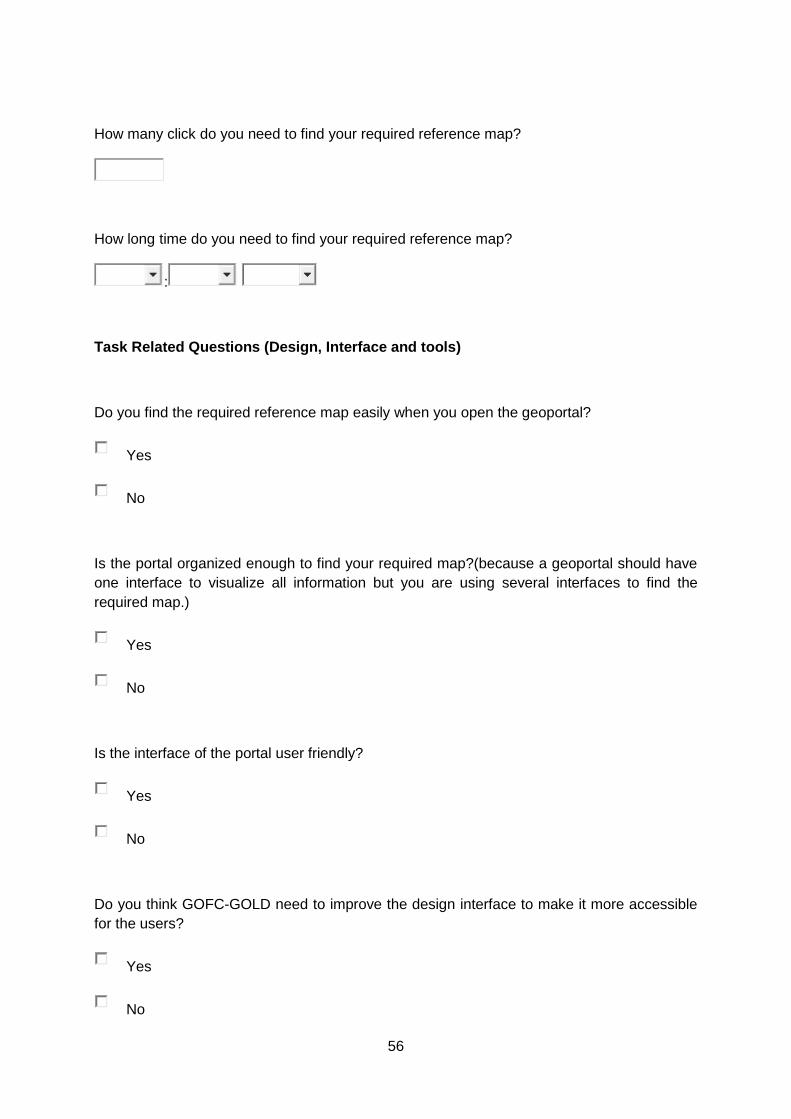
56
How many click do you need to find your required reference map?
How long time do you need to find your required reference map?
:
Task Related Questions (Design, Interface and tools)
Do you find the required reference map easily when you open the geoportal?
Yes
No
Is the portal organized enough to find your required map?(because a geoportal should have
one interface to visualize all information but you are using several interfaces to find the
required map.)
Yes
No
Is the interface of the portal user friendly?
Yes
No
Do you think GOFC-GOLD need to improve the design interface to make it more accessible
for the users?
Yes
No
57
Do you find any button as a tool (not inside of a text paragraph) on the map to download
reference maps?
Yes
No
Can you download reference maps in different format like shape/image/kml file
Yes
No
Do you find any tools to select your research area?
Yes
No
Do you find any information about validation criteria or validation process of these reference
map?(the required reference data you are going to download is validated.)
Yes
No
Is the information in an organized way?
Yes
No
Do you think you can use this reference maps directly to validate your maps?
Yes
No
58
Do you found all criteria of a geoportal in this GOFC-GOLD portal?criteria means data
services, catalog services, design of the portal etc.
Yes
No
Questions related to use of the Portal
Are the meta data information about the reference data clear for you?1 = not really, 2 = poor,
3 = need more improvement, 4 = clear, 5 = fully clear
1 2 3 4 5
Not Really
Fully Clear
does the meta data content about the reference map fit your requests?1 = useless, 2 =
useable anyhow, 3 = useable, 4= informative, 5 = very informative
1 2 3 4 5
Useless
Very informative
Quality of map visualization (customized legend, adaptability of map’s size, attribute queries,
information about data quality, support for all reference system)1= very bad, 2 = bad, 3 =
good, 4 = good enough, 5 = perfect
1 2 3 4 5
Very bad
Prefect
Could you locate the terms and conditions of downloading and using this reference maps?1=
not found, 2 = hard to find, 3 = complicated, 4= described, 5 = well decribed
1 2 3 4 5

59
not found
well described
Could you find information on regular updates of reference maps?1= no information found, 2
= very few, 3 = ok, 4= good, 5 = good enough
1 2 3 4 5
No information found
good enough
Do the resolutions of the portal (given bellow in the images) match your expectations?1=
poor, 2 = ok, 3= medium, 4 = high 5 = very high
1 2 3 4 5
Poor
Very High
How good is the categorization of information about reference maps on the portal?1=
useless, 2 = ok 3 = less informative 4=informative, 5 = very informative
1 2 3 4 5
Useless
Very informative
General Questions
On a scale of 1 to 10 (1 = lowest and 10 = highest), how would you rate this GOFC-GOLD
reference data portal
1 2 3 4 5 6 7 8 9 10
Describe how the use of symbols and tools could be improved
60
Describe your experience with GOFC-GOLD reference data portal
If you have any additional comments about GOFC-GOLD portal
Personal Question
Your name:
Email address:
Organisation / Research domain:

61
Appendix B
Questionnaire Results
Results current GOFC-GOLD portal:
0
2
4
6
8
10
12
Yes No
Do you find the required reference map easily when you open the geoportal?
Do you find the requiredreference map easily whenyou open the geoportal?
0
2
4
6
8
10
12
Yes No
Is the portal organized enough to find your required map?
Is the portal organizedenough to find yourrequired map?

62
0
2
4
6
8
10
12
Yes No
Is the interface of the portal user friendly?
Is the interface of theportal user friendly?
0
2
4
6
8
10
12
Yes No
Do you think GOFC-GOLD need to improve the design interface to make it more accessible for the users?
Do you think GOFC-GOLDneed to improve thedesign interface to makeit more accessible for theusers?

63
These two results looks a bit different. Because both of the result is 100% no. The actual
problem is in existing (year of 2014) GOFC-GOLD geoportal. There was only one option
to download the datasets as shape file. And there is no tools to select the interested area.
You have to download full datasets and then using local software you can select your
interested area.
Can you download reference maps in different format like shape/image/kml file
Yes
No
Do you find any tools to select your research area?
Yes
No

64
Describe how the use of symbols and tools could be improved
I am confused by the headings and arrangement of different product names,
functions, metadata, and download links. Maybe it is helpful to make
the names and metadata more obvious. The download links also need to be
more obvious and state which format of the products I can select;
- add search tool
- use the different color/ bigger letter size for the symbol which indicates a link
- use a common web-symbol
Small screen showing location of world where you are looking at. This would
be especially helpful in situations when you had zoomed in more.
I do not see a button to remove selected
The option to layer the different maps together (using different symbols for
each layer) would be helpful.
I couldn't find the portal as shown above....
I am completely lost. I could only find a download function. I cannot find any
visualization tool. Is there one?
It's okay I think
A search dialog would help.
0123456789
101112
Do you find anyinformation about
validation criteria orvalidation process of
these reference map?
Is the information in anorganized way?
Do you think you canuse this referencemaps directly to
validate your maps?
Yes
No

65
Describe your experience with GOFC-GOLD reference data portal
Confusing; even don't know which is really reference data for which products,
where I can see the metadata for more than half hour. Finally find some
separated information in somewhere description of data.
So far I never really use GOFC-GOLD as my reference data
Which one? The one they have now?
That one makes more the impression of being a info-portal where you can get information
about data, but I did not know that it was available for downloading geo-data.
The text is too much in focus, the map looks like a standard google maps product and
reference data is presented in red dots. I was not even sure what they mean, and why
they only represent a sample. Also optically appeared in the same layout on the
reference map. I wasn't able to distinguish between datasets or show more see more
than one. If data is represented by points it would be nice to have different colours for
each dataset.
In terms of downloading the data, this was not difficult. Since this is the most
important thing, I would say it is therefore a good portal. Other functions
should be optional.
Poor
Too less information on the data portal.
I would have to find something particular that I need for a real case to say
something about this
If you have any additional comments about GOFC-GOLD portal
Improve it to be more user friendly, especially the user interface
I am wondering if I'm looking at the right portal... I don't find any data except
for a few shape files....
It is not a type of portal i am used to.
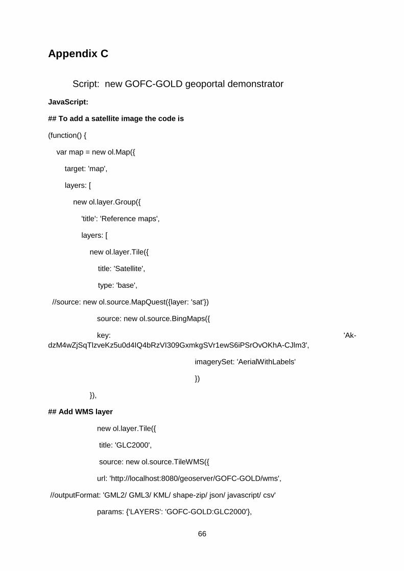
66
Appendix C
Script: new GOFC-GOLD geoportal demonstrator
JavaScript:
## To add a satellite image the code is
(function() {
var map = new ol.Map({
target: 'map',
layers: [
new ol.layer.Group({
'title': 'Reference maps',
layers: [
new ol.layer.Tile({
title: 'Satellite',
type: 'base',
//source: new ol.source.MapQuest({layer: 'sat'})
source: new ol.source.BingMaps({
key: 'Ak-
dzM4wZjSqTlzveKz5u0d4IQ4bRzVI309GxmkgSVr1ewS6iPSrOvOKhA-CJlm3',
imagerySet: 'AerialWithLabels'
})
}),
## Add WMS layer
new ol.layer.Tile({
title: 'GLC2000',
source: new ol.source.TileWMS({
url: 'http://localhost:8080/geoserver/GOFC-GOLD/wms',
//outputFormat: 'GML2/ GML3/ KML/ shape-zip/ json/ javascript/ csv'
params: {'LAYERS': 'GOFC-GOLD:GLC2000'},

67
serverType: 'geoserver'
})
## Fix viewing resolution
view: new ol.View({
center: ol.proj.transform([35.9, 7.46], 'EPSG:4326', 'EPSG:4326'),
zoom: 2.5
})
});
});
## HTML script: (this script is to visualize the datasets on the web)
HTML script is to visualize the datasets on the web.
<html>
<head>
<meta charset="utf-8" />
<title>GOFC-GOLD Land Cover Project Office</title>
<meta name="viewport" content="initial-scale=1.0, user-scalable=no, width=device-
width">
<style type="text/css">
.popover {
z-index: auto;
}
.popover-content {
min-width: 180px;
}
</style>

68
</head>
<body>
<div id="map"></div>
<div style="display: none;">
<div id="popup" title="Welcome to GOFC-GOLD"></div>
<script src="lib/ol.js"></script>
<script src="src/ol3-layerswitcher.js"></script>
<script src="addlayer.js"></script>
<script src="src/jquery.min.js"></script>
<script src="src/bootstrap.min.js"></script>
</body>
</html>

69
Appendix D
Questionnaire new GOFC-GOLD geoportal
Home Page of the existing and new GOFC-GOLD geoportal
Figure 1: Existing GOFC-GOLD geoportal (version 2014)

70
Figure 2: Proposed interface GOFC-GOLD geoportal
Questions for new geoportal
please look at the given image "outlook of the new GOFC-GOLD geoportal" and answer the
following questions.
Pop-up Button
Navigation Bar

71
In this new portal is it easy for you to find reference maps?
Yes
No
Do you think it is improved enough than the previous GOFC-GOLD portal?
Yes
No
Does the user interface looks better now?
Yes
No
Do you find download button now?
Yes
No
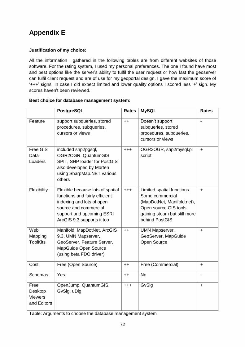
72
Appendix E
Justification of my choice:
All the information I gathered in the following tables are from different websites of those
software. For the rating system, I used my personal preferences. The one I found have most
and best options like the server’s ability to fulfil the user request or how fast the geoserver
can fulfil client request and are of use for my geoportal design. I gave the maximum score of
‘+++’ signs. In case I did expect limited and lower quality options I scored less ‘+’ sign. My
scores haven’t been reviewed.
Best choice for database management system:
PostgreSQL Rates MySQL Rates
Feature support subqueries, stored
procedures, subqueries,
cursors or views
++ Doesn’t support
subqueries, stored
procedures, subqueries,
cursors or views
-
Free GIS
Data
Loaders
included shp2pgsql,
OGR2OGR, QuantumGIS
SPIT, SHP loader for PostGIS
also developed by Morten
using SharpMap.NET various
others
+++ OGR2OGR, shp2mysql.pl
script
+
Flexibility Flexible because lots of spatial
functions and fairly efficient
indexing and lots of open
source and commercial
support and upcoming ESRI
ArcGIS 9.3 supports it too
+++ Limited spatial functions.
Some commercial
(MapDotNet, Manifold.net),
Open source GIS tools
gaining steam but still more
behind PostGIS.
+
Web
Mapping
ToolKits
Manifold, MapDotNet, ArcGIS
9.3, UMN Mapserver,
GeoServer, Feature Server,
MapGuide Open Source
(using beta FDO driver)
++ UMN Mapserver,
GeoServer, MapGuide
Open Source
+
Cost Free (Open Source) ++ Free (Commercial) +
Schemas Yes ++ No -
Free
Desktop
Viewers
and Editors
OpenJump, QuantumGIS,
GvSig, uDig
+++ GvSig +
Table: Arguments to choose the database management system

73
Suitable Server Application to visualize maps online:
GeoServer Rates MapServer Rates
Language Java based + C/C++ with a lot of PHP ++
Output produces KML, GML,
Shapefile, GeoRSS, PDF,
GeoJSON, JPEG, GIF,
SVG, PNG and more
+++ Produces WMS, WFS and
WCS
+
Flexibility Easy to connect virtual
world
++ Hard to connect virtual
world
-
Interoperab
ility
publishes data from any
major spatial data source
using open standards
+++ Develop environment for
building spatially-enabled
web mapping applications
and services
+
Cost Free (Open Source) ++ Free (Open Source) ++
Server Open source Server + Open Source application -
Table: Arguments to choose the server for sharing geospatial data
Suitable Server to add user tools and visualize the maps:
Apache tomcat Rates IIS Windows
Server
Rates
Connection
capacity
Standalone Server with cross
platform
++ Single platform +
Flexibility Flexible. Can run on different
operating system.
+++ Fixed. Can run only
on windows.
-
Cost Free + Free +
Status Web Server and a servlet
container
++ Web server +
Program Plain JavaScript with HTML + --
Table: Arguments to choose the server to visualize the geospatial data with retrievals option.
From the above discussion my choices for different software and programs are below:
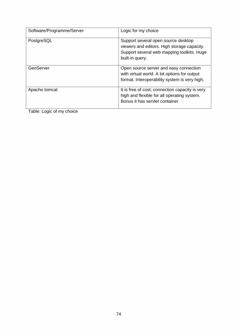
74
Software/Programme/Server Logic for my choice
PostgreSQL Support several open source desktop
viewers and editors. High storage capacity.
Support several web mapping toolkits. Huge
built-in query.
GeoServer Open source server and easy connection
with virtual world. A lot options for output
format. Interoperability system is very high.
Apache tomcat It is free of cost; connection capacity is very
high and flexible for all operating system.
Bonus it has servlet container
Table: Logic of my choice

75
Appendix F The Database Library (Description of attributes):
GLC2000:

76

77
GlobCover2005:

78

79
STEP:

80

81
VIIRS:

82


