1 Figure 1. 1972 Sau Mau Ping landslide Challenges in Slope Engineering in Hong Kong R. K. S. Chan Geotechnical Engineering Office, Civil Engineering and Development Department, Hong Kong Abstract: The combination of extremely hilly terrain, deep weathered rock profiles, high seasonal rainfall, dense population, developments close to the hillside and the ever-increasing public expectation on slope safety render slope engineering in Hong Kong very challenging. There had been severe landslides in the past resulting in fatalities and significant damages to properties. Over the past thirty years, a comprehensive Slope Safety Management System has been developed and implemented to tackle the unique landslide problems. The evolution of the Slope Safety Management System came in stages. In the 1970s, the main concern was related to the lack of geotechnical control and standards of good practice for earthworks, as well as the liquefaction failure of large loose fill slopes. These were combated by the establishment a geotechnical control body (Geotechnical Control Office, renamed as Geotechnical Engineering Office (GEO) in 1991) and a major fill slope recompaction programme. In the 1980s, the main challenges were still in setting up an effective and efficient geotechnical control system, setting geotechnical standards and getting the necessary legal authority to control slope works. There was also much problem due to landslides in squatter areas, which was tackled by a non-development clearance programme. In the 1990s, the most severe landslide was a fatal retaining wall failure at Kwun Lung Lau. It triggered the acceleration of the slope upgrading programme, new insight into failure mode of thin masonry walls, comprehensive monitoring and inspection of buried water-carrying services affecting slopes, the formulation of a systematic landslide investigation programme, regular external technical review and a proactive public education and publicity programme on slope safety. This paper describes the Slope Safety Management System and highlights the many challenges and the evolution of the system by means of a number of landslide case histories. 1 LANDSLIDE PROBLEM AND SLOPE SAFETY MANAGEMENT 1.1 The Old Days Hong Kong has a small land area of 1,097 square kilometers. Only about 15% or 165 square kilometers is developed land; the remaining 85% is woodland, country park areas or sparsely developed areas. The substantial economic expansion since the 1950’s has been accompanied by extensive civil engineering and building works in both the public and the private sectors. The combination of extremely hilly terrain, deep weathered rock profiles and high seasonal rainfall has in the past resulted in some severe landslide problems in Hong Kong’s dense urban environment. In the 1960’s, slope design and construction were based on rules of thumb, such as 10:6 cutting with 1 to 2 m wide berms at about 7.5 m vertical intervals giving an average slope angle of about 50° (Lumb, 1975). Fill embankments were formed by end-tipping without any compaction, resulting in loose slopes at an angle of about 35°. Fatal landslides in these days were not uncommon. Figure 2. 1972 Po Shan Road landslide
Transcript
1
Figure 1. 1972 Sau Mau Ping landslide
Challenges in Slope Engineering in Hong Kong
R. K. S. ChanGeotechnical Engineering Office, Civil Engineering and Development Department, Hong Kong
Abstract: The combination of extremely hilly terrain, deep weathered rock profiles, high seasonal rainfall, dense population, developments close to the hillside and the ever-increasing public expectation on slope safety render slope engineering in Hong Kong very challenging. There had been severe landslides in the past resulting in fatalities and significant damages to properties. Over the past thirty years, a comprehensive Slope Safety Management System has been developed and implemented to tackle the unique landslide problems. The evolution of the Slope Safety Management System came in stages. In the 1970s, the main concern was related to the lack of geotechnical control and standards of good practice for earthworks, as well as the liquefaction failure of large loose fill slopes. These were combated by the establishment a geotechnical control body (Geotechnical Control Office, renamed as Geotechnical Engineering Office (GEO) in 1991) and a major fill slope recompaction programme. In the 1980s, the main challenges were still in setting up an effective and efficient geotechnical control system, setting geotechnical standards and getting the necessary legal authority to control slope works. There was also much problem due to landslides in squatter areas, which was tackled by a non-development clearance programme. In the 1990s, the most severe landslide was a fatal retaining wall failure at Kwun Lung Lau. It triggered the acceleration of the slope upgrading programme, new insight into failure mode of thin masonry walls, comprehensive monitoring and inspection of buried water-carrying services affecting slopes, the formulation of a systematic landslide investigation programme, regular external technical review and a proactive public education and publicity programme on slope safety. This paper describes the Slope Safety Management System and highlights the many challenges and the evolution of the system by means of a number of landslide case histories.
1 LANDSLIDE PROBLEM AND SLOPE SAFETY MANAGEMENT
1.1 The Old Days
Hong Kong has a small land area of 1,097 square kilometers. Only about 15% or 165 square kilometers is developed land; the remaining 85% is woodland, country park areas or sparsely developed areas. The substantial economic expansion since the 1950’s has been accompanied by extensive civil engineering and building works in both the public and the private sectors. The combination of extremely hilly terrain,
deep weathered rock profiles and high seasonal rainfall has in the past resulted in some severe landslide problems in Hong Kong’s dense urban environment.
In the 1960’s, slope design and construction were based on rules of thumb, such as 10:6 cutting with 1 to 2 m wide berms at about 7.5 m vertical intervals giving an average slope angle of about 50° (Lumb, 1975). Fill embankments were formed by end-tipping without any compaction, resulting in loose slopes at an angle of about 35°. Fatal landslides in these days were not uncommon.
Figure 2. 1972 Po Shan Road landslide
Finish.indb14 2007/8/1711:01:50AM
2
1.2 Disastrous Landslides in 1970s
In June 1972, a road embankment in a new public housing development failed (Figure 1) and engulfed a temporary housing area. Seventy-one people died. A few hours later, a temporary excavation in the Mid-levels district on Hong Kong Island collapsed, bringing down the natural hillside above it (Figure 2). The debris demolished a 13-storey building and killed 67 people.
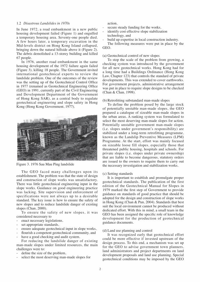
In 1976, another road embankment in the same housing development of the 1972 failure again failed (Figure 3), killing 18 people. The Government invited international geotechnical experts to review the landslide problem. One of the outcomes of the review was the setting up of the Geotechnical Control Office in 1977 (renamed as Geotechnical Engineering Office (GEO) in 1991, currently part of the Civil Engineering and Development Department of the Government of Hong Kong SAR), as a central body to regulate geotechnical engineering and slope safety in Hong Kong (Hong Kong Government, 1977).
Figure 3. 1976 Sau Mau Ping landslide
The GEO faced many challenges upon i ts establishment. The problem was that the state of design and construction of slope works was unsatisfactory. There was little geotechnical engineering input in the slope works. Guidance on good engineering practice was lacking. Site supervision and enforcement of specifications were not always up to a desirable standard. The key issue is how to ensure the safety of new slopes and to reduce landslide danger of existing slopes (Chan, 2000).
To ensure the safety of new slopes, it was considered necessary to- enact necessary legislations,- set appropriate standards,- ensure adequate geotechnical input in slope works,- flourish a competent geotechnical community, and- have a good checking and audit system.
For reducing the landslide danger of existingman-made slopes under limited resources, the main challenges were to:- define the size of the problem,- select the most deserving man-made slopes for
action,- secure steady funding for the works,- identify cost effective slope stabilization
technology, and- build up expertise in local construction industry.
The following measures were put in place by theGEO.
(a) Geotechnical control of new slopesTo stop the scale of the problem from growing, a
checking system was introduced by the government for all new geotechnical works. Hong Kong had for a long time had a Buildings Ordinance (Hong Kong Law, Chapter 123) that controls the standard of private developments. This was extended to cover earthworks. For government projects, administrative arrangement was put in place to require slope designs to be checked (Chan & Chan, 1998).
(b) Retrofitting substandard man-made slopesTo define the problem posed by the large stock
of potentially unstable man-made slopes, the GEO prepared a catalogue of sizeable man-made slopes in the urban areas. A ranking system was formulated to select the most deserving man-made slopes for action. Potentially unstable government man-made slopes (i.e. slopes under government’s responsibility) are stabilized under a long-term retrofitting programme, known as the Landslip Preventive Measures (LPM) Programme. At the start, effort was mainly focused on sizeable loose fill slopes, especially those that threatened public housing, hospitals and schools. For private slopes (i.e. slopes under private ownership) that are liable to become dangerous, statutory orders are issued to the owners to require them to carry out the necessary investigation and stabilization works.
(c) Setting standardsIt is important to establish and promulgate proper
geotechnical standards. The publication of the first edition of the Geotechnical Manual for Slopes in 1979 marked the first step of Government to provide guidance on standards of good practice that should be adopted for the design and construction of slope works in Hong Kong (Chan & Pun, 2004). Standards that best suit the local environment cannot be produced without dedicated effort. With this in mind, a small team in the GEO has been assigned the specific role of knowledge development for the production of geotechnical guidance documents.
(d) Land use planning and controlIt was recognized early that geotechnical effort
could be more effective if invested upstream of the design process. To this end, a mechanism was set up for the GEO to advise government town planners, land administrators and project departments on land development proposals and land use planning. Special geotechnical conditions may be imposed by the GEO
Finish.indb15 2007/8/1711:01:50AM
3
in lease documents for controlling potential landslide hazard. In especially difficult terrain, the GEO may advise against development or make alternative proposals.
(e) Landslip Warning and emergency servicesIn spite of the works programme to upgrade
potentially unstable man-made slopes, not all slopes can be upgraded overnight and not every slope deserves spending money on upgrading. Landslides cannot be avoided during time of heavy rainfall. Landslip Warning and emergency services are therefore integral parts of the slope safety management. A Landslip Warning system was introduced in Hong Kong in 1977. Decision on the issue of landslip warning was made based on real-time rainfall information collected from a network of automatic raingauges and rainfall forecast provided by meteorological professionals (Chan et al, 2001). When the Landslip Warning is in force, it would be broadcast to the public on the television and over the radio at regular intervals. The issue of the Landslip Warning triggers the mobilization of emergency systems within government departments to deal with landslide aftermaths (Figure 4).
1.3 Landslide Risk in the 1980s
The main challenge in the early 1980s are still in setting up an effective and efficient geotechnical control system, setting geotechnical standards and getting the necessary legal and administrative authority to control slope works in order to ensure the safety of new slopes. New legislations were enacted, new standards document were issued and new organizational set up for the geotechnical checking function was established.
Retrofitting of existing substandard man-made slopes continued. Some existing slopes that were formed illegally on hillsides by squatters posed a different problem to the government. The background was that there was steady flow of illegal immigrants to Hong Kong. Many of the illegal immigrants found accommodation in squatter huts on wide stretches of steep hillside. Cutting steep into the hillside and dumping of loose excavated soils to form building platform was normal, virtually without any control. There were hardly any surface drainage provisions and surface protection to the formed slopes. Such slopes and the disturbed hillsides were particularly prone to landslides. In two heavy rainstorms in May and August 1982, nearly 700 landslides were reported to the government and a total of 23 people living in squatters huts were killed (Figure 5).
The challenge is that it is generally difficulty to carry out slope upgrading works in squatter areas because of the lack of access and working space. It is also debatable whether a large sum of public money on slope stabilization should be spent for the benefit of unauthorized occupants of lands. On balance of social responsibility and effective use of resources, the government implemented the direct solution of re-housing squatter occupants subjected to landslide hazard (Massey et al, 2007).
Since the mid 1980s, some 75,000 people living in squatter huts and steep hillsides have been systematically re-housed under the clearance programmes. This landslide risk mitigation approach has significantly reduced the number of landslide fatalities in squatter areas.
The main challenge faced by the GEO nowadays is social rather than technical in nature – many occupants of squatter huts refuse to leave their homes.
1.4 Increasing Public Expectations since the 1990s
Turning to the 1990s, the landslide risk was much reduced, which was reflected in the substantial reduction in fatalities due to landslides (Figure 6). Concurrently, the expectation of the public continued to increase. With the resources the government already invested in slope safety, the public was less tolerant of the occurrence of multi-fatality landslides. The previously secondary impact of landslides, viz. temporary closure of roads and building evacuation,
Figure 4. Mobilisation of GEO Emergency Control Centre
Figure 5. Landslides in 1982 affecting squatters
Finish.indb16 2007/8/1711:01:51AM
4
then became key issues. The public also demanded better environment, a more transparent government and enhanced information service. The GEO reacted positively to the new challenges by:- continuing to improve the slope safety management
system,- enhancing information services,- strengthening maintenance of man-made slopes,- enhancing the appearance of man-made slopes,- launching a comprehensive public education and
publicity programme, and- providing community advisory service to private
slope owners.
(a) Continual improvement in slope safety managementImprovement of the geotechnical control of new
slopes continues to enhance its effectiveness. A recent enhancement is the setting up of a statutory register of geotechnical engineers (Registered Geotechnical Engineers) to take over geotechnical engineering duties related to private building works starting from December 2005. For existing man-made slopes, the LPM Programme was greatly accelerated in mid-1990. The annual expenditure under the LPM Programme is nowadays about HK$900 millions a year. About 250 government man-made slopes are upgraded each year and 300 private man-made slopes are examined for safety screening (Tang et al, 2007).
(b) Enhancement of information servicesThe size of the slope catalogue continues to
expand. The catalogue now contains information on about 57,000 man-made slopes. The catalogue has evolved from a hard copy to a digital version and has been made available on the Internet (Mak et al, 2001). Besides, the maintenance responsibilities of all man-made slopes in the catalogue were identified systematically. The public can also gain access to the information through the Internet.
Most of the landslides in Hong Kong are rain-induced. It is therefore necessary to have a good
understanding of the relationship between rainfall and landslide and much had been done in this regard. Even so, real-time prediction of landslide danger is never easy. The operation of the Landslip Warning System also requires good knowledge of real-time and forecast rainfall. Under-prediction of landslide danger defeats the purpose of the warning. On the other hand, false alarm weakens the credibility of the system and wastes the resource on the mobilization of emergency services. The likelihood of landslide in heavy rainfall changes with time. Some man-made slopes would become more resilient to rainfall attack because they have been upgraded and better maintained. Some poorly-maintained man-made slopes would deteriorate with time and become more vulnerable to rainfall. Continual research in rainfall and landslide relationship is needed. The first set of Landslip Warning criteria was established in 1977 based on the work of Lumb (1975). The criteria have been revised
a number of times since then (e.g. Brand et al, 1984; Pun et al, 2003). The current criterion is based on the correlation between slope failure rate and maximum rolling 24-hour rainfall developed by Yu et al (2004).
(c) Strengthening maintenance of man-made slopesInadequate slope maintenance is a contributory
factor in many landslides in Hong Kong. The standard of slope maintenance was enhanced by the publication of a Guide to Slope Maintenance (GEO, 1995). The Guide stipulates annual routine maintenance inspection and maintenance works, as well as inspection by a professional geotechnical engineer once every five to ten years for every man-made slope. Additional resources were allocated for slope maintenance work.
Fig. 8 Examples of vegetated slopes and an upgraded masonrywall with wall trees preserved
Erosion control mat
Hydroseeding andpit planning of trees
Grass
Climbers
Erosioncontrolmat andwiremesh
Grass
Planterholesforclimber
Block Pattern
Vertical Wall
Newmethodsto grass
Shrubs
Climbers
Trees/Shrubs
Planters
Fig 7 Common methods of vegetating slopesFigure 7. Common methods of vegetating slopes
Finish.indb17 2007/8/1711:01:54AM
5
The Hong Kong Government now spends about HK$600 million a year on maintenance of government slopes.
(d) Enhancement of appearance of man-made slopesPeople want a slope to be safe as well as pleasant
looking and environmental friendly. To meet this challenge, the GEO landscapes all the slopes that are upgraded under the LPM programme. New greening techniques are introduced (Figure 7). The commonly used methods are provision of vegetation covers with the use of erosion control mats as needed, masonry block facing, ribbed or other patterned finishes, toe planters, colouring and planter holes, coupled with suitable retention of existing vegetation. More fancy techniques such as decorative artwork and artificial rock are occasionally used (Figure 8). The enhancement in slope appearance has been made possible by promulgation of new technical guidelines (e.g. GEO Publication No 1/2000 (GEO, 2000)), sharing of experience amongst practitioners and getting specialist advice from landscape experts where needed (Chan, 2005).
(e) Public educationHow to manage the public expectation and keep
the public maintaining vigilant of landslide risk is a real challenge. It is neither good for the public to have too high an expectation nor to feel complacent. It is unrealistic to achieve zero landslide risk.
The GEO began to spend more effort in public education in 1992. Initially, the purpose of the programme is to make the stakeholders to understand the importance of slope maintenance and that private man-made slopes should be maintained by private owners. A systematic publicity campaign on slope maintenance was launched. Later, it was extended to educate the public that it was impossible to achieve zero landslide risk and personal precautionary
measures should be taken during heavy rainfall, particularly when the Landslip Warning is issued. The activities include television and radio announcements, media br ief ings, dis tr ibut ion of leaf lets and promotional materials, lectures, seminars, slogan and bookmark competition, year-round roving exhibitions in schools and shopping centres, preparation of an education toolkit on slope safety for use by schools and so on (Mak et al, 2007). A book on landslide history of Hong Kong was also published to remind people of the landslide risk (Figure 9).
Figure 9. Book on landslide history of Hong Kong
With the assistance of universities and research organizations, the GEO has been conducting annual public opinion surveys to gauge the effectiveness of the campaign. The survey results showed that public awareness of the importance of slope safety was once fairly high but has been declining in recent years (Figure 10). This can be explained by the absence of serious landslides in recent years, leading to the general complacency about landslide risk. To maintain public awareness on landslide risk in ‘quiet’ years is still a challenge ahead.
(f) Community Advisory ServiceTo enhance and reinforce private owners’
acceptance of their responsibility for slope safety, the GEO set up a Community Advisory Unit in 1999 to provide proactive outreach services to advise private slope owners on how to proceed with the necessary slope upgrading and maintenance works. The principal
Fig. 8 Examples of vegetated slopes and an upgraded masonrywall with wall trees preserved
Erosion control mat
Hydroseeding andpit planning of trees
Grass
Climbers
Erosioncontrolmat andwiremesh
Grass
Planterholesforclimber
Block Pattern
Vertical Wall
Newmethodsto grass
Shrubs
Climbers
Trees/Shrubs
Planters
Fig 7 Common methods of vegetating slopes
Figure 8. Examples of vegetated slopes and an upgraded masonry wall with wall trees preserved
Finish.indb18 2007/8/1711:01:55AM
6
functions of the Unit include slope safety talks and seminars, meet-the-public sessions and advisory services on slope maintenance and Dangerous Hillside Order cases. The government also established a loan fund for those who need financial assistance to maintain or upgrade their slopes.
1.5 Summary of evolution of Hong Kong Slope Safety Management System
Triggered by disastrous landslides in the 1970s, comprehensive slope safety management in Hong Kong began in the late 1970s. The system has been evolving over the past thirty years in response to the change in the nature of the landslide problem and in public expectation. The GEO manages the Slope Safety System, and undertakes control, research and educational functions; it also carries out specialist works projects. The Slope Safety Management System is highly regarded by geotechnical practitioners and natural hazard managers worldwide. The key result areas of the current system are as follows (Chan, 2003):- Improve slope safety standards, technology, and
administrative and regulatory framework.- Ensure safety standards of new slopes.
- Rectify substandard government man-made slopes.- Maintain all government man-made slopes.- Ensure that owners take responsibility for slope
safety.- Promote public awareness and response in
slope safety through public education, publicity,information services and public warnings.
- Enhance the appearance and aesthetics ofengineered slopes.
2 TECHNICAL CHALLENGES
In the second part of this paper, a number of landslide case histories are described to highlight some technical challenges in slope engineering.
2.1 Kwun Lung Lau Retaining Wall Failure
2.1.1 The landslideA landslide occurred adjacent to a footpath within
the Kwun Lung Lau housing estate in Hong Kong on 23 July 1994 (Figure 11). The landslide involved the collapse of a masonry wall more than 100 years old, that was likely to have been intended as a facing to a steep cut slope. It resulted in five fatalities and serious injuries to three other people. It was a ‘surprise’ and aroused great concern of the public, the legislators and the Administration. The GEO carried out a comprehensive investigation into the cause and mechanism of the landslide (GEO, 1994), and an international geotechnical expert was engaged to conduct an independent review of the investigation (GEO, 1994).
The landslide occurred in the late evening at about 8:53 pm during heavy rainfall (Figure 12). Many people walked along the footpath at that time. The landslide debris, about 1000 m³ in volume, buried the footpath and some passengers. The landslide scar measured 28 m wide and 14 m high, with an average depth of about 3 m. A cross section through the landslide site, showing the ground profiles before and
Fig. 11 1994 Kwun Lung Lau landslide
Fig 12 Rainfall at Kwun Lung Lau at the time of landslide
Fig. 10 Results of public opinion survey
73%
81%
78%
73%
83%
77%
71%
83%
76%
73%
88%
80%
63%
78%
70%
59%
81%
66%71
%
88%
75%
0%
10%
20%
30%
40%
50%
60%
70%
80%
90%
100%
1999
2000
2001
2002
2003
2004
2005
1999
2000
2001
2002
2003
2004
2005
1999
2001
2002
2003
2004
2005
Concern withslope safety
Importance ofslope maintenance
Understanding ofowners'
responsibility
2000
Figure 12. Rainfall at Kwun Lung Lau at the time of landslide
Fig. 11 1994 Kwun Lung Lau landslide
Fig 12 Rainfall at Kwun Lung Lau at the time of landslide
Fig. 10 Results of public opinion survey
73%
81%
78%
73%
83%
77%
71%
83%
76%
73%
88%
80%
63%
78%
70%
59%
81%
66%71
%
88%
75%
0%
10%
20%
30%
40%
50%
60%
70%
80%
90%
100%
1999
2000
2001
2002
2003
2004
2005
1999
2000
2001
2002
2003
2004
2005
1999
2001
2002
2003
2004
2005
Concern withslope safety
Importance ofslope maintenance
Understanding ofowners'
responsibility
2000
Figure 11. 1994 Kwun Lung Lau landslide
Fig. 11 1994 Kwun Lung Lau landslide
Fig 12 Rainfall at Kwun Lung Lau at the time of landslide
Fig. 10 Results of public opinion survey
73%
81%
78%
73%
83%
77%
71%
83%
76%
73%
88%
80%
63%
78%
70%
59%
81%
66%71
%
88%
75%
0%
10%
20%
30%
40%
50%
60%
70%
80%
90%
100%19
9920
0020
0120
0220
0320
0420
05
1999
2000
2001
2002
2003
2004
2005
1999
2001
2002
2003
2004
2005
Concern withslope safety
Importance ofslope maintenance
Understanding ofowners'
responsibility
2000
Figure 10. Results of public opinion survey
Finish.indb19 2007/8/1711:01:56AM
7
after the failure, is given in Figure 13. The geology of the landslide location comprised fill overlying partially weathered volcanics. The fill behind and above the wall was loose and generally very permeable.
The masonry wall that failed was a pointed squared-rubble wall with stone ties and weepholes. This kind of wall was once commonly constructed in Hong Kong. The wall has a maximum height of 10.6 m. At the failure location, the wall was 700 mm to800 mm thick, and was constructed against a cuttinginto the natural ground (Figure 14). The wall hadbeen inspected by a number of professional partiesin the past. The wall was found to be in fair or goodcondition; no signs of distress were ever recorded.
It was known from old topographic maps that the wall was constructed some time before 1901. Additional fill was placed behind the wall between 1964 and 1969. Engineering analyses showed that, prior to the placement of the additional fill, the wall would not become unstable even if the retained soil became fully saturated. After placement of the fill, the stability of the wall relied on soil suction that was developed in the soil beneath the surface cover, and it would become unstable if the soil became saturated.
According to the accounts of witnesses, the masonry wall failed initially by bursting at about its mid-height. The brittle mode of failure of the slender wall was confirmed using numerical analysis. The analysis predicted that the wall would fail with a complex mechanism, involving a combination of bulging and overturning modes followed by sudden total collapse of the ground (Figure 15).
The landslide was triggered by rainwater. Detailed examination of foulwater and stormwater systems in the vicinity of retaining wall revealed defects including local settlement, cracking, dislocated joints and open joints. Leakages of these defective underground water-carrying services were the principal sources of water for saturating the fill behind the wall.
2.1.2 Masonry wall studyThe landslide highlighted the danger of tall slender
masonry wall. Thin masonry walls are liable to fail in a brittle manner without appreciable prior warning. It would be un-conservative to rely on calculated factor of safety to say that a thin wall is stable. Practitioners learned from this landslide that it would be prudent to assume such slender masonry walls substandard and to carry out upgrading works.
The next question was: how many more slender masonry walls were there in Hong Kong? The old construction record may not be accurate.
The GEO reacted quickly to this potential threat. A weephole probing exercise was initiated to determine the thicknesses of masonry walls. All masonry walls in the urban areas were probed, and upgrading works were carried out where needed.
R e s e a r c h a n d d e v e l o p m e n t w o r k o n t h e applicability of geophysics techniques, including ground penetrating radar (GPR), shallow seismic reflection, resistivity imaging (RI), electromagnetic survey, self-potential , infrared thermography and spectral analysis of surface waves, for the determination of retaining wall geometry was also undertaken. It was found that GPR and RI had the potential to identify thin walls but it was difficulty to delineate the back of the wall in cases of very thick walls or composite walls (i.e. one retaining wall built on top of another) and where the back of the wall was not well defined.
2.1.3 Regular monitoring of water-carrying services affecting slopes
Leakage from water-carrying services had long been known to have adverse effect on the stability of a slope. The approach in dealing with this problem had been reactive, i.e. to conduct leak detection and pipe repair works only when seepage that was suspected to be due to leakage from water-carrying services was observed on a slope.
The approach was proved inadequate. In response to the lesson learnt, the government implemented a systematic programme of regular monitoring and maintenance of buried water-carrying services affecting slopes. A Code of Practice was published to
Fig. 13 Cross section of the ground that failed at Kwun Lung Lau
Fig. 14 Close view of the collapsed retaining wall
(a) At Cycle No. 25 000 (b) At Cycle No. 35 000
(c) At Cycle No. 60 000 (d) At Cycle No. 75 000
Fig. 15 Numerical modelling of the 1994 Kwun Lung Lauretaining wall failure
Figure 14. Close view of the collapsed retaining wall
Finish.indb20 2007/8/1711:01:57AM
8
give guidance on the monitoring work (ETWB, 2006). 2.1.4 Systematic landslide investigation
Although the masonry wall had not had any previous instability, landslides that involved failure volumes ranging from tens of cubic metres to several hundred cubic metres had occurred in other areas of Kwun Lung Lau over the past years. In his independent review report, Professor Morgenstern noted that “In the context of Kwun Lung Lau, there were a number of clues prior to 1994 that loose fill existed and that there were defects in the buried services. An earlier more integrated perspective might have averted the problem that arose and an effort is needed to impose such an integrated perspective into slope stability assessment in Hong Kong”.
The technical challenge of assessing slope stability in perspective prompted the formulation of a systematic landslide investigation programme in Hong Kong in 1997. The main objectives of the systematic landslide studies are as follows (Chan & Ho, 2001):- Identification of slopes in need of early attention
before the situation deteriorates to result in aserious problem.
- Improvement in knowledge on the causes andmechanisms of landslides so as to formulate newideas for reducing landslide risk and enhancing thereliability of landslide preventive or slope remedialworks.
- Provision of data for reviewing the performance ofthe Slope Safety System and identifying areas forimprovement.
- Provision of evidence in forensic studies of seriouslandslides that may involve coroner’s inquest, legalaction or financial dispute.Systematic studies of landslides have led to a
better understanding of the nature of slope safety problems in Hong Kong. Through these studies, practitioners can learn how slopes behave and perform, what the deficiencies in current practice are, and where improvements are needed in respect of slope investigation, design, construction and maintenance.
Guidelines on good practice arising from lessons learnt from landslide investigations are available to practitioners from time to time, e.g. GEO Technical Guidance Note No. 11 (GEO, 2003).
2.1.5 External technical review Prompted by the landslide investigation, the GEO
saw the benefits of having an external review board to provide assistance in enhancing technical quality improvement, maintaining knowledge of developments elsewhere, keeping abreast of international standards of risk-taking, as well as other aspects associated with the discharge of due diligence. It would also enhance the accountability of the GEO. A Slope Safety Technical Review Board, which comprised three international experts, was then appointed in 1997. Slope engineering practice is now reviewed annually and benchmarked internationally by the Slope Safety Technical Review Board.
2.2 Failure of Old Technology Slopes
2.2.1 Uncertainties in slope designIn spite of the advancement in slope engineering
practice, slope stability analyses using the method of slices have considerable uncertainties. The analysis involves the idealization of the ground, simplification of hydrogeological model, making assumptions on material and mass properties, assessment of probable loading scenarios and postulation of possible failure mechanisms. In particular, the uncertainties of the estimation of groundwater response and evaluation of mass properties of weathered rock are high. Many factors like heterogeneity of material properties, influence of geological structures and effect of cyclic porewater pressure are hard to be accounted for. It is
Fig. 13 Cross section of the ground that failed at Kwun Lung Lau
Fig. 14 Close view of the collapsed retaining wall
(a) At Cycle No. 25 000 (b) At Cycle No. 35 000
(c) At Cycle No. 60 000 (d) At Cycle No. 75 000
Fig. 15 Numerical modelling of the 1994 Kwun Lung Lauretaining wall failureFigure 15. Numerical modelling of the 1994 Kwun Lung Lau retaining wall failure
a great challenge to predict reliably the behaviour of a slope during its design life.
In the 1990s, several slopes that had been engineered failed. These slopes were designed by means of the limit equilibrium method to a slope gradient with an acceptable factor of safety and were constructed properly to the design profile. The slope failures highlighted the vulnerability of slope design (by cutting back) to uncertainties. Notable examples of slope failures were a landslide at a cut slope along a carriageway, Ching Cheung Road, in 1997 (Halcrow, 1998) and a distressed cut slope affecting several public housing blocks at Shek Kip Mei in 1999 (Fugro Maunsell Scott Wilson Joint Venture, 2006).
2.2.2 The Ching Cheung Road landslideIn July and August 1997, a series of three
landslides occurred on a roadside cut slope above Ching Cheung Road (Figure 16), which is a major trunk road in the urban area. The last landslide event was the biggest. It occurred at 11:15 a.m. on 3 August 1997. The landslide debris completely blocked a 50 m section of the road and trapped a vehicle. The trunk road was subsequently closed for about one month until completion of temporary stabilization works to the slope.
The landslide scar measured about 20 m wide, 30 m high and up to 7 m deep. The failure volume was about 2000 m³. The geology of the ground was complex (Figure 17). The dominant material in the slope was highly and completely decomposed medium- to fine-grained granite, with medium to closely spaced joints. Some basalt dykes up to 1.3 m thick intruded into the granite. The basalt dykes were occasionally weathered to clayey silt. The permeability of the dykes would be notably lower than that of the surrounding weathered granite and therefore the dykes probably acted as aquitards locally. Extensive natural erosion pipes, up to 250 mm in height, were also present throughout the weathered rock profile. The pipes were generally infilled with quartz-rich fine silts and sands at the top, grading to fine gravels at the base.
The slope had a history of instability. The site was used as a borrow area in the 1920s. Signs of slope failure in the borrow area could be seen in aerial photographs taken from 1945 to 1963. Ching Cheung Road was constructed in late 1960s, and a cut slope was formed partly within the old landslide mass. A major landslide occurred in the cut slope in 1972 during the widening of the road. The failure volume was about 7500 m³. Remedial works involved cutting back of the slope and installation of 151 raking drains up to 16 m long. In August 1982, a shallow landslide occurred on the upper part of the slope again. In response to that, the upper two batters of the slope were further cut back. The slope was upgraded under the LPM Programme between 1990 and 1992. Some minor trimming works were carried out. A minor
failure occurred again in 1993.Previous landsliding would have caused local
weakening of the weathered rock mass and contributed to the development of the natural pipe system in the slope. The 1997 landslides were triggered by adverse transient groundwater conditions which were developed following severe rainfall in early July 1997 (Figure 18) and the previous months. The system of raking drains installed in 1972 was unable to prevent the critical groundwater pressures from developing, possibly due to deterioration and/or blockage of the drains prior to the slope failure. The slope, though having been cut back, became unstable when the groundwater level rose to the critical level.
2.2.3 The Shek Kip Mei landslideOn 25 August 1999, a landslide occurred at a cut
slope behind some public housing blocks in Shek Kip Mei in the urban area of Hong Kong (Figure 19). The landslide resulted in extensive cracking of the slope and localized detachment of soil mass. The volume of distressed material was about 2500 m³. Three housing blocks and a temple were permanently evacuated. More than 1000 people were affected. In the process of evacuation, an old woman who had lived in the housing estate for a long time committed suicide
Fig. 17 Geological section of the landslide at Ching CheungRoad
Fig. 18 Rainfall preceding the landslide at Ching Cheung Road
Fig. 19 1999 Shek Kip Mei landslide
Fig. 20 Slickensided relict joint exposed at the 1999 Shek KipMei landslide
Figure 17. Geological section of the landslide at Ching Cheung Road
Fig. 17 Geological section of the landslide at Ching CheungRoad
Fig. 18 Rainfall preceding the landslide at Ching Cheung Road
Fig. 19 1999 Shek Kip Mei landslide
Fig. 20 Slickensided relict joint exposed at the 1999 Shek KipMei landslide
Figure 18. Rainfall preceding the landslide at Ching Cheung Road
Finish.indb22 2007/8/1711:02:00AM
10
because of the worry on the move to new environment. The slope affected was about 100 m long and
has a maximum height of about 50 m. It comprised predominantly partially weathered medium-grained granite. Persistent sub-horizontal discontinuities were found. The discontinuities were generally infilled with polished, slickensided kaolin and manganese oxide deposits (Figure 20). Pre-existing infilled tension cracks were noted at the soil surface below apparently intact chunam cover. These features indicated that slope movements had occurred in the past.
The cut slope was formed along with site formation works for the construction of the four housing blocks in 1954. It was previously assessed by professional geotechnical engineers to be adequately safe on the premise that porewater suction could be sustained in the groundmass. Only very limited slope stabilization works (mainly local replacement of the surface cover and provision of weepholes) were subsequently carried out, and the basic form of the cut slope had not
been substantially modified since its formation. The presence of persistent sub-horizontal discontinuities with weak infill was not appreciated in the previous slope assessments.
The landslide was probably caused by the build-up of adverse transient groundwater conditions following the prolonged severe rainfall that preceded the failure. These resulted principally from water ingress through surface infiltration through defects in the surface cover and subsurface seepage from the regional groundwater flow regime in the bedrock. Water ingress is likely to have led to reduction in suction in the ground mass, development of cleft water pressures in pre-existing tension cracks and elevated water pressures in discontinuities.
2.2.4 Robust designThe Ching Cheung Road and Shek Kip Mei
landslides highlighted the limitations of ground investigation and slope assessment practice and the vulnerability of cut slopes to adverse geological features and hydrogeological conditions, which are hard to account for in the engineering geological model. The pragmatic approach of adopting more robust design solutions is called for. Examples of
Less sensitive to uncertaintiesVery sensitive to uncertainties
Possible clayseam
Cut backSlipSurface
Soil nails
Fig. 21 Robustness of design scheme
Fig. 23 Landslide at a temporary soil-nailed slope
Fig. 22 Local failure at a soil-nailed slope
Figure 21. Robustness of design scheme
Less sensitive to uncertaintiesVery sensitive to uncertainties
Possible clayseam
Cut backSlipSurface
Soil nails
Fig. 21 Robustness of design scheme
Fig. 23 Landslide at a temporary soil-nailed slope
Fig. 22 Local failure at a soil-nailed slopeFigure 22. Local failure at a soil-nailed slope
Fig. 17 Geological section of the landslide at Ching CheungRoad
Fig. 18 Rainfall preceding the landslide at Ching Cheung Road
Fig. 19 1999 Shek Kip Mei landslide
Fig. 20 Slickensided relict joint exposed at the 1999 Shek KipMei landslide
Figure 19. 1999 Shek Kip Mei landslide
Figure 20. Slickensided relict joint exposed at the 1999 Shek Kip Mei landslide
Finish.indb23 2007/8/1711:02:02AM
11
more robust design schemes are soil nailing, retaining structures, reinforced fill technology and toe support.
Prescriptive surface protection and drainage measures can be provided as contingency measures. For example, prescriptive surface protection and surface drainage reduce the risk of washout failure. Prescriptive raking drains help arrest unforeseen rise in groundwater level. The measures can be provided prescriptively without detailed ground investigation and design (Wong et al, 1999).
Less sensitive to uncertaintiesVery sensitive to uncertainties
Possible clayseam
Cut backSlipSurface
Soil nails
Fig. 21 Robustness of design scheme
Fig. 23 Landslide at a temporary soil-nailed slope
Fig. 22 Local failure at a soil-nailed slope
Figure 23. Landslide at a temporary soil-nailed slope
2.3 Challenges in Soil Nailing Technology
Soil nailing is recognized as a robust scheme in that it is more resilient to local geological defects and unforeseen hydrogeological conditions and can effectively arrest instability due to the unforeseen conditions (Figure 21). Nowadays, soil nailing is the most common type of stabilizing measures in Hong Kong. More than 200 man-made slopes are upgraded by means of soil nails each year.
The performance of soil-nailed slopes is generally satisfactory. There have not been any major instability problems in slopes stabilized using soil nails. However, the soil nailing technology is not immune from technical problems. Minor surface failures did occur on a few vegetated slopes mostly in-between soil nail heads (Figure 22). Large-scale failures had occurred in temporary soil-nailed slopes before soil nailing works were completed (Figure 23). A common feature of these failures is the absence of soil nail heads. Construction problems were encountered occasionally, including hole collapse, excess grout
loss, ground settlement and poor integrity of grout sleeve. These problems are generally associated with long soil nails (over 20 m in length). Practitioners had also raised questions on analysis method, soil-nail interaction, durability, quality control, etc.
In order to further improve the soil nailing technology and rationalize the design approach, a series of studies has been carried out by the GEO. This involved literature review, field tests, laboratory investigation, physical modeling, numerical modeling and analytical study.
The findings from the soil nail studies have enhanced the technical know-how of local engineers in the technique. The major advances made as a result of the studies include:- Improved understanding of the soil-nail interaction
and the effect of axial force, shear and bendingmoment on soil nail behaviour,
- Importance of the role of soil nail head andimproved detailing and approach for soil nail headdesign (Shiu & Chang, 2004),
- Improved design guidelines, particularly on theeffect of nail inclination, stability analysis of soil-nailed slopes and damming effect of soil nails(GEO, 2005),
- Enhanced knowledge on durability of steel soilnails and new practice on soil aggressivenessassessment and corrosion protection measures (Shiu& Cheung, 2003),
- Pointers to difficult sites requiring special attentionduring investigation, design and construction forsoil nailing works,
- Enhanced practice of site supervision and qualitycontrol of soil nailing construction, e.g. control ofexcessive grout loss (GEO, 2004),
- Development of reliable non-destructive techniquefor checking the integrity of installed soil nails, e.g.the use of time domain reflectometry (Figure 24)(Cheung, 2005),
- Introduction of innovative material for soil nailconstruction, e.g. carbon fibre reinforced polymer.Recommended good practice on soil nail design
and construction will be promulgated through the publication of a guide on soil nail design and construction.
2.4 Natural Terrain Landslide Risk
2.4.1 Natural terrain landslidesAbout 60% of the land area of Hong Kong has not
been significantly modified by human activities and can conveniently be referred to as ‘natural’. Much of this natural terrain is steeply sloping and is mantled by weak saprolitic and residual soils derived from many thousands of years of weathering, as well as colluvial soils, which are the product of past landslides and erosion processes (Chan, 1998). Natural hillsides are subject to progressive deterioration and the susceptible
Finish.indb24 2007/8/1711:02:03AM
12
terrain is prone to rain-induced landslide.In 1990, a large channelised debris flow occurred
on the steep slopes of Tsing Shan in the northwestern part of Hong Kong (Figure 25). The landslide had a source volume of about 2000 m³. After erosion and entrainment, the total volume of debris became 20,000 m³. The landslide had a runout distance of more than 1000 m. Up to 3 m of debris was deposited on a vacant site at the foothill and there was fortunately no damage to life and properties (King, 2001).
In November 1993, over 700 mm of rain fell in 24 hours on parts of Lantau Island and resulted in more than 800 landslides on the natural terrain (Figure 26). As development on Lantau Island was scare, the landslides did not cause much concern (Wong & Lam, 1997).
On 23 August 1999, a channelised debris flow
impacted on a number of squatter dwellings in Sham Tseng San Tsuen, which is situated at a foothill in the west of Kowloon (Figure 27). The debris flow resulted in one fatality and several injuries. The debris flow was initiated from a landslide at the natural
terrain. Approximately 500 m³ of detached landslide debris entered a stream course and turned into the mobile channelised debris flow. The debris contained abundant boulders of size up to 1 m in a gravelly, silty sand matrix. The horizontal travel distance of the debris flow was about 270 m from the crest of the main landslide to the distal end of the debris (Fugro Maunsell Scott Wilson Joint Venture, 2005).
These incidents highlight a new area of landslide risk – natural terrain landslide risk. As development has been continuing to extend into areas close to steep natural terrains, the risk has been increasing with time.
2.4.2 Risk management strategyDespite the rich experience GEO had in slope
engineering, the conventional approach in dealing with landslide risk from man-made slopes is not applicable to natural terrain landslide risk. It is not practical to stabilize every hillside and the design options for man-
Fig. 24 Use of time domain reflectometry to determine the lengthof soil nail
Fig. 26 Natural terrain landslides in Lantau in November 1993rainstorm
Fig. 25 Debris flow at Tsing Shan in 1990
Figure 24. Use of time domain reflectometry to determine the length of soil nail
Fig. 24 Use of time domain reflectometry to determine the lengthof soil nail
Fig. 26 Natural terrain landslides in Lantau in November 1993rainstorm
Fig. 25 Debris flow at Tsing Shan in 1990Figure 25. Debris flow at Tsing Shan in 1990
Fig. 24 Use of time domain reflectometry to determine the lengthof soil nail
Fig. 26 Natural terrain landslides in Lantau in November 1993rainstorm
Fig. 25 Debris flow at Tsing Shan in 1990
Figure 26. Natural terrain landslides in Lantau in November 1993 rainstorm
Fig. 27 Debris flow at Sham Tseng San Tsuen in 1999 Fig. 28 Guidelines for screening of sites subject to natural terrainhazards
Proposed development in site A and B involves Group 1, 2 & 3 facilities(Classification of facility groups is given by Ng et al [37].)
Site Within 100 m ofground sloping at > 15°
Site subject tonatural terrain hazard
Yes Yes
NoNo
A
B
ground slope > 15° ground slope ≤ 15°
100 m
Site A Site B
Figure 27. Debris flow at Sham Tseng San Tsuen in 1999
Finish.indb25 2007/8/1711:02:05AM
13
made slopes are generally not cost effective for natural terrain.
To prepare for the technical challenge, the GEO carries out systematic research and development work on natural terrain landslide hazards. The insights gained from the researches have resulted in the rationalization of the technical approach for dealing with the hazards. The strategy is to keep the natural terrain landslide risk to a level that is as low as reasonably achievable. A react-to-known hazard approach is adopted.
Hong Kong has established a set of simple and suitably conservative guidelines (Wong, 2004a), on the basis of runout distance of landslide debris, for initial screening purposes to assist planners, land administrators, project manager, etc. to review whether or not a given site may be subject to natural terrain landslide hazards (Figs. 28 & 29). Where a site is
shown to be potentially affected by landslide hazards, more refined criteria are then used to examine whether the proposed development meet the ‘in-principle objection’ criterion (i.e. to relocate the proposed development or amend development layout), or the ‘alert criteria’ (i.e. to carry out natural terrain hazard study (NTHS) and the appropriate mitigation measures as part of the development).
New technical guidelines for study and mitigation of natural terrain landslide risk have been promulgated. Two alternative approaches were introduced, viz. the quantitative risk assessment approach and the Design Event approach (Ng et al, 2003).
The QRA approach entails detailed assessment of the probability and consequence of natural terrain hazards to a development site and determines any necessary mitigation measures. This approach provides a formalized methodology to gauge the relative importance of different parameters and the uncertainties associated with them, and to determine the acceptability of a calculated risk level by comparing it to established guidelines. Local risk acceptability guidelines for landslides and boulder falls from natural terrain were developed (ERM, 1998) (Figure 30).
The design event approach is also based on a qualitative risk framework, with account taken of both the susceptibility (or likelihood of failure) of the natural terrain and failure consequence in a semi-quantitative manner.
2.4.3 Landslide susceptibility and hazard zoningSusceptibility analyses have been carried out in
Hong Kong over the past ten years to examine the practicality and reliability of susceptibility and hazard zoning. A summary of the notable work completed to data is given in the following (Ho, 2004).Fig. 27 Debris flow at Sham Tseng San Tsuen in 1999 Fig. 28 Guidelines for screening of sites subject to natural terrain
hazards
Proposed development in site A and B involves Group 1, 2 & 3 facilities(Classification of facility groups is given by Ng et al [37].)
Site Within 100 m ofground sloping at > 15°
Site subject tonatural terrain hazard
Yes Yes
NoNo
A
B
ground slope > 15° ground slope ≤ 15°
100 m
Site A Site B
Figure 28. Guidelines for screening of sites subject to natural terrain hazards
(a) In-principle Objection Criteria (Relocation of site (b) Alert Criteria (Natural Terrain Hazard Study toto be considered if criteria are met) be undertaken if criteria are met)
ground slope > 15° ground slope ≤ 15°
Site A Site B
50 m≥ 20°
Site A≥ 35°
≥ 50 m
Site A meets the In-principle Objection Criteria
(a) In-principle Objection Criteria (Relocation of site to beconsidered if criteria are met)
Note: See Ng et al (2003) for further explanations of the criteria.Fig. 29. Guidelines for follow up actions on sites subject to natural terrain hazards
ALARP
Unacceptable Unacceptable
ALARP
Number (N) of Fatalities Number (N) of Fatalities
Freq
uenc
y (F
) of
N o
r M
ore
Fata
litie
s pe
r Yea
r
Freq
uenc
y (F
) of
N o
r M
ore
Fata
litie
s pe
r Yea
r
Inte
nse
Scru
tiny
Reg
ion
Inte
nse
Scru
tiny
Option 1 (Preferred) Option 2
BroadlyAcceptable
In-principle Objection Criteria:- Angular Elevation of Natural Terrain ≥ 35° and
Elevation above site formation level ≥ 50 m
Angular Elevation ofNatural Terrain ≥ 20°
Within 50 m of GroundSloping at > 15°
Alert CriteriaMet?Site
Yes Yes
NoYes No
YesA
B
(b) Alert Criteria (Natural Terrain Hazard Study to beundertaken if criteria are met)
Note: See Ng et al (2003) for further explanations of the criteria.Figure 29. Guidelines for follow up actions on sites subject to natural terrain hazards
Finish.indb26 2007/8/1711:02:07AM
14
(a) Hong Kong-wide susceptibility analysis –landslide susceptibility analysis at 1:20,000 scale was completed for the entire natural terrain by Evans & King (1998). The analysis was based on GEO’s natural terrain landslide inventory. GIS-based regional correlations were established based on the selected geotechnical and terrain parameters, viz. slope gradient and lithology. The susceptibility analysis categorized the terrain units into five classes of landslide frequency.
(b) Regional susceptibility analysis – a regionalsusceptibility analysis using logistic regression was carried out by Dai & Lee (2002) at 1:5000 scale for part of Lantau Island, covering an area of about 140 km². The analysis considered terrain attributes including slope gradient, lithology, landform, slope elevation, ground cover and distance to drainage line. Landslide susceptibility could be zoned into different classes based on probability of landsliding as predicted by the logistic regression model.
(c) Area-based landslide susceptibility analysis– This was undertaken by the GEO as part of anarea-based study of the natural terrain hazards in theTsing Shan Foothills of Hong Kong. A 1:2000 scalesusceptibility analysis augmented by an additional fieldgeological and geomorphological mapping informationwas completed, covering an area of about 10 km².Positive correlation was achieved with slope angle andregolith type, lithological boundary, proximity to headdrainage lines and regolith downslope of rock outcrop.
With the additional information on the last three attributes obtained from detailed field mapping of 117 recent landslides, an improved resolution was achieved in the susceptibility zoning, which gives an average annual landslide frequency of >80 no. per km² for the most susceptible zone and <2 no. per km² for the least susceptible zone (Wong, 2004a).
The experience with the various landslide susceptibility analyses in Hong Kong has brought out some important observations (Wong, 2004). Hong Kong is ‘data rich’ in terms of mapping of landslides at 1:20,000 to 1:5000 scale. Regional or area-based analyses carried out within this range of scales were able to give fairly good statistical correlations and reasonable relative susceptibility categorization. However, the resolution that can be achieved in terms of relative landslide frequency is limited, i.e. the difference between the least susceptible and the most susceptible zones spans by only about one order of magnitude. In view of the limited reliability and resolution of the susceptibility analyses completed to date, the GEO has decided not to promulgate regional landslide hazard zoning maps.
2.4.4 Other technical developmentsThe systematic research and development work
on natural terrain landslide hazards has resulted in progress in the following technical areas:- Improved understanding of the types, mechanisms
and causes of natural terrain landslides,
ground slope > 15° ground slope ≤ 15°
Site A Site B
50 m≥ 20°
Site A≥ 35°
≥ 50 m
Site A meets the In-principle Objection Criteria
(a) In-principle Objection Criteria (Relocation of site to beconsidered if criteria are met)
Note: See Ng et al (2003) for further explanations of the criteria.Fig. 29. Guidelines for follow up actions on sites subject to natural terrain hazards
ALARP
Unacceptable Unacceptable
ALARP
Number (N) of Fatalities Number (N) of Fatalities
Freq
uenc
y (F
) of
N o
r M
ore
Fata
litie
s pe
r Yea
r
Freq
uenc
y (F
) of
N o
r M
ore
Fata
litie
s pe
r Yea
r
Inte
nse
Scru
tiny
Reg
ion
Inte
nse
Scru
tiny
Option 1 (Preferred) Option 2
BroadlyAcceptable
In-principle Objection Criteria:- Angular Elevation of Natural Terrain ≥ 35° and
Elevation above site formation level ≥ 50 m
Angular Elevation ofNatural Terrain ≥ 20°
Within 50 m of GroundSloping at > 15°
Alert CriteriaMet?Site
Yes Yes
NoYes No
YesA
B
(b) Alert Criteria (Natural Terrain Hazard Study to beundertaken if criteria are met)
Figure 30. Recommended societal risk criteria for landslides and boulder falls from natural terrain
Finish.indb27 2007/8/1711:02:08AM
15
- Compilation of a geographic information system(GIS) inventory of about 30,000 historicallandslides on natural hillsides,
- Development of guidance on design of landslidedebris-resisting barriers (Lo, 2000; Sun et al, 2005;Sun & Lam, 2006),
- Identification of vulnerable catchments wherehistorical natural terrain landslides had occurredclose to important existing facilities,
- Insights from detailed study of the correlation ofrainfall intensity with the density of natural terrainlandslides (Ko, 2005), and
- Improved capability in modeling of the mobility oflandslide debris.
2.5 Technical Challenges Ahead
Many technical issues in slope engineering are yet to be solved. The following areas deserve more effort in further research and development.
(a) Hydrogeology – Apart from some broadprinciples, our understanding on the response of groundwater to rainfall under different geological condition is limited. In this respect, systematic collection of groundwater response data to rainfall in conjunction with relevant geological information will be useful. There is room for enhancing the technical know-how on site characterization, quantification of insitu properties (e.g. permeability profile), modeling and analysis. Site investigation practice also needs to be improved for the formulation of more reliable hydrogeological model. More guidelines on good practice and engineering tools are called for. It will also be useful to develop robust groundwater control measures.
(b) Mass properties of saprolites – Weathered rockis a complex and variable material. It is heterogeneous and has anisotropic properties. How to account for local geological features (such as relict joints) and the spatial variation of material properties in engineering geological model for slope design is a great challenge. Improvement to modeling tool and design practice is warranted.
(c) Slope instrumentation – There has long beenthe understanding amongst engineers that landslides in Hong Kong are triggered by short-duration, high intensity rainfall, and that the failures are brittle with little prior warning. Insights gained from landslide investigation show that there are many exceptions to this, especially the large-scale failures. An example is the reactivation of relict landslides that go through a noticeable stage of slow-moving slope displacement. There is a need to develop more reliable and cost-effective real-time monitoring and instrumentation technique for identifying the possible onset of landslide development.
(d) Natural terrain risk mitigation – The focus ofslope retrofitting has been on man-made slopes. From global risk mitigation perspective, natural terrain
landslide risk also deserves attention in the next round of the Landslide Prevention and Mitigation Programme. Much technical advancement has been made over the past few years in respect of natural terrain. Nevertheless, further technical development is still needed in many related areas including 3-dimensional debris mobility modeling, quantitativerisk assessment, priority ranking of natural terraincatchments, cost-effective and environmental-friendlyrisk mitigation measures, and natural terrain landslidewarning system.
(e) Application of new technology – Someadvances have been made in Hong Kong in the application of digital technology and information technology to enhance the capability and efficiency of geotechnical work. These include digi ta l photogrammetry, geographic information system, Interferometric Synthetic Aperture Radar (InSAR) and Light Detection and Ranging (LIDAR) (Wong, 2004b). There is room for further development of the capability of the techniques in geotechnical applications. On the other hand, there has not been much new development in construction technology. The use of novel construction equipment, materials and techniques should be explored.
(f) Information management – A number ofdatabase, information systems and applications have been developed to facilitate the delivery of the various functions of Slope Safety Management System. Practitioners often demand the data and information for the implementation of their projects. There is a need to standardize the quality of the geospatial data and consolidate them in a spatial data infrastructure, such that they are more readily accessible. In this respect, it will be useful to develop a geotechnical information infrastructure to serve as the authoritative source of geotechnical information. It can also provide functionality in geotechnical applications, in addition to information management and dissemination capability.
3 CONCLUSIONS
The combination of extremely hilly terrain, deep weathered rock profiles, high seasonal rainfall, dense population, developments close to the hillside and the ever-increasing public expectation on slope safety render slope engineering in Hong Kong very challenging. In response to the challenge, the GEO was established, and a comprehensive Slope Safety Management System has been developed. The evolution of the System came in stages to meet the changing needs and public expectation. A key to the success is the rich geotechnical expertise embodied in the GEO and the geotechnical community, which has been gained over the past thirty years through implementation of slope projects, research and
Finish.indb28 2007/8/1711:02:08AM
16
development work, learning from landslides and interaction with international geotechnical experts.
ACKNOWLEDGMENTS
The author is grateful for the contribution of many colleagues to this paper, particularly WK Pun, SH Mak, HN Wong, Ken KS Ho and PL Richard Pang.
REFERENCES
Brand E.W., Premchitt, J. and Phillipson, H.B. 1984. Relationship between rainfall and landslides in Hong Kong. Proceedings of the 4th International Symposium on Landslides, Toronto, 1: 377-384.
Chan, R.K.S. 1998. Landslide hazards on natural terrain in Hong Kong, Key-note Address . Proceedings of One-day Seminar on Planning, Design and Implementation of Debris Flow and Rockfall Hazards Mitigation Measures, Hong Kong.
Chan, R.K.S. 2000. Keynote Lecture - Hong Kong slope safety management system. Proceedings of the Symposium on Slope Hazards and their Prevention, Jockey Club Research and Information Centre for Landsl ip Prevent ion and Land Development, May 2000, Hong Kong, 1-16.
Chan, R.K.S. 2003. 10-year overview on advancement of slope engineering practice in Hong Kong. (Keynote paper). Proceedings of the International Conference on Slope Engineering, University of Hong Kong, 1: p. 96-121
Chan, R.K.S. 2005. Safe and green slopes – the holistic Hong Kong approach. Proceedings of the 2005 HKIE Geotechnical Division Annual Seminar, Hong Kong.
Chan, R.K.S. & Chan, T.C.F. 1998. Geotechnical control system in Hong Kong. Proceedings of the HKIE Geotechnical Division Seminar on Slope Engineering in Hong Kong, 1998, edited by Li, K.S., Kay, J.N. & Ho, K.K.S., Hong Kong Institution of Engineers, 203-211.
Chan, R.K.S. & Ho, K.K.S. 2001. Enhancing slope safety through lessons learnt from landslides. Proceedings of the Fourteenth Southeast Asian Geotechnical Conference, Hong Kong, 1: 709-714.
Chan, R.K.S., Pang, P.L.R. & Pun, W.K. 2001. Recent developments in the Landslip Warning System in Hong Kong. Proceedings of the Fourteenth Southeast Asian Geotechnical Conference, Hong Kong, 3: 219-224
Chan, R.K.S. & Pun, W.K. 2004. Sett ing of geotechnical standards in Hong Kong. Proceedings of the 2004 International Conference on Slope and Disaster Mitigation, Taipei, 289-305.
C heu n g , W. M . 2 00 5 . U s e o f Time D o ma in Reflectometry to Determine the Length of Steel
Soil Nails with Pre-installed Wires (Technical Note TN 3/2005), Geotechnical Engineering Office, Civil Engineering and Development Department, Hong Kong SAR Government.
Dai, F.C. & Lee, C.F. 2002. Terrain-based mapping of landslide susceptibility using a geographic information system: a case study. Canadian Geotechnical Journal, 38: 911-923.
ERM 1998. Landslides and Boulder Falls from Natural Terrain : Interim Risk Guidelines (GEO Report No. 75), Geotechnical Engineering Office, Civil Engineering and Development Department, Hong Kong SAR Government.
ETWB 2006. Code of Practice on Monitoring and Maintenance of Water-carrying Services Affecting Slopes, Environment, Transport and Works Bureau, Hong Kong SAR Government.
Evans, N. & King, J. 1998. The natural terrain landslide study: debris avalanche susceptibility (Technical Note No. TN 1/98). Geotechnical Engineering Office, Civil Engineering and Development Department, Hong Kong SAR Government.
Fugro Maunsell Scott Wilson Joint Venture 2005. Report on the Debris Flow at Sham Tseng San Tsuen of 23 August 1999 (GEO Report No. 181), Geotechnical Engineering Office, Civil Engineering and Development Department, Hong Kong SAR Government.
Fugro Maunsell Scott Wilson Joint Venture 2006. Report on the Shek Kip Mei Landslide of 25 August 1999 (GEO Report No. 169), Geotechnical Engineering Office, Civil Engineering and Development Department, Hong Kong SAR Government.
GEO 1994. Report on the Kwun Lung Lau Landslide of 23 July 1994 (Reproduced as GEO Report No. 103), Geotechnical Engineering Office, Civil Engineering and Development Department, Hong Kong SAR Government.
GEO 1995. Guide to Slope Maintenance (Geoguide 5), Geotechnical Engineering Office, Civil Engineering and Development Department, Hong Kong SAR Government.
GEO 2000. Technical Guidelines on Landscape Treatment and Bio-engineering for Man-made Slopes and Retaining Walls (GEO Publication No. 1/2000), Geotechnical Engineering Office, Civil Engineering and Development Department, Hong Kong SAR Government.
GEO 2003. GEO Technical Guidance Note No. 11: Means to Enhance Reliability and Robustness of Engineered Slopes, Geotechnical Engineering Office, Civil Engineering and Development Department, Hong Kong SAR Government.
GEO 2004. GEO Technical Guidance Note No. 19: Installation of Soil Nails and Control of Grouting, Geotechnical Engineering Office, Civil Engineering and Development Department, Hong Kong SAR
Good Practice in Design of Steel Soil Nails for Soil Cut Slopes, Geotechnical Engineering Office, Civil Engineering and Development Department, Hong Kong SAR Government.
Halcrow 1998. Report on the Ching Cheung Road Landslide of 3 August 1997 (GEO Report No. 78). Geotechnical Engineering Office, Civil Engineering and Development Department, Hong Kong SAR Government.
Ho, K.K.S. 2004. Recent advances in geotechnology for slope stabilization and landslide mitigation – perspective from Hong Kong (Keynote paper), Proceedings of the Ninth International Symposium on Landslides, Rio de Janeiro, Basil.
Hong Kong Government 1977. Report on the Slope Failures at Sau Mau Ping, August 1976, Hong Kong Government.
King, J.P. 2001. The 1990 Tsing Shan debris flow. Proceedings of the Fourteenth Southeast Asian Geotechnical Conference, Hong Kong, 1: 783-788.
Ko, F.W.Y. 2005. Correlation between Rainfall and Natural Terrain Landslide Occurrence in Hong Kong (GEO Report No. 168). Geotechnical Engineering Office, Civil Engineering and Development Department, Hong Kong SAR Government.
Lumb, P. 1975. Slope failures in Hong Kong. Quarterly Journal of Engineering Geology, 8: 21-65.
Lo, D.O.K. 2000. Review of Natural Terrain Landslide Debris-resisting Barrier Design (GEO Report No. 104), Geotechnical Engineering Office, Civil Engineering and Development Department, Hong Kong SAR Government.
Mak, S.H., Au Yeung, Y.S. & Chung, P.W.K. 2007. Public education and warnings in landslide risk reduction (paper submitted to the Sixteenth Southeast Asian Geotechnical Conference).
Mak, S.H., Ma, T.M., Chan, T.P. & Chan, D.C. 2001. Slope Information System - an indispensable tool for Hong Kong slope safety management. Proceedings of the Fourteenth Southeast Asian Geotechnical Conference, Hong Kong, 1: 855-861.
Massey, J.B., Franks, C.A.M. & Leung, B.N. 2007. Landslide risk management of slopes affecting squatters in Hong Kong (paper submitted to the Sixteenth Southeast Asian Geotechnical Conference).
Ng, K.C., Parry, S., King, J.P., Franks, C.A.M. & Shaw, R. 2003. Guidel ines for Natural Terrain Hazard Studies (GEO Report No. 138), Geotechnical Engineering Office, Civil Engineering and Development Department, Hong Kong SAR Government.
Pun W. K., Wong A. C. W. & Pang P. L. R. 2003. A review of the relationship between rainfall and landslides in Hong Kong. Proceedings of the 14th
Southeast Asian Geotechnical Conference, 3:
211-216.Shiu, Y.K. & Cheung, W.M. 2003. Long-term
Durability of Steel Soil Nails (GEO Report No. 135). Geotechnical Engineering Office, Civil Engineering and Development Department, Hong Kong SAR Government.
Shiu, Y.K. & Chang, G.W.K. 2004. Soil Nail Head Review (GEO Report No. 175). Geotechnical Engineering Office, Civil Engineering and Development Department, Hong Kong SAR Government.
Sun, H.W. & Lam, T.T.M. 2006. Use of Standardised Debris-Resisting Barriers for Mitigation of Natural Terrain Landslide Hazards (GEO Report No. 182). Geotechnical Engineering Office, Civil Engineering and Development Department, Hong Kong SAR Government.
Sun, H.W., Lam, T.T.M. & Tsui, H.M. 2005. Design Basis for Standardized Modules of Landslide Debris-Resisting Barriers (GEO Report No. 174). Geotechnical Engineering Office, Civil Engineering and Development Department, Hong Kong SAR Government.
Tang, M.C., Ho,K.K.S., Chan, T.C.F. & Chan, N.F. 2007. The landslip preventive measures programme of the Hong Kong SAR Government - reflection on achievements and lessons learnt in the past 30 years (paper submitted to the Sixteenth Southeast Asian Geotechnical Conference).
Wong, H.N. 2004a. Natural terrain management criteria – Hong Kong practice and experience. Proc. of International Conference on Fast Slope Movements: Prediction and Prevention for Risk Mitigation, Naples, Italy.
Wong, H.N. 2004b. New capability and opportunity for using digital technology in geotechnical engineering. Proc. of the Hong Kong Institution of Engineers Geotechnical Division Annual Seminar on Recent Advances in Geotechnical Engineering, 77-94.
Wong, H.N. & Lam, K.C. 1997. The November 1993 natural terrain landslides on Lantau Island, Hong Kong. Slope Engineering in Hong Kong, Proceedings of the HKIE Annual Seminar on Slope Engineering in Hong Kong, Hong Kong, edited by K.S. Li, J.N. Kay & K.K.S. Ho, 51-57.
Wong, H.N., Pang, L.S., Wong, A.C.W., Pun, W.K. & Yu, Y.F. 1999. Application of Prescriptive Measures to Slopes and Retaining Walls (Second edition) (GEO Report No. 56). Geotechnical Engineering Office, Civil Engineering and Development Department, Hong Kong SAR Government.
Yu, Y.F., Lam, J.S., Siu, C.K. & Pun, W.K. 2004. Recent advance in Landslip Warning System. Proceedings of the 1-day Seminar on Recent Advances in Geotechnical Engineering, organized by the Hong Kong Institution of Engineers Geotechnical Division, 139-147.