33
1 MONDAY , SEPTEMBER 25 TH , 2017 CHAMPLAIN HUDSON POWER EXPRESS ROCKLAND COUNTY –ROUTE 9W SUBSURFACE UTILITY ENGINEERING OVERVIEW

1
MONDAY, SEPTEMBER 25TH, 2017
CHAMPLAIN HUDSON POWER EXPRESS
ROCKLAND COUNTY – ROUTE 9WSUBSURFACE UTILITY ENGINEERING OVERVIEW

2
Attendee Introductions

3
Meeting Agenda

4
Here is what we heard:
TDI listened to the various concerns expressed by Rockland County, and worked to address these concerns.
Listening to Rockland County concerns….
• Move route out of recreational areas
• Move route away from waterfront
• Avoid sensitive areas
• Involve Stakeholders
• Consider direct benefits that will meet specific community needs

5
CHPE – Project Overview
• In-development since 2010 and in-service by 2022
• 1,000MW HVdc transmission line buried underground and underwater for 337 miles from the U.S.-Canada border to NYC
• U.S. based project, with 34 mile Canadian leg built by Hydro-Québec
• World-class OEM and Contractors
• 100% private financing
• Completed regulatory process:‒ New York State permit (“Article VII”)
obtained‒ Fully permitted Q2 2015
• Local labor and Union construction www.chpexpress.com
Champlain Hudson Power Express (“CHPE”)

6
• Departs from certified route in the bed of the Hudson River at milepost 295.4
• HDD from Hudson River onto TILCON’s property, including an ~800 foot excavation to Park Rd.
• Park Rd (owned by the Town of Stony Point) ~1,700 foot excavation to 9W
• Follows Route 9W south through and past Stony Point, Haverstraw (T), West Haverstraw (V), Haverstraw (V) and Clarkstown (7 miles of alternate route length)
• Rejoins certified route on 9W in Clarkstown
• HDD to Hudson River from Palisades Interstate Park Commission’s property
Total upland route length in Rockland County is ~8 miles
Route 9W Alternative
TILCON property
Route 9W
Hook Mountain State Park /
Rockland Lake State Park Golf
Rejoins original route on 9W
Article VII route on CSX
A combination of community concerns have led to an improved alternate

7
• TDI evaluated 15 different alternate routes through Rockland County prior to establishing 9W as a preferred alternative
• Alternatives in Westchester and Rockland were reviewed, as well as paths that would avoid the busiest portions of Stony Point’s downtown area
• Pursuing an in-water path is prohibited due to environmental exclusion for endangered species (sturgeon) in Haverstraw Bay
15 Various Alternatives Considered

8
9W Longitudinal Installation
• Direct burial of cable in roadway bed via cable conduit
• Location of cables within the roadway ROW • Installation under a travel lane or two-way
left-turn lane (TWLTL)
Street View along US Route 9W at Stony Point Alternative MP 2.9

9
SUE (Survey and Digital Mapping)
• Above-Grade infrastructure (utility poles, transformers, culverts, roadway structures, water vaults, etc.)
• Subsurface utility infrastructure (electrical, natural gas, fiber optic, communications, water, sewer, etc.)
• Maximum incremental length of cable on reel
• Frequency of splices/vaults
• Cable bend radius (vertical and horizontal)
Geotechnical:
• Characteristics of subsurface soil/rock conditions – installation schedule
• Thermal resistivity of soil at various depths – cable design and placement
Confirming Installation Requirements The key to determining installation requirements and schedule is understanding currentsubsurface conditions via a Subsurface Utility Investigation (SUE) and Geotechnical BoringProgram
10
Subsurface Utility Engineering

11
• Providing Utility design and Survey solutions for 70 years.• Multiple Utility Service Contracts-O&R, CHGE, Nat Grid, NYSEG,
Iroquois, Cricket Valley• SUE for 32 yearsSupporting Team:• Thomas Gleason performing Utility work for over 60 years• Badger Daylighting operating for 25 years• Singer Utility Engineering assisted in writing the ASCE 38-02
Standard
Subsurface Utility Engineering

12
• Haverstraw, New Main St/US Route 9W – O&R Utilities
• Haverstraw, US Route 9W/Rte. 202 to New Main St – O&R Utilities
• Stony Point, CR108 – O&R Utilities
• Clarkstown, West Nyack-NYSPRHP various site locations
• Nyack, US Route 9W-Hudson River Health Care
• Clarkstown, Gasland
• Montebello, 3-miles, O&R Electric
• Newburgh/New Windsor, 8-mi. CHG&E Gas
Chazen Companies Experience in Rockland County

13
Aerial Survey & Field Survey Component• Control targets for Aerial
Survey.
• Aerial flight followed up with ground Field Survey to augment data where necessary.
• Crew locating R.O.W. monuments for mapping US Route 9W limitations

14
SUE Designating Standards
• QUALITY LEVEL “D” (QL D) - INFORMATION DERIVED FROM EXISTING RECORDS AND/OR ORAL RECOLLECTIONS.
• QUALITY LEVEL “C” (QL C) - INDICATES INFORMATION OBTAINED BY SURVEYING AND MAPPING VISIBLE ABOVE-GROUND OR AT-GRADE UTILITY FEATURES AND BY USING BEST PRACTICES PROFESSIONAL JUDGMENT IN COORELATING WITH QL D INFORMATION.
• QUALITY LEVEL “B” (QL B) - INFORMATION OBTAINED THROUGH APPLICATION OF APPROPRIATE SURFACE GEOPHYSICAL METHODS TO DETERMINE THE EXISTENCE AND APPROXIMATE HORIZONTAL POSITIONING OF SUBSURFACE UTILITIES.
• QUAILTY LEVEL “A” (QL A) - THE PRECISE HORIZONTAL AND VERTICAL LOCATION OF UTILITIES OBTAINED BY THE ACTUAL EXPOSURE, MEASUREMENT, ANS SURVEY OF SUBSURFACE UTILITIES, USUALLY NOTED AT A SPECIFIC POINT OR POINTS.
ASCE 38-02 Utility Designating Standards

15
• WZTC-Single lane closures, driveways open, variable length lane closures
• Designating and marking out utilities, GPS same-day survey to minimize repeat closures
• Pot-holing at identified critical routing locations
• 2 trucks to expedite operations
• Backfill according to NYSDOT requirements
• Final pavement restoration prior to winter conditions
QLB Data Gathering QLA Data Gathering

16
QLB Utility Designating
Work Zone Traffic Control Lane Closure

17
Work Zone Traffic Control

18
Work Zone Traffic Control

19
Work Zone Traffic Control

20
• Each member of the Chazen Team has a company-wide Safety policy in force
• Employees have 10-40 hr OSHA
• Project Safety briefings will carry thru the entire project
• All Team members have worked under NYSDOT Safety requirements for many years.
• All Team members have Utility company term contracts requiring D&A testing and adherence to client Safety policies
• Chazen Safety record stands at 0 work-site related accidents
Community Safety Focus

21
Typical Site:
The Designating Field Sketch:
Survey Results

22
Route 9W SUE Site

23
Utility Locating Equipment
Proud to be Employee Owned
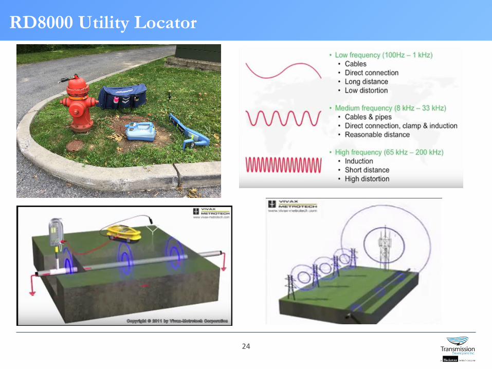
24
RD8000 Utility Locator
Proud to be Employee Owned

25
Fisher TW-6 EM Metal-Detector
Proud to be Employee Owned

26
Duct Rodder & Sondes
Proud to be Employee Owned

27
Proud to be Employee Owned
Ground Penetrating Radar

28
QLA Utility Investigation“Pot-holing” at selected QLB locations to visually ascertain depth and utility characteristics for routing conflict resolution.
QLA – Pot-Holing Investigation
29
SUE - Recap
QLB & QLA effort:• First priority – SAFETY of workers, traffic,
pedestrians• 2nd Priority – access to Businesses and
Residences accessible at all times• Quality data gathering to assist final Design

30
• Boring locations will be located off roadways when possible, or on shoulders
• For coordination, Boring Plan will be shared for reference prior to commencement of effort
• Traffic will likely be diverted, slowed (not stopped) when work is in close proximity to traffic lanes
• Safe zone will be laid out using vehicles and safety cones
• Drill rig will be set in place and boring operations will commence
• One hole per boring location, which will be back-filled with grout upon completion
Geotechnical Boring Program

31
Geotechnical Boring Program – Sample Log

32
Next Steps
• Answer any questions
• Confirm schedule
• Confirm form of notification on SUE work and progress


