University of Pittsburgh Department of Computer Science CS2310 Multimedia Software Engineering Final Project Report Hospital Finder Instructor: Prof. S. K. Chang ([email protected]) Student: Anatoli Shein ([email protected])
This paper describes a new component of the SIS Healthcare system, Hospital Finder. Since there are an increasing number of sensors utilized to monitor the health conditions of senior citizens in today’s world, it is possible to receive alert messages instantly when a patient is in a dangerous state. This Hospital Finder component reacts to these messages by locating the patient on the map, providing directions from the nearest hospitals to the patient, and providing the contact information of these hospitals in order to rescue the patient in a timely fashion.
Introduction:
The current Healthcare Slow Intelligent System (SIS) introduced in this class is capable of generating alert messages and distributing them between all of the components of the system. During normal operation, a large number of messages are passed between the components in order to monitor a patient’s health and build up his or her health record. Sensors are sending messages that include temperature, blood pressure, blood sugar, EKG, spo2 sensors, patient’s location, etc. In extreme cases, such as if the patient’s temperature becomes too high, SPO2 becomes too low, or the patient’s location changes in an unexpected way, alert messages are generated and passed through the system. The goal of this Hospital Finder component is to react to these messages and quickly provide the important information about nearby hospitals. This information includes the hospitals’ phone numbers, addresses, websites, and directions for an ambulance to use to get from these hospitals to the patient’s location. The following section will explain the system model of this Hospital Finder component and give an example of its operation using a real life scenario.
System Description:
First, the SIS system needs to be loaded. When it is loaded and the Hospital Finder component is activated and connected, it displays the message: “Component is active and waiting for alert messages”:
At this point, the component is ready to react to any alert messages coming from the system. One of the possible scenarios that can happen while in this state is illustrated here:
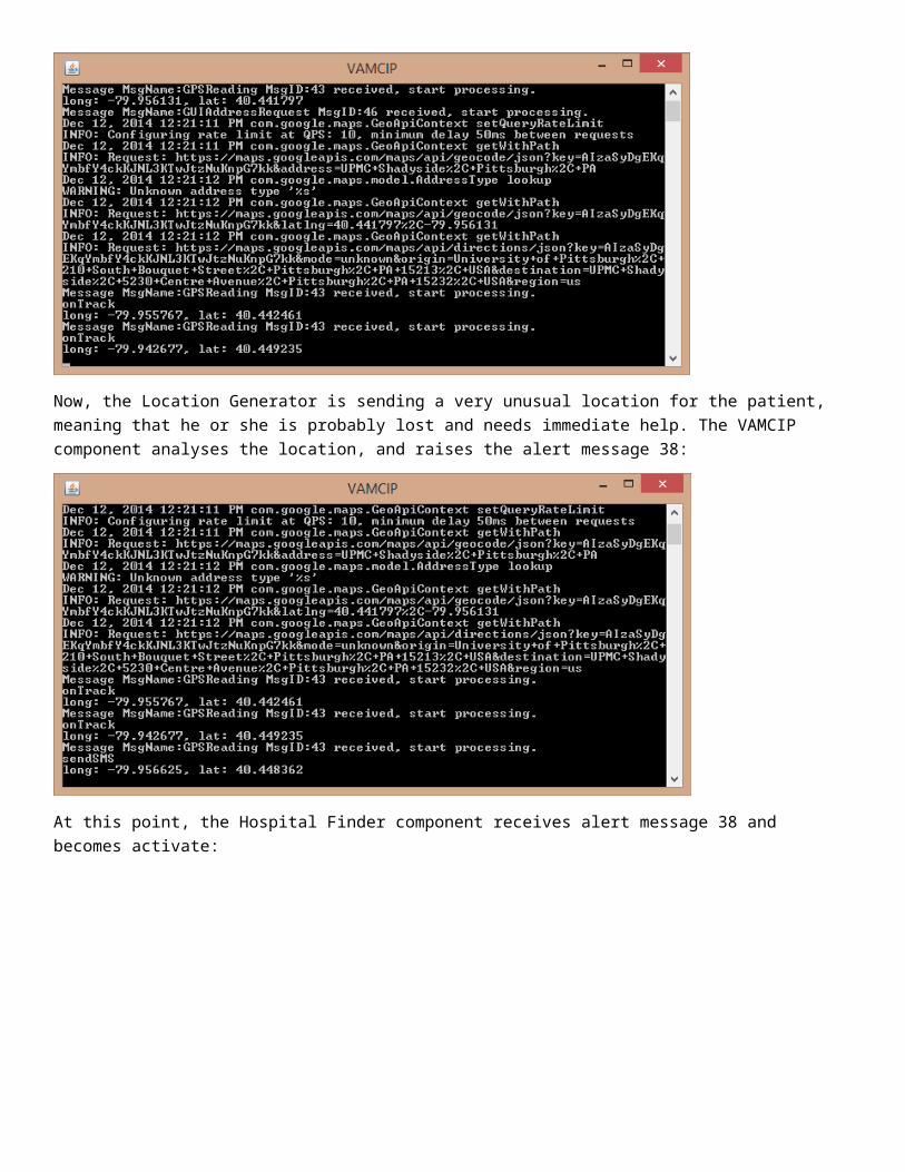
The following scenario will utilize the component VAMCIP developed by Daniel Petrov. VAMCIP monitors the patient’s location when he or she is out for a walk, and generates alert message 38 if the patient’s rout drastically changes in an unexpected way.
At this point, the healthcare SIS system is started and all components are ready for work. The GPS readings from the patient’s sensor are simulated by the Location Generator component. Location Generator component is sending the patient’s locations periodically and the VAMCIP component is verifying that the patient is on his or her normal route:
Now, the Location Generator is sending a very unusual location for the patient, meaning that he or she is probably lost and needs immediate help. The VAMCIP component analyses the location, and raises the alert message 38:
At this point, the Hospital Finder component receives alert message 38 and becomes activate:
Hospital Finder quickly reacts and opens the map based Graphical User Interface (GUI):
The operator who is monitoring the patient’s health using the SIS system at this point knows that the patient is in an emergency state. The operator should be looking for the closest hospitals to deliver help to the patient immediately.
The map-based GUI of the Hospital Finder component offers a variety of ways of locating the patient. In this specific scenario, assuming the patient has a GPS sensor on his or her person, the easiest way to locate the patient is by clicking the “Acquire GPS location” button. The other options of patient location will be described later in this paper.
In order to place the patient’s location on the map, the operator clicks the button “Acquire GPS location”. The patient’s location is immediately requested with message 47 (Coordinates Request). The VAMCIP component receives this
message and quickly sends the patient’s last location reading from the GPS sensor back to the Hospital Finder component. The incoming message 48 (Coordinates Response) is handled by the Hospital Finder component by populating the Latitude and Longitude fields on the map-based GUI, and placing an icon of a patient on the map:
Now, since the operator has received the patient’s location, he or she can click the “Search” button next to the patient’s coordinates to find the closest hospitals:
When the search button is clicked, the GUI requests the three nearest hospitals using the Google Maps Places API from the Google database. When the locations are received, the Hospital Finder component requests the directions from Google using the Google Maps Directions API to get to the patient from these hospitals. As soon as the directions are received, the Hospital Finder component draws them on the map, and displays an information window above each one of the hospitals stating the distance and the time that it would take to get to the patient from each hospital.
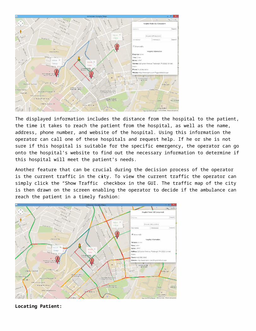
While the operator is in the process of choosing the optimal hospital, he or she can click on the hospital icons on the map, and the information about that hospital appears under “Hospital Information” in the GUI:
The displayed information includes the distance from the hospital to the patient, the time it takes to reach the patient from the hospital, as well as the name, address, phone number, and website of the hospital. Using this information the operator can call one of these hospitals and request help. If he or she is not sure if this hospital is suitable for the specific emergency, the operator can go onto the hospital’s website to find out the necessary information to determine if this hospital will meet the patient’s needs.
Another feature that can be crucial during the decision process of the operator is the current traffic in the city. To view the current traffic the operator can simply click the “Show Traffic” checkbox in the GUI. The traffic map of the city is then drawn on the screen enabling the operator to decide if the ambulance can reach the patient in a timely fashion:
Locating Patient:
Since it is not always possible to have a GPS sensor on every patient, the Hospital Finder can locate a patient using other information. After some alert message triggers the Hospital Finder’s map based GUI to appear, the operator has the following choices to locate the patient:
1. Locate the patient by his or her address . This feature is useful if the patient does not have a GPS sensor, but the address of the patient’s location is known. In this situation, the operator can simply type patient’s address into the address field of the GUI, and hit the “Search” button next to it:
2. Locate the patient by his or her coordinates . If the operator already knows the patient’s coordinates (possibly from some other application or sensor), he or she can enter them in the corresponding “Latitude” and “Longitude” fields and hit the “Search” button. The patient will appear at the location specified and the closest hospitals will be displayed:
3. Locate the patient by his or her position on the map . If the patient does not have a GPS sensor, and the operator does not know patient’s address or coordinates but he or she knows the patient’s approximate whereabouts on the map, the operator can just click this location on the map itself. This situation can happen when the operator knows that a patient is in some specific part of some park, or in some other specific area that does not have a clear address. After a location on the map is clicked, the patient’s icon appears there, and the new coordinates populate the “Longitude” and the “Latitude” fields of the GUI. Then the operator can view the directions to the closest hospitals just by clicking “Search” next to the new coordinates:
4. Locate the patient by his or her GPS coordinates . This scenario has been described above. The operator can click the button “Acquire GPS Location”, and if the component that can provide GPS coordinates is active (ex. VAMCIP), the patients icon will appear on the map at the location provided by the GPS. After that, the operator can easily search for the nearby hospitals and their information by clicking the “Search” button.
After the patient has received the necessary help, the operator can simply close the map-based GUI of the Hospital Finder. The Hospital Finder component, however, does not stop its operation. It just goes into a stand-by mode and waits for the alert messages again. In case of new alert messages, the map-based GUI of the Hospital Finder activates again and becomes ready to find the nearest hospitals and the associated information.
Conclusions:
In this paper, the new Hospital Finder component of the Healthcare SIS system has been introduced. This component is useful for locating a patient on the map in case of an emergency, finding the closest hospitals to the patient, calculating the directions from these hospitals to the patient, displaying the traffic conditions of the area, and displaying the hospitals’ contact information in order to help the operator to contact the nearest hospital. This component fits well with the rest of the Healthcare SIS system, and provides a useful and intuitive GUI that could potentially help save human lives.