Page 1
Colby College Colby College
Digital Commons @ Colby Digital Commons @ Colby
Colby College Watershed Study: Great Pond (2012, 2010, 1998) Senior Capstone in Environmental Science
2012
Changing Water Quality in Great Pond: The Roles of Lake Changing Water Quality in Great Pond: The Roles of Lake
Sediments, Invasive Macrophytes, and the Watershed Sediments, Invasive Macrophytes, and the Watershed
Colby Environmental Assessment Team, Colby College
Problems in Environmental Science course (Biology 493), Colby College
Follow this and additional works at: https://digitalcommons.colby.edu/greatpond
Part of the Biochemistry Commons, Environmental Indicators and Impact Assessment Commons,
Natural Resources and Conservation Commons, and the Water Resource Management Commons
Recommended Citation Recommended Citation Colby Environmental Assessment Team, Colby College and Problems in Environmental Science course (Biology 493), Colby College, "Changing Water Quality in Great Pond: The Roles of Lake Sediments, Invasive Macrophytes, and the Watershed" (2012). Colby College Watershed Study: Great Pond (2012, 2010, 1998). 3. https://digitalcommons.colby.edu/greatpond/3
This Report is brought to you for free and open access by the Senior Capstone in Environmental Science at Digital Commons @ Colby. It has been accepted for inclusion in Colby College Watershed Study: Great Pond (2012, 2010, 1998) by an authorized administrator of Digital Commons @ Colby.
Page 2
CHANGING WATER
QUALITY IN GREAT POND THE ROLES OF LAKE SEDIMENTS, INVASIVE MACROPHYTES, AND THE WATERSHED
COLBY
COLLEGE
2012
PROBLEMS IN
ENVIRONMENTAL SCIENCE
WATERVILLE, MAINE 04901
Page 3
COLBY COLLEGE GREAT POND REPORT, 2012 2
Colby Environmental Assessment Team
Fall 2012
Dom Kone, Molly Susla, Keith Love, Nicolette Kim, Lydia Ball
Caitlin Curcuruto, Cassie Raker, Kate Hamre, Corey Reichler
Michael Stephens, Zak Jaques, Denise Bruesewitz
Jack Mauel, Matt LaPine, Jazmine Russell
Page 4
COLBY COLLEGE GREAT POND REPORT, 2012 3
Table of Contents
CHANGING WATER QUALITY OF GREAT POND EXECUTIVE SUMMARY.......................... 7
Introduction.................................................................................................................................................. 9
General Characteristics of Maine Lakes.......................................................................................... 9
Annual Lake Cycles........................................................................................................................... 10
Trophic Status of Lakes..................................................................................................................... 12
Phosphorus and Nitrogen Cycles...................................................................................................... 14
Watershed Use.............................................................................................................................................. 18
Land Use Types................................................................................................................................. 18
Buffer Strips....................................................................................................................................... 21
Soil Types.......................................................................................................................................... 22
Zoning and Development.................................................................................................................. 22
Shoreline Residential Areas.............................................................................................................. 23
LakeSmart Awards............................................................................................................................ 23
Non-Shoreline Residential Areas...................................................................................................... 24
Subsurface Wastewater Disposal Systems........................................................................................ 24
Roads................................................................................................................................................. 28
Agriculture and Livestock................................................................................................................. 31
Forestry............................................................................................................................................. 32
Successional Land............................................................................................................................. 32
Wetlands............................................................................................................................................ 33
Great Pond Characteristics............................................................................................................................ 34
Lake Formation................................................................................................................................. 34
General Statistics............................................................................................................................... 34
Inflows............................................................................................................................................... 34
Study Objectives........................................................................................................................................... 35
MACROPHYTE IMPACTS..................................................................................................................... 38
Introduction.................................................................................................................................................. 38
Methods........................................................................................................................................................ 41
Point Sampling.................................................................................................................................. 41
Laboratory Analysis.......................................................................................................................... 41
Statistical Analysis............................................................................................................................ 42
Results........................................................................................................................................................... 42
Organic Matter.................................................................................................................................. 42
Pore Water........................................................................................................................................ 43
Water Column................................................................................................................................... 44
Discussion..................................................................................................................................................... 46
Potential Sources of Error................................................................................................................ 46
Organic Matter.................................................................................................................................. 47
Pore Water........................................................................................................................................ 48
Water Column................................................................................................................................... 49
Conclusion.................................................................................................................................................... 50
Future Study................................................................................................................................................. 51
INTERNAL NUTRIENTS........................................................................................................................ 52
Introduction.................................................................................................................................................. 52
Methods........................................................................................................................................................ 54
Laboratory Experiments................................................................................................................... 54
Site Locations.................................................................................................................................... 55
Core Extraction................................................................................................................................. 55
Laboratory Setup and Water Sampling............................................................................................. 57
Page 5
COLBY COLLEGE GREAT POND REPORT, 2012 4
Results........................................................................................................................................................... 58
Discussion..................................................................................................................................................... 62
EXTERNAL NUTRIENTS....................................................................................................................... 64
Introduction.................................................................................................................................................. 64
Development..................................................................................................................................... 64
Nutrients............................................................................................................................................ 64
Tributaries......................................................................................................................................... 64
Belgrade Lakes Watershed................................................................................................................ 65
Land Use Patterns............................................................................................................................. 65
1998 CEAT Study.............................................................................................................................. 67
Research Questions........................................................................................................................... 68
Methods........................................................................................................................................................ 68
Sample Sites...................................................................................................................................... 68
Sample Procedure............................................................................................................................. 70
Chemical Nitrogen Alaysis................................................................................................................ 71
Chemical Phosphorus Analysis......................................................................................................... 71
Results........................................................................................................................................................... 72
Nitrogen............................................................................................................................................. 72
Phosphorus........................................................................................................................................ 73
Depth Profile..................................................................................................................................... 75
Discussion...................................................................................................................................................... 76
Nutrient Levels in Tributaries and Lakes.......................................................................................... 76
Nutrient Flow into Streams............................................................................................................... 77
Eutrophication of Streams................................................................................................................. 77
Depth Profile..................................................................................................................................... 78
Changing Land Use.......................................................................................................................... 78
CONCLUSIONS......................................................................................................................................... 80
Community Awareness and Education......................................................................................................... 82
Maine Department of Environmental Protection (MDEP)............................................................... 82
Belgrade Regional Conservation Alliance (BRCA).......................................................................... 82
Maine Lakes Resource Center (MLRC)............................................................................................ 82
Belgrade Lakes Association (BLA)................................................................................................... 83
Maine Congress of Lake Associations (Maine COLA)..................................................................... 83
APPENDICES............................................................................................................................................ 84
A. Spatial Analysis Techniques.................................................................................................................... 84
B. Eleven Most Unwanted Invasive Aquatic Plants Guide.......................................................................... 95
REFERENCES........................................................................................................................................... 106
Page 6
COLBY COLLEGE GREAT POND REPORT, 2012 5
Figures Figure 1. Lake turnover in dimictic lakes.
Figure 2. A conceptual model of the cycle of the major forms of phosphorus, dissolved (DP) and particulate
(PP), within a lake ecosystem.
Figure 3. The nitrogen cycle within a lake ecosystem.
Figure 4. Comparisons of runoff after an April rainstorm in two neighboring watersheds near Augusta, ME.
Figure 5. Diagram of an ideally buffered home.
Figure 6. Schematic representation of inflow tributaries and outflow rivers of Great Pond.
Figure 7. A map showing water bodies infested with invasive macrophytes in southern Maine.
Figure 8. Sites in Great Pond with variable water milfoil present in North Bay.
Figure 9. The locations of current the milfoil infestation in relation to Great Pond’s hydrology.
Figure 10. A two-sample mean comparison test of sediment organic matter content at variable milfoil
infested and un-infested sites in North Bay, Great Pond.
Figure 11. A two-sample t- test of total phosphorus in the sediment pore water at the un-infested and variable
milfoil infested sites in North Bay, Great Pond.
Figure 12. A two-sample mean comparison test of ammonium content in the water column at the un-infested
and variable milfoil infested sites in North Bay, Great Pond.
Figure 13. A two-sample mean comparison test of total phosphorus content in the water column at the un-
infested and variable milfoil infested sites in North Bay, Great Pond.
Figure 14. Deep and shallow sampling sites in Great Pond.
Figure 15. Photo of lowering the corer into the water.
Figure 16. Photo of capping and unscrewing the core sample
Figure 17. NH4+ concentration (mean +/- SE, n=3) in deep-sediment incubation experiment to estimate
sediment NH4+
flux.
Figure 18. NH4+ concentration (mean +/- SE, n=3) in shallow-sediment incubation experiment to estimate
sediment NH4+
flux.
Figure 19. Phosphorus concentration (mean +/- SE, n=3) in deep-sediment incubation experiment to estimate
sediment NH4+
flux.
Figure 20. Phosphorus concentration (mean +/- SE, n=3) in shallow-sediment incubation experiment to
estimate sediment NH4+
flux.
Figure 21. The Low and High estimates of the percent of contribution to external phosphorus loading per
land use.
Figure 22. Land use within the Belgrade Lakes Watershed based on 2012 data.
Figure 23. Land use in the Great Pond watershed based on 2012 data.
Figure 24. Great Pond Tributary sampling sites of CEAT External Nutrients team.
Figure 25. Great Pond profile sampling site of CEAT External Nutrients team.
Figure 26. Average NH4+
concentration of all sampled tributaries and surface samples.
Figure 27. Average NH4+
concentration at different tributaries.
Figure 28. Average total phosphorus concentration of all sampled tributaries and surface waters.
Figure 29. Average total phosphorus concentration for epicore, surface, and tributary samples.
Figure 30. Average total phosphorus concentration of all sampled tributaries.
Figure 31. Depth profile of average total phosphorus concentrations from two samples.
Figure 32. Diagram of the model used to generate the erosion potential map.
Page 7
COLBY COLLEGE GREAT POND REPORT, 2012 6
Tables Table 1. Generalized characteristics of oligotrophic, eutrophic, dystrophic lakes (adapted from Maitland
1990).
Table 2. Visual example of the samples collected for each set of cores.
Table 3. Nitrogen and Phosphorus release rate in mg m-2
d-1
based on our sediment core samples and lab
experimentation.
Table 4. Impact values of different land use types on a scale from 1-10
Table 5. Erosion potential ratings of different land use types on a scale from 0-10.
Page 8
COLBY COLLEGE GREAT POND REPORT, 2012 7
Executive Summary Colby Environmental Assessment Team
Eutrophication as a result of human activity is a threat to lake water quality globally and within the
state of Maine. Great Pond, in the Belgrade Lakes region of Maine, has traditionally been an oligotrophic
lake that is experiencing early signs of eutrophication and is currently classified as a mesotrophic lake. In the
fall of 2012, the Colby Environmental Assessment Team (CEAT) measured the primary sources of nutrient
loading to Great Pond including the catchment and the lake sediment, current water quality in Great Pond,
and the potential impact of the variable milfoil invasion on the lake’s water quality. An increase in nutrients
(especially phosphorus) since 2008 was found in the water column and coming in from the tributaries. The
sediments as well as the water column were found to have significant sources of both phosphorus (P) and
nitrogen (N). The infestation of invasive macrophytes appears to increase the organic matter in the sediment,
and alters the water column and sediment nutrient distribution. The water quality data collected during the
fall of 2012 was compared with data from previous years to study the water quality trends. Using past data,
future projections could be made about the future of the lake as well as how management programs are and
will be a source of help for the health of Great Pond. Furthermore, we examined land use patterns in the
Great Pond watershed as well as erosion and areas within the watershed that pose the highest risk for nutrient
loading. We conclude with a series of future scenarios for the state of Great Pond given current trends in
land use and nutrient release from bottom sediments during periods of bottom water hypoxia and with
recommendations to improve the water quality in Great Pond. These assessments aim at understanding the
impacts these variables have on lake water quality. By examining nutrient levels, we can depict how Great
Pond may be heading toward eutrophication. These results will be pertinent to all stakeholders in the Great
Pond watershed. Great Pond stills stands a mesotrophic lake but has the potential to move towards
eutrophication from sources including internal nutrient loading and increasing development trends in the
watershed. But with the mitigation and prevention programs, knowledge about the sites of highest concern
and the notable nutrient loading sources a collaborative effort could keep Great Pond in this mesotrophic
state.
Page 9
COLBY COLLEGE GREAT POND REPORT, 2012 8
Great Pond Assessment Introduction
General Nature of Study
There are over 5,000 lakes and ponds in the State of Maine and these thousands of bodies of water
have been deeply engrained in Maine’s culture, economy, and industries (MDEP 2005a). Each summer,
Maine lakes and the surrounding communities experience a massive influx of people with tourists
congregating around recreational fishing, water skiing, and sailing, to name a few. Many summer inhabitants
spend the season living on the expansive lake shorelines. Due to this increased activity in and around the
lakes, the bodies of water have undergone progressive water quality degradation. This increase in activity has
been compounded by the recent increases in year-round residents. In order to better understand the course of
water quality trends and the future implications for lake health, we must study Maine lakes and their
watersheds.
The most worrisome implication of lake degradation is eutrophication. Eutrophication is a natural,
though human-accelerated, process that leads to increased nutrient availability for lake biota, particularly
phytoplankton. An increase in nutrients, particularly in “limiting nutrients,” results in an increased ability for
bacteria, algae, and other plants to grow. Because nutrients are needed in specific ratios for growth, the
limiting nutrient is the specific nutrient that determines the amount of production in a lake; this nutrient is in
the highest demand and biological processes depend on this nutrient. Thus, we use the term “limiting”
because the amount of the limiting nutrient yields the extent of plant production. In a eutrophic system, when
organisms die all the additional biomass from increased production decomposes and consumes oxygen,
which decreases the amount of dissolved oxygen the lake, particularly in deep portions of the lake. This
process of hypoxia harms other plant species and fish (Dodds and Welch 2000). When the cold water at the
bottom of the lake is hypoxic, fish species, such as Maine’s landlocked salmon are forced to move up in the
water column to access oxygen. The water closer to the surface is warmer and may not support the fish
species. The lack of cold, oxygenated water results in fish kills. In Maine lakes, phosphorus (P) typically
limits the rate of growth of primary producers and bacteria and drives eutrophication (MDEP 2008a). Human
activities on and around lakes, such as residential and commercial development, farming, and transportation,
Page 10
COLBY COLLEGE GREAT POND REPORT, 2012 9
increase lake phosphorus concentrations (Carpenter et al. 1998, Baker et al. 2008) and result in increased
algal production (Elser et al. 2011).
Great Pond, located Maine’s Belgrade Lake Region, has a watershed of over 140 square kilometers,
extending through two towns (Rome and Belgrade). This study, performed by the Colby Environmental
Assessment Team (CEAT) 2012, examines human activity in the Great Pond watershed and the subsequent
nutrient loading to the water body. Throughout the study, we hoped to answer: What trophic level is Great
Pond in currently and how quickly is it moving towards eutrophication? In order to answer this, we
collected, analyzed and reviewed field data and pertinent scientific literature on nutrient loading to Great
Pond. Our research endeavors pivoted around internal and external nutrient measurements and data
surrounding the impacts of invasive macrophytes on nutrient concentrations. CEAT performed water quality
testing and GIS-based and mathematical model-based analyses to assess the health of Great Pond. We
identify specific problems contributing to the degradation of water-quality within the Great Pond watershed
and provide recommendations for future action.
Introduction General Characteristics of Maine Lakes
The majority of Maine lakes were formed during the Wisconsonian glaciation of the Pleistocene
Epoch from 2,588,000 to 11,700 years ago (Davis et al. 1978). Glacial activity in Maine has left most lake
basins comprised of glacial till, bedrock, and glaciomarine clay-silt. These deposits and the underlying
granite bedrock are infertile, and as a result, most of Maine’s lakes are relatively nutrient poor, or
oligotrophic. The movement of glaciers in Maine was predominantly to the southeast, carving out Maine
lakes in a northwest to southeast direction (Davis et al. 1978). This orientation, along with surface area and
shape, plays a fundamental role in the effect of wind on the water body. Wind plays a critical role in annual
lake turnover, or the mixing of thermal layers, which will be discussed below.
Most lakes in Maine are located in lowland areas among hills (Davis et al. 1978). Moving beyond the
shores, many Maine lake watersheds are forested. However, current logging practices threaten these forests
and lakes. As trees are removed, erosion increases because there are fewer roots to hold soil in place. A
decrease in trees also means less biological uptake of nutrients by trees. Additionally, residential
Page 11
COLBY COLLEGE GREAT POND REPORT, 2012 10
development and increased construction of lake recreation facilities in watersheds pose a significant threat to
the water quality. Around Great Pond, camps and associated road systems substantially contribute to nutrient
runoff. These unpaved roads channel watershed nutrients into the lake. These are the most acute sources of
anthropogenic nutrient loading in Maine lakes and ponds (Davis et al. 1978).
There are, however, other factors that mediate water quality. These include proximity to the ocean,
location within the state, water residence time within the soil (in the watershed) and within the lake, wetland
influences and bedrock chemistry (Davis et al. 1978). Terrestrial and aquatic vegetation, as well as the
presence of unique habitat types, also affects the water quality. Lastly, depth, surface area, and lake sediment
characteristics can affect temperature and turnover in the lake, which will ultimately influence water quality.
Annual Lake Cycles
Water has the unique physical property of being densest at 4 C (Smith and Smith 2009). Water
decreases in density at temperatures above and below 4 C, allowing ice to float on the surface of lakes and
ponds and warm water to stratify above cold water. In the summer, direct solar radiation warms the upper
levels of the water column forming the epilimnion, which hosts the most abundant phytoplankton
communities (Davis et al. 1978). Due to the amount of plant life and photosynthetic activity in the
epilimnion, this stratum has particularly high levels of oxygen. However, available nutrients in the epilimnion
can be depleted by algal populations in the water column and may remain depleted until the turnover of the
water column in early fall (Smith and Smith 2009; Figure 1).
Below the epilimnion stands a layer of sharp temperature decline, known as the metalimnion (Smith
and Smith 2009). Within this stratum is the greatest temperature gradient in the lake, called the thermocline.
The thermocline separates the epilimnion from the hypolimnion, the lowest stratum of a lake. The
hypolimnion does not receive abundant photosynthetic light and it is the coolest stratum (Figure 1). The
hypolimnion hosts the majority of a lake’s organic material decomposition. This decomposition occurs via
aerobic and anaerobic biological processes. Aerobic bacteria break down organic matter quicker than
anaerobic bacteria and significantly deplete dissolved oxygen concentrations at these depths (Figure 1;
Page 12
COLBY COLLEGE GREAT POND REPORT, 2012 11
Müller et al. 2012). The decrease in dissolved oxygen concentrations can result in hypoxic bottom water.
Benthic organisms, or organisms that require cooler waters found only at the bottom of the lake, may suffer
decreased fitness and even mortality.
As the weather becomes colder, water temperature decreases and wind facilitates thermal mixing until
a uniform vertical temperature profile forms. This event, known as turnover or fall mixing, re-oxygenates the
lower depths of the lake and mixes nutrients throughout the water column. The cold water near the surface
can hold increased levels of oxygen, which is redistributed with turnover. Through this process, organisms at
depth receive oxygenated water. A similar turnover event also occurs in the spring (Read et. al. 2011). A lake
that has two turnover events per year is classified as dimictic, whereas shallow lakes that may turn over more
than twice a year are polymictic. Maine lakes tend to be dimictic and Great Pond is dimictic.
Figure 1. Mixing patterns in
dimictic lakes. During the
summer, lakes are stratified into
three layers (epilimnion,
metalimnion, and hypolimnion).
During the fall and spring, the
isothermal temperature and
density facilitate the lake turnover
and redistribution of nutrients. In
the winter, the lake is again
stratified with the slightly warmer
water on the bottom of the lake
and the ice at the surface.
Page 13
COLBY COLLEGE GREAT POND REPORT, 2012 12
In winter, lakes in Maine are covered with ice for four to five months. During this period, the
stratification is reversed so that the coldest water occurs on the surface and the warmest, densest water
(roughly 4 C) moves to the bottom. Significant snow cover on the ice may affect the photosynthetic
processes under the ice by blocking some of the incoming solar radiation. Ice prevents diffusion of oxygen
into the water and photosynthetic activity decreases, reducing oxygen production from phytoplankton thus
potentially decreasing the dissolved oxygen levels enough to cause significant fish kills (Becker et.al. 2009).
After the ice has melted in the spring, solar radiation warms the upper stratum of the lake. The freshly
melted water sinks and this process continues until the water column is uniform in temperature and oxygen
and nutrients are mixed throughout the water column. As late spring approaches, solar radiation increases,
stratification occurs, and temperature profiles return to that of summer in dimictic lakes, preventing water
column mixing (Smith and Smith 2009).
Trophic Status of Lakes
The biological classification of lakes by their trophic state is based on nutrients and productivity
levels in the water (Maitland 1990). Lakes are divided into four major trophic states: oligotrophic,
mesotrophic, eutrophic, and dystrophic (Table 1). Oligotrophic lakes tend to be deep and oxygen rich with
steep-sided basins, creating a low surface to volume ratio. They have low levels of suspended solids, nitrogen
(N) and phosphorus (P), the limiting nutrient for plant productivity in most freshwater ecosystems. Lake
shape also affects productivity in the water; steep-sided oligotrophic lakes are not conducive to extensive
growth of rooted vegetation because there is little shallow margin for attachment in the photic zone (Table 1).
A mesotrophic lake is in the second phase of the trophic states. Preceded by an oligotrophic state and
then followed by a eutrophic and dystrophic state the qualities this classification of lake will take on are
intermediate. Often mesotrophic lakes have additional sediment inputs, so they are not as deep as they used
to be. Their watercolor tends to less clear and they have elevated levels of nutrients such as nitrogen and
phosphorus (Table 1). However, the increase in nutrients results in an increase of primary producers, which
Page 14
COLBY COLLEGE GREAT POND REPORT, 2012 13
subsequently increase the amount of oxygen in the lake. Great Pond has been classified as a mesotrophic lake
by the Maine Department of Environmental Protection in recent years.
Eutrophic lakes are nutrient-rich and have a relatively high surface to volume ratio compared to
oligotrophic lakes (Maitland 1990, Chapman 1996). These lakes have large but not very diverse
phytoplankton populations supported by limiting nutrients. Due to the high number of decomposers at the
bottom of eutrophic lakes, the water has very low dissolved oxygen levels. Anoxic conditions lead to the
release of phosphorus and nitrogen from the bottom sediments, resulting in the eventual recycling of nutrients
throughout the water column (Chapman 1996). This phosphorus release and recirculation stimulates further
Table 1. Generalized characteristics of oligotrophic, eutrophic, dystrophic lakes (adapted from Maitland 1990).
Character Oligotrophic Mesotrophic Eutrophic Dystrophic
Basin shape Narrow and deep Mid-depth Broad and shallow Small and shallow
Lake shoreline Stony Stony and Weedy Weedy Stony or peaty
Water transparency High Intermediate Low Low
Water color Green or blue Green, blue, or yellow Green or yellow Brown
Dissolved solids Low, deficient in N Intermediate N levels High, especially
in N and Ca Low, deficient in Ca
Suspended solids Low Medium High Low
Oxygen High High
High at surface,
deficient under ice and
thermocline
High
Phytoplankton Many species, low
numbers Intermediate
Few species, high
numbers
Few species, low
numbers
Macrophytes
Few species, rarely
abundant, yet found in
deeper water
Many found in deeper
water and some in
shallow water
Many species,
abundant in shallow
water
Few species some
species are abundant in
shallow water
Zooplankton Many species, low
numbers
Medium number of
species with medium
numbers
Few species, high
numbers
Few species, low
numbers
Zoobenthos Many species low
numbers
Medium number of
species with medium
numbers
Few species, high
numbers
Few species, low
numbers
Fish
Few species,
Salmon and Trout
characteristics
Some species Many species,
especially minnows
Extremely few species,
often none
Page 15
COLBY COLLEGE GREAT POND REPORT, 2012 14
growth of phytoplankton populations (Smith and Smith 2009). This process is known as internal nutrient
loading and has an affect on lake eutrophication rates.
Dystrophic lakes receive large amounts of organic matter from the surrounding land, particularly in
the form of humic (complex organic) materials (Smith and Smith 2009). The large quantity of humic
materials stains the water brown, much like tea. Dystrophic lakes have highly productive littoral zones, high
oxygen levels, high macrophyte productivity, and low phytoplankton populations due to poor light
penetration (Table 1). Eventually, the growth of rooted aquatic macrophytes chokes the habitat with plant
matter, leading to the filling in of the basin, ultimately developing into a swamp and then a terrestrial
ecosystem (Goldman and Home 1983).
Lakes sometimes begin as oligotrophic, and after a very long period of aging, eventually may become
terrestrial landscapes (Niering 1985). Anthropogenic activities greatly accelerate this process of nutrient
loading. Lakes may receive mineral nutrients from streams, groundwater, runoff, and precipitation, which
increase phosphorus levels and subsequently algal growth. This process, anthropogenic eutrophication, is
often undesired by people, as it clouds the water and can result in lower levels of biodiversity.
Henderson-Sellers and Markland (1987) characterizes the process of eutrophication by the following
criteria:
Decreasing hypolimnetic dissolved oxygen (DO) concentrations
Increasing nutrient concentrations in the water column
Increasing suspended solids, especially organic material
Progression from a diatom population to a population dominated by cyanobacteria
Decreasing light penetration (e.g., increasing turbidity)
Increasing nutrient concentrations in the sediments
Phosphorus and Nitrogen Cycles
In freshwater lakes, each nutrient has a complex chemical cycle (Overcash and Davidson 1980), and it
is necessary to understand these cycles to devise better techniques to control high nutrient concentrations.
Page 16
COLBY COLLEGE GREAT POND REPORT, 2012 15
Nutrient cycles are controlled by redox conditions, demand for nutrients, interactions between nutrient cycles
and other natural processes. Since the primary limiting nutrient may shift over time or space, understanding
the physical and chemical processes is necessary to efficiently control high nutrient loads. Phosphorus is the
most common limiting nutrient for primary producers in many temperate lakes (Paerl, 2009). Due to the high
efficiency with which plants assimilate phosphorus, normal, low phosphorus concentrations are sufficient for
plant growth (Paerl, 2009). When the phosphorus load increases in a lake, this stimulates excess primary
production. The data from the 1970’s on Great Pond show a gradual increase in phosphorus over the last
several decades (CEAT 1998 Great Pond Study).
For the purposes of this study, it is necessary to understand two broad categories of phosphorus in a
lake: dissolved phosphorus (DP) and particulate phosphorus (PP). DP is readily available for plant use in
primary production and limits plant growth. PP is incorporated into organic matter such as plant and animal
tissues or wastes. DP is converted to PP through primary producers and heterotrophic bacteria, PP then settles
into the hypolimnion as dead organic matter. PP can be converted to DP through aerobic and anaerobic
processes. In the presence of oxygen, aerobic bacterial decomposition converts PP to DP. Speaking simply,
DP is usable as it is while PP needs to be processed by bacteria before it can be used. In anoxic conditions,
less efficient anaerobic decomposition occurs, resulting in byproducts such as hydrogen sulfide, which is
toxic to fish (Lerman 1978).
An important reaction occurs in oxygenated water between DP and the oxidized form of iron, Fe (III)
(Chapman 1996). This form of iron binds with DP to form an insoluble complex, ferric phosphate, which
binds large amounts of phosphorus as it settles into the bottom sediments, making it unavailable to lake biota.
However, Fe (III) is reduced to Fe (II) in the presence of decreased oxygen levels at the sediment-water
interface, resulting in the release of DP into the hypolimnion. The ferric phosphate complex, combined with
the anaerobic bacterial conversion of PP to DP, leads to significant build-up of DP in anoxic sediments. The
term “a phosphorus time bomb” is applicable here because further down the road the phosphorus currently
held in the sediment could be released, leading to a huge influx of phosphorus into the water (Caraco, 1993).
Page 17
COLBY COLLEGE GREAT POND REPORT, 2012 16
The sediments of a lake have phosphorus concentrations from 50 to 500 times the concentration of the
water phosphorus concentrations (Henderson-Sellers and Markland 1987). Summer thermal water
stratification inhibits the mixing of nutrients in the epilimnion. As a result, DP concentrations accumulate in
the lower hypolimnion until fall turnover. During fall turnover, wind mixes the water and temperatures
become uniform, resulting in a large flux of nutrients generated by internal nutrient loading moving from the
bottom of the lake to the upper layers (Figure 2). This mixing increases the likelihood of algal blooms as
nutrients stimulate algal production. DP is converted to PP by uptake of P into of algal tissues. This happens
even if there is not an algal bloom, however, when algal blooms do occur, there is more biomass than normal.
Heterotrophic bacteria and cyanobacteria also contribute to the increase biomass under increased nutrient
loads. The algae, cyanobacteria, and heterotrophic bacteria die as winter approaches and the dead organic
matter settles to the bottom where PP is converted back to DP. This accumulation of DP allows for another
large nutrient input to surface during spring turnover. During the accumulation of DP, a feedback loop is
generated. Sediments under anoxic conditions release more nutrients, which encourage future algal blooms,
which then stimulate hypoxia and internal nutrient loading.
Nitrogen is the other nutrient that commonly limits primary production in aquatic ecosystems (Abell
et al. 2010). High nitrogen concentrations, coupled with high levels of phosphorus may also lead to algal
blooms. Available nitrogen in lakes exists in two major chemical forms: nitrate (NO3-) and ammonium
(NH4+; Figure 3,Vitousek, 2009), both forms are directly available for assimilation by algae, macrophytes,
and bacteria. In eutrophic lakes, there may be so much algae and macrophyte growth that most of the N is in
organic forms (Maitland 1990). Therefore, it may be better to measure N transformation rates in eutrophic
systems, because concentrations do not show all of the N that is in an organic form.
Page 18
COLBY COLLEGE GREAT POND REPORT, 2012 17
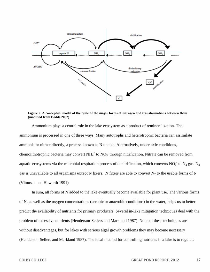
Ammonium plays a central role in the lake ecosystem as a product of remineralization. The
ammonium is processed in one of three ways. Many autotrophs and heterotrophic bacteria can assimilate
ammonia or nitrate directly, a process known as N uptake. Alternatively, under oxic conditions,
chemolithotrophic bacteria may convert NH4+ to NO3
- through nitrification. Nitrate can be removed from
aquatic ecosystems via the microbial respiration process of denitrification, which converts NO3- to N2 gas. N2
gas is unavailable to all organisms except N fixers. N fixers are able to convert N2 to the usable forms of N
(Vitousek and Howarth 1991)
In sum, all forms of N added to the lake eventually become available for plant use. The various forms
of N, as well as the oxygen concentrations (aerobic or anaerobic conditions) in the water, helps us to better
predict the availability of nutrients for primary producers. Several in-lake mitigation techniques deal with the
problem of excessive nutrients (Henderson-Sellers and Markland 1987). None of these techniques are
without disadvantages, but for lakes with serious algal growth problems they may become necessary
(Henderson-Sellers and Markland 1987). The ideal method for controlling nutrients in a lake is to regulate
Figure 2. A conceptual model of the cycle of the major forms of nitrogen and transformations between them
(modified from Dodds 2002)
Page 19
COLBY COLLEGE GREAT POND REPORT, 2012 18
and monitor the input sources before they become problematic, and enhance increased internal nutrient
loading.
Watershed Land Use
Land-Use Types
Different types of land uses have different effects on nutrient loading in lakes primarily because of
varying influences on erosion and runoff. Additionally, any groundwater in the lake watershed is also moving
slowly towards the lake. Excess nutrients in groundwater will eventually end up in the lake as well.
Assessment of land-use within a watershed is essential in the determination of factors that affect lake water
quality. A catchment is the total land area that contributes a flow of water to a particular basin. The highest
point of land that surrounds a lake or pond and its tributaries defines the boundary of a catchment, or the
watershed. Any water introduced to a watershed will be absorbed, evaporate (including transpiration by
plants), or flow into the basin of the watershed. Some nutrients naturally bind to soil particles; if eroded,
nutrient-rich soil will add to the nutrient load of a lake, hastening the eutrophication process and leading to
algal blooms (EPA 1990). As low points on the landscape, lakes are thought of as sentinels of change,
serving as early warnings of anthropogenic change to the landscape and the climate (Williamson et al 2009).
Land area cleared for agricultural, residential, or commercial use contributes more nutrients than a
naturally vegetated area such as forested land (Dennis 1986). The combination of vegetation removal along
with its stabilizing root structure, and soil compaction involved in the clearing of land results in a significant
increase in surface runoff, amplifying the erosion of sediments carrying nutrients and anthropogenic
pollutants. Naturally vegetated areas offer protection against soil erosion and surface runoff. The forest
canopy reduces erosion by diminishing the force of impact of rain on soil while the root systems of trees and
shrubs reduce soil erosion by decreasing the rate of runoff by holding water in place. This allows water to
percolate into the soil. Roots decrease the nutrient load in runoff through direct absorption of nutrients for use
in plant structure and function. As a result, a forested area acts as a buffering system by decreasing surface
runoff and absorbing nutrients before they enter water bodies.
Page 20
COLBY COLLEGE GREAT POND REPORT, 2012 19
Residential areas represent a significant threat to lake water quality. These areas generally contain
lawns and impervious surfaces, such as driveways, parking spaces, or rooftops that reduce percolation and
increase surface runoff. Due to their proximity to lakes, shoreline residences are often direct sources of
nutrients to the water body. Septic systems also introduce additional nutrients to lakes with high levels of
phosphorus leaching from the systems. As more year-round residences develop around Great Pond, the
impact of these sources will increase.
Forests cover much of Maine, however the development or expansion of residential areas often
necessitates the clearing of wooded land. New development increases the amount of surface runoff because
natural ground cover is replaced with impervious surfaces (Dennis 1986). A study conducted in Augusta,
Maine in 1986 illustrates that surface runoff increases with development, increasing nutrient transport and
phosphorus loading in water systems (Figure 4). The study showed that surface runoff from a residential area
contained ten times more phosphorus than runoff from an adjacent forested area. The study concluded that
the surface-runoff flow rate of residential areas may be in excess of four times the rate recorded for forested
land (Dennis 1986). These findings may easily be applied to the Belgrade Lakes as they are within thirty
miles of each other.
Figure 4. Comparisons of runoff after an
April rainstorm in two neighboring
watersheds near Augusta, ME.
Top: volume of immediate runoff over a 12
hour period
Middle: phosphorus concentration in the
runoff
Bottom: total amount of phosphorus
exported into local streams and lakes from
the storm (Dennis 1986).
Page 21
COLBY COLLEGE GREAT POND REPORT, 2012 20
The use of chemicals in and around the home is potentially harmful to water quality. Products
associated with cleared and residential land include fertilizers, pesticides, herbicides, and detergents that
often contain nitrogen, phosphorus, other plant nutrients, and miscellaneous chemicals including
pharmaceuticals (Rosi-Marshall and Royer 2012). It should be noted that environmentally friendly soaps and
detergents containing low phosphorus levels are now available on the market (Figure 4; MDEP 1992a).
Nutrients can enter a lake by leaching directly into ground water or traveling with eroded sediments. Heavy
precipitation expedites the transport of these high nutrient products due to increased surface runoff near
residences (Dennis 1986). Upon entering a lake, these wastes have adverse effects on water quality or
directly on organisms living in a lake. Septic systems associated with residential and commercial land are
significant sources of nutrients when improperly designed, maintained, or used (EPA 1980). Proper treatment
and disposal of nutrient-rich human waste is essential in maintaining high lake water quality.
Commercial use of forested land also affects lake water quality because these activities remove the
cover of the canopy and expose the soil to direct rainfall increase erosion. Two studies by the Land Use
Regulation Commission on tree harvesting sites noted that erosion and sedimentation problems occurred in
50% of active and 20% of inactive logging sites (MDC 1983). Skidder trails may pose a problem when they
run adjacent to or through, streams. Shoreline zoning ordinances have established that a 75 ft strip of
vegetation must be maintained between a skidder trail and the normal high water line of a body of water or
upland edge of a wetland to alleviate the potential impact of harvesting (MDEP 1990).
Roads are a source of excessive surface runoff if they are poorly designed or maintained (Michaud
1992). Different road types have varying levels of nutrient loading potential. In general, roughly 80% of
nutrient loading problems are caused by only 20% of culverts or crossings. Roads and driveways leading to
shoreline areas or tributaries can cause runoff to flow directly into a lake.
Page 22
COLBY COLLEGE GREAT POND REPORT, 2012 21
Buffer Strips
Buffer strips help absorb runoff and in doing so help control the amount of nutrients entering a lake
(MDEP 1990). Specifically, plants can take up nutrients into their biomass and root structure increases
filtration and captures sediment particles. Suggested buffer strip width is dependent on, but not limited to,
steepness of slope, soil type and exposure, pond watersheds, floodways, and areas designated critical for
wildlife (City of Augusta 1998). A good buffer should have several vegetation layers and a variety of plants
and trees to maximize the benefit of each layer (MDEP 1990). Native vegetation forms the most effective
buffer. Trees and their canopy layer provide the first defense against erosion by reducing the impact of
rainfall. The groundcover layer, including vines, ornamental grasses, and flowers slows surface water flow
and traps sediment and organic debris. The duff layer, consisting of accumulated leaves, needles, and other
plant matter on the forest floor, acts like a sponge, absorbing water and trapping sediment. Duff also provides
a habitat for many microorganisms that break down plant material and recycle nutrients (Figure 5; MDEP
1990).
Figure 5. Diagram of an ideally buffered home.
Page 23
COLBY COLLEGE GREAT POND REPORT, 2012 22
An ideally buffered home should have a winding path down to the shoreline so that runoff is diverted
into the woods where it can be absorbed by the forest litter rather than channeled into the lake (Figure 5). The
house itself should be set back at least 100 ft from the shoreline and have a dense buffer strip composed of a
combination of canopy trees, understory shrubs, and groundcover, between it and the water. To divert runoff
effectively, the driveway should be curved rather than straight, and not leading directly toward the water.
Slopes within a buffer strip that are less than 2% steep are most effective at slowing down the surface flow
and increasing ground absorption of runoff (MDEP 1998a). Steep slopes are susceptible to heavy erosion and
will render buffer strips ineffective.
Soil Types
Nutrient loading in a lake ecosystem is partially a function of the soil types and their respective
characteristics. The physical characteristics of soil (permeability, depth, particle size, organic content, and the
presence of an impermeable layer or “fragipan”), as well as the environmental features (slope, average depth
to the water table, and depth to the bedrock) represent important considerations when anticipating the rate of
nutrient loading (USDA 1978). These factors affect land uses, such as forestry, agriculture, and residential or
commercial development. Soils with medium permeability, moderate slopes, deep water tables, low rockiness
and organic matter, and no impermeable layer best accommodate land disturbances by preventing extreme
erosion and runoff of both dissolved and particulate nutrients (USDA 1992). Soils that do not meet these
criteria should be considered carefully before implementing a development, forestry, or agricultural plan.
Zoning and Development
Shoreline zoning and development ordinances control water pollution, protect wildlife and freshwater
wetlands, monitor development and land-use, conserve wilderness, and anticipate the impacts of development
(MDEP 1998a). Furthermore, shoreline-zoning ordinances regulate development along the shore, reducing
the chances for adverse impacts on lake water quality. Uncontrolled development along the shoreline may
result in a severe decline in water quality; such a decline is difficult to correct. In general, these regulations
Page 24
COLBY COLLEGE GREAT POND REPORT, 2012 23
have become more stringent as increased development has caused water quality to decline in many
watersheds (MDEP 1992b). If no comprehensive plan or town ordinances have been enacted, the state
regulations are used by default.
Shoreline Residential Areas
Shoreline residential areas are of critical importance to water quality because of their proximity to the
lake. Any nutrient additives from residences (such as fertilizers) have only a short distance to travel to reach
the lake (Woodard 1989). Residences that have lawns leading directly down to the shore have no barriers to
slow runoff, allowing phosphorus to pass easily into the lake. Buffer strips, when used in conjunction with
appropriate setback laws for house construction, can dramatically reduce the proximity effects of shoreline
residences (MDEP 1992b).
Seasonal residences, especially clusters of older homes located on or near the shoreline, contribute
disproportionately to phosphorus loading into the lake ecosystem. Such clusters of camps usually exist
because they were built prior to the enactment of shoreline zoning laws. Thus, these residences legally non-
conform to contemporary regulations. Although seasonal, they may accommodate large numbers of people in
season. Phosphorus export from these areas is likely to increase during periods of heavy use. The location
and condition of septic systems also affects the nutrient loading from these plots during times of heavy usage
(see Subsurface Wastewater Disposal Systems).
LakeSmart Awards
In response to nutrient loading to lakes and the subsequent declines in lake water quality, Maine
Department of Environmental Protection developed the LakeSmart Awards Program. LakeSmart is a free
educational opportunity for homeowners who wish to understand how to reduce the nutrient runoff from their
properties. LakeSmart also focuses on stabilization of eroded areas, chemical use reduction, rainwater
diversion, and re-establishing groundcover plants near the shores of lakes. DEP certified Soil and Water
Conservation District employees or other qualified individuals provide free assessment of homeowner’s
Page 25
COLBY COLLEGE GREAT POND REPORT, 2012 24
property management techniques and notes for improvement. When homeowners receive awards when they
score above 67% in the categories of: 1. Road, Driveway, and Parking Areas, 2. Structures and Septic
Systems, 3. Lawn, Recreation Areas, and Footpaths, and 4. Shorefront and Beach. The MDEP worked
extensively with lake associations in order to promote LakeSmart in local communities, however LakeSmart
is now run exclusively by volunteers.
Non-shoreline Residential Areas
Non-shoreline residential areas (defined as greater than 250 ft from the shoreline) also impact nutrient
loading, but generally to a lesser extent. Runoff, carrying fertilizers, soaps, and detergents, usually filters
through buffer strips consisting of forested areas several acres wide, rather than a few feet wide. In these
cases, phosphorus has the opportunity to be absorbed into the soils and vegetation; the majority will not reach
the lake, but will enter the forest nutrient cycle.
Runoff collected on roofs and driveways around homes further from the shoreline can travel down
roads or other runoff channels (e.g., driveways) to the lake. Although non-shoreline homes are not as
threatening as shoreline residences, watersheds having large residential areas with improper drainage have a
significant effect on phosphorus loading. Tributaries delivering water and nutrients from throughout the
catchment can make non-buffered, non-shoreline residences as much of a nutrient loading hazard as a
shoreline residence; phosphorus washed from residential lawns without buffer strips can enter into a stream
and eventually into the lake. Similar restrictions and regulations as those for shoreline residences apply to
non-shoreline homes that are located along many streams.
Subsurface Wastewater Disposal Systems
The State of Maine Subsurface Wastewater Disposal Rules define subsurface wastewater disposal
systems as devices and associated piping including treatment tanks, disposal areas, holding tanks, and
alternative toilets which function as a unit to dispose of wastewater in the soil (MDHS 2002). These systems
Page 26
COLBY COLLEGE GREAT POND REPORT, 2012 25
are generally found in areas with no municipal disposal systems, such as sewers. Examples of these
subsurface disposal systems include pit privies, holding tanks and septic systems.
Pit Privy
Pit privies are also known as outhouses and are mostly found in areas with low water pressure
systems. They are simple disposal systems consisting of a small, shallow pit or trench. Human excrement and
paper are the only wastes that can be decomposed and treated. Little water is used with pit privies and
therefore chances of ground water contamination are reduced. Contamination due to infiltration of waste into
the upper soil levels may occur if the privy is located too close to a body of water.
Holding Tank
Holding tanks are watertight, airtight chambers, usually with an alarm, which hold waste for periods
of time. The tanks are durable and made of either concrete or fiberglass (MDHS 2002). The minimum
capacity for a holding tank is 1,500 gallons. These tanks must be pumped in order to prevent backup in the
structure or leakage into the ground, causing contamination. Although purchasing a holding tank is less
expensive than installing a septic system, the owner is then required to pay to have the holding tank pumped
on a regular basis.
Septic System
Septic systems are the most widely used subsurface disposal system. The system includes a building
sewer, treatment tank, effluent line, disposal area, distribution box, and often is connected to a pump (Figure
6). The pump enables effluent to be moved uphill from the shoreline to a more suitable leach field location
(MDHS 1983). Septic systems are an efficient and economical alternative to a sewer system, provided they
are properly installed, located, and maintained. Septic systems that are not installed or located properly lead
to groundwater contamination and nutrient. The location of the systems and the soil characteristics determine
the effectiveness of the system.
The distance between a septic system and a body of water should be sufficient to prevent
contamination of the water by untreated septic waste. However, many parcels of land are grandfathered,
which means their septic systems were installed before the passage of current regulations. Those systems
Page 27
COLBY COLLEGE GREAT POND REPORT, 2012 26
may be closer to the shore than is currently permitted; any replacement systems in these grandfathered areas
must follow the new regulations. Replacement systems can either be completely relocated, or an effluent
pump installed on the outside of the existing treatment tank can be used to move the sewage uphill to an
alternative disposal area further from the water body (MDHS 1983).
Human waste and gray water are transferred from a residence through the building sewer to the
treatment tank. There are two kinds of treatment tanks, aerobic and septic, both of which are tight, durable,
and usually made of concrete or fiberglass (MDHS 1983). The aerobic tanks rely on aerobic bacteria, which
have a greater rate of respiration than anaerobic bacteria. Unfortunately, aerobic bacteria are also more
susceptible to condition changes. These expensive tanks containing aerobic bacteria require more
maintenance and more energy to pump in fresh air.
Septic tanks rely on anaerobic bacteria. Solids are held until they are sufficiently decomposed and
suitable for discharge (MDHS 1983). As the physical, chemical, and biological breakdowns occur, scum and
sludge are separated from the effluent (Figure 6). Scum is the layer of grease, fats, and other particles that are
lighter than water and move to the top of the treatment tank. Baffles trap scum so that it cannot escape into
the disposal area. Sludge is composed of the solids that sink to the bottom of the tank. Over time, anaerobic
digestion breaks down much of the scum and sludge. The effluent then travels through the effluent line to the
disposal area.
Disposal areas provide additional treatment of wastewater. Three types of disposal areas exist: bed,
trench, or chamber (MDHS 1983). Beds are wider than trenches, and usually require more than one
distribution line; typically, beds need a distribution box. The size of the disposal area depends on the volume
of water and soil characteristics. The soils in the disposal area serve to distribute and absorb effluent, provide
microorganisms and oxygen for treatment of bacteria, and remove nutrients from the wastewater through
chemical and cation exchange reactions (MDHS 1983). Effluent contains anaerobic bacteria as it leaves the
treatment tank. Treatment is considered complete when aerobic action in the disposal field has killed the
anaerobic bacteria. Untreated effluent poses risks to bodies of water, groundwater, and human health. Three
Page 28
COLBY COLLEGE GREAT POND REPORT, 2012 27
effluent threats to lakes include organic particulates, which increase the biological oxygen demand (BOD),
nutrient loading, and water contamination through the addition of viruses and bacteria (MDHS 1983).
Reducing the chances of clogging will allow septic systems to be most efficient. Year-round residents
should have their septic tanks pumped every three to five years, or when the sludge level fills half the tank
(MDEP 2003d). Seasonal residents should pump their septic tanks every five to six years to prevent clogging
from occurring in the disposal field. Garbage disposals place an extra burden on a septic system (Williams
1992). Cigarette butts, sanitary napkins, and paper towels should never be disposed of in septic systems
because they are not easily broken down by the microorganisms and fill the septic tank too quickly. The
disposal of chemicals, such as pouring bleach or paint down the drain, may also affect septic systems by
killing microorganisms. Water conservation slows the flow through the septic system and allows more time
for bacteria to treat the water. By decreasing the amount of water passing through the disposal field, the
septic system can work more effectively and recover after heavy use (Williams 1992). Odors, extra green
grass over the disposal field, and slow drainage are symptoms of a septic system that has been subject to
heavy use and is not functioning properly.
When constructing a septic system, it is important to consider soil characteristics and topography to
determine the best location. An area with a gradual slope (10 to 20%) that allows for gravitational pull is
often necessary for proper sewage treatment (MDHS 2002). A slope that is too gradual causes stagnation. A
slope that is too steep drains the soil too quickly cutting treatment time short and preventing water from being
treated properly. Adding or removing soils to change the slope is one solution to this problem.
Soil containing loam, sand, and gravel allow the proper amount of time for runoff and purification
(MDHS 1983). Soils should not be too porous or water runs through them too quickly, and is not sufficiently
treated. Depth of bedrock is another important consideration. If the bedrock is too shallow, waste will remain
near the soil surface. Fine soils such as clay do not allow for water penetration, causing wastewater to run
along the soil surface untreated. Adding loam and sand to clay containing soils can help alleviate this
problem. In the opposite case, if a soil drains too quickly, loam and clay can be added to slow down the
filtration of wastewater.
Page 29
COLBY COLLEGE GREAT POND REPORT, 2012 28
The federal government sets minimum standards for subsurface waste disposal systems. States can
then choose to make their rules stricter, but not more lenient, than federal guidelines. The Maine
Comprehensive Land Use Plan sets standard regulations that each city and town must follow (MLURC
1976). The Maine Department of Environmental Protection (MDEP), Maine Department of Conservation
(MDC), and local Code Enforcement Officers are responsible for overseeing the enforcement of these laws.
Since 1974, state mandates have prevented septic systems from being installed without a site
evaluation or within 100 feet from the high water mark. Other regulations state there must be no less than 300
feet between a septic system disposal field and a well that uses more than 2,000 gallons per day (MDHS
2002). Also, 20% is the maximum slope of the original land that can support a septic system. These
regulations are in place for the safety of people living in the watershed as well as for the aquatic ecosystem.
Roads
Roads in the catchment can significantly contribute to the decline of water quality. They create
pathways for nutrient and sediment runoff into lakes (KCSWCD 2000). Also increase impervious surface,
and decrease water filtration into the soil However, roads with properly created culverts and ditches can
prevent nutrients from flowing easily over a road’s surface.
Proper drainage of roads is very important when trying to control nutrient loading within a watershed.
Construction materials such as pavement, dirt, or gravel, may influence the amount of runoff as well as the
rate (Fassman 2011). Yet, erosion from heavy traffic use on these surfaces is inevitable. Storms increase road
deterioration by dislodging particles from the road surface. This process brings the nutrients that are attached
to these particles into the lakes (Michaud 1992).
When constructing roads, the following should be achieved: minimize the surface area of a road,
minimize runoff and erosion with proper drainage and placement of catch basins (culverts and ditches), and
maximize the lifetime and durability of a road (MDEP 1990). A well-constructed road should divert surface
waters into a vegetated area to prevent excessive amounts of surface runoff, phosphorus, and other nutrients
that could otherwise enter into a lake. Factors that should be considered before beginning the construction of
Page 30
COLBY COLLEGE GREAT POND REPORT, 2012 29
a road includes the location, cross-section, surface area, surface building materials, drainage (ditches,
diversions, and culverts), and maintenance (MDEP 1992a).
The State of Maine has set guidelines to control the building of roads in certain locations. However,
the area in which homes are built typically determines road location. And around lakes, that often means
homes close to the shoreline (MDEP 1990). There are however, regulations for the placement of roads. All
roads must be set back at least 100 feet from the water’s edge if they are for residential use, and 200 feet for
industrial, commercial, or other non-residential uses involving one or more buildings (MDEP 1991).
The cross-section of a road is another important factor to consider when planning construction. A
crowned road cross section allows for proper drainage and helps in preventing deterioration of the road’s
surface (MDOT 1986). This means that the road will slope downward from the middle towards the outer
edges. The slope allows the water to run off the road on either side as opposed to remaining on the surface.
Road shoulders should have a slightly steeper cross slope than the road itself allowing the runoff to be
directed into a ditch or buffer zone (Michaud 1992).
Designing a road with future use in mind is very important. A road should be constructed no longer
than necessary, and should not extend past the last structure that is to be serviced by that road. The width of a
road, which is often based upon the maintenance capabilities of the area, must also be considered (Cashat
1984). Proper planning, including maintenance concerns is an effective, practical, and economical way to
develop a road area (Woodard 1989).
Road surface material is another important factor to consider in road construction. Studies have
shown that phosphorus washes off paved surfaces at a higher rate than off sand and gravel surfaces (Lea et al.
1990). On the other hand, sand and gravel roads erode more quickly and have the potential for emptying
more sediment and nutrients into a body of water. Consequently, pavement is chosen for roads with a high
volume of traffic. Sand and gravel are typically used for roads in low traffic areas or in areas of seasonal use.
Both types of roads need proper maintenance. Gravel road surfaces should be periodically replaced and
properly graded so that a stable base may be maintained and road surface erosion minimized.
Page 31
COLBY COLLEGE GREAT POND REPORT, 2012 30
The drainage off a road and the land that surrounds it must also be considered during construction or
maintenance. Ditches and culverts are used to help drain roads into buffer zones where the nutrient runoff can
be absorbed by vegetation or filtered through soil. These measures are also used in situations for handling
runoff that may be blocked by road construction. Ditches are necessary along wide or steep stretches of road
to divert water flow to areas where it can be absorbed. They are ideally u-shaped, deep enough to gather
water, and do not exceed a depth to width ratio of 2:1. The ditch should be free of debris and covered with
abundant vegetation to reduce erosion (Michaud 1992). Ditches must also be constructed of riprap or soil that
cannot be easily eroded by water flowing through them.
Culverts are pipes that are installed beneath roads to channel water in proper drainage patterns. The
most important factor to consider when installing a culvert is size. Culverts must be large enough to handle
the expected amount of water that will pass through it during the peak flow periods of the year (KCSWCD
2000). If this is not the case, water will flow over and around the culvert and wash out the road. This may
increase the sediment load entering the lake. The culvert must be set in the ground at a 30 angle downward
slope with a pitch of 2 to 4% (Michaud 1992). A proper crown above the culvert is necessary to avoid
creating a low center point and damaging the culvert. The standard criterion for covering a culvert is to have
one inch of crown for every 10 feet of culvert length (Michaud 1992). The spacing of culverts is based upon
the road grade.
Diversions allow water to be channeled away from the road surface into wooded or grassy areas.
These are important along sloped roads, especially those leading towards a lake. By diverting runoff into
wooded or grassy areas, natural buffers work to filter sediment and decrease the volume of water through
infiltrating before it reaches a lake (Michaud 1992). Efficient installation and spacing of diversions can also
reduce the use of culverts.
Maintenance is very important to keep a road in working condition, as well as to prevent it from
causing problems for a lake. Over time, roads deteriorate, and problems will only become worse if ignored
and will cost more money in the long run to repair. Roads should be periodically graded; ditches and culverts
should be cleaned and regularly inspected to assess any problems that may develop. Furthermore, any
Page 32
COLBY COLLEGE GREAT POND REPORT, 2012 31
buildup of sediment on the sides of the road (especially berms) that prevents water from running off into the
adjacent ditches must be removed. These practices will help to preserve the water quality of a lake and
improve its aesthetic value.
Agriculture and Livestock
Agriculture within a watershed can contribute to nutrient loading in a lake (Bruesewitz et al. 2011).
Plowed fields and livestock grazing areas are potential sources of erosion (Williams 1992). To minimize
these problems, ordinances were instated to prohibit the tilling of soil and the creation of new grazing areas
within 100 feet of a lake or river. However, problem areas exist where land was utilized for agriculture prior
to the 1990 enactment of these ordinances by the State of Maine. According to the Maine Shoreland Zoning
Act these areas can be maintained as they presently exist, thereby resulting in relatively high levels of erosion
and nutrient loading (MDEP 1990). Solutions to this problem include plowing with the slope of land (across
as opposed to up and down) and strip cropping.
Livestock wastes are another agricultural factor that poses a harmful impact on water quality.
Improper storage of manure may result in excess nutrient loading. Manure also becomes a problem when it is
spread as a fertilizer. This procedure increases the runoff of nutrients. In winter months, when the ground is
frozen and nutrients cannot filter through the soil the effects are more severe. To help prevent these problems
the state has passed zoning ordinances, which prohibit the storage of manure within 100 feet of a lake or river
(MDEP 1990). The Nutrient Management Act also prohibits the spreading of manure on agricultural fields
during the winter season (Nutrient Management Act 2006).
When fertilizers and pesticides are added to the mix, the nutrients in them can be picked up in runoff
and carried into a water body. There are ways to minimize this form of nutrient loading. Fertilizing only
during the growing season and not before storms will help minimize this problem. Alternative methods of
pest control such as integrated pest management or intercropping will help prevent the degrading effects of
pesticides (Lundun et. al. 2012).
Page 33
COLBY COLLEGE GREAT POND REPORT, 2012 32
Forestry
Forestry also contributes to nutrient loading when logging roads and skidder trails direct runoff into a
lake. Erosion and runoff therefore have a large impact on the water quality of a lake (Williams 1992). State
and municipal shoreline zoning ordinances address these specific problems. They specify that timber
harvesting equipment, such as skidders, cannot use streams as travel routes unless the streams are frozen and
traveling on them does not disturb the ground (MDEP 1990). Clear-cutting within 75 ft of the shoreline of a
lake or a river running to the lake is prohibited. At distances greater than 75 feet, harvest operations cannot
create clear-cut openings greater than 10,000 ft2 in the forest canopy. If they exceed 500 ft
2, the openings
must be at least 100 feet apart. These regulations aim to minimize erosion (MDEP 1990). Enforcing these
regulations often proves difficult in most towns because municipal budgets may not allow the hiring of forest
regulatory staff. Also, illegal practices may occur which negatively impact lake water quality.
Successional Land
Succession is defined as the replacement of one vegetative community by another whose terminus
results in a mature ecosystem called a climax community (Smith and Smith 2009). Land use around the lake
will change because of this succession. An open field ecosystem moves through various transitional stages
before it develops into a mature forest. The earliest stages of open field succession involve the establishment
of smaller trees and shrubs. The growth of larger, more mature tree species characterizes later successional
stages. As the canopy develops, less light reaches the forest floor. A developed canopy also slows rainfall,
reducing ground erosion. This land type, in which a forest is nearing maturity and contains over 50% tree
cover, is referred to as transitional forest. Mature forest is defined as areas of closed canopy that
predominantly contain climax species. Because of the way these difference successional forests stand, their
erosion potential, and carbon fixation varies with each stage. It is important to consider the succession of
forests when looking at future projections of land use and nutrient loading.
Page 34
COLBY COLLEGE GREAT POND REPORT, 2012 33
Wetlands
Wetlands are important transitional areas between lake and terrestrial ecosystems. Wetland soil is
periodically or perpetually saturated, because wetlands usually have a water table at or above the level of the
land and contain non-mineral substrates such as peat. Hydrophytic vegetation grows in partially submerged
habitat, meaning it is adapted for life in saturated and anaerobic soils (Chiras 2001). Wetlands can absorb
heavy metals and nutrients from various sources, including mine drainage, sewage, and industrial wastes
(Chiras 2001). Therefore, wetlands within the watershed substantially contribute to the filtration of nutrients,
sediment, and pollutants, which in turn maintains a higher level of lake water quality.
There are different types of wetlands that may occur in a watershed. A bog is dominated by shrubby
vegetation, large quantities of sphagnum moss, and typically has a low level of productivity (Lewis 2001).
Fens are open, nutrient-rich wetland systems that include species like sedges, sphagnum moss, and
bladderwort. Marshes have variable water levels and are rich with vegetation rooted in the ground and
growing above the surface of the water (Brennan 2005). Swamps have waterlogged soils and occur near
forested areas (Brennan 2005). These wetlands all produce habitat for a variety of animals including
waterfowl and invertebrates (Brennan 2005). As wetlands continue to be developed and disappear, the
importance of preserving the remaining pockets heightens.
The type of wetland and its location in a watershed are important factors when determining whether
the wetland prevents nutrients from going into a lake or contributes nutrients to a lake, acting as either a
nutrient sink or source (Washington State Department of Ecology 1998). This status may vary with the
season depending on the amount of input to the wetland. Heavily vegetated wetlands absorb more nutrients,
so shrub swamps are better nutrient sinks than many other types of wetlands. Nutrient sink wetlands located
close to the lake have greater buffering capacity than those located further back from the water body.
Wetlands that filter out nutrients help control lake water quality and moderate the impacts of erosion near the
lake. In general, wetlands act like ‘bioreactors’ that filter nutrients and sediments before reaching the lake;
they commonly have anaerobic conditions and thus efficient nutrient cycling.
Page 35
COLBY COLLEGE GREAT POND REPORT, 2012 34
Great Pond Characteristics
Lake Formation
Great Pond represents the largest of seven lakes in the Belgrade Lake Region with East Pond, North
Pond, Salmon Lake, McGrath Pond, Long Pond, and Messalonskee Lake as the other six. Maine’s lakes,
Great Pond included, formed at the end of the most recent Ice Age 22,000 years ago. Massive glaciers moved
in a southwestern direction across the state, gouging the landscape and pushing massive rocks ahead of them.
As the glaciers receded, they left low-lying pockets of ice. As the ice melted in these depressions, new lakes
came into existence. In terms of geological processes, lakes exist transiently. Upon formation, lakes slowly
begin to fill back in; an ongoing process of evaporation, precipitation, and subsequent erosion, eases the
contours of lakes and shallows these glacial depressions. This refilling occurs over hundreds of thousands of
years.
General Statistics
Great Pond has a surface area of 3453 hectares, making it the largest of the Belgrade lakes. It is not
the deepest, however. Second to Messalonskee, it has an average depth of around 6.4 meters and the
maximum depth reaching 21 meters. Because of its large surface and its length and width of 11 km and 6.4
km respectively, the residence time of the water in the lake is 2.3 years. This means that the 240,651,000
cubic meter of water is replaced roughly every 2.3 years, but this is an ongoing process. The shoreline of
Great Pond is 74.2 km in length, and the catchment for this lake is 215 km2.
Inflows
Great Pond is fed by six different lakes: East Pond, Serepentine Stream, North Pond, Little Pond, and
unnamed tributary and Salmon Lake (Figure 6). Great Pond outflows through the fourteen foot high Great
Pond Storage Dam into the Messalonskee Lake and Long Pond. In the summer, water levels are kept high
for boating purposes; in the winter, water levels are dropped to prevent ice damage. This fluctuation in the
lake is only about 0.305 meters (1 foot) per year.
Page 36
COLBY COLLEGE GREAT POND REPORT, 2012 35
Study Objectives
Introduction
The goal of our study is to provide a comprehensive examination of nutrient sources to Great Pond
from its catchment, and from internal nutrient sources including sediments and invasive macrophytes.
Throughout the study, our guiding question was ‘What are the causes and consequences of eutrophication on
Great Pond?’ We hope to use this information to determine the main sources of nutrients to Great Pond, and
to make predictions about the potential trajectories for either improvement or degradation of water quality in
Great Pond. The Colby Environmental Assessment Team (CEAT) investigated the nutrient concentrations,
both N and P, of inflowing and outflowing streams, lake sediments, areas of invasive macrophyte
infestations, and shallow areas near LakeSmart properties. CEAT conducted water quality analyses and
measured nutrient levels in the sediment. All these tests aimed to provide information toward answering our
research question on the trophic state of the lake, the sources of nutrients to the lake, and to see whether
Great Pond may be progressing towards a eutrophic state from currently being mesotrophic. This analysis
helped us assess the overall health of the lake and surrounding watershed. It helped provide information
suggesting how the water quality of Great Pond could be protected and improved for the future.
East Pond
Serpentine
Stream
Salmon Lake
North Pond Messalonskee
Lake
Great Pond Long Pond
Little Pond
Figure 6. Schematic representation of inflow and outflow of Great Pond. Arrows represent flow of
water through the Belgrade Lakes chain. Kidder, Watson, Whittier, McIntire, Ingham, and Moose
Ponds also flow into Long Pond and Ward Pond flows into Messalonskee Lake.
Page 37
COLBY COLLEGE GREAT POND REPORT, 2012 36
Macrophyte Assessment
Invasive species in any ecosystem are of concern because they outcompete native species and
ultimately change the structure and function of the invaded ecosystem (Colautti and MacIsaac 2004). Great
Pond has an infestation of Variable-Leaf Milfoil (Myriophyllum heterophyllum). To determine if the milfoil
infestation is playing a role in the nutrient dynamics of the lake, CEAT measured nutrient levels in areas
surround Variable-Leaf Milfoil and areas far from any infestation. CEAT took sediment samples from the
infested area and analyzed the sediment’s chemical, physical and biological characteristics to determine how
the infestation of milfoil affected the sediment and health of the lake in the localized areas of the invasion.
This assessment allowed our team to see how the infestation directly impacts lake sediment nutrients and
organic content. This knowledge allows for predictions regarding how milfoil invasion may change the future
nutrient dynamics in Great Pond, especially if the milfoil invasions expand.
Internal Nutrients Assessment
There was particular concern for nutrients being released into the lake from the sediment because the
bottom waters of Great Pond become anoxic during summer stratification, and there is potential that the
sediments release large amounts of nutrients during this time. To analyze the amount of nutrients in the
sediment that have the potential to affect the lake’s health if released, CEAT performed laboratory
experiments on intact sediment cores under anoxic and oxic conditions. Testing chemical, physical and
biological characteristics of the sediment at both shallow and deep sites helped our team determine whether
there were internal sources of nutrients being added (or that have the potential to be added) to the lake,
affecting the quality of the water. This will allow us to make predictions regarding the importance of internal
nutrient loading through predictions of how much nutrient the sediment releases during periods of bottom
water anoxia. These predictions will be especially important consideration during times of seasonal algal
blooms.
Page 38
COLBY COLLEGE GREAT POND REPORT, 2012 37
External Nutrients Assessment
In order to determine the trophic state of the lake, CEAT conducted nutrient analyses on water
samples taken from Great Pond throughout the late summer and fall of 2012. These samples were analyzed
for a variety of chemical, physical, and biological characteristics including water concentrations of nitrogen,
phosphorus, and dissolved oxygen. Additionally, summer and fall deep-water profile measurements were
taken to test water quality at different depths and look for the turn over of the lake and determine how
nutrient dynamics change with mixing of thermal layers of the lake. Using this current data and historic data
we are able to study how the lakes’ trophic states have changed over the past four decades. Our historical
perspective aids in thinking about the future implications for Great Pond’s water quality.
Spatial Analysis
Land use and lake characteristics in a watershed significantly affect the health of the associated water
body. In order to most accurately portray the stresses Great Pond is subjected to, CEAT used ArcGIS 10 to
analyze bathymetry, catchment land use change, human impact models, invasive species, and erosion
possibilities. These analyses supported all other research endeavors of CEAT 2012.
Conclusions
This section provides information on a basic model used to calculate current chlorophyll-a levels. It
makes sums together the whole report in order to provide a cohesive picture of the phosphorus system in
Great Pond.
Page 39
COLBY COLLEGE GREAT POND REPORT, 2012 38
Macrophyte Impacts Jazmine Russell and Jack Mauel
Introduction
Myriophyllum (watermilfoil) is a genus of freshwater aquatic plants, which grow submersed in lakes
and streams. These plants are generally recognized for having elongated stems with air chambers running
from base to crown, and fine, densely packed leaves, which grow in whorls around the main stem.
Myriophyllum can grow to be up to 15 feet; often the plants form densely packed mats and outcompete local
species (Mehrhoff 2009). Myriophyllum heterophyllum (variable-leaf watermilfoil) is native to the
southeastern United states, but it is invasive in the Northeast. It has been documented in Maine lakes for over
twenty years, and has been targeted by the Maine Department of Environmental Protection due to its
aggressive colonization of Maine water bodies (Bailey 2007). Myriophyllum heterophyllum has now spread
to 17 lakes in the state of Maine (Figure 7).
Figure 7. A map showing water bodies infested with invasive macrophytes in southern Maine.
Page 40
COLBY COLLEGE GREAT POND REPORT, 2012 39
Myriophyllum heterophyllum poses ecological and economic threats to Maine’s lakes and ponds. The
plants clog boat motors and discourage people from participating in recreational activities such as swimming
and fishing. This disruption can deter tourism in affected lakes. In assessing Great Pond, we find this species
causes particular concerns due to its potential effects on lake nutrient cycles. Rooted macrophytes have the
potential to pull nutrients out of the sediment and release them into the water column as they decompose
(Graneli et al. 1988). This could intensify the effects of eutrophication in freshwater bodies. The removal of
large, dense mats of variable water milfoils may have several positive effects. First, the removal prevents
local species from being outcompeted. Second, it may remove sequestered nutrients in the plant tissues from
the water body before they can accelerate eutrophication.
The exact timing of invasion for Myriophyllum heterophyllum in Great Pond is unknown. Some
estimates state that variable-leaf milfoil was first introduced into Great Meadow Stream roughly ten year ago,
and the plant has spread rapidly since then. The original point of infestation has been traced to a boat ramp at
the intersection of Rome Road (225) and Great Meadow Stream (Figure 8). Many people hypothesize that a
recreational boat, harboring the invasive plant, introduced seeds into this stream. The boat ramp for the
stream has since been blocked off.
Figure 8. Sites with variable watermilfoil present in North Bay.
Page 41
COLBY COLLEGE GREAT POND REPORT, 2012 40
Myriophyllum heterophyllum likely followed the southward flow of the stream into the northeastern
corner of Great Pond. This area, North Bay, houses an abundance of flora and fauna. One of the most notable
species in North Bay is the Sandhill Crane, a rare bird that nests in the matt lining along the perimeter of the
bay. This sensitive, dynamic ecosystem became an area of concern following the outbreak of variable-leaf
milfoil. In Great Pond, the threatened native macrophyte species include Elodia canadensis (American
waterweed) and Myriophyllum exalbescens (northern-water milfoil), among many others.
In addition to outcompeting the natives, Myriophyllum heterophyllum has the potential to drastically
alter the nutrient levels in Great Pond. The change in nutrient characteristics induced by an invasive species
provides a subtle, hazardous threat to the aquatic ecosystem. The sediment profile in a lake presents a source
of dissolved nutrients to a given water body (Zhu, et al. 2008). The introduction of vast quantities of biomass
that accompanies a variable-leaf milfoil invasion could potentially alter Great Pond’s specific sediment
nutrient profile. This change in nutrient distribution between sediment and water would affect the
microbiology of the lake yielding notable trophic cascades. Such trophic cascades could result in the
alteration of the entire food web within Great Pond. Myriophyllum heterophyllum has the potential to move
beyond North Bay into other areas of Great Pond, making these potential effects cause for even greater
concern (Figure 9). With this background in mind, this project seeks to analyze the invasive’s effect on
nutrient cycling in Great Pond. Specifically, we want to better understand Great Pond’s transition towards a
more eutrophic state.
Figure 9. The locations of current the milfoil
infestation in relation to Great Pond’s hydrology.
Page 42
COLBY COLLEGE GREAT POND REPORT, 2012 41
Methods
We analyzed pore water from the sediment for phosphorus content and water from the water column
for phosphorus and ammonium content, in areas invaded by milfoil and in reference to sites not invaded by
milfoil. From this, we can determine if the milfoil may be redistributing nutrients.
Point Sampling
We sampled from three locations in un-infested zone and three locations in infested zone. We took
three replicates for each sample (Figure 9). We kayaked into infested zone to prevent propeller-induced
fragmentation and to prevent the sediment from becoming unnecessarily disturbed. We manually extracted
sediment in the infested zone. We took dissolved oxygen profiles and surface water samples at each location.
The conditions during the infested sampling were windy and overcast. In the un-infested site, we sampled in
slightly deeper water, about 2 m as opposed to 1 m. In this sampling, we utilized a homemade sediment
extraction mechanism. We took dissolved oxygen profiles and surface water samples for each location within
the un-infested site. The conditions during this sampling were windy and sunny.
Lab Analysis
Phosphorus Test Preparation: Sediment
We prepared sediments in both zones to be tested for phosphorus content in the pore water. The
preparation procedure used is as follows:
We placed 10ml of sediment into 50 ml centrifuge tube and brought the volume to 40 ml with
deionized water. Then, the samples were shaken for 1.5 hours. We used two replicates per site in centrifuging
process. The third replicate from each site was used to determine amount of organic matter in the sediment.
All 12 samples were centrifuged for 12 minutes at 6000 rpm. We then poured off water from 12 samples into
separate containers. The amount of phosphorus in this water sample indicates the amount of phosphorus in
the pore water of 10ml of sediment.
Page 43
COLBY COLLEGE GREAT POND REPORT, 2012 42
Organic Material in the Sediment Preparation
We tested sediments in both zones for total organic matter content. The procedure used is as follows:
We placed 6 empty tins in the ashing oven for 1.5 hours at 550 degrees Fahrenheit to rid tins of all organic
matter. Then, we measured out 5 ml of sediment into each tin (1 from each site). The tins were left overnight
in drying oven to remove all water. We weighed the samples then placed them in the ashing oven at 550
degrees Fahrenheit for 3 hours. Following the ashing, we weighed the samples and recorded any changes in
weight. The change between ashed and un-ashed samples is the mass of organic matter in 10 ml of sediment.
Ammonium and Phosphorus in the Water Column Test Preparation
We prepared water taken from the water column in both infested and un-infested areas for ammonium
and phosphorus testing. We filtered 50 ml portions of surface water samples from all six sites for ammonium
testing, and we left 50 ml portions unfiltered for total phosphorus testing. The ammonium and total
phosphorus samples were analyzed with standard techniques as described in subsequent sections of this
report.
Statistical Analysis
To compare our infested and uninfested sites, we used a Two-sample independent t-test with α=05.
Due to unequal variances, we utilized a Welch’s approximation. The statistical program used in the study is
Stata 12.1.
Results
During our sampling of infested and uninfested sites in the littoral zone of Great Pond, the water column was
well-mixed, as the fall-mixing process was in full swing. When sampling the infested area, the conditions
were cold, windy and overcast. During the uninfested area, the conditions were cold, windy and sunny. The
milfoil had been beaten back noticeably following the hand-pulling efforts that had begun this past summer,
but patches appeared to be surviving. The milfoil appeared to be dying off, survived by the root fragments
that lie dormant in the sediment during the winter. Additionally, the infested site was closer to the mouth of
Page 44
COLBY COLLEGE GREAT POND REPORT, 2012 43
the stream than the un-infested site. The other macrophytes present were mainly pickerel weed, spatterdock,
common waterweed, and bladderwort.
Organic Matter
The infested site had significantly higher sediment organic matter than the un-infested site (Figure 10, t-test,
p=0.0019). The average sediment organic matter at the infested site was 15.50%, and 5.79% at the un-
infested site. In general, the sediment at the infested site was muddy to silty and silty to sandy at the un-
infested site.
Figure 10. A two-sample mean comparison test of sediment organic matter content at infested and un-infested sites (with
Welch’s approximation used due to unequal variances between categories) determined a two-sided p-value of .0019 (n=6,
t=-5.9071).
Pore Water
The infested site had significantly lower total phosphorus than the un-infested site (Figure 11, t-test,
p=.0422). The average total phosphorus concentrations were 298.73 µg L-1
in the infested site and 127.19
µg L-1
at the un-infested site. . In general, the sediment at the infested site was muddy and silty and silty to
sandy at the un-infested site.
Page 45
COLBY COLLEGE GREAT POND REPORT, 2012 44
Figure 11. A two-sample t- test of total phosphorus in the sediment pore water at the un-infested and infested sites (with
Welch’s approximation used due to unequal variances between categories) determined a two-sided p-value of .0422 (n=12,
t=2.5283).
Water Column
The infested site appeared to have more ammonium in the water column than in the un-infested site, although
this difference was not statistically significant (Figure 12, t-test, p=0.1116). The average ammonium
concentrations were 130.27 µg L-1
at the un-infested site and 193.6 µg L-1
at the infested site. The water
column during the time of this test was well mixed, as it was the beginning of fall on Great Pond.
Page 46
COLBY COLLEGE GREAT POND REPORT, 2012 45
Figure 12: A two-sample mean comparison test of ammonium content in the water column at infested and un-infested sites
(with Welch’s approximation used due to unequal variances between categories) determined a two-sided p-value of 0.1116
(n=5, t=2.709). A non-parametric permutation test for these examples provided a 1-sided p-value of .10 (n=6).
The mean total phosphorus level in the infested area (2.84 µg L-1
) is lower than the mean total phosphorus
level in the un-infested area (6.12 µg L-1
) (Figure 13, t-test, p=0.219). The insignificant p-value may be due
to the extremely high variance in the infested site. This comparison appears to be the least reliable of the four
tests conducted. The water column during the time of this test was well mixed, as it was the beginning of fall
on Great Pond.
Page 47
COLBY COLLEGE GREAT POND REPORT, 2012 46
Figure 13. A two-sample mean comparison test of total phosphorus content in the water column at the infested and un-
infested sites (with Welch’s approximation used due to unequal variances between categories) determined a two-sided p-
value of .219 (n=5, t=-1.6791).
Discussion
Potential Sources of Error
Several factors could have skewed our findings. The first is the sample size. The relatively small size
of the infested area limited the number of samples we were able to take in the field, which lowers the power
of statistical analysis between the infested and un-infested sites. Another possible cause of error is the short
time-scale of the fieldwork. We sampled exclusively in the early fall, when Great Pond was in the beginning
of the mixing phase. Therefore, any conclusions drawn must take this into consideration. We observed an
additional confounding variable: Myriophyllum heterophyllum may exhibit habitat preferences, which may
confound findings regarding its interactions with the environment. Myriophyllum heterophyllum may grow
more readily near inflows. It may be more successful in certain types of sediment, or at different depths with
different levels of light penetration. The infested site was one meter in depth, while the un-infested site was
two meters in depth, therefore, conclusions drawn from our data should be conservative, as differences in
Page 48
COLBY COLLEGE GREAT POND REPORT, 2012 47
nutrient levels between infested and un-infested sites may be due to the environmental differences of the
sites, rather than the presence or milfoil.
Organic Matter
We found that sediment taken from the infested site had a significantly higher percentage of organic
matter than sediment taken from the non-infested site. This difference could be explained in several different
ways. Myriophyllum heterophyllum may be preferentially settling and thriving in areas with more organic
matter, and therefore more available nutrients. In this case, the difference we measured in sediment organic
matter would have existed prior to milfoil invasion. Alternatively, Myriophyllum heterophyllum may also
contribute organic matter to the sediment during the fall die-off season. It is important to note that the
sampling location for the infested zone is both closer to the mouth of Great Meadow Stream and is shallower.
Regarding the sampling location’s proximity to the stream, it is likely that organic matter (i.e. leaves, sticks,
etc). could be carried with the current to the mouth and accumulate in higher quantities. This is especially
likely in conditions that result in large stream discharge. We believe that organic matter content in sediment
should typically be higher in shallow sediments, as more light reaches the bottom for photosynthesis. Also,
more external organic matter may find its way into the sediment from onshore. The infested site was about
one meter shallower than the un-infested site, allowing more light to penetrate to the substrate. More
available light leads to higher macrophyte densities, thus the infested site would be expected to have more
organic matter in the soil simply for environmental reasons. However, this difference in organic matter in the
sediment has likely been exaggerated by the presence of Myriophyllum heterophyllum, which produces dense
monocultures. These dense patches contribute large amounts of organic matter to the sediment during fall
die-off.
This loading of the sediment with organic matter may have some significant impacts in the littoral
zone. Higher levels of organic matter in the sediment of the littoral means an increase in decomposition, and
this could potentially lead to hypoxia, which could negatively impact fish and benthic organisms. Changing
Page 49
COLBY COLLEGE GREAT POND REPORT, 2012 48
sediment composition, as well as changes in the habitat composition in the littoral zone could impact young
fish and invertebrates.
If the milfoil is in fact increasing organic matter content in the sediment, increased organic matter
content in littoral zone sediment will occur as the infestation spreads throughout Great Pond. With the
increase in organic matter-rich sediment, increased decomposition will likely result in altered nutrient
characteristics and increased frequency of hypoxia. These changes would have ramifications that begin with
Great Pond’s invertebrates and infiltrate the subsequent trophic levels.
Pore Water
There is evidence in the analysis of total phosphorus in the pore water samples suggesting that there
are lower total phosphorus amounts in the sediment of infested areas than in un-infested areas. The data
implies that the extensive biomass found within the Myriophyllum heterophyllum invasion has resulted in
reduced nutrient content in the sediment. The extensive root system observed in the robust invasion is likely
sequestering high amounts of total phosphorus from the sediment, and tying it up in the vegetation. This leads
us to conclude that presence of this macrophyte is moving phosphorus from the pore-water to the water
column as the decomposing milfoil releases phosphorus into the water column. This process describes one of
the mechanisms by which Great Pond is moving towards a eutrophic state. As the Myriophyllum
heterophyllum decomposed in the lake more phosphorus will be made available, which would have remained
locked in the sediment, and this has important implications for the monitoring of nutrient inputs into Great
Pond. However, if Myriophyllum heterophyllum is removed in efforts to combat the invasion, the nutrients it
has sequestered will be entirely removed from the lake. Therefore, removal becomes an attractive option to
both combat the Myriophyllum heterophyllum invasion and to remove nutrients, which may be leading Great
Pond into a Eutrophic state.
During the summer of 2012, thousands upon thousands of gallons of milfoil was hand-pulled and
removed from the lake. With the removal of the vegetation came the removal of a significant amount of total
phosphorus that was tied up in the biomass. This phosphorus has been transported inland and is no longer
Page 50
COLBY COLLEGE GREAT POND REPORT, 2012 49
available to the ecosystem. Regular total-phosphorus testing should be conducted as the conservation efforts
move forward on Great Pond so that the lake does not become nutrient deficient.
Water Column
The ammonium in the water column was higher in the infested site, although not significant, this
trend shows that Myriophyllum heterophyllum may be acting as a “pump” that moves nutrients from the
sediment into the water column (Graneli 1988). This is further supported by the significantly higher levels of
phosphorus in the water column of the infested site. Alternatively, it is possible for the higher nutrient levels
to be the result of the inflow from Great Meadow Stream. Because the infested site is close to the outflow, it
is difficult to tease these factors apart. However, laboratory experimentation would help to clarify the
mechanisms for higher nutrient concentrations in the water column. When compared with the total
phosphorus in the water column of Great Meadow Stream, the total phosphorus in the infested area is
substantially lower (2.84 µg/L-1
as compared to 13.82 µg/L-1
). This comparison suggests that this lower
phosphorus level is not simply due to the proximity to the sampling site to the mouth of Great Meadow
Stream.
The movement of nutrients from the sediment into the water column by Myriophyllum heterophyllum
has the potential to move Great Pond towards a eutrophic state. However, it is also possible that this could
represent a removal of nutrients from the system as conservation efforts continue harvesting the vegetation
(and therefore nutrients) from the lake. These conclusions must be viewed with caution, as there are many
other factors at play in this system. The infestation occurred in, and at the outflow of Great Meadow Stream.
Great Meadow Stream has higher concentrations of nutrients than Great Pond, so it is possible that the
relatively higher levels of nutrients found in the infested area is due to its proximity to Great Meadow stream,
as compared to the un-infested area, which was located further from the mouth of the stream. It is difficult to
tease these factors apart, but a series of laboratory experiments may clarify the mechanism for higher nutrient
concentrations in the water column.
Page 51
COLBY COLLEGE GREAT POND REPORT, 2012 50
Myriophyllum heterophyllum has also been determined to emit pulses of nutrients during fall die-off
and decomposition (Nichols et al. 1973). This phenomenon, in addition to Myriophyllum heterophyllum’s
tendency to act as a nutrient “pump”, should be considered when deciding best management practices in
infested lakes. This is especially true in aquatic systems facing problems with eutrophication.
Conclusion
The presence of Myriophyllum heterophyllum in the North Bay area of Great Pond appears to be sequestering
nutrients from the soil and emitting it into the water column. These results were acquired during the early-fall
season, so we suggest that this characterization is true during this period of the milfoil’s life cycle. It is also
important to note that this time marks the beginning of the lakes mixing phase, which may confound nutrient
content analysis due to water mixing. However, samples taken at deep sites in the lake during this time
suggest that mixing of nutrients from the hypolimnion had not yet occurred.
Future Study
Our study has shed light on many areas where increased understanding of Myriophyllum
heterophyllum’s interactions with the systems of Great Pond would be beneficial. A better understanding of
the year-round nutrient levels in the water column and pore water in infested and un-infested sites could be
gained through year-round monitoring. It would also be beneficial to gather a greater number of replicate
samples in future research to increase the power of statistical analysis.
An example of a simple lab experiment that would help answer some of the questions raised in this
study would require growing milfoil in tanks. We would sample the sediment content before and after milfoil
is allowed to grow, and record changes in nutrient characteristics. We could also test the water column
nutrients (before and after) and the mineral content of the milfoil itself. This would control for some of the
(potentially) confounding variables present in our observational study.
Our research highlights the potentially serious issue of nutrient redistribution by invasive
Macrophytes in great pond. This should be considered in the future management of the Myriophyllum
Page 52
COLBY COLLEGE GREAT POND REPORT, 2012 51
heterophyllum invasion, and in the management of Great Pond in general, especially with the concern
regarding nutrient loading and trophic state of the lake.
Page 53
COLBY COLLEGE GREAT POND REPORT, 2012 52
Internal Nutrients Caitlin Curcuruto, Kate Hamre, Zak Jaques, Nicolette Kim
Introduction
Internal nutrient loading is crucial to the state of lakes and the flora and fauna living within the
system. Nutrient loading is the main mechanism that provides phosphorus (P) for algal biomass in lakes, with
low concentrations of ortho-phosphate in water and higher concentrations in sediment (Rasmussen and
Ceballos 2009). It is critical to understand this phenomenon because it can serve as a source of nutrients to
the lake in addition to sources from the lake catchment. Thus, even if external nutrient loads from changing
land use are mitigated, internal nutrient loading from sediments may continue to cause eutrophication
because internal phosphorus loading from a mobile pool accumulates in the sediment (Sondergaard et al.
2007).
Nutrients incorporated into plankton biomass sink through the water column and into the bottom
sediment of the lake. ‘Natural’ background levels of internal nutrient loading in sediment are critical to lakes
and ecological processes because it serves as a nutrient reservoir for primary production. When the seasons
change and the lake mixes, disturbing the water column, nutrients are brought to the epilimnion layer.
Anthropogenic events exacerbate the amount of nutrients that are added to the reservoir within the sediment
found at the bottom of the lake. Increased nutrient loading has the potential to increase the frequency of algal
blooms and hypoxia (Sondergaard 1989), as well as the addition of external nutrient loads from
anthropological events. This may induce the following series of events:
1. More nutrients coming from the catchment can create more algal production in the lake.
2. Greater algal production in the lake generates a great amount of dead, decomposing organic
material and nutrients in the bottom waters and sediment.
3. More decomposition of organic material can increase the chance of hypoxia in the bottom waters
as bacteria consume oxygen during respiration.
Page 54
COLBY COLLEGE GREAT POND REPORT, 2012 53
4. More hypoxia means more nutrients will be released from bottom sediment, leading to more
algal production after the lake mixes bringing these nutrients to the surface (Rasmussen and
Ceballos 2009).
The mechanisms of sediment nutrient release are complex, numerous, and differ between aquatic
systems; they can be affected by sediment structure, lake stratification patterns, lake morphometric, and
biological factors such as composition of the benthic microbiota. Nitrogen is released predominantly as
NH4+ (Forsberg 1989, Burger 2007). The release of nitrogen from lake sediments is largely due to microbial
processes (Gardner et al. 1987, Forsberg 1989) such as the decomposition of organic matter by bacterial
mineralization (Forsberg 1989). Phosphorus release in the benthos is determined by a complex system of
interactions. Reduction of manganese and iron (Fe) compounds brings those ions as well as the associated
phosphorous into solution (Marsden 1989). Iron complexes are the most frequently- quoted determinant in
sediment phosphorus mobilization. Furthermore, bacterial degradation of organic matter allows for
mobilization of calcium, magnesium, and phosphorous when carbonate materials are dissolved (Marsden
1989). Diffusion of nutrients into the photic zone is maximized by mixing within the water column which
delivers more nutrients to the surface (Marsden 1989).
Nutrient release by sediment is affected by the conditions of the water column (temperature and
oxygen levels) and sediment conditions (organic matter content, sediment geochemistry- including content of
clay, iron, and aluminum). Although phosphorus can be released from sediment under both oxic and anoxic
conditions, it is generally considered that anoxia triggers a substantially higher nutrient release to the point of
nutrient loading (Lee et al. 1977). Specifically, under anoxic conditions in the water, the Fe that has bound
PO4- will release the PO4 into the water. As anoxic conditions are often triggered by external phosphorus
loading events, internal nutrient release can occur as a secondary nutrient loading event. This is a source of
concern, as internal nutrient release can contribute to a cycle of eutrophication events, even if high nutrient
loads from the catchment are mitigated
Page 55
COLBY COLLEGE GREAT POND REPORT, 2012 54
The goal of the internal nutrients research team within CEAT 2012 was to determine the contribution
of Great Pond sediments to nutrient loading to the lake, particularly during periods of anoxia, and to
hypothesize the future role of internal nutrient loading. Our null hypothesis is that in anoxic conditions, lake
sediments have no contribution to nutrient loading in the lake. The two alternative hypotheses are that the
lake sediments have a negative contribution to nutrient loading (decrease nutrients) and lake sediments have a
positive contribution on nutrient loading (increase nutrients) in the lake. Based on our previously stated
research, we believe that the results of our experiment will support the second alternative hypothesis: in
anoxic conditions, lake sediments will increase nutrient loading in the lake by releasing nutrients that are
typically trapped inside the sediment in oxygenated conditions.
In order to test our hypotheses, we took sediment from deep and shallow areas of Great Pond and
experimentally evaluated their nutrient release for 48 hours in anoxic and oxygenated conditions. We
decided to test both deep and shallow sediments because we expected the shallow areas of Great Pond would
not be stratified and deep areas would be stratified, meaning the sediments in shallow areas were in an
oxygenated environment and the sediments in deep areas were in an anoxic environment. Although this was
not the case, as all areas were stratified and therefore exposed to anoxic conditions, we still ran the
experiment with deep and shallow sediment to examine potential differences in the two locations. We
expected both shallow and deep sediment placed in anoxic conditions in the lab would release more nutrients
than the shallow and deep sediment placed in oxygenated conditions.
Lab Experiment Methods
In order to quantitatively test the difference between nutrient release from lake sediment in anoxic and
oxygenated water, we set up a lab experiment in which we put lake sediment cores under oxic conditions by
bubbling air with an aquarium air stone, and anoxic conditions by bubbling helium gas into the water. We
tested the concentration of phosphorus and nitrogen in the water from each core before and during treatment,
at six hour intervals. This experiments was conducted with both shallow sediment cores [t3] (oxic bottom
water at field site) and deep sediment cores (anoxic bottom water at field site)
Page 56
COLBY COLLEGE GREAT POND REPORT, 2012 55
Site Locations
Shallow core samples were taken from a site in North Bay in Great Pond, with a depth of 4 feet.
Deep core samples were taken from a middle point in Great Pond, with a depth of 60 feet.
Core Extraction
We extracted the shallow sediment cores by pushing a long piece of PVC piping with a coring
extension on the end into the sediment and then pulling it back out by hand; the core head was the same size
to minimize sediment disturbance. To extract the deep cores we removed the coring extension from the
shallow corer’s PVC piping and attached it to a PVC frame with an adjustable amount of weights on top,
whose function was to push the plastic core itself into the sediment once the corer reached the bottom of the
lake. We then connected the whole unit (corer with empty coring tube surrounded by the frame with
Figure 14. Deep and
shallow sampling sites.
Shallow Sampling Site
Deep Sampling Site
Page 57
COLBY COLLEGE GREAT POND REPORT, 2012 56
weights) onto a crane on a boat and lowered it down to the bottom. The amount of weight attached to the
corer had to be adjusted to determine the correct weight required to fill the core with 6-8 inches of
sediment. For both sets of cores, we capped the ends of the tubes immediately after pulling them out of the
water, and put them in the dark and on ice to prevent any possible effects from sun or heat exposure (Figures
15, 16).
Figure 15. Lowering the corer into the water.
Figure 16. Capping and unscrewing the core sample
Page 58
COLBY COLLEGE GREAT POND REPORT, 2012 57
Laboratory Setup and Water Sampling:
In the lab, we standardized the volume of water above the sediment in all of the cores by removing all
water and refilling them with 200mL of lake water from the coring site, taking care to minimize disturbance
to the sediment surface. We then set up the six cores from each coring in an incubator that was kept at 18ºC,
the temperature of the bottom lake water at the time of core collection. Inside the incubator, we created an
oxygenated environment in three replicate cores (from each set of six) by using typical fish tank airstones,
and created an anoxic environment in the other three cores by attaching bubblers to a helium tank to pump
helium into the water to create anoxic conditions.
We took water samples for each set of six cores over a 48-hour period, sampling every four hours
during the daytime for twenty-four hours and then taking one additional sample after another twenty-four
hours. Samples taken were for total phosphorus (TP) concentration and one for nitrogen (as ammonium,
NH4+) concentration. For phosphorus, we used a syringe to carefully extract 40 mL of water from the top of
each core without disturbing the sediment, and freezing the water for future chemical analysis. Similar
techniques were used for nitrogen sampling, except that we filtered the 40 mL water samples with GF-F
0.45µm before putting them into their separate containers and freezing them for future analysis. After each
sampling we added 90 mL of lake water back to each core in order to replace the water taken out during
sampling (40 mL H20 for phosphorus concentration testing, 40 mL H20 for nitrogen concentration testing,
and 10 mL H20 used for rinsing the syringes before sampling). We also took Dissolved Oxygen
measurements intermittently over the course of the experiment, in order to verify that the cores remained in
their experimental conditions (either oxic or anoxic). Table 2 (below) shows a visual summary of the data we
collected for each set of cores sampled:
We analyzed the NH4 concentrations using the phenylhypochlorite technique for ammonium
determination in freshwater samples (Weatherburn 1967). We thawed our field samples and added reagents A
(phenol and sodium nitropusside) and B (sodium citrate, sodium hydroxide, and clorox bleach) as described
by Weatherburn to create a blue color in our samples. We then ran samples through a spectrophotometer,
Page 59
COLBY COLLEGE GREAT POND REPORT, 2012 58
recording the absorbances. In order to determine the concentrations of NH4+ for our field samples, we
created a range of standards of known NH4+, using NH4CL and deionized water. The standards were used to
create a standard curve of NH4+ concentrations, as a source of comparison for our field samples.
Total phosphorus samples were measured as described in the following section.
Table 2. Visual example of the samples collected for each set of cores. T0 – T5 represent the 6 times that we took water
samples, where T0 = pre-treatment water conditions, T1-T4 = every 4 or 8 hours (over night) starting with T1 = 4 hours
after treatments began, and T5 = 24 hours after T4. Oxygen and helium treatments began directly after T0 water samples
were taken and continued until after T5 samples were taken. In all core sets, we gave cores 1-3 oxygen and cores 4-6 helium
(anoxic treatment). All samples were 40mL, N was filtered and P was unfiltered.
Results
Table 3. Nitrogen and Phosphorus release rate in mg/m^2/day based on our sediment core samples and lab
experimentation.
Page 60
COLBY COLLEGE GREAT POND REPORT, 2012 59
Figure 17. NH4 concentration (mean +/- SE, n=3) in deep-sediment incubation experiment.
Figure 18. NH4 concentration (mean +/- SE, n=3) in shallow-sediment incubation experiment.
Page 61
COLBY COLLEGE GREAT POND REPORT, 2012 60
Figure 19. Phosphorus concentration (mean +/- SE, n=3) in deep-sediment incubation experiment.
Figure 20. Phosphorus concentration (mean +/- SE, n=3) in shallow-sediment incubation experiment.
Page 62
COLBY COLLEGE GREAT POND REPORT, 2012 61
Nitrogen concentration in both deep and shallow core incubations increased throughout the
experiment in oxic and anoxic treatments (Figures 17, 18). There was no significant difference between oxic
and anoxic treatment at any time during the deep-sediment incubation, as evidenced by the overlapping
standard error bars and a one-way ANOVA test (p = 0.973). In the shallow sediment incubation, anoxic
sediments released nitrogen more quickly (Figure 18), but there was no significant difference in nitrogen
concentration between the two treatments at the end of the experiment (p = 0.988). The concentration of
phosphorus in the experimental cores increased overall for both anoxic and oxic deep sediments (Figures 19,
20), and the oxic cores released more phosphorus at the end of the incubation but not significantly. For the
deep cores, NH4 concentration peaked at approximately 2800 µg/L for the oxic cores and 2200 µg/L for the
anoxic cores (ANOVA resulted in p = .794) after 24 hours of incubation and total phosphorus concentration
peaked at approximately 400 µg/L for the oxic cores and 320 µg/L (p = 0.872) for the anoxic cores after 8
hours of incubation. In the shallow sediment incubation, phosphorus concentrations were highest midway
through the experiment (Figure 17), but there was no significant difference in phosphorus release between
oxic and anoxic cores (p = .892). For the shallow cores, NH4 concentration peaked at approximately 1600
µg/L for both oxic and anoxic cores after 48 hours of incubation and total phosphorus concentration peaked
at approximately 220 µg/L for the oxic cores and 160 µg/L for the anoxic cores after 8 hours of incubation.
Table 2 shows the release of nitrogen and phosphorus in mg/m^2/day based on our sediment core
samples and lab experimentation. No significant conclusions can be drawn from our calculated release rate
based on our core samples, but that may be because all of our samples were actually anoxic. It is possible
that, due to the stratification that occurs into late summer (when we sampled), all samples were actually
anoxic and our oxic/anoxic treatments did not have time to actually make our cores oxic/anoxic.
Additionally, the negative number for phosphorus release from the deep anoxic cores is most likely a
experimental error, as no literature states that a lake could actually be absorbing phosphorus.
Page 63
COLBY COLLEGE GREAT POND REPORT, 2012 62
Discussion
Concentrations of nitrogen and phosphorus in the water of the incubation cores were used to measure
the rate of release of these nutrients by the sediments. The results of the incubation experiments do not
support the hypothesis that anoxic sediments would release more nutrients than oxic sediments. There are
three possibilities as to why there was no significant difference between anoxic and oxic release of nitrogen
and phosphorus. Firstly, Great Pond bottom water was measured as anoxic at the time of our sampling just
prior to lake turnover when the season was changing. There may not have been enough time in the
incubation experiment to make the sediment in these cores truly oxic by bubbling oxygen gas through the
water. Therefore, it is possible that all of incubation replicates were anoxic. Secondly, the process of coring
disturbs the water column, adding rare turbulence to deeper water, ultimately releasing nutrients. Also,
despite our careful sampling, the shallow water column of our cores did have some sediment particles
suspended in the water column. There may not have been enough time given to the deep and shallow cores
for the oxygen and helium emitted into the sample to fully affect the oxygen status of the incubation cores.
Finally, it is possible that sediment nutrient release was not affected by oxygen concentrations in the water,
even if the water conditions are oxic, it is possible that the sediment itself was anoxic, resulting in the nutrient
release in the sediments.
Due to time constraints, we were not able to complete as many replicates as we had hoped. If more
replicates were tested, we could have seen less variation in the incubation experiment and smaller standard
error bars. Future studies should attempt to visit more sites, use longer incubation times, and have more
controls. Additionally, future sediment nutrient release experiments should be completed using larger cores
and with higher volumes of water to decrease disturbance from the bubbles and run for much a much longer
time period to ensure the oxic and anoxic state of each core.
Despite concerns with the methods and other various human errors, we were still able to
illustrate that both N and P are being released from the sediments. Thus, internal nutrient loading contributes
a significant amount of nutrient outputs into the lake, even though external nutrient inputs to Great Pond have
declined in the past decade. The internal and external nutrient relationship creates a feedback loop that
Page 64
COLBY COLLEGE GREAT POND REPORT, 2012 63
continues the eutrophication process beyond the time when nutrients were introduced to the lake. By storing
nutrients, sediments can act as a long-term source of nutrients to the water column lake, and can continue to
contribute to algal blooms, even when external inputs of nitrogen and phosphorus are reduced. In the case of
stratified lakes, Nitrogen and Phosphorus released by sediments and trapped in the hypolimnion during
anoxic conditions in the summer can be delivered to the photic zone during fall mixing. This nutrient pulse
can result in an autumn algal bloom. Because the bottom waters of Great Pond become anoxic every year,
nutrient loading most likely takes place in the lakes. It is vital that stakeholders worldwide along with the
managers of Great Pond and Belgrade Lakes take this into consideration. In order to prepare for the future,
we should continue to decrease the amount of external nutrient loading and anticipate algal blooms due to
internal nutrient loading.
Page 65
COLBY COLLEGE GREAT POND REPORT, 2012 64
External Nutrients Dominique Kone, Michael Stephens, Corey Reichler
Introduction
Development
As the demand to own property close or directly on the shore of a lake increases, there’s often an
increase in development within the watershed. Mature forests are cleared and converted into areas for
municipal, residential, and commercial or industrial land use. While owning a piece of property within a
watershed is desirable, it often comes at a price in decreased water quality. Areas of land that have been
cleared of and converted from mature forests increase the rate of erosion and run-off (Rosen et al. 1996).
These processes alone have a huge impact on the rate of nutrient loading into lakes. Areas of land that are not
forested tend to have a much higher contribution to catchment nutrient loading, with a much higher
percentage of total nutrients being leeched into lakes than forested areas (Johnes 1996).
Nutrients
We are most concerned with two nutrients when considering the rate of nutrient loading as influenced
by development, phosphorus and nitrogen. Both of these nutrients are famous for being in fertilizers,
pesticides, and cleaning solutions that we regularly use on and around our properties. Hence, an increase in
development increases the rate of run-off and the probability that items containing these nutrients will be
used on that property and will result in an increase in external nutrient loading. An increase in external
nutrient loading often results in an increase in algal production, eutrophication, and bottom water hypoxia
(Lathrop et al. 1998). As discussed previously, bottom water hypoxia can lead to further nutrient release from
lake sediments.
Tributaries
One source of concern involved with nutrient loading is the presence of tributaries that flow into a
lake. Therefore, there needs to be adequate monitoring of surrounding bodies of water that are connected via
streams. It is well documented that tributaries tend to have higher concentrations of nitrogen and phosphorus
Page 66
COLBY COLLEGE GREAT POND REPORT, 2012 65
than larger bodies of water such as lakes (Dodds 2006). This occurrence is due to a lack of dilution of
nutrient particles in a smaller quantity of water. Therefore, tributaries often have a large influence on
increasing the concentration of nutrients in lakes (Haith 1987). In a watershed where lakes are connected via
many tributaries, measurements have to be made to monitor nutrient levels of all lakes because their
concentrations are dependent on one another.
Belgrade Lakes Watershed
Similar to many watersheds, the Belgrade Lakes Watershed consists of a network of lakes that are all
connected via tributaries. Great Pond, which is the focus of this study, is located directly in the center of this
large watershed where North Pond and Salmon Lake both flow into this centralized lake by streams. It is well
established that nutrient concentration of lakes are highly influenced by the high concentrations of nutrients
fed by tributaries (Haith 1987). Therefore, it’s crucial to take into consideration how the concentrations of all
lakes within the Belgrade Lakes Watershed are influencing the high concentrations of their tributaries that
flow into Great Pond. It’s not only important to acknowledge rates of nutrient loading from development
directly on the shoreline of Great Pond, but also the development within the entire watershed due to the
presence of these tributaries that feed into Great Pond.
Land Use Patterns
To further understand and better characterize the nutrients being loaded into Great Pond, it’s
important to investigate how different types of land use are attributing to external nutrient loading. In the
1998 CEAT Study of Great Pond, it was estimated that mature forests contributed 13% of all phosphorus
loading into Great Pond (CEAT 1998). Therefore land areas such as cleared land, residential property, roads,
etc., contributed a staggering 87% of phosphorus loading into Great Pond (Figure 21). Today, 77% of the
Belgrade Lakes Watershed is covered by forests, while the remaining 23% of the watershed is covered
primarily by wetlands, agriculture, and development (Figure 22 & 23).
Page 67
COLBY COLLEGE GREAT POND REPORT, 2012 66
Figure 23. Land use in the Great Pond watershed.
Figure 21. The Low and High estimates of the percent of contribution to external
phosphorus loading per land use.
Figure 22. 2012 estimates of percent land use within the Belgrade Lakes Watershed.
Page 68
COLBY COLLEGE GREAT POND REPORT, 2012 67
Figure 23. Land use in the Great Pond watershed.
1998 CEAT Study
The average phosphorus concentration for Great Pond in 1998 was 8.8 g L-1
± 0.8 (n=19). Great
Pond’s average phosphorus concentration was relatively lower than the average phosphorus concentrations of
both North Pond (11 g L-1
) and Salmon Lake (10.5 g L-1
), which flow into Great Pond via tributaries.
Page 69
COLBY COLLEGE GREAT POND REPORT, 2012 68
These tributaries exhibited a mean total phosphorus concentration of 24.8 ± 12.8 g L-1
(CEAT 1998) The
Maine Department of Environmental Protection classifies lakes with less than 4.5 g L-1
total phosphorus as
oligotrophic, lakes between 4.5 g L-1
and 20 g L-1
total phosphorus as mesotrophic, and lakes greater than
20 g L-1
total phosphorus as eutrophic (State of Maine Water Quality Assessment 1996). While these high
tributary concentrations are classified as eutrophic, they did change once the particulates were diluted within
Great Pond. All of the combined nitrogen levels in the water samples taken from Great Pond were below 0.02
g L-1
, and therefore it was probable that Great Pond was unaffected by external nitrogen loading (CEAT
1998). In comparison to the rest of the lakes within the Belgrade Lakes Watershed, Great Pond had a very
low average concentration of nitrogen. These low concentrations of nitrogen suggest that a healthy and stable
level of external nitrogen loading was occurring.
Research Questions
In this study, we are interested in finding out how the nutrient loading in Great Pond stands today in
2012 in comparison to previous years. Is the increased development within the watershed causing a heavier
inflow of nitrogen and phosphorus into the lake compared to past years? Which of these tributaries are the
greatest sources of nutrients to Great Pond? As we consider these questions, we hope to gain a better
understanding of the trophic trajectory of Great Pond, particularly if it is becoming more eutrophic or not.
Methods
Sample Sites
Great Pond receives water from both Salmon Lake and North Pond, and discharges into Long Pong.
Great Meadow Stream is the major inflow from North Pond into Great Pond. We took four samples along
this stream (See Figure 4), one at the mouth and head of the stream as well as two sites along the streams
path. The first mid-stream sampling site was at the intersection of the stream and Pine Tree Road, and the
second was at the intersection of Rome Road (Route 225).
Page 70
COLBY COLLEGE GREAT POND REPORT, 2012 69
Salmon Lake is a much smaller discharge of water, so we only took samples at the mouth and head of
Salmon Brook (Figure 24). Great Pond discharges directly into Long Pond by means of a dam along Augusta
Road (Route 27). Here we took one sample just before the dam on the Great Pond side. We also took two full
water profiles from the deep basin in the lake (Figure 25).
Figure 24. Great Pond
Tributary sampling sites of
CEAT External Nutrients
team.
Page 71
COLBY COLLEGE GREAT POND REPORT, 2012 70
Figure 25. Great Pond profile sampling site of CEAT External Nutrients team.
Sample Procedures
We used a Horizontal Alpha water sampler to take all samples from the streams. We collected three
replicate samples for both nitrogen and phosphorus analysis. For phosphorus, the sample bottles were rinsed
three times and then filled. For nitrogen, we first filtered the water through a glass fiber filter (GFF) of
0.45μm. We then rinsed the sample bottles three times with the filtered water and then filled our sample
bottles. We also took dissolved oxygen readings at all stream sample sites.
Page 72
COLBY COLLEGE GREAT POND REPORT, 2012 71
For each profile we took water samples every 3 meters for both nitrogen and phosphorus analysis. We
also took a full dissolved oxygen reading from surface to bottom.
All water sample bottles were placed on ice in a cooler once they were filled for the remainder of the
field sampling day. We then brought them back to the lab and placed them in a freezer until they were
unfrozen for chemical analysis.
Chemical Nitrogen Analysis
Refer to Internal Nutrients section for Nitrogen analysis methods and procedures.
Chemical Phosphorus Analysis
We thawed the samples, and then digested them to convert particulate phosphorus into a dissolved
form, and then we measured soluble reactive phosphorus concentrations. During the total phosphorus
digestion, we made reagent with potassium persulfate and NaOH. We added digestion reagent to 50.0mL of
water samples along with 1.0mL of 30% H2SO4.We then autoclaved samples at 100-110 degree Celsius for
30 minutes, then removed and added NaOH to restore the pH to neutral and then placed them in a
refridgerator.
To test for soluble reactive phosphorus (SRP) we used the University of Notre Dame’s 1999 Protocol
for Bench Top SRP based on standard EPA methods. After digestion the sample is treated with a “combined
reagent” consisting of ammonium molybdate, potassium antimonyl tartrate and ascorbic acid to form a blue
color, which is analyzed colorimetrically at 885 nm to determine the concentrations of total dissolved
phosphorus, and total particulate phosphorus (TP).
We ran both one-way ANOVA tests and t-tests in STATA v. 10. For both tests, the assumptions
required to run the tests were met. The graphs were made in Microsoft excel.
Page 73
COLBY COLLEGE GREAT POND REPORT, 2012 72
Results
Nitrogen
In analyzing the ammonium concentrations of Great Pond, we found that there was a non-significant
trend towards higher ammonium concentrations within the tributaries than the surface waters (Figure 26).
The average ammonium concentration for tributaries was 416.35 g L-1
, and the average ammonium
concentration for surface waters was approximately 0.0 g L-1
(t-test, p=0.186, df=5). If we consider the
average ammonium concentrations between all of the tributaries, we will see that was a non-significant
difference (ANOVA, p=0.344, F=1.27; Figure 27). Specifically looking at the Salmon Brook tributary, there
is a slightly higher level of ammonium at the mouth of the tributary, but this statistic was found to be non-
significant (t-test, p=0.500, df=4). Furthermore, in analyzing Great Meadow Stream specifically, we find that
there is a significantly higher level of ammonium at the head of the stream, compared to the mouth of the
stream (t-test, p=0.037, df=4).
Figure 26. Average ammonium concentration of all sampled tributaries
and surface samples.
0
100
200
300
400
500
600
Tributaries Surface
NH
4+
(
g/L
)
Page 74
COLBY COLLEGE GREAT POND REPORT, 2012 73
Phosphorus
Tributaries had a higher level of phosphorus with an average value of 18.262 μg L-1
while the surface
water’s average concentration was 9.66 μg L-1
(Figure 28). However, these values are not significantly
different even though our data does suggest a trend (p=0.1557, t-test). The head of Great Meadow Stream
had lower concentration of phosphorus than the mouth of the stream as it feeds into Great Pond (head= 13.82
μg L-1
, mouth=26.045 μg L-1
. This trend was found to be significantly different (t-test, p=0.024, df=3).
Furthermore, there was no significant difference between Salmon Brook and Great Meadow (ANOVA,
F=0.2666, n=12)(Figure 29). We compared our findings to those in the 1998 study by CEAT on Great pond
in three different catagories; tributaries, surface water, and the epicore, which is used as an estimate of the
entire lake’s phosphorus concentration. We found that there were no significant differences in the average
concentrations, but our data suggest a trend again that the current levels are higher than those found in 1998
(t-tests, tributaries p=0.7986, surface p=0.5337, lake p=0.8716)(Figure 30).
Figure 27. Average ammonium concentration at different tributaries.
Page 75
COLBY COLLEGE GREAT POND REPORT, 2012 74
Figure 28. Average total
phosphorus concentration of all
sampled tributaries and surface
waters.
Figure 29. Average total
phosphorus concentration for
epicore, surface, and tributary
samples.
Figure 30. Average total
phosphorus concentration of all
sampled tributaries.
Page 76
COLBY COLLEGE GREAT POND REPORT, 2012 75
Depth Profile
As evidence for the occurrence of stratification or mixing within the lake, total phosphorus
concentrations, ammonium concentrations, temperature, and dissolved oxygen samples were recorded across
depths at a deep site in the lake. In analyzing total phosphorus concentration, we see that at a depth of 9.144
m, there is a sudden increase in the concentration that continues to increase down to a depth of 15.24 m (Oct.
28=66.19 g L-1
, Oct. 3=26.86 g L-1
). We also see a reciprocal effect in analyzing dissolved oxygen (Figures
31 & 32). At a depth of 30ft we also see a sudden decrease in dissolved oxygen that continues until a depth of
50ft (Oct. 28=4.43,Oct. 3=5.37) . It’s important to note the differences in these two measurements between the
two sampling dates. There are even greater differences in total phosphorus concentrations on October 28 than
on October 3, as the depth becomes greater past 30ft.
Figure 31. Depth profile of
average total phosphorus
concentrations from two
samples.
Figure 32. Depth profile of
average dissolved oxygen levels
from two samples.
Page 77
COLBY COLLEGE GREAT POND REPORT, 2012 76
Discussion
Our study found that the average phosphorus concentration for Great Pond was 13.3 g L-1
4.3
(n=6). This is slightly higher than the concentration found in 1998, which was 8.8 g L-1
± 0.8 (n=19) (CEAT
1998). However, given the small sample size, this difference was not statistically significant. Furthermore, in
calculating the average total phosphorus concentration for the entire lake, we averaged phosphorus
concentrations from different depths from our two water column sites. Yet, since there was a sudden increase
in phosphorus concentration after 20ft in depth, we decided to calculate the average phosphorus
concentrations for the entire lake using data from surface to 20ft. This discrepancy in phosphorus
concentration supports the possibility that the lake has not mixed or has a low capability in mixing nutrients.
In the 1998 CEAT study, they showed evidence that Great Pond had been mixing and therefore were able to
use all of the concentrations for the entire water column.
Nutrients Levels in Tributaries and Lakes
In our study tributaries of Great Pond had higher concentrations of nutrients than did the lake itself.
The mean phosphorus concentration in tributaries flowing into Great Pond was 18.26 g L-1
2.4 (n=5), and
the average phosphorus concentration for the lake itself was only 13.3 g L-1
4.3 (n=6). This is consistent
with past years, with the average phosphorus concentrations in 1998 being 24.8 g L-1
12.8 for tributaries
and 8.8 g L-1
± 0.8 (n=19) for the lake (CEAT 1998). Again, these differences could be a result of low
levels of replication that were used to calculate the total phosphorus concentration for the entire lake, but the
trend towards slight increases in TP over the last several years is apparent (Figure 29).
Tributaries have a much higher shoreline to water volume ratio than do large water bodies, thus their
nutrient levels are much more likely to be affected by runoff than are lakes. Storm events and draining water
bring fertilizers, detergents, and animal waste from pets and agriculture into streams that carry these nutrients
to the nearest large water body. In this way land use that is not lakeside can directly affect lakes into which
these tributaries feed. The increases in total phosphorus concentrations from 1998 very well could not be
Page 78
COLBY COLLEGE GREAT POND REPORT, 2012 77
related to our small sample size at all, and could be result of an increase in fertilizer use within the watershed,
yet there is no way of quantifying that data without further research.
Nutrient Flow into Streams
Due to their low water volume, streams are more susceptible to spikes in nutrient levels than are large
bodies of water. They can be drastically affected by the land use around them, and carry these high nutrient
loads into nearby water bodies (EPA 1979).
We measured the phosphorus and nitrogen levels of the two major tributaries into Great Pond: Great
Meadow Stream (the inflow from North Pond) and Salmon Brook (the inflow from Salmon Lake). Great
Meadow Stream showed a marked increase in phosphorus concentrations from the head of the stream in
North Pond to the mouth of the stream into Great Pond. There was a 14 g L-1
increase in total phosphorus
between the head and mouth of this tributary.
One possible explanation of this sharp increase is the location of a large dairy farm in close proximity
to the tributary. Agriculture can be a huge source of nutrients like phosphorus that come to the stream in
runoff from fertilizers and animal waste. Agriculture has been found to be the land use type that had the most
influence on phosphorus and nitrogen levels in streams (Omernik 1981).
Eutrophication of Streams
In times past the concept of eutrophication pertained mainly to lakes and other large water bodies.
However in the past decade a greater body of research is concerned with the eutrophication of streams and
rivers. Determining trophic status of lotic water bodies comes with unique challenges due to the large
quantities of discharge and swift flush rates. However it has become evident that nutrient loading in streams
is a serious problem nationwide (Smith et al. 1997). In a recent nationwide study, researchers found that 61%
of 2048 streams across the US failed to meet the EPA standard for total phosphorus levels (Smith et al.
1997). This suggests that the majority of steams in the US may be trending towards eutrophication, which
could have grave implications for the water bodies that these streams connect and feed into. For watersheds
Page 79
COLBY COLLEGE GREAT POND REPORT, 2012 78
like the Belgrade Lakes, where each lake is connected to others by tributaries, this underscores the need for a
larger-scale management outlook. The outlook cannot simply monitor external nutrient inputs to Great Pond,
but must take into consideration external nutrient inputs to the other Belgrade Lakes and their respective
tributaries.
Depth Profile
In analyzing our depth profiles for both total phosphorus and dissolved oxygen, we saw that after a
depth of approximately 20ft, there was a trend of increased total phosphorus concentrations that continued to
increase down to a depth of 50ft. Likewise, after a depth of 20ft, there was a trend of decreased dissolved
oxygen levels that continued to decrease down to a depth of 50ft. Given both of these trends, we can
speculate that as we increase in depth both of these trends are reciprocal effects of one another. This trend is
supported by the idea that lower dissolved oxygen levels lead to anoxic waters. In return, anoxic waters
catalyze the release of sequestered phosphorus in sediment (Bostrom et al. 1988). This is why we see a trend
in decreased dissolved oxygen levels met with an increase in total phosphorus. Anoxic bottom waters are
releasing phosphorus from the sediment at a depth of around 50ft, which is increasing the total phosphorus
concentrations toward the bottom of Great Pond.
In the 1998 CEAT Study, they also found similar trends with an increase in total phosphorus
concentrations as they sampled deeper into the water column. Their findings are consistent with our results.
These results suggest that anoxic bottom sediments and the subsequent release of nutrients from those
sediments were a concern in 1998 and continue to be of concern today. An external nutrient assessment that
took into consideration only surface water sources would therefore fail to include an important source of
nutrients to Great Pond.
Changing Land Use
Clearing of mature forest for development has severe effects on nutrient inputs. The transition of
pervious surfaces to impervious driveways, rooftops, roads, and paths increase runoff and erosion, carrying
Page 80
COLBY COLLEGE GREAT POND REPORT, 2012 79
nutrient laden sediments and water into lakes. Even small increases in development have striking
consequences on nutrient additions into water bodies. Dennis et al. (1979) found that residential land versus
forested land contributed nearly three times the amount of phosphorus during storm events due to drastic
increases in volume of runoff and concentration of phosphorus in the runoff water.
Although percentages of cleared land in the Great Pond watershed have not increased greatly since
1998, even very small amounts of development can have significant effects. As of 2012 the Great Pond
watershed is 77.1% forested. Looking towards the future, residents and developers must be aware of the
dangers of further decreasing that number.
Lastly, external nutrient loading has likely lead to more algal production, and more regular occurrence
of bottom water hypoxia, which sets the stage for more nutrient release in bottom waters. Given what we
have found in this study, it all points to both the influence of land use within the greater Belgrade Lakes
Watershed and the bottom sediments as very important contributors of nutrients to the lake.
Page 81
COLBY COLLEGE GREAT POND REPORT, 2012 80
Conclusions
In order to summarize our findings, we used an equation, adopted from Vollenweider (1979), to
estimate the total amount of chlorophyll-a presently in the lake. Chlorophyll-a estimates give us a better
understanding of the trophic status of the lake. First we will conceptualize the whole lake phosphorus
dynamics, and create an equation for the amount of available phosphorus in the lake.
There are six stream inputs into Great Pond. Human activity and natural events increase the amount
of phosphorus found in these streams. These streams carry phosphorus as they flow into Great Pond.
External nutrients also come directly into Great Pond via the terrestrial environment as runoff, subsurface
flow, or in groundwater. Fertilizers from lakefront lawns represent a substantial source of anthropogenic
phosphorus runoff. Sediments within the lake also hold phosphorus. During anoxic periods followed lake
mixing, this stored phosphorus re-releases into the lake. These internal nutrients serve as another source of
phosphorus used by phytoplankton.
Our work suggests areas with higher biomass of invasive macrophytes, especially variable-leaf
milfoil, may be associated with higher amounts of phosphorus in the sediment. In turn, this finding suggests
two plausible scenarios; variable-leaf milfoil may prefer to settle in areas with more phosphorus in the
sediment, or variable-leaf milfoil dies and bacteria decomposes the plant material, releasing phosphorus into
the pore water.
The Great Pond outlet represents the main point of exit for phosphorus in the Great Pond system. We
can then think of the Great Pond’s phosphorus budget as an equation composed of inflows and outputs. The
phosphorus inputs include phosphorus from the six main tributaries entering Great Pond, phosphorus entering
from the banks of Great Pond, phosphorus derived from internal sediment nutrient loading, and phosphorus
from invasive macrophyte populations. Summing these numbers, we can then the phosphorus that leaves
Great Pond through the Great Pond Outlet. The final value represents estimation of available phosphorus in
Great Pond.
Page 82
COLBY COLLEGE GREAT POND REPORT, 2012 81
Despite the straightforward variables in this equation, our time and seasonal constraints did not allow
us to acquire each value. Therefore, we estimated the amount of chlorophyll-a, a pigment produced by plants
during photosynthesis. Since phosphorus is the limiting nutrient in Great Pond, this number indicates how
much phosphorus is available. In other words, the greater the available phosphorus, the higher the rate of
photosynthesis. This yields a higher level of chlorophyll-a there in Great Pond.
By using just the amount of phosphorus coming into Great Pond through Salmon Brook and Great
Meadow stream, we estimated, using an equation adopted from Vollenweider (1979), that there is
approximately 4.5 g L-1
chlorophyll-a in Great Pond. In order to test the effect of increased or decreasing
phosphorus input on chlorophyll-a levels in Great Pond, we calculated scenarios in which the phosphorus
input increased or decreased ten-fold. When we increased the phosphorus inputs by ten-fold, we calculated
approximately 25.9 g L-1
chlorophyll-a in Great Pond. When we decreased the phosphorus input ten-fold,
we calculated approximately 0.8 g L-1
chlorophyll-a in Great Pond. Studies from the United States
Environmental Protection Agency suggest over 25 g L-1
chlorophyll-a in a water body represents a severe
algal bloom.
Although our estimation of the current level is far below 25 micrograms of chlorophyll-a per liter, this
calculation likely represents a falsely low concentration of chlorophyll-a. We only included phosphorus
inputs from two of the six Great Pond inputs. We did not include any estimation of how much phosphorus is
rising up from the sediment during mixing or turbulence. We did not include any phosphorus input that may
be occurring from invasive macrophyte populations. Additionally, we would expect to see higher levels of
productivity and chlorophyll-a in the spring and we only sampled Great Pond during the autumn months.
Although Great Pond remains in a mesotrophic state, we need to be cautious moving forward. We found
increased phosphorus levels compared to those of the 1998 CEAT study and Great Pond is most likely closer
to 25 g L-1 chlorophyll-a than our rough estimation shows. Efforts such as LakeSmart and the Milfoil
Eradication program may help in keeping Great Pond mesotrophic water body.
Page 83
COLBY COLLEGE GREAT POND REPORT, 2012 82
Community Awareness and Education
There are many educational programs that raise stakeholder awareness that have and will continue to
play important roles within watershed care and maintenance. It is important to recognize the successful work
of the past and understanding the need for continuing education and raising awareness in the future.
Maine Department of Environmental Protection (MDEP)
MDEP monitors water quality, educates the public, and raises awareness of invasive species and
phosphorus loading issues through the Maine Volunteer Lakes Monitoring Program (MVLMP).
Additionally, the MDEP started the LakeSmart Awards program, which recognizes voluntary homeowner
efforts to protect lake water quality. This form of stakeholder involvement helps to demonstrate best
management practices to the general public. MDEP also works with many partners in Great Pond to reduce
the presence of milfoil.
Belgrade Regional Conservation Alliance (BRCA)
The Belgrade Regional Conservation Alliance, housed along with the MLRC in Belgrade, Maine,
conserves the lands, water quality, and natural heritage of the Belgrade Lakes Watershed. Land is preserved
through stewardship and land acquisitions, while watershed protection efforts include the Milfoil program,
the Youth Conservation Corps program, the Watershed program, and courtesy boat inspections. Specifically,
the Youth Conservation Corps program has performed over 500 projects in the Belgrade lakes area and has
proven effective in reducing nutrient loading.
Maine Lakes Resource Center (MLRC)
The MLRC was formed by the BLA, BRCA, local community members, and Colby College in 2011.
The Center functions as a vital element of community life and a scientific hub. By organizing non-
conservation focused activities to draw in the public, such as concerts or farmers markets, and then exposing
Page 84
COLBY COLLEGE GREAT POND REPORT, 2012 83
people to conservation exhibits and conservation opportunities, the MLRC is able to reach a wide audience.
The MLRC’s mission is “to get property owners to adopt best conservation practices”.
Belgrade Lakes Association (BLA)
The BLA is housed in the same building as the MLRC and pledges “to protect and improve the
waters, fisheries, and navigation of the Belgrade chain of ponds”, specifically Great and Long Ponds. BLA
supports programs in land preservation, clean water activism, education, invasive plant prevention, watershed
protection, and the decrease of Swimmers’ Itch parasite.
Maine Congress of Lake Associations (Maine COLA)
This is a non-profit, charitable organization for Maine lakes. It serves as the only statewide network
of lake associations that is dedicated to protecting and preserving Maine Lakes. Maine COLA focuses on
creating a communication network for lake-related projects, providing environmental information to lake
management organizations, and providing educational tools for boat, water, and environmental safety.
Additional effort is made to focus on creating positive legislative action that affects lakes.
Page 85
COLBY COLLEGE GREAT POND REPORT, 2012 84
Appendices
Appendix A. Spatial Analysis Techniques
Matt LaPine and Cassie Raker
Overview and Introduction
A Geographic Information System (GIS) is a widely used and powerful analytical tool that integrates
computer hardware and software to help us enhance our geographic understandings (Bolstad 2008). We can
use GIS to collect, manage, analyze, model and display all forms of spatially referenced data and
information. GIS allows for visualization, understanding, and interpretation of data in a variety of ways that
reveal relationships, patterns, and trends through maps, charts, and reports (ESRI 2011). CEAT 2012 used
ArcGIS 10 developed by ESRI to create maps and models to characterize, synthesize, and analyze data for
our study.
Map Projections and Coordinate Systems
To transfer locations from the curved Earth surface onto a flat map surface, points need to be
projected through systematic renderings, known as map projections (Bolstad 2008). There are different map
projections used in GIS that serve specific mapping objectives and regions of interest. Map projections are
constructed to preserve one or more properties of the Earth’s surface (i.e., area, shape, or direction).
Transverse Mercator is a commonly used projection that can be conceptualized as enveloping the earth in a
horizontal cylinder and projecting the Earth’s surface onto the cylinder, minimizing distortions near the
line(s) of intersections. Choosing the right map projection is important for obtaining the correct measurement
for the landscape of interest.
A standard coordinate system based on the transverse Mercator projection is the Universal Transverse
Mercator (UTM) coordinate system (Bolstad 2008). This is the most prevalent plane grid system used in GIS,
the UTM is adopted for remote sensing, topographic map preparation, and natural resource databases. It is a
global coordinate system and is widely used in the U.S. The UTM divides most of the earth into zones that
are 6° wide in longitude; areas that are above 84° north latitude and below 80° south latitude are excluded.
Page 86
COLBY COLLEGE GREAT POND REPORT, 2012 85
The zones are numbered from 1 to 60 in an easterly direction, starting at 180° west longitude. Zones are
further divided into north and south of the equator. All maps for this project were made using NAD 1983
UTM 19N projections.
Data Models
Spatial data are a conceptualization of the real world phenomena or entities. There are two main
conceptualizations used for digital spatial data: vector and raster data models (Bolstad 2008).
Vector data models use sets of coordinates and associated attribute data to represent discrete elements such as
points, lines, or polygons. Frequently used for objects with well-defined shapes and boundaries, vector data
allow users to calculate geometry, display and analyze respective attributes, and also represent continuous
variations.
In contrast, raster data models describe the world with a set of square cells with associated values in a
grid pattern. Raster data are most useful for continuous data and images like elevation or precipitation. They
can also be used to represent discrete data, for example, land use type. However, complications may be
implied for discrete features like points and lines with low image resolution. Raster data models are often
used for multi-factor analysis.
Watershed studies often require geographically referenced data. GIS is a powerful tool that allows
users to analyze and represent complex information. We created maps and models to visually display the
physical parameters of our study area, to quantify environmental factors contributing to ecosystem health,
and to simulate and model environmental processes.
Sample Site Locations
Maps of sample site location for our study were constructed using base maps from ArcGis 10. A
Great Pond and Belgrade Lakes watershed layer was created using the selection tool. Data for both were in
the form of polylines from the National Hydrography Dataset. The data points used for sample site locations
were taken using handheld Garmin GPSmap 76Cx units. The waypoints were taken on the GPS units, labeled
Page 87
COLBY COLLEGE GREAT POND REPORT, 2012 86
and recorded in our notebooks. These data points were uploaded to a computer with Garmin software, and
saved as shapefiles. Sample site GPS points were then added to a basic map of Great Pond to display the
point where water samples, sediments samples, and macrophyte samples were collected.
Land Use
Introduction
Nutrient loading is largely the result of urban/suburban development and increased agricultural land
use patterns (Carpenter et al. 1998). A landscape perspective is critical for acquiring a comprehensive
understanding of lake ecosystem health. Degradation of the landscape by humans affects the biological
diversity of lakes. These disruptions are also linked to the larger system and its surrounding landscape (Alan
2004). Land adjacent to water bodies has a disproportionately high influence on lake health and
eutrophication (Carpenter et al. 1998). Furthermore, riparian wetlands along larger rivers and lakes fill
important roles in capturing sediments and nutrients flowing into water bodies and serving as buffers between
the entire watershed and other water bodies (Mitch 1995). As mentioned in the Watershed Land Use section
of this report, landuse adjacent to shoreline other than wetlands can have buffering capacities, as evidence by
LakeSmart properties. Wood removal during the development of lakeside residences has detrimental impacts
on water bodies. For example, an experimental removal of wood from a lake shoreline increased sediment
and organic matter export rates by several hundred percent over baseline rates in the first year of observation
(Naiman and Décamps 1997).
Here we will examine the different land use types included in our map: Barren land is characterized
by having little to no living vegetation present and is a strong contributor to runoff and surface flow. Open
land is similar to barren land because it lacks vertical growth in vegetation and consists almost entirely of
ground cover like grass, which is often mowed, reducing runoff abatement potential. The high prevalence of
fertilizer application and a weak ability to abate runoff flow renders open land and manicured lawns strong
contributors to non-point source pollution (King et al. 2007). Residential land use types contain building
development along with planted and natural vegetation. As a whole, residential land use is a primary
Page 88
COLBY COLLEGE GREAT POND REPORT, 2012 87
contributor to lake nutrient loading due to its proximity to the lake and potential for fertilizer application and
selective vegetative clearing.
Commercial and road land use type is characterized by a highly developed land use with high levels
of impenetrable surfaces with a strong potential for runoff. It was important to differentiate agriculture from
other land uses because traditional farming practices grow monoculture crops with heavy fertilizer
applications along with irrigation, which can disproportionately affect nutrient loading. In Vermont, Meals
(1996) showed that phosphorus was 1500% higher than controls when it was winter spread, indicating
farmland’s strong contributing potential. Farmland landscapes have homogeneous vegetation and are highly
modified from natural conditions. They support a low diversity of vegetation and as a result, have a minimal
ability to abate surface water flow. Finally, forested lands comprise the greatest land area within the
watershed.
Land use also has a major impact on the hydrography of a watershed, largely determining trends in
erosion and runoff. Ultimately, each land use classification and its original subdivisions have similar amounts
of vertical vegetation stratification. Increased stratification along with a developed canopy layer is critical in
dissipating rain droplets as they fall to the ground and reducing surface runoff and erosion, primary agents of
nutrient transport (MEDEP). Therefore, land use and its accompanying vegetation affect possible nutrient
loading of the lake.
Bathymetric maps are the topographic maps of the inland water bodies and the marine environment.
They are particularly useful for identification of underwater features and dangers during navigation.
Furthermore, and with increasing pertinence to our study, a bathymetric map will allow us to calculate lake
volume. Lake volume is an important attribute to consider when comparing inland water systems as Anthony
and Hayes (1964) showed that for 150 North American lakes, fish productivity could be directly related to
mean depth and surface area. Our bathymetry map, when coupled with data on water flow and macrophyte
distribution, will also allow us to predict the possible spread of invasive milfoil. If sediment data were
collected in the future, we could also combine this with the bathymetry map to analyze habitat suitability.
Page 89
COLBY COLLEGE GREAT POND REPORT, 2012 88
Land Use Impact Model
As seen in the Watershed Land Use section of this report, water quality in a lake can be directly
attributed to the land use within the watershed of that lake. In an effort to determine what areas within the
Great Pond watershed could be negatively effecting water quality, we created a Land Use Impact Model
(LUIM). The creation of this model was a multi step process starting with data acquisition from the Maine
Office of GIS (MEGIS), the National Hydrography Dataset (NHD), and the Colby College Oak Foundation
GIS Laboratory. From the NHD data for Kennebec County, the watershed boundaries for Great Pond, as well
as for the Belgrade Lakes, were selected and individual polygon layers were created.
The previously described Land Use data from MEGIS was used as the basis for this model. Following
the methodology from CEAT 2012 we grouped land use types as followed and prescribed an impact value
based on Cooke 1993.
Table 4. Impact values of different land use types on a scale from 1-10.
Page 90
COLBY COLLEGE GREAT POND REPORT, 2012 89
The NHD Waterbodies layer was used to identify the Belgrade Lakes system, and more specifically
Great Pond. These polygons were converted to a raster format and data imperfections were smoothed using
the “fill” tool (Spatial Analyst, Hydrology, Fill). Using map algebra, the water body raster was defined as no
data in a Digital Elevation Model the Oak Foundation for GIS at Colby College. The statement used was:
Con ( IsNull (“NHDWaterbody_Ras”) , “DEM30” , ).
From the derived raster, the flow accumulation tool was used to simulate where surface waters within
the watershed would flow. The flow accumulation indicates where greater potential nutrient inflows may
occur. With this information we are able to identify areas where shoreline buffering would be more valuable
to the mitigation of nutrient influx from the watershed.
Shoreline Land Use
Using the previously described land use data and the NHD waterbodies polygons, Great Pond was
identified and a series of buffers was created using the buffer tool. The five buffer distances were 50m, 100m,
150m, 200m, and 250m. For each of these buffers, a tabulated data table was created using an input raster of
the land use data and we compiled each individual dataset to create a complete dataset. Land use statistics for
the watershed were also calculated.
Bathymetry
Using the county layer, watershed boundary layer, and lake depth layer, we constructed a rough
bathymetry map. We classified the lake depth layer using eight equal intervals. We interpolated this data
using the IDW method, creating a raster layer to more clearly show the depth of the lake. To confine our
analysis within the boundaries of Great Pond itself, we masked the interpolated layer using the Great Pond
boundary polygon.
Page 91
COLBY COLLEGE GREAT POND REPORT, 2012 90
Milfoil Infestation
As stated previously in this report, variable leaf milfoil poses a major threat to the ecosystem health of
Great Pond. We know that North Pond has already been largely infested by the invasive species, and there is
a possibility that the plant will spread into Great Pond. Using data from the Maine Lakes Resource Center,
we were able to plot the locations of milfoil plants and fragments found by the team from the MLRC this
summer. Milfoil found in the inflow were largely whole plants, while milfoil found more widely distributed
in North Bay were generally fragments. These fragments can later establish as new plants.
Milfoil plants prefer to live in water with a depth of four meters or less, but they can survive down to
ten meters (Smith and Barko 1990). By adjusting the symbology on the bathymetry map, we were able to see
what portions of the lake provide the optimal depth for variable leaf milfoil. To characterize water flow
patterns within Great Pond and the greater watershed, we added a flowline from the National Hydrography
Dataset (NHD). This line was able to show us the general directions that water moves in Great Pond. Using
this information we were able to assess which locations in Great Pond are most at risk for infestation.
Erosion Potential
Introduction
Soil erosion is the transportation of soil and organic matter away from its original location as a result
of energy transmitted from rainfall, wind and overland flow (Pimentel et al. 1995, Merritt et al. 2003, CEAT
2008). Raindrops hit exposed soil and launch soil particles into the air, and wind can transport airborne soil
particulates long distances (Pimentel et al. 1995). Soil detachment is also influenced by overland flow when
the shear stress to the soil surface exceeds the cohesive strength of the soil (Merritt et al. 2003). Detached soil
can carry large amounts of nutrients and chemicals from the application of fertilizers and pesticides to water
bodies, which can often lead to pollution and health problems (Pimentel et al. 1995).
Important factors influencing the potential of erosion include rainfall, slope, land use type, and soil
type. The intensity and amount of rainfall affects soil erosion as it contributes to the overall runoff and
disturbs the soil surface. Erosion increases dramatically on steep land; steeper slopes allow water to gain
Page 92
COLBY COLLEGE GREAT POND REPORT, 2012 91
more speed and erosive energy with a greater gravitational pull thus washing down soil faster and in larger
particles (Pimentel et al. 1995, CEAT 2008). Land use type also contributes to erosion potential in relation to
vegetation cover. Living and dead plants can reduce soil erosion and water runoff by capturing and
dissipating raindrops and wind, while increasing soil stability with their roots (Pimentel et al. 1995). In
contrast, activities such as construction and farming, which disturb land and expose soil, decrease soil
stability. Barren land loses soil at a higher rate than that of land covered with vegetation (Pimentel et al. 1995
and Merritt et al. 2003).
Soil type also strongly affects erosion potential. Both the texture and structure of soil influence its
susceptibility to erosion (Pimentel et al. 1995). Large particles are more resistant to transportation because
they require more energy to move; very fine particles are also resistant due to cohesiveness (Morgan 2005).
Silts or sands are easily eroded as they are not as cohesive as clay and are small enough to facilitate transport.
Organic matter in the soil presents varying levels of erodibility as some material increases soil stability while
others decrease aggregate strength (Morgan 2005).
Different locations of erosion in a watershed result in variable impacts on the wetland system. Erosion
that occurs near the lakes or the streams has a greater impact on the water than erosion that occurs far away,
as sediment travels from further away is more likely to be absorbed or deposited before reaching the water
body (CEAT 2008). In addition, erosion that takes place near overland flow paths poses a greater influence
on the receiving water than that which occurs away from the paths (CEAT 2008, USDA 2010). Based on
the above factors, we developed a model for erosion potential of the Great Pond watershed to assess what
areas are most at risk from possible nutrient runoff.
Soil
Soil data for the Great Pond watershed were downloaded from the Soil Data Mart managed by the
Department of Agriculture (USDA) Natural Resources Conservation Service (NRCS). The soil survey
database associated with the spatial soil map is a complicated database with more than 50 tables. We used
Page 93
COLBY COLLEGE GREAT POND REPORT, 2012 92
Soil Data Viewer, an extension tool to ArcMap developed by NRCS, to access soil interpretations and soil
properties.
Soil erosion potential is indicated by the K factor (USDA 2010). The K factor is an empirical factor
that represents the combination of detachability of the soil, runoff potential, and the transportability of the
eroded sediment. The main properties affecting K factor include soil texture (i.e. the amount of very fine
sand, silt, and clay percentage, organic matter), structure, and runoff potential as related to permeability in the
soil profile. A higher K factor indicates higher erosion potential.
The study area consists of two survey locations: Somerset County, Maine, Southern Part (ME602)
and Kennebec County, Maine (ME011). These two data sets were combined into one incorporating the entire
Great Pond watershed. The K factor values for the grid cells were converted to an erosion potential rating on
a scale from 0 to 10, with a rating of 0 associated with the smallest K factor value and a rating of 10
associated with the largest K factor value.
Slope
Slope data were generated from the digital elevation model (DEM) in a 10x10 m grid format from the
Maine Office of GIS (MEGIS). The slope values in Great Pond watersheds ranged from 0 to 35.5°. As noted,
erosion increases as slope becomes steeper. Therefore, the slope values for the grid cells were converted to an
erosion potential rating on a scale from 0 to 10, with a rating of 0 associating with the flat ground and a rating
of 10 associating with the steepest slope in the watersheds.
Erosion Potential
Erosion is important when analyzing the health of a body of water, since it runoff is a major source of
external nutrients. As mentioned previously, nutrient levels typically indicate the trophic state of a lake,. Our
erosion potential was modeled after the one created by CEAT 2012 team, and incorporated soil type, slope,
and land use layers. Erosion potential ratings were on a scale of 0 to 10, with 0 being the lowest and 10 being
the highest potential for erosion. We assumed rainfall was similar across the watershed.
Page 94
COLBY COLLEGE GREAT POND REPORT, 2012 93
Using the land use raster layer from the USDA, and building off the previous work of the CEAT 2012 team,
we assigned an erosion potential rating to each land use type using the reclassify tool.
Table 5. Erosion potential ratings of different land use types on a scale from 0-10.
Great Pond itself and the surrounding wetlands and other water bodies were assigned an erosion
potential value of zero, because these areas act as sediment sinks. Wetlands particularly slow sediment
transport (Morgan 2005, Mitch 1995). All types of forest, including deciduous, coniferous, and mixed, were
given a rating of 1. Forest canopies keep large volumes of rainwater from reaching the forest floor, and root
systems hold soil in place and protect against erosion (CEAT 2012). All types of developed land were given
relatively low ratings of 2 or 3. Most of this land was made up of paved roads, which are impermeable and
not easily eroded. Shrub, scrub, and herbaceous land was given a rating of 4, as these areas are often
regrowing after having been used in the past. There are plants there to stabilize the soil, but they do not
protect the soil as much as the mature forests. Barren land was given a rating of 7 as it has almost no soil
stability, depending on how recently the land was cleared. Barren land is characterized by having little to no
living vegetation present and is a strong contributor to runoff and surface flow. Open land is similar to barren
land because it lacks vertical growth in vegetation and consists almost entirely of ground cover like grass
(CEAT 2012). Agricultural land, which included cropland and pasture, was given the highest rating of 8.
Agricultural land is frequently disturbed and contains limited vegetation and is a major contributor to soil
erosion and nutrient loading (Peterjohn and Correll 1984).
Page 95
COLBY COLLEGE GREAT POND REPORT, 2012 94
Weighted Overlay
The erosion potential ratings of soil type, slope, and land use type were integrated using a weighted overlay.
Soil type is the most important factor in erosion potential, so it was weighted at 40% (Morgan 2005). Slope
and land use type were each given 30% weight respectively in the model.
Figure 32. Diagram of the model used to generate the erosion potential map.
Page 96
COLBY COLLEGE GREAT POND REPORT, 2012 95
Appendix B. Eleven Most Unwanted Invasive Aquatic Plants Guide
In the following, you will find a field guide including pictures and descriptions of the eleven most
unwanted invasive aquatic plants in Maine. Pictures were extracted from Maine Volunteer Lake Monitoring
Program (2010) and photo credits are listed underneath each respective species name. This guide was created
in order to provide information about invasive aquatic plant identification for residents. An asterisk (*)
indicates a plant species that has been discovered in a Maine water body (MDEP 2011).
Brazillian elodea (Egeria densa)
Photo: T. Pennington, Portland State University.
Drawing: University of Florida, IFAS Center for Aquatic and Invasive Plants
Brazilian elodea is a rooted, submersed perennial with bright green leaves, densely arranged in whorls of four
to six leaves on the slender, brittle stems. The lower leaves may be opposite or in whorls of 3 leaves. The
leaves are finely toothed, strap-shaped with a pointed tip, one to three centimeters long, and up to 5
millimeters wide. Brazillian elodea generally has more than three leaves per whorl, and leaves more than one
centimeter in length, which helps to distinguish it from Maine’s native waterweeds. Braches form irregularly
along the stems in areas where two whorls appear to be joined, known as “double nodes”. The small flowers,
averaging two centimeters in diameter, have three white petals, a yellow center, and emerge just above or at
the surface on slender stalks projecting from leaf axils near the stem tips. The slender roots are pale and un-
branched. Unlike hydrilla, Brazillian elodea does not produce tubers.
Page 97
COLBY COLLEGE GREAT POND REPORT, 2012 96
*Curly-leaf Pondweed (Potamogeton crispus)
Photo: Dennis Roberge, Maine Volunteer Lake Monitoring Program
Drawing: University of Florida, IFAS Center for Aquatic and Invasive Plants
Curly-leaf pondweed is a submersed aquatic perennial with submersed leaves only. The slightly flattened
stems emerge from slender rhizomes and sprouting turions, often branching profusely as they grow, giving
the plants a bushy appearance. Mature stems average 0.4 to 0.8 meters in length. Stipules when visible (they
disintegrate early) are slightly joined to the stem at the base and four to ten millimeters long. Flower spikes
appear above the surface of the water from June through September. The small flowers are arranged in a
terminal spike on a curved stalk measuring about seven centimeters in length. The fruits, or seeds, have a
prominent cone shaped beak and a bumpy ridge along the “crown.” Turions form in the leaf axils during the
growing season. The turions, resembling small ruffled pinecones, are hard and typically one to two
centimeters long.
Page 98
COLBY COLLEGE GREAT POND REPORT, 2012 97
*Eurasian watermilfoil (Myriophyllum spicatum)
Photo: Maine Department of Environmental Protection
Drawing: University of Florida, IFAS Center for Aquatic and Invasive Plants
Eurasian watermilfoil is a submersed aquatic plant with feather-like finely divided leaves, typically with
twelve to twenty-four pairs of thread-like leaflets on each leaf. The leaves are arranged in whorls with tree to
six leaves per whorl. The whorls are openly spaced along the stem, with one to three centimeters between
whorls. Flowers occur in the axils of the bracts, arranged in whorls around a slender spike that emerges
generally upright from the surface of the water. The bracts have smooth margins and the flowers are
generally larger than the bracts. Eurasian watermilfoil does not form winter buds.
Page 99
COLBY COLLEGE GREAT POND REPORT, 2012 98
European frog-bit (Hydrocharis morsus-ranae)
Photo: Eric Haber, Wisconsin DNR
Drawing: R. Scribailo, Purdue University
European frog-bit is a small free-floating aquatic plant. Its small kidney or heart-shaped water lily like leaves
(1.3-6.3 centimeters long) are not anchored to the bottom substrate. The floating leaves have elongate stalks,
four to six centimeters long, and form a rosette from the short submerged stem. Simple unbranched root-like
tendrils, resembling slender bottle brushes, dangle below. The flowers of European frog-bit have three white
petals with a yellow center.
Page 100
COLBY COLLEGE GREAT POND REPORT, 2012 99
European naiad (Najas minor)
Photo: Don Cameron, Maine Natural Areas Programs
Drawing: USDA NRSC
Seedlings grow from slender roots and develop stems up to two and a half meters long that branch near the
top. Leaves may appear to be opposite, sub-opposite, in whorls or clumps. The leaves are small, rarely more
than three and a half centimeters long, very slender (0.3 to 0.5 millimeters wide), strap-shaped, pointed and
serrated. The leaf serrations of European naiad, though tiny, can usually be observed without magnification,
separating it from native naiads. A second characteristic that distinguishes European naiad from two of
Maine’s three native naiad species is the abruptly protruding blocky or fan-shaped leaf base. The upper
margin of the leaf base in finely toothed for “fringed” in appearance. Like all naiads, the flowers are small,
inconspicuous, and borne in the leaf axils. The seeds are purplish, 1.5 to 3 millimeters long, spindle shaped
and slightly curved, with rectangular indentations arranged in distinct longitudinal rows.
Page 101
COLBY COLLEGE GREAT POND REPORT, 2012 100
Fanwort (Cambomba caroliniana)
Photo: Maine DEP
Drawing: University of Florida, IFAS Center for Aquatic and Invasive Plants
Fanwort is a submersed perennial with stems emerging at intervals along horizontal rhizomes. The plant has
two distinct leaf types. The submersed leaves are finely divided, widely branched, and held apart from the
stem on slender petioles, resembling tiny fans with handles. The leaves are arranged in opposite pairs along
the main stem. The orderly formation of leaves and stems gives the plant a “tubular” appearance underwater.
Plants range in color from grass green or olive green to reddish. Floating leaves, when present, are
inconspicuous (one centimeter long), elongate and elliptical. They are arranged alternately on slender
petioles attached to the center of each leaf. Small white flowers (one centimeter in diameter) develop among
the floating leaves.
Page 102
COLBY COLLEGE GREAT POND REPORT, 2012 101
*Hydrilla (Hydrilla verticillata)
Photo: Maine DEP
Drawing: University of Florida, IFAS Center for Aquatic and Invasive Plants
Hydrilla is a perennial submersed aquatic plant with long slender, branching stems emerging from horizontal
underground rhizomes and above ground stolons. The leaves are strap-like and pointed with claw-like
serrations along the outer margins. The leaves are typically arranged in whorls of four to eight. Small white
flowers rise to the surface on slender stalks from the upper leaf axils. Hydrilla produces two types of over-
wintering structures. Spiny green turions (five to eight millimeters long) are produced in the leaf axils.
Small, somewhat crescent-shaped tubers (five to ten millimeters long) form along the rhizomes and stolons.
The tubers have a scaly appearance under magnification and are pale cream to brownish in color.
Page 103
COLBY COLLEGE GREAT POND REPORT, 2012 102
Parrot feather (Myriophyllum aquaticum)
Photo: Vic Ramey, University of Florida, IFAS Center for Aquatic and Invasive Plants
Drawing: University of Florida, IFAS Center for Aquatic and Invasive Plants
Parrot feather has both emergent and submersed leaves. The bright green emergent leaves are two and a half
to five centimeters long and are the plants’ most distinctive characteristic. They grow like a dense stand of
miniature fir trees to a height of one foot above the surface of the water. The feather-like finely divided
leaves have ten to eighteen pairs of thread-like leaflets and are arranged in whorls of four to six around the
stem. The submersed leaves are less vibrant and located on tough, thickly entangled cord-like stems. Small
white flowers are inconspicuous and borne in the axils of the emergent leaves.
Page 104
COLBY COLLEGE GREAT POND REPORT, 2012 103
*Variable watermilfoil (Myriophyllum heterophyllum)
Photo: Robert Hill, Maine Volunteer Lake Monitoring Program
Drawing: University of Florida, IFAS Center for Aquatic and Invasive Plants
Variable watermilfoil is a submersed, aquatic plant that is often characterized by a dense “bottle brush”
appearance and thick, robust, reddish stems. Feather-like divided leaves are arranged in densely packed
whorls. There are generally four to six leaves per whorl and five to fourteen pairs of thread-like leaflets on
each leaf. The plant produces spike-like flowers that emerge above the surface of the water from mid to late
summer. The bracts and flowers are whorled. Minute white flowers develop in the axils of the bracts. The
bracts are typically deeply toothed, blade-shaped and more than twice the length of the tiny flowers. The
flower spikes are often essential to confirming species identification.
Page 105
COLBY COLLEGE GREAT POND REPORT, 2012 104
Water Chestnut (Trapa natans L.)
Photo: VTDEC
Drawing: University of Florida, IFAS Center for Aquatic and Invasive Plants
Water chestnut has two distinct leaf types. The floating leaves are four-sided but somewhat triangular (or fan
shaped) with conspicuously toothed margins along the outside edges. The upper surface of the leaf is glossy;
the undersides are covered with soft hairs. The leaves are arranged in a radiating pattern or rosette and joined
to the submersed stem by long petioles (up to fifteen centimeters long). The rosettes are anchored to the
sediments on slender stems reaching lengths of up to five meters. White flowers appear above the rosettes in
mid to late July, each emerging from its own stalk from the axils of the floating leaves. When the fruits form
they submerse and dangle beneath the rosette. The fruits are woody and nut-like, typically with four sharp
barbs.
Page 106
COLBY COLLEGE GREAT POND REPORT, 2012 105
Yellow Floating Heart (Nymphoides peltata)
Photo: VTDEC
Drawing: University of Florida, IFAS Center for Aquatic and Invasive Plants
Yellow floating heart is a bottom-rooted perennial that produces branched stolons just below the water
surface. Each rooted stem supports a loosely branched group of several leaves. The leaves are nearly round
to hear-shaped. Note that all heart-shaped floating leaved plants that are native to Maine produce only one
leaf per rooted stem. The leaves are typically wavy, shallowly scalloped, along the outer edges and have
purplish undersides. Leaves average three to ten centimeters in diameter. The flowers are showy (three to
four centimeters in diameter), bright yellow with five distinctly fringed petals. They are held above the water
surface on long stalks with one to five flowers per stalk. The seeds are oval and flat (about three and a half
millimeters long) and hairy on their outer edges.
Page 107
COLBY COLLEGE GREAT POND REPORT, 2012 106
References
Bailey, Jacolyn E. Myriophyllum heterophyllum michx. (Haloragaceae): Control and vegetative reproduction
in Southwestern Maine. 1995. Thesis. University of Maine Farmington.
Becker, A., L. B. Laurenson, and K. Bishop. 2009. Artificial mouth opening fosters anoxic conditions that
kill small estuarine fish. Estuarine Coastal & Shelf Science, 82(4), 566-572.
Burger, D.F., D.P. Hamilton, and C.A. Pilditch. 2008. Modeling the relative importance of internal and
external nutrient loads on water column nutrient concentrations and phytoplankton biomass in a shallow
polymictic lake. Ecological Modeling. 211: 411-423.
Burger, D.F., D.P. Hamilton, C.A. Pilditch, and M.M. Gibbs. 2007. Benthic nutrient fluxesin a eutrophic,
polymictic lake. Hydrobiologia. 584: 13-25.
Caraco, N. F. 1993. Disturbance of the phosphorus cycle: a case of indirect effects of human activity. Trends
in Ecology & Evolution, 8(2), 51.
CEAT. 1999. Land use patterns in relation to lake water quality in the great pond watershed. Problems in
Environmental Science. Colby College.
Dodds, W. K. 2006. Eutrophication and trophic state in rivers and streams. Limnology Oceanography. 51:
671-680.
Omernik, J. M and T. R. McDowell. 1979. Nonpoint source – stream nutrient level relationships: a
nationwide study. Environmental Protection Agency, Corvallis Environmental Research Laboratory.
Fassman, E. A., and S. D. Blackbourn. 2011. Road runoff water-quality mitigation by permeable modular
concrete pavers. Journal Of Irrigation & Drainage Engineering, 137(11), 720-729.
doi:10.1061/(ASCE)IR.1943-4774.0000339
Forsberg, C. 1989. Importance of sediments in understanding nutrient cyclings in lakes. Hydrobiolgia 176.
263-277.
Graneli, W. and D. Solander. 1988. Influence of aquatic macrophytes on phosphorus cycling in
lakes. Hydrobiologia 170: 245-66.
Haith, D. A., and L. L. Shoenaker. 1987. Generalized watershed loading functions for stream flow nutrients.
Journal of the American Water Resources Association. 23, 471-478.
Johnes, P. J. 1996. Evaluation and management of the impact of land use change on the nitrogen and
phosphorus load delivered to surface waters: the export coefficient modeling approach. Journal of
Hydrology. 183, 323-349.
Landers, D. H. 1982. Effects of naturally senescing aquatic macrophytes on nutrient chemistry and
chlorophyll A of surrounding waters." Limnology and Oceanography 27 (3): 428-39.
Lathrop, R. C., S. R. Carpenter, C.A. Stow, P. A. Soranno, and J. C. Panuska. 1998. Phosphorus loading
reductions needed to control blue-green algal blooms in lake Mendota. Canadian Journal of Fisheries
and Aquatic Sciences. 55, 1169-1178.
Page 108
COLBY COLLEGE GREAT POND REPORT, 2012 107
Lee, G.F., W.C. Sonzogni, and R.D. Spear. 1977. Significance of oxic versus anoxic conditions for Lake
Mendota sediment phosphorus release. Proc. International Symposium on Interactions between
Sediments and Fresh Water, Amsterdam, W. Junk, Purdoc, The Hague. 294-306.
Marsden, M. 1989. Lake restoration by reducing external phosphorus loading: the influence of sediment
release. Freshwater Biology. 21:139-162.
Mehrhoff, Leslie J. 2009. Myriophyllum heterophyllum (Haloragaceae). European and Mediterranean Plant
Protection Organiztion. University of Connecticut, Web.
<http://www.eppo.int/INVASIVE_PLANTS/iap_list/Myriophyllum_heterophyllum.htm>.
Müller, B., L.D. Bryant, A. Matzinger, and A. Wüest. 2012. Hypolimnetic oxygen depletion in eutrophic
lakes. Environmental Science & Technology, 46(18), 9964-9971.
Nichols, D. S., and D.R. Keeney. 1973. Nitrogen and phosphorus release from decaying water
milfoil. Hydrobiologia 42.4: 509-25.
Paerl, H. 2009. Controlling eutrophication along the freshwater-marine continuum: dual nutrient (N and P)
reductions are essential. Estuaries and Coasts. Volume 32: 593-601.
Premazzi, G. and A. Provini. 1985. Internal P loading in lakes: A different approach to its evaluation.
Hydrobiologia. 120:23-33.
Rasmussen, C. Todd, and E. Ceballos. 2009. The effect of sediment removal on internal nutrient cycling and
eutrophication in Lake Allatoona. Proceedings of the 2009 Georgia Water Resources Conference.
Read, J. S., D. P. Hamilton, I. D. Jones, K. Muraoka, L. A. Winslow, R. Kroiss, C. H. Wu, and E. Gaiser.
2011. Derivation of lake mixing and stratification indices from high-resolution lake buoy data,
Environmental Modeling & Software, 26 (11): 1325-1336
Rosen, K., J. Aronson, and H. Eriksson. 1996. Effects of clear-cutting on streamwater quality in forest
catchments in central Sweden. Forest Ecology and Management. 83:237-244.
Sondergaard, M., E. Jeppesen, T. L. Lauridsen, C. Skov, E. H. Van Nes, R. Roijackers, E. Lammens, and R.
Portielje. 2007. Lake restoration: successes, failures and long-term affects. Journal of Applied Ecology.
44: 1095-1105.
Sondergaard, M., J.P. Jensen, and E. Jeppesen. 2003. Role of sediment and internal loading of phosphorus in
shallow lakes. Hydrobiologia. 506: 135-145.
Vitousek, P. M., and P.A. Matson. 2009. Chapter III.10: Nutrient Cycling and Biogeochemistry. In ,
Princeton Guide to Ecology, Princeton University Press, 330-339.
Weatherburn, M.W. 1967. Phenolhypochlorite reaction for determination of ammonia. Anal. Chem. 39(8):
971-974.
Zhu, B., C. M. Mayer, R. G. Lars, E. L. Mills, and M. E. Ritchie. 2008. A comparison of irradiance and
phosphorus effects on the growth of three submerged macrophytes. Aquatic Botany 88.4: 358-62.
Page 109
COLBY COLLEGE GREAT POND REPORT, 2012 108