CITY OF HOPEWELL COMPREHENSIVE PLAN CHAPTER 1, PHYSCIAL CONDITIONS, Page 1: 1 _____________________________________________________________________________________________ PMA - Planners and Architects Community Planning Consultants CHAPTER 1 ANALYSIS OF PHYSICAL AND ENVIRONMENTAL CONDITIONS AFFECTING DEVELOPMENT Introduction and Overview, City of Hopewell The City of Hopewell is one of Virginia’s oldest inhabited areas. Captain Christopher Newport discovered what is now City Point on May 13, 1607. Were it not for the impatience of the early settlers who went ashore at Jamestown Island before Captain Newport returned, the first permanent English settlement may have been where Hopewell is today. In 1613, Governor Dale established a fortified settlement called “Bermuda Cittie”, which was later changed to “Charles City Point” and then shortened to “City Point”, by which it is currently known. City Point served as an important port for trade with England during the Colonial Period until the Revolution. During the Civil War, City Point was a major military port for federal troops, equipment, and communications. Hopewell’s beginnings as a town came after the Dupont Company built a large plant in Hopewell to supply gun-cotton to the British and French armies during World War I. In 1917, the plant doubled in size and at its peak it employed more than 30,000 workers. The City of Hopewell sprang up around the Dupont Plant. The first sale of lots occurred in April 1915 at the corner of Broadway and Main. Much of this hastily-built city was burned in December of that same year. In the following year, 1916, Hopewell was incorporated by the General Assembly. Following the War, disaster struck Hopewell as Dupont closed their plant, throwing 30,000 people out of work. The 1920 Census reported that Hopewell had only about 1,500 persons and about the same number at City Point. But by 1930 growth was again occurring and since that time Hopewell has hosted the development of some of America’s foremost industries. The Hercules Company took over part of the Dupont gun-cotton plant to make cellulose, and remains as one of the major industries of Hopewell. The first rayon fibers made in America were manufactured in Hopewell by the Artificial Silk Company of America, today known as Hoechst/Celanese. Allied Chemicals started manufacturing ammonia in 1928 as the Atmospheric Nitrogen Corporation of
Transcript
CITY OF HOPEWELL COMPREHENSIVE PLAN CHAPTER 1, PHYSCIAL CONDITIONS, Page 1: 1
_____________________________________________________________________________________________PMA - Planners and Architects Community Planning Consultants
CHAPTER 1
ANALYSIS OF PHYSICAL AND ENVIRONMENTAL CONDITIONS AFFECTINGDEVELOPMENT
Introduction and Overview, City of Hopewell
The City of Hopewell is one of Virginia’s oldest inhabited areas. Captain Christopher Newport
discovered what is now City Point on May 13, 1607. Were it not for the impatience of the early
settlers who went ashore at Jamestown Island before Captain Newport returned, the first
permanent English settlement may have been where Hopewell is today. In 1613, Governor Dale
established a fortified settlement called “Bermuda Cittie”, which was later changed to “Charles
City Point” and then shortened to “City Point”, by which it is currently known. City Point
served as an important port for trade with England during the Colonial Period until the
Revolution. During the Civil War, City Point was a major military port for federal troops,
equipment, and communications.
Hopewell’s beginnings as a town came after the Dupont Company built a large plant in
Hopewell to supply gun-cotton to the British and French armies during World War I. In 1917,
the plant doubled in size and at its peak it employed more than 30,000 workers. The City of
Hopewell sprang up around the Dupont Plant. The first sale of lots occurred in April 1915 at the
corner of Broadway and Main. Much of this hastily-built city was burned in December of that
same year. In the following year, 1916, Hopewell was incorporated by the General Assembly.
Following the War, disaster struck Hopewell as Dupont closed their plant, throwing 30,000
people out of work.
The 1920 Census reported that Hopewell had only about 1,500 persons and about the same
number at City Point. But by 1930 growth was again occurring and since that time Hopewell has
hosted the development of some of America’s foremost industries. The Hercules Company took
over part of the Dupont gun-cotton plant to make cellulose, and remains as one of the major
industries of Hopewell. The first rayon fibers made in America were manufactured in Hopewell
by the Artificial Silk Company of America, today known as Hoechst/Celanese. Allied
Chemicals started manufacturing ammonia in 1928 as the Atmospheric Nitrogen Corporation of
CITY OF HOPEWELL COMPREHENSIVE PLAN CHAPTER 1, PHYSCIAL CONDITIONS, Page 1: 2
_____________________________________________________________________________________________PMA - Planners and Architects Community Planning Consultants
Syracuse, New York, and has since
expanded to make synthetic fibers,
chemicals, and perform research.
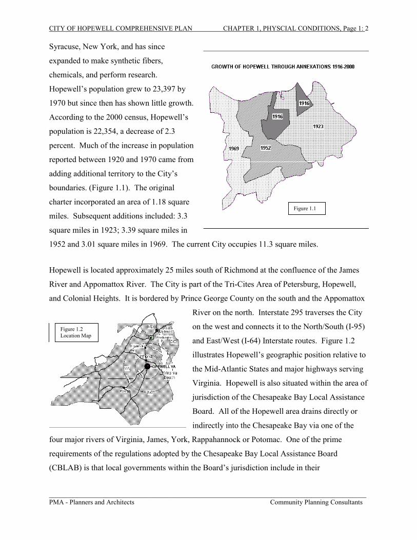
Hopewell’s population grew to 23,397 by
1970 but since then has shown little growth.
According to the 2000 census, Hopewell’s
population is 22,354, a decrease of 2.3
percent. Much of the increase in population
reported between 1920 and 1970 came from
adding additional territory to the City’s
boundaries. (Figure 1.1). The original
charter incorporated an area of 1.18 square
miles. Subsequent additions included: 3.3
square miles in 1923; 3.39 square miles in
1952 and 3.01 square miles in 1969. The current City occupies 11.3 square miles.
Hopewell is located approximately 25 miles south of Richmond at the confluence of the James
River and Appomattox River. The City is part of the Tri-Cites Area of Petersburg, Hopewell,
and Colonial Heights. It is bordered by Prince George County on the south and the Appomattox
River on the north. Interstate 295 traverses the City
on the west and connects it to the North/South (I-95)
and East/West (I-64) Interstate routes. Figure 1.2
illustrates Hopewell’s geographic position relative to
the Mid-Atlantic States and major highways serving
Virginia. Hopewell is also situated within the area of
jurisdiction of the Chesapeake Bay Local Assistance
Board. All of the Hopewell area drains directly or
indirectly into the Chesapeake Bay via one of the
four major rivers of Virginia, James, York, Rappahannock or Potomac. One of the prime
requirements of the regulations adopted by the Chesapeake Bay Local Assistance Board
(CBLAB) is that local governments within the Board’s jurisdiction include in their
Figure 1.2Location Map
Figure 1.1
Figure 1.2Location Map
CITY OF HOPEWELL COMPREHENSIVE PLAN CHAPTER 1, PHYSCIAL CONDITIONS, Page 1: 3
_____________________________________________________________________________________________PMA - Planners and Architects Community Planning Consultants
Comprehensive Plan a Water Quality Protection Plan based on a detailed analysis of physical
and environmental conditions.
This chapter provides that physical analysis for the City of Hopewell. It examines conditions,
both natural and man-made, that may play a significant role in limiting the future development of
the City. For the purpose of this analysis, physical conditions expected to place major
limitations on the City’s potential for development are grouped under the following three
categories:
A. Physical Constraints to Development
B. Protection of Potable Water Supply
C. Analysis of Shoreline Conditions
The major purpose of this analysis is to provide the data that will provide the structural
framework for designing a Land Use Plan, the basic component of Hopewell’s Comprehensive
plan. This analysis, therefore, will define those areas of the City that are likely to impose
constraints on development such as steep slopes, highly-erodible soils, areas subject to flooding,
historic features and other sensitive environmental areas. This data will also be used to ensure
the City’s Comprehensive Plan includes a Water Quality Protection Plan in compliance with the
Chesapeake Bay Preservation Act.
CITY OF HOPEWELL COMPREHENSIVE PLAN CHAPTER 1, PHYSCIAL CONDITIONS, Page 1: 4
_____________________________________________________________________________________________PMA - Planners and Architects Community Planning Consultants
A. PHYSICAL CONSTRAINTS TO DEVELOPMENT
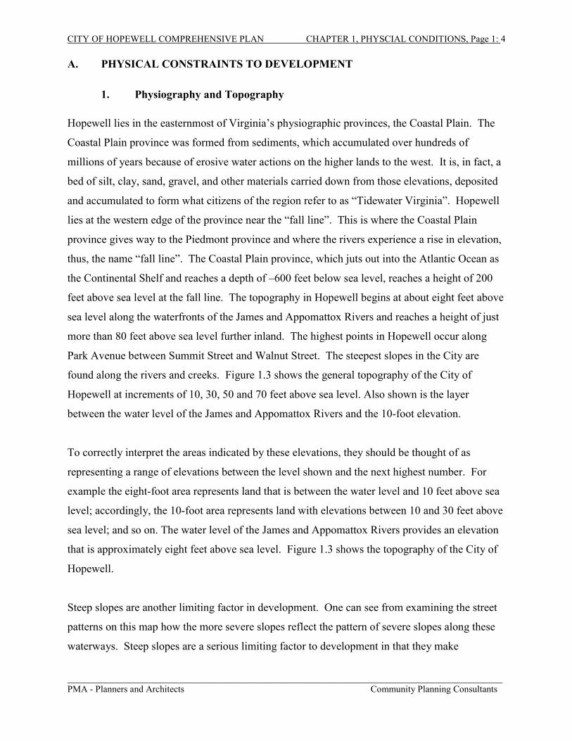
1. Physiography and Topography
Hopewell lies in the easternmost of Virginia’s physiographic provinces, the Coastal Plain. The
Coastal Plain province was formed from sediments, which accumulated over hundreds of
millions of years because of erosive water actions on the higher lands to the west. It is, in fact, a
bed of silt, clay, sand, gravel, and other materials carried down from those elevations, deposited
and accumulated to form what citizens of the region refer to as “Tidewater Virginia”. Hopewell
lies at the western edge of the province near the “fall line”. This is where the Coastal Plain
province gives way to the Piedmont province and where the rivers experience a rise in elevation,
thus, the name “fall line”. The Coastal Plain province, which juts out into the Atlantic Ocean as
the Continental Shelf and reaches a depth of –600 feet below sea level, reaches a height of 200
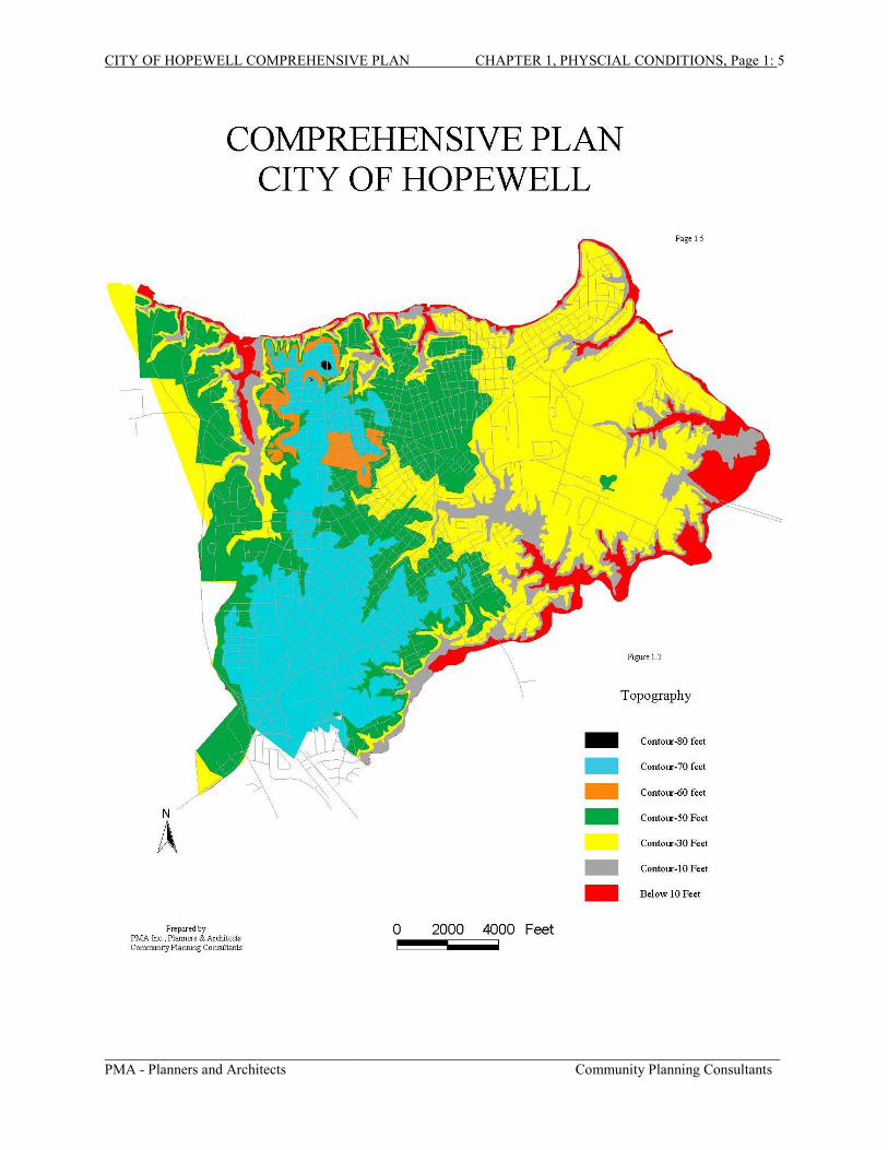
feet above sea level at the fall line. The topography in Hopewell begins at about eight feet above
sea level along the waterfronts of the James and Appomattox Rivers and reaches a height of just
more than 80 feet above sea level further inland. The highest points in Hopewell occur along
Park Avenue between Summit Street and Walnut Street. The steepest slopes in the City are
found along the rivers and creeks. Figure 1.3 shows the general topography of the City of
Hopewell at increments of 10, 30, 50 and 70 feet above sea level. Also shown is the layer
between the water level of the James and Appomattox Rivers and the 10-foot elevation.
To correctly interpret the areas indicated by these elevations, they should be thought of as
representing a range of elevations between the level shown and the next highest number. For
example the eight-foot area represents land that is between the water level and 10 feet above sea
level; accordingly, the 10-foot area represents land with elevations between 10 and 30 feet above
sea level; and so on. The water level of the James and Appomattox Rivers provides an elevation
that is approximately eight feet above sea level. Figure 1.3 shows the topography of the City of
Hopewell.
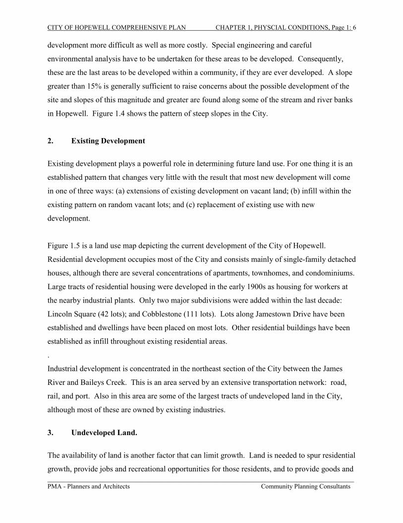
Steep slopes are another limiting factor in development. One can see from examining the street
patterns on this map how the more severe slopes reflect the pattern of severe slopes along these
waterways. Steep slopes are a serious limiting factor to development in that they make
CITY OF HOPEWELL COMPREHENSIVE PLAN CHAPTER 1, PHYSCIAL CONDITIONS, Page 1: 5
_____________________________________________________________________________________________PMA - Planners and Architects Community Planning Consultants
CITY OF HOPEWELL COMPREHENSIVE PLAN CHAPTER 1, PHYSCIAL CONDITIONS, Page 1: 6
_____________________________________________________________________________________________PMA - Planners and Architects Community Planning Consultants
development more difficult as well as more costly. Special engineering and careful
environmental analysis have to be undertaken for these areas to be developed. Consequently,
these are the last areas to be developed within a community, if they are ever developed. A slope
greater than 15% is generally sufficient to raise concerns about the possible development of the
site and slopes of this magnitude and greater are found along some of the stream and river banks
in Hopewell. Figure 1.4 shows the pattern of steep slopes in the City.
2. Existing Development
Existing development plays a powerful role in determining future land use. For one thing it is an
established pattern that changes very little with the result that most new development will come
in one of three ways: (a) extensions of existing development on vacant land; (b) infill within the
existing pattern on random vacant lots; and (c) replacement of existing use with new
development.
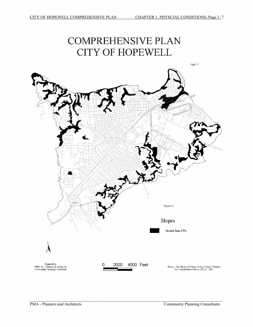
Figure 1.5 is a land use map depicting the current development of the City of Hopewell.
Residential development occupies most of the City and consists mainly of single-family detached
houses, although there are several concentrations of apartments, townhomes, and condominiums.
Large tracts of residential housing were developed in the early 1900s as housing for workers at
the nearby industrial plants. Only two major subdivisions were added within the last decade:
Lincoln Square (42 lots); and Cobblestone (111 lots). Lots along Jamestown Drive have been
established and dwellings have been placed on most lots. Other residential buildings have been
established as infill throughout existing residential areas.
.
Industrial development is concentrated in the northeast section of the City between the James
River and Baileys Creek. This is an area served by an extensive transportation network: road,
rail, and port. Also in this area are some of the largest tracts of undeveloped land in the City,
although most of these are owned by existing industries.
3. Undeveloped Land.
The availability of land is another factor that can limit growth. Land is needed to spur residential
growth, provide jobs and recreational opportunities for those residents, and to provide goods and
CITY OF HOPEWELL COMPREHENSIVE PLAN CHAPTER 1, PHYSCIAL CONDITIONS, Page 1: 7
_____________________________________________________________________________________________PMA - Planners and Architects Community Planning Consultants
CITY OF HOPEWELL COMPREHENSIVE PLAN CHAPTER 1, PHYSCIAL CONDITIONS, Page 1: 8
_____________________________________________________________________________________________PMA - Planners and Architects Community Planning Consultants
services to both the residential and business community. The amount of remaining vacant land
in Hopewell has diminished to a level where it is insufficient to support the long-term future
growth of the City along traditional patterns where new growth is accommodated predominantly
on prime undeveloped land. Compounding this problem are other factors associated with the
remaining vacant land. A significant portion of this land is within the Chesapeake Bay Resource
Protection Area (RPA). Other portions are plagued by steep slopes, are too rough to develop, or
are non-tidal wetlands and considered undevelopable. Some land within the Resource
Management Area (RMA) may be developable, although few large sites exist under single
ownership. Much of the developable vacant land consists of relatively small sites, or groups of
sites under multiple ownership, which may be difficult to develop efficiently. Based on the
shortage of developable vacant land, an emphasis should be placed on using the remaining
vacant land efficiently and effectively, and where appropriate, on redeveloping existing land to
accommodate new growth.
According to the analysis in the 1991 Comprehensive Plan, the vacant land in Hopewell consists
of approximately 1500 acres of which portions include prime acreage, acreage in the Chesapeake
Bay Preservation Area, and areas with rough terrain. Approximately three-quarters of the vacant
land consisted of developable acreage although a portion of this land fell within the RMA which
would be under the limitations of the overlay district. However, not all of this land may be
feasible to develop due to access problems, existing ownerships, and other practical
considerations. The remaining vacant land falls within the Resource Protection Area or consists
of rough terrain and is considered undevelopable for planning purposes.
a. Vacant Residential Land:
Much of the remaining vacant residential land in the City consists of single lots scattered
throughout the City. The larger remaining vacant parcels have development constraints
that may be great enough to preclude them from ever being fully developed. The 1990
Comprehensive plan listed three parcels that had potential for further development.
CITY OF HOPEWELL COMPREHENSIVE PLAN CHAPTER 1, PHYSCIAL CONDITIONS, Page 1: 9
_____________________________________________________________________________________________PMA - Planners and Architects Community Planning Consultants
CITY OF HOPEWELL COMPREHENSIVE PLAN CHAPTER 1, PHYSCIAL CONDITIONS, Page 1: 10
_____________________________________________________________________________________________PMA - Planners and Architects Community Planning Consultants
b. Residential Development Potential of Vacant Land:
It is unlikely that all of the remaining vacant residential land can be fully developed given
that much of it may be difficult to assemble and/or access efficiently to maximize its
potential. The available vacant residential land has a limited capacity to absorb future
growth in housing
c. Vacant Commercial Land:
Most of the vacant Commercial land is in the B-3 zone around the new I-295 interchange.
There are several moderately-sized sites in this area, which could have significant
commercial potential.
d. Vacant Industrial Land:
Most of the vacant industrial land occurs in the M-2 zone and consists of large parcels
under ownership by adjacent industries. Most of this land is prime acreage and will sup-
port additional development although most of this land is reserved for future development
by the companies that own the property.
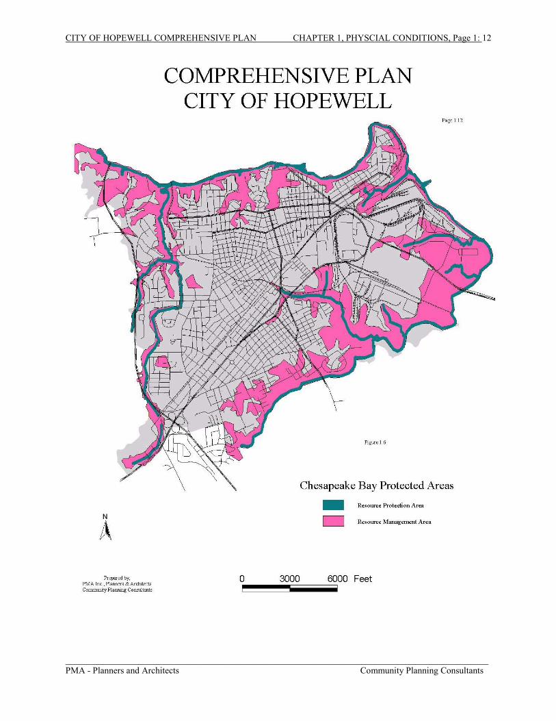
4. Chesapeake Bay Protected Areas
The Chesapeake Bay Preservation Act was adopted by the Commonwealth of Virginia to
improve the quality of water that enters the Chesapeake Bay. Section 10.1-2109 of the Act
required each local government to designate preservation areas, which, if improperly developed,
could negatively impact the water quality of the Bay and its tributaries. Total area for the
Chesapeake Bay protected areas is approximately 2,300 acres. Figure 1.6 delineates the
Chesapeake Bay protected areas.
a. Resource Protection Areas (RPA)
RPAs are lands that absorb wind and wave energy, stabilize soils, and filter sediment and
nutrients that run off the land. They should include all lands that have an inherent water
quality benefit. The only permitted uses in these areas are redevelopment of existing
uses, water dependent uses such as piers, public utilities, railways and roadways, water
wells, passive recreation uses, and historic preservation or archeological uses. The City’s
CITY OF HOPEWELL COMPREHENSIVE PLAN CHAPTER 1, PHYSCIAL CONDITIONS, Page 1: 11
_____________________________________________________________________________________________PMA - Planners and Architects Community Planning Consultants
Zoning Ordinance defines Resource Protection Areas as including the following:
1. Tidal wetlands
2. Nontidal wetlands connected by surface flow and contiguous to tidalwetlands or tributary streams
3. Tidal shores
4. A 100-foot vegetated buffer area located adjacent to one of the abovetypes of areas and along both sides of any tributary stream
b. Resource Management Areas (RMA)
RMAs are lands, which, if improperly developed, have the potential for diminishing the
functionality of RPAs. Any use that is permitted under the City’s zoning ordinance is
permitted in the RMA, provided all development meets performance criteria set forth in
the Chesapeake Bay Act Regulations. According to the City’s current Zoning Ordinance,
the Resource Management Area is composed of concentrations of one or more of the
following land categories:
1. 100-year floodplains
2. Streamside steep slopes
3. Nontidal wetlands not included in the Resource Protection Area
c. Intensely Developed Areas (IDA)
IDAs are areas of existing development and infill sites where little of the natural
environment remains and which meet the following criteria:
1. Development has severely altered the natural state of the area such that ithas more than 50 percent impervious surface
2. Public sewer and water has been constructed and currently serves the area
3. Housing density is equal to or exceeds four dwellings per acre.
CITY OF HOPEWELL COMPREHENSIVE PLAN CHAPTER 1, PHYSCIAL CONDITIONS, Page 1: 12
_____________________________________________________________________________________________PMA - Planners and Architects Community Planning Consultants
CITY OF HOPEWELL COMPREHENSIVE PLAN CHAPTER 1, PHYSCIAL CONDITIONS, Page 1: 13
_____________________________________________________________________________________________PMA - Planners and Architects Community Planning Consultants
City Council action is required in order to establish an IDA. The Local Assistance
Manual provided by CBLAD recommends that Intensely Developed Areas have a
minimum size of 20 acres, and further provides that “Intensely Developed Areas shall
serve as redevelopment areas in which development is concentrated as of the local
program adoption date.”1 No IDAs have been established to date within the City of
Hopewell.
Hopewell first established an overlay zoning district in its zoning ordinance in 1991 and at that
time, as part of the first-year program of implementing the Chesapeake Bay Program, established
the Resource Protection Area boundaries by adopting a model ordinance provided by CBLAD.
Although the criteria for Resource Management Areas were defined in the ordinance (see
language above) boundaries of the RMAs were not expressed in a map. Instead, the City took
the approach that as individual properties were developed, each property owner would be
responsible for providing technical services necessary to define the exact boundaries of both the
RMA and RPA at a specific site. Figure 1.6 delineates graphically the areas that should be
defined as the RMA as could best be determined from the soil data. Areas delineated include
Floodplains are low-lying areas adjacent to rivers, streams, creeks, and other bodies of water that
are subject to periodic flooding when precipitation causes the volume of water to exceed the
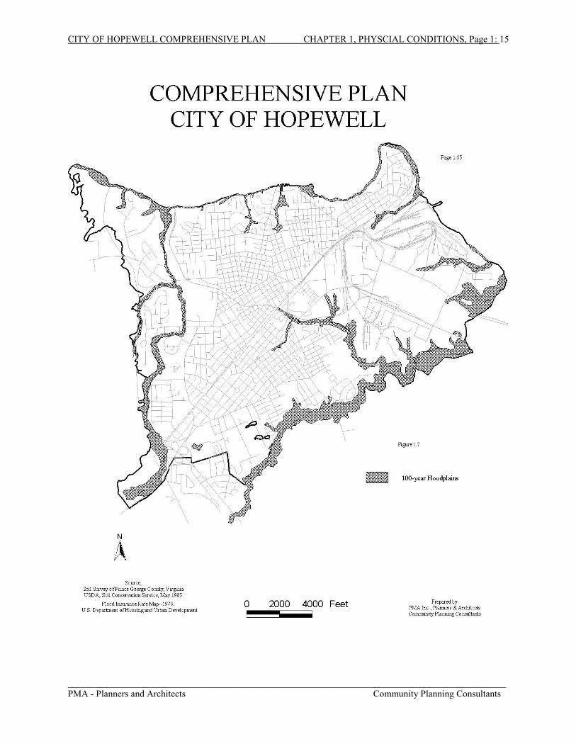
capacity of the waterway. Figure 1.7 shows the 100-year floodplain for the City of Hopewell.
There are a multitude of factors, such as topography, geographic orientation of the shoreline,
depth and duration of the flooding, and rate of water rise, which affect damage caused by floods.
The amount of flood damage is also affected by the extent of development within a floodplain
since development can interfere with the natural functions of floodplains.
1 Section 3.4, CBLAD Regulations.
CITY OF HOPEWELL COMPREHENSIVE PLAN CHAPTER 1, PHYSCIAL CONDITIONS, Page 1: 14
_____________________________________________________________________________________________PMA - Planners and Architects Community Planning Consultants
Congress established the National Flood Insurance Program in 1968. This program enables
property owners to purchase federally-backed flood insurance within communities, which
implement floodplain management measures to reduce flood risks to new development.
Regulations of the National Flood Insurance Program specify requirements that must be included
in local ordinances if a community wishes to participate in the program. Requirements of the
program include regulation of buildings and other developments in floodplain areas. Hopewell’s
Zoning Ordinance includes floodplain regulations in Article XV. The Federal Emergency
Management Agency (FEMA) establishes flood risk data for insurance rating and floodplain
management in addition to conducting Flood Insurance Studies and Maps for localities. The
Flood Insurance Rate maps define flood hazard areas, or areas subject to inundation at 100-year
and 500-year intervals. A 100-year flood zone has a one percent (1%) chance of being inundated
in any given one-year period, whereas the 500-year flood zone has a two-tenths of one percent
(0.2%) chance of being flooded in the same one-year period.
6. Wetlands
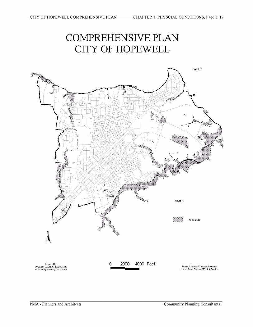
Figure 1.8 shows the location of wetlands in the City of Hopewell. Concentrated along the
southern border of the City, wetlands make up about 730 acres of the land area of Hopewell.
The wetlands in the city closely parallel Cabin Creek, Cattail Creek and Baileys Creek.
The value of wetlands includes aesthetics; flood, erosion, and pollution control; habitat;
productivity; and recreation. They serve as a natural water filter for wastes and sediments, a
barrier and an absorber of floodwaters, a buffer and a stabilizer of the shoreline from coastal
erosion, a recharge area for ground water, and an important breeding and nesting ground for
many species of fish, bird, and plant life. Wetlands also serve as valuable sites for recreation,
open space, and education. There are two classifications for wetlands, tidal and nontidal. Tidal
wetlands are vegetated marshes, non-vegetated beaches, sandflats, and mudflats, which are
subject to regular tidal influences by salt or brackish water. Nearly all wetlands in the City are
classified as non-tidal. The only tidal wetlands are a few sandflats along the James River that are
subject to tidal pressures.
CITY OF HOPEWELL COMPREHENSIVE PLAN CHAPTER 1, PHYSCIAL CONDITIONS, Page 1: 15
_____________________________________________________________________________________________PMA - Planners and Architects Community Planning Consultants
CITY OF HOPEWELL COMPREHENSIVE PLAN CHAPTER 1, PHYSCIAL CONDITIONS, Page 1: 16
_____________________________________________________________________________________________PMA - Planners and Architects Community Planning Consultants
Nontidal wetlands, which may be adjacent to tidal marshes as well as further inland, are beyond
tidal influences, and are either continually or seasonally saturated by freshwater. Due to seasonal
and yearly variations, these types of wetlands are not as easily recognized, since there may not be
any surface evidence of the presence of water during certain times of the year.
For years, wetlands were considered undesirable wastelands and breeding grounds for disease-
carrying mosquitoes. Consequently, many millions of acres were filled, drained, and otherwise
altered for conversion to agricultural lands or development sites. It has been estimated that
between the mid 1950s and the late 1970s approximately 11 million acres of wetlands were lost
nationwide. During this period, Virginia lost approximately 57,000 acres of freshwater
vegetated wetlands to agricultural conversion; channelization; forestry, pond, lake, and reservoir
construction; and other development. Not until the early 1970s did the science community begin
to realize the significant function of wetlands. Because of that research, a number of federal,
state, and local regulations evolved to manage and protect both tidal and non-tidal wetlands.
Federal Regulations: Sections 401 and 404 of the Clean Water Act are the primary federal
regulations which affect development on wetlands. Before a wetland can be filled or disturbed, a
wetlands permit must be obtained from the U.S. Army Corps of Engineers.
State Regulations: The Commonwealth of Virginia began to regulate wetlands in the early
1970s, with the passage of the Virginia Wetlands Act of 1972. The purpose of this act was to
ensure that wetlands of primary ecological significance would not be altered or unreasonably
disturbed. The following areas were exempted from this act: agricultural, silvicultural, and
horticultural activities; cultivation and harvest of shellfish and worms for bait; maintenance and
repair of roads and railways; outdoor recreational activities that do not disturb wetlands;
construction and maintenance of noncommercial piers, boathouses, and fences constructed so as
to preserve tidal flow; construction of navigational aids; maintenance of man-made drainage
ditches; governmental activities; and activities undertaken pursuant to emergency decrees.
Local Regulations: The Virginia Wetlands Act gave local governments authorization to
establish local wetlands boards to exercise jurisdiction and review and issue permits for
development on local wetlands.
CITY OF HOPEWELL COMPREHENSIVE PLAN CHAPTER 1, PHYSCIAL CONDITIONS, Page 1: 17
_____________________________________________________________________________________________PMA - Planners and Architects Community Planning Consultants
CITY OF HOPEWELL COMPREHENSIVE PLAN CHAPTER 1, PHYSCIAL CONDITIONS, Page 1: 18
_____________________________________________________________________________________________PMA - Planners and Architects Community Planning Consultants
Properly managed and maintained, wetlands become an asset to the surrounding land. Wetlands
can provide an economic benefit as well as being vital in the natural ecosystem. They provide
access to hunting and fishing, bird watching, boating, and other outdoor activities. These types
of activities provide many economic benefits to the local economy.
The habitat that wetlands provide is crucial. Any disruption in the food cycle or life cycle can do
harm to the local fauna and wildlife. This can cause the disappearance from the locality of
species that provide a reason for outdoor enthusiasts to return. Loss of these species translates
into loss of economic benefits to the surrounding community. Wetlands also perform cheaper,
more effective, and more attractive, flood and pollution control. Wetland plant species and
vegetation filter out chemicals and trap sediment before it reaches the rivers and bay. They also
slow the force of runoff and store water once received. It is in the economic interests of the
community to protect its wetlands.
7. Soils
According to the most recent soil survey of Prince George County, which includes Hopewell2,
land within the City of Hopewell is made up of 37 different types of soil. All of these soils are
contained in one general soil unit, the Slagle-Emporia-Bonneau general soil unit. The S-E-B is
generally composed of deep, moderately well drained to well-drained soils that have a loamy
subsoil. The soil unit is named for the most common soils although other soils make up more
than 30% of this general unit. There are also large sections of the soil in the City that were not
described or delineated. More than 80% of these areas are covered in asphalt or impervious
covers. It was not possible to determine the type or composition of the soils underlying these
impervious covers without extensive testing. Therefore, before new uses and structures are
established, each site should be tested to determine what type of soil is found there and what are
that soil’s respective properties.
a. Drainage:One important aspect of the soil is how well it drains. Soil drainage affects many things
about a site. Poorly drained soils need to have extra drainage installed so that water does
2 Soil Conservation Service, USDA. Soil Survey of Prince George County, Virginia. (National Cooperative SoilSurvey: Washington), 1980.
CITY OF HOPEWELL COMPREHENSIVE PLAN CHAPTER 1, PHYSCIAL CONDITIONS, Page 1: 19
_____________________________________________________________________________________________PMA - Planners and Architects Community Planning Consultants
CITY OF HOPEWELL COMPREHENSIVE PLAN CHAPTER 1, PHYSCIAL CONDITIONS, Page 1: 20
_____________________________________________________________________________________________PMA - Planners and Architects Community Planning Consultants
not puddle around built structures and damage the foundations. Poorly drained soils also
can exacerbate pollution. Pollutants that would normally be drained off from the soil are
more likely to remain in the soil or descend into the underground aquifers creating a
pollution hazard. Most of the poorly-drained soils follow the creeks and streams of the
city and may be undevelopable. They parallel the RPA and most are within the
floodplain. Figure 1.9 delineates the drainage qualities of the soil in the City of
Hopewell.
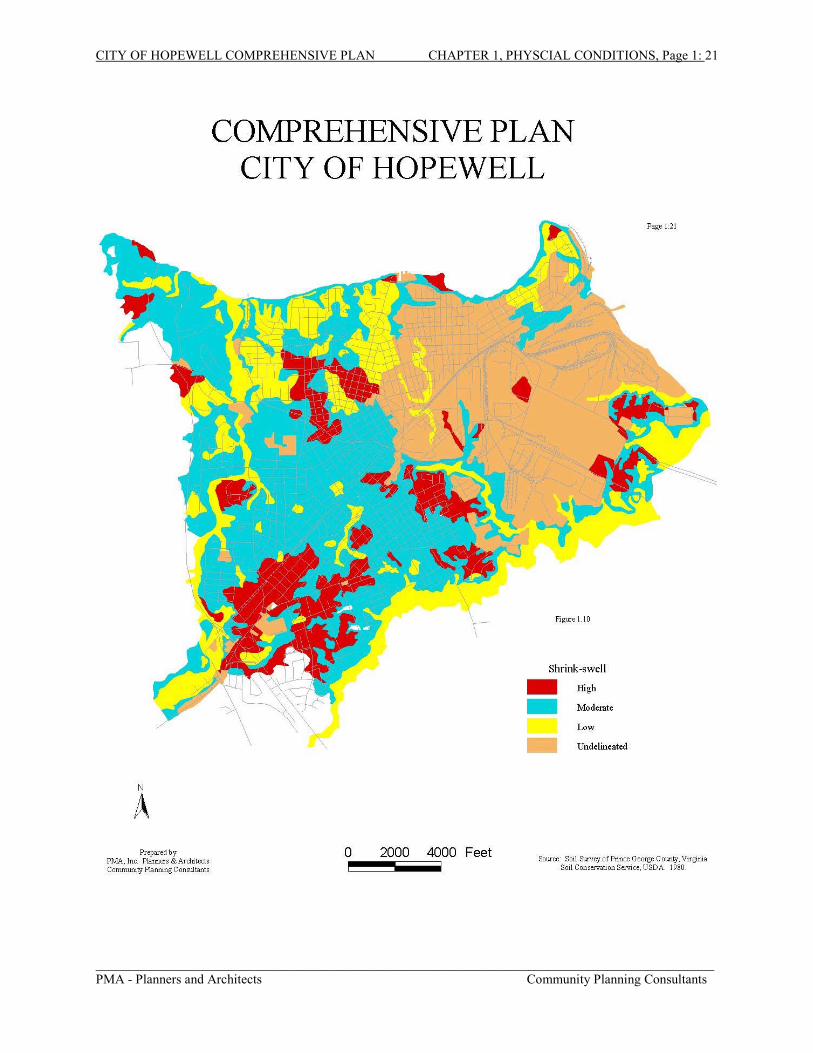
b. Shrink-swell Qualities of the Soil
Shrink-swell refers to the capability of soils to expand or contract as moisture is gained or
lost. The interaction between minerals in clay with water is the primary reason for
volumetric change and, accordingly, the amount of shrink-swell in a particular soil is
related to the type and amount of clay minerals found in the soil. The size of the load on
the soil and the magnitude of change in soil moisture content influence the amount of
swelling of soils in place. Figure 1.10 shows the shrink-swell qualities of the soils in
Hopewell and classifies them as high, moderate, low or undelineated. Please see the
section on Soils for an explanation of the undelineated section of the map.
The implications of the shrink-swell qualities of soils for planning purposes revolve
around the design and building of foundations for such structures as roads, buildings, and
bridges. High shrink-swell soils require special engineering techniques in the design of
foundations to allow for the expansion and contraction of the soil without damaging the
structure that sits upon that soil. Soils with very low shrink-swell qualities may not be
stable enough to support any large-sized structure. Hopewell has no soils that rate very
low in shrink-swell quality.
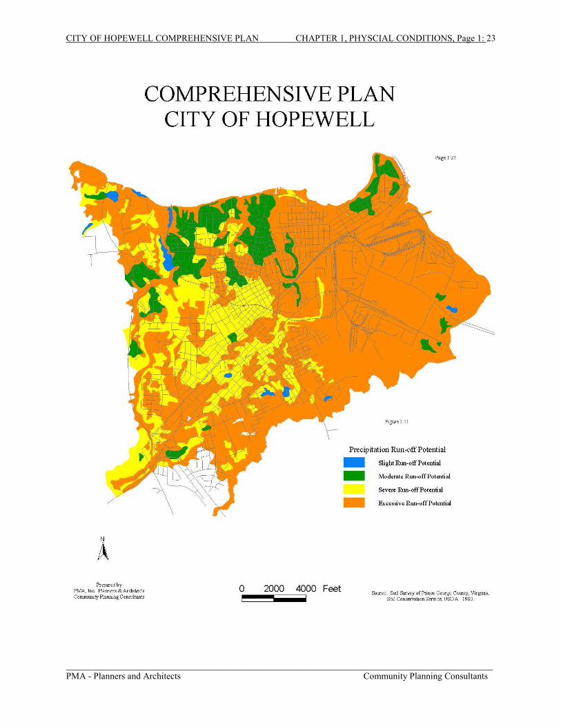
c. Run-off Quality of Soils.
This quality describes the capability of the soil to capture precipitation and prevent it
from running off into streams and other watersheds. Figure 1.11 shows the run-off
potential of the soils and lists them in order from slight potential to excessive potential
for run-off. Most of the soils in Hopewell have either severe or excessive run-off
CITY OF HOPEWELL COMPREHENSIVE PLAN CHAPTER 1, PHYSCIAL CONDITIONS, Page 1: 21
_____________________________________________________________________________________________PMA - Planners and Architects Community Planning Consultants
CITY OF HOPEWELL COMPREHENSIVE PLAN CHAPTER 1, PHYSCIAL CONDITIONS, Page 1: 22
_____________________________________________________________________________________________PMA - Planners and Architects Community Planning Consultants
potential, due, in large part, to the built-up nature that is common to urban areas. Most of
the slight to moderate run-off potential soils are in the northern section of the City.
Run-off potential is important, especially when discussing the Chesapeake Bay
regulations, because one goal of the Chesapeake Bay Act is to reduce pollution from non-
point sources. Non-point source pollution, such as run-off from urban areas like parking
lots and streets, run-off of excess lawn fertilizers and pesticides, and erosion of soil from
stream banks or improperly managed construction sites, is a big contributor to the
pollution of the Chesapeake Bay and its tributaries. By careful management of those
soils with slight run-off potential, it may be possible to lessen non-point source pollution
by allowing these soils to capture precipitation that otherwise would run off into the
waterways carrying possible water contaminants.
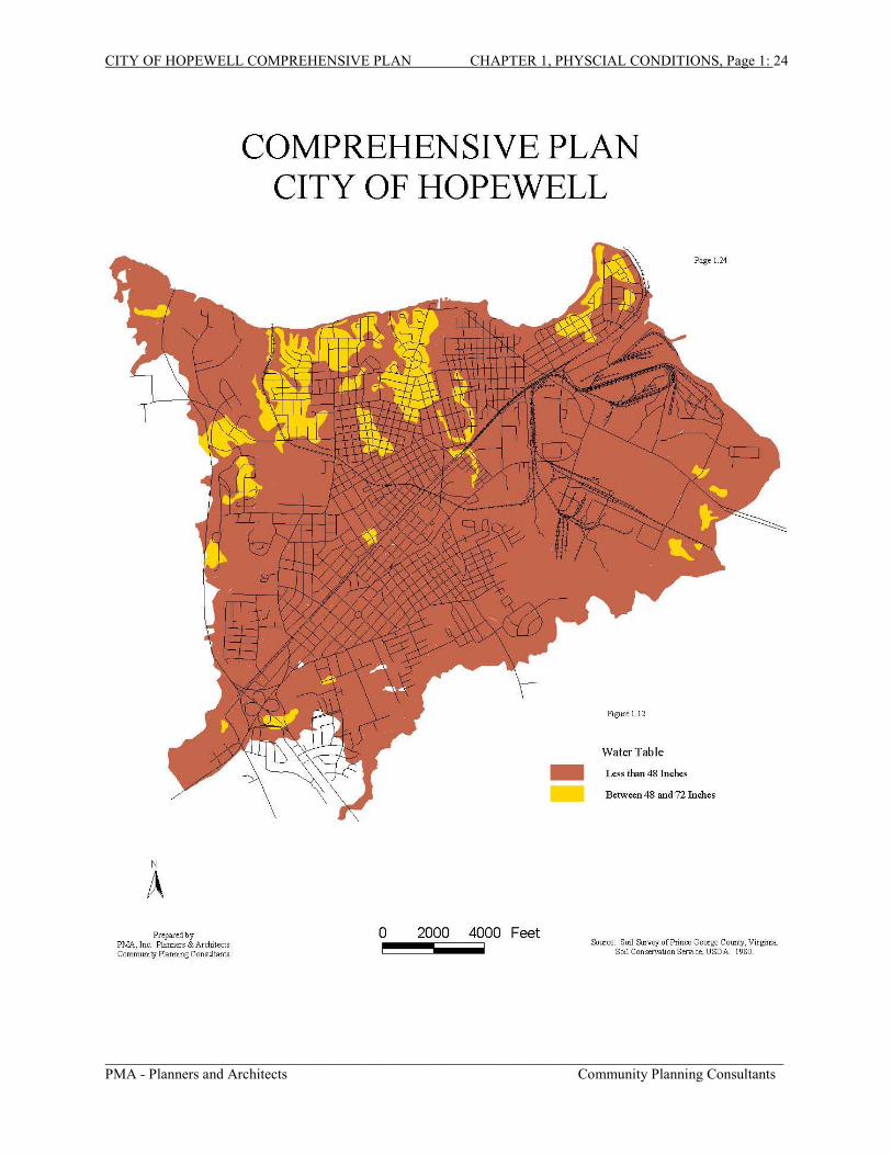
d. High Water Table
Another important soil quality is the depth of the seasonal high water table. The high
water table, Figure 1-12, affects structure placement on a site, suitability for a basement
for a dwelling, and the types of buildings that can be placed on a site. It can also affect
placement of recreational areas such as swimming pools. A seasonal water table is
considered high if it reaches closer than 48 inches below the ground surface. A moderate
water table is between 48 and 72 inches below the surface of the earth. Most of
Hopewell is considered to have a high water table. It must be remembered, however, that
this is a generalized interpretation; each site is different and must be evaluated separately
to determine the height of the seasonal water table.
e. Hydric Soils
A hydric soil is defined as a soil that is saturated, flooded, or ponded long enough during
the growing season to develop anaerobic conditions in the upper layers. Hydric soils of
Virginia are defined and listed in a document published by the U.S. Department of
Agriculture, Soil Conservation Service, entitled Hydric Soils of Virginia. Though there
are wetlands in Hopewell, there are no hydric soils in the City.
CITY OF HOPEWELL COMPREHENSIVE PLAN CHAPTER 1, PHYSCIAL CONDITIONS, Page 1: 23
_____________________________________________________________________________________________PMA - Planners and Architects Community Planning Consultants
CITY OF HOPEWELL COMPREHENSIVE PLAN CHAPTER 1, PHYSCIAL CONDITIONS, Page 1: 24
_____________________________________________________________________________________________PMA - Planners and Architects Community Planning Consultants
CITY OF HOPEWELL COMPREHENSIVE PLAN CHAPTER 1, PHYSCIAL CONDITIONS, Page 1: 25
_____________________________________________________________________________________________PMA - Planners and Architects Community Planning Consultants
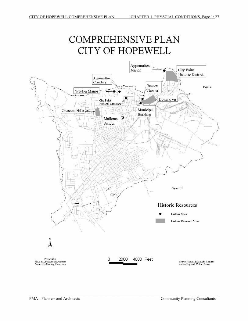
8. Historic Resources
Historic resources play an important role in the community. Their purpose is two-fold; they help
the local economy by drawing tourists and they help educate succeeding generations in the
history of the locality in which they reside. The most significant historic feature of Hopewell is
City Point. It has been previously noted that this area was first known as “Bermuda Cittie” and
later called “Charles City Point” and eventually shortened to its present name.
This community missed being the first permanent English Settlement by some 24 hours. It
seems that when the three ships anchored off Hog Island early in May 1607 the instructions from
the London Company were opened. They were to establish the first settlement at least 50 miles
from the ocean because of fear of Spanish raiders. Captain Christopher Newport, the mariner in
charge of the voyage from England, set out with a small party in a shallop to explore up the river.
When he reached the mouth of the Appomattox River he saw a small Indian village, perched on
the bluff where Appomattox Manor now stands. Newport and his men landed and distributed
gifts to the queen and were so royally entertained that they stayed for three days. Captain
Newport wrote later that he considered this the ideal place for the new settlement but when he
returned down the James, he found the other settlers had already moved up the river and
anchored at Jamestown, which became the first permanent English settlement.
In 1613, Governor Dale (Sir Thomas Dale) established a fortified settlement on the bluff where
Appomattox Manor now stands and called it “Bermuda Cittie” (later Charles City Point and City
Point). The first free school in America was established at City Point in 1621. The very next
year, 1622, the community was wiped out when the Indians staged the “Great Massacre.” City
Point gained further historical significance in 1864 when Union General Ulysses S. Grant
established his headquarters there during the Union siege of Petersburg.
The City Point unit of the Petersburg National Battlefield is located at City Point and
encompasses Grant’s headquarters in the park. Appomattox Manor, built ca. 1763, is located at
the tip of City Point and is included in the Petersburg National Military Park. Other historical
CITY OF HOPEWELL COMPREHENSIVE PLAN CHAPTER 1, PHYSCIAL CONDITIONS, Page 1: 26
_____________________________________________________________________________________________PMA - Planners and Architects Community Planning Consultants
landmarks in old City Point include St. John’s Episcopal Church built ca. 1840; the Porter
House, ca. 1810; and City Point House, ca. 1730.
There are other places of historical interest in Hopewell besides City Point. Weston Manor, built
ca. 1780, is located on the banks of the Appomattox River and now serves as a museum and
cultural center for the City. Crescent Hills subdivision has one of the largest concentrations of
Sears-Roebuck houses in the nation. Built in the late 1920s and early 1930s, these houses have
not been substantially altered which may make them eligible for the National Register. The
Beacon Theater, which has been undergoing a restoration, and the James E. Mallonee School are
also historically significant structures in Hopewell. There are two historic cemeteries in
Hopewell; Appomattox Cemetery and City Point National Cemetery, the latter of which has both
Union and Confederate soldiers buried within its confines. Figure 1.13 shows the locations of
these historic sites as well as others that may have historical significance.
Since Hopewell has been occupied for almost 400 years, there may be other sites of historical
and cultural significance in the City. A complete survey of the older sections of the City by the
Virginia Department of Historic Resources (VDHR) may result in many other sites being
qualified for addition to the Register. Current preservation issues in Hopewell include the
preservation and restoration of the “Downtown” area and adaptive reuse of older buildings that
may have historical significance.
CITY OF HOPEWELL COMPREHENSIVE PLAN CHAPTER 1, PHYSCIAL CONDITIONS, Page 1: 27
_____________________________________________________________________________________________PMA - Planners and Architects Community Planning Consultants
CITY OF HOPEWELL COMPREHENSIVE PLAN CHAPTER 1, PHYSCIAL CONDITIONS, Page 1: 28
_____________________________________________________________________________________________PMA - Planners and Architects Community Planning Consultants
B. ANALYSIS OF CONDITIONS RELATED TO POTABLE WATER SUPPLY
Water resources are often described in the context of a hydrologic cycle. This is the
cyclical movement of water within the environment from atmosphere, to land, to sea, to
atmosphere again. Precipitation, infiltration, evaporation, and transpiration are the
principle mechanisms, which move water from one location to another. Precipitation in
the form of rain, snow, or hail can be intercepted by vegetation, infiltrate into the ground,
or run off as surface waters. Plants, which intercept precipitation, absorb moisture and
transpire water back into the air. Infiltrated water is stored underground in storage areas
between layers of rock or sediment, known as aquifers. Water not infiltrated eventually
runs into depression areas, such as puddles, streams, lakes, rivers, and oceans. As
exposed surface waters evaporate into the atmosphere, the hydrologic cycle continues.
Water for drinking purposes is obtained directly from rivers and streams, impoundments
of surface water (dams and reservoirs) and/or from underground aquifers.
1. Water Supply for Hopewell
In Hopewell, drinking water is obtained from the Appomattox River from a pumping
station at the confluence of the Appomattox and James Rivers. The Appomattox River is
one of the longest and least developed rivers in Virginia. The Virginia-American Water
Company in Hopewell supplies water to Hopewell, Fort Lee and the suburban areas in
Prince George County. The company withdraws its water from the Appomattox River
near the confluence with the James River. The treatment plant has a current capacity of
33 million gallons per day (mgd). The average total water production is 21 mgd. Eighty-
five percent of the water processed is consumed by the industries of Hopewell. There are
currently over 8,500 connections to the system.
2. Conditions Affecting Water Quality
Sources of Pollution. Potential contamination of ground and surface water includes two
sources of pollution: point and non-point. Non-point source pollution contributes about
CITY OF HOPEWELL COMPREHENSIVE PLAN CHAPTER 1, PHYSCIAL CONDITIONS, Page 1: 29
_____________________________________________________________________________________________PMA - Planners and Architects Community Planning Consultants
three-fifths of the nitrogen that reaches the Chesapeake Bay, and more than half of the
phosphorus. To reduce runoff from fields, increased efforts have been made in the Bay
watershed to install Best Management Practice plans (BMPs). To maximize nutrient
control, resource specialists suggest that the BMP concept be replaced with "best
management systems" (BMS’s). BMS’s are a combination of conservation practices or
management measures which, when used in concert, can achieve greater nutrient
reductions. A BMS, for example, may combine conservation tillage practices with grass
waterways, strip-cropping, diversions, stream-side buffers, and a nutrient management
plan.
Nutrients from lawns, roadways and other developed areas are flushed into waterways by
rain. Urban areas contribute about 14 percent of the phosphorus and 11 percent of the
nitrogen. In recent years, some progress has been made toward installing runoff control
devices on new developments, but "retrofitting" controls on already-developed areas are
particularly costly to maintain.
Approximately 25 percent of the nitrogen entering the Bay and its tributaries, and about
33 percent of the phosphorus originates from point source pollution. These are mainly
municipal wastewater treatment plants. Historically, these plants were designed to
remove pathogens from sewage to protect public health. Increasingly, however, these
plants have been upgraded to help better remove nutrients. This upgrading has been
particularly successful for phosphorus -- greatly aided by the phosphate detergent bans
that went into effect in the mid to late 1980s.
Nitrogen removal from wastewater treatment plants has lagged behind phosphorus
removal. New techniques are being developed to better remove nitrogen from
wastewater. Some, such as biological nitrogen removal, promote natural denitrification
processes in waste, increasing nitrogen removal from the normal 10 percent to 20 percent
to 60 percent to 85 percent. Other techniques, such as the addition of certain chemicals,
have also proven effective in nitrogen removal. However, nitrogen removal can be
expensive, requiring millions of dollars of upgrades at treatment plants. Some
technologies such as biological nitrogen removal can require extensive facility
expansions, making them impractical for plants with land constraints. Point sources of
CITY OF HOPEWELL COMPREHENSIVE PLAN CHAPTER 1, PHYSCIAL CONDITIONS, Page 1: 30
_____________________________________________________________________________________________PMA - Planners and Architects Community Planning Consultants
pollution also include landfills, heavy industrial sites, underground storage tanks, and
other commercial facilities that have the potential to generate pollution. Because they are
known, they are readily regulated and monitored. Virginia’s Groundwater Protection
Steering Committee has assigned top priority to the following sources of groundwater
contamination: underground storage tanks, landfills, lagoons and holding ponds, septic
systems and waste treatment facilities, pesticides and fertilizers, and hazardous wastes.
Underground Storage Tanks: Contamination of groundwater from underground
storage tanks has increased steadily in recent years. Reports indicate that there
are thousands of such tanks in use in the State, as well as a substantial amount of
unused and abandoned tanks. Recent Environmental Protection Agency studies
indicate that as many as 35 percent of all underground tanks eventually leak.
Many contain petroleum products or other substances which have the potential to
contaminate groundwater should leakage occur. Groundwater pollution by
petroleum products stored in underground tanks is a very serious problem that is
relatively common and often occurs in the vicinity of gasoline service stations.
The gasoline additive MBTE has been determined to be a significant source of
groundwater pollution not only in Virginia but also nationwide. In Virginia, the
Underground Storage Tank Program requires newly installed underground storage
tanks to meet design, construction, and monitoring standards to prevent leaks and
overflows and have corrective action plans with a detailed mitigation strategy in
the event of a spill. The Department of Environmental Quality (DEQ) operates a
program that investigates reported cases of groundwater contamination resulting
from leaking underground tanks. The table on the following page shows reported
UST leaks in Hopewell since 1987.
Landfills: Various types of substances found in landfills have the potential to
contaminate groundwater. Contaminants such as chemicals, fertilizers, paint, and
other materials may move through the ground and pollute the water table and
deeper aquifers. The Virginia Department of Waste Management’s regulations
contain landfill design requirements and standards to prevent groundwater
contamination.
CITY OF HOPEWELL COMPREHENSIVE PLAN CHAPTER 1, PHYSCIAL CONDITIONS, Page 1: 31
_____________________________________________________________________________________________PMA - Planners and Architects Community Planning Consultants
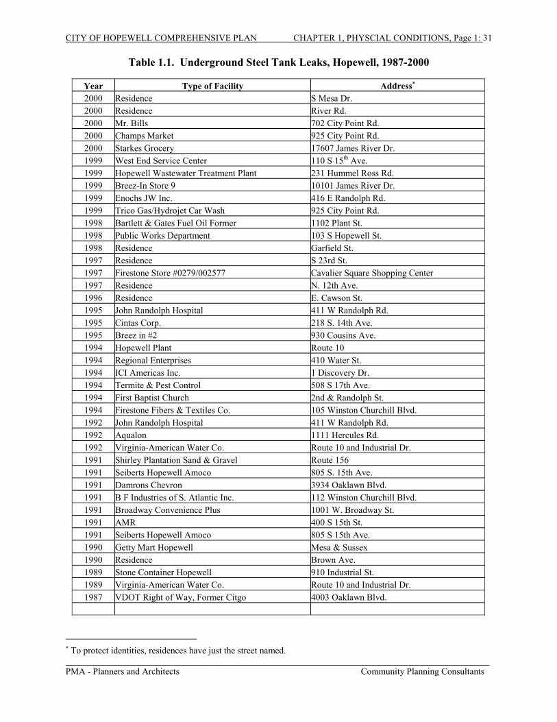
Table 1.1. Underground Steel Tank Leaks, Hopewell, 1987-2000
� To protect identities, residences have just the street named.
Year Type of Facility Address�
2000 Residence S Mesa Dr.2000 Residence River Rd.2000 Mr. Bills 702 City Point Rd.2000 Champs Market 925 City Point Rd.2000 Starkes Grocery 17607 James River Dr.1999 West End Service Center 110 S 15th Ave.1999 Hopewell Wastewater Treatment Plant 231 Hummel Ross Rd.1999 Breez-In Store 9 10101 James River Dr.1999 Enochs JW Inc. 416 E Randolph Rd.1999 Trico Gas/Hydrojet Car Wash 925 City Point Rd.1998 Bartlett & Gates Fuel Oil Former 1102 Plant St.1998 Public Works Department 103 S Hopewell St.1998 Residence Garfield St.1997 Residence S 23rd St.1997 Firestone Store #0279/002577 Cavalier Square Shopping Center1997 Residence N. 12th Ave.1996 Residence E. Cawson St.1995 John Randolph Hospital 411 W Randolph Rd.1995 Cintas Corp. 218 S. 14th Ave.1995 Breez in #2 930 Cousins Ave.1994 Hopewell Plant Route 101994 Regional Enterprises 410 Water St.1994 ICI Americas Inc. 1 Discovery Dr.1994 Termite & Pest Control 508 S 17th Ave.1994 First Baptist Church 2nd & Randolph St.1994 Firestone Fibers & Textiles Co. 105 Winston Churchill Blvd.1992 John Randolph Hospital 411 W Randolph Rd.1992 Aqualon 1111 Hercules Rd.1992 Virginia-American Water Co. Route 10 and Industrial Dr.1991 Shirley Plantation Sand & Gravel Route 1561991 Seiberts Hopewell Amoco 805 S. 15th Ave.1991 Damrons Chevron 3934 Oaklawn Blvd.1991 B F Industries of S. Atlantic Inc. 112 Winston Churchill Blvd.1991 Broadway Convenience Plus 1001 W. Broadway St.1991 AMR 400 S 15th St.1991 Seiberts Hopewell Amoco 805 S 15th Ave.1990 Getty Mart Hopewell Mesa & Sussex1990 Residence Brown Ave.1989 Stone Container Hopewell 910 Industrial St.1989 Virginia-American Water Co. Route 10 and Industrial Dr.1987 VDOT Right of Way, Former Citgo 4003 Oaklawn Blvd.
CITY OF HOPEWELL COMPREHENSIVE PLAN CHAPTER 1, PHYSCIAL CONDITIONS, Page 1: 32
_____________________________________________________________________________________________PMA - Planners and Architects Community Planning Consultants
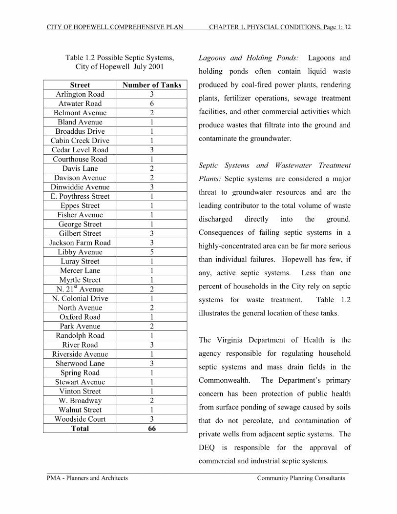
Table 1.2 Possible Septic Systems,City of Hopewell July 2001
Street Number of TanksArlington Road 3Atwater Road 6
Eppes Street 1Fisher Avenue 1George Street 1Gilbert Street 3
Jackson Farm Road 3Libby Avenue 5Luray Street 1Mercer Lane 1Myrtle Street 1
N. 21st Avenue 2N. Colonial Drive 1
North Avenue 2Oxford Road 1Park Avenue 2
Randolph Road 1River Road 3
Riverside Avenue 1Sherwood Lane 3
Spring Road 1Stewart Avenue 1
Vinton Street 1W. Broadway 2Walnut Street 1
Woodside Court 3Total 66
Lagoons and Holding Ponds: Lagoons and
holding ponds often contain liquid waste
produced by coal-fired power plants, rendering
plants, fertilizer operations, sewage treatment
facilities, and other commercial activities which
produce wastes that filtrate into the ground and
contaminate the groundwater.
Septic Systems and Wastewater Treatment
Plants: Septic systems are considered a major
threat to groundwater resources and are the
leading contributor to the total volume of waste
discharged directly into the ground.
Consequences of failing septic systems in a
highly-concentrated area can be far more serious
than individual failures. Hopewell has few, if
any, active septic systems. Less than one
percent of households in the City rely on septic
systems for waste treatment. Table 1.2
illustrates the general location of these tanks.
The Virginia Department of Health is the
agency responsible for regulating household
septic systems and mass drain fields in the
Commonwealth. The Department’s primary
concern has been protection of public health
from surface ponding of sewage caused by soils
that do not percolate, and contamination of
private wells from adjacent septic systems. The
DEQ is responsible for the approval of
commercial and industrial septic systems.
CITY OF HOPEWELL COMPREHENSIVE PLAN CHAPTER 1, PHYSCIAL CONDITIONS, Page 1: 33
_____________________________________________________________________________________________PMA - Planners and Architects Community Planning Consultants
While these systems are governed by the general requirements of a No-Discharge
Program, no separate criteria or program exists for permitting these facilities.
Wastewater treatment plants are another source of potential water pollution.
Storms and heavy usage can cause the system to overflow and fail which could
send untreated raw sewage flooding into rivers and creeks. The Virginia
Department of Environmental Quality is charged with supplying permits and
inspecting wastewater treatment facilities in the state.
The Hopewell Regional Wastewater Treatment Facility (HRWTF) is a 50 million
gallons a day (MGD) secondary treatment plant, currently treating an average
flow of 30 MGD. About 85% of the total plant flow and 90% of the organic
loading is generated by six local industries. It also treats wastewater from the Fort
Lee army base.
Superfund Sites: Superfund sites are abandoned industrial or commercial sites
that have been determined by the Environmental Protection Agency (EPA) to
contain hazardous wastes that endanger the health of the citizens of the area. In
1980, a fund was set up to enable the EPA to clean up these sites when those
companies or individuals responsible for the contamination cannot be found or
cannot pay for the clean-up work. The money for the fund comes primarily from
taxes levied on the chemical and petroleum industries.
The City of Hopewell has one such site, the 42-acre “Exeter Superfund Site”,
which is the former Bridgestone-Firestone Nylon Plant facility. In 1992, the EPA
insulation containing asbestos, and more than 200 drums containing hazardous
materials. In November 1992, the EPA initiated action to stabilize, remove, and
dispose of the PCBs, drums of hazardous substances, and the asbestos. Clean up
on-site was financed by the Superfund and was completed in November 1993.
CITY OF HOPEWELL COMPREHENSIVE PLAN CHAPTER 1, PHYSCIAL CONDITIONS, Page 1: 34
_____________________________________________________________________________________________PMA - Planners and Architects Community Planning Consultants
To recover the costs of the clean up, in 1997 the EPA filed a civil action against
Bridgestone-Firestone Inc., Perry Realty Investments, Perry Machinery
Corporation, and Exeter Properties, Inc., the owners of the property. They
recovered nearly $1 million of the $1.7 million total cost and placed a judgment
lien against the site to recover the rest of the clean up cost. In August of 1998,
Hopewell advised the federal government that the property had outstanding taxes,
penalties, and interest exceeding $600,000.
As a result of an action against the owners of the property to recover the unpaid
taxes, a judge accepted an offer from a local developer to purchase the property.
That company will combine the superfund site with an adjacent parcel and use it
for development by occupancy by a major retail chain. The developer will also
convey a portion of the site to the City for their own use. In order to prevent the
EPA from suing the City and the new owner to recover the rest of the costs of the
clean up, the City has agreed to pay the EPA $50,000 and conduct a removal of
asbestos from the site. That is expected to cost between $1 and $1.5 million.
Pesticides and Fertilizers: Groundwater contamination from pesticides and
fertilizers is a complex problem. Although these chemicals are widely used and
offer numerous benefits in farming, forestry, and lawn maintenance, their use is
difficult to monitor and regulate. Contamination from pesticides and fertilizers in
groundwater is dependent upon the rate of application, rate of decomposition,
water solubility of the substance, nature of the soil, and depth to groundwater.
Although contamination from pesticides and fertilizers generally extends over a
wide area at very low concentrations, increases may build up over years of use.
In Hopewell, fertilizers and pesticides applied to lawns and gardens are one of the
main sources of non-point source pollution.
The problem of groundwater contamination by pesticides and fertilizers has been
addressed by a number of federal and state regulations. Maximum contaminant
levels for approximately a dozen pesticides were adopted by the Environmental
Protection Agency under the Safe Drinking Water Act.
CITY OF HOPEWELL COMPREHENSIVE PLAN CHAPTER 1, PHYSCIAL CONDITIONS, Page 1: 35
_____________________________________________________________________________________________PMA - Planners and Architects Community Planning Consultants
3. Watersheds
Though Hopewell draws its water from the Appomattox River, it is located in the
James River Basin watershed. A watershed is an area of land drained by a river,
stream, or system of connecting rivers and streams such that all water within the
area flows through a single outlet. The James River Basin is the longest
watershed in Virginia, traveling 450 miles and draining approximately 10,102
miles before emptying into the Chesapeake Bay. It actually begins in West
Virginia and traverses the entire state of Virginia. Approximately one-third of the
state’s population lives within this region and it covers about 25% of the land
mass of the State of Virginia.
Hopewell can be subdivided into five secondary watershed areas. Figure 1.14
shows the principal watersheds in the City. Table 1.1, shown opposite the map,
gives a brief description of each watershed.
The hydrologic relationships among areas within the City are important factors in
the persistence of non-point source and point source pollution. These watersheds
are vulnerable to the same types of both point and non-point pollution as
groundwater. It is important to monitor and control the amount of pollutants in
the watershed to protect the cleanliness of the water and ensure that the rivers
remain clean enough to be used for drinking water.
4. Water Supply Planning Issues
While there have been pollution problems with the James River and some of the
streams and creeks in Hopewell, the Appomattox River remains relatively clean
and pollution-free. The biggest issue for the City concerning the cleanliness of
the water supply is the fact that Virginia American Water Company has their
pumping facility less than 500 yards from The City Marina. This could create a
hazard if there is a major spillage or leakage from the Marina into the river. Other
hazards associated with this location include the proposed development of a hotel
in conjunction with the Marina, run-off from streets and roads, and streambank
CITY OF HOPEWELL COMPREHENSIVE PLAN CHAPTER 1, PHYSCIAL CONDITIONS, Page 1: 36
_____________________________________________________________________________________________PMA - Planners and Architects Community Planning Consultants
Table 1.3
SUMMARY OF WATERSHED CONDITIONS
Watershed IdentityApproximate
Land Area Principal Features of Watersheds
1. Cabin Creek 1,905.5 acres The Cabin Creek watershed traverses theCity north to south and includes bothCabin Creek and Bull Hill Creek. Landuse is mostly residential though there issome commercial development along thesouthern edge. Fort Lee is directly to thewest of this watershed.
2. Appomattox Watershed 597.7 acres The Appomattox watershed drains thenorthern end of the City. Much of thisarea is residential though there is somepublic land uses in this region. The CityMarina is also in this watershed, as is theVirginia American Pumping Station.
3. City Point Watershed 578.2 acres This watershed includes the oldest portionsof the city and drains into both theAppomattox River and the James River.There is a mixture of residential,commercial, and industrial uses in thisregion.
4. Industrial Watershed 813.7 acres The Industrial watershed drains into theJames River. This watershed is occupiedalmost entirely with industrial land usesalthough the Hopewell regional sewagetreatment plant is located in this region.
5. Bailey-Cattail Creek Watershed 2,927.8 acres This watershed drains into Cattail Creekand Bailey Creek. The largest watershedin the City, this region is a mixed use areaencompassing residential, commercial andindustrial land uses. Bailey Creek hasbeen placed on the list of “impaired”waters by the State of Virginia due todissolved oxygen and bacteria.
CITY OF HOPEWELL COMPREHENSIVE PLAN CHAPTER 1, PHYSCIAL CONDITIONS, Page 1: 37
_____________________________________________________________________________________________PMA - Planners and Architects Community Planning Consultants
CITY OF HOPEWELL COMPREHENSIVE PLAN CHAPTER 1, PHYSCIAL CONDITIONS, Page 1: 38
_____________________________________________________________________________________________PMA - Planners and Architects Community Planning Consultants
erosion. It is imperative that the City maintain adequate pollution-control measures at the
Marina in order to minimize the risk of pollution so near the pumping facility.
C: ANALYSIS OF SHORELINE SITUATION
The City of Hopewell has approximately seven miles of shoreline fronting on the Appomattox
River and the James River. This section will examine the general development along the
shoreline, shoreline erosion, and public access to those rivers. The information for this section
came from a variety of sources. Information was provided by the Hopewell Department of
Development, the James River Soil and Water Conservation District, and through field surveys
conducted by PMA. Information was also culled from satellite photographic images found on
the world-wide web at www.terraserver.microsoft.com and the Chesapeake Bay Public Access
Plan, prepared in 1990 by the Chesapeake Bay Executive Council. For the purposes of this
study, the shoreline is divided into two areas: the Appomattox River and the James River. Each
will be analyzed on the three previously-mentioned points. Figure 1.14 shows the Public Access
Points mentioned in this section.
1. Appomattox River
General Development: This segment extends from the Hopewell city line to the
confluence of the James River at City Point. Its shoreline extends approximately four
miles and includes the mouth of Cabin Creek. Development along the Appomattox River
is mainly residential with few commercial sites. There are no industrial uses along this
river. There are some historic sites along this waterfront, most notably Weston Manor,
which is described in the section on historic resources. There is a new condominium
residential development along this shoreline, Anchor Point, which includes a full-service
marina. Other development in this area includes some the oldest portions of Hopewell
along old City Point. Three bridges cross the Appomattox in this area: Interstate 295,
Route 10, and the CSX Railroad trestle.
Shoreline Erosion: The Chesapeake Bay Area Public Access Plan did not identify any
sites in this area that had shoreline erosion greater than two feet per year. There are some
CITY OF HOPEWELL COMPREHENSIVE PLAN CHAPTER 1, PHYSCIAL CONDITIONS, Page 1: 39
_____________________________________________________________________________________________PMA - Planners and Architects Community Planning Consultants
slopes greater than 15% along this shoreline (see Figure 1.4), especially around City
Point, that may suffer erosion during major storms.
Public Access: There are three main public access areas along the Appomattox River:
the new marina at Anchor Point, City Marina off of Route 10/Randolph Road, and the
area behind Weston Manor. Anchor Point Marina is a full-service marina built mainly to
service the needs of the condominium owners. City Marina is a city-owned, full-service
facility that charges reduced rates to city residents. There is a VDOT-approved boat-
launching ramp and there are more than two-dozen boat slips for larger boats. There is
also a pavilion and a stage with a large parking area and a welcome center. Weston
Manor, which serves the city as a museum and cultural center, has a grassy area that
extends to the Appomattox River and a pier that extends out into the River.
2. James River
General Development: This section extends from the confluence of the Appomattox and
the James to the mouth of Bailey Bay at Bailey Creek. It is approximately three miles in
length. This section is almost entirely industrial except for some residential land uses at
the tip of City Point. The Hopewell Regional Wastewater Treatment Facility (HRWTF)
is also located in this area.
Shoreline Erosion: The Chesapeake Bay Area Public Access Plan did not identify any
sites in this area that had shoreline erosion greater than two feet per year. There are some
slopes greater than 15% along this shoreline (see Figure 1.4), especially around City
Point, that may suffer erosion during major storms.
Public Access: There is little public access along the James River in the City. Along the
waterfront at City Point is a small historical walk that discusses the role the area played in
the Civil War and a small boardwalk that is used for fishing. There is no place to launch
a trailered boat, though there is space to launch a car top boat such as a canoe or kayak.
At one time, there were docks for river-going tugboats along the industrial waterfront but
those have been dismantled. With limited access to this waterfront for the general public,
it can be assumed this situation is unlikely to, or should, change.