A testament of good governance. Cavite Socio-Economic and Physical Profile 2015 Page | 1 The Aguinaldo Shrine at Kawit, Cavite. Chapter 1. General Information Brief History of Cavite As early the Spanish regime, Cavite was already a significant area of interest. In particular, the colonizers arriving in the late 16th century were found importance to the unusual tongue of land thrust into Manila Bay. They perceived its value to become a main staging ground where they could launch their bulky galleons. Formed in the shape of a hook, which in Tagalog is called Kawit, it became the most significant port linking the colony to the outside world. The present location of Cavite City was once a mooring place for Chinese junks trading that came to trade with the settlements around Manila Bay. In 1571, Spanish colonizers founded the port in the said area. They also fortified the settlement as a first line of defense for the city of Manila. Galleons were built and fitted at the port and many Chinese merchants settled in the communities of Bacoor and Kawit. They are opposite the Spanish city to trade silks, porcelain and other Oriental goods. The vibrant mix of traders, Spanish seamen and local residents gave rise to the use of pidgin Spanish called Chabacano. In 1614, the politico-military jurisdiction of Cavite was established. It covers all the present territory of Cavite except for the town of Maragondon, which used to belong to the Corregimiento of Mariveles. Maragondon was ceded to Cavite in 1754. Within Maragondon was a settlement established in 1663 for Christian exiles from Ternate, Mollucas. Considering that Cavite was a valuable asset due to its military importance, Cavite was attacked by foreigners in their quest to conquer Manila and the Philippines. The Dutch made a surprise attack on the city in 1647, pounding the port incessantly, but were repulsed. Likewise, in 1672, the British occupied the port during their two-year interregnum in the Philippines. American forces attacked the Spanish squadron in Cavite. The Spanish defeat marked the end of Spanish rule in the country. During the Spanish time, there is presence of missionary orders, specifically the friars, who played significant roles in the Spanish occupation of the country. These missionary orders acquired vast haciendas in Cavite during the 18th and 19th century. These haciendas became the source of bitter agrarian conflicts between the friar orders and Filipino farmers. This has pushed a number of Caviteños to live as outlaws. This opposition to the friar orders was an important factor that drove many Cavite residents to support reform, and later, independence. In 1872, a mutiny by disgruntled navy men in Cavite led to a large-scale crackdown of reformers and liberals. Three Filipino priests – Jose Burgos, Mariano Gomez and Jacinto Zamora- were executed and dozens others were sent into exile. In 1896, after the outbreak of the Philippine Revolution, Cavite took center stage as thousands of Katipuneros liberated in most of the province's towns. On August 26, 1896, when the Philippine revolution against Spain broke out, Cavite became a bloody war theatre. Led by Emilio Aguinaldo, Caviteños made surprise attacks on the Spanish headquarters and soon liberated the whole province. Emilio Aguinaldo, the first Philippine president came from the town of Kawit and directed the conduct of the Revolution from his base in the province. He agreed to go into exile in December 1897, but returned to the Philippines in May 1898. On June 12, he declared Philippine independence from the balcony of his home in Kawit. The Americans established civil government in the province in 1901. The naval station in Sangley Point became the chief American naval base in the country. During the World War II, the Japanese targeted the naval base during the first wave of attacks on military installations in the Philippines. Cavite and its people, what they are today, and what will be tomorrow will remain their infinity, as a place with a glorious history, and a people fortified with strength to live and die for a worthy cause.
Transcript
A testament of good governance.
Cavite Socio-Economic and Physical Profile 2015 P a g e | 1
The Aguinaldo Shrine at Kawit, Cavite.
Chapter 1. General Information
Brief History of Cavite
As early the Spanish regime, Cavite was already a significant area of interest. In particular, the
colonizers arriving in the late 16th century were found importance to the unusual tongue of land
thrust into Manila Bay. They perceived its value to become a main staging ground where they
could launch their bulky galleons. Formed in the shape of a hook, which in Tagalog is called Kawit,
it became the most significant port linking the colony to the outside world.
The present location of Cavite City was once a mooring place for Chinese junks trading that came
to trade with the settlements around Manila Bay. In 1571, Spanish colonizers founded the port in the
said area. They also fortified the settlement as a first line of defense for the city of Manila. Galleons
were built and fitted at the port and many Chinese merchants settled in the communities of
Bacoor and Kawit. They are opposite the Spanish city to trade silks, porcelain and other Oriental
goods. The vibrant mix of traders, Spanish seamen and local residents gave rise to the use of pidgin
Spanish called Chabacano.
In 1614, the politico-military jurisdiction of Cavite was established. It covers all the present territory of
Cavite except for the town of Maragondon, which used to belong to the Corregimiento of
Mariveles. Maragondon was ceded to Cavite in 1754. Within Maragondon was a settlement
established in 1663 for Christian exiles from Ternate, Mollucas.
Considering that Cavite was a valuable asset due to its military importance, Cavite was attacked
by foreigners in their quest to conquer Manila and the Philippines. The Dutch made a surprise
attack on the city in 1647, pounding the port incessantly, but were repulsed. Likewise, in 1672, the
British occupied the port during their two-year interregnum in the Philippines. American forces
attacked the Spanish squadron in Cavite. The Spanish defeat marked the end of Spanish rule in the
country.
During the Spanish time, there is presence of missionary orders, specifically the friars, who played
significant roles in the Spanish occupation of the country. These missionary orders acquired vast
haciendas in Cavite during the 18th and 19th century. These haciendas became the source of
bitter agrarian conflicts between the friar orders and Filipino farmers. This has pushed a number of
Caviteños to live as outlaws. This opposition to the friar orders was an important factor that drove
many Cavite residents to support reform, and later, independence. In 1872, a mutiny by
disgruntled navy men in Cavite led to a large-scale crackdown of reformers and liberals. Three
Filipino priests – Jose
Burgos, Mariano Gomez and Jacinto Zamora- were executed and dozens others were sent into
exile. In 1896, after the outbreak of the Philippine Revolution, Cavite took center stage as
thousands of Katipuneros liberated in most of the province's towns.
On August 26, 1896, when the Philippine revolution against
Spain broke out, Cavite became a bloody war theatre. Led
by Emilio Aguinaldo, Caviteños made surprise attacks on the
Spanish headquarters and soon liberated the whole
province.
Emilio Aguinaldo, the first Philippine president came from the
town of Kawit and directed the conduct of the Revolution
from his base in the province. He agreed to go into exile in
December 1897, but returned to the Philippines in May 1898.
On June 12, he declared Philippine independence from the
balcony of his home in Kawit.
The Americans established civil government in the province
in 1901. The naval station in Sangley Point became the chief
American naval base in the country. During the World War II,
the Japanese targeted the naval base during the first wave
of attacks on military installations in the Philippines.
Cavite and its people, what they are today, and what will
be tomorrow will remain their infinity, as a place with a
glorious history, and a people fortified with strength to live
and die for a worthy cause.
A testament of good governance.
P a g e | 2 Cavite Socio-Economic and Physical Profile 2015
The Governor's Palace in Cavite Puerto adjacent to the naval yard in 1899, with Cañacao Bay and Sangley Point in the background.
History of the Cavite Provincial Government
The provincial government of Cavite has a colorful history. During the greater part of the Spanish
regime the provincial administration was handled by the alcalde mayor who was the
representative of the governor and captain general in Manila. As alter ego of the Chief executive
of the country, the alcalde mayor exercised over all executive, judicial, and legislative functions
within his jurisdiction. He was in fact a petty captain general because he held under his orders the
armed forces of the province for purposes of defense and maintenance of peace and order. By
the Decree of June 25, 1847 the title of alcalde mayor in Cavite was changed to politico-military
governor. He was also tripped of judicial functions.
The last Spanish politico-military governor of Cavite, with headquarters in the cabecera of Cavite
(now Cavite City), was Col. Fernando Pargas whom Emilio Aguinaldo, as captain municipal of
Cavite el Viejo (now Kawit), saw on the morning of August 31, 1896 to ask for a detachment of
soldiers to protect his town from bandits. Aguinaldo’s plan was to ambush the government troops
on their way to Kawit and seize their arms which his Magdalo followers needed urgently to start the
armed uprising against Spain.
While waiting for his turn to talk to
Pargas in his office, Aguinaldo
learned that only one company of
soldiers was left in Cavite as all
available infantry men had been sent
to Manila upon urgent summons from
Governor and Captain General
Ramon Blanco, who had placed
eight Luzon provinces (Manila,
Bulacan, Pampanga, Tarlac, Nueva
Ecija, Laguna, Batangas and Cavite)
under martial law following the
discovery of the Katipunan secret
society.
With this valuable information,
Aguinaldo returned post-haste to Kawit
and with the help of two councilmen, Candido Trias Tirona and Santiago Daño, led the assault and
capture of the town’s tribunal (municipal building). Earlier that day the towns of San Francisco de
Malabon (now General Trias) and Noveleta had risen in arms and taken over the control of the
local government. It was this cry of Cavite on August 31, 1896, that signalled the beginning of the
revolution. This soon spilled over to nearby provinces until it engulfed the entire country.
Spanish sovereignty in the Philippines was overthrown by revolutionists led by Aguinaldo. Historical
documents show that during the revolutionary regime, Cavite had three politico-military governors:
Mariano Trias, Emiliano Riego de Dios and Ladislao Diwa.
The revolutionary regime was succeeded by the American regime. Cavite had nine provincial
governors from the start of the American regime until the establishment of the Commonwealth
government in 1935. These governors were Mariano Trias
(1901-1905); Louis J. Van Schaick (1906-1907); Leonardo R.
Osorio (1908-1909); Tomas Mascardo (1910-1912); Antero S.
Soriano (1912-1919); Luis O. Ferrer, Sr.; (1919-1921); Raymundo
Jeciel 1922-1925); Fabian Pugeda (1925-1931) and Pedro F.
Espiritu (1931-1934).
The Commonwealth regime lasted from 1935 to 1946. It was
interrupted by the Pacific war and the subsequent Japanese
occupation of the country. Three governors served during
the first phase: Ramon Samonte (1935-1939); Emilio P. Virata,
acting governor (1939), and Luis Y. Ferrer, Jr. (1940-1944).
Ferrer was succeeded by Mariano N. Castañeda from May
to November 1944. The Japanese-sponsored Second
Republic under Dr. Jose P. Laurel was proclaimed in
October1943. Dominador M. Camerino was appointed
governor from December 1944 to the early part of February
1945. On February 13, Castañeda was recalled as governor
by the commander of the advancing Allied forces.
The Commonwealth government was re-established towards
the end of February 1945 with Rafael F. Trias as the governor.
He served for only a few months after he was succeeded by
Francisco T. Arca.
The Third republic was established on July 4, 1946 by virtue of
the Tydings-McDuffie Act. Manuel Roxas, the last elected
president of the commonwealth, continued as president of
the Third Republic. During that time, Dominador Camerino
was appointed governor. During the end of his term,
Mariano B. Villanueva and Horacio Rodriguez took turn of
Camerino’s position.
Camerino was elected governor in 1952, but again toward
the latter part of his term, he was replaced by Dominador
Mangubat who acted as governor from 1954 to 1955.
Mangubat was followed by Delfin Montano who was
elected governor for four consecutive terms (1956 to 1971).
Lino D. Bocalan succeeded him in 1972. He was replaced by
Dominador M. Camerino who served as acting governor
from October 1, 1972 until his death on July 24, 1979.
Juanito R. Remulla was appointed as acting governor on
September 25, 1979. Under the Third Republic, he was
elected governor on January 30, 1980. President Marcos
proclaimed the Fourth Republic in 1981 and still, Remulla was
in his service as governor until May 1986. Fernando C.
A testament of good governance.
Cavite Socio-Economic and Physical Profile 2015 P a g e | 3
Campos succeeded him in 1986 to 1987. Remulla was reelected for a long term (1987-1995). He
was succeeded by Epimaco A. Velasco from 1995 to January 1998 and when he was given a
position as Secretary of the Department of the Interior and Local Government (DILG), Ramon
“Bong” Revilla, Jr. was appointed in place of him. Bong Revilla served from February 2, 1998 to
2001. He was then replaced by Erineo “Ayong” S. Maliksi in 2001. Maliksi served for three
consecutive terms (2001 – 2010).
Gov. Juanito Victor “Jonvic” C. Remulla, Jr. took his oath as the new governor of Cavite last June
26, 2010 at Holy Cross Parish in Tanza, Cavite. During the turn-over ceremony last June 30, 2010
held at the Provincial Capitol Building’s Ceremonial Hall, Gov. Remulla vows to continue the
programs of the last administration and promise to prioritize public service to the Caviteños. His
flagship program is to bring the province on a higher ground by making “Cavite: First Class,
World Class”. Gaining the trust of his constituents during his first term, Gov. Jonvic was re-elected in
May 2013 for his second term of office.
Geographical Location of Cavite
Cavite is part of the Philippines’ largest
island, the Luzon Peninsula. Found in the
southern portion, Cavite belongs to Region
IV-A or the CALABARZON region. It is
bounded by the provinces of Batangas in
the south, Laguna in the east, Rizal in the
northwest, Metro Manila and Manila Bay in
the north, and West Philippine Sea in the
west. Its proximity to Metro Manila gives the
Province significant edge in terms of
economic development.
Political Subdivisions
The province of Cavite has well-defined political subdivisions. Considering the rising population of
the province, the addition of new legislative districts is a good move in order to ensure the
appropriate representation of the province in the congress. In the year 2009, by virtue of RA 9727,
the province was divided into seven legislative districts. The move to increase the number of
congressional representatives in Cavite aids the province to have better representation in the
national government and in effect receive more appropriate government services and assistance.
Currently, the Province is composed of 16 municipalities and 7 cities with a total of 829 barangays
(Table 1A). The seven cities include the seat of the Provincial Government- Trece Martires City, the
defense frontier- Cavite City, the provincial summer capital- Tagaytay City, the City of Dasmariñas
under the Republic Act 9723 which was ratified last
November 25, 2009 and which also happens to be a lone
legislative jurisdiction of District IV, City of Bacoor and City of
Imus by virtue of RA 10160 dated February 08, 2012 and RA
10161 dated April 10, 2012, respectively, and the newly
converted City of Gen. Trias through Republic Act 10675
which was signed into law on august 19, 2015 and ratified on
December 12, 2015.
By virtue of Presidential Decree 1163, Imus is the provincial
capital but the seat of the provincial government is located
at Trece Martires City.
Cavite has 16 municipalities and 7 cities and is composed of 829
barangays.
A testament of good governance.
P a g e | 4 Cavite Socio-Economic and Physical Profile 2015
Source: Provincial Planning and Development Office
Satellite Islands
In 1909, during the American Regime, Governor-General W. Cameron Forbes issued the Executive
Order No. 124, declaring Act No. 1748 that annexed Corregidor and the Islands of Caballo (Fort
Hughes), La Monja, El Fraile (Fort Drum), Sta. Amalia, Carabao (Fort Frank) and Limbones, as well as
all waters and detached rocks surrounding them to the City of Cavite. These are now major tourist
attractions of the province. The municipality of Ternate also has the Balut Island.
Cavite’s Water Resources
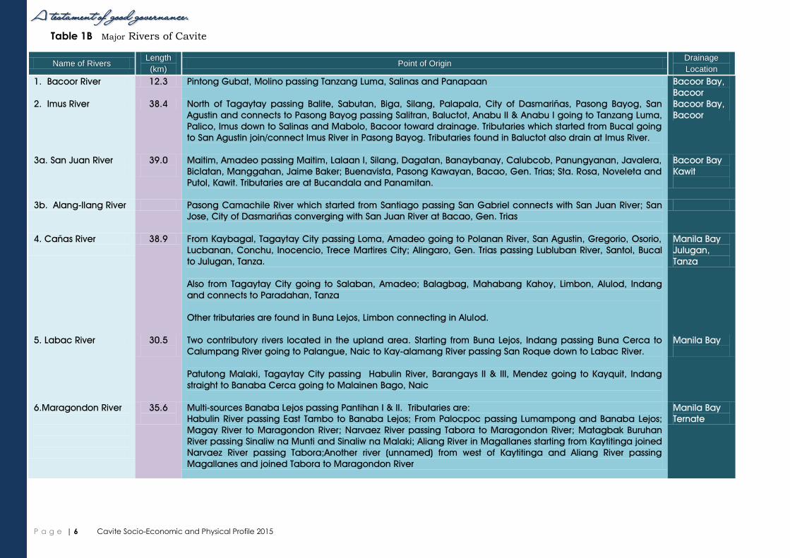
Major Rivers in Cavite The province is being traversed by six major rivers. These are the Maragondon River, Labac River,
Cañas River, San Juan River, Bacoor River and Imus River. These rivers are known to have various
tributaries passing through the different municipalities of the province.
Table 1A Number of Barangays by City/ Municipality
and Congressional District, Province of Cavite: 2015
City/Municipality Number of
Barangays
1st District
Cavite City 84
Kawit 23
Noveleta 16
Rosario 20
2nd
District City of Bacoor 73
3rd District
City of Imus 97
4th District
City of Dasmariñas 75
5th District
Carmona 14
Silang 64
Gen. M. Alvarez 27
6th District
Trece Martires City 13
Amadeo 26
City of Gen. Trias 33
Tanza 41
7th District
Tagaytay City 34
Alfonso 32
Gen. Emilio Aguinaldo 14
Indang 36
Magallanes 16
Maragondon 27
Mendez 24
Naic 30
Ternate 10
TOTAL 829
A testament of good governance.
Cavite Socio-Economic and Physical Profile 2015 P a g e | 5
The scenic Maragondon River, a great source of Cavite’s surface water.
Water source, especially in the upland areas are abundant due to numerous natural springs,
waterfalls and rivers. These have become beneficial among domestic, tourism, and industrial users.
These include Balite Spring (Amadeo), Saluysoy Spring (Alfonso), Matang Tubig Spring (Tagaytay
City), Malakas Spring (General Aguinaldo), and Ulo Spring (Mendez).
The province is also endowed with waterfalls such as Palsajingin Falls (Indang), Balite Falls


![8[WefS 8a^]^ad[SVS - General Trias, Cavite...AGV GRAND BALLROOM ANTEL GRAND VILLAGE, GEN, TRIAS DECEMBER 13, 2010 - 6PM LYCEUM OF THE PHILIPPINES CAVITE CAMPUS CHO NAM GW SONG JONG-EUN](https://static.documents.pub/doc/80x56/60072c2bccd28633f7356243/8wefs-8aadsvs-general-trias-cavite-agv-grand-ballroom-antel-grand-village.jpg)


