M. Maanan, M. Robin (eds.), Sediment Fluxes in Coastal Areas,Coastal Research Library 10, DOI 10.1007/978-94-017-9260-8_1
3
complex series of palaeoclimate changes in the loch since the Last Glacial Maxi-
mum including “Rapid Climate Changes” described in literature.
A characteristic acoustic reflector, identified into the holocene sedimentary
deposit, occurring into the different studied lochs, corresponds to a unique
Turritella layer. A similar reflector has been identified on the continental shelf of
South Brittany and is correlated to a Turritella layer. This Turritella layer seems to
be related, in both case, to a drastic environmental change beginning around the
8,200 year BP cold event and finishing abruptly at 7,500 year BP in the North
Atlantic.
1.1 Introduction
As the western Scottish sea lochs (Fig. 1.1) are located at an important junction
between the North Atlantic Ocean and the European waters of the North Sea, these
sites are adapted for observations on climatic variations at high latitudes, and in
particular variations in sedimentation that have resulted from climatic changes
since the Last Glacial Maximum (LGM) at high latitudes 56�N. Previous studies
Fig. 1.1 Location of the two studies areas in the north west coast of Scotland and in south
Brittany. The white square in Scotland, north of Oban, shows the location of two sea-lochs: Loch
Sunart and Loch Creran. A first geophysic survey (SUCRE, 2002), allowed to acquire seismic
profiles in both lochs and short cores in Creran. An oceanographic cruise with the Marion Dufresne
(ORSANE 2004) permit to acquire 2 long cores. The black square on the south coast of Brittany
shows the location of the “Grande vasiere”, a huge muddy sand patch occurring on the shelf, up to
100 m of water depth
4 A. Baltzer et al.
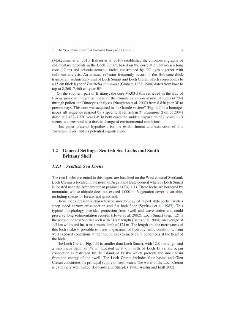
(Mokeddem et al. 2010; Baltzer et al. 2010) established the chronostratigraphy of
sedimentary deposits in the Loch Sunart, based on the correlation between a long
core (12 m) and seismic acoustic facies constrained by 14C ages together with
sediment analysis. An unusual reflector frequently occurs in the Holocene thick
transparent sedimentary unit of Loch Sunart and Loch Creran which corresponds to
a 15 cm thick layer of Turritella communis (Graham 1938, 1988) dated from base to
top at 8,260–7,460 cal year BP.
On the southern part of Brittany, the core VK03-58bis retrieved in the Bay of
Biscay gives an integrated image of the climate evolution at mid latitudes (45�N)through pollen and Dinocysts analyses (Naughton et al. 2007) from 8,850 year BP to
present days. This core was acquired in “la Grande vasiere” (Fig. 1.1) in a homoge-
neous silt sequence marked by a specific level rich in T. communis (Folliot 2004)dated at 8,482–7,520 year BP. In both cases the sudden disparition of T. communisseems to correspond to a drastic change of environmental conditions.
This paper presents hypothesis for the establishment and extinction of this
Turritella layer, and its potential signification.
1.2 General Settings: Scottish Sea Lochs and South
Brittany Shelf
1.2.1 Scottish Sea Lochs
The two Lochs presented in this paper, are localised on the West coast of Scotland.
Loch Creran is located in the north of Argyll and Bute council whereas Loch Sunart
is located near the Ardnamurchan peninsula (Fig. 1.1). These lochs are bordered by
mountains whose altitude does not exceed 1,000 m. Vegetation cover is variable,
including spaces of forests and grassland.
These lochs present a characteristic morphology of “fjord style lochs” with a
steep sided narrow cross section and flat loch floor (Syvitski et al. 1987). Thistypical morphology provides protection from swell and wave action and could
preserve long sedimentation records (Howe et al. 2002). Loch Sunart (Fig. 1.2) is
the second longest Scottish loch with 31 km length (Bates et al. 2004), an average of
1.5 km width and has a maximum depth of 124 m. The length and the narrowness of
this loch make it possible to meet a spectrum of hydrodynamic conditions, from
well exposed conditions at the mouth, to extremely calm conditions at the head of
the loch.
The Loch Creran (Fig. 1.3) is smaller than Loch Sunart, with 12.8 km length and
a maximum depth of 49 m. Located at 8 km north of Loch Etive, its ocean
connection is restricted by the Island of Eriska which protects the inner basin
from the energy of the swell. The Loch Creran includes four basins and Glen
Creran constitutes the principal supply of fresh water. The water of the Loch Creran
is extremely well mixed (Edwards and Sharples 1986; Austin and Inall 2002).
1 The “Turritella Layer”: A Potential Proxy of a Drastic. . . 5
1.2.2 South Brittany Shelf
The Bay of Biscay presents a 300 km wide continental shelf in it’s north-
westernmost area and becomes narrow with a steep slope further south (30 km
wide) (Fig. 1.1). This shelf is composed of two small and one large open-shelf mud
patches: the West and South Gironde shelf mud fields and the “Grande Vasiere”
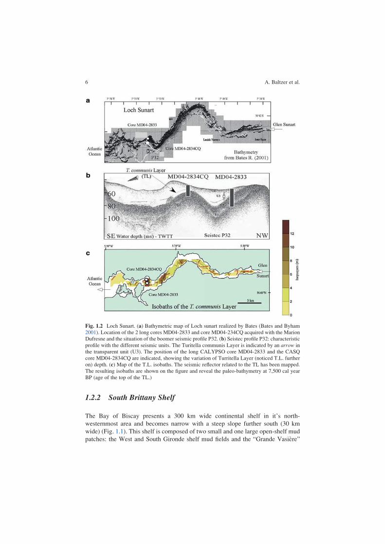
Fig. 1.2 Loch Sunart. (a) Bathymetric map of Loch sunart realized by Bates (Bates and Byham
2001). Location of the 2 long cores MD04-2833 and core MD04-234CQ acquired with the Marion
Dufresne and the situation of the boomer seismic profile P32. (b) Seistec profile P32: characteristic
profile with the different seismic units. The Turitella communis Layer is indicated by an arrow in
the transparent unit (U3). The position of the long CALYPSO core MD04-2833 and the CASQ
core MD04-2834CQ are indicated, showing the variation of Turritella Layer (noticed T.L. further
on) depth. (c) Map of the T.L. isobaths. The seismic reflector related to the TL has been mapped.
The resulting isobaths are shown on the figure and reveal the paleo-bathymetry at 7,500 cal year
BP (age of the top of the TL.)
6 A. Baltzer et al.
(Fig. 1.4) (Allen and Castaing 1977). According to McCave’s classification the
“Grande Vasiere” is a mid-shelf mud belt (McCave 1972). The “Grande Vasiere” is
large (more than 225 km length and 40 km wide), located between 80 and 110 m
water depth and presents an annual mean sedimentary rate of 0.1–0.2 cm year�1
(Lesueur et al. 2001) (Fig. 1.1). Shelf upkeep depends essentially on: (a) continental
supply by nepheloid layers (Jouanneau et al. 1999; Lesueur et al. 2001); (b) wave
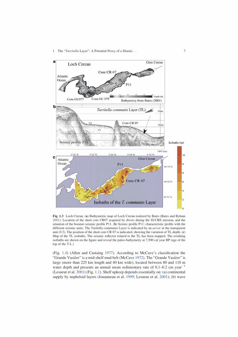
Fig. 1.3 Loch Creran. (a) Bathymetric map of Loch Creran realized by Bates (Bates and Byham
2001). Location of the short core CR07 acquired by divers during the SUCRE mission, and the
situation of the boomer seismic profile P11. (b) Seistec profile P11: characteristic profile with the
different seismic units. The Turitella communis Layer is indicated by an arrow in the transparent
unit (U3). The position of the short core CR 07 is indicated, showing the variation of TL depth. (c)
Map of the TL isobaths. The seismic reflector related to the TL has been mapped. The resulting
isobaths are shown on the figure and reveal the paleo-bathymetry at 7,500 cal year BP (age of the
top of the T.L.)
1 The “Turritella Layer”: A Potential Proxy of a Drastic. . . 7
action (Pinot 1974) and hydrology, and (c) sea level changes (Lesueur and
Klingebiel 1976). The “Grande Vasiere” rests over two sandy units and consists
of a thin (few decimetres) Holocene feature of muddy autochthon sand (Bourillet
et al. 2002, 2005).
1.3 Material and Methods
In this paragraph, we only present materiel and methods deployed for our studies in
Scottish lochs. The comparison with the work done by Naughton et al. (2007) on the
cores acquired on the Brittany shelf will be tackled in the discussion part.
1.3.1 Geophysical Surveys
A complete set of data was acquired in the Loch Sunart: two geophysical surveys
(bathymetric sidescan and a Seistec Boomer) where completed by the acquisition of
a Calypso long core of 12 m. A Seistec Boomer System (IKB Ltd) was used to
record sub-bottom profiles. It has a frequency range from 1 to 10 kHz, a pulse
duration ranging from 75 to 250 ms at a power of 150 J, allowing a spatial
resolution of 25 cm, with a penetration up to 100 m in soft sediments and 200 m
in deep water soft sediments (Simpkin and Davis 1993). Thirty four profiles,
recovering 60 km, were acquired in the loch with an average penetration of 50 m
except in some areas where gas occurrence prevented any signal penetration. The
Seistec sub-bottom profile 32 (Fig. 1.2b) shows a representative section of all five
seismic facies that are present in the inner basin.
1.3.2 Sediment Cores
The long core MD04-2833 (Fig. 1.2b) was acquired by the giant Calypso core
system on board the RV Marion Dufresne. This piston corer is similar to a gravity
corer but a piston is used to reduce internal friction in the barrel, enabling the corer
to recover complete and less disturbed sediment sequences than an open barrel
gravity corer. The MD04-2833 core was 12 m long and was acquired in the middle
loch to the west of Isle of Carna at a water depth of 38 m (Fig. 1.2). MD04-2834CQ
is a casq long core (11.80m) acquired close to the MD04-2833. The combined
pollen, foraminifera and sedimentological analysis help us to interpret many of the
features observed in seismic sections. The correlation of the seismic facies with the
sediments units (Mokeddem et al. 2007, 2010; Baltzer et al. 2010) allowed to followthe evolution of the sediment fluxes linked to environmental changes. In these both
cores, a specific layer of 15 cm thick, composed at 98 % of Turritella communisshells, occurs within the upper seismic section. Another short core CRE07, acquired
1 The “Turritella Layer”: A Potential Proxy of a Drastic. . . 9
in the Loch Creran, reveals a similar Turritella layer. Geochemical analyses have
been realised on this Turritella layer (noticed TL) to complete this study.
1.3.3 14C Ages
Core MD04-2833 was analysed for sedimentation and microfauna with seven 14C
ages acquired on different shell samples, all in life positions (see Table 1.1) and one14C ages for the core MD08-2334CQ. A standard reservoir correction R(t) of
400 years was used as the regional average value for western Britain (Harkness
1983) and calibrated calendar ages were obtained from the calibration tables in
Stuiver and Reimer (1993), Stuiver et al. (1998) by means of the CALIB 5.1.0b
software.
1.3.4 Foraminifera Analysis
A preliminary analysis of foraminiferal assemblages, based on dominant species of
87 samples taken from the core has been conducted. Approximately 20 g of
sediment samples were washed through 2 mm and 500 μm, 125 μm and 45 μmsieves. Residues were oven dried (40 �C) and dry sample weights recorded. The
125 μm and 45 μm fractions were observed under a binocular at 80� magnification
Table 1.1 14C ages acquired from core MD04-2833 (italic) and MD04-2834CQ (normal)
Material
Depth
(cm)
Laboratory
code
Radiocarbone
age (year BP)
Correctedb
(calibrated) age
(cal year BP)
� 2c (cal year
BP)
Turritellacommunis
81 aPoz-23471 1,405� 30 994 777–1,211
Wood
fragment
198 aPoz-23648 4,885� 35 5,623 5,584–5,663
Turritellacommunis
265 aPoz-1054 6,910� 40 7,414 7,325–7,503
Turritellacommunis
270 aPoz-23648 6,920� 35 7,459 7,411–7,507
Turritellacommunis
271 aPoz-23472 6,950� 40 7,468 7,389–7,548
Pectenspecies
385 aPoz-13368 8,710� 50 9,374 9,262–9,447
Pectenmaximus
776 aUL-2853 14,020� 210 16,760 16,067–17,454
Turritellacommunis
178 aPoz-23473 6,750� 40 7,320 7,212–7,407
aPoznan Radiocarbon Laboratory, �Laval University LaboratorybMarine reservoir correction: 405� 40 year (Harkness 1983)cStandard deviation (Stuiver et al. 1998)
10 A. Baltzer et al.
to determine the dominant species. A total of 300 specimens were counted. The
generic and specific identifications were based on taxonomic sources (Murray
1971; Loeblich and Tappan 1988; Murray 2000, 2003; Fontanier et al. 2002). Thepaleoenvironmental reconstitution is based on ecological and morphological groups
of benthic foraminifers (Goubert et al. 2001; Mokeddem et al. 2010). The ecolog-
ical significances of the species come from Murray (2006), Scourse (2002) and
Mokeddem et al. (2010).
1.3.5 Geochemical Analyses (Oxygen and Carbon IsotopeComposition) on Core MD2833
Mollusk gastropods are considered to precipitate their shells in isotopic equilibrium
with seawater (Grossman and Ku 1986; Latal et al. 2004). Particularly, turritelidshells are considered to be a reliable archive of paleoenvironmental and paleocli-
matic conditions (Andreasson and Schmitz 1996; Huyghe et al. 2012).Two aragonitic Turritella communis shells were used for oxygen and carbon
isotope composition. The first one was taken at 265 cm depth in the core MD04-
2833 (shell ID: 265), corresponding to the center of the Loch Sunart and the other
one was taken at 178 cm in the core MD04-2834CQ (shell ID: 178), corresponding
to the edge of the same Turritella layer. The two samples were dated at
7,414 cal year. BP.
Sampling for δ18O and δ 13C analyses was achieved each millimeter along the
transect of growth from the uppermost layer, by using a 0.5 mm drill bit. The
powdered CaCO3 samples were analysed according to standard techniques (Jones
and Quitmyer 1996) which involved an initial reaction in vacuo with 100 %
orthophosphoric acid at 90 �C for 15 min. An on-line automated carbonate-
preparation system facilitated the production and purification of evolved CO2 gas.
The isotopic differences between the derived CO2 gas and the VPDB standard were
determined with a VG Instruments Isoprime mass spectrometer. Isotopic data were
reported in conventional delta (δ) notation relative to the Vienna Pee Dee Belem-
nite (VPDB). The standard used for the analyses was an internal standard calibrated
on the NBS-19. Standard deviation for δ 18O and δ13C is �0.05‰.
1.4 Results
1.4.1 Seismic Data: Mapping of the “Turritella’s Reflector”
Sedimentary processes in this loch have been grouped into four units (Mokeddem
et al. 2007, 2010; Baltzer et al. 2010) from the Last Glacial Maximum (Fig. 1.5).
Unit 1 corresponds to a basal till sequence (numerous dropstones and gravels in a
clayey silty mud matrix). Effective deglaciation processes appear only after
1 The “Turritella Layer”: A Potential Proxy of a Drastic. . . 11
16,750 cal year BP. The more temperate Bolling period (15,730 cal year BP),
occurs at the end of this unit. Unit 2 presents fine acoustic layering of glaciomarine
origin which corresponds to a period including the Younger Dryas sedimentation,
when the ice cap re-advanced, stopped and retreat. A major unconformity surface
cuts across the top of this unit with up to 40 cm of vertical erosion, probably related
to the lowest position of the relative sea level (around 4 m) at these times. Unit 3 is
interpreted as a time of rapid and large volume sediment supply where significant
reworking was taking place, even under weak currents. The transparent facies of
this unit suggests an unconsolidated state of the sediments associated with rapid
sedimentation. A continuous and high amplitude reflector frequently occurs into
this transparent facies (Figs. 1.2b and 1.3b) which corresponds to a 15 cm thick
layer of Turritella shells dated from 7,468 to 7,414 cal year BP in the core MD04-
2833. This TL was sampled in the “sister core” MD04-2834CQ acquired on the
edge of the basin. The Unit 4, characterised by thin laminated beds of silty clay
reveals a low sediment supply in a quiet environment and corresponds to recent
sedimentation patterns with decreasing sediment supply.
The high amplitude of the “Turritella reflector” related to the TL, reveals a very
high impedance which is in accordance with a shelly layer included in a soft
deposit. The spatial extension of this reflector (Figs. 1.2 and 1.3) appears to follow
paleo-bathymetry in loch Sunart and Creran. Turritella communis (Risso 1826)
occurs locally and abundantly in gravelly muddy, more or less buried, in shallow
water sediments up to 200 m (Graham 1988). T. communis, who have a highly
specialized mud-burrowing habit, maintains contact with the water, from which the
gill filters suspended particles (Yonge 1946) but without disturbing the surrounding
mud. The actual distribution ranges from northern Norway (Lofoten Isles) to North
Africa, including the Mediterranean Sea (Graham 1938).
These observations mean that the TL exactly underlines the paleo-bottom floor
of the lochs.
1.4.2 Foraminifera Analyses
The Fig. 1.5 shows that the TL corresponds to abrupt variations of the different
foraminifera curves.
The cold species abundance, Hyalinea balthica and the extinction of Hyanesinagermanica, show a cooling event which began at 380 cm (8,200 cal year BP) and
finished at 240 cm (7,400 cal year BP). This event is short in time and underlines an
abrupt change of temperature. A net increase of Bulimina marginata and Becariiabundance traduces a complete environmental change with occurrence of confine-
ment conditions. Simultaneous extinction of Clavatum species confirms a very low
oxygen content. At 4,000 cal year BP climatic conditions improve with a net
increase of the temperature, illustrated by the development of the porcelaneous
species around the “climatic optimum”.
1 The “Turritella Layer”: A Potential Proxy of a Drastic. . . 13
The benthic foraminiferal assemblages show that the trophic equilibrium of the
environments is disrupted according to the large dominance of opportunistic and
infaunal species like Bulimina marginata and Ammonia spp.
1.4.3 Oxygen and Carbon Isotopic Compositionof T. communis Shells
The two shells exhibit equivalent mean oxygen isotope composition
(δ18O265¼ 2.28� 0.25‰ and mean δ18O178¼ 2.27� 0.25‰). The maximum
range is closely similar: 1.10‰ for the shell 265 and 1.03‰ for the shell 178.
Oxygen isotope values were converted into seawater temperatures using the
paleotemperature equation of Grossman and Ku (1986), for the temperature-
dependent fractionation of aragonite in mollusks relative to seawater: T (�C)¼21.8� 4.69 [shell δ18ΟVPDB� (seawater δ18ΟSMOW� 0.2‰)]. The measured oxy-
gen isotope composition of North-West Scottish coastal waters and sea lochs is
0.18‰ SMOW (Austin and Inall 2002). The mean estimated temperature is
11� 1.2 �C for shell 265 and 11.1� 1.2 �C for shell 178. The two profiles show
clear seasonal cycles, with a winter average of 8.8� 0.7 �C (shell 265) and
9.5� 0.7 �C (shell 178), and a summer average of 12.4� 0.7 �C and 12.8� 0.4 �C(for shell 265 and 178 respectively) (Fig. 1.6).
Fig. 1.6 High-resolution oxygen and carbon stable isotope profiles from Turritella communisshells, and δ18O-converted temperatures. On the left diagram, the shell was issued from the long
core MD04-2833, sampled in the T.L. and aged of 7,414 cal year BP. The diagram on the right
shows a shell sampled in the casq core MD04-2834CQ and aged of 7,320 cal year BP
14 A. Baltzer et al.
The mean carbon isotope values of the two shells are close similar
(δ13C265¼ 3.95� 0.15‰ and δ13C178¼ 3.82� 0.13‰). The shell δ13C profiles
are less variable than δ18O, with a range of 0.54‰ for shell 265 and 0.72‰ for
shell 178. These δ13C positive values are consistent with stable normal marine
conditions for the two shell locations, without significant freshwater or organic
inputs (Gillikin et al. 2006; Lartaud et al. 2010).Calculated seawater paleotemperatures by the 7,414 cal year BP turritellid shells
show data close to present day North-West Scottish seas (Austin et al. 2006). The
estimated seasonal gradient is very low (3.5 �C). This may be related to seasonal
thermal stratification of the water column, which conducts to significantly less
intra-annual bottom water temperature variation than mixed regions (Austin
et al. 2006). Scourse (2002) evaluated the timing of the onset of seasonal stratifi-
cation in the Central Celtic Sea at 8,720 cal year BP.
1.5 Comparison and Discussion
1.5.1 Comparison with the Turritella Layer of the “GrandeVasieres” in South Brittany
The chirp profile (Fig. 1.4) acquired during the Cotoul cruise (2001) shows an
acoustic reflector similar to the Turritella reflector within a thick transparent
acoustic facies. Three cores have been collected in the South-west of the Glenan
sector of the “La Grande Vasiere”, retrieved at 96.8 m of water depth (Bourrillet
et al. 2005), in south Brittany. This mud patch (47�360 N and 4�080 W) has been
sampled using a vibrocorer during the “Vibarmor” oceanographic cruise (integrated
in the “Defi Golfe de Gascogne”, an Ifremer program). The Glenan sector is one of
the end members of the “Grande Vasiere” and is composed of 3 m of sediments
with high percentages of fine material (greater than 80 %). Core description and
sedimentological analyses including micro-granulometry, calcimetry, x-ray
(SCOPIX image-processing; Migeon et al. 1999) and benthic gastropod Turritellacommunis counts were performed by Folliot (2004). Pollen and dynocists analyses
have been realised and complete this approach (Naughton et al. 2007).
Five accelerator mass spectrometer (AMS) 14C dates on T. communis were
obtained on the core VK03-58Bis, indicating that this core sedimentary
sequence covers the last 8850 years (Table 1.2). All AMS 14C dated levels were
calibrated using CALIB Rev 5.0 program and the global marine calibration dataset
(marine 04.14c) (Stuiver and Reimer 1993; Hughen et al. 2004; Stuiver et al. 2005).
This dataset uses the global marine age reservoir correction (R) of 400 years.
T. communis dated levels from twin cores, “VK03-58” (47�360 N, 4�080 W;
97.3 m water depth) and “VK03-59Bis” (47�380 N, 4�090 W; 94.6 m water
depth), were correlated with core “VK03-58Bis” for the age model construction
1 The “Turritella Layer”: A Potential Proxy of a Drastic. . . 15
Table
1.2
14Cages
acquired
from
core
VK03-58bis
Lab
code
Core-
depth
(cm)
Material
Conventional
AMS
14CageBP
Conv.AMS
14Cage
BP(�
400year)
error
WeightedMeanΔr
ArcachonFrance
95.4
%(2σ)
Cal
BPageranges
Cal
BPage
median
probability
POZ-
10166
VK03
58Bis106
T.commun
is3,820
3,420
30
33,667BP:3,865BP
3,763
POZ-
10167
VK03
58Bis149
T.commun
is7,020
6,620
30
37,427BP:7,576BP
7,507
POZ-
10168
VK03
58Bis160
T.commun
is8,030
7,630
30
38,391BP:8,576BP
8,479
POZ-
10170
VK03
58Bis177
T.commun
is8,170
7,770
30
38,532BP:8,808BP
8,652
POZ-
10171
VK03
58Bis226
T.commun
is8,240
7,840
30
38,613BP:8,938BP
8,764
16 A. Baltzer et al.
(Fig. 1.4c). As the ages have been obtained in the same laboratory (Poznan
laboratory), it should be relevant to compare the ages from these different cores.
The core “VK03-58Bis” is characterised by an homogenous silt sequence
marked between 210 and 150 cm by a level containing T. communis (Fig. 1.4).
Between 210 and 160 cm this T. communis community presents all the character-
istics of a biocenose: the shells are deposited in life position; both young and adult
specimens are present within the same level; they do not present any evidence of
shelf destruction by transport. Between 160 and 150 cm, there is an increase in
T. communis abundance, and in contrast with the underlying level they are not in
life position. This indicates a drastic change in the environmental conditions which
probably resulted in their mortality. This single drastic episode has also been
observed in the twin cores. Considering the shortness of this drastic T. communismortality episode Naughton et al. (2007) can assume that this event has been
synchronous in the three cores. T. communis death and the decrease of the
Lingulodinium machaerophorum dinocyst, between 8,480 and 8,390 cal year BP,
was most probably triggered by the opening of the English Channel.
1.5.2 Discussion
The stationary life is typical of ciliary feeders and T. communis is known to remain
stationary for very long periods and possibly indefinitely under natural conditions
(Riso 1826; Graham 1988), unless disturbed by external stresses. But they are able
to survive in environments with fluctuations of salinity and temperatures. Thus, the
establishment of T. communis populations indicates a very low sediment supply
because of their life mode.
The decrease of temperature combined to the lower salinity are parameters
characterizing the 8,200 cold event. The variations of these parameters could
explain the absence of other fauna species and they will permit the T. communisdevelopment. Thus the occurrence of the T.L. corresponds to a change in environ-
mental conditions (T� and S%) together with a stop or at least a slowing down of
sediment fluxes which will avoid the burial of shells.
On a second phase, the brutal disparition of the T. communis could be explainedby the lack of oxygen, as variations of the temperature and salinity are supported by
this species.
To explain a decrease of the oxygen, we could propose three scenarii:
– The arrival of a cold water mass coming from the Agassiz and Ojibway lakes
(supposed to initiate the 8,200 cold event) which implies stratification of the
waters and thus diminution of oxygen conditions.
– The opening of the Channel Pas de Calais, which would drastically change the
hydrodynamic and sedimentation conditions of the north west coast of France
– The increase of the sediment supply related to the rapid amelioration of the
climatic conditions
1 The “Turritella Layer”: A Potential Proxy of a Drastic. . . 17
The cold water temperatures could not only explain the disappearing of the
T. communis as they are not especially sensitive to temperature either salinity
variations. Another point is that chemical analyses do not show any variations of
the salinity or temperature within the months before they died as demonstrated by
the carbon and oxygen isotopic composition (Fig. 1.6).
The potential opening of the Channel proposed by Naughton et al. (2007),
whereas the actual scientific papers are not confident with an opening of the Pas
de Calais strait after 12,500 year BP (Cohen 2007), would probably change the
environmental conditions and the sediment fluxes in the south of Brittany but would
not reach the north western part of Scotland.
The rapid amelioration of the climate conditions after 7,800 cal year BP corre-
spond to the beginning of the temperate humid Atlantic period. Thus, the erosion
power of the fluvial systems is increased and allowed important sedimentation
ratios. The seismic profiles show in both cases a transparent facies usually related
to unconsolidated sediments linked to rapid sediment deposits. At this point, it is
difficult to distinguish the part of the sediment supply increase and the part of the
rapid rising sea level on the reduction of the oxygen content which cold explain the
abrupt mortality of the T. communis. Further studies will be needed to better
understand the role of the sediment fluxes on the TL existence.
The “Turritellids event” marks a great variation in biological, hydrological and
sedimentological conditions of proximal environments such as Lochs or continental
shelf of the Glenan islands.
1.6 Conclusions
This study establishes for the first time the relative importance of a Turritella layer
signification. This work shows that a specific T. communis Layer, dated from
8,300–7,400 cal year BP in sea lochs on the northwestern coast of Scotland and
on the south Brittany coast, marks an important change in environmental condi-
tions, confirmed by the foraminifera species assemblages. On a first step, the
establishment of this layer, exclusively composed of Turritella shells, illustrates
rapid deteriorations of T� and S% probably due to the 8,200 cold event. On a second
step, the brutal death of these T. communis populations at 7,500 cal year BP could
be related to a drastic lack of oxygen. These anoxic or semi-anoxic conditions
would be linked either to the stratification of water masses due to the rapid increase
of sea level rise or/and to the abrupt increase of sediment supply which would burry
the shells. Nevertheless, this layer materializes a global and rapid change in
environmental parameters like sediment fluxes and/or sea level variations,
depending on climate fluctuations. The global mapping of this Turritella Layer in
other north Atlantic coastal areas would help us to understand the complete
signification of this layer.
18 A. Baltzer et al.
Acknowledgements The writers are especially grateful to the Marion Dufresne Captain: Jean-
Marc Lefevre and the Chief operator Yvon Balut for the tenacity they show to obtain these
incredible cores. The authors would like to thanks the team, P. Bretel, Dr J. Fournier, F. Lelong,
E. Poizot and Dr J.M. Rousset, J. & J-C Rousset and Dr A. Stepanian, for their participation during
data acquisition.
References
Allen GP, Castaing P (1977) Carte de repartition des sediments superficiels sur le plateau
continental du Golfe de Gascogne. Bulletin de l’Institut de Geologie du Bassin d’Aquitaine.Talence, France, pp 255–260
Andreasson FP, Schmitz B (1996) Winter and summer temperatures of the early middle Eocene of
France from Turritella δ18O profiles. Geology 24(12):1067–1070
Austin WEN, Inall ME (2002) Deep water renewal in a Scottish fjord: temperature, salinity and
oxygen isotopes. Polar Res 21(2):251–258
Austin WEN, Cage AG, Scourse JD (2006) Mid-latitude shelf seas: a NWEuropean perspective on
the seasonal dynamics of temperature, salinity and oxygen isotopes. Holocene 16:937–947
Baltzer A, Bates R, Clet-Pellerin M, Mokeddem Z, Bonnot-Courtois C, Walter-Simonnet A-V
(2010) Combined pollen and acoustic seismic facies analyses: evaluating climatically-driven
changes in a Scottish sea loch (fjord) over the last 20,000 years. In: Howe JA, Austin WEN,
Forwick M, Paetzel M (eds) Fjord systems and archives, vol 344, Special Publications.
Geological Society, London, pp 357–371
Bates CR, Byham P (2001) Swath-sounding techniques for near shore surveying. Hydrogr J
100:13–18
Bates CR, Moore CG, Harries DB, Austin W, Lyndon AR (2004) Broad scale mapping of