SMP Handbook Chapter 10 Publication Number 11-06-010 2/12; rev. 8/14, 6/17 Chapter 10 Community Visioning Introduction Developing a community vision for the local shoreline is part of the public participation process for Shoreline Master Program (SMP) updates. The Shoreline Management Act (SMA) directs local governments and Ecology to “actively encourage participation” by all interested parties in the shoreline management planning process [RCW 90.58. 130]. Public participation should begin early in the SMP amendment process. During the early stages, participants should be encouraged to share what they value about shorelines and issues they would like the SMP to address. These early activities may include interviews, surveys, workshops or other techniques that will help to frame the inventory and characterization and SMP update process. (See SMP Handbook Chapter 6, “Public Participation”) Local governments that receive grant funds from Ecology for comprehensive SMP updates must also conduct a community visioning process and prepare a report that summarizes the community visioning activities and discusses community goals for the shoreline. (The SMP Guidelines do not require a separate community visioning process.) This task, Task 3.1 of the Shoreline Master Program Planning Process, is part of the public participation process and should be included in the public participation plan. This chapter discusses the purpose of community visioning and when it should occur, reviews techniques, offers tips for community visioning events, explains requirements for a community visioning report, and provides a link to shoreline visualization software. Community visioning experiences for several jurisdictions is provided, as well as two examples of survey forms used by local governments. Phase 3, Task 3.1 Shoreline Master Program Planning Process “Community visioning is a term to describe community ideals and dreams that get turned into manageable and realistic community goal statements” (Washington Department of Commerce).
Transcript
SMP Handbook Chapter 10
Publication Number 11-06-010 2/12; rev. 8/14, 6/17
Chapter 10 Community Visioning
Introduction Developing a community vision for the local shoreline is part of the public participation process for Shoreline Master Program (SMP) updates. The Shoreline Management Act (SMA) directs local governments and Ecology to “actively encourage participation” by all interested parties in the shoreline management planning process [RCW 90.58. 130].
Public participation should begin early in the SMP amendment process. During the early stages, participants should be encouraged to share what they value about shorelines and issues they would like the SMP to address. These early activities may include interviews, surveys, workshops or other techniques that will help to frame the inventory and characterization and SMP update process. (See SMP Handbook Chapter 6, “Public Participation”) Local governments that receive grant funds from Ecology for comprehensive SMP updates must also conduct a community visioning process and prepare a report that summarizes the community visioning activities and discusses community goals for the shoreline. (The SMP Guidelines do not require a separate community visioning process.) This task, Task 3.1 of the Shoreline Master Program Planning Process, is part of the public participation process and should be included in the public participation plan. This chapter discusses the purpose of community visioning and when it should occur, reviews techniques, offers tips for community visioning events, explains requirements for a community visioning report, and provides a link to shoreline visualization software. Community visioning experiences for several jurisdictions is provided, as well as two examples of survey forms used by local governments.
Phase 3, Task 3.1 Shoreline Master Program Planning Process
“Community visioning is a term to describe community ideals and dreams that get turned into manageable and realistic community goal statements” (Washington Department of Commerce).
2 Publication Number 11-06-010 2/12, rev. 8/14, 6/17
Overview of community visioning Community visioning should occur part way through the SMP process, at the beginning of Phase 3, and focus on the community’s goals and aspirations for the shoreline within the context of the SMA, the SMP Guidelines and local shoreline conditions. The Municipal Research and Services Center of Washington, a not-for-profit organization that provides research and support services to local governments, offers this view of community visioning:
A community vision document captures the "big picture" dreams, aspirations, and hopes of your community. Important community values shape this vision. A thoughtful "vision statement" can provide one of the elements needed to form a forward looking strategic framework that gives councils the “long-term-comprehensive” perspective necessary to make more rational and disciplined tactical/incremental decisions on community issues as they arise. (http://www.mrsc.org/subjects/governance/comvision.aspx, 12/2010)
Purpose The purposes of the community visioning task are:
• Gain an understanding of the common shorelines interests held by participants.
• Give the public an opportunity to review and understand the framework for the SMP update. This includes the shoreline conditions discussed in the Inventory and Characterization report, the statewide interests expressed by the SMA, and the requirements of the SMP Guidelines, including the standard to achieve no net loss of shoreline ecological conditions.
• Identify community goals and aspirations for local shorelines within this framework.
• Help to develop shoreline environment designation criteria, policies, uses and regulations.
A community visioning process provides an opportunity to enhance knowledge about shoreline conditions and shoreline management issues and brainstorm possible solutions. It may encourage public participation in the SMP amendment process. Residents and shoreline users may provide information about shoreline history and problems, such as flooding. It can also provide a chance to learn about shoreline processes and functions and projects that are underway or planned in the community. Timeline Community visioning should occur after the SMP shoreline inventory and characterization (Chapter 7, “Shoreline Inventory and Characterization”) is complete. A visioning process should be conducted in light of the local SMP shoreline inventory and characterization findings and
3 Publication Number 11-06-010 2/12, rev. 8/14, 6/17
recommendations so participants are knowledgeable about shoreline conditions, problems and opportunities. These findings, combined with information about the SMA and SMP Guidelines, also provide a factual framework for participants thinking about and discussing their shoreline’s future. This will help avoid situations where participants become committed to proposals that conflict with the SMA or SMP Guidelines or ignore existing shoreline conditions. Bringing visioning products to the SMP planning table at this stage in the process will:
• Enrich the SMP planning process. • Make sure all known relevant issues are addressed. • Help to achieve consistency among all local plans and regulations
Community visioning techniques Public participation is essential to the shoreline planning process and community visioning is one element of public participation. Local governments use community visioning for comprehensive, neighborhood, and sub-area planning as well as shoreline planning.
A community visioning process may include a variety of activities organized and facilitated by the local and state shoreline planners, consultants or facilitators, planning commission or citizen advisory group. The Department of Commerce publication, Shaping Washington’s Growth Management Future - Citizen Participation and Community Visioning Guide, suggests the following activities for community visioning activities. These can be tailored for the SMP update. Although this guidebook is no longer available online, its suggested activities are still relevant.
• “Going to the “Balcony” – Ask participants to use their imagination to “view” the community from the tallest building or a bluff overlooking the community. For shoreline purposes, ask people to “view” the shoreline area from an upland and water level viewpoint that they’re familiar with.
• Walking tours – Focus on what’s on the ground and opportunities for change. If boats can be arranged, schedule a boat tour, so people can see the shoreline from the water.
• Photo gallery – Develop an online or bulletin board display of photos submitted by residents and shoreline users. This can help trigger discussions of potential future uses, public access opportunities, and areas that need protection.
• Polls – Measure attitudes, behaviors and attributes with surveys, telephone or personal interviews and focus groups.
• Attitudinal surveys – Assess perceptions and get an understanding of community values by asking people to respond to a series of statements using a scale. For example, use a “agree or disagree” type scale.
• Surveys – use open-ended surveys to learn about people’s visions for the future.
SMP Handbook
4 Publication Number 11-06-010 2/12, rev. 8/14, 6/17
Small group visioning process – Ask small groups of 8-10 people to develop a vision for the future. Ask group members to write an answer to a question or idea related to shorelines. Ask members to share their ideas and write them on a flip chart. After discussion, ask the group to come up with a vision statement. Small group processes must be well-organized and facilitated. See the Guide for more details. The Municipal Research and Services Center of Washington has additional resources about community visioning on its website at http://www.mrsc.org/subjects/governance/comvision.aspx. Tips for community visioning Following are some tips for carrying out community visioning activities. See Chapter 6, “Public Participation,” Attachment 2, for a checklist of tasks for public participation activities. Who to invite Invite and engage as many interests as possible in community visioning. Include the general public; Indian tribes; local, state, and federal agencies with shoreline management responsibility; port districts; individuals with expertise; and local business, commercial, recreational, environmental and other interest groups. The visioning process is a good opportunity to involve port districts. Port master plans generally include areas within shoreline jurisdiction. They also may include areas that are outside, but adjacent to shoreline jurisdiction. The earlier you identify possible use conflicts or differences of opinion about shoreline issues, the better the chance to avoid inconsistencies between a port master plan and local SMP. Invite local, state, or federal agency staff with knowledge of shoreline conditions, and knowledgeable members of special interest groups or other experts to speak, facilitate small groups or otherwise participate in the visioning session. Give participants an opportunity to share their knowledge of local shorelines, including its history. Ask them to bring in maps or other documents for the group to review. Shoreline residents and users often will hear information about shoreline processes, functions and management issues better from respected members of the community than from staff. The visioning process provides an excellent opportunity for community education about connections within shoreline systems. For example, constructing a bulkhead may cause erosion of a neighboring property's beach or may interfere with beach processes. Or, planting vegetation may reduce erosion and improve water quality. Ask participants about their ideas and goals for local shorelines. Encourage creative thinking.
(WAC 173-26-201(2)(a): “The requirement to use scientific and technical information in these guidelines does not limit a local jurisdiction's authority to solicit and incorporate information, experience, and anecdotal evidence provided by interested parties as part of the master program amendment process. Such information should be solicited through the public participation process described in WAC 173-26-201 (3)(b). Where information collected by or provided to local governments conflicts or is inconsistent, the local government shall base master program provisions on a reasoned, objective evaluation of the relative merits of the conflicting data.”
5 Publication Number 11-06-010 2/12, rev. 8/14, 6/17
What to bring Provide visual materials and handouts that describe existing and historic shoreline conditions.
• Maps showing shoreline jurisdiction, critical areas, floodplains, city boundaries, road and other infrastructure, shoreline uses, historic sites and other relevant maps.
• Findings and recommendations from the inventory and characterization report. • Photographs of the historic and current shoreline that show changes over time and
identify locations of former wetlands, dumpsites, or shoreline uses. These can be useful for developing restoration plans.
• Drawings and diagrams of potential developments to help to identify future shoreline uses.
• Slide shows with photographs of the current shoreline to give participants a sense of place.
• Computer stations with GIS layers for the entire shoreline and down to the parcel level. Other materials that will be useful include:
• Copies of the SMA and SMP guidelines. • Local policy and regulatory documents, such as the comprehensive plan, critical areas
ordinance and flood hazard management plan, for example. • Other plans relevant to shoreline jurisdiction such as port master plans or tribal plans.
For boat or walking tours, it is cumbersome to bring along many materials. Small handheld maps can help people orient to the section of the shoreline they are viewing. Other tips Suggestions for conducting community visioning activities include:
• Clearly identify the objectives of the community visioning exercises with staff before the meeting and with participants.
• Establish ground rules for exercises and discussions for comfortable and safe discussion. • Develop a format or protocol for receiving information at public events, through the mail
or via Internet or email. Chapter 6, “Public Participation,” has basic information about managing public comments.
• Explain to participants how their input will be used in the SMP update process. • Distribute the results of visioning and other public participation activities right away so
people know they have been heard.
SMP Handbook
6 Publication Number 11-06-010 2/12, rev. 8/14, 6/17
Visioning report After the community visioning activities are complete, local government should prepare a community visioning report. This report should at minimum include:
• Community visioning activities. Include a short description of each activity, location, how many people participated and how participants engaged in each activity, and stakeholder groups represented. Include an agenda, copies of handouts and presentations and other materials
• A summary of the feedback received from participants. If the number of comments or returned surveys is small, the report may include all comments and survey results. However, that’s not necessary when including all the responses would make the report unwieldy. Blank versions of surveys and questionnaires and other materials used to gain feedback should be included.
• Goals for shoreline management based on the public input. Goals should be within the parameters of the SMA and the SMP Guidelines. Do participants want more public access and recreation on the shoreline? Do they want industry to expand? Have they suggested shoreline areas for protection or restoration?
The report should be used to help draft goals, policies, regulations, environment designations, and opportunities for resource protection, public access and restoration. For example, participants may focus on future use and restoration of an urban shoreline, or coordination of local, state and federal regulations to help restore water quality at a swimming beach closed because of contamination. Community visioning can help determine appropriate shoreline uses. During the community visioning process, participants may discuss other actions or recommendations, such as those listed below. These should be included in the community visioning report.
• Suggested changes to other local land use policies regulations that have an impact on the shoreline, e.g. the comprehensive plan, stormwater management plan, or flood hazard regulations. This will help achieve the mandate in RCW 90.58.340 requiring local plans and regulations for lands adjacent to the shoreline be consistent with the SMP.
• Policies to reduce incompatibility of different shoreline uses. • Public improvements that support shoreline use. • Public acquisition of critical areas, parks and open spaces or other ways to protect and
restore these resources, including areas outside shoreline jurisdiction. • Stormwater quality improvements. • Development of, or improvements to, waterfront recreation features.
SMP Handbook
7 Publication Number 11-06-010 2/12, rev. 8/14, 6/17
Visualizing shoreline alternatives Visual simulations can help planners, stakeholders and decision-makers understand the impacts of shoreline protection and development alternatives. Photographs or sketches alone don’t allow viewers to fully visualize a bay at build-out, with a house, boat house and dock on every shoreline lot; an urban waterfront with new high-rise buildings lining the shoreline; or a derelict lakeshore marina replaced with a public park and a thriving buffer planted with native vegetation. Seeing realistic representations of how each shoreline alternative will look “on the ground” not only stimulates community interest and participation in the SMP update process, but also helps your decision-makers make more informed decisions.
The National Oceanic and Atmospheric Administration (NOAA) Coastal Services Center provides an invaluable visual software tool called “CanVis” originally developed by the U.S. Department of Agriculture. Available free of charge via the Office for Coastal Management website (https://coast.noaa.gov/digitalcoast/tools/canvis). CanVis allows local governments to illustrate the visual effect of various shoreline protection, development and restoration scenarios using their own shoreline photographs. CanVis allows those with minimal computer skills to develop realistic simulations of shoreline changes. Object libraries with images of plants, agricultural features, people, wildlife, and park elements can be added to a base image. Color, contrast, and shadow can be adjusted. With advanced features that require additional computer skills, users can remove existing elements from photographs, add topographical features, and modify textures.
This example is from the Coastal Services Center website. The first photo shows a pond in Falmouth, Massachusetts. The CanVis visualization shows the visual outcome of proposed changes to dock and pier regulations. ( Images courtesy of Massachusetts Office of Coastal Zone Management.)
SMP Handbook
8 Publication Number 11-06-010 2/12, rev. 8/14, 6/17
Community visioning examples City of Kirkland The City of Kirkland’s visioning process consisted of two, two-day forums. During the first day, the City’s staff explained inventory and characterization findings and the SMP update process, and solicited input from participants. The second day was devoted to site visits to illustrate particular shoreline features or issues. The City’s goals for the workshops included:
• Advise participants why the SMP update was needed and about the issues to be addressed.
• Hear from the participants about their interests and concerns and what’s important regarding the waterfront.
• Identify common interests of the City and participants in protecting the waterfront. The forum agendas and summary of suggestions are available at http://www.kirklandwa.gov/Assets/Planning/Planning+PDFs/SMP+Forum+Summary.pdf. Douglas County and cities Douglas County and the cities of East Wenatchee, Rock Island and Bridgeport held four open houses (from 4 to 6 p.m.) and two workshops (6:30 to 8:30 p.m.) in different locations around the County. In addition, they conducted two “Listening Posts” at a regional mall where people were invited to look at a shoreline map and photograph display, pick up informational handouts and talk with county and city staff. Participants in these events provided input on a long-term vision for the County’s shorelines with respect to public physical and visual access (views); recreation and conservation opportunities; allowable uses for shorelands and shoreline waters; population growth projections; resource carrying capacity; residential, commercial and industrial uses; agriculture; special shoreline qualities; and effective planning, regulations and enforcement. Citizen’s Vision for Douglas County Shorelines 2006-2016 summarizes the comments received at the open houses and Listening Posts and vision developed at the workshops. Clallam County Clallam County used its community visioning process to focus on various geographic areas of the County and specific SMP topics. The report can be reviewed at: http://www.clallam.net/RealEstate/assets/applets/ClallamSMP_Vision_Report_Draft_6-27-11.pdf Focus group meetings were held in January 2011 and regional public forums in April 2011. Topics included the unique features of Clallam County shorelines that people value, what has been getting better, and what has been getting worse. Topics at the April forums included three
9 Publication Number 11-06-010 2/12, rev. 8/14, 6/17
issues of particular interest— marine shoreline development, flood plains, and emerging issues related to public access. Clallam County’s draft Vision Statement “reflects the shared history of local residents and their ideas and goals about how to accommodate change in the future.” (Clallam County Shorelines In Transition: A Vision Statement for the Clallam County Shoreline Master Program Update. ESA, June 27, 2011.) Clark County and cities The Clark County project management team developing a regional SMP update includes representatives of Clark County and the cities of Battleground, Camas, La Center, Ridgefield, Vancouver, Washougal and Yacolt. The project management team held three public visioning meetings in March 2010 as part of the public participation activities for the SMP update. The visioning meetings opened with a presentation on the SMP update steps, the public involvement process, and the shoreline inventory and characterization report. Participants then filled out one questionnaire for each of three maps on display. Questions addressed property ownership, type (fishing, walking, biking, boating, or viewing) and amount of shoreline use, what’s valued, vision for shoreline, and greatest concern for the shoreline.
Using the input from the community and the results of the inventory and characterization report, the project management team developed a shoreline management strategy. The strategy provides an overall approach for the following elements of the SMP update: economic development, public access and recreation, circulation, shoreline uses, conservation and restoration, cultural and historic, and flood damage prevention. For each element, the strategy outlines a general approach and suggests sample goals. The management strategy is included in the “Questionnaires and survey results” section of this chapter. Thurston County Thurston County hosted five public workshops around the County in April and May of 2008, and four more in March 2009. Their purpose was to gather information and hear opinions from County residents about revising the County SMP under the SMP Guidelines requirements.
County shoreline staff and the County's consultant gave presentations about the SMA and SMP Guidelines requirements. After the presentations, the meetings continued in a workshop format with about 6-8 people per table. The kick-off survey included questions about favorite shoreline areas, frequency of use, favorite shoreline activities, prioritized local shoreline "problems" and possible solutions, and aspirations for state, county, and local area shorelines and ideas on how to accomplish them.
The four meetings in March 2009 encouraged residents to share their views and concerns about how the eight elements listed in the SMA [RCW 90.58.100] should be addressed in the SMP. County residents were invited to help craft policies for these elements: economic development; public access; recreation; circulation; land uses; conservation; historic, cultural, scientific, and
10 Publication Number 11-06-010 2/12, rev. 8/14, 6/17
educational; and flood damage prevention. Participants were asked to help determine if and where appropriate shoreline locations may be available for these elements. Information gathered at these events is being used by the County and State shoreline planning staff, County Planning Commission, and elected officials to inform the SMP amendment process. Records of these meetings are available at the County website at http://www.co.thurston.wa.us/planning/shoreline/shoreline_status.htm City of Seattle The City of Seattle surveyed 400 Seattle to elicit opinions about shorelines. The results provide general information useful for determining where to create more public access, addressing water quality issues, and assessing shoreline development intensity. Surveyors asked adult heads of household what shorelines they visited, frequency of their shoreline visits, their activities at the shoreline, and challenges to the future of Seattle shorelines. Of those polled, 44 percent said they visited a Seattle shoreline once or more per week. The City also designed and facilitated seven community visioning workshops to engage residents in developing a holistic vision for Seattle shorelines and establish objectives for future policy work. City staff provided information about the SMP update and the shoreline inventory. Participants met in small groups and discussed issues and opportunities for the local shorelines as well as shorelines citywide. The Vision Report identifies a range of visions and views for the city as a whole, as well as each of six shoreline sub-regions (Elliott Bay, Duwamish River, Lake Union/Ship Canal, Lake Washington, Puget Sound, and Green Lake). The Vision Report results were considered during development of the draft Seattle SMP goals, policies and regulations. The report is available at http://www.seattle.gov/dpd/cs/groups/pan/@pan/documents/web_informational/dpds021416.pdf. Questionnaires and survey results
Following are community visioning questionnaires from the cities of North Bend and Shelton, the Clark County Coalition Shoreline Management Strategy, community questionnaire and open house results from Benton County, and community visioning survey results from Kitsap County.
11 Publication Number 11-06-010 2/12, rev. 8/14, 6/17
SMP Handbook
12 Publication Number 11-06-010 2/12, rev. 8/14, 6/17
SMP Handbook
13 Publication Number 11-06-010 2/12, rev. 8/14, 6/17
SMP Handbook
14 Publication Number 11-06-010 2/12, rev. 8/14, 6/17
SHORELINE MANAGEMENT STRATEGY
June 2010
City of Vancouver
Grant No. G1000058
Task 3.10 Conduct Community Visioning Process
Shoreline Management Strategy
June 2010 i
TABLE OF CONTENTS
Introduction ................................................................................................................................................... 1 Public Involvement ....................................................................................................................................... 1
Open House Meetings .............................................................................................................................. 1 Open House Questionnaire Results ...................................................................................................................... 1
Summary of Shoreline Inventory and Characterization Report Findings ..................................................... 4 Summary of Management Recommendations .............................................................................................. 9 Shoreline Management Strategy ................................................................................................................. 10
Economic Development Element ........................................................................................................... 10 Public Access/Recreation Element ......................................................................................................... 11 Shoreline Use Element ........................................................................................................................... 13 Conservation/Restoration Element ......................................................................................................... 14 Resource Protection ................................................................................................................................ 16
Battleground, Camas, Clark County, La Center, Ridgefield, Vancouver, Washougal, and Yacolt have joined efforts to update their respective Shoreline Management Programs (SMPs) to be consistent with the state Shoreline Management Act (SMA; RCW 90.58) and WAC 173-26. The SMP Update Project Management Team (PMT) consists of representatives from each of the participating jurisdictions. The City of Vancouver is administering a Department of Ecology (Ecology) grant provided for this countywide effort.
The purpose of this report is to set a strategy for development of the updated SMP by identifying overarching policy goals of the Act for shoreline uses, public access, resource protection, restoration, and economic development. It will synthesize the shoreline inventory and characterization findings and management recommendations with public input.
In order to achieve this primary objective, the PMT has provided opportunities for the community to share their vision on public access, habitat restoration and water-dependent uses. This report documents the community’s vision for the shorelines in Clark County by describing the results of two questionnaire forms distributed at public meetings. A summary of the shoreline inventory and characterization findings and management recommendations is also provided.
PUBLIC INVOLVEMENT
Open House Meetings
Open house meetings were hosted by the PMT to introduce the shoreline master program update to the general public. The meetings occurred in October 2009 and were held in Vancouver, Battleground and Camas. Notification for the meetings included mailing notices to 7,500 shoreline property owners and 1,400 interested parties. The open house meetings began with a presentation on the SMP update process and timeline for preparing Ecology grant deliverables. Approximately 150 people attended the meetings. (See Clark -County Coalition Public Participation Plan for detailed documentation of public communication.)
Open House Questionnaire Results
A questionnaire was distributed at each of the three open house meetings and was made available on-line (See Appendix A for questionnaire form.). A total of 41 questionnaires were filled out and submitted at the open house meetings or via post-office mail. The following is a list of questions with summarized results included immediately after:
1. Property where I live is subject to a Shoreline Master Program. Other property I own is subject to a Shoreline Master Program. The majority of respondents lived on property that was subject to a SMP. Almost half of the respondents (including “N/A” responses) did not own other property that is subject to a SMP.
2. I came to the open house because: The reason most people attended the open house was to learn about the SMP update process. Other reasons mentioned included finding out
Shoreline Management Strategy
2 June 2010
what regulations would be placed on private property, owning/living on property near a shoreline, and environmental concerns.
3. Water-dependent uses are those that require a waterfront location, such as a port, marina or boat ramp. What other uses do you consider to be dependent on a waterfront location? Two other uses frequently mentioned as dependent on a waterfront location are wildlife habitat and recreational activities (e.g., fishing, swimming, etc). Less than half of the respondents answered this question.
4. Are shorelines of the cities and the county being adequately protected? What do you think is the best way to protect shoreline resources? There was almost an even split between people considering the shorelines adequately protected and those that felt there was not adequate protection. Two suggestions for protecting shoreline resources were to enforce regulations and to develop additional restrictions.
5. Is there adequate public access to shorelines? What should the cities and the county do to maintain or increase public access to shorelines? The majority of respondents felt that there was adequate public access to shorelines. Some suggested approaches to providing and managing public access are: guaranteed access points, publishing maps of access points, providing parking at access points, and using volunteers to maintain access areas.
Visioning Meetings
The PMT hosted three visioning open house meetings to garner public input on shoreline management. The visioning meetings occurred in March 2010 and were held in Battle Ground, Camas, and Vancouver. Notification for the meetings included mailing notices to 7,730 shoreline property owners and 869 interested parties; posting information on the coalition jurisdictions’ websites and the shoreline project website; sending a press release to various media outlets including newspapers, radio stations, and TV stations; and placing an ad in the Columbian, Camas-Washougal Post Record, and the Battle Ground Reflector . The meetings were staffed by members of the PMT, technical and stakeholder advisory committee members, and the consultant team ESA Adolfson. The meetings began with a presentation that reviewed the following topics:
• Required steps to update shoreline master programs • Public involvement process that had occurred to date • Purpose of shoreline inventory and characterization report • Approach to characterizing the shorelines in the report • Data sources used to develop the report • Preliminary findings of shoreline conditions within the north, southeast and southwest
portions of the County
Shoreline Management Strategy
June 2010 3
After the presentations, the public was asked to share their vision for the shorelines by filling out a questionnaire and discussing their ideas with the technical and stakeholder advisory committee members. There were maps on display that showed the shorelines regulated by the Shoreline Management Act within various areas of the County. There was also a GIS Station that assisted residents in determining their home’s location relative to regulated shorelines. A Historic Station was made available to document memories of shorelines activities. Approximately 75 people attended the meetings.
Visioning Questionnaire Results
A questionnaire was distributed at each of the three visioning meetings. People in attendance were asked to fill out one questionnaire for each of the maps on display. The intent was to obtain answers to questions that would be directly related to the shorelines conveyed on each map. (See Appendix A for questionnaire form.). A total of 50 questionnaires were filled out. The following is a list of questions with summarized results included immediately after:
Shoreline Management Strategy
4 June 2010
1. Do you own property on this shoreline? About half of the respondents were property owners and the other half were not.
2. How do you use this shoreline (Viewing; Fishing; Walking/Hiking; Biking; Boating; Other)? How often do you use this shoreline for each of these activities? Please share some details about your use of this shoreline. The top two most popular activities along the shoreline are viewing and walking/hiking. Fishing and boating are the next most popular types of activities. Almost all answered by checking two or more activities. Other activities that occurred along the shoreline included birding, swimming, and picnicking. The frequency in which these activities occurred typically ranged between weekly and monthly visits.
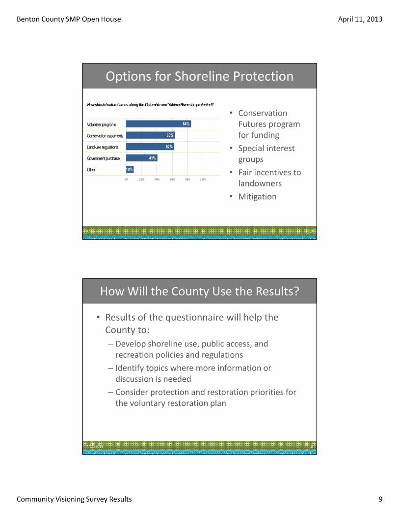
3. What do you value most about this area of the shoreline? (views, public access opportunities, water quality, wildlife habitat) People valued all four listed examples almost evenly with wildlife habitat and public access opportunities in the lead.
4. What is your vision for this area of shoreline? (i.e., more or less public access, restoration, water-enjoyment uses, residential, commercial, industrial development)? Please share some details. Most respondents were interested in seeing more public access and restoration although there were concerns expressed about unregulated public access.
5. What is your greatest concern, if any, about this area of shorelines and its future? The most common concern cited was the negative impact development could have on the environmental condition of the shorelines. Residential development was a specific type of development that was mentioned in several instances. Another major concern was a lack of public access. Additional concerns mentioned were enacting too many regulations, eroding shorelines, and incompatible recreational activities (wakeboard boats versus hand-powered boats).
SUMMARY OF SHORELINE INVENTORY AND CHARACTERIZATION REPORT FINDINGS
The Draft Shoreline Inventory and Characterization Report is a technical report that describes the existing conditions of shorelines in Clark County from a watershed scale to a reach scale, and includes a map folio. The draft report summarizes the ecosystem-wide processes and the land use and existing conditions at the reach scale.
Waterbodies meeting the definition of “shorelines of the state” or “shorelines of statewide significance” were identified in the inventory. A total of 59 waterbodies were identified, with 42 rivers and streams and 17 lakes, representing a total of nearly 370 miles of shoreline. These waterbodies were further divided into 96 reaches to allow for easier study.
The county is divided into two water resource inventory areas, or WRIAs: the Salmon-Washougal River (WRIA 28) and the Lewis River Watershed (WRIA 27).
Shoreline Management Strategy
June 2010 5
WRIA 28 covers 494 square miles that includes the southern portion of Clark County (Wade, 2001). Approximately 75 percent of WRIA 28 lies within Clark County. WRIA 28 does not include a single drainage system, but includes a collection of smaller drainages that are tributary either directly to the Columbia River or to Lake River. Major surface water resources include: Washougal River, Salmon Creek, Lacamas Creek, Burnt Bridge Creek, Lake River, and several smaller streams east of the Washougal that are directly tributary to the Columbia River.
WRIA 27 covers 1,310 square miles that includes the northern portion of Clark County. WRIA 27 is focused on the Lewis River drainage, tributary to the Columbia River near River Mile (RM) 87. Major surface water features include: North Fork (also referred to as the mainstem) Lewis River (including middle and upper reaches), East Fork Lewis River, and Kalama River. The East Fork Lewis River and the lower reach of the mainstem Lewis River are the primary features within Clark County.
Landforms within Clark County generally consist of stair-stepped terraces extending up from the Columbia River toward the Cascade foothills. Surface water is focused on the major rivers, including the Columbia, Lewis, and Washougal Rivers and their tributary streams. Groundwater resources include several aquifers that have sufficient yield to serve as the primary sources of supply to the larger water purveyors, industrial users, and others in Clark County (McFarland and Morgan, 1996).
Swanson et al. (1993) identified a system of eight hydrogeologic units that include significant aquifers in southwest Clark County. The units with greatest yields include the sand-and-gravel aquifer near the bottom of the Troutdale formation, upper, coarser elements of the Troutdale formation, the Troutdale gravel aquifer, and the upper unconsolidated sedimentary aquifer. The upper unconsolidated aquifer occurs in outburst flood deposits and can be very productive. This aquifer is an important source of water, and is also the most susceptible to contamination, given its relatively shallow depth and lack of upper confining layer (Wildrick et al., 2002). Primary critical aquifer recharge areas (Category 2) have been mapped for large portions of Clark County. Category 2 consists of the unconsolidated sedimentary aquifer and the Troutdale gravel aquifer.
The land forms, other landscape features, and the flow of water affect shorelines in each watershed. According to the Watershed Characterization and Analysis of Clark County (Washington State Department of Ecology, 2009) the eastern portion of WRIA 27 (Lewis River) has the greatest percentage of “high importance” areas for hydrologic processes within the study area. This is due to the frequency of rain on snow events in the upper watershed. The watersheds draining to the East Fork Lewis River have significant areas of importance due to highly permeable soils (Washington State Department of Ecology, 2009). The Characterization also identified the majority of WRIA 28 to be of high importance for maintaining hydrologic processes, due to the relatively high levels of precipitation (Washington State Department of Ecology 2009). Other important areas were on the upper terraces of WRIA 28 where surface water is slowed by wetlands. Along the Columbia River, several areas scored high for hydrologic processes due to large unconfined floodplains, permeable soils, and high levels of either groundwater discharge or recharge (Washington State Department of Ecology, 2009).
Shoreline Management Strategy
6 June 2010
A variety of characteristics were analyzed by waterbody for the shoreline characterization including: flood hazards, priority habitat and species use, instream and riparian habitats, water quality, existing and proposed land use patterns and zoning, existing public access, and historical and cultural resources. Several of these parameters are discussed below:
Water Quality & Quantity: Thirteen of 30 SMA waterbodies in WRIA 28 are listed on the Ecology 303(d) list for impaired water quality including the Lower Columbia River, Lake River, Burnt Bridge Creek, Salmon Creek, Vancouver Lake, Lacamas Creek and Lacamas Lake.
• The Lower Columbia River has Ecology listings for exceeding acceptable levels of fecal coliform bacteria, dissolved oxygen, and temperature. There are also listings for impaired sediment including PCBs and sediment bioassay.
• Lake River has Ecology listings for exceeding acceptable levels of fecal coliform bacteria and temperature, as well as impaired sediment including Dieldrin, 4-4’ DDE and 2,3,7,8, - TCDD.
• Burnt Bridge Creek has Ecology listings for exceeding acceptable levels of fecal coliform, pH, dissolved oxygen, and temperature.
• Salmon Creek has Ecology listings for exceeding acceptable levels of pH, dissolved oxygen, and temperature.
• Vancouver Lake has Ecology listings for exceeding acceptable levels of total phosphorous, fecal coliform bacteria, 4,4-DDE (in tissue), Toxaphene (in tissue), 2, 3, 7, 8-TCDD (in tissue), PCBs (in tissue), and dieldrin.
• Lacamas Creek has Ecology listings for exceeding acceptable levels of dissolved oxygen, fecal coliform, pH, and temperature.
• Lacamas Lake has Ecology listings for exceeding acceptable levels of total phosphorous, PCB, dissolved oxygen, fecal coliform, pH, and temperature (Ecology, 2008).
The Washougal River in the eastern portion of WRIA 28 is not listed as exceeding state water quality standards within Clark County; however, just upstream of the county line from RM 12-13 the river is listed as impaired for pH and fecal coliform.
Twelve of 29 waterbodies in WRIA 27 are listed on the Ecology 303(d) list for impaired water quality. The East Fork Lewis River in WRIA 27 has several reaches with Ecology listings for exceeding acceptable levels of fecal coliform bacteria and temperature.
Critical aquifer recharge areas are located throughout both WRIAs and water withdrawals are identified in many areas as contributing to low instream flow conditions and impairing water quality. Groundwater levels declined five feet or more throughout the western portion of WRIA 28, and larger declines have occurred in the unconfined and upper Troutdale gravel aquifers within the Burnt Bridge and Salmon Creek drainages (Wildrick et al., 2002). These reductions in groundwater levels signal that consumptive use of groundwater has exceeded the natural recharge of groundwater in these areas. The Troutdale aquifer system, which encompasses the majority of Clark County, is an EPA-designated sole source aquifer (EPA, 2006).
Priority Habitats and Fish Species: The Washington State Department of Fish and Wildlife Priority Habitats and Species List is a catalog of habitats and species considered to be priorities for conservation and management. Priority species include State Endangered, Threatened,
Shoreline Management Strategy
June 2010 7
Sensitive, and Candidate species; animal aggregations (e.g., heron colonies) considered vulnerable; and species of recreational, commercial, or tribal importance that are vulnerable. Priority habitats are habitat types or elements with unique or significant value to a diverse assemblage of species. A majority of priority habitat areas or priority species (based on overall area in acres) are located along the Lower Columbia River, Vancouver Lake, East Fork Lewis River, Lake Merwin, Yale Lake, Lacamas Creek, Lake River, and Salmon Creek. Anadromous fish concentrate in Cedar Creek, East Fork Lewis River, Salmon Creek and the Washougal watercourses.
Land Use: Land uses throughout WRIA 28 are mainly single-family residential and vacant lands, with some mobile homes and parks and open space/recreation. Commercial/industrial uses are concentrated in the port areas. Land uses throughout WRIA 27 are managed forest lands, single-family residential, and vacant lands. The remaining land uses mainly include mobile homes, and a variety of land uses including parks and open space/recreation. The following table summarizes major land uses in Clark County by WRIA.
Table 1. Major Land Use Categories in Clark County by WRIA
Fores t Lands Sing le-family Res iden tia l Vacan t Mobile Homes
WRIA 28 2% 30% 35% 11%
WRIA 27 28% 27% 30% 8% Note: The percentages do not add up to 100 since this table only represents major land uses.
The majority of impervious area in the county can be found in the Camas, Vancouver and Washougal areas. Other urban areas also have a prevalence of impervious surfaces, including Battle Ground, Ridgefield, La Center and Yacolt.
Water-dependent uses and market trends1
1 The evaluation of trends and future demand for shoreline uses is based on the technical report prepared by BST Associates (2010).
: An Assessment of Water-dependent Commercial, Industrial, and Recreational Uses for Clark County Coalition SMP Update Final Draft Report was prepared in May 2010 by BST Associates that evaluated commercial, industrial, and recreational waterfront uses in Clark County. BST Associates assessed supply and demand for marine terminals, boat/ship yards, and recreational boating facilities and upland support activities. According to the report, a variety of water-dependent uses are currently located on the Columbia River in Clark County or are being planned, including cargo terminals, industrial sites, marinas, private moorage, parks, and mixed use developments. According to BST Associates there may be a shortage of auto, drybulk (potash, clay, bentonite) and breakbulk (agriculture and forest products) cargo storage along the Lower Columbia (including Oregon jurisdiction) (BST Associates, 2010).
Shoreline Management Strategy
8 June 2010
The existing supply of marina moorage in Clark County is approximately 650 slips, spread between four marinas: McCuddy’s Marina in Ridgefield, Kadow’s Marina between Vancouver and Ridgefield, Steamboat Landing Marina in east Vancouver, and the Port of Camas-Washougal Marina. The BST forecast suggests that there will be demand for an additional 410 wet moorage slips by 2030, or approximately two-thirds more than currently exist (BST Associates, 2010). Hand-launch and boat ramp facilities are also in demand. Forecasting the demand for boat ramp space is difficult because usage data is not available. However, generalizations on the need for space can be based on the growth in boat ownership. BST forecasts an addition of more than 1,000 boats that fit in the trailerable boat size range (this includes all the boats in the 16 to 20-foot range and a portion of the boats in the under 16-foot and 21 to 30 foot ranges) (BST Associates, 2010).
Public Access: The Comprehensive Parks, Recreation, & Open Space (PROs) Plan (Vancouver Clark Parks and Recreation, 2007) establishes a vision for Vancouver and Clark County’s park system. The Plan identifies present and future needs for additional public facilities. The needs assessment examined six major park types: neighborhood parks, community parks, natural areas and open space, regional parks, trails and greenways, and special use areas. Based on the standards and guidelines recommended by the PROs Plan, there is a current deficiency of 20 acres of neighborhood parks, 139 acres of community parks, and 61 acres of urban open space within Vancouver and its UGA. There is a 1,684 acre-deficiency of regional parks within Clark County and Vancouver and its UGA. The PROs Plan does not specify standards for regional open space, trails and greenways, or special use area.
Trail expansion was identified as a priority during public involvement efforts conducted as part of the Plan’s development. Trails along rivers were identified as the most important trail type. Given the popularity of trail-related activities the Regional Trail and Bikeway Systems Plan (Vancouver-Clark Parks and Recreation, 2006) has proposed to make significant additions to the existing trail network. When the trail plan is realized, there will be 240 miles of trail within Clark County.
In addition to trail needs, the Comprehensive Parks, Recreation, & Open Space Plan recommends increasing boat launching facilities throughout the County. The Plan recommends that boat launch access points be distributed throughout the County along major waterways,
In addition to the park plans, the Clark County Legacy Lands Program was consulted to identify protected lands and proposed projects. The program focuses on lands that provide for habitat protection, scenic corridors, and low impact recreation.
Habitat Restoration: Riparian and instream habitat is generally degraded within the incorporated areas of the County from residential and industrial development and in some unincorporated areas from resource-based land uses. However, steps are being taken to restore these habitats for the benefit of fish and wildlife. Several entities are currently supporting restoration within Clark County. These include the following:
Shoreline Management Strategy
June 2010 9
• Lower Columbia Fish Recovery Board • Lower Columbia River Estuary Partnership • Lower Columbia Fish Enhancement Group • CREST • Clark Public Utilities • Vancouver-Clark County Parks • Columbia Land Trust • Fish First • Friends of the Ridgefield National Wildlife Refuge • Northwest Power and Conservation Council • Salmon Creek Watershed Council • Watersheds Stewards Program • Vancouver Lake Watershed Partnership Technical Group • Lower Columbia River Watershed Council • USFWS
Habitat restoration currently underway typically targets listed salmonid species and is designed to benefit fish habitat specifically.
SUMMARY OF MANAGEMENT RECOMMENDATIONS
Based upon the inventory and characterization report, several preliminary draft management recommendations have been developed for shorelines in Clark County and partnering cities. These are broad recommendations which will be considered in future management decisions for shorelines of the state including the development of shoreline environment designations, goals and policies, and shoreline regulations. Draft management recommendations provided in the inventory are identified as follows:
a) Rivers with high value for salmonid habitat and demonstrated use by multiple salmonid species (determined by EDT Modeling) should be considered for the highest levels of protection to remain in an unaltered condition(these include Tier 1 and 2 priority reaches) or should be targets for restoration;
b) Lakes that support high-value habitat or associated wetlands that are identified as Category I wetlands should be considered for the highest level of protection to remain in an unaltered condition;
c) Vegetation conservation measures, setbacks and buffer requirements should be continued and in some cases reconsidered for multiple types of new shoreline development including water dependent facilities such as boating facilities, water play areas, bank fishing, etc.;
d) Consider requirements for new development to provide an analysis of impacts to shoreline functions in order to adequately mitigate impacts during permit approval;
e) Water pollution should be prevented at its source. Continue efforts to retrofit existing stormwater management facilities to improve water quality and require low
Shoreline Management Strategy
10 June 2010
impact development strategies or higher levels of water quality improvement for new development within Clark County and partnering cities;
f) Continue encouraging joint-use docks prior to construction of single-use residential docks to minimize dock proliferation;
g) Consider regulations that encourage and facilitate levee setback projects (e.g., pulling back an existing levee to allow for a larger floodplain area contiguous to a waterbody) and other shoreline enhancement projects;
h) Consider establishing enforcement procedures for ensuring septic tanks and drain fields meet setbacks, maintenance and operation regulations to address fecal coliform bacteria levels exceeding water quality standards.
i) Develop master plans that include specific restoration and management practices for large public ownerships to maximize the potential benefits including mitigation for public projects that impact the shoreline environment;
j) Restoration efforts should consider a focus on floodplain reconnection where rivers are confined by levees;
k) Consider requirements for soft-shore armoring techniques where new armoring or retrofits cannot be avoided;
l) Participate in efforts to prevent the introduction of non-native invasive species and allow for their rapid eradication;
m) Consider building an implementation, monitoring and adaptive management plan at the County level in order to track changes in the shoreline jurisdiction and determine successes, failures and corrective actions; and
n) Regulatory language should be written in a manner that is easy to understand and provides options for compliance.
o) Consider the importance of confluence areas (areas where tributaries join the mainstem Columbia) for juvenile salmonid rearing when developing goals, policies, and regulations.
SHORELINE MANAGEMENT STRATEGY
Based on the results of the inventory and characterization report, and input received from the community, the following is the overall approach for addressing the required elements for the SMP Update: economic development; public access/recreation; circulation; shoreline uses, conservation/restoration, cultural/historic and flood damage prevention.
Economic Development Element
The approach to Economic Development will be to rely heavily on the Assessment of Water-dependent Commercial and Industrial Uses (BST Associates, 2010) report as a guide to determine areas that are appropriate for continued water-dependent economic development. Jurisdictional land use comprehensive plans and other economic development plans will also be consulted.
Shoreline Management Strategy
June 2010 11
The following are sample goals that could be considered to guide economic development: 1. Ensure healthy, orderly economic growth by allowing those economic activities which
will be an asset to the local economy resulting in the least possible adverse effect on the quality of the shoreline and downstream environments.
2. Protect current economic activity (e.g., shipping, marinas, agriculture, etc.) that is consistent with the objectives of this SMP.
3. Develop, as an economic asset, the recreation industry along shorelines in a manner that will enhance the public enjoyment of shorelines, consistent with protection of critical areas and cultural resources.
4. Ensure that any new industrial and commercial activities along the shoreline are water oriented uses and that they will not harm the quality of the site’s environment or adjacent shorelands.
5. Encourage new shoreline industrial and commercial development which is water-dependent, water-related, or water-enjoyment, consistent with protecting the functions of critical areas and maintaining or improving water quality.
6. Recognize existing non-water-oriented commercial and industrial activities located in shoreline jurisdiction and encourage them to protect watershed processes and shorelines functions.
7. Consider the impact of uses proposed on lands adjacent to but outside of immediate SMA jurisdiction and whether they are consistent with the intent of this SMP.
Public Access/Recreation Element
Public access to the shoreline is one of the three main goals described in the Shoreline Management Act (SMA). The State requires local governments to provide opportunities for shoreline recreational development (WAC 173-26-241(3)(i)) and to increase public access to publicly owned shoreline areas within Shorelines of Statewide Significance (RCW 90.58.020, WAC 173-26-191(1)(b))1.
The approach for public access will be to identify gaps in public access opportunities by reviewing public access facilities proposed in City and County Capital Improvement Programs (CIPs) and parks, recreation, and open space plans, incorporating recommendations from the shoreline inventory and characterization report and the general public. If it is determined that large gaps in public access facilities exist, then a comprehensive assessment of access opportunities may need to be developed.
The Assessment of Water-dependent Commercial and Industrial Uses (BST Associates, 2010) report provides a long-term forecast for recreational boats and facilities, including demand for boats, wet moorage, boat ramps, and guest moorage. As shoreline environment designations, policies and regulations are developed, the report will be consulted to ensure an appropriate amount of opportunities are provided for installation of recreational facilities and that shoreline regulations provide a reasonable means for jurisdictions to provide public recreation and access
Shoreline Management Strategy
12 June 2010
in the shorelines within Clark County. Other reports will be consulted (e.g., PROs plans) that have identified needs for additional or expansion of existing facilities to determine public access needs.
The following are sample goals that could be considered to guide the approach to public access:
1. Provide, protect, and enhance a public access system that is both physical and visual, utilizes both private and public lands, increases the amount and diversity of public access to the State's shorelines and adjacent areas, consistent with the shoreline character and functions, private rights, and public safety.
2. Encourage development within the shoreline area that is visually coherent, provides visual and physical linkage to the shoreline, and enhances the waterfront and associated riparian corridors.
3. Long-range planning for the shoreline should include the development of integrated trail systems throughout the county which connect to trail systems in the metropolitan area.
4. Increase and diversify recreational opportunities by promoting the continued public acquisition of appropriate shoreline areas, and influence the use of these sites in a manner which will preserve the natural characteristics and functions of the shoreline. This approach should be balanced with providing infrastructure necessary to support a suitable number and type of facilities. Facilities should provide a balanced diversity of recreational opportunities.
5. Integrate recreational elements into public access and conservation planning consistent with the natural characteristics of the shoreline and good stewardship practices.
6. Encourage federal, state, and local government to acquire additional shoreline properties for public recreational uses.
7. Discourage shoreline uses which curtail or reduce existing free movement of the public unless such restriction is in the interest of the environment, public health, and safety, or is necessary to a proposed beneficial use.
8. Where feasible, relocate existing transportation facilities, such as rail lines or freeways, that are disruptive to public shoreline access or other shoreline uses or convert such rights-of-way to new public access routes.
9. When new transportation facilities are developed in shorelines, acquire and develop physical and visual public access where topography, view, and natural features warrant.
10. Acquire and develop recreation facilities so that they are distributed throughout the community to foster convenient access, and are located in a manner that encourages variety, accessibility and connectivity, and promotes systematic use of appropriate shorelines and waterways.
Shoreline Management Strategy
June 2010 13
Shoreline Use Element
Applying shoreline environment designations to shorelines of the state will set the framework for approaching shoreline uses. Designations will be applied based on existing ecological functions and processes, existing and proposed land uses, and the visioning process. Once the designations have been proposed, a list of allowed and prohibited uses will be developed for each designation. The uses will be consistent with the purpose statement and policies of each designation.
The following are sample goals that could be considered to guide the approach to shoreline use:
1. Uses in shorelines and water areas in priority order are (1) water-dependent, (2) water-related and (3) water-enjoyment.
2. Establish and implement policies and regulations for land use consistent with the Shoreline Management Act. These policies and regulations should ensure that the resulting land use patterns in shoreline areas are compatible with the shoreline environment designation and will be sensitive to and compatible with ecological systems and other shoreline resources.
3. Identify and reserve shoreline and water areas with unique attributes for specific long term uses such as commercial, residential, industrial, water, wildlife, fisheries, recreational and open space.
4. Ensure that uses, activities and facilities are located on the shorelines in such a manner as to retain or improve the quality of the environment as it is designated for that area.
5. Ensure that proposed shoreline uses do not infringe upon the rights of others or upon the rights of private ownership.
6. Encourage shoreline uses which enhance their specific areas or employ innovative features for purposes consistent with this program.
7. Encourage shared uses and joint use facilities in shoreline developments.
8. Encourage master planning for projects within shoreline jurisdiction.
9. Preserve and/or restore, to the maximum reasonable extent, the shoreline's natural features and functions in conjunction with any redevelopment or revitalization project.
10. Encourage that any under-utilized area not suitable for preservation of natural features be redeveloped based on its shoreline environment designation with an emphasis on public access and public use.
11. Ensure that all redevelopment and revitalization projects satisfy all the goals of the Shoreline Management Master Program.
12. Provide safe, reasonable, and adequate circulation systems to shorelines where routes will have the least possible adverse effect on unique or fragile shoreline features and existing
Shoreline Management Strategy
14 June 2010
ecological systems, while contributing to the functional and visual enhancement of the shoreline.
13. Protect, manage, and enhance those characteristics of shoreline roadway corridors that are unique or have historic significance or aesthetic quality for the benefit and enjoyment of the public.
14. Acquire historical/cultural sites, so as to insure their protection and preservation.
15. Encourage projects and programs that foster a greater appreciation of shoreline management, local history, maritime activities, environmental conservation, and maritime history.
16. Designated shorelines of state-wide significance (SSWS) are of value to the entire state and should be protected and managed in order of preference, the priorities are to:
a. Recognize and protect the state-wide interest over local interest;
b. Preserve the natural character of the shoreline;
c. Result in long-term over short-term benefit;
d. Protect the resources and ecology of shorelines;
e. Increase public access to publicly owned areas of the shorelines;
f. Increase recreational opportunities for the public in the shoreline;
g. Provide for any other element as defined in RCW 90.58. I 00 deemed appropriate or necessary.
Conservation/Restoration Element
The Ecology Watershed Characterization method (Stanley et. al., 2005) will be applied to sub-basins in Clark County to determine relative restoration potential and priority. The Ecology Watershed Characterization for Clark County (Washington Department of Ecology, 2009) will be consulted as part of this process. Each sub-basin will be rated in terms of its level of importance (High, Medium, and Low) in performing freshwater water flow processes and the extent to which each watershed is altered. The “importance rating” will then be compared to the “alteration rating” so that each watershed could be assigned to a category based on its relative suitability for restoration, protection, or development. This method will rank sub-basins based on restoration and preservation priorities. The rankings will then be compared with comprehensive plan and zoning designations to identify inconsistencies with planned land use types and land use intensities. The rankings will also be used to inform the process of identifying appropriate shoreline environment designations and goals and policies.
Shoreline Management Strategy
June 2010 15
The following are sample goals that could be considered to guide the approach to conservation/restoration:
1. Ensure that impacts to critical areas are first avoided, and where unavoidable, minimized and mitigated to result in no net loss of watershed processes and shorelines functions.
2. Reclaim and restore areas which are biologically and aesthetically degraded to the greatest extent feasible while maintaining appropriate use of the shoreline.
3. Preserve and enhance the scenic aesthetic quality of shoreline areas and vistas to the greatest extent feasible.
4. Identify, protect, preserve, and restore important archaeological, historic, and cultural sites located in shorelands of the State for educational, scientific, and enjoyment of the general public.
5. Encourage cooperative restoration actions involving local, state, and federal public agencies, tribes, NGOs, and landowners.
6. Continue to survey and monitor invasive species, including noxious weeds and nonnative invertebrates (e.g., nutria), and initiate eradication programs as needed.
7. Educate property owners about proper vegetation/landscape maintenance and negative impacts of shore armoring and over-water structures. Educate boaters about proper waste disposal methods, anchoring techniques, and other best boating practices.
8. Restore ecosystem processes so that restoration strategies are sustainable and successful in the long-term.
9. Restoration projects should have adaptive management techniques including adjusting the project design, correcting the problems (barriers to success), and implementing contingency measures.
10. Establish regulatory and incentive programs for the protection and conservation of wildlife habitat areas. Emphasis should be given to policies and standards to protect and conserve critical areas as larger blocks, corridors or interconnected areas rather than in isolated parcels.
Shoreline Management Strategy
16 June 2010
Resource Protection
The approach to protecting resources such as fisheries, mining, forestry, and agriculture would be to gather additional information that addresses the following questions:
1. Where are the resources concentrated in Clark County?
2. Is there demand for expanding resources (e.g., new agricultural fields)? If so, is there land that is appropriate for that resource-use? What type of protections should be instituted to reserve such land for resource-based businesses?
3. Is there development pressure to convert resources to other land uses (e.g., development pressure to subdivide agricultural land to single-family lots)? Are there other types of land uses that surround the resources?
4. Are there existing County or City codes and programs that provide protection for resources?
5. What protection measures should SMPs include that ensure continuation of resources? Potential protective measures that could be instituted include:
a. Creating a unique environment designation system for resources. Policies, allowed uses, and regulations could then be designed to protect resources.
b. Developing programs that provide assistance to resource-based businesses.
6. How can the SMP reduce conflicts between protecting the environment and allowing resources?
Comprehensive plans, sub-area plans, and resource protection programs will be consulted to identify goals and policies that pertain to resource protection. For example, the Clark County Comprehensive Plan 2004-2024 has a Rural and Natural Resource Element that establishes how future land use needs within rural and resource lands will be met (Clark County, 2009).
The following are sample goals that could be considered to guide the approach to conservation/restoration:
1. Develop and implement management practices for natural resources (including agriculture, timber and mining) in shoreline areas that will assure the preservation of non-renewable resources, including unique, scenic and ecologically sensitive features, wetlands and wildlife habitat.
2. Ensure that impacts to critical areas are first avoided, and where unavoidable, minimized and mitigated to result in no net loss of watershed processes and shorelines functions.
3. Preserve and enhance the scenic aesthetic quality of shoreline areas and vistas to the greatest extent feasible.
.
Shoreline Management Strategy
June 2010 17
REFERENCES
BST Associates. 2010. Clark County SMP. Assessment of Water-dependent Commercial and Industrial Uses. Final Draft Report. Prepared for Clark County. February 12, 2010.
City of Camas. 1998. Camas Shoreline Master Program for City of Camas. Adopted December 14, 1998. Amended on October 1, 2009 (Ordinances 2544 and 2551).
City of Vancouver. 2007b. City of Vancouver Shoreline Management Master Program. Effective April 9, 2007.
Clark County. 1974. Shoreline Management Master Program. Prepared by the Clark County Citizen Advisory Committee for Shoreline Management in cooperation with the Regional Planning Council of Clark County. August 1974.
Clark County. 2009. 20-Year Comprehensive Growth Management Plan. 2004-2024. Adopted September 2007. Amended in January 2009, Ordinance 2008-12-15.
Johnson, Ralph W., Craighton Goepple, David Jansen and Rachael Paschal. 1991. The public trust doctrine and coastal zone management in Washington State. Washington Department of Ecology, Olympia.
Regional Planning Council of Clark County. 1974. City of Washougal Shoreline Management Master Program. Prepared by the Washougal Citizens Advisory Committee for Shoreline Management in cooperation with the Regional Planning Council of Clark County.
Stanley, S., J. Brown, and S. Grigsby. 2005. Protecting Aquatic Ecosystems: A Guide for Puget Sound Planners to Understand Watershed Processes. Washington State Department of Ecology. Publication #05-06-027. Olympia, Washington.
Swanson, R.D., W.D. McFarland, J.B. Gonthier, and J.M. Wilkinson. 1993. A description of hydrogeologic units in the Portland Basin, Oregon and Washington. US Geological Survey Water-Resources Investigations Report 90-4196. Portland, Oregon.
United State Environmental Protection Agency (EPA). 2006. Final Support Document for Sole Source Aquifer Designation of the Troutdale Aquifer System. July 2006.
Vancouver Clarks Parks and Recreation. 2006. Regional Trail and Bikeway Systems Plan. Resolution adopted by the Clark County Board of County Commissioners on April 6, 2006.
Vancouver Clarks Parks and Recreation. 2007. Comprehensive Parks, Recreation, & Open Space Plan. Prepared by MIG, Inc. Revised November 2009.
Washington State Department of Ecology. 2008. Washington State’s Water Quality Assessment [303(d)]. Available at: http://apps.ecy.wa.gov/wats08/.
Washington State Department of Ecology. 2009. Watershed Characterization and Analysis of Clark County (Ecology Publication # 09-06-019). Olympia, WA.
Wildrick, L., T. Culhane, D. Davidson, and K. Sinclair. 2002. Watershed Assessment Water Resource Inventory Area 28, Salmon-Washougal. Ecology Open-File Technical Report 98-02. Southwest Regional Office.
May 2, 2013 1
BENTON COUNTY SMP UPDATE OPEN HOUSE EVENTS
Community Questionnaire & Open House Meeting Summary, April 11, 2013
Prepared by BERK and The Watershed Company, May 2 2013
To help Benton County consider the long-term vision for its Yakima and Columbia River shorelines and its Shoreline Master Program (SMP) Update, Benton County issued a web-based Community Questionnaire on Survey Monkey mid-March 2013. The questionnaire asked questions about:
Current shoreline use
Desired future use
Physical and Visual Access
Preservation and restoration options and tools
The results of the survey are attached.
Benton County advertised the questionnaire in a display ad in the Tri-City Herald, a postcard to a mailing list of shoreline property owners, and an email flier to persons interested in planning and the SMP in Benton County. After approximately 3 weeks, the County closed the questionnaire on March 31, 2013. The County received 132 responses. Benton County hosted an open house to share the results of the Community Questionnaire on April 11, 2013. Fifteen members of the public attended, as well as two Shoreline Advisory Committee members. This document summarizes the comments made at the Open House.
GENERAL QUESTIONS Questions regarding the 200-foot Shoreline Jurisdiction:
Is that more than it was previously?
How are we going to measure it? Historically the “height of the tree” is what determined the 200ft.
200ft is not a setback, correct?
What is the setback now? 100ft?
o Response: The shoreline jurisdiction is generally 200 feet from the ordinary high water mark,
and has not changed since development of the County’s 1974 SMP. Shoreline jurisdiction refers
to the applicable area of the SMP (management area). Through the SMP update, setbacks or
buffers would be developed based on current, existing conditions. We will also consider Benton
County’s critical areas regulations. The current critical area code setback is generally 100 feet,
except along certain steep slopes.
COMMUNITY QUESTIONNAIRE & OPEN HOUSE MEETING SUMMARY
May 2, 2013 2
FEEDBACK FOLLOWING REVEAL OF SURVEY RESULTS:
Comments & Questions
Comment: “If you are saying the river shoreline is our identity, then first impressions matter. How
do the dilapidated trailers and other garbage along the rivers reflect us? We need just enforcement
of junked cars that are on properties along the river.”
Public Access
“Who will provide public access? Will private landowners be required to provide access on their
land?”
“Sounds like you are allowing public access on private lands.”
“What are private land owners obligated to do?”
o Response: The goal and preferences of the SAC members are to provide public access on public
lands. Public access on public lands is a priority in the Shoreline Management Act as well. Please
note the State Department of Ecology rules for SMP’s (WAC 173-26) also indicate that new
development that creates a demand for public access should provide for public access, such as
new subdivisions providing a trail to the shoreline. Public access is not required for existing
homes or existing businesses.
“Do you have enough ‘public property’ to create trails?”
“It is a balancing act of use versus impact”
“Ad hoc public access is a community and environmental problem; the County should purchase land
to create designated public access new Twin Bridges”
“We might all want public access but are we willing to pay for it? i.e. property taxes increased?”
Restoration
“What is the Restoration Plan? What does it do?
o Response:
It is separate from the regulations
It is completely voluntary
It brings all the restoration efforts happening in the County into one document
“Can you give us an example of restoration?”
“Will the plan tell us what species to plant?”
o Response: The County’s website already has some information on this topic.
“What are the local ‘noxious’ weeds?”
“What do you do if you see a safety issue or pollution problem?” (Scott Revell gave
examples of places to call that are referenced on the KID website)
“No net ecological loss”
“Who decides if there is no net loss?”
COMMUNITY QUESTIONNAIRE & OPEN HOUSE MEETING SUMMARY
May 2, 2013 3
o Response: The SMP regulations will be designed on a County-wide scale to result in no net loss
of ecological function, and we’ll be required to “show our work” to the Washington Department
of Ecology in a Cumulative Impacts Analysis.
“An EIS costs thousands of dollars; I don’t think individual property owners should have to pay for
that.”
o Response: We’re looking to limit the personal/private obligations for studies. One exception
would be for “conditional use” applications.
“Who will enforce this?”
o Response: The County will enforce the SMP. Every 8 years, the County will evaluate the
effectiveness of the policies of the SMP and revise the SMP as needed.
Program Intent and Policy Direction
“Has there been a change in direction?”
“What are the changes between the 1974 plan and now?”
o Response:
River flows have been altered and improved.
There are more homes.
In the Shoreline Management Act and Washington State Department of Ecology SMP
Guidelines (WAC 173-26), there is an increased focus on habitat protection and restoration,
more emphasis on biological health.
The listing of some species of salmon on the Endangered Species Act has increased
regulatory complexity.
There is more attention and regulation on shoreline stabilization.
Setbacks
“What is the 100 foot setback?”
o Response: The 100-foot setback is a standard in the Benton County critical areas code. The
setback requirement will be reconsidered as part of this process. Through the SMP update,
setbacks or buffers would be developed based on current, existing conditions. We will also
consider Benton County’s critical areas regulations.
Benton County SMP Open House April 11, 2013
Community Visioning Survey Results 1
Benton County
Shoreline Master Program Update
Community Visioning Survey Summary
April 11, 2013
14/11/2013
Shoreline Master Program
Characterize
& Inventory
Shoreline
Shoreline
Master
Program
Goals, policies
& regulations
Cumulative
Impacts
Analysis
Restoration Plan
Determine
JurisdictionLocal
Adoption
We are here
Analysis
Report
Public Participation
Ecology Review and Approval
24/11/2013
Benton County SMP Open House April 11, 2013
Community Visioning Survey Results 2
• Minimum Shoreline
Jurisdiction
– Stream ≥ 20 cfs
– Upland areas 200 feet from
ordinary high water mark
– Floodways and 200 feet of
adjacent floodplain area
– Associated wetlands
• NEW Uses
– Existing shoreline uses and
activities may continue
Where does the SMP apply?
34/11/2013
Why a vision for the shoreline?
• Build a local consensus for the desired future
• Ensure the SMP reflects the long-term desires
of the rural community
• Survey Topics:
– Current shoreline use
– Desired future use
– Physical and Visual Access
– Preservation and restoration options and tools
44/11/2013
Benton County SMP Open House April 11, 2013
Community Visioning Survey Results 3
132 people responded to the survey.
Who responded?
About half of responders
own property along the
County’s rivers
Responses came from
across the County, with
Richland/West Richland
Area most represented
Of those who do
own property,
more own land
along the Yakima
River
45%
18%
16%
8%
2%
10%
0% 10% 20% 30% 40% 50%
Richland/West Richland
Kennewick/Finley
Prosser/Whitstran
Benton City/Kiona
Paterson/Plymouth
I live in an Urban Area
Which rural community do you live
closest to, or associate most often with?
54/11/2013
2
14
35
0 10 20 30 40
35 own property on the Yakima River
14 own property on the Columbia River
2 own property on both rivers
Yes,
43%No,
57%
Do you own property along the
Columbia or Yakima Rivers?
Shoreline Enjoyment and Use
12%
13%
31%
33%
15%
39%
18%
60%
35%
45%
13%
35%
36%
39%
45%
45%
54%
67%
73%
77%
0% 20% 40% 60% 80% 100%
Hunting
Swimming
Fishing
Native plants/ecology
Camping/picnicking
Canoeing/Rafting/Tubing
Boating
Wildlife viewing, birding
Parks or recreation areas
Hiking/walking/jogging
Columbia River
Yakima River
How do respondents enjoy and/or use the
shoreline?
Every
day, 29%
At least
weekly, 27%
At least
monthly, 20%
Several
times a
year, 23%
Once a
year or
less, 2%
How frequently do respondents
use the shoreline?
64/11/2013
Benton County SMP Open House April 11, 2013
Community Visioning Survey Results 4
• Other Uses
– Biking (both mountain
biking and along the
riverside paths)
– Enjoying the quiet and
peacefulness of the river
– Dog walking
– Enjoying the views
– Photography
Shoreline Enjoyment and Use
“We live along the
Yakima and enjoy the
peacefulness of the
river and the wildlife.
Very few motorized
boats on the Yakima
keeps it peaceful.”
74/11/2013
Desired Future UsesWhat are the desired future uses of Benton County's Shorelines?
Trails for walking and hiking
Areas and viewpoints for wildlife viewing or bird watching
Shoreline public access points
Parks or designated swim areas
Within urban growth areas, commercial developments
along the shoreline that have views, access, or trails to
Boat ramps or road access to the water
Camping and day use facilities
Residential uses developed with common open space
or recreation
Concessions (food and/or recreation oriented
businesses)
Port, marina, or other water-oriented businesses 11%
13%
15%
18%
22%
26%
30%
40%
42%
73%
0% 20% 40% 60% 80%
Desired future uses
match today’s most
common uses.• Recreation-focused
More intense uses are
desired by a smaller
percentage of
responders
84/11/2013
Benton County SMP Open House April 11, 2013
Community Visioning Survey Results 5
Other Future Uses
• Protection and conservation
– Wildlife
– Open space
• Comments on commercial uses
– No commercial use
– Well-planned along the Columbia, limited along the
Yakima
• Other preferences for the future:
– Trash receptacles at all public access points
– Improved walking trails along dikes and other areas
94/11/2013
Physical Access
104/11/2013
Benton County SMP Open House April 11, 2013
Community Visioning Survey Results 6
Perspectives on Access
“Van Giessen and Duportail
Yakima river access needs to be
more completely developed or
use needs to be prevented… If we
are going to develop the river for
tubing then there needs to be
money for trash collection,
restrooms and most importantly
law enforcement on motorized
boats going up and down the
river all day long during the
heavy use months.”
114/11/2013
Visual Access
124/11/2013
Benton County SMP Open House April 11, 2013
Community Visioning Survey Results 7
Visual Access
• Few people felt
there was too much
visual access to the
shoreline.
134/11/2013
Additional Public Access
• Many locations within city boundaries.
• Additional locations in Benton County– Between Benton City
and Prosser
– Between Benton City and Horn Rapids
– Hanford Reach
– Crow Butte
• Comments on areas of heavy use (Vernita area, Horn Rapids area)
• Other areas and comments
“In my opinion, there is unprecedented access
to the shorelines in Benton County. The Yakima
River shorelines should be conserved with
limited development and public access. It is
too small and will be destroyed quickly. The
Columbia river shoreline should be the focus of
public facilities, access, etc. It is already
developed more so the emphasis should
continue on it rather than destroying the
Yakima.”
“We own a home at the end of Grosscup and
the amount of "floater" traffic over the
summer has decimated the wildlife in our
neighborhood and is ruining the safety of our
neighborhood.”
144/11/2013
Benton County SMP Open House April 11, 2013
Community Visioning Survey Results 8
Support for County Activities
Level of support by potential County activity:
Provide development incentives for developers who provide joint
access to the shorelines during plat development.
Purchase critical habitat areas for fish and wildlife corridor
preservation.
Purchase property for future public access along the County’s
shorelines.
Upgrade existing park facilities
Regulate building heights and density along its shorelines to
protect shoreline views.
Provide incentives for private landowners to conserve open
space.
Develop a strategy to assist farmers and landowners in
accomplishing shoreline enhancement or restoration projects. 24%
23%
20%
14%
19%
17%
18%
61%
70%
70%
71%
74%
75%
75%
0% 20% 40% 60% 80%
Support
Do Not Support
154/11/2013
Areas in Need of Restoration
• County areas specifically identified:
– Hover Park – Paterson
– Prosser – Plymouth
– Wallula Gap
• Comments on restoration
– Manage use to prevent damage
– Concerns about trash
– Concerns about invasive species
“Protect them before it is too late. Once the areas are destroyed, it costs more to restore than protecting in the first place.”
“Preservation of open space is critical, both along the rivers and the ridges.
This is the identity of our community and how we preserve (or don't preserve) the
area will be our lasting legacy.”
“We are fortunate to have the two rivers in Benton County. We need to have
policies in place to protect and perpetuate its health and existence.”
164/11/2013
Benton County SMP Open House April 11, 2013
Community Visioning Survey Results 9
Options for Shoreline Protection
• Conservation
Futures program
for funding
• Special interest
groups
• Fair incentives to
landowners
• Mitigation
How should natural areas along the Columbia and Yakima Rivers be protected?
Volunteer programs
Conservation easements
Land-use regulations
Government purchase
Other 10%
41%
62%
63%
84%
0% 20% 40% 60% 80% 100%
174/11/2013
How Will the County Use the Results?
• Results of the questionnaire will help the
County to:
– Develop shoreline use, public access, and
recreation policies and regulations
– Identify topics where more information or
discussion is needed
– Consider protection and restoration priorities for