10.0 WILDLAND/URBAN INTERFACE FIRES: TEMPLATE September 9, 2014 As was done in the previous chapters, Use the Find and Replace function in Word to replace ABC with your District’s name throughout this chapter. 10.1 Overview Fire has posed a threat to mankind since the dawn of civilization. Fires often cause substantial damage to property and may also result in deaths and injuries. For the purposes of mitigation planning, we define three types of fires: Structure fires and other localized fires, Wildland fires, and Wildland/urban interface fires. Structure fires are fires where structures and contents are the primary fuel. In dealing with structure fires, fire departments typically have three primary objectives: 1) minimize casualties, 2) prevent a structure fire from spreading to other structures, and 3) minimize damage to the structure and contents. Structure fires and the other common types of fires, such as vehicle or trash fires are most often limited to a single structure or location, although in some cases they may spread to adjacent structures. Wildland fires are fires where vegetation (grass, brush, trees) is the primary fire fuel and with few or no structures involved. For wildland fires, the most common suppression strategy is to contain the fire at its boundaries and then to let the fire burn itself out. Fire containment typically relies heavily on natural or manmade fire breaks. Water and chemical fire suppressants are used primarily to help make or defend a fire break, rather than to put out an entire fire, as would be the case with a structure fire. For wildland 10-1
Transcript
10.0 WILDLAND/URBAN INTERFACE FIRES: TEMPLATE September 9, 2014
As was done in the previous chapters, Use the Find and Replace function in Word to replace ABC with your District’s name throughout this chapter.
10.1 Overview
Fire has posed a threat to mankind since the dawn of civilization. Fires often cause substantial damage to property and may also result in deaths and injuries.
For the purposes of mitigation planning, we define three types of fires:
Structure fires and other localized fires,
Wildland fires, and
Wildland/urban interface fires.
Structure fires are fires where structures and contents are the primary fuel. In dealing with structure fires, fire departments typically have three primary objectives: 1) minimize casualties, 2) prevent a structure fire from spreading to other structures, and 3) minimize damage to the structure and contents. Structure fires and the other common types of fires, such as vehicle or trash fires are most often limited to a single structure or location, although in some cases they may spread to adjacent structures.
Wildland fires are fires where vegetation (grass, brush, trees) is the primary fire fuel and with few or no structures involved. For wildland fires, the most common suppression strategy is to contain the fire at its boundaries and then to let the fire burn itself out. Fire containment typically relies heavily on natural or manmade fire breaks. Water and chemical fire suppressants are used primarily to help make or defend a fire break, rather than to put out an entire fire, as would be the case with a structure fire. For wildland fires, fire suppression responsibility is generally with state and federal fire agencies, although local agencies may also participate.
Wildland/urban interface fires are fires where the fire fuel includes both structures and vegetation. The defining characteristic of the wildland/urban interface area is that structures are built in or immediately adjacent to areas with essentially continuous vegetative fuel loads. When wildland fires occur in such areas, they often spread quickly and structures in these areas may, unfortunately, simply become additional fuel sources. Fire suppression efforts for wildland/urban interface fires focus first on saving lives and then on protecting structures to the extent possible. Local fire agencies have primary fire suppression responsibility for most wildland/urban interface fires, although state and federal agencies may also contribute.
10-1
This chapter focuses on wildland/urban interface fires that pose a substantial threat to districts with K–12 facilities in locations subject to wildland/urban interface fires.
10.2 Wildland/Urban Interface Fires
Many urban or suburban areas have a significant amount of landscaping and other vegetation. However, in most areas the fuel load of flammable vegetation is not continuous, but rather is broken by paved areas, open space, and areas of mowed grassy areas with low fuel loads. In these areas, most fires are single structure fires. The combination of separations between buildings, fire breaks, and generally low total vegetative fuel loads make the risk of fire spreading much lower than in wildland areas.
Furthermore, most developed areas in urban and suburban areas have water systems with good capacities to provide water for fire suppression and fire departments that respond quickly to fires, with sufficient personnel and apparatus to control fires effectively. Thus, the likelihood of a single structure fire spreading to involve multiple structures is generally quite low.
Areas subject to wildland/urban interface fires have very different fire hazard characteristics which are more similar to those for wildland fires. The level of fire hazard for wildland/urban interface fires depends on:
Vegetative fuel load,
Topography,
Climate and weather conditions,
Ignition sources and frequency of fire ignitions, and
Fire suppression resources (fire agency response time and resources of crews and apparatus, access, and water supplies).
High vegetative fuel loads, especially brush and trees, increase the level of wildland/urban fire hazard. Steep topography increases the level of fire risk by exacerbating fire spread and impeding fire suppression efforts by making access more difficult.
The level of fire hazard in areas prone to wildland/urban interface fires is also substantially increased when weather conditions including high temperatures, low humidity, and high winds greatly accelerate the spread of wildland fires and make containment difficult or impossible.
Fire suppression resources are typically much lower in wildland/urban interface fire areas than in more highly developed areas. Fire stations are more widely spaced, with fewer resources of crews and apparatus and longer response times because of distance and/or limited access routes. Water resources for fire suppression are typically lower in these areas, which are often predominantly residential and may
10-2
be served by pumped pressure zones with limited water storage or by individual wells which provide no significant water supply for fire suppression.
These reduced fire suppression resources make it more likely that a small wildland fire or a single structure fire in an urban/wildland interface area will spread before it can be extinguished.
The level of risk from wildland/urban interface fires for K–12 facilities depends on:
Level of fire hazard as outlined above,
Value and importance of buildings and infrastructure,
Vulnerability of inventory at risk, including whether fire-safe construction practices and defensible space measures have been implemented, and
Population at risk and the efficacy of evacuations.
Life safety risk in wildland/urban interface fires arises in large part from delays in evacuations, once a fire has started. For K–12 facilities with significant risk from wildland/urban interface fires, a well-defined, practical, and practiced evacuation plan is essential to minimize potential life safety risk.
10.3 Wildland and Wildland/Urban Fire Hazard Mapping and Hazard Assessment
The three maps on the following pages present different measures of wildland and wildland/urban interface fire hazards in Washington. There are important caveats regarding these maps when making wildland/urban interface fire mitigation decisions for K–12 facilities within mapped fire hazard areas:
The DNR rankings of Wildland/Urban Interface Communities of extreme, high, moderate, or low risk should be interpreted as qualitative or semi-quantitative indicators of the relative level of risk. Facilities identified as being located in communities with “extreme” or “high” levels of risk may not have extreme or high risk as generally understood for mitigation planning purposes. Some of the extreme or high risk interface communities have long burn return periods (the average time interval between fire events) per the USGS Landfire map.
The USGS Landfire Return Period values should also be interpreted as semi-quantitative indicators of the relative level of risk. The numerical estimates of the burn return period and the corresponding probabilities over a 50-year time period should not be interpreted literally.
The DNR rankings and the USGS Landfire Return Periods are based on analysis of fire regime characteristics – such as vegetative fuel loads, topography, climate and fire suppression resources. The USGS Landfire Return Periods may indicate higher levels of fire risk than suggested by historical fire data. Furthermore, most
10-3
of the acreage burned has been wildland with relatively few structures and very few, if any, K–12 facilities.
10-4
Figure 10.1Wildland/Urban Interface Communities Identified by Washington Department of Natural Resources
10-5
Figure 10.2 Washington Wildland/Urban Interface High Risk Communities and Statewide Assessment High and Moderate Risk Areas1
1Washington State Department of Natural Resources, Fire Risk Map, 2010.
10-6
Figure10.3United States Geological Survey Landfire Fire Return Period Map
10-7
10.4 Wildland/Urban Interface Fire Hazard and Risk Assessments
The potential impacts of future wildland/urban interface fires on the ABC District are primarily damage to buildings and contents (include possible complete destruction), disruption of educational services, and displacement costs for temporary quarters if some buildings have enough damage to require moving out while repairs are made. The likelihood of deaths or injuries is generally low, because schools will be evacuated whenever fire warnings are issued. However, in events where evacuation is not timely, there may a substantial risk of deaths and injuries.
The vulnerability of the ABC District’s facilities to wildland/urban interface fires varies from campus to campus. The approximate levels of wildland/urban interface fire hazards and vulnerability are identified at the campus level in the following sections.
Choose one:
There have been no historical wildland/urban interface fires that directly affected, or came very close to, any of the district’s campuses.
There have been no historical wildland/urban interface fires that directly affected any of the district’s campuses. However…insert brief narrative re: which fire(s) came very close to which campuses, including dates.
Note: If any campus has had damage from a WUI fire, insert brief narrative including date and description of damages. Include summary of how evacuation was done (if school was in session).
The campus-level wildland/urban interface fire hazard and risk report for the ABC School District is shown on the following page. The fire hazard and risk levels are generated within the OSPI ICOS Pre-Disaster Mitigation database, by combining the DNR Wildland Interface Community rankings, the Landfire fire return periods and the campus-specific information entered into the database.
For campuses where the hazard and risk level is moderate or higher, the recommendation is to consult with the local fire agency regarding the level of risk at each campus and to determine whether fire mitigation measures may be appropriate. However, regardless of risk levels, all campuses in a wildland/urban interface should have evacuation plans for wildland/urban interface fire events.
More accurate evaluation of wildland/urban interface fire risk for a campus or a building starts with the fire hazard factors listed previously, but also requires higher-resolution, campus-level and building-level information, including:
Vegetative fuel loads on, adjacent and near the campus, including fuel types, fuel density, and proximity of high fuel load areas to the campus,
10-8
Extent to which campus buildings have fire-safe construction details and defensible space.
The number of available evacuation routes and the effectiveness of evacuation plans.
Locations with only one or two evacuation routes, which might be blocked by a given fire event, have much higher life safety risk than locations with multiple possible evacuation routes. Evaluation of the above characteristics may require technical advice and support from fire professionals, including local fire agency staff or other fire experts. Such professional advice is beneficial for any campus in a wildland/urban interface.
Building-level risk assessment reports for wildland/urban interface fires are shown on the pages following the campus-level report.
10-9
Table 10.1ABC School District Campus Level Wildland/Urban Interface Hazard and Risk Assessment Report
Example: Replace with the report for your district from the OSPI ICOS Pre-Disaster Mitigation database.
CampusWUI
Community DNR Rating
USGS Landfire Return Period
Range1
(Years)
High Fuel Load Areas
Near Campus2
History of WUI Fires
Affecting or Near
Campus
Fire Agency Concern
about WUI Fires
WUI Hazard Level and Preliminary Risk Level3
Consult with Local Fire Agency
About Risk and Mitigation
ABC School N/A 91-100 Yes Yes Yes High Yes
DEF School N/A 501-1000 No No No Low No
GHI School N/A 301-500 Yes Yes No Moderate Yes
Bigfoot High School N/A 201-300 No No Yes High Yes
Squirrel Elementary School Extreme 16-20 Yes No No Very High Yes
Gopher High School High 6-10 No No No High Yes
Rabbit Middle School High 81-90 Yes Yes Yes Very High Yes
2 Within 0.5 mile.3 WUI preliminary risk level characterized as the same as WUI hazard level. Building-level assessments required to determine risk more accurately.
1 USGS Landfire estimates of fire return periods have very short returns for many locations, with correspondingly high probabilities in 50 years. Historical fire data suggest longer return periods and lower probabilities. These estimates are best interpreted as indicating relative fire risk, not absolute fire risk.
Building-level risk assessments are shown in the tables on the following page(s).
10-10
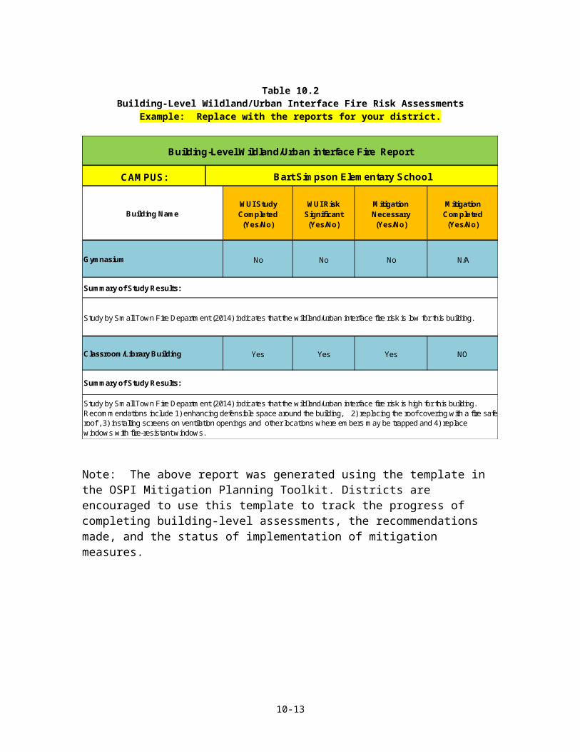
Table 10.2Building-Level Wildland/Urban Interface Fire Risk Assessments
Example: Replace with the reports for your district.
CAMPUS:
WUI Study Completed (Yes/No)
WUI Risk Significant (Yes/No)
Mitigation Necessary (Yes/No)
Mitigation Completed (Yes/No)
No No No N/A
Yes Yes Yes NO
Study by Small Town Fire Department (2014) indicates that the wildland/urban interface fire risk is low for this building.
Classroom/Library Building
Study by Small Town Fire Department (2014) indicates that the wildland/urban interface fire risk is high for this building. Recommendations include 1) enhancing defensible space around the building, 2) replacing the roof covering with a fire safe roof , 3) installing screens on ventilation openings and other locations where embers may be trapped and 4) replace windows with fire-resistant windows.
Summary of Study Results:
Building-Level Wildland/Urban interface Fire Report
Bart Simpson Elementary School
Building Name
Gymnasium
Summary of Study Results:
Note: The above report was generated using the template in the OSPI Mitigation Planning Toolkit. Districts are encouraged to use this template to track the progress of completing building-level assessments, the recommendations made, and the status of implementation of mitigation measures.
10-11
10.7 Mitigation for Wildland/Urban Interface Fires
Common goals for reducing wildland/urban interface fire risk include:
1) reduce the probability of fire ignitions,
2) reduce the probability that small fires will spread,
3) minimize property damage, and
4) minimize life safety risk.
School districts are not responsible for fire suppression or community-wide mitigation measures for wildland/urban interface fires, which are the responsibility of cities, counties, and fire agencies.
For districts with campuses determined to be at significant risk from wildland/urban interface fires, there are three types of practical mitigation measures:
For life safety, develop and practice effective evacuation plans for wildland/urban interface fires,
For existing facilities with significant risk:
o Maintain the maximum possible defensible space around buildings and reduce vegetative fuel loads adjacent to a campus,
o Implement fire-safe improvements such as non-flammable roofs, covering vent openings and overhangs with wire mesh to prevent entry and trapping of embers and others, and
Whenever possible, site new facilities outside of areas with high risk of wildland/urban interface fires, include fire-safe features in the design and ensure the maximum possible defensible space around new buildings.
Some types of mitigation projects for wildland/urban interface fire may be eligible for FEMA and other grant funding, including:
Defensible space activities,
Hazardous fuel reduction activities, and
Ignition resistant construction activities.
For existing buildings, implementing many ignition resistant building upgrades may be most cost-effective when done incrementally. For example, replacing an old roof covering with a non-flammable roof covering may be done at the time the existing roof has reached the end of its useful life and is scheduled for replacement.
The ABC School Districts’ mitigation Action Items for wildland/urban interface fires are shown in the table on the following page.
10-12
Table 10.3ABC School District: Wildland/Urban Interface Fire Mitigation Action Items
(Example only: replace with your fire mitigation Action Items)
3 Years X X X X
Ongoing X X X X
Ongoing X X X X
Hazard Action Item Timeline
Plan Goals Addressed
Short-Term #3
Complete at least a preliminary flood risk study for campuses not within FEMA-mapped floodplain that meet any of the "opt-in" criteria for completing the flood data inputs in the OSPI ICOS PDM database.
Long-Term #1
Evaluate and implement flood mitigation measures for campuses or buildings that have been determined to have high flood risk based on the campus-level flood report and/or local flood studies that have been completed, as funding becomes available.
Long-Term #2
Locate new campuses outside of FEMA-mapped floodplains or other flood-prone areas whenever possible or construct new buildings in flood-prone areas at elevations as high as possible to minimize flood risk.
Note: to the extent possible, make the Action Items as district-specific as possible, including identifying which the campuses for which mitigation measures are desired by the district. The table above is an editable Excel Worksheet Object or use Excel template in OSPI Mitigation Planning Toolkit.