San Juan Creek and Western San Mateo Creek Watersheds SAMP Draft Environmental Impact Statement R:\Projects\RMV\J011\EIS\13.0 Acronyms-Nov2005.doc 13-1 Chapter 13.0 Acronyms, Abbreviations, and Glossary of Terms CHAPTER 13.0 ACRONYMS, ABBREVIATIONS, AND GLOSSARY OF TERMS 13.1 ACRONYMS AND ABBREVIATIONS Acronym/Abbreviation Description A AAQS ambient air quality standards AAM Annual Arithmetic Mean ADT average daily traffic (or average daily trips) made by vehicles or persons in a 24-hour period AGM Annual Geometric Mean AICP American Institute of Certified Planners a.m. morning (before noon) asl or amsl above sea level or above mean sea level APCD Air Pollution Control District AQMD Air Quality Management District AQMP Air Quality Management Plan ARB Air Resources Board ARAMP Aquatic Resources Adaptive Management Program ARCA Aquatic Resources Conservation Areas ARCP Aquatic Resources Conservation Program ARMC Archaeological Resource Management Corporation ARMR Archaeological Resource Management Report (state guidelines) ARRP Aquatic Resources Restoration Plan ASBS Area of Special Biological Significance ASR Archaeological Survey Report AST above-ground storage tank AVR Average Vehicle Ridership B BACT Best Available Control Technology BCC Birds of Conservation Concern (USFWS) BEPA Bald Eagle Protection Act BMPs Best Management Practices (or Programs) B.P. before present C °C Degrees Celsius CAA Clean Air Act (federal) CAA Community Analysis Areas CAAQS California Ambient Air Quality Standards CAD Computer Aided Design CalEPA California Environmental Protection Agency Cal EPPC California Exotic Pest Plant Council Caltrans California Department of Transportation CARB California Air Resources Board CCAA California Clean Air Act CCC California Coastal Commission CCR California Code of Regulations CDC California Department of Conservation
Transcript
San Juan Creek and Western San Mateo Creek Watersheds SAMP Draft Environmental Impact Statement
CHAPTER 13.0 ACRONYMS, ABBREVIATIONS, AND GLOSSARY OF TERMS
13.1 ACRONYMS AND ABBREVIATIONS
Acronym/Abbreviation Description
A
AAQS ambient air quality standards AAM Annual Arithmetic Mean ADT average daily traffic (or average daily trips) made by vehicles or
persons in a 24-hour period AGM Annual Geometric Mean AICP American Institute of Certified Planners a.m. morning (before noon) asl or amsl above sea level or above mean sea level APCD Air Pollution Control District AQMD Air Quality Management District AQMP Air Quality Management Plan ARB Air Resources Board ARAMP Aquatic Resources Adaptive Management Program ARCA Aquatic Resources Conservation Areas ARCP Aquatic Resources Conservation Program ARMC Archaeological Resource Management Corporation ARMR Archaeological Resource Management Report (state guidelines) ARRP Aquatic Resources Restoration Plan ASBS Area of Special Biological Significance ASR Archaeological Survey Report AST above-ground storage tank AVR Average Vehicle Ridership
B
BACT Best Available Control Technology BCC Birds of Conservation Concern (USFWS) BEPA Bald Eagle Protection Act BMPs Best Management Practices (or Programs) B.P. before present
C °C Degrees Celsius CAA Clean Air Act (federal) CAA Community Analysis Areas CAAQS California Ambient Air Quality Standards CAD Computer Aided Design CalEPA California Environmental Protection Agency Cal EPPC California Exotic Pest Plant Council Caltrans California Department of Transportation CARB California Air Resources Board CCAA California Clean Air Act CCC California Coastal Commission CCR California Code of Regulations CDC California Department of Conservation
San Juan Creek and Western San Mateo Creek Watersheds SAMP Draft Environmental Impact Statement
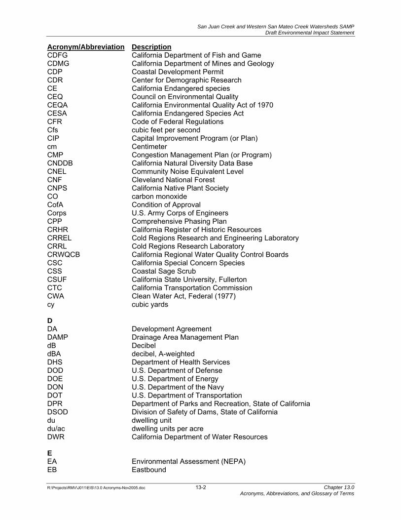
Acronym/Abbreviation Description CDFG California Department of Fish and Game CDMG California Department of Mines and Geology CDP Coastal Development Permit CDR Center for Demographic Research CE California Endangered species CEQ Council on Environmental Quality CEQA California Environmental Quality Act of 1970 CESA California Endangered Species Act CFR Code of Federal Regulations Cfs cubic feet per second CIP Capital Improvement Program (or Plan) cm Centimeter CMP Congestion Management Plan (or Program) CNDDB California Natural Diversity Data Base CNEL Community Noise Equivalent Level CNF Cleveland National Forest CNPS California Native Plant Society CO carbon monoxide CofA Condition of Approval Corps U.S. Army Corps of Engineers CPP Comprehensive Phasing Plan CRHR California Register of Historic Resources CRREL Cold Regions Research and Engineering Laboratory CRRL Cold Regions Research Laboratory CRWQCB California Regional Water Quality Control Boards CSC California Special Concern Species CSS Coastal Sage Scrub CSUF California State University, Fullerton CTC California Transportation Commission CWA Clean Water Act, Federal (1977) cy cubic yards
D DA Development Agreement DAMP Drainage Area Management Plan dB Decibel dBA decibel, A-weighted DHS Department of Health Services DOD U.S. Department of Defense DOE U.S. Department of Energy DON U.S. Department of the Navy DOT U.S. Department of Transportation DPR Department of Parks and Recreation, State of California DSOD Division of Safety of Dams, State of California du dwelling unit du/ac dwelling units per acre DWR California Department of Water Resources
E EA Environmental Assessment (NEPA) EB Eastbound
San Juan Creek and Western San Mateo Creek Watersheds SAMP Draft Environmental Impact Statement
Acronym/Abbreviation Description EDD Employment Development Department, State of California EDR Environmental Data Resources, Inc. EIR Environmental Impact Report (CEQA) EIS Environmental Impact Statement (NEPA) EMA Environmental Management Agency EMFAC7D Emission Factor Model EPA U.S. Environmental Protection Agency ERDC U.S. Army Engineer Research Development Center ESA Endangered Species Act (or FESA, Federal Endangered Species
Act) ESC Evolutionary Significant Units
F F Degrees Fahrenheit FAC Facultative FACU Facultative Upland FACW Facultative Wetlands FC Federal Candidate Species FCAA Federal Clean Air Act FCCP Foothill Corridor Circulation Plan FCDM Flood Control Design Manual FD/WQ Flow Duration/Water Quality FE Federally endangered species (USFWS) FEIR Final Environmental Impact Report FESA Federal Endangered Species Act FMMP Farmland Mapping and Monitoring Program FONSI Finding of No Significance fp fully protected FSC Federal Species of Concern FT Federally Listed Threatened Species FTC-S Foothill Transportation Corridor-South
G gal Gallons GDP General Development Plan GERA Gobernadora Ecological Restoration Area GIS Geographic Information Systems GM Growth Management GMA Growth Management Area GMP Growth Management Plan GP General Plan GPA General Plan Amendment GPS Global Positioning System
H HBP Department of Harbors, Beaches, and Parks, County of Orange HCM Highway Capacity Manual HCP Habitat Conservation Plan HNL hourly noise level HOV high-occupancy vehicle lane hr. Hour
San Juan Creek and Western San Mateo Creek Watersheds SAMP Draft Environmental Impact Statement
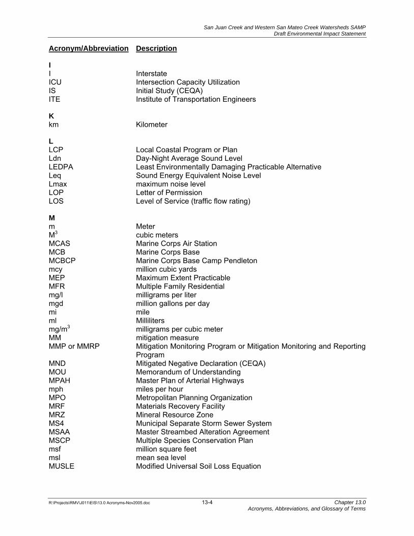
I I Interstate ICU Intersection Capacity Utilization IS Initial Study (CEQA) ITE Institute of Transportation Engineers
K km Kilometer
L LCP Local Coastal Program or Plan Ldn Day-Night Average Sound Level LEDPA Least Environmentally Damaging Practicable Alternative Leq Sound Energy Equivalent Noise Level Lmax maximum noise level LOP Letter of Permission LOS Level of Service (traffic flow rating)
M m Meter M3 cubic meters MCAS Marine Corps Air Station MCB Marine Corps Base MCBCP Marine Corps Base Camp Pendleton mcy million cubic yards MEP Maximum Extent Practicable MFR Multiple Family Residential mg/l milligrams per liter mgd million gallons per day mi mile ml Milliliters mg/m3 milligrams per cubic meter MM mitigation measure MMP or MMRP Mitigation Monitoring Program or Mitigation Monitoring and Reporting
Program MND Mitigated Negative Declaration (CEQA) MOU Memorandum of Understanding MPAH Master Plan of Arterial Highways mph miles per hour MPO Metropolitan Planning Organization MRF Materials Recovery Facility MRZ Mineral Resource Zone MS4 Municipal Separate Storm Sewer System MSAA Master Streambed Alteration Agreement MSCP Multiple Species Conservation Plan msf million square feet msl mean sea level MUSLE Modified Universal Soil Loss Equation
San Juan Creek and Western San Mateo Creek Watersheds SAMP Draft Environmental Impact Statement
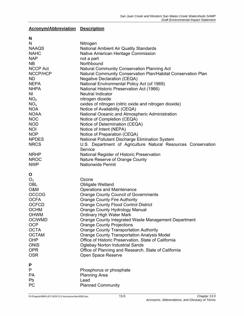
N N Nitrogen NAAQS National Ambient Air Quality Standards NAHC Native American Heritage Commission NAP not a part NB Northbound NCCP Act Natural Community Conservation Planning Act NCCP/HCP Natural Community Conservation Plan/Habitat Conservation Plan ND Negative Declaration (CEQA) NEPA National Environmental Policy Act (of 1969) NHPA National Historic Preservation Act (1966) NI Neutral Indicator NO2 nitrogen dioxide NOx oxides of nitrogen (nitric oxide and nitrogen dioxide) NOA Notice of Availability (CEQA) NOAA National Oceanic and Atmospheric Administration NOC Notice of Completion (CEQA) NOD Notice of Determination (CEQA) NOI Notice of Intent (NEPA) NOP Notice of Preparation (CEQA) NPDES National Pollutant Discharge Elimination System NRCS U.S. Department of Agriculture Natural Resources Conservation
Service NRHP National Register of Historic Preservation NROC Nature Reserve of Orange County NWP Nationwide Permit
O O3 Ozone OBL Obligate Wetland O&M Operations and Maintenance OCCOG Orange County Council of Governments OCFA Orange County Fire Authority OCFCD Orange County Flood Control District OCHM Orange County Hydrology Manual OHWM Ordinary High Water Mark OCIWMD Orange County Integrated Waste Management Department OCP Orange County Projections OCTA Orange County Transportation Authority OCTAM Orange County Transportation Analysis Model OHP Office of Historic Preservation, State of California ONIS Oglebay Norton Industrial Sands OPR Office of Planning and Research, State of California OSR Open Space Reserve
P P Phosphorus or phosphate PA Planning Area Pb Lead PC Planned Community
San Juan Creek and Western San Mateo Creek Watersheds SAMP Draft Environmental Impact Statement
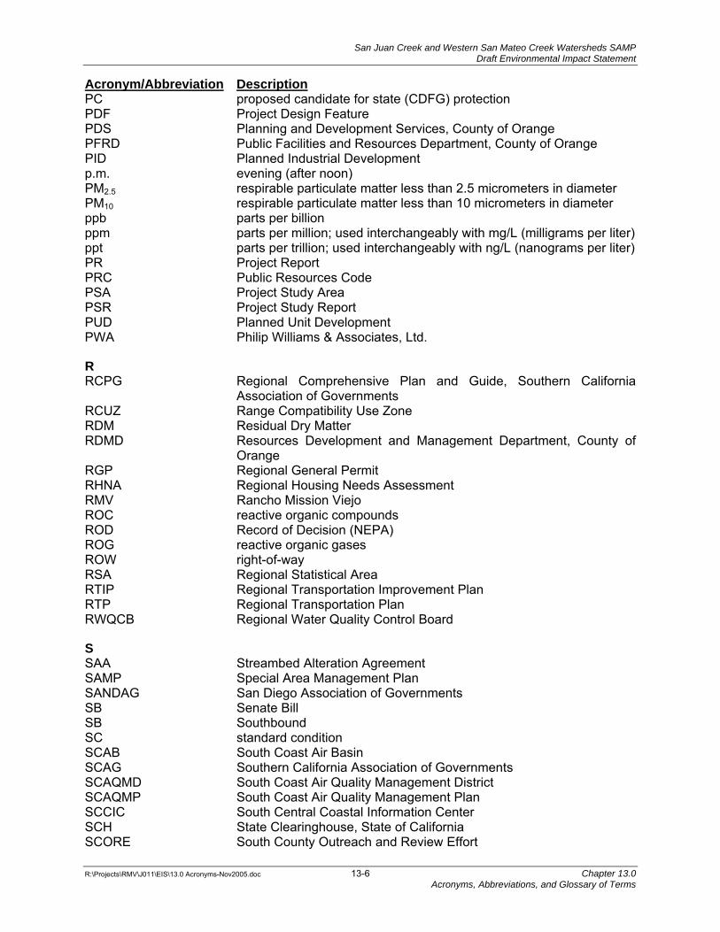
Acronym/Abbreviation Description PC proposed candidate for state (CDFG) protection PDF Project Design Feature PDS Planning and Development Services, County of Orange PFRD Public Facilities and Resources Department, County of Orange PID Planned Industrial Development p.m. evening (after noon) PM2.5 respirable particulate matter less than 2.5 micrometers in diameter PM10 respirable particulate matter less than 10 micrometers in diameter ppb parts per billion ppm parts per million; used interchangeably with mg/L (milligrams per liter) ppt parts per trillion; used interchangeably with ng/L (nanograms per liter) PR Project Report PRC Public Resources Code PSA Project Study Area PSR Project Study Report PUD Planned Unit Development PWA Philip Williams & Associates, Ltd.
R RCPG Regional Comprehensive Plan and Guide, Southern California
Association of Governments RCUZ Range Compatibility Use Zone RDM Residual Dry Matter RDMD Resources Development and Management Department, County of
Orange RGP Regional General Permit RHNA Regional Housing Needs Assessment RMV Rancho Mission Viejo ROC reactive organic compounds ROD Record of Decision (NEPA) ROG reactive organic gases ROW right-of-way RSA Regional Statistical Area RTIP Regional Transportation Improvement Plan RTP Regional Transportation Plan RWQCB Regional Water Quality Control Board
S SAA Streambed Alteration Agreement SAMP Special Area Management Plan SANDAG San Diego Association of Governments SB Senate Bill SB Southbound SC standard condition SCAB South Coast Air Basin SCAG Southern California Association of Governments SCAQMD South Coast Air Quality Management District SCAQMP South Coast Air Quality Management Plan SCCIC South Central Coastal Information Center SCH State Clearinghouse, State of California SCORE South County Outreach and Review Effort
San Juan Creek and Western San Mateo Creek Watersheds SAMP Draft Environmental Impact Statement
Acronym/Abbreviation Description SCS Soil Conservation Service SCSAM South (Orange) County Sub-Area Model San Diego RWQCB San Diego Regional Water Quality Control Board SEIR Supplemental Environmental Impact Report SENEL Single Event Noise Equivalent Level sf square foot (or feet) SFP State Fully Protected Species SFPP Santa Fe Petroleum Pipeline SFR Single-family residential SG or S&G Sand and Gravel SHP Scenic Highways Plan SHPO State Historic Preservation Officer, State of California SIP State Implementation Plan SMWD Santa Margarita Water District SO2 sulfur dioxide SO4 Sulfates SOx sulfur oxides SOC Species of Concern SOCTIIP South Orange County Transportation Infrastructure Improvement
Project sq.ft. square feet SR State Route SRA Source Receptor Area ST State Threatened Species STIP Statewide Transportation Improvement Program STP Surface Transportation Program STPP Surface Transportation Policy Project SWANCC Solid Waste Agency of Northern Cook County V. U.S. Army Corps of
Engineers SWMM Storm Water Management Model SWMP Storm Water Management Plan SWP State Water Project SWPPP Storm Water Pollution Prevention Plan SWRCB State Water Resources Control Board
T TAC toxic air contaminant TAZ Traffic Analysis Zone TCA Transportation Corridor Agencies (Orange County) TCM transportation control measure TDM Transportation Demand Management TEA Transportation Equity Act for the 21st Century (TEA-21) TIA Traffic Impact Analysis TMA Transportation Management Associations TMDL Total Maximum Daily Load TOD Transit-oriented Development TOG total organic gases TRO Trip Reduction Ordinance TRW Northrop Grumman Space Technology TSF Thousand Square Feet TSM Transportation System Management
San Juan Creek and Western San Mateo Creek Watersheds SAMP Draft Environmental Impact Statement
U UAC Urban Activity Center (County of Orange General Plan designation) UBC Uniform Building Code UPL Obligate Upland U.S. United States of America USACE U.S. Army Corps of Engineers USFS U.S. Forest Service USFWS U.S. Fish and Wildlife Service USGS United States Geological Survey
V V/C Volume-to-capacity ratio VMT vehicle miles traveled VOC volatile organic compounds vpd vehicles per day vph vehicles per hour vphpl vehicles per hour per lane
W WDR Waste Discharge Requirements WES Waterways Experiment Station WQMP Water Quality Management Plan
Z ZC Zone Change
Symbols µg/L micrograms per liter µg/m3 micrograms per cubic meter
San Juan Creek and Western San Mateo Creek Watersheds SAMP Draft Environmental Impact Statement
A-Weighted Decibel Sound Level (dBA): (See decibel, A-Weighted)
Acoustics: (1) The science of sound, including the generation, transmission, and effects of sound waves, both audible and inaudible. (2) The physical qualities of a room or other enclosure (such as size, shape, amount of noise) that determine the audibility and perception of speech and music.
Acre: A unit of land equal to 43,560 square feet.
Acre-Foot: The amount of water needed to cover an acre (approximate a football field) to a depth of one foot, or 325,900 gallons. One acre-foot can support the annual indoor and outdoor needs of between one and two households per year and, on average, three acre-feet are needed to irrigate one acre of farmland.
Acre, Gross: The total area within the lot lines of a lot of land before public streets, easements or other areas to be dedicated or reserved for public use are deducted from such lot, and not including adjacent lands already dedicated for such purposes. Most communities calculate gross acreage to the centerline of proposed bounding streets and to the edge of the right-of-way of existing or dedicated streets.
Acre, Net: The portion of a site that can actually be built upon. The following generally are not included in the net acreage of a site: public or private road right-of-ways, public open space, and flood ways.
Addendum: A lead agency or responsible agency can prepare an addendum to a previously certified EIR or an addendum to an adopted negative declaration/mitigated negative declaration if some changes or additions are necessary but none of the conditions described in CEQA Guidelines §15162 calling for preparation of a subsequent EIR have occurred. An Addendum does not need to be circulated for public review (source: CEQA Guidelines §15164).
Adverse Impact: A term used to describe unfavorable, harmful, or detrimental environmental changes. Adverse impacts may be significant or not significant. (See Significant Impact)
Advisory Council on Historic Preservation (ACHP): Independent federal agency responsible for implementing the Section 106 review process.
Agricultural Land Use: The use of land primarily for farming, ranching, horse breeding, dairy farming and other forms of food and crop production. From a planning perspective, agricultural land use connotes primary economic use of the property.
Agricultural Preserve: Land designated for agriculture or conservation. (See Williamson Act.)
Agriculture: Use of land for the production of food and fiber, including the growing of crops and/or the grazing of animals on natural prime or improved pasture land.
Air Basin: An area of the state designated by the Air Resources Board pursuant to Subdivision (a) of §39606 of the California Health and Safety Code for air quality planning purposes.
Air District: A political body responsible for managing air quality on a regional or county basis. California is currently divided into 35 air districts.
San Juan Creek and Western San Mateo Creek Watersheds SAMP Draft Environmental Impact Statement
Air Monitoring: The periodic or continuous sampling and analysis of air pollutants in ambient air or from individual pollutant sources.
Air Pollution/Pollutants: Substances that are foreign to the atmosphere or are present in the natural atmosphere to the extent that they may result in adverse effects on humans, animals, vegetation, and materials. Common air pollutants are ozone, nitrogen dioxide, particular matter, and carbon monoxide. Air pollution is defined in the California Heath and Safety Code as any discharge, release, or other propagation into the atmosphere and includes, but is not limited to, smoke, charred paper, dust, soot, grime, carbon, fumes, gases, odors, particulate matter, acids, or any combination thereof.
Air Pollution Control District (APCD): A local agency with authority to regulate stationary sources of air pollution (such as refineries, manufacturing facilities, and power plants) within a given county, and governed by a District Air Pollution Control Board composed of elected county supervisors and city representatives.
Air Quality Index (AQI): A numerical index used for reporting severity of air pollution levels to the public. It replaces the formerly used Pollutant Standards Index (PSI). Like the PSI, the AQI incorporates five criteria pollutants−ozone, particulate matter, carbon monoxide, sulfur dioxide, and nitrogen dioxide−into a single index. The new index also incorporates the 8-hour ozone standard and the 24-hour PM2.5 standard into the index calculation. AQI levels range from 0 (Good air quality) to 500 (Hazardous air quality). The higher the index, the higher the level of pollutants and the greater the likelihood of health effects. The AQI incorporates an additional index category−unhealthy for sensitive groups−that ranges from 101 to 150. In addition, the AQI comes with more detailed cautions.
Air Quality Management District (AQMD): A group of counties or portions of counties, or an individual county specified in law with authority to regulate stationary, indirect, and area sources of air pollution within the region and governed by a regional air pollution control board comprised mostly of elected officials from within the region.
Air Quality Management Plan (AQMP): A plan prepared by an air pollution control district or air quality management district for a county or region designated as a non-attainment area, for the purpose of bringing the area into compliance with the requirements of the federal Clean Air Act and/or the California Clean Air Act. An AQMP contains measures that will be taken to attain and maintain federal and state ambient air quality standards. In California, air districts prepare air quality management plans that are included in the state’s State Implementation Plan (SIP) that is required by the federal Clean Air Act. Such plans are also referred to as Clean Air Plans or Clean Air Attainment Plans.
Air Quality Model: An algorithmic relationship between pollutant emissions and pollutant concentrations used in the prediction of a project's pollutant impact.
Air Quality Standards: Standards promulgated by state or federal pollution control districts. The specified average concentration of an air pollutant in ambient air during a specified time period at or above which undesirable effects may be produced. The prescribed level of a pollutant in the outside air that should not be exceeded during a specific time period to protect public health. Established by both federal and state governments.
Airshed: A subset of an air basin, the term denotes a geographical area that shares the same air because of topography, meteorology, and climate.
San Juan Creek and Western San Mateo Creek Watersheds SAMP Draft Environmental Impact Statement
Air Toxics: Any air pollutant for which a national ambient air quality standard (NAAQS) does not exist (i.e., excluding ozone, carbon monoxide, PM10, sulfur dioxide, nitrogen dioxide) that may reasonably be anticipated to cause cancer, developmental effects, reproductive dysfunctions, neurological disorders, heritable gene mutations, or other serious or irreversible chronic or acute health effects in humans. Substances that are especially harmful to health, such as those considered under U.S. EPA's hazardous air pollutant program or California's AB 1807 and/or AB 2588 air toxics programs, are considered to be air toxics. Technically, any compound that is in the air and has the potential to produce adverse health effects is an air toxic.
Alquist-Priolo Special Study Zone: In 1972, the State of California began delineating Special Studies Zones around active and potentially active faults in the State. The zones extend about 660 feet on either side of identified fault traces. No structures for human occupancy may be built across an identified fault trace. An area of 50 feet on either side of an active fault trace is assumed to be underlain by the fault unless proven otherwise. Proposed construction within the Special Studies Zone can take place only following completion of a geotechnical report prepared by a California Registered Geologist or Certified Engineering Geologist.
Alternative Fuels: Fuels such as methanol, ethanol, natural gas, and liquid petroleum gas that are cleaner burning with lower air emissions and help to meet the Air Resources Board's mobile and stationary emission standards. These fuels may be used in place of less clean fuels for powering motor vehicles.
Ambient Air: The air occurring at a particular time and place outside of structures. Often used interchangeably with "outdoor air."
Ambient Air Quality Standards (AAQS): Health- and welfare-based standards for outdoor air which identify the maximum acceptable average concentrations of air pollutants during a specified period of time.
Ambient Conditions: Initial background concentration sensed/measured at a monitoring/ sampling site, as in air quality or noise.
Ambient Noise: The background noise associated with a given environment, usually a composite of sounds from many sources near and far. The ambient noise level constitutes the normal or existing level of environmental noise at a given location.
Applicant: Applicant means a person who proposes to carry out a project which needs a lease, permit, license, certificate, or other entitlement for use or financial assistance from one or more public agencies when that person applies for the governmental approval or assistance (source: CEQA Guidelines §15351).
Approval: Approval means the decision by a public agency which commits the agency to a definite course of action in regard to a project intended to be carried out by any person. The exact date of approval of any project is a matter determined by each public agency according to its rules, regulations, and ordinances. Legislative action in regard to a project often constitutes approval. With private projects, approval occurs upon the earliest commitment to issue or the issuance by the public agency of a discretionary contract, grant, subsidy, loan, or other form of financial assistance, lease, permit, license, certificate, or other entitlement for use of the project (source: CEQA Guidelines §15352).
San Juan Creek and Western San Mateo Creek Watersheds SAMP Draft Environmental Impact Statement
Aquatic: General reference to various water-oriented habitats such as rivers, streams, creeks, ponds, lakes, etc. These resources may be perennial, intermittent, or ephemeral in nature.
Aquifer: A natural underground formation that is saturated with water, and from which water can be withdrawn. A geologic formation of sand, rock, and gravel through which water can pass and which can store, transmit, and yield significant quantities of water to wells and springs. Aquifers generally hold sufficient water to be used as a water supply.
Archeological Site: The location of past focused human activities, defined in close proximity of continuous distribution of artifacts.
Area; Area Median Income: As used in State of California housing law with respect to income eligibility limits established by the U.S. Department of Housing and Urban Development (HUD), "area" means metropolitan area or non-metropolitan county. In non-metropolitan areas, the "area median income" is the higher of the county median family income or the statewide non-metropolitan median family income.
Area Sources: Those sources for which a methodology is used to estimate emissions. This can include areawide, mobile, and natural sources, and also groups of stationary sources (such as dry cleaners and gas stations). The California Clean Air Act requires air districts to include area sources in the development and implementation of the Air Quality Management Plan. In the California emission inventory, all sources which are not reported as individual point sources are included as area sources. The federal air toxics program defines a source that emits less than 10 tons per year of a single hazardous air pollutant or 25 tons per year of all hazardous air pollutants as an area source.
Area-Wide Sources: Sources of pollution where the emissions are spread over a wide area, such as consumer products, fireplaces, road dust and farming operations. Area-wide sources do not include mobile sources or stationary sources.
Arterial Road: A vehicular right-of-way whose primary function is to carry through traffic in a continuous route across an urban area while also providing some access to abutting land. Medium-speed (30-40 mph), medium-capacity (10,000-35,000 average daily trips) roadway that provides intra-community travel and access to the county-wide highway system. Access to community arterials should be provided at collector roads and local streets, but direct access from parcels to existing arterials is common.
Artifact: An object (tool or ornament) showing human workmanship or modification.
Assemblage: The complete inventory of artifacts from a single, defined archaeological unit (such as a stratum or component).
Asthma: A chronic inflammatory disorder of the lungs characterized by wheezing, breathlessness, chest tightness, and cough.
Atmosphere: The gaseous mass or envelope of air surrounding the Earth. From ground-level up, the atmosphere is further subdivided into the troposphere, stratosphere, mesosphere, and the thermosphere.
Atmospheric Stability: The resistance to or enhancement of vertical air movement related to the vertical temperature profile.
San Juan Creek and Western San Mateo Creek Watersheds SAMP Draft Environmental Impact Statement
Attainment: Achieving and maintaining the air quality standards (both state and federal) for a given air pollutant.
Attainment Area: A geographical area considered to have air quality as good as or better than the National Ambient Air Quality Standard as defined in the Clean Air Act or California ambient air quality standards. An area may be an attainment area for one pollutant and a non-attainment area for others.
Average Daily Traffic (ADT): The number of vehicles (trips) passing a given point on a road going in a direction during a 24-hour period.
Background Concentration: Air pollutant concentration due to natural sources and distant unidentified man-made sources.
Background Noise: See Ambient Noise.
Background View: View beginning at a distance from the observer and extending as far toward the horizon as the eye can detect the presence of objects. Skylines or ridge lines against other land surfaces are the strongest visual elements of the "background."
Base Flood: In any given year, a 100-year flood that has a one percent likelihood of occurring, and is recognized as a standard for acceptable risk.
Base Flow: River surface flow, not counting storm flow and/or purchased imported water.
Basin Plan: A water quality control plan developed by a Regional Water Quality Control Board (RWQCB) for a specific geographic area. The Basin Plan identifies beneficial uses of waters, the water quality objectives needed to maintain these beneficial uses, and an implementation plan.
Bedrock Mortar: A mortar cup in a bedrock outcrop.
Beneficial Uses: The resources, services, and qualities of state waters that may be protected against quality degradation. The uses include, but are not limited to, domestic, municipal, agricultural and industrial supply, power generation, recreation, aesthetic enjoyment, navigation, and preservation and enhancement of fish, wildlife, and other aquatic resources or preserves. The specific uses such as “cold freshwater habitat” and “water contact recreation” are defined in Section 2 of the Regional Water Quality Control Boards’ Basin Plans. Beneficial Uses are defined in California Water Code Section 13050.
Berm: An embankment, usually extended in a linear alignment. Berms can function as visual screens, noise attenuators, and surface water diverters.
Best Available Control Measure (BACM): A term used to describe the "best" measures (according to U.S. EPA guidance) for controlling small or dispersed sources of particulate matter and other emissions from sources such as roadway dust, woodstoves, and open burning.
Best Available Control Technology (BACT): Under the South Coast Air Quality Management District (SCAQMD) rules, for example, BACT is defined as the most stringent emissions control which for a given air emission source has been 1) achieved in practice; 2) is identified in a State Implementation Plan; or 3) has been found by the SCAQMD to be technologically achievable and cost-effective.
San Juan Creek and Western San Mateo Creek Watersheds SAMP Draft Environmental Impact Statement
Best Management Practice (BMP): A BMP is any program, technology, process, siting criteria, operating method, measure, or device which controls, prevents, removes, or reduces pollution.
Bicycle Lane (Class II facility): A corridor expressly reserved for bicycles, existing on a street or roadway in addition to any lanes for use by motorized vehicles.
Bicycle Path/Trail (Class I facility): A paved route not on a street or roadway and expressly reserved for bicycles traversing an otherwise unpaved area. Bicycle trails may parallel roads, but typically are separated from them by landscaping.
Bicycle Route (Class III facility): A facility shared by motorists and identified only by signs, a bicycle route has not pavement markings or lane stripes.
Biface: A tool that has been worked on both sides.
Bike Lane: A lane devoted to non-motorized bicycles.
Bikeway: A term that encompasses bicycle lanes, bicycle paths, and bicycle routes.
Biological Diversity: The variety of life forms and its processes, including the variety of living organisms, the genetic differences among them, and the communities and ecosystems in which they occur.
Biotic Community: A group of living organisms characterized by a distinctive combination of both animal and plant species in a particular habitat.
Building: Any structure having a roof supported by columns or walls and intended for the shelter, housing, or enclosure of persons, animals, or property of any kind.
Building Height: The vertical distance from the average contact ground level of a building to the highest point of the coping of a flat roof or to the deck line of a mansard roof or to the mean height level between eaves and ridge for a gable, hip, or gambrel roof. The exact definition varies by community. For example, in some communities building height is measured to the highest point of the roof, not including elevator and cooling towers.
Buildout: Development of land to its full potential or theoretical capacity as permitted under current or proposed planning or zoning designations. The year in which project construction has been completed.
Bulk: The mass or volume of buildings.
California Air Resources Board (CARB): California’s lead air quality agency, consisting of an 11-member Governor-appointed board, responsible for motor vehicle air pollution control, and having oversight over California’s air pollution management program. CARB is responsible for attainment and maintenance of the state and federal air quality standards, and is fully responsible for motor vehicle pollution control. It oversees county and regional air pollution management programs.
California Ambient Air Quality Standards (CAAQS): A legal limit that specifies the maximum level and time of exposure in the outdoor air for a given air pollutant and which is protective of human health and public welfare (Health and Safety Code section 39606b). CAAQSs are recommended by the California Office of Environmental Health Hazard Assessment and
San Juan Creek and Western San Mateo Creek Watersheds SAMP Draft Environmental Impact Statement
adopted into regulation by the CARB. CAAQSs are the standards which must be met per the requirements of the California Clean Air Act (CCAA).
California Clean Air Act (CCAA): A California law passed in 1998 the provides the basis for air quality planning and regulation independent of federal regulations, and which establishes new authority for attaining and maintaining California’s air quality standards by the earliest practicable date. A major element of the CCAA is the requirement that local Air Pollution Control Districts in violation of the California Ambient Air Quality Standards must prepare attainment plans that identify air quality problems, causes, trends, and actions to be taken for attainment.
California Coastal Commission: The lead agency responsible for carrying out California’s federally-approved coastal management program. The Coastal Commission plans for and regulates land and water uses in the coastal zone consistent with policies of the Coastal Act.
California Code of Regulations (CCR): The regulations that implement California laws.
California Department of Transportation (Caltrans): The state government agency responsible for the construction, maintenance, and operation of state and federal highways in California.
California Environmental Protection Agency (Cal EPA): The state agency established in 1991 for unifying environmental activities related to public health protection in the State of California. There are six boards, departments, and offices under the organization of Cal/EPA including the California Air Resources Board (ARB), California Integrated Waste Management Board (IWMB), State Water Resources Control Board (SWRCB) and its nine Regional Water Quality Control Boards (RWQCB), Department of Pesticide Regulation (DPR), Department of Toxic Substances Control (DTSC), and Office of Environmental Health Hazard Assessment (OEHHA). The Cal EPA boards, departments, and offices are directly responsible for implementing California environmental laws, or play a cooperative role with other regulatory agencies at regional, local, state, and federal levels.
California Environmental Quality Act (CEQA): The California Environmental Quality Act, California Public Resources Code Sections 21000 et seq (Source: CEQA Guidelines §15353).
Candlepower: The total light output expressed in candelas.
Capital Improvements: The building of infrastructure or public works projects.
Capital Improvements Program (CIP): A program established by a city or county government which schedules infrastructure improvements necessary to accommodate existing and anticipated future development. Most CIPs are for a minimum of five years into the future, and include a financing mechanism, to fit the projected fiscal capability of the local jurisdiction. The program generally is reviewed annually for conformance to and consistency with the general plan.
Carbon Dioxide (CO2): A colorless gas that enters the atmosphere as the result of natural and artificial combustion processes. Significant quantities are also emitted into the air by fossil fuel combustion. It is also a normal part of the ambient air.
Carbon Monoxide (CO): A colorless, odorless gas resulting from the incomplete combustion of fossil fuels. CO interferes with the blood’s ability to carry oxygen to the body’s tissues and can result in adverse health effects. CO is a criteria air pollutant.
San Juan Creek and Western San Mateo Creek Watersheds SAMP Draft Environmental Impact Statement
Carrying Capacity: Used in determining the potential of an area to absorb development: (1) The level of land use, human activity, or development for a specific area that can be accommodated permanently without an irreversible change in the quality of air, water, land, or plant and animal habitats; (2) The upper limits of development beyond which the quality of human life, health, welfare, safety or community character within an area will be impaired; or (3) The maximum level of development allowable under current zoning.
Catch Basin: A storm drain inlet having a sump below the outlet to capture settled solids.
Categorical Exclusion: Categorical exclusion, under NEPA, covers various categories of actions which do not individually or cumulatively have a significant effect on the human environment and are exempt from the requirement to prepare an Environmental Assessment or an Environmental Impact Statement. This replaces the federal term “non-major action.” The federal term refers to the action as a whole having no significant impact on the environment. It does not refer to categories of project types.
Categorical Exemption: Categorical exemption means an exemption from CEQA for a class of projects based on a finding by the Secretary for Resources that the class of projects does not have a significant effect on the environment unless exceptions to the exemption apply (source: CEQA Guidelines §15354). A Categorical Exemption does not apply in the following situations: 1) a reasonable possibility exists that the activity may have a significant environmental impact because of unusual circumstances; 2) the cumulative impacts of the project would be considerable and therefore significant; 3) the project occurs within specified sensitive environments, 4) a project affects scenic resources within official state scenic highways, 5) a project is located on a toxic site that is listed by the California Environmental Protection Agency, or 6) a project causes substantial adverse changes in a significant historic resource. (CEQA Guidelines §15300.2)
Census: The official United States decennial enumeration of the population conducted by the federal government.
Channel: A water course with a definite bed and banks which confine and conduct the normal continuous or intermittent flow of water.
Channelization: (1) The straightening and/or deepening of a watercourse for purposes of storm runoff control or ease of navigation. Channelization often includes lining of stream banks with a retaining material such as concrete. (2) At the intersection of roadways, the directional separation of traffic lanes through the use of curbs or raised islands that limit the paths that vehicles may take through the intersection.
Chert: Crypto-Crystalline Silicate. A flint-like rock, commonly selected as a raw material for flaked-stone tools.
Chlorofluorocarbons (CFC): A family of inert, nontoxic, and easily-liquefied chemicals used in refrigeration, air conditioning, packaging, insulation, or as solvents or aerosol propellants. Because CFCs are not destroyed in the lower atmosphere, they drift into the upper atmosphere where the chlorine is released and destroys ozone.
Circulation Element: One of the seven state-mandated elements of a general plan, it contains adopted goals, policies, and implementation programs for the planning and management of existing and proposed thoroughfares, transportation routes, and terminals, as well as local public utilities and facilities, all correlated with the land use element of the general plan.
San Juan Creek and Western San Mateo Creek Watersheds SAMP Draft Environmental Impact Statement
Circulation System: A network of transit, automobile, bicycle, and pedestrian rights-of-way that connect origins and destinations.
Clean Air Act (CAA): A federal law passed in 1970 and amended in 1977 and 1990 that sets primary and secondary National Ambient Air Quality Standards for major air pollutants and forms the basis for the national air pollution control effort.
Clean Fuels: Blends and/or substitutes for gasoline fuels. These include compressed natural gas, methanol, ethanol, and others.
Code of Federal Regulations (CFR): The document that codifies all rules of the executive departments and agencies of the federal government. It is divided into 50 volumes, known as titles. Title 40 of the CFR (referenced as 40 CFR) lists all the environmental regulations.
Cohensionless Soil: A soil that when confined has little or no strength when air-dried, and that has little or no cohesion when submerged.
Collector: Relatively low speed (25-30 mph), relatively low volume (5,000-20,000 average daily trips) street that provides circulation within and between neighborhoods. Collectors usually serve short trips and are intended for collecting trips from local streets and distributing them to the arterial network.
Commercial: A land use classification that permits facilities for the buying and selling of commodities and services.
Community Noise Equivalent Level (CNEL): A noise compatibility level established by California Administrative Code, Title 21, Section 5000. Represents a time-weighted 24-hour average noise level based on the A-weighted decibel. The CNEL scale includes an additional 5 dB adjustment to sounds occurring in the evening (7 p.m. to 10 p.m.) and a 10 dB adjustment to sound occurring in the late evening and early morning between (10 p.m. and 7 a.m.).
Conditional Use: A land use which is not permitted by right, but which may be appropriate in a given zoning district under certain circumstances. The use may occur only upon approval of a conditional use permit.
Conditional Use Permit (CUP): A permit based on a discretionary decision required prior to initiation of particular uses not allowed as a matter of right. The use may be desirable under appropriate circumstances, but are not permitted by right in the applicable zone. The purpose of the CUP process is to determine whether, and under what conditions, a specific use may be appropriate in a given location. Further, the intent is that each use be developed so as to fully protect the public health, safety, and welfare of the community. To provide this protection, conditions may be applied to address potential adverse effects associated with the proposed use.
Conformity: A demonstration of whether a federally-supported activity is consistent with the State Implementation Plan (SIP)−per Section 176 (c) of the Clean Air Act. Transportation conformity refers to plans, programs, and projects approved or funded by the Federal Highway Administration or the Federal Transit Administration. General conformity refers to projects approved or funded by other federal agencies.
Congestion Management Plan/Program (CMP): A state-mandated program (California Government Code Section 65089a) that requires each county to prepare a plan to relieve
San Juan Creek and Western San Mateo Creek Watersheds SAMP Draft Environmental Impact Statement
congestion and reduce air pollution. Growth management techniques include traffic level of service requirements, standards for public transit, trip reduction programs involving transportation systems management and jobs/housing balance strategies, and capital improvement programming, for the purpose of controlling and/or reducing the cumulative regional traffic impacts of development.
Conjunctive Use: The planned use of groundwater in conjunction with surface water in overall management to optimize total water resources.
Conservation Agreement: A formal signed agreement between the U.S. Fish and Wildlife Service or National Marine Fisheries Service and other parties that implements specific actions, activities, or programs designed to eliminate or reduce threats or otherwise improve the status of a species. Conservation Agreements can be developed at a state, regional, or national level and generally include multiple agencies at both the state and federal level, as well as tribes.
Conservation Element: One of the seven State-mandated elements of a local general plan, it contains adopted goals, policies, and implementation programs for the conservation, development, and use of natural resources including water and its hydraulic force, forests, soils, rivers and other waters, harbors, fisheries, wildlife, minerals, and other natural resources.
Conservation Strategy: A strategy outlining current activities or threats that are contributing to the decline of a species, along with the actions or strategies needed to reverse or eliminate such a decline or threats. Conservation strategies are generally developed for species of plants and animals that are designated or that have been determined by the U.S. Fish and Wildlife Service or National Marine Fisheries Service to be federal candidates under the Endangered Species Act.
Consistency, Consistent With: Free from significant variation or contradiction. The various diagrams, text, goals, policies, and programs in the general plan must be consistent with each other, not contradictory or preferential. The term "consistent with" is used interchangeably with "conformity with." The courts have held that the phrase "consistent with" means "agreement with; harmonious with." Webster defines "conformity with" as meaning harmony, agreement when used with "with." The term "conformity" means in harmony therewith or agreeable to (Sec 58 Ops.Cal.Atty.Gen. 21, 25 [1975]). California State law also requires that a general plan be internally consistent and also requires consistency between a general plan and implementation measures such as the zoning ordinance.
Consistent: Free from variation or contradiction. Programs in the general plan are to be consistent, not contradictory or preferential. State law requires consistency between a general plan and implementation measures such as the zoning ordinance.
Construction: Any site preparation, assembly, erection, substantial repair, alteration, or similar action for or of public or private rights-of-way, structures, utilities, or similar property.
Contiguous: Lands or legal subdivisions having a common boundary; lands having only a common corner are generally not contiguous.
Contour Grading: A grading technique which uses curvilinear, horizontal, and vertical undulations in order to simulate the characteristics of natural topography.
Cooperating Agency: “Under NEPA, any agency other than the lead agency which has jurisdiction by law or special expertise with respect to any environmental impact involved in a
San Juan Creek and Western San Mateo Creek Watersheds SAMP Draft Environmental Impact Statement
proposal for any action significantly affecting the human environment. Under CEQA, the term “responsible agency” is used.
Co-Permittee: A permittee to an NPDES permit that is only responsible for permit conditions relating to the discharges from its area of jurisdiction.
Core: A cobble or small rock from which flakes or blades are removed. The core may be used as a tool as well as a source of flakes.
Council of Governments (COG): An association of cities and counties that often acts as a regional planning agency with some power under state and federal law.
Covenants, Conditions, and Restrictions (CC&Rs): A term used to describe restrictive limitations that may be placed on property and its use, and which usually are made a condition of holding title or lease.
Criteria Air Pollutant: An air pollutant for which acceptable levels of exposure can be determined and for which an ambient air quality standard has been set in order to protect public health. Examples include zone, carbon monoxide, nitrogen dioxide, sulfur dioxide, PM10, and PM2.5. The term "criteria air pollutants" derives from the requirement that the U.S. EPA must describe the characteristics and potential health and welfare effects of these pollutants. The U.S. EPA and CARB periodically review new scientific data and may propose revisions to the standards as a result.
Cumulative Impact: A cumulative impact refers to two or more individual affects which, when considered together, are considerable or which compound or increase other environmental impacts. The individual effects may be changes resulting from a single project or a number of separate projects. The cumulative impact from several projects is the change in the environment which results from the incremental impact of the project when added to other closely related past, present, and reasonable foreseeable probable future projects. Cumulative impacts can result from individually minor but collectively significant projects taking place over a period of time (source: CEQA Guidelines §15355).
Data Recovery: The act of excavating with the intent of answering specific research questions.
Datum: A stationary control point from which all other features or artifacts are mapped from.
Day-Night Average Sound Level (Ldn): The A-weighted average sound level in decibels during a 24-hour period with a 10 dB weighing applied to nighttime sound levels (10 p.m. to 7 a.m.). This exposure method is similar to the CNEL, but deletes the evening time period (7 p.m. to 10 p.m.) as a separate factor.
Debitage: Debris; waste products or by-products of the flaked-stone tool manufacturing process. Lithic debitage would include unused flakes, exhausted cores, and broken artifacts.
Depression: A large or small circular or rectangular area where cultural activity took place (e.g., depressed area of a roundhouse or longhouse).
Decibel (dB): A unit for expressing the relative intensity (loudness) of sounds. The decibel is the logarithm of the ratio of the intensity of a given sound to the faintest sound discernible by the human ear.
San Juan Creek and Western San Mateo Creek Watersheds SAMP Draft Environmental Impact Statement
Decibel, A-Weighted (dBA): The "A-weighted" scale for measuring sound in decibels; weighs or reduces the effects of low and high frequencies in order to simulate human hearing. Every increase of 10 dBA doubles the perceived loudness though the noise is actually ten times more intense.
Decision Making Authority: Decision-making authority means any person or body vested with the authority to make recommendations or act on application requests. The final decision-making authority is the one which has the authority to act on a request by approving or denying the request. This may include the Community Development Director or his/her designee, Planning Commission, or the City Council.
Decision Making Body: Any person or group of people within a public agency permitted by law to approve or disapprove the project at issue (source: CEQA Guidelines §15356).
Dedication: The turning over by an owner or developer of private land for public use, and the acceptance of land for such use by the governmental agency having jurisdiction over the public function for which it will be used. Dedications for roads, parks, school sites, or other public uses often are made conditions for approval of a development by a city or county.
Dedication, In lieu of: Cash payments that may be required of an owner or developer as a substitute for a dedication of land, usually calculated in dollars per lot, and referred to as in lieu fees or in lieu contributions.
Density: The gross site area which shall include local roadways, slopes, and open space areas, unless otherwise specified. Density is usually expressed “per acre.” For example, a development with 100 dwelling units located on 20 acres has a density of 5 units per acre.
Density, Residential: The number of permanent residential dwelling units per acre of land. Densities specified in a general plan may be expressed in units per gross acre or per net developable acre.
Desilting: The physical process of removing suspended particles from water.
Detention Dam/Basin/Pond: Dams may be classified according to the broad function they serve, such as storage, diversion, or detention. Detention dams are constructed to retard flood runoff and minimize the effect of sudden floods. Detention dams fall into two main types. In one type, the water is temporarily stored, and released through an outlet structure at a rate which will not exceed the carrying capacity of the channel downstream. Often, the basins are planted with grass and used for open space or recreation in periods of dry weather. The other type, most often called a Retention Pond, allows for water to be held as long as possible and may or may not allow for the controlled release of water. In some cases, the water is allowed to seep into the permeable banks or gravel strata in the foundation. This latter type is sometimes called a Water-Spreading Dam or Dike because its main purpose is to recharge the underground water supply. Detention dams are also constructed to trap sediment. These are often called Debris Dams.
Detention Device: Facilities designed to collect and temporarily detain the initial volume of storm water runoff for a specified period of time to permit settlement of particulate pollutions.
Developable Acres, Net: The portion of a site that can be used for density calculations. Some communities calculate density based on gross acreage. Public or private road rights-of-way are not included in the net developable acreage of a site.
San Juan Creek and Western San Mateo Creek Watersheds SAMP Draft Environmental Impact Statement
Developable Land: Land that is suitable as a location for structures and that can be developed free of hazards to, and without disruption of, or significant impact on, natural resource areas.
Developer: An individual who or business that prepares raw land for the construction of buildings or causes to be built physical building space for use primarily by others, and in which the preparation of the land or the creation of the building space is in itself a business and is not incidental to another business or activity.
Development: The physical extension and/or construction of land uses. Development activities include: subdivision of land; construction or alteration of structures, roads, utilities, and other facilities; installation of septic systems; grading; deposit of refuse, debris, or fill materials; and clearing of natural vegetative cover (with the exception of agricultural activities)
Development Agreement: A legislatively-approved contract between a jurisdiction and a person having legal or equitable interest in real property within the jurisdiction (California Government Code §65865 et seq.) that “freezes” certain rules, regulations, and polices applicable to development of a property for a specified period of time, usually in exchange for certain concessions by the owner.
Development Impact Fees: A fee or tax imposed on developers to pay for the costs to the community of providing services to a new development. It is a means of providing a fund for financing new improvements without resorting to deficit financing.
Development Rights: The right to develop land by a land owner who maintains fee-simple ownership over the land or by a party other than the owner who has obtained the rights to develop. Such rights usually are expressed in terms of density allowed under existing zoning. For example, one development right may equal one unit of housing or may equal a specific number of square feet of gross floor area in one or more specified zone districts.
Dewatering Device: The removal of groundwater resulting from excavations activities.
Direct Effects: Effects which are caused by an action and occur at the same time and place.
Discoidal: Stone artifact having a circular shape. Specific to earlier periods of prehistory. Actual function uncertain.
Discretionary Approval/Decision: A decision requiring the exercise of judgment, deliberation, or decision on the part of the decision-making authority in the process of approving or disapproving a particular activity, as distinguished from situations where the decision-making authority merely has to determine whether there has been conformity with applicable statutes, ordinances, or regulations. An approval by a decision-making body which has the legal discretion to approve or deny a project or action.
Discretionary Project: A project which requires the exercise of judgment or deliberation when the public agency or body decides to approve or disapprove a particular activity, as distinguished from situations where the public agency or body merely has to determine whether there has been conformity with applicable statutes, ordinances, or regulations(source: CEQA Guidelines §15357).
Dispersion: The process by which atmospheric pollutants disseminate due to wind and vertical stability.
San Juan Creek and Western San Mateo Creek Watersheds SAMP Draft Environmental Impact Statement
District: (1) An area of a city or county that has a unique character identifiable as different from surrounding areas because of distinctive architecture, streets, geographic features, culture, landmarks, activities, or land uses. (2) A portion of the territory of a city or county within which uniform zoning regulations and requirements apply; a zone.
Diversion: The direction of water in a stream away from its natural course (i.e., as in a diversion that removes water from a stream for human use).
Drainage: An area that collects and diverts rain water and urban runoff down slope.
Drainage Area: The portion of the earth’s surface from which precipitation or other runoff flows to a given location. With respect to a highway, this location may be a culvert, the farthest point of a channel, or an inlet to a roadway drainage system.
Drainage Swale: A storm drainage conveyance structure designed to intercept, divert, and convey surface runoff (generally sheet flow) to prevent erosion and reduce pollution loading.
Dwelling, Single-Family: A detached building constructed in conformance with the Uniform Building Code or a mobile home constructed on or after June 15, 1976.
Dwelling, Two-Family: A building containing two separate dwelling units.
Dwelling Unit: A room or group of rooms (including sleeping, eating, cooking, and sanitation facilities, but not more than one kitchen), which constitutes an independent housekeeping unit, occupied or intended for occupancy by one household on a long-term basis.
Easement (preservation or conservation): A right given by the owner of land to another party for specific limited use of that land. An easement may be acquired by a government through dedication when the purchase of an entire interest in the property may be too expensive or unnecessary.
Effects: “Effects” and “impacts” as used in the CEQA Guidelines are synonymous. Effects include: (a) Direct or primary effects which are caused by the project and occur at the same time and place; (b) Indirect or secondary effects which are caused by the project and are later in time or farther removed in distance, but are still reasonably foreseeable. Indirect or secondary effects may include growth-inducing effects and other effects related to induced changes in the pattern of land use, population density, or growth rate, and related effects on air and water and other natural systems, including ecosystems. Effects analyzed under CEQA must be related to a physical change (source: CEQA Guidelines §15358).
Effluent: Wastewater or other liquid, partially or completely treated or in its natural state, flowing from a treatment plant.
Eligible property: Property that meets the criteria for inclusion in the National Register of Historic Places but is not formally listed.
Emergency: Emergency means a sudden, unexpected occurrence, involving a clear and imminent danger, demanding immediate action to prevent or mitigate loss of, or damage to life, health, property, or essential public services. Emergency includes such occurrences as fire, flood, earthquake, or other soil or geologic movements, as well as such occurrences as riot, accident, or sabotage (CEQA Guidelines §15359)
San Juan Creek and Western San Mateo Creek Watersheds SAMP Draft Environmental Impact Statement
Eminent Domain: The legal right of government to acquire or "take" private property for public use or public purpose upon paying just compensation to the owner.
Emission: An air contaminant released to the atmosphere. The act of passing into the atmosphere of air contaminant or a gas stream that may or may not contain an air contaminant or the material so passed into the atmosphere.
Emission Factor: For stationary sources, the relationship between the amount of pollution produced and the amount of raw material processed or burned. For mobile sources, the relationship between the amount of pollution produced and the number of vehicle miles traveled. By using the emission factor of a pollutant and specific data regarding quantities of materials used by a given source, it is possible to compute emissions for the source. This approach is used in preparing an emissions inventory.
Emission Inventory: An estimate of the amount of pollutants emitted into the atmosphere from major mobile, stationary, area-wide, and natural source categories over a specific period of time such as a day or a year.
Emission Offsets (Emissions Trading): A rule-making concept whereby approval of a new or modified stationary source of air pollution is conditional on the reduction of emissions from other existing stationary sources of air pollution. These reductions are required in addition to reductions required by best available control technology.
Emission Rate: The weight of a pollutant emitted per unit of time (e.g., tons/year).
Emission Standards: The federal Environmental Protection Agency (EPA), California Air Resources Board (ARB), or air district standards or limits for air contaminant emissions. The maximum amount of a pollutant that is allowed to be discharged from a polluting source such as an automobile or smoke stack
Encroachment: The occupancy of project right-of-way by non-project structures or objects of any kind or character; also, activities of other parties within the operating right-of-way.
Endangered Species: In accordance with CEQA, “Species” means a species or subspecies of animal or plant or a variety of plant. A species of animal or plant is: “Endangered” when its survival and reproduction in the wild are in immediate jeopardy from one or more causes, including loss of habitat, change in habitat, overexploitation, predation, competition, disease, or other factors. A species of animal or plant shall be presumed to be endangered, rare or threatened, as it is listed in: (1) Sections 670.2 or 670.5, Title 14, California; (2) Title 50, Code of Federal Regulations Section 17.11 or 17.12 pursuant to the Federal Endangered Species Act as rare, threatened, or endangered. A species not included in any listing identified in subsection (c) shall nevertheless be considered to be endangered, rare or threatened, if the species can be shown to meet specified criteria. This definition shall not include any species of the Class Insecta which is a pest whose protection under the provisions of CEQA would present an overwhelming and overriding risk to man as determined by: The Director of Food and Agriculture with regard to economic pests; or The Director of Health Services with regard to health risks (source: CEQA Guidelines §15380).
Environment: The physical conditions which exist within the area which will be affected by a proposed project including land, air, water, minerals, flora, fauna, ambient noise, and objects of historical or aesthetic significance. The area involved shall be the area in which significant
San Juan Creek and Western San Mateo Creek Watersheds SAMP Draft Environmental Impact Statement
effects would occur either directly or indirectly as a result of the project. The "environment" includes both natural and man-made conditions (source: CEQA Guidelines §15360).
Environmental Assessment: A concise public document for which a federal agency is responsible that serves to briefly provide sufficient evidence and analysis for determining whether to prepare an Environmental Impact Statement or a Finding of No Significant Impact. It is the federal equivalent of the CEQA term “initial study.”
Environmental Documents: Environmental documents means Initial Studies, Negative Declarations, draft and final EIRs, documents prepared as substitutes for EIRs and Negative Declarations under a program certified pursuant to Public Resources Code Section 21080.5, and documents prepared under NEPA and used by a state or local agency in the place of an Initial Study, Negative Declaration, or an EIR (source: CEQA Guidelines §15361).
Environmental Impact Report: A detailed statement prepared under the California Environmental Quality Act (CEQA) describing and analyzing the significant environmental effects of a project and discussing ways to mitigate or avoid the effects. The term “EIR” may mean either a draft or a final EIR depending on the context. A Draft EIR means an EIR containing the information specified in CEQA Guidelines §§15122 through 15131. A Final EIR means an EIR containing the information contained in the draft EIR, comments either verbatim or in summary received in the review process, a list of persons commenting, and the response of the Lead Agency to the comments received (source: CEQA Guidelines §15362).
Environmental Impact Statement: An environmental impact document prepared pursuant to the National Environmental Policy Act (NEPA). NEPA uses the term EIS in the place of the term EIR which is used in CEQA (source: CEQA Guidelines §15363).
Environmental Justice: The fair treatment of people of all races and incomes with respect to development, implementation, and enforcement of environmental laws, regulations, and policies. Fair treatment implies that no person or group of people should shoulder a disproportionate share of negative environmental and economic impacts resulting from the execution of environmental programs.
Equivalent Noise Level (Leq): A single-number representation of the fluctuating sound level in decibels over a specified period of time. It is a sound-energy average of the fluctuating level.
Erosion: The process by which material is removed from the earth's surface (including weathering, dissolution, abrasion, and transportation), most commonly by wind or water.
Erosion Control: The stabilization of cut and fill slopes and other areas.
Ethnography: The study of a culture to obtain information on past and present ways of life.
Evapotranspiration: The quantity of water transpired (given off), retained in plant tissues, and evaporated from plant tissues and surrounding soil surface. Quantitatively, it is expressed in terms of depth of water per unit area during a specified period of time.
Exaction: A contribution or payment required as an authorized precondition for receiving a development permit. It usually refers to a mandatory dedication or fee in lieu of dedication requirements found in many subdivision regulations and may apply to land for parks or other public facilities.
San Juan Creek and Western San Mateo Creek Watersheds SAMP Draft Environmental Impact Statement
Excavation: A systematic process of digging archaeological sites, removing the soil and observing the provenience and context of the finds (both cultural and non-cultural) contained within, and recording them in a three-dimensional way.
Exceedance: A measured level of an air pollutant higher than the national or state ambient air quality standards.
Expansive Soils: Soils that swell when they absorb water and shrink as they dry.
Extirpation: The local extinction of a species that is no longer found in a locality or country, but exists elsewhere in the world.
Facultative: Plants with similar likelihood (estimated 33 percent to 67 percent) of occurring in both wetlands and non-wetlands (i.e., valley oak).
Facultative Upland: Plants that occur sometimes (estimated 1 percent to less than 33 percent) in wetlands, but occur more often (estimated greater than 99 percent) in non-wetlands (i.e., giant rye).
Facultative Wetlands: Plants that occur usually (estimated 67 percent to 99 percent) in wetlands, but also occur (estimated 1 percent to 33 percent) in non-wetlands (i.e., mule fat or willow).
Fall: A fall is a movement of unattached soil or rock from a steep slope along a surface on which little or no shear displacement takes place. The material descends mainly through the air by falling.
Farmland: Refers to eight classifications of land mapped by the U.S. Department of Agriculture Soil Conservation Service. The five agricultural classifications, except Grazing Land, do not include publicly owned lands for which there is an adopted policy preventing agricultural use. They are: Prime Farmland, Farmland of Statewide Importance, Unique Farmland, Farmland of Local Importance, and Grazing Land.
Farmland of Local Importance: Lands of importance to the local agricultural economy, as determined by each county's board of supervisors and local advisory committee. Each county has developed its own definition of Farmland of Local Importance. (Source: Natural Resource Conservation Service)
Farmland of Statewide Importance: Lands similar to Prime Farmland but with minor shortcomings, such as greater slopes or with less ability to hold and store moisture. These lands have the same reliable source of adequate quality irrigation water available during the growing season as required for Prime Farmland. The land must have been used for the production of irrigated crops at some time during the two update cycles prior to the mapping date. (Source: U.S. Department of Agriculture Soil Conservation Service)
Fault: A fracture in the earth's crust forming a boundary between rock masses that have shifted. An active fault is a fault that has moved recently and which is likely to again. An inactive fault is a fault which shows no evidence of movement in recent geologic time and no potential for movement in the relatively near future.
San Juan Creek and Western San Mateo Creek Watersheds SAMP Draft Environmental Impact Statement
Feasible: Feasible means capable of being accomplished in a successful manner within a reasonable period of time, taking into account economic, environmental, legal, social, and technological factors (source: CEQA Guidelines §15364).
Feature: A large, complex artifact or part of a site such as a hearth, cairn, house pit, rock alignment, or activity area.
Federal Clean Air Act (FCAA): A federal law passed in 1970 and amended in 1974, 1977, and 1990 which forms the basis for the national air pollution control effort. Basic elements of the act include national ambient air quality standards for major air pollutants, mobile and stationary control measures, air toxics standards, acid rain control measures, and enforcement provisions.
Federal Emergency Management Agency (FEMA): The federal agency under which the National Flood Insurance Program is administered.
Federal Implementation Plan (FIP): In the absence of an approved State Implementation Plan (SIP), a plan prepared by the U.S. EPA which provides measures that non-attainment areas must take to meet the requirements of the Federal Clean Air Act.
Filtration: The mechanical process that removes particulate matter from water by passing through sand or other media.
Final Map: A map of an approved subdivision filed in the county recorder’s office. It shows surveyed lot lines, street rights-of-way, easements, monuments, and distances, angles, and bearings, pertaining to the exact dimensions of all parcels, street lines, and so forth.
Findings of Fact: Findings required by CEQA are the conclusions made regarding the significance of a project in light of its environmental impacts. A public agency cannot approve or carry out a project for which an EIR has been certified which identifies one or more significant environmental effects of the project unless the public agency makes one or more written findings for each of those significant effects, accompanied by a brief explanation of the rationale for each finding (source: CEQA Guidelines §15091).
Finding of No Significant Impact (FONSI): A document by a federal agency briefly presenting the reasons why an action, not otherwise categorically excluded, will not have a significant effect on the human environment and therefore does not require the preparation of an EIS. A FONSI is the federal equivalent of a Negative Declaration.
Fine Particulate Matter (PM10): PM10 causes a greater health risk than larger-sized particles, since these fine particles can be inhaled more easily and irritate the lungs by themselves and in combination with gases.
Fire-Cracked Rock: Burned rocks, typically fracture during intense hearing in a fire hearth or remnants of rocks associated with cooking. Fairly common to prehistoric archaeological sites.
Fire Hazard Zone: An area where, due to slope, fuel, weather, or other fire-related conditions, the potential loss of life and property from a fire necessitates special fire protection measures and planning before development occurs.
Fixed Noise Source: A stationary device which creates sounds while fixed or motionless, including but not limited to, residential, agricultural, industrial, and commercial machinery and equipment, pumps, fans, compressors, air conditioners, and refrigeration equipment.
San Juan Creek and Western San Mateo Creek Watersheds SAMP Draft Environmental Impact Statement
Flake: A thin, flattened piece of chip of stone intentionally removed from the core rock by chipping with either a stone or bone hammer.
Flood: A general and temporary condition of partial or complete inundation of normally dry land areas from: (1) overflow of inland or tidal waters; (2) the unusual and rapid accumulation or runoff of surface waters from any source; (3) mudslides (i.e. mudflows) which are proximately caused by flood, and are akin to a river of liquid and flowing mud on the surface of normally dry land areas, as when earth is carried by a current of water and deposited along the path of the current; and (4) the collapse or subsidence of land along the shore of a lake or other body of water as a result of erosion or undermining caused by waves or currents of water exceeding the cyclical levels which result in flood.
Flood, 100-Year: The magnitude of a flood expected to occur on the average every 100 years, based on historical data. The 100-year flood has a 1/100, or one percent, chance of occurring in any given year.
Floodplain: Any land area susceptible to being inundated by flood waters from any source. The relatively level land area on either side of the banks of a stream regularly subject to flooding. That part of the floodplain subject to a one percent chance of flooding in any given year is designated as an “area of special flood hazard” by the Federal Insurance Administration.
Floodplain Management: The operation of an overall program of corrective and preventive measures for reducing flood damage, including but not limited to, emergency preparedness plans, flood control works, and floodplain management regulations.
Floodway: The channel of a river or other watercourse and the adjacent land areas that must be reserved in order to discharge the “base flood” without cumulatively increasing the water surface elevation more than one foot. No development is allowed in floodways.
Floor Area Ratio: The ratio of gross floor area of all buildings permitted on a site divided by the total net area of the site, expressed in decimals to one or two places. For example, on a site with 10,000 net square feet of land area, a Floor Area Ratio of 1.0 will allow a maximum of 10,000 gross square feet of building floor area to be built. On the same site, an FAR of 1.5 would allow 15,000 square feet of floor area; an FAR of 2.0 would allow 20,000 square feet; and an FAR of 0.5 would allow only 5,000 square feet. Also commonly used in zoning, FARs typically are applied on a parcel-by-parcel basis as opposed to an average FAR for an entire land use or zoning district.
Flow: A flow is a sudden movement of a soil mass in which individual particles travel separately in a fluid motion. Debris and mudflows are rapid and can be related to excess rainfall on slopes often where vegetation has been removed. Debris flows often have the consistency of cement and can result in catastrophic effects to structures.
Freeway: A high-speed, high-capacity, limited-access road serving regional and county-wide travel. Such roads are free of tolls, as contrasted with “turnpikes” or other “toll roads” now being introduced into southern California. Freeways generally are used for long trips between major land use generators. At Level of Service “E,” they carry approximately 1,875 vehicles per lane per hour, in both directions. Major streets cross at a different grade level.
Fugitive Dust: Dust particles that are introduced into the air through certain activities such as soil cultivation, or vehicles operating on open fields or dirt roadways. A subset of fugitive emissions.
San Juan Creek and Western San Mateo Creek Watersheds SAMP Draft Environmental Impact Statement
Fugitive Emissions: Emissions not caught by a capture system which are often due to equipment leaks, evaporative processes, and windblown disturbances.
General Plan: A compendium of city or county policies regarding long-term development, in the form of maps and accompanying text. A General Plan is a legal document required of each local agency by the State of California Government Code Section 65301 and adopted by a city council or board of supervisors. California law requires the preparation of seven elements or chapters in a General Plan: Land Use, Housing, Circulation, Conservation, Open Space, Noise, and Safety. Additional elements are permitted.
General Plan Amendment: A change or addition to a community’s general plan. A general plan can be amended up to four times a year.
General Plan Consistency: Compatibility and agreement with a general plan. Consistency exists when the standards and criteria of a general plan are met or exceeded.
Geographic Information System (GIS): A computer system capable of storing, analyzing, and displaying data and describing places on the earth’s surface.
Geological: Pertaining to rock or solid matter.
Geometric Improvements: Improvements to roads such as widening, adding signals to intersections, or adding turning lanes. These are required to mitigate traffic impacts and maintain a required level of service (LOS).
Geomorphic: Relating to the form or surface features of the earth.
Glare: A light source, either reflected or direct, that is annoying or distracting. The effect produced by lighting sufficient to cause annoyance, discomfort, or loss of visual performance and visibility. Glare can occur when the luminaire or associated lens of a light fixture is directly viewable from a location off the property that it serves.
Grade: Adjacent ground level. For purposes of building height measurement, grade is the average of the finished ground level at the center of all walls of a building or other datum point established by the division of building and safety.
Grading: Alteration of existing slope and shape of the ground surface.
Grazing Land: Lands on which the existing vegetation is suited to the grazing of livestock. (Source: Natural Resource Conservation Service)
Ground Failure: Ground movement or rupture caused by strong shaking during an earthquake. Includes landslide, lateral spreading, liquefaction, and subsidence.
Ground Shaking: Ground movement resulting from the transmission of seismic waves during an earthquake.
Groundwater: The term usually refers to the “saturated” zone in the ground where all the pore space between the soil particles is occupied by water. Water under the earth's surface, often confined to aquifers capable of supplying wells and springs. Does not include water which is being produced with oil in the production of oil and gas or in a bona fide mining operation.
San Juan Creek and Western San Mateo Creek Watersheds SAMP Draft Environmental Impact Statement
Groundwater Basin: A groundwater reservoir defined by the entire overlying land surface and the underlying aquifers that contain water stored in the reservoir. Boundaries of successively deeper aquifers may differ and make it difficult to define the limits of the basin.
Groundwater Table: The upper surface of the zone of saturation (all pores of subsoil filled with water), except where the surface if formed by an impermeable body.
Growth Management: The use by a community of a wide range of techniques in combination to determine the amount, type, and rate of development desired by the community and to channel that growth into designated areas. Growth management policies can be implemented through growth rates, zoning, capital improvement programs, public facilities ordinances, urban limit lines, standards for levels of service, and other programs.
Growth Management Plan (GMP): A plan developed for a given geographical region (e.g., by the Southern California Association of Governments [SCAG]) that contains demographic projections (i.e., housing units, employment, and population for the region. The plan provides recommendations for local governments to better accommodate the growth projected by occur and reduce environmental impacts.
Habitat: A place where a plant or animal naturally or normally lives or grows.
Habitat Conservation Plan (HCP): A plan required in support of a federal Section 10(a) permit under the federal Endangered Species Act.
Height: The vertical distance from the adjacent grade to the highest point of that which is being measured.
Heliport: An identifiable area on land or water, including any building or facilities thereon, used or intended to be used for the landing and takeoff of helicopters. Does not include temporary landing and takeoff sites. Refueling and overnight maintenance are permitted.
Helistop: An identifiable area on land or water, including any building or facilities thereon, used or intended for the landing and takeoff of helicopters. Does not include temporary landing and takeoff sites. Refueling and overnight maintenance are not permitted.
Hertz: Unit of measurement of frequency, numerically equal to cycles per second.
High-Occupancy Vehicle (HOV): A motor vehicle that is carrying at least a minimum specified number of passengers (normally at least two or more, sometimes three or more). It can be a bus, a taxi with passengers, or a car or van used for carpooling.
Historic Preservation: The preservation of historically significant structures and neighborhoods until such time as, and in order to facilitate, restoration and rehabilitation of the building(s) to a former condition.
Highway: High-speed, high-capacity, limited-access transportation facility serving regional and county-wide travel. Highways may cross at a different grade level.
Historic Preservation: The preservation of historically significant structures and neighborhoods until such time as, and in order to facilitate, restoration and rehabilitation of the building(s) to a former condition.
San Juan Creek and Western San Mateo Creek Watersheds SAMP Draft Environmental Impact Statement
Hot Spot: A localized concentration of an air pollutant associated with restricted dispersion conditions, often occurring in such places as street intersections or close to the source of emissions.
Household: The U.S. Census Bureau defines a household as all persons living in a housing unit whether or not they are related. A single person living in an apartment as well as a family living in a house is considered a household. Household does not include individuals in dormitories, prisons, convalescent homes, or other group quarters.
Household Income: The total income of all the persons living in a household. A household is usually described as very low income, low income, moderate income, and upper income based upon household size and income, relative to the regional median income.
Households, Market Rate: Households who, as determined by the county or county, have the financial capability to meet their housing needs without sacrificing other essential needs.
Households, Non-Market-Rate: Households who, as determined by the city or county, do not have the financial capability to meet their housing needs without sacrificing other essential needs.
Housing and Community Development, California Department of (HCD): The department of the California State Government which has responsibility for housing policy and programs. HCD establishes the guidelines for preparation of local housing elements, prepares the statewide housing element, and offers technical assistance to local jurisdictions.
Housing Element: One of the seven state-mandated elements of a local general plan, it assesses the existing and projected housing needs of all economic segments of the community, identifies potential sites adequate to provide the amount and kind of housing needed, and contains adopted goals, policies, and implementation programs for the preservation, improvement, and development of housing. Under State law, a housing element must be updated every five years.
Hydrocarbons (HC): Compounds containing various combinations of hydrogen and carbon atoms. They may be emitted into the air by natural sources (e.g., trees) and as a result of fossil and vegetative fuel combustion, fuel volatilization, and solvent use. Hydrocarbons are a major contributor to smog.
Hydrogen Sulfide (H2S): A colorless, flammable, poisonous compound having a characteristic rotten-egg odor. It is used in industrial processes and may be emitted into the air.
Hydrology: The study of the water cycle.
Impact: The effect, influence, or imprint of an activity or the environment. Impacts include: direct or primary effects which are caused by the project and occur at the same time and place; indirect or secondary effects which are caused by the project and are later in time or farther removed in distance, but are still reasonably foreseeable. Indirect or secondary effects may include growth-inducing effects and other effects related to induced changes in the pattern of land use, population density, or growth rate and related effects on air and water and other natural systems, including ecosystems.
Impact Fee: A fee, also called a development fee, levied on the developer of a project by a city, county, or public agency as compensation for otherwise-unmitigated impacts the project will
San Juan Creek and Western San Mateo Creek Watersheds SAMP Draft Environmental Impact Statement
produce. California Government Code Section 66000 et seq. specifies that development fees shall not exceed the estimated reasonable cost of providing the service for which the fee is charged. To lawfully impose a development fee, the public agency must verify its method of calculation and document proper restrictions of use of the fund.
Impervious Surface: Ground surface that cannot be penetrated by water. Includes paved and compacted surfaces, as well as those covered by buildings.
Important Farmlands: Important farmlands include prime farmlands, farmlands of statewide importance, unique farmlands, and farmlands of local importance as defined and mapped by the California Department of Conservation (source: Advisory Guidelines for the Farmland Mapping and Monitoring Program, California Department of Conservation-Division of Land Resource Protection, 1984)
Impoundment: A body of water, such as a pond, confined by a dam, dike, floodgate, or other barrier.
Income Categories/Levels: Four categories are used to classify a household according to the median income for the county. Under state housing statutes, these categories are as follows: Very Low (0 to 50 percent of county median); Low (50 percent to 80 percent of county median); Moderate (80 percent to 120 percent of county median); and Upper (over 120 percent of county median). Four levels are included relating to the Orange County HUD median income: Income I is defined as households earning 0-30 percent of the HUD county median income. Income II is defined as households earning 30-50 percent of the HUD county median income. Income III is defined as households earning 50-80 percent of the HUD county median income. Income IV is defined as households earning 80-120 percent of the HUD county median income.
Incorporation by Reference: Reliance on a previous environmental document for some portion of the environmental analysis of a project. An EIR or Negative Declaration may incorporate by reference all or portions of another document which is a matter of public record or is generally available to the public. Where all or part of another document is incorporated by reference, the incorporated language shall be considered to be set forth in full as part of the text of the EIR or Negative Declaration. Source: CEQA Guidelines §15150.
Indirect Impact: Effects caused by an action that are later in time or farther removed in distance, but are still reasonably foreseeable. Indirect effects may include growth inducing effects and other effects related to induced changes in the pattern of land use, population density or growth rate, and related effects on air and water and other natural systems, including ecosystems.
Indirect Source: Any facility, building, structure, or installation, or combination thereof, which generates or attracts mobile source activity that results in emissions of any pollutant (or precursor) for which there is a state ambient air quality standard. Examples of indirect sources include employment sites, shopping centers, sports facilities, housing developments, airports, commercial and industrial development, and parking lots and garages.
Indirect Source Control Program: Rules, regulations, local ordinances and land use controls, and other regulatory strategies of air pollution control districts or local governments used to control or reduce emissions associated with new and existing indirect sources. Indirect source control programs include regulatory strategies such as transportation control measures (e.g., South Coast's Regulation XV for employer-based trip reduction); parking charges; land
San Juan Creek and Western San Mateo Creek Watersheds SAMP Draft Environmental Impact Statement
use controls that reduce the need for vehicle travel and increase transit, bicycle, and pedestrian access; and source-specific regulations such as truck idling and travel schedule requirements.
Infiltration: The introduction of underground water, such as groundwater, into wastewater collection systems. Infiltration results in increased wastewater flow levels.
Infiltration System: An infiltration basin designed to capture runoff volume from the water quality design storm and infiltrate it to the soil.
Inflow: Surface water, such as rainfall runoff, that enters a wastewater collection system through manhole covers and joints or cracks in pipes. Inflow results in increased wastewater flow levels.
Infrastructure: Permanent utility installations, including roads, water supply lines, sewage collection pipes, and power and communications lines.
Initial Study: Under CEQA, a preliminary analysis prepared by the Lead Agency to determine whether an EIR, a Negative Declaration, or Mitigated Negative Declaration must be prepared, or to identify the significant environmental effects to be analyzed in an EIR (source: CEQA Guidelines §15365).
In situ: In place. Applied to archaeological remains found in their original, undisturbed location or position.
Institute of Transportation Engineers (ITE): Organization for professional transportation engineers. ITE publishes the Trip Generation Manual, which provides information on trip generation for land uses and building types. For instance, if an individual needs to know the number of trip ends produced by an industrial park, the report provides a trip rate based upon the size of the building. The report also divides the trip rate into peak hour rates, weekday rates, etc.
Intensity, Building: For residential uses, the actual number or the allowable range of dwelling units per net or gross acre. For non-residential uses, the actual or the maximum permitted floor area ratios (FARs).
Inter-agency: Indicates cooperation between or among two or more discrete agencies in regard to a specific program.
Inter Alia: Latin: "among other things," "for example," or "including." Legal drafters would use it to precede a list of examples or samples covered by a more general
Intermittent Stream: A stream that normally flows for at least 30 days after the last major rain of the season and is dry a large part of the year.
Intermodal Surface Transportation Efficiency Act of 1991 (ISTEA): This Congressional act requires states to develop a Statewide Transportation Plan and a Statewide Transportation Improvements Program (STIP) that identifies short-term project needs and priorities. It has also been a major source of funding for transportation planning and encourages the linking of transportation and community planning.
San Juan Creek and Western San Mateo Creek Watersheds SAMP Draft Environmental Impact Statement
Intersection Capacity: The maximum number of vehicles that has a reasonable expectation of passing through an intersection in one direction during a given time period under prevailing roadway and traffic conditions.
Intersection Capacity Utilization Method (ICU): A method of analyzing intersection level of service by calculating a volume-to-capacity (V/C) ratio for each governing "critical" movement during a traffic signal phase. The V/C ratio for each phase is summed with the others at the intersection to produce an overall V/C ratio for the intersection as a whole. The ICU is usually expressed as a percent. The percent represents that portion of the hour required to provide sufficient capacity to accommodate all intersection traffic if all approaches operate at capacity. The V/C ratio represents the percent of intersection capacity used. For example, a V/C ratio of 0.85 indicates that 85 percent of capacity is being used.
Intrusive Noise: Noise which intrudes over and above the existing ambient noise at a given location. The relative intrusiveness of a sound depends upon its amplitude, duration, frequency, and time of occurrence and tonal or information content as well as the prevailing ambient noise level.
Inversion Layer: A condition in the atmosphere through which the temperature increases with altitude, holding cooler surface air down along with its pollutants.
Jobs/Housing Balance or Jobs/Housing Ratio: The jobs/housing ratio divides the number of jobs in an area by the number of employed residents. A ratio of 1.0 typically indicates a balance. A ratio greater than 1.0 indicates a net in-commute; less than 1.0 indicates a net out-commute.
Joint EIR/EIS: A joint environmental document prepared for a project meeting the requirements of both CEQA and NEPA. (See CEQA Guidelines §15170).
Joint Powers Authority (JPA): A legal arrangement that enables two or more units of government to share authority in order to plan and carry out a specific program or set of programs that serves both units.
Jurisdiction by Law: Jurisdiction by law means the authority of any public agency: (a) To grant a permit or other entitlement for use; (b) To provide funding for the project in question; or (c) To exercise authority over resources which may be affected by the project. A city or county will have jurisdiction by law with respect to a project when the city or county having primary jurisdiction over the area involved is: (a) The site of the project; (b) The area in which the major environmental effects will occur; and/or (c) The area in which reside those citizens most directly concerned by any such environmental effects. Where an agency having jurisdiction by law must exercise discretionary authority over a project in order for the project to proceed, it is also a Responsible Agency (source: CEQA Guidelines §15366).
Landfill: An area of land or an excavation in which wastes are placed for permanent disposal, and that is not a land application unit, surface impoundment, injection well, or waste pile.
Landslide: Down slope movement of soil and/or rock, which typically occurs during an earthquake or following heavy rainfall.
Landslide Complex: The association of geologic structure and deep-seated landsliding.
Land Use: The purpose or activity for which a piece of land or its buildings is designed, arranged, or intended, or for which it is occupied or maintained.
San Juan Creek and Western San Mateo Creek Watersheds SAMP Draft Environmental Impact Statement
Land Use Classification: A system for classifying and designating the appropriate use of properties.
Land Use Element: A required element of the General Plan that uses text and maps to designate the future use or reuse of land within a given jurisdiction's planning area. The land use element serves as a guide to the structuring of zoning and subdivision controls, urban renewal, and capital improvements programs, and to official decisions regarding the distribution and intensity of development and the location of public facilities and open space. Designates the general location and intensity of housing, business, industry, open space, education, public buildings and grounds, waste disposal facilities, and other land uses.
Land Use Plan: An adopted map depicting the approximate location of residential, commercial, public, semi-public, and private uses, open space, and road systems with a statistical summary of areas and densities for these land uses.
Land Use Regulation: A term encompassing the regulation of land in general and often used to mean those regulations incorporated in the General Plan, as distinct from zoning regulations (which are more specific).
Lateral Spreading: Lateral movement of soil, often as a result of liquefaction during an earthquake.
Ldn: Day-Night Average Sound Level. The A-weighted average sound level for a given area (measured in decibels) during a 24-hour period with a 10 dB weighting applied to night-time sound levels. The Ldn is approximately numerically equal to the CNEL for most environmental settings.
Lead: A gray-white metal that is soft, malleable, ductile, and resistant to corrosion. Sources of lead resulting in concentrations in the air include industrial sources and crustal weathering of soils followed by fugitive dust emissions. Health effects from exposure to lead include brain and kidney damage and learning disabilities. Lead is the only substance which is currently listed as both a criteria air pollutant and a toxic air contaminant.
Lead Agency: The public agency which has the principal responsibility for carrying out or approving a project. The Lead Agency will decide whether an EIR or Negative Declaration will be required for the project and will cause the document to be prepared (source: CEQA Guidelines §15367).
Lease: A contractual agreement by which an owner of real property (the lessor) gives the right of possession to another (a lessee) for a specified period of time (term) and for a specified consideration (rent).
Leq: The energy equivalent level, defined as the average sound level on the basis of sound energy (or sound pressure squared). The Leq is a "dosage" type measure and is the basis for the descriptors used in current standards, such as the 24-hour CNEL used by the State of California.
Level of Service (LOS): LOS is the qualitative measure that incorporates the collective factors of speed, travel time, traffic interruption, freedom to maneuver, safety, driving comfort and convenience, and operating costs provided by a highway facility under a particular volume condition.
San Juan Creek and Western San Mateo Creek Watersheds SAMP Draft Environmental Impact Statement
Level of Service A: Indicates a relatively free flow of traffic, with little or no limitation on vehicle movement or speed.
Level of Service B: Describes a steady flow of traffic, with only slight delays in vehicle movement and speed. All queues clear in a single signal cycle.
Level of Service C: Denotes a reasonably steady, high-volume flow of traffic, with some limitations on movement and speed, and occasional backups on critical approaches.
Level of Service D: Designates the level where traffic nears an unstable flow. Intersections still function, but short queues develop and cars may have to wait through one cycle during short peaks.
Level of Service E: Represents traffic characterized by slow movement and frequent (although momentary) stoppages. This type of congestion is considered severe, but is not uncommon at peak traffic hours, with frequent stopping, long-standing queues, and blocked intersections.
Level of Service F: Describes unsatisfactory stop-and-go traffic characterized by “traffic jams” and stoppages of long duration. Vehicles at signalized intersections usually have to wait through one or more signal changes, and “upstream” intersections may be blocked by the long queues.
Lithic: Of and pertaining to a stone (obsidian, chert, basalt, etc.), as “lithic artifacts.”
Local Agency: Local agency means any public agency other than a state agency, board, or commission. Local agency includes but is not limited to cities, counties, charter cities and counties, districts, school districts, special districts, redevelopment agencies, local agency formation commissions, and any board, commission, or organizational subdivision of a local agency when so designated by order or resolution of the governing legislative body of the local agency (source: CEQA Guidelines §15368).
Local Agency Formation Commission (LAFCO): A five- or seven-member commission within each county that reviews and evaluates all proposals for formation of special districts, incorporation of cities, annexation to special districts or cities, consolidation of districts, and merger of districts with cities. Each county's LAFCO is empowered to approve, disapprove, or conditionally approve such proposals. The five LAFCO members generally include two county supervisors, two city council members, and one member representing the general public. Some LAFCOs include two representatives of special districts.
Local Coastal Program (LCP): A combination of a local governments land use plans, zoning ordinances, zoning district maps, and (within sensitive coastal resources areas) other implementing actions that together meet the local requirements of, and implement the provisions and policies of, the California Coastal Act of 1976.
Local Coastal Program Land Use Plan: The relevant portion of a local government general plan or coastal element that details type, location, and intensity of land use, applicable resource protection and development policies, and, where necessary, implementation actions.
Lot: An area of land created or established for purposes of sale, lease, finance, or division of interest or separate use, separated from other lands by description on a final map or parcel map.
San Juan Creek and Western San Mateo Creek Watersheds SAMP Draft Environmental Impact Statement
Low-income Household: A household with an annual income usually no greater than 80 percent of the area median family income adjusted by household size, as determined by a survey of incomes conducted by a city or a county, or in the absence of such a survey, based on the latest available eligibility limits established by the U.S. Department of Housing and Urban Development (HUD) for the Section 8 housing program.
Luminaire or Luminary: The light-producing element of a light fixture. Examples are bulbs and tubes. Direct viewing of luminaries of greater than 1,000 lumens per fixture is undesirable.
Mano: A loaf-shaped handstone used for grinding seeds, pigments, and so forth, a metate or millingstone.
Manufactured Slope: A slope crated by grading that consists of cut and fill material.
Mass Grading: A grading technique in which all lots, building pads, and streets are generally graded over the entire area resulting in the disruption of the majority of the onsite natural grade and vegetation and/often resulting in, but not required to result in, a successive pad/terrace configuration.
Master Environmental Assessment: A Master Environmental Assessment may contain an inventory of the physical and biological characteristics of the area for which it is prepared and may contain such additional data and information as the public agency determines is useful or necessary to describe environmental characteristics of the area. It may include identification of existing levels of quality and supply of air and water, capacities and levels of use of existing services and facilities, and generalized incremental effects of different categories of development projects by type, scale, and location. A public agency may prepare a Master Environmental Assessment, inventory, or data base for all, or a portion of, the territory subject to its control in order to provide information which may be used or referenced in EIRs or Negative Declarations. (See CEQA Guidelines §15169).
Master EIR: An EIR that is intended to provide a detailed environmental review of plans and programs upon which the approval of subsequent related development proposals can be based. For example, a master EIR may be prepared for projects consisting of smaller individual projects to be implemented in phases, such as staged projects (See CEQA Guidelines Section 15175).
Master Plan of Arterial Highways (MPAH): A diagram in the Circulation Element which illustrates the arterial designation of roadways. Each arterial designation defines the number of ultimate lanes planned for a given roadway. Arterial designations include: Freeway, Transportation Corridor, Expressway, Major Highway, Primary Highway, Secondary Highway, and Commuter Highway.
Materials Recovery Facility (MRF): An intermediate processing facility designed to remove recyclables and other valuable materials from the waste stream for purposes of recycling or composting. A "dirty MRF" removes reusable materials from unseparated trash. A "clean MRF" separates materials from commingled recyclables, typically collected from residential or commercial curbside programs.
May: In accordance with CEQA Guidelines §15005, “may” identifies a permissive element which is left fully to the discretion of the public agencies involved.
San Juan Creek and Western San Mateo Creek Watersheds SAMP Draft Environmental Impact Statement
Maximum Achievable Control Technology (MACT): Federal emissions limitations based on the best demonstrated control technology or practices in similar sources to be applied to major sources emitting one or more federal hazardous air pollutants.
Maximum Extent Practicable (MEP): The extent to which storm water management practices are required to be implemented to reduce storm water pollution. All management practices that are effective at reducing storm water pollution are required to be implemented, except when any of the following conditions are met: (1) other effective management practices would achieve greater or substantially the same pollution control benefits; (2) the management practices would not be technically feasible; (3) the cost of management practice implementation would greatly outweigh pollution control benefits; or, (4) implementation of the management practice would compromise other legal or institutional constraints, expectations, and obligations imposed by federal or state statute or case law.
Mean Sea Level: The average altitude of the sea surface for all tidal stages.
Memorandum of Understanding (MOU): A common form of formal agreement between government agencies.
Mercalli Intensity Scale: A subjective measure of the observed effects (human reactions, structural damage, geologic effects) of an earthquake. Expressed in Roman numerals from I to XII.
Metate: A portable stone slab upon which seeds and other grains are milled with a mano (worked with a push-pull motion).
Metropolitan Planning Organization (MPO): The regional agency which administers the federally required transportation planning processes in a metropolitan area. An MPO must be in place in every urbanized area with a population over 50,000, and is responsible for the 20-year long-range plan and the Transportation Improvement Program (TIP). The MPO is the coordinating agency for grants, billings, and policy-making for transportation. The MPO is often, but not always, the COG.
Median: A physical divider separating lanes of traffic that typically are traveling in opposite directions. A median is often installed to prohibit unsafe turning movements. It can also be used to beautify a streetscape.
Median Income: The annual income of each household size within a region which is defined annually by HUD. Half of the households in the region have incomes above the median and half have incomes below the median.
Millingstone: A roughly shaped stone slab upon which seeds and other plant products are ground with the aid of a mano. The milling basin of the slab may be ovoid to round, depending on the rotary motion of the handstone.
Mineral Resource: Land on which known deposits of commercially viable mineral or aggregate deposits exist. This designation is applied to sites determined by the State Division of Mines and Geology as being a resource of regional significance, and is intended to help maintain the quarrying operations and protect them from encroachment of incompatible land uses.
San Juan Creek and Western San Mateo Creek Watersheds SAMP Draft Environmental Impact Statement
Mineral Resource Zones: Zones that have been identified as having potential mineral and aggregate resources. The State Mining and Geology Board recommends that these lands be preserved as open space or used for interim uses to allow for future extraction.
Ministerial (Administrative) Decision: Describes a governmental decision involving little or no personal judgment by the public official as to the wisdom or manner of carrying out the project. The public official merely applies the law to the facts as presented, but uses no special discretion or judgment in reaching a decision. A ministerial decision involves only the use of fixed standards or objective measurements, and the public official cannot use personal, subjective judgment in deciding whether or how the project should be carried out. Common examples of ministerial permits include automobile registrations, dog licenses, and marriage licenses. A building permit is ministerial if the ordinance requiring the permit limits the public official to determining whether the zoning allows the structure to be built in the requested location, the structure would meet the strength requirements in the Uniform Building Code, and the applicant has paid his fee (source: CEQA Guidelines §15369).
Mitigated Negative Declaration: Mitigated negative declaration means a negative declaration prepared for a project when the Initial Study has identified potentially significant effects on the environment, but (1) revisions in the project plans or proposals made by, or agreed to by, the applicant before the proposed negative declaration and Initial Study are released for public review would avoid the effects or mitigate the effects to a point where clearly no significant effect on the environment would occur, and (2) there is no substantial evidence in light of the whole record before the public agency that the project, as revised, may have a significant effect on the environment (source: CEQA Guidelines §15369.5).
Mitigation: Mitigation refers to (1) avoiding the impact altogether by not taking a certain action or parts of an action; (2) minimizing impacts by limiting the degree or magnitude of the action and its implementation; (3) rectifying the impact by repairing, rehabilitating, or restoring the impacted environment; (4) reducing or eliminating the impact over time by preservation and maintenance operations during the life of the action; or, (5) compensating for the impact by replacing or providing substitute resources or environments (source: CEQA Guidelines §15370).
Mitigation Measure: Action taken to reduce or eliminate environmental impacts. Mitigation includes: avoiding the impact altogether by not taking a certain action or parts of an action; minimizing impacts by limiting the degree or magnitude of the action and its implementation; rectifying the impact by repairing, rehabilitating, or restoring the affected environment; reducing or eliminating the impact over time by preservation and maintenance during the life of the action; and compensating for the impact by replacing or providing substitute resources or environments.
Mitigation Monitoring Program: When a lead agency adopts a mitigated negative declaration or an EIR, it must adopt a program of monitoring or reporting which will ensure that mitigation measures are implemented. (See CEQA Statute Section 21081.6[a] and CEQA Guidelines Sections 15091[d] and 15097.)
Mixed Use: Properties on which various uses, such as office, commercial, institutional, and residential, are combined in a single building or on a single site in an integrated development project with significant functional interrelationships and a coherent physical design. A “single site” may include contiguous properties.
Mobile Sources: A source of air pollution that is related to transportation vehicles, such as automobiles, motorcycles, trucks, off-road vehicles, boats, and airplanes.
San Juan Creek and Western San Mateo Creek Watersheds SAMP Draft Environmental Impact Statement
Moderate Income Household: A household with an annual income between the lower income eligibility limits and 120 percent of the area median family income adjusted by household size, usually as established by the U.S. Department of Housing and Urban Development (HUD) for the Section 8 housing program.
Mortar: A stone or wooden bowl-like artifact in which sees, berries, meat, and other products are ground or pulverized with a pestle. Mortars occur in bedrock outcrops and as portable items.
Motor Vehicle: A motor vehicle shall include any and all self-propelled vehicles as defined in the California Motor Vehicle Code including all on-highway type motor vehicles subject to registration under said code and all off-highway type motor vehicles subject to identification under said code.
Mudflow (Mudslide): A river flow or inundation of liquid mud down a hillside, usually as a result of a dual condition of loss of brush cover and the subsequent accumulation of water on or under the ground, preceded by a period of unusually heavy or sustained rain.
Multiple-Family (Multi-Family) Dwelling Unit: A building or portion of a building containing two or more dwelling units with each dwelling unit occupied by only one household.
Multiple Species Conservation Program (MSCP): A cooperative, long-term habitat conservation planning program for southwestern San Diego County, as authorized under the federal and California Endangered Species Acts and the California Natural Communities Conservation Planning Act. The MSCP is designed to preserve an interconnected system of viable native habitat for the protection of multiple sensitive species by identifying priority conservation areas, Multiple-Habitat Planning Areas (MHPA), where development will be restricted and areas outside the MHPA where future development will be directed.
Must: In accordance with CEQA Guidelines §15005, “must” or “shall” identifies a mandatory element which all public agencies are required to follow.
National Ambient Air Quality Standards (NAAQS): Standards set by the U.S. Environmental Protection Agency for the maximum levels of air pollutants that can exist in the ambient air without unacceptable effects on human health or public welfare. There are two types of NAAQS. Primary standards set limits to protect public health and secondary standards set limits to protect public welfare.
National Environmental Policy Act (NEPA): In 1969, the National Environmental Policy Act was enacted establishing a national environmental policy and the Council on Environmental Quality (CEQ) to advise the President on environmental issues. NEPA requires the preparation of environmental impact statements (EIS) for all major federal actions which would have a significant effect on the environment. NEPA served as a model for the California Environmental Quality Act (CEQA) enacted in 1970.
National Flood Insurance Program: A federal program that authorizes the sale of federally subsidized flood insurance in communities where such flood insurance is not available privately.
National Historic Landmark (NHL): Property included in the National Register of Historic Places that has been judged by the Secretary of the. Interior to have "national significance in American history, archeology, architecture, engineering and culture."
San Juan Creek and Western San Mateo Creek Watersheds SAMP Draft Environmental Impact Statement
National Historic Preservation Act: A 1966 federal law that established a National Register of Historic Places and the Advisory Council on Historic Preservation, and that authorized grants-in-aid for preserving historic properties.
National Pollutant Discharge Elimination System (NPDES) Permits: Under the NPDES Program (Federal Clean Water Act), any person responsible for the discharge of a pollutant or pollutants into any waters of the United States from any point source must apply for and obtain a permit. According to Section 402 of the Clean Water Act, the Environmental Protection Agency is the issuing authority for all NPDES permits in a state until such time as the state elects to take over the administration and obtains EPA approval of its programs. (The State Water Resources Control Board (SWRCB) has this authority in California.) Dischargers are required to disclose the volume and nature of their discharges. Further, the EPA or equivalent State Agency has the authority to specify limitations to be imposed on discharges and to require monitoring and reporting as to compliance or non-compliance.
National Register of Historic Places: The official inventory established by the National Historic Preservation Act of districts, sites, buildings, structures, and objects significant in American history, architecture, archeology, engineering and culture."
Natural Community Conservation Plan (NCCP): NCCP generally refers to a plan authorized pursuant to the Natural Communities Conservation Planning Act.
Natural Grade: The grade unaffected by construction techniques such as fill, landscaping, or berming.
Navigable Waters: The “waters of the United States” that are currently used, where used in the past, or may be susceptible to use in interstate or foreign commerce, including all waters that are subject to the ebb and flow of the tide; interstate waters; and intrastate lakes, rivers, streams, mudflats, sandflats, and wetlands.
Negative Declaration: Negative Declaration means a written statement by the Lead Agency briefly describing the reasons that a proposed project, not exempt from CEQA, will not have a significant effect on the environment and therefore does not require the preparation of an EIR. The contents of a Negative Declaration are described in CEQA Guidelines §15071 (source: CEQA Guidelines §15371).
Neutral Indicator: Plant species that is found in both upland and wetland conditions may be considered an indicator plant species through a FAC-Neutral vegetation test option. This plant species must also include greater than 50 percent FAC, FACW, and or OBL species. This option is sued when a plant species is questioned or when FAC dominated community is present.
New Source Review (NSR): A Clean Air Act requirement that State Implementation Plans must include a permit review, which applies to the construction and operation of new and modified stationary sources in non-attainment areas, to ensure attainment of national ambient air quality standards. The two major requirements of NSR are Best Available Control Technology and Emission Offsets.
Nitric Oxide (NO): Precursor of ozone, NO2, and nitrate; nitric oxide is usually emitted from combustion processes. Nitric oxide is converted to nitrogen dioxide (NO2) in the atmosphere, and then becomes involved in the photochemical processes and/or particulate formation.)
San Juan Creek and Western San Mateo Creek Watersheds SAMP Draft Environmental Impact Statement
Nitrogen Dioxide (NO2): A secondary contaminant formed through a reaction between nitric oxide (NO) and atmospheric oxygen, irritates the lungs at high concentrations and contributes to ozone formation.
Nitrogen Oxides (NOX): Chemical compounds containing nitric oxide (NO), nitrogen dioxide (NO2), and oxygen; reacts with volatile organic compounds, in the presence of heat and sunlight to form ozone. It is also a major precursor to acid rain. A reddish brown gas that is a byproduct of combustion and ozone formation processes. Often referred to as NOX, this gas gives smog its "dirty air" appearance. NO2 is a criteria air pollutant, and may result in numerous adverse health effects.
Noise: Any sound that is undesirable because it interferes with speech and hearing, or is intense enough to damage hearing, or is otherwise annoying. Noise is unwanted sound.
Noise Attenuation: Reduction of the level of a noise source using a substance, material, or surface, such as earth berms and/or solid concrete walls.
Noise Barrier: A wall or other solid structure constructed with the objective of attenuating (i.e., reducing) noise behind the barrier; commonly, a noise wall along a roadway.
Noise Contour: A line connecting points of equal noise level as measured on the same scale. Noise levels greater than the 60 Ldn contour (measured in dBA) require noise attenuation in residential development.
Noise Element: One of the seven state-mandated elements of a local general plan. It assesses noise levels of highways and freeways, local arterials, railroads, airports, local industrial plants, and other ground stationary sources, and adopts goals, policies, and implementation programs to reduce the community's exposure to noise.
Noise Sensitive Land Use: Any land use (i.e., residential development) or designated geographic area (i.e., hospital complex) where “intrusive noise” is incompatible with the conduct of the noise sensitive uses or constitutes a “noise disturbance” for residents or works.
Non-attainment: The condition of not achieving a desired or required level of performance. Frequently used in reference to air quality. A geographic area identified by the U.S. EPA and/or the California Air Resources Board as not meeting either National or California Ambient Air Quality standards for a given pollutant.
Non-conforming Use: A use that was valid when brought into existence, but by subsequent regulation becomes no longer conforming. "Non-conforming use" is a generic term and includes (1) non-conforming structures (by virtue of size, type of construction, location on land, or proximity to other structures), (2) non-conforming use of a conforming building, (3) non-conforming use of a non-conforming building, and (4) non-conforming use of land. Thus, any use lawfully existing on any piece of property that is inconsistent with a new or amended General Plan, and that in turn is a violation of a zoning ordinance amendment subsequently adopted in conformance with the General Plan, will be a non-conforming use. Typically, non-conforming uses are permitted to continue for a designated period of time, subject to certain restrictions.
Non-Point Source: Air pollution sources that are not at individual, stationary locations (i.e., mobile source or area source).
San Juan Creek and Western San Mateo Creek Watersheds SAMP Draft Environmental Impact Statement
Non-Point Source Discharge: Discharge from a diffuse pollution source (i.e., without a single point of origin or not introduced into a receiving stream from a specific outlet).
Non-Storm Water Discharge: Any discharge to a storm drain system or receiving water that is not composed entirely of storm water.
Notice of Completion: A brief notice filed with the Office of Planning and Research (OPR) by a Lead Agency as soon as it has completed a draft EIR, and is prepared to send out copies for review (source: CEQA Guidelines §15372).
Notice of Determination: A brief notice to be filed by a public agency after it approves or determines to carry out a project which is subject to the requirements of CEQA (source: CEQA Guidelines §15373). The filing of the NOD starts the statute of limitations period.
Notice of Exemption: A brief notice which may be filed by a public agency after it has decided to carry out or approve a project and has determined that the project is exempt from CEQA as being ministerial, categorically exempt, an emergency, or subject to another exemption from CEQA. Such a notice may also be filed by an applicant where such a determination has been made by a public agency which must approve the project (CEQA Guidelines §15374).
Notice of Intent to Adopt a Negative Declaration (NOI): A notice provided to the public, responsible agencies and trustee agencies that the lead agency plans to adopt a Negative Declaration or Mitigated Negative Declaration based upon the attached environmental document. The filing of the Notice with the State Clearinghouse starts the public review period (See CEQA Guidelines §Section 15072).
Notice of Preparation: A brief notice sent by a Lead Agency to notify responsible agencies, trustee agencies, and involved federal agencies that the Lead Agency plans to prepare an EIR for the project. The purpose of the notice is to solicit guidance from those agencies as to the scope and content of the environmental information to be included in the EIR. Public agencies are free to develop their own formats for this notice (source: CEQA Guidelines §15375).
Objective: A description of a desired condition for a resource. A specific statement of desired future condition toward which the City or County will expend effort in the context of striving to achieve a broader goal. An objective should be achievable and, where possible, should be measurable and time-specific. The State Government Code (Section 65302) requires that general plans spell out the "objectives," principles, standards, and proposals of the general plan. "The addition of 100 units of affordable housing by 1995" is an example of an objective.
Obligate Upland: Plants that occur rarely (estimated 1 percent) in wetlands, but occur almost always (estimated greater than 99 percent) in non-wetlands under natural conditions.
Obligate Wetland: Plants that occur almost always (estimated to be 99 percent) in wetlands under natural conditions, but which may also occur rarely (estimated to be 1 percent) in non-wetlands (i.e., cattails or common water hyacinth).
Oblique: A fault with both strike-slip and dip-slip components.
Open Space: Land that has been left in its natural state and has not been developed with primary or accessory structures.
San Juan Creek and Western San Mateo Creek Watersheds SAMP Draft Environmental Impact Statement
Open Space Element: One of the seven state-mandated elements of a local general plan. It contains an inventory of privately and publicly owned open-space lands, and adopted goals, policies, and implementation programs for the preservation, protection, and management of open space lands.
Ordinance: A law or regulation set forth and adopted by a governmental authority, usually a city or county.
Other Land: Lands which do not meet the criteria of any other category. (Source: Natural Resource Conservation Service)
Overlay: A land use designation on the land use map, or a zoning designation on a zoning map, that modifies the basic underlying designation in some specific manner.
Oxides of Nitrogen: A reddish-brown gas with an odor similar to bleach. The major source of this pollutant is the high temperature combustion of fossil fuels. Health effects include irritation and damage to lungs and lower resistance to respiratory infections.
Ozone (O3): A compound consisting of three oxygen atoms that is the primary constituent of smog. It is formed through chemical reactions in the atmosphere involving volatile organic compounds, nitrogen oxides, and sunlight. Ozone can irritate the lungs as well as damage to trees, crops, and materials. There is a natural layer of ozone in the upper atmosphere which shields the earth from harmful ultraviolet radiation. Ozone is a criteria pollutant.
Ozone Precursors: Chemicals such as non-methane hydrocarbons and oxides of nitrogen, occurring either naturally or as a result of human activities, which contribute to the formation of ozone, a major component of smog.
PM10: (See Fine Particulate Matter).
Parcel Map: A map depicting the establishment of up to four new lots by splitting a recorded lot. Parcel maps are subject to the California Subdivision Map Act and a city’s subdivision regulations.
Parks, Park Land, Parkland: Open space lands whose primary purpose is recreation. Land that is publicly owned or controlled for the purpose of providing parks, recreation, or open space for public use.
Particulate Matter: Any material except uncombined water which exists in a finely divided form and is a liquid or solid at standard conditions. The size of particulate matter can vary from coarse, wind-blown dust particles to fine particle combustion products.
Particulate Matter-Fine (PM2.5): PM2.5 is a mixture of very small particulates with an aerodynamic diameter equal to or less than 2.5 microns. PM2.5 consists of particles directly emitted into the air and particulates formed in the air from the chemical transformation of gaseous pollutants. PM2.5 particulates are emitted from activities such as industrial and residential combustion, and from vehicle exhaust. Particles 2.5 microns or smaller infiltrate the deepest portions of the lungs, increasing the risks of long-term disease, including chronic respiratory disease, cancer, and increased and premature death.
Particulate Matter (PM10): PM10 is any particulate matter with an aerodynamic diameter equal to or less than 10 microns (about 1/7 the diameter of a single human hair). PM10 consists of
San Juan Creek and Western San Mateo Creek Watersheds SAMP Draft Environmental Impact Statement
particles directly emitted into the air and particulates formed in the air from the chemical transformation of gaseous pollutants. PM10 particulates are emitted from activities such as industrial and residential combustion, and from vehicle exhaust. PM10 causes adverse health effects, atmospheric visibility reduction. It is a criteria pollutant.
Parts Per Million (ppm): The number of weight or volume units of a minor constituent present within each one million units of the major constituent of a solution or mixture, such as salts in water.
Peak Hour or Peak Period: The one hour period during which the roadway carries the greatest number of vehicles. Traffic volumes are not constant throughout the day. Peak hours are the times during which volumes are significantly higher than others. Most areas have two peak hours–morning while people travel to work and late afternoon or evening as they leave work and return home. In some cases as third, though usually smaller, peak occurs during the middle of the day. As development intensifies and traffic volumes increase, the durations of the peaks are extended until eventually the peak hour becomes a peak period which may last for two or three hours. Peak period volumes are important as these are the times of day when the most severe congestion occurs, and intersections must be designed to accommodate these volumes if smooth traffic flow is to be maintained. The peak hour refers to the one-hour period during the a.m. peak period (typically 7 a.m. to 9 a.m.) and the one-hour period during the p.m. peak period (typically 3 p.m. to 6 p.m.) in which the greatest number of vehicle trips are generated by a given land use or are traveling on a given roadway.
Percent Slope: A common way of expressing the steepness of the slope of terrain, which is derived by dividing the change in elevation by the horizontal distance traversed. An increase of 20 feet elevation over a 100 foot distance is a 20 percent slope.
Permeability (soil): That quality of the soil or other geologic formations that enables it to transmit water or air.
Permit: The possession of a permit issued by the city, or where no permits are issued, the sanctioning of the activity by the jurisdiction as noted in a public record.
Person: Person includes any person, firm, association, organization, partnership, business, trust, corporation, limited liability company, company, district, city, county, city and county, town, the state, and any of the agencies or political subdivisions of such entities (source: CEQA Guidelines §15376).
Person Trips: Indicates the number of people, and are of interest in situations where there may be opportunities to accomplish more one-person trips with less vehicle trips–such as a carpool.
Pestle: An elongated, often cylindrical, stone used to pulverize food products and other cultural products in a mortar.
Phase I: For cultural resources, generally consists of a records search, a pedestrian field survey, and a written report.
Phase II: Usually will include test excavation pits. The goals are to determine the site’s boundaries, an assessment of the site’s integrity, and evaluation of the site’s importance or significance through a study of its features and artifacts.
Phase III: Total data recovery.
San Juan Creek and Western San Mateo Creek Watersheds SAMP Draft Environmental Impact Statement
Photochemical Smog: The atmospheric condition that results when reactive organic gases and nitrogen oxides emitted into the atmosphere react in the presence of sunlight to form other pollutants, such as oxidants.
Physiographic: Physical geography of the earth.
Planned Community: A large-scale development whose essential features are a definable boundary; a consistent, but not necessarily uniform, character; overall control during the development process by a single development entity; private ownership of recreation amenities; and enforcement of covenants, conditions, and restrictions by a master community association.
Planned Unit Development (PUD): A description of a proposed unified development, consisting at a minimum of a map and adopted ordinance setting forth the regulations governing, and the location and phasing of all proposed uses and improvements to be included in the development.
Planning and Research, Governor's Office of (OPR): A division of the State of California Governor's Office responsible for coordinating state, regional, and local planning in California, including publishing guidelines for the preparation and content of city and county general plans.
Planning Area: The area directly addressed by the general plan. A city’s planning area typically encompasses the city limits and potentially annexable land within its sphere of influence.
Planning Commission: A body, usually having five or seven members, created by a city or county in compliance with California law (Section 65100) that requires the assignment of the planning functions of the city or county to a planning department, planning commission, hearing officers, and/or the legislative body itself, as deemed appropriate by the legislative body.
Plant Community: A group of plant species commonly occurring together in roughly similar proportions.
Point Source: Specific points of origin where pollutants are emitted into the atmosphere such as factory smokestacks.
Police Power: The inherent right of a government to restrict an individual’s conduct or use of his/her property in order to protect the health, safety, welfare, and morals of the community.
Policy: A specific statement of principle or of guiding actions that implies clear commitment but is not mandatory. A general direction that a governmental agency sets to follow, in order to meet its goals and objectives before undertaking an action program.
Pollutant: Any introduced gas, liquid, or solid that makes a resource unfit for its normal or usual purpose.
Pollution: The presence of matter or energy whose nature, location, or quantity produces undesired environmental effects.
Pollution, Non-Point: Sources for pollution that are less definable and usually cover broad areas of land, such as agricultural land with fertilizers that are carried from the land by runoff, or automobiles.
San Juan Creek and Western San Mateo Creek Watersheds SAMP Draft Environmental Impact Statement
Pollution, Point: In reference to water quality, a discrete source from which pollution is generated before it enters receiving waters, such as a sewer outfall, a smokestack, or an industrial waste pipe.
Potable Water: Suitable and safe for drinking.
Precursor: A chemical compound that leads to the formation of a pollutant. Reactive organic gases and nitrogen oxides are precursors of photochemical oxidants.
Preservation: As used in historic preservation, the process of sustaining the form and extent of a structure essentially as it exists. Preservation aims at halting further deterioration and providing structural stability but does not contemplate significant rebuilding.
Preserve: An area in which beneficial uses in their present condition are protected; for example, a nature preserve or an agricultural preserve. To keep safe from destruction or decay; to maintain or keep intact.
Prime Agricultural Land: (1) Land used actively in the production of food, fiber, or livestock. (2) All land which qualifies for rating as Class I or Class II in the Soil Conservation Service land use compatibility classifications. (3) Land which qualifies for rating 80 through 100 in the Storie Index Rating. (See Prime Farmland.)
Prime Farmland: Lands with the best combination of physical and chemical features able to sustain long-term production of agricultural crops. The land must be supported by a developed irrigation water supply that is dependable and of adequate quality during growing season. The land must have been used for the production of irrigated crops at some time during the two update cycles prior to the mapping date (source: Natural Resource Conservation Service).
Private Project: A “private project” means a project which will be carried out by a person other than a governmental agency, but the project will need a discretionary approval from one or more governmental agencies for: (a) a contract or financial assistance, or (b) a ease, permit, license, certificate, or other entitlement for use (source: CEQA Guidelines §15377).
Private Road/Private Street: Privately owned (and usually privately maintained) motor vehicle access that is not dedicated as a public street. Typically the owner posts a sign indicating that the street is private property and limits traffic in some fashion. For density calculation purposes, some jurisdictions exclude private roads when establishing the total acreage of the site; however, aisles within and driveways serving private parking lots are not considered private roads.
Program: An action, activity, or strategy carried out in response to adopted policy to achieve a specific goal or objective. Policies and programs establish the "who," "how" and "when" for carrying out the "what" and "where" of goals and objectives.
Program EIR: An EIR prepared on a series of actions that can be characterized as one large project. A program EIR generally establishes a framework for tiered or project-level environmental documents that are prepared in accordance with the overall program (See CEQA Guidelines §15168[a]).
Project: Project means the whole of an action which has a potential for resulting in either a direct physical change in the environment, or a reasonably foreseeable indirect physical change in the environment, and that is any of the following: (a) an activity directly undertaken by any
San Juan Creek and Western San Mateo Creek Watersheds SAMP Draft Environmental Impact Statement
public agency including but not limited to public works construction and related activities clearing or grading of land, improvements to existing public structures, enactment and amendment of zoning ordinances, and the adoption and amendment of local General Plans or elements thereof pursuant to Government Code Sections 65100-65700; (b) an activity undertaken by a person which is supported in whole or in part through public agency contacts, grants, subsidies, loans, or other forms of assistance from one or more public agencies; (c) an activity involving the issuance to a person of a lease, permit, license, certificate, or other entitlement for use by one or more public agencies. Project does not include: (a) Proposals for legislation to be enacted by the State Legislature; (b) Continuing administrative or maintenance activities, such as purchases for supplies, personnel-related actions, general policy and procedure making (except as they are applied to specific instances covered above); (c) The submittal of proposals to a vote of the people of the state or of a particular community; (d) The creation of government funding mechanisms or other government fiscal activities, which do not involve any commitment to any specific project which may result in a potentially significant physical impact on the environment. The term “project” refers to the activity which is being approved and which may be subject to several discretionary approvals by governmental agencies. The term “project” does not mean each separate governmental approval. Where the Lead Agency could describe the project as either the adoption of a particular regulation under subsection (a)(1) or as a development proposal which will be subject to several governmental approvals under subsections (a)(2) or (a)(3), the Lead Agency shall describe the project as the development proposal for the purpose of environmental analysis. This approach will implement the Lead Agency principle as described in Article 4 (source: CEQA Guidelines §15378).
Project Description: Describes the basic characteristics of the project including location, need for the project, project objectives, technical and environmental characteristics, project size and design, project phasing, and required permits. The level of detail provided in the project description varies according to the type of environmental document prepared.
Project EIR: An EIR that examines the impacts that would result from development of a specific project (See CEQA Guidelines §15161).
Projectile Point: A sharp tip (usually stone) affixed to the end of a spear, lance, dart, or arrow.
Project Lot Area: The total land area of a project after all required dedications or reservations for public improvements, including, but not limited to, streets, parks, schools, flood control channels, etc.
Property Line: Boundary line between two or more adjacent legal lots.
Pro Rata: Refers to the proportionate distribution of the cost of something to something else or to some group, such as the cost of infrastructure improvements associated with new development apportioned to the users of the infrastructure on the basis of projected use.
Public Agency: Public agency includes any state agency, board, or commission and any local or regional agency, as defined in these Guidelines. It does not include the courts of the state. This term does not include agencies of the federal government (source: CEQA Guidelines §15379).
Public Right-of-Way: Any street, avenue, boulevard, highway, sidewalk, or alley or similar place which is owned or controlled by a governmental entity.
San Juan Creek and Western San Mateo Creek Watersheds SAMP Draft Environmental Impact Statement
Pump Station: A complete pumping installation, including a storage box, pump or pumps, standby pumps, connecting pipes, electrical equipment, pump house, and outlet chamber.
Pyroclastic: Formed by or involving fragmentation as a result of volcanic or igneous action.
Quasi-public: A use owned or operated by a non-profit, religious or charitable institution and providing educational, cultural, recreational, religious, or similar types of public programs.
Rare Species: In accordance with the CEQA Guidelines, a “Species” means a species or subspecies of animal or plant or a variety of plant. A species of animal or plant is: “Rare” when either: (a) Although not presently threatened with extinction, the species is existing in such small numbers throughout all or a significant portion of its range that it may become endangered if its environment worsens; or (b) The species is likely to become endangered within the foreseeable future throughout all or a significant portion of its range and may be considered “threatened” as that term is used in the Federal Endangered Species Act. A species of animal or plant shall be presumed to be endangered, rare or threatened, as it is listed in: (1) Sections 670.2 or 670.5, Title 14, California; (2) Title 50, Code of Federal Regulations Section 17.11 or 17.12 pursuant to the Federal Endangered Species Act as rare, threatened, or endangered. A species not included in any listing shall nevertheless be considered to be endangered, rare or threatened, if the species can be shown to meet specific criteria. This definition shall not include any species of the Class Insecta which is a pest whose protection under the provisions of CEQA would present an overwhelming and overriding risk to man as determined by: The Director of Food and Agriculture with regard to economic pests; or The Director of Health Services with regard to health risks (source: CEQA Guidelines §15380).
Reactive Organic Compound (ROC)/Reactive Organic Gases (ROG): A photochemically reactive chemical gas, composed of non-methane hydrocarbons, which may contribute to the formation of smog. Also sometimes referred to as Non-Methane Organic Gases (NMOGs).
Recharge: The physical process where water naturally percolates or sinks into a groundwater basin.
Recharge Basin: A surface facility, often a large pond, used to increase the infiltration of surface water into a groundwater basin.
Reclamation: The reuse of resources, usually those present in solid wastes or sewage.
Record of Decision (ROD): The Record of Decision is a formal written statement, required under NEPA, wherein a federal lead agency must present the basis for its decision to approve a selected project alternative, summarize mitigation measures incorporated into the project an document any required Section 4(f) approval.
Recreation, Active: A type of recreation or activity that requires the use of organized play areas including, but not limited to, softball, baseball, football and soccer fields, tennis and basketball courts, and various forms of children's play equipment.
Recreation, Passive: Type of recreation or activity that does not require the use of organized play areas.
Recycle: Per Public Resources Code Section 40180, the process of collecting, sorting, cleansing, treating, and reconstituting materials that would otherwise become solid waste, and
San Juan Creek and Western San Mateo Creek Watersheds SAMP Draft Environmental Impact Statement
returning them to the economic mainstream in the form of raw material for new, reused, or reconstituted products that meet the quality standards necessary to be used in the marketplace.
Regional: Pertaining to activities or economies at a scale greater than that of a single jurisdiction, and affecting a broad geographic area.
Regional Housing Needs Assessment (RHNA): The Regional Housing Needs Assessment (RHNA) is based on state projections of population growth and housing unit demand and assigns a share of the region’s future housing need to each jurisdiction within the SCAG region. These housing need numbers serve as the basis for the update of each California city and county Housing Element.
Regional Park: A park typically 150-500 acres in size focusing on activities and natural features not included in most other types of parks and often based on a specific scenic or recreational opportunity.
Regional Transportation Plan (RTP): The official intermodal metropolitan transportation plan that is developed through the metropolitan planning process for the metropolitan planning area, developed pursuant to 23 CFR part 450.
Regulation: A rule or order prescribed for managing government.
Reservoir: A pond, lake, tank, basin, or other space either natural or created in whole or in part by the building of engineering structures.
Residential Land Use: Land designated in the city or county general plan and zoning ordinance for buildings consisting only of dwelling units. May be improved, vacant, or unimproved. Any parcel or area of land devoted to housing and ancillary uses.
Residential, Multiple Family: Usually three or more dwelling units on a single site, which may be in the same or separate buildings.
Residential, Single-family: A single dwelling unit on a building site.
Resources, Non-renewable: Refers to natural resources, such as fossil fuels and natural gas, which, once used, cannot be replaced and used again.
Resource Sector: An area judged to contain a significant deposit of construction-quality aggregate.
Responsible Agency: A public agency which proposes to carry out or approve a project, for which a Lead Agency is preparing or has prepared an EIR or Negative Declaration. For the purposes of CEQA, the term "Responsible Agency" includes all public agencies other than the Lead Agency which have discretionary approval power over the project (source: CEQA Guidelines §15381).
Reviewing Agencies: Local, state, and federal agencies with jurisdiction over the project area or resources potentially affected by the project. Cities and counties are also considered reviewing agencies.
San Juan Creek and Western San Mateo Creek Watersheds SAMP Draft Environmental Impact Statement
Rezoning: An amendment to the map and/or text of a zoning ordinance to effect a change in the nature, density, or intensity of uses allowed in a zoning district and/or on a designated parcel or land area.
Ridgeline: A line connecting the highest points along a ridge and separating drainage basins or small-scale drainage systems from one another.
Right-of-Way (ROW): That portion of property which is dedicated or over which an easement is granted for public streets, utilities, or alleys.
Riparian: Term used for areas within and adjacent to rivers, streams, and creeks. These areas typically support plant species adapted to (or can tolerate) occasional or permanent flooding and/or saturated soils.
Riparian Ecosystem: An ecosystem defined by linear corridors of variable width occurring along rivers, streams, and creeks. Hydrologic interaction (with a river, stream, or creek) and distinct geomorphic features are two unique components of this ecosystem.
Riparian Habitat: Refers to habitat found in a riparian setting, and includes areas within the jurisdiction of the U.S. Army Corps of Engineers. Riparian habitat would contain the applicable river, stream, or creek (within an Ordinary High Water Mark). Riparian habitat may contain three-parameter wetlands (Federal definition), but usually does not.
Runoff: That portion of rain or snow that does not percolate into the ground and is discharged into streams instead.
Sacred Objects: Ceremonial objects which are used by traditional Native American religious leaders in the practice of traditional Native American religions.
Safety Element: One of the seven state-mandated elements of the general plan. It establishes the policies and programs to protect the community from risks associated with seismic, geologic, flood, and wildfire hazards.
SANDAG: San Diego Association of Governments (SANDAG): San Diego’s Council of Government.
Scale: Refers to the geographic area and data resolution under examination in an assessment or planning effort.
Scenic Highway Corridor: The area outside a highway right-of-way that is generally visible to persons traveling on the highway.
Scenic Highway/Scenic Route: A highway, road, drive, or street that, in addition to its transportation function, provides opportunities for the enjoyment of natural and man-made scenic resources and access or direct views to areas or scenes of exceptional beauty or historic or cultural interest. The aesthetic values of scenic routes often are protected and enhanced by regulations governing the development of property or the placement of outdoor advertising.
Section 106: Provision in National Historic Preservation Act that requires federal agencies to consider effects of proposed undertakings on properties listed or eligible for listing in the National Register of Historic Places.
San Juan Creek and Western San Mateo Creek Watersheds SAMP Draft Environmental Impact Statement
Section 4(d): A section of the federal Endangered Species Act (ESA) that allows special rules to apply to a species listed as threatened. Can specify the conditions allowing incidental take.
Section 2081: A section of the California Endangered Species Act (CESA) that governs the take of listed endangered species.
Section 4(f): Provision in U.S. Department of Transportation Act that prohibits federal approval or funding of transportation projects that require "use" of any historic site unless (1) there is "no feasible and prudent alternative to the project," and (2) the project includes "all possible planning to minimize harm."
Section 10(a): A section of the federal ESA that governs issuance of a permit to allow incidental take of a listed endangered species.
Sediment: Organic or inorganic material that is carried by or is suspended in water and that settles out to form deposits in the storm drain system or receiving waters.
Sedimentation: Process by which material suspended in water is deposited in a body of water.
Seismic: Caused by or subject to earthquakes or earth vibrations.
Sensitive Receptors: Sensitive receptors are people or institutions with people that are particularly susceptible to illness from environmental pollution, such as the elderly, very young children, people already weakened by illness (e.g., asthmatics), and persons engaged in strenuous exercise.
Setback: The horizontal distance between the property line and any structure.
Settlement: (1) The drop in elevation of a ground surface caused by settling or compacting. (2) The gradual downward movement of an engineered structure due to compaction. Differential settlement is uneven settlement, where one part of a structure settles more or at a different rate than another part.
Shall: In accordance with CEQA Guidelines §15005, “shall” or “must” identifies a mandatory element which all public agencies are required to follow.
Should: In accordance with CEQA Guidelines §15005, “should” identifies guidance provided by the Secretary for Resources based on policy considerations contained in CEQA, in the legislative history of the statute, or in federal court decisions which California courts can be expected to follow. Public agencies are advised to follow this guidance in the absence of compelling, countervailing considerations.
Significance (NEPA): NEPA requires that an EIS is required when the proposed federal action has the potential to “significantly affect the quality of the human environment.” To determine that potential, one must consider both the context in which the action takes place and the intensity of its effect. Section 1508.27 of the CEQ regulations define the term “significantly” as:
Significantly as used in NEPA requires considerations of both context and intensity:
(a) Context. This means that the significance of an action must be analyzed in several contexts such as society as a whole (human, national), the affected region, the affected interests, and the locality. Significance varies with the setting of the proposed action. For
San Juan Creek and Western San Mateo Creek Watersheds SAMP Draft Environmental Impact Statement
instance, in the case of a site-specific action, significance would usually depend upon the effects in the locale rather than in the world as a whole. Both short- and long-term effects are relevant.
(b) Intensity. This refers to the severity of impact. Responsible officials must bear in mind that more than one agency may make decisions about partial aspects of a major action. The following should be considered in evaluating intensity:
(1) Impacts that may be both beneficial and adverse. A significant effect may exist even if the Federal agency believes that on balance the effect will be beneficial.
(2) The degree to which the proposed action affects public health or safety.
(3) Unique characteristics of the geographic area such as proximity to historic or cultural resources, park lands, prime farmlands, wetlands, wild and scenic rivers, or ecologically critical areas.
(4) The degree to which the effects on the quality of the human environment are likely to be highly controversial.
(5) The degree to which the possible effects on the human environment are highly uncertain or involve unique or unknown risks.
(6) The degree to which the action may establish a precedent for future actions with significant effects or represents a decision in principle about a future consideration.
(7) Whether the action is related to other actions with individually insignificant but cumulatively significant impacts. Significance exists if it is reasonable to anticipate a cumulatively significant impact on the environment. Significance cannot be avoided by terming an action temporary or by breaking it down into small component parts.
(8) The degree to which the action may adversely affect districts, sites, highways, structures, or objects listed in or eligible for listing in the National Register of Historic Places or may cause loss or destruction of significant scientific, cultural, or historical resources.
(9) The degree to which the action may adversely affect an endangered or threatened species or its habitat that has been determined to be critical under the Endangered Species Act of 1973.
(10) Whether the action threatens a violation of Federal, State, or local law or requirements imposed for the protection of the environment. (43 FR 56003, Nov. 29, 1978; 44 FR 874, Jan. 3, 1979)
Significant Impact or Significant Effect on the Environment: As defined by the CEQA Guidelines, a substantial, or potentially substantial, adverse change in any of the physical conditions within the area affected by the project including land, air, water, minerals, flora, fauna, ambient noise, and objects of historic or aesthetic significance. An economic or social change by itself shall not be considered a significant effect on the environment. A social or economic change related to a physical change may be considered in determining whether the physical change is significant. The lead agency will determine whether a project may have a
San Juan Creek and Western San Mateo Creek Watersheds SAMP Draft Environmental Impact Statement
significant effect on the environment based on substantial evidence in light of the whole record (source: CEQA Guidelines §15382).
Siltation: The accumulating deposition of eroded material; the gradual filling in of streams and other bodies of water with sand, silt, and clay.
Single Event Noise Exposure Level (SENEL): SENEL is the single event aircraft noise descriptor commonly used in California as a result of regulatory requirements by the California Department of Transportation, Division of Aeronautics. It is essentially identical to the equivalent federal descriptor known as “SEL.” In decibels, SENEL shall mean the sound exposure level of a single event, such as an aircraft fly-by, measured over the time interval between the initial and final times for which the sound level of a single event exceeds the threshold sound level. SENEL is an A-weighted measure of an individual flyover, which time integrates the level accumulated during this event with reference to a duration of one second. Because of the integration process, SENEL takes into consideration both the duration and the magnitude of the noise signal.
Single-family Dwelling, Attached: A dwelling unit occupied or intended for occupancy by only one household that is structurally connected with at least one other such dwelling unit.
Single-family Dwelling, Detached: A dwelling unit occupied or intended for occupancy by only one household that is structurally independent from any other such dwelling unit or structure intended for residential or other use.
Single-Family Housing: A conventionally built house consisting of a single dwelling unit occupied by one household.
Single Occupant Vehicle (SOV): One person per vehicle.
Site: A parcel of land used or intended for one use or a group of uses and having frontage on a public or an approved private street. A lot.
Slide: A slide is a down slope movement of a soil or rock mass occurring dominantly on shallower slopes at surfaces of rupture or on relatively thin zones of intense shear strain. The displaced mass often slides beyond the toe of the surface rupture covering the original ground surface of the slope. Slides consist of two main types: rotational and translational. Rotational slides move along a surface of rupture that is curved and concave. Translational slides move along a planar or undulating surface of rupture
Slope: Land gradient described as the vertical rise divided by the horizontal run, and expressed in percent.
Slope Face: The slopes located directly below, or leading up to, the crest of a significant ridgeline or prominent landform.
Slope Steepness: The relationship (the ratio) between the change in elevation (rise) and the horizontal distance (run) over which that change in elevation occurs. The percent of steepness of any given slope is determined by dividing the rise by the run on the natural slope of land, multiplied by 100.
Smog: A combination of smoke and other particulates, ozone, hydrocarbons, nitrogen oxides, and other chemically reactive compounds which, under certain conditions of weather and
San Juan Creek and Western San Mateo Creek Watersheds SAMP Draft Environmental Impact Statement
sunlight, may result in a murky brown haze that causes adverse health effects. The primary source of smog in California is motor vehicles.
South Coast Air Basin (SCAB): A geographic area defined by the San Jacinto Mountains to the east, the San Bernardino Mountains to the north, and the Pacific Ocean to the west and south. The SCAB is under the jurisdiction of the South Coast Air Quality Management District (SCAQMD).
South Coast Air Quality Management District (SCAQMD): The agency responsible for protecting public health and welfare through the administration of federal and state air quality laws, regulations, and policies in the South Coast Air Basin.
Southern California Association of Governments (SCAG): The organization, known in federal law as a Council of Governments or Metropolitan Planning Organization. As the designated Metropolitan Planning Organization, Southern California Association of Governments (SCAG) represents the counties of Imperial, Riverside, San Bernardino, Orange, Los Angeles, and Ventura, and the cities within these six counties. SCAG is mandated by the federal government to research and prepare plans for transportation, growth management, hazardous waste management, and air quality. Additional mandates exist at the state level.
Specific Plan: A legal tool authorized by Government Code §65450 et seq. for the systematic implementation of the general plan for a defined portion of a community’s planning area. A specific plan must specify in detail the land uses, public and private facilities needed to support the land uses, phasing of development, standards for the conservation, development, and use of natural resources, and a program of implementation measures, including financing measures.
Spread: A spread is a sudden lateral movement of a cohesive rock or soil mass along softer underlying material generally composed of homogenous clays or cohesionless fill. Spread includes a general subsidence of fractures of the mass of cohesive material into the softer underlying material. This type of landslide is often triggered by seismic activity.
State Agency: State agency means a governmental agency in the executive branch of the State Government or an entity which operates under the direction and control of an agency in the executive branch of State Government and is funded primarily by the State Treasury (source: CEQA Guidelines §15383).
State Historic Preservation Officer (SHPO): Official appointed or designated, pursuant to the National Historic Preservation Act, to administer a state's historic preservation program.
State Implementation Plan (SIP): A plan prepared by each state, and subject to U.S. Environmental Protection Agency (EPA) approval, which describes existing air quality conditions and identifies actions and programs to be undertaken by the state and its subdivisions to attain and maintain National Ambient Air Quality Standards. A SIP is a compilation of all of a state’s air quality plans and rules that have been approved by the federal EPA. In California, air districts prepare non-attainment plans that are included in the state’s SIP.
Statement of Overriding Considerations: A statement indicating that even though a project would result in one or more unavoidable adverse impacts, specific economic, social or other stated benefits are sufficient to warrant project approval.
San Juan Creek and Western San Mateo Creek Watersheds SAMP Draft Environmental Impact Statement
State Transportation Improvement Plan (STIP): A staged, multi-year statewide capital improvement program of Intermodal transportation projects funded with revenues from the State Highway Account and other sources.
State Water Project (SWP): An aqueduct system that delivers water from northern California to central and southern California.
Stationary Source: A source of air pollution that is not mobile. Any building, structure, facility, or installation which emits or may emit any affected pollutant directly or as a fugitive emission. Building, structure, facility, or installation means any pollutant emitting activities, including activities located in California coastal waters adjacent to the District boundaries, which (a) belong to the same industrial grouping, (b) are located on one or more contiguous or adjacent properties (except for activities located in coastal waters, and (c) are under the same or common ownership, operation, or control or which are owned or operated by entities which are under common control.
Statute of Limitations: The time period within which a lawsuit may be filed or other legal action to challenge a CEQA document and approval.
Statutory Exemptions: Exemptions from CEQA granted by the Legislature (See CEQA Guidelines §§ 15260-15285).
Sterile Soil: The layer of soil that contains no presence of cultural material.
Storie Index: A numerical system (0þ100) rating, the degree to which a particular soil can grow plants or produce crops, based on four factors: soil profile, surface texture, slope, and soil limitations.
Storm Runoff: Surplus surface water generated by rainfall that does not seep into the earth but flows overland to flowing or stagnant bodies of water.
Storm Water: Storm water means storm water runoff, snow melt runoff, and surface runoff and drainage.
Storm Water Drainage System: Streets, gutters, inlets, conduits, natural or artificial drains, channels and watercourses, or other facilities that are owned, operated, maintained, and used for the purpose of collecting, storing, transporting, or disposing of storm water.
Stratum: A layer of material deposited by cultural or geological processes.
Structure: Anything, including a building, located on the ground in a permanent location or attached to something having a permanent location on the ground.
Strike-Slip: a fault in which the primary displacement is horizontal and parallel to the direction of the fault plane.
Structure: Anything constructed or erected on the ground, or that requires location on the ground, or is attached to something having a location on or in the ground. Structure does not include fences or walls used as fences less than fix feet in height, or plant materials.
Subdivision: The division of a lot, tract, or parcel of land into two or more lots, tracts, parcels, or other division of land for lease, sale, or financing, in accordance with the Subdivision Map Act
San Juan Creek and Western San Mateo Creek Watersheds SAMP Draft Environmental Impact Statement
(California Government Code Section 66410 et seq.). The lots can either improved or unimproved, and be separately conveyed by sale or lease, and which can be altered or developed.
Subdivision Map Act: Division 2 (Sections 66410 et seq.) of the California Government Code, this act vests in local legislative bodies the regulation and control of the design and improvement of subdivisions, including the requirement for tentative and final maps.
Subregional: Pertaining to a portion of a region.
Subsequent EIR: An EIR prepared for projects that change substantially due to new information, a changed project description, or changed circumstances within which the project would take place. Generally, new information requiring a subsequent EIR would pertain to significant effects that were not previously analyzed. A subsequent EIR must receive the same circulation and review as the previous EIR (See CEQA Guidelines §15162).
Subsidence: Sinking of the land surface due to a number of factors, of which groundwater extraction is one; the gradual settling or sinking of an area with little or no horizontal motion.
Sulfur Dioxide (SO2): A strong smelling, colorless gas that is formed by the combustion of fossil fuels. Power plants, which may use coal or oil high in sulfur content, can be major sources of SO2. SO2 and other sulfur oxides contribute to the problem of acid deposition. SO2 is a criteria air pollutant.
Sulfur Oxides: Pungent, colorless gases (sulfates are solids) formed primarily by the combustion of sulfur-containing fossil fuels, especially coal and oil. Considered major air pollutants, sulfur oxides may impact human health and damage vegetation.
Supplement to an EIR: An EIR prepared for projects in which only minor changes would be necessary to make the previous EIR adequate for the project as revised. A Supplement to an EIR may be circulated by itself without recirculating the previous Draft or Final EIR, but the Supplement must receive the same circulation and review as the previous EIR (See CEQA Guidelines §15163).
Substantial Evidence: Substantial evidence as used in these guidelines means enough relevant information and reasonable inferences from this information that a fair argument can be made to support a conclusion, even though other conclusions might also be reached. Whether a fair argument can be made that the project may have a significant effect on the environment is to be determined by examining the whole record before the lead agency. Argument, speculation, unsubstantiated opinion or narrative, evidence which is clearly erroneous or inaccurate, or evidence of social or economic impacts which do not contribute to or are not caused by physical impacts on the environment does not constitute substantial evidence. Substantial evidence shall include facts, reasonable assumptions predicated upon facts, and expert opinion supported by facts (source: CEQA Guidelines §15384).
Sulfur Dioxide (SO2): A colorless, extremely irritating gas or liquid. Sulfur dioxide enters the atmosphere as a pollutant mainly as a result of burning high sulfur-content fuel oils and coal and from chemical processes occurring at chemical plants and refineries. There are National Ambient Air Quality Standards and California Air Quality Standards for sulfur dioxide.
Sump: In drainage, any low area that does not permit the escape of water by gravity flow.
San Juan Creek and Western San Mateo Creek Watersheds SAMP Draft Environmental Impact Statement
Surface Survey: A reconnaissance or on-foot examination of an area to determine its archeological potential, and usually, to formally locate and record archaeological sites.
Surface Water: Water in lakes, streams or rivers, as distinct from subsurface groundwater.
Surface Water Runoff: Precipitation, snow melt, or irrigation water in excess of what can infiltrate the soil surface and be stored in small surface depressions.
Swale: An elongated or depressed landform within a landscaped area, which is designed to carry storm or other runoff.
Taking: A real estate term traditionally used to mean acquisition by eminent domain but broadened by the U.S. Supreme Court to mean any government action that denies economically viable use of property.
Tentative Map: The initial map setting forth in detail a proposed land subdivision, which must comply with the city’s or county’s subdivision and zoning regulations and the state Subdivision Map Act. The subdivision of land depicted on the tentative map does not take effect until approval and recordation of the Final Map.
Threatened Species: A species of animal or plant is endangered when its survival and reproduction in the wild are in immediate jeopardy form one or more causes, including loss of habitat, change in habitat, over-exploitation, predation, competition, disease, or other factors. Although when not presently threatened with extinction, the species exists in such small numbers that it may become endangered if its environment worsens. A species of animal or plant shall be presumed to be rare or endangered as it is listed in: Sections 670.2 or 670.5, Title 14, California Code of Regulations; or Title 50, Code of Federal Regulations Sections 17.11 or 17.12 pursuant to the Federal Endangered Species Act as rare, threatened, or endangered.
Threshold of Significance: Criteria for each environmental issue area to assist with determinations of significance of project impacts.
Tiered EIR: An EIR that evaluates a specific project that is covered by a certified Program EIR. General information from the Program EIR is summarized or incorporated by reference so that the tiered EIR can focus on project-specific issues (See CEQA Guidelines §15385). A Tiered EIR is required when the Initial Study or other analysis finds that the later project may cause significant effects on the environment that were not adequately addressed in the prior EIR.
Tiered Mitigated Negative Declaration: A Tiered Mitigated Negative Declaration evaluates a specific project or later development action that is covered by a Program EIR. General information from the Program EIR is summarized or incorporated by reference so that the Tiered Mitigated Negative Declaration can focus on project-specific issues. A Tiered Mitigated Negative Declaration is used where project revisions or mitigations reduce all significant impacts to a less than significant level (See CEQA Guidelines §§15070-15075).
Tiered Negative Declaration: A Negative Declaration evaluates a specific project or later development action that has already been covered by a certified Program EIR. General information from the Program EIR is summarized or incorporated by reference so that the tiered Negative Declaration can focus on project specific issues. A Tiered Negative Declaration is used where there is no substantial evidence that the project may have a significant impact not previously analyzed and mitigated.
San Juan Creek and Western San Mateo Creek Watersheds SAMP Draft Environmental Impact Statement
Tiered Project: A specific project evaluated in a project EIR, Negative Declaration, or Mitigated Negative Declaration that is covered by a certified Program EIR.
Tiering: Tiering refers to the coverage of general matters in broader EIRs (such as on general plans or policy statements) with subsequent narrower EIRs or ultimately site-specific EIRs incorporating by reference the general discussions and concentrating solely on the issues specific to the EIR subsequently prepared. Tiering is appropriate when the sequence of EIRs is: (a) from a general plan, policy, or program EIR to a program, plan, or policy EIR of lesser scope or to a site-specific EIR; or (b) from an EIR on a specific action at an early stage to a subsequent EIR or a supplement to an EIR at a later stage. Tiering in such cases is appropriate when it helps the Lead Agency to focus on the issues which are ripe for decision and exclude from consideration issues already decided or not yet ripe (source: CEQA Guidelines §15385).
Title 24 of the California Code of Regulations: Title 24 is part of the California Buildings Standards Code, the building regulations of California. Part 6 is the Energy Code.
Topographic Map: A map showing the various topographic features of a given area, such as hills, valleys, mountains, slope of land surfaces, usually by means of contours or lines connecting points of equal elevation.
Topography: The physical shape of the ground surface. Configuration of a surface, including its relief and the position of natural and man-made features.
Topple: A topple is a forward rotation of a mass of soil or rock out of a steep slope at a hinge or pivot point below the center of gravity of the displaced mass. Topples usually involve the overturn of interacting columns or blocks at or near a vertical face and may lead to falls or slides of the displaced mass. Movement of material during a topple ranges from extremely slow to extremely rapid.
Total Dissolved Solids (TDS): A quantitative measure of the residual minerals dissolved in water that remains after evaporation of a solution. Usually expressed in milligrams per liter or parts per million.
Total Maximum Daily Load (TMDL): An estimate of the total quantity of pollutants (from all sources: point, non-point, and natural) that may be allowed into waters without exceeding applicable water quality criteria.
Total Organic Gases (TOG): Gaseous organic compounds, including reactive organic gases and the relatively unreactive organic gases such as methane.
Total Suspended Particulate (TSP): Particles of solid or liquid matter−such as soot, dust, aerosols, fumes, and mist−up to approximately 30 microns in size.
Toxic Air Contaminant (TACs): Airborne chemical compounds determined by the U.S. Environmental Protection Agency (EPA) and the California EPA, including the Office of Environmental Health Hazard Assessment and the California Air Resources Board, to pose a present or potential threat to public health. Air pollutants (excluding ozone, carbon monoxide, PM10, sulfur dioxide, and nitrogen dioxide) that may reasonably be anticipated to cause cancer, developmental effects, reproductive dysfunctions, neurological disorders, heritable gene mutations, or other serious or irreversible acute or chronic health effects in humans. Toxic air pollutants are considered under a different regulatory process (California Health and Safety Code section 39650 et seq.) than pollutants subject to California Ambient Air Quality Standards.
San Juan Creek and Western San Mateo Creek Watersheds SAMP Draft Environmental Impact Statement
Health effects to TACs may occur at extremely low levels, and it is typically difficult to identify levels of exposure which do not produce adverse health effects.
Traffic Model: A mathematical representation of traffic movement within an area or region based on observed relationships between the kind and intensity of development in specific areas. Many traffic models operate on the theory that trips are produced by persons living in residential areas and are attracted by various non-residential land uses.
Transect: A survey conducted by persons walking a study area which has been mentally divided into subareas, in order to systematically locate artifacts exposed on the ground. A series or transects, or passes, are walked by one or more persons in a parallel fashion to inventory an area.
Transit: The conveyance of persons or goods from one place to another by means of a local, public transportation system.
Transportation Analysis Zone (TAZ): A geographic area that identifies land uses and associated trips that is used for making land use projections and performing traffic modeling.
Transportation Control Measures (TCMs): Air pollution control measures in the Air Quality Management Plan that are directed to reducing air emissions by reducing vehicle miles traveled, vehicle idling, or traffic congestion. Federal and state law specifies requirements for TCMs. Steps taken by a locality to adjust traffic patterns (e.g., bus lanes, right turn on red) or reduce vehicle use (ridesharing, high-occupancy vehicle lanes) to reduce vehicular emissions of air pollutants.
Transportation Demand Management (TDM): A strategy for reducing demand on the road system by reducing the number of vehicles using the roadways and/or increasing the number of persons per vehicle. TDM attempts to reduce the number of persons who drive alone on the roadway during the commute period and to increase the number in carpools, vanpools, buses and trains, walking, and biking. TDM can be an element of Transportation Systems Management.
Transportation Equity Act of the 21st Century (TEA 21): TEA 21 was enacted June 9, 1998, as Public Law 105-178. TEA-21 authorizes and funds the federal surface transportation programs for highways, highway safety, and transit for the 6-year period of 1998-2003. The TEA 21 Restoration Act, enacted July 22, 1998, provided technical corrections to the original law.
Transportation Improvement Plan (TIP): A staged, multi-year, intermodal program of transportation projects which is consistent with the metropolitan transportation plan. It is a federal term.
Transportation Systems Management (TSM): A comprehensive strategy developed to address the problems caused by additional development, increasing trips, and a shortfall in transportation capacity. Transportation Systems Management focuses on more efficiently utilizing existing highway and transit systems rather than expanding them. TSM measures are characterized by their low cost and quick implementation time frame, such as computerized traffic signals, metered freeway ramps, and one-way streets.
Trip: The trip is the basic measurement used to describe transportation volumes. A one-way journey that proceeds from an origin to a destination via a single mode of transportation; the
San Juan Creek and Western San Mateo Creek Watersheds SAMP Draft Environmental Impact Statement
smallest unit of movement considered in transportation studies. Each trip has one "production end," (or origin, often from home, but not always), and one "attraction end," (destination).
Trip Assignment: The allocation of vehicle trips to available routes between locations in a traffic study area.
Trip End: Every trip has two ends–an origin and a destination. Conversely, every origin or destination generates two trip ends–one arriving and one leaving. For example, traveling from home to work and back involves two trips–home to work and work to home, and four trip ends–home as the origin and home as the destination. Quantification of trip ends is useful in describing the contribution of specific land uses to traffic volumes.
Trip Generation: The number of vehicle trip ends associated with (i.e., produced by) a particular land use or traffic study site. A trip end is defined as a single vehicle movement. Roundtrips consist of two trip ends.
Trustee Agency: A state agency having jurisdiction by law over natural resources affected by a project which are held in trust for the people of the state of California. Trustee agencies include the California Department of Fish and Game, State Lands Commission, the State Department of Parks and Recreation, and the University of California (with regard to sites within the Natural Land and Water Reserves System) (source: CEQA Guidelines §15386).
Turn Lane: A lane devoted to vehicles making a turning movement to go in a different direction. Turn lanes are necessary to ensure the free-flow of traffic in the through lanes by providing a separate area/lane for turning traffic to slow down and complete the turning maneuver without impeding the through traffic.
Uniface: A tool that has been worked only on one side.
Uniform Building Code (UBC): A national, standard building code that sets forth minimum standards for construction, published by the International Conference of Building Officials (ICBO).
United States Environmental Protection Agency (EPA): The federal agency with primary responsibility setting of policy and guidelines and carrying out legal mandates for the protection of natural interests in environmental resources, including the Clean Water Act, Clean Air Act, Safe Drinking Water Act, and the Resource Conservation and Recovery Act. California is included within EPA Region IX, headquartered in San Francisco.
Unique Farmland: Lands of lesser quality soils used for the production of the state's leading agricultural cash crops. These lands are usually irrigated but may include non-irrigated orchards or vineyards as found in some climate zones in California (Source: Natural Resource Conservation Service).
Urban: Of, relating to, characteristic of, or constituting a city. Urban areas are generally characterized by moderate and higher density residential development (i.e., three or more dwelling units per acre), commercial development, and industrial development, and the availability of public services required for that development, specifically central water and sewer, an extensive road network, public transit, and other such services (e.g., safety and emergency response). Development not providing such services may be “non-urban” or “rural.” CEQA defines “urbanized area” as an area that has a population density of at least 1,000 persons per square mile (Public Resources Code 21080.14[b]).
San Juan Creek and Western San Mateo Creek Watersheds SAMP Draft Environmental Impact Statement
Urban and Built-Up Land: Lands occupied by structures with a building density of at least one unit to one and one-half acres, or approximately six structures to a 10-acre parcel (Source: Natural Resource Conservation Service).
Urbanized Area: Urbanized area means a central city or a group of contiguous cities with a population of 50,000 or more, together with adjacent densely populated areas having a population density of at least 1,000 persons per square mile. A Lead Agency shall determine whether a particular area meets the criteria in this section either by examining the area or by referring to a map prepared by the U.S. Bureau of the Census which designates the area as urbanized. Use of the term “urbanized area” in Section 15182 is limited to areas mapped and designated as urbanized by the U.S. Bureau of the Census. (Source: CEQA Guidelines §15387).
Use Permit: The discretionary and conditional review of an activity or function or operation on a site or in a building or facility.
Variance: An adjustment in regulations. Variances are based on discretionary decisions and may be granted to allow deviations from ordinance regulations governing such development factors such as set backs, height, lot coverage, lot area and width, signs, off-street parking, landscaping, and wall, fencing, and screening standards. Variances may not be granted to authorize a use or activity which is not otherwise expressly authorized by the zone regulations governing the property. A variance usually is granted only upon demonstration of hardship based on the peculiarity of the property in relation to other properties in the same zone district.
Vehicle Miles Traveled (VMT): The total number of vehicle miles traveled over a specified length of time (e.g., daily, monthly, or yearly) or over a specified road or transportation corridor.
Vehicle Trip: Vehicle trip describes the number of vehicles traveling from point to point.
Vehicle Trip Ends: A single or one-direction vehicle movement with either the origin or destination inside a traffic study site.
Very Low Income Household: A household with an annual income usually no greater than 50 percent of the area median family income adjusted by household size, as determined by a survey of incomes conducted by a city or a county, or in the absence of such a survey, based on the latest available eligibility limits established by the U.S. Department of Housing and Urban Development (HUD) for the Section 8 housing program.
Vesting Map: A map which meets the requirements of subdivision (a) and Section 66452 of the California Government Code.
View Point: A location from which a site is visible.
Viewshed: The surface area that is visible from a given viewpoint or series of viewpoints. It is also the area from which that viewpoint or series of viewpoints may be seen (a collection of viewpoints). The viewshed aids in identifying the views that could be affected by the proposed action.
Volatile: Any substance that evaporates readily.
Volatile Organic Compound (VOC): Carbon-containing compounds that evaporate into the air, except for specific exempt compounds found to be non-photochemically reactive and thus not
San Juan Creek and Western San Mateo Creek Watersheds SAMP Draft Environmental Impact Statement
participating in smog formation. VOCs contribute to the formation of smog and/or may themselves be toxic. VOCs often have an odor; some examples include gasoline, alcohol, and solvents used in paints. VOC is synonymous with reactive organic gases and reactive organic compounds.
Volume-to-Capacity Ratio (V/C): In reference to public services or transportation, ratio of peak hour use to capacity. A measure of the operating capacity of a roadway or intersection, in terms of the number of vehicles passing through, divided by the number of vehicles that theoretically could pass through when the roadway or intersection is operating at its designed capacity. Abbreviated as "v/c." At a v/c ratio of 1.0, the roadway or intersection is operating at capacity. If the ratio is less than 1.0, the traffic facility has additional capacity. Although ratios slightly greater than 1.0 are possible, it is more likely that the peak hour will elongate into a "peak period." In evaluating the performance of a roadway, v/c ratios should be considered together with the letter grade system, which is more of a qualitative assessment based heavily on speeds and travel time.
Wastewater: Water that has been previously used by a municipality, industry, or agriculture and has suffered a loss of quality as a result of use.
Wastewater Reclamation: Treatment and management of municipal, industrial, or agricultural wastewater to produce water of suitable quality for additional beneficial uses.
Watercourse: Natural or once natural flowing (perennially or intermittently) water including rivers, streams, and creeks. Includes natural waterways that have been channelized, but does not include manmade channels, ditches, and underground drainage and sewage systems.
Watershed: The total area above a given point on a watercourse that contributes water to its flow; the entire region drained by a waterway or watercourse that drains into a lake, or reservoir.
Waters of the United States: Refers to federally regulated streams classified as non-wetlands, as well as wetlands, bordered by an Ordinary High Water Mark. Waters of the United States are regulated by the U.S. Army Corps of Engineers.
Weaving: The process of exiting a site and merging across multiple lanes "with traffic" to reach an intersection and go in a different direction.
Weekday: Any day, Monday through Friday, which is not a legal holiday.
Wetland: Refers to the federal definition, and requires three parameters to be present: hydrologic indicators, hydric soil, and hydrophytic vegetation. Wetlands are a subset of Waters of United States. Wetlands in a riparian contact are regulated by the U.S. Army Corps of Engineers.
Whole of an Action: An action that may result in either a direct or reasonably foreseeable indirect physical change in the environment. (See CEQA Guidelines §15378)
Wildlife Corridor: A natural corridor, such as an undeveloped ravine, that is frequently used by wildlife to travel from one area to another.
Williamson Act: Known formally as the California Land Conservation Act of 1965, it was designed as an incentive to retain prime agricultural land and open space in agricultural use, thereby slowing its conversion to urban and suburban development. The program entails a 10-
San Juan Creek and Western San Mateo Creek Watersheds SAMP Draft Environmental Impact Statement
year contract between the city or county and an owner of land whereby the land is taxed on the basis of its agricultural use rather than the market value. The land becomes subject to certain enforceable restrictions, and certain conditions need to be met prior to approval of an agreement.
Williamson Act Lands: Lands preserved for agricultural production. Lands under Williamson Act contracts are assessed according to their agricultural use value rather than as potentially developable lands.
Zone: A specifically delineated area or district in a municipality within which regulations and requirements uniformly govern the use, placement, spacing and size of land and buildings.
Zoning: The division of a municipality by legislative regulations into areas or zones for the purpose of regulating land use, types of buildings, required yards and setbacks, parking, and other prerequisites to development. Zones are generally shown on a map and the text of the zoning ordinance specifies requirements for each zoning category. A program that implements policies of the General Plan.
Zoning Map: Government Code Section 65851 permits a legislative body to divide a county, a city, or portions thereof, into zones of the number, shape, and area it deems best suited to carry out the purposes of the zoning ordinance. These zones are delineated on a map or maps, called the Zoning Map.
Zoning Ordinance: A law dividing all land in the city into zones that specifies uses permitted and standards required in each zone.