148 TOWN OF FRONT ROYAL MUNICIPAL CODE 148 148-1 Chapter 148 SUBDIVISION AND LAND DEVELOPMENT Sections: ARTICLE 1 – TITLE; PURPOSE; APPLICABILITY 148-100 TITLE 148-110 PURPOSE 148-120 AUTHORITY 148-130 ADMINISTRATION 148-140 SEVERABILITY AND VALIDITY 148-150 APPLICABILITY; WHEN EFFECTIVE 148-160 INTERPRETATION; WORD USAGE 148-170 EFFECT ON PRIOR APPROVALS 148-180 SUBDIVISION APPROVAL AND RECORDING REQUIRED ARTICLE 2 – ADMINISTRATION AND GENERAL REGULATIONS 148-200 COMPLIANCE REQUIRED 148-210 ADMINISTRATIVE WAIVER OF REQUIREMENTS 148-211 SPECIAL EXCEPTIONS 148-220 VIOLATIONS AND PENALTIES 148-230 PRIVATE CONTRACTS 148-240 RECORD PLAT REVISIONS OR CHANGES 148-250 AMENDMENTS 148-260 FILING 148-270 STORMWATER DRAINAGE FEES ARTICLE 3 – SUBMISSION REQUIREMENTS AND REVIEW PROCEDURES FOR MAJOR SUBDIVISIONS 148-300 WHEN A MAJOR SUBDIVISION APPLICATION IS REQUIRED 148-301 PRE-APPLICATION PROCEDURE 148-305 SKETCH PLAN SUBMISSION REQUIREMENTS AND REVIEW PROCEDURES 148-310 PRELIMINARY PLAN SUBMISSION REQUIREMENTS AND REVIEW PROCEDURES 148-315 MAJOR SUBDIVISION SUBMISSION REQUIREMENTS AND REVIEW PROCEDURES 148-320 FINAL SUBDIVISION PLAT RECORDATION REQUIREMENTS 148-325 WAIVER OF PLAN AND PLAT SUBMISSION REQUIREMENTS ARTICLE 4 – SUBMISSION REQUIREMENTS AND REVIEW PROCEDURES FOR MINOR SUBDIVISIONS 148-400 WHEN A MINOR SUBDIVISION APPLICATION IS REQUIRED 148-401 PRE-APPLICATION PROCEDURE
Transcript
148 TOWN OF FRONT ROYAL MUNICIPAL CODE 148
148-1
Chapter 148
SUBDIVISION AND LAND DEVELOPMENT
Sections:
ARTICLE 1 – TITLE; PURPOSE; APPLICABILITY
148-100 TITLE
148-110 PURPOSE
148-120 AUTHORITY
148-130 ADMINISTRATION
148-140 SEVERABILITY AND VALIDITY
148-150 APPLICABILITY; WHEN EFFECTIVE
148-160 INTERPRETATION; WORD USAGE
148-170 EFFECT ON PRIOR APPROVALS
148-180 SUBDIVISION APPROVAL AND RECORDING REQUIRED
ARTICLE 2 – ADMINISTRATION AND GENERAL REGULATIONS
148-200 COMPLIANCE REQUIRED
148-210 ADMINISTRATIVE WAIVER OF REQUIREMENTS
148-211 SPECIAL EXCEPTIONS
148-220 VIOLATIONS AND PENALTIES
148-230 PRIVATE CONTRACTS
148-240 RECORD PLAT REVISIONS OR CHANGES
148-250 AMENDMENTS
148-260 FILING
148-270 STORMWATER DRAINAGE FEES
ARTICLE 3 – SUBMISSION REQUIREMENTS AND REVIEW PROCEDURES FOR
MAJOR SUBDIVISIONS
148-300 WHEN A MAJOR SUBDIVISION APPLICATION IS REQUIRED
148-301 PRE-APPLICATION PROCEDURE
148-305 SKETCH PLAN SUBMISSION REQUIREMENTS AND REVIEW
PROCEDURES
148-310 PRELIMINARY PLAN SUBMISSION REQUIREMENTS AND REVIEW
PROCEDURES
148-315 MAJOR SUBDIVISION SUBMISSION REQUIREMENTS AND REVIEW
PROCEDURES
148-320 FINAL SUBDIVISION PLAT RECORDATION REQUIREMENTS
148-325 WAIVER OF PLAN AND PLAT SUBMISSION REQUIREMENTS
ARTICLE 4 – SUBMISSION REQUIREMENTS AND REVIEW PROCEDURES FOR
MINOR SUBDIVISIONS
148-400 WHEN A MINOR SUBDIVISION APPLICATION IS REQUIRED
148-401 PRE-APPLICATION PROCEDURE
148 TOWN OF FRONT ROYAL MUNICIPAL CODE 148
148-2
148-405 SKETCH PLAN SUBMISSION REQUIREMENTS AND REVIEW
PROCEDURES
148-415 MINOR SUBDIVISION SUBMISSION REQUIREMENTS AND REVIEW
PROCEDURES
148-420 FINAL SUBDIVISION PLAT RECORDATION REQUIREMENTS
148-425 WAIVER OF PLAN AND PLAT SUBMISSION REQUIREMENTS
ARTICLE 5 – SUBMISSION REQUIREMENTS AND REVIEW PROCEDURES FOR
MAJOR SITE DEVELOPMENT PLANS
148-500 WHEN A MAJOR SITE DEVELOPMENT PLAN IS REQUIRED
148-501 PRE-APPLICATION PROCEDURE
148-505 SKETCH PLAN SUBMISSION REQUIREMENTS AND REVIEW
PROCEDURES
148-515 MAJOR SITE DEVELOPMENT PLAN SUBMISSION REQUIREMENTS
AND REVIEW PROCEDURES
148-525 WAIVER OF PLAN AND PLAT SUBMISSION REQUIREMENTS
ARTICLE 6 – SUBMISSION REQUIREMENTS AND REVIEW PROCEDURES FOR
MINOR SITE DEVELOPMENT PLANS
148-600 WHEN A MINOR SITE DEVELOPMENT PLAN IS REQUIRED
148-601 PRE-APPLICATION PROCEDURE
148-605 SKETCH PLAN SUBMISSION REQUIREMENTS AND REVIEW
PROCEDURES
148-615 MINOR SITE DEVELOPMENT PLAN SUBMISSION REQUIREMENTS
AND REVIEW PROCEDURES
148-625 WAIVER OF PLAN AND PLAT SUBMISSION REQUIREMENTS
ARTICLE 7 – SUBMISSION REQUIREMENTS AND REVIEW PROCEDURES FOR
BOUNDARY ADJUSTMENTS AND LOT CONSOLIDATIONS
148-700 WHEN A BOUNDARY ADJUSTMENT OR LOT CONSOLIDATION
APPLICATION IS REQUIRED
148-701 PRE-APPLICATION PROCEDURE
148-715 BOUNDARY ADJUSTMENT AND LOT CONSOLIDATION
SUBMISSION REQUIREMENTS AND REVIEW PROCEDURES
148-720 FINAL PLAT RECORDATION REQUIREMENTS
148-725 WAIVER OF PLAN AND PLAT SUBMISSION REQUIREMENTS
ARTICLE 8 – DESIGN STANDARDS
148-800 GENERAL PROVISIONS
148-810 DEVELOPERS RESPONSIBILITY
148-820 STREET DESIGN
148-830 BLOCKS AND LOTS
148-840 UTILITIES AND SERVICES
148-850 STREET IMPROVEMENTS
148-860 ENVIRONMENTAL IMPROVEMENTS
148-870 PARKING AND LOADING AREAS
148 TOWN OF FRONT ROYAL MUNICIPAL CODE 148
148-3
148-880 COMPLETION OF REQUIRED IMPROVEMENTS
148-890 DEVELOPMENT SURETY
ARTICLE 9 – DEFINITIONS
148-900 Definitions
ARTICLE 10 – PLAN AND PLAT DETAIL REQUIREMENTS
148-1005 SKETCH PLAN DETAIL REQUIREMENTS
148-1010 PRELIMINARY PLAN DETAIL REQUIREMENTS
148-1015 SUBDIVISION DEVELOPMENT PLAN DETAIL REQUIREMENTS
148-1020 SITE DEVELOPMENT PLAN DETAIL REQUIREMENTS
148-1025 AS-BUILT DETAIL REQUIREMENTS
148-1030 OVERLOT GRADING PLAN DETAIL REQUIREMENTS
148-1035 FINAL SUBDIVISION PLAT DETAIL REQUIREMENTS
148-1040 LOT CONSOLIDATION/BOUNDARY LINE ADJUSTMENT PLAT
DETAIL REQUIREMENTS
148-1045 GENERALIZED DEVELOPMENT PLAN DETAIL REQUIREMENTS
148-1050 PROPOSED HOUSE LOCATION SURVEY DETAIL REQUIREMENTS
ARTICLE 11 – SCHEDULE OF FEES
148-1100 FEES
Adopted by the Town Council of the Town of Front Royal 4-10-78 (Subdivision of Land). Chapter amended in its
entirety 6-24-91 (Subdivision and Land Development). Amended 148-25 (Performance Bonds) 8-10-98. Amended
1. After approval by the Town Council and with all endorsements indicated on the final
subdivision plat, the owner or agent shall record the approved plat in the office of the
Clerk of the Circuit Court within six (6) months following the date of approval and shall
immediately provide a copy of the recorded plat to the Director. No subdivision plat may
be legally recorded unless it bears the required Town endorsements.
2. Such plat shall be filed and recorded in the office of the Clerk of the Circuit Court where
deeds are admitted to record for the lands contained in the plat and indexed in the general
index of deeds under the names of the owners of lands signing such plat and under the
name of the subdivision.
3. Any plat not recorded within six (6) months after approval by the Town Council shall be
considered void, and such approval shall be considered withdrawn. The Director shall
mark the plat “VOID” and return it to the applicant.
4. The recordation of such plat shall operate to transfer in fee simple to the Town such
portion of the premises platted and set apart for streets, alleys or other public use and to
transfer to the Town any easement indicated on such plat to create a public right of
passage over the same; but nothing contained in this section shall affect any right of a
subdivider of land heretofore validly reserved.
B. Termination of Easements. Upon the recording of an approved plat in the office of the Clerk
of the Circuit Court, all rights-of-way, easements or other interest of the Town in the land
included on the plat, except as shown thereon, shall be terminated and extinguished. However,
an interest acquired by the Town by condemnation or by purchase for valuable consideration and
evidenced by a separate instrument of record shall not be affected thereby.
C. Phased Recordation. Where a developer bonds and records a final subdivision plat that is a
section of an approved phasing plan, unless otherwise approved by the commission, the
developer shall have the right to record the remaining sections shown on the preliminary plan for
a period of five (5) years from the recordation date of the first section. Final subdivision plats
and plans shall comply with engineering and construction standards and all requirements of the
Town Code in effect at the time each remaining section is recorded.
D. Re-subdivision. If a plat is to be revised or amended after recordation, it is a re-subdivision;
amendments prior to recordation are revisions to an approved plat.
148-325 WAIVER OF PLAN AND PLAT SUBMISSION REQUIREMENTS
In accord with Section 148-210.G. of this Chapter, the Director may make a written
determination to waive any submission requirement set forth in this Chapter, if such requirement
is not relevant to the review and evaluation as to whether the proposed development meets the
requirements of this Chapter.
148 TOWN OF FRONT ROYAL MUNICIPAL CODE 148
148-18
ARTICLE 4 – SUBMISSION REQUIREMENTS AND REVIEW PROCEDURES FOR
MINOR SUBDIVISIONS
148-400 WHEN A MINOR SUBDIVISION APPLICATION IS REQUIRED
The requirements of this article apply to all minor subdivisions, as defined under Article 9 of this
chapter, within the boundaries of the Town of Front Royal.
148-401 PRE-APPLICATION PROCEDURE
A pre-application consultation between the applicant and the Director is encouraged prior to the
submission of any proposed subdivision. This is desirable to minimize development planning
costs, to avoid misunderstanding or misinterpretation and to ensure compliance with the
requirements of this Chapter. Representations made at pre-application meetings shall not be
binding on the Town or the applicant.
148-405 SKETCH PLAN SUBMISSION REQUIREMENTS AND REVIEW
PROCEDURES
A. Sketch Plan Submission Procedures.
1. A sketch plan of the proposed minor subdivision may be submitted prior to the preparation
of engineered plans. In such cases, a sketch plan shall be considered a submission for
informal discussion and shall not constitute official submission of a plan to the Town. A
sketch plan shall be submitted to the Director in numbers sufficient for distribution to
and/or review by appropriate Town departments. The sketch plan shall be prepared in
accordance with the detail requirements of Section 148-1005.
2. Additional information may be provided at the option of the applicant.
B. Sketch Plan Review Procedures.
1. The sketch plan shall be reviewed administratively by the appropriate Town departments,
taking into consideration the requirements of the Subdivision and Zoning Ordinances, the
arrangement, location and width of streets, the topography of the land, sewage disposal,
water supply, drainage and stormwater control, lot sizes and lot arrangement, further
development of adjoining lands, the guidelines of the Town Comprehensive Plan and the
requirements of other plans and ordinances as adopted by the Town. The advice of other
officials or consultants may be sought in reviewing a sketch plan. Within one week of
receipt by the Director, the sketch plan submission shall be reviewed for completeness. If
found complete, it shall be immediately forwarded to the appropriate Town departments
for review.
2. The reviewing departments shall have two (2) weeks for the review of the sketch plan and
to provide written comments to the Director. The Director shall then contact the applicant
and schedule a meeting to discuss any changes or modifications regarding any aspect of
148 TOWN OF FRONT ROYAL MUNICIPAL CODE 148
148-19
the plan that will be required for approval of future plan submissions. These discussions
are informal and will not result in an official summary letter to the applicant, but are
intended to serve as a guideline in the preparation of plans.
148-415 MINOR SUBDIVISION SUBMISSION REQUIREMENTS AND REVIEW
PROCEDURES
A final subdivision plat is required for all minor subdivisions.
A. Minor Subdivision Submission Procedures.
1. An applicant shall submit a minor subdivision application form and checklist for a final
subdivision plat to the Director along with sufficient number of the plat for distribution to
and review by the appropriate Town departments.
2. The application shall be accompanied by a nonrefundable filing fee in the amount set in
the schedule of fees.
B. Final Subdivision Plat Detail Requirements. The final subdivision plat shall be prepared by a
land surveyor or professional engineer licensed by the Commonwealth of Virginia and shall
conform to the Standards for Plats of the Virginia State Library Board (17VAC15-60-10, et seq).
The Final Plat shall be prepared in accordance with the detail requirements of Section 148-1035.
C. Supplemental Data to Accompany Minor Subdivision Submission.
1. An overlot grading plan or generalized development plan as determined by the Director.
The overlot grading plan and/or generalized development plan shall be prepared in accord
with the requirements contained herein.
2. In the event that public water and/or sewer is not available to the site to be subdivided, a
certificate of appropriate approval of the State Health Department for the water supply
and/or sanitary sewage disposal system(s) for a proposed subdivision. If individual on-site
sewage disposal systems are to be used, the applicant shall submit Health Department
tentative approval of each lot in the subdivision as having a suitable site for a septic
system at the state lot size. This shall be done on a lot-by-lot basis. This tentative
approval does not guarantee the issuance of a permit for a septic system when construction
occurs. The State Health Department reserves the right to withdraw any tentative
approval at the time a permit for a septic system is applied for.
D. Minor Subdivision Review Procedures.
1. The Director shall determine whether the submitted plat, plan and application is complete,
in accord with this Chapter. The Director must notify the applicant of any items that are
required to make the application complete and eligible for official submission within ten
(10) business days of submission. The date of official acceptance of the application by the
Town shall be noted on the application.
148 TOWN OF FRONT ROYAL MUNICIPAL CODE 148
148-20
2. After official acceptance of the application, the Director shall submit the plat and plan to
the appropriate Town departments for review. The Director shall take action on the
application within 60 days of submission. However, if approval of a feature or features of
the proposed subdivision by a state agency or public authority is necessary, the
commission or agent shall forward the plat and plan to the appropriate state agency or
agencies for review within 10 business days of receipt of such plat or plan. Upon receipt
of the approvals from all state agencies, the Director shall act upon the submission within
35 days.
3. The Director shall not approve any plan or plat until such plan or plat comply with the
Town Code and until all required modifications are made. The Director shall notify the
applicant if the plan or plat is disapproved, in writing, and the reasons for disapproval
shall be specifically enumerated and the modifications or corrections necessary for
approval shall be identified.
4. The Director shall act on any subdivision plan and plat that was previously disapproved
within 45 days after the plan has been modified, corrected and resubmitted for approval.
5. If the review is favorable, the plat will be signed by the Director, the Director of Finance
and the Town Manager, with the date of action.
E. As-built Survey Required.
1. An as-built plan is required for all minor subdivision overlot grading plans. The as-built
drawing shall be prepared in accordance with the detail requirements of Section 148-1025.
148-420 FINAL SUBDIVISION PLAT RECORDATION REQUIREMENTS
A. Conditions and Procedures.
1. After approval by the Director and with all endorsements indicated on the final
subdivision plat, the owner or agent shall record the approved plat in the office of the
Clerk of the Circuit Court within six (6) months following the date of approval and shall
immediately provide a copy of the recorded plat to the Director. No subdivision plat may
be legally recorded unless it bears the required Town endorsements.
2. Such plat shall be filed and recorded in the office of the Clerk of the Circuit Court where
deeds are admitted to record for the lands contained in the plat and indexed in the general
index of deeds under the names of the owners of lands signing such plat and under the
name of the subdivision.
3. Any plat not recorded within six (6) months after approval by the Director shall be
considered void, and such approval shall be considered withdrawn. The Director shall
mark the plat “VOID” and return it to the applicant.
4. The recordation of such plat shall operate to transfer in fee simple to the Town such
portion of the premises platted and set apart for streets, alleys or other public use and to
148 TOWN OF FRONT ROYAL MUNICIPAL CODE 148
148-21
transfer to the Town any easement indicated on such plat to create a public right of
passage over the same; but nothing contained in this section shall affect any right of a
subdivider of land heretofore validly reserved.
B. Termination of Easements.
1. Upon the recording of an approved plat in the office of the Clerk of the Circuit Court, all
rights-of-way, easements or other interest of the Town in the land included on the plat,
except as shown thereon, shall be terminated and extinguished. However, an interest
acquired by the Town by condemnation or by purchase for valuable consideration and
evidenced by a separate instrument of record shall not be affected thereby.
C. (Intentionally left blank)
D. Re-subdivision.
1. If a plat is to be revised or amended after recordation, it is a re-subdivision; amendments
prior to recordation are revisions to an approved plat.
148-425 WAIVER OF PLAN AND PLAT SUBMISSION REQUIREMENTS
In accord with Section 148-210.G. of this Chapter, the Director may make a written
determination to waive any submission requirement set forth in this Chapter, if such requirement
is not relevant to the review and evaluation as to whether the proposed development meets the
requirements of this Chapter.
ARTICLE 5 – SUBMISSION REQUIREMENTS AND REVIEW PROCEDURES FOR
MAJOR SITE DEVELOPMENT PLANS
148-500 WHEN A MAJOR SITE DEVELOPMENT PLAN IS REQUIRED
The requirements of this article apply to development, as defined by Article 9 of this Chapter,
within the Town of Front Royal. Certain types of development may submit a minor site
development plan in lieu of a major site development plan, as specified under the definition for a
minor site development plan in Article 9 of this Chapter.
148-501 PRE-APPLICATION PROCEDURE
A pre-application consultation between the applicant and the Director is encouraged prior to the
submission of any proposed major site development plan. This is desirable to minimize
development planning costs, to avoid misunderstanding or misinterpretation and to ensure
compliance with the requirements of this Chapter. Representations made at pre-application
meetings shall not be binding on the Town or the applicant.
148 TOWN OF FRONT ROYAL MUNICIPAL CODE 148
148-22
148-505 SKETCH PLAN SUBMISSION REQUIREMENTS AND REVIEW
PROCEDURES
A. Sketch Plan Submission Procedures.
1. A sketch plan of the proposed major site development may be submitted prior to the
preparation of engineered site development plans. In such cases, a sketch plan shall be
considered a submission for informal discussion and shall not constitute official
submission of a plan to the Town. A sketch plan shall be submitted to the Director in
numbers sufficient for distribution to and/or review by appropriate Town departments.
The sketch plan shall be prepared in accordance with the detail requirements of Section
148-1005.
2. Additional information may be provided at the option of the applicant.
B. Sketch Plan Review Procedures.
1. The sketch plan shall be reviewed administratively by the appropriate Town departments,
taking into consideration the requirements of the Subdivision & Land Development and
Zoning Ordinances, the arrangement, location and width of streets, the topography of the
land, sewage disposal, water supply, drainage and stormwater control, lot sizes and lot
arrangement, further development of adjoining lands, the guidelines of the Town
Comprehensive Plan and the requirements of other plans and ordinances as adopted by the
Town. The advice of other officials or consultants may be sought in reviewing a sketch
plan. Within one week of receipt by the Director, the sketch plan submission shall be
reviewed for completeness. If found complete, it shall be immediately forwarded to the
appropriate Town departments for review.
2. The reviewing departments shall have two (2) weeks for the review of the sketch plan and
to provide written comments to the Director. The Director shall then contact the applicant
and schedule a meeting to discuss any changes or modifications regarding any aspect of
the plan that will be required for approval of future plan submissions. These discussions
are informal and will not result in an official summary letter to the applicant, but are
intended to serve as a guideline in the preparation of plans.
148-515 MAJOR SITE DEVELOPMENT PLAN SUBMISSION REQUIREMENTS
AND REVIEW PROCEDURES
A. Major Site Development Plan Submission Procedures
1. An applicant shall submit a major site development plan application form and checklist to
the Director accompanied by plans in numbers determined sufficient for distribution to
and review by the appropriate Town departments and any necessary State or Federal
agencies.
2. The application shall be accompanied by a nonrefundable filing fee in the amount set in
148 TOWN OF FRONT ROYAL MUNICIPAL CODE 148
148-23
the schedule of fees.
3. In the event that Special Use Permit approval is required for any element of the plan or
any features therein, a Special Use Permit application shall be made in conjunction with
the site development plan submission. The Special Use Permit Application may be
processed concurrently with the plan, but the SUP must be acted upon by the Planning
Commission and approved by the Town Council following standard SUP procedures prior
to any approval of the plan.
B. Major Site Development Plan Detail Requirements
1. The major site development plan or any portion thereof involving engineering, planning,
landscape architecture or land surveying shall be prepared by qualified professionals
licensed as same in the Commonwealth of Virginia. The site development plan shall be
prepared in accordance with the detail requirements of Section 148-1020.
C. Supplemental Data to Accompany Major Site Development Plan Submission
1. A landscape plan showing the location, number, species and size of plant materials, in
accord with this Chapter. The plan shall show existing trees that are to be preserved on
the site and the methods employed for ensuring preservation during the construction
process.
2. An erosion and sedimentation control plan in accord with the Virginia Erosion and
Sediment Control Handbook.
3. A complete list of any and all proffers or other conditions that may be attached to the
property through a zoning map amendment, conditional zoning, or special exception
approval, in their entirety.
4. A detailed estimate, prepared by a certified professional engineer, of the costs for
construction and installation of the following on-site and off-site improvements:
a. Any street, curb, gutter, sidewalk, bicycle trail, drainage or sewerage system, waterline
as part of a public system or other improvement dedicated for public use, located
within the subdivision and maintained by the Town, the Commonwealth, or any other
public agency.
b. Any other site-related improvements required by this Ordinance or the Town Code for
vehicular ingress and egress, including traffic signalization and control, public streets,
structures necessary to ensure stability of critical slopes and for storm water
management facilities.
c. Cost estimates must be based on per-unit quantities and costs for respective public or
private-sector construction within the Northern Shenandoah Valley. The estimates
must include a reasonable allowance for estimated administrative costs, inflation
during the anticipated time of project completion (determined using the most recent
148 TOWN OF FRONT ROYAL MUNICIPAL CODE 148
148-24
yearly rate of change in the Consumer Price Index or Construction Cost Index), and
potential damage to existing roads, utilities or other public facilities.
d. Each cost estimate must include an estimated time frame for phasing and completion
of all improvements.
e. Cost estimates, including estimated time frames, will be reviewed and approved,
approved with revisions, or disapproved by the Director of Environmental Services.
5. All offers of dedication and covenants governing the reservation and maintenance of
undedicated open space, which shall bear the certificate of approval of the Town Attorney
as to their legal sufficiency.
6. If applicable, a record plat showing any proposed easements and/or rights-of-way to be
dedicated for utility or street construction.
D. Major Site Development Plan Review Procedures
1. The Director shall determine whether the submitted plan and application is complete, in
accord with this Chapter. The Director must notify the applicant of any items that are
required to make the application complete and eligible for official submission within ten
(10) business days of submission. The date of official acceptance of the plan by the Town
shall be noted on the application.
2. Review by the Planning Commission.
a. The commission shall take action on the major site development plan within 60 days
of submission. However, if approval of a feature or features of the plan by a state
agency or public authority is necessary, the commission or agent shall forward the plat
and plan to the appropriate state agency or agencies for review within 10 business days
of receipt of such plan. Upon receipt of the approvals from all state agencies, the
commission shall act upon the site development plan within 35 days.
b. The Director shall communicate the decision of the commission to the applicant, in
writing. If the plan is disapproved, the reasons for disapproval shall be specifically
enumerated and the modifications or corrections necessary to permit approval shall
be identified.
c. The commission or agent shall act on any major site development plan that it has
previously disapproved within 45 days after the plan has been modified, corrected and
resubmitted for approval.
d. The Planning Commission shall review the plan and shall ensure that all requirements
and standards of the Town Code have been met and that any appropriate changes from
the preliminary plan have been made.
e. An approved major site development plan shall be valid for a period of not less than
148 TOWN OF FRONT ROYAL MUNICIPAL CODE 148
148-25
five years from the date of approval thereof or for such longer period as the local
planning commission or other agent may, at the time of approval, determine to be
reasonable, taking into consideration the size and phasing of the proposed
development. A site plan shall be deemed final once it has been reviewed and
approved by the locality if the only requirement remaining to be satisfied in order to
obtain a building permit is the posting of any bonds and escrows. Upon application of
the subdivider or developer filed prior to expiration of a recorded plat or final site
plan, the local planning commission or other agent may grant one or more extensions
of such approval for additional periods as the commission or other agent may, at the
time the extension is granted, determine to be reasonable, taking into consideration the
size and phasing of the proposed development, the laws, ordinances and regulations in
effect at the time of the request for an extension.
f. Where a site development plan has been approved, or approved subject to any
conditions, prior to the effective date of an ordinance, no subsequent changes or
amendments to the Zoning Ordinance and Subdivision Ordinance or other governing
ordinance or plan shall be applied to adversely affect the right of the applicant to
commence and to complete any item for which the site development plan approval was
granted.
3. Revisions to site development plan design.
a. Any revisions to an approved site development plan must be approved by the Town in
accord with the procedures of this Chapter prior to making design changes in the field.
The extent of the revisions will determine whether or not the revision can be approved
administratively or requires re-review by the Planning Commission.
E. As-built Plan Required
1. An as-built plan is required for all major site development plans. The as-built drawing
shall be prepared in accordance with the detail requirements of Section 148-1025.
148-525 WAIVER OF PLAN AND PLAT SUBMISSION REQUIREMENTS
In accord with Section 148-210.G. of this Chapter, the Director may make a written
determination to waive any submission requirement set forth in this Chapter, if such requirement
is not relevant to the review and evaluation as to whether the proposed development meets the
requirements of this Chapter.
ARTICLE 6 – SUBMISSION REQUIREMENTS AND REVIEW PROCEDURES FOR
MINOR SITE DEVELOPMENT PLANS
148-600 WHEN MINOR SITE DEVELOPMENT PLAN IS REQUIRED
The requirements of this article apply to the specific types of development specified under the
definition of a minor site development plan, found under Article 9 of this Chapter.
148 TOWN OF FRONT ROYAL MUNICIPAL CODE 148
148-26
148-601 PRE-APPLICATION PROCEDURE
A pre-application consultation between the applicant and the Director is encouraged prior to the
submission of any proposed site development plan. This is desirable to minimize development
planning costs, to avoid misunderstanding or misinterpretation and to ensure compliance with the
requirements of this Chapter. Representations made at pre-application meetings shall not be
binding on the Town or the applicant.
148-605 SKETCH PLAN SUBMISSION REQUIREMENTS AND REVIEW
PROCEDURES
A. Sketch Plan Submission Procedures.
1. A sketch plan of the proposed minor site development may be submitted prior to the
preparation of engineered site development plans. In such cases, a sketch plan shall be
considered a submission for informal discussion and shall not constitute official
submission of a plan to the Town. A sketch plan shall be submitted to the Director in
numbers sufficient for distribution to and/or review by appropriate Town departments.
The sketch plan shall be prepared in accordance with the detail requirements of Section
148-1005.
2. Additional information may be provided at the option of the applicant.
B. Sketch Plan Review Procedures.
1. The sketch plan shall be reviewed administratively by the appropriate Town departments,
taking into consideration the requirements of the Subdivision and Zoning Ordinances, the
arrangement, location and width of streets, the topography of the land, sewage disposal,
water supply, drainage and stormwater control, lot sizes and lot arrangement, further
development of adjoining lands, the guidelines of the Town Comprehensive Plan and the
requirements of other plans and ordinances as adopted by the Town. The advice of other
officials or consultants may be sought in reviewing a sketch plan. Within one week of
receipt by the Director, the sketch plan submission shall be reviewed for completeness. If
found complete, it shall be immediately forwarded to the appropriate Town departments
for review.
2. The reviewing departments shall have two (2) weeks for the review of the sketch plan and
to provide written comments to the Director. The Director shall then contact the applicant
and schedule a meeting to discuss any changes or modifications regarding any aspect of
the plan that will be required for approval of future plan submissions. These discussions
are informal and will not result in an official summary letter to the applicant, but are
intended to serve as a guideline in the preparation of plans.
148 TOWN OF FRONT ROYAL MUNICIPAL CODE 148
148-27
148-615 MINOR SITE DEVELOPMENT PLAN SUBMISSION REQUIREMENTS
AND REVIEW PROCEDURES
A. Minor Site Development Plan Submission Procedures
1. An applicant shall submit a minor site development plan application form and checklist to
the Director accompanied by plans in numbers determined sufficient for distribution to
and review by the appropriate Town departments and any necessary State or Federal
agencies.
2. The application shall be accompanied by a nonrefundable filing fee in the amount set in
the schedule of fees.
B. Minor Site Development Plan Detail Requirements
The Minor Site development plan or any portion thereof involving engineering, planning,
landscape architecture or land surveying shall be prepared by qualified professionals licensed as
same in the Commonwealth of Virginia. The site development plan shall be prepared in
accordance with the detail requirements of Section 148-1020.
C. Supplemental Data to Accompany Minor Site Development Plan Submission
An Erosion and Sedimentation Control Plan in accord with the Virginia Erosion and Sediment
Control Handbook, if applicable.
D. Minor Site Development Plan Review Procedures.
1. The Director shall determine whether the submitted plan and application is complete, in
accord with this Chapter. The Director must notify the applicant of any items that are
required to make the application complete and eligible for official submission within ten
(10) business days of submission. The date of official acceptance of the plan by the Town
shall be noted on the application.
2. After official acceptance of the application, the Director shall submit the plat and plan to
the appropriate town departments for review. The Director shall take action on the
application within 60 days of submission. However, if approval of a feature or features of
the proposed subdivision by a state agency or public authority is necessary, the
commission or agent shall forward the plat and plan to the appropriate state agency or
agencies for review within 10 business days of receipt of such plat or plan. Upon receipt
of the approvals from all state agencies, the Director shall act upon the submission within
35 days.
3. Except where a phased project has been approved by the Town, a minor site development
plan shall be void if a building permit for all aspects of the approved plan is not obtained
within one (1) year of final approval.
4. The Director shall not approve any plan until such plan complies with the Town Code and
148 TOWN OF FRONT ROYAL MUNICIPAL CODE 148
148-28
until all required modifications are made. The Director shall notify the applicant if the
plan is disapproved, in writing, and the reasons for disapproval shall be specifically
enumerated and the modifications or corrections necessary for approval shall be identified.
5. The Director shall act on any plan that was previously disapproved within 45 days after
the plan has been modified, corrected and resubmitted for approval.
6. If the review is favorable, the plan will be signed by the Director, the Director of Finance
and the Town Manager, with the date of action.
E. As-built Plan Required
An as-built plan is required for all minor site development plans, except where waived in
accordance with this Chapter. The as-built drawing shall be prepared in accordance with the
detail requirements of Section 148-1025.
148-625 WAIVER OF PLAN AND PLAT SUBMISSION REQUIREMENTS
In accord with Section 148-210.G. of this Chapter, the Director may make a written
determination to waive any submission requirement set forth in this Chapter, if such requirement
is not relevant to the review and evaluation as to whether the proposed development meets the
requirements of this Chapter.
ARTICLE 7 – SUBMISSION REQUIREMENTS AND REVIEW PROCEDURES FOR
BOUNDARY ADJUSTMENTS AND LOT CONSOLIDATIONS
148-700 WHEN A BOUNDARY ADJUSTMENT OR LOT CONSOLIDATION
APPLICATION IS REQUIRED
The requirements of this article apply to any boundary adjustment or lot consolidation, as
defined by Article 9 of this Chapter, within the Town of Front Royal. A plat of survey that does
not involve any changes to the existing lot or parcel is not subject to the requirements of this
article.
148-701 PRE-APPLICATION PROCEDURE
A pre-application consultation between the applicant and the Director is encouraged prior to the
submission of any proposed boundary adjustment or lot consolidation. This is desirable to avoid
misunderstanding or misinterpretation and to ensure compliance with the requirements of this
Chapter. Representations made at pre-application meetings shall not be binding on the Town or
the applicant.
148-715 BOUNDARY ADJUSTMENT AND LOT CONSOLIDATION
SUBMISSION REQUIREMENTS AND REVIEW PROCEDURES
A boundary adjustment/ lot consolidation plat is required for all boundary adjustments or lot
consolidations.
148 TOWN OF FRONT ROYAL MUNICIPAL CODE 148
148-29
A. Boundary Adjustment and Lot Consolidation Submission Procedures.
1. An applicant shall submit a boundary adjustment/ lot consolidation application form and
checklist to the Director along with sufficient number of copies of the plat for distribution
to and review by the appropriate Town departments.
2. The application shall be accompanied by a nonrefundable filing fee in the amount set in
the schedule of fees.
B. Boundary Adjustment and Lot Consolidation Plat Detail Requirements. The boundary
adjustment/ lot consolidation plat shall be prepared by a land surveyor or professional
engineer licensed by the Commonwealth of Virginia and shall conform to the Standards for
Plats of the Virginia State Library Board (17VAC15-60-10, et seq). The Final Plat shall be
prepared in accordance with the detail requirements of Section 148-1040.
C. (Intentionally left blank)
D. Boundary Adjustment and Lot Consolidation Review Procedures.
1. The Director shall determine whether the submitted plat application is complete, in accord
with this Chapter. The Director must notify the applicant of any items that are required to
make the application complete and eligible for official submission within ten (10) business
days of submission. The date of official acceptance of the application by the Town shall
be noted on the application.
2. After official acceptance of the application, the Director shall submit the plat to the
appropriate Town departments for review. The Director shall take action on the
application within 60 days of submission. However, if approval of a feature or features of
the proposed boundary adjustment or lot consolidation by a state agency or public
authority is necessary, the director shall forward the plat to the appropriate state agency or
agencies for review within 10 business days of receipt of such plat. Upon receipt of the
approvals from all state agencies, the Director shall act upon the submission within 35
days.
3. The Director shall not approve the plat until such plat complies with the Town Code and
until all required modifications are made. The Director shall notify the applicant if the
plat is disapproved, in writing, and the reasons for disapproval shall be specifically
enumerated and the modifications or corrections necessary for approval shall be identified.
4. The Director shall act on any boundary adjustment or lot consolidation plat that was
previously disapproved within 45 days after the plat has been modified, corrected and
resubmitted for approval.
5. If the review is favorable, the plat will be signed by the Director, the Director of Finance
and the Town Manager, with the date of action.
148 TOWN OF FRONT ROYAL MUNICIPAL CODE 148
148-30
148-720 FINAL PLAT RECORDATION REQUIREMENTS
A. Conditions and Procedures
1. After approval by the Director and with all endorsements indicated on the final plat, the
owner or agent shall record the approved plat in the office of the Clerk of the Circuit Court
within six (6) months following the date of approval and shall immediately provide a copy
of the recorded plat to the Director. No plat may be legally recorded unless it bears the
required Town endorsements.
2. Such plat shall be filed and recorded in the office of the Clerk of the Circuit Court where
deeds are admitted to record for the lands contained in the plat and indexed in the general
index of deeds under the names of the owners of lands signing such plat.
3. Any plat not recorded within six (6) months after approval by the Director shall be
considered void, and such approval shall be considered withdrawn. The Director shall
mark the plat “VOID” and return it to the applicant.
148-725 WAIVER OF PLAN AND PLAT SUBMISSION REQUIREMENTS
In accord with Section 148-210.G. of this Chapter, the Director may make a written
determination to waive any submission requirement set forth in this Chapter, if such requirement
is not relevant to the review and evaluation as to whether the proposed development meets the
requirements of this Chapter.
ARTICLE 8 – DESIGN STANDARDS
148-800 GENERAL PROVISIONS
A. The design standards and regulations of this Article shall be required as minimum
requirements for all subdivisions and developments within the Town.
B. Except where this Article specifically requires or allows for the approval of alternative design
standards, the design standards of the Virginia Department of Transportation, Virginia
Department of Conservation and Recreation, Virginia Department of Environmental Protection
shall be required for all subdivisions and development.
C. The requirements of this Article incorporate by reference the additional minimum standards of
the document Construction Standards and Specifications Manual (2005), or as may be amended
in the future after review by the Planning Commission and approval by Town Council.
148-810 DEVELOPER’S RESPONSIBILITY
Nothing herein shall be construed to create an obligation on the Town to design, engineer, or
construct any of the improvements required by this article. Costs associated with new
148 TOWN OF FRONT ROYAL MUNICIPAL CODE 148
148-31
subdivisions or developments shall be responsibility of the developer or subdivider unless
otherwise approved by Town Council.
148-820 STREET DESIGN
A. General Standards
1. All streets shall be dedicated to the Town of Front Royal for public use, and shall be
designed, engineered and constructed to the public street design standards found within
the Construction Standards and Specifications Manual.
2. Proposed subdivisions and developments shall coordinate the location, width and other
street improvements associated with proposed streets with existing and planned streets that
are contiguous to, or within, the property boundaries. For the purposes of this subsection,
planned streets shall include streets, rights-of-way, and street improvements designated as
a future road improvement by the Town of Front Royal Comprehensive Plan. Town
Council, upon recommendation by the Planning Commission, may waive this requirement
where the continuation of the planned, existing or platted street will create adverse traffic
impacts.
a. The proposed street system shall extend existing or planned streets at the same width
or larger, but at not less than the required minimum width as specified in this chapter.
Where possible, a new intersection into an existing street shall align with an existing
street intersection on the opposite side of such street.
b. Streets that are designated for continuation to adjoining properties shall be designed
and constructed to the property line with a temporary cul-de-sac turnaround, or other
temporary turn-around approved by the Town.
3. Whenever a property proposed for subdivision or development abuts or contains an
existing public street that does not meet the minimum right-of-way width requirements of
this article, additional right-of-way shall be provided on each side of the existing public
street abutting the proposed subdivision or development so the minimum right-of-way
width requirement is ultimately achieved.
4. On-site road improvements shall be required for new subdivisions or developments based
on the requirements of this chapter.
5. In accordance with Virginia Code §15.2-2242.A.4, the Town may accept certain off-site
road improvements that are reasonable and necessary, the need for which is substantially
generated and reasonably required by the construction or improvement of the subdivision
or development. Off-site road improvements may include, but are not limited to,
acceleration and deceleration lanes, a center turning lane, a parallel service drive, reverse
frontage lots, and/or the dedication of additional right-of-way.
148 TOWN OF FRONT ROYAL MUNICIPAL CODE 148
148-32
6. In accordance with Virginia Code §15.2-2242.A.4, the Town may develop reasonable
provisions for the advancement of payments for, or construction of, reasonable and
necessary road improvements located outside the property limits of the land owned or
controlled by the subdivider or development, the need for which is substantially generated
and reasonably required by the construction or improvement.
7. Private lanes or streets shall not be authorized for any new or existing subdivision or
development without approval by the Town in accordance with Section 148-820.N.
B. Partial and Half Streets. Partial and half street sections of the required full street section may
be authorized for subdivisions or developments with multiple phases, provided that the partial or
half sections are sufficient to handle anticipated traffic volumes for the stage of development.
Where possible, the dedication and grading of the full section shall be provided during the
engineering and construction processes for the partial or half street sections.
C. Street Hierarchy and Right-of-Way Widths.
1. Streets shall be classified in the following street hierarchy system based on the
characteristics and magnitude of the service to be provided.
a. Local Streets. Local Streets, also referred to as Subdivision Streets, shall include
streets that function to serve as direct access to adjacent land for relatively short
distances. Streets shall be classified as a Local Streets when the projected traffic
volume is less than 2,000 average daily trips (ADT), except when appropriate to
designate as Collector or Arterial Streets based on the Virginia Department of
Transportation (VDOT) Road Design Manual, and associated Appendixes.
b. Collector Streets. Collector Streets shall include streets that function to serve as a
distributor to arterial streets for relatively medium distances. Streets shall be classified
as Collector Streets in accordance with the Virginia Department of Transportation
(VDOT) Road Design Manual, and associated Appendixes.
c. Arterial Streets. Arterial streets shall include streets that function to serve as a main
travel route between designations for relatively long distances. Streets shall be
classified as Arterial Streets in accordance with the Virginia Department of
Transportation (VDOT) Road Design Manual, and associated Appendixes.
2. The minimum width of a proposed street right-of-way, measured from lot line to lot line
on either side of such right-of-way, shall be as shown in the table below for Alleys and
Local Streets. Arterial Streets shall comply with the minimum right-of-way requirements
found within the Virginia Department of Transportation Road Design Manual, and
associated appendixes.
148 TOWN OF FRONT ROYAL MUNICIPAL CODE 148
148-33
3. Additional right-of-way and pavement widths may be required by the Town Council for
major subdivisions, the Director for minor subdivisions, or the Planning Commission for
developments other than subdivisions, for the purpose of promoting the public safety and
convenience or to provide parking in commercial and industrial areas and in areas of high-
density residential development.
D. Construction of Public Streets and Alleys. The following specifications shall apply for public
streets within the corporate limits of Front Royal, unless otherwise approved by special
exception.
1. The roadway shall be graded to the full width of the right-of-way.
2. Where deemed necessary, the Town may require boring tests, and if warranted, require the
replacement of unsuitable subgrade materials and compaction certification of the subgrade
and base materials for new streets.
3. When grading slopes steeper than 50% or where erosive soils are present, the Town may
require on-site inspection of grading activities to be inspected by a geotechnical engineer
provided by the developer.
4. The subdivider or developer shall be required to warrant and repair any deficiencies in the
constructed roadway for one (1) year following the date of acceptance by the Town
Council.
5. The roadway shall meet the geometric design requirements of VDOT, unless otherwise
specified within this Chapter.
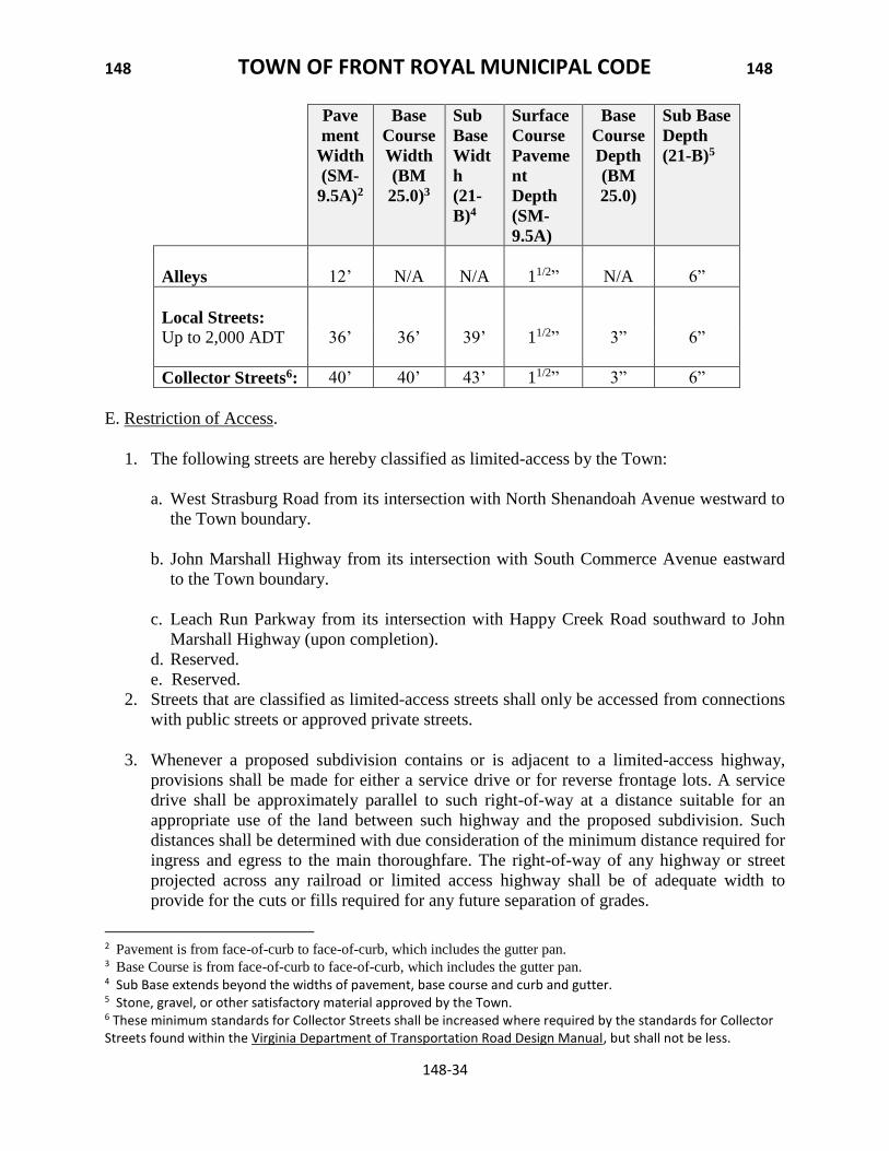
6. The minimum design standards of the following table shall be required for all Local
Streets, Collector Streets and Alleys. Arterial Streets design standards shall comply with
the Virginia Department of Transportation Road Design Manual, and associated
Appendixes.
1 The minimum right-of-way may be reduced when against the curb.
Minimum right-of-way width1
Alleys 20’
Local Streets
Up to 1,000 ADT 50’
1001 to 2,000 ADT 55’
Collector Streets 65’
148 TOWN OF FRONT ROYAL MUNICIPAL CODE 148
148-34
Pave
ment
Width
(SM-
9.5A)2
Base
Course
Width
(BM
25.0)3
Sub
Base
Widt
h
(21-
B)4
Surface
Course
Paveme
nt
Depth
(SM-
9.5A)
Base
Course
Depth
(BM
25.0)
Sub Base
Depth
(21-B)5
Alleys
12’
N/A
N/A
11/2”
N/A
6”
Local Streets:
Up to 2,000 ADT 36’ 36’ 39’ 11/2” 3” 6”
Collector Streets6: 40’ 40’ 43’ 11/2” 3” 6”
E. Restriction of Access.
1. The following streets are hereby classified as limited-access by the Town:
a. West Strasburg Road from its intersection with North Shenandoah Avenue westward to
the Town boundary.
b. John Marshall Highway from its intersection with South Commerce Avenue eastward
to the Town boundary.
c. Leach Run Parkway from its intersection with Happy Creek Road southward to John
Marshall Highway (upon completion).
d. Reserved.
e. Reserved.
2. Streets that are classified as limited-access streets shall only be accessed from connections
with public streets or approved private streets.
3. Whenever a proposed subdivision contains or is adjacent to a limited-access highway,
provisions shall be made for either a service drive or for reverse frontage lots. A service
drive shall be approximately parallel to such right-of-way at a distance suitable for an
appropriate use of the land between such highway and the proposed subdivision. Such
distances shall be determined with due consideration of the minimum distance required for
ingress and egress to the main thoroughfare. The right-of-way of any highway or street
projected across any railroad or limited access highway shall be of adequate width to
provide for the cuts or fills required for any future separation of grades.
2 Pavement is from face-of-curb to face-of-curb, which includes the gutter pan. 3 Base Course is from face-of-curb to face-of-curb, which includes the gutter pan. 4 Sub Base extends beyond the widths of pavement, base course and curb and gutter. 5 Stone, gravel, or other satisfactory material approved by the Town. 6 These minimum standards for Collector Streets shall be increased where required by the standards for Collector Streets found within the Virginia Department of Transportation Road Design Manual, but shall not be less.
148 TOWN OF FRONT ROYAL MUNICIPAL CODE 148
148-35
F. Approach Angle and Alignment. All streets shall approach each other at an angle of not less
than eighty degrees (80o) unless the Town shall approve a lesser angle of approach for reasons of
terrain, contour or the matching of existing patterns. Street jogs with a center-line offset of less
than one hundred twenty-five (125) feet shall not be permitted. Town Council may authorize a
waiver to this requirement if no other reasonable alternative exists and it is demonstrated that the
deviation will not result significant traffic problems.
G. Street Grades. Center-line grades for all streets shall not exceed ten percent (10%). The grade
of cul-de-sac turnarounds shall not exceed four percent (4%).
H. Cul-de-sac and Dead-end Streets.
1. Dead-end streets shall be prohibited, except for the circumstances listed below.
a. Dead-end streets shall be permitted as stubs to permit future extensions to adjoining
land or future phases of a subdivision or development.
b. Dead end streets shall be permitted where, in the opinion of the Planning Commission,
interconnectivity is not desired or feasible for the proposed type of subdivision or
development.
2. In such instances when dead-end streets are allowed, they shall be designed as cul-de-sac
streets.
3. Cul-de-sac streets shall not exceed eight hundred (800) feet in length and shall not furnish
access to more than twenty-five (25) individual lots.
4. Any dead-end street intended for access to an adjoining property or created as the result of
stage development shall be provided with a temporary all-weather turnaround within the
subdivision. Such dead-end streets shall not exceed eight hundred (800) feet in length from
the center line of the nearest road intersection.
5. Except for permanently designed cul-de-sac streets, the turnaround right-of-way of dead-
end streets shall be placed adjacent to the tract on the subdivision stage boundary with
sufficient additional width provided along the boundary line to permit extension of the
street at full width.
6. All dead-end and cul-de-sac streets shall be provided at the closed end with a turnaround
whose minimum radius shall be forty (40) feet.
7. Drainage of cul-de-sac streets shall preferably be designed towards the open end. If
drainage is designed toward the closed end, adequate provisions shall be made for runoff
to be carried away. Drainage easements shall be required where necessary.
148 TOWN OF FRONT ROYAL MUNICIPAL CODE 148
148-36
I. Street Signs and Names. All procedures and standards for street signs and names shall be
consistent with the E-911 Addressing System which shall supersede the standards below in the
case of any conflict between them.
1. At each street intersection within or adjacent to the proposed subdivision, one (1) street
identification sign of a design approved by the Town shall be installed by and at the
expense of the subdivider/developer. Such signs shall comply with VDOT’s street sign
requirements and the Federal Highway Administration’s Manual on Uniform Traffic
Control Devices.
2. Street names shall be subject to the approval of the Town Council. Names of existing
streets shall not be changed except by approval of the Council.
3. A proposed street which is in alignment with an existing named street shall bear the name
of the existing street.
4. The name of a proposed street shall not duplicate that of an existing street in the Town or
in the postal district. The use of the following suffixes: street, road, avenue, boulevard,
drive, way, place, court, lane, etc., shall constitute a duplication if used after a name which
is repeated after the suffix. Names which may be confused with existing street names shall
be avoided.
5. Should development on a street occur prior to acceptance of the street for maintenance by
the Town, temporary signs indicating “Not Maintained by the Town” with the proposed
street name shall be installed by the developer.
J. Alleys
1. Alleys may be permitted where vehicular access to lots is restricted from public streets.
2. Dead-end alleys shall be avoided. In the event that this proves impractical, dead-end alleys
shall terminate with an all-weather circular turnaround having a minimum radius of forty
(40) feet.
3. Alley intersections and sharp changes in alley alignment shall be avoided.
4. Notwithstanding the requirements of Section 148-870.A.20, rear load parking access from
alleys is permitted as a means of meeting required parking standards.
K. Driveways. Private driveways on corner lots shall be located at least forty (40) feet from the
curbline intersection.
L. Railroad Crossings. The creation of new at-grade railroad crossings shall be prohibited,
unless it involves the closure of one or more existing at-grade railroad crossings and improves
overall safety. Existing at-grade railroad crossings shall not be used as the primary means of
access to a subdivision or development. Where existing at-grade railroad crossings are utilized as
148 TOWN OF FRONT ROYAL MUNICIPAL CODE 148
148-37
secondary access or are included within the streets of a subdivision, the applicant shall be
responsible for providing flashing lights and short-arm gates, unless the railroad track is no
longer active.
M. Subdivision and Development Entrances.
1. All means of access and entrances to a subdivision or development shall conform to all
applicable standards of the Town and the Virginia Department of Transportation.
2. Where feasible, each subdivision shall provide two (2) connections to an existing public
street where the traffic generated from the subdivision or development is between five
hundred one (501) and two thousand (2,000) ADT's. Three (3) road connections shall be
provided where the traffic generated exceeds two thousand (2,000) ADT's. In situations
where only one (1) street connection is physically possible, due to topography, site
distance or road frontage, the single entrance street shall be a four-lane restricted access
divided road with a length of not less than two hundred fifty (250) feet for roads
generating two thousand one (2,001) or more ADTs, and for every additional five hundred
(500) ADTs generated, the four lane divided street standard shall be extended an
additional one hundred (100) feet. Streets with two thousand (2,000) or fewer ADTs shall
not be subject to this requirement.
N. Private Streets, Common Driveways, and Common Parking Courts.
1. Private Streets
a. Subdivisions on existing private non-dedicated private streets are permitted only as
follows:
[1] Each lot parcel shall be a minimum of two (2) acres in area, regardless of zoning
district classification.
[2] Each lot and residual parcel shall abut with a minimum frontage of one hundred
seventy five (175) feet on the existing private non-dedicated street, regardless of
zoning district classification.
[3] The existing private non-dedicated street shall have been platted and recorded in
the office of the Clerk of the Circuit Court of Warren County on or before
December 31, 1978.
[4] The existing non-dedicated street shall have a platted width of at least fifty (50)
feet at the date of subdivision approval. For subdivisions along Locust Dale Road,
the width can be approved as thirty (30) feet for that section at or near John
Marshall Highway.
[5] As of the date of subdivision approval, the platted non-dedicated street shall be in
existence and shall conform to minimum design standards of a graded road surface
148 TOWN OF FRONT ROYAL MUNICIPAL CODE 148
148-38
of at least twenty (20) feet wide, suitable for motor vehicle traffic, topped with
gravel, crushed stone or other all-weather material, and provided with such
culverts and ditching as are necessary to carry water runoff and to prevent erosion
of the road surface. Conformity with said minimum design standards shall be
subject to the inspection and approval by the Town.
[6] In order to facilitate future dedication of street right-of-way, the applicant shall
dedicate to the Town of Front Royal such additional footage along the street
frontage of each lot and residual parcel necessary to increase the street width to
that required for the type of street in accordance with this Chapter, for that portion
of the street abutting the subdivided lots and residual parcels. The applicant shall
further dedicate to the Town of Front Royal any and all property interest he may
possess in the existing non-dedicated street as a whole.
[7] All the aforesaid dedications shall be contingent and shall not take effect until such
time as the entire street or a contiguous portion connected to a public street is
improved to the then-current state standards for public streets, is subsequently
dedicated to the Town of Front Royal by all parties in interest and is accepted by
the Town of Front Royal as a public street. Until such time, the Town of Front
Royal shall be under no obligation to maintain or improve any portion of the
aforesaid street, and the Town shall not be liable for any acts or omissions
associated with the street and its use.
[8] The private street does not exceed a total of 25 dwelling units or lots.
b. Subdivisions on new non-dedicated private streets may be permitted upon the approval
of a special exception by Town Council. In addition to the general submission
requirements for special exceptions, as prescribed under this Chapter, requests for
private streets through the special exception process shall include a concept plan
prepared by a Virginia registered architect, landscape architect, land surveyor or
engineer with seal and signature affixed to the plan. The plan shall be approximately to
scale and clearly show the following:
[1] Location map showing existing zoning and ownership of property and adjacent
land;
[2] Identification of principal site features, including topography, steep slopes,
wetlands, wooded areas, archeological areas, floodplains, and other features of
significant public interest.
[3] Relationship of the proposal with surrounding utilities and public facilities to serve
the tract at the ultimate proposed densities;
[4] A general layout of the road system within the project, including all proposed
private and public streets and land uses.
148 TOWN OF FRONT ROYAL MUNICIPAL CODE 148
148-39
[5] Detailed information on the proposed private street standards with an explanation
of the reason for any modifications to the public street standards of this Chapter.
[6] A description of the provisions for continued maintenance of any proposed private
street.
[7] A description of the private deed restrictions that will be provided as notice to
future property owners regarding the limitations of service available on any
proposed private streets.
2. Subdivisions abutting approved non-dedicated common driveways may be permitted as
follows:
a. Each lot shall be a minimum of two (2) acres in area.
b. Each approved common driveway shall serve no more than six (6) single-family
residential lots.
c. Common driveways permitted under this section shall have a minimum pavement width
of twenty (20) feet and a minimum public easement width of forty (40) feet and shall
not serve a through function. All common driveways shall be designed and constructed
in accordance with the construction standards of the Town of Front Royal and shall be
sufficient to accommodate emergency vehicle travel.
d. No common driveway shall be located within twenty-five (25) feet of any abutting
property which is not directly served by the common driveway.
e. Each common driveway shall connect with a publicly dedicated street or highway. No
common driveway shall be more than six hundred (600) feet in length.
f. Each common driveway shall be clearly identified as such. A single sign, not to exceed
two (2) square feet in area, shall be posted at the entrance, displaying only the words
"Private Drive" and the addresses of the residences utilizing the common driveway.
Addresses shall be assigned to the dedicated public street to which the common
driveway connects.
g. In addition to all other requirements for a final subdivision plat, any subdivision
containing a common driveway shall include a statement on the final subdivision plat
acknowledging a perpetual private maintenance responsibility and guaranteeing public
utility and emergency vehicle access.
3. Subdivisions with townhouse or duplex lots abutting common parking courts shall be
permitted as follows:
a. Each approved common parking court shall serve no more than a total of thirty-six (36)
dwelling unit lots, one (1) dwelling unit per lot. A minimum of two and a half (2 1/2)
parking spaces are required for each Townhouse unit.
148 TOWN OF FRONT ROYAL MUNICIPAL CODE 148
148-40
b. No common parking court shall serve a through function, and all common parking shall
be designed in accordance with the provisions of Section 148-870.D.
c. Common parking areas shall be adequately landscaped to ensure the residential
character of the development, as provided in Section 148-870.
d. No common parking court shall be located within twenty five (25) feet of any abutting
lot which is not directly served by the common parking court.
e. Each common parking court driveway shall be clearly identified as a private
roadway. A single sign, not to exceed two (2) square feet in area, shall be posted at the
entrance, displaying only the words "Private Drive" and the addresses of the residences
utilizing the parking court. Addresses shall be assigned to the dedicated public street to
which the common driveway connects.
f. In addition to all other requirements for a final subdivision plat, any subdivision
containing a common parking court shall include a statement on the final subdivision
plat acknowledging a perpetual private maintenance responsibility and guaranteeing
public utility and emergency vehicle access.
g. Townhouses and/or duplexes that utilize common parking courts shall include a
minimum of 4 acres.
148-830 BLOCKS AND LOTS
A. Block Length. Blocks should not normally exceed one thousand two hundred (1,200) feet,
unless unusual circumstances justify greater length. Within blocks of over eight hundred (800)
feet in length, the Town may require dedication of a ten-foot right-of-way at or near the middle
of the block for a public pedestrian walkway connecting adjacent streets or other public and
private areas.
B. Block Depth. Blocks should be wide enough to allow two (2) tiers of lots of appropriate
depth, except where an interior street parallels an arterial street or highway or where
topographical conditions or the parcel size make a double tier impractical. In these cases, the
Town Council may approve a single tier of lots.
C. Lot Shape.
1. Lots shall not contain peculiarly shaped elongations, unusable for normal building
purposes, solely to provide necessary square footage.
2. The depth of residential lots shall not be less than one (1) nor more than four (4) times the
width, unless the Town approves other configurations because of unusual topographical
conditions.
148 TOWN OF FRONT ROYAL MUNICIPAL CODE 148
148-41
D. Lot Location.
1. The municipal boundary of the Town shall not cut through lots but rather shall act as lot
lines for property adjacent to either side of the municipal boundary.
2. Each lot shall abut a street dedicated to and accepted by the Town of Front Royal, and
each lot shall have a minimum frontage of fifty (50) feet on said street, or other minimum
as specified in Chapter 175, Zoning, of the Municipal Town Code.
E. Remnants. All remnants shall be added to adjacent land within a subdivision.
F. Residual Parcels. For the purpose of this ordinance a residual parcel shall be treated as a
typical lot.
148-840 UTILITIES AND SERVICES
A. Sanitary Sewer.
1. The applicant shall provide the type of sanitary sewer disposal facility determined by the
Town and the Health Department to be consistent with existing physical, geographical and
geological conditions. Connection to the Town sanitary sewer system shall be required, if
available. Where Town sanitary sewers are not available, the following types of sanitary
sewage disposal facilities shall be employed in order of desirability:
a. Community sanitary sewage system with a temporary sewage treatment plant.
b. On-lot disposal with septic tank and drain field.
2. Sanitary sewers, whether public, community or on-site, shall be designed and constructed
in strict accordance with standards of the Department of Health, Department of
Environmental Quality, and/or the Town’s construction standards, as applicable.
3. The sewer system and all service lines and appurtenances shall be installed in accordance
with the plans and profiles prepared for the subdivision or development by a professional
engineer or licensed land surveyor and shall be approved by the Town Engineer.
4. Sanitary sewers shall not be used to carry stormwater.
5. Where the Town determines that the public sanitary sewage collection system is
accessible to the subdivision, the connections from the system to the property line of each
lot in the subdivision shall be made at the time that the general site improvements are
installed. Sewer connection shall be installed by the applicant at his own expense in
accordance with the design and specifications of the Town of Front Royal and shall be
inspected by the Town in each instance.
6. Sanitary sewer lines installed in accordance with plans and specifications approved by the
Town shall be required improvements in each subdivision or development to serve each
148 TOWN OF FRONT ROYAL MUNICIPAL CODE 148
148-42
subdivision lot, except where the Town sewer lines are not available to the subdivision site
and septic tanks are to be employed. The applicant at the time the sanitary sewer lines are
constructed shall, at his own expense, install connections from the sanitary sewage lines to
the property line of each lot in the subdivision not then served by the existing public
sanitary sewage system.
7. The subdivider or developer shall be required to warrant and repair any deficiencies in the
constructed sanitary sewer system for one (1) year following the date of acceptance by the
Town Council.
B. On-site Sewage Disposal.
1. Subdivisions and developments that propose an on-site sewage disposal system shall
provide the results of a soil evaluation from an Authorized On-site Soil Evaluator (AOSE)
at the time of preliminary plan submittal.
2. No plat shall be approved for a subdivision or development where septic tanks are to be
used, unless a tentative approval from the Health Department is received stating that all lots
have a suitable site for a septic tank system.
C. Water Supply.
1. Complete water main line systems installed in accordance with plans and specifications
approved by the Town shall be required improvements in each subdivision or development
to serve each subdivision, except where Town water lines are not available to the site and
individual wells are to be used. Where determined feasible by the Town, water lines
serving any cul-de-sac or other dead-end street exceeding three hundred (300) feet in length
shall be connected back in a loop to the water distribution system. A blowoff valve
assembly shall be installed at the end of all temporary dead-end streets, where no
permanent fire hydrant is installed or where no loop back into the water distribution system
is provided, for the purpose of periodic flushing of the water mains. Such systems shall
furnish an adequate supply of water to each lot and shall have adequate main sizes and fire
hydrants located and installed in accordance with specifications of the Town of Front
Royal. A copy of the preliminary approval of such system by the appropriate public agency
or utility company shall be submitted with the final plat. 2. The water system and all service lines and appurtenances, except the water meter, shall be
installed in accordance with the plans prepared for the subdivision or development by a
professional engineer or licensed land surveyor and shall be approved by the Town
Engineer.
3. In instances where Town water is not available to the subdivision site, the Town may
require the applicant to provide his own community water system in accordance with plans
and specifications approved by the Town and the State Department of Health. Agreements
may be required as to the ownership and maintenance of private community water systems.
148 TOWN OF FRONT ROYAL MUNICIPAL CODE 148
148-43
A copy of the approval of such system by the appropriate public agency or utility company
shall be submitted with the final plat.
4. Where the Town water system is accessible to the subdivision site, the connections from
the system to the property line of each lot in the subdivision not served by Town water
shall be made at the time the general site improvements are installed. The water
connections shall be installed by the applicant at his own expense in accordance with the
design and specifications of the Town of Front Royal and shall be inspected by the Town in
each instance.
5. Where individual wells or other on-site water supply systems are to be utilized, each lot so
served shall be of such size and shape to allow safe location of the water source, in
accordance with Health Department requirements.
6. The subdivider or developer shall be required to warrant and repair any deficiencies in the
constructed water service system for one (1) year following the date of acceptance by the
Town Council.
D. Stormwater Management.
1. Storm drainage facilities: adequacy, size and capacity.
a. Stormwater management facilities designed and installed for subdivisions and
developments shall have the hydraulic characteristics necessary to accommodate the
expected flow of stormwater from a given watershed or portion thereof for a specified
duration and intensity of rainfall, as stated in Subsection 2 shown below.
Determination of flooding and channel erosion impacts to receiving streams due to land
development projects shall be measured at each point of discharge from the
development project and such determination shall include any runoff from the balance
of the watershed which also contributes to that point of discharge.
b. Stormwater management facilities shall be designed to:
[1] Account for both on-site and off-site stormwater;
[2] Honor natural drainage divides;
[3] Convey stormwater to a stream, water channel, natural drainageway or existing
facility;
[4] Discharge stormwater into an existing facility of sufficient capacity to receive the
same; and
[5] Not increase stormwater flow so as to create the potential for an increased hazard to
downstream landowners.
c. In determining the size and capacity of an adequate stormwater drainage system design,
the applicant shall take into account the characteristics and location of the subdivision
or development in the watershed or affected portions thereof. The design shall not
adversely affect adjacent or neighboring properties.
148 TOWN OF FRONT ROYAL MUNICIPAL CODE 148
148-44
2. The method used for determining the specified design storms and determining pre-
development and post-development runoff rates shall comply with the current standards
and guidelines of the Department of Conservation and Recreation (DCR).
3. Off-site stormwater management. The following minimum criteria shall apply to protect
waterways and property downstream from erosion due to increases in the volume, velocity
and peak flow rate of stormwater runoff resulting from new subdivision and development
activities.
a. Concentrated stormwater runoff leaving a subdivision or development site must be
discharged directly into a well-defined natural or man-made receiving channel or pipe.
If there is no well-defined receiving channel or pipe, one must be constructed to convey
stormwater to the nearest adequate channel. Increased volumes of unconcentrated sheet
flows which will cause erosive action or sedimentation on adjacent properties shall be
diverted to a stable outlet or detention facility. Adequacy of channel design shall be
verified by the Town.
b. Each stormwater management/Best Management Practices (BMP’s) plan shall require
that peak rate and velocity of runoff be controlled and that land and receiving
waterways which are downstream from the land development be protected from
stormwater runoff damage, as provided herein:
[1] To protect downstream properties and receiving waterways from flooding, the ten
(10) year post-development peak rate of runoff from the land development shall not
exceed the ten (10) year predevelopment peak rate of runoff.
[2] To protect downstream properties and receiving waterways from channel erosion,
the two (2) year post-development peak rate and velocity of runoff from the land
development shall not exceed the two (2) year pre-development peak rate and
velocity of runoff.
[3] If the land development is in a watershed for which a hydrologic and/or hydraulic
study has been conducted or a stormwater model developed, the Town Engineer
may modify the requirements of paragraphs 1) and 2) so that runoff from the land
development is controlled in accordance with the findings in the study or model, or
to prevent adverse watershed stormflow timing, channel degradation, and/or
localized flooding problems.
[4] In addition to the requirements of paragraphs 1) and 2), the Town Engineer may
require that the plan include additional measures to address damaging conditions to
downstream properties and receiving waterways caused by the land development.
[5] Pre-development and post-development runoff rates determined using methods
consistent with the requirements identified in the current Department of
Conservation and Recreation (DCR) Stormwater regulations and guidelines.
148 TOWN OF FRONT ROYAL MUNICIPAL CODE 148
148-45
c. In the event that any existing off-site receiving channel is to be employed for
subdivision or development runoff but said channel does not conform to the
requirements of this chapter, the applicant shall:
[1] Obtain permission from downstream property owners and improve the receiving
channel so as to bring it into compliance. Such drainage improvements shall extend
downstream until an adequate channel section is reached.
[2] Develop a site design that will not cause an increase in the existing predevelopment
peak runoff rate for ten-year storms. Such a design may be accomplished by
enhancing the stormwater infiltration capacity of the site or by providing on-site
stormwater detention measures. The estimation of pre-development and post-
development peak runoff rates shall be verified by engineering calculations
submitted to the Town.
[3] Provide a combination of channel improvement, stormwater detention or other
measures satisfactory to the Town designed to prevent overflow and to prevent
channel erosion.
d. All channel improvements or modifications shall comply with applicable laws and
regulations. Modifications to flowing waterways shall be performed in accordance with
Best Management Practices for Hydrologic Modifications, Virginia State Water
Control Board Planning Bulletin 319, 1979, or as may be subsequently amended.
4. Drainage easements and fencing.
a. Where a subdivision or development is traversed by a watercourse, drainageway,
channel or stream, the Town shall be granted a drainage easement, conforming to the
line of such watercourse, drainageway, channel or stream, of such width as required
under Section 148-840.E. to preserve the unimpeded flow of natural drainage or such
additional width as may be necessary to provide for the widening, deepening, relocation,
improvement or protection of the watercourse and drainage facilities.
b. All stormwater outlet pipes installed on residential lots shall extend to a point beyond
the buildable area of the lot.
c. Dedicated drainage easements shall be granted to the Town for all stormwater
management facilities. Fencing of stormwater drainage facilities designed to retain or
detain runoff may be required by the Town for facilities exceeding 25% side slopes or
water depth of three (3) or more feet. When fencing is required, a fifteen (15) foot wide
gate shall be installed at the access point to the facility.
d. All stormwater drainage systems that depend on off-site channels or conveyances shall
secure an easement for the channel to an adequate public facility designed to receive
stormwater runoff, and shall include any necessary improvements required for adequate
148 TOWN OF FRONT ROYAL MUNICIPAL CODE 148
148-46
conveyance of storm water runoff to the nearest public facility, be it a ditch, sewer or
pond.
e. All designs for stormwater management facilities shall be reviewed by the Town
Engineer to verify compliance of the requirements within this Chapter.
E. Utility Easements.
1. Utility easements with a minimum width of ten (10) feet for underground electric facilities
and twenty (20) feet for overhead electric facilities shall be dedicated to the Town for all
electrical facilities and appurtenances intended to service subdivisions or developments.
Easements for water, sanitary sewer, and stormwater facilities shall be dedicated to the
Town with the following minimum widths:
TABLE 148-840.E.
System Minimum Easement Width
Open Stormwater Channel 20’
Up to 33” Pipe 20’
34” – 48” Pipe 25’
49” – 72” Pipe 30’
For trench depths greater than six (6) feet, the easement width shall be increased by an
additional five (5) feet for each incremental five (5) feet of depth. Additional easement
width shall be required for areas of steep slopes as required by the Town.
2. To the fullest extent possible, utility easements shall be centered on or adjacent to side lot
lines.
3. Utility easements shall be granted in accordance with the specifications and requirements
of appropriate utility companies.
F. Underground Wiring and Electric Service.
1. All electric, telephone, television and other communication lines, both main and service
connections, installed for new subdivisions or developments shall be made by underground
wiring. Underground wiring shall be contained within a single unified utility easement
located under dedicated public rights-of-way or other public easements. The Town Council
may waive the requirements of this section only where the substantial presence of rock at a
depth of less than four (4) feet below finished grade makes the installation of underground
wiring impractical.
2. The location of all lines and facilities shall be subject to the approval of the Town of Front
Royal. Except where street crossings are required or where otherwise approved by the
Town, underground electric lines shall not be located beneath street pavement, structures or
other dedicated improvements and generally shall be located in a ten-foot easement parallel
to the street right-of-way.
148 TOWN OF FRONT ROYAL MUNICIPAL CODE 148
148-47
3. Lots and development that abut easements where there are existing overhead electric or
communication distribution supply lines or service connections may be supplied with
service from these overhead lines, but the service connections to these overhead lines shall
be installed underground. In the event that existing overhead lines are replaced or relocated
in the course of subdivision development, the replaced or relocated lines shall be installed
underground, unless the section so replaced or relocated is, in the determination of the
Town, too insignificant to make underground installation practical.
4. Where overhead lines are permitted by the Town, the placement and alignment of the poles
shall be designed to lessen the visual impact of the overhead lines. Alignments and pole
locations shall be carefully routed to avoid locations along horizons. The clearing of swaths
through areas of trees shall be avoided by selective cutting and staggered alignment. Trees
shall be planted in open areas and at key locations to minimize the alignment of poles.
5. The subdivider, developer or builder shall be responsible for all engineering, trenching,
backfilling and installation and expense of conduits for the underground electric system.
All conduits shall be fitted with pull wires for the electric conductor. Conductors shall be
Schedule 40 PVC or such other quality material as may be approved by the Town of Front
Royal. Primary line conduits shall be three (3) inches in diameter. Secondary line conduits
and conduits used for street crossings shall be four (4) inches in diameter. All work, design
and material shall be in accordance with the conditions and specifications of the
Department of Energy Services. 6. The Town of Front Royal shall supply and install electrical conductors and such
transformers, pedestals and other electrical equipment, except as otherwise stated in this
Chapter, as are necessary for the operation of the underground electric system. In the event
that the conduit pull wire should break prior to or in the course of line installation, for
whatever reason, it shall be the subdivider's sole responsibility to replace the pull wire
within the conduit at his own expense.
7. The Town shall supply up to one-hundred twenty-five (125) feet of conductor for each lot
from the pedestal to the electric meter located on the lot’s structure. The builder of said
structure shall pay for all conductor over one hundred twenty-five (125) feet. In addition,
the builder shall be responsible for all trenching and backfilling and shall supply three-inch
Schedule 40 PVC conduit with pull wire from the pedestal to the electric meter installed on
the lot’s structure, and schedule 80 PVC conduit for all sweeps. In addition, a slip joint
shall be installed between the last elbow and the bottom of the meter base. Should the
conduit pull wire break, the builder shall be responsible for replacement of the pull wire at
his sole expense. All work and materials shall be in accordance with the conditions and
specifications of the Department of Energy Services. Electric meters shall be furnished and
installed by the Town of Front Royal.
8. All underground electric systems shall include connections for streetlight poles located
every three hundred (300) feet along subdivision streets. Pole location shall be subject to
the approval of the Town of Front Royal. Except where otherwise approved, pole location
shall be staggered on the opposite sides of the street. No overhead wires shall be permitted
148 TOWN OF FRONT ROYAL MUNICIPAL CODE 148
148-48
to serve streetlights. All streetlights poles and bases shall be equipped with wiring and
connections to the underground electric system and shall be in accordance with the
conditions and specifications of the Department of Energy Services. Streetlight poles and
bases shall be supplied and installed by the subdivider or developer at his sole expense, or,
at the Town's option, streetlight poles and bases may be installed by the Town of Front
Royal at the subdivider's or developer’s expense. All pole lights shall be supplied and
installed by the. The Town retains complete discretion as to when and if streetlight poles
and lights will be installed. 9. All materials and improvements comprising the underground electric system shall be
dedicated to the Town of Front Royal and shall be depicted on the subdivision plat. A ten-
foot-wide easement shall be dedicated to the Town of Front Royal for the operation,
maintenance and repair of the underground electric system.
148-850 STREET IMPROVEMENTS
A. Streetlights.
1. Streetlights shall be installed to illuminate streets and other public highways. The
installation of streetlights shall be accordance with the design standards and specifications of
the Town.
2. Streetlights shall be spaced at a maximum of three hundred (300) feet apart and staggered
on opposite sides of the street with one streetlight every six hundred (600) feet on both sides
of the road.
B. Monuments.
1. Street Monuments. Street right-of-way lines shall be marked at all points of tangent and
points of curve with a steel rod or iron pipe not less than one-half (1/2) inch in diameter
and eighteen (18) inches in length. Following completion of road work, a steel rod or iron
pipe shall also be placed at street centerline, centerline points of tangent and points of curve
and the radius point of each new cul-de-sac.
2. Corner Monuments. All lot corners shall be marked with a steel rods or iron pipe not less
than one-half (1/2) inch in diameter and eighteen (18) inches in length, driven flush with
the finished grade.
3. In the event a steel rod or iron pipe cannot be set due to an obstruction, an offset monument
may be set or the point may be marked by drill hole, chisel mark or other method deemed
appropriate by the professional and so documented to the Director.
4. All required monuments shall be installed by the subdivider or developer. Upon
completion of subdivision streets, sewers and other improvements, the subdivider or
developer shall make certain that all monuments required by the Town are clearly visible
148 TOWN OF FRONT ROYAL MUNICIPAL CODE 148
148-49
for inspection and use. All monuments must be set before any site or street improvements
are accepted by the Town.
C. Curb and Gutter.
1. Curbs and gutter shall be required for the purpose of drainage and safety and delineation
and protection of the pavement edge. Curbs and gutters and all driveway entrances shall
meet the design standards found within the Construction Standards and Specifications
Manual.
2. Curbs and gutters shall be installed by the applicant along both sides of all new streets. For
all subdivisions involving the creation of an additional lot and for all new development
projects, curb and gutter sections shall be required along the frontage of all existing public
streets. This requirement may be waived upon approval by Town Council in residential
areas where the majority of surrounding developed properties do not have curb and gutter,
where the character of the area is relatively low-density, after consideration of the traffic
impact created by the subdivision and the total lots on a given street, drainage
considerations and other environmental design parameters. The Town Engineer may
waive curb & gutter for development projects comprising of no more than two (2)
dwelling units in residential areas along existing streets where curb & gutter is not
currently present within 200 feet of the property.
D. Sidewalks.
1. Sidewalks shall be installed by the applicant along both sides of all new streets. For
subdivisions involving the creation of an additional lot and for all new development
projects, sidewalk sections shall be required along the frontage of all existing public
streets. This requirement may be waived on vote of the Town Council in residential areas
under the following conditions: where the character of the area is relatively low-density,
after consideration of the traffic impact created by the subdivision and the total lots on a
given street, drainage considerations and other environmental design parameters. The
Town Engineer may waive sidewalks for development projects comprising of no more
than two (2) dwelling units in residential areas along existing streets where sidewalks are
not currently present within 1000 feet of the property.
2. The minimum design standards for sidewalks shall be at least six (6) feet in width when
abutting the curb, and a minimum of five (5) feet when offset from the curb. For the
latter, the land located between the sidewalk and the curb shall comply with the
Construction Standards and Specifications.
3. Sidewalks shall normally be parallel to the street. Nonparallel sidewalks and/or walkways
may be approved by the Town in order to preserve topographical or natural features and to
provide visual interest.
4. Where pedestrian walkway systems have been approved as an alternative to sidewalks, the
walkways may be located away from streets, linking groups of dwelling units with other
groups of dwelling units and/or facilities such as parking areas, recreational areas and
148 TOWN OF FRONT ROYAL MUNICIPAL CODE 148
148-50
activity centers. In reviewing the location of alternative walkway systems, the Town shall
consider safety, practical accessibility and aesthetics.
5. Public easements shall be granted for sidewalks and/or walkways located outside the
public right-of-way.
6. All sidewalks shall be constructed in accordance with Town standards and specifications
and shall conform to the requirements of Section 15.2-2021, Code of Virginia, as
amended, requiring curb ramps for the handicapped. Curb ramps shall comply with the
Virginia Department of Transportation’s Road and Bridge Standards.
E. Solid Waste Disposal and Collection.
1. All developments with exterior trash disposal or collection areas shall locate these sites so as to
facilitate collection and minimize the negative impact on residents, neighboring properties and
public rights-of-way.
2. All visible trash disposal or collection and storage areas shall be screened from neighboring
residential properties and from public property, including streets, parks, sidewalks and other public
areas.
3. Screening shall consist of a combination of landscaping and fencing. A solid wood or masonry
fence at least six (6) feet in height shall be provided on three (3) sides, with a solid opaque gate on
the fourth side. Landscaping shall be incorporated to improve the visual appearance.
4. All permanently installed trash containers shall be adequately sized to handle the needs of the
facility or development and shall be equipped with fitted lids to prevent odor leakage and
infestation from rodents, insects, and other pests.
148-860 ENVIRONMENTAL IMPROVEMENTS
A. Steep Slopes.
1. Purpose: Steep slopes, when developed, require more grading and land disturbance than
development of flat to gently sloping topographical areas. Therefore, the purpose of this section is
to establish protective regulations to:
a. Minimize soil disturbance on steep or critical slopes due to the potential for erosion problems;
b. Assist in the prevention of soil erosion from storm water runoff, protect downstream buildings
and yards from water and soil intrusion, and protect the Town’s surface and groundwater
resources from siltation and contamination;
c. Promote stable building sites that prevent soil erosion and are structurally sound so as to
maintain slope stability;
d. Promote accessibility for fire and rescue apparatus;
148 TOWN OF FRONT ROYAL MUNICIPAL CODE 148
148-51
e. Maintain the visual and environmental resources that are part of the character of Front Royal;
and
f. Encourage innovative development in Front Royal by providing the flexibility necessary to
produce environmentally sensitive subdivisions which direct building, parking and street
locations to terrain more suitable to development while maximizing conservation of the
original slopes, native cover, prominent land forms, rocky outcrops, natural open space,
wildlife habitat and scenic resources.
2. Applicability: All proposed subdivisions which result in the creation of an additional building lot
or lots with the exception of boundary line adjustments, must submit a plan, in addition to any
required subdivision development, street construction or erosion & sediment control plan,
identifying predevelopment areas of steep slope. Clear cutting or grading for the purpose of
altering predevelopment slopes shall not be permitted.
3. Establishment of Steep Slope Areas: The predevelopment slopes shall be computed by rise over
run from naturally occurring contour lines based on topographic information showing two foot
contour intervals and based on NAVD 88 vertical datum. The topographic data may be field run
or from aerial photography, provided the information is current and the contouring method
provides the precision expected for the contour interval used. a. Identification of Steep Slope Areas: Steep slopes areas are classified into one of the following
two categories:
[1] All areas of slope between 15% and 25% which contain highly erodible, highly
permeable or shrink-swell soils. Determination of soils which are highly erodible, highly
permeable or shrink-swell shall be based on the USDA Soil Conservation Service Soil
Survey of Warren County, Virginia, or based on soils analysis prepared by a geotechnical
engineer or other appropriate licensed professional.
[2] All areas of slope greater than 25%.
b. Minimum Size of Steep Slope Area: Steep slope standards do not apply to isolated steep slope
areas that are less than 5,000 square feet in land area. For the purposes of this provision, the
entire contiguous area of the steep slopes shall be included in the minimum size calculations,
regardless of the number of individual lots or different land ownerships involved.
4. Creation of Slope Overlays: The plan identifying steep slopes and critical slopes must include
overlays over the entire tract involved identifying by color coding the following: a. All areas of slope between 15 to 25% which contain highly erodible, highly permeable or
shrink-swell soils.
b. All areas of slope greater than 25%.
5. Plan Requirements: An overlot grading plan, prepared by a professional licensed by the State of
Virginia to prepare such a plan, for the development, management, stabilization and preservation
of steep slope areas shall be prepared in accordance with the detail requirements of Town Code
Section 148 and upon submission of a report by a certified soil or geotechnical engineer, and/or
148 TOWN OF FRONT ROYAL MUNICIPAL CODE 148
148-52
other appropriate licensed professional, indicating if and how the steep slope may be safely
developed.
The final subdivision plat showing any lot or portion of any lot located within a steep slope
overlay area must contain a note stating that the property shown hereon is subject to the provisions
of Section 148-42, Steep Slopes, of the Town of Front Royal Subdivision Ordinance, in
accordance with the conditions shown on the approved overlot grading plan and/or geotechnical
report filed with the applicable and appropriate subdivision application.
6. Building Site Requirements: In addition to the requirements of the grading plan described herein,
the plan shall include the following standards:
a. Site development shall be designed in a manner that requires a minimum amount of alteration
to the steep slope.
b. Existing vegetation shall be preserved to the maximum extent possible.
c. No finished slopes are to be created with a final grade greater than 15% unless deemed
feasible by a geotechnical report.
d. Residential driveway grades exceeding 10% are not recommended. Residential driveway
grades greater than 10% shall be constructed in conformance with Virginia Department of
Transportation’s (VDOT) standard CG-9 or other applicable entrance detail requirements.
Commercial or industrial driveway grades shall be constructed in conformance with VDOT
standard CG-11 or other applicable entrance detail requirements. All driveways shall have a
nonerodable surface treatment, such as asphalt or concrete pavement. Side slopes for driveway
cuts shall not exceed 25% (4:1) unless deemed feasible by a geotechnical report.
e. Use of retaining wall is encouraged to reduce the steepness of man-made slopes and to provide
planting pockets conducive to vegetation and landscaping. All retaining walls shall require an
engineered design with the exception of non-tiered retaining walls with level backfill and no
surcharge loading with a height of 24 inches (2.0 feet) or less from the finished grade.
Retaining walls shall not exceed 72 inches (6.0 feet) in height from the finished grade,
however, the Town Council, at its discretion, may waive the maximum height requirement for
retaining walls located within non-residentially zoned areas. This provision is not intended to
preclude a structure’s foundation or basement wall or the creation of a walkout basement.
f. Landscaping and plantings shall be in accordance with Town Standards.
7. As-Built Plan Required: A post construction as-built survey of the approved steep slope overlot
grading plan shall be required prior to the issuance of an approved occupancy permit. The as-built
drawings shall clearly show any changes or variations from the approved design, and if deemed
significant by the Director, may require any such change or variation be brought into compliance
with the approved plan. The as-built information shall be shown on the original plan and include
the following:
a. Horizontal variations greater than 1.0 foot should be shown dimensionally or through plus
stations. Horizontal variations greater than 5.0 feet should also show the graphic relocation of
the object. Vertical elevation variations greater than 0.1 feet shall be provided for all shown
design elevations.
148 TOWN OF FRONT ROYAL MUNICIPAL CODE 148
148-53
b. All as-built information shall be shown on the original plan either as blocked in or drawn in a
different text style or font from that as shown on the original plan.
c. Each sheet of the plan shall contain the words “AS-BUILT” in bold text on or near the title
block.
d. Date, plan legend, bar scale and north arrow.
e. Retaining walls. Indicate type and show elevations of the top of wall and the lowest adjacent
finished grade.
f. Curb cut, driveway and material. Centerline grade of driveway with spot elevations.
g. Spot elevations of graded areas to determine grade of finished slope. Highlight all areas of
finished slopes exceeding design grade by more than 1%.
h. Horizontal location with dimensions of all structures with dimensions including porches,
decks, garages, etc. Show vertical elevations of first floor and basement floor.
i. Horizontal and vertical location of roof drains, foundation drains and other drainage outlets.
Locations of utility services.
j. Location of required plantings.
k. The final as-built plan must be stamped by Licensed Land Surveyor or Professional Engineer
and include certification that the as-built plan is substantially in conformance with the original
plan. If a geotechnical report is used, the appropriate licensed professional must certify that the
as-built is in conformance with the report.
8. Exemptions: Except as otherwise provided herein, no disturbance of steep slopes will be allowed
except for the following activities which may be permitted by exemption from the Director of
Planning & Zoning:
a. Utility service lines, walkways, steps, landings.
b. Emergency action to remediate an unstable slope which poses an imminent threat to health,
safety or welfare of the public. c. Normal landscape maintenance or routine arboreal activities, including small scale planting of
ornamental flowers or shrubs, and/or the removal of diseased or damaged trees, and/or the
removal of undesirable trees, provided revegetation is in conformance with Town Standards.
d. Disturbance for public roadway or street crossings, or other public purposes as determined by
the Director of Planning.
e. Construction of approved landscaping berms, drainage ditches or swales, ponds and dams and
other required storm drainage conveyance facilities.
148 TOWN OF FRONT ROYAL MUNICIPAL CODE 148
148-54
B. Erosion and Sediment Control.
All land disturbing activities shall conform to the requirements of the Virginia Erosion and
Sediment Control Handbook.
C. Preservation of Natural Features.
The arrangement of lots, blocks, streets, parking areas and structures shall be designed to make
the most advantageous use of topography and natural physical features. Tree masses and large
individual trees shall, whenever possible and consistent with the provisions of this chapter, be
preserved. Any system of sidewalks, roadways and lot layout shall be designed to take advantage
of the visual qualities of the area.
D. Floodplain Regulations.
1. Land within a one-hundred-year floodplain may be platted, provided that such lands are
not used to meet the minimum required lot size and are designated on the plats as a
floodplain easement area and that the subdivision would not necessitate changes to
topographic conditions that alter the floodway district.
2. All development within floodplain areas, as established by Chapter 175, Sections 76
through 78 of the Town Code, including dam and impounding structure break zones,
shall be subject to the regulations of Chapter 175, Sections 74 through 81.3 of the Town
Code.
3. Except where floodplain development is permitted, floodplain areas shall be maintained
in their natural state.
E. Landscaping.
All major subdivisions and developments meet the landscaping requirements found under
Chapter 156 of the Town Code, including, but not limited to, screens and buffers, development
tree plantings, street trees, and parking lot landscaping.
F. Light and Air.
1. All outdoor lighting fixtures shall be arranged or shielded to direct, or reflect, light away
from adjoining residential uses.
2. Where a site development plan is required, new outdoor lighting fixtures shall be
designed, constructed, and operated to meet the International Dark-Sky Association
(IDA) design standards or certifications for lighting; except that, the Planning Director
may authorize alternative design standards or certifications that reasonably achieve the
purpose of controlling the spillover of light onto adjacent properties and the sky, and
protecting the public safety by preventing glare from outdoor light.
148 TOWN OF FRONT ROYAL MUNICIPAL CODE 148
148-55
3. All outdoor lighting that produces harmful electromagnetic energy, including arc welding
or acetylene torches, shall be completely screened from view sufficiently to be
imperceptible beyond the lot lines.
4. All development shall conform to the regulations of the Virginia State Air Pollution
Control Board concerning the emissions of smoke, particulate matter, odors and other
gaseous pollutants.
5. All development shall comply not exceed the maximum height and setback regulations of
the underlying zoning district, as found under Chapter 175 of the Town Code.
148-870 PARKING AND LOADING AREAS
A. Parking Areas.
1. Off-street parking shall be provided in accordance with this subsection on every lot or
parcel on which any use is established or expanded.
2. Based on the type of use, the minimum quantity of required off-street parking spaces is
show in the following table.
TABLE 148-870.A.2
TYPE OF USE REQUIRED OFF-STREET PARKING
SPACES
Residential Two (2) parking spaces per dwelling unit.
Motels/hotels One (1) parking space per room and one (1)
additional parking space for every ten (10)
rooms.
Lodging/boarding/bed and
breakfasts
One (1) parking space per room and an additional
two (2) parking spaces for employees.
Shopping Centers Five (5) parking spaces per one thousand (1,000)
gross square feet for every shopping center
facility ten thousand (10,000) square feet in size
or less.
Four (4) parking spaces per one thousand (1,000)
gross square feet for every shopping center over
ten thousand (10,000) square feet.
Commercial/retail One (1) parking space per two hundred (200)
gross square feet.
Furniture/appliance/lumber and
building supply
One (1) parking space per four hundred (400)
gross square feet.
Wholesale, storage and
contractor’s facilities
One (1) parking space per one thousand (1,000)
gross square feet for nonpublic areas.
One (1) parking space per one hundred (100) net
square feet for public sales areas.
Self-service storage facilities One (1) parking space per twenty (20) individual
units, and one (1) additional space per three
148 TOWN OF FRONT ROYAL MUNICIPAL CODE 148
148-56
hundred (300) gross square feet of office area.
Art galleries/museums One (1) parking space per three hundred (300)
gross square feet.
Professional offices
One (1) parking space per three hundred (300)
gross square feet.
Medical/dental offices One (1) parking space per two hundred (200)
gross square feet.
Indoor recreation facilities One (1) parking space per two hundred (200)
gross square feet.
Bowling alleys Three (3) parking spaces per alley.
Outdoor recreation facilities One (1) parking space per two hundred (200) net
square feet of improved area.
Personal service facilities One (1) parking space per two hundred (200)
gross square feet.
Churches/theaters/other
assembly buildings/auditoriums
One (1) parking space per four (4) fixed seats in
the main assembly area or one (1) parking space
per one hundred (100) net square feet.
Day-care/nursery facilities One (1) parking space per employee and one (1)
parking space for every ten (10) children.
Nursing homes One (1) parking space for every four (4) beds,
and one (1) parking space per employee.
Hospitals One (1) parking space for every two (2) beds,
and one (1) parking space for each employee,
excluding medical doctors.
Funeral homes One (1) parking space for every four (4) fixed
seats or one (1) parking space per one hundred
(100) square feet net visitation area, plus five (5)
employee parking spaces.
Restaurants (sit-down) One (1) parking space for every four (4) seats.
Restaurants (carry-out) One (1) parking space per fifty (50) net square
feet of customer service area.
Restaurants (drive-through) Three (3) parking spaces plus stacking lanes for
six (6) vehicles.
Industrial Uses/Office
Component
One (1) parking space per three hundred (300)
gross square feet of office area.
Industrial
Use/Manufacturing/Distribution
Areas
One (1) parking space per employee and one (1)
space for every vehicle used on-site, plus one (1)
parking space per delivery/loading bay.
Automobile/motor vehicle
service facilities
Two (2) spaces per service bay or two (2) spaces
for every three hundred sixty (360) square feet.
Every such facility shall have a minimum of
three (3) parking spaces.
Car sales/rental facilities
One (1) parking space per each two thousand five
hundred (2,500) square feet of open sales display
area and one (1) parking space per employee. In
148 TOWN OF FRONT ROYAL MUNICIPAL CODE 148
148-57
addition, there shall be two (2) parking spaces
per service bay or two (2) parking spaces for
every three hundred sixty (360) square feet of
service bay area. There shall be a minimum of
three (3) spaces for the service bay areas of these
facilities.
Car wash (self-service)
One (1) parking space for drying vehicles, plus
two (2) stacked spaces per car wash bay.
Car wash (automatic)
Two (2) parking spaces for drying vehicles, plus
five (5) stacking spaces per car wash bay.
Libraries One (1) parking space per one thousand (1,000)
gross square feet.
Public/private schools One (1) parking space per employee, plus
parking space for school auditoriums as noted
above for auditoriums.
Greenhouse and landscape nursery facilities
One (1) parking space per four hundred (400) square feet of structured public selling area; one (1) parking space per one thousand (1,000) square feet of greenhouse/warehouse/plant storage areas; and one (1) parking space for each company vehicle.
Veterinary hospitals and kennels
One (1) parking space per three hundred (300) gross square feet.
3. When a use is not specifically listed above, the Director shall determine which of the
above categories to use to determine the spaces required, based on similarities between
the characteristics of the uses. When a use is not specifically listed above, the Director
may also use information provided by the applicant or other sources of information to
determine the number of spaces required.
4. Off-street parking areas shall be oriented to the buildings they are designed to serve and
shall be within three hundred (300) feet walking distance. Before off-site parking
facilities are approved, a written agreement thereto assuring their retention for such
purposes shall be properly drawn and executed by the parties concerned, and approved as
to form by the Town Attorney, and for compliance with the requirements of this Chapter
by the Director.
5. The Access to off-street parking areas shall be designed so as not to obstruct the free flow
of street traffic. There shall be adequate provision for ingress and egress to ensure ease of
mobility, ample clearance and the safety of vehicles and pedestrians. For corner lots, the
distance from the center line of the parking lot entrance to the curbline or pavement edge
of the street intersection shall be adequate to, in the opinion of the Director, provide a
safe and sufficient margin for normal traffic patterns and pedestrians at or about the
intersection in question.
6. Up to 20 percent of the total number of required off-street parking spaces may be
designated for compact cars if signage is posted in front of the space to notify vehicles
that the space is only for compact vehicles.
148 TOWN OF FRONT ROYAL MUNICIPAL CODE 148
148-58
7. With the exception of off-street compact car spaces, and off-street parallel spaces, off-
street parking spaces shall include an area of not less than 162 square feet (9’ x 18’).
Compact car spaces shall include an area not less than 144 square feet (8’ x 18’).
8. The width of all interior parking lot aisles providing direct one-way access to individual
parking spaces shall be as follows:
TABLE 148-870.A.8.
Parking Angle (degrees) Aisle Width (feet)*
30 12
45 15
60 18
90 22
*The minimum width of all interior parking lot aisles designed for two way traffic flow
shall be twenty (20) feet, except where 90 degree aisles are used, which shall require
twenty-two (22) feet.
9. A parking space shall be at least three (3) feet from a side or rear property line, except
where the parking is designed to be shared by the abutting property. No parking space
for multiple-family dwelling shall be less than ten (10) feet from a residential structure.
10. Parking areas shall be setback a minimum of five (5) feet from any building or structure.
This setback area may be used for sidewalks or landscaping.
11. Parking space already provided to meet off-street parking requirements for stores, office
buildings and industrial establishments lying within three hundred (300) feet of the place
of public assembly, as measured along lines of public access, which are not normally in
use on Sundays or between the hours of 6:00 p.m. and 12:00 midnight on other days may
be used to meet not more than seventy-five percent (75%) of the off-street parking
requirements of a church or other similar place of public assembly.
12. Any flea market, farmers' market or other open-air commercial activity not listed above
shall provide one (1) parking space for each one hundred (100) square feet of land to be
used by said flea market, farmers' market or other commercial activity in its open-air
operations. The amount of land to be used shall be designated by the respective open-air
business in its application for a special permit. If no special permit is required under this
chapter, the land to be used shall be designated in the application for a business license.
No business shall then use more land than has been designated in its application for
special permit or business license without the filing of a new application for a special
permit or business license as required herein and then complying with the parking space
requirements of this section.
13. For every commercial or industrial parking area located within fifteen (15) feet of the
side or rear boundary of a residentially zoned lot or a lot with a residential use, an opaque
ornamental fence or masonry wall with a minimum height of four (4) feet shall be erected
148 TOWN OF FRONT ROYAL MUNICIPAL CODE 148
148-59
and maintained. The provisions of this section shall not compel such fence or wall to
extend into the required front yard of the premises.
14. Parking areas, including aisles and maneuvering areas, shall be paved with bituminous
concrete, or similar hard surface material. The Director may approve stone, in lieu of
pavement, for parking areas of no more than 4,500 square feet in size.
15. Lights used to illuminate parking areas shall be arranged and shielded to minimize light
pollution to adjoining properties.
16. All parking areas shall meet the landscaping requirements of Section 156-6 of the Town
Code.
17. Off-street parking shall not be required on any lot fronting on that portion of Main Street
which extends from Royal Avenue to Happy Creek or upon that portion of Jackson Street
which extends between South Royal Avenue and Church Street.
18. As with the other standards of this chapter, off-street parking requirements may be
waived by special exception, in accordance with Section 148-211 of this Chapter.
19. Off-street parking requirements shall be waived by the Zoning Administrator for
expansion of an existing use for any property located within the Historic Front Royal
District where the following criteria are met:
a. The development activity proposed includes the retention and/or the substantial
renovation of a contributing structure in the district.
b. The square footage of additions or new construction shall not be more than twice that
of the original structure.
c. The proposed project has been found by the Board of Architectural Review to be in
keeping with the scale of development in the surrounding area and with the character
of the district as a whole.
d. All efforts have been made to provide parking whenever possible.
20. Alleys shall be upgraded to a minimum pavement width of 24 feet when they are used as
the primary access to parking areas, excluding individual parking for single-family, two-
family, and duplex uses.
21. Existing parking facilities shall be maintained in a safe condition, including the repair of
damaged areas, restriping, and resurfacing when necessary.
148 TOWN OF FRONT ROYAL MUNICIPAL CODE 148
148-60
B. Loading Areas.
1. On the same premises with every building, structure or part thereof erected and occupied
for uses involving the receipt or distribution of vehicles, materials or merchandise, there
shall be provided and maintained on the lot adequate space for standing, turning, loading
and unloading services in order to avoid interference with public use of the streets and
alleys.
2. Loading areas shall be a minimum of fifteen (15) feet wide and fifty-five (55) feet in
length, with a minimum clear height of fifteen (15) feet. An off-street truck loading space
shall be provided at a rate of one (1) space for the first ten thousand (10,000) square feet
or less of gross floor area, plus a minimum of one (1) additional space for each additional
forty thousand (40,000) square feet of gross floor area or part thereof. For the purpose of
this section, "gross floor area" shall also include gross outdoor storage area, whether
covered or uncovered.
148-880 COMPLETION OF REQUIRED IMPROVEMENTS
A. It shall be the responsibility of the subdivider/developer to complete all required site
improvements prior to final plat approval, except when a development surety is accepted by the
Town, in accordance with Section 148-890.
B. All required site improvements shall be completed at the expense of the subdivider/developer,
including all required engineering and legal expenses necessary for construction and dedication,
except where the subdivider and the Town enter into a cost-sharing or reimbursement agreement.
C. All required site improvements shall be constructed in compliance with the approved final
plat, subdivision development plan, overlot grading plan and/or site development plan, and the
Town’s Construction Standards and Specifications Manual, as may be periodically amended.
D. All required improvements shall be constructed only upon the issuance of a permit(s) by the
agent of the Town. Such a permit, or permits, of the Town shall be conducted solely to
determine compliance with the requirements and specifications provided by law and the
approved site development plan, subdivision development plan, overlot grading plan and/or final
plat. The submittal of any application required by this chapter shall constitute consent by the
subdivider/developer to all officers and employees of the Town, the service authority, and any
other authority, and any state department or agency, reasonable administrative and enforcement
of this chapter to enter upon the property at all reasonable times for the purpose of making
periodic inspections related to application or plan review, or inspection of improvements.
E. The subdivider shall certify to the agent of the Town that all of the construction costs for the
improvements, including those for materials and labor, have been paid to the person constructing
the improvements, or at the option of Town Council, shall present evidence satisfactory to Town
Council that the time for recordation of any mechanics lien has expired or evidence that any debt
for said construction that may be due and owing is contested and further provides indemnity with
adequate surety in an amount deemed sufficient by Town Council, or its designated
148 TOWN OF FRONT ROYAL MUNICIPAL CODE 148
148-61
administrative agent.
F. When a developer’s surety is provided in accordance with Section 148-890, all required site
improvements shall be completed within one (1) year from issuance of the first zoning permit, or
such other period of time as may be approved by the Town or mandated by the Virginia Code, up
to a maximum of five (5) years from the time of final plat approval. Any extension of time
beyond such one (1) year period shall require the annual reevaluation of construction estimates
and the amount of surety. The Planning Commission shall be authorized to grant an extension of
time up to two (2) years from the date of final plat approval. Any extension of time granted
beyond two (2) years from the date of final plat approval shall only be granted upon approval by
Town Council. Failure to complete all required improvements within the applicable time period
shall be a forfeiture of the bond or other security by the subdivider to the Town for completion of
the required improvements.
G. Upon completion of required site improvements, and as a condition of the acceptance thereof
by the Town and the release of performance bonds, or other securities, the subdivider or
developer shall provide the Town with as-built plans, consistent with the detail requirements of
Section 148-890.I.
H. Nothing in this chapter, including the approval of the final plat, shall obligate the Town, an
authority, or a state agency or department to accept and take over for operation and maintenance
any improvements completed by a subdivider/developer as required by this chapter. Acceptance
or approval of an improvement shall be made only if the improvement satisfies all applicable
statues, regulations, ordinances, guidelines and design and construction standards for acceptance
or approval of the improvement, upon completion of inspections.
148-890 DEVELOPMENT SURETY
A. In lieu of completion and acceptance by the Town of all required improvements, as
determined by the approved site development plan, subdivision development plan, overlot
grading plan or final plat, a developer shall provide a development surety, such as a performance
bond, cash escrow or letter of credit, for the purpose of ensuring that the required site
improvements are satisfactorily completed within a time period agreed upon by the Town. The
amount of the development surety shall be calculated by the Town Engineer based on the
projected cost of installation of the improvements. The amount of such development surety shall
not exceed the total of the estimated cost of construction based on unit prices for new public or
private sector construction in the locality and a reasonable allowance for estimated
administrative costs, inflation, and potential damage to existing roads or utilities, which shall not
exceed twenty-five percent (25%) of the estimated construction costs, except in circumstances
when Virginia Code § 15.2-2241.A.5 requires localities to limit such estimated costs to ten
percent (10%). Such development surety shall be payable to and held by the Town, in a form
approved by the Town Attorney. No development security shall be terminated without the
Town’s consent, nor without at least sixty (60) days notice to the Town.
B. No site development plan, subdivision development plan, overlot grading plan and/or final
plat that is subject to a development surety shall be approved, nor a building or land disturbance
148 TOWN OF FRONT ROYAL MUNICIPAL CODE 148
148-62
permit issued for development, until the development surety instrument for that particular
development, or phase of development, has been submitted and certified by the Director as being
consistent with the indemnification and other requirements and format of the Town.
C. Upon completion of part or all of the individual facilities covered by a development security,
the subdivider/developer may request for a partial or final release of the development surety, as
provided below.
1. All requests from the subdivider/developer shall be submitted in writing.
2. The Director of Planning shall make periodic partial releases of the development surety
as provided in Virginia Code § 15.2-2245.
3. Periodic partial releases may not occur before the completion of at least thirty percent of
the public facilities covered by any bond, escrow, letter of credit, or other performance
guarantee. The governing body or administrative agency shall not be required to execute
more than three periodic partial releases in any twelve-month period.
4. Within thirty (30) days after receipt of a written notice by the subdivider/developer of
completion of part or all of any improvements required to be constructed by this chapter,
the Director of Planning shall respond in writing to the subdivider in one of the following
ways: (i) grant the partial or final release, if the applicable state agency, department or
any applicable authority or other entity has accepted the improvements; or (ii) inform the
subdivider that the improvement has not been accepted by the applicable state agency,
department, authority or other entity and/or identify any specified defects or deficiencies
in construction and suggested corrective measures.
5. If the Director of Planning fails to take action within the thirty (30) day period, the
request of the subdivider/development shall be deemed approved and a partial release
shall be granted. No final release shall be granted until after expiration of the thirty (30)
day period and there is an additional request in writing sent by certified mail by the
subdivider to the Town Manager. If the Town Manager fails to take action on the request
within ten (10) working days of receipt of the request, it shall be deemed approved and
final release shall be granted to the subdivider.
6. No development surety shall be reduced to less than 10 percent of the original
development surety amount.
D. Upon final completion and acceptance or approval of the site improvements and upon receipt
from the subdivider/developer of a certification of final completion from a professional engineer,
land surveyor, or Planning Director, the Planning Director shall release any remaining
development surety to the subdivider/developer. A public improvement shall be deemed to be
accepted when it is accepted by and taken over for operation and maintenance by the Town, an
authority, or state agency or department responsible for maintaining and operating the
improvement.
148 TOWN OF FRONT ROYAL MUNICIPAL CODE 148
148-63
E. For the acceptance of site improvements by the Town, the Town may require a maintenance
bond in an amount determined reasonable by the Director not to be held for a period of time over
twelve (12) months, for the purpose of ensuring that all facilities meet the requirements of the
Town Code. For the purpose of final release, the term "acceptance" is deemed to mean when
said public facility is accepted by and taken over for operation and maintenance by the Town or
such other public authority which is responsible for maintaining and operating such a facility
upon acceptance.
F. For all securities issued pursuant to Subsection A and in an original amount of $10,000 or
less, the Director hereby is designated as the Town Council's administrative agent for authorizing
partial and final releases as set forth in Subsection C herein.
G. For the purpose of this section the terms "developer's securities" and "securities" shall mean
any bond, escrow, letter of credit or other performance guarantee required by the Council in a
form approved by the Town Attorney and in such amount(s) approved by the Director and/or the
Town Engineer sufficient to guarantee the completion of public improvements shown on a
subdivision development plan, final plat or site development plan and to be completed by the
developer as part of the approval of a subdivision plat or site plan process.
H. Prior to any partial or full release of securities, the developer shall provide the Town with
evidence that the plat has been recorded.
I. As-built required. Upon completion of all required improvements shown on approved site
development plans and/or final plats, the owner or applicant shall submit and as-built drawing to
the Director of Planning. The as-built shall be prepared in conformance with the as-built detail
requirements of Section 148-1025. At least three (3) paper copies and a digital copy shall be
submitted, which shall be certified by an engineer, architect or land surveyor. The "as-built
plan" shall be submitted within a year of issuance of occupancy permits for the review and
approval by the Town Engineer and the Director of Planning for conformity with the approved
site development plan, subdivision development plan, overlot grading plan and/or final plat, and
the ordinances and regulations of the Town of Front Royal and state agencies. Final approval of
the as-built by the Director of Planning, after review by the Town Engineer, shall be required
before the final release of applicable development sureties to determine if the required site
improvements were constructed in compliance with the approved site development plan, overlot
grading plan, and/or final plat.
J. The Town reserves the right to vacate previously approved and platted subdivisions as
permitted under the Virginia Code.
K. The Town may make use of the development surety if either: (i) the subdivider/developer
fails to timely renew the development surety, when necessary to prevent the development surety
from terminating, or (ii) the Planning Director, upon consultation with the Town Engineer and
Town Attorney, determines that any of the improvements have not been completed in a timely
manner and the completion of the improvements is deemed necessary to protect the public
health, safety or general welfare.
148 TOWN OF FRONT ROYAL MUNICIPAL CODE 148
148-64
L. When a new street is incomplete, permits for new construction may not be issued to more than
(1) incomplete street segment at a time.
ARTICLE 9 - DEFINITIONS
148-900 DEFINITIONS
As used in this Chapter, the following terms shall have the meanings indicated:
ADT (AVERAGE DAILY TRIPS) - The average number of motor vehicles per day that pass
over a given point or are generated by a specific use, in a 24-hour period.
ALLEY - A permanent serviceway providing a means of vehicular access to the side or rear of
abutting properties whose principal frontage is on some other street, and not intended for general
traffic circulation.
APPLICANT - A developer or subdivider submitting an application for subdivision or
development.
APPLICATION - The application form and all accompanying documents and fees required
under this Chapter for approval of a subdivision plat or site development plan.
AS-BUILT: A drawing, other than a plat, prepared by the appropriate licensed professional,
showing existing post construction data and topography in comparison to the proposed site
improvements shown on the approved overlot grading, subdivision or site development plan and
is a required submission for bond release or issuance of a final occupancy permit.
BEARINGS – See “Dimensions, Angular”.
BLOCK - A tract of land bounded by streets or by a combination of streets and public parks,
cemeteries, railroad rights-of-way, shorelines of waterways or boundary lines of municipalities.
BOUNDARY LINE ADJUSTMENT - The combination or relocation of property boundaries
of previously platted and recorded lots where the total number of lots is not increased.
BUILDING - Any structure having a roof supported by columns or walls and intended for the
shelter, housing or enclosure of persons, animals or chattel.
BUILDING (SETBACK) LINE - A line defining the required minimum distance from any
building or structure and the adjacent property or street line. Such line shall be measured at right
angles to and parallel with the property or street line.
COMMISSION - The Planning Commission of the Town of Front Royal.
COMMON DRIVEWAY – A driveway jointly owned, used and maintained by the owners of
the properties it gives access to.
148 TOWN OF FRONT ROYAL MUNICIPAL CODE 148
148-65
COMMON PARKING COURT – A parking area jointly owned, used and maintained by the
owners of properties it provides parking for.
COMMUNITY SEWERAGE SYSTEM - A private community sewer system, including
collection and treatment facilities established by the developer to serve a subdivision.
COMMUNITY WATER SYSTEM - A private water company formed by a developer to serve
a community development. It includes water treatment and distribution facilities.
COMPREHENSIVE PLAN - The most recent Comprehensive Plan for the Town of Front
Royal, Virginia, adopted by the Town Council, and any subsequently adopted amendments or
supplements.
CONDOMINIUM - A system of separate ownership of individual units in a multiple-unit
building or development (See Code of Virginia, Section 55-79.39 et seq.)
CONSERVATION EASEMENT - An easement granting a right or interest in real property that
is appropriate to retaining land or water areas predominantly in their natural, scenic, open or
wooded condition; retaining such areas as suitable habitat for fish, plants or wildlife; or
maintaining existing land uses.
COUNCIL - The Town Council of Front Royal, Virginia.
CUL-DE-SAC - A local street with a single means of ingress and egress, and having an
appropriate turnaround for a safe and convenient reversal of traffic movement.
DEDICATION - The deliberate appropriation of land by its owner for any general and/or public
use, reserving to himself no other rights than those that are compatible with the full exercise and
enjoyment of the public uses to which the property has been devoted.
DESIGNATED STORMWATER DRAINAGE IMPROVEMENT AREA - An area
established by the Front Royal Town Council, having related and common stormwater drainage
conditions.
DEVELOPER - Any person, persons or entity who owns and/or seeks to subdivide or develop
land under the provisions of this ordinance. See also "subdivider" and “applicant”.
DEVELOPER SECURITY (see “performance bond”)
DEVELOPMENT - A planning or construction project involving property improvement and,
usually, a change in land use character within the site.
DIMENSIONS, ANGULAR – The angle between a line connecting two points and a north-
south line or meridian and expressed in degrees, minutes and seconds.
DIMENSIONS, LINEAR – The horizontal distance between two points, expressed in feet, and
as appropriate, to the nearest tenth or one hundredth of a foot.
148 TOWN OF FRONT ROYAL MUNICIPAL CODE 148
148-66
DIRECTOR OF PLANNING - The Director for the Town of Front Royal or other agent as
designated by the Town Council for the administration of this Chapter.
EASEMENT - Authorization by a property owner which runs with the land of any designated
part of his property for use by another for a specific purpose.
ENDORSEMENT - The application of the reviewing and/or approving authority's stamp and
the signature of the appropriate authority on the record plat.
ENGINEER – A person licensed to practice as such in the Commonwealth of Virginia.
FINAL PLAT – See “Final Subdivision Plat”
FINAL SUBDIVISION PLAT – The plat of subdivision (including resubdivision, major
subdivision, and minor subdivision) showing detailed size and boundaries of each lot, street,
easement and other items in accordance with the regulations described herein.
GENERAL DRAINAGE IMPROVEMENT PROGRAM - A plan adopted by resolution of
the Town Council for the construction of stormwater drainage facilities within a designated
stormwater drainage improvement area.
GRADE – The slope of a road, street or other right-of-way, specified in percentage terms (also
see: “Slope”)
GRADING PLAN: A drawing, other than a plat, prepared by the appropriate licensed
professional, showing existing and proposed topography, environmental controls, demolition
and/or improvements to the property in accordance with the requirements of this ordinance
and/or other applicable local, state or federal regulations.
HALF STREET - A street, generally parallel with and adjacent to a property line, having a
lesser right-of-way width than normally required.
HEALTH DEPARTMENT - The Health Department of the Commonwealth of Virginia.
HEALTH OFFICER - The legally designated health authority of the State Health Department
for Warren County or his authorized representative.
HOMEOWNERS' ASSOCIATION - A private nonprofit association or corporation of
property owners and/or residents of a fixed area for the purpose of owning, operating and
maintaining various common properties.
IMPROVEMENTS - All required utilities and facilities as specified in this Chapter, including
but not limited to streets, streetlights, landscaping, sidewalks, storm and sanitary sewers, water
lines and curbing.
INDIVIDUAL ON-SITE SEWAGE DISPOSAL SYSTEM - A septic tank, seepage tile
148 TOWN OF FRONT ROYAL MUNICIPAL CODE 148
148-67
sewage disposal or any other such sewage treatment device approved by the State Health
Department.
JOINT OWNERSHIP - "Joint ownership" of any type among persons shall be construed as the
same owner.
JURISDICTION - The area or territory subject to the legislative control of the Town Council of
the Town of Front Royal, Virginia.
LANDSCAPE ARCHITECT - A person licensed to practice as such in the Commonwealth of
Virginia.
LAND SURVEYOR - A person licensed to practice as such in the Commonwealth of Virginia.
LIMITED ACCESS HIGHWAY - A highway especially designed for through traffic, over
which abutters have no easement or right of light, air or access to by reason of the fact that their
property abuts upon such limited access highway.
LOT - A recorded tract, plot or portion of a subdivision or other parcel of land intended as a unit
for the purpose of transfer of ownership or for building development.
LOT CONSOLIDATION – see Lot Line Vacation.
LOT LINE ADJUSTMENT – see Boundary Line Adjustment.
LOT LINE VACATION – Elimination of a common boundary line between two parcels of land
as part of a properly approved and recorded plat of subdivision or re-subdivision in accord with
Virginia Code §15.2-2264, provided that such action does not involve the relocation or alteration
of streets, alleys, easements for public passage, or other public areas, and that no easements or
utility rights-of-way are relocated or altered without the express consent of all persons holding
any interest therein.
LOT, CORNER - A lot abutting upon two (2) or more streets at their intersection; the shortest
side fronting upon a street shall be considered the front of the lot, and the longest side fronting
upon a street shall be considered the side of the lot. A lot abutting on a curved street or streets
shall be considered a "corner lot" if straight lines drawn from the foremost point of the lot meet
at an interior angle of less than one hundred thirty-five degrees (135 degrees).
LOT, DEPTH OF - The mean horizontal distance between the front and rear lot lines.
LOT, INTERIOR - A lot other than a corner lot.
LOT OF RECORD - A lot which has been recorded among the land records in the office of the
Clerk of the Circuit Court of Warren County.
LOT, REVERSE FRONTAGE - An interior lot having frontage on two (2) streets.
148 TOWN OF FRONT ROYAL MUNICIPAL CODE 148
148-68
LOT, WIDTH OF - The horizontal distance between the side lot lines, measured at the front
setback line.
MONUMENT - A permanent survey marker identifying lot corners, street centerline and right-
of-way lines or control points meeting the requirements of this ordinance.
OPEN AIR USE – Located or taking place in the open air; out-of-doors, outdoors, outside;
happening or existing outside.
OPEN SPACE - Any parcel or area of land or water essentially unimproved and set aside,
dedicated, designated or reserved for the public or private use or enjoyment or for the use and
enjoyment of owners and occupants of land adjoining or neighboring such open space.
OVERLOT GRADING PLAN: See ‘Grading Plan’.
OWNER - Any person, group of persons, firm or firms, corporation or corporations or any other
legal entity having legal title to or sufficient proprietary interest in the land sought to be
subdivided under these regulations; also applicant, developer and subdivider.
PARTIAL STREET - See "half street".
PERFORMANCE BOND - Security in the form of a cash deposit, surety bond or instrument of
credit, approved by the governing body and Town Attorney, in an amount equal to the full cost
of improvements required by these regulations and providing for completion of said
improvement within a definite period.
PLAN – A drawing, other than a plat, prepared by the appropriate professional, showing a
proposed or tentative project and/or course of action and prepared in accordance with the
requirements of this ordinance and/or other applicable local, state or federal regulations.
PLAN AND PROFILE – A detailed engineering drawing showing both the plan view and a
profile view of required and/or existing infrastructure improvements and generally included with
and made a part of the submission of a Site Development or Subdivision Development plan.
PLANNING COMMISSION - The Planning Commission of the Town of Front Royal,
Virginia.
PLAT - A drawing of a specific tract or parcel of land made to scale prepared by a land surveyor
or engineer licensed in the Commonwealth of Virginia. The drawing shall be prepared in
accordance with the requirements of this ordinance and conform to the Standards for Plats of the
Virginia State Library Board (17VAC15-60-10 et seq.)
PRELIMINARY PLAN - The preliminary drawing or drawings, described in these regulations,
including the supplemental information and data required herein, indicating the proposed layout
of the subdivision and related information that is submitted to the Planning Commission for
preliminary approval.
148 TOWN OF FRONT ROYAL MUNICIPAL CODE 148
148-69
PRELIMINARY PLAT – See “Preliminary Plan”.
PRIMARY SUBDIVIDED PARCEL - The object of or reason for the subdivision request, to
include all portions of the source tract submitted for approval as new subdivided lots which are
to be developed in some fashion by the erection of buildings or construction of improvements
thereon or which are to be sold following subdivision to other individuals or entities.
PROPERTY - Any tract, lot or parcel of land or several of the same collected together for the
purpose of subdividing or developing.
PRO RATA FEE - The fee paid by the subdivider or developer for a proportionate share of the
cost of construction under the general drainage improvement program for a designated
stormwater drainage improvement area.
PUBLIC IMPROVEMENT - Any drainage ditch, roadway, parkway, sidewalk, pedestrian
way, tree, off-street parking area, lot improvement or other facility for which the local
government may ultimately assume the responsibility for maintenance and operation or which
may affect an improvement for which local government responsibility is established.
RECORD PLAT - The copy of the plat showing major or minor subdivision, resubdivision,
boundary line adjustment, lot consolidation or other drawing meeting the requirements described
herein containing the endorsement of the Town of Front Royal and intended to be recorded
among the County land records.
REGULATION, GENERAL – Any design standard or technical requirement of Chapter 48,
Subdivision and Land Development Ordinance, of the Town of Front Royal Municipal Code,
that applies to a subdivision or development within the Town of Front Royal.
REMNANT PARCEL –A portion of property left over after a subdivision or boundary line
adjustment that does not meet the minimum lot size, frontage, or other general regulation of this
Chapter, as applicable for the creation of a new lot.
REQUIREMENT, DESIGN STANDARD – All of the requirements of Article 8 of this
Chapter that pertain to qualitative and quantitative characteristics that set criteria to be satisfied
in designing or constructing a subdivision or development within the Town of Front Royal.
REQUIREMENT, TECHNICAL – All of the requirements of this Chapter, other than a design
standard, that apply to the application, permitting, plan or plat contents, information, or other
processes or procedures necessary to obtain approval of a subdivision or development.
RESIDUAL SUBDIVIDED PARCEL - A portion of property left over after a subdivision,
typically retained by the property owner that complies with the minimum lot size, frontage and
other general regulations of this Chapter, as applicable for the creation of a new lot.
RESUBDIVISION - A change to an approved or recorded subdivision plat if such change
affects any street layout on such area reserved thereon for public use or any lot line thereon or if
it affects any plat legally recorded as a subdivision prior to the adoption of any regulations
148 TOWN OF FRONT ROYAL MUNICIPAL CODE 148
148-70
controlling subdivisions.
REVERSE FRONTAGE LOT - See "lot, reverse frontage".
RIGHT-OF-WAY - A strip of land occupied or intended to be occupied by a street, crosswalk,
railroad, road, electric transmission line, oil or gas pipeline, water main, sanitary or storm sewer
main, shade trees or another special use. The usage of the term "right-of-way" for land platting
purposes shall mean that every "right-of-way" hereafter established and shown on a final
subdivision plat is to be separate and distinct from the lots or parcels adjoining such "right-of-
way" and not included within the dimensions or areas of such lots or parcels. "Rights-of-way"
intended for streets, crosswalks, water mains, sanitary sewers, storm drains, shade trees or any
other use involving maintenance by a public agency shall be dedicated to public use by the
maker of the plat on which each "right-of-way" is established.
ROAD– Also “street - a strip of land, other than private driveways serving a single structure,
subject to vehicular and/or pedestrian traffic providing means of access to property; also
designated as "street", "road", "lane", "drive", "avenue", "right-of-way", "highway", "boulevard",
"trail", "court", "place", "terrace", etc.
ROAD, ARTERIAL - A major street that serves as an avenue for the circulation of traffic and
carries a high volume of traffic; as defined in the Town’s adopted Construction Standards &
Specifications, as amended.
ROAD, COLLECTOR - A street that carries and distributes traffic from adjoining local streets
to arterial streets; traffic is generally limited to motorists having origin or destination within the
immediate neighborhood; as defined in the Town’s adopted Construction Standards &
Specifications, as amended.
ROAD, LOCAL - A street that provides access to lots and carries traffic having destination or
origin on the street itself; as defined in the Town’s adopted Construction standards &
Specifications, as amended.
ROAD PRIVATE – A street that is owned and maintained by a non-government entity such as a
property owners association and not necessarily open to public use.
ROAD OF RECORD - Any street shown on any subdivision plat recorded in the office of the
Clerk of the Circuit Court, whether such street is constructed or not.
ROAD OR ALLEY, PUBLIC USE OF - The unrestricted use of a specific area of right-of-way
for ingress and egress to two (2) or more abutting properties.
ROAD, SERVICE DRIVE - A public right-of-way generally parallel with and contiguous to a
major highway, primarily designed to promote safety by eliminating ingress and egress to the
major highway right-of-way by providing safe and orderly points of access to the major highway.
ROAD, THROUGH - A street that carries and distributes traffic to adjoining subdivisions and
148 TOWN OF FRONT ROYAL MUNICIPAL CODE 148
148-71
to streets and highways outside of the subdivision. Such streets function as collector streets.
ROAD WIDTH - The total width of the strip of land dedicated or reserved for public travel,
including roadway, curb and gutter, sidewalks, planting strips and, where necessary, utility
easements.
SETBACK - See "building (setback) line".
SITE DEVELOPMENT PLAN – A detailed engineering plan required for the development of
an existing parcel of land that shows existing conditions as well as depicting details of a
proposed development and prepared in accordance with the regulations described herein.
SITE DEVELOPMENT PLAN, MAJOR – Any site development plan other than a minor site
development plan.
SITE DEVELOPMENT PLAN, MINOR – A site development plan that involves technical,
procedural and submission requirements that are generally less restrictive than a major site
development plan, and are only allowed for specific types of development. For the purposes of
this definition, the specific types of development that may submit a minor site development plan
application, in lieu of a major site development plan application, include the following, except
that, a major site development plan may be required by the Director for the following uses when
the proposed development exceeds the criteria listed under Section 148-210.B. of this chapter:
a. For Residential Uses. An existing parcel or lot of record in a residential district for three
(3) or fewer dwelling units in a single structure.
b. For Non-Residential Uses. The development or re-development of an existing parcel of
record where the required number of parking spaces is ten (10) or less and the size of the
structure and/or land use area does not exceed two thousand (2,000) square feet.
c. Changes of Use. A change of use with no proposed site improvements, other than minor
improvements to existing improvements.
Proposed development that includes 2 (two) or fewer dwelling units on an existing lot or parcel
in a residential district shall not require a site development plan, minor or major, but will require
the submission of a Proposed House Location Survey prepared in accordance with the
requirements of Section 148-1050. An As-Built Survey, prepared in accordance with the
requirements of Section 148-1025, shall be submitted prior to the issuance of final approval or
authorization for a final occupancy certificate.
SITE PLAN – See “Site Development Plan”.
SKETCH PLAN – A drawing that does not require engineering detail and is an early first draft
of a proposed subdivision or development.
SLOPE – The steepness, incline, gradient or grade of the natural incline of the ground expressed
148 TOWN OF FRONT ROYAL MUNICIPAL CODE 148
148-72
as a percentage based on computations of rise over run between existing contours.
SLOPE, STEEP – (1) Areas of slope of the natural incline of between 15% to 25% which
contain highly erodible, highly permeable or shrink-swell soils. (2) Areas of slope of the natural
incline greater than 25%.
SOURCE TRACT - In a proposed subdivision, the entire parcel or parcels of land which exists
as the single cohesive lot or unit of land in the records of Warren County and the Town of Front
Royal, from which all subdivided parcels, are to be taken.
SPECIAL EXCEPTION – The approval of a subdivision or development with variations to the
general regulations of this Chapter, under the criteria established under Section 148-211, and as
authorized by Virginia Code §15.2-2242.
STREET – see Road.
STRUCTURE - Anything constructed or erected, the use of which requires permanent location
on the ground or attachment to something having a permanent location on the ground.
STRUCTURE, PRINCIPAL - A structure in which the principal or primary use of the property
is carried out.
SUBDIVIDE - The process of creating new lots to establish a subdivision.
SUBDIVIDER - A person or persons having a freehold, contractual or possessory interest in a
parcel of land, who are commencing proceedings under this Chapter to effect a subdivision or
development within the Town.
SUBDIVISION - The division of a parcel of land into separate parts, under the terms of this
Chapter, regardless of whether the parts are held, developed, sold, leased, rented or transferred.
The term includes resubdivision, and, when appropriate to the context, shall relate to the process
of subdividing or to the land subdivided.
SUBDIVISION AGENT - Any person who represents or acts for or on behalf of a subdivider or
applicant in selling, leasing or developing or offering to sell, lease or develop any interest, lot,
parcel, unit, site or plat in a subdivision, except an attorney at law whose representation of
another person consists solely of rendering legal services.
SUBDIVISION DEVELOPMENT PLAN – A detailed engineering plan of the proposed site
improvements required for the development of a proposed subdivision and prepared in
accordance with the regulations described herein.
SUBDIVISION, MAJOR - Any subdivision other than a minor subdivision.
SUBDIVISION, MINOR - A subdivision that does not involve any of the following: the
creation of more than a total of eight (8) lots, the creation of any new public streets, the extension
148 TOWN OF FRONT ROYAL MUNICIPAL CODE 148
148-73
of a public water or sewer system, or the installation of drainage improvements through one (1)
or more lots to serve one (1) or more other lots.
SURVEYOR - A person licensed as such by the Commonwealth of Virginia.
TOWN - Town of Front Royal, Virginia.
TREE COVER - All areas of coverage by plant materials exceeding five (5) feet in height, to
include the area directly beneath the canopy and within the dripline of a tree.
TREE COVER, PROJECTED TWENTY-YEAR - The area projected to be directly beneath
the canopy and within the dripline of a given tree species after a twenty-year growing
period. The reference text used in determining the projected twenty-year cover is Michael W.
Dirr's Manual of Woody Landscape Plants - Their Identification Ornamental Characteristics,
Culture, Propagation and Uses, 4th Edition, 1990.
TREE, STREET - A tree of a deciduous species capable of providing shade that is located in a
public place, along the right-of-way adjoining a street or along the street frontage of a
property. Such trees shall be a minimum two-inch caliper in size.
USCGS - The United States Coast and Geodetic Survey.
USGS - The United States Geological Survey.
UTILITY LOT – Any parcel or area of land or water that is set aside, dedicated, designated or
reserved exclusively for public utilities.
VIRGINIA COORDINATE SYSTEM OF 1983 – The systems of plane coordinates which
have been established by the National Ocean Survey/National Geodetic Survey or its successors
for defining and stating the positions or locations of points on the surface of the earth within the
Commonwealth of Virginia. Coordinate system = US State Plane 1983; Zone = Virginia North
4501; Datum = NAD 1983; Units = US Survey Feet.
WAIVER – The approval of a subdivision or development with variations to the technical
regulations of the Chapter, as delegated by Town Council to the Director, under the specific
criteria of Section 148-210.
ARTICLE 10 – PLAN AND PLAT DETAIL REQUIREMENTS
148-1005 SKETCH PLAN DETAIL REQUIREMENTS
The sketch plan should be prepared at a scale of no greater than one (1) inch equals one hundred
(100) feet and should be drawn in on sheets no larger than eighteen by twenty four (18 x 24)
inches and no smaller than eight and one-half by eleven (8.5 x 11) inches. The sketch plan
should include the following:
1. All lands in the source tract and that which is in common ownership and contiguous to the
148 TOWN OF FRONT ROYAL MUNICIPAL CODE 148
148-74
source tract.
2. Significant topographical and physical features (steep slopes, floodplains, watercourses,
wooded areas, wetlands, etc.)
3. The proposed general street and lot layout, with approximate dimensions.
4. Preliminary proposals for connection with the existing water supply and sanitary sewerage
systems.
5. Preliminary provisions for collecting and controlling surface water drainage.
6. Other information as requested by the Director.
7. Preliminary traffic impact analysis.
8. North arrow with meridian reference on each sheet.
9. Scale of drawing, written and graphic, on each sheet.
10. Title Block requirements, on each sheet.
a. Plan type.
b. Owner’s name or
c. Lot, block and subdivision name.
d. Town and County designation.
e. Sheet number.
f. Plan date.
11. Cover Sheet (or first sheet) requirements:
a. Index of sheets and match lines.
b. Name, address and phone number of plan preparer.
c. Zoning designation(s).
d. FEMA Flood Zone designations.
e. Vicinity map (1’=1000’), with sheet index for multiple sheets.
f. Tax map number and/or parcel identification.
g. Legend of symbols, abbreviations and line types used
148-1010 PRELIMINARY PLAN DETAIL REQUIREMENTS
The preliminary plan shall indicate the proposed layout of the subdivision including
supplemental information and data required for the location of proposed lots, parcels, streets,
storm drainage and public utilities. The preliminary plan or any portion thereof involving
engineering, planning, landscape architecture or land surveying shall be prepared by the
appropriate professional licensed in the Commonwealth of Virginia. All proposed improvements
shall reference design standards in ARTICLE 8 – DESIGN STANDARDS, and other applicable
148 TOWN OF FRONT ROYAL MUNICIPAL CODE 148
148-75
sections of this ordinance. Unless otherwise approved by the Director, the preliminary plan shall
include the following:
1. Sheets prepared at a scale of no greater than one (1) inch equals one hundred (100) feet and
drawn in ink on pages no larger than twenty four by thirty six (24 x 36) inches unless
otherwise approved by the Director. Plan view portions of the plan shall be drawn to scale
and show the location of all proposed improvements. Profiles, if required, shall be submitted
on standards federal aid plan and profile sheets and shall have a scale of one (1) inch equals
fifty (50) feet horizontal and one (1) inch equals five (5) feet vertical, unless otherwise
approved. Special studies as required may be submitted on standard cross section paper at
the above-noted scale and size. If prepared on more than one sheet, match lines shall clearly
indicate where the several sheets join.
2. All dimensions, angular and linear, for locating property lines, lots, street centerlines, alleys,
easements and other proposed improvements. Angular measurements shall be expressed in
bearings shown in degrees, minutes and seconds. Linear dimensions shall be expressed in
feet to the nearest one hundredth of a foot. All curves shall be defined by their radius, arc
length, central angle, tangent length, chord bearing and chord distance. A line and/or curve
table may be used provided the data being tabulated and numbered corresponds with the
respective information shown throughout the plan.
3. Proposed phasing of the subdivision, including maximum length of road segments for each
phase, temporary street turnarounds and assurance of utility line continuity.
4. The total tract boundaries of the proposed subdivision and the source of title for all boundary
information. Indicate if boundary information shown is based on a current field survey or
based on deeds of record. When the property is of land acquired from more than one source
of title, the outlines of the several tracts shall be indicated by means of a dotted line or within
an inset block.
5. Existing topography shown with a contour interval of not greater than five (5) feet and based
on USGS datum. The source of the topography shall be identified
6. Show proposed and existing water supply and distribution with available fire flow data. Note
source of fire flow information. Show location and detail of proposed connection to existing
line. Location of existing and proposed fire hydrant(s).
7. Show location, type, grade, and size of all proposed and existing sanitary sewers, manholes,
gas lines, storm sewers, inlets, ditches, culverts and other utilities. Show location of
proposed connections to existing utilities.
8. A conceptual plan for stormwater management and surface drainage on the entire proposed
subdivision. Show proposed overlot grading with contours. Provide preliminary
computations for storm drainage outfall into existing system and/or calculations proving
outfall to adequate channel.
148 TOWN OF FRONT ROYAL MUNICIPAL CODE 148
148-76
9. All existing or proposed utility transmission lines, bridges, culverts and railroads.
10. Preliminary design of any proposed bridges or large culverts which may require review by
other state or local agencies. The preliminary design must meet all applicable requirements
of the appropriate state and local agencies and shall be submitted to such agencies by the
applicant.
11. Building restriction setback lines with dimensions.
12. Lot numbers. All lots within each block shall be numbered consecutively.
13. Blocks consecutively numbered or lettered in alphabetical order. The blocks in numbered
additions to subdivisions bearing the same name shall be numbered or lettered consecutively
throughout the several additions.
14. Names and widths of all proposed streets and the functional classification of each, along with
a statement of any condition governing the use of the streets.
15. Names and/or route numbers of all existing roads or streets adjoining the property. Indicate
if access is limited. NOTE: If the subdivision proposes a new street within three thousand
(3000) feet of an existing state road, the Virginia Department of Transportation (VDOT)
must review all such streets.
16. Proposed average daily trip (ADT) information. Indicate if a traffic impact analysis was
prepared.
17. Tie-in of proposed streets with existing streets. Show intersection sight distance.
18. Show any VDOT required improvements to existing streets or roads, if applicable.
19. Location, character, size, height and orientation of any required street sign or other proposed
signage.
20. Typical street section of proposed street showing entire width of right-of-way, depth and type
of pavement, base and subbase and curb line or ditch section, sidewalk and cut or fill slope.
21. Preliminary street centerline sight distance calculations.
22. The location and width of existing and proposed right-of-ways and easements and their
intended use and purpose.
23. Soils map and soils data. Show location of any required test borings.
24. Show any special flood hazard area(s) subject to inundation by the 1% annual chance flood
as shown on FEMA Flood Insurance Maps. Provide floodplain limit study, if required.
25. Approximate location of existing buildings on the property and within two hundred (200)
148 TOWN OF FRONT ROYAL MUNICIPAL CODE 148
148-77
feet outside of the perimeter boundary lines.
26. The location and area of any parcel of land proposed for non-residential use, such as a park
or playground or other public use or for the use of the proposed subdivision lot owners.
Indicate any conditions governing the use, dedication or preservation of such areas, including
provisions for permanent maintenance.
27. The location of any cemetery, grave, object or other structure indicating a place of burial.
28. Show any historical buildings, structures or sites designated on the Virginia Landmarks
Register that are located within or adjacent to the proposed subdivision.
29. Steep Slope analysis.
30. Any necessary notes that may be required to explain the intent and purposes of specific items