Buckland Park Environmental Impact Statement Page 2-1 Chapter 2 Need for the proposal This chapter outlines the rationale behind the proposal. 2.1 Overall objective The proposal’s key objective is the creation of a steady supply of housing allotments to support Adelaide’s growth and economic wellbeing over the next 30 years, which are well served with the physical and social infrastructure needed to create a well functioning and sustainable community. Achievement of this objective will be facilitated by the Masterplan and Staging Plan, which will guide the coordinated provision of housing and infrastructure, services and facilities over a 25 year time frame, and measures to avoid potential impacts on its physical environment. 2.2 Strategic directions The key documents that reflect strategic thinking by Government and the community in relation to the proposal are: • South Australia’s Strategic Plan • Metropolitan Planning Strategy • City of Playford Development Plan • City of Playford Community Plan • City of Playford Council Plan 2008/09–2011/12. Other relevant strategies include: • Water Proofing Northern Adelaide • Gawler River Floodplain Management Authority (GRFMA) & Scheme • Development of Horticulture Industries on the Adelaide Plains–A Blueprint for 2030 • Adelaide and Mount Lofty Ranges Regional NRM Plan. 2.2.1 South Australia’s Strategic Plan 2007 Within the South Australian Strategic Plan, the Government of South Australia has presented its blue print for strengthening the economy and community by establishing a direction for the next decade and beyond. The plan is based on six interrelated objectives: • Growing prosperity. • Improving wellbeing. • Attaining sustainability. • Creativity and innovation. • Building communities. • Expanding opportunities. The plans, programs and budgets of all government agencies align with the Plan’s key directions and strategies.
Transcript
Buckland Park Environmental Impact Statement Page 2-1
Chapter 2 Need for the proposal
This chapter outlines the rationale behind the proposal.
2.1 Overall objective
The proposal’s key objective is the creation of a steady supply of housing allotments to support Adelaide’s growth and economic wellbeing over the next 30 years, which are well served with the physical and social infrastructure needed to create a well functioning and sustainable community.
Achievement of this objective will be facilitated by the Masterplan and Staging Plan, which will guide the coordinated provision of housing and infrastructure, services and facilities over a 25 year time frame, and measures to avoid potential impacts on its physical environment.
2.2 Strategic directions
The key documents that reflect strategic thinking by Government and the community in relation to the proposal are:
• South Australia’s Strategic Plan
• Metropolitan Planning Strategy
• City of Playford Development Plan
• City of Playford Community Plan
• City of Playford Council Plan 2008/09–2011/12.
Other relevant strategies include:
• Water Proofing Northern Adelaide
• Gawler River Floodplain Management Authority (GRFMA) & Scheme
• Development of Horticulture Industries on the Adelaide Plains–A Blueprint for 2030
• Adelaide and Mount Lofty Ranges Regional NRM Plan.
2.2.1 South Australia’s Strategic Plan 2007
Within the South Australian Strategic Plan, the Government of South Australia has presented its blue print for strengthening the economy and community by establishing a direction for the next decade and beyond. The plan is based on six interrelated objectives:
• Growing prosperity.
• Improving wellbeing.
• Attaining sustainability.
• Creativity and innovation.
• Building communities.
• Expanding opportunities.
The plans, programs and budgets of all government agencies align with the Plan’s key directions and strategies.
Page 2-2 Buckland Park Environmental Impact Statement
Key targets of the State Strategic Plan include:
• Increase South Australia’s population to 2 million by 2050, with an interim target of 1.64 million by 2014 (T1.22).
• Improve the quality of life of all South Australians through maintenance of a healthy work/life balance (T2.12).
• Increase environmental flows by 500 GL in the River Murray by 2009 as a first step towards improving sustainability in the Murray-Darling Basin, with a longer-term target to reach 1500 GL by 2018 (T3.10).
• Achieve the Kyoto target by limiting the state’s greenhouse gas emissions to 108% of 1990 levels during 2008–2012, as a first step towards reducing emissions by 60% (to 40% of 1990 levels) by 2050 (T3.5).
• Reduce South Australia’s ecological footprint by 30% by 2050 (T3.7).
• Increase affordable home purchase and rental opportunities by 5 percentage points by 2014 (T6.7).
• Halve the number of South Australians experiencing housing stress by 2014 (T6.8).
Growing prosperity
The proposal is projected to generate both construction jobs and on-going employment in the service and maintenance areas, equating to directly and indirectly 2,229 Full Time Equivalent jobs (FTEs) of employment per annum over 25 years. This will contribute to the achievement of T1.10 Jobs, T1.11 Unemployment and T1.12 Employment Participation targets. This is particularly important in Metropolitan Adelaide’s northern region, which has historically have experienced high unemployment levels.
The proposal will contribute to economic growth and can be expected to involve investment of more than $4,287 million over 25 years in the construction of external infrastructure, internal infrastructure, housing and other elements. It will thus contribute to achieving the T1.1 Economic Growth and T1.5 Business Investment targets.
Most significantly, the proposal is likely to contribute to Adelaide’s competitive business climate by creating a supply of housing land capable of accommodating 12,000 houses, thereby assisting in keeping land housing costs down, by matching demand. This will be complemented by the inclusion of affordable housing and increase in competition with other projects in the northern Adelaide area. The proposal will therefore contribute to achieving the T1.2 Competitive Business Climate target.
By maintaining or improving Adelaide’s attractiveness as a low cost centre, the proposal has an indirect potential to influence T1.23 Interstate Migration and T1.22 Total Population.
Attaining sustainability
The proposal has the ability to deliver many of the outcomes sought under Objective 3: Attaining Sustainability. The proposed approach to energy conservation through correct design of housing, encouragement of solar panels and achieving a five-star energy rating for dwellings, or better, can contribute towards the achievement of the T3.12 Renewable Energy, T 3.14 Energy Efficiency – Dwellings and T3.7 Ecological Footprint targets and in doing so, contribute to the T3.5 Greenhouse Gas Emissions Reduction target. The use of alternate technologies, such as gas powered air conditioning will assist.
The proposal has the potential to create a biodiversity corridor along the Gawler River and provide a significant component in the link between the Gulf St Vincent and the upper reaches of the Gawler River and its tributaries, the North Para River and the South Para River. This could, in fact, represent one of the five biodiversity corridors sought under the T3.2 Land Biodiversity target.
Substantial positive impact upon native vegetation is possible through the protection of, and care for, the river red gum woodland along the Gawler River and the samphire shrubland in the south of the site (T3.1 and T3.2). Biodiversity benefits can flow from the use of indigenous plantings in the public domain, while a contribution to the reduction of our ecological footprint can be made through extension of the One Million Trees Program to the site.
Buckland Park Environmental Impact Statement Page 2-3
Expanding opportunity
The proposal can make a meaningful contribution to the provision of affordable housing (T6.7) and, indirectly, contribute to the decline in the number of South Australians experiencing housing stress (T6.8). The proposal can achieve the 15% Affordable Housing component sought by the State Housing Plan.
2.2.2 Metropolitan Planning Strategy
In December 2007, the State Government released a Planning Strategy for Metropolitan Adelaide. The Planning Strategy provides a physical and policy framework for reaching the various targets outlined in the South Australia’s Strategic Plan. There are three volumes in the Planning Strategy. The site is within the Metropolitan Adelaide volume, which:
• Provides a framework for development based on principles of ecologically sustainable development and management of the Adelaide metropolitan area.
• Creates an environment of certainty for investors, State agencies, local government and the community by providing a clear indication of the State Government's policy directions for the physical development of the metropolitan area.
The Strategy includes an Urban Growth Boundary (UGB) which seeks to:
• Protect valuable agricultural production areas from urban development.
• Facilitate the efficient provision and use of infrastructure and services inside the boundary.
• Facilitate the clustering of activities.
• Reduce the social disadvantage which can be caused through distance.
• Reduce travel time and costs to and from employment.
• Provide certainty to investors.
The following range of environmental, development and community initiatives within the Planning Strategy, are relevant to the proposal:
• Water resources.
• Biodiversity.
• Open space, recreation and sport.
• Land use and transport integration.
• Energy efficiency.
• Integrated waste management.
• Coastal, estuarine and marine environments.
• Education facilities.
• Health and community services.
• Hazard avoidance, minimisation and management.
• Activity centres.
• Residential neighbourhoods and housing.
Page 2-4 Buckland Park Environmental Impact Statement
• Urban design.
• Primary industry.
• Employment and business focus areas.
• Commercial uses.
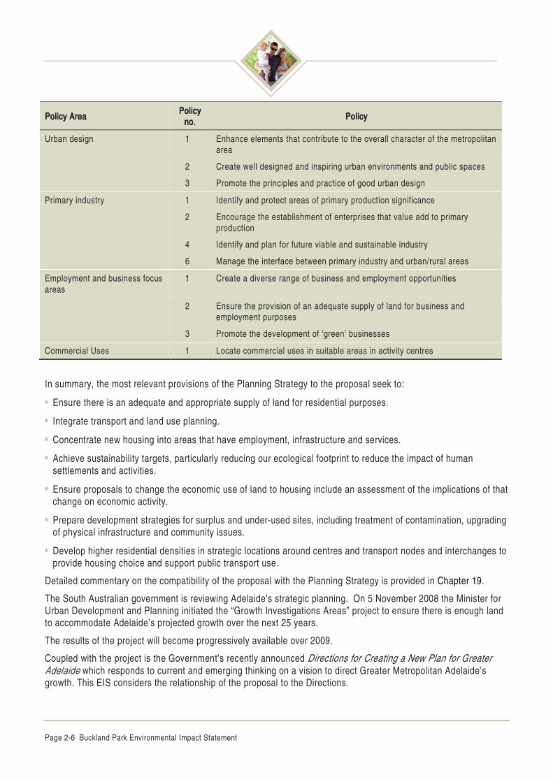
The relevant individual policies are listed in Table 2.1.
Table 2.1 Planning Strategy for Metropolitan Adelaide: Relevant policies
Policy AreaPolicy AreaPolicy AreaPolicy Area Policy Policy Policy Policy no.no.no.no.
PolicyPolicyPolicyPolicy
Water resources 1 Efficient use of water
2 Water sensitive urban design
3 Integrate the management, protection and use of water resources
4 Coordination of multi-objective management of stormwater
5 Development of alternate water re-use schemes
Biodiversity 1 Integrate the protection of biodiversity and ecosystem processes into urban development
2 Increase the integrity and viability of areas of biological significance
3 Increase the viability of areas of biological significance by creating linkages between such areas
Open space, recreation and sport
1 Create strategic open space
2 Ensure that biodiversity assets are protected
4 Provide a network of accessible recreation facilities
Land use and transport integration
1 Integrate transport and land use planning decisions
3 Maximise accessibility to, and the use of, the public transport system
4 Encourage people to walk and cycle to destinations
9 Ensure integrated transport and land use supports quality of life outcomes
Energy efficiency 1 Reduce energy requirements for transportation and buildings
3 Ensure urban design and buildings incorporate space, facilities, access and construction methods to manage waste
Coastal, estuarine and marine environments
2 Protect coastal, estuarine and marine habitats
3 Minimise the discharge of stormwater, pollution and nutrients to coastal and marine environments
4 Avoid, prevent or reduce coastal hazards such as flooding, erosion or acid sulphate soils
Buckland Park Environmental Impact Statement Page 2-5
Policy AreaPolicy AreaPolicy AreaPolicy Area Policy Policy Policy Policy no.no.no.no.
PolicyPolicyPolicyPolicy
5 Minimise the adverse impacts of development on coastal, marine and estuarine environments
Education facilities 1 Provide access to a range of education and care facilities
2 Locate education and care facilities so that access to them is equitable and convenient
5 Ensure education and care facilities and services are adaptable and responsive to changing needs and demographics
Health and community services 1 Create living environments with services and facilities to support healthy lifestyles and active communities
2 Match location and delivery of health and community services and facilities with the needs of the community
Hazard avoidance, minimisation and management
1 Minimise risk of flood damage to persons and property
3 Ensure development does not mobilise, and is protected from, acid sulphate soils
Activity centres 2 Support a range of activity centres that are complimentary and meet community needs
3 Encourage an appropriate mix of uses to create multifunctional activity centres
4 Actively encourage people to walk, cycle and use public transport to access activity centres
5 Improve the transit focus of activity centres through greater integration with public transport facilities
7 Encourage attractive, functional and vibrant activity centres
Residential neighbourhoods and housing
1 Facilitate and support a variety of affordable housing development options
2 Increase the diversity of activities within walking distance of housing
5 Develop transit-focused neighbourhoods to provide opportunities for people to walk to public transport and other services and facilities
6 Create safe, convenient and pleasant environments for walking, cycling and public transport use
9 Provide a network of parks and recreation areas within neighbourhoods
10 Design and develop neighbourhoods in an ecologically sustainable manner
11 Integrate ecologically sensitive design principles into housing development
12 Accommodate a range of facilities in neighbourhoods
13 Facilitate and support a variety of affordable housing development options
14 Encourage a broad distribution of social housing
Page 2-6 Buckland Park Environmental Impact Statement
Policy AreaPolicy AreaPolicy AreaPolicy Area Policy Policy Policy Policy no.no.no.no.
PolicyPolicyPolicyPolicy
Urban design 1 Enhance elements that contribute to the overall character of the metropolitan area
2 Create well designed and inspiring urban environments and public spaces
3 Promote the principles and practice of good urban design
Primary industry 1 Identify and protect areas of primary production significance
2 Encourage the establishment of enterprises that value add to primary production
4 Identify and plan for future viable and sustainable industry
6 Manage the interface between primary industry and urban/rural areas
Employment and business focus areas
1 Create a diverse range of business and employment opportunities
2 Ensure the provision of an adequate supply of land for business and employment purposes
3 Promote the development of ‘green’ businesses
Commercial Uses 1 Locate commercial uses in suitable areas in activity centres
In summary, the most relevant provisions of the Planning Strategy to the proposal seek to:
• Ensure there is an adequate and appropriate supply of land for residential purposes.
• Integrate transport and land use planning.
• Concentrate new housing into areas that have employment, infrastructure and services.
• Achieve sustainability targets, particularly reducing our ecological footprint to reduce the impact of human settlements and activities.
• Ensure proposals to change the economic use of land to housing include an assessment of the implications of that change on economic activity.
• Prepare development strategies for surplus and under-used sites, including treatment of contamination, upgrading of physical infrastructure and community issues.
• Develop higher residential densities in strategic locations around centres and transport nodes and interchanges to provide housing choice and support public transport use.
Detailed commentary on the compatibility of the proposal with the Planning Strategy is provided in Chapter 19.
The South Australian government is reviewing Adelaide’s strategic planning. On 5 November 2008 the Minister for Urban Development and Planning initiated the “Growth Investigations Areas” project to ensure there is enough land to accommodate Adelaide’s projected growth over the next 25 years.
The results of the project will become progressively available over 2009.
Coupled with the project is the Government’s recently announced Directions for Creating a New Plan for Greater Adelaide which responds to current and emerging thinking on a vision to direct Greater Metropolitan Adelaide’s growth. This EIS considers the relationship of the proposal to the Directions.
Buckland Park Environmental Impact Statement Page 2-7
Table 2.2 Directions for creating a new plan for greater Adelaide
DirectionsDirectionsDirectionsDirections
A city which will undergo urban regeneration and revitalisation in many existing areas (while sensibly protecting valued heritage and character), with vibrant new higher-density neighbourhoods created in and near the CBD and along designated transit corridors to the west, north and south.
A city that embraces well-planned fringe growth with new population centres closely connected to transport infrastructure and employment opportunities.
A city that encourages the sustainable growth of near country towns and townships, while protecting our most valuable environmental, agricultural and tourism assets.
A city that will see the provision of high speed mass transport linked to the growth in residential housing and jobs. The government will spend nearly $2billion over the next 10 years to modernise our public transport system.
Revised population projections indicate that up to 600,000 additional people could be living in South Australia by 2036. The majority of this population growth is anticipated to occur in Greater Metropolitan Adelaide.
This represents a 40% increase on the existing population, presenting considerable growth management questions for the Government.
Consequently, high population growth and an ageing profile could create a demand for almost 250,000 additional dwellings in Greater Metropolitan Adelaide over the next three decades.
The Government has therefore committed to a Plan that incorporates the following:
• Within the next 30 years Greater Adelaide can house 500,000 more people, nearly 250,000 new dwellings and 160,000 new jobs.
• New housing will move over time from a 50:50 split between existing suburbs and new suburbs, to a 70:30 split.
• Well located and functioning Transit Oriented Developments.
• A 25 year supply of broad-acre land identified, and a 15 year supply of land zoned for urban use at all times.
2.2.3 Playford (City) Development Plan
The Playford (City) Development Plan is a product of the process of review and assessment of its land use allocation and development policies. The Development Plan is the key document used by the relevant authority in the South Australian planning and development system.
Development Plans contain the zones, maps and policies that guide property owners and others with regard to what may or may not be achieved on any given piece of land in the area covered by the Plan. The information within the plan is intended to provide detailed criteria against which development applications will be assessed.
The policies and zonings in Development Plans should be reviewed and updated over time. The Development Act 1993 provides the legislative framework for undertaking amendments to a Development Plan. Amendments can be instigated, either by the relevant local council or the Minister for Urban Development and Planning. The document used to propose changes to a Development Plan is called a Development Plan Amendment (DPA).
In summary, the role of the Development Plan is to:
• Inform the community about how an area is expected to be developed.
• Assist adjoining owners/occupiers to appreciate what kinds of development they can expect in their neighbourhood.
Page 2-8 Buckland Park Environmental Impact Statement
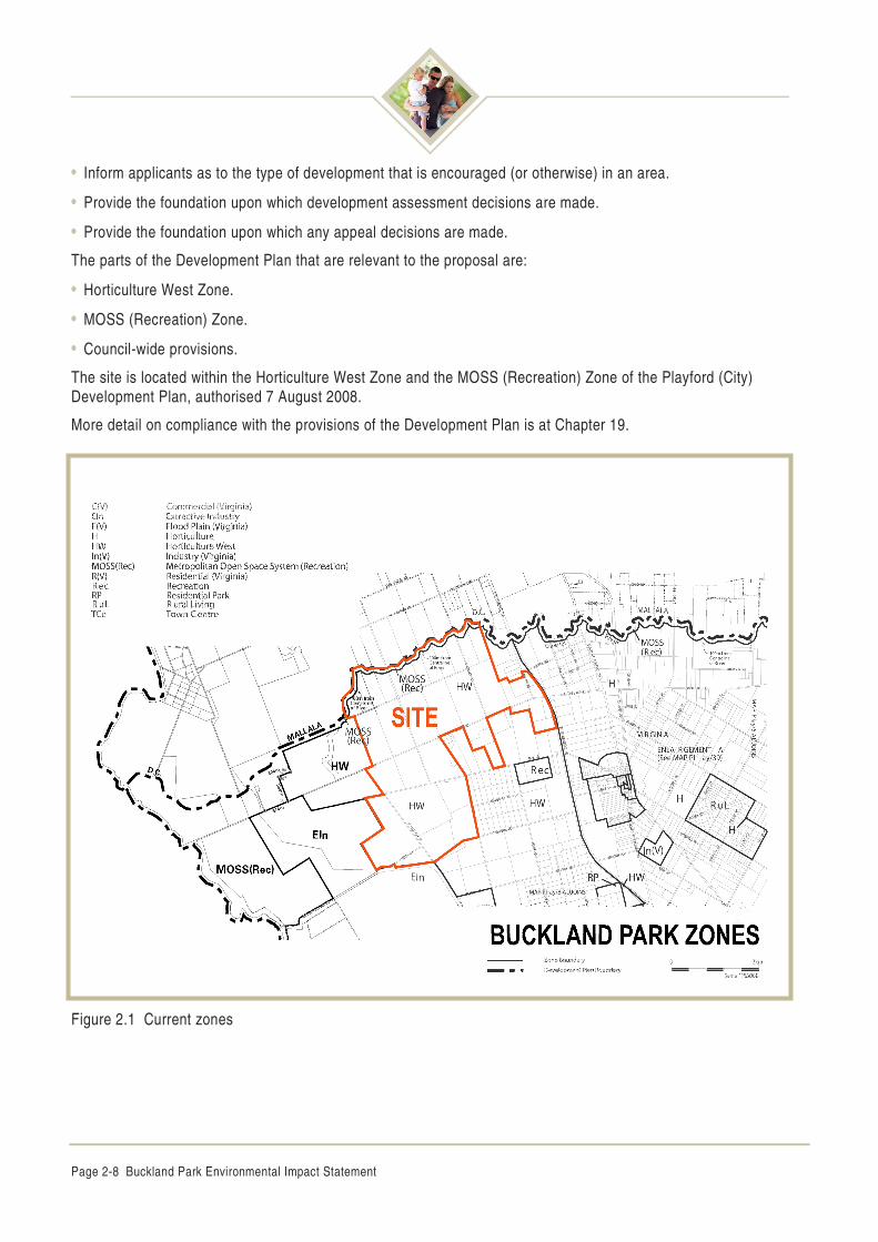
• Inform applicants as to the type of development that is encouraged (or otherwise) in an area.
• Provide the foundation upon which development assessment decisions are made.
• Provide the foundation upon which any appeal decisions are made.
The parts of the Development Plan that are relevant to the proposal are:
• Horticulture West Zone.
• MOSS (Recreation) Zone.
• Council-wide provisions.
The site is located within the Horticulture West Zone and the MOSS (Recreation) Zone of the Playford (City) Development Plan, authorised 7 August 2008.
More detail on compliance with the provisions of the Development Plan is at Chapter 19.
Figure 2.1 Current zones
Buckland Park Environmental Impact Statement Page 2-9
Horticulture (West) Zone
The Horticulture (West) Zone’s key objective is to accommodate a broad range of horticultural activities, while specifically discouraging residential and urban development.
The Zone recognises the importance of horticultural areas in Adelaide’s northern plains to the state’s economy.
Objective 1: Retention of land for horticultural purposes
The northern Adelaide plains’ horticulture area provides significant economic benefit to the State and region. The location and seasonal advantages of the horticulture area, including proximity to the produce markets, major transport routes, labour supply and extended growing periods are unique within the South Australian context. The Zone is also strategically located to take advantage of the Adelaide to Darwin railway.
It is envisaged that, in association with packaging sheds and irrigated horticulture, there will be demand for modern greenhouses including hydroponics on allotments. Such developments are promoted within the Zone.
A threat to the long-term economic viability of the Zone is the conversion of horticultural land to residential/rural living activities. These activities are incompatible with horticulture production and could raise the cost of production for those remaining in production.
Objective 2: A zone characterised by open rural areas, market gardens, greenhouses, hydroponics, vineyards, orchards and pasture.
Objective 3: Education and extensive employment opportunities in horticulture and related industries.
Objective 4: Horticultural activities supported by horticultural related industrial and commercial activities such as packing sheds, cold storage facilities and small-scale processing facilities.
Objective 5: Intensive horticulture in appropriate locations supported by adequate infrastructure and environmental management techniques.
Objective 6: Horticultural activities that are protected from the encroachment of residential and rural living development.
Objectives 8 and 9: Preservation and enhancement of the area’s rural character and scenic qualities, and the flow of flood water from the Gawler River is not impeded, and the pattern of movement of flood waters are not changed.
The objectives of the Zone are supported by more detailed principles of development control. In addition to emphasising development should principally be for horticultural purposes, the principles also provide guidance in relation to the provision of physical infrastructure, vehicle access, impact management, stormwater and waste disposal, land division, water courses and flooding.
MOSS (Recreation) Zone
The northern portion of the site adjoining the Gawler River is affected by the MOSS (Recreation) Zone. This zone extends for 100 m from the centreline of the Gawler River into the site for the entire length of Gawler River, which forms the northern boundary.
The pertinent objectives of the Zone, which are pertinent to the proposal seek:
• The establishment of a regional open space network which is integrated and linked to adjoining areas.
• Linear open space for a range of public and private activities.
• Maintenance of stormwater capacity and flood mitigation measures for adjoining areas.
• Provision for cycling and walking paths.
• Protection of the Gawler River riparian zone.
Page 2-10 Buckland Park Environmental Impact Statement
• Presentation and enhancement of the attributes of the Gawler River.
• Provision of public access to and along the length of the Gawler River.
• Protection of the Gawler River 100-year ARI Flood Plain from development that may impede the flow of floodwaters.
Objectives 1 to 5, 7 to 10, 12 and 13 are reproduced here.
Objective 1: Establishment of a regional open space network.
Objective 2: A zone that provides a linear open space for a range of public and private activities, including passive and active recreational land uses in an open and natural landscaped setting as part of the Metropolitan Open Space System, within a well landscaped setting.
Objective 3: Protection of items of Aboriginal and European heritage significance and areas of scientific, archaeological or cultural importance.
Objective 4: The maintenance of stormwater capacity and flood mitigation measures for adjoining areas, and the protection of recharge of underground aquifers.
Objective 5: Provision of cycle and walking paths within an integrated system of open spaces linking adjoining land uses.
Objective 7: Protection of the Gawler River, Little Para River and Smith Creek riparian zones through the conservation and enhancement of existing locally indigenous vegetation and the creation of a wildlife corridor.
Objective 8: Preservation and enhancement of the character, scenic beauty and amenity of the Gawler River, Little Para River, Smith Creek, Hills Face and coastline.
Objective 9: Provision of public access to and along the length of the Gawler River, Little Para River, Smith Creek, Hills Face and coastline.
Objective 10: Land kept free of buildings and structures along the Gawler River.
Objective 12: The Gawler River 100 year Average Return Interval Flood Plain kept free of development which could impede the flow of floodwaters.
Buildings, solid fences and increases in the level of land all have the potential to impede the flow of floodwaters or change the pattern of the movement of floodwaters. This in turn may increase the depth, velocity or spread to floodwaters in other parts of the floodplain, resulting in an increase in damage or inconvenience in that location.
Objective 13: Development of the Gawler River Flood Plain which recognises varying degrees of flood hazard.
2.2.4 Playford Community Plan
The Playford Community Plan establishes and provides the framework for implementing the strategic direction for the City of Playford. This direction is being embraced by the City, its business and residential communities.
The Playford Community Plan is a collective direction for the Council area. It is a reflection of a diverse community's hopes and desires to establish a positive future for the area. Through the work undertaken for the Playford Community Plan, Playford Council has prepared a range of objectives and strategies that it believes are realistic, together with measures and targets to monitor the progress of the area and its communities.
Goal plans
The Playford Community Plan sets out three goals for the City of Playford:
• Economic prosperity.
Buckland Park Environmental Impact Statement Page 2-11
• Environmental care.
• Community wellbeing.
These three goal plans provide an integrated, planned approach for the City of Playford, while allowing flexibility to respond to emerging needs.
2.2.5 City of Playford Council Plan 2008/09–2011/12
The Council Plan identifies the City of Playford’s priorities over a 4-year period, defines its key strategic response and provides an annual budget to fund activities and therefore, it communicates Council's contribution to the realisation of the community vision, contained within the Playford Community Plan.
Goal Committees have been formed, with each focused on one of Council's strategic goals of Community Wellbeing, Economic Prosperity, Environmental Care and Organisational Excellence, identifying the strategic priorities that will guide Council's efforts and resources over the four years period.
The strategic priorities include the following:
• Community wellbeing: health and wellbeing, community safety, liveable communities and lifelong learning.
• Economic prosperity: urban growth and townships, targeted business and industry, learning and employment, economic sustainability and civil infrastructure.
• Environmental care: land, growth, energy, waste and water.
• Organisational excellence: service sustainability, community engagement, organisational development and decision-making.
2.2.6 Other relevant strategies
Other strategies and documents relevant to the Buckland Park proposal include those described as follows.
Water Proofing Northern Adelaide
Metropolitan Adelaide’s northern region includes the adjoining Councils of Playford, Salisbury and Tea Tree Gully. The region is experiencing significant change with new residential suburbs. In addition, it is rapidly becoming the industrial, commercial and technology centre of South Australia.
The Water Proofing Northern Adelaide Project is the region's commitment to ensure future growth is sustainable and water is used as effectively as possible, it is a coordinated plan to Water Proof Northern Adelaide and sustain the region.
Sustainability is being achieved through innovation, cooperation and shared commitment. Over the preceding 10 years the City of Salisbury has broken new ground in the use of wetlands and water recycling projects to improve overall water efficiency in the region.
The Australian Government Water Fund is providing a $41.8 million grant, with the State provide over $16 million and the three Councils will invest over $22 million up to 2010 signifying the collaborative commitment to assist the North of Adelaide in becoming more sustainable.
The impact of achieving Water Proofing Northern Adelaide on the region that it targets but on the wider South Australian community cannot be overstated.
It seeks to ensure northern Adelaide’s 300,000 residents have potable and ‘fit for purpose’ water, while at the same time reducing Adelaide’s reliance on the scarce resources of the River Murray.
This is to occur through reduced consumption, better management of existing systems and the use of pioneering technologies not yet in use anywhere in the world.
Page 2-12 Buckland Park Environmental Impact Statement
Gawler River Floodplain Management Authority (GRFMA) and Scheme
The Gawler River Flood Mitigation Authority has been established to implement a flood mitigation scheme that was developed and sponsored by the Northern Adelaide Barossa Catchment Water Management Board to be jointly funded by the three spheres of Government.
It is a Government and community response to the periodical flooding that occurs to the Gawler River. The last major flood event occurred in 1992, with a further significant flood event in November 2005.
The City of Playford is one of the six constituent councils of the GRFMA.
The GRFMA has been established for the following purposes:
• To co-ordinate the construction, operation and maintenance of flood mitigation infrastructure in the Gawler River area (the Floodplain).
• To raise finance for the purpose of developing, managing and operating and maintaining flood mitigation works within the Floodplain.
• To provide a forum for the discussion and consideration of topics relating to the Constituent Council's obligations and responsibilities in relation to management of flood mitigation within the Floodplain.
• To enter into agreements with Constituent Councils for the purpose of managing and developing the Floodplain.
Development of Horticulture Industries on the Adelaide Plains—A Blueprint for 2030
Development of Horticulture Industries on the Adelaide Plains—A Blueprint for 2030 July 2007 prepared for the Virginia Horticulture Centre (VHC), provides a vision for the horticulture industry on the Adelaide plains to assist long-term strategic planning and the efficient use of land and resources.
The Blueprint identifies the Adelaide Plains’ horticulture industry as being concentrated around Virginia and Angle Vale, with expansion likely to occur into the area around Two Wells. The Blueprint suggests the Virginia ‘horticulture cluster’ should be preserved and expanded where production, packaging, processing and support industries are located in close proximity.
The Blueprint recognises the intrinsic lower value, and therefore lower priority, of land on the western side of the Port Wakefield Road, where the site is located. This land is envisaged as being suited to hydroponic greenhouse production.
Adelaide and Mount Lofty Ranges Regional Natural Resources Management (NRM) Plan
Under the Natural Resources Management Act 2004, to better manage the State’s natural resources the Adelaide and Mount Lofty Ranges Natural Resources Management Board (NRMB) is required to develop an NRM plan for its region.
Therefore the NRMB have prepared the Adelaide and Mount Lofty Ranges Regional NRM Plan.
The plan aims to provide leadership, encourage community action, foster partnerships and identify where investment is required. The plan has been put together with extensive consultation with the community and stakeholders.
This plan links to the State’s NRM Plan and South Australia's Strategic Plan, and sets out the long-term vision for the region and will guide ongoing actions.
In addition to expressing goals, the Plan outlines the Board’s proposed investment over a three-year period, and also provides strategic direction for all NRM partners who invest in the region. Part of this process includes establishing long-term goals, plainly defined outcomes and targets.
Buckland Park Environmental Impact Statement Page 2-13
2.3 Benefits and costs
Since European occupation the site has been cleared grazing and some cropping. Some remnant vegetation remains along the Gawler River and in the south west portion of the site. The site has a low agricultural value and aside from the Gawler River corridor, limited attraction or high visual amenity.
The proposal is an opportunity to make significant environmental, social and economic improvements to the site and for the surrounding community.
Investigations into the proposal’s effects on the environment, and required management are set out in detail in this EIS.
The proposal and site has been extensively investigated over a number of years. The following benefits and costs were identified during those investigations.
2.3.1 Benefits
The benefits to the local environment include:
• Economic benefits for the region’s, Adelaide’s and SA’s economy flowing from business, employment and expenditure generated during the construction phase, the ongoing operation of the community.
• The supply of housing land to support Adelaide’s projected growth over coming decades, contributing to meeting demand and managing housing affordability.
• The supply of housing land strategically located in relation to infrastructure, centres and potential growth areas in Metropolitan Adelaide’s northern region.
• The creation of a large, planned community making the implementation of services, infrastructure and facilities feasible, and coordinated with the construction of housing.
• The creation of a large community, which can accommodate a range of housing types and a diverse population over time.
• The protection and enhancement of the physical and natural environment, facilitated by the proposal’s large scale and Masterplan which will allow the implementation of comprehensive management schemes over time.
• The rehabilitation and revegetation of Gawler River corridor and its remnant vegetation, and its transfer to public ownership, creating public access.
• Creation of a planned community of a scale which facilitates the implementation of efficient sustainability measures, as opposed to measures targeted at individual home owners, which are potentially less efficient.
2.3.2 Costs
• The loss of an estimated $1,780,000 per year farm gate value, including multipliers associated with current agricultural production on the site, based on 2008 production from the site.
• The provision of public infrastructure, services and facilities in a locality currently not provided with those items.
Page 2-14 Buckland Park Environmental Impact Statement
2.4 Proposal rationale and consequences of not proceeding
2.4.1 Rationale
The proposal’s characteristics
The proposal’s Masterplan and Staging Plan and control by a single proponent, allows it to be implemented in an orderly and economic manner. This is enhanced by its large scale.
This is unique in Adelaide’s experience of creating new suburbs.
More specifically, all the proposal’s aspects have been outlined in the Masterplan, which will guide the detailed design and implemented with each of the proposal’s stages, resulting in a large, well serviced community. Each of the proposal’s stages will also be created with its required services.
The Masterplan and Staging Plan will ensure each stage is effectively linked to past and previous stages, in terms of its road, transport, open space and utility networks, and in terms of its social and community networks.
Strategic context
The site is being investigated in the Growth Investigation Areas project.
The site’s strategic context has changed over recent years. The changed circumstances included the following:
• Instigation of flood mitigation works associated with the Gawler River, which are anticipated to reduce flood risks in the area.
• Relocation of the 7RAR Battalion with 1,200 personnel from its current location in Darwin to new facilities within the Edinburgh Defence Precinct, including the construction of over $620 million of new facilities at Edinburgh. This in turn creates a significant demand for housing.
• Construction of the Northern Expressway (NEXY), a major piece of road infrastructure. It will improve accessibility to the northern suburbs of Adelaide as will the northern connector and consequently the regions ability to attract employment and support new urban areas.
• A decline in Metropolitan Adelaide’s land stocks and housing affordability over the last 3 years.
• The site’s location relative to Greater Metropolitan Adelaide’s other new and growing suburbs, including those that are either commenced, committed, proposed or under investigation, has been reviewed by Connor Holmes (Appendix 2).
Table 2.3 contains a comparison of eight different new or growing areas with the site:
• Golden Grove
• Concordia
• Hewett
• Sellicks Beach
• Bowering Hill
• Mt Barker
• Dry Creek
• Roseworthy.
Buckland Park Environmental Impact Statement Page 2-15
The new and growing areas have been analysed against the following eight location indicators:
• Location within Metropolitan Adelaide Area as described in the Planning Strategy.
• Distance by road to:
– Adelaide CBD
– Regional centres
– Major employment areas
– Major rail interchanges
– Major hospitals
– TAFE colleges
– Universities
It was found that the site’s relationship to these key urban facilities was:
• Superior to six of the eight comparable growth areas, on at least five of the eight location indicators.
• Superior to two of the four comparable growth areas within Metropolitan Adelaide on at least five of the eight location indicators.
The site more strategically well placed, often by a considerable margin, than the most of the comparable growth areas reviewed, including others within Metropolitan Adelaide.
Figure 2.2 illustrates the site’s strategic context relative to the eight new or growing areas mentioned above, and strategic sites identified in the Planning Strategy including:
• Economic growth areas.
• Key industry sites.
• Defence industry and technology.
• Significant employment nodes.
• Regional centres (activity nodes).
• District (activity nodes).
The site relative to Greater Metropolitan Adelaide’s other growth areas is strategically favourable. It is in close proximity to the greater number of Adelaide’s economic growth areas and significant employment nodes, including key industry, Defence and technology sites. It is also in close proximity to rail interchange facilities at Salisbury and Elizabeth, tertiary education and major medical services.
Page 2-16 B
uckland Park E
nvironmental Im
pact Statem
ent
Table 2.3 The Site’s strategic context
Urban areasUrban areasUrban areasUrban areas SizeSizeSizeSize (ha)(ha)(ha)(ha)
TypeTypeTypeType Within Within Within Within Metro Metro Metro Metro aaaarearearearea
Distances to key services/facilities (km by vehicle)Distances to key services/facilities (km by vehicle)Distances to key services/facilities (km by vehicle)Distances to key services/facilities (km by vehicle)
No. of location indicators inferior No. of location indicators inferior No. of location indicators inferior No. of location indicators inferior to to to to the sitethe sitethe sitethe site
4444 6666 5555 5555 6666 6666 6666
Key: LM – Lyell McEwin Hospital; F – Flinders Hospital; RA – Royal Adelaide Hospital; Levels – The University of SA Levels Campus; BP proposed Buckland Park major development area
Areas selected include consideration of some of the areas identified within the Minister’s News Release “Growth Investigation Areas” dated 5 November 2008
Source: Connor Holmes
Buckland Park Environmental Impact Statement Page 2-17
Land supply
Up to 250,000 new houses will be required to meet Adelaide’s demands over coming decades. Connor Holmes predicts much of that demand will need to be met in Metropolitan Adelaide’s northern region, which has more suitable, available land and considerably better access to employment, infrastructure, and future infrastructure (Appendix 3). As new suburbs are established in the northern region, they will draw in more infrastructure, employment and services, providing a catalyst for the creation of additional suburbs.
Strong land price increases in Adelaide’s residential market can at least be partially addressed by a substantive increase in the supply of land. While land prices are influenced by a range of factors, the strength of demand coupled with restricted supply have contributed to a rapid escalation in prices.
The proposal can accommodate 12,000 new houses, or 5% of the amount needed to meet Adelaide’s demand.
The supply of housing land and competition in the residential market provided by the proposal will contribute to restraining house prices in Adelaide.
The proposal will make a major contribution to the provision of the required housing.
Consequences of not proceeding
Adelaide’s required housing will be provided in smaller projects, located over dispersed areas which require an incremental approach to planning for infrastructure and services, which may be inefficient and uneconomic for service providers.
Adelaide requires a large amount of new housing over the next 25 years. A constrained supply of housing will have negative implications for housing affordability.
The Gawler River, where it passes the site, has the potential to be a major environmental asset, for the whole community. This potential will not be realised if the proposal does not proceed. This section of the river will remain in private ownership, and current grazing will continue.
While the construction of 12,000 new houses in any part of Adelaide will have economic benefits, the economic benefits associated with the proposal will be enjoyed most particularly in Metropolitan Adelaide’s northern region.
It could be argued Metropolitan Adelaide’s northern region is more worthy of those benefits than other areas.
If the proposal does not proceed, those economic benefits will be lost to the region.
Page 2-18 Buckland Park Environmental Impact Statement