Final Environmental Impact Statement March 2013 Page 2‐1 Chapter 2 Project History and Alternatives This chapter provides a brief history of the Elliott Bay Seawall, describes the deterioration of the seawall to its current condition, and explains the planning processes used to develop alternatives to replace the seawall. It also explains how the Elliott Bay Seawall Project relates to two other major capital projects in the vicinity, the Alaskan Way Viaduct Replacement Project and Waterfront Seattle. The chapter also includes a discussion of the planning objectives and constraints and the process used to develop, screen, and refine the proposed alternatives to address the project’s purpose and need. It also describes the public and agency outreach process that informed the development of the alternatives, which began with environmental scoping and has continued throughout the design and environmental analysis phases of the project, and summarizes how the comments have been reflected in the design. The chapter concludes with a detailed description of the No Action Alternative and the three potential build alternatives. It describes the proposed upland and habitat improvements, construction methods, and construction duration and schedule associated with each of the build alternatives. This information provides the foundation upon which the analyses discussed in subsequent chapters of this EIS are based. 2.1 Project Background and History Historical Development of the Seawall Built as part of the working waterfront in the early 1900s, the Elliott Bay Seawall was constructed to support railway and roadway access to the piers in Elliott Bay. The piers were constructed offshore to provide deep‐water mooring, and trestles were built to connect to the uplands. The City then constructed the seawall landward of the piers and filled the area from the seawall to the natural shoreline. This filled area, which generally extends east from the present‐day shoreline to Western Avenue, consists of unconsolidated and liquefiable soil. Together, the seawall and the soils it protects constitute the western portion of downtown Seattle, which contains much of the city’s historical waterfront development and many newer commercial and residential developments. The seawall has required extensive maintenance over time, primarily due to coastal storm damage that has resulted in shoreline erosion and subsequent deterioration of the structure. The City has monitored and maintained the seawall as necessary to ensure public safety by preserving the structure and the transportation corridor it supports. Since its construction, the seawall has required multiple major repairs Placement of fill at Bay Street during seawall construction, 1934 Seawall construction south of Bay Street, 1934 Leaking sheet pile seawall, 1954
Transcript
Final Environmental Impact Statement March 2013 Page 2‐1
Chapter 2 Project History and Alternatives This chapter provides a brief history of the Elliott Bay Seawall, describes the deterioration of the seawall to its current condition, and explains the planning processes used to develop alternatives to replace the seawall. It also explains how the Elliott Bay Seawall Project relates to two other major capital projects in the vicinity, the Alaskan Way Viaduct Replacement Project and Waterfront Seattle.
The chapter also includes a discussion of the planning objectives and constraints and the process used to develop, screen, and refine the proposed alternatives to address the project’s purpose and need. It also describes the public and agency outreach process that informed the development of the alternatives, which began with environmental scoping and has continued throughout the design and environmental analysis phases of the project, and summarizes how the comments have been reflected in the design.
The chapter concludes with a detailed description of the No Action Alternative and the three potential build alternatives. It describes the proposed upland and habitat improvements, construction methods, and construction duration and schedule associated with each of the build alternatives. This information provides the foundation upon which the analyses discussed in subsequent chapters of this EIS are based.
2.1 Project Background and History
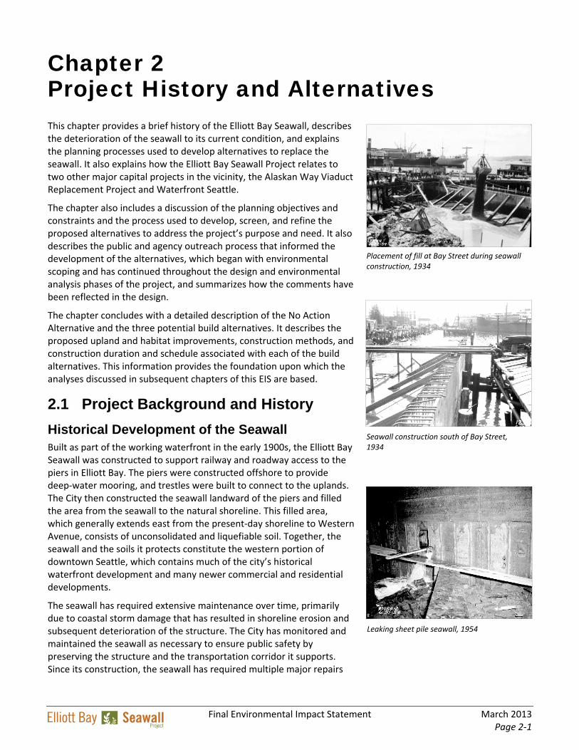
Historical Development of the Seawall Built as part of the working waterfront in the early 1900s, the Elliott Bay Seawall was constructed to support railway and roadway access to the piers in Elliott Bay. The piers were constructed offshore to provide deep‐water mooring, and trestles were built to connect to the uplands. The City then constructed the seawall landward of the piers and filled the area from the seawall to the natural shoreline. This filled area, which generally extends east from the present‐day shoreline to Western Avenue, consists of unconsolidated and liquefiable soil. Together, the seawall and the soils it protects constitute the western portion of downtown Seattle, which contains much of the city’s historical waterfront development and many newer commercial and residential developments.
The seawall has required extensive maintenance over time, primarily due to coastal storm damage that has resulted in shoreline erosion and subsequent deterioration of the structure. The City has monitored and maintained the seawall as necessary to ensure public safety by preserving the structure and the transportation corridor it supports. Since its construction, the seawall has required multiple major repairs
Placement of fill at Bay Street during seawall construction, 1934
Seawall construction south of Bay Street, 1934
Leaking sheet pile seawall, 1954
PROJECT HISTORY AND ALTERNATIVES
March 2013 Final Environmental Impact Statement Page 2‐2
Relieving Platform A relieving platform is the horizontal timber structure on the land side of a seawall that supports the surface soil.
Ekki Wood Ekki wood is a hardwood from sub‐Saharan Africa used in wet environments.
due to tidal and seismic damage and collapses of surface streets, and has required site‐specific rehabilitation of the structure itself and the supporting riprap. In addition to major repairs, the seawall has required periodic maintenance to prevent corrosion, repair damaged sheet pile, install and maintain the Ekki wood wall facing, and fill voids.
The southern terminus of the seawall abuts the bulkheads in the vicinity of Pier 48 (S. Washington Street). The northern terminus of the seawall is at Bay Street. The section of the seawall from Broad Street to Bay Street (850 feet) is not evaluated in this EIS because it was rehabilitated as part of the Olympic Sculpture Park Project, which opened to the public in 2007. The total length of shoreline in the project area between S. Washington Street and Broad Street is approximately 7,166 feet. The seawall extends this entire length, except for 784 feet of fill/bulkhead in the vicinity of Pier 66, leaving an estimated 6,382 feet of seawall in the project area.
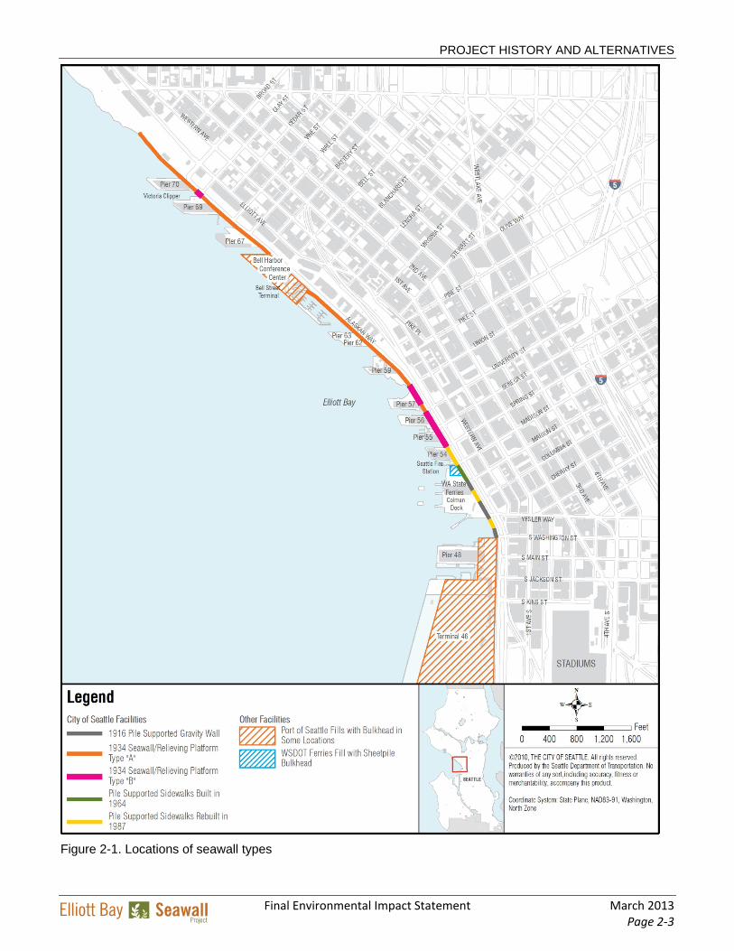
Current Seawall Configuration and Condition The existing seawall consists of three types of structures that were constructed at different times, as depicted in Figure 2‐1. The first type, completed in 1916, features gravity walls of unreinforced concrete supported by timber pilings, above which sits a pile‐supported sidewalk. The 1916 sections of the wall remain in service today, although sections of the pile‐supported sidewalk structures between S. Washington and Madison Streets were replaced between 1964 and 1987. This early type of seawall construction is commonly referred to as the gravity wall seawall (Figure 2‐2).
North of Union Street, where the relieving platform is approximately 40 feet wide and the maximum seawall height is approximately 20 feet, the structure is referred to as a Type A seawall, which was built in 1934 (Figure 2‐2).
The remainder of the seawall, constructed from 1934 to 1936, consists of a precast‐concrete face panel supported on a steel master pile. The seawall face panel is attached to and integrated with a horizontal “relieving platform” constructed of untreated timber and supported by timber piles (Figure 2‐1). The top of the relieving platform is 13 feet below Alaskan Way. The platform is approximately 60 feet wide between Madison and Union Streets, where the maximum seawall height is approximately 40 feet. This is referred to as a Type B seawall (Figure 2‐2).
Surface street failure as a result of seawall deterioration, 1954
PROJECT HISTORY AND ALTERNATIVES
Final Environmental Impact Statement March 2013 Page 2‐3
Figure 2-1. Locations of seawall types
PROJECT HISTORY AND ALTERNATIVES
March 2013 Final Environmental Impact Statement Page 2‐4
Riprap Riprap is large rock (or other material) used to protect the shoreline from forces such as the impact of waves on the face of the seawall.
Examples of historic seawall construction, 1934
Figure 2-2. Existing seawall types
As a complete system, the seawall provides protection from storm‐induced waves, tidal‐ and storm‐induced currents, and inundation. Although the structure has served its protective function effectively over the years, repeated exposure to the forces of storm and tidal action has resulted in significant damage, much of it undetectable from the surface or the water. The downward forces of storm waves on the face of the seawall move and damage the riprap that protects the toe of the concrete face panel, expose the corrosion‐prone steel sheet pile walls below, and result in the development of holes or cracks in the structure’s face. Inspection and investigation of the seawall structure indicate considerable deterioration and evidence of possible structural
PROJECT HISTORY AND ALTERNATIVES
Final Environmental Impact Statement March 2013 Page 2‐5
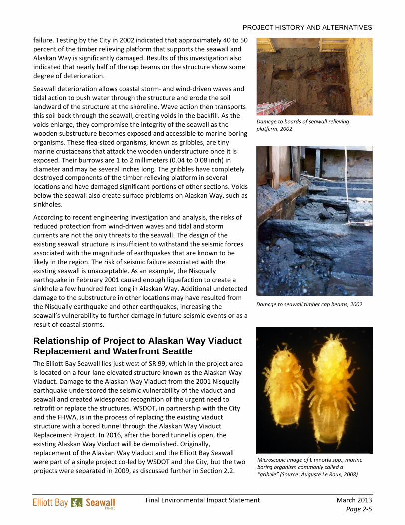
failure. Testing by the City in 2002 indicated that approximately 40 to 50 percent of the timber relieving platform that supports the seawall and Alaskan Way is significantly damaged. Results of this investigation also indicated that nearly half of the cap beams on the structure show some degree of deterioration.
Seawall deterioration allows coastal storm‐ and wind‐driven waves and tidal action to push water through the structure and erode the soil landward of the structure at the shoreline. Wave action then transports this soil back through the seawall, creating voids in the backfill. As the voids enlarge, they compromise the integrity of the seawall as the wooden substructure becomes exposed and accessible to marine boring organisms. These flea‐sized organisms, known as gribbles, are tiny marine crustaceans that attack the wooden understructure once it is exposed. Their burrows are 1 to 2 millimeters (0.04 to 0.08 inch) in diameter and may be several inches long. The gribbles have completely destroyed components of the timber relieving platform in several locations and have damaged significant portions of other sections. Voids below the seawall also create surface problems on Alaskan Way, such as sinkholes.
According to recent engineering investigation and analysis, the risks of reduced protection from wind‐driven waves and tidal and storm currents are not the only threats to the seawall. The design of the existing seawall structure is insufficient to withstand the seismic forces associated with the magnitude of earthquakes that are known to be likely in the region. The risk of seismic failure associated with the existing seawall is unacceptable. As an example, the Nisqually earthquake in February 2001 caused enough liquefaction to create a sinkhole a few hundred feet long in Alaskan Way. Additional undetected damage to the substructure in other locations may have resulted from the Nisqually earthquake and other earthquakes, increasing the seawall’s vulnerability to further damage in future seismic events or as a result of coastal storms.
Relationship of Project to Alaskan Way Viaduct Replacement and Waterfront Seattle The Elliott Bay Seawall lies just west of SR 99, which in the project area is located on a four‐lane elevated structure known as the Alaskan Way Viaduct. Damage to the Alaskan Way Viaduct from the 2001 Nisqually earthquake underscored the seismic vulnerability of the viaduct and seawall and created widespread recognition of the urgent need to retrofit or replace the structures. WSDOT, in partnership with the City and the FHWA, is in the process of replacing the existing viaduct structure with a bored tunnel through the Alaskan Way Viaduct Replacement Project. In 2016, after the bored tunnel is open, the existing Alaskan Way Viaduct will be demolished. Originally, replacement of the Alaskan Way Viaduct and the Elliott Bay Seawall were part of a single project co‐led by WSDOT and the City, but the two projects were separated in 2009, as discussed further in Section 2.2.
Damage to boards of seawall relieving platform, 2002
Damage to seawall timber cap beams, 2002
Microscopic image of Limnoria spp., marine boring organism commonly called a “gribble” (Source: Auguste Le Roux, 2008)
PROJECT HISTORY AND ALTERNATIVES
March 2013 Final Environmental Impact Statement Page 2‐6
Another project currently underway along the waterfront is the City’s early planning and design work for Waterfront Seattle, a separate, comprehensive program to redevelop the downtown Seattle waterfront, improve its connectivity with the rest of downtown Seattle, and enhance recreational opportunities and amenities that currently make the waterfront a hub for public use. The footprint of Waterfront Seattle extends upland into the core downtown area and far exceeds the limits of the Elliott Bay Seawall Project. The City is coordinating the two projects closely to ensure that the alternatives developed for the Elliott Bay Seawall Project do not preclude potential future opportunities developed under the Waterfront Seattle vision.
Other projects in the area (referred to as partner projects in Figure 2‐3) are discussed in Chapter 6. One key partner project is the Seattle Multimodal Terminal at Colman Dock Project. Currently scheduled for completion by 2020 by the Washington State Ferries, construction of this project would overlap with seawall construction and requires close coordination between the City and Washington State Ferries. The two agencies are meeting regularly to coordinate project designs and schedules.
Figure 2-3. Other City projects near the Elliott Bay Seawall Project
PROJECT HISTORY AND ALTERNATIVES
Final Environmental Impact Statement March 2013 Page 2‐7
2.2 Planning Process, Alternatives Development, and Screening
In 2002, the City, WSDOT, and the FHWA began the preliminary development and screening of alternatives for replacing the existing seawall as a component of the Alaskan Way Viaduct and Seawall Replacement Program. At that time, reconstruction of the seawall was an essential component of the complete replacement of the Alaskan Way Viaduct because the proposed changes to SR 99 would have used portions of the seawall for structural support. In 2004, after the City requested financial assistance for replacing the seawall, USACE and the City entered into a formal project partnership. USACE has specific interests in reducing coastal storm, tidal, and seismic damage to navigable waters of the United States.
In 2009, WSDOT, the City, and FHWA began pursuing a bored tunnel option for replacing the Alaskan Way Viaduct, which entailed moving the alignment east from the current SR 99 location. This move eliminated the need for a seawall replacement or retrofit as a component of the viaduct replacement because the tunnel would no longer require structural support from the seawall. However, the degraded condition of the existing seawall and the public safety risk posed by its potential failure still prompted the need for action. The City became the project sponsor and sole SEPA environmental lead for the seawall replacement, and WSDOT and FHWA ceased their participation in the seawall project.
The City and USACE developed a range of alternatives for replacing the seawall. These alternatives were focused on the project purpose, which is to reduce the risks of coastal storm and seismic damage that continues to degrade and threaten the seawall and to improve the degraded ecosystem functions and processes of the Elliott Bay nearshore in the vicinity of the seawall. These alternatives were consistent with the City’s goals for the project, as described in Chapter 1.
The planning objectives used to formulate and evaluate the project alternatives (see sidebar) were jointly developed by the City and USACE to guide early project planning. The City also identified planning constraints (shown on the following page) to help guide the project’s formulation.
Formulation and Screening of Alternatives To meet the dual purposes of the project, the City and USACE developed a range of preliminary alternatives for reducing coastal storm damage (including exacerbated coastal storm damages expected to follow an earthquake of sufficient magnitude to damage the existing seawall). These measures were considered in tandem with a separate range of measures for ecosystem restoration which could be included in various combinations with any of the alternatives for reducing coastal storm damage. Both sets of options are described briefly below; for
Elliott Bay Seawall Project Planning Objectives
Coastal Storm Damage Reduction Objectives
Reduce coastal storm and tidal damage to the downtown Seattle waterfront
Reduce coastal storm damage to transportation functions and linkages
Reduce coastal storm damage to utilities
Reduce the loss of access to waterfront public facilities associated with coastal storm damage after failure of the seawall
Reduce operation, maintenance, repair, replacement, and rehabilitation costs for the protection of the downtown Seattle waterfront
Reduce risks to public safety from seawall failure and other coastal storm damage
Ecosystem Restoration Objectives
Improve ecosystem structure, functions, and processes within the project area
Improve aquatic and riparian habitat, including migration corridors for juvenile salmon
Increase the quantity and diversity of nearshore habitat
PROJECT HISTORY AND ALTERNATIVES
March 2013 Final Environmental Impact Statement Page 2‐8
more information see Alternative Development Background (Appendix A).
Preliminary Coastal Storm Damage Reduction Alternatives Five preliminary alternatives were identified for reducing coastal storm damage.
Preliminary Alternative 1: No Action If nothing were done to the existing seawall, ongoing storm damage would eventually result in partial or complete failure of the seawall, causing losses to transportation and utility infrastructure, disruption of access to businesses and industry, potentially severe adverse economic impacts, and threats to public safety. Although not acceptable from a public policy standpoint, this alternative was recommended for further consideration because it represents a baseline against which other alternatives are evaluated under SEPA.
Preliminary Alternative 2: Nonstructural Solution Under this alternative, the infrastructure at risk from a seawall failure—including residential and commercial businesses and utility lines, as well as Colman Dock Ferry Terminal and Fire Station No. 5—would be acquired and/or relocated to prevent possible damage. All infrastructure currently protected by the seawall would be included except road and rail infrastructure, which would remain vulnerable. This alternative was not carried forward for further study because it would not meet the project’s purpose and need (since some facilities would remain vulnerable) and would be very costly, with little corresponding increase in benefits.
Planning Constraints Meet current seismic design criteria
Maintain the existing and planned transportation functions of the Alaskan Way surface transportation corridor
Minimize adverse impacts on existing economic activity and transportation modes in the study area
Rely on proven construction methods, minimize construction duration, and promote effective traffic management during construction
Maintain harmony with the City’s waterfront planning process, supporting land use and shoreline plans and policies pertaining to the downtown waterfront
Minimize adverse social, cultural, recreational, environmental, and economic impacts during and after construction
Comply with all applicable environmental laws and other laws and regulations
To the extent possible, avoid or minimize any adverse environmental effects of the proposed coastal storm damage reduction and shoreline protection measures; appropriate mitigation should be developed for any unavoidable impacts
Limit ecosystem restoration measures to the areas within and immediately adjacent to the seawall
PROJECT HISTORY AND ALTERNATIVES
Final Environmental Impact Statement March 2013 Page 2‐9
Preliminary Alternative 3: Post-Failure Shoreline Stabilization Followed by Rebuild Under this alternative, no action would be taken until after the seawall failed. After the failure, the shoreline would be stabilized by the placement of riprap and a temporary wall, and the design and construction of a replacement seawall would begin using a soil improvement method such as jet grouting or deep soil mixing. The design and construction process would be similar to a planned replacement of the seawall but would be more costly and complex due to the need for emergency response and debris removal. Because of the unacceptable safety risks associated with this alternative, as well as its higher cost, it was not recommended for further study.
Preliminary Alternative 4: Post-Failure Stabilization with Rubble-Mound Revetment This alternative would involve construction of a rubble‐mound revetment waterward of the existing seawall following a seawall failure. Extending up to an elevation of 16 feet above mean lower low water (MLLW), the revetment would limit large‐scale erosion (which is predicted to cause the shoreline to retreat up to 140 feet inland) and the resulting loss of upland facilities. However, it would fill a large amount of nearshore habitat, would likely settle as a result of the underlying liquefiable soils, and would not adequately support the Alaskan Way roadway and utilities if settling occurred. Due to these factors, combined with the same safety risks and increased costs described for Preliminary Alternative 3, this alternative was not recommended for further study.
Preliminary Alternative 5: Seawall Replacement The seawall replacement alternative would design and build a replacement seawall before a failure occurred. Two preliminary design options were considered:
Soil Improvement Option: Creation of a “block” of stabilized soil inland of the existing seawall that would prevent seismically induced liquefaction
Braced Soldier Pile/Drilled Shafts Option: Creation of a new seawall, also inland of the existing seawall, constructed of braced soldier piles capped with a cantilevered slab and braced soil anchors that resist the loads of seismically induced liquefied soils
Both of these options were recommended for further study because they would maintain effective shoreline protection from both storm and seismic forces, preserve existing infrastructure, maintain access to waterfront businesses and residences, and provide opportunities for adding new nearshore marine habitat.
Evaluation of Preliminary Ecosystem Restoration Measures Preliminary ecosystem restoration measures were screened and evaluated in December 2010 according to the following criteria:
Provide ecosystem process and function
Remain stable during seismic events
Minimize the risk to public health and safety
Minimize impacts on utilities
Minimize impacts on species listed under the Endangered Species Act
Be consistent with City, state, and federal land use and shoreline plans
Minimize the operation, maintenance, repair, replacement, and rehabilitation costs
Minimize impacts on Elliott Bay water quality
Minimize impacts on cultural and/or archaeological resources
Avoid or minimize the placement of fill in Elliott Bay
Minimize impacts on nearshore habitat
Minimize impacts on waterfront businesses
Consider construction and contract risks
Minimize impacts on navigation
PROJECT HISTORY AND ALTERNATIVES
March 2013 Final Environmental Impact Statement Page 2‐10
Preliminary Ecosystem Restoration Measures During the last 150 years, the Elliott Bay nearshore ecosystem has been substantially degraded, greatly affecting habitat in and around Elliott Bay. Past large‐scale alterations, such as changes to hydrology, deforestation of the nearshore, chemical contamination, and urbanization, place substantial stress on the ecosystem.
Although the structure, functions, and processes of Elliott Bay have been diminished, the bay still provides support for important natural resources. Currently, eight species of migratory salmon and trout, three of which are listed under the Endangered Species Act, use the shoreline during their outmigration through Elliott Bay. Several species of waterfowl and marine birds use the bay for feeding and refuge. Elliott Bay supports small patches of kelp in multiple locations, primarily associated with human‐placed rock or other materials.
In the aquatic nearshore area, the original wetlands have been replaced by streets. The seawall is a vertical, concrete slab that reflects much of the wave energy from ferry and vessel traffic, causing erosion and scouring. Much of the vegetated shallow area that once provided refuge for juvenile fish is gone. As a result, very little effective habitat remains.
To address the degraded nearshore conditions, the City and USACE evaluated habitat improvement and ecosystem restoration measures that could be integrated into the design of any of the selected storm damage reduction alternatives. These ecosystem restoration measures are summarized below. All but two of the measures (noted in the text) were carried forward for further analysis.
Measure 1: No Ecosystem Restoration Action If no action were taken, the shoreline of Elliott Bay in the project area would remain in its current condition. The numerous stressors that limit biologic productivity and diversity would not change. Juvenile fish such as Chinook and coho salmon that must migrate through the waterfront area would still lack the feeding and refuge areas needed to sustain them during their migration. The existing lack of nearshore vegetation and macroalgae would continue to limit the food supply. Therefore, No Ecosystem Restoration Action was not a recommended measure, although it was carried forward in the analysis as a benchmark for gauging the effectiveness of other measures.
Measure 2: Ecosystem Restoration and Aquatic Habitat Enhancement Measure 2 included eight separate approaches to habitat improvement that could be used separately or in combination. They included:
Providing substrate for kelp and macroalgae attachment;
Improving lighting in the nearshore area through the use of light‐penetrating surfaces (LPS) in overwater structures;
Typical existing conditions under piers, 2011
Glass blocks along Vancouver, British Columbia waterfront, 2012
Intertidal habitat bench at Olympic Sculpture Park, 2011
Examples of textured seawall surfaces, 2011
PROJECT HISTORY AND ALTERNATIVES
Final Environmental Impact Statement March 2013 Page 2‐11
Placing clean sediments in appropriate locations in Elliott Bay to encourage nearshore sediment transport;
Providing an intertidal bench to serve as a migratory corridor for juvenile salmon;
Developing vegetated floating islands to contribute wetland vegetation to the aquatic food web;
Enhancing the substrate by placing various materials such as cobbles, pea gravel, and oyster shell in deeper water;
Increasing habitat diversity by replacing the front flat vertical slabs of concrete in the existing seawall with a more complex facing that includes bumps, shelves, fins, and different textured panels; and
Adding riparian habitat and food sources by planting appropriate shrubs and trees along the upland areas behind the seawall.
All but two of these measures (placement of clean sediments and development of vegetated floating islands) were carried forward for further evaluation.
Results of the Screening Process Screening of the coastal storm damage reduction alternatives and ecosystem restoration measures resulted in a recommendation to carry forward the following solutions for further evaluation:
Coastal Storm Damage Reduction
No Action
Seawall replacement with soil improvement
Seawall replacement with braced soldier pile/drilled shafts
Ecosystem Restoration
No Action
Kelp/macroalgae attachment
Light treatments
Intertidal bench
Substrate enhancement
Seawall complexity improvements
Riparian habitat
Public Scoping Process Scoping under the Washington State Environmental Policy Act (SEPA) begins with the issuance and publication of a Determination of Significance and Request for Comments on the Scope of an Environmental Impact Statement (EIS).
The Determination of Significance for the Elliott Bay Seawall Project included a description of the proposal and its location and a summary of areas for discussion in the EIS. It also included information on submitting comments during the scoping period and established a deadline for receipt of scoping comments.
The Determination of Significance for this project was signed on May 27, 2010, and published in the Washington State Department of Ecology SEPA Register on June 1, 2010, and in the Seattle Department of Planning and Development Land Use Bulletin (SEPA Register) on June 3, 2010. The scoping comment period ended on July 19, 2010.
March 2013 Final Environmental Impact Statement Page 2‐12
Public and Agency Input into the Project
Public Scoping Process The City signed a SEPA Determination of Significance for the project on May 27, 2010, and a public scoping meeting was held to determine the scope of the environmental review. This scoping process was concurrent with the NEPA scoping led by USACE. A public scoping meeting was held on Wednesday, June 16, 2010, at the Bell Harbor International Conference Center. The meeting included an open house for information exchange followed by a project presentation and opportunity for formal public comments.
As part of the scoping process, all affected federal, state, and local agencies, Native American tribes, private organizations, and the public were invited to comment on the scope of the EIS, and the City conducted an intensive public outreach effort. Activities and resources used to encourage public and stakeholder engagement included:
Posting legal ads and other official notifications
Posting display ads in print and on the internet
Mailing postcards to the project mailing list, including adjacent property owners
Establishing a project website
Hosting public meetings, workshops, tours, and open houses
Staffing informational booths and kiosks at fairs and festivals
Conducting outreach to businesses and property owners in and adjacent to the project
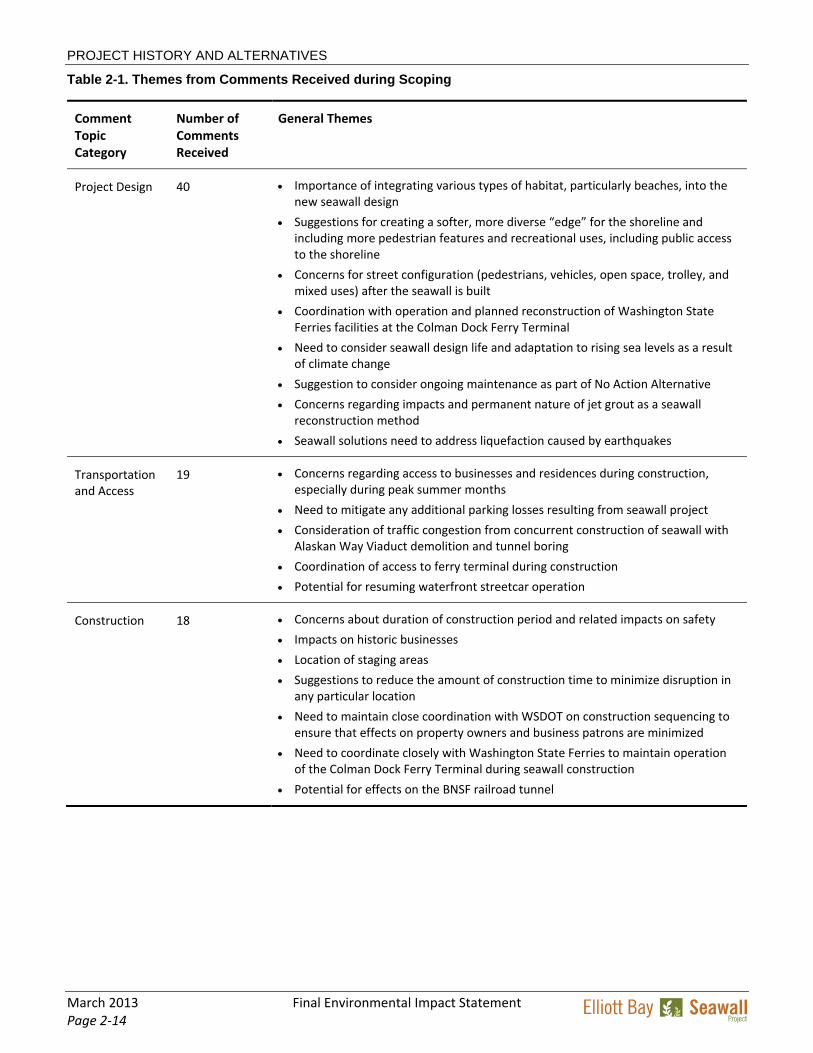
A total of 39 individuals and 17 organizations submitted scoping comments on the project. A summary of comment themes is provided in Table 2‐1. All of the scoping comments were incorporated into the environmental and design processes.
Draft EIS Review The Draft EIS was issued on November 13, 2012. The 30‐day comment period ended on December 13, 2012. A public and agency open house was held on December 5, 2012 in the Bell Harbor Conference Center. During the open house, the project team explained the project and the Draft EIS analysis of effects and made two formal presentations. A court reporter was also available to receive oral testimony at the public open house, although no one availed themselves of this opportunity.
A total of 54 comment letters, comment forms, and e‐mails were received. Ten were from tribes or government agencies, 11 from organizations, 14 from businesses, and the remainder from the general public. The comments and responses to each comment can be found in Appendix P to this Final EIS.
Elliott Bay Seawall Project Interagency and Tribal Team King County
Muckleshoot Indian Tribe
National Oceanic and Atmospheric Administration (NOAA)
Port of Seattle
Suquamish Tribe
U.S. Army Corps of Engineers (USACE)
U.S. Environmental Protection Agency (EPA)
U.S. Fish and Wildlife Service (USFWS)
Washington Department of Archaeology and Historic Preservation (DAHP)
Washington Department of Fish and Wildlife (WDFW)
Washington State Department of Ecology (Ecology)
Washington State Department of Natural Resources (DNR)
Washington State Department of Transportation (WSDOT)
Washington State Ferries (WSF)
PROJECT HISTORY AND ALTERNATIVES
Final Environmental Impact Statement March 2013 Page 2‐13
Additional Public and Agency Outreach Public and agency outreach has continued throughout project planning and design. As part of the City’s effort to ensure that interested and potentially affected parties remain engaged during the process, the City established a stakeholder group as a formal means of obtaining perspectives and recommendations. This group meets monthly to consider topics related to the design of the new seawall and potential construction impacts of the project. This Central Waterfront Stakeholders Group consists of waterfront business owners and tenants, professionals in the design and environmental fields, representatives from the Port of Seattle and Washington State Ferries, and downtown community members and residents. All of the stakeholder meetings have been open to the public, and the information presented at the meetings has been provided on the City’s project website.
For a chronological summary of the public involvement program to date see Social Resources and Environmental Justice Discipline Report (Appendix B). The information obtained from agencies, stakeholders, and the public informed the development of the alternatives that are evaluated in this EIS.
Agency Coordination and Input The City holds periodic meetings with an Interagency and Tribal Team to provide project updates and solicit feedback on project analysis and design, as well as permitting issues. This team consists of technical representatives from cooperating agencies and those that have jurisdiction over the project. As appropriate, meetings are held with individual agencies to discuss agency‐specific topics. The City has also formed an interdepartmental team of affected City departments, who review interim design products and provide feedback.
Public scoping meeting to gather input, 2010
PROJECT HISTORY AND ALTERNATIVES
March 2013 Final Environmental Impact Statement Page 2‐14
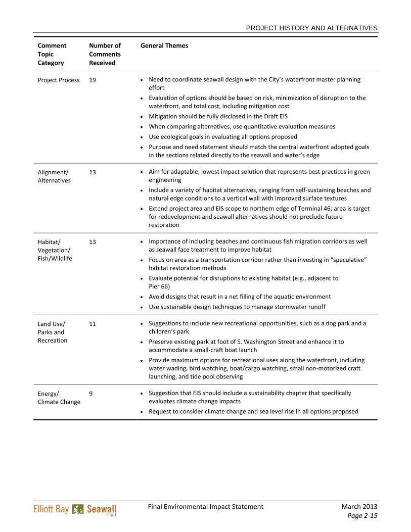
Table 2-1. Themes from Comments Received during Scoping
Comment Topic Category
Number of Comments Received
General Themes
Project Design 40 Importance of integrating various types of habitat, particularly beaches, into the new seawall design
Suggestions for creating a softer, more diverse “edge” for the shoreline and including more pedestrian features and recreational uses, including public access to the shoreline
Concerns for street configuration (pedestrians, vehicles, open space, trolley, and mixed uses) after the seawall is built
Coordination with operation and planned reconstruction of Washington State Ferries facilities at the Colman Dock Ferry Terminal
Need to consider seawall design life and adaptation to rising sea levels as a result of climate change
Suggestion to consider ongoing maintenance as part of No Action Alternative
Concerns regarding impacts and permanent nature of jet grout as a seawall reconstruction method
Seawall solutions need to address liquefaction caused by earthquakes
Transportation and Access
19 Concerns regarding access to businesses and residences during construction, especially during peak summer months
Need to mitigate any additional parking losses resulting from seawall project
Consideration of traffic congestion from concurrent construction of seawall with Alaskan Way Viaduct demolition and tunnel boring
Coordination of access to ferry terminal during construction
Potential for resuming waterfront streetcar operation
Construction 18 Concerns about duration of construction period and related impacts on safety
Impacts on historic businesses
Location of staging areas
Suggestions to reduce the amount of construction time to minimize disruption in any particular location
Need to maintain close coordination with WSDOT on construction sequencing to ensure that effects on property owners and business patrons are minimized
Need to coordinate closely with Washington State Ferries to maintain operation of the Colman Dock Ferry Terminal during seawall construction
Potential for effects on the BNSF railroad tunnel
PROJECT HISTORY AND ALTERNATIVES
Final Environmental Impact Statement March 2013 Page 2‐15
Comment Topic Category
Number of Comments Received
General Themes
Project Process 19 Need to coordinate seawall design with the City’s waterfront master planning effort
Evaluation of options should be based on risk, minimization of disruption to the waterfront, and total cost, including mitigation cost
Mitigation should be fully disclosed in the Draft EIS
When comparing alternatives, use quantitative evaluation measures
Use ecological goals in evaluating all options proposed
Purpose and need statement should match the central waterfront adopted goals in the sections related directly to the seawall and water’s edge
Alignment/ Alternatives
13 Aim for adaptable, lowest impact solution that represents best practices in green engineering
Include a variety of habitat alternatives, ranging from self‐sustaining beaches and natural edge conditions to a vertical wall with improved surface textures
Extend project area and EIS scope to northern edge of Terminal 46; area is target for redevelopment and seawall alternatives should not preclude future restoration
Habitat/ Vegetation/ Fish/Wildlife
13 Importance of including beaches and continuous fish migration corridors as well as seawall face treatment to improve habitat
Focus on area as a transportation corridor rather than investing in “speculative” habitat restoration methods
Evaluate potential for disruptions to existing habitat (e.g., adjacent to Pier 66)
Avoid designs that result in a net filling of the aquatic environment
Use sustainable design techniques to manage stormwater runoff
Land Use/ Parks and Recreation
11 Suggestions to include new recreational opportunities, such as a dog park and a children’s park
Preserve existing park at foot of S. Washington Street and enhance it to accommodate a small‐craft boat launch
Provide maximum options for recreational uses along the waterfront, including water wading, bird watching, boat/cargo watching, small non‐motorized craft launching, and tide pool observing
Energy/ Climate Change
9 Suggestion that EIS should include a sustainability chapter that specifically evaluates climate change impacts
Request to consider climate change and sea level rise in all options proposed
PROJECT HISTORY AND ALTERNATIVES
March 2013 Final Environmental Impact Statement Page 2‐16
Comment Topic Category
Number of Comments Received
General Themes
Economics 8 Importance of accurately considering economic factors affecting waterfront businesses, including seasonality, access, parking availability, and pier‐based transportation functions
Concern about severity of construction impacts during peak summer season
Importance of minimizing impacts on the Seattle Aquarium
Need to address impacts on Port of Seattle tenant access and operations, both due to project and as a result of seawall failure under No Action Alternative
Public Involvement
8 Suggestion that public meetings be held later in the day and/or in different locations to allow greater participation
Noise/ Vibration
6 Concerns about construction noise, including timing of impacts with other nearby projects
Suggestion to include noise mitigation measures in Draft EIS
Issues about vibration, including effects on pile‐supported buildings and potential for combined impacts of seawall and tunnel construction
Recommendation to include new noise monitoring locations for seawall rather than using viaduct measurements
Other Topics 25 General concerns about air quality, including need to mitigate dust and air pollution from construction
Continued provision of utility service to waterfront customers and coordination of utility relocation
Existing contamination should be cleaned up as part of the Elliott Bay Seawall Project
Compatibility of construction lighting with residential uses
Importance of respecting the history and context of the waterfront
Need to maintain/provide Americans with Disabilities Act (ADA) provisions along the waterfront
PROJECT HISTORY AND ALTERNATIVES
Final Environmental Impact Statement March 2013 Page 2‐17
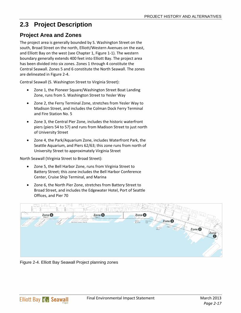
2.3 Project Description
Project Area and Zones The project area is generally bounded by S. Washington Street on the south, Broad Street on the north, Elliott/Western Avenues on the east, and Elliott Bay on the west (see Chapter 1, Figure 1‐1). The western boundary generally extends 400 feet into Elliott Bay. The project area has been divided into six zones. Zones 1 through 4 constitute the Central Seawall. Zones 5 and 6 constitute the North Seawall. The zones are delineated in Figure 2‐4.
Central Seawall (S. Washington Street to Virginia Street):
Zone 1, the Pioneer Square/Washington Street Boat Landing Zone, runs from S. Washington Street to Yesler Way
Zone 2, the Ferry Terminal Zone, stretches from Yesler Way to Madison Street, and includes the Colman Dock Ferry Terminal and Fire Station No. 5
Zone 3, the Central Pier Zone, includes the historic waterfront piers (piers 54 to 57) and runs from Madison Street to just north of University Street
Zone 4, the Park/Aquarium Zone, includes Waterfront Park, the Seattle Aquarium, and Piers 62/63; this zone runs from north of University Street to approximately Virginia Street
North Seawall (Virginia Street to Broad Street):
Zone 5, the Bell Harbor Zone, runs from Virginia Street to Battery Street; this zone includes the Bell Harbor Conference Center, Cruise Ship Terminal, and Marina
Zone 6, the North Pier Zone, stretches from Battery Street to Broad Street, and includes the Edgewater Hotel, Port of Seattle Offices, and Pier 70
Figure 2-4. Elliott Bay Seawall Project planning zones
PROJECT HISTORY AND ALTERNATIVES
March 2013 Final Environmental Impact Statement Page 2‐18
Project Alternatives The EIS evaluates a No Action Alternative and three potential build alternatives for the project. As required by SEPA, the build alternatives represent different ways of accomplishing the project purpose. Evaluating alternatives allows SDOT decision‐makers, with input from the public, agencies, and tribes, to consider environmental impacts in conjunction with other factors such as cost, schedule, and feasibility.
The three build alternatives encompass a range of design ideas to establish “bookends” for the project, thereby capturing a suite of potential options and effects. The alternatives considered in the Elliott Bay Seawall Project (EBSP) EIS were developed as a direct result of input received during the scoping process and included seawall replacement farther landward than had been considered in earlier analyses. The alternatives provide as wide a range of seawall placement options (3 feet waterward to 75 feet landward) as the space allows, given the purpose and need for the project. The primary reason for not moving the seawall farther landward is to maintain the existing capacity and function of all existing infrastructure, including Alaskan Way, bicycle and pedestrian facilities, utilities, railroads, and pier infrastructure.
Features of the alternatives could be blended in future design phases to reflect public, agency, and stakeholder input. Some project components are included as optional and could be incorporated into or eliminated from the preferred alternative. The alternatives can generally be summarized as follows:
Alternative A would reconstruct the seawall as close to its existing alignment as possible. Jet grouting, a subsurface soil improvement, would be used to form the structural support of the seawall. Habitat improvements would include the addition of basic shoreline enhancements and riparian plantings, as well as the installation of a continuous habitat bench and light‐penetrating surfaces at piers.
Alternative B would move the seawall up to 75 feet landward of its current location. Braced soldier piles would be used to build an underground wall structure. Moving the seawall inland would provide additional space for habitat improvements including the construction of a wider continuous habitat bench, and continuous light‐penetrating surfaces. This alternative would also include public gathering space at either a land or water plaza in the vicinity of the aquarium.
Alternative C would move the seawall up to 15 feet landward of its current location. This alternative would use soil improvements to provide structural support. The landward movement of the seawall would allow the placement of a continuous habitat bench and continuous light‐penetrating surfaces. In addition, shoreline enhancements would be provided between pier structures.
PROJECT HISTORY AND ALTERNATIVES
Final Environmental Impact Statement March 2013 Page 2‐19
The following sections describe the No Action Alternative, discuss the features that are common to the three build alternatives, and provide an overview of project construction and additional detail about specific features that differ among the build alternatives.
No Action Alternative SEPA and the City’s implementing regulations (SMC 25.05) require that the EIS evaluate a No Action Alternative in addition to the build alternatives. The No Action Alternative provides a baseline against which the potential effects of the build alternatives can be compared.
The No Action Alternative is projected over the next 50 years. Given the age and condition of the seawall, continued deterioration and some level of failure will likely occur within the 50‐year timeframe. Because the existing seawall is vulnerable to various types of damage, the No Action Alternative must anticipate the possibility of degrees of seawall failure. Therefore, three scenarios under the No Action Alternative have been evaluated and are described below.
Minimal Damage: This scenario would not require a significant repair of the seawall, and any needed repairs could be undertaken by the City. Small failures caused by tidal erosion (as are currently happening today) or minor seismic events would result in settlement of the wall or collapse of the roadway or sidewalk on Alaskan Way. This scenario assumes continued operation of the seawall with ongoing maintenance as needed.
Loss of Functionality: This scenario would result from sustained damage, and the seawall would no longer be considered safe for public access and could no longer perform the majority of its essential functions. As with the Minimal Damage scenario, this scenario could result from either tidal or seismic events.
Collapse of the Seawall: This scenario would occur only as a result of seismic damage; however, collapse resulting from a seismic event could trigger additional damage due to tidal erosion. Seawall failure would have significant impacts on the public, Seattle, the Puget Sound region, Washington State, and the nation. Loss of the seawall function would disrupt or destroy the critical transportation infrastructure that runs along the Seattle waterfront, potentially displacing hundreds of thousands of vehicles on roadways, 30,000 daily ferry passengers who use Colman Dock Ferry Terminal, and 24 freight trains and six passenger trains that run near the waterfront. It would also jeopardize critical utility corridors that serve downtown Seattle and the region and impair the viability of the waterfront as a major tourist destination and regional economic engine.
PROJECT HISTORY AND ALTERNATIVES
March 2013 Final Environmental Impact Statement Page 2‐20
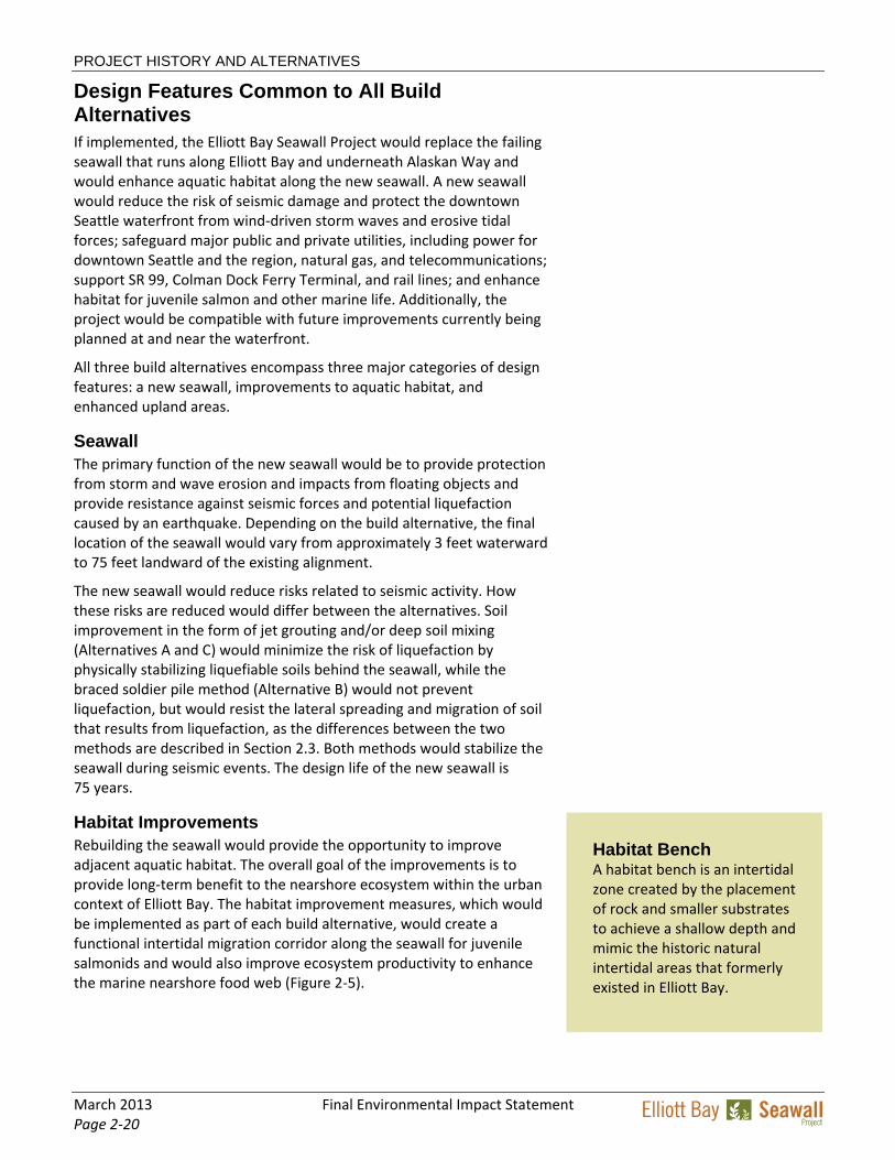
Habitat Bench A habitat bench is an intertidal zone created by the placement of rock and smaller substrates to achieve a shallow depth and mimic the historic natural intertidal areas that formerly existed in Elliott Bay.
Design Features Common to All Build Alternatives If implemented, the Elliott Bay Seawall Project would replace the failing seawall that runs along Elliott Bay and underneath Alaskan Way and would enhance aquatic habitat along the new seawall. A new seawall would reduce the risk of seismic damage and protect the downtown Seattle waterfront from wind‐driven storm waves and erosive tidal forces; safeguard major public and private utilities, including power for downtown Seattle and the region, natural gas, and telecommunications; support SR 99, Colman Dock Ferry Terminal, and rail lines; and enhance habitat for juvenile salmon and other marine life. Additionally, the project would be compatible with future improvements currently being planned at and near the waterfront.
All three build alternatives encompass three major categories of design features: a new seawall, improvements to aquatic habitat, and enhanced upland areas.
Seawall The primary function of the new seawall would be to provide protection from storm and wave erosion and impacts from floating objects and provide resistance against seismic forces and potential liquefaction caused by an earthquake. Depending on the build alternative, the final location of the seawall would vary from approximately 3 feet waterward to 75 feet landward of the existing alignment.
The new seawall would reduce risks related to seismic activity. How these risks are reduced would differ between the alternatives. Soil improvement in the form of jet grouting and/or deep soil mixing (Alternatives A and C) would minimize the risk of liquefaction by physically stabilizing liquefiable soils behind the seawall, while the braced soldier pile method (Alternative B) would not prevent liquefaction, but would resist the lateral spreading and migration of soil that results from liquefaction, as the differences between the two methods are described in Section 2.3. Both methods would stabilize the seawall during seismic events. The design life of the new seawall is 75 years.
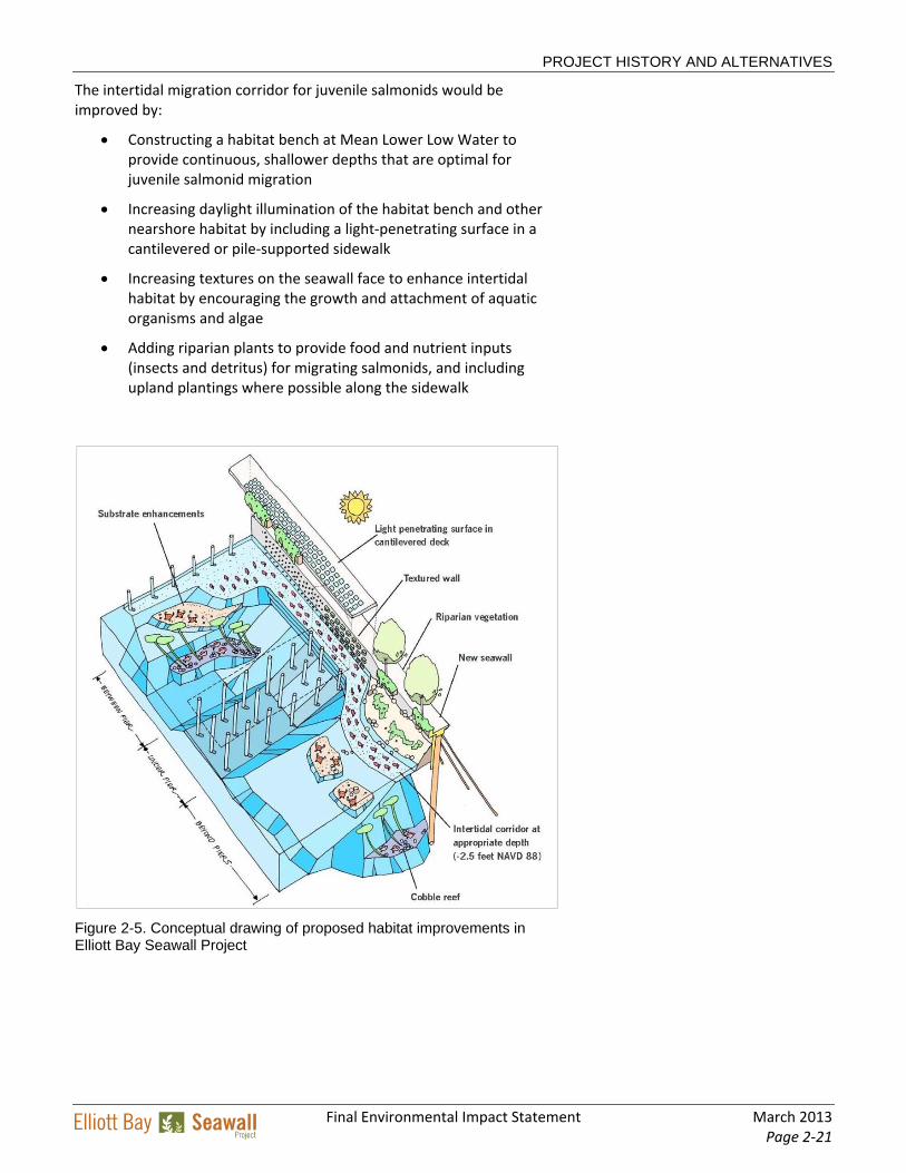
Habitat Improvements Rebuilding the seawall would provide the opportunity to improve adjacent aquatic habitat. The overall goal of the improvements is to provide long‐term benefit to the nearshore ecosystem within the urban context of Elliott Bay. The habitat improvement measures, which would be implemented as part of each build alternative, would create a functional intertidal migration corridor along the seawall for juvenile salmonids and would also improve ecosystem productivity to enhance the marine nearshore food web (Figure 2‐5).
PROJECT HISTORY AND ALTERNATIVES
Final Environmental Impact Statement March 2013 Page 2‐21
The intertidal migration corridor for juvenile salmonids would be improved by:
Constructing a habitat bench at Mean Lower Low Water to provide continuous, shallower depths that are optimal for juvenile salmonid migration
Increasing daylight illumination of the habitat bench and other nearshore habitat by including a light‐penetrating surface in a cantilevered or pile‐supported sidewalk
Increasing textures on the seawall face to enhance intertidal habitat by encouraging the growth and attachment of aquatic organisms and algae
Adding riparian plants to provide food and nutrient inputs (insects and detritus) for migrating salmonids, and including upland plantings where possible along the sidewalk
Figure 2-5. Conceptual drawing of proposed habitat improvements in Elliott Bay Seawall Project
PROJECT HISTORY AND ALTERNATIVES
March 2013 Final Environmental Impact Statement Page 2‐22
Enhanced ecosystem productivity would generally be accomplished by:
Providing smaller, more naturally sized substrates
Placing various substrates waterward of the habitat bench to diversify shallow‐water habitats
Constructing a textured seawall face
Adding riparian plants to provide food and nutrient inputs (insects and detritus) for migrating salmonids, and including upland plantings where possible along the sidewalk
Adding light‐penetrating surfaces to increase light to the habitat corridor
The enhanced habitat areas have been designed to minimize impacts on navigation along the seawall. These features would not interfere with the public’s ability to move through and perform water‐dependent business within the harbor area waters. Disruption of typical use patterns is not anticipated.
Upland Improvements In addition to replacing the seawall and restoring aquatic habitat, the three build alternatives would enhance upland areas. The existing Alaskan Way roadway, multi‐use trail, and parking would be restored to their original function and capacity after construction. A cantilevered or pile‐supported sidewalk would be constructed along the waterfront. The cantilevered area would range from 5 to 20 feet in width and would include a light‐penetrating surface that would benefit the marine habitat below. Viewing areas with opportunities for public gathering space could be provided waterward of the sidewalk. New railings, formal and informal seating, bicycle racks, wayfinding elements, and other design amenities would also be provided. All alternatives would restore the historic Washington Street Boat Landing, either maintaining its current location or moving it 15 feet waterward.
Currently, there are no water quality facilities for treating surface water runoff from Alaskan Way. Stormwater drainage pipes in the project area would be reconstructed, and water quality would be improved by stormwater treatment to remove suspended solids, oils, and greases. These features would improve nearshore water quality in the project area.
Project Construction
Construction Schedule Construction of the Central Seawall is expected to begin in fall 2013, with limited early work activities, such as utility relocations, taking place in spring and summer 2013. The detailed construction schedule is still under development. At this time, work is expected to generally occur from north to south, beginning in Zone 4 and progressing southward. To take advantage of the current closure of Alaskan Way for the bored
PROJECT HISTORY AND ALTERNATIVES
Final Environmental Impact Statement March 2013 Page 2‐23
tunnel south portal construction, work in Zone 1 may be done concurrently with Zone 4 during the first construction season. Construction would require three (Alternatives A and C) to five (Alternative B) construction seasons. The North Seawall would be built as a separate construction phase and would require an additional four construction seasons. Construction is expected to start from Broad Street and move south to Virginia Street.
Each construction season will extend from approximately Labor Day to Memorial Day, with a summer construction shutdown observed to avoid major disruption during the peak tourist season. To minimize impacts during September, which is a busy month for many waterfront businesses, construction mobilization would begin gradually after Labor Day, and an effort would be made to preserve as much parking as possible. For instance, during the first construction season, the contractor could avoid construction directly in front of waterfront businesses in Zone 4 and provide some parking within the construction zone.
Temporary Roadway and Construction Work Zone To accommodate construction activities during the seawall replacement, the existing Alaskan Way roadway would be relocated to beneath the Alaskan Way Viaduct. Three lanes of traffic would be maintained underneath the viaduct throughout construction. The resulting space along the waterfront would be used as a work zone during construction of the Central Seawall (Figure 2‐6). During North Seawall construction, this dedicated construction work zone would not be available, and the temporary roadway would be accommodated in the available right‐of‐way.
The construction work zone would primarily extend from the western edge of the existing multi‐use path on Alaskan Way to the water. Existing street trees in this area would be removed and either replanted as street plantings or replaced during future waterfront improvement projects. The existing streetcar tracks that run along Alaskan Way would also be removed during construction.
Figure 2-6. Construction work zone and temporary roadways
PROJECT HISTORY AND ALTERNATIVES
March 2013 Final Environmental Impact Statement Page 2‐24
Construction would be staged from several locations within the work zone. The staging areas, which would vary in size, would be used for delivery and storage of construction materials and equipment. The staging areas would be sited to avoid disrupting access to piers, residences, and businesses along the waterfront. In addition to the upland staging areas, construction activities may also be staged from one to two barges in Elliott Bay, which would be used for storage of precast concrete, rebar, and other materials and equipment.
To the greatest extent possible, construction materials and personnel would be transported to the construction work zone and staging areas via freeways and arterials. However, other city streets could be used when needed. The eastern border of the construction work zone along Alaskan Way would serve as a haul road, channeling construction truck traffic within the project area, off of the temporary roadway. To reduce traffic within the project area, construction materials could also be transported to and from the project area via barge.
During seawall construction, some temporary public parking spaces could be provided outside of active construction zones. Throughout construction, the existing multi‐use trail would be maintained with the potential for temporary detours, and access to the piers would be maintained with the potential for revised access points.
Construction Methods The seawall would be replaced using soil improvement or braced soldier piles or a combination of these two methods. Under either of these methods, it would be most efficient to leave the existing seawall complex in place during construction of the new seawall and to build the new structure either behind or in front of the existing face (depending on alternative). This section describes the two construction methods for seawall replacement, along with related construction activities.
Soil Improvement Soil improvement is a general term for a variety of techniques that are used to stabilize existing soils by improving their internal structure and strength. Two techniques are being considered for Alternatives A and C: jet grouting and deep soil mixing. Jet grouting consists of adding grout to existing soils to form a “block” of improved soil mass that extends down to the competent foundation below. This technique has been identified as a feasible way to strengthen the material underlying the project area, which includes an existing timber relieving platform, buried timber piles, utilities, and other potential obstructions.
Jet grouting creates circular columns of soil cement by means of a hollow drill pipe measuring a few inches in diameter that is inserted into the soil. Grout is then sprayed into the surrounding soil under high pressure through horizontal nozzles in the rotating drill pipe into the surrounding soil. This process cuts the existing soil and mixes the soil with the grout. The strength of the soil would be substantially improved
Jet grouting construction site in downtown Pittsburgh
PROJECT HISTORY AND ALTERNATIVES
Final Environmental Impact Statement March 2013 Page 2‐25
through this process, greatly reducing the soil’s potential for liquefaction during an earthquake.
The grout columns would be constructed in a grid pattern to create a jet‐grouted block of improved soil. The grid pattern would be installed between the timber piles of the existing seawall to eliminate the need to remove the existing piles. The finished arrangement of the grouted columns would create a “spine” for the new seawall. The grouting process generates excess materials (a mixture of water, soil, and cement) that would come to the surface as grouting is taking place. This excess material will be captured and reused or disposed of by appropriate means, in accordance with applicable regulations.
Deep soil mixing, another technique that could be used for soil improvement, uses an auger that penetrates the ground surface to mix and consolidate the underlying soils to a depth of up to 20 feet. With deep soil mixing, no grout is applied under pressure, and there is less excess material for disposal.
Braced Soldier Piles Braced soldier piles are an alternative structural stabilization method. This method would involve drilling large holes (approximately 8 feet in diameter) to a depth of approximately 75 feet below the present street level of Alaskan Way, where a firm layer of glacial till is located. An oscillator (a specialized piece of drilling equipment) would install a steel casing as the drilling progresses to prevent the holes from collapsing and to contain the soils to be excavated. The leading edge of the casing would be equipped with cutting teeth to carve through the timber boards and piles of the existing relieving platform and into the soils below.
Once the holes have been drilled and excavated to the final depth, a steel reinforcing cage would be placed into the interior of the shaft casing, and the casing would be filled with concrete. The casing would be extracted as the concrete is poured and would leave behind a reinforced concrete cylinder, or soldier pile. A line of these soldier piles would be constructed to form the spine of the seawall. Soil anchors would then be installed to brace or tie back these soldier piles.
Temporary Containment Wall To isolate construction activities from the open waters of Elliott Bay, a temporary containment wall would be installed waterward of the existing seawall face, below the area occupied by the existing cantilevered sidewalk. The temporary containment wall would consist of a series of sheet piles that would be driven into the subsurface soils. Constructed as a robust barrier between the primary construction zone and Elliott Bay, the temporary containment wall would contain construction debris, provide added water quality protection during soil improvement activities, and serve as support for temporary access bridges and walkways. Once completed, the wall would allow construction activities behind the wall to occur isolated from Elliott Bay.
Equipment used for braced soldier pile construction
PROJECT HISTORY AND ALTERNATIVES
March 2013 Final Environmental Impact Statement Page 2‐26
Soil Dewatering Regardless of the construction method that is selected, excavations into soils in the construction zone would need to be dewatered, which generally involves disposing of the wastewater offsite or pumping the excess water to a location where it can be settled and/or treated before discharge. Wet spoils generated during construction must be managed or disposed of as well. The City is currently exploring various methods for managing and disposing of wastewater and spoils, which will be detailed in the project’s dewatering and erosion control submittals required as part of the Clean Water Act Section 401 and National Pollutant Discharge Elimination System (NPDES) construction general stormwater permit processes, as well as by the City’s standard construction specifications.
Utility Protection and/or Relocation The project area contains a large number of utilities, including water, sanitary sewer, combined sewer, stormwater, electrical transmission and distribution, steam, natural gas, fire alarm, and numerous telecommunication systems. These utilities range from major transmission lines serving portions of Seattle and the region to individual connections serving adjacent properties. As shown in Figure 2‐7, some of these utilities are directly beneath the Alaskan Way roadway and sidewalk and above the relieving platform of the existing seawall, while others extend through the seawall to the piers.
The City’s objective is to maintain utility service to the greatest extent possible during construction, although the means and methods for doing so would vary depending on the construction method used. Most individual service lines would be temporarily relocated during
PROJECT HISTORY AND ALTERNATIVES
Final Environmental Impact Statement March 2013 Page 2‐27
construction and would be reinstalled in their final locations as construction progresses. Final points of service to the waterfront piers would remain close to the existing connections. The final construction method chosen will not preclude the ability of the utilities to provide future new services to the waterfront area.
Use of Precast Components Precast‐concrete components would be used as part of the seawall construction. These components can accelerate project construction by allowing the concrete to be formed and cured in a controlled environment at an off‐site location, away from the construction activity.
Precast superstructure components (e.g., seawall face panels) and ancillary components (e.g., rebar cages) will be constructed at an off‐site facility and will be delivered to the site via barge or truck for incorporation into the seawall structure. Construction of these pieces would occur at an existing commercial or industrial facility, where construction and materials storage is consistent with typical facility operations.
Although no land‐based staging areas are currently planned outside of the work zone, it is possible that such staging areas could be identified. These staging areas could be used for the storage of construction equipment and materials, preparatory work, and employee parking. If the contractor were to decide that an off‐site staging area is needed to maintain schedule and progress, appropriate environmental documentation would be prepared before the use of the area for this purpose.
Use of Barges Barges would likely be used for a number of activities during construction, including:
Delivery of precast components to specific access points along the seawall
Removal of riprap and large debris waterward of the existing seawall
Installation and removal of the temporary containment wall and in‐water piles
Removal of the Washington Street Boat Landing pergola and replacement of piles for its new foundation after restoration
Placement of habitat features
Barge use would allow the movement of large, heavy materials, such as precast‐concrete sections and marine mattresses, without trucking through city streets. Barges could also provide storage at the job site, allowing for a ready supply of materials with a lesser chance of delay. Reduced delays allow for greater productivity, efficiency and cost savings while maintaining the proposed construction schedule. Barges
PROJECT HISTORY AND ALTERNATIVES
March 2013 Final Environmental Impact Statement Page 2‐28
would be used during all construction seasons. The majority of the barge traffic would occur during delivery of the precast wall segments and for placing habitat features.
Managing Waste Stream from Soil Improvement A number of sustainability goals have been identified throughout the design process and evaluated for potential incorporation into the project design and construction. Among these goals is the commitment to minimize the project’s waste stream. In collaboration with the contractor, the City is working to identify materials that could be acceptable for reuse on the seawall project or as part of future City projects. Reusing materials generated or encountered during construction would reduce the total amount of material that is disposed of in a landfill or other permitted facility.
Planned soil improvement activities will produce a large volume of jet grout spoils (a mixture of soil and cement). Based on existing data, it is expected that the jet grout spoils could meet SDOT requirements for unclassified borrow (common fill). A portion of the spoils could be used onsite in their wet condition as controlled density fill. Additionally, the spoils could be stockpiled at a City‐owned off‐site location until reuse opportunities are identified for other local projects. All reuse would meet Ecology requirements.
The existing soil that would be excavated above the relieving platform of the existing seawall has been identified for potential reuse as backfill. This material consists of well graded sandy gravel. Soils would be sampled and tested to determine their suitability for reuse.
Details regarding how and where to stockpile materials for reuse would be incorporated into the project’s waste management plan. Appropriate environmental analysis and documentation of off‐site storage locations would be prepared, if needed, before the site is used. Temporary erosion and sediment control measures would be implemented to prevent runoff from any stockpiling sites.
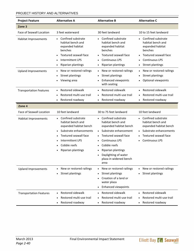
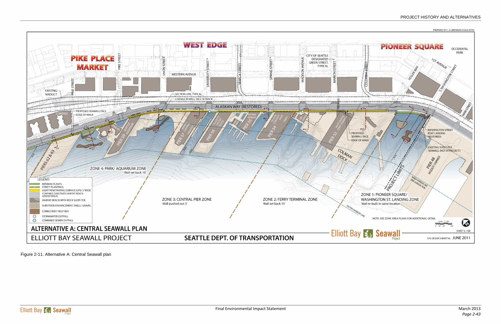
Features Specific to Each Build Alternative The preceding sections provided information on project components that would be similar among the three build alternatives. The following discussion focuses on the primary differences among Alternatives A, B, and C in terms of the seawall location, configuration of Alaskan Way, habitat improvements, public amenities, and construction sequence and schedule. The key features of the build alternatives within each of the zones are indicated in Table 2‐2 (at the end of this chapter). Conceptual plans for the three build alternatives are provided at the end of this chapter (Figure 2‐11 through Figure 2‐17).
PROJECT HISTORY AND ALTERNATIVES
Final Environmental Impact Statement March 2013 Page 2‐29
Seawall Alignment, Alternative A The approximate proposed location of the seawall face relative to the existing seawall face would be:
Zone 1: In place (no change)
Zone 2: 15 feet landward
Zone 3: 3 feet waterward
Zones 4, 5, and 6: 10 feet landward
Alternative A Alternative A would reconstruct the seawall as close to its existing alignment as possible, with jet grouting forming the structural support. Habitat improvements would include the addition of basic shoreline enhancements and riparian plantings, as well as the installation of a continuous habitat bench and light‐penetrating surfaces. Figure 2‐11 and Figure 2‐12 at the end of this chapter depict Alternative A.
Seawall Under Alternative A, the new seawall would be constructed as close to the alignment of the existing seawall as possible, with only a minimal setback (as outlined in the sidebar). The slight setback in most places would allow construction to proceed without requiring the removal of the existing seawall first.
In Zone 1, the new seawall would be reconstructed in the location of the existing seawall. In Zones 2, 4, 5, and 6, the new seawall would be constructed behind (east of) the existing seawall, and then the existing seawall west of the new seawall face would be demolished. In Zone 3, the new seawall structure would be constructed west of the existing seawall; the new seawall face would be set 3 feet waterward of the existing seawall face.
Roadway The existing Alaskan Way is generally four lanes (two lanes in each direction), except in the vicinity of Colman Dock (Yesler Way to Spring Street), where it consists of one northbound lane and two southbound lanes. Alternative A would add a permanent northbound lane between S. Washington and Spring Streets1 to handle traffic in this segment headed to Colman Dock and through to other destinations; a temporary second northbound lane (constructed by WSDOT) is currently in place. Parking and loading zones in the finished configuration would be similar to today.
A sidewalk of approximately the same width as the existing sidewalk (15 to 20 feet) would be provided on the west side of the street. The sidewalk would be cantilevered or pile supported in Zones 2 through 6 and would extend back to the piers in all zones, with a light‐penetrating surface provided where feasible. The mixed‐use trail on the east side of Alaskan Way would be extended north from its existing terminus to Clay Street. At Clay Street, the trail would cross Alaskan Way and continue on the west side of Alaskan Way to Broad Street, where it would connect to the existing trail system that runs along Olympic Sculpture Park and Myrtle Edwards Park.
1 The Elliott Bay Seawall Project would build the additional lane from S. Washington Street to Spring Street. The portion between S. King Street and S. Washington Street has already been constructed as part of the SR 99 Tunnel Project.
PROJECT HISTORY AND ALTERNATIVES
March 2013 Final Environmental Impact Statement Page 2‐30
Habitat Improvements Alternative A would provide a continuous intertidal corridor along the seawall, starting at Colman Dock, to support juvenile salmonid migration and would enhance ecosystem productivity by the installation of light‐penetrating surfaces adjacent to the piers, a textured seawall face, subtidal substrate enhancements and cobble reefs, and riparian plantings.
Upland Improvements Under Alternative A, public amenities would include the restored historic Washington Street Boat Landing, new or replaced railings, new sidewalks, waterfront planters, and street plantings. Reconstructed sidewalks would extend from the curb line of the restored Alaskan Way to the western edge of the existing sidewalk. These improvements would add variety to the waterfront by defining gathering spaces, viewing areas, and building entries.
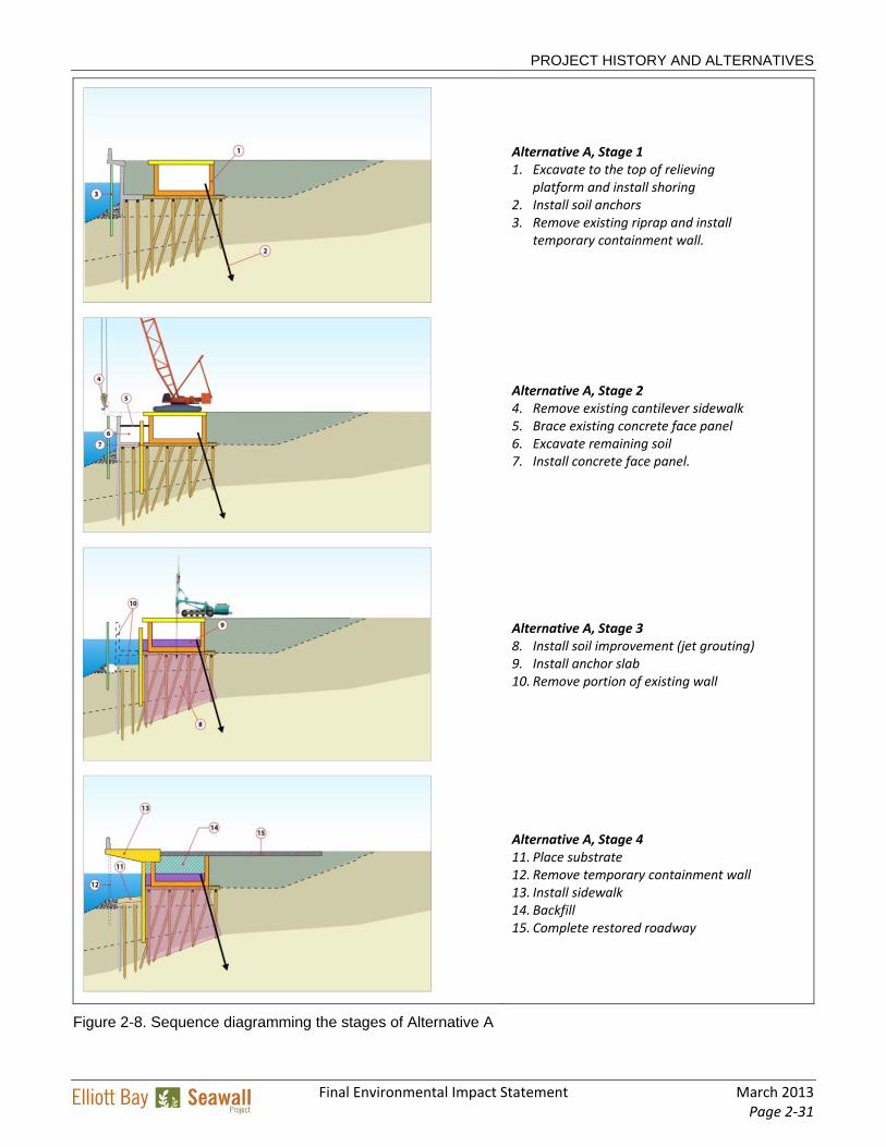
Construction and Schedule Under Alternative A, the construction method proposed for the primary structural element of the seawall is jet grouting. With this method, construction of the Central Seawall would require approximately three construction seasons, with two summer shutdown periods. Construction of the North Seawall would require an additional four construction seasons, with three summer shutdown periods. Construction of Central Seawall under Alternative A would begin in Zone 4, move south to Zone 3, and then progress to Zones 2 and 1. The Central Seawall construction would be followed by the North Seawall construction in Zones 6 and 5.
The anticipated construction activities and their probable sequence for Alternative A, using jet grouting for the soil improvement, are depicted in Figure 2‐8. The figure describes the four primary stages of work along the waterfront. The construction activities within each zone would vary depending on the type of existing seawall. The figures depict the Type A seawall. (Type A seawall is a sheet pile‐supported, reinforced, concrete face panel, which is tied back to a buried timber relieving platform supported by vertical and battered timber piles.) For Alternative A, it was assumed that the area above the existing relieving platform would be excavated before jet grouting begins.
PROJECT HISTORY AND ALTERNATIVES
Final Environmental Impact Statement March 2013 Page 2‐31
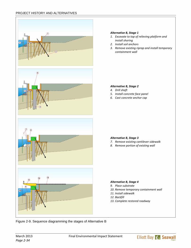
Alternative A, Stage 1 1. Excavate to the top of relieving
platform and install shoring 2. Install soil anchors 3. Remove existing riprap and install
temporary containment wall.
Alternative A, Stage 2 4. Remove existing cantilever sidewalk 5. Brace existing concrete face panel 6. Excavate remaining soil 7. Install concrete face panel.
Alternative A, Stage 3 8. Install soil improvement (jet grouting) 9. Install anchor slab 10. Remove portion of existing wall
Alternative A, Stage 4 11. Place substrate 12. Remove temporary containment wall 13. Install sidewalk 14. Backfill 15. Complete restored roadway
Figure 2-8. Sequence diagramming the stages of Alternative A
PROJECT HISTORY AND ALTERNATIVES
March 2013 Final Environmental Impact Statement Page 2‐32
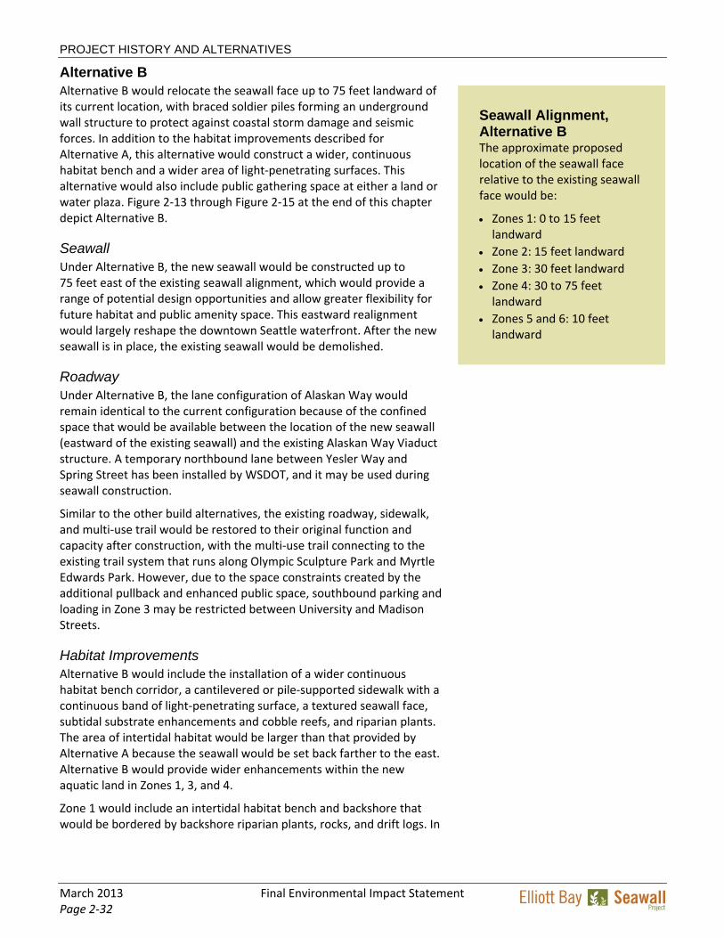
Alternative B Alternative B would relocate the seawall face up to 75 feet landward of its current location, with braced soldier piles forming an underground wall structure to protect against coastal storm damage and seismic forces. In addition to the habitat improvements described for Alternative A, this alternative would construct a wider, continuous habitat bench and a wider area of light‐penetrating surfaces. This alternative would also include public gathering space at either a land or water plaza. Figure 2‐13 through Figure 2‐15 at the end of this chapter depict Alternative B.
Seawall Under Alternative B, the new seawall would be constructed up to 75 feet east of the existing seawall alignment, which would provide a range of potential design opportunities and allow greater flexibility for future habitat and public amenity space. This eastward realignment would largely reshape the downtown Seattle waterfront. After the new seawall is in place, the existing seawall would be demolished.
Roadway Under Alternative B, the lane configuration of Alaskan Way would remain identical to the current configuration because of the confined space that would be available between the location of the new seawall (eastward of the existing seawall) and the existing Alaskan Way Viaduct structure. A temporary northbound lane between Yesler Way and Spring Street has been installed by WSDOT, and it may be used during seawall construction.
Similar to the other build alternatives, the existing roadway, sidewalk, and multi‐use trail would be restored to their original function and capacity after construction, with the multi‐use trail connecting to the existing trail system that runs along Olympic Sculpture Park and Myrtle Edwards Park. However, due to the space constraints created by the additional pullback and enhanced public space, southbound parking and loading in Zone 3 may be restricted between University and Madison Streets.
Habitat Improvements Alternative B would include the installation of a wider continuous habitat bench corridor, a cantilevered or pile‐supported sidewalk with a continuous band of light‐penetrating surface, a textured seawall face, subtidal substrate enhancements and cobble reefs, and riparian plants. The area of intertidal habitat would be larger than that provided by Alternative A because the seawall would be set back farther to the east. Alternative B would provide wider enhancements within the new aquatic land in Zones 1, 3, and 4.
Zone 1 would include an intertidal habitat bench and backshore that would be bordered by backshore riparian plants, rocks, and drift logs. In
Seawall Alignment, Alternative B The approximate proposed location of the seawall face relative to the existing seawall face would be:
Zones 1: 0 to 15 feet landward
Zone 2: 15 feet landward
Zone 3: 30 feet landward
Zone 4: 30 to 75 feet landward
Zones 5 and 6: 10 feet landward
PROJECT HISTORY AND ALTERNATIVES
Final Environmental Impact Statement March 2013 Page 2‐33
Zone 4, the 30‐ to 75‐foot seawall setback would allow expanded upland riparian planting or increased intertidal habitat.
Upland Improvements Alternative B would improve water viewing at various locations and provide additional public gathering spaces, as well as interpretive and recreational opportunities. The new sidewalks would be enhanced with light‐penetrating surfaces and reconfigured with planters and new or replaced railings along the length of the seawall. These additional and enhanced gathering and overlook spaces would be provided in Zones 1, 3, 4, 5, and 6.
In Zone 1, the Washington Street Boat Landing would be restored and reinstalled within the Washington Street right‐of‐way, waterward of its current location to improve its connection to the water. A new gangway and short‐stay boat moorage could be created to restore the landing’s historic connection with Elliott Bay. North of the boat landing, steps and a boardwalk (Option 1) or boulders (Option 2), could be added for seating and for physical access to or viewing of the new intertidal habitat bench.
Zones 3, 5, and 6 would include viewpoints between the piers. These viewpoints would create opportunities for public gathering, seating, and water viewing. The viewpoints would be parallel with the adjacent piers, thereby directing the view out to Elliott Bay. The viewpoints would include seating steps and stairs to bring people closer to the water and light‐penetrating surfaces.
In Zone 4, the proposed seawall setback of 30 to 75 feet would provide two types of opportunities: a water plaza (Option 1) or a land plaza (Option 2). In Option 1, openings in the expansive plaza and walk would allow users to view tide pools and aquatic life below. In Option 2, raised planters would be filled with riparian plants, logs, and stones that would be reminiscent of Puget Sound shorelines.
Construction and Schedule Under Alternative B, the design option proposed for the primary structural element of the seawall is braced soldier piles, installed by means of a drilled‐shaft construction method. With this method, construction of the Central Seawall would require approximately five construction seasons, with four summer shutdown periods. Construction of the North Seawall would require an additional four construction seasons, similar to Alternatives A and C, although the duration may be slightly longer. The anticipated construction stages for Alternative B (assuming a Type A existing seawall) are shown in Figure 2‐9.
PROJECT HISTORY AND ALTERNATIVES
March 2013 Final Environmental Impact Statement Page 2‐34
Alternative B, Stage 1 1. Excavate to top of relieving platform and
Figure 2-9. Sequence diagramming the stages of Alternative B
PROJECT HISTORY AND ALTERNATIVES
Final Environmental Impact Statement March 2013 Page 2‐35
Access during construction would be more difficult than for either Alternatives A or C because the eastward setback of the seawall would restrict the construction staging areas to the project ends (i.e., north and south extents), instead of alongside the construction work zone. Under Alternative B, it would not be possible to maintain a continuous construction haul road because of the seawall setback in Zones 3 and 4. The construction of a land plaza or water plaza in Zone 4 would increase the duration of construction.
Construction of the Central Seawall would begin in Zone 4, move southward to Zone 3, and then progress to Zones 2 and 1. The Central Seawall construction would be followed by the North Seawall construction in Zones 6 and 5.
Alternative C Alternative C would move the seawall approximately 15 feet landward of its current location and would use soil improvements (likely including both jet grouting and deep soil mixing) to provide structural support. Alternative C would also provide a continuous habitat bench and continuous light‐penetrating surfaces. The habitat bench width would be intermediate between Alternatives A and B because the wall pullback provides some additional room as compared to Alternative A, but not as much room as in Alternative B. Figure 2‐16 and Figure 2‐17 at the end of this chapter depict Alternative C.
Seawall Under Alternative C, the seawall would be constructed approximately 10 to 15 feet landward of the existing alignment along its entire length. The setback proposed for Alternative C would allow soil improvements to proceed without first removing the existing seawall. The soil improvement could also be performed from the street surface, allowing the initial phase of construction to occur before roadway excavation.
Roadway The existing roadway is generally four lanes (two lanes in each direction), except in the vicinity of Colman Dock (Yesler Way to Spring Street), where it consists of one northbound lane and two southbound lanes. Alternative C would add a northbound lane between S. Washington and Madison Streets to support traffic bound for Colman Dock and other destinations; a temporary second northbound lane (constructed by WSDOT) is currently in place and could be used during seawall construction.
Parking and loading zones would be similar to those present today. A sidewalk of approximately the same width as the existing sidewalk (15 to 20 feet) would be provided on the west side of the street after construction. The sidewalk alignment would be cantilevered or pile supported and would extend to the piers in all zones. The mixed‐use trail on the east side of Alaskan Way would be extended north from its existing terminus to Clay Street, where it would cross Alaskan Way and
Seawall Alignment, Alternative C The approximate proposed location of the seawall face relative to the existing seawall face would be:
Zones 1 and 2: 15 feet landward
Zone 3: 10 to 15 feet landward
Zones 4, 5, and 6: 10 feet landward
PROJECT HISTORY AND ALTERNATIVES
March 2013 Final Environmental Impact Statement Page 2‐36
continue on the west side of the street to Olympic Sculpture Park and Myrtle Edwards Park.
Habitat Improvements Alternative C would provide a continuous habitat bench corridor along the seawall. The habitat bench would be placed adjacent to textured seawall face panels, which would also support the development of marine nearshore habitat. Installation of light‐penetrating surfaces in the cantilevered sidewalk above the habitat bench would allow light to penetrate into the marine environment below. Substrate enhancements would be provided further offshore for habitat diversity.
Similar to Alternative B, a large intertidal bench with a backshore area would be constructed in Zone 1. The backshore area in Zone 1 would be restored with species of riparian and beach trees and shrubs that are native to Puget Sound.
Upland Improvements Under Alternative C, the restored sidewalk space would include new or upgraded railings, historic elements, wayfinding features, and lighting. Preserved, enhanced, or additional viewing opportunities could also be included at Spring and University Streets; however, these public spaces are currently included as optional features that may be added at a future date. In Zone 1, the Washington Street Boat Landing would be restored and reinstalled at its current location within the Washington Street right‐of‐way.
Construction and Schedule For Alternative C, the construction method proposed for the primary structural element of the seawall is soil improvement in the form of jet grouting and deep soil mixing. With this method, construction of the Central Seawall would require approximately three construction seasons, with two summer shutdown periods. Subsequent construction of the North Seawall would require an additional four construction seasons.
After the temporary roadway detour has been established, four primary stages of work would occur during each construction season. These construction stages are briefly described below and depicted in Figure 2‐10. However, the activities within each zone would vary depending on the type of existing seawall present.
Preferred Alternative Alternative C has been identified as the preferred alternative for the Elliott Bay Seawall Project. This alternative is preferred for the following reasons:
It provides coastal storm damage protection and seismic protection through soil improvements, which are the most cost effective and least disruptive of the construction techniques evaluated.
PROJECT HISTORY AND ALTERNATIVES
Final Environmental Impact Statement March 2013 Page 2‐37
By moving the seawall landward, this alternative affords enhanced opportunities for ecosystem restoration, including a wider continuous habitat bench for fish passage and development of nearshore enhancements in Zone 1.
Alternative C requires the fewest seasons of construction, which would reduce impacts on local businesses and residents as well as the aquatic environment.
PROJECT HISTORY AND ALTERNATIVES
March 2013 Final Environmental Impact Statement Page 2‐38
Alternative C, Stage 1 1. Remove existing sidewalk
2. Install temporary containment wall
3. Pre‐drill and install casings for jet grouting
4. Install soil improvement with jet grouting or deep soil mixing
Alternative C, Stage 2 5. Temporarily relocate utilities
6. Excavate to timber relieving platform
Alternative C, Stage 3 7. Demolish existing seawall, then install new face
panels and habitat shelves
8. Place habitat bench
9. Fill behind new seawall face
Alternative C, Stage 4 10. Remove temporary containment wall
11. Install cantilevered sidewalk with light
penetrating surface
12. Restore utilities
13. Restore roadway for local traffic
Figure 2-10. Sequence diagramming the stages of Alternative C
PROJECT HISTORY AND ALTERNATIVES
Final Environmental Impact Statement March 2013 Page 2‐39
Table 2-2. Comparison of Features of the Three Elliott Bay Seawall Project Build Alternatives
Project Feature Alternative A Alternative B Alternative C
Construction Method Soil improvement (jet grouting)
Braced soldier piles Soil improvement (jet grouting and deep soil mixing)
Central Seawall Construction Duration
Three construction seasons
Five construction seasons
Three construction seasons
North Seawall Construction Duration
Four construction seasons
Four construction seasons
Four construction seasons
Zone 1
Face of Seawall Location Existing location 0 to 15 feet landward 15 feet landward
Habitat Improvements Riparian plantings
Substrate enhancement
Cobble reef
Textured seawall face
Riparian plantings
Substrate enhancement
Cobble reef
Expanded habitat bench and backshore
Riparian plantings
Substrate enhancement
Expanded habitat bench and backshore
Upland Improvements Washington Street Boat Landing restoration in current location
New or restored railings
Washington Street Boat Landing restoration (up to 15 feet waterward of existing location)
Steps, boardwalk, and overlook (Option 1)
Short‐stay boat moorage
Washington Street Boat Landing restoration in current location
Transportation Features Restored sidewalk
Restored multi‐use trail
Restored roadway with additional northbound lane from S. Washington to Spring Street
Restored sidewalk
Restored multi‐use trail
Restored roadway
Restored sidewalk
Restored multi‐use trail
Restored roadway with additional northbound lane from S. Washington to Spring Street
Zone 2
Face of Seawall Location 15 feet landward 15 feet landward 15 feet landward