271
City of Auburn Chapter 29 Zoning Ordinance
City of Auburn
Chapter 29 Zoning Ordinance
CHAPTER 29 – ZONING ARTICLE 1: General Provisions Section 1.1 Purpose Section 1.2 Zoning Districts Section 1.3 Zoning Map Section 1.4 Zone Boundaries ARTICLE 2: Definitions Section 2.1 Terms Section 2.2 Definitions ARTICLE 3: Zoning District Regulations Section 3.1 General Provisions Section 3.2 Non-Conforming Buildings or Uses Section 3.3 Resource Districts Section 3.31 Agriculture & Resource Protection (AG) Section 3.32 Low Density Country Residential (LDCR) Section 3.4 Residential Districts Section 3.41 Rural Residence (RR) Section 3.42 Suburban Residence (SR) Section 3.43 Urban Residence (UR) Section 3.44 Multi-Family Suburban (MFS) Section 3.45 Multi-Family Urban (MFU) Section 3.5 Mixed Use Districts Section 3.51 Planned Unit Development (PUD) Section 3.52 Downtown Enterprise Zone (DEZ) Section 3.6 Commercial Districts Section 3.61 Neighborhood Business (NB) Section 3.62 General Business (GB) Section 3.63 Minot Avenue (GBII) Section 3.69 Central Business (CB) Section 3.7 Industrial Districts Section 3.71 Industrial (ID) ARTICLE 4: Supplementary District Regulations Section 4.1 Off-Street Parking & Loading Section 4.2 Signs Section 4.3 Manufactured Housing & Mobile Homes Section 4.4 Excavation Permit Regulations Section 4.5 Home Occupation Regulations Section 4.6 Access Management Standards Section 4.7 Wireless Communications Facilities
ARTICLE 5: Environmental Regulations Section 5.1 Flood Plain Overlay District (FPO) Section 5.2 Taylor Pond Overlay District (TPO) Section 5.3 Lake Auburn Watershed Overlay District (LAO) Section 5.4 Shoreland Overlay District (SLO) Section 5.5 Manufactured Housing Overlay District (MHO) Section 5.6 Environmental Performance Standards (EPS) Section 5.7 Phosphorous Control Ordinance (PCO) Section 5.8 Historic and Archaeological Resources (HAR) ARTICLE 6: Board of Appeals Section 6.1 Organization Section 6.2 Appeals Procedures Section 6.3 Powers & Duties Section 6.4 Judicial Appeal Section 6.5 Special Appeals ARTICLE 7: Administration & Enforcement Section 7.1 Site Plan Review Section 7.2 Special Exceptions Section 7.3 Subdivision Section 7.4 Appeals & Applicability Section 7.5 Enforcement ARTICLE 8: Amendments Section 8.1 Initiation Section 8.2 Public Hearing Section 8.3 Planning Board Recommendation ARTICLE 9: Schedule of Fees Section 9.1 Establishment of Fees Section 9.2 Fee Schedule ARTICLE 10: Conflict, Validity, Severability Section 10.1 Conflict of Laws Section 10.2 Validity Section 10.3 Severability
ARTICLE 1 GENERAL PROVISIONS
Sections
1.1 Purpose 1.2 Zoning Districts 1.3 Zoning Map 1.4 Zone Boundaries 1.1 Purpose
The zoning districts and regulations as set forth in this Chapter are for the following purposes.
* To promote the health, safety, convenience and general welfare of the
City’s inhabitants.
* To improve and beautify the City; protect property values; avoid environmental blight and pollution; conserve natural resources; and protect access to direct sunlight for solar energy use.
* To lessen congestion in the streets; secure safety from fire, flood and
other dangers; provide adequate light and air; prevent overcrowding of the land; avoid undue concentration of population; and economize public expenditure in the provision of public services, utilities and facilities.
This Zoning Ordinance has been adopted pursuant to the provision of Titles 1, 12, 22, 30, 33 and 36 of the Maine Revised Statutes Annotated and is consistent with a Comprehensive Master Plan adopted by the City Council. Zoning districts have been designated with reasonable consideration given to the character of each district and its peculiar suitability for particular uses.
1.1-1
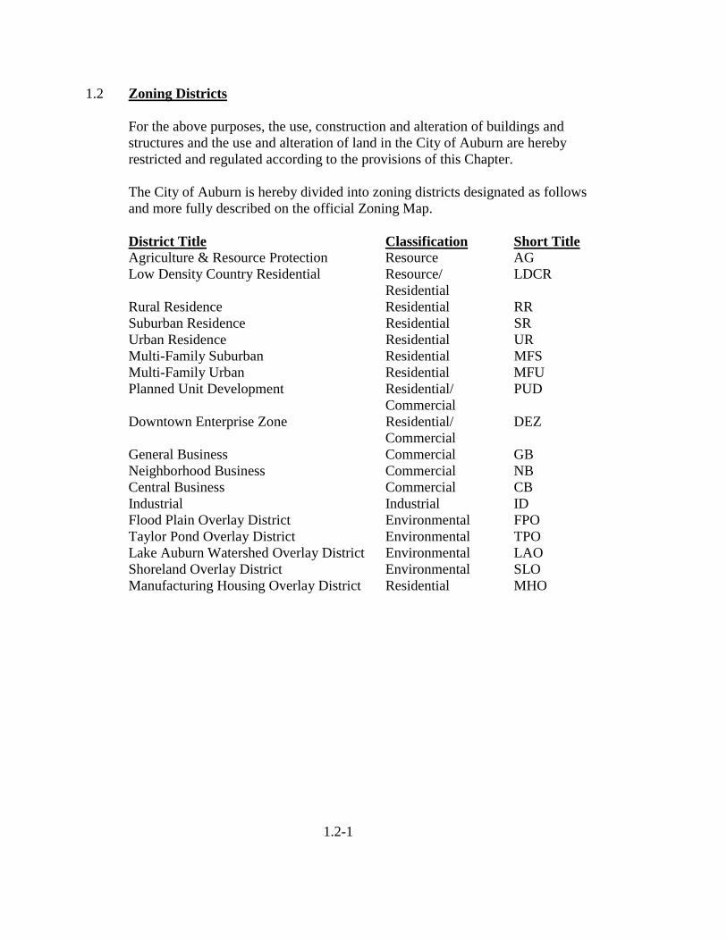
1.2 Zoning Districts
For the above purposes, the use, construction and alteration of buildings and structures and the use and alteration of land in the City of Auburn are hereby restricted and regulated according to the provisions of this Chapter.
The City of Auburn is hereby divided into zoning districts designated as follows and more fully described on the official Zoning Map. District Title Classification Short Title
Agriculture & Resource Protection Resource AG Low Density Country Residential Resource/ LDCR Residential
Rural Residence Residential RR Suburban Residence Residential SR Urban Residence Residential UR Multi-Family Suburban Residential MFS Multi-Family Urban Residential MFU Planned Unit Development Residential/ PUD Commercial Downtown Enterprise Zone Residential/ DEZ Commercial General Business Commercial GB Neighborhood Business Commercial NB Central Business Commercial CB Industrial Industrial ID Flood Plain Overlay District Environmental FPO Taylor Pond Overlay District Environmental TPO Lake Auburn Watershed Overlay District Environmental LAO Shoreland Overlay District Environmental SLO Manufacturing Housing Overlay District Residential MHO
1.2-1
1.3 Zoning Map
The location and boundaries of the above zoning districts are as shown on the map entitled City of Auburn, Maine, Zoning Map, dated March 2001, revised through its current date and revisions, is hereby adopted by reference and declared to be a part of this Zoning Ordinance.
As Zoning District boundaries are amended from time to time in accordance with Article 8 of this Chapter, such changes shall be entered on the official Zoning Map promptly after final approval of the amendment and the date following “revised through” appearing on the map shall be changed to match the effective date of the latest amendment. All previous editions of the Zoning Map shall thereupon become obsolete, null and void.
The official Zoning Map, revised according to the most recent amendment, shall be located in the office of the Department of Community Development and Planning and shall be the final authority on current zoning district locations and boundaries. It shall be the responsibility of the Auburn Planning Director to see that the official map is kept current and accurate.
1.3-1
1.4 Zone Boundaries
In the interpretation of the exact boundaries of zoning districts as shown on the official Zoning Map, the following rules shall apply:
A. Boundaries indicated as approximately following the center lines of
streets, highways or alleys shall be construed to follow such center lines;
B. Boundaries indicated as approximately following platted lot lines shall be construed as following such lot lines;
C. Boundaries indicated as approximately following City or County limits
shall be construed as following City or County limits;
D. Boundaries indicated as following railroad lines shall be construed to be midway between the main tracks;
E. Boundaries indicated as approximately following the center lines of
streams, lakes or other bodies of water shall be construed to follow such center lines;
F. Boundaries indicated as parallel to or extensions of features indicated in
Subsections A through E above indicated on the official Zoning Map shall be determined by the measurements using the scale of the map.
G. Where physical or cultural features existing on the ground are at variance
with those shown on the official Zoning Map, or in other circumstances not covered by Subsections A through F above, the Planning Board shall interpret the zone boundaries.
1.4-1
ARTICLE 2 DEFINITIONS
Sections
2.1 Terms 2.2a Definitions (A to L) 2.2b Definitions (M to Z) 2.1 Terms
For the purpose of this Ordinance, certain terms or words used herein shall be interpreted as follows:
A. The word person includes a firm, association, organization, partnership,
trust, company or corporation, as well as an individual.
B. The present tense includes the future tense, the singular number includes the plural, and the plural number includes the singular.
C. The word shall is mandatory, the word may is permissive.
D. The words used or occupied include the words intended, designed, or arranged, to be used or occupied.
E. The word lot includes the words plot or parcel.
2.1 - 1
1
2.2 Definitions
For the purposes of this Ordinance, the following words and terms as used herein shall have the meanings or limitations of meaning hereby defined, explained or assigned:
Accessory Structure or Building – An uninhabited building, at least five feet distance from the principal building, used for a purpose which is customarily subordinate and incidental to that of the principal building(s) or to the principal use of the land and which is located on the same lot as the principal building use. Such accessory buildings in residential districts, shall include tool sheds, wood sheds, detached garages and swimming pools. No accessory building shall house a home occupation or professional office or be used as a sales outlet in a residential district. Accessory Use – A subordinate use of land or building which is customarily incidental and subordinate to the principal building or to the principal use of the land and which is located on the same lot with the principal building or use. Adult Day Centers – A supervised facility providing a program of education, crafts or recreation for adults over the age of fifty-five. Animal Unit – One living animal of any species. Antique Shop – A building, or portion of building, where artifacts from generally recognized previous eras are sold or traded as the primary commercial activity. Apartment – See dwelling unit. Art Galleries – A building or place where works of art or other objects of value are kept, displayed, produced and offered for sale to the general public. Automobile – A passenger vehicle propelled by a self-contained motor. The term automobile shall also include motorcycles, all-terrain vehicles, trucks and recreation vehicles (R.V.). Automobile, Commercial – A vehicle the primary use of which is commercial in character. Automobile Filling Station – A building or lot having pumps and storage tanks at which fuel, oil or accessories for the use of motor vehicles are dispensed, sold or offered for sale at retail, where repair service is incidental and no vehicle storage or parking space is offered for rent.
2
Automobile Garage, Private – An accessory building or portion of a main building designed, arranged or used for housing of private motor vehicles, only one of which may be a commercial vehicle. Not more than fifty percent of the space in such a garage shall be used for housing vehicles other than those owned by occupants of the premises. Automobile and Marine Paint and Body Shops – A building in which the business of automobile and marine paint and body work is conducted. Such use may also include as an accessory use a facility for the orderly display and sale of vehicles which have undergone substantial body repair on the premises. No such facility shall display, outdoors or indoors, or offer for sale more than ten vehicles at any one time. Automobile and Marine Repair and Service Station – A building, lot or both in or upon which the business of general motor repair and vehicle service is conducted, but excluding junk and/or wrecking business. Automobile Parking Lot, Private – A parcel of land, lot or portion thereof required, in accordance with these regulations, for off-street automobile parking. Automobile Repair and Service Station – A building, lot or both in or upon which the business of general motor vehicle repair and service is conducted, but excluding junk and/or wrecking business. Automobile Sales Lot – A lot arranged, designed or used for the storage and display of motor vehicles or any unoccupied trailer for sale. Automobile Scrap yard – Any land or building used for the dismantling, storage and salvaging for reuse of automobiles or other vehicles not in running condition. Automotive Towing and Storage – A business engaged in/or offering the services of a tow truck or towing service whereby motor vehicles are towed or otherwise removed from one place to another by the use of a motor vehicle specifically designed for that purpose. Storage of towed vehicles is considered to be the keeping of vehicles in a secured yard for not more than one hundred and twenty (120) days until claimed or disposed of in accordance with the laws of the State of Maine. Basement – That portion of a building below the first floor joists having at least one-half of its clear ceiling height above the main level of the adjacent ground. Bed and Breakfast Home – An accessory use to a single-family dwelling involving the renting of four (4) or fewer guest rooms to transient guests who are staying for a limited duration (seven consecutive days and/or 60 accumulated in a calendar year) and the serving of breakfast only to house
3
guests. Such establishment shall be owned and operated by the resident(s) of the dwelling. The term Bed and Breakfast home shall also include Tourist Home. Bed and Breakfast Inn – A dwelling involving the renting of more than four but fewer than ten guest rooms to transient guests who are staying for a limited duration (seven consecutive days and/or sixty accumulated days in a calendar year) and the serving of breakfast to house guests only. Such use may provide a restaurant, function rooms and places of public assembly. Boarding House, Lodging House – A dwelling which, for compensation, lodging or lodging and meals are provided to more than four persons and where a proprietor or owner resides in the building. No provisions for cooking in individual rooms other than a main kitchen is allowed. Building – A structure having one or more stories and a roof, designed primarily for the shelter, support or enclosure of persons, animals or property of any kind. (See Structure.) Building, Principal – A building in which is conducted the principal use of the lot on which it is situated. Building Height – The vertical distance from the grade of the top of the highest roof beams of a flat roof, or to the mean level of the highest gable or slope of a hip roof. When a building faces on more than one (1) street, the height shall be measured from the averages of the grades at the center of each street front. Building Inspector – The Building Inspector of the City of Auburn, Maine, or his duly authorized agent. Building Line – A line beyond which the foundation wall and/or any enclosed porch, vestibule of other enclosed portion of a building shall not project. Care Home – A rest, nursing, or convalescent home established to render domiciliary nursing care and board for chronically ill or convalescent patients, or persons who are infirm because of mental or physical conditions, but excluding a child care home or one for the care of mentally retarded patients, alcoholics, psychotics or drug addicts. Cellar – That portion of a building below the first floor joists having at least one-half of its clear ceiling height below the mean level of the adjacent ground. A cellar shall not be used for habitation. Cemetery – A place used for the permanent interment of dead bodies or cremated remains thereof. It may be a burial park of earth interments, a mausoleum for vault or crypt interments, a columbarium for cinerary interments, or a combination of one or more thereof.
4
Child Care Home – A child boarding home, summer camp, foster family home or other place providing domiciliary arrangements for compensation, of three or more children, unrelated to the operator by blood, marriage or adoption, under eighteen years of age. For the purpose of this Ordinance a facility providing child day care less than 24 hours per day per child to more than five children shall not be considered a child care home. The term “child care home” shall include any family-type facility which provides child care to children placed by order of any Court of competent jurisdiction or by any public welfare department or other governmental agency having responsibility for placing children for care, or placed by child-placing agency licensed under State Law. Child Day Care Center – A facility conducted or maintained by anyone who provides, for consideration, care and protection for more than twelve children under sixteen years of age, unrelated to the day care center operator, who are unattended by parents or guardians, for any part of the day. Any facility, the chief purpose of which is to provide education shall not be considered to be a day care center, but is classified as a nursery school. Child Day Care Home – An accessory use of a residence by a person residing on a premises to provide on a regular basis, and for consideration, care and protection for up to twelve children under sixteen years of age, unrelated to the day care home operator, who are unattended by parents or guardians, for any part of the day. Any facility, the chief purpose of which is to provide education shall not be considered to be a day care home, but is classified as a nursery school. A child day care home shall not be located closer to another child day care home than 500 feet measured along the street frontage. Church – A building, together with its accessory buildings and uses, where persons regularly assemble for religious worship, and which buildings, accessory buildings and uses, are maintained and controlled by a religious body organized to sustain public worship. City Council – The City Council of the City of Auburn, Maine. Clinic – An establishment where patients are accepted for treatment by a group of physicians practicing medicine together, but shall not offer domiciliary arrangements; Medical and Dental. Club, Private – Any building or rooms, which serve as a meeting place for an incorporated or unincorporated association for civic, social, cultural, religious, literary, political, recreational or like activities, operated for the benefit of its members and not open to the general public. Community Based Residential Facilities (CRF) – Dwelling units providing communal domiciliary arrangements for a group of unrelated persons under
5
supervision of the state government human service agencies, for the transition of formerly institutionalized persons back into “main-stream” community living and participation; a “halfway house”; a group home. Comprehensive Plan - The Master Development plan of the City of Auburn, Maine, any amendments or additions thereto, part or portion thereof adopted by the City Council upon recommendations of the Planning Board of Auburn, Maine, pursuant to Title 30-A, Section 4323 of the Maine Revised Statutes Annotated. Convenience Store – A business establishment having an interior selling space of less than 3,000 square feet where general food supplies for the table, other articles of household use and gasoline pump service is offered for sale. Such a use may include the sale of food vended in disposable containers for consumption on or off the premises. Court – An open, unoccupied space, other than a yard, on the same lot with a building or group of buildings which is bounded on two or more sides by such building or buildings and every part of which is clear and unobstructed from its lowest point to the sky. Dental Clinic – An establishment where patients are accepted for treatment by a group of dentists practicing dentistry together. District or Zone – An area within which certain uses of land and building are permitted, permitted or denied pursuant to municipal review, and certain others are prohibited. District, Overlay – A special district or zone which addresses special land use circumstances and environmental safeguards and is superimposed over the underlying existing zoning districts. Permitted uses in the underlying zoning district shall continue subject to compliance with the regulations of the overlay zone or district. Dormitory – A building or portion thereof used for sleeping purposes in connection with a school, college or other educational institution. Driveway – Private ways intended for internal vehicular circulation on a lot or within an automobile parking lot. Dump – Any premises used primarily for disposal by abandonment, discarding, dumping, reduction, burial, incineration or any other means and for whatever purpose of garbage, trash, refuse, dead animals, waste materials of any kind, junk; but not untreated sewage, animal waste, discarded machinery, or vehicles or parts thereof. The establishment of any dump shall be approved by the City Council of the City of Auburn.
6
Dwelling or Dwelling Unit – A building or portion thereof arranged or designed to provide living facilities for one or more families. Dwelling, Multi-Family – A residence designed for or occupied by three or more families with separate housekeeping and cooking facilities for each. Dwelling, One-Family Detached – A dwelling unit singly and apart from any other building and intended and designed to be occupied and used exclusively for residential purposes by one family only, excluding those forms of temporary housing permitted by Section 4.3B. of this Chapter. Each one-family detached dwelling shall contain not less than 700 square feet of net floor area of habitable space. Dwelling, Seasonal – A dwelling occupied for not more than six months of any year. Dwelling, Two-Family – A free-standing building intended and designed to be occupied and used exclusively for residential purposes by two families only, with separate housekeeping and cooking facilities for each. Dwelling Unit – A room or group of rooms located within a building and forming a single habitable unit, physically separated from any other rooms or dwelling units which may be in the same structure, with facilities which are used for or intended to be used for independent living, sleeping, cooking and eating purposes. Dwelling units available for rental or occupancy for periods of less than one week shall be considered boarding/lodging units. Erected – The word “erected” shall include the words “built”, “constructed”, “reconstructed”, “enlarged” and/or “retained on”. Family – One or more persons occupying a single housekeeping unit and using common cooking facilities, provided that unless all members are related by blood or marriage, no such family shall contain over four persons. Farm – Any parcel of land containing more than 10 acres which is used in the raising of agricultural products, livestock or poultry, or for dairying. A farm, under the Agricultural Resource Protection District, shall be further defined as meeting the following criteria:
1. At least fifty (50) percent of the total annual income of the farm occupant and his or her spouse living in the farm residence will be derived from such uses; and
2. At least ten (10) acres of the farm will be devoted to the
production by the occupant of field crops or to the grazing of the
7
occupant’s livestock. For purposes of this Section, “poultry” shall mean no fewer than 100 foul and “livestock” shall mean no fewer than twenty (20) cattle or other animals being raised for commercial purposes.
Farm, Animal – Any parcel of land used for the keeping of horses, mules, cows, goats, sheep, hogs and similar sized animals for the domestic use of the residents of the lot, provided that adequate land area for each animal unit contains at least the following, excluding water bodies of one-quarter (1/4) acre surface area or larger:
1. Cattle – 1 bovine animal unit per acre of cleared hay-pasture land.
2. Horse – 1.5 animal units per acre of cleared hay/pasture land.
3. Sheep – 3 animal units per acre of cleared hay/pasture land.
4. Swine – 2 animal units per acre of cleared land.
5. Other animal farms – The required lot size shall be determined by
municipal officer charged with enforcement and shall conform to the lot size for similar sized animals.
Flood Plain Overlay – Those areas of the City which are directly affected by flooding as shown on the Flood Insurance Rate Maps (FIRM) as established by the Federal Emergency Management Agency and that shall comply with the pertinent regulations found in Article 5, Section 5.1., The Flood Plain Overlay District. Floor Area of Building – The total number of square feet of floor area of all stories in a building, excluding cellars, uncovered steps and uncovered porches. All horizontal measurements shall be made between exterior faces of walls. Frontage – The length of a lot extending between the side lot lines which borders an accepted portion of a street. Maine Turnpike frontage does not apply to this definition. Greenhouse – An enclosed structure where trees, shrubs, vines and plants are propagated, grown or maintained. Activities associated with a greenhouse include: the sale of greenhouse products and related supplies and the storage of material used in the maintenance of plants and growing items sold. Grocery Store – A small retail establishment having an interior selling space of less than 3,000 square feet where general food supplies for the table and other articles of household use are offered for sale. Such a use may include the sale of
8
food vended in disposable containers for consumption on or off the premises; “a corner market, a Mom and Pop store”. Ground Area of Building – The total number of square feet of horizontal surface covered by a building, including covered porches and accessory buildings. All measurements shall be made between exterior faces of walls, foundation, piers or other means of support. Group Home – See Community Based Residential Facilities. Habitable Space – That area within a dwelling which has headroom of not less than 7 feet when measured vertically upward from the finished floor, provided that any such area next below the roof of a dwelling shall be counted only if it is connected with the story next below by a permanent inside stairway. The floor area of any porch, cellar room, garage or shed attached to such dwelling shall not be counted in any measure of habitable space. Half-Story – A story directly under a sloping roof in which the points of intersection of the bottom of the rafters with the interior faces of the walls are less than 3 feet above the floor level. Historic Site – A parcel of land, a particular building, or a group of buildings that have played a significant role in the history of the community, and identified as such by the Maine Historic Preservation Committee. Historic or Archaeological Resources – Areas identified by a governmental agency such as the Maine Historic Preservation Commission as having significant value as historic or archaeological resources and any areas identified in the municipality’s Comprehensive Plan. Hog Farm – Any land or building used for the purpose of keeping, feeding or raising 20 or more swine’ a piggery. Establishment of this use requires approval from the City of Auburn Health Department. Home Occupation – The accessory use of a dwelling unit for a business or commercial venture engaged in, by the person or persons residing in the dwelling unit, and which allows up to one (1) person who does not reside on the premises to be employed by that Home Occupation. Hotel – A building in which the primary use is transient lodging accommodations offered to the public on a daily rate of compensation and where ingress and egress to the sleeping rooms is primarily through an inside lobby or office, supervised by a person in charge at all hours. Such facilities may include accessory uses such as restaurants, bars, nightclubs, function rooms, places of public assembly and/or recreational facilities.
9
Hospital – Any institution receiving in-patients and rendering medical, surgical and/or obstetrical care. This shall include general hospitals and institutions in which service is limited to special fields such as cardiac, eye, nose and throat, pediatric, orthopedic, skin, cancer, mental health, tuberculosis, chronic disease and obstetrics. The term “hospital” shall also include sanitariums, including those wherein mentally retarded and mental patients, epileptics, alcoholics, senile psychotics or drug addicts are cared for or treated. House, Guest – A detached dwelling that is intended, arranged or designed for occupancy by transient, nonpaying visitors. Household Pet – Any animal kept as a pet and normally housed at night within the owner’s dwelling or an accessory building on the same lot; but not including any animal normally raised as livestock or poultry, nor any animal raised for commercial gain. No household pet shall be kept that creates a public nuisance by reason of (1) objectionable effects perceptible outside the owner’s property, such as excessive or untimely noise or offensive odors; or (2) being a hazard to the health, safety and welfare of neighbors, invited guests or public servants visiting the property in the pursuit of their normal duties. Industrial Use, Heavy – The use of real estate, building or structure, or any portion thereof, for assembling, fabricating, manufacturing, packaging or processing operations. Industrial Use, Light – The use of real estate, building or structure, or any portion thereof, the main processes of which involve the assembly of prefabricated parts and which will not create a nuisance by noise, smoke, vibration, odor or appearance. Institutions – Any building or open area used only by an educational, religious, medical, charitable, philanthropic, or non-profit organization, either public or private. Institution, Philanthropic – A private, nonprofit organization that is not organized or operated for the purpose of carrying on a trade or business, no part of the net earnings of which inures to the benefit of any member of said organization and which either (a) provides volunteer aid to the sick and wounded of the armed forces in time of war and relief services to victims of natural or man-made calamities, or (b) provides all or any of the following: religious, social, physical, recreational and benevolent service. Institution, Private Educational – Any private school or educational institution, however designated, which offers an academic curriculum of college, professional, preparatory, high school, middle school, elementary, kindergarten or nursery school instruction, or any combination thereof; but not a training program of trade, craft, technical or artistic instruction operated by a
10
governmental entity. No private educational institution shall be deemed a home occupation. See Training School and School. Institution, Research – An agency for scientific research of technical development including offices, libraries, laboratories, testing facilities and equipment incidental to such research and development. Junk Yard, Automobile Graveyard – Any land or building used for the abandonment, storage, keeping, collecting or bailing of paper, rags, scrap metal, other scrap or discarded material, or for the abandonment, demolition, dismantling, storage or salvaging of automobiles or other vehicles not in running condition, machinery or parts thereof. Establishment and operation of this use requires annual approval from the City Council of Auburn, Maine. Kennel – Any building or buildings and/or land used, designed or arranged for the boarding, breeding or care of dogs, cats, pets, fowl or domestic animals, kept for purposes of show, hunting or as pets; except horses. Land Use Permit – A permit required for the use of property that is legally permitted under the provisions of this Chapter. Landscape Services – The actual planting, bed preparation, installation of landscape materials and maintenance of the landscape, planting and materials. Activities associated with landscaping include: the storage of materials and equipment related to the performance of landscaping, the temporary storage of trees, shrubs and plants pending installation in an existing landscape plan and the application and storage of pesticides and fertilizers by a licensed person. Lawn Maintenance Service – The care and upkeep of the landscape after its installation and consists of such activities as mowing of the lawn, pruning of trees and shrubs, application by hand of fertilizer and weed control, insect and disease control, planting and care of flower beds, replacement of dead plants, incidental repairing of walls and paved surfaces, cleaning of fountains and pool basins, irrigation of lawns, cultivation of soil around trees and shrubs, rolling and reseeding of lawns, raking of leaves, winterization of trees and shrubs and snow removal. Library – A place containing books and other material for reading, study or reference, provided that no such material is offered for sale. Livestock – Domestic animals kept, used or raised on a farm for the production of income. Lodge, Private – See Club, Private.
11
Lot – For zoning purposes, as covered by this Ordinance, a lot is a parcel of land under one ownership or joint ownership of at least sufficient size to meet minimum zoning requirements for use, coverage and area, and to provide such yards and other open spaces as are herein required. Such lot shall have frontage on an accepted public street and may consist of:
1. a single lot of record;
2. a portion of a lot of record;
3. a combination of complete lots of record;
4. a parcel of land described by metes and bounds; provided that in no case of division or combination shall any residential lot or parcel be created which does not meet the requirements of this Ordinance.
5. lots shown on a plan approved by the Planning Board of the City
of Auburn. Lot Frontage/Width – The front of a lot shall be construed to be the portion nearest the street. For the purpose of determining yard requirements or corner lots and through lots, all sides of a lot adjacent to streets shall be considered frontage, and yards shall be provided as indicated under Yards in this Section. Lot Line, Rear – The lot line or lines generally opposite or parallel to the front lot line, except in a through lot. If the rear lot line is less than 10 feet long or the lot comes to a point at the rear, said rear lot line is assumed to be a line not less than 20 feet long, lying wholly within the lot, parallel to the front lot line, or in the case of a curved front lot line, parallel to the chord of the arc of said front lot line. Lot Measurements - Lot measurements are defined as follows:
1. Depth of a lot shall be considered to be the uninterrupted distance between the midpoints of straight lines connecting the foremost points of the side lot lines in front and the rearmost points of the side lot lines in the rear unless a lot meets the exception provided for by Section 3.1.G.
2. Width of a lot shall be considered to be the distance between
straight lines connecting front and rear lot lines at each side of the lot, measured across the rear of the required front yard, provided, however, that the width between the side lot lines at their foremost points (where they intersect the street line) shall not be less than 80 percent of the required lot width except in the case of
12
a lot on the turning circle of a cul-de-sac, where the 80 percent requirement shall not apply.
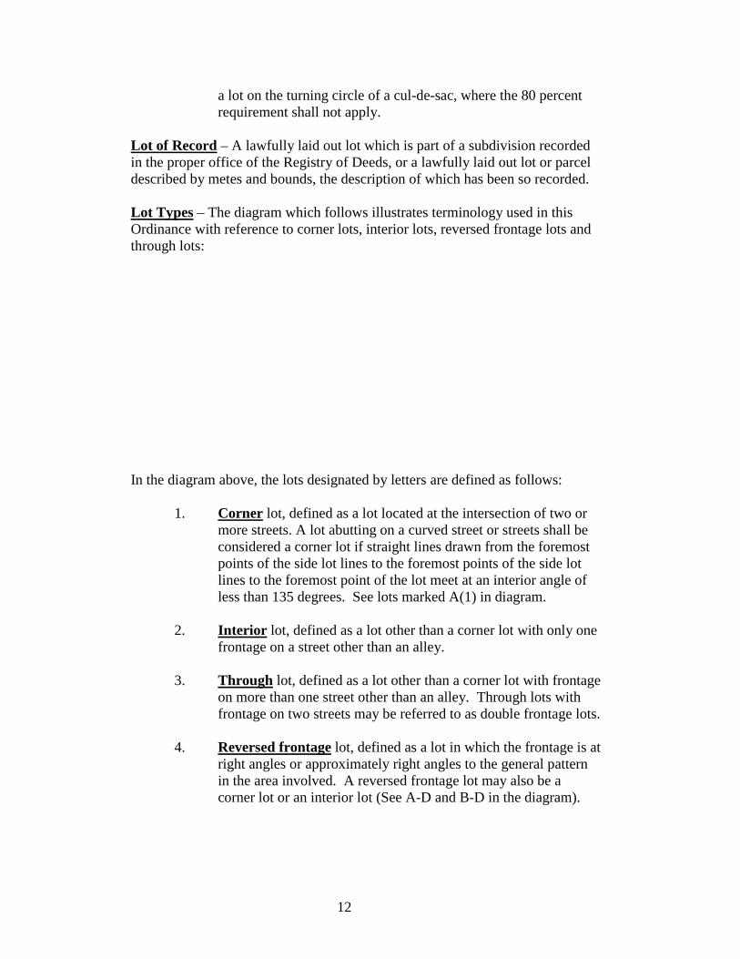
Lot of Record – A lawfully laid out lot which is part of a subdivision recorded in the proper office of the Registry of Deeds, or a lawfully laid out lot or parcel described by metes and bounds, the description of which has been so recorded. Lot Types – The diagram which follows illustrates terminology used in this Ordinance with reference to corner lots, interior lots, reversed frontage lots and through lots:
In the diagram above, the lots designated by letters are defined as follows:
1. Corner lot, defined as a lot located at the intersection of two or more streets. A lot abutting on a curved street or streets shall be considered a corner lot if straight lines drawn from the foremost points of the side lot lines to the foremost points of the side lot lines to the foremost point of the lot meet at an interior angle of less than 135 degrees. See lots marked A(1) in diagram.
2. Interior lot, defined as a lot other than a corner lot with only one
frontage on a street other than an alley. 3. Through lot, defined as a lot other than a corner lot with frontage
on more than one street other than an alley. Through lots with frontage on two streets may be referred to as double frontage lots.
4. Reversed frontage lot, defined as a lot in which the frontage is at
right angles or approximately right angles to the general pattern in the area involved. A reversed frontage lot may also be a corner lot or an interior lot (See A-D and B-D in the diagram).
13
Lot, Undersized – For zoning purposes, as covered by this Ordinance, an undersized lot is a parcel of land of insufficient size to meet minimum zoning requirements for area or width or depth. Major or Principal Arterial Highway –
1. Serves the major traffic movements within urbanized areas such
as between central business districts and outlying residential areas, between major intercity communities, or between major suburban centers;
2. serves a major portion of the trips entering and leaving the urban
area, as well as the majority of the through traffic desiring to bypass the central city;
3. provides continuity for all rural arterials which intercept the
urban area. Major or principal arterial highways include Washington Street (State Routes 4 and 100, U.S. 202), Minot Avenue (State Routes 11 and 121), Union Street/Center Street/Turner Road (State Route 4), Veterans Memorial Bridge and approaches (State Routes 11 and 100, U.S. Route 202), North Bridge/Court Street to in town Minot Avenue Intersection (Turner Street), Court to Center Street (State Route 4).
Major Retail Development – A single building in excess of 100,000 square feet of new ground floor retail space. Manufactured Housing – A structural unit or units designed for occupancy, and constructed in a manufacturing facility and then transported by the use of its own chassis, or placed on an independent chassis, to a building site. The term includes any type of building which is constructed at a manufacturing facility and then transported to a building site where it is utilized for housing and may be purchased or sold by a dealer in the interim. Manufactured housing shall include newer mobile homes and modular homes. Mining, Quarrying or Earth Removing – The excavation of any earth materials. Minor Arterial Highway –
1. Serves trips of moderate length at a somewhat lower level of travel mobility than principal arterials;
2. provides access to geographic areas smaller than those served by
the major arterial highway system; and
14
3. provides intra-community continuity but does not penetrate identifiable neighborhoods. Examples are Riverside Drive, Mill Street, South Bridge (Broad Street to Mill Street), Main Street, Mechanics Row, High Street (Minot Avenue to Academy Street), Academy Street (High Street to Main Street), Elm Street, Spring Street (Minot Avenue to Court Street), Turner Street (Union Street to Turner Road), Mount Auburn Avenue (Center Street to Turner Street), Lake Street, Court Street (Union Street to in town Minot Avenue Intersection), Hotel Road (Manley Road to Poland Spring Road).
Mobile Homes, Newer – Those units constructed after June 15, 1976 commonly called “newer mobile homes”, which the manufacture certifies are constructed in compliance with the United States Department of Housing and Urban Development standards, meaning structures, transportable in one or more sections, which, in the traveling mode, are 14 body feet, or more in width and are 700 or more square feet, and which are built on a permanent chassis and designed to be used as dwellings on foundations when connected to the required utilities, including the plumbing, heating, air conditioning and electrical system contained therein; except that the term shall include any structure which meets all the requirements of this paragraph, except the size requirements and with respect to which the manufacturer voluntarily files a certification required by the Secretary of the United States Department of Housing and Urban development and complies with the standard established under the National Manufactured Housing Construction and Safety Standards Act of 1974, United States Code, Title 42, Section 5401, et. seq. Mobile Homes, Older – Any factory-built home which fails to meet the definition of manufactured housing and more specifically, it shall mean any mobile home constructed prior to June 15, 1976. These units shall be restricted to approved mobile home parks. Mobile Home Development – Intended to be generic; it includes mobile home parks, mobile home subdivisions, and mobile home condominiums. Mobile Home Park – A parcel of land under single ownership in Rural Residence and Suburban Residence Districts which has been planned and improved for the placement of not less than three (3) mobile homes for non-transient use. Modular Homes – Those units which the manufacturer certifies are constructed in compliance with the State’s Manufactured Housing Act and regulations, meaning structures, transportable in one or more sections, which are not constructed on a permanent chassis and are designed to be used as dwellings on foundations when connected to required utilities, including the plumbing, heating, air-conditioning or electrical systems contained therein.
15
Motel – A building or group of detached buildings intended primarily to provide sleeping accommodations to the public on a daily rate of compensation and having a parking space generally located adjacent to a sleeping room. Such facilities may include a main kitchen or snack bar for the use of motel guests only. Municipal Sanitary Landfill – A disposal site for household, commercial and industrial wastes, sludge or incinerator ash operated or controlled for operation by the City of Auburn in a controlled manner involving the covering of deposited wastes with layers of earth so as to reduce health hazards and public nuisances from vermin, insects, odors and wind-borne debris. The location and design of sanitary landfills also require precautions against ground and surface water contamination through clay lining, water impoundment, aquifer avoidance and similar techniques. Municipal Uses – Any lawful use of a building or of land carried on by the City of Auburn. Municipal Sanitary Landfill shall not be deemed a municipal use. Museum – A building or place where works of art or other objects of permanent value are kept and displayed, provided such objects are not offered for sale. Non-Conforming Building – A building lawfully existing at the time this or any previous Zoning Ordinance became effective and which does not conform with the dimensional regulations of the district in which it is located. Non-Conforming Lot – A lot lawfully existing gat the time this or any previous Zoning Ordinance became effective and which does not conform with the dimensional regulations of the district in which it is located. Non-Conforming Use – A use of a building or of land lawfully existing at the time this or any previous Zoning Ordinance became effective and which does not conform with the use regulations of the district in which it is located. Nurseries – A nursery is an outdoor place where live trees, shrubs, vines and plants are propagated, grown or maintained before permanent planting. Activities associated with nursery a business include: the sale of nursery products and related gardening supplies, storage of material used in the maintenance of plants and growing items sold and the use of power-motorized equipment required by the nursery. Nurseries, Wholesale – A nursery where plants, trees, shrubs and vines are propagated and/or grown and sold only at wholesale to industry related buyers such as retail nurseries, greenhouses and landscape contractors. A wholesale nursery may also provide landscape services accessory to the nursery use provided.
16
1. At least one-half of the area of the lot (up to a maximum of 3
acres) is in active nursery production in a husband type manner; and
2. The plants and trees propagated, grown and nurtured in the
nursery are used as the primary products by the owner/operator of the landscape service.
Nursery, Child – A facility providing a program less than 24 hours per day per child for the care of infants up to the age of two and one-half years. Office – A building, or portion of a building, wherein services are preformed involving predominantly administrative, professional or clerical operations. Office Trailer – A movable vehicle or structure designed for year-round or temporary occupancy for purposed of supervising construction; for business actually engaged in the business of selling manufactured housing, mobile homes and trailers; and as temporary office space for a business during the period in which permanent office space is being constructed. Parking Space, Off-Street – A rectangular area, not less than 9 x 18 feet, forming a parking stall within or without a structure, not located in any public right-of-way. Performing Arts Center – A public or private space used to create and present various performing and visual arts. For the purposes of this definition, a Performing Arts Center shall also include educational and training uses associated with the various performing and visual arts. Planning Board – The Planning Board of the City of Auburn, Maine Planning Director – The Director of the Auburn Department of Community Development and Planning. Principal Use – The principal use for which a lot or main building thereon is designed, arranged or intended and for which it is or may be used, occupied or maintained. Professional Office – Rooms and/or buildings used for office purposes as the principal use by members of any recognized profession, including doctors, dentists, lawyers, accountants, engineers, architects, veterinarians, etc. Recreational Uses of Land – Recreational uses of land are permanent uses of outdoor space which are intended or designed for public use and include but are not limited to ski areas, golf courses (both public and private), driving ranges,
17
horse boarding and riding facilities, miniature golf, paint ball, horse and dog racing, snowmobile races and facilities for mass gatherings when used for two or more events during a calendar year. Residential Artist Studio – A dwelling where up to 50 percent of the total floor space can be used for the production of art and/or craft products. Activities shall not include galleries or studios open to the public for display or sales. All Artist Studios shall be designed to meet all residential safety and occupancy requirements and shall be considered to be accessory to the residential use. Restaurant – An eating place in which food is prepared and vended for immediate consumption on the premises without further preparation by the customer. The take out of food on an infrequent basis is not prohibited. Restaurant, Carry-Out – An eating place in which all food is vended in disposable containers for consumption on or off premises at the customer’s choice; a “fast-food” restaurant. Restaurant, Drive-In – An eating place in which the business transacted is conducted by a customer from within his automobile or in which consumption of goods sold normally takes place within the customer’s automobile on the establishment’s premises. Retail – A principal use encompassing the sale of commodities or goods in small quantities directly to the consumer. Retail sales does not include sales of professional, financial and governmental services and personal services, including but not limited to a hotel and its accessory uses (restaurants, salons, gift shops, recreational facilities, convention space, etc.). Retail Space – The areas of a building, within a climate controlled environment, devoted to the display of commodities or goods for sale directly to the consumer and including customer sales transaction areas and areas associated with customer access. Rifle, Pistol, Skeet or Trap Shooting Range – A rifle, pistol, skeet or trap shooting range operated by an individual or club. Such a range may be opened to the general public or developed for the exclusive use of the individual, or club and invited guests. Road – Any public or private traveled way or any portion thereof. Roof – The covering for a building which is an integral part of the structure for the purpose primarily of protecting the interior of the building or covering a porch or other similar permanent portion thereof, excluding awnings, stoop coverings, or similar additionals which are removable without substantially impairing the original structure.
18
Sawmill – A unit designed to saw logs into lumber, firewood or other processed wood products. School – An educational institution offering an academic curriculum; not the teaching of the crafts or a training school offering a program of trade, technical instruction or physical education. See Training School. Shared Housing – Housing consisting of two or more families occupying a single dwelling and using common cooking facilities. Shared housing shall permit the same number of families at the same density as allowed in the zoning district where the property is located subject to all applicable codes relating to building, housing, life safety, health and zoning as would be applied to independent living units located in the same structure. Approval for shared housing shall be secured from the Department of Community Development and Planning subject to the above codes and ordinances, prior to establishing a shared housing arrangement in any building. Shelter for Abused Persons – Dwelling facilities complying with the laws administered by the state government human services agencies, providing temporary domiciliary arrangements for children and adults unable to protect their own interest and welfare because of critical family circumstances. Shopping Center or Office Mall – A planned integrated complex of three or more retail stores and/or offices sharing a common structure and developed according to a unified plan. Such uses may include a common pedestrian circulation system and off-street automobile parking facilities. Sign – Any device, display surface, structure or object in public intended for visual communications. Sign, Mobile Mounted – A temporary sign which is mounted or for mounting on wheels or a mobile platform or which is portable. Sign, On-Premises – Any sign that advertises, calls attention to, or indicates the person occupying the premises on which the sign is erected or maintained or the business transacted thereon, or advertises the property itself or any part thereof as for sale or rent, and which contains no other matter. Sign, Official Business Directional – Any off-premise sign permitted to be erected pursuant to Chapter 27, Article 5 of the Auburn Ordinances. Sign, Standing – Any sign that is not attached to a building. Sign, Temporary – Any movable sign, including its supporting structure, intended to be maintained for not more than 90 days in any calendar year.
19
Site-Built Home – A building constructed on-site which is designed to be used as a dwelling on foundations, when connected to the required utilities. Slaughter House (Abattoir, Dressing Plant) – Any building, place or establishment in which is conducted the slaughtering of livestock and/or poultry for commercial purposes. Special Exception – A special exception is a use that would not be appropriate generally or without restriction throughout the district, but which, if controlled as to number, area, location or relation to the neighborhood, would promote the public health, safety, welfare, order, comfort, convenience, appearance, prosperity, or general welfare. Such a use may be permitted in such district as a special exception, if specific provision for such special exceptions is made in this Zoning Ordinance and reasonable restrictions imposed by the Planning Board are complied with. Specialty Shop – A retail business offering products of a similar kind and nature designed for a particular use, purpose or occasion and distinguished from a store offering the same type of product together with other products of a non-homogeneous quality. Stable, Riding – Any building or structure used or designed for boarding, breeding or care of horses, other than horses used for farming or agricultural purposes. Standing – A person who holds title, right or interest in a property which may include a written option, contract to purchase the property or a leasehold interest or may be a person who can show how his or her actual use or enjoyment of property will be adversely affected by the proposed decision as an abutter as defined in Article 8, Section 8.2.C of this Chapter. Story – That portion of a building between the surface of any floor and the surface of the other floor or roof next above it, but not including the lowest portion so contained if more than one-half of such portion vertically is below the mean finished grade of the ground adjoining such building unless such space is used for business or as habitable space, in which case it shall count as a story. Story, Half – A story under the gable, hip or gambrel roof, the plates of which on at least two opposite exterior walls are more than 2 feet above the floor of such story. Street –
1. A public way laid out and established by the State of Maine, County Commissioners of the County of Androscoggin;
20
2. a way accepted by the municipal officers of the City of Auburn;
3. a way as to which a petition for improvements has been allowed under the provisions of Section 204 of Chapter 23 of these Ordinances for which the cost of the improvements has been provided for by the developer in either a cash amount or as provided for in Chapter 23, Section 105.5; or
4. a way on a plan of a subdivision duly approved by the Planning
Board. Street Frontage – See Frontage Street Line – A line defining the edge of a street right-of-way separating the street from abutting property or lots. Structure (Building) – A combination of materials to form a construction that is safe and stable including, among other things, stadia, reviewing stands, platforms, automobile parking garages, stagings, windmills, observation towers, trestles, sheds, coal bins, shelters and display signs, but not fences of any kind. Subdivision – A division of land as defined in Title 30-A, Section 4401.4 of The Maine Revised Statutes Annotated. Summer Camps – Seasonal dwelling units intended for and actually used for single family dwellings only during the months of May, June, July, August, September and October or weekends or other periods of vacations not exceeding thirty (30) days. Supermarket – A retail establishment having an interior selling space of 3,000 square feet or more where general food supplies for the table and other articles of household use are offered for sale. Swimming Pool – Any man-made receptacle or excavation housing a surface area of 250 square feet, or more, designed to hold water to a depth of at least 24 inches, primarily for swimming or bathing whether in the ground or above the ground. Theater, Indoor – A building designed and/or used primarily for the commercial exhibition of motion pictures or plays to the general public. Theater, Outdoor – An outdoor theater shall include only those areas, buildings or structures designed and used for the commercial outdoor exhibition of motion pictures to passengers in parked motor vehicles.
21
Tourist Home – See Bed and Breakfast Home Townhouse – A single family dwelling unit that is one of two or more residential buildings having a common or party wall separating the units. Trailer (R.V., including Motor Home and Trailer Home) – Any vehicle or structure (except a device exclusively used upon stationary rails or tracks) mounted on wheels for use on highways and streets; propelled or drawn by its own or other motor power; and designed and constructed to provide living and/or sleeping quarters for one or more persons or for the conduct of a business, profession, trade or occupation for use as a selling or advertising device. It the wheels of a trailer are removed, except for repairs, it is deemed a building subject to all the regulations thereof. A trailer shall not be considered an accessory building. Trailer Home – A travel trailer, camping trailer or other similar vehicle capable of being hauled by a passenger automobile or light truck and designed primarily for temporary occupancy for recreational purposes or other seasonal use. A trailer home shall not be considered an accessory building. Training School – A public or private school or training institution which offers a training program of trade, technical instruction, or physical education. A training school shall not be deemed a home occupation. Transmission Towers – A structure that has the sole purpose of transmitting Radio, Television, Cellular Telephone or Telephone Waves from one location to another. Variance – A variance is a relaxation of the terms of the Zoning Ordinance where such variance will not be contrary to the public interest and where, owing to conditions peculiar to the property and not the result of the actions of the applicant, a literal enforcement of the Ordinance would result in unnecessary and undue hardship. As used in this Ordinance, a variance is authorized for only dimensional and supplemental regulations. Establishment of a use otherwise prohibited shall not be allowed by variance, nor shall a variance be granted because of the presence of nonconformities in the district or adjoining districts. Wayside Stand – A structure designed, arranged or used for the display and sale of agricultural products primarily grown or produced on the premises upon which such stand is located. A wayside stand may be located on premises that the products are not grown upon provided such premises is owned by the grower. Wholesale – Sales chiefly to retailers, other merchants, industrial and/or commercial users mainly for resale or business use.
22
Yard – A required open space on a lot unoccupied and unobstructed by any principal structure or portion of a principal structure. Yard, Front – Open space extending across the full width of lot between the front lot line and nearest line of the principal building or any enclosed portion thereof. The depth of such yard shall be the shortest horizontal distance between the front lot line and the nearest point of the building or any enclosed portion thereof. Yard, Rear – Open space extending across the full width of lot between the rear line of the lot and the nearest line of the building or any enclosed portion thereof. The depth of such yard is the shortest horizontal distance between the rear lot line and the nearest point of the building. When the rear lot line is less than 10 feet long or if the lot comes to a point at the rear, the depth of the rear yard is measured to an assumed rear lot line as follows:
The lot line or lines generally opposite or parallel to the front lot line, except in a through lot. If the rear lot line is less than 10 feet long or the lot comes to a point at the rear, said rear lot line is assumed to be a line not less than 20 feet long, lying wholly within the lot, parallel to the front lot line, or in the case of a curved front lot line, parallel to the chord of the arc of said lot line.
Yard, Side – Open space between the side lot line, the side street line, or the proposed side street line and the principal buildings, or any portion thereof, extending from the front yard to the rear yard, or, in the absence of either of such yards, to the front lot line and/or rear lot line. The width of a side yard shall be the shortest distance between the side lot line and the nearest point of the principal building or any portion thereof. Zone – See District Zoning Officer – The Zoning Officer of the City of Auburn, Maine or his duly authorized agent. Zoning Ordinance – The Zoning Ordinance of the City of Auburn, Maine, comprised of Chapter 29 of the City Ordinances, currently adopted and amended.
ARTICLE 3 ZONING DISTRICT REGULATIONS
Sections
3.1 General Provisions 3.2 Non-Conforming Buildings or Uses 3.3 Resource Districts 3.31 Agriculture & Resource Protection (AG) 3.32 Low Density Country Residential (LDCR) 3.4 Residential Districts 3.41 Rural Residence (RR) 3.42 Suburban Residence (SR) 3.43 Urban Residence (UR) 3.44 Multi-Family Suburban (MFS) 3.45 Multi-Family Urban (MFU) 3.5 Mixed Use Districts 3.51 Planned Unit Development (PUD) 3.52 Downtown Enterprise Zone (DEZ) 3.6 Commercial Districts 3.61 Neighborhood Business (NB) 3.62 General Business (GB) 3.63 Minot Avenue (GBII) 3.69 Central Business (CB) 3.7 Industrial Districts 3.71 Industrial (ID)
3.0-1
3.1 General Provisions
A. Permitted Uses – In the zoning districts specified in this article and in Article 5, the designated buildings and alterations and extensions thereof and buildings accessory thereto and the designated uses of land, of buildings and of parts of land or buildings and the uses accessory thereto are permitted. Except as provided in this article, all other buildings and uses of land or of buildings are hereby expressly prohibited, except those already lawfully existing which by the operation of this provision would hereby become lawfully non-conforming.
B. Buildings Per Lot – No more than one principal building shall be
erected on any lot in residential zoning districts except in the case of multi-family buildings and/or developments approved under Section 3.51 and 3.52.
C. Conversion of One-Family Dwellings – In all residential, general
business and central business districts, one-family dwellings erected prior to January 1, 1958 may be converted to two-family dwellings provided that:
1. Any floor space created by additions to the existing structure
after January 1, 1958 shall not be converted to a second dwelling.
2. There will not be less than one accessible off-street parking place of 200 square feet area, exclusive of driveways, per dwelling unit resulting from such conversion.
3. Stairways leading to any floor above the first floor will be
enclosed within the exterior walls of the dwelling and any fire escapes required will be on the rear or one side of the dwelling and not on any wall facing a street.
4. After such conversion, the building converted will retain
substantially the appearance and character of a one-family dwelling.
D. Lots in More Than One Jurisdiction – When a lot in one ownership
lies in more than one jurisdiction, the whole lot shall be considered for density and lot dimension purposes in the same manner as if the entire lot were situated in Auburn. Any Site Plan or Special Exception review of the use or development of the lot in the City of Auburn, however, shall be limited to that portion that lies within Auburn’s jurisdiction only.
3.1-1
E. Minimum Lot Area Determined – In determining the minimum area of lot required in any zoning district, any land within the lines of the street upon which such lot abuts shall not be included, even if the fee to such street is in the owner of the lot with the following exception:
If a lot at a street corner is bounded in part by a curved exterior street line not more than eighty (80) feet in length connecting other exterior street lines bounding such lot which, if extended, would intersect, the area required in such lot shall be computed as if said line were extended. If such curved line is more than eighty (80) feet in length, the minimum area required in such lot shall be measured and computed entirely within the lines bounding such lot.
F. Non-Conforming Lots – Abutting undeveloped non-conforming lots
under one ownership shall be considered as one lot and shall not again be divided.
Abutting non-conforming lots under one ownership or joint ownership shall be considered as one lot. Such a lot may be divided provided that:
1. One or more of the lots has been developed. 2. The lots were purchased by separate deed. 3. The lots are divided along the historical lot dimensions. 4. All dimensional regulations are maintained.
An abutting conforming and non-conforming lot under one ownership or joint ownership shall be considered as one lot. Such a lot may be divided provided that:
1. The lots are divided along the historical lot dimensions.
2. The conforming lot is not reduced in any manner that violates any provision of this Chapter.
3. All dimensional regulations are maintained.
G. Lot Area, Width & Depth Exception – The lot area (except as otherwise may be required), lot width and lot depth requirements of this Chapter shall not apply to any lot which was lawfully laid out in
3.1-2
conformance with zoning regulations in effect at the time of lot creation and duly recorded by plan or deed.
H. Reduction in Dimensional Regulations – No lot (except as allowed by
the Planning Board at the time of final approval of a subdivision or development plan) shall be reduced, subdivided, conveyed, divided or otherwise transferred that violates, or creates a lot that violates, any minimum dimensional regulation of this Chapter. No building permit or other municipal permit or license shall be issued to any of the land so transferred or to the land retained until all of such land or lots are in conformance with all dimensional regulations. If a serious health or safety issue with the property should arise, the Director of Planning and Permitting Services shall determine if a permit should be issued to correct the problem. This provision shall not allow further non-conformity to occur in order to achieve the corrective action necessary.
Any land taken by eminent domain or conveyed for a public purpose shall not be deemed in violation of this provision. Any setback or lot that is reduced below the minimum dimensional requirements as a result of land taken by eminent domain or conveyed for a public purpose shall not be deemed non-conforming. Setbacks for the enlargement of any existing building located on such a lot shall be referenced to the property line as it was located prior to the eminent domain action or the conveyance for a public purpose.
I. Lot of Record – Where used in this article, the word “lot” is interpreted
to mean “lot of record” as defined in Article 2 of this Chapter.
J. Unsewered Lots – The minimum lot sizes specified in this Chapter for residential districts are for lots having sanitary sewer service. No unsewered lots having an area less than 20,000 square feet shall be developed for residential dwelling purposes. This regulation does not reduce lot size requirements in residential districts having larger minimum lot sizes.
K. Residential Accessory Buildings and Structures
1. Accessory buildings of 120 sq ft and 10 feet or less in height will have a zero (0) rear and side setback. The front yard setback shall be maintained.
2. Accessory buildings greater than 120 sq ft shall have rear and
side yard setbacks that are 50% of the requirement for principal
3.1-3
buildings, except that in no case shall the setbacks be reduced to less than 5 feet. The front yard setback shall be maintained.
3. A deck that is no greater than 30 inches high shall be allowed a
zero (0) rear and side setback provided that the deck is no closer than 15 feet to a neighboring principal building. All decks that are higher than 30 inches shall meet the requirements of 2. above.
4. A deck that attaches a principal building to an accessory building
shall be allowed and shall not be deemed to cause the accessory building to be nonconforming. Such decks shall meet all other requirements as found above.
5. The maximum floor space of accessory buildings on lots under 2
acres is 1000 sq ft. On lots of over 2 acres, there is no maximum size.
L. Conflicts - In any case where there is a conflict with another Ordinance
the more stringent standard shall apply.
M. Site Plan/Special Exception Review –
1. Projects requiring Site Plan Review shall be reviewed by the Planning Board in accordance with Article 7, Sections 7.1 and 7.2 of this Chapter and according to the standards and criteria contained therein. No project requiring Site Plan Review shall be expanded, extended or enlarged so as to occupy additional land area greater than 10% of the original area or one-half acre, whichever is less; or by the construction of a structure or an addition to an existing structure by more than 10 % of additional floor space unless approval has been secured from the Planning Board in the manner provided above. A reduction in the scope of the project, except for land area, does not have to be reviewed by the Planning Board provided that an amended plan is submitted to the Planning Department to determine that all other land use provisions are satisfied.
The expansion, extension or enlargement of uses or buildings which are less than described above, shall be reviewed and approved by the Planning Department using the criteria of Article 7, Sections 7.1 and 7.2.
3.1-4
If an applicant disagrees with the review of the Planning Department, the Planning Board upon the written request of the applicant, shall conduct an administrative review of the Planning Staff’s decision.
2. Permitted uses subject to Special Exception Review pursuant to
Section 3.62.B.2.q., 3.63.B.2.m., 3.69.B.2.d., and 3.71.B.2.gg. which are to be located in a commercial or industrial subdivision which has been duly approved by the Auburn Planning Board shall not be required to be reviewed and approved by the Planning Board in accordance with Article 7, Section 7.2 unless, in the determination of the municipal officer charged with enforcement, the project contains elements that deserve a full review by the Planning Board. In making such a determination, the municipal officer shall take into account the Planning Board’s initial review of the subdivision, including but not limited to such issues as traffic, drainage, infrastructure improvements, availability of water and sewer, fire protection and the impact on the environment.
The permitted uses which have been exempted from Special Exception Review and located in duly approved commercial or industrial subdivisions shall be processed by administrative review by the Planning Department in accordance with Article 7, Section 7.2. Such uses shall also be subject to all municipal ordinances as would be required for review of Special Exceptions.
3. The Planning Board shall be notified of all action taken, or
approvals granted, by the municipal officer pursuant to Section 3.1.M.
4. The City finds that a Major Retail Development can have a
significant impact on the immediate and surrounding areas and accordingly requires a determination by the City of Auburn Planning Board of consistency with the adopted Comprehensive Plan in addition to the review and approval process of Site Plan/Special Exception Review and other state and/or municipal permitting. A request for a determination of consistency shall be submitted to the Department of Planning and Code Enforcement a minimum of 15 days prior to this item being placed on the Planning Board agenda for action. Action on the request for a determination of consistency shall be made a minimum of one regularly scheduled meeting prior to the Planning Board meeting
3.1-5
at which the project is to be reviewed. Notice for the consideration of a request for a determination of consistency shall conform to the requirements found in Article 8, Section 8.2.A. and must state that the determination of consistency is being sought for a Major Retail Development.
N. Home Occupation – The establishment of a home occupation shall be
permitted in all residential zoning districts provided the use is consistent with the definition of home occupation and approval is secured form the Department of Community Development and Planning in accordance with Section 4.5 of this Chapter.
O. Corner Lots – There shall be a front yard along the street line as
provided for under Yard Requirements, Front in the District where located. All other yards shall be considered as side yards and measured as provided for under Yard Requirements, Side in the District where located.
P. Public Utilities – The use of property by a public utility for the
transmission of water, electricity, telephone or gas by pipes, poles, wires, lines, conduits, cables or other devices is permitted in all zoning districts.
Q. Railroads – Railroad tracks, spurs, yards, crossings and structures
existing as of the date of the enactment of this provision are permitted. The expansion, extension or enlargement of these facilities and the introduction of new facilities shall be reviewed and approved by the Planning Board in accordance with Article 7, Section 7.1 of the Chapter and according to the standards and criteria contained therein. Railroads shall be allowed in all zoning districts.
R. Access ways to Land Zoned Commercial or Industrial – Access ways
over land zoned residential to parcels of land situated in commercial or industrial districts shall be allowed upon approval of a site plan reviewed by the Planning Department in accordance with Article 7, Section 7.1 and further provided that:
1. Access to a public street that does not require using land zoned as
residential is reasonably available. Such access shall be used.
2. The access way and the building or buildings shall be screened from adjacent residential lots or uses as provided for by Section 3.71.C.3.g. of this Chapter.
3.1-6
3. The street onto which access will be gained is adequate to carry the projected volumes of traffic. This shall be determined by a Traffic Study as provided for by Chapter 32 of the Auburn Ordinances.
4. Access ways shall be designed in accordance with the standards
for Industrial/Commercial streets as provided for by Chapter 32 of the Auburn Ordinances.
5. Title to the land used for access will be retained by the owner of
the land zoned for commercial or industrial use to which access is provided.
S. Mass Gatherings – The use of property for a mass gathering as defined
and regulated by Chapter 24, Section 3.32 of the Auburn Ordinances is permitted in all zoning districts.
T. Adult Day Centers and Child Day Centers – Adult Day Care Centers
and Child Day Care Centers proposed to be operated in a church, school or municipally owned building or recreation facility shall not be required to be reviewed and approved by the Auburn Planning Board as a Special Exception. Such uses shall be processed by administrative review by the Planning Department in accordance with Article 7, Section 7.2. The Planning Board shall be notified of any project approved by the Planning Department.
3.1-7
3.2 Non-Conforming Buildings or Uses
A. Continuance of Non-Conforming Building or Use - Any lawfully non-conforming use of building or land which was established prior to September 14, 1960 or in conformance with zoning regulations in effect at the time of establishment or granted by variance may be continued in the same kind and manner and to the same extent as at the time it became lawfully non-conforming.
No lot shall be deemed to be a non-conforming lot, nor shall any building or use of a lot or a building be deemed a non-conforming use solely by reason of the lot being one shown upon an approved Planned Unit Development pursuant to Section 3.51 of this Chapter.
B. Change, Extension or Enlargement of Non-Conforming Building or
Use – The following provisions shall govern changes, extensions or enlargements of non-conforming buildings or uses:
1. A lawfully non-conforming use shall not be changed to a
dissimilar use, extended or enlarged; unless it can meet the criteria listed in the following sections:
2. A lawfully non-conforming residential building may not be
enlarged beyond the size permitted by dimensional regulations for buildings in said district except that an existing non-conforming building line may be extended, but in no case shall the yard requirement for said addition be reduced to less than five (5) feet.
3. An existing lawfully non-conforming, non-residential building or
structure may be extended or enlarged, provided that is satisfies the following criteria:
a. No building or structure shall be altered, enlarged, added
to or reconstructed (except as may be allowed by Section 3.2.H) to extend further in a non-conforming manner or in any way which does not satisfy all dimensional regulations required in the district where located;
b. A building or structure occupied or otherwise used for a
non-conforming use shall not be extended or enlarged;
c. Any enlargement shall only be used to accommodate the needs of the existing use or different conforming use proposed to occupy the entire structure. An enlargement
3.2-1
which purpose is to provide for additional floor space as a result of the addition of a new business under separate ownerships shall not be allowed;
d. Only a commercially used building or structure located in
a commercially zoned district may be enlarged or extended;
e. Any building or structure enlarged under this Section
shall conform to all regulations applicable to: access management, parking, landscaping and buffering, signage and environmental regulations;
f. Any building or structure enlarged under this Section
shall require the removal of non-conforming or obnoxious characteristics such as: excess signage, improper lighting, outside storage and environmental performance standards;
g. No building or structure may be enlarged to exceed 25
percent of the occupied floor area that now exists or 5,000 square feet, whichever is less. Expansion proposed to exceed 25 percent or 5,000 square feet may be allowed by the Planning Board, pursuant to Section 7.1 and further provided that all applicable criteria herein articulated are satisfied; and
h. No building or structure which possesses two or more
non-conforming violations (lot dimensions, density, yard requirements or height) shall be extended or enlarged unless approved by the Planning Board, pursuant to Section 7.1.
None of the above limitations shall apply to a building or structure which requires it to be altered, extended or enlarged to satisfy life safety codes and/or handicapped accessibility.
4. An existing non-conforming use may be authorized by the Planning Director to be changed to a similar non-conforming use upon application to and a finding that the following criteria are met:
a. It would not be economically feasible to convert the
property to a conforming use;
3.2-2
b. The use proposed would have the same or less adverse impact on the neighborhood in terms of noise, odor, smoke, traffic, physical appearance and other similar conditions than the existing or lapsed non-conforming use; and
c. Expenditures for any structural modifications to the
property required to accommodate the new non-conforming use shall not exceed 50 percent of the assessed tax value of the property at the time of the change in use.
5. The use of any property or building that formerly was used in a
lawfully non-conforming manner and which was abandoned (as defined in Section 3.2.D.) may be permitted after approval by the Planning Board in accordance with Article 7, Section 7.1.
C. Non-Conforming Building, Use or Change of – Any non-conforming
building or portion thereof or non-conforming use of building or land or portions whether or not granted by action of the Board of Appeals, may be changed to one conforming with all the Zoning Ordinance provisions of the district in which located, provided it shall thereafter continue to conform.
D. Non-Conforming Use, Abandonment – If any non-conforming use of a
building or portion thereof or of land or portion thereof be discontinued for a period of twelve consecutive months duration or more or is voluntarily discontinued, it shall be presumed abandoned, such use shall not be resumed, and only a use conforming with Zoning Ordinance provisions in the zoning district in which located shall thereafter be made of such building or land, except as may be permitted otherwise under Section 3.2.B.4. and 3.2.B.5. of this Chapter. A use shall be deemed to be discontinued when the principle activity ceases. A use that is voluntarily discontinued shall be deemed to have ceased when a written statement containing the name of the owner of the property, the name of the business or use, the nature of the use being discontinued and the date of the discontinuance is reviewed by the municipal officer charged with enforcement.
E. Damage to Non-Conforming Building – Any non-conforming use of a
building or structure which has the structural members (frame, flooring, roof and exterior walls) above the foundation and the mechanical equipment (Plumbing, electrical and heating) destroyed or damaged by
3.2-3
fire, lightning, wind or other natural disaster to the extent of 65 percent or more shall not be rebuilt, repaired, reconstructed or altered except in conformance with all provisions of the underlying district’s regulations. For the purpose of this paragraph, a residence building on a full foundation in an Agriculture and Resource Protection District which has been destroyed or damaged by natural disaster shall not be deemed non-conforming for a period of one year following the damage and may be rebuilt, repaired and reconstructed in the same non-conforming location. Alterations and expansions of such buildings shall only be in conformance with all the underlying district’s regulations. For the purpose of this Section, a full foundation is considered to be a permanent concrete or masonry structure used to support a building.
F. Relocation and Replacement of Non-Conforming Mobile Homes –
No non-conforming mobile home may be moved to another lot or parcel in the City of Auburn and no non-conforming structure may be replaced by another non-conforming structure but shall be replaced with a site-built home or manufactured home that meets the definition of newer mobile home as found in Section 2.2 of this Chapter.
G. Non-Conforming Use, Forfeited – Any non-conforming use housed in
a building or structure which has the structural members (frame, flooring, roof and exterior walls) and the mechanical equipment (plumbing, electrical and heating) destroyed or damaged by fire, lightning, wind or other natural disaster to the extent of 65 percent or more shall be presumed to be forfeited at the time of such damage. Such use shall not be resumed, and only a use conforming with Zoning Ordinance provisions in the zoning district in which located shall thereafter be made of such building or land.
H. Reconstruction, Alteration or Modification to Non-Conforming
Buildings – A non-conforming building or structure which is being rebuilt, remodeled, reconstructed or otherwise modified shall not have its structural members (frame, flooring, roof and exterior walls) above the existing foundation or frame supports removed by more than 50 percent.
I. Non-Conforming Residential Use – An existing residential building
that is non-conforming in terms of density of units and where the units, either some or all, have been abandoned as defined under Section 3.2.D. of this Chapter, shall be allowed to exceed its permitted density by two
units or to re-establish the same number of units at the time they were abandoned, whichever is less.
3.2-4
3.3 Resource District 3.31 Agriculture and Resource Protection District
A. Purpose – The purposes of this district are to allow for conservation of natural resources and open space land, and to encourage agricultural, forestry, and certain types of recreational uses. It is declared to be in the public interest that these areas should be protected and conserved because of their natural, aesthetic and scenic value, the need to retain and preserve open space lands, their economic contribution to the City, and primarily because these areas are so remote from existing centers of development that any added uncontrolled growth could result in an economic burden on the City of Auburn and its inhabitants. This Section shall be construed so as to effectuate the purposes outline here and to prevent any attempt to establish uses which are inconsistent with these purposes or any attempt to evade the provisions of this Section.
B. Use Regulations 1. Permitted Uses – The following uses are permitted:
a. One-family detached dwellings, including manufactured housing subject to all the design standards, except the siting requirements of Subsection C.9., as set forth in Article 5 of this Chapter, accessory to farming operations subject to the following restrictions:
(1) No certificate of occupancy shall be issued for any
such farm residence until the barns, livestock pens, silos, or other such buildings or structures which are to be erected in connection with the proposed agricultural use as shown on the plans and specifications presented to the municipal officer charged with enforcement are substantially completed.
(2) In no case shall any farm residence constructed
under the provisions of this Subsection after the effective date of this amended ordinance continue to be occupied as a residence if the principal agricultural use has been abandoned or reduced in scope below the minimum requirements as shown on the plans and specifications presented to the municipal officer charged with enforcement.
3.31- 1
(3) Any residence constructed under this Section shall not be converted to non-farm residential use except by permission of the Planning Board based upon a finding that the abandonment or reduction in such use resulted from causes beyond the control of the applicant and not from any intention to circumvent the requirements of this Section.
b. Buildings, equipment and machinery accessory to the
principal use including, but not limited to: barns silos, storage buildings and farm automobile garages.
c. Forest products raised for harvest. d. Field crop farms. e. Row crop farms. f. Orchard farms. g. Truck gardens. h. Plant and tree nurseries. i. Greenhouses.
j. Handling, storage and sale of agriculture produce and processed agricultural products derived from produce grown on the premises.
k. Livestock operations including poultry farms, cattle
farms, dairy farms, stud farms, hog farms, sheep ranches, other animal farms, including farms for raising fur-bearing animals.
l. Wayside stands.
m. Two Family Dwellings which are created from the conversion of a One Family Dwelling structure which was constructed prior to 1900.
2. Special Exception Uses – The following uses are permitted by
Special Exception after approval by the Planning Board in accordance with the provisions of Article 7, Section 7.2:
3.31 - 2
a. Sawmills and their customary accessory land uses and buildings incidental to the harvesting of forest products, subject to the following conditions:
(1) Sawmill and accessory activity shall not be
detrimental to the neighborhood or the City by reason of special danger of fire or explosion, pollution of rivers or perennial streams or accumulation of refuse.
(2) Wood processing operation shall be located no
closer than 75 feet from any river or perennial stream, 250 feet from any zoning district boundary or residential dwelling and shall be limited to four persons employed.
(3) Where natural vegetation is removed, it shall be
replaced within six months with other vegetation which will be equally effective in retarding erosion and will preserve natural beauty.
b. Veterinary hospitals where operated by licensed
veterinarians including offices and facilities for temporarily boarding animals.
c. Handling, storage and sale of agricultural services,
equipment, and supplies accessory to the farming use.
d. Bona fide residences required for farm labor. Any residence constructed for farm labor shall not be converted to non-farm residential use except by permission of the Planning Board based upon a finding that the abandonment or reduction in such use resulted from causes beyond the control of the applicant and not from any intention to circumvent the requirements of this Section. The findings and the conditions upon which such altered use may be continued shall be made a part of the permanent records.
e. Recreational uses of land intended or designed for public
use subject to the following conditions:
(1) No such recreational use shall be expanded or extended so as to occupy additional land area
3.31 - 3

greater than 20% of the original area or one acre, whichever is less; or by the construction of a structure or an addition to an existing structure by more than 900 square feet of additional floor space unless the owner or occupant first obtains approval of the Planning Board in the manner and upon the same terms as approvals of initial recreational uses.
(2) Any proposed new or expanded recreational use
shall be completed on or before the estimated completion date except that the Planning Board may grant reasonable extension of time where good cause for the failure to complete is shown.
f. Any legally non-conforming summer camp or cottage
may be rebuilt if destroyed by fire or other casualty, subject to the following conditions:
(1) Such reconstruction shall comply with all
ordinances applicable to new construction. Such reconstruction need not, however, comply with zoning ordinance provisions which would otherwise be applicable except for the provisions of Article 5 of this Chapter.
(2) In cases where no minimum set-back is
established by Section 5.4 an open yard space of at least 10 feet between the building as reconstructed and each of the property lines shall be maintained.
g. Rifle, pistol, skeet or trap shooting ranges, public or
private. h. Cemeteries, subject to the following conditions: (1) At least 20 acres in area.
(2) Not located in any environmental overlay district or over any known aquifer.
i. Municipal sanitary landfill, subject to the following
conditions:
3.31 - 4
(1) Not located in any environmental overlay district or over any known aquifer.
(2) Provisions shall be made to avoid surface and
groundwater pollution.
(3) Provisions shall be made for frequent covering of deposited wastes with earth to counteract vermin, insects, odors, and windblown debris.
j. Radio, radar, television and radio telephone transmitting
or broadcasting towers, but not studios or offices for such transmitting or broadcasting, provided that:
(1) Every such tower shall be installed in a location
and manner that assures its safe operation and the safety of the surrounding residents, building occupants, land uses and properties.
(2) In no case shall such tower be located less than
one and one-half times its height from the nearest property line.
k. Wholesale nurseries, subject to the following conditions:
(1) At least one-half of the area of the lot (up to a maximum of 3 acres) is in active nursery production in a husband type manner.
(2) The plants and trees propagated, grown and
nurtured in the nursery are used as the primary products by the owner/operator of the landscape service.
l. Processing and storage of compost and bulking agents
from the Municipal Waste Water Sewerage Sludge Facility provided that:
(1) All compost and amendments are to be stored
undercover or screened from the public way and abutting property as determined by the Planning Board.
3.31 - 5
(2) All Federal, State and local ordinances and laws relating to the processing and storage of waste are complied with.
(3) An End-Use Plan must be filed as part of the
Planning Board process.
C. Dimensional Regulations – All structures in this district, except as noted shall be subject to the following dimensional regulations:
1. Minimum Lot Area, Width and Depth – No lot shall be created
and/or no building shall be erected on a lot containing less than 10 acres; exclusive of any bodies of water having a surface area of ¼ acre or more; and measuring not less than 250 feet in width at the street frontage, and 200 feet in depth.
A building may be erected on a lot containing not less than 50,000 square feet and possessing the required minimum frontage width provided it is contiguous with other lots or parcels of land in the same ownership containing an aggregate of not less than ten acres; notwithstanding the separation of the said other lots or parcels of land by a road, stream, private right-of-way or other natural boundary from the lot on which the building is to be constructed. This Subsection shall not be construed to prevent the construction of non-residential accessory farm buildings on any such lot.
On legally nonconforming undersized lots, the keeping of horses, mules, cows, goats, sheep, hogs, and similar sized animals for domestic use of the residents of the lot is permitted provided that the land area required per animal unit conforms to the definition of animal farm contained in Section 2.2 of this Chapter.
2. Density – The density of year round dwelling units shall not
exceed an average of one dwelling per ten acres. 3. Yard Requirements
a. Rear – There shall be behind every building a rear yard having a minimum depth of 25 feet.
b. Side – There shall be a minimum distance of 15 feet
between any building and the side property line.
3.31 - 6
c. Front – There shall be in front of every building a front yard having a minimum depth of 25 feet or 25% of the average depth of the lot whichever is less.
4. Height – The height of all dwelling structures shall be limited to
two and one-half stories of 35 feet in height.
Accessory buildings and structures may have a maximum height of 65 feet from grade, provided that the front yard, rear yard and each of the side yards shall be increased by one foot for each foot in height in excess of 35 feet.
5. Off-Street Parking – Off-street parking spaces shall be provided
in accordance with the requirements for specific uses as set forth in Article 4 of this Chapter.
3.31 - 7
3.32 Low Density Country Residential (LDCR)
A. Purpose: The purpose of this zone is to maintain and promote the rural/agricultural character of the land within this zone. This zone is composed of those areas in the City whose predominant land use is rural, wooded and agricultural. The regulations for this zone are designed to protect and stabilize these predominant land uses which are the essential characteristics of these areas and to minimize conflicting land uses detrimental to agricultural enterprises. Since residences are only incidental to this zone’s development, the densities which require improved roads and expanded municipal services, in excess of those required by the present agricultural-oriented uses, shall not be permitted.
B. Use Regulations
1. Permitted Uses – The following uses are permitted:
a. All uses permitted in the Agriculture and Resource Protection District, except uses allowed by Section 3.31.B.1.h. and i.
b. One-family detached dwellings. c. Lawn Maintenance Services.
2. Special Exception Uses – The following uses are permitted by special exception after approval by the Planning Board in accordance with the provisions of Article 7, Section 7.2:
a. All uses permitted by special exception in the Agriculture
and Resource Protection (AR) District, (Section 3.31 of this Chapter), except uses allowed by Section 3.31.B.2.g.
b. Bed and Breakfast.
C. Dimensional Requirements – All structures in this district except as noted shall be subject to the following dimensional regulations:
1. Minimum Lot Area, Width and Depth – No lot shall be created
and/or no building shall be erected on a lot containing less than 3 acres and measuring less than 325 feet in width. No lot shall be less than 200 feet in depth.
The keeping of horses, mules, cows, goats, sheep, hogs and
3.32 - 1
similar size animals for domestic use of the residents of the lot is permitted provided that the land area required per animal unit forms to the definition of animal farm contained in Section 2.2 of this Chapter.
2. Density – The density of dwelling units shall not exceed an
average of one dwelling per three (3) acres. 3. Yard Requirements
a. Rear – There shall be behind every building a rear yard having a minimum depth of 50 feet or 25% of the average depth of the lot, whichever is less.
b. Side – There shall be a minimum distance of 15 feet
between any building and the side property line plus the side yard setback shall be increased 1 foot for every 5 feet or part thereof increase in street frontage over 50 feet to a maximum of 25 feet for side yard setback.
c. Front – There shall be in front of every building a front
yard having a minimum depth of 50 feet or 25% of the average depth of the lot whichever is less.
4. Height – The height of all dwelling structures shall be limited to
two and one-half stories or 35 feet in height. Accessory buildings and structures may have a maximum height of 65 feet from grade, provided that the front yard, rear yard, and each of the side yards shall be increased by one foot for each foot in height in excess of 35 feet.
5. Off-street Parking – Off-street parking spaces shall be provided
in accordance with the requirements for specific uses as set forth in Article 4 of this Chapter.
3.32 - 2
3.4 Residential Districts 3.41 Rural Residence (RR)
A. Purpose – This district is intended to provide for low density rural residential areas while protecting adjacent agriculture and resource protection districts, allowing a degree of residential development compatible with maintenance of environmental quality and preservation of the open character of the area.
B. Use Regulations 1. Permitted Uses – The following uses are permitted:
a. All uses permitted in the Agriculture and Resource Protection District (Section 3.31.B.1).
b. One-family detached dwellings. c. Two-family dwellings.
d. Attached single-family dwellings, provided that they are approved by the Planning Board as part of a planned residential unit development and subdivision, under the provisions of Section 3.51 and 7.3 of this chapter.
e. Mobile Home Parks, subject to the requirements and
conditions of Chapter 29, Section 4.3.E., Mobile Home Park Standards.
f. Licensed veterinarians provided that the lot is of at least 3
acres. g. Wayside Stands. h. Accessory uses, buildings or structures. i. Lawn maintenance services. j. Municipal uses and buildings.
3.41-1
2. Special Exception Uses – The following uses are permitted by special exception after approval by the Planning Board in accordance with the provisions of Article 7, Section 7.2:
a. Radio, radar, television and radio-telephone transmitting
or broadcasting towers, but not studios or offices for such transmitting or broadcasting, provided that:
(1) Every such tower shall be installed in a location
and manner that assures its safe operation and the safety of the surrounding residents, buildings occupants, land uses and properties.
(2) In no case shall such tower be located less than
one and one-half times its height from the nearest property line.
b. Care homes, lodging houses and boarding houses.
c. Recreational uses of land intended or designed for public use subject to the following conditions:
(1) No such recreational use shall be expanded or
extended so as to occupy additional land area greater than 20 percent of the original area or one acre, whichever is less; or by the construction of a structure or an addition to an existing structure by more than 900 square feet of additional floor space unless the owner or occupant first obtains approval of the Planning Board.
(2) Any proposed new or expanded recreational use
shall be completed on or before the estimated completion date except that the Planning Board may grant reasonable extension of time where good cause for the failure to complete is shown.
d. Child day care centers provided that:
(1) They are located on Arterial and Collector streets as defined in the Auburn Tomorrow Comprehensive Plan.
3.41-2
(2) They shall not be located closer than 1,000 feet from other established Day Care Centers.
(3) These standards shall not apply to Section 3.1.T of
this Ordinance. e. Cemeteries, provided that: (1) At least 20 acres in area.
(2) Not located in any environmental overlay district or over any known aquifer.
f. Community based residential facilities, provided that:
(1) The minimum distance between any two such facilities shall be 1,500 feet.
(2) Any such facility shall house no more than eight
persons.
g. Licensed kennels provided that there shall be available land area of at least three acres.
h. Training schools.
i. Handling, storage and sale of agricultural services, equipment, and supplies accessory to the farming use.
j. Adult Day Centers. k. Landscape Services. l. Wholesale nurseries, subject to the following conditions:
(1) At least one-half of the area of the lot (up to a maximum of 3 acres) is in active nursery production in a husband type manner.
(2) The plants and trees propagated, grown and
nurtured in the nursery are used as the primary products by the owner/operator of the landscape service.
3.41-3
m. Schools. n. Churches or temples. o. Libraries. p. Museums.
C. Dimensional Regulations – All structures in this district, except as noted, shall be subject to the following dimensional regulations:
1. Minimum Lot Area, Width and Depth – No lot shall be created
and/or no building shall be erected on a lot containing less than 43,560 square feet; and measuring less than 250 feet in width. No lot shall be less than 150 feet in depth.
The keeping of horses, mules, cows, goats, sheep, hogs, and similar sized animals for domestic use of the residents of the lot is permitted provided that the land area required per animal unit conforms to the definition of animal farm contained in Section 2.2 of this Chapter.
2. Density – The density of dwelling units shall not exceed an
average of one dwelling per acre. 3. Yard Requirements
a. Rear – There shall be behind every building a rear yard having a minimum depth of 25 feet or 25 percent of the average depth of lot, whichever is less.
b. Side – There shall be a minimum distance of 5 feet
between any building and the side property line plus the side yard set back shall be increased 1 foot for every 5 feet or part thereof increase in street frontage over 50 feet to a maximum of 15 feet for side yard set back.
c. Front – There shall be in front of every building a front
yard having a minimum depth of 25 feet or 25 percent of the average depth of the lot whichever is less.
3.41-4
4. Height – The height of all dwelling structures shall be limited to two and one-half stories or 35 feet in height.
A public building, church or temple, and accessory buildings and structures may have a maximum height of 65 feet from grade, provided that the front yard, rear yard, and each of the side yards shall be increased by one foot for each foot in height in excess of 35 feet.
5. Off-Street Parking – Off-street parking spaces shall be provided
in accordance with the requirements of specific uses as set forth in Article 4 of this Chapter.
3.41-5
3.42 Suburban Residence (SR)
A. Purpose – This district is intended to provide for, protect and stabilize low density suburban residential areas and their adjunct public and institutional uses. It is designed to assure an open character of development through its lot size requirements and through permitting of certain uses, rural in nature, that are compatible with residential uses.
B. Use Regulations 1. Permitted Uses – The following uses are permitted: a. One-family detached dwellings. b. Two-family dwellings.
c. Attached single-family dwellings, provided that they are approved by the Planning Board as part of a planned residential unit development and subdivision, under the provisions of Section 3.51 and 7.3 of this chapter.
d. Mobile Home Parks, subject to the requirements and
conditions of Chapter 29, Section 4.3.E., Mobile Home Park Standards.
e. Farming of field crops, row crops, orchards or truck
gardens. f. Greenhouses.
g. Licensed veterinarian, provided that the lot containing same is of at least 3 acres.
h. Animal farms provided that the land area required per
animal unit conforms to the definition of animal farm contained in Section 2.2 of this Chapter and:
(1) A site plan be submitted to the municipal officer
charged with enforcement that contains the information required by Section 7.1.D.2. of this Chapter.
3.42-1
(2) Upon request, the municipal officer charged with enforcement may waive the necessity of providing any of the foregoing information which is not relevant to the proposed development.
(3) In judging whether or not a permit to operate an
animal farm will be issued, the municipal officer charged with enforcement shall review and make a decision consistent with the finding requirements of Section 7.1.D.5 of this Chapter.
i. Wayside stands. j. Accessory uses, buildings or structures. k. Lawn maintenance services. l. Municipal uses and buildings.
2. Special Exception Uses – The following uses are permitted by special exception after approval by the Planning Board in accordance with Article 7, Section 7.2:
a. All uses permitted by special exception in the Rural
Residence (RR) District, except those uses allowed by Sections 3.41.B.2.c., i., k., and l.
b. Professional offices may be created within existing
single-family residences in existence at the time of adoption of this Ordinance, provided the following conditions are met:
(1) Such residences shall have frontage on a major
arterial as defined in the Auburn Comprehensive Plan.
(2) Access to parking shall be located on the arterial
frontage except for corner lots, in which case access may be located on the secondary roadway frontage.
(3) In addition to meeting the requirements of Article
4 of this Chapter, required parking shall be
3.42-2
separated from all lot lines by a buffer of 30 feet in width. Such buffer shall be vegetated in a manner to fully screen parked vehicles from view at the lot lines. A driveway serving such a parking area must be separated from the side lot line by a sight impervious fence of 6 feet in height or a buffer of 10 feet in width meeting the vegetation requirements above.
(4) Signage shall be limited to a single non-
illuminated sign with a maximum of 16 square feet of display per side.
C. Dimensional Regulations – All structures in this district, except as
noted, shall be subject to the following dimensional regulations:
1. Minimum Lot Area, Width and Depth – No lot shall be created and/or no building shall be erected on a lot containing less than 21,780 square feet; and measuring less than 150 feet in width; and measuring less than 125 feet in depth.
2. Density – The density of dwelling units shall not exceed an
average of two dwellings per acre. 3. Yard Requirements
a. Rear – There shall be behind every building a rear yard having a minimum depth of 25 feet or 25 percent of the average depth of lot, whichever is less.
b. Side – There shall be a minimum distance of 5 feet
between any building and the side property line plus the side yard set back shall be increased 1 foot for every 5 feet or part thereof increase in street frontage over 50 feet to a maximum of 15 feet for side yard setback.
c. Front – There shall be in front of every building a front
yard having a minimum depth of 25 feet or 25 percent of the average depth of the lot whichever is less.
4. Height – The height of all structures shall be limited to two and
one-half stories or 35 feet in height with the following exceptions:
3.42-3
a. A farm accessory building or structure, church or temple, or windmill may have a maximum height of 65 feet from grade, provided that the front yard, rear yard and each of he side yards shall be increased by one foot for each foot in height in excess of 35 feet.
5. Off-Street Parking – Off street parking spaces shall be provided
in accordance with the requirements for specific uses as set forth in Article 4 of this Chapter.
3.42-4
3.43 Urban Residence (UR)
A. Purpose – This district is intended to provide for, protect and stabilize medium density urban residential areas of single and two-family detached dwellings and their adjunct public and institutional uses. It is designed to assure a family living environment in an urban setting through lot size requirements that provide adequate yard space for family outdoor activity and play space for children.
B. Use Regulations 1. Permitted Uses – The following uses are permitted: a. One-family detached dwellings. b. Two-family dwellings.
c. Attached single-family dwellings, provided that they are approved by the Planning Board as part of a planned residential unit development and subdivision, under the provisions of Section 3.51 and 7.3 of this chapter.
d. Accessory uses, building or structures.
e. Farming of field crops, row crops, orchards or truck
gardens. f. Municipal uses and buildings.
2. Special Exception Uses – The following uses are permitted as special exceptions after approval by the Planning Board in accordance with Article 7, Section 7.2:
a. All uses permitted by special exception in the Suburban
residence (SR) District (Section 3.42 of this Chapter), except radio, radar, television and radio-telephone transmitting towers.
C. Dimensional Regulations – All structures in this district, except as noted,
shall be subject to the following dimensional regulations:
1. Minimum Lot Area, Width and Depth – No lot shall be created and/or no building shall be erected on a lot containing less than 10,000 square feet; and measuring less than 100 feet in width. No
3.43 - 1
lot shall be less than 100 feet in depth. No two-family dwelling shall be erected on a lot containing less than 14,500 square feet.
2. Density – The density of single-family dwelling units shall not
exceed four units per acre. The density of two-family dwelling units shall not exceed six units per acre.
3. Yard Requirements
a. Rear – There shall be behind every building a rear yard having a minimum depth of 25 feet or 25% of the average depth of lot, whichever is less.
b. Side – There shall be a minimum distance of 5 feet
between any building and the side property line plus the side yard set back shall be increased 1 foot for every 5 feet or part thereof increase in street frontage over 50 feet to a maximum of 15 feet for side yard setback.
c. Front – There shall be in front of every building a front
yard having a minimum depth of 25 feet or 25% of the average depth of the lot, whichever is less.
4. Height – The height of all structures shall be limited to two and
one-half stories or 35 feet in height with the following exceptions:
a. A farm accessory building or structure, church or temple, or windmill may have a maximum height of 65 feet from grade, provided that the front yard, rear yard and each of he side yards shall be increased by one foot for each foot in height in excess of 35 feet.
5. Off-Street Parking – Off street parking spaces shall be provided
in accordance with the requirements for specific uses as set forth in Article 4 of this Chapter.
3.43 - 2
3.44 Multi-Family Suburban (MFS)
A. Purpose – This district is intended to stabilize and protect medium to high density residential areas by providing for a varied denser urban pattern made suitable to the needs of the population by encouraging a range of dwelling types. This multi-family zone has a maximum density of 17 dwelling units per acre, yet retains the open character of residential areas by requiring 50 percent green space. It is intended that this district will provide the maximum possible freedom in the design of structures and their grouping and will encourage flexible and imaginative layouts and designs.
B. Use Regulations 1. Permitted Uses – The following uses are permitted: a. One family detached dwellings. b. Two-family dwellings.
c. Multi-family dwellings in existence on September 23, 1988.
d. Attached single-family dwellings, provided that they are
approved by the Planning Board as part of a planned residential unit development and subdivision, under the provisions of Section 3.51 and 7.3 of this chapter.
e. Farming of field crops, row crops, orchards, truck
gardens. f. Shelter for abused persons. g. Accessory uses, buildings or structures.
h. Newly constructed multi-family dwellings and existing structures expanded to contain three or more additional dwelling units within a five (5) year period provided that they are approved by the Planning Board as a Subdivision under Chapter 23.
i. Municipal uses and buildings.
3.44-1
2. Special Exception Uses – The following uses are permitted as special exceptions after approval by the Planning Board in accordance with Article 7, Section 7.2:
a. All uses permitted by special exception in the Urban
Residence (UR) District (Section 3.43 of this Chapter). b. Off-street parking lot, provided that:
(1) Such parking is limited to occupants of buildings located within five hundred (500) feet of such parking area whether or not within the same zone.
(2) Reasonable conditions imposed by the Planning
Board regarding location, fencing, screening, drainage, ingress and egress, signs and lighting and total capacity of the parking area designed to protect the residential character of the neighborhood are met.
c. Professional Offices
(1) Shall be in buildings which are listed on the State Resource List and/or Federal Historic Register.
(2) All renovations to the building either internally
and externally or both to accommodate the office use shall be accomplished in conformance with accepted historic preservation and rehabilitation guidelines.
(3) A single sign to identify the building and its uses,
conforming to the requirements contained in Section 4.2 of Chapter 29. Signs shall not be lighted.
C. Dimensional Regulations – All structures in this district, except as
noted, shall be subject to the following dimensional regulations.
1. Minimum Lot Area, Width and Depth – For each building erected, there shall be provided lot areas as follows:
a. Building housing one family: 10,000 square feet
minimum lot area, not less than 100 feet width, and 100 feet in depth.
3.44-2
b. Buildings housing two families: 12,000 square feet minimum lot area, not less than 100 feet width, and 100 feet in depth.
c. Buildings housing three families: 14,000 square feet minimum lot area, not less than 100 feet width, and 100 feet in depth.
d. Buildings housing four families: 16,000 square feet
minimum lot area, not less than 100 feet width, and 100 feet in depth.
e. Multi-family buildings: 10,000 square feet minimum lot
area for the first dwelling unit and 2,000 square feet minimum lot area for each additional dwelling unit. No lot shall be less than 100 feet width and 200 feet in depth. More than one principal building per lot is allowed.
2. Density – The following maximum densities per acre shall apply,
according to housing type: One-Family: four units per acre Two-Family: six units per acre Three-Family: nine units per acre Four-Family: ten units per acre Multi-Family: seventeen units per acre
Not less than 50 percent of the net acreage shall be devoted to green area. Green space shall be deemed to include patios, whether paved or not, pedestrian walks, and landscaping within parking lots, but no off-street parking spaces, driveways, or common roads. For townhouse projects, the green area of individual lots may be counted toward the 50 percent green space requirement of the project. Net acreage shall include all land contained within the project except dedicated streets or street rights-of-way shown on the City’s adopted Master Development Plan or proposed to be so included within a reasonable period of time.
3. Yard Requirements
a. Rear – There shall be behind every building a rear yard having a minimum depth of 25 feet or 25 percent of the average depth of lot, whichever is less.
3.44 - 3
b. Side – There shall be a minimum distance of 5 feet between any building and the side property line plus the side yard set back shall be increased 1 foot for every 5 feet or part thereof increase in street frontage over 50 feet to a maximum of 15 feet for side yard set back.
c. Front – There shall be in front of every building a front
yard having a minimum depth of 25 feet or 25 percent of the average depth of the lot, whichever is less.
d. Principal Buildings – More than one principal building
may be erected on a lot, provided that the building(s) meet all yard set back requirements and are separated by a distance equivalent to the height of the higher building or 30 feet, whichever is greater.
4. Height – The height of all structures shall be limited to two and
one-half stories of 35 feet, except as follows:
a. Multi-family buildings shall have a maximum height of 45 feet from grade.
b. A church or temple or windmill may have a maximum
height of 65 feet from grade, provided that the front yard, rear yard and each of the side yards shall be increased by one foot for each foot in height in excess of 35 feet.
5. Off-Street Parking – Off-street parking spaces shall be provided
in accordance with the requirements for specific uses as set forth in Article 4 of this Chapter.
3.44 - 4
3.45 Multi-Family (MFU)
A. Purpose – This district is intended to stabilize and protect high density residential areas by providing for a varied, denser, urban pattern made suitable to the built-up portions of the City. This multi-family zone has a maximum density of 26 dwelling units per net acre, yet retains the open character of residential areas by requiring 50 percent green space. It is intended that this district will provide the maximum possible freedom in the design of structures and their grouping and will encourage flexible and imaginative layouts and designs.
B. Use Regulations 1. Permitted Uses – The following uses are permitted:
a. All uses permitted in the Multi-Family Suburban (MFS) Districts except 3.44 B.1.e.
2. Special Exception Uses – The following uses are permitted
special exceptions after approval by the Planning Board in accordance with Article 7, Section 7.2:
a. All uses permitted by special exception in the Multi-
Family Suburban (MFS) District (Section 3.44 of this Chapter).
b. Medical and dental clinics provided that
(1) Shall be in buildings which are listed on the State
Resource List and/or Federal Historic Register.
(2) All renovations to the building either internally or externally or both to accommodate the office use shall be accomplished in conformance with the accepted historic preservation and rehabilitation guidelines.
(3) A single sign to identify the building and its uses,
conforming to the requirements contained in Section 4.2 of Chapter 29. Signs shall not be lighted.
C. Dimensional Regulations – All structures in this district, except as
noted, shall be subject to the following dimensional regulations:
3.45-1
1. Minimum Lot Area, Width and Depth – For each building erected there shall be provided lot areas as follows:
a. Building housing one family: 5,000 square feet minimum
lot area, not less than 50 feet width and 100 feet in depth.
b. Buildings housing two families: 6,500 square feet minimum lot area, not less than 50 feet width and 100 feet in depth.
c. Buildings housing three families: 8,000 square feet
minimum lot area, not less than 50 feet width and 100 feet in depth.
d. Buildings housing four families: 9,500 square feet
minimum lot area, not less than 50 feet width and 100 feet in depth.
e. Multi-family buildings: 5,000 square feet minimum lot
area for first dwelling unit and, 1,500 square feet minimum lot area for each additional dwelling unit. No lot shall be less than 50 feet in width and 100 feet in depth. More than one principal building per lot is allowed. Buildings located inside the Fire Zone (as defined in the Auburn Building Code) are subject to the requirements of Chapter 20 of the City of Auburn Ordinances.
2. Density – The following maximum densities per acre shall apply,
according to housing type: One family: eight units per acre Two-family: thirteen units per acre Three-family: fifteen units per acre Four-family: seventeen units per acre Multi-family: twenty-six units per acre
Not less than 50 percent of the net acreage shall be devoted to green area. Green space shall be deemed to include patios, whether paved or not, pedestrian walks, and landscaping within parking lots, but no off-street parking spaces, driveways, or common roads. For town-house projects, the green area of individual lots may be counted toward the 50 percent green space required of the project. Net acreage shall include all land
3.45-2
contained within the project except dedicated streets or street rights-of-way shown on the City’s adopted Master Development Plan or proposed to be so included within a reasonable period of time.
3. Yard Requirements
a. Rear – There shall be behind every building a rear yard having a minimum depth of 25 feet or 25 percent of the average depth of lot, whichever is less.
b. Side – There shall be a minimum distance of 5 feet
between any building and the side property line plus the side yard set back shall be increased 1 foot for every 5 feet or part thereof increase in street frontage over 50 feet to a maximum of 15 feet for side yard setback.
c. Front – There shall be in front of every building a front
yard having a minimum depth of 25 feet or 25 percent of the average depth of the lot, whichever is less.
d. Principal Buildings – More than one principal building
may be erected on a lot, provided that the building(s) meet all yard setback requirements and are separated by a distance equivalent to the height of the higher building or 30 feet, whichever is greater.
4. Height – The height of all structures shall be limited to four and
one-half stories or 45 feet, except as follows:
a. A church or temple or windmill may have a maximum height of 65 feet from grade, provided that the front yard, rear yard and each of the side yards shall be increased by one foot for each foot in height in excess of 45 feet.
5. Off-Street Parking – Off-street parking spaces shall be provided
in accordance with the requirements for specific uses as set forth in Article 4 of this Chapter.
3.45-3
3.5 Mixed Use Districts 3.51 Planned Unit Development
A. Purpose – The purpose of this Section is to provide for a greater variety and choice of design for urban living, to gain efficiencies, to coordinate design development efforts, to conserve and make available open space, to utilize new technologies for urban land development and to gain flexibilities over conventional land control regulations. This Section should not be used as a device for circumventing the City’s development regulations. This Section shall be employed in instances where there is truly some benefit to be derived from its use for the community and for the developer.
B. Scope
1. Application for a planned unit development may be made for land located where public sewer is presently available or will be made available by the developer prior to Certificates of Occupancy being issued in all zoning districts except Agriculture and Resource Protection Districts.
2. The requirements for setback, lot width, lot depth, lot area, street
frontage and percentage of lot coverage stated in individual zoning classifications shall be subject to negotiation as they apply to planned unit developments, except the front yard setback from all dedicated rights-of-way shall not be reduced. In specific cases, the requirements for off-street parking stated in Article 4, Section 4.1 and minimum area as stated in individual zoning classifications may be reduced. These requirements shall be controlled by the criteria and standards of this Section and as shown on the approved planned unit development plan.
3. Coordination with Subdivision regulations
a. It is the intent of this Ordinance that if plan review is required under Article 7, Section 7.3 of this chapter, that it be accomplished simultaneously with the review of the planned unit development plan under this Section of the Zoning Ordinance.
b. The final development plan shall be submitted in a form
that is in accordance with the requirements of Article 7, Section 7.3 of this chapter relative to final plans where
3.51 - 1
applicable.
c. Requirements of this Section of the Zoning Ordinance and those of Article 7, Section 7.3 of this chapter shall apply to all planned unit developments.
C. Types of Planned Unit Development (PUD) 1. General
The following types of planned unit development may be established by special use approval in any existing zoning district or districts as noted below. The options for use are as follows:
a. PUD-R Planned Unit Development - Residential in
LDCR, RR, SR, UR, MFS, MFU, GB and CB.
b. PUD-C Planned Unit Development - Commercial in GB and CB.
c. PUD-I Planned Unit Development – Industrial in ID.
The area included in each approved planned unit development shall be indicated on the zoning map as PUD “R” or ”C”, or “I”.
The term, “Planned”, for the purposes of this Section shall include plans, plats or any combination thereof.
2. Planned Unit Development – Residential (PUD-R)
It is the intent of this Subsection that any residential property which is under single ownership and contains three (3) acres or more area may be developed as PUD-R Planned Unit Development – Residential. Within the PUD-R the following uses and densities may be permitted subject to the approval of the Planning Board.
a. Uses permitted by right or permitted by special exception
in the residential district or districts noted above.
b. Commercial uses may be permitted in the PUD-R District if the planned unit development contains twenty (20) or
3.51 - 2
more dwelling units. Such commercial centers shall be subject to the following requirements:
(1) Such centers including parking shall be included
as an integral part of the PUD and shall not occupy more than 5 percent of the total area of the PUD. Commercial uses in any development shall not be open to use prior to issuance of the Certificates of Occupancy for 50 percent of the dwelling units.
(2) Except as stated in Section 3.51 all restrictions
applicable to the NB District are applicable to the commercial center in the PUD-R District.
(3) Such establishments shall be located, designed and
operated primarily to serve the needs of the persons within the planned development. Theses buildings shall be architecturally compatible using similar materials, geometry, topographic relationships, color and lighting to minimize its effect on the environment of existing or future residential uses adjacent to it.
(4) Sign
(a) Any part of the sign shall not project above the eaves or protrude from the face of the building more than 12”. A premise shall have not more than one sign for every street frontage. All free standing signs may not exceed twenty (20) feet in height and must have a minimum setback of 25 feet. Portable flashing and moving signs are not permitted. All emblems, shields or logos are considered part of the total allowable sign area.
(b) Residential Subdivision may have one sign
for each newly created entry to the Subdivision, not to exceed 40 sq ft in size.
c. The total number of dwellings permitted in the PUD-R
shall be determined by dividing the total project acreage
3.51 - 3
(not including Public Rights-of-Way) by the area required per unit in that zoning district or as approved by the City pursuant to Section 3.51.D.3.
d. If common open space remaining is offered to the City
and is acceptable to the City, such dedication shall not be considered as partial or total fulfillment of park and open space dedication.
e. Upon review of a PUD-R proposal, if special
circumstances exist in regard to land usability, topographical characteristics, or natural assets of the site to be preserved, the City may authorize up to a 20 percent increase in density over the district requirement if the following criteria are met:
(1) Architecture – utilization of existing topography,
recognition of the character of the area reflected in materials and layout.
(2) Siting – preservation of unique natural features,
separation of pedestrian and vehicular circulation and integration of open space.
(3) Design – unified cohesive development, focal
points (cluster of seating, art forms, water feature) for orientation and interaction, variety of scale.
(4) Landscaping – compatibility with natural
landscape, separation of individual units for privacy.
(5) Convenient, well defined access.
(6) Compatibility with: ultimate plans for school service area and size of buildings, park system, police and fire protection standards and other facilities public or private.
f. All planned unit developments containing residential units
shall comply with the provisions of Chapter 23, Section 2.12 of the City of Auburn Land Subdivision Ordinance.
3.51- 4
3. Planned Unit Development - Commercial (PUD-C)
The PUD-C is created to provide for the development of planned business and shopping centers and mixtures thereof. It is intended to promote the grouping of professional offices and retail commercial uses and to provide areas of sufficient size to establish harmonious relationships between structures, people and vehicles through the use of well planned parking access, pedestrian walkways, courtyards, walls and other open spaces. This district should offer a wide variety of goods and services. Any commercially-zoned area three (3) acres or more in size may be developed as a PUD-C. Uses permitted in the commercial zoning districts are permitted in the PUD-C.
4. Planned Unit Development – Industrial (PUD–I)
The PUD-I is created to provide for the development of planned industrial areas. It is intended to promote the grouping of industrial uses and to group these uses in such a manner that they provide well planned parking and access, landscaped open areas and harmonious relationships between structures. Any industrial area over five (5) acres may be developed as a PUD-I. Uses permitted in the Industrial Zoning District are permitted in the PUD-I.
D. General Standards The following provisions apply to all planned unit development districts:
1. The setback, lot width and lot coverage requirements as stated in individual zoning classification shall apply within the PUD but may be reduced due to individual site limitations as determined by the Planning Board.
2. The number of off-street parking spaces in each planned unit
development may not be less than the requirements as stated in Section 4.1 except that the Planning Board may increase or decrease the required number of off-street parking spaces in consideration of the following factors:
a. Probably number of cars owned by occupants of
dwellings in the planned unit development; b. Parking needs of any non-dwelling uses;
3.51-5
c. Varying time periods of use, and whatever joint use of common parking areas is proposed.
Whenever the number of off-street parking spaces are reduced because of the nature of the occupancy, the City shall obtain assurance that the nature of the occupancy will not change.
3. In any PUD involving residential uses that receives a density
bonus and has lot sizes that are reduced below the minimum required within the residential district, shall reserve an amount of land equal to that created through the reduction in required lot sizes, to be held for the mutual use of the residents of the PUD. This shall be accomplished by either: (1) the land shall be administered through a homeowner’s association, or (2) the land shall be dedicated to and accepted by the City for public use.
4. All of the requirements of the Municipal Code applicable to the
zoning district or districts, not addressed in this Section, shall apply.
5. Before granting approval of the final development plans, the City
must be satisfied that said plan incorporates each of the following criteria or can demonstrate that:
a. One or more of the criteria are not applicable or
b. a practical substitute has been achieved for each of these elements consistent with the public interest.
(1) There is an appropriate relationship to the
surrounding area;
(2) Circulation, in terms of internal street circulation system, is designed for the type of traffic generated, safety, separation from living areas, convenience, access and noise and exhaust control. Proper circulation in parking areas is designed for safety, convenience, separation and screening.
(3) Functional open space in terms of optimum
preservation of natural features including trees and drainage areas, recreation, views, density relief and convenience of functions;
3.51-6
(4) Privacy in terms of needs of individuals, families and neighbors;
(5) Pedestrian bicycle traffic in terms of safety,
separation, convenience, access points of destination and attractiveness;
(6) Building types in terms of appropriateness to
density, site relationship and bulk;
(7) Building design in terms of orientation, spacing, materials, color and texture, storage, signs and lighting;
(8) Landscaping of total site in terms of purpose such
as screening, ornamental types used, and materials uses, if any; maintenance, suitability and effect on the neighborhood.
(9) There is public sewer available to the lot or will be
made available by the developer prior to Certificates of Occupancy being issued.
E. Planned Unit Development Application Procedure
All Applicants for planned unit development shall comply with procedures set forth below and in accordance with Section 7.1 Site Plan Review
1. Submission and Review of the Application
a. An applicant shall make application for the approval of
the planned unit development to the Planning Department. The applicant shall present his completed application and fee along with the development plan outline as specified in this Section.
b. The development plan outline shall include both the site
plan map and a written statement of procedures. The plan shall indicate sufficient areas surrounding the proposed planned unit development to demonstrate the relationship of the planned unit development to adjoining existing and proposed uses.
3.51-7
c. The site plan must contain the following information: (1) All site plans shall conform to the provisions as
contained in Article 7, Section 7.1;
(2) The type and character of proposed development to include general architectural design, types of building materials to be used and, when appropriate, the proposed number of dwelling units per acre;
(3) The proposed location and size of public uses
including schools, parks, playgrounds, swimming pools and other common open spaces.
d. The written statement to accompany the development
plan outline map must contain the following information:
(1) A brief description of unique project design needs that make the planned unit approach advantageous to the City and developer;
(2) An anticipated schedule of development;
(3) Proposed agreements, provisions or covenants which govern the use, maintenance and continued protection of the PUD and any of its common areas.
e. The number of copies of the written statement must be
consistent with the provisions of Section 7.1.D.1.
f. The applicant may be requested to submit any other information or exhibits deemed pertinent in evaluating the proposed planned unit development.
2. Final Development Plan
a. The final development plan shall be submitted in accordance with Chapter 23, Article 2, Division 4 of the municipal code relative to final plans.
b. The Planning Board shall approve the final development
plan if it is in substantial compliance with the approved
3.51-8
preliminary development plan. The final development plan shall be recorded as if it were a final Subdivision plan.
c. No changes shall be made in the approved final plan
during the construction of the planned unit development except upon application to the appropriate agency under the procedures provided below:
(1) Minor changes in location, siting and height of
buildings and structures may be authorized by the Planning Director if unforeseen problems in the implementation of the project should occur. No change authorized by this Section may increase or decrease the dimensions of any building or structures by more than 10 percent.
(2) All changes relative to use, rearrangement of lots,
blocks and buildings, any changes in the provision of common open spaces and all other changes to the approved final plan shall be approved by the Planning Board. No amendments shall be made in the approved final plan unless they are illustrated to be required by changes in the development policy of the community or by conditions that were unforeseen at the time of approval of the final development plan.
(3) Any changes which are approved for the final plan
shall be recorded as amendments to the recorded copy of the final plan.
d. From time to time the Planning Board shall compare the
actual development accomplished in the planned unit development with the approved development schedule. If the owner or owners of property in the PUD have failed to meet the approved development schedule without cause, the Planning Board may initiate proceedings. The Planning Board, for good cause shown by the property owner, may extend the limits of the development schedule.
e. The Planning Board may require adequate assurance in a
form consistent with Chapter 23, Section 7.12, that the
3.51-9
common open space shown in the final development plan shall be provided and developed.
f. Final Development Plan Contents
(1) The final development plan shall contain the information the preliminary development plan or any logical part thereof, must be submitted within one (1) year following the approval of the preliminary development plan unless written request is made for an extension of one (1) year and approves by the Planning Board.
(2) The final development plan, with supplemental
information in report form, shall be prepared in conformance with the provisions of Chapter 23, Article 2, Division 4 of the Auburn Municipal Ordinances.
(3) Copies of any special agreements, conveyances,
deed restrictions, or covenants, which will govern the use, maintenance and continued protection of the planned unit and any of its common area must accompany the final development plan.
(4) The applicant may submit any other information
or exhibits he deems pertinent in evaluating his proposed planned unit development.
g. Control of Planned Unit Development following
completion.
(1) The Planning Board shall review and take action on the competed final plan.
(2) After final approval has been granted the use of
the land and the construction, modification or alteration of any building or structure within the planned development shall be governed by the approved final development plan rather than by any other provisions of this Zoning Ordinance.
(3) After final approval, no changes may be made in
the approved final development plan except upon
3.51-10
application to the appropriate agency under the procedures provided below:
(a) Any minor extension, alteration, or
modification of existing buildings or structures may be authorized by the Planning Board if they are consistent with the purposes and intent of the final plan. No change authorized by this Section may decrease or increase the dimension of any building or structure by more than 10 percent.
(b) Any uses not authorized by the approved
final plan, but allowable in the PUD as a permitted principle, accessory, or special use under the provisions of the underlying zoning district in which the planned development is located may be authorized by the Planning Director and added to the final development plan provided that such an addition does not adversely impact the approved development plan.
(c) A building or structure that is totally or
substantially destroyed may be reconstructed only in compliance with the final development plan or amendments thereof approved under Paragraph g.(3)(a) and (b) above.
(d) Changes in use of common open spaces
my be authorized by an amendment to the final development plan under Paragraph g.(3)(a) and (b) above.
(e) All other changes in the final development
plan must be made by the Planning Board under the procedures authorized by this Ordinance. No changes may be made in the final development plan unless found to be required for:
3.51-11
1) Continued successful functioning of the planned unit development, or
2) By changes in conditions that have
occurred since the final plan was approved, or
3) By changes in the development of
the community.
4) No changes in the final development plan which are approved under this Section are to be considered as a waiver of the provisions limiting the land use, buildings, structures, and improvements within the area of the planned unit development, and all rights to enforce these provisions against any changes permitted in this Section are expressly reserved.
3.51-12
3.52 Downtown Enterprise Zone (DEZ)
A. Purpose – To promote the historic, economic, operational. and visual character of the established residential areas within downtown Auburn, by introducing incentives for reinvestment while maintaining the essential physical integrity of the area consistent with Auburn’s Downtown Action Plan for Tomorrow.
B. Use Regulations 1. Permitted Uses. The following uses are permitted: a. One, two and three family homes. b. Townhouses.
c. Bed and Breakfast Homes with four or fewer rooms for rent.
d. Restaurants, diners or cafes with up to 50 seats, but
not to include drive-in facilities. An additional 25 outdoor seats may also be permitted subject to all municipal health and safety codes.
e. Artist studios, up to two such studios per building.
f. Art galleries.
g. Performing arts centers owned and operated by a public agency.
h. Antique shops.
i. Clothing stores. j. Furniture stores. k. Bookstores.
l. Elderly day care centers. m. Child day care centers.
3.52 - 1
n. Medical and dental clinics.
o. Grocery stores, up to 1,000 square feet of gross floor area.
p. Office space, up to 5,000 square feet.
q. Retail bakeries. r. Specialty shops.
s. Accessory uses and structures commonly associated with the above uses.
t. Municipal uses and government buildings.
2. Special Exception Uses – The following uses are permitted
as Special Exceptions after approval by the Planning Board in accordance with Article 7, Section 7.2:
a. Apartment buildings of four or more dwelling units.
b. Bed and Breakfast Inn with five, but not more than 10 rooms for rent.
c. Restaurants, dining or lunch rooms with more than
50 seats, but not to include drive-in facilities. Up to 25 outdoor seats may also be permitted subject to all municipal health and safety codes.
d. Artist studios, more than two such studios per
building but not more than four.
e. Research or philanthropic institutions.
f. Performing Arts Centers owned and operated by non-profit and for-profit entities.
g. Places of worship such as temples, churches or
mosques.
3.52 - 2
C. Dimensional Regulations – All new structures in this district shall be subject to the following dimensional regulations.
1. Minimum Lot Area, Width and Depth – For each
building erected, there shall be provided lot areas as follows:
a. Buildings housing one family: 5,000 square feet
of lot area, not less than 50 feet in width and 100 feet in depth.
b. Buildings housing two families: 7,500 square feet
minimum lot area, not less than 50 feet in width and 100 feet in depth.
c. Buildings housing three families: 10,000 square
feet minimum lot area, not less than 50 feet in width and 100 feet in depth.
d. Townhouses: 5,000 square feet minimum lot area,
5,000 square feet of lot area plus 1,500 square feet minimum lot area per dwelling and not less than 50 feet in width and 100 feet in depth.
e. Multi-family Buildings: 10,000 square feet of lot
area for the first dwelling unit, and 2,000 square feet of lot area for each additional dwelling unit; no lot shall be less than 100 feet in width and 100 feet in depth.
f. Commercial Building: 10,000 square feet of lot
area, not less than 100 feet in width and 100 feet in depth.
g. Mixed-use Building: 5,000 square feet of lot area,
not less than 50 feet in width and 100 feet in depth if at least 50 percent of the total building area is used for residential living space.
2. Maximum Lot Coverage – For each new building erected,
the maximum combined lot area for the building and all parking areas shall not exceed 75 percent of the total lot area for commercial and 65 percent for residential.
3.52 - 3
3. Yard Requirements
a. Rear – There shall be a rear yard of 25 feet or 25 percent of the average depth of the lot, whichever is less for all structures.
b. Side – There shall be a minimum distance of five
feet between any portion of a building and the side property line for all structures.
c. Front – There shall be a minimum front yard of 10
feet.
d. Principal Building – More than one principal building may be erected on a lot provided all yard requirements listed above are met.
4. Height – The height of all structures shall be limited to
four and one-half stories or 45 feet. Religious and municipal buildings may have a steeple or tower to a maximum height of 90 feet, if said structure is limited to 15 percent of the footprint of the principal building.
5. Parking and Loading – All uses shall be subject to the
off-street parking and loading regulations as listed below. Subsections 7, 8, 12 and 15 contained in Section 4.1 of Chapter 29 shall also be followed.
a. For all uses, no portion of the front yard, other than
driveways, shall be used for off-street parking.
b. One unit, two spaces: two and three unit dwellings, one space per unit.
c. Residential Artist Studio: one space for one and
two bedroom units; two spaces for Residential Artist Studio with three or more bedrooms.
d. Townhouses: one space per unit.
e. Multi-family Buildings: same as Townhouses.
f. Retail Businesses: one space per 400 feet of net floor area.
3.52 - 4
g. Office Uses: one space per 400 feet of net floor area.
h. Medical or Dental Clinics: one space per 200 feet
of net floor area.
i. Restaurants, cafes and diners: one space per four seats or bench equivalent capacity.
j. Off-street parking provided as a private or
municipal facility, within 500 feet of any use allowed in the DEZ may be included in the calculation of off-street parking requirements, if written documentation is provided indicating the permanent availability of off-street parking for the use in question. Parking areas may or may not be within the same zoning district.
k. One parking space may be eliminated from the total
off-street parking requirement if two trees and flowering shrubs (or similar planting scheme) are provided and maintained along the lot frontage or within the lot so as to minimize views of the parking area and/or improve the streetscape.
l. One parking space may be eliminated from the total
off-street parking requirement if a publicly accessible walkway is provide connecting two streets in the instance where a lot has the minimum required frontage on two parallel streets or where the lots are back to back and have the minimum required frontage on two parallel streets.
m. One parking space may be eliminated from the total
off-street parking requirement if a significant and permanent public art contribution is provided.
n. Items j., k. and l. above may be combined resulting
in a reduction of up to two parking spaces. A developer shall be eligible for parking reductions in k., l. and m. if all requirements in the Subsections are met and the proposal has been reviewed by the Auburn Planning Department.
3.52 - 5
o. For projects subject to Special Exception review, the Planning Board may reduce the total required off-street parking by up to 30 percent. Off-street parking is required to be met on site to the extent practicable based on the characteristics and use of the property. On-street parking may be allowed within 500 feet if no other off-street parking is available, subject to the approval of the Community Development Department.
D. Development Review – Expansions of existing buildings or new
construction in excess of 1,000 square feet shall be subject to the Site Plan Review, Section 7.1 of this Ordinance. Projects of less than 1,000 square feet shall be reviewed by the Community Development Department for a determination of consistency with the intent and standards of this Ordinance.
The requirements listed below and those of Section 7.1 are intended to foster safe and effective site plans that will result in projects that are consistent with the size and scale of the surrounding neighborhoods, and the use of materials or design treatments that protect and highlight the architectural and historic qualities of the area.
1. All off-street parking areas shall be screened by plantings,
wood fencing or a combination of both.
2. All lighting shall fall within the lot from which it emanates, and all lighting fixtures shall be in compliance with lighting and fixture standards approved by the Planning Board or the Community Development Department.
3. All dumpsters or trash receptacles of any kind shall not be
permitted in any portion of the front yard setback, and all said facilities shall be screened from public view.
4. Renovation of structures listed on federal, state or local
historic registers shall be consistent, at a minimum, with standards adopted by the State of Maine Office of Historic Preservation, common preservation practices, and additional standards which, from time to time, may be adopted or amended by the City of Auburn.
3.52 - 6
5. If not previously existing, at least one tree per 50 feet of frontage shall be required for all development. Said tree shall have a trunk diameter of at least three inches, measured six inches above planting grade.
E. Signs – All signs shall be subject to the regulations contained in
Section 4.2 of this Ordinance except for the following:
1. All uses shall be limited to externally illuminated signs.
2. Standing signs shall not exceed 12 square feet in area. The maximum height shall not exceed six feet above grade. If employed, a standing sign shall be the only sign permitted except for window signs. See Item 4. below.
3. Signs for all commercial activities, attached to the premises
which they advertise, shall not exceed 16 square feet.
4. Signs attached perpendicular to a building shall be permitted and shall have a maximum area of 12 square feet. Signs shall not extend more than four feet from the building to which they are attached. Further, the lowest portion of the sign shall be seven feet above grade and the highest portion not more than 15 feet above grade. Height minimums and maximums can be altered by the Planning Board if it is determined an alternate sign location is required by the building configuration, building material, design consistency in the immediate neighborhood, or to protect historic buildings or facades.
5. Roof Signs, internally lighted signs, automatically changing
signs and signs or advertising on canopies are prohibited.
F. Fees – All fees found in Article 9 of Chapter 29, the Zoning Ordinance, shall not apply to developments found in Section 3.52.
3.52 - 7

3.6 Commercial Districts 3.61 Neighborhood Business (NB)
A. Purpose – This District is intended to provide for the daily convenience shopping and business needs of nearby residents and contains those retail, service and office uses which serve primarily a neighborhood population. It is intended that this District be located on lots in areas zoned for residential use.
B. Use Regulations
1. Permitted Uses – The following uses are permitted, provided that the business use(s) be limited to the ground floor and/or basement and that the gross building area devoted to business use, excluding storage, does not exceed 3,000 square feet.
a. Residential dwelling at the same density as permitted in
any abutting residential district. b. Beauty parlors, barber shops and self-service laundries. c. Public transportation passenger stations. d. Grocery stores.
2. Special Exception Uses – The following uses are permitted as Special Exceptions after approval by the Planning Board in accordance with Article 7, Section 7.2.
a. Automobile parking lots and garages, commercial and
public, provided that they shall be at least 10 feet from any lot in a residential district and that the setback area be landscaped.
b. Public utility uses, such as electric substations and office,
excluding repair facilities and the storage of material and trucks;
c. Convenience stores, drug stores, variety stores and retail
bakeries shops provided that goods baked on the premises shall be sold only on the premises.
3.61 - 1
d. Automobile filling stations. e. Halls, private clubs and lodges. f. Shoe repair shops, pick-up laundries and dry cleaners.
C. Dimensional Regulations – All structures in this district, except as noted, shall be subject to the following dimensional regulations:
1. Minimum Lot Area, Width and Depth – No minimum shall be
applied to buildings in this district.
2. Density – The maximum lot coverage by all building shall be 40 percent.
3. Yard Requirements
a. Rear – There shall be behind every principal building a rear yard having a minimum depth of 35 feet or 25% of the average depth of the lot, whichever is less.
b. Side – There shall be a distance of 5 feet between any
principal building and the side property line, plus the side yard setback shall be increased one foot for every four feet or part thereof increase in street frontage over 49 feet to a maximum of 25 feet for side yard setback.
c. Front – There shall be in front of every principal building
a front yard having a minimum depth of 25 feet or 25% of the average depth of the lot, whichever is less.
d. Any yard space or area required to be kept open and
unbuilt on may be used, if otherwise lawful, for off-street automobile parking, except that a green strip not less than ten feet wide shall be maintained open and green, not built on, paved, or parked on, all or parked on, all along each property line that abuts land residentially.
4. Height – No permitted structure shall exceed two stories or 35
feet in height.
A public building, church or temple, or accessory building or structure may have a maximum height of 65 feet from grade,
3.61 - 2
provided that the front yard, rear yard and each of the side yards shall be increased by one foot for each foot in height in excess of 35 feet.
5. Off-Street Parking and Loading – Provisions for off-street
parking shall not be required in the NB District, except for dwellings and for any parking and loading area(s) required as a condition of Special Exception approval.
3.61 - 3
3.62 General Business (GB)
A. Purpose – This district is intended to include commercial uses serving both the City and the region, together with normal accessory uses compatible with a cohesive and attractive shopping and office area.
B. Use Regulation 1. Permitted Uses – The following uses are permitted:
a. Residential dwelling uses permitted in the Multi-Family Suburban District (MFS) (Section 3.44 of this Chapter).
b. Grocery stores and supermarkets. c. Clothing stores. d. Furniture stores. e. Department stores. f. Specialty shops. g. Hotels and motels. h. Funeral homes and mortuaries. i. Child day care centers. j. Medical and dental clinics. k. Wholesale bakeries. l. Retail laundries and dry cleaners, but not plants. m. Banks, business and professional offices. n. Public transportation passenger offices. o. Governmental offices.
3.62 - 1
p. Municipal, civic or public service buildings and other utility facilities.
q. Warehouses, wholesale offices, salesrooms and
showrooms. r. Restaurants, bars, dining or lunch room, but not to include
drive-in and carry-out restaurants.
s. Halls, private clubs and lodges, bowling alleys, ice and roller skating rinks, indoor theaters and similar places of indoor amusement or recreation.
t. Animal hospital and pet shops, but no kennels. u. Business equipment repair and business services. v. Radio and television studios. w. Printing shops, but not publishing plants.
x. Retail, service, office and commercial uses similar to the foregoing.
y. Car washes. z. Accessory uses, building and structures. aa. Shelter for abused persons. bb. Greenhouses and lawn maintenance services.
cc. Temporary outdoor places of amusement.
dd. Churches and temples.
2. Special Exception Uses – the following uses are permitted as Special Exceptions after approval by the Planning Board in
3.62 - 2
accordance with Article 7, Section 7.2: a. Automobile filling stations. b. Automobile repair and service stations.
c. Automobile and marine sales lots and sales and service agencies.
d. Automobile and marine paint and body repair shops.
e. Hospital, care homes, boarding and lodging houses. f. Research or philanthropic institutions. g. Outdoor theaters. h. Drive-in or carry-out restaurants. i. Commercial parks.
j. Sales, rental and service agencies for mobile homes, farm equipment, trucks and trailers, and machine equipment.
k. Light industrial plants whose main processes involve
assembly of prefabricated parts and which will not create a nuisance by noise, vibration, smoke, odor or appearance.
l. Off-street parking as a commercial or municipal use
provided that such parking is limited to occupants of buildings located within 500 feet of such parking area whether or not within the same district. The Planning Board may impose conditions regarding fencing and screening, drainage, ingress and egress, signs and lighting, and total capacity of the parking area as it deems necessary to protect the character of the neighborhood.
m. Trucking terminals and similar non-processing storage
and distribution uses, except bulk storage of chemicals, petroleum products and other flammable, explosive or noxious materials.
3.62 - 3
n. Convenience stores. o. Research, experimental and testing laboratories. p. Landscape services.
q. Any new building of 5,000 square feet or more or any existing building which proposes a use permitted under Section 3.62.B.1. which will occupy an area of 5,000 square feet or more.
r. Automotive Towing and Storage. s. Major Retail Development provided that: (1) it meets the conditions noted in Section 3.1.M.4.
C. Dimensional Regulations – All structures in this district, except as noted, shall be subject to the following dimensional regulations:
1. Minimum Lot Width and Depth – No building used for
commercial or office uses shall be constructed on a lot having less than 10,000 square feet minimum lot area and measuring 100 feet in width. No lot shall be less than 100 feet in depth.
Buildings used for residential uses shall have the same minimum lot area, width and depth as provided for buildings in the Multi-Family Suburban District (MFS), Section 3.44.C.1. of this Chapter.
2. Density – Not more than 30 percent of the total lot area shall be
covered by buildings used for commercial or office uses. The density of residential uses shall be the same as that required for buildings in the Multi-Family Suburban District (MFS), Section 3.44.C.2. of this Chapter.
3. Yard Requirements
a. Rear – There shall be behind every building a rear yard having a minimum depth of 35 feet or 35 percent of the average depth of the lot, whichever is less.
b. Side – There shall be a distance of five feet between any
3.62 - 4
side property line, plus the side yard setback shall be increased one foot for every two feet or part thereof increase in street frontage over 60 feet to a maximum of 25 feet for side yard setback.
c. Front – There shall be in front of every building a front
yard having a minimum depth of 25 feet or 25 percent of the average depth of the lot, whichever is less. No front yard need to be any deeper than the average depth of front yards on the lots next thereto on either side. A vacant lot or a lot occupied by a building with a front yard more than 25 feet shall be considered as having a front yard of 25 feet.
d. Principal Buildings – More than one principal building
may be erected on a lot, provided that the building(s) meet all yard setback requirements and are separated by a distance equivalent to the height of the higher building or 30 feet, whichever is greater.
e. Railroad Tracks – Where the principal use requires
access to a railroad, the yard requirements are disregarded for the side(s) of the building adjacent to the railroad trackage. The engineering requisites for a safe and properly designed siding and building setback acceptable to the railroad shall take precedence.
f. Any yard, space or area required to be kept open and
unbuilt on may be used, if otherwise lawful for outdoor storage and display of articles, supplies and materials. Such outdoor storage and display shall occupy no more than 20 percent of the lot with display areas not to exceed one quarter (1/4) of the total allowable area. Storage and display areas shall be clearly identified on the land in a fixed location. Storage areas shall be screened from the view of an abutting residential district or use and from the street by an evergreen tree line planted in staggered rows having the base of the trees not more than 10 feet apart or by a solid fence not less than 6 feet in height.
4. Height – No permitted structure shall exceed four stories
or 45 feet in height. Religious buildings, municipal buildings or buildings listed by the Maine Historic Preservations Commission may have a steeple, cupola or
3.62 - 5
tower to a maximum height of 90 feet, if said structure is limited to 15 percent of the footprint of the principal building. In the Airport Approach Zone, Federal Aviation Administration regulations shall apply.
5. Off-Street Parking – Off-street parking and loading
spaces shall be provided in accordance with the requirements for specific uses as set forth in Article 4 of this Chapter.
3.62 - 6
3.63 Minot Avenue (GBII)
A. Purpose – This district is intended to allow commercial development to locate along the Minot Avenue corridor which is most compatible with local scale business. The corridor is also an arterial which requires that good sound access management design is incorporated into the uses consistent with the Access Management Ordinance.
B. Use Regulation 1. Permitted Uses – The following uses are permitted:
a. Residential dwelling uses permitted in the Multi-Family Suburban District (MFS) (Section 3.44 of this Chapter).
b. Grocery stores and supermarkets. c. Clothing stores. d. Furniture stores. e. Department stores. f. Specialty shops. g. Hotels and motels. h. Funeral homes and mortuaries. i. Child day care centers. j. Medical and dental clinics. k. Retail bakeries. l. Retail laundries and dry cleaners. m. Banks, business and professional offices. n. Public transportation passenger offices. o. Governmental offices.
3.63 - 1
p. Municipal, civic or public service buildings and other utility facilities.
q. Restaurants, dining or lunch rooms. r. Bowling alleys, ice and roller skating rinks, indoor
theaters and similar places of indoor amusement or recreation.
s. Animal hospital and pet shops, but not kennels. t. Business equipment repair and business services. u. Radio and television studios. v. Printing shops, but not publishing plants. w. Car washes. x. Accessory uses, buildings and structures. y. Greenhouses. z. Seasonal outdoor places of amusement. aa. Churches and temples. bb. Shelters for abused persons.
2. Special Exception Uses – The following uses are permitted as
Special Exceptions after approval by the Planning Board in accordance with Article 7, Section 7.2:
a. Commercial Parks. b. Automobile repair and service stations. c. Hospitals, care homes, boarding and lodging houses. d. Research or philanthropic institutions. e. Outdoor theaters.
3.63 - 2
f. Drive-in or carry out restaurants.
g. Sales, rental and service agencies for farm equipment, trucks and trailers, and construction equipment.
h. Light industrial plants whose main processes involve
assembly of prefabricated parts and which support a retail store selling goods made on the premises and will not create a nuisance by noise, vibration, smoke, odor or appearance.
i. Convenience stores. j. Research, experimental and testing laboratories. k. Landscape services and lawn maintenance services. l. Halls, private clubs and lodges m. Any new building of 5,000 square feet or more or any
existing building which proposes a use permitted under Section 3.62B.1. which will occupy an area of 5,000 square feet or more.
C. Dimensional Regulations – All structures in this district, except as
noted, shall be subject to the following dimensional regulations:
1. Minimum Lot Width and Depth – No building used for commercial office uses shall be constructed on a lot having less than 10,000 square feet minimum lot area and measuring 100 feet in width. No lot shall be less than 100 feet in depth.
Buildings used for residential uses shall have the same minimum
lot area, width and depth as provided for buildings in the Multi-Family Suburban District (MFS), Section 3.44C.1. of this Chapter.
2. Density – Not more than 30 percent of the total lot area shall be
covered by buildings used for commercial or office uses. The density of residential uses shall be the same as that required for buildings in the Multi-Family Suburban District (MFS), Section 3.44C.2. of this Chapter.
3.63 - 3
3. Yard Requirements
a. Rear – There shall be behind every building a rear yard having a minimum depth of 35 feet or 35 percent of the average depth of the lot, whichever is less.
b. Side – There shall be a distance of five feet between any
building and the side property line, plus the side yard setback shall be increased one foot for every two feet or part thereof increase in street frontage over 60 feet to a maximum of 25 feet for side yard setback.
c. Front – There shall be in front of every building a front
yard having a minimum depth of 25 feet or 25 percent of the average depth of the lot, whichever is less.
d. Principal Buildings – More than one principal building
may be erected on a lot, provided that the building(s) meet all yard set back requirements and are separated by a distance equivalent to the height of the higher building or 30 feet, whichever is greater.
e. Outdoor Storage – Any yard, space or area required to
be kept open and unbuilt on may be used, if otherwise lawful for outdoor storage and display of articles, supplies and materials, Such outdoor storage and display shall occupy no more than 20 percent of the lot with display areas not to exceed one quarter (1/4) of the total allowable area. Storage and display areas shall be clearly identified on the land in a fixed location. Storage areas shall be screened from the view of an abutting residential district or use and from the street by an evergreen tree line planted in staggered rows having the base of the trees not more than 10 feet apart or by a solid fence not less than 6 feet in height.
4. Height – No permitted structure shall exceed four stories or 45
feet in height, except in the Airport Approach Zone where Federal Aviation Administration regulations shall apply.
5. Off-Street Parking – Off-street parking and loading spaces shall
be provided in accordance with the requirements for specific uses as set forth in Article 4 of this Chapter.
3.63 - 4
3.69 Central Business (CB)
A. Purpose – This district is intended to provide for the diversity of uses appropriate and compatible with the City’s historic center and central business district. It seeks to preserve and promote the variety of interrelated uses present in or appropriate to the district; a city-wide and regional marketplace, light industry area, medium to high density residential environment and major focus of governmental, civic, meeting, entertainment and culture activity.
B. Use Regulations – 1. Permitted Uses – The following uses are permitted:
a. All uses permitted in General Business (GB) District except warehouses, wholesale offices and animal hospitals.
b. All uses permitted in the Multi-Family Urban (MFU)
District. c. Delicatessens and similar carry-out restaurants.
d. Temporary outdoor places of amusement.
2. Special Exception Uses – The following uses are permitted as Special Exceptions after approval by the Planning Board in accordance with Article 7, Section 7.2:
a. Any use permitted by Special Exception in the General
Business (GB) District except: automobile sales lots and service agencies, automobile scrap yards, outdoor theaters, automobile paint and body repair shops, commercial parks and outdoor places of amusement and sales, rental and service agencies for mobile homes, farm equipment, trucks and trailers and machine equipment and carry-out restaurants.
b. Any use permitted by Special Exception in the Multi-
Family Urban (MFU) District.
3.69 - 1
c. All new construction and expansions of existing buildings. In the review of these developments, the Planning Board shall consider the development guidelines in Section 3.69.D.
d. Any new building of 5,000 square feet or more or any
existing building which proposes a use permitted under Section 3.69.B.1 which will occupy an area of 5,000 square feet or more.
C. Dimensional Regulations – All structures in this district, except as
noted, shall be subject to the following dimensional regulations:
1. Minimum Lot Width and Depth – No minimums shall be applied to buildings in this district.
2. Density – Not more than 80 percent of the total lot area shall be
covered by buildings. 3. Yard Requirements
a. Rear – There shall be behind every building a rear yard having a minimum depth of 35 feet or 20 percent of the average depth of the lot, whichever is less.
b. Side – All new buildings shall be constructed at least 5
feet from the side property line unless sharing a common wall with an adjacent building.
c. Front – There shall be in front of every building a front
yard having a minimum depth of 20 feet or 20 percent of the average depth of the lot, whichever is less. No front yard need be any deeper than the average depth of the front yards on the lots on either side. For the purpose of this Section, a vacant lot, a parking lot, a street or a lot occupied by a building with a front yard of more than 20 feet shall be considered as having a front yard of 20 feet.
d. Principal Buildings – More than on principal building
may be erected on a lot provided that the building(s) meet all yard setback requirements and are separated by a distance equivalent to the height of the higher building or 30 feet, whichever is greater.
3.69 - 2
4. Height
a. Central Business District One (CBD I) – All structures shall not exceed 150 feet in height.
b. Central Business District Two (CBD II) – All shall not
exceed 75 feet in height
c. Central Business District Three (CBD III) – All shall not exceed 45 feet in height.
5. Landscaping – All lots which are developed or redeveloped shall
have the setback areas or other undeveloped space landscaped to the extent possible. Landscaping is considered to be vegetative treatment with trees, shrubs, flowering plants and grass and/or bark mulch. Grass only is not deemed to satisfy this requirement. The continuation of a planting and the use of vegetation which is commonly found in the area is encouraged in order to develop a unified plan for the district.
6. Off-Street Parking – Off-street parking and loading spaces shall
be provided in accordance with the requirements for specific uses as set forth in Article 4 of this Chapter.
D. Development Guidelines
1. Purpose – The purpose of this Section is to guide the Planning Board in the review of new construction and expansion of existing buildings in order to insure that these developments a) promote and protect the public health, safety, general welfare and amenities through the use of unique and appropriate architectural design; b) provide public parking in excess of the required amount; c) increase light and air, including view protection and enhancement by providing landscaped roof decks, plazas, public observation decks, low coverage on floors above USGS elevation 200 and appropriate siting of building; d) improve pedestrian amenities by means of open arcades, internal arcades, multiple building entrances, access to the riverfront and open space amenities; e) provide child care space for children of occupants of commercial buildings located primarily within the CBD Districts; f) promotes cultural or entertainment activities through the provision of space for such endeavors that are centrally
3.69 - 3
located; and g) promote the special character of the districts by the use of building materials and design that are consistent with the other developments adjacent to or within the area.
2. Desired Public Amenities – The following amenities have been
determined to be appropriate to satisfy the objectives of Site Plan review of developments in the Central Business District.
a. Building Setback of Upper Floors – The sides of a
building which front on a street shall be set back a minimum of 25 percent of the required lot setback starting at the first floor above 50 feet from the grade of the adjacent street. The setback area shall be unobstructed to the sky and shall extend along the entire length of the building. Where the building is not located parallel to any lot lines, the setbacks shall be measured as appropriate to the specific siting of the building in relation to the lot and streets. A building which maintains at least a 25 foot front yard setback may substitute a distinct architectural horizontal delineation similar to a cornice line at the same height required for the upper floor building setback.
b. Roof Top Mechanical Equipment – Equipment should
be enclosed or screened so as not to be visible.
c. Off-street Parking – Parking spaces provided in excess of the required amount, designed for general public use. This amenity is desired to help reduce the parking pressure in the Downtown.
d. Plaza – A plaza is an area open from the ground to the
sky, partially landscaped and/or treated with brick or other decorative material that is directly and conveniently accessible to the general public at all times from a street, permanent and public open space or parking area with a minimum sidewalk width of 6 feet. The plaza area shall have a minimum entrance width of 10 feet and shall be at least 30 feet in its horizontal dimensions. Up to two-thirds of the surface of the plaza area may be occupied by plantings, pools, works of art or similar features and the balance shall be suitable for walking, sitting or similar pursuits.
3.69 - 4
e. Observation Deck – The observation deck or similar public space shall be located at or above 100 feet and shall be of sufficient size to accommodate at least 30 people at one time. Such space shall be advertised at ground level and shall be open during normal working hours to the general public without the necessity of their doing business in the building.
f. Landscaped Roof Deck – A roof deck located on a
building or part of a building at least 60 feet in height that is not less than 300 square feet in area, open to the sky, accessible and landscaped with grass, trees, bushes or other similar natural vegetation.
g. Low Coverage at Upper Floors – Developers are
encouraged to reduce coverage on upper floors of buildings in order to reduce the overall bulk of development, increase light and air and to assure view protection and enhancement.
h. Siting of Buildings – On large lots where the possibility
of multiple locations exists, buildings are desired to be sited so as to provide the greatest view protection of existing Auburn and Lewiston landmarks, the Androscoggin River, the Great Falls and the western hills. Landmarks in Auburn which shall be protected include those identified in the Study prepared by Terrien Architects (4/89). Landmarks in Lewiston include St. Peter & Paul’s Cathedral, Davis Mountain, Lewiston City Hall, churches in the Kennedy Park area and the Continental Mill area. In siting a building the long axis shall be oriented in an east-west direction.
i. Arcade – An arcade is a continuous area open to a plaza,
street, sidewalk or walkway connected to a street or public open space, which is open and unobstructed (except for columns and piers) to a height of not less than 12 feet, is not less than 10 feet in clear width for pedestrian movement, extends for the full length of, or at least 25 feet along, the lot line or plaza boundary, whichever is the lesser distance.
3.69 - 5
j. Multiple Building Entrances – More than one major entrance not associated with an arcade or plaza, to the subject building, open generally to occupants of the building for both entrance and exit and readily identifiable to them is encouraged. All such major entrances shall be accessible from streets or plazas with a minimum width of 6 feet and shall be located at least 50 feet apart along the building front.
k. Day Care – Developers are encouraged to make available
ground floor space or space accessible to an outdoor play area for not less than 25 children to a child care operator.
l. Internal Arcade – Internal arcades shall connect (1) two
public streets, or (2) a public street to a plaza fronting on another street, or (3) a street and/or plaza fronting on a street to an internal plaza between buildings, or (4) a street or plaza to a public open space or parking garage. The arcade shall not be less than (1) 10 feet in width if completely separated from sales areas and elevator lobbies; (2) 10 feet in width plus 6 feet for each side containing a sales area or elevator entrance opening directly to the arcade.
m. Cultural and Entertainment Activity – Developers are
encouraged to make space available to cultural and/or entertainment activities.
3. Administration – In processing development that requires Site
Plan review, the Planning Board may require the developer to provide traffic and parking impact studies, drainage impact studies, absorption rate and market analysis studies; shall require architectural renderings of the building elevations and cross-section of the building height. The Planning Board may further require architectural renderings with the hills to the west and to landmarks in Auburn and Lewiston, a study of shade and shadow on adjacent properties, streets and open space, a visual impact assessment, and an analysis of how the development furthers the goals and objectives of the Comprehensive Plan and, if applicable, the Riverfront Beautification Program; and may also require massing models and either artistic or photographic simulation of the building from at least three individual vantage points.
3.69 - 6

The Board may request that the development be modified to satisfy the goals and objectives found in Section 3.69.D of this Article. In addition to this criteria, the Board shall apply all applicable criteria for Site Plan Review, Section 7.1 of Chapter 29.
3.69 - 7
3.7 Industrial Districts 3.71 Industrial (ID)
A. Purpose – This district is intended to provide for those manufacturing, processing, transportation and storage uses which should be separated from other uses by reason of characteristics which may conflict with other uses. The exclusion of residential and commercial uses is intended to promote the economic welfare of the City by reserving especially suited areas for industry.
B. Use Regulations
1. Permitted Uses – The following uses are permitted, provided that the use proposed will not be noxious, offensive or detrimental to the neighborhood or to the City by reason of danger of fire or explosion; pollution of waterways or groundwater; vibration; emission of corrosive, toxic or unhealthful fumes, gas, smoke, soot obnoxious dust, disagreeable odors, offensive noises or other objectionable characteristics.
a. Farming of field crops, row crops, orchards and truck
gardens.
b. Plant and tree nurseries, wholesale nurseries, landscape services and greenhouses; on-premise sales permitted.
c. Farm dwellings on premises actively farmed. d. Financial institutions. e. Office buildings. f. Post Offices. g. Telephone exchanges or telephone business offices. h. Public transportation passenger stations. i. Churches or temples. j. Municipal uses buildings.
3.71 - 1
k. Airports.
l. Wholesale businesses, warehouses, trucking terminals and similar non-processing storage and distribution uses, except bulk storage of chemicals, petroleum products and other flammable, explosive or noxious material.
m. Manufacture, compounding, processing or packaging of
foods and food products, except uses approved by resolution of the City Council allowing review and recommendation of the Planning Board in the same manner as a Special Exception.
n. Manufacture, compounding or assembling of articles
using the following prepared materials: bone or shell, cellophane, fur, glass, leather, plastics, precious or semi-precious metals or stones, rubber textiles or cloth products, tobacco, or wood, bark or wood products.
o. Manufacture of ceramic products, brick and cinder
blocks.
p. Manufacture or assembling from prepared material of the following: musical instruments, clocks or watches, toys or novelties, electrical devices, light sheet metal products, office equipment.
q. Building material sales yard and contractor’s equipment
storage yard and plant. r. Research, experimental or testing laboratories.
s. Lumber yard, including planing, milling and other processing.
t. Ice manufacturing and storage plant. u. Beverage bottling plants.
v. Public utilities uses, such as electric substations, storage of material and trucks, repair facilities, offices and electric generating plants.
3.71 - 2
w. Accessory uses and buildings, including but not limited to:
(1) Retail sales of products manufactures on premises.
(2) Dwellings used as living quarters for caretakers or watchmen and their families.
(3) Storage boxes or space trailers as defined in
Section 4.3.B.12 used for the storage of non-hazardous material by the commercial or industrial use which occupies the property.
x. Training Schools.
y. Uses similar to the above and not elsewhere named in the following Subsections, provided that the use will not be noxious.
z. Any new or existing building proposed as a complex of
three of more business and/or offices provided that they are approved by the Planning Board as a Subdivision under Chapter 23.
2. Special Exception Uses – The following uses are permitted as
Special Exceptions after approval by the Planning Board in accordance with Article 7, Section 7.2; upon determination that such a use will not unduly disturb or harmfully influence other uses in the areas adjoining.
a. Uses similar to those found in Section 3.71.B.1 and not
elsewhere named in the following Subsection; that in the determination of the municipal officer charged with enforcement do not meet the requirements of Section 3.71.B.1.
b. Automobile filling stations.
c. Automobile and marine repair and service stations, automobile and marine paint and body repair shops.
d. Restaurants and diners including drive-in and carry-out
restaurants.
3.71 - 3
e. Retail food stores.
f. Microwave, radio, radar, television or radio-telephone transmitting or broadcasting towers, including studios or offices for such transmitting or broadcasting, provided that:
(1) Every such tower shall be installed in a location
and manner that assures its safe operation and the safety of surrounding residents, building occupants, land uses and properties.
(2) In no case shall such tower be located less than
one and one-half times its height from the nearest property line.
g. Motels. h. Automobile scrap yards.
i. Off-street parking accessory to a permitted use whether or not located on the same lot.
j. Outdoor advertising. k. Junk yard. l. Airplane manufacture or assembly. m. Alcohol, methanol, or ethanol manufacture. n. Automobile or automotive manufacture or assembly. o. Brewery or distillery.
p. Manufacture, or bulk storage of chemicals, petroleum products and other flammable, explosive or noxious materials.
q. Machinery and machine tool manufacture. r. Metal fabrication plant. s. Municipal incinerator or sewage treatment plant.
3.71 - 4
t. Manufacture of cosmetics, toiletries and pharmaceuticals. u. Asphalt batching plant. v. Grain processing and storage. w. Concrete or cement products manufacture. x. Coal distillation and derivation of coal products. y. Iron or steel foundry. z. Meat products manufacture.
aa. Packing house, including meat and poultry canning and curing, processing or freezing.
bb. Plastic and pyroxylin manufacture.
cc. Uses similar to the above and not elsewhere named in the following Subsections.
dd. Accessory uses, building and structures, including but not
limited to:
(1) Retail sales of products manufactured on the premises and products accessory to the industry.
(2) A single dwelling unit for security personnel.
Such dwelling unit shall be located in the principal building.
ee. Hospital. ff. Automobile and Marine Sales Lots and Agencies.
gg. Any new building of 10,000 square feet or more or any existing building which proposes a use permitted under Section 3.71.B.1. which will occupy an area of 10,000 square feet or more.
3. Uses Allowed Only by Resolution of the City Council – The
following uses and others of a similar nature are prohibited,
3.71 - 5
unless approved by resolution of the City Council following review and recommendation of the Planning Board in the same manner as a Special Exception.
a. Uses similar to those found in Section 3.71.B.1 and not
elsewhere named in the following Subsections; that in the determination of the municipal officer charged with enforcement do not meet the requirements of Section 3.71.B.1.
b. Fish smoking, curing or canning. c. Oilcloth or linoleum manufacture. d. Stove or shoe polish manufacture. e. Textile dyeing of bleaching. f. Acetylene gas manufacturing or storage. g. Ammonia or bleaching powder manufacture. h. Asphalt manufacture or refining.
i. Cement, lime, gypsum or plaster of Paris manufacture. j. Chlorine or hydrochloric, nitric, picric or sulfuric acid
manufacture. k. Creosote manufacture or treatment. l. Distillation of bones. m. Explosives, fireworks or gun powder manufacture or
storage of same. n. Fertilizer manufacture. o. Gas manufacture from coal. p. Offal or dead animal reduction or dumping. q. Petroleum refining or storage in more than tank car lots.
3.71 - 6
r. Processing or canning of fish. s. Processing of vinegar or yeast. t. Rendering or refining of fats and oils. u. Rubber or gutta-percha manufacture or treatment. v. Soap manufacture. w. Sodium compound manufacture. x. Slaughterhouse, stockyard, abattoir, dressing plant. y. Smelting of tin, copper, zinc or iron ore including blast
furnace or blooming mill. z. Steel furnace or rolling mill. aa. Tanning or curing raw hides. bb. Tar distillation, tar products manufacture. cc. Wool fueling or scouring. dd. Private dumps for liquid or solid waster disposal. ee. Processing of fish or poultry wastes. ff. Paint, oil, shellac, turpentine, lacquer or varnish
manufacture. gg. Paper mills. hh. The treatment, storage, processing or disposal of solid
waste, (except those materials included in 3.71.B.1.n.), oily waste, hazardous waste or radioactive waste, by any person, partnership, corporation or other entity designed for the primary purpose of such treatment, processing, storage or disposal.
ii. Any use which is found by the City to be a public
nuisance by reason of the emission of dust, fumes, gas,
3.71 - 7
smoke, odor, noise, vibration or other disturbance is and shall be expressly prohibited. No such finding shall be made by the Planning Board except after a hearing upon reasonable notice, and any person, the Planning Board or the City Council may file a petition with the Planning Board for such hearings.
C. Dimensional Regulations – All structures in this district, except as
noted, shall be subject to the following dimensional regulations:
1. Minimum Lot Width and Depth – Each lot shall have not less than 150 feet width. No lot shall be less than 250 feet in depth.
2. Density – Not more than 40 percent of the total lot area shall be
covered by buildings. 3. Yard Requirements
a. Rear – There shall be behind every building a rear yard having a minimum depth of 50 feet or 20 percent of the average depth of the lot, whichever is less.
b. Side – There shall be a distance of five feet between any
building and the side property line, plus the side yard setback shall be increased one foot for every three feet or part thereof increased in street frontage over 60 feet to a maximum of 35 feet for side yard setback.
c. Front – There shall be in front of every building a front
yard having a minimum depth of 35 feet or 15 percent of the average depth of the lot, whichever is less. No front yard need be any deeper than the average depth of front yards on the lots next thereto on either side. A vacant lot or a lot occupied by a building with a front yard more than 35 feet shall be considered as having a front yard of 35 feet.
d. Principal Buildings – More than one principal building
may be erected on a lot provided that the building(s) meet all yard setback requirements and are separated by a distance equivalent to the height of the higher building or 30 feet whichever is greater.
3.71 - 8
e. Railroad Tracks – Where the principal use requires access to a railroad, the yard requirements are disregarded for the side(s) of the building adjacent to the railroad trackage. The engineering requisites for a safe and properly designed siding and building setback acceptable to the railroad shall take precedence.
f. Any yard, space or are required to be kept open and
unbuilt on may be used, if otherwise lawful, for outdoor storage of articles, supplies and materials except that such storage shall be screened from the view of abutting residential property owners and/or street by a solid wall or evergreen hedge.
g. Landscaping – Landscaping shall be provide and
maintained as follows:
(1) Within a parking lot landscaping shall be provided in an amount equal to 10 percent of the area of the parking lot.
(2) The perimeter of a principal building, except for
entrances and loading doors, shall be landscaped in an amount equal to 20 percent of the building footprint. Emphasis shall be given to the front and sides of the building.
(3) All lots which abut the side or rear lot line of a lot
in a residential district or use shall be screened from said lot by an evergreen tree line planted in staggered rows having the base of the trees not more than 10 feet apart. The minimum width of the screened buffer line shall be 30 feet.
(4) Side and rear lot lines between non-residential
uses shall be planted with evergreen trees in the same manner as (3), except that the width of the screened buffer line shall not be less than 15 feet.
(5) Landscaping is considered to be vegetative
treatment with trees, shrubs, flowering plants and grass and/or bark mulch. Grass only is not
3.71 - 9
deemed to satisfy this requirement. Evergreen trees shall be used as required in (3) and (4). Trees shall be a minimum of 6 feet at the time of planting. Where possible, existing trees shall be preserved, building shall be oriented with respect to natural landscape features, topography and natural drainage areas.
4. Height – Buildings shall not exceed 75 feet in height, except in
the Airport Approach Zone where Federal Aviation Administration height regulations shall apply.
5. Off-Street Parking – Off-street parking and loading spaces shall
be provided in accordance with the requirements for specific uses as set forth in Article 4 of this Chapter.
3.71 - 10
ARTICLE 4 SUPPLEMENTARY DISTRICT REGULATIONS
Sections
4.1 Off-Street Parking and Loading 4.2 Signs 4.3 Manufactured Housing and Mobile Homes 4.4 Excavation Permit Regulations 4.5 Home Occupation 4.6 Access Management 4.7 Wireless Communications Facilities
4.1 Off-Street Parking and Loading
A. General Provisions – Development of the parking and loading spaces required by this Section is subject to the following general provisions and design standards:
1. There shall be provided, at the time of erection of any main
building or structure or development of a site in its permitted use, the minimum number of off-street parking and loading spaces specified in the following Subsections, within or without a structure. In calculating the spaces, any fractions shall be rounded to the nearest whole number.
2. Each individual parking space shall consist of an effective area of
9 feet by 18 feet in dimension and shall be accessible to a public way, except for residential uses in Multi-Family Urban Districts (MFU) containing five or more dwelling units. Such uses may develop tandem parking spaces but shall be limited to not more than two vehicles in depth.
3. Loading spaces shall have the following dimensions:
a. Buildings having a gross floor area of 10,000 square feet or less: 25 foot length, 20 foot width;
b. Buildings having a gross floor area of greater than 10,000
square feet: 50 foot length, 10 foot width.
Each loading space shall have a vertical clearance of at least 14 feet. Required loading spaces shall not be counted as meeting part of the parking space requirements.
4.1 - 1
4. Interior driveways and ingress and egress points serving parking areas shall be at least 20 feet in width to allow safe and expeditious movement of vehicles. Ingress and egress points shall be separated wherever possible and so signed. Ingress and egress points for one-way vehicular movement only, may be reduced to not less than 14 feet for angle parking areas or 12 feet for perpendicular parking areas.
5. The required parking and/or loading spaces(s) shall be provided
on the same lot as the principal use, building or structure they are required to serve. For buildings other than dwellings, parking spaces may be located not more than 300 feet there from should practical difficulties prevent their provision on the same lot.
6. No required parking area or driveways servicing same shall be
used for the sale, repair, dismantling or servicing of any vehicle, equipment, material, supplies or merchandise.
7. In any residential district, off-street parking may include the
parking or storage of not more than one inoperable motor vehicle per lot. If also unlicensed, the vehicle must be stored within a building.
8. In any residential district, off-street parking may include not
more than one commercial vehicle per lot. 9. In any residential district, no portion of the front yard space,
other than the driveway, shall be utilized for off-street parking. 10. Any parking or loading space serving a business or industrial use
which abuts the side or rear lot line of a lot in a residential district or use shall be screened from said lot by a tight evergreen shrub hedge or similar landscaping, a fence, a solid wall or a combination of two or more of the foregoing. The screen landscaping, wall or fence shall be at least six feet high and may be extended no closer than 15 feet from the street line.
11. Exterior lighting provided in any parking or loading area shall be
arranged and shielded so that it is deflected away from adjacent properties used for residential purposes and from any public highway.
12. All uses containing over five parking and/or loading spaces shall
either contain such spaces within structures or be subject to the following requirements.
4.1 - 2
a. All access drives, parking, loading and service spaces shall be graded and surfaced with a solid paving material that is impermeable to water and so as to be dust free and properly drained. Materials which satisfy this criteria include but are not limited to: bituminous pavement, concrete, geotextiles and brick or cobblestone or other paving block provided that it is mortared.
b. Parking and loading spaces shall be suitably marked by
painted lines or other appropriate markings.
c. A substantial bumper of concrete, masonry, steel or heavy timber or a curb of similar material or an earthen berm shall be placed at the head of each parking or loading stall that abuts a structure, rear or side setback or property line, sidewalk, street right-of-way, or landscaped area to prevent vehicles from rolling into such areas.
d. Where, in non-residential districts, parking is planned to
occupy a portion of the required front yard area, parking shall not be placed nearer than 10 feet from the street right-of-way line. The area between the parking area and the street right-of-way line shall be landscaped.
13. Parking and loading spaces shall be so arranged as not to require
backing of vehicles onto any public street. No loading platforms or receiving doors shall be located on the street side of any retail store or other commercial building unless such platforms or receiving doors be located not less than sixty (60) feet from the side line of any street right-of-way lines.
14. No portion of any entrance or exit driveway serving a residential
use or building shall be closer than 50 feet from the nearest public street intersection unless prevented by dimensional or physical difficulties. No portion of any entrance or exit driveway serving a commercial or industrial use of building shall be closer than 100 feet from the nearest public street intersection unless prevented by dimensional or physical difficulties.
15. On lots where one entrance and exit driveway or curb-cut is
constructed, the curb-cut shall not exceed 32 feet in width. Where two or more driveways or curb-cuts are constructed, the curb-cuts shall not exceed 20 feet in width. For automotive
4.1 - 3
service stations, the curb-cut widths may be increased to 32 feet for each driveway or access, but shall not exceed two driveways. These widths may be increased up to a maximum of 44 feet on arterial roads if required by the City Engineering Department or the Maine Department of Transportation.
16. A parking lot cluster containing more than 80 stalls shall contain
landscaped areas within the perimeter of the overall lot, in the form of landscaped perimeter and islands.
17. For those developments subject to site plan review (Section 7.1
of this Chapter) the relaxation of the requirements of this Section shall be reviewed by the Planning Board.
18. Required off-street parking in the Auburn Downtown Action Plan
for Tomorrow area for lots which cannot provide their own parking because of location, lot size or existing development may be substituted by parking facilities which, in the public’s interest may be provided for by the municipality or private parking resources. No such public or private off-street parking shall be considered as a substitute unless located within 1,000 feet of the principal building or use as measured along lines of public access.
19. In calculating the required number of off-street parking spaces,
the gross leasable area shall be used. B. Off-Street Parking Requirements – A minimum number of off-street
parking spaces shall be provided with each use permitted, erected, altered or changed, in accordance with the following standards:
Minimum Number of Off-Street Land Use Parking Spaces 1. Residential a. Single-Family; Farm Two (2) per each dwelling
unit b. Multi-Family; two-family One and one-half (1 ½) per dwelling unit c. Elderly** One-half (1/2) per dwelling unit
4.1 - 4
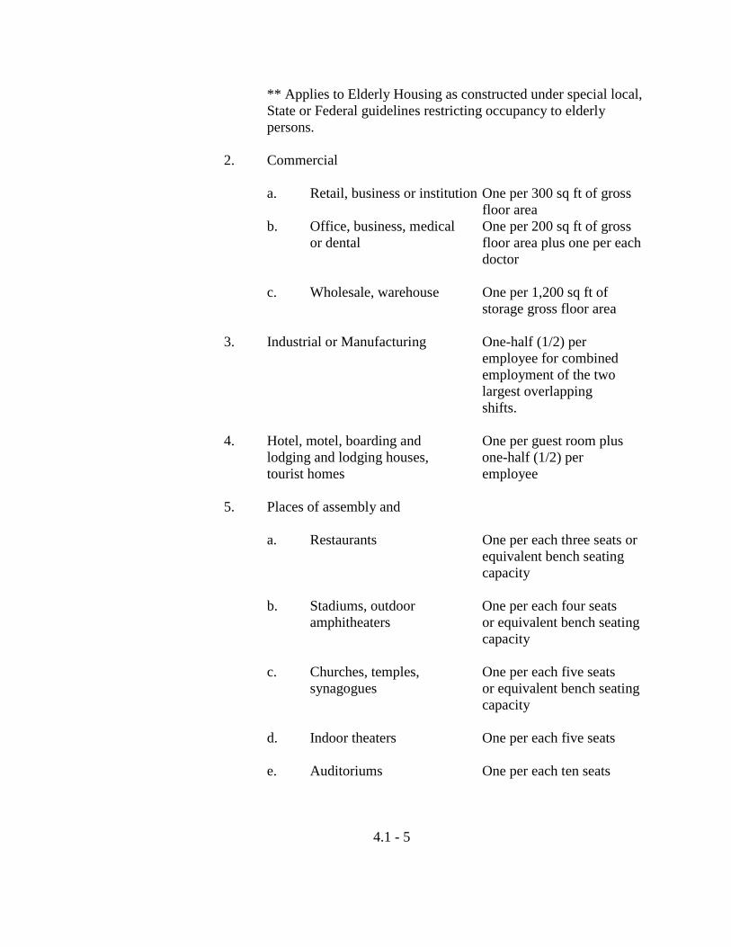
** Applies to Elderly Housing as constructed under special local, State or Federal guidelines restricting occupancy to elderly persons.
2. Commercial a. Retail, business or institution One per 300 sq ft of gross floor area b. Office, business, medical One per 200 sq ft of gross or dental floor area plus one per each doctor c. Wholesale, warehouse One per 1,200 sq ft of storage gross floor area 3. Industrial or Manufacturing One-half (1/2) per employee for combined employment of the two largest overlapping shifts. 4. Hotel, motel, boarding and One per guest room plus lodging and lodging houses, one-half (1/2) per tourist homes employee 5. Places of assembly and a. Restaurants One per each three seats or equivalent bench seating capacity b. Stadiums, outdoor One per each four seats
amphitheaters or equivalent bench seating capacity
c. Churches, temples, One per each five seats
synagogues or equivalent bench seating capacity
d. Indoor theaters One per each five seats e. Auditoriums One per each ten seats
4.1 - 5
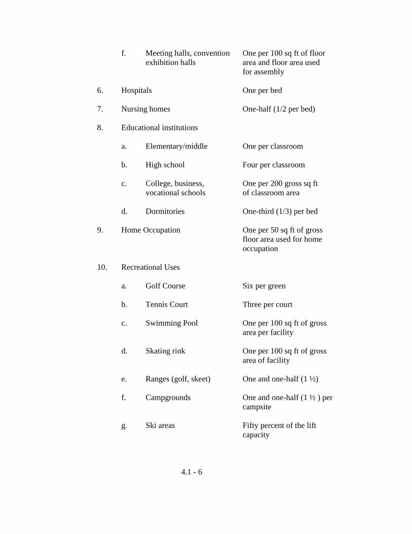
f. Meeting halls, convention One per 100 sq ft of floor exhibition halls area and floor area used for assembly 6. Hospitals One per bed 7. Nursing homes One-half (1/2 per bed) 8. Educational institutions a. Elementary/middle One per classroom b. High school Four per classroom c. College, business, One per 200 gross sq ft vocational schools of classroom area d. Dormitories One-third (1/3) per bed 9. Home Occupation One per 50 sq ft of gross floor area used for home occupation 10. Recreational Uses a. Golf Course Six per green b. Tennis Court Three per court c. Swimming Pool One per 100 sq ft of gross area per facility d. Skating rink One per 100 sq ft of gross area of facility e. Ranges (golf, skeet) One and one-half (1 ½) f. Campgrounds One and one-half (1 ½ ) per campsite g. Ski areas Fifty percent of the lift capacity
4.1 - 6
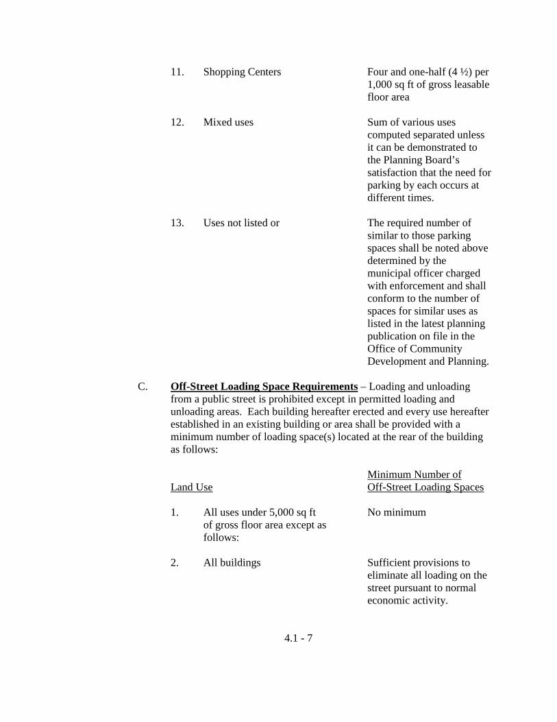
11. Shopping Centers Four and one-half (4 ½) per 1,000 sq ft of gross leasable floor area 12. Mixed uses Sum of various uses computed separated unless it can be demonstrated to the Planning Board’s satisfaction that the need for parking by each occurs at different times. 13. Uses not listed or The required number of similar to those parking spaces shall be noted above determined by the municipal officer charged with enforcement and shall conform to the number of spaces for similar uses as listed in the latest planning publication on file in the Office of Community Development and Planning.
C. Off-Street Loading Space Requirements – Loading and unloading
from a public street is prohibited except in permitted loading and unloading areas. Each building hereafter erected and every use hereafter established in an existing building or area shall be provided with a minimum number of loading space(s) located at the rear of the building as follows:
Minimum Number of Land Use Off-Street Loading Spaces 1. All uses under 5,000 sq ft No minimum of gross floor area except as follows: 2. All buildings Sufficient provisions to eliminate all loading on the street pursuant to normal economic activity.
4.1 - 7
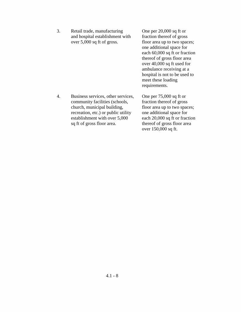
3. Retail trade, manufacturing One per 20,000 sq ft or and hospital establishment with fraction thereof of gross over 5,000 sq ft of gross. floor area up to two spaces; one additional space for each 60,000 sq ft or fraction
thereof of gross floor area over 40,000 sq ft used for ambulance receiving at a
hospital is not to be used to meet these loading requirements. 4. Business services, other services, One per 75,000 sq ft or
community facilities (schools, fraction thereof of gross church, municipal building, floor area up to two spaces; recreation, etc.) or public utility one additional space for establishment with over 5,000 each 20,000 sq ft or fraction sq ft of gross floor area. thereof of gross floor area over 150,000 sq ft.
4.1 - 8
4.2 Signs
A. General Provisions – Signs in all districts shall be subject to the following general provisions and regulations:
1. Unless otherwise in this Article, no sign shall be erected until a
Sign Permit has first been issued by the municipal officer charged with enforcement.
a. An application for a Sign Permit may be obtained at the
Department of Community Development and Planning.
b. No Sign Permit shall be issued unless the municipal officer charged with enforcement is satisfied that the sign supporting devices and electrical appurtenances and connections are in conformance with the City’s Building and Electrical Codes.
c. A processing fee in the amount stipulated in Article 9 of
this Chapter shall accompany all applications for a Sign Permit.
2. No sign shall contain any moving, flashing or animated lights, or
visible moving or movable parts, except such portions of a sign as consist solely of indicators of time and/or temperature or automatically changing message shall be permitted only by special exception after approval by the Planning Board in accordance with the provisions of Article 7, Section 7.2, and upon a positive recommendation by the Chief of Police.
3. Signs may be illuminated only by the following means:
a. By a white, steady, stationary light of reasonable intensity shielded and directed solely at the sign and not casting light off the premises.
b. By interior non-exposed lights of reasonable intensity.
An illuminated sign or lighting device shall not be so placed or directed so that it constitutes a traffic hazard or nuisance through glare or reflection upon a public street, highway, sidewalk or adjacent premises.
4.2 - 1
4. No illuminated sign shall contain red, green or amber colors or lights if same would, in the opinion of the Chief of Police, constitute a driving hazard.
5. No sign shall project beyond the property line of the lot on which
it is placed. 6. No sign may be located so as to obstruct a traffic control device
or in a manner which would obscure the view of approaching or merging traffic.
7. Wall, projecting and roof signs shall be firmly affixed to the
building. Wall signs shall not project more than twelve inches from the face of the wall to which it is attached. Projecting signs shall not project more than four feet perpendicularly from the face of the wall to which they are attached. Roof signs shall not project more than four feet above the roof line.
8. No sign which advertises or calls attention to any products,
businesses or activities which are no longer sold or carried on shall remain on the premises for more than six months after the product, business or activity has ceased being sold or carried on.
9. Temporary movable signs are not permitted except for the
following uses:
a. To call attention to and/or to advertise the name of a new business and the products sold or activities to be carried on in connection with a new business. In such cases, no sign shall remain at premises for more than ninety (90) days.
b. To advertise a Special Sale. In such cases a sign shall be
allowed for a period not to exceed ninety (90) days in any calendar year.
c. Signs or other advertising devices as may be permitted by
the City Council to promote community or civic activities. Petitions for such signs shall be made directly to the City Council and shall include a scaled map of the sign site, size and design of the sign, how the sign may be electrified, period of use, written permission of property owner if not the City, a description of the reason for the
4.2 - 2
sign, a recommendation from the Police Department and the Department of Community Development and Planning and any other information the City may require. Such signs shall not be required to satisfy the requirements of Section 4.2.A.1. of this Article.
10. Signs legally erected before the adoption of this Ordinance which
do not conform to the provision of this Ordinance may continue to be maintained, provided, however, that no such sign shall be permitted if it is, after the adoption of this Ordinance, enlarged, reworded (other than in the case of theater or cinema signs or signs with automatic or manually changing messages), redesigned or altered in any way excluding repainting in a different color, except to conform to the requirements of this Ordinance; and provided further that any such sign which has deteriorated to such an extent that the cost of restoration would exceed thirty-five percent of the replacement cost of the sign at the time of restoration shall not be repaired, rebuilt or altered except to conform to the requirements of this Ordinance. Any exemption provided in this Section shall terminate with respect to any sign which:
a. Shall have been abandoned for at least 12 consecutive
months;
b. Advertises or calls attention to any products, businesses or activities which are no longer sold or carried on, whether generally or at the particular premises; or
c. Shall not have been repaired or properly maintained
within thirty (30) days after notice to that effect has been given by the municipal officer charged with enforcement.
11. For those developments subject to site plan review (Section 7.1
of this Chapter) the relaxation of the number and location of signs shall be reviewed by the Planning Board. The modifications to the sign requirements shall be allowed as the Planning Board may deem necessary to carry out the objectives and intent of site plan review.
4.2 - 3
B. Signs, On premises
1. All Districts – The following signs are permitted in any use district, except where otherwise prohibited by law, and shall not be subject to the issuance of a Sign Permit.
a. One sign not exceeding one square foot used to display
the street number and/or name of the occupants of the premises.
b. One non-illuminated sign not exceeding two square feet
used to describe a home occupation, boarding or lodging house, or tourist home located on the premises.
c. One sign not exceeding twenty-four square feet on the
premises of public or semi-public buildings, funeral homes and charitable or religious institutions. This sign may incorporate a bulletin board.
d. One real estate sign not exceeding eight square feet
relating to the sale, rental or lease of the premises. Such sign shall be removed within one (1) week after the property transaction.
e. One sign each for a building contractor, architect or
engineer, each sign not exceeding sixteen square feet, relating to construction projects. Such sign shall be removed within one (1) week after the issuance of the certificate of occupancy (completion).
f. Building name and date sign and/or memorial tablet, not
exceeding an aggregate of ten (10) square feet, showing the name of the building and date of erection and/or historic information, when cut into masonry, formed of bronze or similar non-combustible material.
g. One professional name plate sign not exceeding eight (8)
square feet.
h. Two signs, not exceeding sixteen (16) square feet each, describing farm products for sale on the premises. Instead of two signs, a single double-faced sign may be erected
4.2 - 4
with a display area, not exceeding sixteen (16) square feet on each side.
i. Political signs, not exceeding sixteen (16) square feet in
total area for single faced signs on one (1) standard, or eight (8) square feet on each side of double-faced signs on one (1) standard, provided that:
(1) Such signs shall not be erected more than thirty
(30) days prior to the election to which they pertain;
(2) Such signs are removed within seven (7) days
after the election to which they refer;
(3) Removal of such signs shall be the joint responsibility of the candidate and the property owner on whose premises the signs are displayed.
j. Traffic or other municipal signs, legal notices, railroad
crossing signs, danger signs, directional signs, non-commercial and temporary signs or street banners related to public or charitable purposes may be approved by the City Clerk along with stipulations as to the size, location, message, period of display and other requirements such as insurance and approval of building owners on whose property the banner will be attached.
2. Residence Districts – The following sign regulations apply in
residence districts:
a. Except where specifically permitted, all signs shall be single-faced mounted flat on the wall of a structure or standing.
b. No off-premise signs are permitted, except as provided
for in Chapter 27. c. No projecting or roof signs are permitted.
d. One identification sign, not exceeding forty (40) square feet in area, at any public entrance to a subdivision or multi-family development.
4.2 - 5
e. Signs permitted pursuant to a site plan review.
f. In Agriculture and Resource Protection, Low Density Country Residential, Rural Residential and Suburban Residential Districts one non-illuminated sign, not exceeding 16 square feet, used to display the name of the business and products or services sold from a use which is permitted in the district.
3. Business and Industrial Districts – The following sign
regulations apply in business and industrial districts:
a. Sign shall relate to the premises on which they are located and shall only identify the occupants of said premises or advertise the nature of the products and services available within said premises. In the case of a multi-tenant or condominium development, it shall be the responsibility of the owner or property manager of such premises to allocate sign space upon the premises, under the terms of this Article.
b. Wall signs and roof signs are permitted provided that the
aggregate area of the signs shall not exceed fifteen (15) percent of the area of the wall on or over which the signs are located. Signs proposed for placement at an angle at the intersection of two walls shall use fifteen (15) percent of the area of the wall with the smallest dimensions.
c. Projecting and standing signs, one of each per premise,
are permitted subject to the following provision:
(1) The aggregate area of sign surface for any one premise shall not exceed four (4) square feet per foot of street to the maximum of two hundred fifty (250) square feet or one (1) square foot per foot of street frontage, whichever is larger. These dimensions shall be halved in Neighborhood Business Districts (NB).
(2) Standing signs may be located within the required
front yard space but not nearer than twelve (12) feet from either side lot line unless written permission is obtained from the abutting property
4.2 - 6
owner to erect such sign nearer than that distance from the common side lot line between the two properties.
(3) The maximum height of standing signs shall be
twenty-five (25) feet above grade.
(4) Two projecting and two standing signs are permitted where the premise fronts on two streets; one sign of each type per street.
(5) Compliance with all State of Maine Sign
Regulations when applicable.
d. In addition to the foregoing sign or signs, one directory of the establishments occupying a building may be affixed to the exterior wall of the buildings at each public entrance to the building. Such directory shall not exceed an area determined on the basis of one square foot for each establishment occupying the building.
e. Signs painted or placed on the inside of the glass of a
window may be permitted in addition to the above, provided that the aggregate area of such signs does not exceed fifty (50) percent of the area of the window glass.
f. Sign permitted pursuant to Site plan review.
g. Commercial and industrial subdivisions and planned unit developments are allowed to have a single standing sign at each public entrance to the development to advertise the individual uses within the development, not to exceed in size the aggregate area of sign surface allowed by Section 4.2.B.3.c. for lots within the development. Individual standing signs for lots within the development are prohibited.
4.2 - 7
4.3 Manufactured Housing and Mobile Homes A. General Provisions
1. Permanent and Temporary Use Defined: Permanent use of manufactured housing is defined to mean occupancy while in a parked position for any purpose permitted by Section 4.3.B.1. and 4.3.B.2. including storage. Manufactured housing units and mobile homes must meet all Federal, State and Municipal Codes. Temporary use of manufactured housing, mobile homes, trailer homes and office trailers must be recorded with the municipal officer charged with enforcement and a permit issued for each period of use prior to the beginning of such use.
2. A mobile home shall be construed to remain a mobile home,
subject to all regulations applying thereto, whether or not wheels, axles, hitch or other E-G of mobility are removed and regardless of nature of the foundation provided.
B. Uses of Manufactured Housing, Trailers, Office Trailers – The use of
manufactured housing, trailers and office trailers is prohibited except as follows:
1. As permanent single-family residences on individual lots in all
residential districts (applies only to manufactured housing units that meet all Federal, State and Municipal Codes).
2. As permanent single-family residence in approved mobile home
developments in Rural Residence (RR), and Suburban Residence (SR) Districts (applies only to manufactured housing units that meet all Federal, State and Municipal Codes).
3. As permanent single-family residence on individual lots in the
Manufactured Housing Overlay (MHO) Districts (applies only to manufactured housing units that meet the requirements of Section 5.5 of this Chapter).
4. As temporary residences for farm laborers or supervisory
personnel employed on a seasonal basis on the farm of their employer and limited to the period of such seasonal employment.
5. As temporary field headquarters or office space on construction
sites for persons or firms actually engaged in construction work.
4.3 - 1
6. As temporary office space for persons or firms actually engaged in the business of selling manufactured housing, mobile homes and trailers.
7. As temporary living quarters for construction workers located on
or within one-quarter of a mile from the construction site on which they are employed. Such occupancy shall be limited to the period during which construction is in progress.
8. As temporary living quarters for persons whose need arises from
emergency resulting from loss of their homes through accident, natural disaster, or other physical causes. The period of occupancy permitted by this Subsection shall be limited to twelve (12) months together with any additional period during which a valid building permit for construction of replacement living quarters may be in effect (applies to manufactured housing only).
9. As temporary office space for a business enterprise during the
period in which permanent office space is being constructed for which a valid building permit has been issued.
10. As temporary living quarters for employees of itinerant
businesses such as carnivals during the period when such businesses are actually being conducted within the City and in no case for longer than thirty (30) days (applied to trailers only).
11. As temporary classroom space at an existing school facility for
educational activities conducted by the City of Auburn, Department of Education.
12. Storage boxes or space trailers used as storage space for non-
hazardous materials by the commercial or industrial use which occupies the property. For the purpose of this Ordinance, a storage box or space trailer is defined as a fully enclosed structure manufactured for storage use only and does not include tractor trailer bodies, cargo container boxes or railroad cars.
13. As office space for excavation and sawmill operations for the
period of active use. If such operations are discontinued for a period of twelve (12) consecutive months, such use shall be considered abandoned and the office trailer shall be removed.
4.3 - 2
C. Uses of Mobile Homes The uses of mobile homes are prohibited except as follows:
1. As permanent single-family residence in approved mobile home developments in Rural Residence (RR) and Suburban Residence (SR) Districts.
2. All uses permitted by Section 4.3.B.3. through 4.3.B.9.
D. Mobile Homes in Flood Plain Districts Mobile homes shall be elevated and anchored to prevent flotation,
collapse and lateral movement. Mobile homes shall be anchored as follows:
1. By the use of over-the-top or frame ties: or
2. As provided for in the FEMA Manual, “Manufactured Home Installation in Flood Hazard Areas”, published in September 1985.
Mobile homes shall be elevated as follows:
3. General requirements that the lowest floor of the mobile home be elevated to or above the base flood elevation; or
4. As provided for in the FEMA Manual, “Manufactured Home
Installation in Flood Hazard Areas”, published in September 1985.
E. Mobile Home Park Standards Mobile home parks shall meet all of the following standards set forth in
this Section. Mobile home parks proposed to be established must have a minimum of 3 lots and be located within 1,500 feet of municipal sewer and water.
1. Minimum Lot Size a. The minimum lot size shall be 5,000 square feet.
4.3 - 3
b. The following frontage and setbacks shall apply: Frontage 50 feet Front Setback 15 feet Side 10 feet Rear 10 feet Parking in front yard to zero lot line.
c. Setbacks may be reduced along rear lot lines of lots adjacent to abutting property where buffers are proposed along the perimeter of the proposed park.
2. Siting
All mobile home lots shall be laid out on the proposed Subdivision and site plan showing approximate pad locations prior to Final Approval. On sites/lots which abut rear lot lines, the pads shall be offset as to not obstruct view from the rear portion of each unit. Units/Lots that abut public roads shall meet front yard setbacks established by the Zone in which the park is proposed.
3. Off-Street Parking Requirements
a. Off-street parking in the form of parking lots or carports for Mobile Home Parks shall meet the same standards as provided in Article 4 of Chapter 29.
b. Residential parking spaces need not be located on lots
occupied by the dwelling units served, but at least two such spaces per unit shall be reserved for, and located within 100 feet walking distance of the dwelling unit it is intended to serve. NO on street parking will be provided.
c. Parking on each individual lot will be allowed to infringe
the principal structure setbacks. All off-street parking must be of an impervious material. All off-street parking lots proposed must be shown on the site and Subdivision plans at time of Planning Board review.
Lots with 50 feet of frontage will allow parking within the 10 foot side yard setback and associated front setback.
4.3 - 4
4. Buffering and Landscaping
a. All parks shall provide and maintain a buffer strip of 50 feet around the perimeter of the mobile home park. If the per acre density of homes within the mobile home park is at least 2 times greater than:
(1) The density of residential development on
immediately adjacent parcels of land; or
(2) If the immediately adjacent parcels of land are undeveloped, the maximum net residential density permitted by applicable municipal ordinances or State Law.
This buffer must include either a wooden stockade fence,
a chain link fence with vegetative cover at a minimum height of 6 feet or the buffer must be heavily vegetated with coniferous trees that at the time of planting must be 6 feet in height. Heavily vegetated is considered to mean trees planted in a row at least 8 feet on center. The buffer vegetation shall not exceed 25 feet in width. Each row shall be offset from the adjacent row. The Planning Board may allow a reduction in the buffer width, if the developer can prove that the intent of this provision is not impaired.
b. Where possible, existing trees shall be preserved, mobile
home sites shall be oriented with respect to scenic vistas, natural landscape features, topography and natural drainage areas. Areas such as wetlands shall be preserved in accordance with the Army Corps of Engineers Standards.
c. Open space, storage or recreation requirements shall not
exceed 10 percent of the combined area of the individual lots within a mobile home park. If the developer wishes to develop more than 10 percent open space, storage and/or recreation area, he may do so.
5. Accessory Buildings and Utility Sheds
a. Utility sheds or accessory buildings will be allowed along
4.3 - 5
the rear portion of the lot and along the rear lot line and shall not exceed 2 percent of the lot size.
b. At least one large storage facility may be required in the
park in order to store such items as recreation vehicles, boats, snowmobiles and all other licensed and unlicensed recreation vehicles which might otherwise be stored in a parking space to be utilized by an individual unit. This area shall in total not be less than 50 square feet for each mobile home lot and shall have screening around the storage area on all four sides. Fully enclosed security fencing is encouraged.
6. Street Design Standards
Privately owned and maintained streets shall meet the following requirements:
a. Streets shall have a right-of-way of 23 feet in width, and
pavement shall be 20 feet in width.
b. Intersections proposed as part of the mobile home park which will tie directly into City accepted streets, shall meet minimum intersection geometric design standards as developed by the Institute of Transportation Engineers or the American Association of State Highway and Transportation Officials.
c. All street design plans must be stamped and signed by a
Registered Professional Engineer. 7. Refuse
Refuse containers shall be conveniently located throughout the site at a rate of one (1) eight (8) yard garbage container for every twenty (20) mobile home units and shall be fenced in on three sides in order to protect the health and safety of the park residents. This standard is based on a weekly pick-up and may be reduced if pick-up is more frequent. In the event lot to lot pick-up is provided by the park management, this provision shall be waived.
4.3 - 6
8. Fire Hydrants
Fire hydrants shall be placed at a distance of no more than 1,000 feet apart in order to service the complete mobile home park.
9. Mail Boxes
Must be established in such a manner that at a minimum five (5) vehicles may be able to either park or be queued in order to pick up mail at the proposed mail box location. This location must also be approved in writing by the local Post Master.
10. Design and Anchoring of Units
All units being established within an approved mobile home park are subject to all standards noted in Chapter 29, Article 5, Section 5.5C.1.10.
11. Provisions of this Section are subject to both Chapter 23,
Subdivision and Chapter 29, Section 7.1, Site Plan Standards for Review.
12. Planned Unit Developments (PUDs) are encouraged under
Section 3.51.C.2. of Chapter 29. If a developer proposes a park under the PUD Section, then all standards and Sections of that Ordinance must be met.
4.3 - 7
4.4 Excavation Permit Regulations A. Activities Requiring Excavation Permits
1. The excavation of sand, gravel, stone or other earth material from any land in the City of Auburn is hereby prohibited except such excavation as may be authorized in any zoning district by a permit issued by the Planning Board or as otherwise permitted under this Chapter.
2. The commercial excavation of sod, loam, topsoil, peat or other
organic material for landscaping and site development related activities exceeding 300 cubic yards per site per year from any land in the City of Auburn is hereby prohibited except such excavation as may be authorized in any zoning district by a permit issued by the Department of Community Development and Planning or as otherwise permitted under this Chapter.
B. Items to be considered in Application Review
1. In judging whether or not an excavation permit shall be issued, the Planning Board shall after a public hearing, determine the setback allowances, ingress and egress to provide a site distance that meets minimum safety standards, and access road location and maintenance.
2. In judging whether or not an excavation permit shall be issued,
the Planning Board shall address the following, if applicable:
a. Maintenance of safe and healthful conditions such as the posting of danger areas, the installation of gates to prevent access, etc;
b. The prevention and control of erosion and sedimentation; c. The proximity of water bodies and wetland areas;
d. The effect on the aesthetic, scenic or natural beauty of the immediate area;
e. Whether the size of the resource deposit in relation to the
area affected justifies the excavation activity;
4.4 - 1
f. The compatibility of the use with the surrounding uses and the neighborhood. Under this criteria items to be addressed are as follows: hours of operation, noise emitted from the operation, types of machinery to be used, dust, provisions of screening, orientation of the excavation operation, etc.
3. In judging whether or not an excavation permit should be issued,
the Planning Board shall address the following: a. Adequacy of the applicant’s Reclamation Plan;
b. The applicant must demonstrate proof of bonding capacity or security adequate to ensure compliance with an approved Reclamation Plan.
4. In judging whether or not an excavation permit should be issued
for the excavation of organic material, the Department of Community Development and planning shall consider compliance with the criteria cited in Section 4.4B.1. and shall address, if applicable, the criteria in Section 4.4B.2.
C. Submission of Application and Review Procedure
1. A written application for an excavation permit required under Section 4.4A.1. shall be submitted with a processing fee of $25 to the Department of Community Development and Planning. The Planning Board shall conduct an on-site inspection of the proposed excavation location prior to the public hearing. Notice of such inspection shall be given to the applicant and others by mail at such addresses as may be known to the Department of Community Development and Planning or as appear in the City of Auburn property tax list. Comments concerning the proposed excavation operation will be solicited from all persons in attendance. Failure of the applicant or others to receive a mailed notice of such on-site inspection shall not constitute grounds for objections by the applicant or others and shall not invalidate any action taken by the Planning Board shall hold a public hearing on such application.
2. An application of an excavation permit under Section 4.4A.1.
shall be submitted to the Department of Community Development and Planning not less than thirty (30) days prior to
4.4 - 2
the next regular meeting of the Planning Board. The Planning Board shall schedule a public hearing, the notice of which shall be given by publication in a newspaper having general circulation in the City of Auburn not less than twelve (12) days prior to the meeting of the Planning Board. Upon holding the public hearing and reviewing the application, the Planning Board shall approve, conditionally approve or deny the application based on the criteria set forth in Section 4.4.B. The Planning Board shall notify the applicant in writing of any conditions and the reasons for its action.
3. A written application for an excavation permit required under
Section 4.4A.2. shall be submitted with a processing fee of $15 to the Department of Community Development and Planning.
4. When an application for an excavation permit under Section
4.4A.2. is submitted, the Department of Community Development and Planning shall have fifteen (15) working days to complete its review of the application. The Department of Community Development and Planning can approve, conditionally approve or deny the application based on the criteria set forth in Section 4.4B. The Department of Community Development and Planning shall notify the applicant in writing of any conditions and the reasons for its action.
D. Application
1. The written application submitted to the Department of Community Development and Planning shall contain the following information:
a. Legal description of the property and description of he
site to be affected by the excavation operation; b. Status of title of land;
c. Description of the scope of activities to be undertaken on the site: i.e., area, depth of proposed excavation, etc;
d. Narrative description addressing the items required under
Section 4.4B.1;
4.4 - 3
e. Narrative description addressing any items listed under Section 4.4B.2. that the applicant feels are applicable to his proposed operation; and
f. Proof of bonding capacity or security adequate to ensure
compliance with an approved Reclamation Plan.
2. At the time of submission of the written application, the applicant shall submit an inked original and fifteen (15) copies of a site plan map drawn to the following specifications:
a. Sheet size not to exceed 24” x 30”;
b. A plan prepared to a scale of 1” = 40’ is preferred but where appropriate, a scale up to 1” = 100’ is acceptable.
c. Name and address of owner and developer, and interest of
the applicant if other than the owner or developer; d. Name of development and north point;
e. Names and addresses of all owners of record of all adjacent property as appear on Assessor’s records;
f. Current zoning classification and district boundaries;
g. Easements, rights-of-way, or other reservations adjacent to or intersecting the property;
h. Existing and proposed topography, at contour intervals of
not more than five feet;
i. Location of water course, marshes and wooded areas within 150 feet of property lines;
j. Location of buildings existing on the site to be developed
and on adjacent land;
k. Existing public street rights-of-way and proposed ingress and egress facilities; and
l. Proposed temporary and permanent drainage methods (to
be approved by the City Engineer).
4.4 - 4
3. At the time of submission of the written application and site plan, the applicant shall submit a Reclamation Plan which shall include such items as slope of finished banks, vegetation to be introduced, etc.
E. Posting of Bond or Security Upon approval of an application for an excavation permit and prior to the
excavation of any earth or organic materials, the applicant shall tender a certified check payable to the City of Auburn, a performance bond running to the City of Auburn and issued by a surety company or secured by deposits issued by institutions authorized to issue the same by the Laws of Maine, or the United States or irrevocable letters of credit issued by said banking institutions, in a dollar amount to be determined by the Planning Board and/or the Department of Community Development and Planning in an amount adequate to guarantee fulfillment of conditions imposed.
F. Enforcement Procedure and Penalty
1. The Planning Staff shall conduct at least an annual review of the excavation operation and forward its findings to the Planning Board at the next regular scheduled meeting. The review process shall take into consideration the conditions of compliance, adjustment of the performance bond, if warranted, and any other applicable concerns.
2. If after the review of the Planning Staff findings the Planning
Board determines that the conditions of the permit have substantially changed, the owner of an excavation permit may be required to submit a new application in the same manner as prescribed in Section 4.4C. and 4.4D. of this Article.
3. If after the review of the Planning Staff findings the Planning
Board determines that the owner of an excavation permit has violated the conditions of the permit, the Planning Board may revoke such permit provided the owner of such permit is given a reasonable time to abate the violations as prescribed in Section 7.4C. of Chapter 29 of the Auburn Ordinances.
4. Any person or persons, firm or corporation being the owner or
tenant of, or having the control or use of land or part thereof in Auburn, who excavates, grades, transfers or removes any earth or
4.4 - 5
organic materials prior to receiving an excavation permit and who intends to initiate an excavating operation shall be guilty of a civil infraction and penalized as provided for by Section 7.4E. of Chapter 29 of the Auburn Ordinances. This Section is not intended to prohibit exploratory excavation for earth material deposits.
5. Complaints against an excavation operation permitted under this
Article shall be received and reviewed in the manner provided by Section 7.4C. of Chapter 29 of the Auburn Ordinances.
G. Excavation Permit Exceptions
1. The foregoing article shall be deemed not to prohibit the excavation of earth or organic materials as may be incidental to any lawfully permitted use of land or of a building or incidental to any necessitated by any building construction for which a building permit has lawfully been issued under the Auburn Zoning Ordinance prior to such materials excavation.
2. The foregoing article shall also be deemed not to prohibit the
excavation from any lot or way of materials so far as may be necessitated by the construction or installation of utilities, public ways or other engineering works for public service on such lot or in such way.
3. The foregoing article shall also be deemed not to prohibit the
excavation, grading, or transferring of any earth materials noted under Section 4.4A.1. from one part of a lot, tract, or parcel of land to another part of the same lot, tract or parcel of land in the same ownership, or excavation for sale at a rate not exceeding ten (10) cubic yards per acre per year.
4. The foregoing Article shall not apply to excavation activities in
existence on the date of adoption of this Ordinance provision and registered with the Department of Community Development and Planning within six (6) months of the date of adoption of this Ordinance provision as long as the total land area affected by the excavation activity is not expanded by more than one (1) acre. Excavation activities which expand in depth must file a Reclamation Plan to be approved by the Department of Community Development and Planning. The applicant shall post
4.4 - 6

a bond of security in a dollar amount to be determined by the Department of Community Development and Planning in an amount adequate to guarantee completion of reclamation activities. Any excavation activity which is discontinued for twelve (12) consecutive months shall require a permit to reopen.
4.4 - 7
4.5 Home Occupation Regulations
A. Purpose – The purpose of this Home Occupation Ordinance is to allow the secondary and incidental use of a residence for the conduct of appropriate occupations whose external activity levels and impacts are so limited as to be compatible with and not adversely affect the character of the surrounding neighborhood. Additionally, the City wishes to provide all residents freedom from excessive noise, excessive traffic, nuisances, fire hazard and other possible impacts of business activities being conducted in residential buildings.
B. Definition – A Home Occupation refers to the accessory use of a
dwelling unit for a business or commercial venture engaged in, by the person or persons residing in the dwelling unit, and which allows up to one (1) person who does not reside on the premises to be employed by that Home Occupation.
C. Objectives – The following objectives will be those standards provided
to the Code Enforcement Officer for guidance to determine if the proposed Home Occupation meets the appropriate standards set forth in the Ordinance.
1. The proposed home occupation will be conducted entirely within
the dwelling unit and shall not be extended to any accessory structures.
2. The provisions for vehicular loading, unloading and parking and
for vehicular and pedestrian circulation on the site and onto adjacent public streets will not create hazards to safety.
3. The location or operation of the proposed home occupation will
not be detrimental to and adversely affect the use and values of existing development in the neighborhood or the health or safety of persons residing or working therein.
4. The provisions for exterior lighting will not create safety hazards
for motorists traveling on adjacent streets and will be adequate for the safety of occupants and users of the site, and will not create a nuisance affecting adjacent properties.
5. The proposed home occupation will not unduly burden off-site
sewer drainage or water systems.
4.5 - 1
6. The proposed home occupation will not create a fire/safety concern beyond what currently exists as determined by the Fire Department.
7. The proposed home occupation does not violate provisions of the
zoning regulations applicable to the site or other applicable laws, regulations or Ordinances.
8. The proposed home occupation shall not unduly impact the
ability to provide municipal services. D. Criteria for Home Occupation – 1. Require a permit, which shall be reviewed and renewed annually.
2. Be conducted entirely within the dwelling unit and involve not more than one person other than members of the family residing in the dwelling, employed on the premises in conjunction with the home occupation.
3. Be clearly incidental and secondary to the use of the dwelling for
residential purposes and not involve the use of more than twenty-five percent of the habitable floor area occupied by the applicant.
4. Present only incidental visible exterior evidence of the home
occupation. Structural alterations of the dwelling, related to the home occupation, shall be consistent with the residential character of the dwelling.
5. Exterior signage shall be limited to one (1) non-illuminated sign,
not exceeding a total area of two (2) square feet in size.
6. Not involve the use of any accessory buildings located on the property, nor any exterior storage of materials used in the home occupation. Storage or use of any highly explosive or combustible material is prohibited.
7. Not involve any retail sales, other than incidental, which are
associated with the home occupation.
8. Not involve deliveries or pick-ups made by vehicles larger than a single unit truck with three (3) or fewer axles. Overall deliveries shall be limited to not more than five (5) per week.
4.5 - 2
9. Provide one (1) parking space, on the property, for each one-hundred and fifty (150) square feet of area designated for home occupation use.
10. Not generate any offensive noise, vibration, smoke, dust, odors,
heat or glare which is detectible to normal sensory perception at or beyond the property boundaries. The home occupation shall also not interfere with radio or television reception in the area.
11. Not involve the use, on the premises, of any equipment other than
that normally used within a residential household or general office.
12. Only be permitted with the written consent of the property owner
if the property is not owned by the applicant. G. Administrative Procedures –
1. Application and fee, $24.00, will be prorated on a monthly basis to December 31st of the calendar year.
2. The Abutters shall be notified and given a fourteen (14) day
comment period to raise issues of concerns with the proposed use of the property.
3. Decision and required conditions for the use of the property for a
home occupation will be forwarded by the Code Enforcement Officer within fourteen (14) days of the date of the application.
4. There shall be a thirty (30) day appeal period from the date of the
Code Enforcement Officer’s written decision. H. Appeals – If either the Applicant or the Abutters to the proposed Home
Occupation do not agree with the decision rendered by the Code Enforcement Officer, that party has thirty (30) days from the date of the Code Enforcement Officer’s letter to the Applicant advising he/she of the decision. The appeal shall be made in accordance with Article 6, Section 6.3.B. of Chapter 29. The Board of Appeals shall render its decision based on the criteria found in Sections 4.5.B., 4.5.C. and 4.5.D. as applicable.
I. Enforcement – Home Occupation Applicants shall permit a reasonable
inspection of the premises by the Code Enforcement Office on an annual
4.5 - 3
basis. Any violation of the Home Occupation approval shall be followed up in accordance with Article 7, Section 7.4.C. of Chapter 29 of the City of Auburn Ordinances.
J. Renewal – The applicant will be required to pay a renewal fee of $15.00
for a Home Occupation permit on a yearly basis. The permit will be based on the calendar year with renewals occurring on January 1. There shall be a thirty (30) day grace period for all renewals. If a Home Occupation permit has not been renewed during that time period a $10.00 late fee will be charged.
K. Applicability – Any person presently operating a home occupation in
the City of Auburn as defined herein on the effective date of this Article shall comply with the terms of this Article by obtaining a permit within six (6) months of the effective date of this Article.
4.5 - 4
4.6 Access Management Standards (AMS)
A. General Purpose – The access management program is the sum of all actions taken by the City to maintain the safety and traffic carrying capacity of its arterials and collector roadways. The following standards are enacted to provide for safe driving conditions, reduced potential traffic hazards, relieve congestion, and achieve a sustainable level of vehicle carrying capacity within identified commercial corridors and abutting lands. The effective application of these standards, coupled with other associated municipal ordinances, will assist in preserving highway capacity, reducing accidents and avoiding or minimizing costly road improvements.
B. Definitions – The following definitions are applicable to an access
management program for development along arterial and collector roadways and, where applicable, local roads serving land abutting arterial and collector roadways. Definitions found in other Chapters or in other municipal Ordinances which relat to access management may be used to assist in gaining greater understanding of the City’s overall intentions.
1. Acceleration Lane – A speed-change lane for the purpose of
enabling a vehicle entering a roadway to increase its speed to a rate at which it can safely merge with through traffic.
2. Access – The ability to enter or leave a public street or highway
from an adjacent driveway or another public street.
3. Access Management – The control of driveways and intersections to maintain highway safety and the traffic carrying capacity of an arterial.
4. Annual Average Daily Traffic (AADT) – The annual average
two-way daily traffic volume. It represents the total annual traffic on a road for the year, divided by 365.
5. Arterial – Major roadways which serve long distance through
traffic. Access to abutting land can generally be provided. Also see definition of Major Arterial Highway and Minor Arterial Highway in Section 2.2.
4.6 - 1
6. Collector Street – Roadways which connect streets to arterials and generally provide access to abutting lands. Also see definition of Minor Arterial Highway in Section 2.2.
7. Corner Clearance – The minimum dimension, measured parallel
to a highway, between the curb, pavement or shoulder lines of an intersecting highway and the nearest edge of a driveway.
8. Corner Lot – A single lot with frontage on two or more intersecting roads. Also see definition of Corner Lot in Section 2.2.
9. Deceleration Lane – A speed-change lane for the purpose of
enabling a vehicle to leave the through traffic lane at speed equal to or slightly less than the speed of traffic in the through lane and to decelerate to a stop or make a slow speed turn.
10. Driveway – An entrance used by vehicular traffic to access
property abutting a highway. As used in this Chapter, the term includes private residential driveways as well as commercial and other non-residential driveways.
Low Volume Driveways: Driveways with a traffic volume of less than 500 vehicle trips per day and less than 50 vehicle trips per peak hour. Medium Volume Driveways: Driveways with a traffic volume of 500 to less than 1,500 vehicle trips per day and 50 to less than 150 vehicle trips per peak hour. High Volume Driveways: Driveways with a traffic volume of 1,500 or more vehicle trips per day and 150 or more vehicle trips per peak hour.
11. Design Hourly Volume – The hourly traffic volume used to evaluate or design a highway or driveway.
12. Driveway Width – The narrowest width of the driveway,
measured parallel to the highway right-of-way. 13. Highway Capacity – The maximum number of vehicles that a
highway can handle during a specific unit of time at a given level of service.
4.6 - 2
14. Lane – The portion of a roadway for the movement of a single line of vehicles which does not include the gutter or shoulder of the roadway.
15. Peak Hour Traffic – The highest number of vehicles found to be
passing over a section of a lane or roadway during any 60 consecutive minutes. Typically, there is a peak hour condition in the A.M. and a peak hour condition in the P.M. for which the roadway or intersection is analyzed for capacity and level of service.
16. Service Road/Frontage Road – A local street or road located
parallel to an arterial for service to abutting properties for the purpose of controlling access to the arterial.
17. Shared Driveway – A single driveway serving two or more lots.
A shared driveway may cross a lot line or be on the lot line, and the owners may have an easement for the shared used and maintenance.
18. Storage Length – Additional lane footage added to a turning
lane to hold the maximum number of vehicles likely to accumulate during a peak period so as not to interfere with the through travel lanes.
19. Traffic Congestion – A condition resulting from more vehicles
trying to use a given road during a specific period of time than the road can handle with what are considered to be acceptable levels of delay or inconvenience.
20. Trip Generation – The estimated volume of traffic going to and
from a particular location. 21. Uncontrolled Access – The unlimited number, spacing and/or
unstandardized design of driveways onto a street or road. 22. Vehicle Trip – The vehicle moving from an origination point to
a destination point.
4.6 - 3
C. Applicability – The provisions of this Ordinance shall apply as follows:
1. See Section 2.2., definitions of Major or Principal Highway and Minor Arterial Highway for a listing of roadways subject to Access Management Standards.
2. Proposed changes in use requiring the issuance of any Land Use
permit. 3. Properties which meet the following threshold standards:
a. Any building or addition which results in a building footprint of greater than 5,000 square feet.
b. Uses generating more than 100 vehicle trips in the peak
hour.
c. Uses with a drive-through facility which generate more than 50 vehicle trips in the peak hour.
4. Subdivision consisting of three or more lots. 5. The following municipal uses where large or emergency vehicles
are commonly used: fire, public works, parks and recreation, police and schools.
D. General Standards – The following standards are designed to ensure
safety and maintain the traffic carrying capacity of identified roadways. In the review of a development proposal, a primary consideration shall be for the safety of people traveling on the arterial and a secondary consideration shall be for people entering and leaving the proposed development. Design elements should conform to the standards as contained in the most current version of the Institute of Transportation Engineers (ITE) Manual and commonly used by the Maine Department of Transportation (MDOT).
1. Safe Site Distance – Driveways and other accesses for all
developments, including individual residences, subdivisions and commercial and other non-residential developments shall be located to meet a minimum sight distance measured in each direction along the arterial or collector while maintaining
4.6 - 4
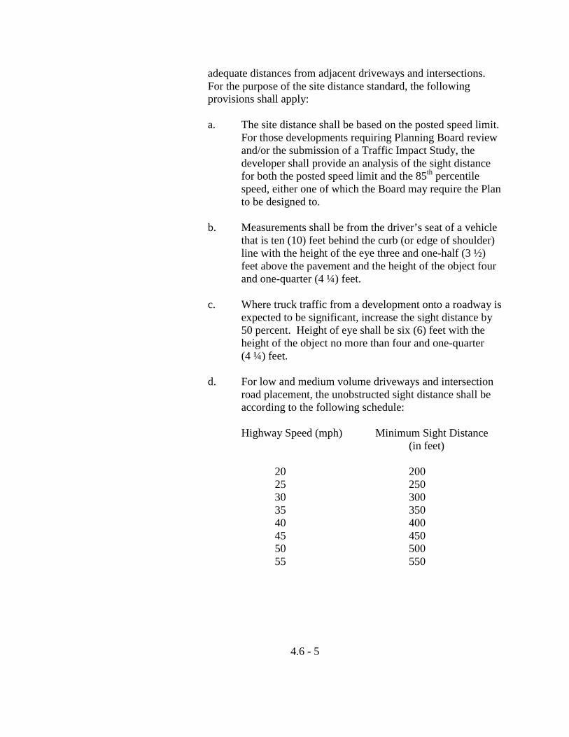
adequate distances from adjacent driveways and intersections. For the purpose of the site distance standard, the following provisions shall apply:
a. The site distance shall be based on the posted speed limit.
For those developments requiring Planning Board review and/or the submission of a Traffic Impact Study, the developer shall provide an analysis of the sight distance for both the posted speed limit and the 85th percentile speed, either one of which the Board may require the Plan to be designed to.
b. Measurements shall be from the driver’s seat of a vehicle
that is ten (10) feet behind the curb (or edge of shoulder) line with the height of the eye three and one-half (3 ½) feet above the pavement and the height of the object four and one-quarter (4 ¼) feet.
c. Where truck traffic from a development onto a roadway is
expected to be significant, increase the sight distance by 50 percent. Height of eye shall be six (6) feet with the height of the object no more than four and one-quarter (4 ¼) feet.
d. For low and medium volume driveways and intersection
road placement, the unobstructed sight distance shall be according to the following schedule:
Highway Speed (mph) Minimum Sight Distance (in feet)
20 200 25 250 30 300 35 350 40 400 45 450 50 500 55 550
4.6 - 5
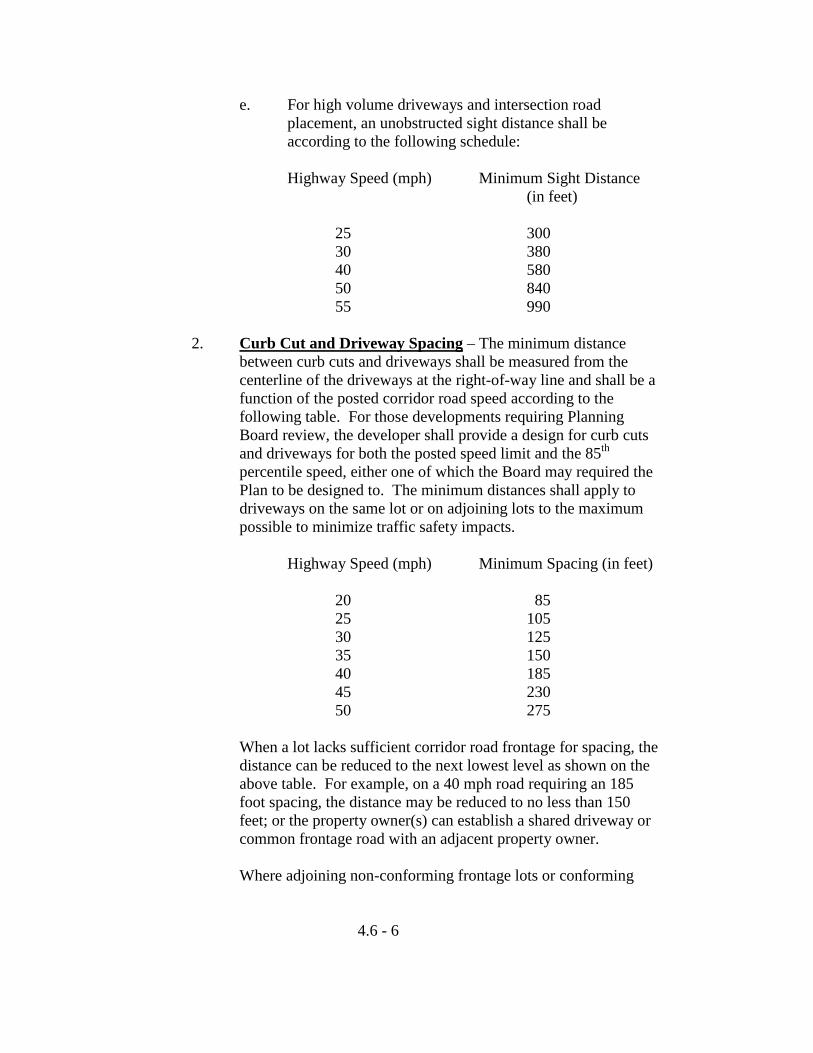
e. For high volume driveways and intersection road placement, an unobstructed sight distance shall be according to the following schedule:
Highway Speed (mph) Minimum Sight Distance (in feet) 25 300 30 380 40 580 50 840 55 990
2. Curb Cut and Driveway Spacing – The minimum distance between curb cuts and driveways shall be measured from the centerline of the driveways at the right-of-way line and shall be a function of the posted corridor road speed according to the following table. For those developments requiring Planning Board review, the developer shall provide a design for curb cuts and driveways for both the posted speed limit and the 85th percentile speed, either one of which the Board may required the Plan to be designed to. The minimum distances shall apply to driveways on the same lot or on adjoining lots to the maximum possible to minimize traffic safety impacts.
Highway Speed (mph) Minimum Spacing (in feet) 20 85 25 105 30 125 35 150 40 185 45 230 50 275 When a lot lacks sufficient corridor road frontage for spacing, the
distance can be reduced to the next lowest level as shown on the above table. For example, on a 40 mph road requiring an 185 foot spacing, the distance may be reduced to no less than 150 feet; or the property owner(s) can establish a shared driveway or common frontage road with an adjacent property owner.
Where adjoining non-conforming frontage lots or conforming
4.6 - 6
and non-conforming frontage lots are owned in common, those lots shall be considered combined for the purposes of meeting the frontage and access requirements of this Ordinance.
3. Number of Driveways Per Lot – The maximum number of
driveways to a particular site shall be governed by the following:
a. No low volume traffic generator, including single-family dwellings and duplexes, shall have more than one two-way access onto a single roadway.
b. No medium or high volume traffic generator shall have
more than one two-way access or two one-way accesses in total onto a single roadway.
c. All driveways shall comply with the spacing
requirements. 4. Access to Planned Developments – Where a proposed
development involves the construction of two or more uses, or where the potential for two or more uses being developed over time exists, access to the development shall be as follows:
a. Direct access to an arterial to any individual lot or to a
single place of business shall be prohibited unless it is determined that physical conditions peculiar to the parcel justify the granting of a waiver. A waiver may be granted only if there will be no further subdivision of the parcel and one of the following conditions is met:
(1) There is too little road frontage to reasonably
allow the creation of a new way;
(2) The shape or physical condition of the parcel does not permit access to or creation of a street other than an arterial; or
(3) Common access will be utilized which will allow
other proposed lots to be serviced by one new curb cut.
b. If there is more than one developer or if development
proceeds piece meal over time, smaller sites may be served by an individual entrance until such time as
4.6 - 7
adjacent lots are developed. These temporary individual commercial driveways shall be closed or consolidated into one or two access points and connected to a common service road.
c. Permitted access to the development may include one or
more of the following:
(1) A common frontage road running parallel to the corridor road provided that such frontage road shall be located at least 35 feet from the edge of the right-of-way.
(2) A common driveway or subdivision street which
may intersect the arterial and which serves the individual lots or businesses or a common parking lot adjacent to the individual lots or businesses.
(3) One or more minor roads to be constructed by the
developer according to the standards of this Ordinance which shall serve the development.
5. Corner Lot Access – Where a proposed development is to be
located at the intersection of an arterial and a minor or collector road, entrance(s) to and exit(s) from the site shall be located only on the minor or collector road. This requirement may be waived where it can be demonstrated that existing site conditions preclude the location of a driveway on the minor or collector road or that the location of the driveway on the minor or collector road would significantly interfere with a predominately residential neighborhood.
6. Shared Driveways – Shared driveways shall be encouraged for
adjacent sites in order to minimize the number of driveways along the arterial. When two or more adjacent property owners agree to a shared curb cut, driveway or common frontage road, the development may be granted a bonus of lot size and road frontage up to 15 percent for each property owner. In addition, the percentage of the total lot area to be covered by buildings may be increased by up to 10 percent for each development that uses a shared driveway. No additional parking shall be required as a result of building space.
4.6 - 8
7. Interconnections – For all projects, provisions for vehicular and pedestrian circulation connections to future projects on adjacent properties shall be provided wherever feasible and to the maximum extent possible. When the developer agrees to establish vehicular connections to adjacent developments of a type, scale and intensity similar to the proposed development, a reduction up to 5 percent of lot size, road frontage and parking requirements may be granted. Developers are further encouraged to provide pedestrian and bicycle linkages, separated from vehicular connections between adjacent developments and residential developments in the area.
8. An applicant for a project subject to Site Plan Review or a
developer or owner of property which is subject to the Access Management Standards may request, with the exception of Section 4.6.D.1., a modification of such Standards. Such requests shall be made to the Planning Board. Modifications to the Access Management Standards may be allowed upon a demonstration of need by the applicant provided the Planning Board makes a finding that the objectives of Access Management have been satisfied.
4.6 - 9
4.7 Wireless Communications Facilities
A. Purpose – The City of Auburn recognizes that Wireless Communications Facilities provide a valuable and necessary service to the public. The City also recognizes that the proliferation of these facilities could result in unintended interference with public safety communications and the potential for avoidable visual impacts in the community. These regulations are intended to balance the interests of the telecommunication providers, their customers, public safety agencies and the public by:
1. Establishing clear standards and submission requirements for
Wireless Communication Facilities (WCFs).
2. Creating a two-tier process in which minor WCFs can be reviewed and approved by a staff review committee while all other WCFs are subject to Planning Board review and approval.
3. Encouraging the collocation of proposed WCFs on existing
facilities and requiring new towers to be designed to permit collocation.
4. Encouraging the use of finishes and colors to minimize visual
impact by matching or blending the appearance of the new facilities with the surrounding natural or built environment.
5. Ensuring that new WCFs, either by themselves or in combination
with other existing on- or off-site WCFs, will not interfere with any public safety communications.
B. Definitions – In addition to the definitions presented in Article 2, the
following definitions are applicable to this Section.
1. Antenna – Any system of poles, panels, rods, reflecting discs or similar devices used for the transmission of radio or electromagnetic frequency signals.
2. Colocation – The use of a WCF by more than one wireless
communications provider.
3. Expansion of WCF – The addition of antennas, towers, or other devices to an existing structure.
4.7 - 1
4. Parabolic Antenna – An antenna which is bowl-shaped, designed for the reception and/or transmission of radio frequency communication signals in a specific directional pattern (also known as a satellite dish antenna).
5. Targeted Market Coverage – The area which is targeted to be
served by a WCF.
6. Wireless Communications Facility (WCF) – Any structure, antenna, tower or other device which provides radio/television transmission, commercial mobile wireless services, unlicensed wireless services, cellular phone services, specialized mobile radio telecommunications (SMR), common carrier wireless exchange phone services, common carrier wireless exchange access services, and personal communications service (PCS) or pager services.
C. Applicability – This Section shall apply to all WCFs except the
following: 1. WCF for municipal use.
2. Parabolic antennas less than seven (7) feet in diameter, that are an accessory use of the property.
3. Maintenance, repair or reconstruction of a WCF and related
equipment, provided that it does not constitute an expansion of a WCF and there is no change in the height or any other dimension of the facility.
4. An antenna that is an accessory use to a residential dwelling unit.
D. Administrative Procedures – A WCF that includes construction of a
new tower, structural modification to an existing tower or an increase of ten (10) percent or more in total WCF height shall be permitted by special exception in all zoning districts after approval by the Planning Board in accordance with the provisions of Article 7, Section 7.1 as well as the supplemental provisions described in these regulations. The Planning Board shall not approve such WCF if it is closer than one-half (1/2) miles radius from an existing public safety WCF.
Unless subject to the provisions of the preceding paragraph or listed as
4.7 - 2
an exempt activity in Section 4.7.C., any other WCF, including the replacement of an existing antenna or the addition and/or collocation of a new antenna on an existing tower, shall be permitted by right in all zoning districts subject to review and approval in accordance with these regulations.
E. Application Requirements –
1. WCF Permitted by Special Exception – In addition to the submissions requirements of site plan review, an application for a WCF permitted as a special exception shall contain the following information:
a. A copy of the federal license for the WCF, or a signed
statement from the owner or operator attesting that the facility will comply with FCC regulations.
b. A USGS 7.5 minute topographic map showing the
locations of all WCFs above 100 feet in height above ground level, except rooftop antennas, within a five (5) miles radius of the proposed WCF.
c. A site plan prepared and certified by a professional
engineer registered in Maine indicating the location, type, and height of the proposed WCF, antenna capacity, on-site and abutting off-site land uses, means of access, and setbacks from property lines. The site plan must include said engineer’s certification that the proposed WCF complies with all American National Standards Institute (ANSI) and other applicable technical codes.
d. Elevation drawings of the proposed WCF and any other
proposed structures, showing height above ground level, guy wires and existing and proposed tree line within one hundred (100) feet of the property line.
e. Details of the tower base, support structures, access road,
fencing and gate. f. Written description of how the WCF fits into the
applicant’s communications network. g. Photos of the site showing existing conditions at the
4.7 - 3
perimeter of the site, within setback areas and in the vicinity of proposed improvements.
h. An estimate of the cost of construction and removal of the
WCF prepared by a professional engineer registered in Maine and evidence of financial capacity to construct and operate the WCF.
i. A letter of commitment from a financial institution
agreeing to provide an irrevocable letter of credit sufficient to cover the cost of removal of the WCF.
j. For proposals to construct a new tower, evidence that no
existing building, site or structure can accommodate the proposed facility. Such evidence may consist of the following:
(1) Evidence that no existing facilities are located
within the targeted market coverage area as required to meet the applicant’s engineering requirements.
(2) Evidence that existing facilities do not have
sufficient height, structural strength or capacity and cannot be reasonably improved to address these deficiencies to meet the applicant’s engineering requirements.
(3) Evidence that the fees, costs, or contractual
provisions required by the owner of an existing facility in order to permit collocation on an existing facility are unreasonable. Costs exceeding the pro rata share of a new facility development are presumed to be unreasonable.
k. A letter signed by the applicant for a new tower agreeing
to allow future collocation of WCFs based on a reasonable charge for shared use, based on community rates and generally accepted accounting principles. Such charge may include but is not limited to a pro rata share of the cost of site selection, planning and project administration, land costs, site design, construction, permitting, financing, return on equity, depreciation, and
4.7 - 4
all of the costs of adapting the tower or equipment to accommodate a shared user without causing electromagnetic interference. The amortization of the above costs by the facility owner shall be accomplished at a reasonable rate, over the useful life span of the facility.
l. An analysis prepared and certified by an RF Engineer or
qualified engineer registered in Maine demonstrating that WCF will not interfere with any public safety communications. Such analysis shall include the following:
(1) Location in longitude and latitude of the antenna (2) Frequency in megahertz
(3) Ground elevation (4) Antenna centerline (5) Antenna model number (6) ERP (7) Cumulative field measurements of frequency
emissions of all antennas installed on an existing WCF
2. WCF Permitted by Right – An application for a WCF that is
permitted by right as described in Section 4.7.D. use shall contain the following information:
a. Name and address of owner and developer and interest of
the applicant if other than the owner or developer. b. Names and addresses of all owners of all adjacent
propertites as they appear on Assessor’s records. c. Copy of City Tax-Topographic Map showing the location
of the proposed facility. d. A copy of the federal license for the WCF, or a signed
statement from the owner or operator attesting that the facility will comply with FCC regulations.
e. Written description of how the WCF fits into the
applicant’s communications network. f. If the applicant is the owner of the structure on which a
4.7 - 5
proposed antenna is to be located, a letter agreeing to allow future collocation of WCFs based on a reasonable charge for shared use, based on community rates and generally accepted accounting principles. Such charge may include but is not limited to a pro rata share of the cost of site selection, planning and project administration, land costs, site design, construction, financing, return on equity, depreciation, and all of the costs of adapting the tower or equipment to accommodate a shared user without causing electromagnetic interference. The amortization of the above costs by the facility owner shall be accomplished at a reasonable rate, over the useful life span of the facility.
g. An analysis prepared and certified by an RF Engineer or
qualified engineer registered in Maine demonstrating that the WCF will not interfere with any public safety communications. Such analysis shall include the following:
(1) Location in longitude and latitude of the antenna (2) Frequency in megahertz
(3) Ground elevation (4) Antenna centerline (5) Antenna model number (6) ERP (7) Cumulative field measurements of frequency
emissions of all antennas installed on an existing WCF
F. Approval
1. WCF Permitted by Special Exception – In addition to the criteria in Section s 7.1.D.5 and 7.2.B., the Planning Board shall consider the following standards. The Planning Board is authorized to retain experts at the applicant’s expense to evaluate technical information or conduct studies that it finds necessary in order to determine whether these standards will be met.
a. A WCF consisting of a new or expanded tower structure
is designed to accommodate future collocation of at least three additional WCFs or providers.
4.7 - 6
b. A new or expanded WCF complies with the setback requirements for the zoning district in which it is located, or set back one hundred fifty percent (150%) of its height from all property lines, whichever is greater. The setback may be satisfied by including areas outside the property boundaries if secured by an easement. Such setback may be reduced by the Planning Board upon a showing that the WCF is designed to collapse in a manner that will not harm an abutting property.
c. The landscaping plan demonstrates that existing and
proposed vegetation is sufficient to create a minimum six (6) foot high continuous vegetative buffer within required setback areas.
d. A gated eight (8) foot high perimeter fence adequately
protects improvements from trespassers. e. Lighting is limited to shielded nighttime security lighting
as well as any illumination required by state or federal regulations.
f. Proposed color and materials are designed to allow the
structures as well as cables to match or blend with the surrounding natural or built environment to the maximum extent practicable. Unless otherwise required, this may be accomplished by muted colors, earth tones and subdued hues. There shall be no environmental impact or potential impact including noise, fuel leakage, etc.
g. A new or expanded WCF complies with the current
Electronic Industries Association/Telecommunications Industries Association (EIA/TIA) 222 Revision Standard entitled “Structural Standards for Steel Towers and Antenna Supporting Structures”.
h. The applicant has demonstrated to the satisfaction of the
Planning Board that the WCF will not, either by itself or in combination with other existing on- or off-site WCFs, interfere with any public safety communications.
i. The applicant has submitted a letter of commitment from
a financial institution agreeing to provide an irrevocable
4.7 - 7
letter of credit sufficient to cover the cost of removal of the WCF. Such letter of credit shall be in force prior to the issuance of a building permit, be adjusted annually to reflect any changes in Consumer Price Index, and include a covenant requiring the City of Auburn be provided a minimum of one hundred eighty (180) days notice prior to the cancellation of said letter of credit.
2. WCF Permitted by Right – An application for a WCF permitted
by right shall require review and approval by a staff review committee consisting of the City Planner, City Engineer and a representative of Lewiston Auburn 911 Committee. The committee shall disapprove the WCF if it finds that the applicant has not demonstrated to the satisfaction of the committee that the WCF, either by itself or in combination with other existing on- or off-site WCFs, will not interfere with any public safety communications.
G. Abandonment – A WCF that is not operated as a WCF for a continuous
period of twelve (12) months or for which the City has received notice that the irrevocable letter of credit is to be canceled shall be considered abandoned. The Code Enforcement Officer shall notify the owner of an abandoned WCF in writing and order the removal of the facility within sixty (60) days of receipt of a written notice. The owner of the facility shall have thirty (30) days from the receipt of the notice to demonstrate to the Code Enforcement Officer that the facility has not been abandoned. If the owner fails to show that the facility has not been abandoned, the owner shall have sixty (60) days to remove the facility. If the facility is not removed within the time period, the City may draw on the line of credit to pay for the costs of removing the WCF and returning the site to its pre-construction condition, including removal of roads an reestablishment of vegetation.
The owner who removes an abandoned WCF may apply to the Planning
Board for release of the surety when the facility and related equipment are removed to the satisfaction of the Planning Board.
H. Appeals – An appeal from a decision of the Planning Board on a WCF
permitted by special exception shall be in accordance with the provisions of Section 7.3.
An appeal from a decision of the staff review committee on a WCF
permitted by right shall be to the Board of Appeals and shall be limited
4.7 - 8

to the potential for the WCF, either by itself or in combination with other existing on- or off-site WCFs, to interfere with any public safety communications. The Board of Appeals is authorized to retain experts at the applicant’s expense to evaluate technical information or conduct studies that the Board of Appeals determines may be necessary in order to render a decision on the appeal.
4.7 - 9
ARTICLE 5 ENVIRONMENTAL REGULATIONS
Sections
5.1 Flood Plain Overlay District (FLO) 5.2 Taylor Pond Overlay District (TPO)
5.3 Lake Auburn Watershed Overlay District (LAO) 5.4 Shoreland Overlay District (SLO) 5.5 Manufactured Housing Overlay District (MHO) 5.6 Environmental Performance Standards (EPS) 5.7 Phosphorous Control Ordinance (PCO) 5.8 Historic and Archaeological Resources Ordinance (HARO)
5.1 Flood Plain Overlay District (FPO)
A. Establishment
Certain areas of the City of Auburn are subject to periodic flooding, causing serious damage to properties within these areas. Relief is available in the form of Federally subsidized flood insurance as authorized by the National Flood Insurance Act of 1968.
Therefore, the City of Auburn has chosen to become a participating community in the National Flood Insurance Program, and agrees to comply with the requirements of the National Flood Insurance Act of 1968 (P.L. 90-488, as amended), as delineated in the attached Floodplain Management Ordinance.
It is the intent of the City of Auburn to require the recognition and evaluation of flood hazards in all official actions relating to land use in the floodplain areas having special flood hazards. This body has the legal authority to adopt land use and control measures to reduce future flood losses pursuant to Title 30-A MRSA, Sections 3001-3007, 4352 and 4401-4407.
The National Flood Insurance Program, established in the aforesaid Act, provides that areas of the community having a special flood hazard be
5.1 - 1
identified by the Federal Emergency Management Agency (FEMA) and that floodplain management measures be applied in such flood hazard areas. This Ordinance establishes a Flood Hazard Development Permit system and review procedure for development activities in the designated flood hazard areas.
The areas of special flood hazard, Zones A and AE, identified by FEMA in a report entitled “Flood Insurance Study – City of Auburn, Maine, Androscoggin County”, dated October 18, 1995 with accompanying “Flood Insurance Rate Map” dated October 18, 1995 is hereby adopted by reference and declared to be a part of this Ordinance.
B. Permit Required
Before any construction or other development (as defined in Section E), including the placement of manufactured homes, begins within any areas of special flood hazard established in Section A, a Flood Hazard Development Permit shall be obtained from the Community Development Office. This permit shall be in addition to any other building permits which may be required pursuant to the codes and ordinances.
C. Application for Permit
The application for a Flood Hazard Development Permit shall be submitted to the Community Development Office and shall include:
1. The name and address of the applicant;
2. An address and a map indicating the location of the construction
site;
3. A site plan showing location of existing and/or proposed structures, sewage disposal facilities, water supply facilities, areas to be cut and filled, and lot dimensions;
4. A statement of the intended use of the structure;
5. A statement as to the type of sewage system proposed;
6. Specification of dimensions of the proposed structure;
5.1 - 2
7. The elevation in relation to the National Geodetic Vertical Datum (NGVD) or to a locally established datum in Zone A only, of the: a. base flood at the proposed site of all new or substantially
improved structures, which is determined: (1) in Zones A1-30, AE, AO and AH from data
contained in the “Flood Insurance Study – City of Auburn, Maine”, as described in Section A; or,
(2) in Zone A, to be the elevation of the
ground at the intersection of the floodplain boundary and a line perpendicular to the shoreline which passes along the ground through the site of the proposed building;
b. highest and lowest grades at the site adjacent to the walls
of the proposed building;
c. lowest floor, including basement; and whether or not such structures contain a basement; and,
d. level, in the case of non-residential structures only, to which the structures will be flood proofed;
8. A description of a base flood elevation reference point established on the site of all new or substantially improved structures;
9. A written certification by a registered land surveyor that the elevations shown on the application are accurate;
10. Certification by a registered professional engineer or architect that flood-proofing methods for any non-residential structures will meet the flood-proofing criteria of C.7.d., E.7. and other applicable standards in Section E.
11. A description of the extent to which any water course will be altered or relocated as a result of the proposed development; and,
12. A statement of construction plans describing in detail how each applicable development standard in Section E will be met.
5.1 - 3
D. Review of Flood Hazard Development Permit Applications The Community Development Office shall:
1. Review all applications for the Flood Hazard Development Permit to assure that proposed building sites are reasonably safe from flooding and to determine that all pertinent requirements of Section E (Development Standards) have, or will be met;
2. Utilize, in the review of all Flood Hazard Development Permit
applications, the base flood data contained in the “Flood Insurance Study – City of Auburn, Maine”, as described in Section A. In special flood hazard areas where base flood elevation data are not provided, the C.E.O. shall obtain, review and reasonably utilize any base flood elevation and floodway data from federal, state, or other sources, including information obtained pursuant to Section C.7.a.(2.); Section E.1.a.; and Section G.4., in order to administer Section E of this Ordinance.
3. Make interpretations of the location of boundaries of special
flood hazard areas shown on the maps described in Section A of this Ordinance;
4. In the review of Flood Hazard Development Permit applications,
determine that all necessary permits have been obtained from those federal, state, and local government agencies from which prior approval is required by federal or state law, including but not limited to Section 404 of the Federal Water Pollution Control Act Amendments of 1972, 33 U.S.C. 1334;
5. Notify adjacent municipalities, the Department of Environmental
Protection, the Maine State Planning Office (Floodplain Management Program), and FEMA prior to any alteration or relocation of a water course;
6. Issue a two part Flood Hazard Development Permit for elevated structures. Part I shall authorize the applicant to build a structure to and including the first horizontal floor only above the base flood level. At that time the applicant shall provide the Community Development Office with an application for Part II of the Flood Hazard Development Permit and shall include an Elevation Certificate completed by a registered Maine surveyor for compliance with the elevation requirements of Section E,
5.1 - 4
Paragraphs 6, 7, 8 and 10. Following review of the application, which review shall take place within 72 hours of receipt of the application, the Community Development Office shall issue Part II of the Flood Hazard Development Permit. Part II shall authorize the applicant to complete the construction project; and,
7. Maintain, as a permanent record, copies of all Flood Hazard Development Permits issued and data relevant thereto, including reports of the Board of Appeals on variances granted under the provisions of Section H of this Ordinance, and copies of Elevation Certificates and Certificates of Compliance required under the provisions of Section F. of this Ordinance.
E. Development Standards
All development in areas of special flood hazard shall meet the following applicable standards:
1. New construction or substantial improvement of any structure
shall: a. be designed or modified and adequately anchored to
prevent flotation, collapse or lateral movement of the structure resulting from hydrodynamic and hydrostatic loads, including the effects of buoyancy;
b. use construction materials that are resistant to flood damage;
c. use construction methods and practices that will minimize flood damage; and,
d. use electrical, heating, ventilation, plumbing, and air conditioning equipment, and other service facilities that are designed and/or located so as to prevent water from entering or accumulating within the components during flooding conditions.
2. All new and replacement water supply systems shall be designed
to minimize or eliminate infiltration of flood waters into the systems.
5.1 - 5
3. All new and replacement sanitary sewage systems shall be designed and located to minimize or eliminate infiltration of flood waters into the system and discharges from the system into flood waters.
4. On-site waste disposal systems shall be located and constructed to avoid impairment to them or contamination from them during floods.
5. All development shall be constructed and maintained in such a manner that no reduction occurs in the flood carrying capacity of any watercourse.
6. New construction or substantial improvement of any residential structure located within: a. Zones A1-30, AE and AH shall have the lowest floor
(including basement) elevated to at least one foot above the base flood elevation.
b. Zones AO and Ah shall have adequate drainage paths around structures on slopes, to guide floodwater away from the proposed structures.
c. Zone AO shall have the lowest floor (including basement) elevated above the highest adjacent grade; (1) at least one foot higher than the depth specified in
feet on the community’s Flood Insurance Rate Map; or
(2) at least three feet if no depth number is specified.
d. Zone A shall have the lowest floor (including basement) elevated to at least one foot above the base flood elevation utilizing information obtained pursuant to Section C.7.a.(2); Section D.2; or Section G.4.
7. New construction or substantial improvement of any non-
residential structure located within: a. Zones A1-30, AE and AH shall have the lowest floor
(including basement) elevated to at least one foot above
5.1 - 6
the base flood elevation, or together with attendant utility and sanitary facilities shall: (1) be flood proofed to at least one foot above the
base flood level so that below that elevation the structure is watertight with walls substantially impermeable to passage of water;
(2) have structural components capable of resisting
hydrostatic and hydrodynamic loads and the effects of buoyancy; and,
(3) be certified by a registered professional engineer
or architect that the design and methods of construction are in accordance with accepted standards of practice for meeting the provisions of this Section. Such certification shall be provided with the application for a Flood Hazard Development Permit, as required by Section C.10. and shall include a record of the elevation above mean sea level to which the structure is flood proofed.
b. Zones AO and AH shall have adequate drainage paths
around structures on slopes, to guide floodwater away from them.
c. Zone AO shall have the lowest floor (including basement)
elevated above adjacent grade. (1) at least one foot higher than the depth specified in
feet on the community’s Flood Insurance Rate Map; or,
(2) at least three feet if no depth number is specified; or,
(3) together with attendant utility and sanitary facilities be flood proofed to meet the elevation requirements of this Section and flood proofing standards of Section E, Paragraph 7.a.
d. Zone A shall have the lowest floor (including basement)
5.1 - 7
elevated to at least one foot above the base flood elevation utilizing information obtained pursuant to Section C.7.a.(2); Section D.2; or Section G.4.
8. New or substantially improved manufactured homes located
within: a. Zones A1-30, AE or AH shall:
(1) be elevated on a permanent foundation so that the lowest floor is at least one foot above the base flood elevation; and,
(2) be securely anchored to an adequately anchored
foundation system to resist flotation, collapse, or lateral movement. Methods of anchoring may include, but are not limited to: (a) over-the-top ties anchored to the ground at
the four corners of the manufactured home, plus two additional ties per side at intermediate points (homes less than 50 feet long require one additional tie per side); or by,
(b) frame ties at each corner of the home, plus five additional ties along each side at intermediate points (homes less than 50 feet long require four additional ties per side).
(c) All components of the anchoring system described in Section E.8.a. shall be capable of carrying a force of 4,800 pounds.
b. Zones AO and AH shall have adequate drainage paths
around structures on slopes, to guide floodwater away from them.
c. Zone AO shall have the lowest floor (including basement)
elevated above the highest adjacent grade:
5.1 - 8
(1) at least one foot higher than the depth specified in feet on the community’s Flood Insurance Rate Map; or,
(2) at least three feet if no depth number is specified;
and,
(3) meet the requirements of Section E.8.a.(1) and (2).
d. Zone A shall have the lowest floor (including basement) elevated to at least one foot above the base flood elevation utilizing information obtained pursuant to Section C.7.a.(2); Section D.2; or Section G.4.
e. Recreational vehicles located within Zone AE shall either:
(1) be on the site for fewer than 180 consecutive days,
(2) be fully licensed and ready for highway use. A
recreational vehicle is ready for highway use if it is on its wheels or jacking system, is attached to the site only by quick disconnect type utilities and security devises, and has no permanently attached additions; or,
(3) meet the permit requirements of elevation and
anchoring requirements for “manufactured home” in Article VI.H.1.a. and b.
9. Floodways
a. In Zones A1-30 and AE encroachments, including fill, new construction, substantial improvement, and other development shall not be permitted in riverine areas, for which a regulatory floodway is designated on the community’s “Flood Boundary and Floodway Map”, unless a technical evaluation certified by a registered professional engineer is provided demonstrating that such encroachments will not result in any increase in flood levels within the community during the occurrence of the base flood discharge.
b. In Zones A1-30 and AE riverine areas, for which no
5.1 - 9
regulatory floodway is designated, encroachments, including fill, new construction, substantial improvement, and other development shall not be permitted unless a technical evaluation certified by a registered professional engineer is provided demonstrating that the cumulative effect of the proposed development, when combined with all other existing development and anticipated development will not increase the water surface elevation of the base flood more than one foot at any point within the community; and,
c. In Zone A riverine areas, in which the regulatory floodway is determined to be the channel of the river or other water course and the adjacent land areas to a distance of one-half the width of the floodplain as measured from the normal high water mark to the upland limit of the floodplain, encroachments, including fill, new construction, substantial improvement, and other development shall not be permitted unless a technical evaluation certified by a registered professional engineer is provided meeting the requirements of Section E., Paragraph 9.b.
10. New construction or substantial improvement of any structure in
Zones A1-30, AE, AO, AH and A that meets the development standards of Section E, including the elevation requirements of Section E, Paragraphs 6, 7 or 8 and is elevated on posts, columns, piers, piles, “stilts”, or crawlspaces less than three feet in height and may be enclosed below the elevation requirements provided all the following criteria are met or exceeded: a. Walls, with the exception of crawlspaces less than three
feet in height, shall not be part of the structural support of the building; and,
b. Enclosed areas are not “basements” as defined in Section J; and,
c. Enclosed areas shall be designed to automatically equalize hydrostatic flood forces on exterior walls by allowing for the entry and exit of floodwater. Designs for meeting this requirement must either:
5.1 - 10
(1) be certified by a registered professional engineer or architect; or,
(2) meet or exceed the following minimum criteria:
(a) a minimum of two openings having a total
net area of not less than one square inch for every square foot of the enclosed area;
(b) the bottom of all openings shall be no higher than one foot above the lowest grade; and,
(c) openings may be equipped with screens, louvers, valves, or other coverings or devices provided that they permit the entry and exit of flood waters automatically without any external influence of control such as human intervention, including the use of electrical and other non-automatic mechanical means; and,
d. The enclosed area shall not be used for human habitation;
and,
e. The enclosed area may be used for building maintenance, access, parking vehicles, or storing of articles and equipment used for maintenance of the building.
F. Certificate of Compliance
No land in a special flood hazard area shall be occupied or used and no structure which is constructed or substantially improved shall be occupied until a Certificate of Compliance is issued by the Community Development Office subject to the following provisions:
1. The applicant shall submit an Elevation Certificate completed by
a. a registered Maine surveyor for compliance with Section
E., Paragraphs 6, 7, 8 or 9; and, b. a registered professional engineer or architect, in case of
flood proofed non-residential structures, for compliance
5.1 - 11
with Section E.7; and,
2. The application for a Certificate of Compliance shall be submitted by the applicant in writing along with a completed Elevation Certificate to the Community Development Office.
3. The Community Development Office shall review the application within 10 working days of receipt of the application and shall issue a Certificate of Compliance, provided the building conforms with the provisions of this Ordinance.
G. Review of Subdivision and Development Proposals
The Planning Board shall, when reviewing subdivisions and other proposed developments that require review under other federal law, state law or local ordinances, assure that:
1. All such proposals are consistent with the need to minimize flood
damage.
2. All public utilities and facilities, such as sewer, gas, electrical and water systems are located and constructed to minimize or eliminate flood damages.
3. Adequate drainage is provided so as to reduce exposure to flood hazards.
4. All proposals include base flood elevation and, in a riverine floodplain, floodway data.
5. Any proposed development plan shall include a statement that the developer will require that structures on lots in the development be constructed in accordance with Section E of this Ordinance and that such requirement will be included in any deed, lease, or document transferring or expressing an intent to transfer any interest in real estate or structure. The statement shall clearly articulate that the municipality may enforce any violation of the construction requirement and that fact shall also be included in the deed or any other document previously described. The construction requirement shall also be stated on any map, plat, or plan to be signed by the Planning Board or local reviewing authority as part of the approval process.
5.1 - 12
H. Appeals and Variances
The Board of Appeals of the City of Auburn may, upon written application of an aggrieved party, hear and decide appeals from determination of the Code Enforcement Officer in the administration of the provisions of this Ordinance. The Board of Appeals may grant a variance from the requirements of this ordinance consistent with state law and the following criteria: 1. Variances shall not be granted within any designated regulatory
floodway if any increase in flood levels during the base flood discharge would result.
2. Variances shall be granted only upon: a. a showing of good and sufficient cause; and,
b. a determination that should a flood comparable to the base flood occur, the granting of a variance will not result in increased flood heights, additional threats to public safety, public expense, or created nuisances, cause fraud or victimization of the public or conflict with existing local laws or ordinances; and,
c. a showing that the existence of the variance will not
conflict with other state, federal or local laws or ordinances; and,
3. Variances shall only be issued upon a determination that the
variance is the minimum necessary, considering the flood hazard, to afford relief.
4. Variances may be issued by a community for new construction,
substantial improvements, or other development for the conduct of a functionally dependent use provided that:
a. other criteria or Section H and Section E-9 are met;
b. the structure or other development is protected by methods that minimize flood damages during the base flood and create no additional threats to public safety.
5.1 - 13
5. Variances may be issued for the repair, reconstruction, rehabilitation, or restoration of historic structure upon the determination that,
a. the development meets the criteria of Section H.1.through
4: and b. the proposed repair, reconstruction, rehabilitation, or
restoration will not preclude the structure’s continued designation as an historic structure and the variance is the minimum necessary to preserve the historic character and design of the structure.
6. Any applicant who meets the criteria of Section H, Paragraphs 1
through 5 shall be notified by the Board of Appeals in writing over the signature of the Chairman of the Board of Appeals that:
a. The issuance of a variance to construct a structure below
the base flood level will result in greatly increased premium rates for flood insurance up to amounts as high as $25 per $100 of insurance coverage;
b. such construction below the base flood level increases
risks to life and property; and, c. the applicant agrees in writing that the applicant is fully
aware of all the risks inherent in the use of land subject to flooding, assumes those risks and agrees to indemnify and defend the municipality against any claims filed against it that are related to the applicant’s decision to use land located in a floodplain and that the applicant individually releases the municipality from any claims the applicant may have against the municipality that are related to the use of land located in a floodplain.
I Enforcement and Penalties
1. It shall be the duty of the Code Enforcement Officer to enforce the provisions of this Ordinance pursuant to 30A MRSA Section 4452.
2. The penalties contained in Article 7.4 of Chapter 29 shall apply
to any violation of this Ordinance.
5.1 - 14
3. In addition to any other actions, the Code Enforcement Officer, upon determination that a violation exists, shall submit a declaration to the Administrator of the Federal Insurance Administration requesting a denial of flood insurance. The valid declaration shall consist of;
a. the name of the property owner and address or legal
description of the property sufficient to confirm its identity or location;
b. a clear and unequivocal declaration that the property is in
violation of a cited State or local law, or ordinance; c. a statement that the public body making the declaration
has authority to do so and a citation to that authority; d. evidence that the property owner has been provided notice
of the violation and the prospective denial of insurance; and,
e. a clear statement that the declaration is being submitted
pursuant to Section 1316 of the National Flood Insurance Act of 1968, as amended.
J. Definitions
Unless specifically defined below, words and phrases used in this Ordinance shall have the same meaning as they have at common law and to give this Ordinance its most reasonable application. Words used in the present tense include the future, the singular number includes the plural, and the plural number includes the singular. The word “may” is permissive; “shall” is mandatory and not discretionary. Adjacent Grade – The natural elevation of the ground surface prior to construction next to the proposed walls of a structure. Area of Shallow Flooding – A designated AO and AH zone on a community’s Flood Insurance Rate Map (FRIM) with a one percent or greater annual chance of flooding to an average depth of one to three feet where a clearly defined channel does not exist, where the path of flooding is unpredictable, and where velocity flow may be evident. Such flooding is characterized by ponding or sheet flow.
5.1 - 15
Area of Special Flood Hazard – The land in the floodplain having a one percent or greater chance of flooding in any given year, as specifically identified in the Flood Insurance Study cited in Section A of this Ordinance. Base Flood – The flood having a one percent chance of being equaled or exceeded in any given year, commonly called the 100-year flood. Basement – Any area of he building having its floor sub grade (below ground level) on all sides. Breakaway Wall – A wall that is not part of the structural support of the building and is intended through its design and construction to collapse under specific lateral loading forces, without causing damage to the elevated portion of the building or supporting foundation system. Building – see Structure Certificate of Compliance – A document signed by the Code Enforcement Officer stating that a structure is in compliance with all of the provisions of this Ordinance. Code Enforcement Officer – Any person or board responsible for performing the inspection, licensing, and enforcement duties required by a particular statute or ordinance. Development – Any change caused by individuals or entities to improved or unimproved real estate, including but not limited to the construction of buildings or other structures; the construction of additions or substantial improvements to buildings or other structures; mining, dredging, filling, grading, paving, excavation, drilling operations or storage of equipment or materials; and the storage, deposition, or extraction of materials, public or private sewage disposal systems or water supply facilities. Elevated Building – A non-basement building: 1. built, in the case of a building in Zones A1-30, AE, A, A99, AO
or AH, to have the top of the elevated floor, elevated above the ground level by means of pilings, columns, posts, piers, or “stilts”; and
5.1 - 16
2. adequately anchored so as not to impair the structural integrity of the building during a flood of up to one foot above the magnitude of the base flood.
In the case of Zones A1-30, AE, A, A99, AO or AH, Elevated Building also includes a building elevated by means of fill or solid foundation perimeter walls less than three feet in height with openings sufficient to facilitate the unimpeded movement of flood waters. Elevation Certificate – An official form (FEMA Form 81-31, 05/93, as amended) that: 1. is used to verify compliance with the floodplain management
regulations of the National Flood Insurance Program; and, 2. is required for repurchasing flood insurance. Flood or Flooding: 1. A general and temporary condition of partial or complete
inundation of normally dry land areas from: a. The overflow of inland or tidal waters.
b. The unusual and rapid accumulation or runoff of surface waters from any source.
2. The collapse or subsidence of land along the shore of a lake or
other body of water as a result of erosion or undermining caused by waves or currents of water exceeding anticipated cyclical levels or suddenly caused by an unusually high water level in a natural body of water, accompanied by a severe storm, or by an unanticipated force of nature, such as flash flood or an abnormal tidal surge, or by some similarly unusual and unforeseeable event which results in flooding as defined in Paragraph 1.a. of this definition.
Flood Elevation Study – An examination, evaluation and determination of flood hazards and, if appropriate, corresponding water surface elevations. Flood Insurance Rate Map (FIRM) – An official map of a community, on which the Administrator of the Federal Insurance Administration has
5.1 - 17
delineated both the special hazard areas and the risk premium zones applicable to the community. Flood Insurance Study – see Flood Elevation Study Flood Plain or Flood-prone Area – Any land area susceptible to being inundated by water from any source (see as above Flooding) Flood Plain Management – The operation of an overall program of corrective and preventive measures for reducing flood damage, including but not limited to emergency preparedness plans, flood control works, and flood plain management regulations. Flood Plain Management Regulations – Zoning Ordinances, subdivision regulations, building codes, health regulations, special purpose ordinances (such as a floodplain ordinance, grading ordinance, and erosion control ordinance) and other applications of police power. The term describes such State or local regulations, in any combination thereof, which provide standards for the purpose of flood damage prevention and reduction. Flood proofing – Any combination of structural and non-structural additions, changes, or adjustments to structures which reduce or eliminate flood damage to real estate or improved real property, water and sanitary facilities, structures and contents. Floodway – see Regulatory Floodway Floodway Encroachment Lines – The lines marking the limits of floodways on federal, state, and local floodplain maps. Freeboard – A factor of safety usually expressed in feet above a flood level for purposes of floodplain management. Freeboard tends to compensate for the many unknown factors, such as wave action, bridge openings, and the hydrological effect of urbanization of the watershed, that could contribute to flood heights greater than the height calculated for a selected size flood and flood conditions. Functionally Dependent Use – A use which cannot perform its intended purpose unless it is located or carried out in close proximity to water. The term includes only docking facilities, port facilities that are necessary for the loading and unloading of cargo or passengers, and ship building and ship repair facilities, but does not include long-term storage or related manufacturing facilities.
5.1 - 18

Historic Structure – Any structure that is: 1. Listed individually in the National Register of Historic Places (a
listing maintained by the Department of the Interior) or preliminarily determined by the Secretary of the Interior as meeting the requirements for individual listing on the National Register;
2. Certified or preliminarily determined by the Secretary of the
Interior as contributing to the historical significance of a registered historic district or a district preliminarily determined by the Secretary of the Interior to qualify as a registered historic district.
3. Individually listed on a state inventory of historic places in states
with historic preservation programs which have been approved by the Secretary of the Interior; or
4. Individually listed on a local inventory of historic places in
communities with historic preservation programs that have been certified either:
a. By an approved state program as determined by the
Secretary of the Interior, or b. Directly by the secretary of the Interior in states without
approved programs.
Locally Established Datum – For purposes of this Ordinance, an elevation established for a specific site to which all other elevations at the site are referenced. This elevation is generally not referenced to the National Geodetic Vertical Datum (NGVD) or any other established datum and is used in areas where Mean Sea Level data is too far from a specific site to be practically used. Lowest Floor – The lowest floor of the lowest enclosed area (including basement). An unfinished or flood resistant enclosure, usable solely for parking of vehicles, building access or storage in an area other than a basement area is not considered a building’s lowest floor, provided that such enclosure is not built so as to render the structure in violation of the applicable non-elevation design requirements described in Section E of this Ordinance.
5.1 - 19
Manufactured Home – A strucure, transportable in one or more sections, which is built on a permanent chassis and is designed for use with or without a permanent foundation when connected to the required utilities. For floodplain management purposes the term manufactured home also includes park trailers, travel trailers, and other similar vehicles placed on a site for greater than 180 consecutive days. Manufactured Home Park or Subdivision – A parcel (or contiguous parcels) of land divided into two or more manufactured home lots for rent or sale. Mean Sea Level – For purposes of the National Flood Insurance Program, the National Geodetic Vertical Datum (NGVD) of 1929, or other datum, to which base flood elevations shown on a community’s Flood Insurance Rate map are referenced. Minor Development – All development that is not new construction or a substantial improvement, such as repairs, maintenance, or renovations, whose value is less than 50 percent of the market value of the structure. It includes, but is not limited to: mining, dredging, filling, grading, paving, excavation, drilling operations, storage of equipment or materials, deposition or structures. New Construction – Structures for which the “start of construction” commenced on or after the effective date of floodplain management regulations adopted by a community and includes any subsequent improvements to such structures. 100 – Year Flood – see Base Flood. Recreational Vehicle – A vehicle which is: 1. built on a single chassis; 2. 400 square feet or less when measured at the largest horizontal
projection; 3. designed to be self-propelled or permanently towable by a light
duty truck; and, 4. designed primarily not for use as a permanent dwelling but as
temporary living quarters for recreational, camping, travel, or seasonal use.
5.1 - 20
Regulatory Floodway – 1. the channel of a river or other water course and the adjacent land
areas that must be reserved in order to discharge the base flood without cumulatively increasing the water surface elevation more than one foot, and
2. in riverine areas is considered to be the channel of a river or other
water course and the adjacent land areas to a distance of one-half the width of the floodplain, as measured from the normal high water mark to the upland limit of the floodplain.
Riverine – Relating to, formed by, or resembling a river (including tributaries), stream, brook, etc. Special Flood Hazard Area – see Area of Special Flood Hazard. Start of Construction – The date the building permit was issued, provided the actual start of construction, repair, reconstruction, rehabilitation, addition, placement, substantial improvement or other improvement was within 180 days of the permit date. The actual start means either the first placement of permanent construction of a structure on a site, such as the pouring of slab or footings, the installation of piles, the construction of columns, or any work beyond the stage of excavation; or the placement of a manufactured home on a foundation. Permanent construction does not include land preparation, such as clearing, grading and filling; nor does it include the installation of streets and/or walkways; nor does it include excavation for basement, footings, piers, or foundations or the erection of temporary forms; nor does it include the installation on the property of accessory buildings, such as garages or sheds not occupied as dwelling units or not part of the main structure. For substantial improvement, the actual start of construction means the first alteration of any wall, ceiling, floor, or other structural part of a building, whether or not that alteration affects the external dimensions of the building. Structure – For floodplain management purposes, a walled and roofed building. A gas or liquid storage tank that is principally above ground is also a structure. Substantial Damage – Damage of any origin sustained by a structure whereby the cost of restoring the structure to its before damage condition
5.1 - 21
would equal or exceed 50 percent of the market value of the structure before the damage occurred. Substantial Improvement – Any reconstruction, rehabilitation, addition, or other improvement of a structure, the cost of which equals or exceeds 50 percent of the market value of the structure before the start of construction of the improvement. This term includes structures which have incurred substantial damage, regardless of the actual repair work performed. The term does not, however, induce either: 1. Any project for improvement of a structure to correct existing
violations of state or local health, sanitary, or safety code specifications which have been identified by the local code enforcement official and which are the minimum necessary to assure safe living conditions; or
2. Any alteration of an historic structure, provided that the alteration
will not preclude the structure’s continued designation as an historic structure.
Variance – means a grant of relief by a community from the terms of a floodplain management regulation.
Violation – means the failure of a structure or development to comply with a community’s floodplain management regulations.
5.1 - 22
5.2 Taylor Pond Overlay District (TPO)
A. Purpose – The Taylor Pond Overlay District is intended to address both the present and future special circumstance of the land uses surrounding Taylor Pond. In the past, improper land use development, caused by the allowance of seasonal and year-round living within the same area, the creation of smaller sized lots, the erection of summer camps without compliance with a building code, the placement of such camps on these small lots in close proximity to each other, the use of cesspools, holding tanks, outhouses and septic tank systems installed under the old percolation test for residential waste disposal, the granting of right-of-way easements for private roads without defined widths, and the long continued use of these roads has resulted in pollution of the Pond and present land use problems surrounding the Pond. With the installation of public sewers, it is the intention of the City to ensure that the improper land use development that has taken place in the past will not continue into the future, while recognizing that it is impractical to attempt to correct all of the past development mistakes. To ensure that public investment in the cleaning up of Taylor Pond is protected, and that where practical, past land use practices are not continued, it is the policy of the City of Auburn to guide the growth of the land uses surrounding Taylor Pond through regulations which allow for the conversion of summer camps and the erection of new dwellings on private roads provided such buildings are connected to a public sewer and that the applicable City codes are complied with.
In permitting the conversion of summer camps and the erection of new dwellings on unaccepted private roads, it is recognized by the City that these persons who wish to live at Taylor Pond on a year-round basis assume certain responsibilities for maintaining and plowing their access road and realize that because such access roads are not constructed to City street standards, the travel of personal, service and maintenance vehicles over such access roads can be hindered. Nothing herein contained shall be construed as requiring additional City services to properties on unaccepted private roads not already receiving those services.
B, Boundaries – The Taylor Pond Overlay District includes that limited
area of Auburn which is 250 feet horizontal from the high water mark of Taylor Pond plus the south-easterly portion of Taylor Pond as delineated on an overlay map on file in the office of the Department of Community Development and Planning, the City Clerk and the Androscoggin Country Registry of Deeds. Undersized lots which are divided by the
5.2 - 1
overlay zone shall be subject to the provisions of the overlay zone. In addition, adjacent undersized lots shall also be subject to the provisions of the overlay zone.
C. Use Regulations 1. Permitted Uses a. Uses permitted in the underlying zoning district.
b. Conversion of summer camps into year-round single-family dwellings.
c. One-family detached dwelling. d. Existing private, commercial and public water-related
recreational uses. e. Existing Summer Camps.
2. Standards for the Conversion of Summer into Year-Round
Dwellings and for the Erection of New Dwellings a. Connecting to public sewer is required.
b. Compliance with the City Zoning Ordinance, Building Code, Housing Code, Electrical Code, Life Safety Code, Plumbing Code for construction, enlargements, extensions, additions, alterations, or change in use or occupancy of building(s) and structure(s) is required.
c. A summer camp which is proposed to be converted to
year round use shall have, if one story, 600 square feet of area; if one and one-half story, not less than 600 square feet on the first floor and not less than 200 square feet above the first floor; if two story, not less than 600 square feet on each floor.
d. The erection of a new dwelling must meet the rear, side,
and front yard setback requirements as contained in regulations for the underlying district and the Shoreland Overlay District, whichever is greater. The horizontal enlargement, extension or addition to an existing dwelling
5.2 - 2
must meet the rear, side yard setback requirements as contained in regulations for the underlying district and a non-conforming front yard setback from the high water mark may be extended but in no case shall the setback be reduced to a distance less than what exists. For the purposes of this provision, a non-conforming front yard setback from the high water mark is considered to be less than the distance permitted by Section 5.4.D.1. of this Chapter.
3. Non-Conforming Dwellings and Undersized Lots
a. A summer camp which was permitted to be occupied as a year-round residence pursuant to the City of Auburn Ordinances at the time of occupation and subsequently was occupied as a year-round residence prior to October, 1979, is not required to secure a conversion permit as specified in Section 5.2.C.2. Such dwelling shall be connected to public sewer.
A summer camp which was occupied as a year-round
residence prior to June 6, 1968 is not required to secure a conversion permit as specified in Section 5.2.C.2. Such dwellings shall be connected to public sewer.
b. The lot area and lot width requirement of any of the
underlying district shall not apply to any lot intended to be used for the erection of a dwelling if such lot was lawfully laid out and duly recorded by plan or deed prior September 14, 1960.
c. Adjacent undersized lots, not separated by a private or
public road, under one ownership or joint ownership shall be considered as one lot. Adjacent conforming and undersized lot(s) not separated by a private or public road, under one ownership or joint ownership shall be considered as one lot. However, this Subsection shall not prevent the division of a lot on which more than one existing dwelling or summer camp is located in two separate lots provided the rear, side and front setback requirements as contained in regulations for the underlying district are met.
5.2 - 3
4. Permit Required – No person shall convert a summer camp into year-round use without first applying to the Department of Community Development and Planning for a permit to do so. A permit for such conversion shall be issued to any person who can establish that the converted building will comply with the requirements of Subsection 5.2.C.2. above. A processing fee in the amount stipulated in Article 9 of this Chapter shall accompany all requests for conversion permits.
5.2 - 4
5.3 Lake Auburn Watershed Overlay Districts (LAO)
A. Purpose – The Lake Auburn Watershed District is intended to maintain safe and healthful environmental conditions; prevent and control water pollution; protect spawning ground for fish, aquatic life, bird and other wildlife habitats; control building sites; provide visual and physical points of access to waters and natural beauty; and protect and maintain the present quality and volume of potable water supplied from the Lake Auburn Watershed to the population of the Auburn-Lewiston area.
B. Boundaries and Definitions – The Lake Auburn Watershed District is
that section of Auburn in which surface and subsurface waters ultimately flow or drain into Lake Auburn as such section is delineated on a watershed map and survey by the Auburn Water District on file in the office of the Auburn Water District, the Auburn Department of Planning and Permitting Services and the Auburn City Clerk. The Lake Auburn Watershed District shall be superimposed over underlying districts within such section. Permitted uses in the underlying districts shall continue subject to compliance with the provisions of the Lake Auburn Watershed District.
C. Use and Environmental Regulations
1. Agricultural Uses – All uses of land for chicken farms, cattle farms, horse farms, egg farms, piggeries, sheep farms, stables, crop farming and other agricultural purposes shall be subject to the approval of the Auburn Water District. Such approval shall be granted upon a showing that such uses will not cause ground water contamination or contaminate or disturb the normal course of surface water runoff.
2. Agricultural Buffer Strip – Where land adjoining Lake Auburn
or its perennial tributaries is tilled for agricultural purposes, an untilled buffer strip fifty (50) feet wide shall be retained between the tilled area and the normal high water mark. This Subsection shall not be interpreted as permitting agricultural tillage in any zoning district in which it is not otherwise permitted.
3. Municipal and Manure Sludge Disposal – All spreading and
disposal of municipal sludge shall be accomplished in conformance with the “Rules of Municipal Sludge Utilization on Land”, published by the Department of Environmental Protection in September, 1980. All spreading and disposal of manure shall
5.3 - 1
be accomplished in conformance with “Maine Guidelines for Manure and Manure Sludge Disposal on Land”, published by the Life Sciences and Agriculture Experiment Station and the Cooperative Extension Service, University of Maine at Orono, and the Maine Soil and Water Conservation Commission in July, 1972.
4. Erosion Control – The following provisions shall be observed
for the control of erosion in the Lake Auburn Watershed:
a. Any earth cutting, moving or removal activities that will result in erosion or runoff which is likely to increase sedimentation of Lake Auburn, or any tributaries or other water bodies in the watershed is prohibited.
b. Vegetative cover shall not be removed except in a manner
which will minimize erosion. Harvesting of trees shall be permitted only after a plan prepared by a qualified forester is submitted to and approved by the Water District. Such plan will be approved or disapproved on the basis of its conformance with good watershed management practice for domestic water supplies.
c. Trees may be cleared, provided the cleared areas are
covered with other vegetation, for approved construction and landscaping. Where such clearing is extended to the shoreline, a cleared opening or openings not greater than 30 feet in width for every 100 feet of shoreline (measured along the high water mark) may be created in the strip extending 50 feet inland from the normal high water mark For purposes of this Section, clearing is the removal of adjacent dominant trees which extend into the canopy and shrubs within 10 feet of the shoreline. Where natural vegetation is removed, it shall be replaced with other vegetation which is equally effective in retarding erosion and preserving natural beauty. When the vegetative cover is changed in areas greater than three (3) acres, a plan shall be filed with the Auburn Water District indicating the changes so that a record can be maintained of watershed water yields to the system.
5.3 - 2
5. Private Sewage Disposal Systems – The following regulations shall be adhered to in the development of private sewage disposal systems in the Lake Auburn Watershed:
a. Subsurface absorption areas shall not be permitted on
sites on which the highest seasonal groundwater table, bedrock, or other impervious layer is less than 36 inches below the bottom of the organic horizon. Not less than 24 inches of suitable soil shall be present below the bottom of the subsurface absorption area. The bottom of such subsurface absorption area shall not be less than 12 inches below the bottom of the organic horizon measured from the lowest point on the subsurface absorption area.
b. Within areas containing soils described as “deep, loose
and sandy” or “gravelly” and which contain more than 70 percent sand as shown on Table 9-3 of the State of Maine Plumbing Code, Part II (April 25, 1975), no subsurface absorption area shall be installed closer than 300 feet to the normal high water mark of any lake, pond, or year-round or intermittent stream. Where the daily sewage flow is or is reasonably likely to be in excess of 2,000 gallons, the system shall be located at least 1,000 feet from the normal high water mark of any lake, pond or year-round or intermittent stream.
c. The Auburn Water District shall have the right to inspect
any system within the Lake Auburn Watershed District during its construction and operation and may notify the Health Office, Police Chief, Local Plumbing Inspector or Housing Inspector who shall require the abatement of such defects or malfunctions.
d. The Local Plumbing Inspector shall furnish a copy of all
Site Investigation Reports in the Lake Auburn Watershed District to the Auburn Water District.
e. Replacement or reconstruction of private residential
sewage disposal systems in existence and in use on December 17, 1983 shall not be subject to the requirements of this Section but shall be required to comply with the current State Plumbing Code.
5.3 - 3
D. Dimensional Regulations
1. Building Setbacks – All buildings and structures, except those requiring direct access to the water as an operational necessity, shall be constructed not less than 75 feet inland from the normal high water mark. Operational necessity shall include private docks, but shall not include boat houses, storage sheds, garages or other structures. Marinas and boat rental facilities shall not be permitted within 75 feet of the normal high water mark of Lake Auburn.
E. Conflicts – In any case in which a provision of this Section conflicts
with a provision of any other Section of this Chapter, the provision which establishes the more stringent standard shall apply.
5.3 - 4
5.4 Shoreland Overlay District (SLO)
A. Purpose – The purpose of the Shoreland Overlay District is to maintain safe and healthful environmental conditions; prevent and control water pollution; protect spawning grounds, fish, aquatic life, bird and other wildlife habitats; control building sites, placement of structures and land uses; and conserve shore cover, wetlands, visual and physical points of access to waters and natural beauty.
B. Boundaries and Definitions – The Shoreland Overlay District are those
sections of Auburn which are located within 250 feet of the normal high water mark of those areas noted on the Official Shoreland Zoning Map for the City. The perimeters of the Shoreland Overlay District shall be superimposed over underlying zoning districts. The provisions of the underlying zoning district shall be adhered to subject to compliance with the provisions of the Shoreland Overlay District.
Normal High Water Mark – The line along lakes and ponds where
vegetative cover changes from predominantly aquatic to predominantly terrestrial and, along rivers and streams, the highest elevation on the bank of a channel at which the water has left a definite mark.
C. Non-conforming Structures
1. Expansions – A non-conforming structure may be added to or expanded after obtaining a permit from the Building Inspector and Code Enforcement Officer if such addition or expansion does not increase the non-conformity of the structure.
Further Limitations:
a. After January 1, 1989, if any portion of a structure is less than the required setback from the normal high-water line of a water body or upland edge of a wetland, that portion of the structure shall not be expanded in floor area or volume, by 30 percent or more, during the lifetime of the structure.
b. Construction or enlargement of a foundation beneath the
existing structure shall not be considered an expansion of the structure provided that the structure and new foundation are placed such that the setback requirement is met to the greatest practical extent as determined by the
5.4 - 1
Board of Appeals, basing its decision on the criteria specified in Subsection 2. Relocation, below: that the completed foundation does not extend beyond the exterior dimensions of the structure; and that the foundation does not cause the structure to be elevated by more than three (3) additional feet.
c. No structure which is less than the required setback from
the normal high-water line of a water body, tributary stream, or upland edge of a wetland shall be expanded toward the water body, tributary stream, or wetland.
2. Relocation – A non-conforming structure may be relocated
within the boundaries of the parcel on which the structure is located provided that the site of relocation conforms to all setback requirements to the greatest practical extent as determined by the Board of Appeals and provided that the applicant demonstrates that the present subsurface sewage disposal system meets the requirements of State Law and the State of Maine Subsurface Wastewater Disposal Rules or that a new system can be installed in compliance with the law and said Rules. In no case shall a structure be relocated in a manner that causes the structure to be more non-conforming.
In determining whether the building relocation meets the setback to the greatest practical extent, the Board of Appeals shall consider the size of the lot, the slope of the land, the potential for soil erosion, the location of other structures on the property and on adjacent properties, the location of the septic system and other on-site soils suitable for septic systems and the type and amount of vegetation to be removed to accomplish relocation.
D. Principal and Accessory Structures
1. All new principal and accessory structures shall be set back at least one hundred (100) feet from the normal high water mark of those areas noted on the Official Shoreland Zoning Map or one hundred (100) feet from the upland edge of a wetland as noted on the Official Shoreland Zoning Map or identified during field investigations.
5.4 - 2
In addition:
a. The water body or wetland setback provision shall neither apply to structures which require direct access to the water as an operational necessity, such as piers, docks and retaining walls, nor to other functionally water-dependent uses.
2. The total area of all structures, parking lots and other non-
vegetated surfaces within the Shoreland Zone shall not exceed twenty (20) percent of the lot or a portion thereof including land area previously developed and shall not exceed seventy (70) percent coverage in the Urban Built Up Area, as shown on the Shoreland Zoning Map.
3. Notwithstanding the requirements stated above, stairways or
similar structures may be allowed with a permit from the Building Inspector and Code Enforcement Officer to provide shoreline access in areas of steep slopes or unstable soils provided that the structure is limited to a maximum of four (4) feet in width; that the structure does not extend below or over the normal high-water line of a water body or upland edge of a wetland, (unless permitted by the Department of Environmental Protection pursuant to the Natural Resources Protection Act, Title 38, Section 480-C); and that the applicant demonstrates that no reasonable access alternative exists on the property.
E. Use and Environmental Regulations
1. Agricultural Uses – All uses of land for chicken farms, cattle farms, horse farms, egg farms, piggeries, sheep farms, stables, crop farming and other agricultural purposes shall be subject to the approval of the municipal officer charged with enforcement. Such approval shall be granted upon a showing that such uses will not cause groundwater contamination or contaminate or disturb the normal course of surface runoff. In considering any such proposed agricultural uses, the municipal officer may consult or may require the proponent to supply certification by a soil scientist or other expert as to the effect on ground-water and water runoff, if any, which the proposed use is likely to cause.
Existing farm activities conducted in accordance with a Soil and
Water Conservation Plan shall not be subject to the approval of
5.4 - 3
those activities by the municipal officer charged with enforcement. The municipal officer shall be provided with a copy of the Plan and subsequent amendments to such Plan.
2. Agricultural Buffer Strip – An untilled buffer strip at least
fifteen (15) feet wide for agricultural fields existing on the date of adoption of this Ordinance and one hundred (100) feet for fields established after the date of the adoption of this Ordinance shall be retained between the normal high water mark and that portion of any lot within the Shoreland Overlay District which is used for agricultural purposes.
3. Municipal and Manure Sludge Disposal – All spreading and
disposal of municipal sludge shall be accomplished in conformance with the “Rules for Municipal Sludge Utilization on Land” published by the Department of Environmental Protection in December, 1989. All spreading and disposal of manure shall be accomplished in conformance with “Maine Guidelines for Manure and Manure Sludge Disposal on Land”, published by the Life Sciences and Agriculture Experiment Station and the Cooperative Extension Service, University of Maine at Orono, and the Maine Soil and Water Conservation Commission in July, 1972.
4. Erosion Control – The following provisions shall be observed
for the control of erosion in the Shoreland Overlay District:
a. Any earth cutting, moving or removal activities that will result in erosion or runoff which is likely to increase sedimentation of Taylor Pond, Taylor Brook and Little Androscoggin River or the Androscoggin River, as determined by the City Engineer with the advice, as needed, of appropriate State or Federal agencies, is prohibited.
b. The following Timber Harvesting Standards shall be
complied with in the carrying out of any timber harvesting in the Shoreland Overlay District:
(1) No substantial accumulation of slash shall be left
within fifty (50) feet of the traveled surface of public roads, property lines, or the normal high water mark of any pond, river or stream. At
5.4 - 4
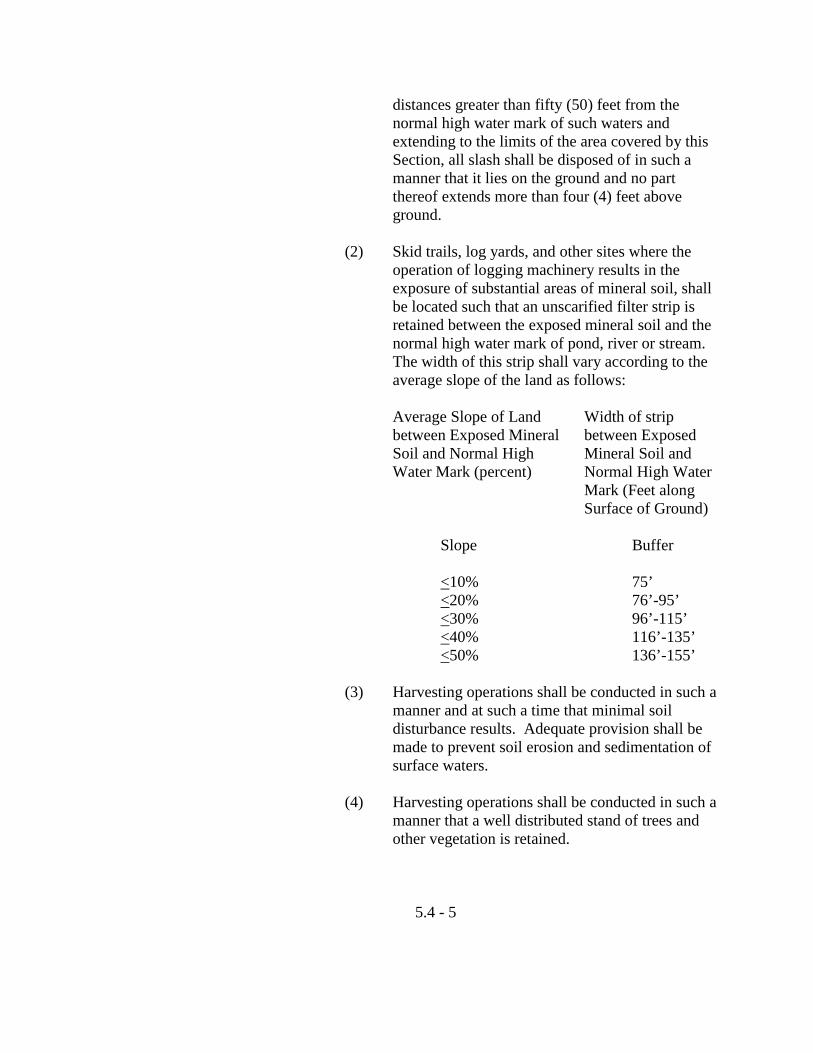
distances greater than fifty (50) feet from the normal high water mark of such waters and extending to the limits of the area covered by this Section, all slash shall be disposed of in such a manner that it lies on the ground and no part thereof extends more than four (4) feet above ground.
(2) Skid trails, log yards, and other sites where the
operation of logging machinery results in the exposure of substantial areas of mineral soil, shall be located such that an unscarified filter strip is retained between the exposed mineral soil and the normal high water mark of pond, river or stream. The width of this strip shall vary according to the average slope of the land as follows:
Average Slope of Land Width of strip between Exposed Mineral between Exposed Soil and Normal High Mineral Soil and Water Mark (percent) Normal High Water Mark (Feet along Surface of Ground) Slope Buffer <10% 75’ <20% 76’-95’ <30% 96’-115’ <40% 116’-135’ <50% 136’-155’ (3) Harvesting operations shall be conducted in such a
manner and at such a time that minimal soil disturbance results. Adequate provision shall be made to prevent soil erosion and sedimentation of surface waters.
(4) Harvesting operations shall be conducted in such a
manner that a well distributed stand of trees and other vegetation is retained.
5.4 - 5
(5) Harvesting activities shall not create single openings greater than 7,500 square feet in the forest canopy.
(6) In any stand, harvesting shall remove not more
than 40 percent of the volume of trees in any ten year period. For the purpose of these standards, a stand means a contiguous group of trees, sufficiently uniform in species, arrangement of age classes, and conditions, to be identifiable as a homogenous and distinguishable unit.
(7) Within one hundred (100) feet, horizontal distance
of the normal high water line of a great pond classified GPA or a river flowing to a great pond classified GPA, and within seventy-five (75) feet, horizontal distance, of the normal high water line of other water bodies, tributary streams, or the upland edge of a wetland, there shall be no clear-cut openings and a well-distributed stand of trees and other vegetation, including existing ground cover, shall be maintained.
5. Private Sewage Disposal Systems
a. The Health Officer, Housing Inspector or Plumbing Inspector shall have the right to inspect any system within any Shoreland Overlay District during its construction and operation and shall require the abatement of any defects, improper construction or operation.
b. Replacement or reconstruction of private residential
sewage disposal systems in existence and in use on December 17, 1983 shall be required to comply with the current State Plumbing Code.
F. Clearing of Vegetation for Development
1. Within a shoreland area abutting those water bodies identified on the Shoreland Zoning Map. There shall be no cutting of vegetation within the strip of land extending seventy-five (75) feet, horizontal distance, inland from the normal high water line, except to remove safety hazards.
5.4 - 6
Elsewhere, the clearing of vegetation shall be limited to that which is necessary for uses expressly authorized in the district.
2. Except in areas as described in Paragraph 1, above, and except to
allow for the development of permitted uses, within a strip of land extending one hundred (100) feet, horizontal distance, inland from any water bodies identified on the Shoreland Zoning Map. A buffer strip of vegetation shall be preserved as follows:
a. There shall be no cleared opening greater than 250 square
feet in the forest canopy as measured from the outer limits of the tree crown. However, a footpath not to exceed ten (10) feet in width, as measured between tree trunks, is permitted provided that a cleared line of sight to the water through the buffer strip is not created. Adjacent to a great pond classified GPA, or stream or river flowing to a great pond classified GPA, the width of the footpath shall be limited to six (6) feet.
b. Selective cutting of trees within the buffer strip is
permitted provided that a well-distributed stand of trees and other vegetation is maintained. For the purposes of this Section a “well-distributed stand of trees and other vegetation” adjacent to a great pond classified GPA or a river or stream flowing to a great pond classified GPA, shall be defined as maintaining a rating score of 12 or more in any 25-foot by 25-foot square (625 square feet) area as determined by the following rating system:
Diameter of tree at 4 ½ feet Points above ground level (in inches) 2 – 4 inches 1 > 4 – 12 inches 2 > 12 inches 4 Adjacent to other water bodies, tributary streams and
wetlands, a “well-distributed stand of trees and other vegetation” is defined as maintaining a minimum rating score of 8 per 25-foot square area.
Note: As an example, adjacent to a great pond, if a 25-
foot x 25-foot plot contains three (3) trees between
5.4 - 7
2 and 4 inches in diameter, three trees between 4 and 12 inches in diameter and three trees over 12 inches in diameter, the rating score is:
(3x1) + (3x2) + (3x4) = 21 points Thus, the 25-foot x 25-foot plot contains trees
worth 21 points. Trees totaling 9 points (21 – 12 = 9) may be removed from the plot provided that no cleared openings are created.
Notwithstanding the above provisions, no more than 40 percent of the total volume of trees four (4) inches or more in diameter, measured at 4 ½ feet above ground level may be removed in any ten (10) year period.
c. In order to protect water quality and wildlife habitat,
adjacent to great ponds classified GPA, and streams and rivers which flow to great ponds classified GPA, existing vegetation under three (3) feet in height and other ground cover shall not be removed, except to provide for a footpath or other permitted uses as described in Paragraphs 2. and 2.a. above.
d. Pruning of tree branches on the bottom 1/3 of the tree is
permitted. e. In order to maintain a buffer strip of vegetation, when the
removal of storm-damaged, diseased, unsafe, or dead trees results in the creation of cleared openings, these openings shall be replanted with native tree species unless existing new tree growth is present. The provisions contained in Paragraph 2. above shall not apply to those portions of public recreational facilities adjacent to public swimming areas. Cleared areas, however, shall be limited to the minimum area necessary.
3. At distances greater than one hundred (100) feet, horizontal
distance, from a great pond classified GPA or a river flowing to a great pond classified GPA, and seventy-five (75) feet, horizontal distance, from the normal high water line of any other water body, tributary stream, or the upland edge of a wetland, except to allow for the development of permitted uses, there shall be
5.4 - 8
permitted on any lot, in any ten (10) year period, selective cutting of not more than forty (40) percent of the volume of trees four (4) inches or more in diameter, measured 4 ½ feet above ground
level. Tree removal in conjunction with the development of permitted uses shall be included in the forty (40) percent
calculation. For the purposes of these standards, volume may be considered to be equivalent to basal area.
In no event shall cleared openings for development, including but
not limited to, principal and accessory structures, driveways and sewage disposal areas, exceed in the aggregate, 25 percent of the lot area or ten thousand (10,000) square feet, whichever is greater, including land previously developed.
4. Cleared openings legally in existence on the effective date of this
Ordinance may be maintained, but shall not be enlarged, except as permitted by this Ordinance.
5. Fields which have reverted primarily to shrubs, trees, or other
woody vegetation shall be regulated under the provisions of this Section. For the purpose of this Subsection, “primarily” shall be considered as 75 percent or more of the area of a field.
G. Dimensional Regulations
1. Building Setbacks – All new buildings and structures, except those requiring direct access as an operational necessity, shall be constructed not less than one hundred (100) feet inland from the normal high water mark. Operational necessity shall include docks and marinas. Buildings in existence before December 17, 1973 may be replaced if destroyed as defined by Subsection 3.2.E. of this Chapter. Lots less than 120 feet deep measured at right angles to the shoreline which were in existence on or before December 17, 1973 shall have a shoreline setback requirement of 50 percent of the lot depth. Non-conforming setbacks from the high water mark may be extended but in no case shall the setback distance be reduced. Nothing in this Section shall permit any structure to be constructed in a location where it is not otherwise permitted.
H. Conflicts – In any case in which a provision of this Section conflicts
with a provision of any other Section of this Chapter, the provision which establishes the more stringent standard shall apply.
5.4 - 9
I. The Official Shoreland Zoning Map – as adopted, along with these regulations, may be amended for wetland areas.
5.4 - 10
5.5 Manufactured Housing Overlay District (MHO)
A. Purpose – This district is intended to establish minimum standards for the placement of manufactured housing in accordance with the provisions of Title 30-A M.R.S.A., Section 4358, “Regulation of Manufactured Housing”, to restrict the location of older mobile homes and trailers, to require that manufactured housing, as defined in this Ordinance, be aesthetically compatible in terms of design standards with site-built homes and to provide alternatives for the location of affordable and safe housing within the City.
B. Boundaries and Definitions
1. Overlay District Boundaries – The Manufactured Housing Overlay Districts are those sections of Auburn shown on an overlay map on file in the offices of the Department of Community Development and Planning and the City Clerk. The Manufactured Housing Overlay District shall be superimposed over underlying zoning districts and any use shall be subject to compliance with all applicable provisions of the underlying district. Permitted uses in the underlying districts shall continue subject to compliance with the provisions of their overlay district. Nothing in this Section shall permit uses in districts where such uses are not otherwise permitted.
2. Definitions
a. Manufactured Housing – A structural unit or units designed for occupancy, and constructed in a manufacturing facility and then transported by the use of its own chassis, or placed on an independent chassis, to a building site. The term includes any type of building which is constructed at a manufacturing facility and then transported to a building site where it is utilized for housing and may be purchased or sold by a dealer in the interim. For proposed of this Section, 2 types of manufactured housing are included. They are:
(1) Those units constructed after June 15, 1976
commonly called “newer Mobile homes”, which the manufacturer certifies are constructed in compliance with the United States Department of Housing and Urban Development standards,
5.5 - 1
meaning structures, transportable in one or more sections, which, in the traveling mode, are 14 body feet or more in width and are 700 or more square feet, and which are built on a permanent chassis and designed to be used as dwellings on foundations when connected to the required utilities, including the plumbing, heating, air conditioning and electrical systems contained therein; except that the term shall include any structure which meets all the requirements of this Paragraph, except the size requirements and with respect to which the manufacturer voluntarily files a certification required by the State’s Department of Housing and Urban Development and complies with the standards established under the National Manufactured Housing Construction and Safety Standards Act of 1974, United States Code, Title 42, Section 5401, et. seq; and
(2) Those units commonly called “modular homes”,
which the manufacturer certifies are constructed in compliance with the State’s Manufactured Housing Act and regulations, meaning structures, transportable in one or more sections, which are not constructed on a permanent chassis and are designed to be used as dwellings on foundations when connected to required utilities, including the plumbing, heating, air-conditioning or electrical systems contained therein.
b. Site-Built Home – A building constructed on-site which
is designed to be used as a dwelling on foundations when connected to the required utilities.
c. Older Mobile Homes, Trailers – Any factory-built home
which fails to meet the definition of manufactured housing and more specifically, it shall mean any mobile constructed prior to June 15, 1976. These units shall be restricted to approved mobile home parks.
d. Design Standards – Shall include, but are not limited to
requirements for building width, roof pitch, roof material, siding material, foundations, additions and siting that are
5.5 - 2
similar in character to traditional site-built residential homes. Design standards shall not apply to manufactured housing located in approved mobile home parks.
3. Siting – Siting of a dwelling on a lot is considered to be
the angle at which a dwelling is placed in relation to frontage, as defined in Section 5.5C.9.e.
C. Design Standards – All dwelling units in this district shall be subject to
the following minimum design standards:
1. Building Dimensions – No building shall be less than 14 body feet in width and shall contain not less than 700 square feet of habitable living space.
2. Roof Construction – All roofs shall be covered with standard
asphalt shingles and have a minimum pitch of 3.5/12. Roofs covering manufactured housing shall provide certified engineering data to show that roof additions will meet the performance criteria of the Auburn Building Code for snow and wind loads; the roof shall extend for the full length of the structure.
3. Exterior Walls – Exterior walls shall have traditional site-built
appearance and may be materials such as clapboards, shingles and shakes, including synthetic or metal siding manufactured to closely resemble clapboards, shingles and shakes. Walls may also include masonry, wood, board-and-batten, and “Texture 111” exterior plywood, but shall not include artificial masonry or fake board-and-batten made from metal.
4. Skirting – Skirting is required except for dwellings placed on a
frost wall or full foundations. Skirting shall meet the following criteria:
a. The material used is consistent with the materials
permitted by Subsection 5.5C.3.; b. The skirting is extended either to the foundation or as
close to the slab as possible that will still permit proper ventilation;
5.5 -3
c. The skirting shall totally enclose the unit and be permanently affixed and fully supported by suitable framing to the unit.
5. Foundations – The foundation shall be a permanent concrete
reinforced 6” slab; concrete or masonry frost wall, wood or full basement. Al foundations shall meet the performance criteria of the Auburn Building Code.
6. Enclosed Additions – Additions shall have the same exterior
wall material as permitted by Subsection 5.5.C.3., except that glass may be used for greenhouse additions. All additions shall have an asphalt shingled roof with a minimum pitch of 3.5/12.
7. Anchoring – All mobile homes shall be anchored to the
foundation or slab by attaching the frame to six (6) inch eye bolts, set at the four corners of the foundation or slab, with ¼” steel cable or equivalent. All mobile homes shall be anchored to the foundation and elevated as required by Section 4.3.D. of this Chapter.
8. Transportation Components – Appendages required for
transportation, which shall include but not limited to the tongue, axles and wheels shall be removed or enclosed so as not to be visible.
9. Siting – Dwellings shall be sited on the lot subject to the
following conditions: a. Dwellings less than 24 feet in width
(1) Dwellings sited in excess of 15 degrees but less than 30 degrees shall have an enclosed addition equal to 15 percent of the floor area of the structure. The addition shall project out not less than 20 percent of the length of the structure at not greater than a 60 degree angle. Additions shall not be permitted attached to and extended from the narrow side of the dwelling.
(2) Dwellings sited in excess of 30 degrees but less
5.5 - 4
than 45 degrees shall meet all of the criteria set forth in (1) provided that such addition be located on the street side area of the lot.
(3) No dwellings less than 24 feet in width shall be
allowed to be sited on a lot in excess of 45 degrees unless it is sited a minimum of 100 feet from the front yard setback and screened from view of the Public Right of Way.
b. Dwellings 24 feet or greater in width shall not be subject
to siting standards.
c. Additions shall include enclosed structures such as breezeways, garages and extensions to the interior living space. Carports, open breezeways, decks and patios shall not be counted as an addition.
d. Angles of siting are based upon the lot frontage being the
horizontal or parallel line. e. Dwellings to be located on a curve shall have the angle of
siting determined by locating a tangent point at the midpoint of the curve arc. Lines shall then be drawn parallel and perpendicular to such point.
10. Fuel Storage Tank – Any fuel storage tank must be placed either
in the basement, crawl space or in an attached addition or be screened so as not to be visible from adjacent properties or any street, within one (1) year of installation.
5.5 - 5
5.6 Environmental Performance Standards (EPS)
A. Purpose – The purpose of the following standards relating to smoke, noise, vibration, odors, air pollution and electrical disturbance of infrastructure is to assure that no new development occurs which may have an environmental impact that could be detrimental to the City or property owners or that may have a direct impact to property caused by nuisances directly or indirectly associated with the above environmental issues. The following standards shall apply to all nonresidential uses in the City:
B. Smoke
1. For the purposes of determining the density of equivalent opacity of smoke, the Ringlemann Chart, as adopted and published by the United States Department of Interior, Bureau of Mines Information Circular 8333, May 1967, shall be used. The Ringlemann number referred to in this Section refers to the number of the area of the Ringlemann Chart that coincides most nearly with the visual density of equivalent opacity of the emission of smoke observed. For example, a reading of Ringlemann No. 1 indicates a twenty (20) percent density of the smoke observed.
2. All measurements shall be taken as close to the point emission of
the smoke as reasonably possible. 3. In all zones, no development may emit from a vent, stack,
chimney or combustion process any smoke that exceeds a density or equivalent capacity of Ringlemann No. 1, except that an emission does not exceed a density or equivalent capacity of Ringlemann No. 2, is permissible for a duration of not more than four (4) minutes during any eight-hour period if the source of such emission is not located within two hundred fifty (250) feet of a residential district.
4. In the Industrial Zone, no development use may emit from a vent,
stack, chimney or combustion process any smoke that exceeds a density or equivalent capacity of Ringlemann No. 2, except that an emission that does not exceed a density or equivalent capacity of Ringlemann No. 3 is permissible for a duration not more than four (4) minutes during any eight-hour period if the source of emission is not located within five hundred (500) feet of a residential district.
5.6 - 1
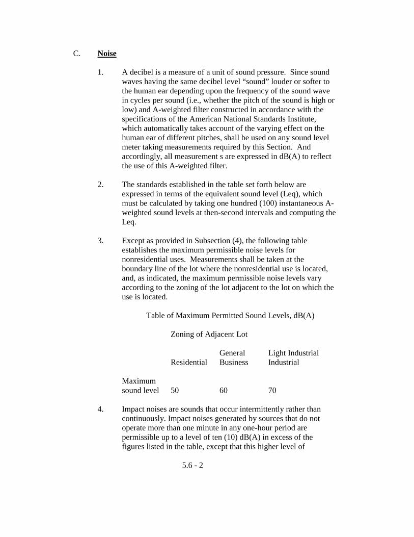
C. Noise
1. A decibel is a measure of a unit of sound pressure. Since sound waves having the same decibel level “sound” louder or softer to the human ear depending upon the frequency of the sound wave in cycles per sound (i.e., whether the pitch of the sound is high or low) and A-weighted filter constructed in accordance with the specifications of the American National Standards Institute, which automatically takes account of the varying effect on the human ear of different pitches, shall be used on any sound level meter taking measurements required by this Section. And accordingly, all measurement s are expressed in dB(A) to reflect the use of this A-weighted filter.
2. The standards established in the table set forth below are
expressed in terms of the equivalent sound level (Leq), which must be calculated by taking one hundred (100) instantaneous A-weighted sound levels at then-second intervals and computing the Leq.
3. Except as provided in Subsection (4), the following table
establishes the maximum permissible noise levels for nonresidential uses. Measurements shall be taken at the boundary line of the lot where the nonresidential use is located, and, as indicated, the maximum permissible noise levels vary according to the zoning of the lot adjacent to the lot on which the use is located.
Table of Maximum Permitted Sound Levels, dB(A)
Zoning of Adjacent Lot
General Light Industrial Residential Business Industrial Maximum
sound level 50 60 70
4. Impact noises are sounds that occur intermittently rather than continuously. Impact noises generated by sources that do not operate more than one minute in any one-hour period are permissible up to a level of ten (10) dB(A) in excess of the figures listed in the table, except that this higher level of
5.6 - 2
permissible noise shall not apply from 7:00 p.m. to 7:00 a.m. when the adjacent lot is zoned residential. The impact noise shall be measured using the fast response of the sound level meter.
5. Noise resulting from temporary construction activity that occurs
between 7:00 a.m. and 7:00 p.m. shall be exempt from the requirements of this Section.
D. Vibration
1. No development in any zone may generate any ground-transmitted vibration that is perceptible to the human sense of touch measured at (a) the outside boundary of the immediate space occupied by the enterprise generating the vibration if the enterprise is one of several located on a lot, or (b) the lot line if the enterprise generating the vibration is the only enterprise located on a lot.
2. No development in any zone may generate any ground-
transmitted vibration in excess of the limits set forth in Subsection (5). Vibration shall be measured at any adjacent lot line or residential district line as indicated in the table set forth in Subsection (5).
3. The instrument used to measure vibrations shall be a three-
component measuring system capable of simultaneous measurement of vibration in three (3) mutually perpendicular directions.
4. The vibration maximums set forth in Subsection (5) are stated in
terms of particle velocity, which may be measured directly with suitable instrumentation or computed on the basis of displacement and frequency. When computed, the following formula shall be used:
PV = 6.28 F x D Where: PV = Particle velocity, inches-per-second F = Vibration frequency, cycles-per-second
D = Single amplitude displacement of the vibration, inches The maximum velocity shall be the vector sum of the three (3) components recorded.
5.6 - 3
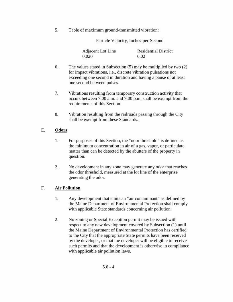
5. Table of maximum ground-transmitted vibration: Particle Velocity, Inches-per-Second Adjacent Lot Line Residential District 0.020 0.02
6. The values stated in Subsection (5) may be multiplied by two (2) for impact vibrations, i.e., discrete vibration pulsations not exceeding one second in duration and having a pause of at least one second between pulses.
7. Vibrations resulting from temporary construction activity that
occurs between 7:00 a.m. and 7:00 p.m. shall be exempt from the requirements of this Section.
8. Vibration resulting from the railroads passing through the City
shall be exempt from these Standards. E. Odors
1. For purposes of this Section, the “odor threshold” is defined as the minimum concentration in air of a gas, vapor, or particulate matter than can be detected by the abutters of the property in question.
2. No development in any zone may generate any odor that reaches
the odor threshold, measured at the lot line of the enterprise generating the odor.
F. Air Pollution
1. Any development that emits an “air contaminant” as defined by the Maine Department of Environmental Protection shall comply with applicable State standards concerning air pollution.
2. No zoning or Special Exception permit may be issued with
respect to any new development covered by Subsection (1) until the Maine Department of Environmental Protection has certified to the City that the appropriate State permits have been received by the developer, or that the developer will be eligible to receive such permits and that the development is otherwise in compliance with applicable air pollution laws.
5.6 - 4
G. Electrical Disturbance or Interference – No use may:
1. Create any electrical disturbance that adversely affects any operations or equipment other than those of the creator of such disturbance; or
2. Otherwise cause, create or contribute to the interference with
electronic signals (including television and radio broadcasting transmissions) to the extent that the operation of any equipment not owned by the creator of such disturbance is adversely affected. {Ord. No. 87-20, ss 4 (Art. XII, ss 19), 1-9-86}.
5.6 - 5
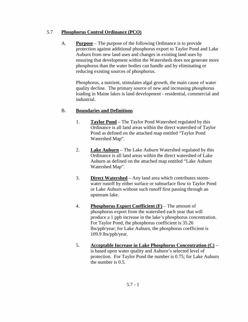
5.7 Phosphorus Control Ordinance (PCO)
A. Purpose – The purpose of the following Ordinance is to provide protection against additional phosphorus export to Taylor Pond and Lake Auburn from new land uses and changes in existing land uses by ensuring that development within the Watersheds does not generate more phosphorus than the water bodies can handle and by eliminating or reducing existing sources of phosphorus.
Phosphorus, a nutrient, stimulates algal growth, the main cause of water
quality decline. The primary source of new and increasing phosphorus loading in Maine lakes is land development - residential, commercial and industrial.
B. Boundaries and Definitions
1. Taylor Pond – The Taylor Pond Watershed regulated by this Ordinance is all land areas within the direct watershed of Taylor Pond as defined on the attached map entitled “Taylor Pond Watershed Map”.
2. Lake Auburn – The Lake Auburn Watershed regulated by this
Ordinance is all land areas within the direct watershed of Lake Auburn as defined on the attached map entitled “Lake Auburn Watershed Map”.
3. Direct Watershed – Any land area which contributes storm-
water runoff by either surface or subsurface flow to Taylor Pond or Lake Auburn without such runoff first passing through an upstream lake.
4. Phosphorus Export Coefficient (F) – The amount of
phosphorus export from the watershed each year that will produce a 1 ppb increase in the lake’s phosphorus concentration. For Taylor Pond, the phosphorus coefficient is 35.26 lbs/ppb/year; for Lake Auburn, the phosphorus coefficient is 109.9 lbs/ppb/year.
5. Acceptable Increase in Lake Phosphorus Concentration (C) –
is based upon water quality and Auburn’s selected level of protection. For Taylor Pond the number is 0.75; for Lake Auburn the number is 0.5.
5.7 - 1
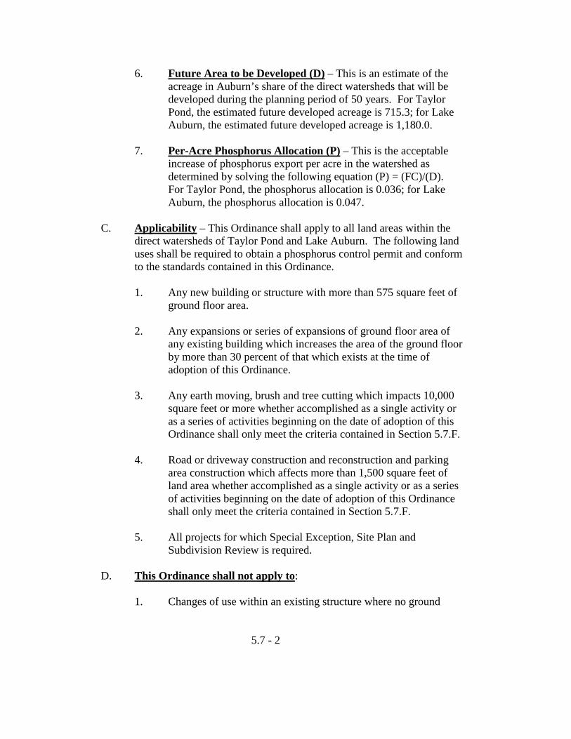
6. Future Area to be Developed (D) – This is an estimate of the acreage in Auburn’s share of the direct watersheds that will be developed during the planning period of 50 years. For Taylor Pond, the estimated future developed acreage is 715.3; for Lake Auburn, the estimated future developed acreage is 1,180.0.
7. Per-Acre Phosphorus Allocation (P) – This is the acceptable
increase of phosphorus export per acre in the watershed as determined by solving the following equation (P) = (FC)/(D). For Taylor Pond, the phosphorus allocation is 0.036; for Lake Auburn, the phosphorus allocation is 0.047.
C. Applicability – This Ordinance shall apply to all land areas within the
direct watersheds of Taylor Pond and Lake Auburn. The following land uses shall be required to obtain a phosphorus control permit and conform to the standards contained in this Ordinance.
1. Any new building or structure with more than 575 square feet of
ground floor area.
2. Any expansions or series of expansions of ground floor area of any existing building which increases the area of the ground floor by more than 30 percent of that which exists at the time of adoption of this Ordinance.
3. Any earth moving, brush and tree cutting which impacts 10,000
square feet or more whether accomplished as a single activity or as a series of activities beginning on the date of adoption of this Ordinance shall only meet the criteria contained in Section 5.7.F.
4. Road or driveway construction and reconstruction and parking
area construction which affects more than 1,500 square feet of land area whether accomplished as a single activity or as a series of activities beginning on the date of adoption of this Ordinance shall only meet the criteria contained in Section 5.7.F.
5. All projects for which Special Exception, Site Plan and
Subdivision Review is required. D. This Ordinance shall not apply to:
1. Changes of use within an existing structure where no ground
5.7 - 2
floor expansion and/or road, driveway and parking area expansion is planned.
2. Timber management or harvesting operations conducted
according to a management plan prepared and supervised by a registered forester (unless required by Article 5.3) or the Auburn Water District.
3. Agricultural uses conducted according to a soil and water
conservation plan approved by the Androscoggin County Soil and Water Conservation District.
E. Best Management Practices – Agriculture, silviculture, mining,
chemical use and storage and waste disposal activities should be conducted in accordance with the Best Management Practices (BMPs) as recommended by the Department of Environmental Protection, the Maine Soil and Water Conservation Commission, the Cooperative Extension Service or other appropriate public service agency. New roads and the reconstruction of existing roads, driveways, drainage diversions, ditches and roadside buffers should be designed for the worst storm conditions in accordance with the Best Management Practices (BMPs) recommended by the Department of Environmental Protection, the Maine Soil and Water Conservation Commission, the Cooperative Extension Service or other appropriate public service agency.
F. Erosion and Sedimentation Controls – A comprehensive erosion and
sedimentation control plan, including a proposed program for the maintenance and periodic inspection of all control facilities which will remain after the project is completed and a designation of the responsible party, shall be submitted as follows:
1. Taylor Pond Watershed – A plan designed in accordance with
the applicable sections of Chapter 8 of the DEP Phosphorous Control and Lake Watersheds: A Technical Guide to Evaluating New Development, the latest edition of the Maine Erosion and sediment Control Handbook and Chapter 32 of the Auburn Ordinances.
2. Lake Auburn Watershed – A plan designed in accordance with
the applicable sections of Chapter 8 of the DEP Phosphorous Control and Lake Watersheds: A Technical Guide to Evaluating New Development, the latest edition of the Maine Erosion and Sediment Control Handbook, Chapter 32 of the Auburn
5.7 - 3
Ordinances and criteria of the Auburn Water District or Commission.
G. Submission Requirements – All projects subject to review under the
provisions of this Ordinance shall submit a phosphorus control plan and maintenance provisions meeting the standards set forth in the manual “Phosphorus Control and Lake Watersheds A Technical Guide to Evaluating New Development” (Maine DEP et-al., September 1989 with the Simple Review Method revised in May 1990).
1. Plan Submission
Plans shall be submitted and processed in accordance with Article 7 of this Chapter. In addition to the requirements for submission under this Article, the following instruction shall be provided: a. A long-term maintenance plan for all phosphorus control
measures including provisions for inspection and repair, designation of responsible parties, contractual obligations and proposed deed restrictions.
b. Hydrologic soil class of all areas to be cleared or where
clearing will be permitted, with the area indicated in square feet of each lot using the appropriate method as described in the Phosphorus Control Manual.
c. All calculations and worksheets in the format of those
contained in the Phosphorus Control Manual and detailed construction specifications and diagrams for all control measures.
d. A comprehensive erosion and sedimentation control plan,
designed in accordance with the Maine Erosion and Sediment Control Handbook for Construction: Best Management Practices, March 1991 and Chapter 32 of the Auburn Ordinances.
2. Review Method
a. All projects shall use the Standard Review Method and shall conform to the Phosphorus Allocation standard set forth in this Ordinance including the following:
5.7 - 4
(1) Expansions of four (4) lot subdivisions which were previously approved using the Simple Review Method.
b. Projects meeting the following criteria may employ the
Simple Review Method:
(1) Minor Subdivisions with four (4) or fewer lots provided that these developments contain less than 200 feet of new or upgraded roads and/or all driveways serving residential uses are less than 150 feet in length.
(2) Activity which includes less than 200 feet of new
or upgraded road construction. (3) Commercial and industrial development and
expansions of commercial and industrial developments and the expansion of multi-family dwelling units, which involve less than 15,000 square feet of disturbed area.
c. All other subdivisions including expansions of previously
approved 4-lot subdivisions which were reviewed using the Simple Review Method and all other projects shall utilize the Standard Review Method.
5.7 - 5
5.8 Historic and Archaeological Resources
A. Purpose - The provisions set forth in this Ordinance are intended to protect the public health and safety, promote the general welfare of the community and conserve the environment by assuring that all projects requiring Planning Board review are designed and developed in a manner which assures that adequate provisions are made for protection of historic and archaeological resources; minimizing the adverse impacts on adjacent properties; and fitting the project harmoniously into the fabric of the community.
B. Submission Requirements – The location of historic and/or
archaeological resources, must be indicated on the plans if the area is located within identified Historic or Archaeological areas shown on the Maine Historic Preservation Commission Maps in the Community Development Office.
C. Standards of Approval – The plan for the development will reflect the
natural capabilities of the site to support development. Building lots and support facilities will be clustered in those portions of the site that have the most suitable conditions for development. The development shall include appropriate measures for protecting these resources including, but not limited to, modification of the proposed design of the site, time of construction, and limiting the extent of excavation.
5.8 - 1
ARTICLE 6 BOARD OF APPEALS
Sections
6.1 Organization 6.2 Appeals Procedure 6.3 Powers and Duties 6.4 Judicial Appeal 6.5 Special Appeals 6.1 Organization
A. Membership – There shall be a Board of Appeals consisting of seven members and two associate members appointed by the City Council. Each member shall be at all times a resident of the City of Auburn.
B. Term of Office – The members and associate members of the Board
shall serve no more than three (3), three (3) year consecutive terms. C. Associate Members – An associate member shall have a vote only in the
event that one or more regular members of the Board are absent or are disqualified from serving on a particular matter because of a conflict of interest.
D. Jurisdiction – The Board of Appeals shall have jurisdiction over: (1)
interpretation of provisions of the Zoning ordinance called into question; (2) administrative appeals from decisions or lack thereof of the Building Inspector or Zoning Officer in regard to an application for a permit under the Zoning Ordinance; (3) the granting of variances from the requirements of the Zoning Ordinance would cause undue hardship.
E. Board Rules – The Board shall adopt, and may from time to time
amend, rules and regulations to govern the conduct of its business. The tape recording of the Board’s proceedings, the transcript of testimony, if any, and exhibits, together with all papers and requests filed in the proceedings, shall constitute the record. All decisions shall become a part of the record and shall include a statement of findings and conclusion and the appropriate order, relief or denial thereof.
F. Quorum – Five members shall constitute a quorum at any meeting.
6.1-1
6.2 Appeals Procedure
A. Petition – Written petitions for appeal signed by any party in interest shall be filed in duplicate in the office of the municipal officer charged with enforcement of the Zoning ordinance, together with the fee stipulated in Article 9 of this Chapter, within thirty (30) days from the date of the decision or order. The municipal officer shall forward to the Board of Appeals, Planning Director, the Chairman of the Planning Board and the City Solicitor, one copy of such petition. The Planning Director, or in his absence, the Chairman of the Planning Board, shall forward to the Board of Appeals as soon as possible any pertinent City planning information in his possession bearing on such appeal. The City Solicitor shall forward to the Board of Appeals as soon as possible any pertinent legal information bearing on such appeal. Where no such information is received by the Board of Appeals by the time of the meeting at which such appeal is scheduled to be heard, it shall be presumed that none was available at that time. In any case in which such planning and legal information is received, it shall be summarized at the public hearing and an opportunity afforded for comment by those interested in the appeal.
B. Public Hearing
1. On each such petition, the Board shall hold a public hearing, within sixty-five (65) days of the filing of the appeal petition. Notice of the time, date, place, appellant name and subject of each such hearing shall be given by publication in a newspaper of general circulation in the City of Auburn on two separate dates not more than twelve (12) nor less than three (3) days before the date of such hearing. Notification of the public hearing shall also be sent to the appellant, the Planning Director, the Building Inspector, the City Manager and all owners of abutting property and property located directly across the street from the site of the property which is the subject of the appeal by mailing to them copies of such notice as published. Notices shall be mailed to such property owners at the addresses appearing for them in the then current property tax listing of the City of Auburn. Failure of any property owner to receive such mail notice of any such public hearing shall not necessitate another hearing and shall not constitute grounds for objection by such property owner and shall not invalidate any action by the Board of Appeals on such appeal or application for variance.
6.2-1

2. The Chairman, or in his absence the Acting Chairman, shall preside at the Public Hearing. All hearings of the Board of Appeals shall be open to the public.
3. The Chairman shall open the hearing and determine whether a
quorum of the Board of Appeals is present. For each appeal heard, the Chairman shall summarize the nature of the appeal, identify all relevant information submitted, determine the Board’s jurisdiction and the appellant’s standing, determine the parties to the action and proceed to accept oral and written testimony from the appellant and the public for and against the appeal. When all parties have been heard, the Chairman shall close the hearing or, if additional time is needed, continue it to a later date.
4. The Chairman shall determine that the appellant has standing,
that is, the right to appear as an appellant before the Board. An appellant must hold title to the land, be part owner or have an option to buy or lease property and/or building, in order to have standing.
5. The Chairman shall determine the parties to the action. The
appellant, municipal officers, Planning Board, abutting property owners, individuals who might be adversely affected by any decision and any member of the general public attending the meeting who has made specific statements concerning terms of the appeal, may be made party to the action.
C. Decision
1. The decision of the Board shall be made as soon as possible, but not later than thirty (30) days of the Pubic Hearing, unless extended by mutual agreement of the Board and appellant. Failure of the Board to act within thirty (30) days shall be deemed to be the denial of the petition sought, subject to judicial appeal.
2. The Board of Appeals may by an affirmative vote of a majority
of those members present amend or revise a decision of the Building Inspector, Zoning Officer or of any other municipal officer acting under the Zoning Ordinance. The Board of Appeals may permit variances from literal application of the Zoning Ordinance in accordance with the principles, conditions
6.2-2
and procedures set forth in this Chapter, subject to the duty of the Board to promote the public health, safety, convenience and welfare and to adhere to the central intents and purposes of this Chapter. Approval may be subject to conditions, modifications and restrictions as the Board of Appeals may deem necessary.
3. The Board shall keep a record of each appeal entertained, noting
the date when received from the Building Inspector or Zoning Officer, the date of hearing, the applicant or appellant and the date of the decision. The Board shall record by resolution the final disposition of every appeal. All of the foregoing shall be public records filed with the office charged with enforcement of the Zoning Ordinance. Notice of the decision shall be mailed within seven (7) days to the applicant or appellant. Each notice shall specify that judicial appeals shall be made pursuant to the terms of Section 6.4
4. The right to proceed under any variance or petition granted under
the terms of this Chapter, voted by the Board of Appeals, or under change in a decision of the Building Inspector, Zoning Officer or other municipal official voted by the Board of Appeals, shall expire if such right be not exercised beginning within six (6) months from the date of such vote. If such right is not exercised within six (6) months of the date of the vote, the Board may grant a six (6) month extension without having to make another finding of hardship provided that:
a. Conditions upon which the appeal was granted have not
changed; and
b. The appellant can show just cause for the delay in beginning the project.
6.2-3
6.3 Powers and Duties A. Interpretation
1. Except as otherwise provided in this Ordinance, the Board of Appeals shall interpret provisions of the Zoning Ordinance which are called into question. Only persons with standing may appeal the denial of a permit which was based on provisions of the Zoning Ordinance.
2. Where there is no evidence to the contrary, Zoning Ordinance
language should be given its ordinary meaning. Statements of purpose may provide a key to the intent of zoning provision. In interpreting the Ordinance, the Board may request the advice of the City Solicitor, the Planning Director or qualified experts in zoning law.
B. Administrative Appeals
1. The Board of Appeals may hear appeals in the administration of the Zoning Ordinance in order to determine if the Building Inspector or Zoning Officer erred in granting or denying a permit. An applicant who is given no decision on a permit request, or who is denied a permit may appeal.
2. If the Board of Appeals finds that the Building Inspector or
Zoning Officer acted in error, it should order the error to be corrected.
C. Variance
1. The Board of Appeals may grant a variance from the Dimensional Regulations and supplementary District Regulations contained in the Zoning Ordinance where the strict application of the Ordinance, or a provision thereof, to the petitioner or property would cause undue hardship based on:
a. The land in question cannot yield a reasonable return
unless the variance is granted; and
6.3-1
b. The need for a variance is due to the unique circumstances of the property and not to the general conditions in the neighborhood; and
c. The granting of a variance will not alter the essential
character of the locality; and d. The hardship is not the result of action taken by the
appellant or a prior owner.
Variances granted under this Subsection shall be the minimum necessary to relieve hardship. The burden of proof is on the applicant to prove undue hardship.
2. The Board of Appeals may grant a variance for the expansion,
extension or enlargement of non-conforming buildings or uses provided that:
a. The use being requested shall be approved by a majority
of those members present (not less than a quorum being present).
b. The Board of Appeals shall make findings that the
requirements of Section 6.3.C.1 have been met.
3. In addition to the above criteria, in determining whether or not to grant a variance, the Board shall also take into consideration the following:
a. Fire, electrical and police safety requirements;
b. The adequacy of the traffic circulation system in the immediate vicinity;
c. The availability of an adequate water supply; d. The availability of adequate sewerage facilities;
e. Would not violate the environmental standards or criteria contained in the Overlay Zoning Districts;
6.3-2
f. Would not adversely affect property adjoining the premises under appeal or nearby in the same neighborhood or in the same zoning district;
g. Would not endanger the public health, safety or
convenience; and h. Would not impair the integrity of the Zoning Ordinance.
4. Wherever necessary to meet the criteria or consideration listed in this subsection, the Board, when granting a variance, may attach such conditions or restrictions as are in accordance with the objectives and purposes of this Zoning Ordinance.
5. The Planning Director, or his representative, shall be responsible
for reviewing the records of hearings of the Board of Appeals. Such review shall be conducted on a monthly basis and shall be for the purpose of maintaining the Zoning Ordinance. The Ordinance may be deemed to be in need of amendment when variances for identical purposes or reasons are applied for in a single zoning district or regarding a specific section of this ordinance on three or more occasions within a given calendar year. In any case in which the Zoning Ordinances are deemed to be in need of amendment, the Planning Director or his representative shall prepare a report indicating whether the variances applied for suggest that the Ordinance or the description of the zoning districts should be amended. Such reports shall be forwarded to the Planning Board for its review and recommendation.
6.3-3
6.4 Judicial Appeal
Appeals from decisions of the Auburn Planning Board or of the Auburn Zoning Board of Appeals or on account of the failure of any municipal official or Board to comply with the order of the Board of Appeals shall be taken to the Superior Court within thirty (30) days of such decision or action in accordance with Rule 80B of the Maine Rules of Civil Procedure and Title 30, M.R.S.A., Section 2411, Subsection 3. Except as otherwise provided by statute, every person shall have the right to inspect and copy any record of the Board’s proceedings, provided that, the inspection be scheduled to occur during regular hours and at such a time as will not inconvenience the regular activities of the office having custody of the record and provided further that the cost of copying the recorded or, if necessary, the translation of mechanical or electronic date compilations into some other form, shall be paid by the person requesting the copy.
6.4-1
6.5 Special Appeals A. Flood Plain District Variances
1. The Board of Appeals may grant a variance from strict compliance with requirements of Section 5.1 of this Chapter after public notice and public hearing as provided in Article 6 of this Chapter, provided the following conditions are met:
a. The applicant can show that a failure to grant a variance would
result in undue hardship as defined in Title 30-A, M.R.S.A., 4353.
b. A determination made by the Board with a certification from a
registered professional engineer provided by the applicant, if need be, that the granting of the variance will not result in increased flood heights. The professional engineer shall include the following information within their certification: criteria on which the certification was based; any assumptions that were made; source of data for those assumptions; and references to the research material that was relied upon in making the certification. In addition, the Board shall determine as a condition for the granting of the variance that it will not result in threats to public safety, extraordinary public expense, create nuisances, cause fraud on or victimization of the public or conflict with existing local laws or ordinances.
c. A determination by the Board that the variance is the minimum
necessary, considering the flood hazard, to afford relief.
d. The applicant shall be notified in writing that the issuance of a variance to building a structure below the base flood level will result in increased premium rates for flood insurance and such construction below the base flood level increases risks to life and property.
B. Shoreland Zone Variance
When by reasons of extraordinary physical conditions peculiar to the land or building under appeal but not to other land or buildings adjoining or nearby, an owner of land would be subject to unusual difficulty or special hardships (not mere financial hardship or hardships caused by reason of the literal application and rigorous enforcement of the terms of
6.5-1
this Chapter), the Board of Zoning Appeals may grant a variance from strict compliance with the requirements of Section 5.4 of this Chapter after notice and public hearing as provided in Article 6 of this Chapter. No such variance shall be granted unless the Board is satisfied that the variance applied for will not adversely affect the quality of the adjacent water body. In granting any such variance application, the Board may also impose reasonable conditions upon the use of the land in question which shall be reduced to writing and made a part of the permanent records of the Board.
C. Lake Auburn Watershed Zone Variance
When by reason of extraordinary physical conditions peculiar to the land or buildings under appeal but not to other land or buildings adjoining or nearby, an owner of land would be subject to unusual difficulty or special hardships (not mere financial hardship or hardships caused by rigid sewage disposal regulations) by reason of the literal application and rigorous enforcement of the terms of this Chapter, the Board of Zoning Appeals may grant a variance from strict compliance with the requirements of Section 5.3 of this Chapter after notice and public hearing as provided in Article 6 of this Chapter. No such variance shall be granted unless the Board is satisfied that the variance applied for will not adversely affect the quality of the Lake Auburn water supply. When an application for a variance is filed, it shall be forwarded to the Auburn Water District with a request for an informational report and a recommendation to the Board regarding the disposition of the requested variance application. In any case in which a variance request is granted, despite the recommendation of the Water District that it be denied, the Board of Appeals shall make part of its permanent records a written statement of its reasons for taking such action. In granting any such variance application, the Board may also impose reasonable conditions upon the use of the land in question which shall be reduced to writing and made a part of the permanent records of the Board.
6.5-2
ARTICLE 7 ADMINISTRATION AND ENFORCEMENT
Sections
7.1 Site Plan Review 7.2 Special Exceptions 7.3 Subdivision 7.4 Appeals and Applicability 7.5 Enforcement
7.1 Site Plan Review A. Purpose
The purpose of site plan review is to ensure that the design and layout of certain developments permitted by special exceptions, or other developments noted herein, will constitute suitable development and will not result in a detriment to City, neighborhood or the environment.
B. Objective
In considering a site plan, the Planning Board shall make findings that the development has made provisions for:
1. Protection of adjacent areas against detrimental or offensive uses
on the site by provision of: adequate surface water drainage, buffers against artificial and reflected light, sight, sound, dust and vibration; and preservation of light and air; and
2. Convenience and safety of vehicular and pedestrian movement
within the site and in relation to adjacent areas; and 3. Adequacy of the methods of disposal for wastes; and
4. Protection of environment features on the site and in adjacent areas.
C. Projects Requiring Site Plan Review 1. All uses permitted by Special Exception.
2. Any other uses for which site plan review is required by any other provision contained in this or other ordinances.
7.1-1
D. Procedure
1. An applicant for site plan review shall file with the Department of Community Development and Planning a completed site plan application along with an original and twenty (20) copies of the site plan and the required processing fee. Such plans shall be filed not less than thirty (30) days prior to a regularly scheduled meeting. Plans shall be folded at a size not to exceed 8-1/2 by 11 inches.
2. The original plan shall be drawn on reproducible Mylar at a scale
of no more than 100 feet to the inch. Each site plan shall contain the following information:
a. Name and address of owner and developer and interest of
the applicant if other than the owner or developer.
b. Name of development, scale and meridian arrow, with specific definition of representation, date of plan and legend.
c. Names and addresses of all owners of record of all
adjacent property as appear on Assessor’s records.
d. Current zoning boundaries and 100-year flood plain boundaries including surrounding areas to a distance of 300 feet from the perimeter of the site.
e. Easements; rights-of-way, existing, planned or proposed;
or other reservations adjacent to or intersecting the property.
f. Topographic map of the site.
(1) Existing contours: where the slope of existing ground surface is generally 2 percent or more, the topographic map shall show contours at intervals of five feet of elevation (or lesser intervals as the Planning Board or Engineering Department may prescribe). Where the slope of the existing ground surface is generally less than 2 percent, contour intervals of 1 foot shall be shown. These contours shall not be copied from the City topographic
7.1-2
maps and shall be determined from an on-site survey certified by a registered land surveyor.
(2) Proposed contours: shall be shown at intervals to
be determined by the City Engineer.
g. Location of watercourses, wetlands, marshes, surface water, rock outcroppings, wooded areas, single trees with a diameter of 10 inches measured 3 feet from the base of the trunk.
h. Location of buildings existing on the tract to be developed
and on adjacent tracts within a distance of 100 feet from the property line, indicating whether existing buildings on the tract are to be retained, modified or removed.
i. Locations of water mains, sewer mains, wells, fire
hydrants, culverts, drains, pipe sizes, grades and direction of flow, existing within 200 feet of the subject property.
j. Existing soil conditions and soil suitability test results. k. Locations of proposed buildings and uses thereof.
l. Proposed traffic circulation system including streets, parking lots, driveways and other access and egress facilities, curb lines, sidewalk lines and existing streets, including the projected traffic flow patterns into and upon the site for both vehicles and pedestrians and an estimate of the projected number of motor vehicle trips to and from the site for an average day and for peak hours.
m. Location of existing and proposed public utility lines,
indicating whether proposed lines will be placed underground.
n. A storm drainage study certified by a professional
engineer and a proposed drainage system plan, both surface and subsurface, showing measures proposed to prevent pollution of surface or ground water, soil erosion, increased runoff, changes in ground water level and flooding.
7.1-3
o. Location and design of proposed off-street parking and loading areas indicating number and size of stalls.
p. Proposed location and direction of and time of use of
outdoor lighting.
q. Existing and proposed planting, fences and walls, including all landscaping and screening and indicating existing trees to be retained and areas to be left undisturbed, including design features intended to integrate the proposed new development into the existing landscape to enhance aesthetic assets and to screen objectionable features from neighbors.
r. Location, size, design and manner of illumination of
signs.
s. Disposal of sewage, trash, solid waste, oily waste, hazardous waste or radio-active waste showing disposal facilities, receptacles or areas.
t. Perimeter boundaries of the site giving complete
descriptive lot data by bearings, distances and radii of curves including the name and seal of the registered land surveyor who prepared the plan.
u. Description and plan of capacity and location of means of
sewage disposal together with approval of Sewer District Engineer or evidence of soil suitability for such disposal (test pit locations shall be shown on the plans) similarly approved by the City Engineering Department.
v. A statement of the amount of area of land involved in the
site, the percentage of the site proposed to be covered by buildings, the total number of dwelling units proposed per acre, the area proposed to be devoted to open space, the area proposed to be paved for parking, driveways, loading space and sidewalks, the total number of parking spaces required by the Zoning Ordinance for the uses proposed, the number of employees expected per shift and the total floor area of proposed commercial or industrial uses.
7.1-4
w. Description and plan of a “phase development concept” detailing the areas and sequence of phasing.
x. A statement by the developer assuring that he has the
financial capabilities to fully carry out the project and to comply with the conditions imposed by the Planning Board.
3. Upon request, the Planning Board, or the Planning Director,
acting for the Board, may waive the necessity of providing any of the foregoing planning information which is not relevant to the proposed development.
4. The Planning Director shall, within five (5) days of receipt,
transmit copies of the application and site plan to the department that in his view requires such information. The agencies receiving these copies shall have up to fifteen (15) days to make recommendations to the Planning Board.
5. The Planning Board shall, within thirty (30) days of receipt of a
completed application, hold a Public Hearing. Notice of a hearing shall be given in the manner provided for in Article 8, Section 8.2 of this Chapter. The Planning Board will take final action on the site plan within sixty (60) days of receiving a completed application, or within such other time limit as may be mutually agreed to. Such final action shall consist of either: (1) a finding and determination that the proposed project will constitute a suitable development and will not result in a detriment to the neighborhood or the environment, or (2) a written denial of the application stating the reasons for such denial, upon a finding that:
a. The provisions for vehicular loading, unloading and
parking and for vehicular and pedestrian circulation on the site and onto adjacent public streets will create hazards to safety.
b. The bulk, location or operation of proposed buildings and
structures will be detrimental to and adversely affect the use and values of existing development in the neighborhood or the health or safety of persons residing or working therein.
7.1-5
c. The provisions for on-site landscaping are inadequate to screen neighboring properties from unsightly features of the development.
d. The site plan does not adequately provide for the soil and
drainage problems which the development may give rise to.
e. The provisions for exterior lighting create safety hazards
for motorists traveling on adjacent streets, or are inadequate for the safety or occupants or users of the site, or will create a nuisance affecting adjacent properties.
f. The proposed development will unduly burden off-site
sewer drainage or water systems.
g. The proposed development will create a fire hazard by failing to provide adequate access to the site, or to buildings on the site, for emergency vehicles.
h. The proposed development violates provisions of the
zoning regulations applicable to the site or other applicable laws, regulations or ordinances.
i. The proposed development will unduly impact the ability
to provide municipal services.
6. Approval may be made subject to conditions, modifications and restrictions as the Planning Board may deem necessary; and any construction, reconstruction, alteration or addition shall be carried on only in conformity to such conditions, modifications or restrictions and in conformity with the application and site plan.
7. If no action is taken within sixty (60) days after submittal of a
completed application, the site plan shall be deemed to have been approved. An original of the approved plan signed by the Planning Board and one signed copy shall be delivered to the applicant, the Assessor’s Department, the Engineering Department and to the Building Inspector on which basis building permits may be issued when all other required plans have been approved.
7.1-6
8. The findings of the Planning Board shall be in writing with a copy being forwarded to the applicant. The Planning Board’s written report shall also include a statement as to how any deficiencies in the site plan might be resolved and what conditions, modifications and restrictions are to be complied with in executing the plan.
9. Approval of a site plan shall expire one year after the date of
approval unless all building permits have been obtained to begin construction in accordance with the approved site plan. Any site plan that contains a phase concept approved by the Planning Board shall not be required to obtain all building permits within the time sequence established for completion of each phase. No building permits or other permits shall be issued until all improvements are substantially completed for the preceding phase. A single one-year extension may be given upon a showing of good cause in writing by the applicant to the Planning Board not less than thirty (30) days before the expiration of approval of his existing plan. The Planning Board shall approve or disapprove the requested extension at its next regular meeting.
10. No permit shall be issued for the construction of any building in
an area included in the site plan or in any development for which a site plan is required until such site plan has been approved by the Planning Board and unless the construction plans and specifications presented to the Building Inspector with the application for the permit are consistent with the approved site plan.
No certificate of occupancy shall be issued with respect to any building until all construction called for by the site plan is completed, except by special permission of the Planning Board granted upon a showing of special circumstances warranted the issuance of the certificate and that the remaining construction will be completed within a reasonable time.
11. The Planning Board may require the applicant with the
submission of the site plan to tender a certified check payable to the City of Auburn and issued by a surety company or secured by deposits issued by institutions authorized to issue the same by the Laws of the State of Maine or the United States or irrevocable letters of credit issued by said banking institutions in an amount
7.1-7
of money determined by the City Planner, with the advice of the various City Departments and Agencies concerned, to be sufficient to ensure compliance with the approved site plan.
12. For those developments subject to site plan review (Section 7.1
of this Chapter) the relaxation of the dimensional requirements of any use district shall be reviewed by the Planning Board. The modifications of the dimensional requirements shall be allowed as the Planning Board may deem necessary to carry out the objectives and intent of site plan review as specified in Section 7.1 of this Chapter.
13. The Planning Board shall have the right to require the developer,
at his expense, to correct any off-site deficiencies either created or aggravated by the developer’s proposed project.
7.1-8

7.2 Special Exception
A. Approval Required – The Planning Board may approve for development those land uses listed as Special Exceptions under the terms of the Zoning Ordinance. The determinations of the Board shall be in harmony with the expressed intent of the Zoning Ordinance and with the expressed major purpose of the Auburn Master Development Plan. Special exceptions shall be allowed only when they will substantially serve public convenience and welfare and will not involve dangers to health or safety.
B. Conditions
1. As conditions prerequisite to the granting of any Special Exceptions, the Board shall require evidence of the following:
a. That the Special Exception sought fulfills the specific
requirements, if any, set forth in the Zoning Ordinance relative to such exception;
b. That the Special Exception sought will neither create nor
aggravate a traffic hazard, a fire hazard or any other safety hazard.
c. That the Special Exception sought will not block or
hamper the Master Development Plan pattern of highway circulation or of planned major public or semi-public land acquisition;
d. That the exception sought will not alter the essential
characteristics of the neighborhood and will not tend to depreciate the value of property adjoining and neighboring the property under application.
e. That reasonable provisions have been made for adequate
land space, lot width, lot area, drainage, green space, driveway layout, road access, off-street parking, landscaping, building separation, sewage disposal, water supply, fire safety, and where applicable, a plan or contract for perpetual maintenance of all the common green space and clustered off-street parking areas to
7.2-1
assure all such areas will be maintained in a satisfactory manner.
f. That the standards imposed are, in all cases, at least as
stringent as those elsewhere imposed by the Auburn Building Code and by the provisions of this Chapter.
g. That essential City services which will be required for the
project are presently available or can be made available without disrupting the City’s Master Development Plan.
2. As part of the granting or the denial of any such petition for a
Special Exception, the Board shall show by written statements filed in its records of such application and by a statement in the minutes of the Board how the Special Exception sought fulfills the foregoing conditions. An applicant may request the Board to make a statement as to how the Special Exception may be granted without danger to health and safety and without substantially derogating from the essential intents and purposes of the Zoning Ordinance or of the Auburn Master Development Plan.
3. Approval of a Special Exception may be made subject to such
conditions, modifications and restrictions on the proposed land use as the Planning Board may deem necessary to carry out the foregoing objectives and conditions. Any development of the land uses allowed by Special Exception shall be carried out only in conformity to such conditions, modifications and restrictions in addition to those that may be called for by an approved site plan for the same site and shall be enforced by the municipal officer charged with enforcement in the same manner as specified for approved site plans. Any change, addition or enlargement of a use allowed by Special Exception shall require approval of the Planning Board in the same manner as specified for the original Special Exception.
C. Procedures
Special exceptions shall be subject to the Site Plan Review procedure specified in Article 7, Section 7.1.D. The Planning Board shall, within thirty (30) days of receipt of a completed application, hold a Public Hearing. Notice of a hearing shall be given in the manner provided for
7.2-2

in Article 8, Section 8.2 of this Chapter. The Planning Board will take final action on the Special Exception within sixty (60) days after its submittal or within such other time limit as may be mutually agreed to. The applicant shall accompany the application with the required fee stipulated by Article 9 of this Chapter.
7.2-3
7.3 Subdivision
A. Guidelines
1. When reviewing any subdivision for approval, the Planning Board shall consider the following criteria, and before granting either approval or denial, shall determine that the proposed subdivision:
a. Will not result in undue water, air or noise pollution. In
making this determination it shall at least consider: the elevation of land above sea level and its relation to the floodplains, the nature of soils and subsoils and their ability to adequately support waste disposal; the slope of the land and its effect on effluents; the availability of streams for disposal of effluents; and the applicable state and local health and water resources regulations;
b. Has sufficient water available for the reasonably
foreseeable needs of the subdivision;
c. Will not cause an unreasonable burden on an existing water supply, if one is to be utilized;
d. Will not cause unreasonable soil erosion or reduction in
the capacity of the land to hold water so that a dangerous or unhealthy condition may result;
e. Will not cause unreasonable highway or public road
congestion or unsafe conditions with respect to use of the highways or public roads existing or proposed;
f. Will provide for adequate sewage waste disposal;
g. Will not cause an unreasonable burden on the ability of a
municipality to dispose of solid waste and sewage if municipal services are to be utilized;
h. Will not have an undue adverse effect on the scenic or
natural beauty of the area, aesthetics, historic sites or rare and irreplaceable natural areas;
i. Is in conformance with a duly adopted subdivision
regulation or ordinance, comprehensive plan, development plan, or land use plan, if any;
7.3-1
j. The subdivider has adequate financial and technical capacity to meet the above stated standards;
k. The subdivision will not adversely affect the character of
the surrounding neighborhood and will not tend to depreciate the value of property adjoining the neighboring property under application.
l. The provisions for on site landscaping are adequate to
screen neighboring properties from unsightly features of the development.
m. The proposed development will not create a fire hazard
and has provided adequate access to the site for emergency vehicles.
n. Will not, alone or in conjunction with existing activities,
adversely affect the quality or quantity of ground water.
o. The long-term cumulative effects of the proposed subdivision will not unreasonably increase a great pond phosphorus concentration during the construction phase and life of the proposed subdivision.
B. Minor Subdivision
1. General
The Planning Board may require where it deems it necessary for the
protection of public health, safety and welfare, that a minor subdivision comply with all or any of the requirements specified for major subdivision.
2. Procedure
a. The subdivider shall submit an application for approval of
a minor subdivision plan at least thirty (30) days prior to a scheduled meeting of the Planning Board.
b. The applicant shall secure approval from the Tax
Assessor for a lot numbering sequence to insure compatibility with the existing tax system. The numbering system will not be construed to indicate anything more than identification of parcels for taxation purposes.
7.3-2
c. All applications for plan approval for minor subdivision shall be accompanied by a fee in the amount of $250 and $100 per lot payable by check to the City of Auburn.
d. The subdivider or his duly authorized representative, shall
attend the meeting of the Planning Board to discuss the plan.
e. Upon receiving an application, the municipal reviewing
authority shall notify by mail all abutting property owners of the proposed subdivision, specifying the location of the proposed subdivision and a general description of the project. After the municipal reviewing authority has determined that a complete application has been filed, it shall notify the applicant and begin its full evaluation of the proposed subdivision.
f. The Planning Board shall within thirty (30) days of
receiving the complete application, hold a Public Hearing on such Plan. Notification shall comply with Article 8, Section 8.2 of this Chapter.
g. Upon receipt of a complete application, the Planning
Board shall take final action within thirty (30) days or within such other time limits which may be mutually agreed to by the developer. Such final action shall consist of approval, approval with conditions or disapproval of the final plan. The Planning Board shall specify its reasons for any such conditions or approval by its approved minutes. The Planning Board shall convey in writing to the developer their final action.
C. Major Preliminary Subdivision
1. Procedure
a. The application for approval of the preliminary plan shall be accompanied by a fee in the amount of $500 and $100 per lot, up to 100 lots, payable by check to the City of Auburn.
b. The applicant shall secure approval from the Tax
Assessor for a lot numbering sequence that is compatible with the existing system.
7.3-3
c. The subdivider, or his duly authorized representative shall attend the meeting of the Planning Board to discuss the preliminary plan.
d. Upon receiving an application, the Planning Department
shall issue to the applicant a dated receipt. Upon receiving an application, the Planning Department shall notify by mail all abutting property owners of the proposed subdivision, specifying the location of the proposed subdivision and a general description of the project.
e. The Planning Board shall within thirty (30) days of
receiving the completed application, hold a Public Hearing on the preliminary plan. The City shall publish a Public Hearing notice in conformance with Article 8, Section 8.2 A. Abutters shall also be specifically notified of this hearing by the municipality. Failure of any petitioner or property owner to receive such mailed notice of such a zoning hearing shall not necessitate another hearing and shall not constitute grounds for objections by such petitioner or property owner and shall not invalidate any recommendation by the Planning Board.
f. When granting preliminary approval to the preliminary
plan, the Planning Board shall state the conditions of such approval, if any, with respect to:
(1) The specific changes which it will require in the
final plan;
(2) The character and extent of the required improvements for which waivers may have been requested and which in its opinion may be waived without jeopardy to the public health, safety and general welfare.
g. Preliminary approval of a preliminary plan shall not
constitute approval of the final plan, but rather it shall be deemed an expression of approval of the design submitted on the preliminary plan as a guide to the preparation of the final plan. The final plan shall be submitted for approval of the Planning Board and for recording upon fulfillment of the requirements of these standards and the
7.3-4
conditions of the preliminary approval, if any. Prior to approval of the final subdivision plan, the Planning Board may require additional changes as a result of new information obtained at the public hearing. The Board by majority vote may determine if a Public hearing is necessary at this time for Final Plan Review.
D. Major Subdivision Final Plan
1. Procedure
a. The subdivider shall, within six (6) months after the
preliminary approval of the preliminary plan, file with the Planning Board an application for approval of the final subdivision plan in the form described herein. If the final plan is not submitted to the Planning Board within six (6) months after the approval of the preliminary plan, a single six (6) month extension may be given upon a showing of good cause in writing by the applicant to the Planning Board not less than thirty (30) days before the expiration of approval of his existing plan. The Planning Board shall approve or disapprove the requested extension at its next regular meeting. The Planning Board may refuse without prejudice to act on the final plan and require resubmission of the preliminary plan. All applications for final plan approval for major subdivisions shall be accompanied by a fee in the amount of $500, payable by check to the City of Auburn.
b. The Planning Board shall, within thirty (30) days after the
public hearing on a final plan, conditionally approve, approve, approve with conditions, or disapprove the final plan. Any such decision of the Planning Board shall include findings of fact, and any approval with conditions or disapproval shall be accompanied by the reasons therefore in writing.
c. In reviewing a subdivision, the Planning Board shall
consider previous subdivision of the same applicant, subdivider or principals of such application. If the developer has failed to complete the public improvements shown on an approved plan to the satisfaction of the Planning Board, then this shall constitute conclusive evidence of technical capabilities of the applicant or
7.3-5
developer to comply with the terms of this chapter or to complete work required by a plan.
E. Final Approval and Filing
1. Final Approval
a. One (1) Computer Aided Drafting Disk, three (3) reproducible Mylar copies and twenty (20) paper prints of each diagram plan and each sheet of all accompanying information shall be submitted by the subdivider or his agent to the Planning Board not less than thirty (30) days prior to a regular monthly meeting of the Planning Board. Any lack of required information or other deficiencies must be completed before such final plan can be reviewed by the Planning Board.
b. The Planning Board, after such public hearing, may
require the subdivider to incorporate in the final plan such changes as they deem advisable. The Planning Board may then vote final approval of such final plan. Notice of the date and substance of such vote shall be entered on the Mylar drawing of such final map, if one sheet, or on the sheet containing the index map, if more than one sheet; on the reproducible master of any subsequent sheets there shall be entered a reference to the notice on the index sheet. The reproducible master drawings, so endorsed, shall be returned to the subdivider at the time that the performance bonds have been submitted to the City Engineering Department.
c. Such final approval of a final plan shall not be deemed the
laying out or acceptance by the City of any way, easement or utility or other public area shown on such plan, nor shall such approval be deemed to constitute by itself any acceptance of liability by the City of Auburn for the use or maintenance of any streets, ways or other public areas indicated on such a final plan.
2. Filing
a. As promptly as may be, and not more than thirty (30) days after the date of the vote of final approval, the subdivider at his expense shall furnish the Planning Board
7.3-6
with three (3) reproductions on Mylar of each sheet of the endorsed original Mylar drawing(s) of the final plan as approved together with three (3) paper prints of each sheet thereof, and each reproduction or print shall show any endorsement made on its original.
b. The City Clerk shall attest and seal each of the aforesaid
three (3) master reproductions and each of the aforesaid three (3) paper prints. The City Planner shall transmit one set of such paper prints, so attested, to the City Engineer, one to the Water District, and one set to the Sewer District if the subdivision be within the Sewer District limits, otherwise to the Planning and Permitting Services Department. In addition, the City Planner shall send one of the three sets of attested copies to the Planning Board, one set to the Assessor and one set to the subdivider to be recorded by him in the Androscoggin County Register of Deeds, and a CAD disk to Information Services.
3. Plan Revisions after Approval
No changes, erasures, modifications, or revisions shall be made in any final plan after approval has been given by the Planning board and endorsed in writing on the plan, unless the plan is first resubmitted and Planning Department staff approves any modifications. In the event that a final plan is recorded without complying with this requirement, the same shall be considered null and void, and the Board shall institute proceedings to have the plan stricken from the records of the municipal officers and the registry of deeds and/or to enjoin any development attempted or commenced pursuant to said plan, and for other appropriate relief.
4. Improvement Completion Time
a. All required improvements shall be completed no later than two (2) years after approval of the final plan. Should the subdivider request an extension it shall be made in writing to the Planning Board. Should the Planning Board grant an extension it shall be for a period not to exceed six (6) months. Only one extension shall be granted. Should the subdivider not complete the required improvements within the time specified the subdivider
7.3-7
shall be in violation of this chapter. If a development is proposed to be phased then specific requirements for each phase shall be complete prior to issuing Building Permits for that phase.
F. Enforcement
1. No plan of a subdivision of land within the City of Auburn which
would constitute a subdivision as defined herein shall hereafter be filed or recorded in the Registry of Deeds until a final plan thereof shall have been approved by the Planning Board in accordance with all of the requirements, design standards, and construction specifications set forth elsewhere in this chapter, Chapter 32, nor until such approval shall have been entered on such final plan by the Planning Board.
2 No person, firm, corporation or other legal entity may convey,
offer or agree to convey any land in a subdivision which has not been approved by the Planning Board and recorded in the Registry of Deeds.
3. Any person, firm, corporation or other legal entity who conveys,
offers or agrees to convey any land in a subdivision which has not been approved as required by this section shall be punished by a fine as set forth by state law or in the Code of Ordinances, City of Auburn, Maine for each such conveyance, offering or agreement. The attorney general, district attorney or the City of Auburn or the appropriate municipal officers may institute proceedings to enjoin the violation of this section.
4 No public utility, water district, sanitary district or any utility
company of any kind shall serve any lot in a subdivision for which a final plan has not been approved by the Planning Board.
5 Not only is making a subdivision without Planning Board
approval a violation of law, but so also within such a subdivision is grading or construction of roads, grading of land or lots, or construction of buildings until such time as a final plan of such subdivision shall have been duly prepared, submitted, reviewed, approved and endorsed as provided in these standards, and until the original copy of the final plan so approved and endorsed has been duly recorded in the Androscoggin County Registry of Deeds.
7.3-8
6. In the event that the subdivider shall fail to comply with the requirements of Article 7, or Chapter 32, the City Engineer may issue a stop work order directing cessation of all work in the subdivision, or the Planning Board, after notice and hearing, may revoke its approval of the final plan, or both such steps may be taken.
G. General Requirements
1. In reviewing applications for the subdivision of land, the Board shall consider the following general requirements. In all instances the burden of proof shall be upon the persons proposing the subdivision.
a. Subdivision plan shall conform to the comprehensive
plan. Any proposed subdivision shall be in conformity with the Comprehensive Plan of Auburn and with the provisions of all pertinent state and local codes and ordinances.
b. Preservation of natural and historic features. The Board
may require that a proposed subdivision design include a landscape plan that will show the preservation of existing trees and vegetation, graded contours, streams and the preservation of scenic, historic or environmentally desirable areas. The street and lot layout shall be adapted to the topography. Extensive grading and filling shall be avoided as far as possible.
c. Lots
(1) The lost size, width, depth, shape and orientation and the minimum building setback lines shall be appropriate for the location of the subdivision and for the type of development and use contemplated.
(2) Depth and width of properties reserved or laid out
for all purposes shall be adequate to provide for off-street parking and service facilities for vehicles required by the type of use and development contemplated.
(3) No person shall make a subdivision within the city
7.3-9
unless all lots of the proposed subdivision have frontage, as regulated by the Zoning Ordinance, upon a way granting legal access. The following ways shall constitute legal access to a lot:
(a) A way accepted by or established as
belonging to the City, provided access is not specifically prohibited.
(b) A public way shown on a plan approved in
accordance with the provision of this Chapter and Chapter 32.
(c) A private way (unaccepted street) existing
prior to October 6, 1968, which way is shown on a plan recorded in the registry of deeds prior to such date and is deemed adequate by the Planning Board as evidenced by the Board’s endorsement on a final plan for the subdivision of land. In its approval of an existing private way, the Board may make whatever requirements it feels necessary to improve the way commensurate with the projected use of same.
d. A person issued a permit pursuant to this subchapter in a
great pond watershed shall have a copy of the permit on the site while work authorized by the permit is being conducted.
H. Staff Approvals and Waivers
1. Where plans need to be modified after Planning Board approval due to changes beyond the developer’s control, the Planning and Permitting Services Department staff will have the authority to approve any amendments that staff feels may be approved without detriment to the health, safety and welfare of the community. If staff feels the amendments must go back to the Planning Board the subdivision approval process must be followed.
a. A paper copy of the plan shall be submitted to the
7.3-10
Planning and Permitting Services Department staff marked with all proposed changes in Red ink. An accompanying letter shall also be attached requesting all changes.
b. Staff shall circulate the plan to the proper departments for
review.
c. Once all review has been completed, Planning and Permitting Services Department staff shall write a letter to the developer explaining how to proceed with the proposed amendments.
2. If staff determines the amendments must go back to the Planning
Board, the subdivision approval process must be followed.
3. Where Planning Board finds that extraordinary, unnecessary and financial hardships may result from strict compliance with the standards of a particular plan, it may vary these standards so that substantial justice may be done and the public interest secured; provided that such variations will not have the effect of nullifying the intent and purpose of the official map, the Comprehensive Plan or the Zoning Ordinance. Any variances or waivers granted by the Planning Board must be noted on the face of the recording plat.
4. Where the Planning Board finds that, due to special
circumstances of a particular plan, provisions of certain required improvements are not requisite in the interest of public health, safety and welfare or are inappropriate because of inadequacy of lack of connecting facilities adjacent or in proximity to the proposed subdivision, it may waive such requirements, subject to appropriate conditions.
I. Recreation Area/Open Space Standards
1. Every developer of a residential subdivision shall include as part of a subdivision proposal a provision for recreational and open space which is adequate to meet the reasonably foreseeable needs of the residents of the subdivision.
The standard established by the City to satisfy this purpose is an area of not less than 43,560 contiguous square feet or one (1) acre of land for the first ten (10) lots or units. The amount of land
7.3-11
required is increased at a rate of 5,000 square feet per unit for each unit over ten (10) units.
The standard noted above shall be used as a guideline by the Planning Board and may be varied for low impact developments.
2. In any case in which the developer chooses to develop in total or
in part land area that could be used to satisfy the recreational land dedication for units/house lots of it is not feasible to dedicate rights and land to meet the requirements due to topography, location or other limiting factors or if the developer can satisfy the Planning Board that a dedication of land is not required for recreational and open space needs, the developer may contribute to the City of Auburn, or to a condominium or homeowners’ association, a Fee-in-Lieu amount in cash which is essentially equivalent to the value which such dedicated land rights in the area where the proposed subdivision is located would have had. This fee will be capped at and based on the average market value of similarly zoned land in the immediate area of the proposed development at the time of Final Subdivision approval as determined by the City Tax Assessor.
In reviewing the amount of money requested, the Board shall review the adequacy of existing facilities available to the inhabitants of the subdivision, improvements that may be needed by the existing facilities to make them adequate for the additional impact being created by the added units and any other factors which may influence the need for land dedication for a fee-in-lieu of.
3. A developer may choose to use both the land dedication
provision and fee-in-lieu of land dedication provision in conjunction with each other. Any fee-in-lieu of amount of money used with a land dedication shall be used to develop, enlarge or enhance this recreational facility.
In determining the adequacy of land dedication and/or fee-in-lieu of land dedication, the Board shall assess the projected needs of the inhabitants of the subdivision. If the Planning Board determines that full land dedication is necessary, then they may require such land dedication with no fee-in-lieu of land dedication.
In the situation when a fee-in-lieu of land dedication is supplied
7.3-12
by the developer, then the developer may choose to request what uses or equipment the money will be used for. The Planning Board shall request an assessment of the developer’s desires from the Parks and Recreation Advisory Board and if they agree with the developer, then all monies received will be earmarked for the purposes so chosen.
4. The proposal for land dedication may be in the form of a deed of
a parcel of land within or contiguous to the subdivision, or contiguous to an existing public recreational facility within reasonable proximity of the subdivision. The Planning Board shall use the Recreational/Open Space District Map, made a part of the Ordinance as a guide. Alternatively, the land dedication may be part of a condominium or homeowners’ association or proposed in any other form acceptable to the Planning Board provided it serves the needs of the residents of the subdivision.
5. The Planning Board may decline to accept a proposed dedication
of rights in land to serve the recreational needs of the residents of the subdivision in any case in which it determines that the public expense of maintaining the same would unduly burdensome compared to the recreational benefit which would be conferred or where the Planning Board determined that such recreational needs can more efficiently be served by applying a cash contribution from the developer to enlarge or enhance an existing recreational facility.
6. All funds contributed to the parks and recreation open space
dedication will be allocated to the development of facilities located within zones as shown on the Recreational/Open Space District Map, made a part of this Ordinance, unless the Planning Board and/or developer have determined that a contribution to a facility which lies outside the zoned area would better serve the needs of the subdivision. Such funds shall be used within a five (5) year period. Funds not used after five (5) years shall be returned to the developer with interest. The interest amount shall be the average of yearly interest rates established by local banks. If for unforeseen reasons monies accumulated are not used as previously agreed upon within the five (5) year period, the Recreation Advisory Board may request the Planning Board to reallocate the funds for other recreational uses. Notice to the developer shall be given and input from the developer shall be used to determine whether or not these monies may be reallocated.
7.3-13
7. Before making any final determination about the recreational needs of the subdivision’s residents, or how they can best be met, the Planning Board shall solicit input from the Parks and Recreation Advisory Board and shall carefully consider any recommendations in this regard which it received in response.
8. If a project is either proposed to be phased in, is a part of a
unified development or is developed by the same developers on adjacent land to previously developed land, it shall be considered as one development and will be required to participate in the recreation open space dedication.
9. The approval by the Planning Board of a residential subdivision
plan shall not be deemed to constitute an acceptance by the City of any open space shown on such plan. The Planning Board may also require the filing of a written agreement between the developer and the City covering future deed and title, dedication and provisions for the costs of grading, developing, equipping and maintaining recreation areas.
J. Appeals
1. An appeal from a decision of the Planning Board on any final
plan may be taken to the Superior Court.
7.3-14
7.4 Appeals and Applicability
A. Appeals – Appeals from decisions of the Auburn Planning Board or of the Auburn Zoning Board of Appeals shall be taken to the Superior Court in accordance with Rule 80B of the Maine Rules of Civil Procedure. Where a record of the Board’s proceedings has been kept, the Board shall, at the request of the appealing party and at his expense, furnish him with a transcript of the record for use in connection with the appeal.
B. Applicability – The provisions of this Article shall apply to any
development subject to review under Section 7.1, the construction of which has not been commenced on the date on which they become effective.
7.4-1
7.5 Enforcement
A. Permit Required – No building shall be erected, altered or moved in Auburn without first filing an application in writing with the Building Inspector. Such permits shall be applied for to the Building Inspector and he shall not approve an application for a building permit unless the plans for such a building and the intended uses thereof in all respects fulfill the provisions of this Chapter and all other applicable City Ordinance provisions.
B. Plan Required – Each application for a permit to build, enlarge, alter or
move a building shall be accompanied by a plot plan in duplicate drawn to scale showing and stating the dimensions in feet of the lot on which such building is proposed to be erected, enlarged, altered or moved, also the location and ground coverage dimensions of any building already existing upon such lot, and the location thereon and ground coverage dimensions on such lot of any building or structure proposed to be erected, or moved onto it. Such plot plan shall also show each street, alley or right-of-way on or adjacent to the lot in question. Upon request, the Building Inspector may waive the necessity of providing any of the foregoing information which is not relevant to the proposed project. One copy of each such application and plot plan shall be kept on file in the office to the Building Inspector. Submission of a plot plan in connection with permits for agricultural buildings need not be submitted unless deemed necessary by the Building Inspector.
C. Enforcement
1. This Chapter shall be enforced by the Director of Land Use Planning and Enforcement and his duly authorized agents.
2. The Director, Building Inspector, Zoning Officer or Police Chief,
on their individual initiative, or on the request of any other municipal official or upon any well founded information in writing indicating possible violation of this Chapter, shall make or cause to be made an investigation of facts and an inspection of the premises where such violation is said to exist.
3. Whenever the municipal official charged with enforcement
determines that there are reasonable grounds to believe that there has been a violation of any provisions of these Chapter, he shall
7.5-1

initiate enforcement proceedings in accordance with the citation system established in Chapter 33 of these ordinances. Alternatively, he may initiate a land use complaint pursuant to 30 – A.M.R.S.A. Section 4452, in which case the penalties there provided shall apply.
7.5-2
ARTICLE 8
Sections
8.1 Initiation 8.2 Public Hearing 8.3 Planning Board Recommendation
8.1 Amendment to the Zoning Ordinance or Zoning Map
A. Amendments to the Zoning Ordinance, including the Zoning Map, may be initiated by the Planning Board on its own initiative or upon request by the City Council or by a petition signed by not less than twenty-five (25) registered voters of the City of Auburn.
B. Each proposal to change the Zoning Map shall be made in writing and
shall explicitly state the nature, extent, location and purpose of the map change proposed and shall be accompanied by a black line print of a diagram drawn to scale showing and stating clearly the dimensions in feet, the area, metes and bounds of the land proposed for a change and a sketch or other explicit identification of the general location and relationship of such land to some major neighborhood or other recognizable geographic segment of Auburn. Petitions shall be filed not less than thirty (30) days prior to a regularly scheduled meeting.
C. Each proposal to change any Zoning Ordinance text (other than a change
of zoning district name or zoning boundary description) shall include the wording then current, the words of change, the wording if so amended and a statement of the reasons for such change, showing how such change would affect the public health, safety, convenience and welfare.
D. Within 45 days of submittal of a completed petition to amend the Zoning
Ordinance Text or Map, the Planning Board shall hold a Public Hearing thereon.
E. Notice of hearings shall be given in the manner provided for in Section
8.2.
8.1-1
8.2 Public hearing
A. Public Notice – The City shall publish in a newspaper having general circulation in Auburn, two public notices, the first notice at least twelve (12) days before the hearing and the second notice at least seven (7) days before the hearing. Each notice shall state the time, date, place and general subject to be heard.
B. Notice to Abutters – Abutters, as defined in Section 8.2.C., shall be
mailed a notice of a Public Hearing on an application for subdivision, site plan and/or special exception approval and amendments for Chapter 29 at least fourteen (14) days prior to the hearing. The applicant, developer or petitioner shall be responsible for the cost associated with all mailed notices to abutters as established in Article 9 of this Chapter. The notice shall state the time, date, place, the general subject to be heard and a responsible party to be contacted for information. Notices shall be mailed to the address appearing on the Auburn property tax listing. Failure of any abutter to receive such mailed notice of any such Public Hearing shall not necessitate another hearing and shall not constitute grounds for objections by such abutter or petitioner and shall not invalidate any action by the Planning Board. The applicant, developer or petitioner shall provide a list of abutters and their addresses at the time of application, plan or petition submission.
C. Abutters – Owners of property within 500 feet of the land under
consideration are considered to be abutters.
8.2-1
8.3 Planning Board Recommendation
The Planning Board shall, within 30 days of the conclusion of the public hearing, report in writing the results of the hearing and recommendations of the Board on the amendment(s) to the City Council.
8.3-1
ARTICLE 9 SCHEDULE OF FEES
Sections
9.1 Establishment of Fees 9.2 Fee Schedule
9.1 Establishment of Fees
The City Council, upon recommendation of the Planning Board, shall from time to time establish and amend a schedule of fees to be paid upon the filing of certain applications and petitions described in the Zoning Ordinance.
No certificate, permit, special exception, variance or zoning ordinance amendment shall be issued unless or until such fees have been paid in full by the applicants or petitioners; nor shall any action to schedule public hearings on applications or petitions be taken until the fees related to the application or petition have been paid in full.
If an approved application or petition is required to be recorded at the Registry of Deeds, the applicant or petitioner shall pay such fee.
9.1-1
9.2 Fee Schedule APPLICATION OR PETITION
FEE A. Zoning Ordinance Text and Map Amendments Private Petitions $200 B. Subdivision Review Minor Subdivision $250 per lot/unit
Major Subdivision, Preliminary Review $500 & $100 per lot/unit
Major Subdivision, Final Review $500 C. Appeals Application $150 D. Special Exception Applications $450 (1) Traffic Impact Analysis Review $100 (2) Storm Water Analysis Review $100 E. Taylor Pond Summer Camp Conversion Permits $10 F. Signs (1) Permanent Signs $25 + .50 per sq ft of area (2) Temporary Signs $10 + .50 per day
G. Notice to Abutters $.50 plus the cost of a First Class stamp per mailed notice.
9.2-1

ARTICLE 10 CONFLICT, VALIDITY, SEVERABILITY
Sections
10.1 Conflict of Laws 10.2 Validity 10.3 Severability
10.1 Conflict of Laws
In general, this Chapter is supplementary to other Auburn Ordinances affecting the use, height, area and location of buildings and structures and the use of premises. Nothing contained in this Chapter shall be construed as repealing or invalidating any existing ordinance or regulation of the City, but shall operate in addition thereto.
10.2 Validity
The invalidity of any section or provision of this Chapter shall not invalidate any other section or provision thereof.
10.3 Severability
Nothing in this Chapter shall be construed to affect any suit or proceeding now pending in any court, or any rights acquired, or liability incurred nor any cause or causes of action accrued or existing under any act or ordinance repealed hereby. Nor shall any right or remedy of any character be lost, impaired or affected by this Chapter.
10.1-1


