Chapter 3 CIRCULATION TRANSPORTATION SYSTEM MANAGEMENT PARKING PUBLIC/SPECIAL NEEDS TRANSIT AND PASSENGER RAIL BICYCLE/PEDESTRIAN STREETS AND HIGHWAYS COMMODITIES MOVEMENT IMPLEMENTATION
Transcript
Chapter 3
CIRCULATION TRANSPORTATION SYSTEM MANAGEMENT PARKING PUBLIC/SPECIAL NEEDS TRANSIT AND PASSENGER RAIL BICYCLE/PEDESTRIAN STREETS AND HIGHWAYS COMMODITIES MOVEMENT IMPLEMENTATION
CIRCULATION
2/18/20
CONTENTS
Page Authority and Purpose ______________________________________________________________ 3-1 Goals ____________________________________________________________________________ 3-4 Transportation System Management __________________________________________________ 3-5 3.1 Vehicle Miles 3.2 Vehicle Occupancy Parking __________________________________________________________________________ 3-7 3.3 Balanced Parking Supply Public and Special Needs Transit and Passenger Rail ____________________________________ 3-9
Bicycle and Pedestrian Facilities and Programs ________________________________________ 3-14
3.8a System Development 3.8b Coordination 3.8c Bicycle Use 3.9 Bicycle Safety 3.10 Pedestrian Travel
Streets and Highways ______________________________________________________________ 3-25
3.11 Roadway Network Function 3.12 Roadway Capacity/Level of Service 3.13 Neighborhood Traffic Control 3.14 Recreational Access 3.15 Air/Noise/Energy Impacts of Auto 3.16 Area Circulation Plans
Commodities Movement ____________________________________________________________ 3-51 3.17 Commodities Movement
Implementation ___________________________________________________________________ 3-53 3.18 Staging of Improvements 3.19 Funding 3.20 Plan Revision
Language identified with (LCP) is not restricted to the Coastal Zone; language which includes the (LCP) initials is part of the Local Coastal Program and applies countywide unless specifically stated that the policy, etc. is limited to the coastal zone.
AUTHORITY AND PURPOSE The Circulation element is intended to be the key policy statementoftheCountyregardingttansportationfacilities and programs setving the unincorporated areas. It is an integral part of the General Plan and Local Coastal Program Land Use Plans that provides a basis for transportation related decisions and complements the other General Plan and LCP Land Use Plan elements. Specifically, the Circulation Element clarifies transportation issues raised in other General Plan elements and offers guidance towards solutions. The Circulation Element represents along-range guide for the maintenance and improvement of the circulation system in Santa Cruz County.
State planning law requires a General Plan to contain a Circulation Element, which in its previous edition was referred to as the Transportation Element. This is to include "the general location and extent of existing and proposed major thoroughfares, transportation routes," and terminals, and other local public utilities and facilities. It can also include optional sections, such as measures to obtain greater efficiency from the existing transportation network and to minimize harmful impacts of excessive reliance on driving alone to wolk and other destinations.
The efficient movement of people and goods is critical to the economic health of the County. 1be transportation system also strongly affects growth patterns, the environment, and the quality of life.
As of 1990 the transportation system in Santa Cruz County setved approximately230,000residents of whom 130,000 lived in the unincorporated areas. By the year 2010 the population is expected to increase to approximately 292,000 countywide with 150,000 living in the unincorporated areas. With no change in travel behavior, traffic volumes and the number of vehicle miles traveled are projected to increase approximately 37% while vehicle hours of delay (a measure of congestion) is expected to increase at a significantly higher rate.
Regional population growth, increases in tourism, future development and the increase in vehicle miles traveled per person are all factors that increase traffic. Along with traffic increases come increases in fuel consumption, air pollution, noise, accidents, impacts on residential neighborhoods and increases in delays.
5/24/95
Chapter 3: Circulation
The emphasis of the Circulation Element is to accommodate the expected increases in travel demand by developing alternative transportation modes that are competitive with automobile travel and wherever possible improving the efficiency of the existing system. Increasing capacity by constructing new facilities will also contribute to carrying future travel demand however the high cost of improvements and dwindling money for roads will not allow us to build our way out of future traffic problems.
The County cannot control the demands placed on its transportation system entirely on its own. For example, the Highway 1 freeway (maintained by the state) passes through its borders. Consistent with state initiatives, requirements have also been imposed by the Santa Cruz County Regional Transportation Commission (SCCRTC or Transportation Commission), which represents the Cities as well as the County. Parking demand and traffic levels are heavily affected by the actions of neighboring cities and counties, particularly their development plans.
This Circulation Element is based on the 1980 General Plan Transportation Element (as updated) and the Local Coastal Program Land Use Plan. The Circulation Element is in response to changes in other elements and also new plans from other government agencies. This update is based on wolk by County staff members from many departments, transportation consultants, and citizens, with policy decisions by the Board of Supetvisors.
In recent years, a number of focused area studies have been adopted for the Soquel, Aptos, Ben Lomond, Felton, and Boulder Creek village areas. Citizens have had numerous opportunities to comment on all aspects of these plans through public hearings and the environmental review process. These village, town, community and specific plans are incorporated into the General Plan and LCPLand Use Plan Update by reference. Policies relating to the Circulation Element contained within these community plans shall supersede the policies contained herein, as applicable.
Page 3-1
Santa Cruz County General Plan
RELATIONSHIP TO OTHER ELEMENTS OFTHEGENERALPLANANDTHE CAPITAL IMPROVEMENT PROGRAM
The Circulation Element achieves consistency with other General Plan and LCP Land Use Plan elements through the use of common demographic assumptions. In particular it supports the transportation needs resulting from implementation of the Land Use Element
The County Capital Improvement Program lists planned capital improvements, including roadway and roadside improvements. It includes programmed improvements that have been costed and scheduled and un-programmed improvements.
RELATIONSHIP TO OTHER PLANS AND PLANNING FRAMEWORK
During the 1960s and 1970s, Santa Cruz County experienced rapid population growth. In more recent years, growth has slowed, however, traffic volumes have continued to increase. This is consistent with the national trend that Vehicle Miles Traveled (VMO have grown at roughly double the rate of population growth.
While the area is fortunate to have avoided the severe congestion experienced by the larger metropolitan areas of California, a large percentage of the freeways, highways, and arterial streets are significantly congested during peak periods. Residents also are naturally concerned about safety and mobility on other modes besides the automobile.
In response to statewide concerns about such issues, a structured transportation planning process has been set up in the ''wbanized" counties of California to address transportation issues in a regional and inteljurisdictional context This is by the nature of transportation systems an inter-jurisdictional approach, which is critical to success. While the General Plan and LCP Land Use Plan Circulation Element is principally concerned with the unincorporated areas of the County, there are other key documents that evaluate the region's transportation system. These include the following:
The Regional Transportation Plan (RTP), updated in August 1990, is intended to be the basic policy document for major improvements to the transportation system throughout Santa Cruz County. This document covers
Page3-l
the unincorporated County and the Cities, over the next twenty years. The RTP is developed by the Santa Cruz County Regional Transportation Commission, the State recognized Regional Transportation Planning Agency. The RTP is updated approximately every two years.
The Congestion Management Program (CMP), prepared by Santa Cruz County Regional Transportation Commission addresses a state mandated effort to reduce congestion through a balanced program of capacity enhancements, careful land use planning and promotion of alternative transportation modes. The CMP identifies a network of state highways and principal arterials where Levels Of Service (LOS) are to be monitored and compared to adopted standards. The CMP also includes the Regional Transportation Improvement Program (RTIP) and other Capital Improvement Projects. The CMP is updated annually.
The Air Quality Management Plan (AQMP), includes nine transportation control measures, with a general thrust to limit both additional roadway capacity and population/employment growth. The AQMP responds to state and federal mandates. It is prepared by the Monterey Bay Unified Air Pollution Control District (MBUAPCD) for Monterey, San Benito and Santa Cruz Counties.
Other agencies directly involved in Transportation Planning and implementation in Santa Cruz County include: • The Association of Monterey Bay Area Governments
(AMBAG) • California Department of Transportation (Caltrans) • California Transportation Commission (CTC) • Federal Highway Administration (FHW A) • Santa Cruz Metropolitan Transit District (SCMTD) • Private providers, cities of Scotts Valley, Santa Cruz,
Capitola and Watsonville.
5/lA/95
Chapter 3: Circulation
2/18/20 Page 3-3
SUMMARY OF THE ELEMENT The Goals and Strategy section provides an overall framework for the Circulation Element and coordinates policies for different modes. It includes goals regarding Balanced Transportation, Transportation Financing, and Minimizing Impacts. The Transportation System Management (TSM) section is the cornerstone of the Circulation Element and Transportation Planning in general. TSM addresses the need to make more efficient use of the existing transportation system both through low cost, “fine tuning” improvements and through efforts to promote alternatives to driving alone, especially during the peak periods. The TSM section relates to different modes of travel and includes application of a trip reduction ordinance. Throughout the element, the provision of transit, pedestrian, and bicycle facilities is stressed. The Parking section discusses the provision of adequate, convenient parking facilities, but also addresses the role of parking management in discouraging unnecessary auto use. It also encourages parking supply which is more efficiently utilized and located to minimize costs and environmental impacts. The Transit section provides policies and programs that cover development of the transit system, promoting transit, increasing mobility and rail service development. Increased transit services are called for, including specialized services and facilities for low-mobility groups such as disabled persons and the elderly. Transit is to be encouraged through bus passes, carpool programs, and subscription bus services to large employers and tourist activity areas. The Rail portion of the element describes passenger rail lines on the Santa Cruz-Watsonville corridor and connections to Santa Clara and Monterey Counties. The Bicycle/Pedestrian section includes policies and programs regarding the promotion of bicycle use, bicycle safety, and pedestrian facilities. Bicycle facilities, including pathways and secure parking, are required as part of new development. A yearly development program for the County Bikeway System, as well as education, registration, and bikeway maintenance programs, are proposed.
The Streets and Highways section includes policies and programs covering the road system, capacity, Level of Service (LOS), neighborhood traffic control, signage, safety, recreation access, and minimizing impacts. Local, collector, and arterial streets are defined and standards are set for access and interior circulation. A set of roadway improvements are recommended, with additional details to be supplied by the Live Oak and Pajaro Valley Community Plans. A formal Level of Service policy is suggested to limit congestion and require mitigating improvements by development projects. The concentration of commercial uses, and development of mixed uses and neighborhood facilities are encouraged. The Commodities Movement section includes policies and programs calling for standards and requirements for truck use and access. (Amended by Resolution 197-2019) A final Implementation section discusses staging of improvements, funding and responsibilities, and plan revision processes. Separate illustrations in the Circulation Element are provided for the Aptos, Soquel, Live Oak, Carbonera/Felton, and Pajaro Valley areas. These indicate current and planned functional street classifications, major roadway improvements, major transit facility locations, and existing and planned bikeways. Local Coastal Program (LCP) Land Use Plan policies and programs related to shoreline access are included. Specific LCP Land Use Plan policies and programs are noted by the initials LCP.
Santa Cruz County General Plan
Page 3-4 2/18/20
GOALS AND STRATEGIES
TRANSPORTATION SYSTEM GOALS
The following are goals for improving the transportation system. These relate to the objectives, policies and programs listed later in the element.
Transportation System: Provide a convenient, safe,
and economical transportation system for the movement of people and goods, promoting the wise use of resources, particularly energy and clean air, and the health and comfort of residents.
Mode Choice: Provide the public with choice in transportation modes on a well-integrated system.
Limit Increase in Auto Use: Limit the increase in auto usage to minimize adverse impacts. Increase transit ridership, carpooling, vanpooling, walking and bicycling, etc.
Efficiency: Provide for more efficient use of existing transportation facilities.
Regional Goals: Meet the requirements of regional plans, such as the Congestion Management Program, Air Quality Management Plan and Regional Transportation Plan. Integrate planning for transportation, land use, and air quality goals.
Parking: Manage parking supply to provide reasonably convenient parking for groups such as shoppers, and visitors who are most sensitive to the parking supply levels, while encouraging alternatives to solo commuting and limiting impacts on neighborhoods.
Access: Provide for the special transportation needs of the elderly and disabled.
Bikeway System: Develop and implement a comprehensive bikeway system that promotes bicycle travel as a viable transportation mode and meets the recreation and travel needs of the citizens of Santa Cruz County.
Safety: Reduce the number and severity of bicycle accidents.
Finance: Plan a system within the County’s ability to finance and operate, distributing the costs of transportation system improvements equitably among Santa Cruz County and neighboring jurisdictions.
Aesthetics: Minimize impacts on visual, historic, and archaeological resources.
Coordination: Coordinate transportation improvements in area plans with the General Plan and LCP Land Use Plan and regional transportation plans.
TRANSPORTATION SYSTEM RECOMMENDED STRATEGY
The strategy of this plan is to reduce congestion and traffic delay by forging a balance between travel demand and available transportation facilities. In response to shrinking financial resources and the significant environmental and social impacts of constructing new transportation facilities, the County must look at increasing the efficiency of existing transportation systems. This can be accomplished by providing improved alternative transportation modes such as transit, car/vanpooling, bicycling, and walking, also by discouraging solo driving, and by encouraging use of alternative work schedules and telecommuting. This strategy recognizes the reliance of the County on the automobile and thus supports selected increases in traffic capacity and parking supply, but at a level designed to encourage use of alternative modes. A strong bikeway plan is incorporated. Protecting residential neighborhoods against excessive through traffic is also a goal, but needs to be balanced against the need to maintain convenient local access for residents and guests.
Chapter 3: Circulation
TRANSPORTATION SYSTEM MANAGEMENT
It is the goal of the County to reduce automobile trips and congestion by improving alternative transportation modes, developing effective travel demand management strategies and whenever possible improving the efficiency rather than increasing the size of the existing road system.
To limit the increase in Vehicle Miles Traveled (VMT) to achieve as a minimum, compliance with the current Air Quality Management Plan.
Policies
3.1.1 Land Use Patterns (Jobs/Housing Balance) Encourage concentrated commercial centers, mixed residential and commercial uses, and overall land use patterns which reduce urban sprawl and encourage the reduction of vehicle miles traveled per person.
3.1.2 Telecommuting/Tele-Shopping Suppon local communication system developments (telecommuting and computer/phone shopping) to reduce the vehicle miles traveled.
3.1.3 Neighborhood Facilities · Suppon the development of neighbmbood facilities such as parlcs, schools, and neighborhood commercial services.
3.1.4 Services Encourage phone order, catalog, and home delivery services through tradeoff programs such as agreements to reduce parking requirements and other incentives, if such services are provided, in the review of new and expanded commercial development
3.1.5 Flex Time Encourage new developments, where appropriate, to implement strategies such as staggered or flexible work hours and/or restricted hours of operation in order to reduce traffic congestion, panicularly during peak periods.
Program
S/lA/95
a. Establish a program to reduce the auto vehicle miles traveled for County business. (Responsibility: General Services)
Page3-5
Santa Cruz County General Plan
To increase the average number of persons per commute vehicle to 1.35 persons per vehicle while pursuing a goal of reducing automobile trips to a maximum of 60 percent of all trips through encouragement of alternative transportation by transit, bicycles and walking.
Policies ·
3.2.1 Trip Reduction Require all existing and proposed development to comply with all provisions of the Trip Reduction ordinance.
3.2.2 Mode Split Encourage large employers to provide incentives to carpoolers, bicyclists, pedestrians and transit riders such as priority parldng, company car use, bicycle lockers, bus passes etc. in conjunction with the Trip Reduction ordinance.
3.2.3 Employee Carpool Program Encourage large new developments to establish employee pool programs for car, van or bus pools.
3.2.4 Park and Ride Encourage the use of parking areas in new and existing large developments for Park and Ride purposes.
Programs
a. Maintain support for a countywide carpool program. (Responsibility: Planning Department, Board of Supervisors)
b. Give priority to carpools in the issuance of parldng permits at County facilities and provide preferential carpool parking areas in County parking areas, consistent with the demand. (Responsibility: General Services)
c. Develop a program to provide Park and Ride facilities for carpoolers as well as transit users, with priority being given to designated areas. (Responsibility: Planning Department, Transportation Commission, Transit District)
d. The County as a major employer will join a Transportation Management Associations (TMA) and encourage other public-private TMA associations to increase the number of persons per vehicle. (Responsibility: Planning Department, County Administrative Office)
e. Develop and apply a Trip Reduction ordinance to require larger employers and new development to encourage use of alternative commute programs. (Responsibility: Planning Department, County Administrative Office)
f. Promote and facilitate ridesharing activities, operational improvements, flexible hours, telecommuting and other traffic reducing strategies for existing employers in Santa Cruz County. (Responsibility: Planning Department, County Administrative Office)
PageJ-6 S(lA/95
Chapter 3: Circulation
PARKING
To require sufficient parking to meet demand, but limit parldng supply and use available parking as efficiently as possible to support trip reduction objectives. Give higher priority to special groups, such as carpoolers and disabled.
Policies
3.3.1 Reduced Parking Requirements Reduce parldng requirements for existing or new large uses that provide for improvements in transit, ridesharing, pedestrian/bicycle facilities and/or participate in an approved TSM/fDM program. Consider a reduction only where possible neighborhood conflicts will be avoided.
3.3.2 Shared Parking Support shared parldng facilities, rather than on-site parking, in the primary commercial/visitor areas, in order to meet parldng needs with fewer total spaces. Consider a reduction in parldng requirements in such areas that where complementary mixed uses can be demonstrated.
3.3.3 Park & Ride Lots Provide intercept Parle & Ride lots to serve visitors, employees and commuters.
3.3.4 · Joint Use Encourage joint use agreements to share parldng at existing facilities for new and existing developments where complementary parldng demand patterns allow this.
3.3.5 Neighborhood Parking Spillover Reduce parking spillover into neighborlloods by using residential permit parldng where there is a demonstrated need and by requiring commercial uses and institutions to provide sufficient on-site or adjacent parldng.
3.3.6 Americans With Disabilities Act Require parldng facilities to meet the requirements of the Americans With Disabilities Act, and require that pedestrian ways be designed into parldng lots of all developments to enable pedestrians to get to their destinations in a safe manner.
5/l4/95 Page 3-7
Santa Cruz County General Plan
Programs
a. Investigate locations for new shared parking facilities in visitor/retail districts. (Responsibility: Planning Department, Redevelopment Agency)
b. Update County parking requirements to review the number of spaces required. (Responsibility: Planning Department, Public Works)
c. Identify and develop Park & Ride lots and shuttle service for both summer visitors and in the Highway 1/17 corridors year-round for commuters. (Responsibility: Planning Department, Public Works, Board of Supervisors, Transit Service)
d. Develop a County program and support a state program to develop and maintain parking facilities serving recreation areas which ensure traffic safety, bicycle safety pedestrian safety, adequate parking supply and minimum disruption to surrounding neighborlloods. (Responsibility: Planning Department, Public Works, Board of Supervisors)
e. Support time-limited and paid parking programs as a disincentive for unnecessary automobile use. (Responsibility: Board of Supervisors)
f. Develop and maintain parking regulations and development guidelines to: (1) Reserve the roadways for the movement of persons and goods. (2) Mitigate adverse impacts such as drainage, visual, etc., resulting from the development of parking areas. (3) Encourage efficient transportation alternatives such as bicycles, carpools, transit, and compact vehicles. (Responsibility: Planning Department, Board of Supervisors.)
Page3-8 5/24/95
Chapter 3: Circulation
PUBLIC AND SPECIAL NEEDS TRANSIT AND PASSENGER RAIL
~~j~~!il~···~·~ ·········••~t!y§~~····~~!!~!~····~jp~~~ty······ To plan and develop an integrated countywide transit system which may include fixed guideway as well as buses, and is capable of accommodating as much as 30% of all trips and at least 10% in public transit and 1% in school transit, consistent with the Regional Transportation Plan by 2005.
Policies
3.4.1 Transit Facilities and Roadway Design Include transit facilities in the design of road improvements along designated existing and proposed bus routes.
3.4.2 Transit Centers/Park & Ride Lots Support development of additional transit centers and Parle & Ride lots, as well as improving infonnal Parle & Ride lots and making pennanent where feasible.
3.4.3 Metro School Service Support Metro service changes to better serve schools.
3.4.4 On-Site Transit Facilities Require developers of major traffic generating activities to provide fixed transit facilities, such as bus shelters and pullouts, consistent with the anticipated demand. Locate these facilities in areas convenient to pedestrians' use.
3.4.5 Bus Pullouts Require developers of new large projects located on transit routes to dedicate the right-of-way and construct a bus pullout bay.
3.4.6 Transit Incentives Provide transit use incentives to the Government Center for County employees.
3.4.7 Balance Land Use Designate land uses and zoning which cluster areas of employment, areas of commercial use, and recreation areas.
3.4.8 Transit Extension Encourage increased transit to rural areas in order to improve access to health care, job marleets, educational opportunities, and recreational opportunities.
3.4.9 School Bus Service Support additional and dedicated funding for local school districts to continue and increase school bus transit
5!24195 Page 3-9
Santa Cruz County General Plan
Programs
a Advocate legislation and programs which increase the funding available for transit in Santa Cruz County. (Responsibility: Board of Supervisors)
b. Strictly enforce parking regulations limiting or restricting auto or truck parking in signed bus loading areas. (Responsibility: Board of Supervisors, Sheriffs Department)
c. Include provision for signal pre-emption by transit vehicles in all signal improvements. (Responsibility: Public Works)
d. Establish design criteria for transit facilities such as bus turnouts and shelters for inclusion in the County Design Criteria (Responsibility: Public Works, Planning Department)
e. Pursue all available funding for transit-related improvements to road facilities. (Responsibility: Public Worlcs, Transit District)
f. Encourage major traffic generators to provide incentives for transit use. (Responsibility: Planning Commission)
g. Support the development of inter-county bus transit service. (Responsibility: Board of Supervisors, Transit District)
Page3-10 5!24195
Chapter 3: Circulation
To increase the potential for mobility of traditionally low-mobility groups such as the disabled and the elderly.
Policies
3.5.1 Americans With Disabilities Act Para-transit Service Support expansion of van and taxi service for those who cannot use regular fixed-route buses and reduction or elimination of 24-hour reservation notice.
3.5.2 Wheelchair Ramps Require new development to include ramps at all intersections in new developments.
3.5.3 Coordination Require those para-transit services using County funds and encourage others, such as school districts, transit districts and service agencies, to coordinate equipment, service areas, and maintenance facilities with other transit or para-transit operators, to the maximum degree possible.
Programs
5124195
a. Identify and eliminate wheelchair barriers adjacent to transit stops. (Responsibility: Public Works, SCMTD)
b. Incorporate wheelchair ramps into all road projects as specified in the County Design Criteria. (Responsibility: ·Public Works)
c. Support the Transit District's efforts to obtain funding for purchase, installation, and maintenance of properly functioning wheelchair lifts on buses. (Responsibility: Board of Supervisors)
d. Continue to support specialized service to some low-mobility groups through the Lift Line program, Metro ADA programs and subsidized taxi programs. (Responsibility: Board of Supervisors, Transit District)
e. Support coordination between all transit service providers including service organizations, and private and public agencies. (Responsibility: Board of Supervisors)
Page 3-11
Santa Cruz County General Plan
To promote opportunities for regular transit use to commute to school, shopping, employment, and recreational resources.
Policies
3.6.1 Transit-Friendly Design Locate and design public facilities and new developments to facilitate transit access, both within the development and outside it
3.6.2 Recreational Transit Facilities (LCP) Require new recreation and visitor-serving development to support special recreation transit service where
appropriate, including but not limited to, construction of bus turnouts and shelters, parldng spaces for buses and shuttle service, and bus passes for employees and subsidies for visitor serving transit services.
3.6.3 Recreational Transit Service (LCP) Require transit and ·bus parldng facilities to be provided at all major hotel, motel, convention, and other tourist
serving areas in conjunction with development approvals. Wolk closely with the transit district to schedule and route buses for maximum coastal access. Monitor these routes to maximize transit ridership in coastal areas.
Programs
a:. Actively support recreational transit services such as Parle. and Ride facilities to recreation areas. (Responsibility: Board of Supervisors)
(LCP) b. Develop coordinated transit malketing efforts with the transit district, hotels, motels, restaurants, convention facilities, the University of California at Santa Cruz, and local merchants. Request recreation oriented sites and developments to include publicity and scheduling informationfortransit use in their advertising. (Responsibility: Board of Supervisors, Planning Department)
(LCP) c. Develop programs and funding which facilitate transit use by providing intermodal transportation or monetary savings such as the bicycle racks on buses and bus pass programs of the Santa Cruz Metropolitan Transit District. (Responsibility: Board of Supervisors, Planning Department, Transportation Commission, Transit District)
(LCP) d. Request coordinated operations and use of transit facilities by local transit and inter-County carriers. (Responsibility: Board of Supervisors, Planning Department, Transportation Commission, Transit District)
(LCP) e. Develop recreational transit services and funding in conjunction with local transit and inter-County carriers, such as park and ride facilities or beach shuttle to recreation areas. Consider any existing large parldng areas, such as the Cabrillo College parldng lots, as potential park and ride parldng facilities. (Responsibility: Board of Supervisors, Planning Department)
(LCP) f. Promote and encourage special recreation oriented transit routes such as the Elephant Seal Express. (Responsibility: Board of Supervisors, Planning Department, Transportation Commission, Transit District)
Page3-ll 5124/95
Chapter 3: Circulation
2/18/20 Page 3-13
To preserve and protect the Santa Cruz and Monterey Bay Railway (owned by RTC) and the Santa Cruz Big Trees & Pacific Railway rail corridors for current seasonal recreational travel, for availability to carry freight, for possible future passenger rail transportation, and for possible future connectivity to intra-County rail facilities including AMTRAK and High Speed Passenger Rail, for recreational and other transportation purposes. (Amended by Resolution 197-2019)
Policies 3.7.1 Rail Ridership Potential (LCP) Ensure that new development adjacent to rail lines is compatible with the General Plan and LCP Land Use Plan
objective to preserve and protect existing railroad right-of-way and existing rail facilities for current seasonal recreational travel, for availability to carry freight, for possible future passenger rail service within the County, and for possible future passenger rail transportation for intra-County commuter use. (Amended by Resolution 197-2019)
3.7.2 Noise Protection (LCP) Require the design of new development near existing rail lines to minimize the impact of existing and potential
rail system noise and to provide appropriate setbacks for new development. (Amended by Resolution 197-2019) 3.7.3 Rail-Trail Planning – Santa Cruz/Watsonville
Support development of the RTC-owned rail corridor for passenger transit, recreational, and goods movement; as well as the Monterey Bay Sanctuary Scenic Trail as a bicycle/pedestrian trail, with improvements to move forward as they are determined by the RTC to be feasible, fundable, and deemed to meet current or future transportation needs. (Amended by Resolution 197-2019)
3.7.4 Rail Planning – Watsonville/Pajaro Junction
Support a station at Watsonville/Pajaro junction to be used by inter-region Amtrak (Pacific Coast and San Francisco Bay Area – Monterey County), future High Speed Passenger Rail, and other future commuter trains. Support extension of Metro bus service and private bus service to station. (Amended by Resolution 197-2019)
3.7.5 Rail Corridor Safety Require any future development adjacent to or near the railroad right-of-way (ROW) to be planned with the safety of the rail corridor in mind. New developments may increase traffic volumes not only on streets and at intersections, but also at at-grade crossings. This includes considering pedestrian circulation patterns or destinations with respect to railroad ROW and compliance with the Americans with Disabilities Act. Mitigation measures to consider include, but are not limited to, planning for and incorporating grade separations for major thoroughfares as feasible, improvements to existing at-grade crossings to accommodate increases in traffic volumes, and continuous vandal-resistant fencing or other appropriate barriers to limit the access of pedestrians and trespassers onto the railroad ROW. (Added by Resolution 197-2019. Replaced previous Policy 3.7.5: Rail Planning-Over the Hill)
3.7.6 Rail Services – Felton to Santa Cruz
Support enhanced rail service from Felton to Santa Cruz, including station development at the Santa Cruz Beach Boardwalk.
3.7.7 Rail Planning – Around the Hill
Support passenger rail service between the San Francisco Bay Area and Santa Cruz via Gilroy and Watsonville/Pajaro to serve recreational and inter-regional travel. (Amended by Resolution 197-2019)
Objective 3.7 Rail Facilities
Santa Cruz County General Plan
Page 3-13a 2/18/20
Programs
a. Identify land use policies which will support future passenger rail use and prepare recommendations for General Plan and LCP Land Use Plan amendments at such time passenger rail use is approved and funded. (Responsibility: Planning Department, Regional Transportation Commission, Board of Supervisors) (Amended by Resolution 197-2019)
b. Participate in planning and consider funding for fixed guideway/rail service in the Santa Cruz/Watsonville corridor. (Responsibility: Planning Department, Public Works, Regional Transportation Commission, SCMTD, Board of Supervisors) (Amended by Resolution 197-2019)
c. If initiated by the RTC or other agencies, participate in a Santa Cruz to Los Gatos rail study and an around the hill recreational and commuter or passenger rail service study. (Responsibility: Planning Department, Public Works, Regional Transportation Commission) (Amended by Resolution 197-2019)
Chapter 3: Circulation
2/18/20 Page 3-13b
This page intentionally left blank.
Santa Cruz County General Plan
Page 3-14 2/18/20
BICYCLE AND PEDESTRIAN FACILITIES AND PROGRAMS Since 1975 the Santa Cruz County Regional Transportation Commission (SCCRTC) has taken an aggressive approach in its attempt to encourage and facilitate bicycle use by Santa Cruz County residents. The goal of this planning effort was to increase the bicycle use for work trips to 20% while increasing the general bicycle use to 5%. Current bicycle use accounts for approximately 2% of all trips. In 1993 the County of Santa Cruz Planning Department took over responsibility for planning bicycle facilities in the unincorporated County. Development of this program will include maintaining the goals to increase bicycle use and will also include a Master Plan of County Bikeways (MPCB). Today traffic congestion, air pollution and energy costs have become more serious problems, and the bicycle has become a practical alternative mode of transportation. Comprehensive planning efforts will help the bicycle reach its full potential as an alternative transportation mode for commuting and shopping as well as for recreation. The Master Plan of Countywide Bikeways defines goals, objectives, policies and implementation programs involved in the planning, design and construction of an integrated system of regional bicycle facilities. The emphasis is placed on safe and convenient bicycle routes which complement other transportation modes (e.g., transit, carpool, etc.) to serve places of employment, commercial districts, schools, beaches and parks. A secondary purpose of the MPCB is to serve the recreational objectives of bicycling. This is done in concert with other countywide recreational programs such as regional parks riding and hiking trails. The Master Plan of Countywide Bikeways component provides the policies and practices which help define the role of bicycle travel within the County. The MPCB defines a network of regional bikeways which coordinates with and complements adjacent County’s and local (city) bike routes. The Master Plan of Countywide Bikeways supports General Plan and LCP Land Use Plan policies and covers both the incorporated and unincorporated areas of Santa Cruz County. Coordination of the plan’s development and implementation with the various cities of Santa Cruz County is an important part of the process.
The Caltrans Highway Design Manual can be referenced for clarification and specific detail on design speeds, signing, striping and other related design issues. Laws pertaining to the use of bicycles and trail facilities can be found in the Vehicle Code of the State of California. The following is a general description of the characteristics of bikeways. A) A Class I Bikeway (Bike Path) provides a separated
right-of-way for the exclusive use of bicycles and pedestrians.
B) A Class II Bikeway (Bike Lane) provides a striped
lane for one way travel on a street or highway. C) A Class III Bikeway (Bike Route) provides for shared
use with pedestrian or motor vehicle traffic. D) A bike trail is an off road bikeway usually located in
rural areas and intended for recreational use by bicyclists, pedestrians and equestrians. The Bike Trail system is part of the County’s recreational facilities and is not designated on the MPCB.
Designated bikeways are shown on Figures 3-1, 3-2 and 3-3. The specific classification has not been determined for all designated bikeways due to the incompletion of the bikeway and roadway system. Topographic, right-of-way and other considerations will be analyzed before classifying designated bikeways.
Chapter 3: Circulation
BIKEWAY SYSTEM
To develop a bikeway network maximizing the safety and convenience of users of all levels of experience within that system.The netwoit. should be primarily for commuter travel designed to increase the potential of combining bicycle travel with other fonns of transportation and also include the opportunity for recreational use.
g~l~~tix~•••~·~s6••••••• .•••c66raifiltiilll••·••••• To coordinate the County's bikeway planning efforts with local cities and adjacent counties and other agencies to provide an integrated regional bikeway system and to actively seek all available means of financing bikeways including state and federal grants.
To encourage bicycle travel as a major fonn of transportation in order to increase bicycle use to 20 percent of all work trips and to increase general bicycle trips to 5 percent of all trips by the year 2010.
BIKEWAY SYSTEM DEVELOPMENT
Policies
3.8.1 System Continuity Plan a bikeway network to integrate with other modes of transportation (train or transit stations and Park and Ride lots, etc.) in order to encourage and support the use of bicycling and reduce the use of motor vehicles.
3.8.2 Commuting Design regional bicycle routes to connect residential areas with major activity centers (employment, educational, civic, etc.) by including bikeway network development as part of the Capitol Improvements Program to prioritize construction or retrofits for completion of specific routes.
3.8.3 Modal Interaction Encourage other modes of transportation (buses, trains, etc.) to plan for, and provide space for carrying recreational and commuting bicyclists on public transportation systems. Include secure bicycle parking facilities with development of transit shelters incorporating Santa Cruz County Transit District design approval.
3.8.4 User Convenience Encourage the provision of bicycle racks, showers, lockers and other storage facilities at destinations, where practical and economically feasible, when reviewing discretionary permits for major activity centers and employer sites.These facilities should be provided at a level consistent with the County goal of 5% total bicycle travel
3.8.5 Regional Continuity Coordinate with other jurisdictions to adopt a system of bikeways that is functional throughout the County and region.
5124/95 Page 3-15
Santa Cruz County General Plan
3.8.6 Regional Consistency Periodically revise the Master Plan of Countywide Bikeways component of the Circulation Element to reflect changing conditions, and to evaluate proposed development projects for compatibility with the MPCB through the subdivision, and development permit approval process.
Programs
a. Provide for bicycle use when planning, designing, and constructing all County projects. Provide adequate, secure, and convenient bicycle parldng at all existing County facilities. (Responsibility: General Services, Public Worlcs)
(LCP) b. Provide bicycle parking stands (facilities) at all primary public access points and at appropriate neighborhood access points (i.e., County beaches, paries, recreation centers). (Responsibility: Public Worlcs, County Paries)
c. Establish a program to provide and maintain secure bicycle parldng, as needed, at transit stops, to be secured as funds become available. (Responsibility: Transit Districts, Board of Supervisors, cities)
d. Coordinate County bicycle programs and projects with those of the cities. (Responsibility: Planning Department, Transportation Commission)
e. Review subdivision applications for consistency with the MPCB and require that new developments dedicate necessary right of way for bikeway facilities according to the MPCB classification and design specifications. (Responsibility: Public Works, Planning Department)
f. Plan, design, and construct bikeways consistent with the adopted Bikeway Plan. Priority shall be given to bicycle commuting routes and routes to schools. Include bikeways on all new arterial and collectors with road construction and reconstruction designed and inspected for bicycle safety consistent with the Bikeway Plan and adopted Plan Lines. (Responsibility: Public Works)
g. Prepare yearly development and maintenance programs for the Bikeway System which will be funded with Transportation Development Act funds, road funds, and other funds as available. (Responsibility: Public Works)
h. Install in all existing and proposed signalized intersections bicycle detector loops (a device to trigger traffic signal phasing) that are recognizable by the cyclist (Responsibility: Public Works)
i. Develop a Master Plan of Countywide Bikeways that delineates existing and proposed Oass I, D and ill bikeways. (Responsibility: Planning Department, Public Works)
Figures 3-1, 3-2 and 3-3 represent the Master Plan of County Bikeways.
Page3-16 5/lA/95
~""'TEO COUNTY
NORTH
2 MILES
MASTER PLAN OF COUNTY BIKEWAYS County of Santa Cruz, Planning Department
County of Santa Cruz, Planning Department • May, 1994
.. ... .. -;,0
rl ______ u .. n ---
1 ... r"'
MASTER PLAN OF COUNTY BIKEWAYS WATSONVILLE AREA
County of Santa Cruz, Planning Department • May, 1994 Nv:Jp copyrighted 4JQ2 by the Cohfomlo State Automobile Association.
Reproduced by permission
::a::5 1-V'J
"'o o .... z~
.. nMi';
Figure3-3 Page3-19
Santa Cruz County General Plan
RECREATION SYSTEM DEVELOPMENT
Policies
3.8. 7 Recreation (LCP) Plan bicycle routes to facilitate access to recreational areas such as regional parks, beach areas, and major tourist
commerciaVrecreational facilities. Promote recreational bicycle routes to promote "eco tourism".
3.8.8 Trail Network Plan, develop, and maintain a network: of countywide regional trails in both incorporated and unincorporated areas, through cooperative efforts with cities, property owners, and other interested persons in Santa Cruz County.
3.8.9 Right-ofWay Utilize existing and abandoned public rights-of-way along flood control channels, paries, and roads, and utility and railroad rights-of-way wherever possible, and where consistent with the MPCB.
3.8.10 Tourism (LCP) Encourage all new motels, hotels and other visitor accommodations to provide bicycles for use by the patrons.
3.8.11 Scenic Value Locate regional bikeways along designated scenic roads wherever environmentally, physically, or economically feasible, and encourage the development of scenic vista points and rest areas where appropriate.
Programs
a. Consider the Southern Pacific right-of-way for bicycle, equestrian and other modes of travel consistent with freight service operations and planning for passenger rail. (Responsibility: Planning Department, County Parks)
b. In development of the Trails Master Plan, County Parks shall develop guidelines for the safe use of"mountain bikes", and identify suitable areas for their use while reducing the potential for conflicts with other trail users. Design these trails to connect with other on road trails. (Responsibility: County Parks)
(LCP) c. Update the County Code to allow for bicycle rental concessions in conjunction with established parte-andride beach shuttle parlcing services as part of ongoing County transportation programs. (Responsibility: Planning Department)
d. Request the State of California and the County of Santa Clara to provide a safe bicycle route between the town of Los Gatos and Santa Cruz County and the Sanborn Park Youth Hostel location and Santa Cruz County. (Responsibility: Transportation Commission, Planning Department)
e. In accordance with regional bikeway funding programs (Senate Bills 244 and 821, etc.), grant priority to those projects which improve bicycleaccesstoemploymentcenters, educational facilities, and commercial developments with secondary priority given to recreational areas and users. (Responsibility: Public Worlcs, Transportation Commission, Planning Department)
(LCP) f. Pursue additional state and federal funding for the Bikeway System, including funding to initiate a program to pay for placement ofbicycle parlcing facilities by public and private agencies. (Responsibility: Public Works, Board of Supervisors)
Page3-20 5{24/95
Chapter 3: Circulation
GENERAL POLICIES
3.8.12 Funding Solicit and utilize all sources of local, regional, state and federal funds to plan, acquire right-of-way, and construct bikeways.
3.8.13 Participation
5{1A/95
Provide citizen participation in the bicycle planning process by consulting with the existing SCCRTC Bicycle Committee on all bicycle issues and matters.
Q».i~·~~~~•·•~·~~·· •••••••··~·i~y~~~···~~r~!~••••••••• To reduce the conflict between bicycles and other modes of travel and to decrease the number of accidents involving bicycles.
Policies
3.9.1 Design Design and construct regional bikeways in accordance with County and Caltrans standards in order to maximize safety and minimize potential conflicts with pedestrians and motor vehicles.
3.9.2 Construction Construct and mark bicycle routes in conformance with state standards. Limit the number of driveways where feasible in new developments to reduce the potential for automobile-bicycle conflicts.
3.9.3 Parking Limit on-street parldng where the need for a clear bike lane exists. Stripe all arterials for bike lanes and strictly enforce parking limitations.
3.9.4 Maintenance Require that contractors and utility companies doing roadside work maintain the road edge in the best possible ci>ndition during construction and, upon project completion, improve the road shoulder to the pre-construction condition or better.
Programs
a. Install new drain grates that are designed for cyclist safety. (Responsibility: Public Works)
b. Maintain and sweep, on a regular basis, the bicycle routes and other road edges used by bicyclists. (Responsibility: Public Works)
c. Inspect all construction, resurfacing and road patch work to ensure road surfaces are maintained as good or better than before the project began. (Responsibility: Public Works)
d. Work with the Transportation Commission to ensure that the Commission continues to provide bicycle trail and safety infonnation to the public by publishing bike trail maps and representing the countywide bicycling interestes at trade shows, rideshare fairs, etc. (Responsibility: Bicycle Coordinator, Transportation Commission)
e. Continue and expand Bicycle Safety Education by implementing a bicycle safety education program in cooperation with the school districts and police agencies. (Responsibility: Health Services Administration, Bicycle Coordinator, Transportation Commission, Department of Motor Vehicles)
f. Implement a countywide bicycle registration program. (Responsibility: Sheriff's Department, Planning Department)
g. Continue the cooperative bicycle hazard reporting program. (Responsibility: Public Works, Transportation Commission)
Page3-22 5f}A/95
Chapter 3: Circulation
To encourage pedestrian travel as a viable means oftransportation,by itself and in combination with other modes to achieve at least 7% of all trips through walking, by increasing and improving pedestrian facilities, particularly in urban areas and reducing the conflicts between pedestrians and other modes of travel.
Policies
3.10.1 Pathways Require pathways for pedestrian and bicycle use through cul-de-sac and loop streets where such access will encourage these modes of travel as part of new development.
3.10.2 Landscape Landscape and buffer pedestrian walkways wherever feasible.
3.10.3 Lighting Require adequate lighting for pedestrian and transit patrons movement where appropriate.
3.10.4 Pedestrian Traffic Require dedication and construction of walkways for through pedestrian traffic and internal pedestrian circulation in new developments where appropriate.
3.10.5 Access ·Ensure safe and convenient pedestrian access to the transit system, where applicable in new developments.
3.10.6 Clustered Development Encourage clustered commercial land uses, as shown on the General Plan and LCPLand Use Maps, to encourage pedestrian and combined pedestrian and transit use.
3.10. 7 Parking Lot Design Provide for pedestrian movement in the design of parking areas.
3.10.8 Americans With Disabilities Act (ADA) Requirements Incorporate ADA standards in design of new projects and reconstruction where applicable. Prohibit landscaping and all other obstacles, such as telephone poles and fire hydrants, which would prevent pedestrian movement within this walkway. Require the use of materials which will provide an all-weather surface for walking.
3.10.9 Americans With Disabilities Act (ADA) Existing Development Retrofit all existing comers to be compatible with ADA standards.
3.10.10 Americans With Disabilities Act (ADA) New Development All new development shall incorporate ADA standards into the design, where applicable.
5/lA/95 PageJ-23
Santa Cruz County General Plan
Programs
a Identify and overcome barriers to pedestrian travel created by public facilities such as freeways, roads, dividers, telephone poles and fire hydrants through construction of pedestrian over-passes, walkways, crosswalks, etc. Prevent occurrence of barriers in new projects. (Responsibility: Public Works, Planning Department, Caltrans)
b. Develop a program to provide paved sidewalks on all arterial and collector streets as part of new development in the urban area within the Urban Services Line. (Responsibility: Planning Department, Planning Commission, Board of Supervisors, Public Works)
c. Investigate alternative design for pedestrian pathways and sidewalks on local and select streets. (Responsibility: Planning Department, Board of Supervisors, Public Worlcs, Redevelopment Agency)
Page3-24 5{1,4/95
Chapter 3: Circulation
STREETS AND HIGHWAYS
ROADWAY NETWORK PLANNING AND DESIGN STANDARDS
1bis section focuses on planning and design standards for the urban roadway network. The rural road standards are adopted and enforced as part of the General Plan and LCP Land Use Plan Fire Hazards section of chapter 6, Public Safety and Noise, and the County Design Criteria Standards. The responsibility for maintaining and updating the rural road standards is shared by the Planning Department, Public Works and the fire agencies
To provide a road system capable of carrying a maximum of 77 percent of all trips by automobile mode by the year 2005, consistent with the Santa Cruz County Regional Transportation Plan.
Policies
3.11.1 Functional Street Classification and Street Standards in Urban Areas Design and develop new street and interior circulation systems according to the following principles: (a) Plan streets according to their functional street classification. The purposes of functional street classifications
are: • to provide guidance in defming and prioritizing roadway improvements; • to provide guidance in determining which traffic control devices and signs are appropriate; • for funding applications; and • to provide guidance in identifying local streets where traffic management techniques are appropriate.
(b) Defme street classification according to the character of the street. (c) Minimize the number of intersections and side traffic interference along arterial. (d) Limit driveways, mid-block access points, intersections and on-street parking along major arterial
whenever possible. (e) Locate and design public facilities and new developments to facilitate transit, pedestrian, and bicycle access,
as well as auto access, both within the development and outside it.
Programs
a. Maintain rural road design standards as part of the County Design Criteria and Fire Hazards section in the General Plan and LCP Land Use Plan. (Responsibility: Public Works, Planning Department, fire agencies)
b. Develop design standards for transitions from urban to rural roads. (Responsibility: Public Works, Planning Department)
The following figures characterize and illustrate the functional street classifications in the urban areas of Santa Cruz County.
Characterization of Urban Classifications Changes in Functional Street Classifications Carbonera, Felton Areas Live Oak Planning Area Soquel Planning Area Aptos Planning Area Pajaro Planning Area Existing Traffic Volumes for Major Arterials and Highways
PageJ-25
"'0 00 ~ ~ (JQ
= ft> (M s-. N
('i Q\
2 N
('i 0
location location speed
typical § cross ....
number on-street parking blkelanes and design traffic
through of bus
design of control MPH average t...<
of lanes parking lane of control
trips routes
bus stops devices• dally C':l sidewalks traffic tD
= tD ., ~ -both sides; ~ -MaJor yes- per formal w/st. generally formal
minimal 35-45 >15,000 ~
3-61anes no N/A yes yes = arterials bike plan trees w/signals pullouts (ideally 6')
both sides; Minor 2-41anes discourage N/A yes- per formal w/st. generally. yes yes formal minimal 25-45 10-15,000 arterials bike plan trees w/signals pullouts
(ideally 6')
one or two signs or parking sides; could formal
Collectors 21anes yes, where lane, where possible per be Informal signals@ possible possible pullouts or possible 25-35 3-12,000
possible required bike plan st. trees; (4' arterial
stops width) Intersection
one or two only for parking on
sides; and access to where route possible-
Select 21anes yes, where shoulder, possible per Informal st. generally park or unlikely exists, as support 25 <3,000 locals possible where bike plan trees; (4' w/signs school; Informal where possible width) otherwise stops necessary
discourage
parking on one or two
where route possible-sides; and Locals 21anes yes, where shoulder, possible per Informal st. generally discourage unlikely exists, as support 25 <2,000 possible where bike plan
trees; (4' w/signs Informal where
possible width) stops necessary
• Speed control devices such as textured crosswalks, chokers or median islands Ul
~ """ "\0 Ul
Chapter 3: Circulation
Street Name and Segment 1980 General 1994 General
Rationale Plan Class. Plan Class.
Sunset Way Select Local Collector
Existing and forecast volumes; (Soquel Drive to Mesa Drive} significant through link.
Mission Drive Select Local Collector Existing and forecast volumes;
(Soquel Drive to Patterson Lane} significant through link.
Paulsen Roaci/Whiting Road Select Local Collector Existing and forecast volumes; (Green Valley Road to Casserly Road} significant through link.
Calabasas Road Select Local Collector Existing and forecast volumes; (Buena Vista Drive to Bradford Road} significant through link.
East Walnut Select Local Collector
Existing and forecast volumes; (Soquel Drive to Soquel Riverside Park} significant through link.
Hilltop Road (Soquel San Jose Road to Select Local Collector Existing and forecast volumes;
Cornwell Road} significant through link.
41st Avenue Collector Arterial Existing and forecast volumes; (Portola Drive to East Cliff Drive} significant through link.
5/lA/95 Page 3-27
Santa Cruz County General Plan
Page3-28 5124195
NORTH NOT TO SCALE
Carbon era/ Felton
Planning Area
7/30/93
. I .
~--_I . .. .
CITY OF SCOTTS VALLEY
, .
:"\ I ·--· • lt
I . I .
I . I
~
"'' ! !1
r' \
FUNCTIONAL STREET CLASSIFICATION
LEGEND: Functional Street Classification =*= FREEWAYS
ARTERIALS
--- COLLECTORS
LOCAL
Proposed New Classification
e e e e ARTERIALS
• • • • • • COLLECTORS
Figure3-6 Page3-29
Santa Cruz County General Plan Circulation Element
LEGEND: Functional Street Classification =*= FREEWAYS
ARTERIALS
--- COLLECTORS
LOCAL
Proposed New Classification
e e e e ARTERIALS
.• • • •• • COLLECTORS
CITY OF SANTA CRUZ
NORTH NOT TO SCALE
Live Oak Planning
Area FUNCTIONAL STREET CLASSIFICATION
7/30/93 Santa Cruz County General Plan Circulation Element
CITY OF CAPITOLA
FigureJ-7 PageJ-30
LEGEND: Functional Street Classification
FREEWAYS
ARTERIALS
COLLECTORS
LOCAL
Proposed New Classification
e e e e ARTERIALS
• • • • • • COLLECTORS
NORTH NOT TO SCALE
/ . .
...... ., ..... . .
r I . \ . )
I 'i '~ ..... [g • 0
I~ • Q:
\ . \ . J .
HIGHWAY 1
CITY OF CAPITOLA
FUNCTIONAL STREET CLASSIFICATION Santa Cruz County General Plan Circulation Element
\ .. / .. __ .,.,. .. -"
I. I . \
/·, ; ·~
i /
Soquel Planning
Area
7/30/93
Aptos Planning
Area
7/30/93
\
. ' -·
MONTEREY
FUNCTIONAL STREET CLASSIFICATION Santa Cruz County General Plan Circulation Element
LEGEND: Functional Street Classification
:$:: FREEWAYS
ARTERIALS
- -- COLLECTORS
LOCAL
Proposed New Classification
e e e e ARTERIALS
•• •• •• COLLECTORS
. / .
~)
NORTH NOT TO SCALE
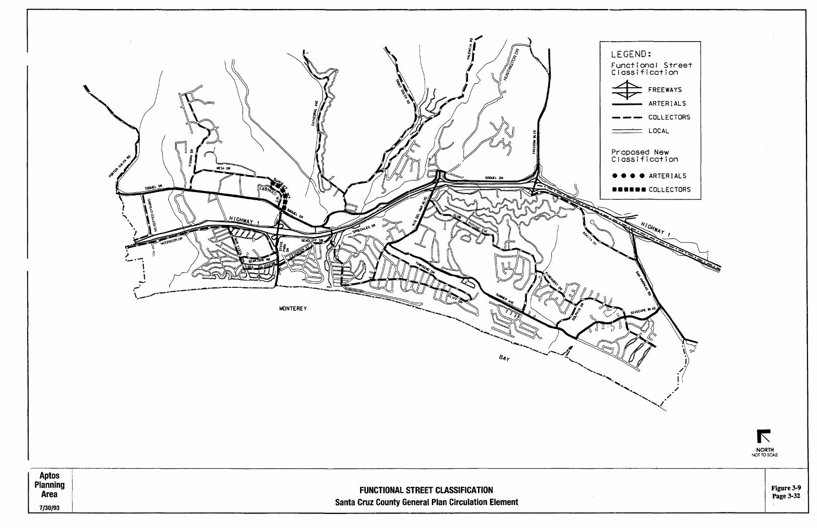
·Figure3-9 Page 3-32
Pajaro Valley
Planning Area
6/30/93
. \..
I . \ . I ,. .
', PIONEERS RD '
. ' \ . '·J
'~~
~- '--·"'\ \ ·"" _ ......
CITY OF WATSONVILLE
FUNCTIONAL STREET CLASSIFICATION Santa Cruz County General Plan Circulation Element
CASSERLy RD
-. I ·-. I .,_
-. I • .....
LEGEND: Functional Street Classification =*= FREEWAYS
ARTERIALS
--- COLLECTORS
LOCAL
Proposed New Classification
e e e e ARTERIALS
• • • • • • COLLECTORS
NORTH NOT TO SCALE
Figure 3-10 Page 3-33
LEGEND:
- = State Highways
-- = Arterial Streets and Roads
2o.ooo = Daily Traffic Volumes
r--··"····· !
i
SOURCE: Santa Cruz County County Regional Transportation Commission, 1989-1991 and CAL TRANS 1991 Traffic Volumes on Slate Highways.
EXISTING TRAFFIC VOLUMES FOR MAJOR ARTERIAL STREETS AND HIGHWAYS
Santa Cruz County General Plan Circulation Element
NORTH NOT TO SCALE
7/30/93.
Chapter 3: Circulation
ROADWAY CAPACITY/LEVEL OF SERVICE
To ensure that development shall not create traffic which will exceed acceptable levels of service on surrounding roadways.
Policies
3.12.1. Level of Service (LOS) Policy In reviewing the traffic impacts of proposed development projects or proposed roadway improvements, LOS C should be considered the objective, but LOS D as the minimum acceptable (where costs, right-of-way requirements, or environmental impacts of maintaining LOS under this policy are excessive, capacity enhancement may be considered infeasible). Review development projects or proposed roadway improvements to the Congestion Management Program netwolk for consistency with Congestion Management Plan goals.
Proposed development projects that would cause LOS at an intersection or on a uninterrupted highway segment to fall below D during the weekday peak hour will be required to mitigate their traffic impacts. Proposed development projects that would add traffic at intersections or on highway segments already at LOSE or F shall also be required to mitigate any traffic volume resulting in a 1% increase in the volume/capacity ratio of the sum of all critical movements. Projects shall be denied until additional capacity is provided or where overriding . finding of public necessity and or benefit is provided.
3.12.2 Level Of Service (LOS) Calculation Methods Utilize the most current Highway Capacity Manual (HCM) Operations Methodology for all existing levels of service analysis. For all-way stop intersections, utilize currently accepted interim methodology (for instance, Circular 273) until appropriate guidelines are adopted as part of the Highway Capacity Manual. HCM Planning, Circular 212, or other methodologies approved by the Board of Supervisors, may be used for future level of service projections and analysis if appropriate. Operations methodology shall be used for all short range projections.
3.12.3. Transportation Impact Fees as Mitigation Measures Payment of an approved Transportation Impact Fee proportional to the forecast trip generation will be required.
3.12.4. Reduced Trame Generation
5{24/95
Forecast traffic generation for purposes of development project review may be reduced ("discounted") if proposed development can demonstrate lower than average traffic rates. For example, if the development site is adjacent to transit corridors, will have an effective Transportation Demand Management (TOM) program, or is in a mixed-use development, it is reasonable to expect lower-than-average auto use.
Page3-35
Santa Cruz County General Plan
Programs·
a. Develop written guidelines on the preparation of traffic impacts studies and the LOS policy. These guidelines should be made available to citizens, developers, and others. The guidelines should address issues such as allowable LOS calculation methods, "discounts" in forecast traffic generation. (Responsibility: Public Works)
b. Develop a countywide List of Congested Intersections that do not meet the LOS requirements in policy 3.12.1. The list should be updated annually. (Responsibility: Public Works)
c. Develop and maintain an existing traffic count map incorporating the cities traffic counts and bicycle counts. (Responsibility: Public Works)
d. Update and maintain the County Design Criteria manual to establish standards for street development to provide adequate access and safety provisions. (Responsibility: Public Works, Planning Department)
Page3-36 5/lA/95
Chapter 3: Circulation
NEIGHBORHOOD TRAFFIC CONTROL
To protect residential neighborhoods from disruption caused by high traffic volumes and speeds through design, signs, and traffic control devices.
Policies
3.13.1. Limiting Traffic Volumes Seek to limit traffic volumes and speeds in residential neighborhoods through alignment and improvement of existing and proposed local streets.
3.13.2 Planning of New Residential Streets and Improving Existing Streets Plan roadway netwolks in residential areas and subdivisions to inter:..Connect adjacent residential areas while discouraging through traffic on local streets.
3.13.3. Commercial Traffic Whenever feasible, heavy commercial traffic should be routed away from residential neighborhoods.
3.13.4. Design and Enforcement Measures . Emphasize design and enforcement solutions to slow and discourage through traffic.
3.13.5. Physical Devices Physical devices may be used but should not unduly restrict access to neighborhoods, particularly by emergency vehicles. All devices should be consistent with the Caltrans Traffic Manual.
3.13.6. Street Closures Utilize new and existing street closures only when necessary to protect residential neighborhoods from high volumes of through traffic. Terminate all street closures with full cul-de-sac improvements and maintain emergency secondary access where feasible and where required by County design standards.
3.13. 7 Through Auto Traffic
5/lA/95
Discourage inter-neighborhood and through auto traffic movement on local streets through street alignment and intersection design.
figure 3-12lists some typical Neighborhood Traffic Control Programs/Devices.
Page 3-37
Santa Cruz County General Plan
Programs
flgl.lrEl3-}~ ? > N~'~l'l~~thoOCIT~ffi~SP?tr~te~?~~m~ n
Program/Device
Traffic Engineering and Specialized Improvements
Policy Enforcement Neighborhood Speed Watch Program
Speed Humps
Traffic Circles
Stop Signs
Diverter
One-Way/Chokers
Street Closure
a. Develop and maintain an official truck routes plan and sign program consistent with the functional classification system. (Responsibility: Public Worlcs)
b. Evaluate options for discouraging inter-neighborhood and through auto traffic on collectors and locals, such as chokers, diverters, one-way roads etc. for inclusion in the County Design Criteria. (Responsibility: Public · Worlcs, Redevelopment Agency)
Page3-38 5/lA/95
Chapter 3: Circulation
RECREATIONAL ACCESS
<)tij~~i!~··~~·~~···•••••· •••••••••••1llei1~iti6fill••){g~~~§•••••••• To provide access to the County's recreational resources, using multiple means, and recognizing that there will be additional congestion during peak recreational travel periods.
Policies
3.14.1 Capacity (LCP) Reserve capacity on the existing County road system for recreational traffic.
3.14.2 Priority to Recreational Improvements (LCP) In the development of transportation improvement programs, consider giving priority to road improvements
which provide access to recreational resources.
Program
(LCP) a. Seek state and federal funding for road improvements for recreational travel corridors in recognition of the statewide and national interest in local recreational resources. (Responsibility: Planning Department, Public Works, Board of Supervisors, Transportation Commission)
5/24/95 Page 3-39
Santa Cruz County General Plan
IMPACTS ON ENVIRONMENT
To minimize the adverse impacts of roadways on air quality, noise levels and energy use.
Policies
3.15.1. Landscaping Major entrances and corridors into the County unincorporated areas should be landscaped to minimize impacts of noise and air pollution.
3.15.2 Consistency with Air Quality Plans Circulation planning shall be consistent with the Monterey Bay Area Air Quality Management Plan.
3.15.3 Air Pollution Prohibit drive-through facilities and discourage other land uses and land use patterns which generate unnecessary auto-emitted air pollution.
(See section 5.18, Air Resources and section 6.7, Noise.)
Programs
a. Support the implementation of measures which are identified in future updates to the Monterey Bay Unified Air Pollution Control District Air Quality Management Plan for the Monterey Bay Region as productive in reducing air pollution from Transportation Sources. (Responsibility: Board of Supervisors)
b. Maintain County ordinances restricting drive-through uses. (Responsibility: Board of Supervisors)
c. Identify problem areas and recommend priorities in support of the Caltrans Freeway Noise Walls Program to buffer residential development from State Highway noise. (Responsibility: Planning Department, Public Worlcs, Board of Supervisors)
d. Actively support legislation to increase the energy efficiency of all transportation vehicles. (Responsibility: Board of Supervisors)
e. Experiment with alternate fuels, propulsion systems, and more efficient County fleet vehicles. (Responsibility: General Services, Public Worlcs, County Partes)
f. Design and construct transportation facilities to minimize their impact on the environment (Responsibility: Public Works)
g. Major entrances and corridors into the County unincorporated areas should be landscaped in accordance with the Santa Cruz County Urban Forestry Program. (Responsibility: Redevelopment Agency, Public Worlcs, Planning, County Partes)
Page3-40 5/24/95
Chapter 3: Circulation
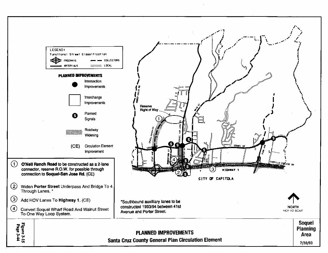
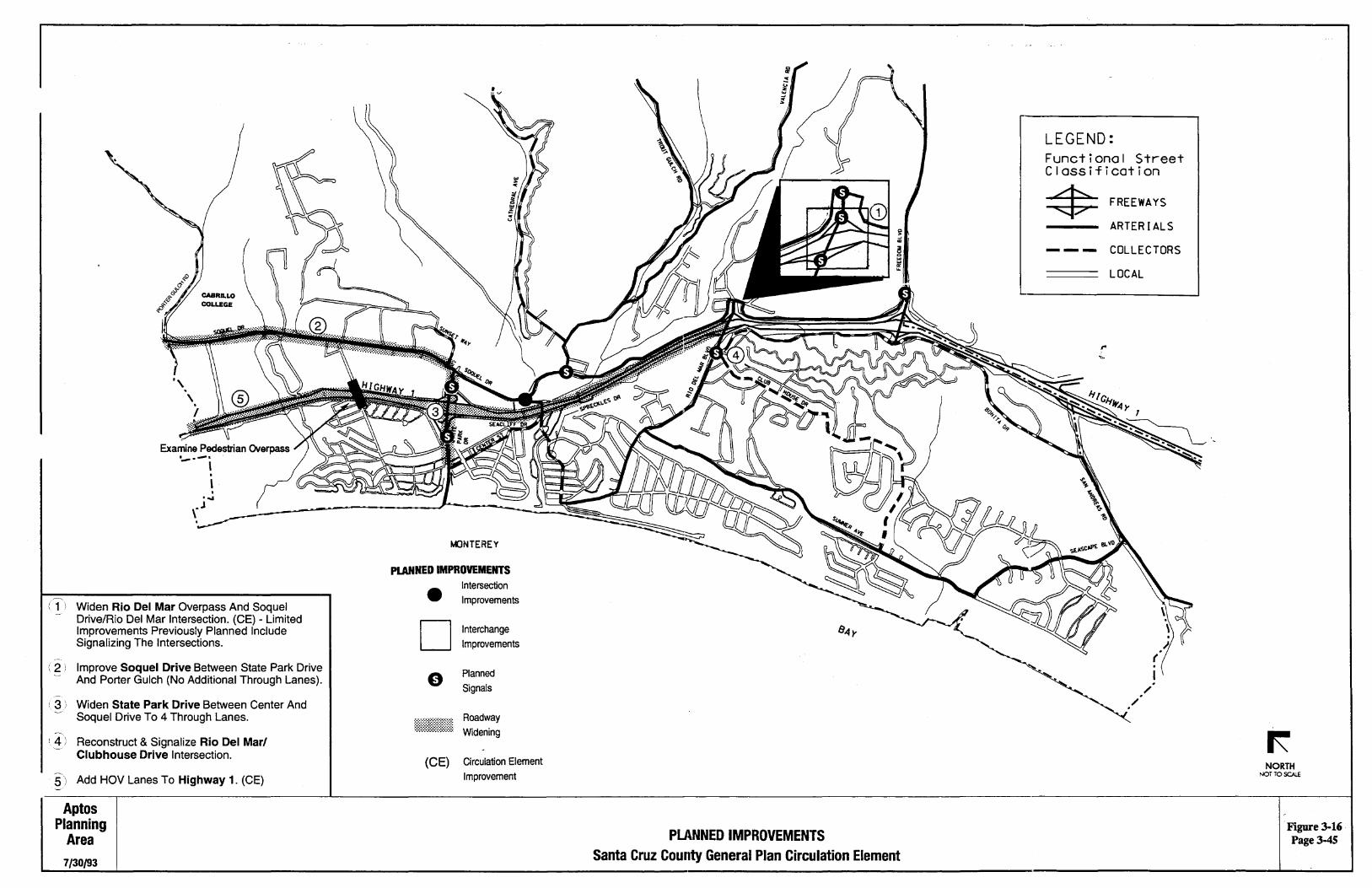
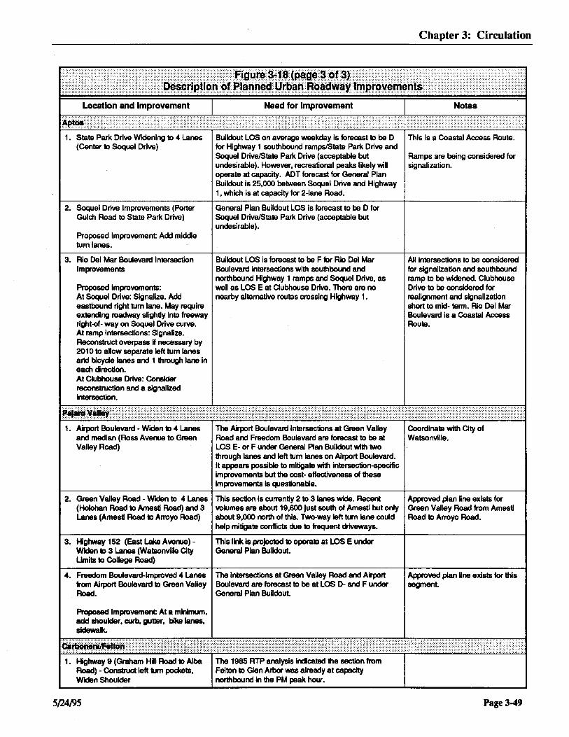
AREA CffiCULATION PLANS
To improve the County roadway system according to area circulation plans.
Figures 3-13, 3-14,3-15, 3-16 and 3-17 illustrate planned roadway improvements in urban areas. Key improvements are described in Figure 3-18 and planned and potential signals are listed in Figure 3-19.
S(lA/95 Page 3-41
NORTH NOT TO SCALE
CITY OF SCOTTS VALLEY
. I .
':'I
.f\ . .-.
LEGEND: FU'Ic:tl-1 Str•t Cl-lflcotlan
*FIIIEM'rS
- MJEIIIALS
- - CQ.LICTDIIS
=L~
PLANNED IMPROVEMENTS
• D 0
Intersection Improvements
Interchange Improvements
Planned Signals
Roadway n;mnmtiil Widening
(CE) Circulation Element Improvement
CD ®
Add HOV Lanes To Highway 17 From Highway 1 To Granite Creek Road. (CE)
(3l Reconstruct Highway 17/Highway 1 Interchange.
Widen Shoulders Of Highway 9 And Construct Left Turn Pockets.
Carbon era/ Felton
Planning Area
7/30/93
PLANNED IMPROVEMENTS Santa Cruz County General Plan Circulation Element
Figure3-13 Page3-42
LEGEND: Functional Street Classification * FREEWAYS
CITY OF SANTA CRUZ
ARTERIALS
COLLECTORS
LOCAL
G) Realign Interchange. (CE)
® Add HOV Lanes To Highway 1. (CE)
@ Widen Soquel Avenue To 4 Lanes From Soquel Drive To 17th Avenue, And Widen To 3 Lanes From 17th Avenue To Mattison Lane.
@ Widen Capitola Road To 4 Through Lanes, with Median Islands And Left Turn Pockets.
@ Examine East Cliff Drive As A One-Way Inbound With Bike/Pedestrian Lane. Portola Drive To Pick Up Extra Outbound Traffic. (CE)
-,
PLANNED IMPROVEMENTS
CITY OF CAPITOLA
• D 0
Intersection Improvements
Interchange Improvements
Planned Signals
ff}}fiii Roadway Widening
(CE) Circulation Element Improvement
NORTH NOT TO SCALE
( 6 l Widen 17th Avenue from East Cliff Dr. to Southern Pacific Right-of Way to 3 lanes by adding a 2-way left tum lane. (CE)
( 7 I Widen Eaton Street (From 6th Ave. To 7th Ave.) To 4 Through Lanes. (CE)
-( 8 I Widen 7th Avenue (From Eaton St. To Capitola
Rd.) To 3 Lanes (Add 2-Way Left Turn Lane).
Live Oak Planning
Area PLANNED IMPROVEMENTS FigureJ-14 PageJ-43
7/30/93 Santa Cruz County General Plan Circulation Element
CD
LEGEND: Functional Street Classification
• FREEWAYS - - COLLECTORS
- ARTERIALS = LOCAL
PLANNED IMPROVEMENTS
• D
Intersection Improvements
Interchange Improvements
Planned Signals
(CE) Circulation Element Improvement
O'Neil Ranch Road to be constructed as a 2-lane connector, reserve R.O.W. for possible through connection to Soquel-San Jose Rd. (CE)
Widen Porter Street Underpass And Bridge To 4 Through Lanes. *
@ Add HOV Lanes To Highway 1. (CE)
@ Convert Soquel Wharf Road And Walnut Street To One Way Loop System.
~--·-·-·-·-·
' \ I f: ta ,,
*Southbound auxilliary lanes to be constructed 1993/94 between 41st Avenue and Porter Street.
PLANNED IMPROVEMENTS
....... , 0 I
HIGHWAY 1
C I TY OF CAP I TOL A
Santa Cruz County General Plan Circulation Element
NORTH NOT TO SCALE
Soquel Planning
Area
7/30/93
(1'
-
Widen Rio Del Mar Overpass And Soquel Drive/Rio Del Mar Intersection. (CE) - Limited Improvements Previously Planned Include Signalizing The Intersections.
\ 2 ! Improve Soquel Drive Between State Park Drive And Porter Gulch (No Additional Through Lanes).
-~
' 3 ) Widen State Park Drive Between Center And Soquel Drive To 4 Through Lanes.
r 4 ) Reconstruct & Signalize Rio Del Mar/ Clubhouse Drive Intersection.
5) Add HOV Lanes To Highway 1. (CE)
Aptos Planning
Area
7/30/93
KJNTEREY
PLANNED IMPROVEMENTS
• D
(CE)
Intersection Improvements
Interchange Improvements
Planned Signals
Roadway Widening
Circulation Element Improvement
PLANNED IMPROVEMENTS Santa Cruz County General Plan Circulation Element
LEGEND: Functional Street Classification
:::$: FREEWAYS
ARTERIALS
--- COLLECTORS
LOCAL
. / .
/ .
NORTH NOT TO SCALE
Figure 3-16 Page3-45
Widen Airport Boulevard To 4 Through Lanes Between Ross Avenue And Green Valley Road. (CE)
LEGEND: Functional Street Classification * FREEWAYS
ARTERIALS
- - • COLLECTORS
LOCAL
. -. \ . I .
r . I ·,
~) Widen Green Valley Road To 4 Lanes From Airport Boulevard/Holohan Road To Amesti Road. (CE)
Widen Green Valley Road To 3 Lanes Between Amesti Road And Arroyo Drive.
4 i Widen Highway 152 To 3 Lanes. (CE)
CITY OF WATSONVILLE
Improve Shoulder, Curb, Gutter, Sidewalks On Freedom Boulevard Between Airport Boulevard And Green Valley Road.
\.~ , Improve Buena VIsta Drive, realign and add Bike Lanes. (CE)
PLANNED IMPROVEMENTS
Pajaro Valley
Planning Area
6/18/93 Santa Cruz County General Plan Circulation Element
..................... . I ·.
I. ....... ....... ....;
PLANNED IMPROVEMENTS
• D 0
(CE)
Intersection Improvements
Interchange
Improvements
Planned
Signals
Roadway
Widening
Circulation Element Improvement
Improve AmesU Road, from Green Valley Road to Browns Valley Boad, add Bike Lanes and Pedestrian improvements.
NORTH r-.QT TO SCAlE
Figure 3-17 Page3-46
1. Construct Highway 1 High Occupancy Vehicle (HOV) Carpool Lanes (Widen to 6 Lanes: Highway 17 to Rio Del Mar)
2. Highway 1/17 Interchange Reconstruction
3. Highway 17 HOV Lanes (Highway 1 to Granite Creek Road)
1. Highway 1/Soquel Drive/Soquel Avenue/Commercial Way
Interchange Reconstruction.
2. 7th Avenue Widening
Proposed Improvements: Generally 3-lane widening from Eaton to Capitola, with a through lane in each direction and left turn lanes at most intersections.
Highway 1 over this segment was listed as LOS Fin '92 CMP. Also, this was recommended as a "contingency measure• in the 1991 Air Quality Management Plan for the District.
LOS F on both freeways. Low capacity loop to continue north on Highway 1. Also southbound 17 to southbound 1 has poor ramp alignment
LOS F per '92 CMP north of the freeway segment and LOS F on freeway portion.
Highway 1/Soquel Avenue southbound ramps intersection is forecast at LOS F at General Plan Buildout and Soquel Drive/Soquel Avenue forecast at LOS D. It appears infeasible to mitigate the Highway 1 southbound ramps/Soquel Avenue intersections with limited intersection improvements without signifiCant realignment of Soquel Avenue and some right~f-way (perhaps including structures), per Soquel Avenue plan line study (which covered Soquel Drive to Gross Road).
Capitola/7th Avenue forecast at LOS F at General Plan buildout. Average Daily Traffic forecast at 19,500 near Capitola Road and 17,000 near East Cliff Drive, which is near capacity for two- lane road. Appears possible to mitigate with Intersection improvements.
3. Capitola Road Widening Capitola Road/7th Avenue forecast at LOS F at General Plan buildout. Appears
Widen to 41anes, add median from 7th to possible to mitigate with intersection 30th. Improvement.
4. Highway 1/41 st Avenue Interchange Improvements
5. Soquel Avenue Widening
Widen to 4 Lanes from south- bound ramps at Hwy 1 to 17th Avenue and 3 Lanes from 17th Avenue to Mattison Lane
6. East Cliff Drive • 1 Way Couplet (30th Avenueto 41st Avenue)
Proposed Improvement: One Jane would be retained for vehicle travel with the other lane converted to bicycle/pedestrian faciUty. Portola Drive would pick up additional traffiC.
5{l4/95
Southbound green phase is not sufficient to meet demand.
Numerous left turns into driveways. The Highway 1 southbound ramps/Soquel Avenue intersection Is forecast at LOS F at buildout without improvement.
Erosion on East CUff Drive limits Right-dWay available.
Chapter 3: Circulation
This is not under County jurisdiction. Caltrans is the agency primarily responsible for planning and operation of this facility.
Not under County jurisdiction.
Not under County jurisdiction.
In the long-term (by 201 O) complete interchange reconfiguration should studied in detail and if feasible, should be constructed. This could, for example, convert buttonhook ramps to partial cloverleaf configuration and lengthen the ramps, which are extremely short. M the interchange appears unlikely to be funded within the next 1 0 years or so. Soquel Avenue should be realigned to allow existing southbound ramps to be lengthened and to allow two through lanes to be carried through the ramp intersection In both directions.
..
Synctvonize signals
Approved plan line exists for this project.
Proposed one way couplet to be considered in the future.
Page3-47
Santa Cruz County General Plan
7. Eaton Street: Widen to 4-Lanes (6th to 7th Avenue) and Widen 7th Avenue lntersecUon
Proposed Improvement: Widen to 4 lanes on Eaton Street, plus add a second northbound-to-westbound exclusive left tum lane.
8. 17th Avenue Widening to 3 Lanes from East Cliff Drive to Southern Pacific Right-of-Way
1. O'Neill Ranch Road
Proposed Improvement: Reserve right-of-way per Draft O'Neill Ranch Master Plan for possible road connection between Soquel-San Jose Road and Soquel Drive.
2. Improvements at Soquel Drive/Porter Street and on Soquel Drive
Proposed Improvement: Soquel Drive Intersections with Main Street, Robertson Street and Daubenblss Avenue (as wen as Main Street/Porter Street) to be signalized. If this Intersection continues to operate at LOS F despite short-term planned Improvements, addiUonallmprovements may be warranted.
3. Highway 1/Bay Avenue/Porter Street Interchange Improvements
4. Porter Street
Proposed Improvement: Porter Street Improved to 3 lanes and bike lanes between Soquel Wharf Road and Papermlll Road and 2 lanes and bike lanes between Paper Mill Road and Dawn Lane.
5. Soquel Wharf Road -West Walnut Street One Way Couplet
Proposed Improvement: Soquel Wharf Road to be restrlped for one east bound travel lane, bike lane and parking where feasible. East Walnut Street to be restrlped and Improved for one west bound travel lane, a bike lane, parking, pedestrian path.
6. Park Avenue - Highway 1 to Soquel Drive
Proposed Improvement: Add bike lanes, curb, gutter and sidewalk
Page3-48
7th Avenue/Eaton Street forecast for LOS D during typical weekday peak condiUons at bulldout. However, during recreaUonal peaks operates at capacity.
Average Dally Traffic now over 13,000 south of Brommer Street, forecast to be at General Plan Bulldout over 15,000.
Two-lane collector (O'Neill Ranch Road) planned to serve O'Neill Ranch redevelopment project Not Intended now to serve through trips, but has the potenUal to serve as a bypass to relieve the lntersecUon of Soquel Drive/Porter Street
Soquel Drive/Porter Street Is now LOS F per CMP. Restrlplng to provide exclusive left turns and left tum phasing at Soquel Drive/Porter Street Is planned for short term, but probably not sufficient to avoid capacity operaUon at General Plan Bulldoul
No future LOS problem forecast with Improvements described.
This Is a Coastal Access Route.
Design approved. Construction 1994.
General Plan Amendment required prior to or concurrent with decision to construct connection to Soquel San Jose Road.
To be signalized and widened In 1993 (with 4 lanes on Bay Avenue/Porter Street on underpass) per '92 RTIP and '92-3 CIP. Also, Porter Street bridge over Soquel Creek to be widened.
Porter Street between Soquel Wharf Road and Soquel Drive to be Improved In 1994.
Porter Street between Soquel Drive and Dawn Lane to be Improved In 1995.
Improvements to be made In 1994 as part of Lower Porter Street Improvements.
ADA Improvement
5/lA/95
Chapter 3: Circulation
1. State Park Drive Widening to 4 Lanes Builclout LOS on average weekday is forecast 1D be D This is a Coastal Access Route. (Center to Soquel Drive) for Highway 1 southbound ramps/State Park Drive and
Soquel Drive/State Park Drive (acceptable but Ramps are being considered for undesirable). However, recreational peaks likely will signalization. operate at capacity. ADT forecast for General Plan Buildout is 25,000 between Soquel Drive and Highway 1, which is at capacity for 2-lane Road.
2. Soquel Drive Improvements (Porter General Plan Buildout LOS is forecast to be D for Gulch Road to State Park Drive) Soquel Drive/State Park Drive (acceptable but
undesirable). Proposed Improvement Add middle tum lanes.
3. Rio Del Mar Boulevard Intersection Builclout LOS is forecast to be F for Rio Del Mar All intersections to be considered Improvements Boulevard intersections with southbound and for signalization and southbound
northbound Highway 1 ramps and Soquel Drive, as ramp to be widened. Clubhouse Proposed Improvements: well as LOS E at Clubhouse Drive. There are no Drive to be considered for At Soquel Drive: Signalize. Add nearby alternative routes crossing Highway 1. realignment and signalization eastbound right tum lane. May require short to mid- term. Rio Del Mar extending roadway slightly into freeway Boulevard is a Coastal Access right-of- way on Soquel Drive curve. Route. At ramp intersections: Signalize. Reconstruct overpass H necessary by 2010 to allow separate left tum lanes and bicyde lanes and 1 through lane in each cirecdon. At Clubhouse Drive: Consider reconstruction and a signalized Intersection.
1. Airport Boulevard - Widen to 4 Lanes The Airport Boulevard Intersections at Green Valley Coordinate with City of and median (Ross Avenue to Green Road and Freedom Boulevard are forecast to be at Watsonville. Valley Road) LOS E- or F under General Plan Buildout with two
through lanes and left tum lanes on Airport Boulevard. It appears possible to mitigate with intersection-specific improvements but the cost- effectiveness of these improvements Is questionable.
2. Green Valley Road - Widen to 4 Lanes This section Is currently 2 to 3 lanes wide. Recent Approved plan Une exists for (Holohan Road to Amesti Road) and 3 volumes are about 19,600 just south of Amesti but only Green Valley Road from Amestl Lanes (Amestl Road to Arroyo Road) about 9,000 north of this. Two-way left turn lane could Road to Arroyo Road.
help mitigate conflicts due to frequent driveways.
3. Highway 152 (East Lake Avenue) - This link Is projected 110 operate at LOS E under Widen 110 3 Lanes (WatsonviUe City General Plan Bullclout. Limits to College Road)
4. Freedom Boulevard-Improved 4 Lanes The Intersections at Green Valley Road and Airport Approved plan line exists for this from Airport Boulevard to Green Valley Boulevard are forecast to be at LOS D- and F under segment. Road. General Plan BuUdoul
Proposed Improvement At a minimum, add shoulder, curb, gutter, bike lanes, sidewalk..
1. Hghway 9 (Graham HAl Road 1D Alba The 1985 RTP analysis Indicated the section from Road) - Construct left tum pockets, Felton 1D Glen Arbor was already at capacity Widen Shoulder northbound In the PM peak hour.
5(1.4/95 Page 3-49
Santa Cruz County General Plan
The following list includes currently unsignalized intersections that are either planned for signals or appear likely to meet Caltrans signal warrants.
If not otherwise planned for signal installation, signal warrants should be checked, ideally annually.
Figure 3-19 Planned and Potential Signals.
(Amended by Res. 146-2008)
Intersection Status
Brommer Streetlih Avenue Signal planned short-term
Portola Drive/41 51 Avenue Signal planned mid-term
ih Avenue/East Cliff Drive Unsignalized LOS under Alternative 2 (no widening) would be E overall, But both left turns probably would operate at capacity.
Highway 1 northbound ramps/Porter Street/Bay Avenue Signal planned this year.
Highway 1 southbound ramps/Porter Street/Bay Avenue Signal planned this year.
Highway 1 northbound ramps/State Park Drive Possible signal mid-term.
Highway 1 southbound ramps/State Park Drive Possible signal mid-term.
Soquel Drive/Freedom Boulevard Signal planned long-term.
Highway 1 southbound ramps/Rio Del Mar Boulevard Ramps to be signalized short-term.
Highway 1 northbound ramps/Rio Del Mar Boulevard Ramps to be signalized short-term
Clubhouse Drive/Rio Del Mar Boulevard Consider redesign and signalization short to mid-term.
Soquel Driveffrout Gulch Road Meets signal warrants, previously proposed.
Soquel Drive/ Rio Del Mar Boulevard Signal planned mid-term.
Soquel Drive/Robertson Street Signal planned mid-term.
Soquel Drive/Daubenbiss Avenue Signal planned short-term.
Soquel Drive/Main Street Signal planned short-term.
Soquel Drive/Capitola Avenue Signal planned short-term
Soquel Drive/Willowbrook Lane Signal planned mid-term.
Soquel Avenue/1 ih Avenue Possible signal mid-term.
Hwy 9/Gien Arbor Road/Mill Street Signal planned mid-term.
Green Valley Road/Paulson Road Possible signal short-term.
Soquel Drive/Dominican Hospital main entrance Meets signal warrants.
Green Valley Road/Minto Road Possible signal mid-term.
Page 3-50 6/2/2010
Chapter 3: Circulation
COMMODITIES MOVEMENT
To provide a system for the efficient transport of commodities which serves the needs of residents and industry without degrading the environment or adversely impacting the rest of the transportation system.
Policies
3.17 .1 Peak Hour Goods Movement Encourage minimum movement of goods by truck during peak traffic flow hours.
3.17 .2 Peak Hour Loading Limit on-street loading and unloading of goods on arterials to non-peak traffic hours.
3.17 .3 Rail/ Air Encourage commercial, industrial, and agricultural developments to utilize rail and/or air cargo for commodity movement
3.17 .4 Residential Impacts Develop access to loading and unloading facilities from non-residential streets. Require buffering from residential uses.
3.17 .S ·Street Design Require streets and interior circulation systems in new developments adequately to provide for truck delivery and utility services.
3.17 .6 Access Require adequate loading facilities in developments.
3.17. 7 Commodities
5/lA/95
Give priority to the improvement of highways carrying a significant amount of goods movement, particularly agricultural goods.
Page 3-51
Santa Cruz County General Plan
Programs
a. Institute a system of truck routes which limit truck traffic on collectors and local streets and in recreational areas to delivery and utility service trucks as much as possible. (Responsibility: Public Works, Board of Supervisors)
b. Continue the program to upgrade railroad crossings. (Responsibility: Public Works)
c. Protect railroad rights-of-way from the intrusion of parlced vehicles. (Responsibility: Public Works)
d. Protect railroad rights-of-way by identifying the need for and developing Public Utilities Commission approved pedestrian crossings. (Responsibility: Public Works)
e. Support the continued operation of cargo service at the Watsonville Airport. (Responsibility: Board of Supervisors)
f. Adopt as part of regular updates of the General Plan and LCP Land Use Plan, land use policies and programs which: • Increase the potential for movement of goods by rail. • Encourage the use of air freight • Provide for major shipping activities along arterial • Require use of rail for the movement of goods to the maximum extent possible. (Responsibility: Planning Department, Planning Commission, Board of Supervisors)
g. Continue and expand the use of discretionary pennit conditions regulating the amount of bulk commodities such as sand, gravel, cement and lumber that must be shipped by rail. (Responsibility: Planning Department, Planning Commission, Board of Supervisors)
h. Require commercial facilities located near existing rail to retain access for rail shipping facilities. (Responsibility: Planning Department, Public Works, Planning Commission, Board of Supervisors)
Page3-Sl 5/lA/95
Chapter 3: Circulation
2/18/20 Page 3-53
IMPLEMENTATION
To prioritize transportation improvements in the annual Capital Improvement Program based on established priorities described in this Circulation Element.
Policies 3.18.1 Priorities for Improvements
The Capital Improvement Program should give highest priority to projects that: Implement Congestion Management Program goals Improve safety Require little capital investment Serve the greatest number of local residents and employees Limit auto use and reduce environmental impacts Serve both local residents and employment travel needs as well as visitor serving uses.
3.18.2 High Occupancy Vehicle (HOV) Improvements
Promote as County policy the inclusion of HOV lanes in the Regional Transportation Plan’s constrained funding project list.
3.18.3 Dedication of Public Rights-Of-Way
Require dedication of public rights-of-way for public use and maintenance on all streets to ensure an integrated circulation system consistent with Government Code Sections 65909(a) and 66475.4(b). Dedication shall be consistent with the adopted street standards as in the County of Santa Cruz Design Criteria.
3.18.4 Maintenance of Any Project Interior Circulation System
Require maintenance of any project interior circulation system by an improvement association or other continuing mechanism.
3.18.5 Plan Lines
Establish specific plan lines for future road improvements consistent with the General Plan and LCP Land Use Plan adopted road system and the Design Criteria, as adopted by the Board of Supervisors.
3.18.6 Planned Future Road Projects
Require development projects to dedicate frontage property and construct improvements per approved plan lines consistent with Government Code Sections 65909(a) and 66475.4(b).
Programs
a. Continue the high traffic hazard identification program. Eliminate and/or improve congested and critical intersections. (Responsibility: Public Works) b. Continue and expand the street safety lighting program to include provisions for the safety of pedestrians and transit patrons. (Responsibility: Public Works)
Objective 3.18 Staging of Improvements
Santa Cruz County General Plan
Page 3-54 2/18/20
c. Encourage the strict enforcement of the Vehicle Code and support driver education and bicycle safety programs. (Responsibility: Board of Supervisors, Superior Court, Municipal Court) d. Ensure adequate maintenance of streets sufficient to avoid deterioration of facilities. (Responsibility: Public Works) e. Advocate priority funding for the construction of HOV lanes on Highway 1 and Highway 17. (Responsibility: Board of Supervisors, Transportation Commission)
Chapter 3: Circulation
2/18/20 Page 3-55
To establish a transportation system that is within the County’s ability to finance and operate. Policies 3.19.1 New Transportation Revenues
Investigate new federal, state and local revenue sources for critical transportation needs, including non-general fund County or regional contribution toward state highway improvements.
3.19.2 Minimize Impacts to General Fund
Utilize all available public and private sources of funding for transportation development; do not utilize the County’s General Fund for transportation development.
3.19.3 Transportation Impact Fees
Require those benefiting from transportation improvements to pay a fair share of the costs through assessment of fees on new developments.
3.19.4 Mitigation Requirements
Require new development projects to mitigate their impacts on transportation facilities through system improvements and/or transportation impact fees.
3.19.5 Distribution of the Cost of Road Construction
Consider the distribution of the cost of road improvements equitably among benefiting property owners. 3.19.6 Legislation
Actively support legislation which would increase the share of gasoline tax made available for local road maintenance and construction.
3.19.7 Live Oak: Highway 1 Interchange Improvements
Require all major development projects which impact the traffic flow at the Soquel Drive/Soquel Avenue interchange with Highway 1 to contribute funding for the planned roadway improvements on Soquel Avenue/Soquel Drive and/or improvements at the Soquel Drive/Soquel Avenue interchange with Highway 1, either through the establishment of a special transportation improvement assessment area or through conditions of approval on development permits to mitigate project impacts.
Programs
a. Advocate legislation to allocate state funds to communities providing statewide recreational opportunities. (Responsibility: Board of Supervisors)
b. Examine potential changes to traffic/roadside impact fee program already operating in Aptos, Soquel, Pajaro Valley, and Live Oak. Changes could include expansion to new areas covered, changes in fees to match recent construction costs, and reductions in the fee for mitigating factors (TDM program or multi-use developments). (Responsibility: Planning Department, Public Works, Board of Supervisors)
c. Support countywide traffic impact fees to provide funding for improvements needed to mitigate impacts of major development projects that may occur in a different jurisdiction than the project location or on state highways. (Responsibility: Board of Supervisors)
Objective 3.19 Funding
Santa Cruz County General Plan
Page 3-56 2/18/20
To update the Circulation Element on a regular basis to take into account changing travel patterns, land uses, technology, and legislation.
Policies 3.20.1 Respond to New Regional Plans
Review and update the Circulation Element to be generally consistent with any major updates of key regional plans such as the Regional Transportation Plan or the Monterey Bay Unified Air Pollution Control District Air Quality Management Plan.
3.20.2 Monitoring and Revisions
Effectiveness of the Circulation Element should be monitored and reported every one to three years.