23 The Santa Fe Group aquifer system, which supplies the ground- water resources for the Albuquerque metropolitan area and surrounding communities within the Middle Rio Grande Basin, is composed chiefly of sand and silt with lesser amounts of clay and gravel. Most of the sediment was transported into subsiding fault-bounded basins of the Rio Grande Rift by ancient streams and rivers that drained the surrounding regions. Addi- tional deposition was a result of windblown sediment (eolian deposits), intermittent streams, and downslope creep from mountain uplifts. Because these geologic processes have been active in the Middle Rio Grande Basin for millions of years, the Santa Fe Group locally is thousands of feet thick. The varied processes and the available sediment combine to form a complex, three-dimensional framework of truncated and overlapping sedi- mentary units of contrasting hydrologic properties. (See Box B.) The Rio Grande Rift The geologic processes at work in this part of New Mexico have guided and controlled formation of the Santa Fe Group aquifer system. More than 25 million years ago, tectonic forces operating on the western North American continent began to pull apart the brittle upper crust, and the continent began to spread and extend toward the Pacific Ocean basin (Chapin and Cather, 1994; Pazzaglia and others, 1999). In New Mexico and Colorado, these forces created a more-or-less continuous north-south structural zone called the Rio Grande Rift (fig. 3.1). This rift formed in northern Mexico and southern New Mexico and slowly continued to split and extend toward the north as the Colorado Plateau block on the west separated from the North American continental interior block on the east. Since its inception, the floor of the rift has subsided, sporadically and unevenly, to local depths greater than 14,000 feet as the continental crust east and west of the rift continues to slowly pull apart (Grauch, Gillespie, and Keller, 1999). The Rio Grande Rift is a zone of faults and sediment-filled basins extending along its length. Some faults appear to follow ancient lines of weakness in the brittle crust that are related to older geologic events, but many of the faults cut through older rock along new, crosscutting traces. These faults caused pieces of the brittle crust to pull apart and slide past each other; blocks on the inside of the rift zone generally dropped down under the influence of gravity relative to (uplifted) blocks on the outside edges of the rift. In this way, the rift has created a series of valleys along its length that have influenced the flow of streams and sediment deposition. Faulting, uplift, volcanic activity, subsidence, and deposition rates have varied through time in the rift. Nonetheless, the overall geologic processes have remained fairly constant. Geologic and geophysical data show that the rift consists of numerous discrete structural basins that mark the loca- tions where faulting and subsidence rates and displacements have been greatest overall (see Box C). Chapter 3: Geology of the Santa Fe Group aquifer system An aquifer is defined as “a rock unit that will yield water in a usable quantity to a well or spring” (Heath, 1983). An aquifer system is two or more aquifers that are separated (at least locally) by impermeable rock units but function together as an aquifer with regional extent. The impermeable or low- permeability rock units that bound aquifers are confining beds. A rift is an elongated valley in the Earth’s crust that forms in response to the crust extending or spreading apart. The Rio Grande Rift forms one of the great rift valleys of the world, on a scale similar to the East African rift and the Lake Baikal rift in Russia. Rock units may be classified and mapped on the basis of many different criteria including lithology, magnetic polarity, age, and depositional environ- ment. The most common method is to classify rock strata of about the same age and similar physical characteristics into formations. Formations may be subdivided into members and beds or aggregated into groups. By convention, the formal name of the unit is a geographic feature near the type expo- sures (or outcrops) of the rock unit. Geologic maps typically portray the surface extent and structure of such stratigraphic units. However, young unconsolidated deposits are generally mapped and classified primarily by depositional environment and material properties.
Transcript
23
The Santa Fe Group aquifer system, which supplies the ground-water resources for the Albuquerque metropolitan area and surrounding communities within the Middle Rio Grande Basin, is composed chiefly of sand and silt with lesser amounts of clay and gravel. Most of the sediment was transported into subsiding fault-bounded basins of the Rio Grande Rift by ancient streams and rivers that drained the surrounding regions. Addi-tional deposition was a result of windblown sediment (eolian deposits), intermittent streams, and downslope creep from mountain uplifts. Because these geologic processes have been active in the Middle Rio Grande Basin for millions of years, the Santa Fe Group locally is thousands of feet thick. The varied processes and the available sediment combine to form a complex, three-dimensional framework of truncated and overlapping sedi-mentary units of contrasting hydrologic properties. (See Box B.)
The Rio Grande Rift
The geologic processes at work in this part of New Mexico have guided and controlled formation of the Santa Fe Group aquifer system. More than 25 million years ago, tectonic forces operating on the western North American continent began to pull apart the brittle upper crust, and the continent began to spread and extend toward the Pacific Ocean basin (Chapin and Cather, 1994; Pazzaglia and others, 1999). In New Mexico and Colorado, these forces created a more-or-less continuous north-south structural zone called the Rio Grande Rift (fig. 3.1). This rift formed in northern Mexico and southern New Mexico and slowly continued to split and extend toward the north as the Colorado Plateau block on the west separated from the North American continental interior block on the east. Since its inception, the floor of the rift has subsided, sporadically and unevenly, to local depths greater than 14,000 feet as the continental crust east and west of the rift continues to slowly pull apart (Grauch, Gillespie, and Keller, 1999).
The Rio Grande Rift is a zone of faults and sediment-filled basins extending along its length. Some faults appear to follow ancient lines of weakness in the brittle crust that are related to older geologic events, but many of the faults cut through older rock along new, crosscutting traces. These faults caused pieces of the brittle crust to pull apart and slide past each other; blocks on the inside of the rift zone generally dropped down under the influence of gravity relative to (uplifted) blocks on the outside edges of the rift. In this way, the rift has created a series of valleys along its length that have influenced the flow of streams and sediment deposition. Faulting, uplift, volcanic activity, subsidence, and deposition rates have varied through time in the rift. Nonetheless, the overall geologic processes have remained fairly constant. Geologic and geophysical data show that the rift consists of numerous discrete structural basins that mark the loca-tions where faulting and subsidence rates and displacements have been greatest overall (see Box C).
Chapter 3: Geology of the Santa Fe Group
aquifer system
An aquifer is defined as “a rock unit that will yield water in a usable quantity to a well or spring” (Heath, 1983). An aquifer system is two or more aquifers that are separated (at least locally) by impermeable rock units but function together as an aquifer with regional extent. The impermeable or low- permeability rock units that bound aquifers are confining beds.
A rift is an elongated valley in the Earth’s crust that forms in response to the crust extending or spreading apart. The Rio Grande Rift forms one of the great rift valleys of the world, on a scale similar to the East African rift and the Lake Baikal rift in Russia.
Rock units may be classified and mapped on the basis of many different criteria including lithology, magnetic polarity, age, and depositional environ-ment. The most common method is to classify rock strata of about the same age and similar physical characteristics into formations. Formations may be subdivided into members and beds or aggregated into groups. By convention, the formal name of the unit is a geographic feature near the type expo-sures (or outcrops) of the rock unit. Geologic maps typically portray the surface extent and structure of such stratigraphic units. However, young unconsolidated deposits are generally mapped and classified primarily by depositional environment and material properties.
24
The interplay of faulting and sedimenta-tion within the Rio Grande Rift has controlled major aspects of aquifer geom-etry. Basin-fill sediment thickens substan-tially toward the center of the basin. Outcrop and drill-hole studies show that basin-fill sediments thicken abruptly across major faults, indicating that faults were active while sediment was accumu-lating (fig. B.1). Rising fault blocks were eroded, and the detritus was deposited on the sinking fault blocks in a process that recycled older sediment within the rift or stripped material off the rift-flank moun-tain ranges. The rising and falling fault blocks also shifted the internal stream drainage in the subbasins and caused various depositional environments (such as river channel, overbank flood plain, alluvial fan, and pediment) to migrate laterally over time (Cather and others, 1994; Stone, 2001). In this dynamic setting, the types of sediment that accu-mulated across the rift basins were highly varied, and the location of their deposition changed as the basin filled. Erosion on the uplifted blocks created breaks in the sedi-mentary record that make it difficult to correlate sequences of strata from one location to another.
The Middle Rio Grande Basin consists of three discrete subbasins distinctly sepa-rated by zones where the rocks underlying the basin-fill sediment (basement rocks) are high (fig. 3.2). Each subbasin has a unique structural and depositional history. Drainage was internal to each subbasin during the early history of the rift valley, as indicated by the type of sediment
Structural, sedimentologic, and climate effects on the Middle Rio Grande Basin aquifer system
James C. Cole1 and Byron D. Stone2
1U.S. Geological Survey, Denver, Colorado.
2U.S. Geological Survey, Storrs, Connecticut.
EXPLANATION
Fault; bar and ball on downthrown side
Production well, well-field name,
Monitoring well Line of section Don
1 98thStreet A A'
0 1 2 3 MILES
0 1 2 3 KILOMETERS
Modified from Allen and others (1998);Stone and others (1998)
106˚45' 106˚35'106˚40'
35˚10'
35˚05'
Landsurface
INC
RE
AS
ING
DE
PT
H
A98
th S
treet
well
Wes
t Mes
a no
. 1 w
ell
Colleg
e no
. 1 w
ell
Colleg
e no
. 2 w
ell
A'
A A'
SA
N M
ATE
O B
LVD
4TH
ST
CO
OR
S B
LVD
Rio
Gra
nde
Innervalley
Don
98thStreet
WestMesa
College
CENTRAL AVE
CO
OR
S B
LVD
Leavitt
1
23 4
12
12
1
23
Albuquerquevolcanic
field
Llano deAlbuquerque
Approximately740 feet thick
Approximately380 feet thick
? Atrisco beds
Atrisco beds
A
B
25
40
Maparea
Figure B.1.—Generalized section showing substantial thickening of the Atrisco silt- and clay-rich beds in the downthrown fault block east of the 98th Street well location (A) and index map (B). All wells except the 98th Street well are projected to the line of section, parallel to the northwest-trending fault trace.
B
and well number
25
deposited; thus, no continuous hydrostratigraphic deposit in the deeper parts of the Santa Fe Group aquifer system extends across all three subbasins.
The youngest sediments that were deposited during roughly the last 5 million years can be traced across the buried basement highs and the deep subbasin centers. These deposits differ from the older rift-fill deposits in ways that reflect significant changes in rift history and climate. First, these younger deposits are thinner (for a specific interval of time), indicating that the rates of subsidence began decreasing at least 5 million years ago. Second, the younger deposits are more tabular in form across all three subbasins and show less variation in thickness across faults, indicating that faulting was less active during deposition. Some subhorizontal younger sedimentary layers were deposited above erosion surfaces on top of inclined older deposits, consistent with a decline in the rate of tilting. Third, the younger deposits are only more than a few hundred feet thick along the central axis of the subbasins (Hawley, Haase, and Lozinsky, 1995; Connell, Allen, and Hawley, 1998), showing that active faulting and subsidence occurred in a much narrower part of the rift than earlier in the rift's history. These younger deposits show that the supply of sediment was greater than subsidence; thus, stream deposition was able to fill the sepa-rate subbasins to form a connected, broad basin (Cather and others, 1994; Chapin and Cather, 1994; Pazzaglia and others, 1999).
The youngest sedimentary deposits also consist of coarser grained mate-rials than most of the earlier rift-fill deposits. Coarse sand and pebble to
cobble gravel are common in the younger deposits, indicating that streams trans-porting these materials had greater discharge and flowed at greater velocities. The change from fine- to coarse-grained sediment is evident on a regional scale and is consistent with regional and world evidence that rainfall and runoff increased substantially beginning about 5 million years ago (Krantz, 1991; Thompson, 1991). These younger deposits locally are productive zones of the aquifer in the Middle Rio Grande Basin, but they compose only a small percentage of the rift-fill deposits and are not laterally extensive. These deposits are currently being eroded in the Rio Grande drainage.
Rift faults remain active today and continue to influence sedimentation. Outcrops along the western and northern basin margins show sequences of alluvial and windblown sediment that are thickest on top of the tilted, downdropped blocks of faults (Koning, Pederson, and Pazza-glia, 1998; Connell, Koning, and Cather, 1999). The sediment accumulated next to the fault scarp and developed a calcareous soil as the surface stabilized. Subsequent faulting buried the calcareous soil beneath another layer of sand and silt, which then developed its own calcareous soil zone (Wright, 1946; Machette, 1978; Stone, 2001). More than 10 buried soil zones are preserved in some locations (Wright, 1946), which indicate repeated offsets across young rift faults (Personius, Machette, and Kelson, 1999).
Windblown silt
Calcareous soil
Figure B.2.—Oblique aerial photograph of outcrops in the upper Santa Fe Group sediment adjacent to the Zia fault in the northern Calabacillas subbasin. The prominent whitish zone is a buried calcareous soil that was buried by yellowish, windblown silt deposited following downdrop-ping on the Zia fault. (Courtesy of J.C. Cole.)
26
Subsurface geologic information about an aquifer is obtained primarily from wells. Studies of sites where the aquifer crops out on the surface provide some geologic information, but such outcrops are often unsaturated and of limited extent. Conse-quently, geologic and hydrogeologic data used to characterize aquifers at depth are routinely obtained from petroleum exploration and water wells. Such subsurface data are typically obtained during the drilling and construction of wells and include (1) characteristics of rock cuttings removed by the drill bit and used to reconstruct the general sequence and composition of the rocks in the subsurface (lithology); (2) drillers’ notes of drilling conditions, including drilling rate; (3) measurements of the physical properties of the rock and fluids using borehole geophysical logging tools; (4) hydraulic conductivity as estimated from hydraulic tests; and (5) ground-water chemistry. Abundant geophysical-log data and lithologic descriptions have been obtained for wells in the Albuquerque-Rio Rancho metropolitan area and have been used to interpret hydrogeologic conditions of the Santa Fe Group aquifer system in the Middle Rio Grande Basin (Connell, Allen, and Hawley, 1998).
CHow well information is used to understand the hydrogeology of the basin
Sean D. Connell1 and David A. Sawyer2
Figure C.1.—Hypothetical responses of various bore-hole geophysical tools to alluvial deposits of contrasting texture and saturation and to volcanic rock units.
1New Mexico Bureau of Geology and Mineral Resources, Albuquerque, New Mexico.
2U.S. Geological Survey, Denver, Colorado.
Electricalresistivity
(ohm-meters)
Electricalconductivity(millisiemens
per meter)
Lithology Naturalgamma
(AmericanPetroleumInstituteunits)
Boreholecaliper
(inches)
64-inchresistivity
16-inchresistivity
Wellcasing
Watertable
Caving ofmaterialfromboreholewalls and fractures
Modified from Keyes (1989)
Sand
Gravel
Clay and silt
Basalt
Volcanic ash
Saturated zone
EXPLANATION
A USGS hydrologist using geophysical-logging equipment at the Del Sol Divider monitoring well.
27
Modified from Allen and others (1998); Stone and others (1998)
EXPLANATION
Fault, showing relative movement Correlation line
5,000
5,200
4,600
4,800
4,200
4,400
3,800
4,000
3,600
1,600
1,400
1,500
1,200
1,300
1,100
ELECTRICAL CONDUCTIVITY, IN MILLISIEMENS PER METER
ELE
VAT
ION
AB
OV
E S
EA
LE
VE
L, IN
ME
TE
RS
ELE
VAT
ION
AB
OV
E S
EA
LE
VE
L, IN
FE
ET
Leavittno. 3
West Mesano. 4
Donno. 2
98th St.well
Collegeno. 1
4000400400 0 4000 4000 0
The most common drilling method is mud rotary, which uses a thick drilling fluid to carry rock fragments to the surface after they are broken from the bottom of the hole by a spinning drill bit. Examination of these cuttings provides information about the mineralogy and general grain size of the deposit; however, fine-grained cuttings (clay, silt, and fine sand) often are suspended by the drilling fluid and are washed out of the sample, which tends to bias cutting descriptions toward the coarser fragments (medium- to coarse-grained sand and gravel). Borehole-geophys-ical logs measure the physical properties of the rock surrounding the well and pro-vide essential qualitative and quantitative information about aquifers that cuttings cannot provide. Geophysical logs provide critical data on the fine-grained materials as well as information about features that affect ground-water movement. The most common geophysical logs in the Albuquerque area are of electromagnetic proper-ties, natural gamma radioactivity, and borehole diameter (caliper).
Two types of geophysical logs that are measures of the response of fluid in the rock surrounding the borehole to an induced electromagnetic field are electrical (or resis-tivity) and induction logs. In freshwater aquifers, these logs are good indicators of the percentage of clay minerals in the deposit because moist clays conduct electric-ity much better than freshwater alone (Kwader, 1985). Thus, sand and gravel units are poor conductors of electric current because they contain few clays, and clay- or silt-rich units tend to be better conductors (fig. C.1).
The most common radioactivity log mea-sures natural gamma-ray production in the rock surrounding the borehole and is used to determine rock type. The log measures the natural radioactive decay of potas-sium, uranium, and thorium in feldspar, mica, and clay minerals. The amount of decay correlates with clay-mineral con-tent because clays are generally rich in potassium, resulting in higher measure-ments (fig. C.1). In the Santa Fe Group, gamma-ray logs also respond to deposits of volcanic origin and ash beds that con-tain potassium, uranium, and thorium. Therefore, using only the gamma-ray log, these volcanic deposits can be misinter-preted as clay-rich beds; such mistakes can be avoided by using other geophysical logs or by evaluating the cuttings descrip-tion. Another type of radioactivity log measures the response of the rock to a source of neutrons and is used to deter-mine bulk density and porosity,
Caliper logs show the shape and size of the borehole and delineate zones of loose and caving rock or sediment caused by weak cementation (such as unconsoli-dated gravel and sand) or breakage by faults (fig. C.1). Caliper logs are also used to correct and interpret other log data for variations in the distance between the borehole sensor and the surrounding rock.
Evaluation of geologic and hydrogeologic information for wells involves a system-atic approach that uses all available litho-logic, geophysical, and geochemical information for a given borehole or well field (Keyes, 1989). With multiple wells, distinctive geophysical features can be identified and correlated areally. An example in the Santa Fe Group aquifer system is a prominent clay-rich interval in western Albuquerque identified by a sharp change in electrical conductivity. The base of this unit was correlated for several miles between different well fields (fig. C.2) (Hawley and Haase, 1992; Allen and others, 1998). Such correlations aid in understanding the hydrogeology of the Santa Fe Group aquifer system (Connell, Allen, and Hawley, 1998).
Figure C.2.—Correlation of electrical-conductivity logs among Albuquerque well fields west of the Rio Grande. The dashed line indicates a rather abrupt boundary between overlying, fine-grained clayey sand and sand (high electrical conductivity) and underlying, medium-grained sand (lower electrical conductivity). Variations in the elevation of this boundary are inter-preted to reflect tilted bedding and faults, especially between the 98th Street well and the College no. 1 well. See figure B.1A for a location map of the wells. The order of presentation is from well to well, not strictly south to north.
28
The Middle Rio Grande Basin consists of three discrete subbasins, separated by northwest-trending structural benches (fig. 3.2). Each subbasin contains more than 14,000 feet of rift-fill deposits in its deepest part, but structural benches and upthrown blocks separate these three subbasins where the sediment is as thin as 3,000 feet (Stone, 2001). Detailed geologic mapping and geophysical logs and cores obtained from petroleum-exploration wells show that the stratigraphic record for the lower and middle parts of each subbasin is distinct (Cole and others, 1999), indicating that the drainage system for each subbasin evolved differently in response to its unique structural history. Abundant fine-grained sediment and local lakebed deposits indicate that each subbasin drained internally during the early history of the Rio Grande Rift. Consequently, no major hydrostratigraphic unit extends across all three subbasins in the deeper parts of the aquifer system.
EXPLANATION
Rift basin
0 100 200 300 MILES
100 200 3000 400 KILOMETERS
38°
37°
36°
35°
34°
33°
32°
31°
109° 108° 107° 106° 105° 104° 103° 102° 101°
UTA
HC
OL
OR
AD
O KA
NS
AS
CO
LO
RA
DO
COLORADO
NEW MEXICOOKLAHOMA
NEW MEXICOTEXAS
AR
IZO
NA
NE
W M
EX
ICO
NE
W M
EX
ICO
TE
XA
S
UNITED STATESMEXICO
Middle Rio Grande Basin
Rift
Gra
nd
eR
io
Elephant Butte Reservoir
Heron ReservoirEl Vado Reservoir
Abiquiu Reservoir
Cochiti Lake
Elephant Buttestreamflow-gaging station
Otowi streamflow-gaging station
Elephant Butte Dam
Caballo Reservoir
Rio Grande
GrandeRio
Las Cruces
El Paso
Socorro
Albuquerque
Santa FeSanta Fe River
Figure 3.1.—Location of the Middle Rio Grande Basin and the Rio Grande Rift.
Lithology is the term used by Earth scientists to describe the physical and mineralogical characteristics of a rock (Jackson, 1997). Common lithologic names may denote a specific type of rock, for example, sandstone, basalt, or granite, or may denote the general mode of rock formation, for example, sedimentary, volcanic, or intrusive. Strata are layers or beds of sedimentary rock (Jackson, 1997).
29
Rift processes also have influenced the types of sediment trans-ported into the Rio Grande Rift basins. The faulting and mountain uplift that have occurred along the rift have changed the topography and slope, and these changes have influenced the ability of streams to carry sediment toward the valleys. Rift-margin uplifts expose additional rock material to weathering and erosion and increase the supply of sediment to be trans-ported by streams, wind, and gravity-driven processes. Changes in topog-raphy also have caused changes in local climate (especially precipitation) that affect weathering, streamflow, and sediment transport. The Rio Grande Rift has experienced widespread and diverse volcanic activity through time, and molten material has exploited weaknesses in the rift-faulted crust to rise from depth and erupt at the surface. Volcanic processes have provided new source areas for sediment, produced landforms that alter topography and drainage, and affected climate and vegetation patterns in the region of the Middle Rio Grande Basin.
The rift has altered river processes in the Middle Rio Grande Basin and has affected deposition (see Box B). Rivers in more geologically stable settings typically are in equilibrium and neither erode nor deposit much sediment but simply transport it through the basin. Faulting and subsidence in the Rio Grande Rift, however, have repeatedly produced sags and swales where the river has deposited sediment to maintain its gradient.
Geologic processes that shaped the aquifer system
The dynamic setting of the Rio Grande Rift has produced a complex geologic framework for ground water. The river and stream networks that deposited most of the sediment shifted across the landscape through time in response to tectonic uplift and subsidence and to climate change. The sediments deposited by running water typically are quite variable because of the very different depositional settings that form side by side (for example, main or axial channels, natural levees, and flood plains). Such sedimentary deposits commonly interfinger in complicated three-dimen-sional patterns, rather than form continuous tabular beds (fig. 3.3). In addi-tion, faults that have been displaced after these sediments were buried have also offset the deposits (fig. B.1A). Chemical alteration, compaction, frac-turing, and cementation over time have affected the hydrologic character of the sedimentary deposits in the Middle Rio Grande Basin to varying degrees.
The type of deposit and the distribution of sediment depend on the transport medium (water, wind, gravity, or ice), the energy of the transpor-tation process, and the depositional environment. Depositional environ-ments that have existed in the rift during deposition of the Santa Fe Group aquifer system are principally of five types: fluvial (sediment deposited by rivers and streams), alluvial-colluvial (sediment deposited on slopes and along mountain fronts), eolian (wind-transported sediment deposited in dunes), lacustrine (sediment deposited in lakes), and volcanic (molten rock erupted from vents in the form of lava flows or volcanic ash). Fluvial deposits are highly variable because the grain size and mixture of the sedi-ment depend on the velocity and turbulence of the streamflow and on the amount of erosion and redeposition before burial and preservation. Main-
Indistinct subbasin boundary
Subbasin generally outlinedby –12-milligal lineof equal gravity anomaly
EXPLANATION
Rio
Gra
nde
Rio P
uerco
0 30 MILES
0 30 KILOMETERS
Hub
bell
benc
h
Laguna bench
Ziana
anticline
MiddleRio Grande Basin Santo Domingo
subbasin
Belensubbasin
Calabacillassubbasin
Modified from Grauch, Gillespie, and Keller (1999)
Figure 3.2.—Simplified structural features of the Middle Rio Grande Basin. Features are defined on the basis of gravity surveys, struc-tural models of other authors, and geologic mapping.
Faults mark parts of the Earth’s crust that have broken and where the two sides have slid past each other across the break (Jackson, 1997). This relative motion can be vertical, horizontal, or a combination. Not all faults are exposed at the land surface, either because younger deposits overlie the faults or because the break at depth did not propagate to the surface through the intervening rock. The gaping fault cracks depicted in popular movies are rare and are called fissures if they remain open (Jackson, 1997).
30
channel deposits tend to be coarser grained because the fine-grained sedi-ment is carried away by the current, whereas overbank flood deposits on the margins of a river valley typically contain more silt and clay because of reduced current velocity. Alluvial-colluvial deposits that form near moun-tain fronts are composed of sediment ranging in size from boulders to sand and silt. In eolian deposits, the sediment grains typically are uniform in size and well rounded, and pore spaces are well connected. Lacustrine deposits consist of very fine grained sand, silt, and clay, and often, evaporitic salts. Volcanic rocks have highly variable hydraulic properties depending on the kind of deposit and the extent of alteration following deposition (such as fracturing).
Ground water moves through the pore spaces between the grains and through fractures in the deposit. Unconsolidated deposits consisting pri-marily of medium- to coarse-grained sand or gravel have interconnected larger pore spaces that allow water to move freely in the deposit and, thus, make highly productive aquifers. Deposits containing a mixture of grain sizes (fine to coarse) have less pore space because finer grains fill the pore spaces between larger grains, thus reducing the interconnection between pore spaces. Deposits consisting of a high percentage of silt and clay have large proportions of pore spaces, but the pore spaces are smaller and inter-connection is poor. Thus, water does not move freely in these deposits, and these deposits typically form confining units in an aquifer system. The interconnection of pore spaces in volcanic deposits is commonly due to fracturing after the rock has cooled.
Main-channel deposits tend to make more productive aquifers because of their coarse-grained size, whereas overbank deposits are likely to form confining units because of their fine-grained size. The poorly sorted range of grain sizes in alluvial-colluvial deposits typically make moderate to poor aquifers. Because of their uniform grain size, eolian deposits generally make very productive aquifers. Fine-grained lacustrine deposits tend to form confining units.
Sandia Mountains
Rio
Gra
nde
Ziana horst
San Francisco fault
Sand Hill fault
WEST EAST
Calabacillas subbasin
EXPLANATION
Axial gravel Eolian sand and silt
Piedmont-slope deposits
Pre-Santa Fe Group units
Contact
Fault
Blanket gravel, sand
Medium-coarse sand
Silt and fine sand
Medium sand
Fine-medium sand
Figure 3.3.— East-west geologic section through the Calabacillas subbasin illustrating general relation of faults and sedimentary units.
Sedimentary particles are generally described according to their grain size. The classification system used is called the Modified Wentworth Scale (Ingram, 1989).
Largest diameter (inches)
Smallest diameter (inches)
Size-class name
Deposit name
161.3 10.1 Boulders Gravel
10.1 2.52 Cobbles Gravel
2.52 0.08 Pebbles Gravel
0.08 0.002 Sand Sand
0.002 0.0002 Silt Silt
0.0002 0.00001 Clay Clay
31
How the basin has changed over geologic time
The early history of the Rio Grande Rift and the Middle Rio Grande Basin is not well known because much of the geologic record is buried. However, several lines of evidence show that the basin has responded to significant changes in tectonic conditions, volcanic activity, and climatic conditions. Each of these changes has influenced the ground-water envi-ronment to varying degrees.
Gravity data (see Box D) are most useful in defining the structural trends of the deeper and, therefore older, parts of the Middle Rio Grande Basin. Along the western margin of the central subbasin (Calabacillas) of the Middle Rio Grande Basin, the entire basin-fill sequence is only about 1,400 feet thick, but several miles to the east rocks deposited over the same span of time are more than 14,000 feet thick (Tedford and Barghoorn, 1999). The subbasins are bounded by steep gravity gradients (probably caused by buried faults) that trend toward the northwest and the north. These trends indicate that tectonic forces were oriented differently in the early stages of rift formation than they are today, when the most conspic-uous faults trend toward the north.
Regional volcanic activity has accompanied faulting within the Rio Grande Rift, but the eruptions have varied considerably over space and time. Early volcanic eruptions occurred primarily south of the Middle Rio Grande Basin near Socorro and north of the basin near Santa Fe (fig. 3.1). These early volcanic rocks were eroded to form some of the first basin-fill sediments in the Socorro and Santa Fe areas. Volcanic deposits are gener-ally missing in the central part of the Middle Rio Grande Basin, with the exception of thin ash beds that formed as a result of distant eruptions. Volcanic deposits are abundant in the northern part of the basin as a result of eruptions from volcanoes in the Jemez Mountains. Basalt flows are also common in several areas of the basin; most erupted during the last 4 million years. With the exception of an area southwest of Albuquerque, most basalt flows are within the upper, unsaturated part of the Santa Fe Group and have little effect on ground-water resources.
Climate in the Southwestern United States has changed signifi-cantly during the time of sedimentation of the Rio Grande Rift (fig. 3.4). Variations in precipitation and aridity have affected vegetation and stream-flow and thus the amount of erosion and sediment transported into and within the Middle Rio Grande Basin. Eolian deposits are common in the lower part of the Santa Fe Group in the northwestern part of the basin, indicating that a warm, arid climate existed until about 15 to 14 million years ago. The dominantly fluvial parts of the middle portions of the Santa Fe Group indicate a more temperate climate, but streamflows probably were not large because most deposits consist of fine-grained sand and silt. Beginning about 5 million years ago, rift-fill deposits across much of the basin became notably coarser grained, indicating that the climate became wetter, which led to more upland erosion, increased stream discharge, and the transport of coarse gravel into the central parts of the valley. This sedi-mentological change is consistent with independent climatic, isotopic, and paleobotanical evidence that rainfall and runoff increased significantly during the early Pliocene (about 5 million years ago) along with a general
The Jemez Mountains. Volcanic activity in this area was the source of many of the volcanic deposits in the northern part of the Middle Rio Grande Basin.
32
cooling of the climate that preceded late Pliocene glaciations, which began as early as 2.8 to 2.7 million years ago (Thompson, 1991).
Sometime after 2.7 million years ago (late Pliocene), the first through-flowing Rio Grande in the Albuquerque area was formed, and it began to erode the rift-fill deposits laid down by smaller streams in closed-basin settings (Cole, 2001). This erosion indicates that the Rio Grande drainage system became connected southward through Socorro to lower elevations in other closed basins near Las Cruces and in northern Mexico (Gile, Hawley, and Grossman, 1981). This ancestral Rio Grande continued to intermittently erode into the rift-fill deposits in response to Pleistocene climatic fluctuations (Dethier, 1999) and in response to final connection to the Gulf of Mexico after about 700,000 years before present (Gile, Hawley, and Grossman, 1981).
DE
LTA
18O
(P
ER
MIL
LIO
N)
WA
RM
ING
C
OO
LIN
G
1.5
2.5
3.5
4.5
5.5
0.5
0
25 20 15 10 5 Today
MILLION YEARS AGO
Sand dunesPlaya lakes
Sand-silt streamsInternal drainage
Sand-gravel riversExternal drainage
Oligocene Early Miocene Mid-Miocene Late Miocene Pliocene Pleisto-cene
Modified from Shackleton and others (1984); Krantz (1991); Pagani, Arthur, andFreeman (1999)
Figure 3.4.—Variation of oxygen isotope composition of shells from bottom-dwelling micro-organisms in the Pacific and Atlantic Oceans during the last 25 million years. The oxygen isotope composition varies according to the temperature of seawater and reflects long-term climatic conditions (as indi-cated on the right side). Generally warm conditions existed until about 15 million years ago, roughly when the sedimentary record in the Rio Grande Rift indicates a change from sand dunes and playa-lake environments to braided stream systems. Significant cooling began about 5 million years ago, about when coarse sand and cobble-boulder gravel appeared prominently in the rift-fill deposits.
Typical gravels deposited by the through-flowing Rio Grande.
33
Three-dimensional form of the aquifer system today
The structure of the aquifer system within the Middle Rio Grande Basin today is complex. The major hydrostratigraphic units in the aquifer are tabular and wedge-shaped bodies that are truncated and displaced by numerous faults (fig. 3.3). Few of the major units are present continuously throughout all three subbasins, and most pinch out against the subsurface basement blocks that separate the subbasins. These major units are hundreds to thousands of feet thick, extend over tens of square miles, and primarily consist of unconsolidated and partially cemented deposits that interfinger in complex arrangements. The diverse rock types and intricate interbedding relations mean that the hydrologic characteristics of these units can be defined only in general terms.
Some of the greatest geologic complexity in the system is near the basin margins. Tectonic uplift of mountain ranges adjacent to the Rio Grande Rift has caused erosion and the formation of alluvial-fan deposits, chiefly next to the Sandia and Manzano Mountains on the east and Ladron Peak on the southwest. Persistent volcanic eruptions in the Jemez Moun-tains north of the basin produced thick deposits of volcanic rocks and transported volcaniclastic debris (fragments of volcanic rock) in that area. Most of the western margin of the rift basin has remained fairly stable through time. Deposits on the western margin are thin and are separated by breaks in deposition, representing times when the east-flowing streams neither eroded nor deposited sediment in the basin.
The hydrostratigraphic units of particular interest for ground-water resources in the Middle Rio Grande Basin are the coarse-grained sand and gravel facies that compose some of the most productive aquifer materials in the basin. These Pliocene (5 to 1.6 Ma) and younger deposits reflect deposition by streams and rivers during a period of significantly greater precipitation and increased streamflow in the last 5 million years as well as integration of the through-flowing Rio Grande drainage after about 2.7 million years ago. These medium to coarse sand and pebble deposits form an irregular sheetlike zone that blankets the western and northern parts of the basin. The unit is locally several hundred feet thick below the water table, primarily in a broad band that follows the modern Rio Grande (Hawley, Haase, and Lozinsky, 1995).
A hydrostratigraphic unit is a body of rock or sediment distinguished and characterized by its hydrologic charac-teristics (Seaber, 1988).
34
Effect of faults on the aquifer system
Most faults in the Middle Rio Grande Basin trend in a north-south direction, although northeasterly trending faults are common in the northern (Santo Domingo) part of the basin. Faults have two principal effects on the aquifers and confining units, the first resulting from displace-ment and the second from the altered physical nature of the fault zone itself.
The lateral continuity of a hydrostratigraphic unit is broken where the displacement across a fault is greater than the thickness of the unit. For example, a highly permeable deposit might be faulted against low-perme-ability silt- and clay-rich deposits that restrict ground-water flow across the fault zone. Such a juxtaposition can lead to large changes in water-table elevation across the fault, as is observed in the Albuquerque area across the Isleta and West Sandia faults (Thorn, McAda, and Kernodle, 1993). Lesser displacements may not completely truncate a permeable unit but may reduce flow within the unit.
Fault displacement also affects the thickness of similar units in the adjoining fault blocks. Units of the same age tend to be thicker on the downthrown side of faults because faulting was more or less continuous with deposition (see fig. B.1). The downthrown block may have a thicker unit because more sediment is deposited on this block over time or because erosion removed material from the upthrown block. Faulting during depo-sition also can alter depositional facies along the fault scarp and change the hydrologic character of the deposits (see Box B; Cather and others, 1994).
Physical changes within the fault zone can alter the local hydrologic environment (Caine, Evans, and Forster, 1996). Faults can increase the number and extent of fractures in the rock medium and can disaggregate loosely consolidated deposits, resulting in enhanced permeability along the fault zone. In contrast, intense shearing along the core of the fault zone can grind rock fragments into fine-grained fault gouge (a soft, clayey material) that has lower permeability than the rock on either side of the fault zone. Thus, fault zones may become either conduits or barriers for horizontal ground-water movement at various places along their extents.
In addition, increased permeability along a fault zone can enhance movement of ground water in contact with freshly broken rock. Ground water can have chemical reactions in fault zones as a result of enhanced movement, and mineral constituents may dissolve and (or) reprecipitate as cement. Carbonate and silica cements are common along some of the major fault zones in the Middle Rio Grande Basin (Mozley and Goodwin, 1995).
Permeability refers to the general ability of a rock unit to transmit fluid (Jackson, 1997). It is a function of how well the pores in a rock unit are connected. Because different fluids such as petro-leum or brines are found in rocks, the permeability can change depending on the fluid. For this reason, hydrologists use a water-dependent permeability called hydraulic conductivity, which is discussed on page 58.
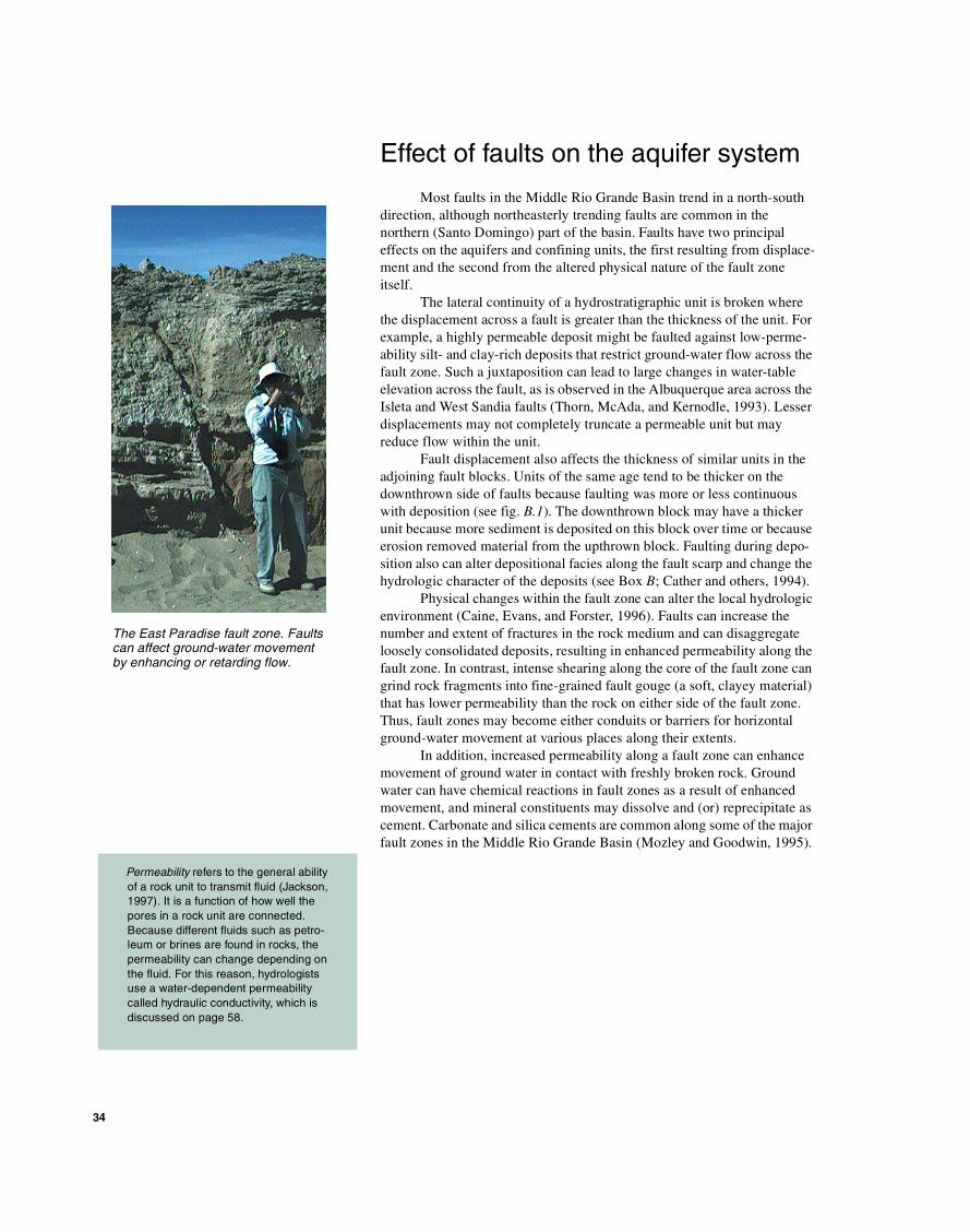
The East Paradise fault zone. Faults can affect ground-water movement by enhancing or retarding flow.
35
Contribution of geophysical data to understanding the aquifer system
Surface outcrops can provide only a general guide to the lithologic and hydrologic characteristics at depth; thus, various geophysical methods are used to gain information about subsurface conditions (see Box D). These methods rely on indirect measurements of rock properties. The most commonly used techniques are based on measurements of density, magne-tization, natural radioactivity, or electrical conductivity. Geophysical data have been collected in the Middle Rio Grande Basin by equipment towed behind aircraft, lowered into deep boreholes, or transported across the land surface.
Density-based techniques, also called gravity methods, are conducted by measuring minor variations in the strength of the Earth’s gravitational force. Local variations in the gravity field primarily reflect variations in the density of rock, sediment, and pore fluids. In the Middle Rio Grande Basin, gravity methods have been especially useful in defining the buried margins of the subbasins and in estimating the thickness of low-density deposits of the aquifer system.
Magnetic methods measure minor differences in the Earth’s magnetic field strength from place to place. Local variations primarily reflect the concentration and type of minor magnetic minerals in different rock and soil materials but in some cases may also reflect an intrinsic magnetic field contained in the rock itself. Some of the most magnetic materials in the Middle Rio Grande region are the ancient granitic and metamorphic rocks that are exposed in the mountain uplifts around the margins of the basin. Most of these materials typically are barriers to ground-water movement. Buried young (Cenozoic age) volcanic rocks throughout the basin are also strongly magnetic. The magnetic data obtained from airborne surveys across much of the study area have been extremely useful in locating these rock units and in identifying faults that offset aquifer units (see Box D).
Earth materials contain minor amounts of naturally occurring radio-active elements, the most common of which are potassium, uranium, and thorium. Sophisticated versions of the Geiger counter can be towed behind an airplane or lowered down a borehole to measure variations in the concentrations of these elements. The borehole tool has been extremely useful in subsurface exploration of aquifer properties because it is sensitive to the potassium content of clay-rich layers and some volcanic materials (see Box C).
Measurements of electrical conductivity rely on sensing differences in the way Earth materials and pore fluids conduct electricity. The methods are varied, but the results can help define important properties of the ground-water system. In the Middle Rio Grande Basin Study, these methods have been most useful in identifying zones or layers rich in clay (good electrical conductor, poor aquifer properties) and zones rich in medium- to coarse-grained sand and gravel (poor electrical conductor, good aquifer properties).
Most people are familiar with the magnetic field of the Earth and its effect on a compass needle. Periodically, however, the Earth’s magnetic field reverses magnetic polarity, which would cause a compass needle to point the opposite direction. As some rocks are deposited (or heated above 870°F and cooled), some iron minerals align with the Earth’s magnetic field, thus preserving the magnetic polarity at the time of deposition or cooling. Because the reversals have not occurred at regular or uniform intervals, a paleo-magnetic history can be used to date a sequence of rocks (Press and Siever, 1986).
A converted Spanish transport plane used for airborne time-domain electromagnetic surveys in the Middle Rio Grande Basin. The wires wrapped around the plane compose the trans-mitting antenna.
36
Modified from Grauch, Gillespie, and Keller (1999)
Belensubbasin
AlbuquerqueAlbuquerqueAlbuquerque
Calabacillassubbasin
SantoDomingosubbasin
0 50 MILES
50 KILOMETERS0
106˚ 15'107˚ 15'
-30
0
-15
15
30
45
Gravity-Anomaly Map
35˚
35˚ 30'
34˚ 30'
MiddleRio GrandeBasin Boundary
MIL
LIG
ALS
Different rock units and the fluids contained in them can be characterized by their physical properties, such as density, magnetization, and electrical resistivity. Geophysicists use indirect methods to measure the differences in under-ground physical properties; these methods pro-vide information about the subsurface without well information (though some well informa-tion is needed for the calibration of geophysi-cal data). For example, measuring the variations in the Earth’s gravity or magnetic field at different places provides information about the density or magnetization of the sub-surface deposits. Measuring the effects of an electric current transmitted through the ground gives clues to the electrical resistivity, a mea-sure of how well or how poorly the subsurface deposits and their fluids conduct electricity.
In the Middle Rio Grande Basin, several dif-ferent geophysical methods were used to determine specific aspects of the subsurface hydrogeology, three of which are listed in table D.1. The gravity geophysical method was used to estimate the total thickness of the Santa Fe Group deposits, which are less dense than the underlying and surrounding bedrock. The mapping provided a base for the geologic model of the Santa Fe Group aquifer system (fig. D.1). Aeromagnetic surveys can detect faults that offset water-bearing units in the Santa Fe Group and can be used to map the extent of buried igneous rocks, which have dif-ferent hydraulic properties than the surround-ing sedimentary deposits (fig. D.2). When correlated with lithologic and geophysical borehole logs, the airborne time-domain elec-tromagnetic method can be used to determine changes in the electrical resistivity of the Santa Fe Group with depth that are related to varia-tions in grain size and hydraulic properties.
How geophysical methods have been used to understandthe subsurface
V.J.S. Grauch,1 Brian D. Rodriguez,1 and Maryla Deszcz-Pan1
D
1U.S. Geological Survey, Denver, Colorado.
Figure D.1.—Gravity data for the entire Middle Rio Grande Basin and surrounding area. The Santa Fe Group has much lower density than the surrounding bedrock, producing low values (shown in blue and purple) on the gravity-anomaly map .
37
Buildings
Watertank
Bridge Pipeline
Pipeline
RioG
rand
e
Aeromagnetic-Anomaly Map
0
–500
–900
500
1,000
1,350
NA
NO
TE
SLA
S
0 5 KILOMETERS
0 5 MILES
Modified from U.S. Geological Survey and Sander Geophysics, Ltd. (1998)
Table D.1.—Brief description of the geophysical methods used and the hydrogeologic features delineated by each
Geophysicalmethod
Geophysicalmeasurement
Associated physical property
Type of geophysical map and units
Hydrogeologic features delineated
Gravity Ground measurements of variations in the Earth’s gravity field
Bulk-rock density Gravity-anomaly map in milligals
Thickness of the Santa Fe Group
Aeromagnetic Airborne measure-ments of variations in the Earth’s magnetic field
Total rock magnetiza-tion
Aeromagnetic anomaly map in nanoTeslas
Faults within the Santa Fe Group and buried igneous rocks
Time-domainelectromagnetic
Airborne monitoring of the time-varying effects of shutting off an electric current induced in the Earth
Electrical resistivity (inverse of electrical conductivity)
Electrical-resistivity maps for different depth slices in ohm-meters
Grain-size variations within the Santa Fe Group
Hydrogeologic Features
EXPLANATION
Exposed igneous rocks
Igneous rocks estimated at 49-foot depth
Igneous rocks estimated at 490-foot depth
Interpreted fault trace
RioG
rand
e
0 5 KILOMETERS
0 5 MILES
Figure D.2.—Aeromagnetic-anomaly map of an area south of Albuquerque (A) and simplified map of important hydro-geologic features (B). Many geologic features and manmade structures can be seen on the anomaly map (A), which is displayed in color and shaded as though it were a relief map illuminated from the east. The most important hydrogeologic features expressed in the aeromagnetic map are faults and igneous rocks, depicted on the simplified map (B). Depths to the buried igneous rocks were estimated by analysis of the aeromagnetic data. Note the shallow, buried igneous rocks near the Rio Grande that probably affect ground-water flow.
A
B
38
In 1996, the USGS, in cooperation with the City of Albuquerque, drilled a 1,560-foot well into the Santa Fe Group aquifer system to obtain information about the conditions within the aquifer at depth and to establish a reference point that could be correlated with other wells. The well is located near the intersection of 98th Street and Interstate Highway 40 immedi-ately west of Albuquerque (see fig. B.1A for a location map). A continuous core collected during drilling provided samples of the undis-turbed sediment that composes the aquifer. A number of studies were performed to charac-terize these continuous-core samples. Other information collected from this well (some of which is described here) allowed reinterpreta-tion of previous work from other wells in the basin and consequently improved the accuracy of the geologic framework.
Geologic characterization of the Santa Fe Group aquifer system within the Middle Rio Grande Basin relies primarily on subsurface information collected from wells. As dis-cussed in Box C, the information obtained from these wells is based chiefly on rock frag-ments recovered during drilling (cuttings), on geophysical logs that measure physical proper-ties of the rock and fluids, and on hydrologic tests to determine aquifer properties. Because core samples are continuous pieces of aquifer material, they allow correlation between the geophysical-log responses and the grain-size and bedding characteristics as well as an improved interpretation of aquifer tests based on detailed knowledge of the variation in these hydrologic properties.
The types of sediments penetrated in the well and two geophysical logs from the borehole are shown in figure E.1 (the lowermost 60 feet of the borehole were not logged or described). Drilling penetrated an upper zone of about 100 feet of gravel and coarse sand that was deposited by high-discharge stream networks
flowing eastward into the valley during the Pliocene Epoch (Connell, Allen, and Hawley, 1998; Stone and others, 1998). This unit has large values of hydraulic con-ductivity and is an important ground-water source farther east where it is saturated beneath Albuquerque.
Beneath this coarse uppermost unit is a zone of about 700 feet of mostly silty fine sand, silt, and clay that were deposited by lower energy drainage systems of the ancestral Rio Puerco and Jemez River (Stone and others, 1998). The bottom part of this zone is conspicuously red and clay rich and is referred to as the Atrisco member of the Santa Fe Group (Connell, Allen, and Hawley, 1998). The Atrisco member appears to be laterally continuous between several wells in the central part of the basin and may restrict ground-water flow because of its low permeability.
The lowermost 700 feet of the 98th Street well is mostly fine- to medium-grained sand with discontinuous layers of pebble gravel, silty clay, coarse sand, and sand-stone (fig. E.1). Like the silty sands above the Atrisco member, these sediments were also interpreted as deposits of east-flowing, low-energy streams.
The specific time of deposition of any of the sediments could not be established because no datable materials were found (for example, volcanic ash or pollen). Detailed measurements of magnetic polarity of the core indicated that most of the lower section was deposited during a period of normal magnetic polarity, although no unique correspondence to normal periods of the Earth’s magnetic polarity time scale could be detected (Hudson and others, 1998). On the basis of several possible correlations with the magnetic polarity time scale, most of the sediment below the uppermost coarse unit probably was deposited in a relatively short span of geologic time, possibly less than a few million years.
Geochemical analyses of core samples and ground water were conducted to deter-mine the occurrence and concentrations of arsenic in Santa Fe Group sediments (Stanton and others, 1998a; 1998b). Core samples from selected depths were pro-cessed to isolate four geochemically different sediment fractions. Analyses of these fractions indicated that most of the arsenic was contained in the iron-oxide fraction of sediment that was probably deposited with clay minerals and silt-sized rock fragments. The most likely sources of these materials are the weathering of natu-rally occurring arsenic-rich volcanic rocks in the Jemez Mountains and Precam-brian crystalline rocks in parts of the Sangre de Cristo Range (north of the Middle Rio Grande Basin in north-central New Mexico). Chemical treatment of some of the core sediment demonstrated that most of the arsenic in the deposits is not solu-ble in ground water of the Santa Fe Group aquifer system. No water sample col-lected from the 98th Street well contained more than 0.042 mg/L of total arsenic, though this isolated value is greater than the 2001 Federal drinking-water standard of 0.010 mg/L of arsenic (Stanton and others, 1998a). (See Chapter 6 for more information on water chemistry in the aquifer system.)
Knowledge gained from the 98th Street well core
Mark R. Stanton1 and James C. Cole1
E
1U.S. Geological Survey, Denver, Colorado.
39
Sand and gravel
Medium sand
Silty fine sand
Clayey, sandy silt
Clay
Sandstone
EXPLANATION
Clay bed
Coarse-sand bed
Pebble-gravel bed
Conductivity
0 100 200 300 400MILLISIEMENS PER
METER
150
Natural gamma
10050AMERICAN PETROLEUM
INSTITUTE UNITS
Sampleintervals
Depth,in feet
200
400
600
800
1,000
1,200
1,400
0
1,500
Modified from Stone and others (1998)
Water table378
Figure E.1.—Lithology and geophysical logs of the 98th Street well.
A USGS drilling rig collecting core at the 98th Street well.
40
Drill hole
Fault scarp
How the geologic model represents current interpretation of basin structure and stratigraphy
The combined geologic and geophysical studies in the Middle Rio Grande Basin over a 6-year period (1995–2001) have produced consider-able new information about the geologic framework of the Santa Fe Group aquifer system. The three-dimensional geologic model that forms the basis of the new ground-water-flow model embodies the major elements of this refined understanding of the Rio Grande Rift and its basin-fill deposits (Cole and others, 1999; Cole, 2001).
Major structural elements of the basin are currently (2002) better known and located than elements used in previous ground-water-flow models. Interpretation of the regional gravity data (see Box D; Heywood, 1992; Grauch, Gillespie, and Keller, 1999) has shown that the major sub-basins are bounded at depth by northwest-trending faults, that the principal basin-bounding fault beneath Albuquerque is very near the Sandia Moun-tains uplift, and that the Belen subbasin is quite complex. These findings improve the preexisting structural framework model of Russell and Snelson (1994), on which the ground-water-flow model of Kernodle, McAda, and Thorn (1995) was based. The new aeromagnetic data provide detailed information about faults that offset aquifer units (see Box D) and allow for more accurate analysis of hydrologic relations among wells in adjacent fault blocks.
The stratigraphy of the basin-fill deposits that compose the aquifer system has always been difficult to define, largely because of the complex relation between rock units resulting from the interplay of faulting, climate, and deposition (see Box B). The current geologic model improves on previous concepts by recognizing that distinct stratigraphic assemblages were deposited over the same time period, but more or less independently, in the three subbasins (Santo Domingo, Calabacillas, and Belen) (fig. 3.2). This new geologic model includes numerous major faults that were identi-fied and precisely located by the mapping and aeromagnetic surveys, and regional information about the thickness of rift-fill sediment based on calculations from the gravity data. In addition, the model accurately portrays laterally discontinuous and wedge-shaped units, particularly for the middle and deeper parts of subbasins where fault activity had the greatest effect on the composition and geometry of the aquifer system.
Perspective view of the southern part of a model of the Middle Rio Grande Basin showing the base of the Santa Fe Group aquifer system. The model was derived from gravity data and constrained by infor-mation for the deep drill holes shown as yellow circles. (Courtesy of V.J.S. Grauch, USGS.)