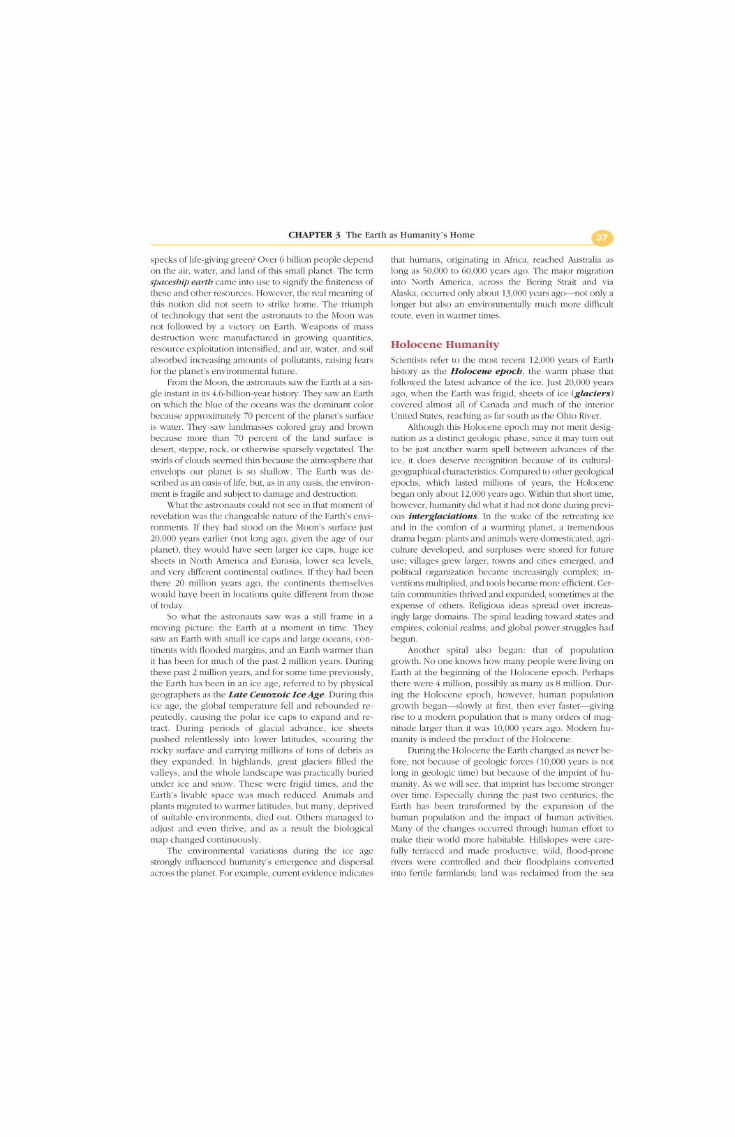
Chapter 3 The Earth as Humanity’s Home 35 From the field notes “Sicily held a special place in both the Greek and the Roman Empires because of its strategic location and agricultural potential. Yet the physical environment must have been an allure as well. How else can one explain the decision by the Greeks to build some of their most majestic temples on this island—including the Temple of Segesta? Set amid the rolling hills of southwestern Sicily, the temple almost seems to grow out of the physical landscape. Gazing through its massive columns to the vista beyond, I feel as if I can sense a synergy between the human and physical worlds, for what makes both the temple and the surrounding hills truly extraordinary is their mutual presence.” 15°E 20°E 40°N 35°N Mediterranean Sea Ionian Sea Tyrrhenian Sea Adriatic Sea Segesta ITALY MACE- DONIA ALBANIA GREECE CROATIA BOSNIA & HERZ. SICILY SERBIA & MONT.
Transcript
Chapter 3The Earth as Humanity’s Home
35
From the field notes
“Sicily held a special place in both the Greek and the Roman Empires
because of its strategic location and agricultural potential. Yet the
physical environment must have been an allure as well. How else can one
explain the decision by the Greeks to build some of their most majestic
temples on this island—including the Temple of Segesta? Set amid the
rolling hills of southwestern Sicily, the temple almost seems to grow out
of the physical landscape. Gazing through its massive columns to the vista
beyond, I feel as if I can sense a synergy between the human and physical
worlds, for what makes both the temple and the surrounding hills truly
extraordinary is their mutual presence.”
15°E 20°E
40°N
35°N
Mediterranean Sea
IonianSea
TyrrhenianSea
Adriatic Sea
Segesta
ITALYMACE-DONIA
ALBANIA
GREECE
CROATIA
BOSNIA& HERZ.
SICILY
SERBIA& MONT.
The study of human geography is a search for an-swers to some of the most fascinating questionsabout humanity, behavior, and environment. What
factors helped to fuel and sustain conflicts between eth-nic groups? How did food supply catch up with popula-tion growth when the threat of mass starvation seemedinescapable? Why are socioeconomic differences so greatfrom place to place—and why are they so intractable?Such questions range from the global to the local, fromnational cultures to village life.
Questions such as these raise a myriad of political,economic, and social issues, but each of them is also tiedin some fundamental way to the environment. Concernsover access to water are of great importance in the con-flict between the Palestinians and the Israelis. The impactof biotechnology on hunger has been so great becausenew hybrid, high-yielding seed varieties are suited to en-vironments in places like India with large concentrationsof people. In countries as diverse as Poland and Indone-sia, regions of environmental devastation are also regionsof acute poverty. All of these examples show that critical
issues in human geography require some understandingof the physical-environmental context in which humanslive. The better we know the physical geography of ourplanet, the better we are able to understand its humanpatterns and processes.
To provide a foundation for such understanding, inChapter 3 our aim is to define some fundamental charac-teristics of the physical stage on which human actiontakes place and to consider some of the most basic wayshumans have interacted with it. Such knowledge willhelp us appreciate the challenges faced by human cul-tures now and in the past, the advantages and obstaclesexperienced by migrants, and the unifying bonds—aswell as the divisive forces—affecting different peoples.We will return in Chapter 33 to a matter that must bekept in mind here: natural environments are not staticbut change over time. Only in recent years have scien-tists become fully aware of the dimensions of thischange. In the process, our understanding of the emer-gence of humanity and the patterns of civilization hasbeen altered. ◆
KEY POINTS
◆ Environmental change is humanity’s con-stant companion and is a key to under-standing the geography of culture.
◆ Plant and animal domestication trans-formed human communities’ ways of lifeand led to the first clustering of significantnumbers of people in villages.
◆ State formation and urbanization trans-formed the world, beginning in the FertileCrescent more than six millennia ago.
◆ The Earth is presently in the grip of a se-ries of ice ages, but humanity is benefiting
from a warm spell that has lasted about12,000 years and has witnessed the forma-tion of complex civilizations.
◆ Global terrain varies from flat plains tohigh and rugged mountains; the varyingterrain forms are still reflected in the dis-tribution of human population.
◆ Global climates range from humid equa-torial to cold polar; humanity’s technologi-cal capabilities notwithstanding, climatecontinues to influence global populationpatterns.
36
◆ THE CHANGING EARTH
From the surface of the Moon, our Earth, as seen by thefirst lunar astronauts, was a pearl of bright colors in ablack sky. Great swirls of white clouds partly veiledblue oceans and brown-gray continents. Emerald-greenpatches of land drew the eye to the oases of life on Earth.The glistening white snows of the polar regions really
did look like ice caps. It was a lesson in geography thatno ordinary Earthling had ever had.
The photographs taken on that lunar mission havebecome commonplace. Again and again we see the Earthfrom space—in books and journals, in advertising, andon television and film. But what about the geography les-son? How well do we remember just how small our Earthreally is, how thin that layer of clouds, how tiny those
specks of life-giving green? Over 6 billion people dependon the air, water, and land of this small planet. The termspaceship earth came into use to signify the finiteness ofthese and other resources. However, the real meaning ofthis notion did not seem to strike home. The triumph of technology that sent the astronauts to the Moon wasnot followed by a victory on Earth. Weapons of mass destruction were manufactured in growing quantities,resource exploitation intensified, and air, water, and soilabsorbed increasing amounts of pollutants, raising fearsfor the planet’s environmental future.
From the Moon, the astronauts saw the Earth at a sin-gle instant in its 4.6-billion-year history. They saw an Earthon which the blue of the oceans was the dominant colorbecause approximately 70 percent of the planet’s surfaceis water. They saw landmasses colored gray and brownbecause more than 70 percent of the land surface isdesert, steppe, rock, or otherwise sparsely vegetated. Theswirls of clouds seemed thin because the atmosphere thatenvelops our planet is so shallow. The Earth was de-scribed as an oasis of life, but, as in any oasis, the environ-ment is fragile and subject to damage and destruction.
What the astronauts could not see in that moment ofrevelation was the changeable nature of the Earth’s envi-ronments. If they had stood on the Moon’s surface just20,000 years earlier (not long ago, given the age of ourplanet), they would have seen larger ice caps, huge icesheets in North America and Eurasia, lower sea levels,and very different continental outlines. If they had beenthere 20 million years ago, the continents themselveswould have been in locations quite different from thoseof today.
So what the astronauts saw was a still frame in amoving picture: the Earth at a moment in time. Theysaw an Earth with small ice caps and large oceans, con-tinents with flooded margins, and an Earth warmer thanit has been for much of the past 2 million years. Duringthese past 2 million years, and for some time previously,the Earth has been in an ice age, referred to by physicalgeographers as the Late Cenozoic Ice Age. During thisice age, the global temperature fell and rebounded re-peatedly, causing the polar ice caps to expand and re-tract. During periods of glacial advance, ice sheetspushed relentlessly into lower latitudes, scouring therocky surface and carrying millions of tons of debris asthey expanded. In highlands, great glaciers filled thevalleys, and the whole landscape was practically buriedunder ice and snow. These were frigid times, and theEarth’s livable space was much reduced. Animals andplants migrated to warmer latitudes, but many, deprivedof suitable environments, died out. Others managed toadjust and even thrive, and as a result the biologicalmap changed continuously.
The environmental variations during the ice agestrongly influenced humanity’s emergence and dispersalacross the planet. For example, current evidence indicates
that humans, originating in Africa, reached Australia aslong as 50,000 to 60,000 years ago. The major migrationinto North America, across the Bering Strait and viaAlaska, occurred only about 13,000 years ago—not only alonger but also an environmentally much more difficultroute, even in warmer times.
Holocene HumanityScientists refer to the most recent 12,000 years of Earthhistory as the Holocene epoch, the warm phase thatfollowed the latest advance of the ice. Just 20,000 yearsago, when the Earth was frigid, sheets of ice (glaciers)covered almost all of Canada and much of the interiorUnited States, reaching as far south as the Ohio River.
Although this Holocene epoch may not merit desig-nation as a distinct geologic phase, since it may turn outto be just another warm spell between advances of theice, it does deserve recognition because of its cultural-geographical characteristics. Compared to other geologicalepochs, which lasted millions of years, the Holocenebegan only about 12,000 years ago. Within that short time,however, humanity did what it had not done during previ-ous interglaciations. In the wake of the retreating iceand in the comfort of a warming planet, a tremendousdrama began: plants and animals were domesticated, agri-culture developed, and surpluses were stored for futureuse; villages grew larger, towns and cities emerged, andpolitical organization became increasingly complex; in-ventions multiplied, and tools became more efficient. Cer-tain communities thrived and expanded, sometimes at theexpense of others. Religious ideas spread over increas-ingly large domains. The spiral leading toward states andempires, colonial realms, and global power struggles hadbegun.
Another spiral also began: that of populationgrowth. No one knows how many people were living onEarth at the beginning of the Holocene epoch. Perhapsthere were 4 million, possibly as many as 8 million. Dur-ing the Holocene epoch, however, human populationgrowth began—slowly at first, then ever faster—givingrise to a modern population that is many orders of mag-nitude larger than it was 10,000 years ago. Modern hu-manity is indeed the product of the Holocene.
During the Holocene the Earth changed as never be-fore, not because of geologic forces (10,000 years is notlong in geologic time) but because of the imprint of hu-manity. As we will see, that imprint has become strongerover time. Especially during the past two centuries, theEarth has been transformed by the expansion of thehuman population and the impact of human activities.Many of the changes occurred through human effort tomake their world more habitable. Hillslopes were care-fully terraced and made productive; wild, flood-pronerivers were controlled and their floodplains convertedinto fertile farmlands; land was reclaimed from the sea
CHAPTER 3 The Earth as Humanity’s Home 37
and made livable. However, the impacts of human-induced environmental change, especially during thetwentieth century, have unfolded at an unprecedentedrate, leading to ever more serious environmental prob-lems. Soil erosion is more severe than ever. Rivers, lakes,and even parts of the oceans are polluted. Gases of manykinds are spewed into the atmosphere. Raw materialssuch as fuels and ores are used up at an ever faster rate.Our need to dispose of wastes (many of them hazardousor poisonous) has led to the contamination of drinkingwater and the fouling of the air we breathe. And as hu-manity and its activities expand, nature recedes. Manyspecies of animals and plants are becoming extinct, andwe may never know what role some of them might haveplayed in sciences such as medicine and plant physiology.
◆ ORGANIZING HUMANITY
After numerous advances and recessions of Late Ceno-zoic Ice, the Holocene warm phase began in much thesame way as preceding periods. Humans of the Pale-olithic period (the earliest and longest stage of theStone Age, marking the period when simple stone toolswere made and fire was used) lived in scattered groupsand depended on hunting and gathering for their sur-vival. As had happened before, the retreat of the ice ex-panded the amount of available living space andwidened the range of environments open to the movingbands. There was plenty of wildlife to be hunted, fish tobe caught, and edible plants and fruits to be gathered.There is evidence that goods (such as cured animal skinsfor clothing, flint, and obsidian weapons and tools) weretraded. Nevertheless, a map of the human population of12,000 years ago would show mostly small, isolatedgroups of people numbering perhaps 20 to 60 members,their cultures diverging as a result of contrasting ecologi-cal settings.
Although survival was the principal objective ofthose hunting-and-gathering communities, there wastime for other things. From the cave-wall paintings of Eu-ropean Paleolithic groups, we have learned how andwhat they hunted, what kinds of weapons they used,and other aspects of their culture. In addition to art, therewere local developments in language, religion, and cus-toms (such as burial of the dead). Recent research showsthat hunting (sometimes accompanied by burning ofgrassland or forest to drive herds toward the hunters)often went far beyond what the community needed, de-stroying many forest animals and altering the vegetationof plains. Something akin to the destruction of the pre-sent Amazon rainforest occurred as more numerous andefficient hunters exterminated entire species of animalsin northern America, Eurasia, and Africa.
When the global warming began that drove backthe glaciers that covered much of North America 18,000years ago, there was little to foreshadow the momentous
events soon to come. Humans still were living in smallnumbers from hunting and gathering; their control of firehad begun to have major impact on regional ecologies,but ecological change still was caused mainly by naturalforces. Anthropologists report that some hunter-gatherergroups probably had started using plants in new ways.The notion that useful or sacred plants could be pro-tected by pulling weeds away from them added a newdimension to food production. But since a patch of food-producing plants could not move with a migrating band,the idea of plant care is likely to have taken hold aroundstable, long-term settlements assured of a dependablesupply of food from other sources.
Domestication of PlantsSimply caring for plants that yield desired products is notthe same as plant domestication and organized,planned farming, but it was an important step in that di-rection. Human groups lived in widely diverse environ-ments, and they learned to exploit them in diverse ways.The domestication of root crops, plants that grow as tu-bers in the tropics (such as manioc or cassava, yams, andsweet potatoes), is not the same as the sowing of seedfor fields of barley or wheat under more temperate envi-ronments. So the domestication of plants took differentpaths in different places at different times—but this wasa process unique to the Holocene; it was to transformpatterns of human livelihood.
Where did plant domestication begin? Cultural geo-grapher Carl Sauer, who spent a lifetime studying culturalorigins and diffusion, suggested that southeastern Asiamay have been the scene, more than 14,000 years ago, ofthe first domestication of tropical plants (Fig. 3-1). There,he believed, the combination of human settlements, forestmargins, and freshwater streams may have given rise tothe earliest planned cultivation of root crops (i.e., cropsthat are reproduced by cultivating either the roots or cut-tings from the plants). A similar but later developmentmay have taken place in northwestern South America.
The planned cultivation of seed plants (plants thatare reproduced by cultivating seeds) is a more complexprocess, involving seed selection, sowing, watering, andwell-timed harvesting. Again, the practice seems to havedeveloped in more than one area and at different times.Some scholars believe that the first domestication ofseed plants may have occurred in the Nile River Valley inNorth Africa, but the majority view is that this crucial de-velopment took place in a region of southwestern Asia,through which flow the two major rivers of present-dayIraq: the Tigris and the Euphrates. This marked the be-ginning of what has been called the First AgriculturalRevolution, and the area where it occurred is known asthe Fertile Crescent. The grain crops, wheat and bar-ley, grew in the warming Southwest Asian climate. Whenrainfall diminished as the interglaciation wore on, theriver-inundated plains of Mesopotamia provided alter-
Part One Geography, Culture, and Environment38
nate, irrigable fields for farming (Fig. 3-2). Food surplusescould now be stored for long-term distribution and use.
Domestication of AnimalsThe domestication of animals appears to have takenplace during the same period, also in different ways anddifferent areas and times. As with the growing of rootcrops, the notion of animal domestication must haveemerged quite naturally. Hungry animals foragedthrough garbage near human settlements; orphanedyoung probably were adopted as pets; some wild animalswere docile and easily penned up. Goats were domesti-cated in the Zagros Mountains as long as 10,000 yearsago; sheep some 9500 years ago in Anatolia (Turkey);pigs and cattle shortly thereafter. The advantages of ani-mal domestication—their use as beasts of burden, as asource of meat, and as providers of milk—stimulated therapid diffusion of this idea throughout the inhabitedworld and gave the sedentary farmers of southwesternAsia and elsewhere a new measure of security. Again, anidea that was probably not totally new to the Holocenetook on revolutionary form in the present epoch.
Early Settlements and NetworksThe domestication of plants and animals allowed hu-mans to live in stable, permanent settlements for the firsttime in human history. About 10,000 years ago, a net-work of farm villages appeared across the area betweenthe Mediterranean Sea, the Persian Gulf, the CaspianSea, and the Black Sea. These villages were not large bymodern standards, but they contained hundreds of
Figure 3-1 Hearths of Early Plant Domestication. Areas of earliest plant domestication,as postulated by C. O. Sauer. Source: J. E. Spencer & W. L. Thomas, Introducing Cultural Geog-raphy. New York: Wiley, 1973, p. 67.
From the field notes
“Our ideas about early civilizations are so oftenshaped by the great monuments and tombs that are left be-hind. Yet here in Deir el-Medina (Egypt) I gain a glimpse intothe ordinary lives that lie behind the more visible symbols ofthe Ancient world. These are the remains of the stone andmud-brick houses occupied by those who helped to buildthe great temples of Ancient Egypt’s civilization. A societycannot support the occupational specialization implied bythe existence of such “worker’s villages” if it is not prosper-ous and well organized. Egypt had obviously achieved thatposition when Deir el-Medina was built—over 3500 yearsago.”
inhabitants rather than the dozens that were typical ofnomadic hunter-gatherer settlements.
The implications of this transformation were far-reaching. Some of the people in the farm villages werenonfarmers who performed other work, including notonly activities directly related to farming (toolmaking,bagging, transport) but also teaching, administration,and policing. Thus a set of social strata or layers, termedsocial stratification, developed. People found them-selves on different rungs on a social ladder. At the topwere those with prestige, influence, and power (theelite). Below them were the lower classes engaged inproduction and provision.
Conflict and competition also arose. Some villageshad more productive lands; others were less fortunate.Stronger villages took control over weaker ones, andsome became regional centers. The transition from vil-lage to city was under way.
Just what stimulated the rise of cities in SouthwestAsia is not yet certain. It may have been a combination ofcircumstances: prospering regional centers, strong mili-tias, the strength of numbers, and the rise of larger scale,well-organized religious orders. Possibly the role of irri-gation was crucial because towns that controlled irriga-tion works could deny their competitors access to water.Perhaps some villages grew stronger and larger becausetechnological inventions enhanced their productivityand power. Some geographers believe that the rise ofcertain cities (and the decline of other places) was re-lated to continuing climatic change. For example, whenthe region’s rainfall declined, the Fertile Crescent’s townslocated on the slopes, far from controllable river water,were at a disadvantage relative to those towns in theriver basins. Whatever the cause(s), urbanization hadbegun and would eventually affect all of humanityeverywhere on the Earth.
Part One Geography, Culture, and Environment40
Black Sea
0
0 500250 750 Kilometers
250 500 Miles
40°
30°
50°40°30°
30°
40°30° 50°
40°
T H E F E R T I L E C R E S C E N TA N D T H E N I L E V A L L E Y
Memphis
Thebes
Persepolis
Susa
Ur
Babylon
Assur
SidonTyre
Jerusalem
Hattusas
ELAM3000-640 B.C.
SUMER3200-1950 B.C.
BABYLON1900-539 B.C.
ASSYRIA2000-600 B.C.
HITTITES1600-1200 B.C.
SYRIA
PALESTINE
EGYPT3000-343 B.C.
UPPEREGYPT
LOWER
EGYPT
A R A B I A
M E D I A
U R A R T U
A S I AM I N O R
URUK3500 B.C.
Sinai
SyrianDesert
LibyanDesert
Zag ro sM
oun ta i n s
Fe r t i l e C rescen t
Mediterranean Sea
Red
Sea
Persian Gulf
Caspian
Sea
�
�
�
�
�
�
�
�
�
�
�
M E S O P O T AM
I A
Nile
R
.
TigrisR.
Euphrates R.
Figure 3-2 The Fertile Crescent. The Fertile Crescent and ancient states (in different col-ors) of Mesopotamia and adjacent areas, and of the Nile Valley. Modern political boundaries areshown for reference.
Although there is little doubt that the developmentof sedentary and irrigated agriculture and the rise of vil-lages and towns initially occurred in Southwest Asia, weshould remember that the dispersal of humans into otherregions had already taken place. During the period fromabout 10,000 to 5000 years ago, important advanceswere being made in those regions as well as in the FertileCrescent. In Africa, the Nile River Valley was a ribbon ofagriculture. Rice-farming villages arose in Southeast Asia.And in China, momentous developments were occurringin the basins of the Chang (Yangtzi) and the Yellow(Huang) rivers, where rice and millet farmers suppliedvillages in networks not unlike those of Southwest Asia.On the North China Plain, the Shang Dynasty emerged,with its capital at Anyang and its core area in the conflu-ence of the Huang and Wei rivers (Fig. 3-3). Whetherthese were independent innovations or the consequenceof the diffusion of ideas from Southwest Asia remains anopen question.
Early Cities and StatesEven after the development of the first villages, it wouldnot yet have been possible to draw a map of the next stage
of regional organization: the state. There were networks offarm settlements and established trade routes; fields andpastures marked the countryside; and some villages weregrowing larger. But political states, with capitals andboundaries and military forces, had not yet developed.
This next stage of human organization was not longin coming. The cities of the Fertile Crescent in particularbecame centers of political power, economic strength,and religious dominance. Indeed, Babylon was one of the largest and most powerful cities of antiquity—controlling a significant domain in Mesopotamia. Situatedon the Euphrates River in present-day Iraq, Babylon en-dured for nearly 2000 years (from 4100 B.P.) as a walled,fortified center endowed with temples, towers, palaces,river docks, and a stone bridge. Rising above the town-scape was the tallest structure in Mesopotamia at thetime: the Ziggurat, or tower of the great temple. With abase of 90 m (300 ft), and rising in seven levels morethan 90 m above the plain, this magnificent tower was asymbol of power that could be seen for miles around.Outside the town’s fortified walls lay irrigated fields andan artificial, terraced hill built and planted over an elabo-rate vaulted foundation. When the Greeks under Alexan-der the Great conquered Babylon in 331 B.C., they called
CHAPTER 3 The Earth as Humanity’s Home 41
E a s t
C h i n a
S e a
Yellow
Sea
Sea
of
Japan
Huang River
Wei River
Cha
ng
Rive
r
C H I N A
M O N G O L I A
R U S S I A
NORTHKOREA
JAPAN
TA IWAN
Anyang�
SOUTHKOREA
RUSSIA
SHANG DYNASTYCHINA
Shang core area:Concentration of Shang-period archeological sites 0
0 500250 750 Kilometers
250 500 Miles
Figure 3-3 Shang Dynasty in China.The geographical origins of what may bethe world’s oldest continuous civilization.
these “Hanging Gardens” one of the Seven Wonders ofthe World.
Although scholars are not in complete agreement onthe subject, clearly a relationship exists between the riseof powerful cities such as Babylon and the emergence oflarge and durable states. We will discuss the character ofancient cities in Part Seven, but it is worth noting herethat momentous political and geographic developmentsfollowed the emergence of large cities.
The Sumerian state arose in the lower reaches ofMesopotamia at about the same time that Egypt was uni-fied politically for the first time (Fig. 3-2). The state ofUruk developed on the southwestern slopes of the ZagrosMountains in what is now Iran. These states arose be-tween 6000 and 5000 years ago, soon to be followed byBabylon (north of Sumer) and Assyria (a state in theTigris Valley). Later the Hittites forged a state in Anatolia,but by then Southwest Asia no longer had a monopolyover the development of states. Large states had arisen inthe Indus Valley (in present-day Pakistan) and China,and the stage was set for the rise of Greece and Rome.
As we know, not only urban life but also the idea ofthe state spread throughout the world. Today, as a re-sult, the planet’s living space is compartmentalized into
over 200 states, dependencies, and other bounded terri-tories. From a comparatively small number of migratinghunter-gatherer groups that represented the most com-plex spatial-organizational system on Earth just 12,000years ago, we have reached a point where theirs is nowthe simplest form, represented by a few surviving hunter-gatherer groups like the San of Botswana’s KalahariDesert.
◆ IMPRINTS OF HUMANORGANIZATION
Time and again over the past million years, deglacia-tion was followed by sustained interglaciation, and dur-ing the warm interglaciations our hominid ancestorsspread far and wide. They left their imprint on the land-scape: they burned forests, killed wildlife, built encamp-ments, inhabited caves, and in some instances buriedtheir dead. Their bone and stone tools are found at fossilsites, sometimes in large quantities. But until about12,000 years ago, when the present interglaciationbegan, our ancestors had left only the slightest imprinton the Earth as a whole.
Why Is the Holocene Different?The Holocene began with little indication that this inter-glaciation would be different. Perhaps this was so be-cause for the first time humans living in more or less sta-ble communities had to adapt to changing environmentsin particular settings. People were living, for example, inthe tundras and grasslands of northern Europe, follow-ing migratory herds and killing animals for meat when-ever they needed it. But the warming climate caused thetundras and grasslands to shift to the north, and forestsof pine, oak, and birch developed in their place. Somehuman groups moved northward, but others adapted tothis new environment in which hunting was more diffi-cult. Those who stayed behind learned to make newweapons that were better suited to hunting in thewoods. Their fossil teeth indicate that they also changedtheir diets. They collected wild grains, caught fish, andgathered mollusks. Importantly, they began to fashionbetter stone axes and were able to cut down trees. Nowthey could build log houses and hollow out trees tomake canoes. Their settlements took on the look of permanence.
Even then, however, toward the end of the Meso-lithic, there was no indication of what lay ahead. Had theHolocene interglaciation come to a close, there wouldhave been little to differentiate it from previous warmphases. Human communities remained small, and moststill were migratory.
Human populations also remained very small. Be-cause the data can be interpreted in different ways, thereis no consensus on this subject. But around the begin-
Part One Geography, Culture, and Environment42
From the field notes
“When the Ancient Romans built their empire inNorth Africa, they could visit the Giza pyramids (on the out-skirts of present-day Cairo) and gaze upon monuments that,for them, were older than the Ancient Roman ruins are forus. When one stops to reflect that the first of the Giza pyra-mids rose from the Saharan sands more than 2500 years be-fore Julius Caesar led the Roman armies into battle, onegains some perspective on just how old the Egyptian civiliza-tion really is. Yes, the development of cities and states hashappened only in the most recent period of humanity’s timeon earth, but the story still has deep roots in human history.”
ning of the Neolithic, some 10,000 years ago, when ani-mal and plant domestication commenced, the totalhuman population was almost certainly below 6 million.Although they had spread far and wide, humans occu-pied but a tiny fraction of the Earth’s surface.
And yet the world has been transformed during theHolocene epoch. Several theories have been proposedto explain why the transformation occurred this time.After all, humans had been confronted by environmentalchange during previous interglaciations as well, andnothing comparable had happened. In truth, there still isno satisfactory answer. Some historical geographers sug-gest that this enormous change was the result of compar-atively rapid population growth in the Middle East,which pushed people into less hospitable regions wheretheir knowledge of agriculture helped them to adapt.Adaptation led to the domestication of animals andplants, and this set in motion the First Agricultural Revo-lution. It is true that population differences stand outwhen we try to identify ways in which the earlyHolocene differed from the previous interglaciation.Homo sapiens was not nearly as numerous, nor aswidely dispersed, during the previous warm phase.
In other areas population numbers were substantial,and yet no revolutionary changes occurred there. Thespecial combination of conditions that was to propel theworld into its modern age seems to have existed in onlya few places.
How Did Holocene Humanity Transform the Earth?Let us consider the human imprint on the Earth duringthe Holocene. We will look at several major areas, al-though of course we could mention many others.
Farming The First Agricultural Revolution has been fol-lowed by two more, one organizational and the other(still in progress) the product of biotechnology. Entireregions of the Earth have been plowed, terraced, fenced,and covered with crops; huge herds of livestock grazeon fields from Tierra del Fuego to Finland. No human ac-tivity transforms as much of the Earth’s surface as farm-ing does.
Administration The world has been compartmental-ized into more than 200 countries and other entities,heirs to the state idea that first arose about 5500 yearsago. The imprint of the modern state is complex and in-cludes its capital city, its provincial or other subsidiarycapitals, its heartland or core area, and its boundaries—the last often marked by walls, fences, or posts.
Urbanization In a matter of centuries, urban dwellers,rather than villagers, have become the majority of theworld population. The earliest cities, established less
than 6000 years ago, had successors (such as Babylon,Damascus, and Athens) that anchored growing civiliza-tions, but until the twentieth century they were relativelyrare. Today many cities house more people than entirenations. Nothing symbolizes Holocene humanity asmuch as the great cities of the present day.
Capitalism Societies have long engaged in the ex-change of goods and services. In late medieval Europe,however, the foundations were laid for a competitiveeconomic system in which goods and services were as-signed a monetary value and in which those with thegreatest wealth in land, goods, and money (capital)could exert the greatest influence over the exchangeprocess. The resulting concentrations of wealth and in-vestment fueled the rise of a global system of productionand exchange that, together with industrialization (seethe next subsection), promoted an enormous expansionin production and consumption with significant environ-mental impacts. Other economic systems have fosteredsignificant environmental change as well (e.g., commu-nism as practiced in the former Soviet Union and China),but taking a broad historical and geographical view, cap-italism’s impact is of particular note because of its longhistory and global reach.
Industrialization Even in the context of the Holocene,industrialization as we know it is a late development. Industries existed 6000 years ago, and they spreadthroughout the world. “Preindustrial” India and Japanhad major complexes of workshops that producedgoods ranging from textiles to ceramics. The IndustrialRevolution occurred little more than two centuries ago;but it transformed manufacturing and vastly expandedthe demand for natural resources. From the great indus-trial complexes to the slag heaps at the mines, the impactof industrialization is etched in the landscape.
Transportation and Communication Another symbolof humanity’s imprint is the global network of transporta-tion and communication routes and lines crisscrossingthe Earth’s surface. Railroads, highways, ports, pipelines,airfields, power lines, and other signs of the transporta-tion age bear witness to modern civilization; not even anew glaciation could erase all of this evidence.
Population Cutting across all of the preceding develop-ments is the almost unimaginable expansion of thehuman population during the Holocene, especially in re-cent centuries. Every month, more people are added tothe world population than existed on the entire planet atthe beginning of the Holocene. From 6 million the popu-lation has grown to 6 billion, a thousandfold increase,most of which has taken place in less than two centuries.In Part Two we begin our geographic look at the modernworld by turning our attention to population.
CHAPTER 3 The Earth as Humanity’s Home 43
◆ THE CONTEMPORARYPHYSICAL FRAMEWORK
To understand both how humans live in the environ-ment and how they are transforming it, some basic famil-iarity with the world’s contemporary physical geo-graphic organization is needed. Two important mapspresented in the following section provide critical in-sights into the habitable space of our planet.
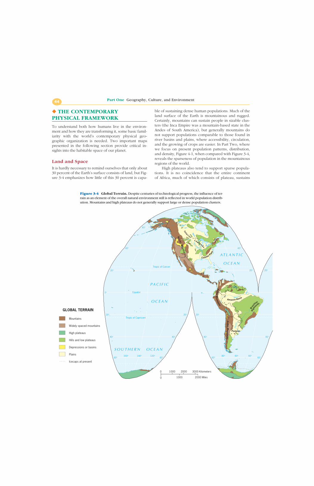
Land and SpaceIt is hardly necessary to remind ourselves that only about30 percent of the Earth’s surface consists of land, but Fig-ure 3-4 emphasizes how little of this 30 percent is capa-
ble of sustaining dense human populations. Much of theland surface of the Earth is mountainous and rugged.Certainly, mountains can sustain people in sizable clus-ters (the Inca Empire was a mountain-based state in theAndes of South America), but generally mountains donot support populations comparable to those found inriver basins and plains, where accessibility, circulation,and the growing of crops are easier. In Part Two, wherewe focus on present population patterns, distribution,and density, Figure 4-1, when compared with Figure 3-4,reveals the sparseness of population in the mountainousregions of the world.
High plateaus also tend to support sparse popula-tions. It is no coincidence that the entire continent of Africa, much of which consists of plateau, sustains
Part One Geography, Culture, and Environment44
GLOBAL TERRAIN
Mountains
Widely spaced mountains
High plateaus
Hills and low plateaus
Depressions or basins
Plains
Icecaps at present
Tropic of Cancer
Equator
Tropic of Capricorn
P A C I F I C
O C E A N
AT L A N T I C
O C E A N
Yukon R.
Missouri
Mississippi
Ro
ck
yM
ou
nt a
i ns
I n t e r i o rL o w l a n ds
Coastal Plain
Amazon Basin
Andes
Mountains
Hig
hlan
ds
Braz
ilian
And
esM
ountains
Pampas
Amazon
0
0 20001000 3000 Kilometers
1000 2000 Miles
S O U T H E R N O C E A N
Para
ná
60°
40°40°
20°20°20°
0°
20° 20° 20°
40°
60°
40°
60°
40°
60°
40°
60°160° 140° 120° 80° 60° 40°
Figure 3-4 Global Terrain. Despite centuries of technological progress, the influence of ter-rain as an element of the overall natural environment still is reflected in world population distrib-ution. Mountains and high plateaus do not generally support large or dense population clusters.
fewer people than the single country of India. The ele-vation of high plateaus like that of Tibet makes livingconditions difficult. Severe erosion can create prob-lems similar to those presented by mountainous ter-rain. Again, the high-plateau regions stand out as low-population areas.
Land and ClimateIn combination, all the elements of weather, the sweep ofthe Sun’s energy, the rotation of the Earth, the circulationof the oceans, the movement of weather systems, and therush of air in jet stream produce a pattern of climates thatis represented in Figure 3-5. We owe this remarkablemap to the work of Wladimir Köppen (1846–1940), whodevised a scheme for classifying the world’s climates onthe basis of temperature and precipitation.
Köppen’s map displays the present distribution of climatic regions across the planet. The legendlooks complicated, but it really is not; here is one ofthose maps worth spending some time on. For ourpurposes, it is enough to get a sense of the distributionof the major types of climate. The letter categories inthe legend give a clear indication of the conditionsthey represent.
The (A) climates are hot or very warm and generallyhumid. The “no dry season” (Af) regions are equatorialrainforest regions. The “short dry season” (Am) climateis known as the monsoon climate. And if you can envis-age an African savanna, you know what the (Aw, sa-vanna) designation means.
Once you realize that the yellow and light browncolors on the map represent dry climates (BW, desertand BS, steppe), it becomes clear how much of the
CHAPTER 3 The Earth as Humanity’s Home 45
Niger
Nile
Zambezi
S a h a r a
Nor
thEuropean Lowland
Alps
Ural Mts.
WestSiberia
Lowland
GreatCentral
Plateau
Himalayas
Ob
Volga
Lena
Huang HeChang Jiang
Mekong
WesternPlateau
Great
Div
idin
gRa
nge
Congo
S O U T H E R N O C E A N
Tropic of Cancer
Arctic Circle
Equator
Tropic of Capricorn
Antarctic Circle
AT L A N T I C
O C E A N
I N D I A N
O C E A N
P A C I F I C
O C E A N
60° 60°
40°40°
20°
0°
20° 20° 20° 20° 20°
40°
60°
40°
60°
40°
60° 60°0° 20° 40° 60° 100° 120° 140° 160°
world is always in need of water. As we will see later,some very large population clusters have developed inthese water-deficient regions, especially at lower (andwarmer) latitudes. The world faces a long-term watercrisis, and the Köppen map helps explain why.
The (C) climates also have familiar names. The (Cf)climate, represented by dark green, prevails over thesoutheastern United States. If you know the localweather in Atlanta or Nashville or Jacksonville, you un-derstand why this climate is often called “humid temper-ate.” It is moist, and it does not get as cold as it does inCanada or as warm (continuously, anyway) as in theAmazon Basin. If you have experienced this kind of cli-mate, the map gives you a good idea of what it’s like in
much of eastern China, southeastern Australia, and alarge part of southeastern South America.
The “dry summer” (C) climates are known asMediterranean climates (the small s in Cs means thatsummers are dry). This mild climate occurs not onlyaround the Mediterranean Sea, and thus in the famouswine countries of France, Italy, and Spain, but also inCalifornia, Chile, South Africa’s Cape, and southern partsof Australia. So you know what kind of weather to ex-pect in Rome, San Francisco, Santiago, Cape Town, andAdelaide.
Farther toward the poles, the planet gets rather cold.Note that the (D) climates dominate in the United States’upper Midwest and Canada, but it gets even colder in
Figure 3-5 World Climates. The Köppen map of world climates as modified by R.Geiger.These, of course, are macroclimatic regions; microclimates are set within these but cannot beshown at this scale.
Siberia. The “milder” (Da) climates (here the key is thesmall a, which denotes a warm summer) have a very lim-ited extent in Eurasia. Winters are very cold in all the (D)climates and downright frigid (and long) in the (Dfb)and (Dfc) regions. The latter merge into the polar cli-mates, where tundra and ice prevail.
The climate map, like the landscape map, reflectsthe limited habitable areas of the Earth. Vast portions ofthe planet’s landmasses are extremely arid or frigid orexcessively hot and humid and therefore cannot sustainlarge populations that depend directly on the land fortheir sustenance. And despite technological advances,hundreds of millions of people still live off the land.
Figure 3-5 is a still photo of a changing pattern.When pre-Holocene conditions prevailed, the habit-able zone of the Earth was much narrower, and polar
(E) climates reached as far south as the central GreatPlains and the Alpine slopes of southern Europe.Today the Earth is much warmer, but it will not remainwarm forever. Eventually the Köppen map will lookquite different.
The two world maps presented here provide a goodportrait of the physical stage on which the events de-scribed in the rest of this book take place. For example,we will discuss places like Nigeria (Africa’s most popu-lous country) and Quebec (the Canadian provincewhere separatism is a popular sentiment). From thesemaps we can deduce basic aspects of the terrain, the cli-mate, and the precipitation in those places, and thus ob-tain some notion of what their environments are like.Such information can be useful in understanding muchthat follows in this book.
CHAPTER 3 The Earth as Humanity’s Home 47
E
CsbCfb
Cfa
CwbBSkBWh
BSh
Cwa
Cwa
BWh
BSh
Aw
Aw
Af
AwBSh
Aw
AfAmH
H
BSh
BWh
BSh
Aw
H
AwAm
BSh
BWh
HBSh
CsaCsa
BWh
H
H
Csa
CsaCsa
CsbBSk
Cfb
Cfb
Cfc
Cfc
Cfb
H HCfa
Cfa
BSk
Dfc
E
Dfb
DfaBSk
BSk
Dfc
E
Dfb
H
CfaBWk
BSk
BSh BSk BWh
BSh
H
H
Cwa
CwaBSh Aw
Aw
Af
BWk
H
Aw
Am
Dwc
DfdDwd Dfd
DfcE EE
Dwb
Dfc
DfbDwaDwb
Dwb
BSk
Cfa
Cfa
Cwa
CwaCfa
Am
Aw
Am
Af
AwAm
Af
AfH
Am
Af
H
AfAf
HAf
AwAw
Aw
AwAm
Aw
Af
Af
BShBSh
BWh
CwaBSh
BShBSk
Csa
CsbCsb
Csa Cfb
Cfb
Cfa
Cfb
H
Am
E E
S O U T H E R N O C E A N
ATLANTIC
OCEAN
AT L A N T I C
O C E A N
P A C I F I C
O C E A N
I N D I A N
O C E A N
Tropic of Cancer
Arctic Circle
Equator
Tropic of Capricorn
Antarctic Circle
60° 60°
40°40°
20°
0°
20° 20° 20° 20° 20°
40°
60°
40°
60°
40°
60° 60°0° 20° 40° 60° 100° 120° 140° 160°
Part One Geography, Culture, and Environment48
From the field notes
“After driving for hours though the open expansesof the southern Sinai peninsula, I come to a little oasis in theform of the Christian Monastery of St. Catherine. Erected onwhat was believed to be the site of the Burning Bush whereGod revealed himself to Moses, the monastery has been apresence in the Sinai since the sixth-century. Relying on pe-riodic flows of water through a wadi (watercourse), as wellas what could be made and traded with surrounding no-madic peoples, the monks of the monastery eked out an ex-istence. The threat of attack led to the building of massivegranite walls 40 to 200 feet tall. This is clearly a challengingsite for human occupance, yet the monastery’s longstandingvitality is a clear testament to human tenacity in the face ofdifficult environmental circumstances.”
1. A company that wants to test an engine for an all-terrain vehicle in those settings has asked you to writea report on the climatic conditions prevailing in theworld’s low-relief plains. Use Figures 3-4 and 3-5 toestablish the environmental setting.
2. You have been offered the opportunity to lead a tourgroup consisting of travelers from North America to
New Zealand and Australia. How will you use Figure3-5 to answer questions about the climate andweather in those countries? If your guests resided inVancouver, British Columbia, where would they finda familiar environment “downunder?” in Phoenix, Ari-zona? Jacksonville, Florida? San Francisco, California?
glacierglobal warmingHolocene epochinterglaciationLate Cenozoic Ice Age
Part OneGEOGRAPHY, CULTURE,
AND THE ENVIRONMENT
At Issue: Revisited
Why is geography so much a part of the effort tocome to terms with our rapidly changing world?What does it mean to think geographically? Cangeography offer insights into the diversity of
changes unfolding around us? The developments of the past decade have shown that we live in a world ofconstant change—a world that defies easy generalization.Differences from place to place matter, and no one map
can capture the dynamism of our situation. At the sametime, the practice of separating the study of physical andhuman phenomena seems increasingly problematic. Smallwonder, then, that geography is being looked to for ideasand approaches. As one geographer put it, place matters—
as does the relationship among phenomena in place andspace. The concepts and tools of geography are thus anindispensable part of our effort to come to terms with theworld around us.
CHAPTER 3 The Earth as Humanity’s Home 49
◆ SELECTED REFERENCES ◆Part One Geography, Culture, and the Environment
Abler, R., et al., eds. Human Geography in a Shrinking World. NorthScituate, Mass.: Duxbury Press, 1975.
Allen, J., & Massey, D., eds. Geographical Worlds. Oxford, U.K.: Ox-ford University Press, 1995.
Amedeo, D., & Golledge, R. An Introduction to Scientific Reasoningin Geography. New York: John Wiley & Sons, 1975.
Bailey, R., ed. The True State of the Planet. New York: The FreePress, 1995.
Brown, L. A. Innovation Diffusion: A New Perspective. New York:Methuen, 1981.
Buttimer, A. Geography and the Human Spirit. Baltimore: JohnsHopkins University Press, 1993.
Campbell, B. G. & Loy, J. D., eds. Humankind Emerging. 8th rev. ed.Boston: Longman, 2000.
Campbell, J. Map Use and Analysis. Dubuque, Iowa: Wm. C. Brown,1991.
Chrisman, N. R. Exploring Geographic Information Systems. NewYork: John Wiley & Sons, 2002.
Cloke, Paul, Crang, P., & Goodwin, M. Introducing Human Geo-graphies. New York: Oxford, 1999.
Cox, C. B., & Moore, P. D. Biogeography: An Ecological and Evolu-tionary Approach. 6th ed. Oxford, U.K.: Blackwell Scientific Publi-cations, 2000.
Crang, M. Cultural Geography. New York: Routledge, 1998.
de Blij, H. J., & Muller, P. O. Geography: Realms, Regions and Con-cepts. 10th rev. ed. New York: John Wiley & Sons, 2002.
Dent, B. Principles of Thematic Map Design. Reading, Mass.: Addi-son-Wesley, 1984.
Ember, C. R., & Ember, M. E. Cultural Anthropology. 6th rev. ed. Englewood Cliffs, N.J.: Prentice-Hall, 1990.
Espenshade, E. B., Jr., ed. Goode’s World Atlas. 20th rev. ed. Chicago:Rand McNally, 2000.
Gaile, G. L., & Willmott, C. J., eds. Geography in America. Colum-bus, Ohio: Merrill, 1989.
Geertz, C. The Interpretation of Cultures. New York: Basic Books,1973.
Gibbons, A. “First Hominid Finds from Ethiopia in a Decade.” Science, 22 March 1991, p. 1428.
Gold, J. An Introduction to Behavioral Geography. New York: Oxford University Press, 1980.
Gould, P. The Geographer at Work. London: Routledge & KeganPaul, 1985.
Gould, P., & White, R. Mental Maps. 2nd rev. ed. Boston: Allen &Unwin, 1992.
Graedel, T. E., & Crutzen, P. J. Atmosphere, Climate and Change.New York: Scientific American Library, 1995.
Gregory, D. Ideology, Science and Human Geography. London:Hutchinson, 1978.
Gregory, D., & Walford, R., eds. Horizons in Human Geography.Totowa, N.J.: Barnes & Noble Books, 1989.
Grove, J. M. The Little Ice Age. London: Methuen, 1988.
Harris, C. D., ed. A Geographical Bibliography for American Li-braries. Washington, D.C.: Association of American Geographersand the National Geographic Society, 1985.
Hartshorne, R. The Nature of Geography. Washington, D.C.: Associa-tion of American Geographers, 1939.
Hartshorne, R. Perspective on the Nature of Geography. Chicago:Rand McNally, 1959.
Holz, R., ed. The Surveillant Science: Remote Sensing of the Environ-ment, 2nd rev. ed. New York: John Wiley & Sons, 1985.
Houghton, J. T., Ding, Y., Griggs, D.J., Noguer, M., van der Linden P.J. & Xiaosu, D., eds. Climate Change 2001: The Scientific BasisContribution of Working Group I to the Third Assessment Report ofthe Intergovernmental Panel on Climate Change (IPCC). Cam-bridge: Cambridge University Press, UK, 2001, p. 944.
Huntington, E., and Cushing, S.W., Principles of Human Geography,5th ed. New York: John Wiley & Sons, 1940.
Jackson, P. Maps of Meaning. London: Unwin Hyman, 1989.
James, P. E., & Jones, C. F., eds. American Geography: Inventoryand Prospect. Syracuse, N.Y.: Syracuse University Press, 1954.
James, P. E., & Martin, G. All Possible Worlds: A History of Geo-graphical Ideas, 3rd rev. ed. New York: John Wiley & Sons, 1993.
Johnston, R. J. Geography and Geographers: Anglo-AmericanHuman Geography since 1945. 5th ed. London; New York: Arnold,1997.
Johnston, R. J. On Human Geography. Oxford, New York: Black-well, 1986.
Johnston, R. J., et al., eds.; Smith, D. M., consultant editor. The Dic-tionary of Human Geography. 4th ed. Oxford, U.K.: Malden, Mass.Blackwell Publishers, 2000.
Johnston, R. J., Taylor, P., & Watts, M. J. Geographies of GlobalChange: Remapping the World in the Late Twentieth Century.Cambridge: Blackwell, 1995.
Levenson, T. Ice Time: Climate, Science and Life on Earth. NewYork: Harper & Row, 1989.
Lewis, M. W., & Wigen, K. E. The Myth of Continents: A Critique ofMetageography. Berkeley: University of California Press, 1997.
Markham, S. F. Climate and the Energy of Nations. London and NewYork: Oxford University Press, 1947.
Massey, D., & Allen, J., eds. Geography Matters! A Reader. NewYork: Cambridge University Press, 1985.
Michener, J. “The Mature Social Studies Teacher.” Social Education,November 1970, pp. 760–766.
Monmonier, M. S. Computer-Assisted Cartography: Principles andProspects. Englewood Cliffs, N.J.: Prentice-Hall, 1982.
Monmonier, M. S. How to Lie with Maps. Chicago: University ofChicago Press, 1990.
Monmonier, M. S. Mapping It Out: Expository Cartography for theHumanities and Social Sciences. Chicago: University of ChicagoPress, 1993.
Monmonier, M. S. Maps with the News. Chicago: University ofChicago Press, 1989.
National Geographic Society, Maps, the Landscape, and Fundamen-tal Themes in Geography. Washington, D.C., 1986.
National Geographic Society. Historical Atlas of the United States.Washington, D.C.: National Geographic Society, 1988.
National Research Council. Rediscovering Geography: New Rele-vance for Science and Society. Washington, D.C.: National Acad-emy Press, 1997.
Pattison, W. “The Four Traditions of Geography.” Journal of Geo-graphy 63 (1964): 211–216.
Peet, R. Modern Geographical Thought. Oxford: Malden, Mass.:Blackwell Publishers, 1998.
Pielou, E. C. After the Ice Age: The Return of Life to Glaciated NorthAmerica. Chicago: University of Chicago Press, 1991.
Rand McNally & Co. The New International Atlas. 25th anniversaryed. Chicago: Rand McNally, 1999.
Roberts, N. The Holocene: An Environmental History. New York:Basil Blackwell, 1989.
Robinson, A. H., et al. Elements of Cartography. 6th rev. ed. NewYork: John Wiley & Sons, 1995.
Sauer, Carl. “Recent Developments in Cultural Geography.” In Re-cent Developments in the Social Sciences, Elwood, C. A., Wissler,
C., and Gault, R. H., eds. Philadelphia: J. B. Lippincott, 1927, pp.154–212.
Schneider, S. H. Laboratory Earth: The Planetary Gamble We Can’tAfford to Lose. New York: Basic Books, 1997.
Sheffield, C. Man on Earth: How Civilization and TechnologyChanged the Face of the World—A Survey from Space. New York:Macmillan, 1983.
Simons, E. L. “Human Origin.” Science, 22 September 1989, pp.133–135.
Strahler, A. N., & Strahler, A. H. Modern Physical Geography. 4th rev.ed. New York: John Wiley & Sons, 1992.
Thomas, W., ed. Man’s Role in Changing the Face of the Earth.Chicago: University of Chicago Press, 1956.
Tufte, E. R. Envisioning Information. Cheshire, Conn.: GraphicsPress, 1990.
Weaver, K. “The Search for Our Ancestors.” National Geographic,November 1985, pp 560–623.
Wegener, A. The Origin of Continents and Oceans. Trans. J. Biram,New York: Dover, 1966.
Wenke, R. J. Patterns in Prehistory: Humankind’s First Three MillionYears. 4th rev. ed. New York: Oxford University Press, 1999.
Williams, M.A.J., et al. Quaternary Environments. London: EdwardArnold, 1993.
Wood, D., with J. Fels. The Power of Maps. New York: GuilfordPress, 1992.